Embed Size (px)
Citation preview
United Statesthe Interior
Oeological Purvey
of the twig«t«r and Hanging Valley Tun^cten Mines
by Paul C.
This report is preliminary and has not been edited or reviewed for conformity nith U. S* Geological ^Survey »tandard» and nomenclature*
jo
*» * » «» * **
Geology of the Tungstar and Hanging Volley Ttmgstan Mines
by Paul C» Bateaan
Introduction
The Tongirtar and Banging Valley tungsten oinec arc in the Siorra
Tterada west of Bishop, California, They arc about one nilo apart, on
opposite sides of a hi^h talus~filled valley on the west side of Ut»
Ton, between the Pine Creek and Horton Creek drainages* The Tongstar
mine is In the SSj see. 1$, T. 7 S», R. 30 B., at an elevation of about
12,000 feet, and the Hanging Valley mine ie id the ^ sec* 22, T* 7 S«
H* 30 35,, at an eXeration of about 11,7UO feet*
The mines are in the south part of the Pine Creek pendant, the
locus of a Ronber of important tungsten deposits, including the highly
productirt Pine Creek nine of the n. S. V^nadiua Corporation* The
Ttmgatar Mine, althott|*h much aaaller, ranks second In production among
the nines in the pendant, largely because of the high grade of the ore
adzted. The overage grade of all ore mined was about 2*00 ftfo. Produc
tion from the Hanging Valley Mine has been comparatively snail, butt the
current development work nay lead to significant production. The
average grade of ore rained has been in excess of 1.0 percent
the beet Beans of access to both nines is by Jeep, driving up the
Hanging Vallay mine road* This road follows Horton Creek, on the
south side of Mt» Tom, to Horton lake then switches spectacularly up
a steep 2,000-foot high escarpment north of the lake* The Hanging
Valley mine is at the road terminus f a branch road that Joins the sain
road at the top of the escarpment leads to the Tungstar mine. Because
of heavy snows, access by road is ordinarily possible only during the
suGBser and fall iaonths« The sines can also bo reached from Pine Greek
canyon by a 7-mile trail that follows Gable Creek and the Tungstar tram
line,
Tungstar mine
The Tungstar deposit, discovered in 193? by Bill asso and Qerard
CrawfordjWas acquired by the Tungstar Corporation in 1938* It was
brought into production in 1939 after erection of a aill and a 2*6fsile
aerial tram. The mill was in Pine Creek Canyon at 7»bOO foot elevation*
near the junction of QaKLe Creek with Pine Creek* Mining operations
were carried on from Hoveaber 1939 to October 19lt6, when th« aine in
stallations and upper tram terminal burned, but with interruptions to
replace first the mill, then the aerial tram* In 19£l, the Kill and
offioe buildings were destroyed by snow slides.
The productive part of the Tungatar aine, called the Qreene ore
is developed in a aass of metaaorphic rock that is enclosed in mafic
quarts diorite* (PI* 1*) A second ore body, the Stephens ore body, which
crops out a few hundred feet south and uphill from the Oreen ore body,
has supplied only a little ore* It also is enclosed in quarts diorite*
Ore remains only in the deepest parts of the Oreenc ore body, and
exploration and development in depth are required before additional
mining can be undertaken*
The Oreene ore body was originally developed by means of a
glory hole, an adit level (A level) which intersected the ore body
6£ feet beneath th® lowest outcrop, an intermediate level between A
level and the glory hole, and several raises and sub-level«. An in«*
dined winze was later sunk frota A levoj. to a depth of 180 feet, and
levels were extended into the ore body at 70, 100, 130, and 180 feet
vertically beneath the winze collar* Subsequently, a two-cocapartoant
vertical shaft was sunk to a depth of 230 feet beneath A level, and
connections made with the existing levels^ in addition a new level
was extended into the ore body from the bottom of the shaft* Company
records show that a 320-foot level wan, developed at the bottom of a
winze sunk froa the 280 level, and that several diamond drill borings
were made froa the 320 level, but accurate surveys were never aade of
either the level or the borings«
The ore above A level was ained by Beans of the glory hole and
in open stopes* Wining in open stopes proved unworkable for extract
ing the ore beneath A level when a etope above the 100 level caved,
resulting in the loos of both the level and the stop*. As a conee-
qusnce, practically all the block between A level and the 290 level
was idned by square Betting and back filling* the ore above the 180
level was hoisted through the winse, but the ore beneath the 180
level was transferred through the shaft*
The Greene ore body is a tabular taotito stass that dips steeply
to the weat (PI* 1») It occupies alaost all of a aetoaorphie in~
elusion, bat barren odea-quart* schist ia present on 4 level, and on*
mineralised horaea of sarbla are found on the 230 level* The longest
axis of the ore body is nearly vertical} in plan the ore body ia elongate
in a northerly direction* On all the levels the south part of the ore
body is thickest. On A level the thinner northern part is separated from
the thicker southern part by quartz diorite, possibly through faulting,
but on the deeper levels the ore body thins gradually to the north*
Coxpany maps of the surface and upper mine workings show a diorite core
in the south central part of the ore body, which extends downward
from the surface for about 6f> feet*
Recording to Lemon, the outcrop was 100 feet long and 20 to ItO
feet side* On A level it was 70 feet long and averaged 20 feet wide*
Latanon, B* K«, ttagaten deposits in the Sierra Nevada near Bishop,
Calif, t U» S* neol* Survey Bull. °3QL-S, p. °3»
Downward, the long horizontal dimension increased to a maadmm of 160
feet on the 130 level* then diminished to leas than 100 feet on the 180
level* fhe 280 level was briefly exaadned in 19b&, before the vine ia*
stallationa burned, but the geology was not mapped* Kffrarthalesa, it
was evident that the plan dimensions of the ore body on the 280 level
were leas than on the 190 level* The borings from the 320 level inter*
seeted taotite only near their collarsj the cores are largely of mafic
quart* diorit<*. Fractures filled with clay gouge which are prominent
In the upDer part of the mine, are thought to be faults of small
displacement*
The tacts te of the ore body consists largely of garnet and epidote,
but Includes quart«f pyrite, sphene, apatite, oligoelass, potash feld
spar, and alteration producta. In tho upper parts of the mine the
pyrite 1.* oxidiaed, but in the lowor levels it Is altered very little*
The seheellt©, fluorescent in blue-white, cowaonly is present in
coarse crystals, some of t»hich are several inches in mean diaaeter*
Some of tho best ore was composed of ollrroclase, potash feldspar, pyrite
and scheellte.
necreuse in the TO- content of this sdH heads during the life of
the mine suggests that the scheellte content of the ore boo^r diminished
with depth* !!ho grade of the mill he&ds diminished from 2.6 percent
for the first 17,000 tons mined In 1939 and 19kQ J to about 2«0
t.enhart, Walter B., Milling scheelite at Tungstar olnet Mining Gong.
Vol. 27* Ro» lif pp. 67-71, April 19l4l»
percent In 19U3, then to a little aore than 1.0 percent In 192«6*
weighted average of assays of the ore Intersected In the borings from
the 320 level shows fnrthor decrease to 0.73 percent *&», Sxaaination
of the ore body under ultra-violet light, made at Intervals of one to
two years, support the interpretation that the grade of the ore decreased
with depth* The alternative explanation of the decreasing grade of the
7.
sdll heads, that the ore was diluted with Increasing aaotmts of waste
in dining from greater depths, 10 unsupported by factual data*
The decrease of grade with depth 10 similar to relations between
grade and depth in deposits in the Deep Canyon area of the fungsten
Hills near Bishop* where the deposits are also in netaaorphlo inclu
sions. The aarble on the 230 level of the Tungatar mine suggests leas
intense additive aetaaorphiaa, as in the Deep Canyon mines*
The Stephens ore Ixxfy is largely narble which is penetrated by
saastaaosing sheelite-bearing silicate bands* The scheelite content
of the ore body as a whole is too low for profitable exploitation, but
that of the oilicatc bonds is high* Attempts at selective mining of
the silicate material have not been successful because signifleant
amounts of marble were still present in the product* In milling the
marble breaks down to slime and Interfere with the gravity concentra
tion of the scheellte* Hie ore bodty- Is evidently underlain at s shallow
depth by quarts diorltej B level passes beneath It in quart* diorite,
and a raise through the center of the ere body is in quarts diorlte to
within a few feet of the surface* She Stephens ore body is suggestive
of the roots of an Inclusion, which may have contained rich ore in its
eroded upper parts*
flanging '/alley alne
The Hanging '/alley deposit was located in 1939 by Mike Millovitch
aad Fete Jono, but because of the inaccessibility of the deposit
development has been alow. Construction of the mine road was expensive
and coiuneaed several ynars tiae. In 1°£0, the Hanging "alley Mining
Corporation merged with the Tungstar Corporation to fora the Tungstar*
Valley Mining Co. 'ince the merger, development of the Hanging
mine has continued, and socie ore has been shipped.
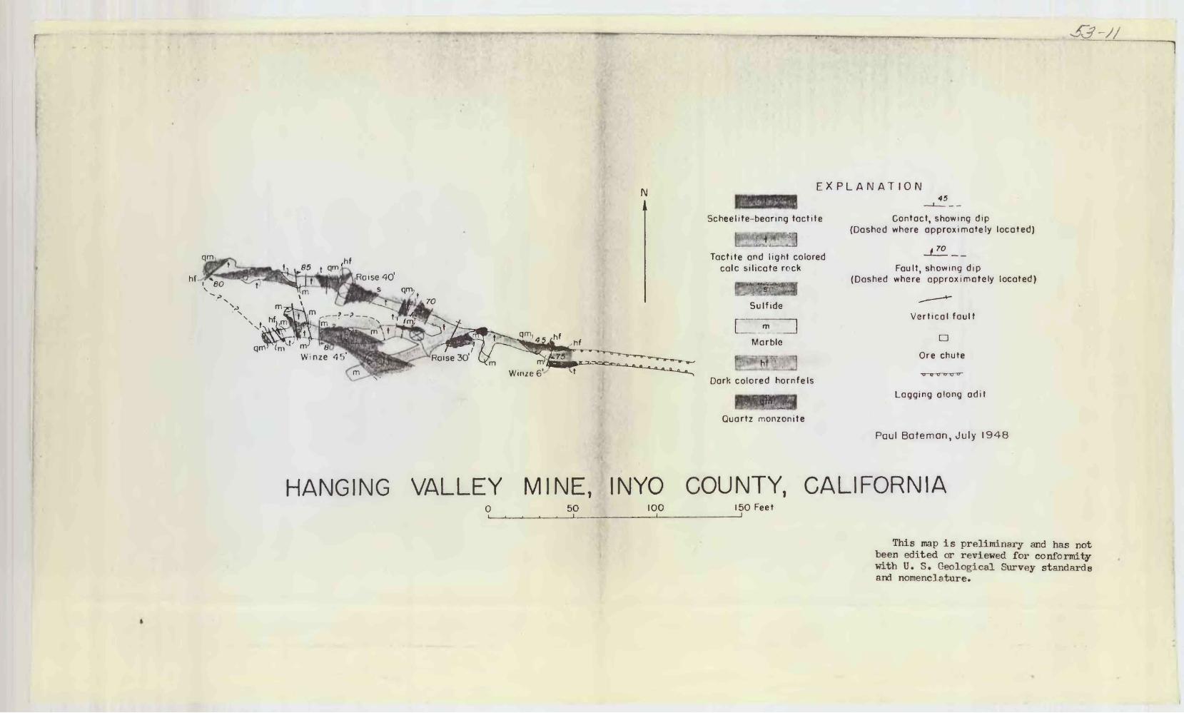
Th!5 ^anrrln- "^lle-" deposit, crops out through t^lrs .it only one
plnce, but refrioml relationships Indicate that, th<» dsnosit is along
or very n^v to « north«?.«t«tri!snd?.nr ^ontnct N^tam^p mi.-irt* nonaonlte
on ths flOnttTffiMjt -^^d nBt'TtorpMr? ^^cks of thf? Pine ^roak p^rfi^nt on the
narthoafit* Tt is -l^wlop^d by r«>^ns of two Adit levels sepitr.itod
vertically 11^ feet, and by several raises, ^ Ji£-fv>ot winiR^, and ssvensil
sm-^ll atopes* Only th^ rsr»r>G^ adit in shown on Pl«t« 2j the low«r adit
was driven in 19^2, anr* reached the ore SSOJIG ^ter thf? writ«r examined
the deposit.
"^R or^ in in n ^on*s o?* mctYiorpbi? rocks tsonsi«t4n?- of tactite,
h*jrr»f««!!s,, ^nd ^irble, wh^h is ponetr-'ted 5jrr«rnlarlv hv otisrtr, ^on^onite.
Bedding is obevtiv* *?.t most pl?»«©s, tn^t Tihere It i? discernible it strikes
westerly *md dips varfclcfcl or stoepl-/ 3Otith* ^ear-vert5.col north-trending
fracttjr-'fT of unknoimt Tf1! t pro»jibly eisnll, displnccnent cat the bed«»
Quarts r»ojisro?!ite exposed in the faces of the ti*o loncsst forks of the
upper adit war be t>ari of the sain quarts* monxmite naos on tile souUweot,
btjt neither wxnosvre hae been p«natrsted far enoorh to de^.onetrate that
it is? not a dike* Other exposures of nuart« ®on9?onit« are apparently
part* of dlke^lifce masses,.
The ore is discontinuous in planj eipht septrat^ srasll shoots
are dlstinguiftH&hla in the tirr»er adit* ^cploratiou throagh raises,
9.
winzes, and by dlugiond drilling denonstritos that, in contrast with
their limited extent in plan, the or shoots er** vertically very
persistent. Orm shoot has been explored in -a r^is*? to hO feet above
the upper v&t l«vel, an^ mother has been followed In a wlnae to IS
feet beneath the l*vel. ^srth^rrujre, ort? interpreted in dimaond {i
it rffpthB as "wnh ia 90 f«et ^nenth th«e ^iwr«r «<iit level
tx> r«pr«5f»nt f»'Tfcf*nf;1onfi of or<* shoots ^xno^ed on th<* level,
of th« ore sboot« nr* obv1.oiisly oonfin.Rd h«rfc»ra*n »a«t-tr«nding: near*
rerticsl ^ds snd north«»tr^n'1inf* near-*v«rticnl frsctureB| but others
»how no ar>pror<»nt r*»l«tionRhln to nither h«ddlnf: or fractiires*
in tho lower adit probably td.ll result in materially
ore r**cerven, Hyt the adit has not yet bean «*xt0tu!0d far
for evol«atl«5n of the r^swrvea* On the nnr^r leVBl, exploration
of the proimd >>oth to the north %nd to the ao^jth of the exl&tinf wwte*
Ingn T5ir resnilt in fin 'Inp stor*' or«. In addition, thp extension of at
least OIK? of the adit faces now in quart* jaonsonit^ to determine
whether ore Is r/rosent beyond th« ^uartr aonsonit~ seems worth while.
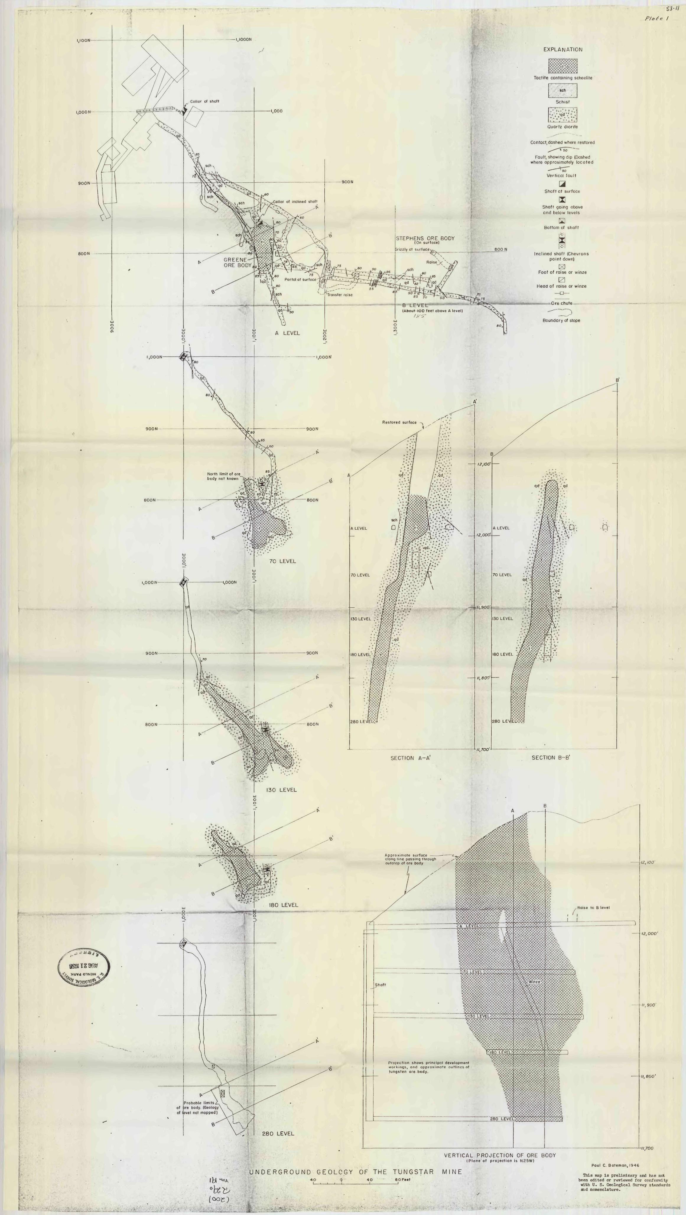
I,IOON -I.IOOON
J
i.OOON -
900N
BOON
Collar of inclined shaft
STEPHENS ORE BODY(On surface)
GREENE ORE BODY fo
Portal at surface
B LEVEL(About 4OG feet above A level)
A LEVEL
EXPLANATION
Tactite containing scheelite
sen
Schist
Quartz diorite
Contact,dashed where restored
Fault, showing dip (Dashed where approximately located
90
Vertical fault
aShaft at surface
nShaft going above and below levels
H Bottom of shaft
800 NInclined shaft (Chevrons
point down)
Foot of raise or winze
0 Head of raise or winze
-Ore chute-
Boundary of stope
I,OOON -i.ooow
SOON
BOON-
I.OOON
900N
BOON
North limit of ore body not known
Restored surface
,fc
A LEVEL
70 LEVEL
180 LEVEL
12,100'
_ .12,000'-
U, BOO'-
t. -,1 V.
130 LEVEL v ':-, '
//, 800
(6»C' 280 LEVEL<>
//, 700 ' *
SECTION A-A SECTION B-B'
130 LEVELu O o
Approximate surface along line passing through outcrop of ore body
of of
Probable limits ore body. (Geology level not mapped)
280 LEVEL
Shaft
Projection shows principal development workings, and approximate outlines of tungsten ore body.
//, eoo'
VERTICAL PROJECTION OF ORE BODY(Plane of projection is N25W)
UNDERGROUND GEOLOGY OF THE T'UNGSTAR MINE4OI_
0 ' 40I
8 O FeetI
'11,700
Paul C. Bateman, 1946
This map Is preliminary and has not been edited or reviewed for conformity with U. S. Geological Survey standards aid nomenclature.
fc , _*; - .
,hf
IMEX PL AN AT ION
Scheelite-beanng tactite
HfiHE!Tactile and light colored
calc silicate rock
Sulfide
m
Marble
Dark colored hornfels
Quartz monzonite
45
Contact, showing dip (Dashed where approximately located)
f ro
Fault, showing dip (Dashed where approximately located)
Vertical fault
aOre chute
Lagging along adit
Paul Bateman, July 1948
HANGING VALLEY MINE, INYO COUNTY, CALIFORNIA0 50 100
I150 Feet
This map is preliminary and has not been edited or reviewed for conformity with U. S. Geological Survey standards and nomenc]ature.