Embed Size (px)
Citation preview
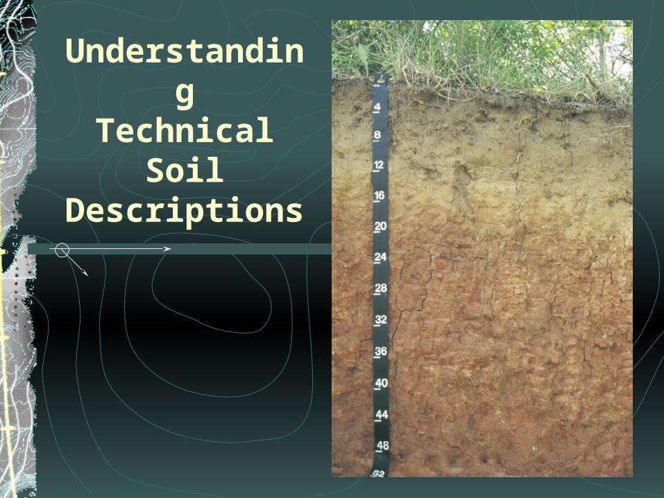
Understanding
TechnicalSoil
Descriptions
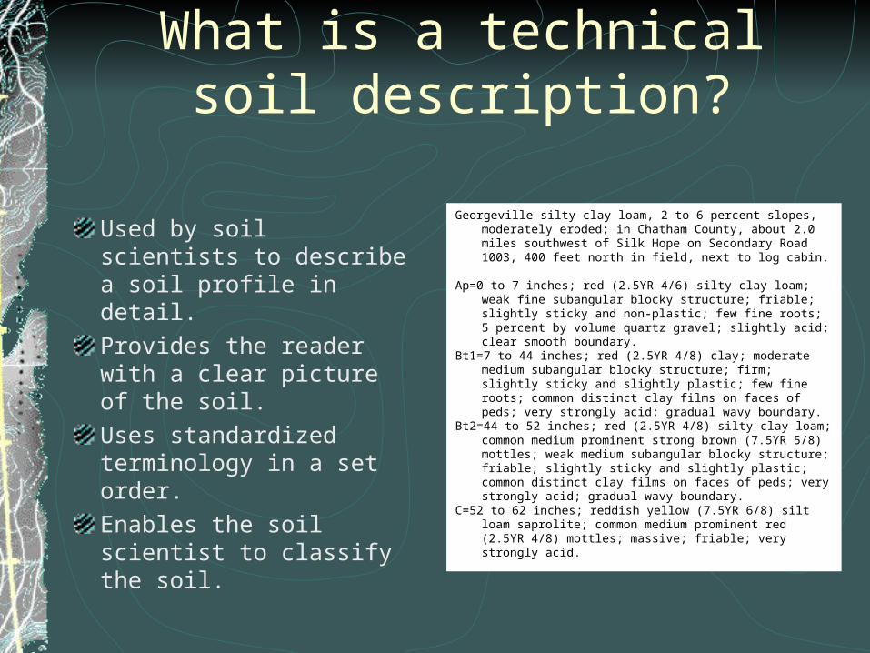
What is a technical soil description?
Used by soil scientists to describe a soil profile in detail. Provides the reader with a clear picture of the soil.Uses standardized terminology in a set order.Enables the soil scientist to classify the soil.
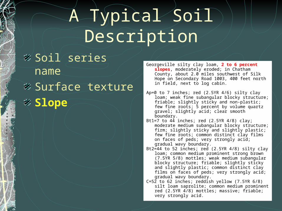
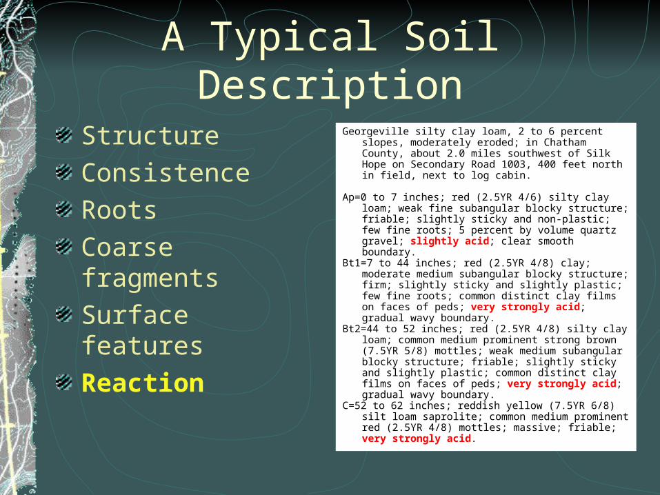
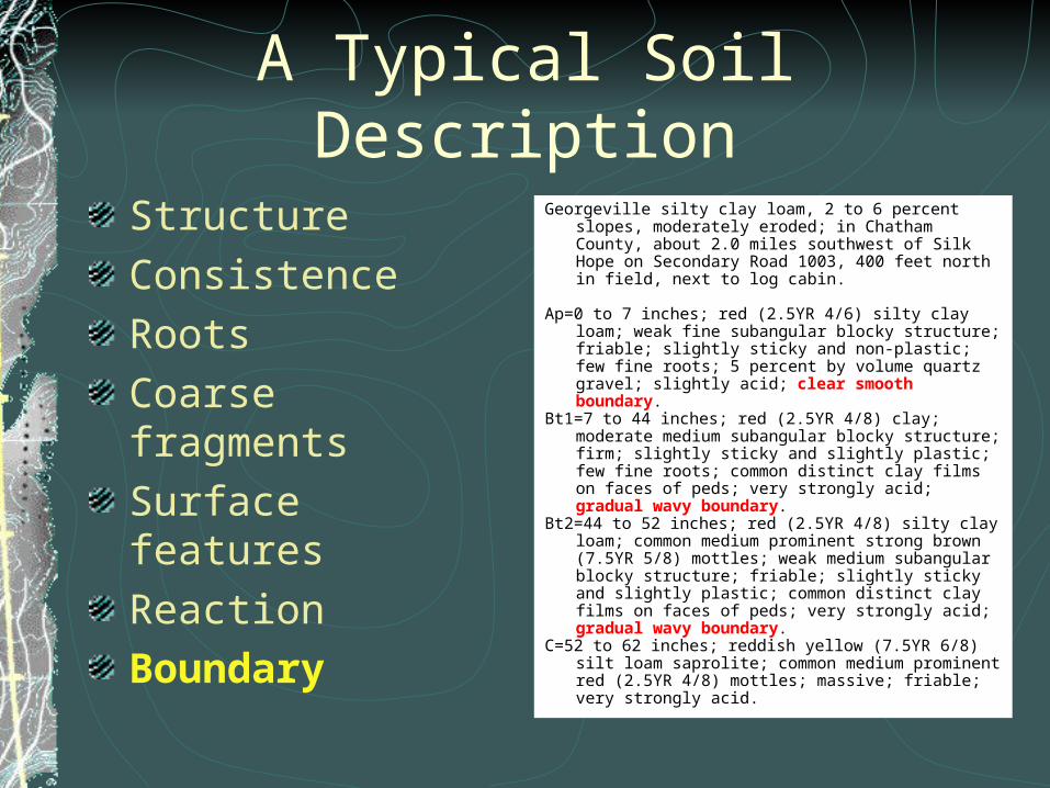
Georgeville silty clay loam, 2 to 6 percent slopes, moderately eroded; in Chatham County, about 2.0 miles southwest of Silk Hope on Secondary Road 1003, 400 feet north in field, next to log cabin.
Ap=0 to 7 inches; red (2.5YR 4/6) silty clay loam; weak fine subangular
blocky structure; friable; slightly sticky and non-plastic; few fine roots; 5 percent by volume quartz gravel; slightly acid; clear smooth boundary.
Bt1=7 to 44 inches; red (2.5YR 4/8) clay; moderate medium subangular blocky structure; firm; slightly sticky and slightly plastic; few fine roots; common distinct clay films on faces of peds; very strongly acid; gradual wavy boundary.
Bt2=44 to 52 inches; red (2.5YR 4/8) silty clay loam; common medium prominent strong brown (7.5YR 5/8) mottles; weak medium subangular blocky structure; friable; slightly sticky and slightly plastic; common distinct clay films on faces of peds; very strongly acid; gradual wavy boundary.
C=52 to 62 inches; reddish yellow (7.5YR 6/8) silt loam saprolite; common medium prominent red (2.5YR 4/8) mottles; massive; friable; very strongly acid.
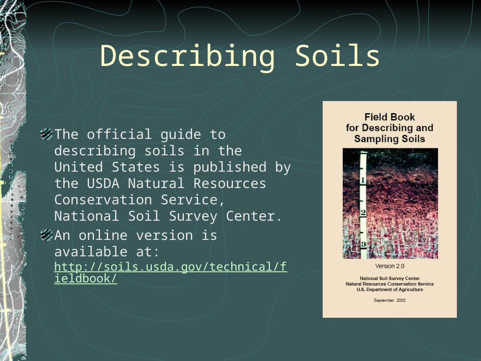
Describing Soils
The official guide to describing soils in the United States is published by the USDA Natural Resources Conservation Service, National Soil Survey Center. An online version is available at: http://soils.usda.gov/technical/fieldbook/
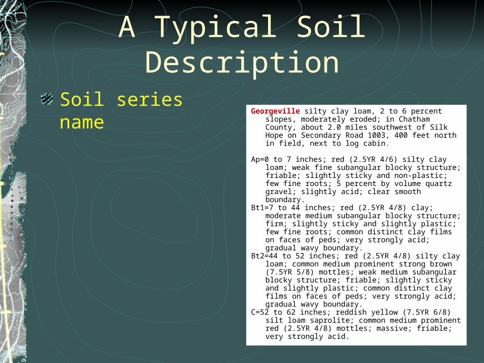
A Typical Soil Description
Soil series nameGeorgeville silty clay loam, 2 to 6 percent slopes,
moderately eroded; in Chatham County, about 2.0 miles southwest of Silk Hope on Secondary Road 1003, 400 feet north in field, next to log cabin.
Ap=0 to 7 inches; red (2.5YR 4/6) silty clay loam; weak fine
subangular blocky structure; friable; slightly sticky and non-plastic; few fine roots; 5 percent by volume quartz gravel; slightly acid; clear smooth boundary.
Bt1=7 to 44 inches; red (2.5YR 4/8) clay; moderate medium subangular blocky structure; firm; slightly sticky and slightly plastic; few fine roots; common distinct clay films on faces of peds; very strongly acid; gradual wavy boundary.
Bt2=44 to 52 inches; red (2.5YR 4/8) silty clay loam; common medium prominent strong brown (7.5YR 5/8) mottles; weak medium subangular blocky structure; friable; slightly sticky and slightly plastic; common distinct clay films on faces of peds; very strongly acid; gradual wavy boundary.
C=52 to 62 inches; reddish yellow (7.5YR 6/8) silt loam saprolite; common medium prominent red (2.5YR 4/8) mottles; massive; friable; very strongly acid.
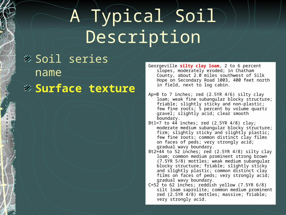
A Typical Soil Description
Soil series nameSurface texture
Georgeville silty clay loam, 2 to 6 percent slopes, moderately eroded; in Chatham County, about 2.0 miles southwest of Silk Hope on Secondary Road 1003, 400 feet north in field, next to log cabin.
Ap=0 to 7 inches; red (2.5YR 4/6) silty clay loam; weak fine
subangular blocky structure; friable; slightly sticky and non-plastic; few fine roots; 5 percent by volume quartz gravel; slightly acid; clear smooth boundary.
Bt1=7 to 44 inches; red (2.5YR 4/8) clay; moderate medium subangular blocky structure; firm; slightly sticky and slightly plastic; few fine roots; common distinct clay films on faces of peds; very strongly acid; gradual wavy boundary.
Bt2=44 to 52 inches; red (2.5YR 4/8) silty clay loam; common medium prominent strong brown (7.5YR 5/8) mottles; weak medium subangular blocky structure; friable; slightly sticky and slightly plastic; common distinct clay films on faces of peds; very strongly acid; gradual wavy boundary.
C=52 to 62 inches; reddish yellow (7.5YR 6/8) silt loam saprolite; common medium prominent red (2.5YR 4/8) mottles; massive; friable; very strongly acid.
A Typical Soil Description
Soil series nameSurface textureSlope
Georgeville silty clay loam, 2 to 6 percent slopes, moderately eroded; in Chatham County, about 2.0 miles southwest of Silk Hope on Secondary Road 1003, 400 feet north in field, next to log cabin.
Ap=0 to 7 inches; red (2.5YR 4/6) silty clay loam; weak fine
subangular blocky structure; friable; slightly sticky and non-plastic; few fine roots; 5 percent by volume quartz gravel; slightly acid; clear smooth boundary.
Bt1=7 to 44 inches; red (2.5YR 4/8) clay; moderate medium subangular blocky structure; firm; slightly sticky and slightly plastic; few fine roots; common distinct clay films on faces of peds; very strongly acid; gradual wavy boundary.
Bt2=44 to 52 inches; red (2.5YR 4/8) silty clay loam; common medium prominent strong brown (7.5YR 5/8) mottles; weak medium subangular blocky structure; friable; slightly sticky and slightly plastic; common distinct clay films on faces of peds; very strongly acid; gradual wavy boundary.
C=52 to 62 inches; reddish yellow (7.5YR 6/8) silt loam saprolite; common medium prominent red (2.5YR 4/8) mottles; massive; friable; very strongly acid.
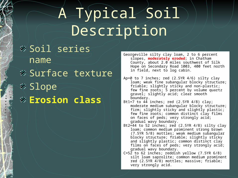
A Typical Soil Description
Soil series nameSurface textureSlopeErosion class
Georgeville silty clay loam, 2 to 6 percent slopes, moderately eroded; in Chatham County, about 2.0 miles southwest of Silk Hope on Secondary Road 1003, 400 feet north in field, next to log cabin.
Ap=0 to 7 inches; red (2.5YR 4/6) silty clay loam; weak fine
subangular blocky structure; friable; slightly sticky and non-plastic; few fine roots; 5 percent by volume quartz gravel; slightly acid; clear smooth boundary.
Bt1=7 to 44 inches; red (2.5YR 4/8) clay; moderate medium subangular blocky structure; firm; slightly sticky and slightly plastic; few fine roots; common distinct clay films on faces of peds; very strongly acid; gradual wavy boundary.
Bt2=44 to 52 inches; red (2.5YR 4/8) silty clay loam; common medium prominent strong brown (7.5YR 5/8) mottles; weak medium subangular blocky structure; friable; slightly sticky and slightly plastic; common distinct clay films on faces of peds; very strongly acid; gradual wavy boundary.
C=52 to 62 inches; reddish yellow (7.5YR 6/8) silt loam saprolite; common medium prominent red (2.5YR 4/8) mottles; massive; friable; very strongly acid.
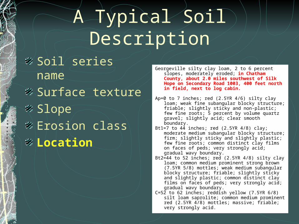
A Typical Soil Description
Soil series nameSurface textureSlopeErosion classLocation
Georgeville silty clay loam, 2 to 6 percent slopes, moderately eroded; in Chatham County, about 2.0 miles southwest of Silk Hope on Secondary Road 1003, 400 feet north in field, next to log cabin.
Ap=0 to 7 inches; red (2.5YR 4/6) silty clay loam; weak fine
subangular blocky structure; friable; slightly sticky and non-plastic; few fine roots; 5 percent by volume quartz gravel; slightly acid; clear smooth boundary.
Bt1=7 to 44 inches; red (2.5YR 4/8) clay; moderate medium subangular blocky structure; firm; slightly sticky and slightly plastic; few fine roots; common distinct clay films on faces of peds; very strongly acid; gradual wavy boundary.
Bt2=44 to 52 inches; red (2.5YR 4/8) silty clay loam; common medium prominent strong brown (7.5YR 5/8) mottles; weak medium subangular blocky structure; friable; slightly sticky and slightly plastic; common distinct clay films on faces of peds; very strongly acid; gradual wavy boundary.
C=52 to 62 inches; reddish yellow (7.5YR 6/8) silt loam saprolite; common medium prominent red (2.5YR 4/8) mottles; massive; friable; very strongly acid.
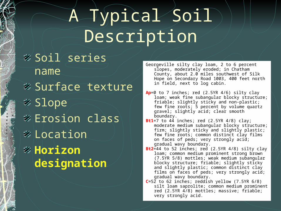
A Typical Soil Description
Soil series nameSurface textureSlopeErosion classLocationHorizon designation
Georgeville silty clay loam, 2 to 6 percent slopes, moderately eroded; in Chatham County, about 2.0 miles southwest of Silk Hope on Secondary Road 1003, 400 feet north in field, next to log cabin.
Ap=0 to 7 inches; red (2.5YR 4/6) silty clay loam; weak fine
subangular blocky structure; friable; slightly sticky and non-plastic; few fine roots; 5 percent by volume quartz gravel; slightly acid; clear smooth boundary.
Bt1=7 to 44 inches; red (2.5YR 4/8) clay; moderate medium subangular blocky structure; firm; slightly sticky and slightly plastic; few fine roots; common distinct clay films on faces of peds; very strongly acid; gradual wavy boundary.
Bt2=44 to 52 inches; red (2.5YR 4/8) silty clay loam; common medium prominent strong brown (7.5YR 5/8) mottles; weak medium subangular blocky structure; friable; slightly sticky and slightly plastic; common distinct clay films on faces of peds; very strongly acid; gradual wavy boundary.
C=52 to 62 inches; reddish yellow (7.5YR 6/8) silt loam saprolite; common medium prominent red (2.5YR 4/8) mottles; massive; friable; very strongly acid.
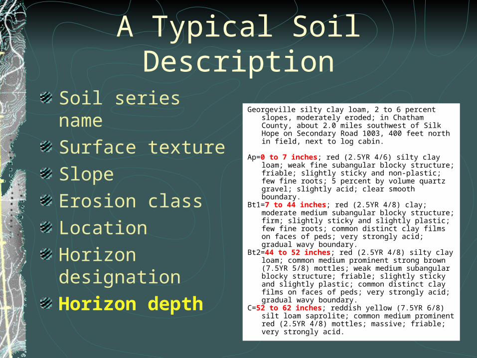
A Typical Soil Description
Soil series nameSurface textureSlopeErosion classLocationHorizon designationHorizon depth
Georgeville silty clay loam, 2 to 6 percent slopes, moderately eroded; in Chatham County, about 2.0 miles southwest of Silk Hope on Secondary Road 1003, 400 feet north in field, next to log cabin.
Ap=0 to 7 inches; red (2.5YR 4/6) silty clay loam; weak fine
subangular blocky structure; friable; slightly sticky and non-plastic; few fine roots; 5 percent by volume quartz gravel; slightly acid; clear smooth boundary.
Bt1=7 to 44 inches; red (2.5YR 4/8) clay; moderate medium subangular blocky structure; firm; slightly sticky and slightly plastic; few fine roots; common distinct clay films on faces of peds; very strongly acid; gradual wavy boundary.
Bt2=44 to 52 inches; red (2.5YR 4/8) silty clay loam; common medium prominent strong brown (7.5YR 5/8) mottles; weak medium subangular blocky structure; friable; slightly sticky and slightly plastic; common distinct clay films on faces of peds; very strongly acid; gradual wavy boundary.
C=52 to 62 inches; reddish yellow (7.5YR 6/8) silt loam saprolite; common medium prominent red (2.5YR 4/8) mottles; massive; friable; very strongly acid.
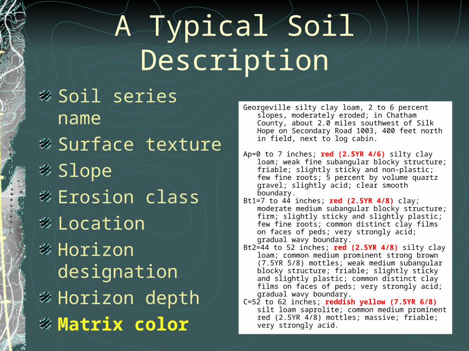
A Typical Soil Description
Soil series nameSurface textureSlopeErosion classLocationHorizon designationHorizon depthMatrix color
Georgeville silty clay loam, 2 to 6 percent slopes, moderately eroded; in Chatham County, about 2.0 miles southwest of Silk Hope on Secondary Road 1003, 400 feet north in field, next to log cabin.
Ap=0 to 7 inches; red (2.5YR 4/6) silty clay loam; weak fine
subangular blocky structure; friable; slightly sticky and non-plastic; few fine roots; 5 percent by volume quartz gravel; slightly acid; clear smooth boundary.
Bt1=7 to 44 inches; red (2.5YR 4/8) clay; moderate medium subangular blocky structure; firm; slightly sticky and slightly plastic; few fine roots; common distinct clay films on faces of peds; very strongly acid; gradual wavy boundary.
Bt2=44 to 52 inches; red (2.5YR 4/8) silty clay loam; common medium prominent strong brown (7.5YR 5/8) mottles; weak medium subangular blocky structure; friable; slightly sticky and slightly plastic; common distinct clay films on faces of peds; very strongly acid; gradual wavy boundary.
C=52 to 62 inches; reddish yellow (7.5YR 6/8) silt loam saprolite; common medium prominent red (2.5YR 4/8) mottles; massive; friable; very strongly acid.
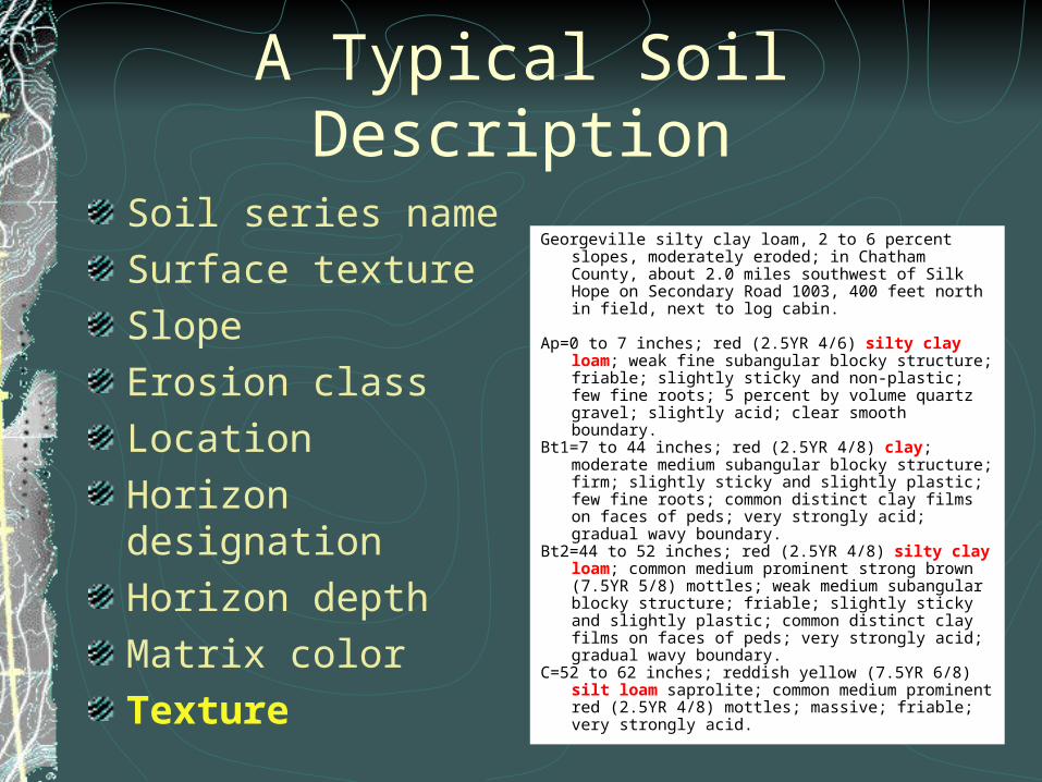
A Typical Soil Description
Soil series nameSurface textureSlopeErosion classLocationHorizon designationHorizon depthMatrix colorTexture
Georgeville silty clay loam, 2 to 6 percent slopes, moderately eroded; in Chatham County, about 2.0 miles southwest of Silk Hope on Secondary Road 1003, 400 feet north in field, next to log cabin.
Ap=0 to 7 inches; red (2.5YR 4/6) silty clay loam; weak fine
subangular blocky structure; friable; slightly sticky and non-plastic; few fine roots; 5 percent by volume quartz gravel; slightly acid; clear smooth boundary.
Bt1=7 to 44 inches; red (2.5YR 4/8) clay; moderate medium subangular blocky structure; firm; slightly sticky and slightly plastic; few fine roots; common distinct clay films on faces of peds; very strongly acid; gradual wavy boundary.
Bt2=44 to 52 inches; red (2.5YR 4/8) silty clay loam; common medium prominent strong brown (7.5YR 5/8) mottles; weak medium subangular blocky structure; friable; slightly sticky and slightly plastic; common distinct clay films on faces of peds; very strongly acid; gradual wavy boundary.
C=52 to 62 inches; reddish yellow (7.5YR 6/8) silt loam saprolite; common medium prominent red (2.5YR 4/8) mottles; massive; friable; very strongly acid.
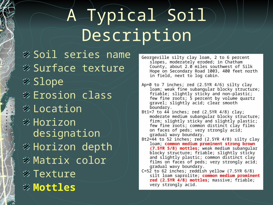
A Typical Soil Description
Soil series nameSurface textureSlopeErosion classLocationHorizon designationHorizon depthMatrix colorTextureMottles
Georgeville silty clay loam, 2 to 6 percent slopes, moderately eroded; in Chatham County, about 2.0 miles southwest of Silk Hope on Secondary Road 1003, 400 feet north in field, next to log cabin.
Ap=0 to 7 inches; red (2.5YR 4/6) silty clay loam; weak fine
subangular blocky structure; friable; slightly sticky and non-plastic; few fine roots; 5 percent by volume quartz gravel; slightly acid; clear smooth boundary.
Bt1=7 to 44 inches; red (2.5YR 4/8) clay; moderate medium subangular blocky structure; firm; slightly sticky and slightly plastic; few fine roots; common distinct clay films on faces of peds; very strongly acid; gradual wavy boundary.
Bt2=44 to 52 inches; red (2.5YR 4/8) silty clay loam; common medium prominent strong brown (7.5YR 5/8) mottles; weak medium subangular blocky structure; friable; slightly sticky and slightly plastic; common distinct clay films on faces of peds; very strongly acid; gradual wavy boundary.
C=52 to 62 inches; reddish yellow (7.5YR 6/8) silt loam saprolite; common medium prominent red (2.5YR 4/8) mottles; massive; friable; very strongly acid.
A Typical Soil Description
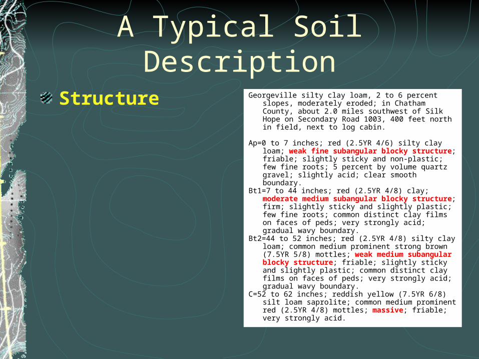
Structure Georgeville silty clay loam, 2 to 6 percent slopes, moderately eroded; in Chatham County, about 2.0 miles southwest of Silk Hope on Secondary Road 1003, 400 feet north in field, next to log cabin.
Ap=0 to 7 inches; red (2.5YR 4/6) silty clay loam; weak fine
subangular blocky structure; friable; slightly sticky and non-plastic; few fine roots; 5 percent by volume quartz gravel; slightly acid; clear smooth boundary.
Bt1=7 to 44 inches; red (2.5YR 4/8) clay; moderate medium subangular blocky structure; firm; slightly sticky and slightly plastic; few fine roots; common distinct clay films on faces of peds; very strongly acid; gradual wavy boundary.
Bt2=44 to 52 inches; red (2.5YR 4/8) silty clay loam; common medium prominent strong brown (7.5YR 5/8) mottles; weak medium subangular blocky structure; friable; slightly sticky and slightly plastic; common distinct clay films on faces of peds; very strongly acid; gradual wavy boundary.
C=52 to 62 inches; reddish yellow (7.5YR 6/8) silt loam saprolite; common medium prominent red (2.5YR 4/8) mottles; massive; friable; very strongly acid.
A Typical Soil Description
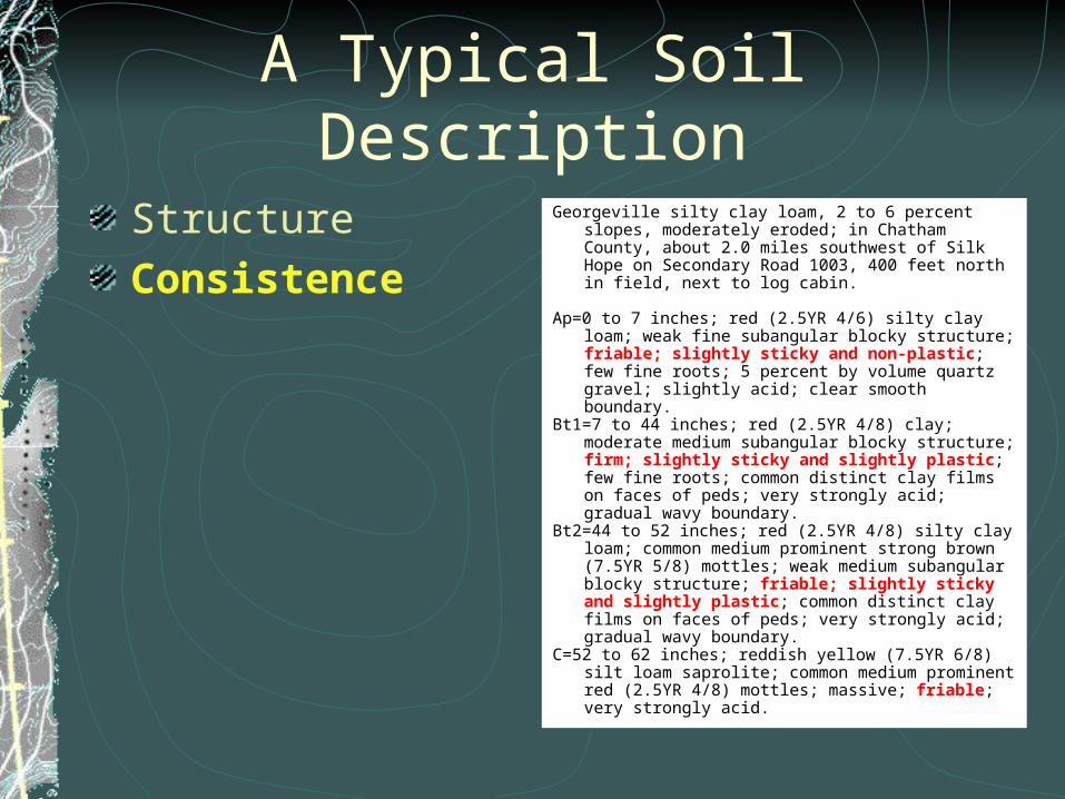
StructureConsistence
Georgeville silty clay loam, 2 to 6 percent slopes, moderately eroded; in Chatham County, about 2.0 miles southwest of Silk Hope on Secondary Road 1003, 400 feet north in field, next to log cabin.
Ap=0 to 7 inches; red (2.5YR 4/6) silty clay loam; weak fine
subangular blocky structure; friable; slightly sticky and non-plastic; few fine roots; 5 percent by volume quartz gravel; slightly acid; clear smooth boundary.
Bt1=7 to 44 inches; red (2.5YR 4/8) clay; moderate medium subangular blocky structure; firm; slightly sticky and slightly plastic; few fine roots; common distinct clay films on faces of peds; very strongly acid; gradual wavy boundary.
Bt2=44 to 52 inches; red (2.5YR 4/8) silty clay loam; common medium prominent strong brown (7.5YR 5/8) mottles; weak medium subangular blocky structure; friable; slightly sticky and slightly plastic; common distinct clay films on faces of peds; very strongly acid; gradual wavy boundary.
C=52 to 62 inches; reddish yellow (7.5YR 6/8) silt loam saprolite; common medium prominent red (2.5YR 4/8) mottles; massive; friable; very strongly acid.
A Typical Soil Description
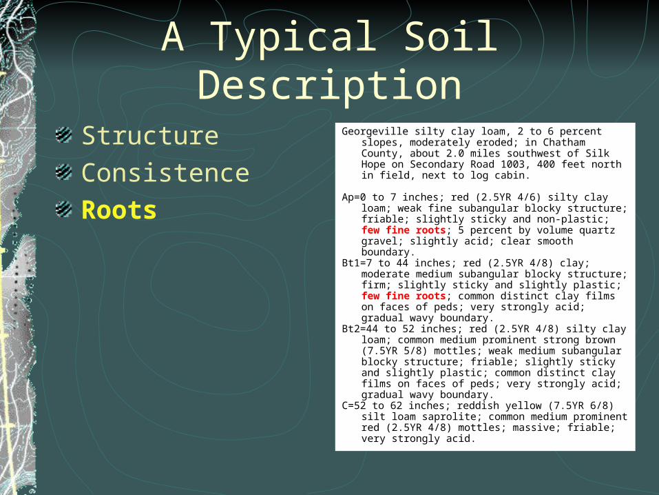
StructureConsistenceRoots
Georgeville silty clay loam, 2 to 6 percent slopes, moderately eroded; in Chatham County, about 2.0 miles southwest of Silk Hope on Secondary Road 1003, 400 feet north in field, next to log cabin.
Ap=0 to 7 inches; red (2.5YR 4/6) silty clay loam; weak fine
subangular blocky structure; friable; slightly sticky and non-plastic; few fine roots; 5 percent by volume quartz gravel; slightly acid; clear smooth boundary.
Bt1=7 to 44 inches; red (2.5YR 4/8) clay; moderate medium subangular blocky structure; firm; slightly sticky and slightly plastic; few fine roots; common distinct clay films on faces of peds; very strongly acid; gradual wavy boundary.
Bt2=44 to 52 inches; red (2.5YR 4/8) silty clay loam; common medium prominent strong brown (7.5YR 5/8) mottles; weak medium subangular blocky structure; friable; slightly sticky and slightly plastic; common distinct clay films on faces of peds; very strongly acid; gradual wavy boundary.
C=52 to 62 inches; reddish yellow (7.5YR 6/8) silt loam saprolite; common medium prominent red (2.5YR 4/8) mottles; massive; friable; very strongly acid.
A Typical Soil Description
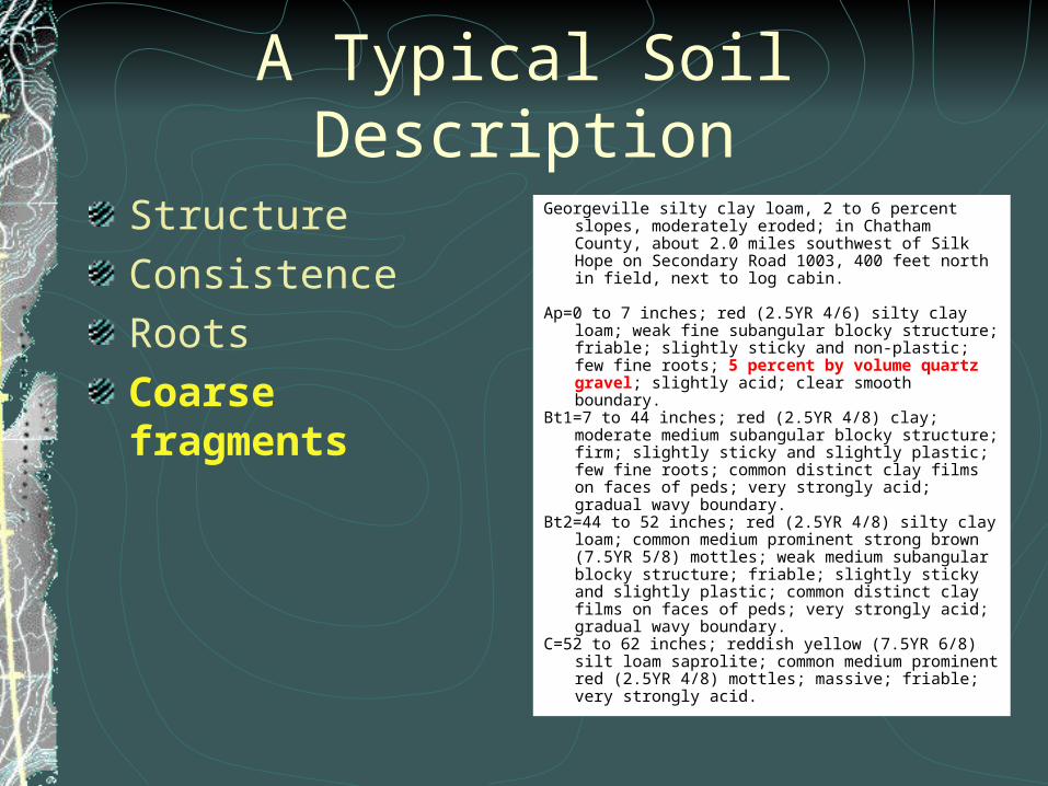
StructureConsistenceRootsCoarse fragments
Georgeville silty clay loam, 2 to 6 percent slopes, moderately eroded; in Chatham County, about 2.0 miles southwest of Silk Hope on Secondary Road 1003, 400 feet north in field, next to log cabin.
Ap=0 to 7 inches; red (2.5YR 4/6) silty clay loam; weak fine
subangular blocky structure; friable; slightly sticky and non-plastic; few fine roots; 5 percent by volume quartz gravel; slightly acid; clear smooth boundary.
Bt1=7 to 44 inches; red (2.5YR 4/8) clay; moderate medium subangular blocky structure; firm; slightly sticky and slightly plastic; few fine roots; common distinct clay films on faces of peds; very strongly acid; gradual wavy boundary.
Bt2=44 to 52 inches; red (2.5YR 4/8) silty clay loam; common medium prominent strong brown (7.5YR 5/8) mottles; weak medium subangular blocky structure; friable; slightly sticky and slightly plastic; common distinct clay films on faces of peds; very strongly acid; gradual wavy boundary.
C=52 to 62 inches; reddish yellow (7.5YR 6/8) silt loam saprolite; common medium prominent red (2.5YR 4/8) mottles; massive; friable; very strongly acid.

A Typical Soil Description
StructureConsistenceRootsCoarse fragmentsSurface features
Georgeville silty clay loam, 2 to 6 percent slopes, moderately eroded; in Chatham County, about 2.0 miles southwest of Silk Hope on Secondary Road 1003, 400 feet north in field, next to log cabin.
Ap=0 to 7 inches; red (2.5YR 4/6) silty clay loam; weak fine
subangular blocky structure; friable; slightly sticky and non-plastic; few fine roots; 5 percent by volume quartz gravel; slightly acid; clear smooth boundary.
Bt1=7 to 44 inches; red (2.5YR 4/8) clay; moderate medium subangular blocky structure; firm; slightly sticky and slightly plastic; few fine roots; common distinct clay films on faces of peds; very strongly acid; gradual wavy boundary.
Bt2=44 to 52 inches; red (2.5YR 4/8) silty clay loam; common medium prominent strong brown (7.5YR 5/8) mottles; weak medium subangular blocky structure; friable; slightly sticky and slightly plastic; common distinct clay films on faces of peds; very strongly acid; gradual wavy boundary.
C=52 to 62 inches; reddish yellow (7.5YR 6/8) silt loam saprolite; common medium prominent red (2.5YR 4/8) mottles; massive; friable; very strongly acid.
A Typical Soil Description
StructureConsistenceRootsCoarse fragmentsSurface featuresReaction
Georgeville silty clay loam, 2 to 6 percent slopes, moderately eroded; in Chatham County, about 2.0 miles southwest of Silk Hope on Secondary Road 1003, 400 feet north in field, next to log cabin.
Ap=0 to 7 inches; red (2.5YR 4/6) silty clay loam; weak fine
subangular blocky structure; friable; slightly sticky and non-plastic; few fine roots; 5 percent by volume quartz gravel; slightly acid; clear smooth boundary.
Bt1=7 to 44 inches; red (2.5YR 4/8) clay; moderate medium subangular blocky structure; firm; slightly sticky and slightly plastic; few fine roots; common distinct clay films on faces of peds; very strongly acid; gradual wavy boundary.
Bt2=44 to 52 inches; red (2.5YR 4/8) silty clay loam; common medium prominent strong brown (7.5YR 5/8) mottles; weak medium subangular blocky structure; friable; slightly sticky and slightly plastic; common distinct clay films on faces of peds; very strongly acid; gradual wavy boundary.
C=52 to 62 inches; reddish yellow (7.5YR 6/8) silt loam saprolite; common medium prominent red (2.5YR 4/8) mottles; massive; friable; very strongly acid.
A Typical Soil Description
StructureConsistenceRootsCoarse fragmentsSurface featuresReactionBoundary
Georgeville silty clay loam, 2 to 6 percent slopes, moderately eroded; in Chatham County, about 2.0 miles southwest of Silk Hope on Secondary Road 1003, 400 feet north in field, next to log cabin.
Ap=0 to 7 inches; red (2.5YR 4/6) silty clay loam; weak fine
subangular blocky structure; friable; slightly sticky and non-plastic; few fine roots; 5 percent by volume quartz gravel; slightly acid; clear smooth boundary.
Bt1=7 to 44 inches; red (2.5YR 4/8) clay; moderate medium subangular blocky structure; firm; slightly sticky and slightly plastic; few fine roots; common distinct clay films on faces of peds; very strongly acid; gradual wavy boundary.
Bt2=44 to 52 inches; red (2.5YR 4/8) silty clay loam; common medium prominent strong brown (7.5YR 5/8) mottles; weak medium subangular blocky structure; friable; slightly sticky and slightly plastic; common distinct clay films on faces of peds; very strongly acid; gradual wavy boundary.
C=52 to 62 inches; reddish yellow (7.5YR 6/8) silt loam saprolite; common medium prominent red (2.5YR 4/8) mottles; massive; friable; very strongly acid.
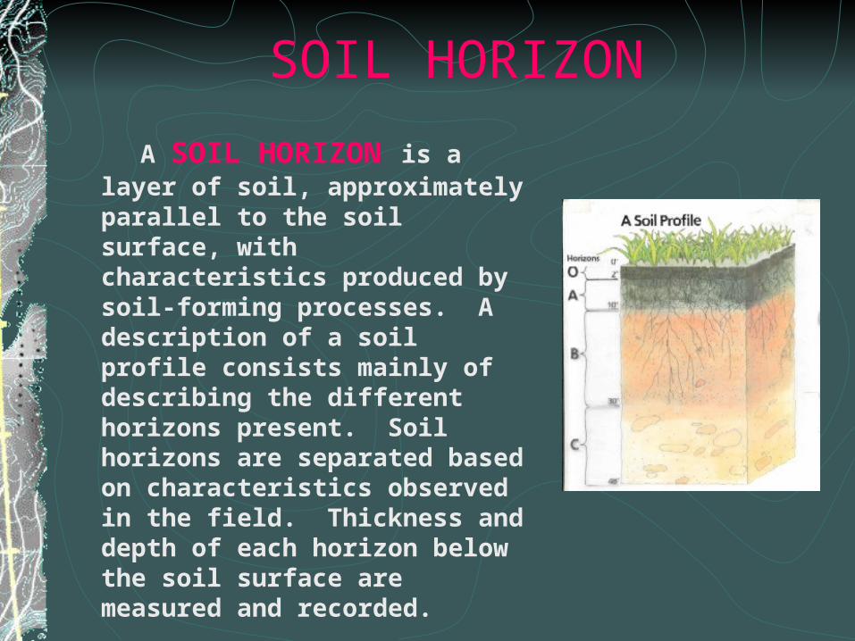
SOIL HORIZON
A SOIL HORIZON is a layer of soil, approximately parallel to the soil surface, with characteristics produced by soil-forming processes. A description of a soil profile consists mainly of describing the different horizons present. Soil horizons are separated based on characteristics observed in the field. Thickness and depth of each horizon below the soil surface are measured and recorded.
MAJOR HORIZONS
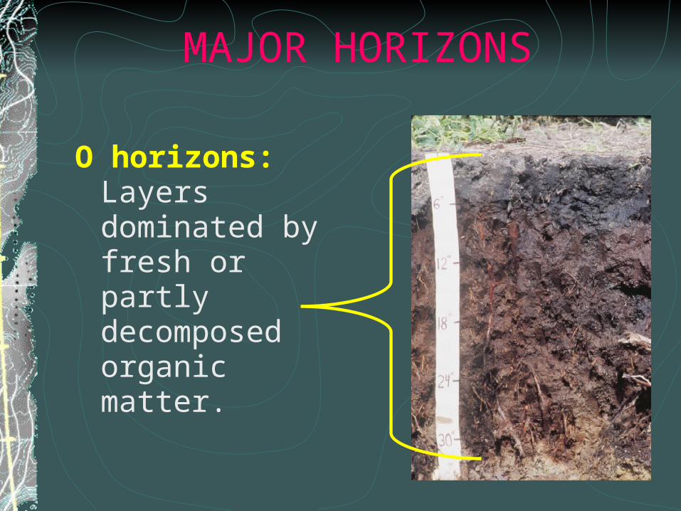
O horizons: Layers dominated by fresh or partly decomposed organic matter.
MAJOR HORIZONS
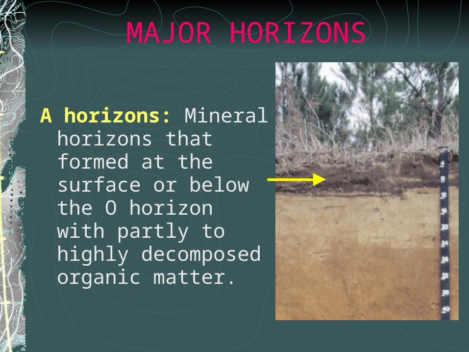
A horizons: Mineral horizons that formed at the surface or below the O horizon with partly to highly decomposed organic matter.
MAJOR HORIZONS
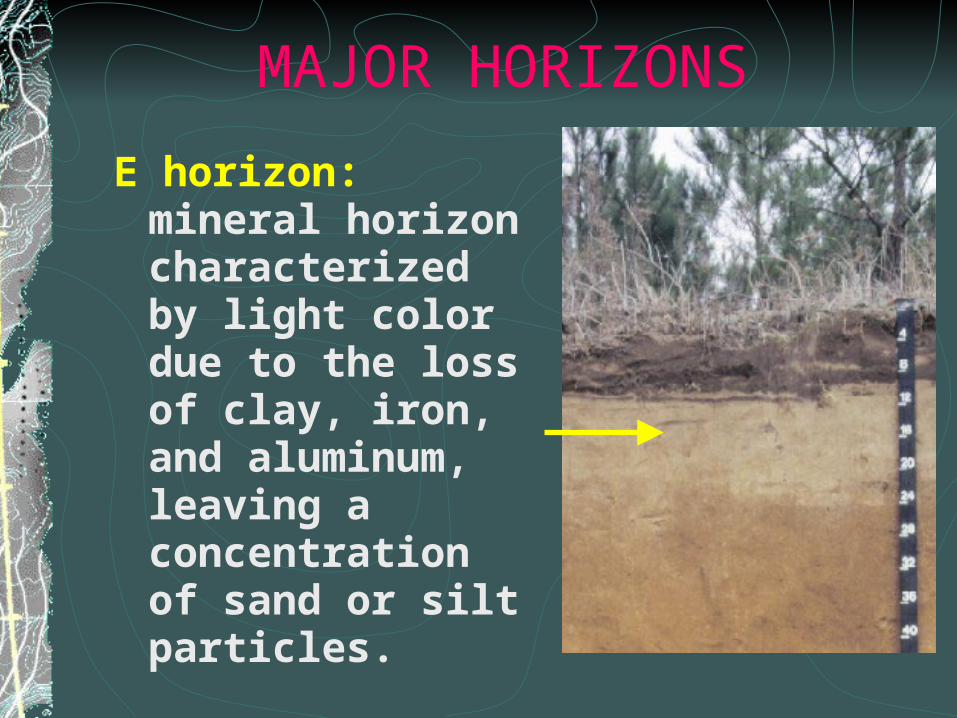
E horizon: mineral horizon characterized by light color due to the loss of clay, iron, and aluminum, leaving a concentration of sand or silt particles.
MAJOR HORIZONS
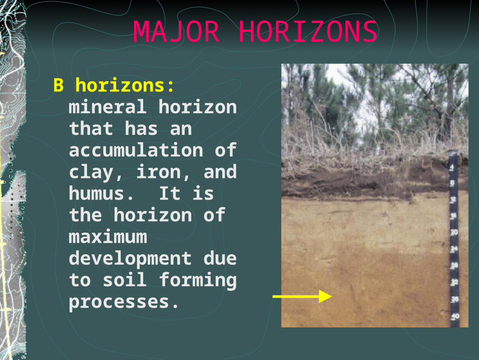
B horizons: mineral horizon that has an accumulation of clay, iron, and humus. It is the horizon of maximum development due to soil forming processes.
MAJOR HORIZONS
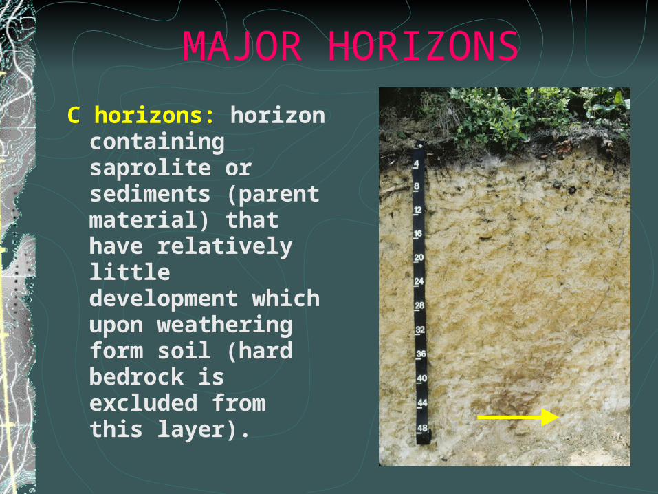
C horizons: horizon containing saprolite or sediments (parent material) that have relatively little development which upon weathering form soil (hard bedrock is excluded from this layer).
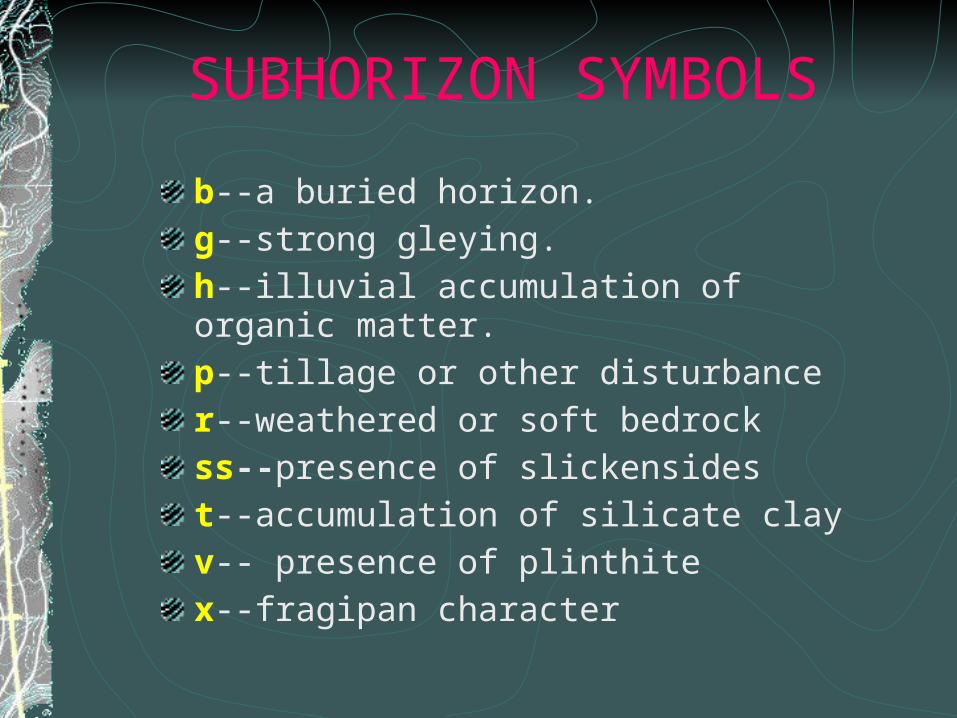
SUBHORIZON SYMBOLS
b--a buried horizon.
g--strong gleying.
h--illuvial accumulation of organic matter.
p--tillage or other disturbance
r--weathered or soft bedrock
ss--presence of slickensides
t--accumulation of silicate clay
v-- presence of plinthite
x--fragipan character
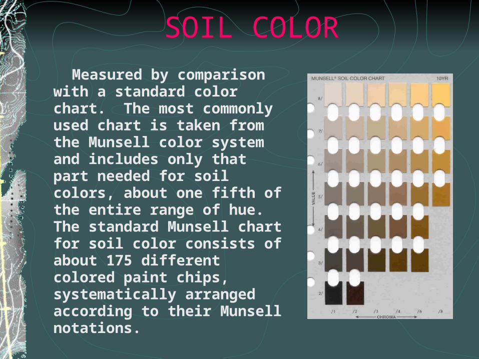
SOIL COLOR
Measured by comparison with a standard color chart. The most commonly used chart is taken from the Munsell color system and includes only that part needed for soil colors, about one fifth of the entire range of hue. The standard Munsell chart for soil color consists of about 175 different colored paint chips, systematically arranged according to their Munsell notations.
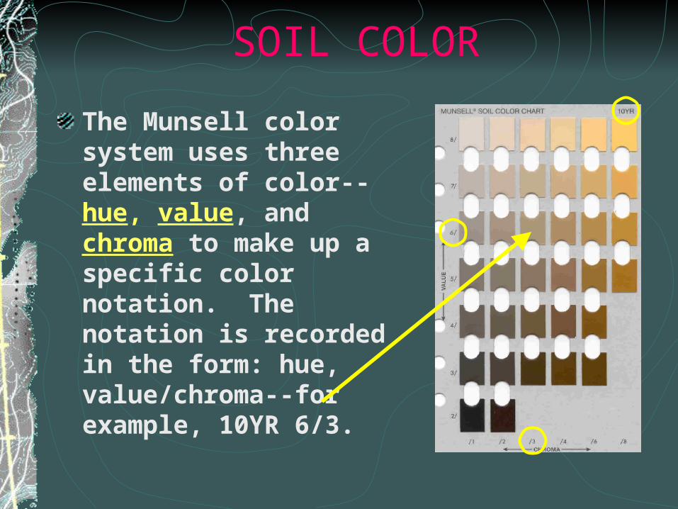
SOIL COLOR
The Munsell color system uses three elements of color--hue, value, and chroma to make up a specific color notation. The notation is recorded in the form: hue, value/chroma--for example, 10YR 6/3.
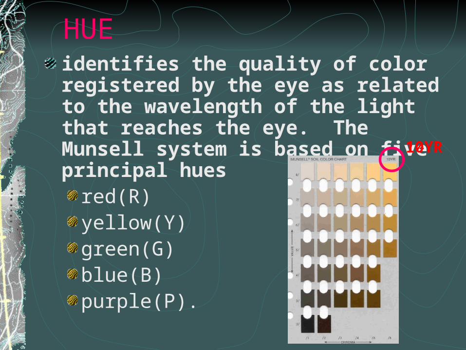
HUEidentifies the quality of color registered by the eye as related to the wavelength of the light that reaches the eye. The Munsell system is based on five principal hues
red(R)yellow(Y)green(G)blue(B)purple(P).
10YR
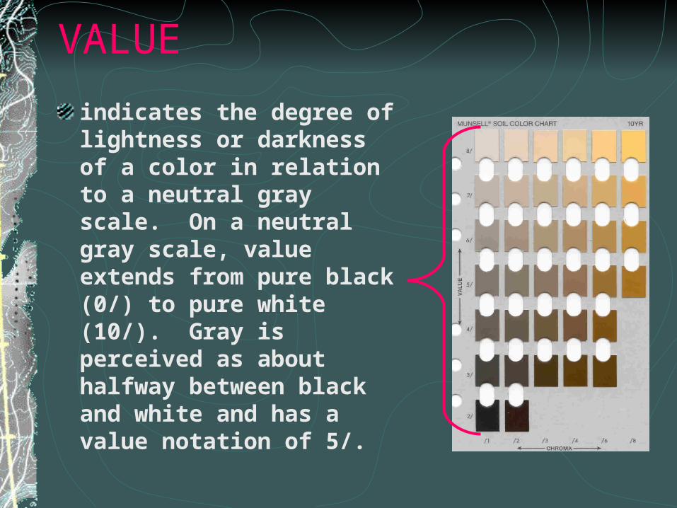
VALUE
indicates the degree of lightness or darkness of a color in relation to a neutral gray scale. On a neutral gray scale, value extends from pure black (0/) to pure white (10/). Gray is perceived as about halfway between black and white and has a value notation of 5/.
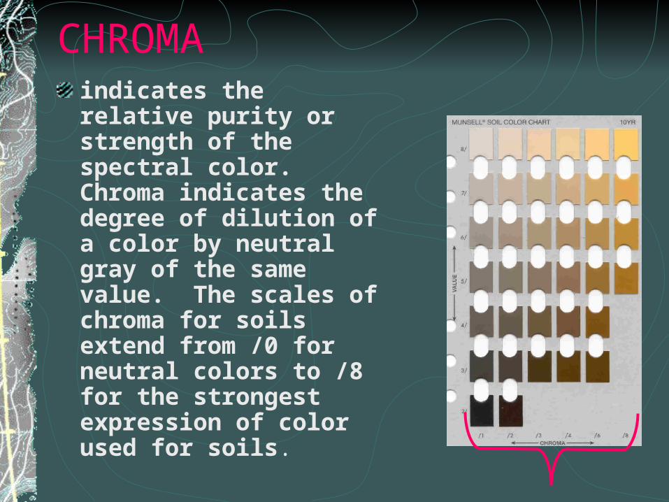
CHROMAindicates the relative purity or strength of the spectral color. Chroma indicates the degree of dilution of a color by neutral gray of the same value. The scales of chroma for soils extend from /0 for neutral colors to /8 for the strongest expression of color used for soils.
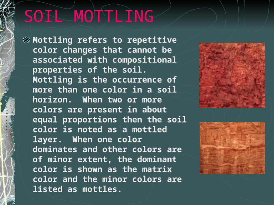
SOIL MOTTLINGMottling refers to repetitive color changes that cannot be associated with compositional properties of the soil. Mottling is the occurrence of more than one color in a soil horizon. When two or more colors are present in about equal proportions then the soil color is noted as a mottled layer. When one color dominates and other colors are of minor extent, the dominant color is shown as the matrix color and the minor colors are listed as mottles.
Abundance
Few--mottles are <2% of the surface of the soil (f)
Common--mottles are 2-20% of the surface of the soil (c)
Many--mottles are >20% of the surface of the soil (m)
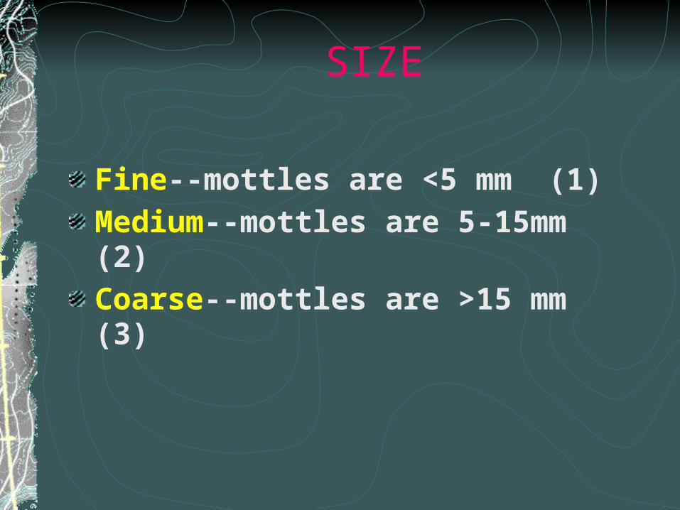
SIZE
Fine--mottles are <5 mm (1)
Medium--mottles are 5-15mm (2)
Coarse--mottles are >15 mm (3)
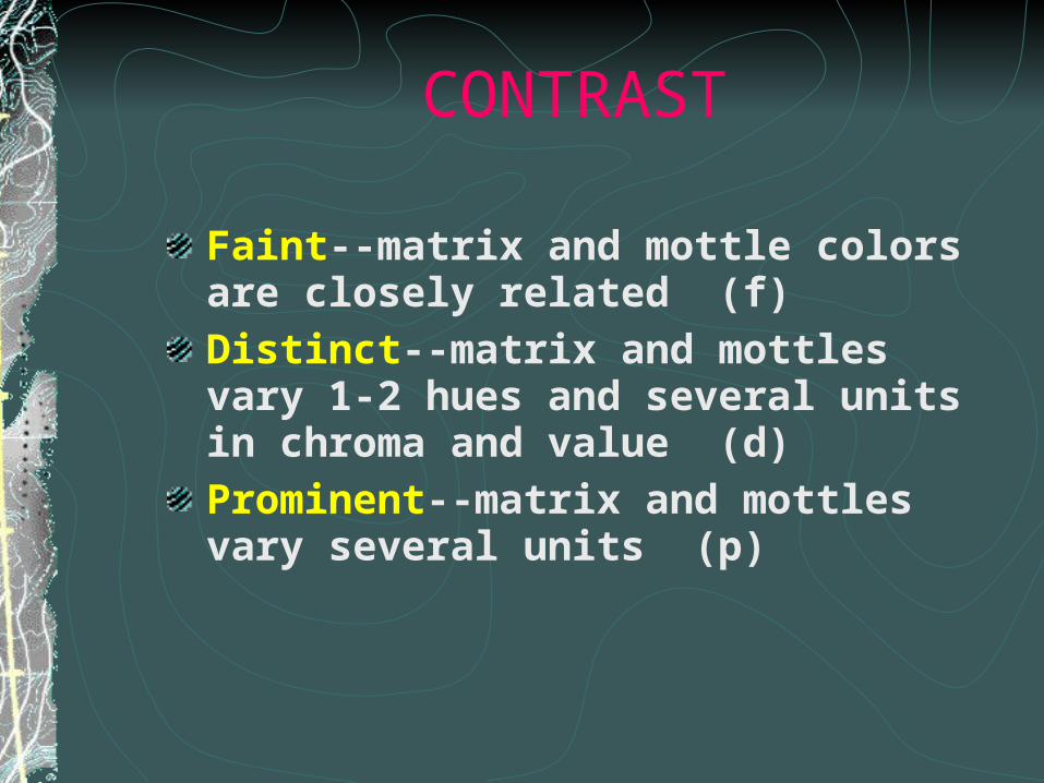
CONTRAST
Faint--matrix and mottle colors are closely related (f)
Distinct--matrix and mottles vary 1-2 hues and several units in chroma and value (d)
Prominent--matrix and mottles vary several units (p)
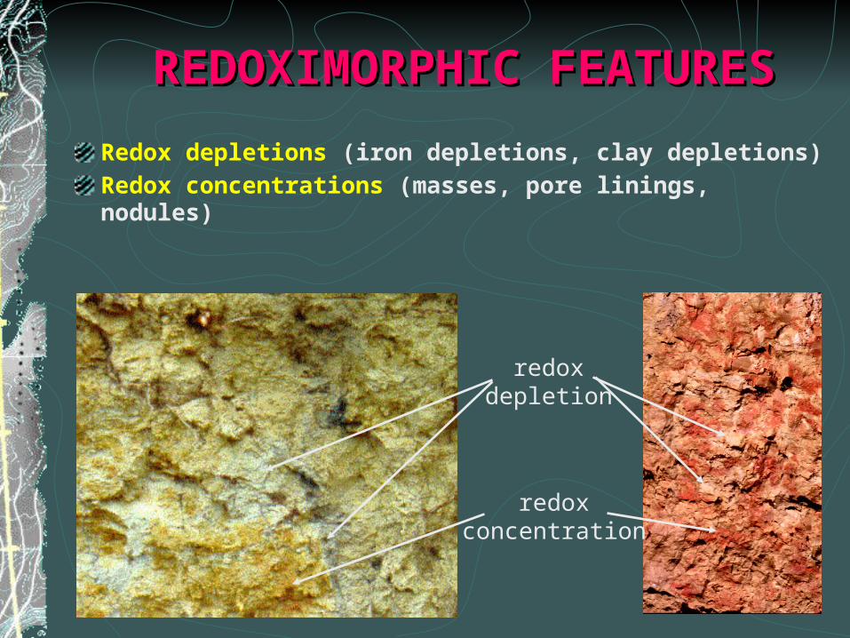
REDOXIMORPHIC FEATURESREDOXIMORPHIC FEATURES
Redox depletions (iron depletions, clay depletions)
Redox concentrations (masses, pore linings, nodules)
redoxdepletion
redoxconcentration
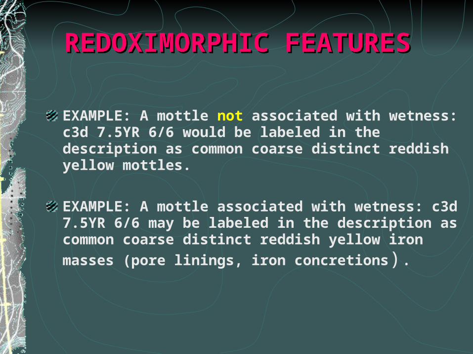
REDOXIMORPHIC FEATURESREDOXIMORPHIC FEATURES
EXAMPLE: A mottle not associated with wetness: c3d 7.5YR 6/6 would be labeled in the description as common coarse distinct reddish yellow mottles.
EXAMPLE: A mottle associated with wetness: c3d 7.5YR 6/6 may be labeled in the description as common coarse distinct reddish yellow iron masses
(pore linings, iron concretions).
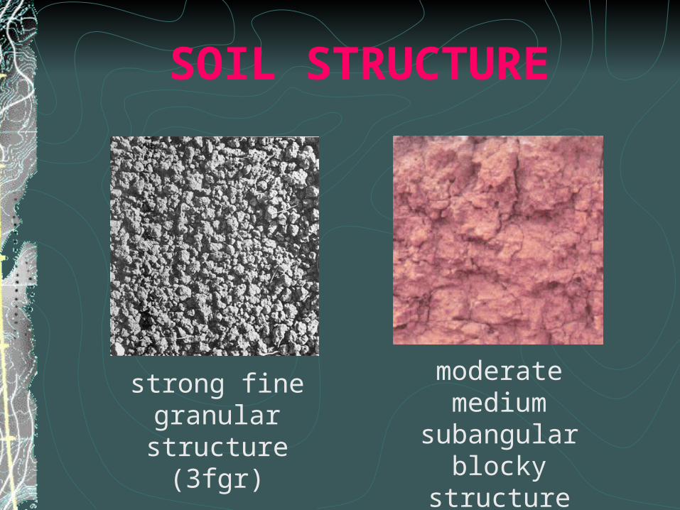
SOIL STRUCTURESOIL STRUCTURE
Formed when the sand, silt, and clay particles in the soil cling or stick together. Structure is important in water movement and root development in soils. It is determined by the dominant structural type in an undisturbed natural volume of soil. In describing structure, grade, size, and form are used.
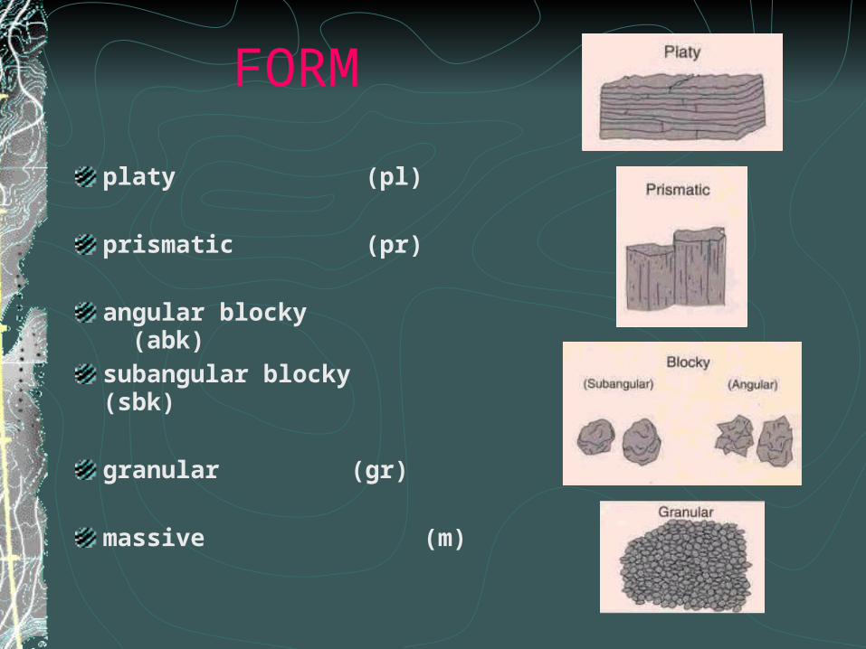
FORM
platy (pl)
prismatic (pr)
angular blocky (abk)
subangular blocky (sbk)
granular (gr)
massive (m)
GRADE
The degree to which soil particles have been formed into distinct and durable peds.
structureless-- no obvious aggregation (0)
weak--poorly formed indistinct peds (1)
moderate--well formed distinct peds (2)
strong--well formed distinct peds that withstand displacement (3)
SIZE
very fine (vf)
fine (f)
medium (m)
coarse (c)
very coarse(vc)
SOIL STRUCTURE
moderate medium subangular blocky structure (2msbk)
strong fine granular structure (3fgr)
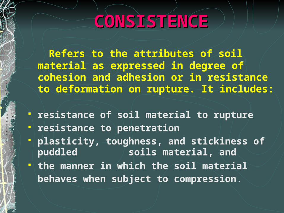
CONSISTENCECONSISTENCE
Refers to the attributes of soil material as expressed in degree of cohesion and adhesion or in resistance to deformation on rupture. It includes:
resistance of soil material to rupture resistance to penetration plasticity, toughness, and stickiness of puddled
soils material, and the manner in which the soil material behaves
when subject to compression.
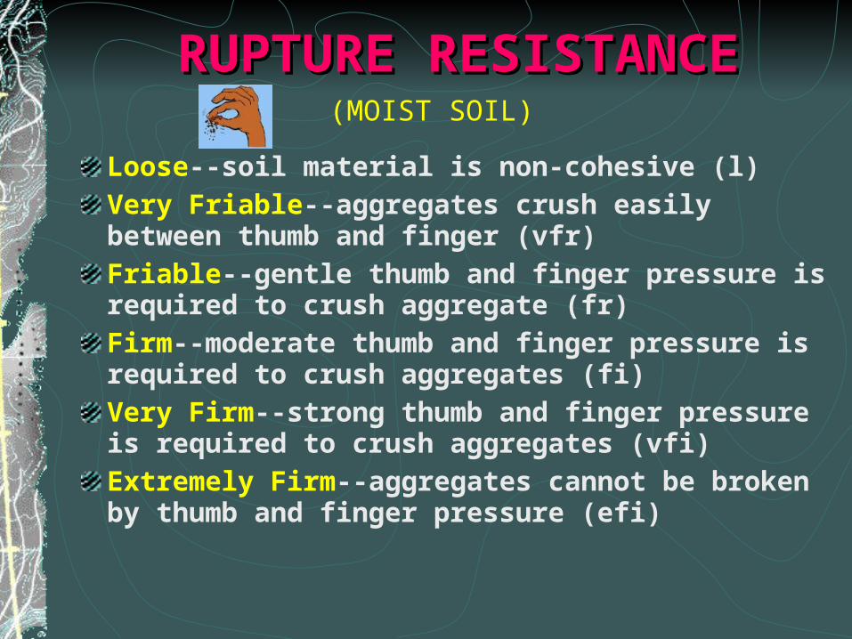
RUPTURERUPTURE RESISTANCERESISTANCE
Loose--soil material is non-cohesive (l)
Very Friable--aggregates crush easily between thumb and finger (vfr)
Friable--gentle thumb and finger pressure is required to crush aggregate (fr)
Firm--moderate thumb and finger pressure is required to crush aggregates (fi)
Very Firm--strong thumb and finger pressure is required to crush aggregates (vfi)
Extremely Firm--aggregates cannot be broken by thumb and finger pressure (efi)
(MOIST SOIL)

STICKINESS CLASSESSTICKINESS CLASSES
Nonsticky--almost no natural adhesion of soil material to fingers (so)
Slightly Sticky--soil material adheres to one finger but other finger is clean (ss)
Sticky--soil material adheres to both fingers and thumb; stretches somewhat (s)
Very Sticky--soil material strongly adheres to both thumb and finger (vs)
(WET SOIL)
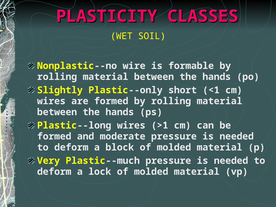
PLASTICITY CLASSESPLASTICITY CLASSES
Nonplastic--no wire is formable by rolling material between the hands (po)
Slightly Plastic--only short (<1 cm) wires are formed by rolling material between the hands (ps)
Plastic--long wires (>1 cm) can be formed and moderate pressure is needed to deform a block of molded material (p)
Very Plastic--much pressure is needed to deform a lock of molded material (vp)
(WET SOIL)
SOIL BOUNDARYSOIL BOUNDARY
A surface or transitional layer between two adjoining horizons. It is roughly parallel to the soil surface. Most boundaries are zones of transition rather than sharp lines of division. Boundaries vary in distinctness and topography.
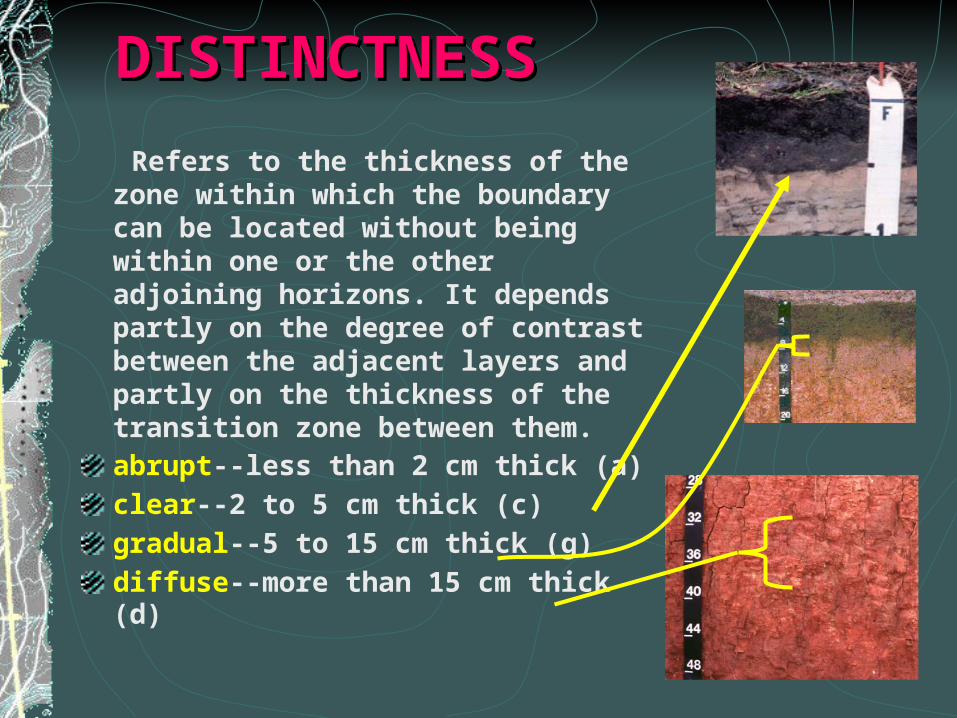
DISTINCTNESSDISTINCTNESS
Refers to the thickness of the zone within which the boundary can be located without being within one or the other adjoining horizons. It depends partly on the degree of contrast between the adjacent layers and partly on the thickness of the transition zone between them.abrupt--less than 2 cm thick (a)
clear--2 to 5 cm thick (c)
gradual--5 to 15 cm thick (g)
diffuse--more than 15 cm thick (d)
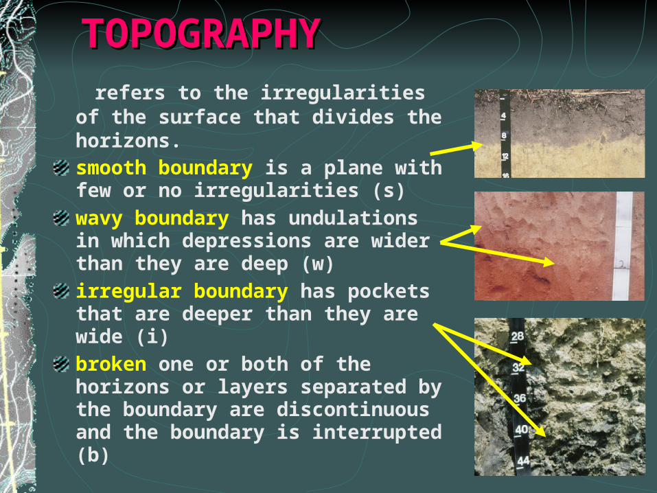
TOPOGRAPHYTOPOGRAPHY refers to the irregularities of the
surface that divides the horizons. smooth boundary is a plane with few or no irregularities (s)
wavy boundary has undulations in which depressions are wider than they are deep (w)
irregular boundary has pockets that are deeper than they are wide (i)
broken one or both of the horizons or layers separated by the boundary are discontinuous and the boundary is interrupted (b)
Rich HayesSoil Scientist Aquifer Protection SectionRaleigh Regional Office