Embed Size (px)
Citation preview
Bathymetry of the Northern Gulf of Mexico and the Atlantic Ocean
East of Florida
Undersea Feature Names GazetteerSource Abbrevaitions:BGN = Names from BGN Gazetteer.Bryant etal 90 = Bryant WR, Bryant JR, Feeley MH, and Simmons GR (1990) Geomarine Letters 10: 182-199.B&B 94 = Bouma AH, and Bryant WR (1994) Geomarine Letters: 14: 252-263.IBCCA04 = Names from IBCCA area 1-04.Liu & Bryant 97 = Names from Liu and Bryant unpublished map.Taylor etal 99 = Names from No GOM bathy map & CD-ROM.
FEATURE NAMEFEATURE
TYPELATITUDE LONGITUDE SOURCE
FEATURE NAMEORIGIN
Acadia Mound mound 27 18N 92 05W B & B 94Former home of manyLA French ; AcadiaParish LA
Acadiana Basin basin 26 46N 93 15W Taylor etal 99Cultural domain ofmany LA French whocame from Acadia
Adeline Bank bank 27 56N 91 28W B & B 94 Town of Adeline, St.Mary Parish LA
Agassiz Basin basin 26 53N 90 58W B & B 94Early USoceanographerAlexander Agassiz
Agassiz Valleys valleys 24 00N 82 45W BGNEarly U. S.oceanographerAlexander Agassiz
Alaminos Bank bank 28 01N 91 45W BGNFormer Texas A&Moceanographic shipALAMINOS
Alaminos Canyon canyon 26 30N 94 35W BGNFormer Texas A&Moceanographic shipALAMINOS
Alamo Mound mound 27 27N 94 53W Bryant etal90
San Antonio site ofsiege during TXrevolution of1836
Alderdice Bank bank 28 05N 92 00W BGN
Amery Terrace terrace 25 57N 91 42W Bryant etal90
Pioneer salt domegeologist George B.Amery
Anderson Basin basin 26 20N 93 43W Liu & Br 97
Antoine Bank bank 27 50N 92 18W BGNFormer Texas A&Mresearcher JohnAntoine
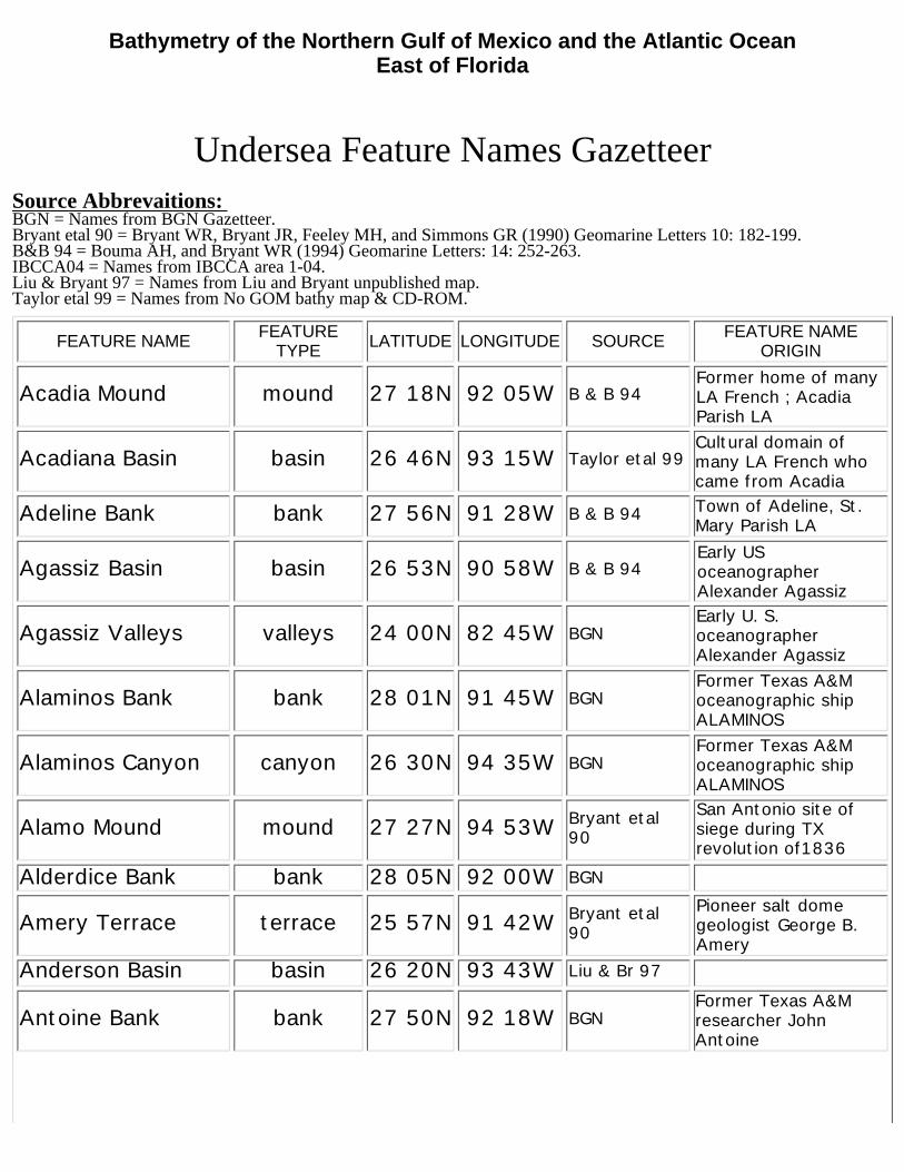
Appelbaum Bank bank 27 51N 94 15W BGNFormer Texas A&Mresearcher BruceAppelbaum
Arellano Basin basin 26 26N 91 05W B & B 94Span. Missionary atLos Adaes Fray PedroRamirez de Arellano
Assumption Dome basin 27 40N 91 28W B & B 94 Assumption Parish LA
Atakapa Basin basin 26 31N 91 42W B & B 94Natv ams (Atakapan)who resided in SE TXand SW LA
Atwater Valley valley 27 30N 87 30W BGNLocated in US MineralsMgmt Service leaseblock ATWATER
Austin Basin basin 26 36N 94 58W Bryant etal90
TX empresario andcolonial leaderStephen F. Austin
Bahama Basin basin 29 15N 74 15W IBCCA04Lies adjacent to andeast of the BahamaRidge
BahamaEscarpment escarpment 24 00N 74 45W IBCCA04
Escarpment boundsthe northern BahamaIs. to the east
Bahama Ridge ridge 28 30N 74 30W Taylor etal 99 Lies northeast of theBahama Islands
Barton Basin basin 27 06N 94 26W Bryant etal90
Pioneer TX and saltdome geologist D. C.Barton
Bates Hill hill 26 13N 95 09W Bryant etal90
Former U. S. Navyoceanographer CharlesC. Bates
Bayogoula Mound mound 27 24N 92 57W B & B 94The town of BayouGoula, Iberville ParishLA
Beaufort Valley valley 32 18N 78 10W BGNThe town of Beaufort,Carteret County,coastal NC
Beaumont Basin basin 26 32N 92 13W B & B 94City of Beaumont TX;early Anglo-Normanfamily of reknown
Bernard Basin basin 27 06N 92 27W B & B 94 Saint Bernard Parishand town, coastal LA
Berryhill Basin basin 27 18N 93 32W Bryant etal90
Former U. S. Geol.Survey geologistHenry Berryhill
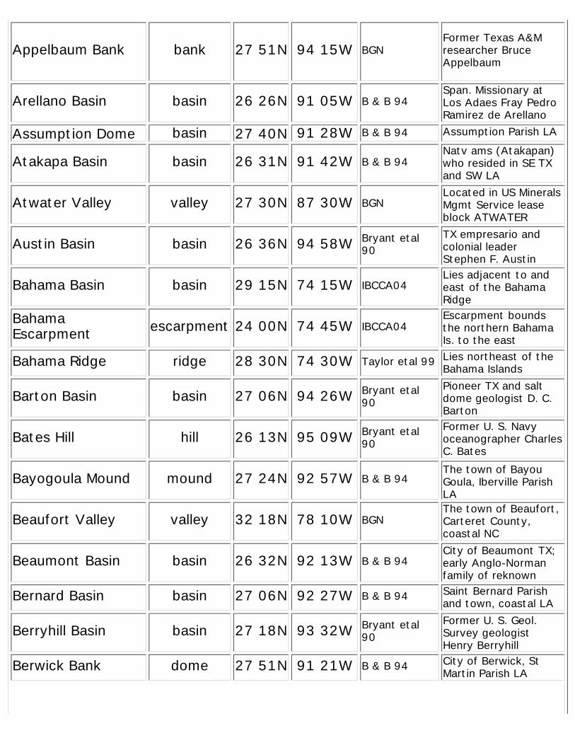
Berwick Bank dome 27 51N 91 21W B & B 94 City of Berwick, StMartin Parish LA
shoal
Bienville Basin basin 26 59N 92 04W B & B 94Founder, New Orleans1718 Sieur deBienville; LA Parish
Biloxi Dome dome 28 40N 88 27W Liu & Br 97Natv ams (Siouan) ofcoastal MS; City ofBiloxi MS
Bird Mound mound 27 53N 88 07W Liu & Br 97 Commemorative ofbirds
Blake Abyssal Plain plain 29 30N 76 04W IBCCA04Lies in the Blake Basinadjacent to the BlakeEsc.
Blake Basin basin 28 35N 75 50W IBCCA04Lg basin bounded bythe Blake Esc. andBahama Ridge
Blake Canyon canyon 30 13N 76 03W BGNEarly (1874) US CoastSurvey oceanographicship
Blake Escarpment escarpment 29 00N 76 45W BGNEarly (1874) US CoastSurvey oceanographicship
Blake Plateau terrace 31 00N 79 00W BGNEarly (1874) US CoastSurvey oceanographicship
Blake Ridge ridge 30 30N 74 00W Taylor etal 99Early (1876) CoastSurvey oceanographicship
Blake Spur spur 30 00N 76 30W BGNEarly (1874) US CoastSurvey oceanographicship
Blake Trough trough 28 30N 76 35W Taylor etal 99Early (1876) CoastSurvey oceanographicship
Bon Secour Mound mound 28 32N 88 01W Liu & Br 97Bon Secour Bay, River,and village, BaldwinCounty AL
Bornhauser Basin basin 26 39N 92 20W B & B 94Gulf Coast petroleumgeologist M.Bornhauser
Bouma Bank bank 28 03N 92 27W BGNLouisiana State Univ.marine geologistArnold Bouma
Bowie Basin basin 27 33N 94 10W Bryant etal90
James Bowie, early TXcolonist and hero ofthe Alamo
Braunstein Mound mound 27 06N 93 55W Bryant etal90
Pioneer Gulf Coastgeologist JulesBraunstein
BGNBethel Shoal 27 44N 80 11W
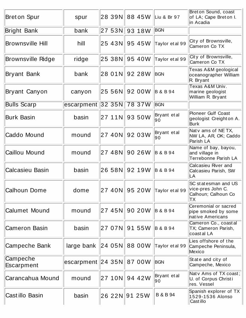
Breton Spur spur 28 39N 88 45W Liu & Br 97Breton Sound, coastof LA; Cape Breton I.in Acadia
Bright Bank bank 27 53N 93 18W BGN
Brownsville Hill hill 25 43N 95 45W Taylor etal 99 City of Brownsville,Cameron Co TX
Brownsville Ridge ridge 25 38N 95 40W Taylor etal 99 City of Brownsville,Cameron Co TX
Bryant Bank bank 28 01N 92 28W BGNTexas A&M geologicaloceanographer WilliamR. Bryant
Bryant Canyon canyon 25 56N 92 00W B & B 94Texas A&M Univ.marine geologistWilliam R. Bryant
Bulls Scarp escarpment 32 35N 78 37W BGN
Burk Basin basin 27 11N 93 50W Bryant etal90
Pioneer Gulf Coastgeologist Creighton A.Burk
Caddo Mound mound 27 40N 92 03W Bryant etal90
Natv ams of NE TX,NW LA, AR, OK; CaddoParish LA
Caillou Mound mound 27 48N 90 26W B & B 94Name of bay, bayou,and village inTerrebonne Parish LA
Calcasieu Basin basin 26 58N 92 19W B & B 94Calcasieu River andCalcasieu Parish, SWLA
Calhoun Dome dome 27 40N 95 20W Taylor etal 99SC statesman and USvice-pres John C.Calhoun; Calhoun CoTX
Calumet Mound mound 27 45N 90 20W B & B 94Ceremonial or sacredpipe smoked by somenative Americans
Cameron Basin basin 27 07N 91 55W B & B 94Cameron Co., coastalTX; Cameron Parish,coastal LA
Campeche Bank large bank 24 05N 88 00W Taylor etal 99Lies offshore of theCampeche Peninsula,Mexico
CampecheEscarpment escarpment 24 35N 87 00W BGN State and city of
Campeche, Mexico
Carancahua Mound mound 27 10N 94 42W Bryant etal90
Natv Ams of TX coast;U. of Corpus Christires. VesselSpanish explorer of TX1529-1536 AlonsoCastillo Basin basin 26 22N 91 25W B & B 94Castillo

Cat Basin basin 27 15N 90 42W B & B 94Cat Island, barrierisland, coast ofMississippi
Cat Gap gap 24 32N 74 17W IBCCA04 Lies northeast of CatIsland in the Bahamas
Cat Valley valley 24 58N 75 35W Taylor etal 99 Lies offshore of CatIsland in the Bahamas
Central Slope slope 27 10N 92 50W BGNIts intermediateposition on the N Gulfcontinental slope
Chalmette Basin basin 26 18N 92 17W B & B 94The city of Chalmette,Saint Bernard ParishLA
Chandeleur Valley valley 28 25N 88 55W Liu & Br 97 Chandeleur Islands,coast of LA
Charleston Valley valley 32 42N 77 50W BGN The city of CharlestonSC
Cherokee Mound mound 27 37N 92 30W Bryant etal90
Iroquoian natv ams ofSouth. Appalachiansand NE OK
Choctaw Basin basin 26 45N 91 16W B & B 94Natv. Americans ofMS, moved to OK;Choctaw County OK
Chorreras Canyon canyon 24 05N 96 32W Taylor etal 99Lies offshore ofArroyo Chorreras,Tamaulipas, Mexico
Claypile Bank bank 28 20N 94 10W BGN
Coleman Basin basin 26 51N 93 43W Liu & Br 97Louisiana State Univ.marine geologistJames Coleman
ColumbusSeamount seamount 24 35N 74 13W IBCCA04
Lies off San SalvadorI., ChristopherColumbus landfall
Cooke Basin basin 26 30N 92 42W B & B 94 Cooke County TX
Corpus ChristiMound mound 26 02N 95 11W Taylor etal 99 City of Corpus Christi,
Nueces County TX
Cortéz Canyon canyon 26 04N 91 17W B & B 94Spanish conquistadorof Aztec MexicoHernando Cortez
Coushatta Mound mound 27 42N 92 24W Bryant etal90
Natv ams(Muskogean) of N AL;now in SE TX
Creole Basin basin 26 37N 93 22W Taylor etal 99Early French-speakingsettlers in LA, somefrom West Indies
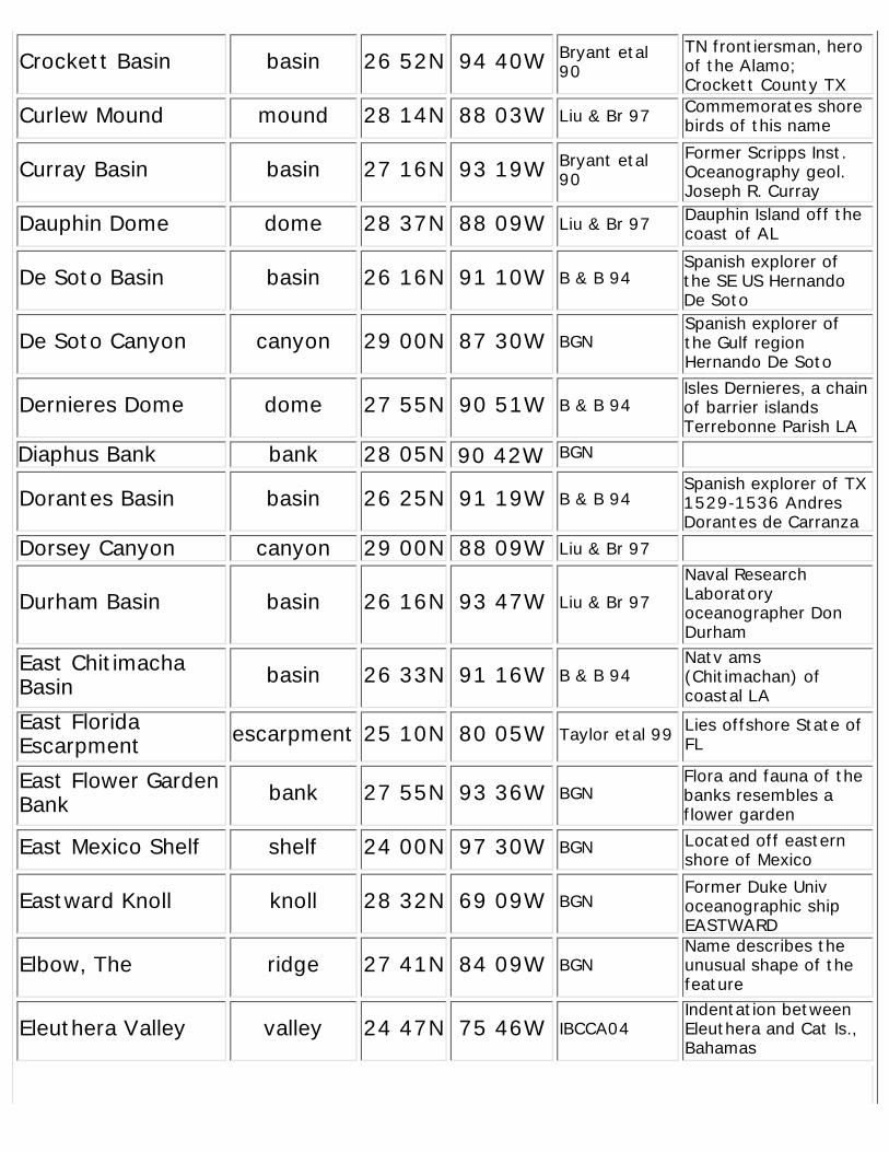
Crockett Basin basin 26 52N 94 40W Bryant etal90
TN frontiersman, heroof the Alamo;Crockett County TX
Curlew Mound mound 28 14N 88 03W Liu & Br 97 Commemorates shorebirds of this name
Curray Basin basin 27 16N 93 19W Bryant etal90
Former Scripps Inst.Oceanography geol.Joseph R. Curray
Dauphin Dome dome 28 37N 88 09W Liu & Br 97 Dauphin Island off thecoast of AL
De Soto Basin basin 26 16N 91 10W B & B 94Spanish explorer ofthe SE US HernandoDe Soto
De Soto Canyon canyon 29 00N 87 30W BGNSpanish explorer ofthe Gulf regionHernando De Soto
Dernieres Dome dome 27 55N 90 51W B & B 94Isles Dernieres, a chainof barrier islandsTerrebonne Parish LA
Diaphus Bank bank 28 05N 90 42W BGN
Dorantes Basin basin 26 25N 91 19W B & B 94Spanish explorer of TX1529-1536 AndresDorantes de Carranza
Dorsey Canyon canyon 29 00N 88 09W Liu & Br 97
Durham Basin basin 26 16N 93 47W Liu & Br 97Naval ResearchLaboratoryoceanographer DonDurham
East ChitimachaBasin basin 26 33N 91 16W B & B 94
Natv ams(Chitimachan) ofcoastal LA
East FloridaEscarpment escarpment 25 10N 80 05W Taylor etal 99 Lies offshore State of
FL
East Flower GardenBank bank 27 55N 93 36W BGN
Flora and fauna of thebanks resembles aflower garden
East Mexico Shelf shelf 24 00N 97 30W BGN Located off easternshore of Mexico
Eastward Knoll knoll 28 32N 69 09W BGNFormer Duke Univoceanographic shipEASTWARD
Elbow, The ridge 27 41N 84 09W BGNName describes theunusual shape of thefeature
Eleuthera Valley valley 24 47N 75 46W IBCCA04Indentation betweenEleuthera and Cat Is.,Bahamas
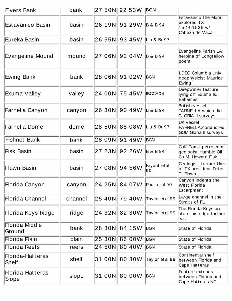
Estavanico Basin basin 26 19N 91 29W B & B 94Estavanico the Moorexplored TX1529-1536 w/Cabeza de Vaca
Eureka Basin basin 26 55N 93 45W Liu & Br 97
Evangeline Mound mound 27 06N 92 04W B & B 94Evangeline Parish LA;heroine of Longfellowpoem
Ewing Bank bank 28 06N 91 02W BGNLDEO Columbia Univ.geophysicist MauriceEwing
Exuma Valley valley 24 00N 75 45W IBCCA04Deepwater featurelying off Exuma Is.,Bahamas
Farnella Canyon canyon 26 30N 90 49W B & B 94British vesselFARNELLA which didGLORIA II surveys
Farnella Dome dome 28 50N 88 08W Liu & Br 97UK vesselFARNELLA;conductedGOM Gloria II surveys
Fishnet Bank bank 28 09N 91 49W BGN
Fisk Basin basin 27 23N 92 26W B & B 94Gulf Coast petroleumgeologist Humble OilCo.M. Howard Fisk
Flawn Basin basin 27 08N 94 56W Bryant etal90
Geologist, former Univ.of TX president PeterT. Flawn
Florida Canyon canyon 24 25N 84 07W Paull etal 90Canyon indents theWest FloridaEscarpment
Florida Channel channel 25 40N 79 40W Taylor etal 99 Large channel in theStraits of FL
Florida Keys Ridge ridge 24 32N 82 30W Taylor etal 99The Florida Keys areatop this ridge farthereast
Florida MiddleGround bank 28 30N 84 15W BGN State of Florida
Florida Plain plain 25 30N 86 00W BGN State of Florida
Florida Reefs reefs 24 50N 80 40W BGN State of Florida
Florida-HatterasShelf shelf 31 00N 80 30W Taylor etal 99
Continental shelfbetween Florida andCape Hatteras
Florida-HatterasSlope slope 31 00N 80 00W BGN
Feature extendsbetween Florida andCape Hatteras NC
Elvers Bank bank 27 50N 92 53W BGN
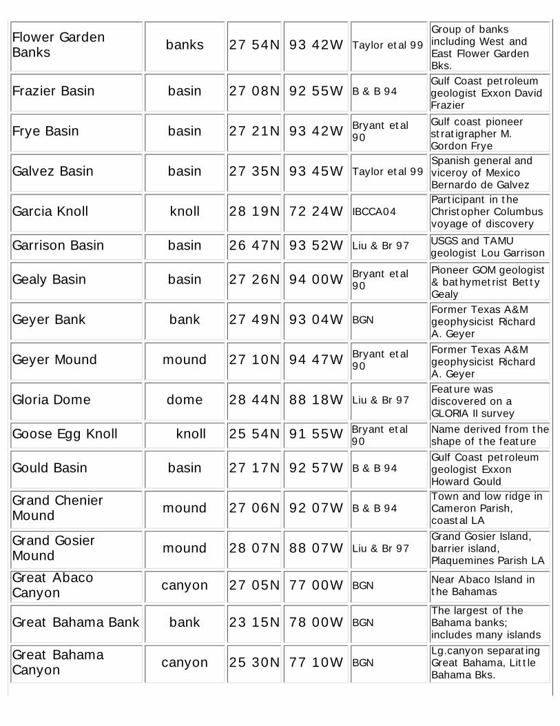
Flower GardenBanks banks 27 54N 93 42W Taylor etal 99
Group of banksincluding West andEast Flower GardenBks.
Frazier Basin basin 27 08N 92 55W B & B 94Gulf Coast petroleumgeologist Exxon DavidFrazier
Frye Basin basin 27 21N 93 42W Bryant etal90
Gulf coast pioneerstratigrapher M.Gordon Frye
Galvez Basin basin 27 35N 93 45W Taylor etal 99Spanish general andviceroy of MexicoBernardo de Galvez
Garcia Knoll knoll 28 19N 72 24W IBCCA04Participant in theChristopher Columbusvoyage of discovery
Garrison Basin basin 26 47N 93 52W Liu & Br 97 USGS and TAMUgeologist Lou Garrison
Gealy Basin basin 27 26N 94 00W Bryant etal90
Pioneer GOM geologist& bathymetrist BettyGealy
Geyer Bank bank 27 49N 93 04W BGNFormer Texas A&Mgeophysicist RichardA. Geyer
Geyer Mound mound 27 10N 94 47W Bryant etal90
Former Texas A&Mgeophysicist RichardA. Geyer
Gloria Dome dome 28 44N 88 18W Liu & Br 97Feature wasdiscovered on aGLORIA II survey
Goose Egg Knoll knoll 25 54N 91 55W Bryant etal90
Name derived from theshape of the feature
Gould Basin basin 27 17N 92 57W B & B 94Gulf Coast petroleumgeologist ExxonHoward Gould
Grand ChenierMound mound 27 06N 92 07W B & B 94
Town and low ridge inCameron Parish,coastal LA
Grand GosierMound mound 28 07N 88 07W Liu & Br 97
Grand Gosier Island,barrier island,Plaquemines Parish LA
Great AbacoCanyon canyon 27 05N 77 00W BGN Near Abaco Island in
the Bahamas
Great Bahama Bank bank 23 15N 78 00W BGNThe largest of theBahama banks;includes many islands
Great BahamaCanyon canyon 25 30N 77 10W BGN
Lg.canyon separatingGreat Bahama, LittleBahama Bks.
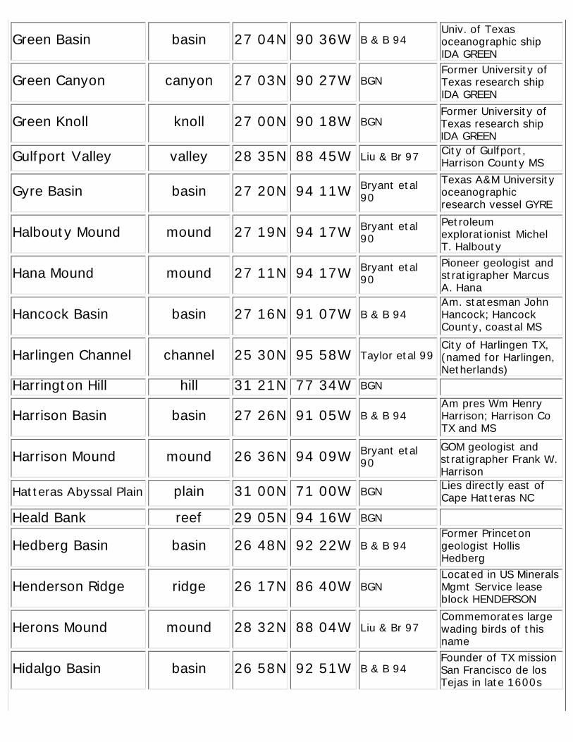
Green Basin basin 27 04N 90 36W B & B 94Univ. of Texasoceanographic shipIDA GREEN
Green Canyon canyon 27 03N 90 27W BGNFormer University ofTexas research shipIDA GREEN
Green Knoll knoll 27 00N 90 18W BGNFormer University ofTexas research shipIDA GREEN
Gulfport Valley valley 28 35N 88 45W Liu & Br 97 City of Gulfport,Harrison County MS
Gyre Basin basin 27 20N 94 11W Bryant etal90
Texas A&M Universityoceanographicresearch vessel GYRE
Halbouty Mound mound 27 19N 94 17W Bryant etal90
Petroleumexplorationist MichelT. Halbouty
Hana Mound mound 27 11N 94 17W Bryant etal90
Pioneer geologist andstratigrapher MarcusA. Hana
Hancock Basin basin 27 16N 91 07W B & B 94Am. statesman JohnHancock; HancockCounty, coastal MS
Harlingen Channel channel 25 30N 95 58W Taylor etal 99City of Harlingen TX,(named for Harlingen,Netherlands)
Harrington Hill hill 31 21N 77 34W BGN
Harrison Basin basin 27 26N 91 05W B & B 94Am pres Wm HenryHarrison; Harrison CoTX and MS
Harrison Mound mound 26 36N 94 09W Bryant etal90
GOM geologist andstratigrapher Frank W.Harrison
Hatteras Abyssal Plain plain 31 00N 71 00W BGN Lies directly east ofCape Hatteras NC
Heald Bank reef 29 05N 94 16W BGN
Hedberg Basin basin 26 48N 92 22W B & B 94Former Princetongeologist HollisHedberg
Henderson Ridge ridge 26 17N 86 40W BGNLocated in US MineralsMgmt Service leaseblock HENDERSON
Herons Mound mound 28 32N 88 04W Liu & Br 97Commemorates largewading birds of thisname
Hidalgo Basin basin 26 58N 92 51W B & B 94Founder of TX missionSan Francisco de losTejas in late 1600s
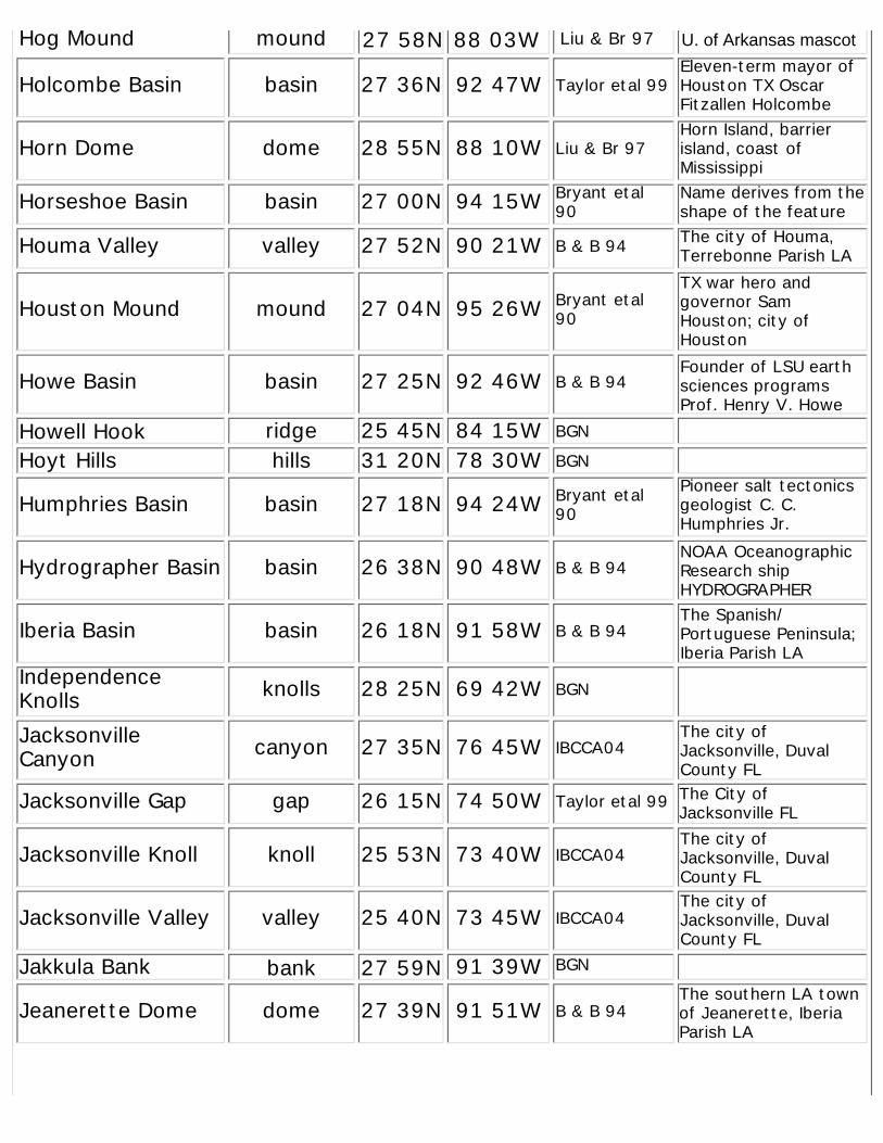
Hog Mound mound
Holcombe Basin basin 27 36N 92 47W Taylor etal 99Eleven-term mayor ofHouston TX OscarFitzallen Holcombe
Horn Dome dome 28 55N 88 10W Liu & Br 97Horn Island, barrierisland, coast ofMississippi
Horseshoe Basin basin 27 00N 94 15W Bryant etal90
Name derives from theshape of the feature
Houma Valley valley 27 52N 90 21W B & B 94 The city of Houma,Terrebonne Parish LA
Houston Mound mound 27 04N 95 26W Bryant etal90
TX war hero andgovernor SamHouston; city ofHouston
Howe Basin basin 27 25N 92 46W B & B 94Founder of LSU earthsciences programsProf. Henry V. Howe
Howell Hook ridge 25 45N 84 15W BGN
Hoyt Hills hills 31 20N 78 30W BGN
Humphries Basin basin 27 18N 94 24W Bryant etal90
Pioneer salt tectonicsgeologist C. C.Humphries Jr.
Hydrographer Basin basin 26 38N 90 48W B & B 94NOAA OceanographicResearch shipHYDROGRAPHER
Iberia Basin basin 26 18N 91 58W B & B 94The Spanish/Portuguese Peninsula;Iberia Parish LA
IndependenceKnolls knolls 28 25N 69 42W BGN
JacksonvilleCanyon canyon 27 35N 76 45W IBCCA04
The city ofJacksonville, DuvalCounty FL
Jacksonville Gap gap 26 15N 74 50W Taylor etal 99 The City ofJacksonville FL
Jacksonville Knoll knoll 25 53N 73 40W IBCCA04The city ofJacksonville, DuvalCounty FL
Jacksonville Valley valley 25 40N 73 45W IBCCA04The city ofJacksonville, DuvalCounty FL
Jakkula Bank bank 27 59N 91 39W BGN
Jeanerette Dome dome 27 39N 91 51W B & B 94The southern LA townof Jeanerette, IberiaParish LA
27 58N 88 03W Liu & Br 97 U. of Arkansas mascot
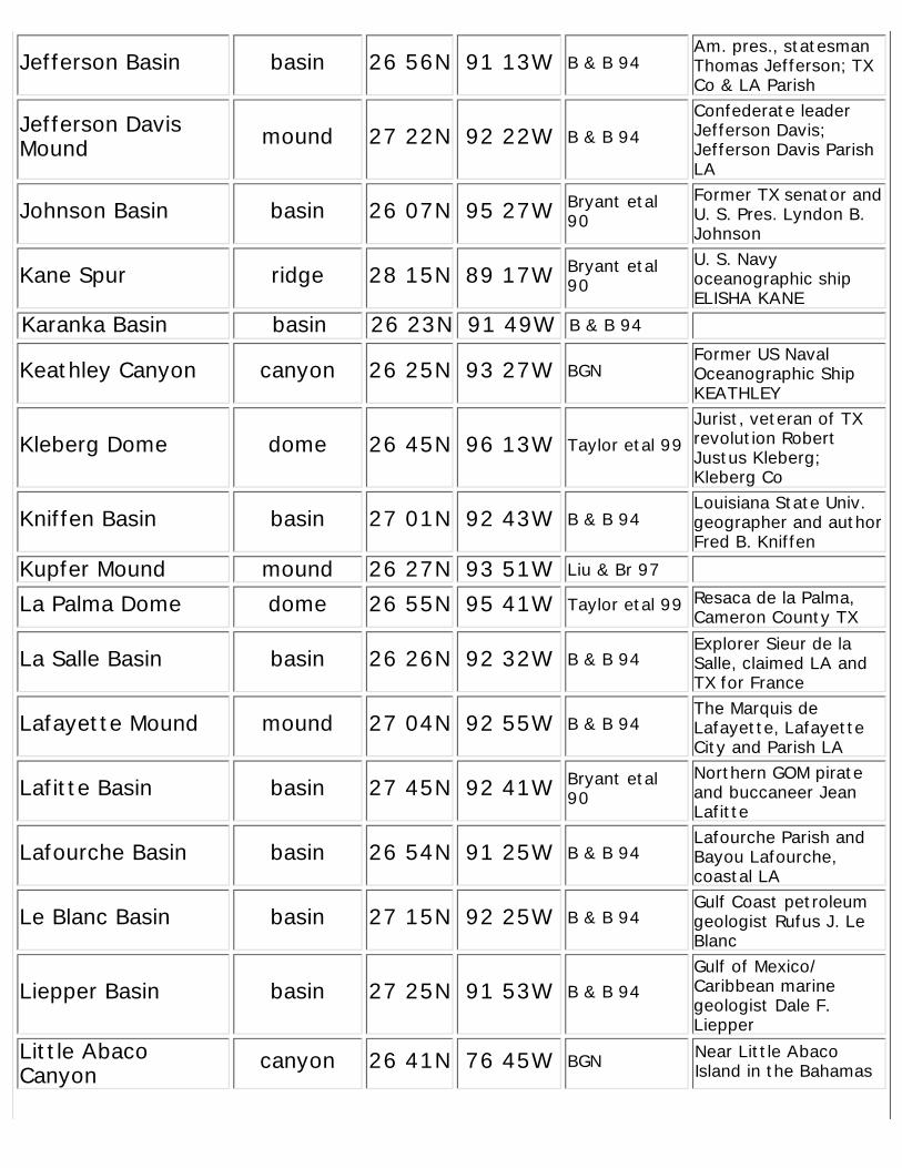
Jefferson Basin basin 26 56N 91 13W B & B 94Am. pres., statesmanThomas Jefferson; TXCo & LA Parish
Jefferson DavisMound mound 27 22N 92 22W B & B 94
Confederate leaderJefferson Davis;Jefferson Davis ParishLA
Johnson Basin basin 26 07N 95 27W Bryant etal90
Former TX senator andU. S. Pres. Lyndon B.Johnson
Kane Spur ridge 28 15N 89 17W Bryant etal90
U. S. Navyoceanographic shipELISHA KANE
Karanka Basin basin 26 23N 91 49W B & B 94
Keathley Canyon canyon 26 25N 93 27W BGNFormer US NavalOceanographic ShipKEATHLEY
Kleberg Dome dome 26 45N 96 13W Taylor etal 99Jurist, veteran of TXrevolution RobertJustus Kleberg;Kleberg Co
Kniffen Basin basin 27 01N 92 43W B & B 94Louisiana State Univ.geographer and authorFred B. Kniffen
Kupfer Mound mound 26 27N 93 51W Liu & Br 97
La Palma Dome dome 26 55N 95 41W Taylor etal 99 Resaca de la Palma,Cameron County TX
La Salle Basin basin 26 26N 92 32W B & B 94Explorer Sieur de laSalle, claimed LA andTX for France
Lafayette Mound mound 27 04N 92 55W B & B 94The Marquis deLafayette, LafayetteCity and Parish LA
Lafitte Basin basin 27 45N 92 41W Bryant etal90
Northern GOM pirateand buccaneer JeanLafitte
Lafourche Basin basin 26 54N 91 25W B & B 94Lafourche Parish andBayou Lafourche,coastal LA
Le Blanc Basin basin 27 15N 92 25W B & B 94Gulf Coast petroleumgeologist Rufus J. LeBlanc
Liepper Basin basin 27 25N 91 53W B & B 94Gulf of Mexico/Caribbean marinegeologist Dale F.Liepper
Little AbacoCanyon canyon 26 41N 76 45W BGN Near Little Abaco
Island in the Bahamas
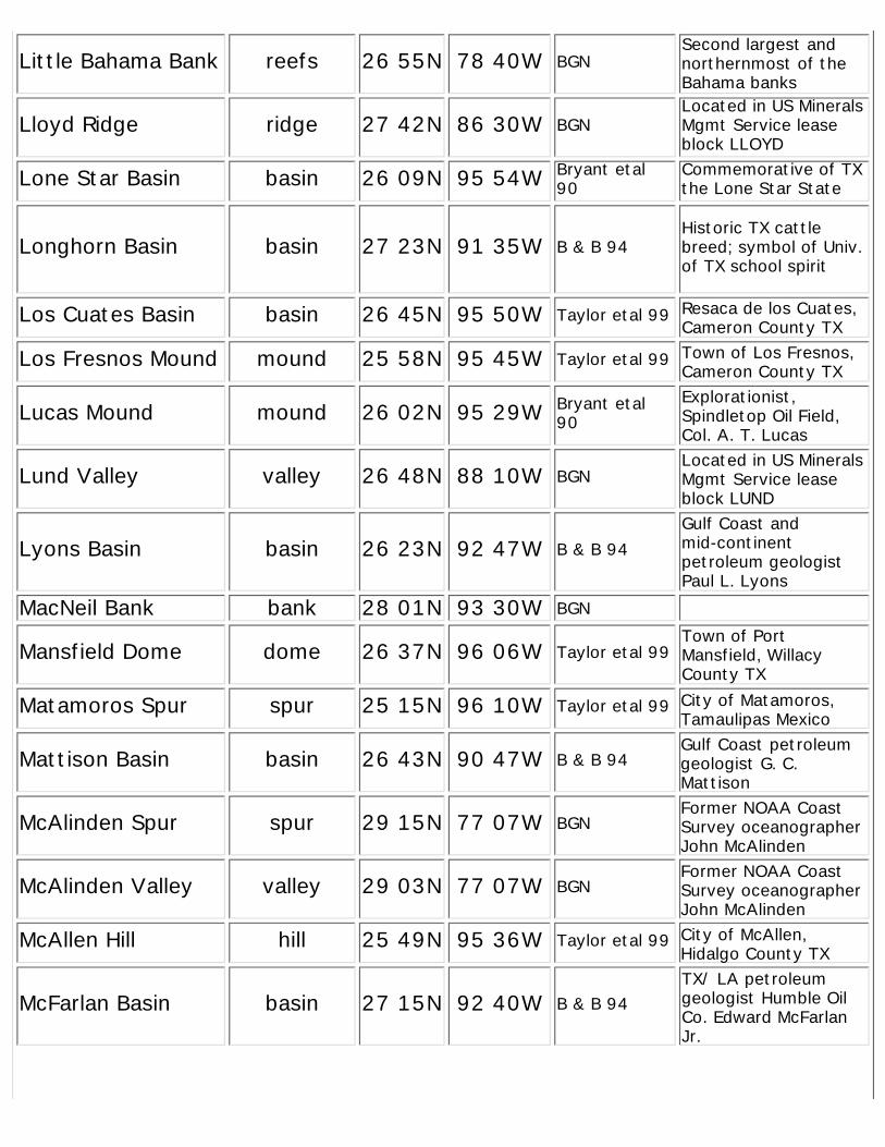
Little Bahama Bank reefs 26 55N 78 40W BGNSecond largest andnorthernmost of theBahama banks
Lloyd Ridge ridge 27 42N 86 30W BGNLocated in US MineralsMgmt Service leaseblock LLOYD
Lone Star Basin basin 26 09N 95 54W Bryant etal90
Commemorative of TXthe Lone Star State
Longhorn Basin basin 27 23N 91 35W B & B 94Historic TX cattlebreed; symbol of Univ.of TX school spirit
Los Cuates Basin basin 26 45N 95 50W Taylor etal 99 Resaca de los Cuates,Cameron County TX
Los Fresnos Mound mound 25 58N 95 45W Taylor etal 99 Town of Los Fresnos,Cameron County TX
Lucas Mound mound 26 02N 95 29W Bryant etal90
Explorationist,Spindletop Oil Field,Col. A. T. Lucas
Lund Valley valley 26 48N 88 10W BGNLocated in US MineralsMgmt Service leaseblock LUND
Lyons Basin basin 26 23N 92 47W B & B 94Gulf Coast andmid-continentpetroleum geologistPaul L. Lyons
MacNeil Bank bank 28 01N 93 30W BGN
Mansfield Dome dome 26 37N 96 06W Taylor etal 99Town of PortMansfield, WillacyCounty TX
Matamoros Spur spur 25 15N 96 10W Taylor etal 99 City of Matamoros,Tamaulipas Mexico
Mattison Basin basin 26 43N 90 47W B & B 94Gulf Coast petroleumgeologist G. C.Mattison
McAlinden Spur spur 29 15N 77 07W BGNFormer NOAA CoastSurvey oceanographerJohn McAlinden
McAlinden Valley valley 29 03N 77 07W BGNFormer NOAA CoastSurvey oceanographerJohn McAlinden
McAllen Hill hill 25 49N 95 36W Taylor etal 99 City of McAllen,Hidalgo County TX
McFarlan Basin basin 27 15N 92 40W B & B 94TX/ LA petroleumgeologist Humble OilCo. Edward McFarlanJr.
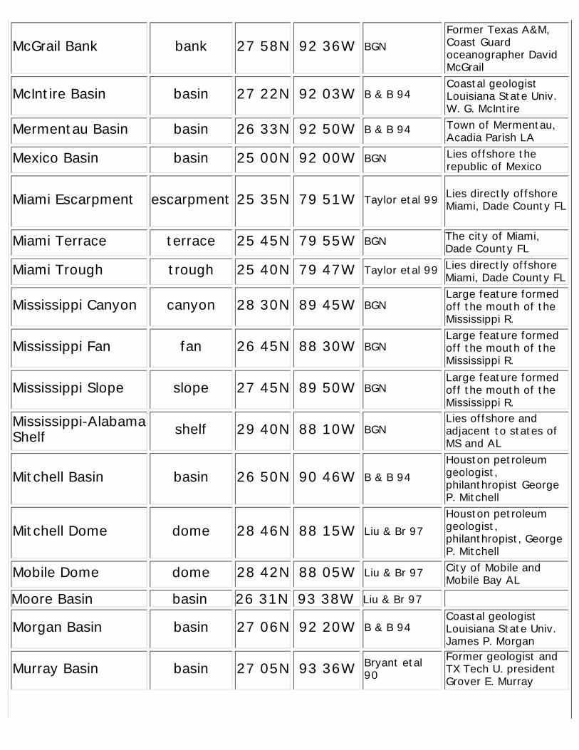
McGrail Bank bank 27 58N 92 36W BGNFormer Texas A&M,Coast Guardoceanographer DavidMcGrail
McIntire Basin basin 27 22N 92 03W B & B 94Coastal geologistLouisiana State Univ.W. G. McIntire
Mermentau Basin basin 26 33N 92 50W B & B 94 Town of Mermentau,Acadia Parish LA
Mexico Basin basin 25 00N 92 00W BGN Lies offshore therepublic of Mexico
Miami Escarpment escarpment 25 35N 79 51W Taylor etal 99 Lies directly offshoreMiami, Dade County FL
Miami Terrace terrace 25 45N 79 55W BGN The city of Miami,Dade County FL
Miami Trough trough 25 40N 79 47W Taylor etal 99 Lies directly offshoreMiami, Dade County FL
Mississippi Canyon canyon 28 30N 89 45W BGNLarge feature formedoff the mouth of theMississippi R.
Mississippi Fan fan 26 45N 88 30W BGNLarge feature formedoff the mouth of theMississippi R.
Mississippi Slope slope 27 45N 89 50W BGNLarge feature formedoff the mouth of theMississippi R.
Mississippi-AlabamaShelf shelf 29 40N 88 10W BGN
Lies offshore andadjacent to states ofMS and AL
Mitchell Basin basin 26 50N 90 46W B & B 94Houston petroleumgeologist,philanthropist GeorgeP. Mitchell
Mitchell Dome dome 28 46N 88 15W Liu & Br 97Houston petroleumgeologist,philanthropist, GeorgeP. Mitchell
Mobile Dome dome 28 42N 88 05W Liu & Br 97 City of Mobile andMobile Bay AL
Moore Basin basin 26 31N 93 38W Liu & Br 97
Morgan Basin basin 27 06N 92 20W B & B 94Coastal geologistLouisiana State Univ.James P. Morgan
Murray Basin basin 27 05N 93 36W Bryant etal90
Former geologist andTX Tech U. presidentGrover E. Murray
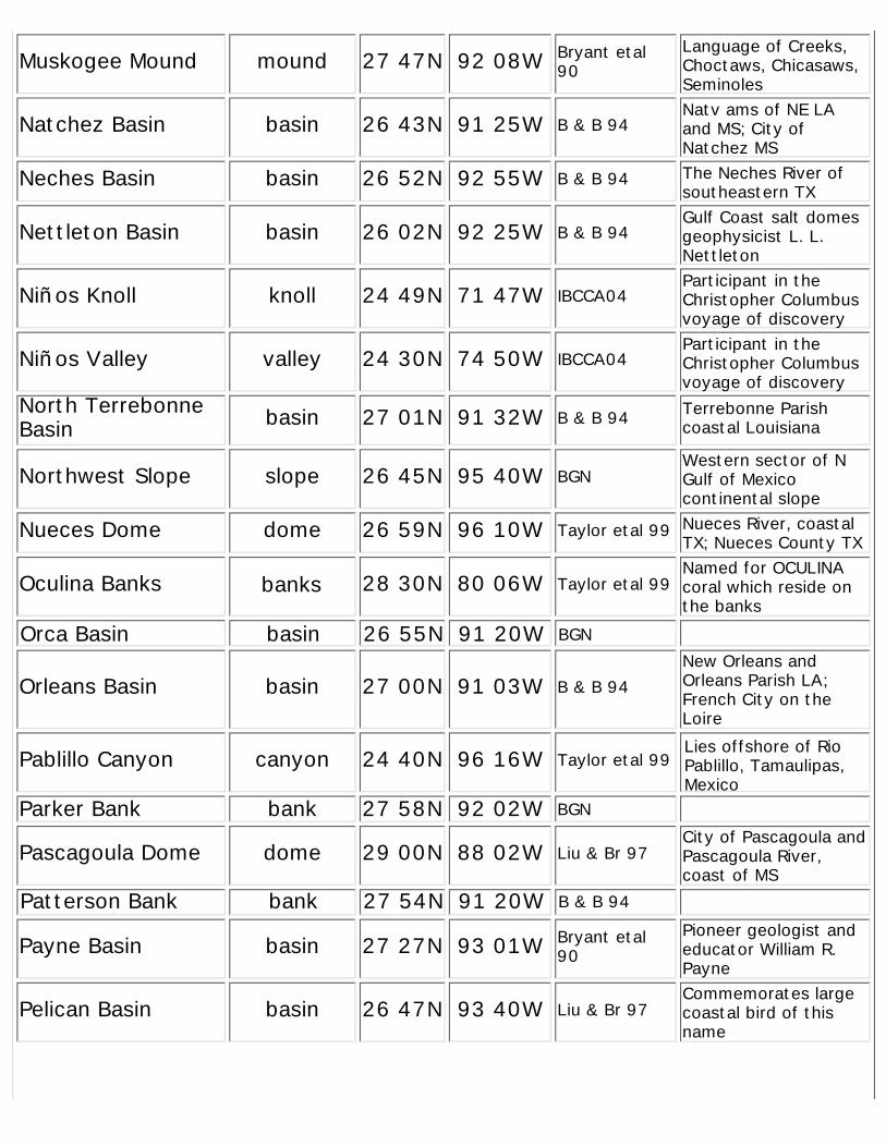
Muskogee Mound mound 27 47N 92 08W Bryant etal90
Language of Creeks,Choctaws, Chicasaws,Seminoles
Natchez Basin basin 26 43N 91 25W B & B 94Natv ams of NE LAand MS; City ofNatchez MS
Neches Basin basin 26 52N 92 55W B & B 94 The Neches River ofsoutheastern TX
Nettleton Basin basin 26 02N 92 25W B & B 94Gulf Coast salt domesgeophysicist L. L.Nettleton
Niños Knoll knoll 24 49N 71 47W IBCCA04Participant in theChristopher Columbusvoyage of discovery
Niños Valley valley 24 30N 74 50W IBCCA04Participant in theChristopher Columbusvoyage of discovery
North TerrebonneBasin basin 27 01N 91 32W B & B 94 Terrebonne Parish
coastal Louisiana
Northwest Slope slope 26 45N 95 40W BGNWestern sector of NGulf of Mexicocontinental slope
Nueces Dome dome 26 59N 96 10W Taylor etal 99 Nueces River, coastalTX; Nueces County TX
Oculina Banks banks 28 30N 80 06W Taylor etal 99Named for OCULINAcoral which reside onthe banks
Orca Basin basin 26 55N 91 20W BGN
Orleans Basin basin 27 00N 91 03W B & B 94New Orleans andOrleans Parish LA;French City on theLoire
Pablillo Canyon canyon 24 40N 96 16W Taylor etal 99Lies offshore of RioPablillo, Tamaulipas,Mexico
Parker Bank bank 27 58N 92 02W BGN
Pascagoula Dome dome 29 00N 88 02W Liu & Br 97City of Pascagoula andPascagoula River,coast of MS
Patterson Bank bank 27 54N 91 20W B & B 94
Payne Basin basin 27 27N 93 01W Bryant etal90
Pioneer geologist andeducator William R.Payne
Pelican Basin basin 26 47N 93 40W Liu & Br 97Commemorates largecoastal bird of thisname
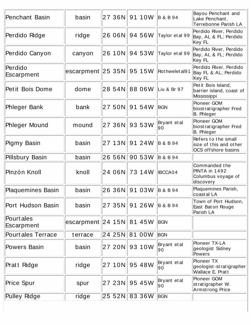
Penchant Basin basin 27 36N 91 10W B & B 94Bayou Penchant andLake Penchant,Terrebonne Parish LA
Perdido Ridge ridge 26 06N 94 56W Taylor etal 99Perdido River, PerdidoBay, AL & FL; PerdidoKey FL
Perdido Canyon canyon 26 10N 94 53W Taylor etal 99Perdido River, PerdidoBay, AL & FL; PerdidoKey FL
PerdidoEscarpment escarpment 25 35N 95 15W Rothweletal91
Perdido River, PerdidoBay FL & AL; PerdidoKey FL
Petit Bois Dome dome 28 54N 88 06W Liu & Br 97Petit Bois Island,barrier island, coast ofMississippi
Phleger Bank bank 27 50N 91 54W BGNPioneer GOMbiostratigrapher FredB. Phleger
Phleger Mound mound 27 36N 93 53W Bryant etal90
Pioneer GOMbiostratigrapher FredB. Phleger
Pigmy Basin basin 27 13N 91 24W B & B 94Refers to the smallsize of this and otherOCS offshore basins
Pillsbury Basin basin 26 56N 90 53W B & B 94
Pinzón Knoll knoll 24 06N 73 14W IBCCA04Commanded thePINTA in 1492Columbus voyage ofdiscovery
Plaquemines Basin basin 26 36N 91 03W B & B 94 Plaquemines Parish,coastal LA
Port Hudson Basin basin 27 35N 91 26W B & B 94Town of Port Hudson,East Baton RougeParish LA
PourtalesEscarpment escarpment 24 15N 81 45W BGN
Pourtales Terrace terrace 24 25N 81 00W BGN
Powers Basin basin 27 20N 93 10W Bryant etal90
Pioneer TX-LAgeologist SidneyPowers
Pratt Ridge ridge 27 10N 95 48W Bryant etal90
Pioneer TXgeologist-stratigrapherWallace E. Pratt
Price Spur spur 27 23N 95 45W Bryant etal90
Pioneer GOMstratigrapher W.Armstrong Price
Pulley Ridge ridge 25 52N 83 36W BGN
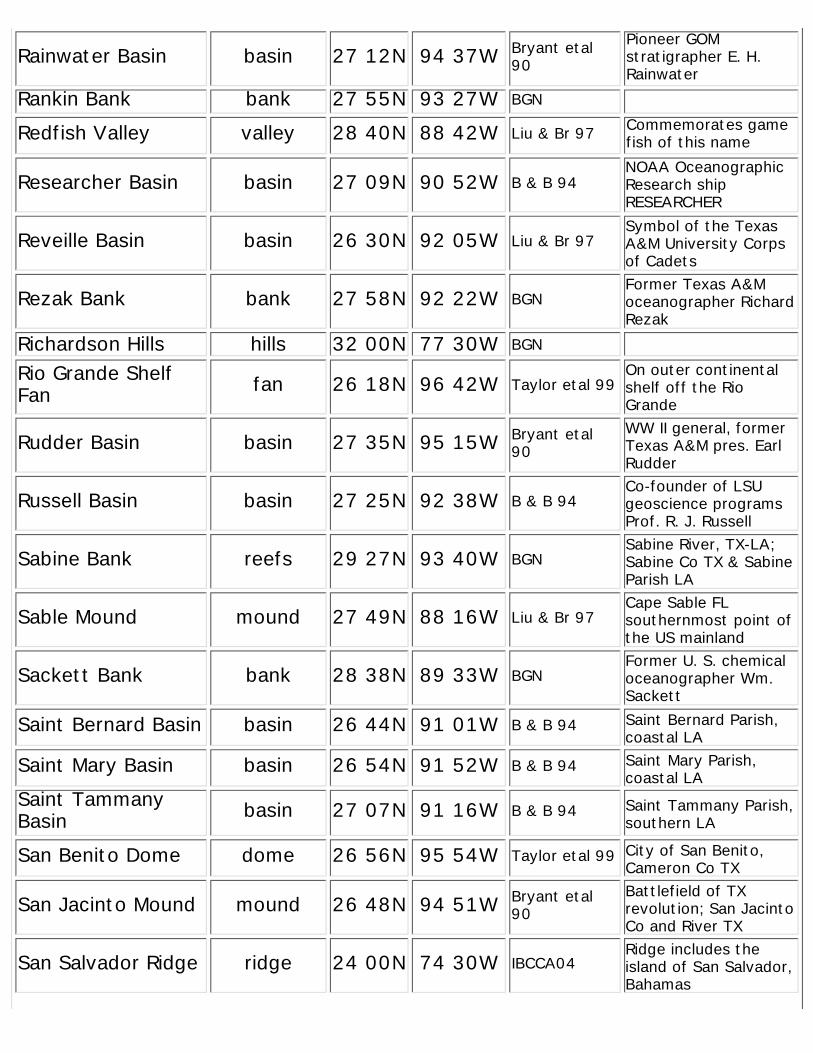
Rainwater Basin basin 27 12N 94 37W Bryant etal90
Pioneer GOMstratigrapher E. H.Rainwater
Rankin Bank bank 27 55N 93 27W BGN
Redfish Valley valley 28 40N 88 42W Liu & Br 97 Commemorates gamefish of this name
Researcher Basin basin 27 09N 90 52W B & B 94NOAA OceanographicResearch shipRESEARCHER
Reveille Basin basin 26 30N 92 05W Liu & Br 97Symbol of the TexasA&M University Corpsof Cadets
Rezak Bank bank 27 58N 92 22W BGNFormer Texas A&Moceanographer RichardRezak
Richardson Hills hills 32 00N 77 30W BGN
Rio Grande ShelfFan fan 26 18N 96 42W Taylor etal 99
On outer continentalshelf off the RioGrande
Rudder Basin basin 27 35N 95 15W Bryant etal90
WW II general, formerTexas A&M pres. EarlRudder
Russell Basin basin 27 25N 92 38W B & B 94Co-founder of LSUgeoscience programsProf. R. J. Russell
Sabine Bank reefs 29 27N 93 40W BGNSabine River, TX-LA;Sabine Co TX & SabineParish LA
Sable Mound mound 27 49N 88 16W Liu & Br 97Cape Sable FLsouthernmost point ofthe US mainland
Sackett Bank bank 28 38N 89 33W BGNFormer U. S. chemicaloceanographer Wm.Sackett
Saint Bernard Basin basin 26 44N 91 01W B & B 94 Saint Bernard Parish,coastal LA
Saint Mary Basin basin 26 54N 91 52W B & B 94 Saint Mary Parish,coastal LA
Saint TammanyBasin basin 27 07N 91 16W B & B 94 Saint Tammany Parish,
southern LA
San Benito Dome dome 26 56N 95 54W Taylor etal 99 City of San Benito,Cameron Co TX
San Jacinto Mound mound 26 48N 94 51W Bryant etal90
Battlefield of TXrevolution; San JacintoCo and River TX
San Salvador Ridge ridge 24 00N 74 30W IBCCA04Ridge includes theisland of San Salvador,Bahamas
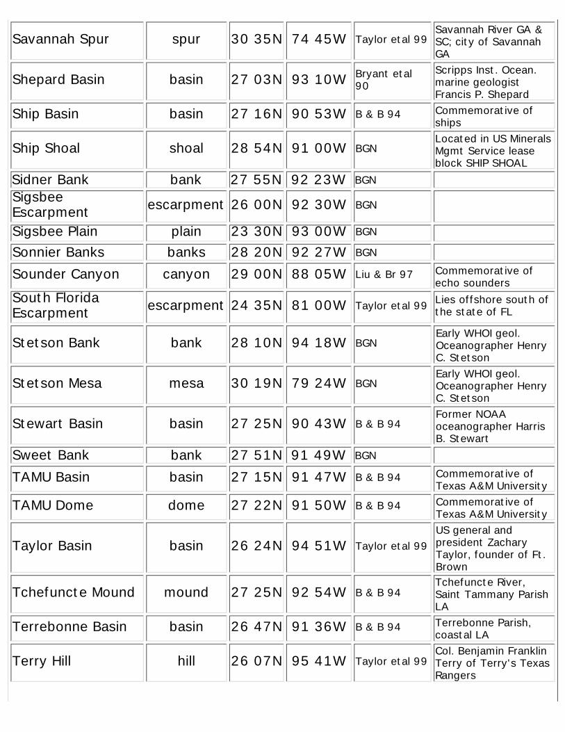
Savannah Spur spur 30 35N 74 45W Taylor etal 99Savannah River GA ≻ city of SavannahGA
Shepard Basin basin 27 03N 93 10W Bryant etal90
Scripps Inst. Ocean.marine geologistFrancis P. Shepard
Ship Basin basin 27 16N 90 53W B & B 94 Commemorative ofships
Ship Shoal shoal 28 54N 91 00W BGNLocated in US MineralsMgmt Service leaseblock SHIP SHOAL
Sidner Bank bank 27 55N 92 23W BGN
SigsbeeEscarpment escarpment 26 00N 92 30W BGN
Sigsbee Plain plain 23 30N 93 00W BGN
Sonnier Banks banks 28 20N 92 27W BGN
Sounder Canyon canyon 29 00N 88 05W Liu & Br 97 Commemorative ofecho sounders
South FloridaEscarpment escarpment 24 35N 81 00W Taylor etal 99 Lies offshore south of
the state of FL
Stetson Bank bank 28 10N 94 18W BGNEarly WHOI geol.Oceanographer HenryC. Stetson
Stetson Mesa mesa 30 19N 79 24W BGNEarly WHOI geol.Oceanographer HenryC. Stetson
Stewart Basin basin 27 25N 90 43W B & B 94Former NOAAoceanographer HarrisB. Stewart
Sweet Bank bank 27 51N 91 49W BGN
TAMU Basin basin 27 15N 91 47W B & B 94 Commemorative ofTexas A&M University
TAMU Dome dome 27 22N 91 50W B & B 94 Commemorative ofTexas A&M University
Taylor Basin basin 26 24N 94 51W Taylor etal 99US general andpresident ZacharyTaylor, founder of Ft.Brown
Tchefuncte Mound mound 27 25N 92 54W B & B 94Tchefuncte River,Saint Tammany ParishLA
Terrebonne Basin basin 26 47N 91 36W B & B 94 Terrebonne Parish,coastal LA
Terry Hill hill 26 07N 95 41W Taylor etal 99Col. Benjamin FranklinTerry of Terry's TexasRangers
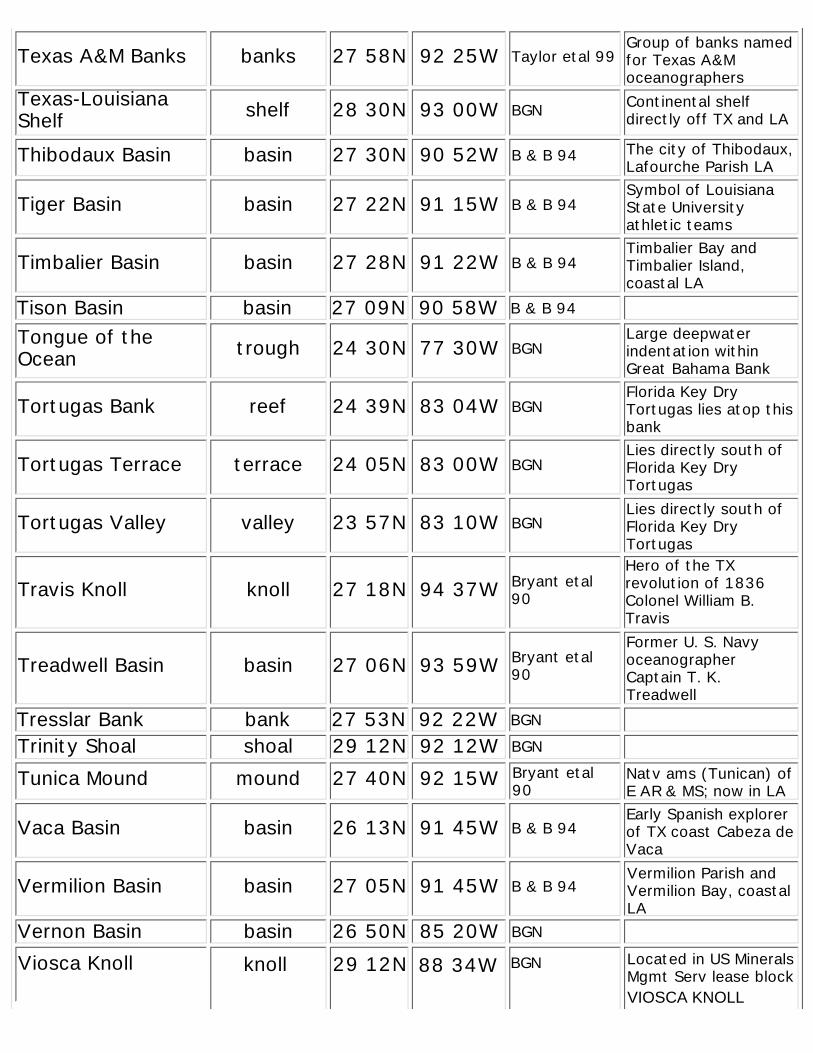
Texas A&M Banks banks 27 58N 92 25W Taylor etal 99Group of banks namedfor Texas A&Moceanographers
Texas-LouisianaShelf shelf 28 30N 93 00W BGN Continental shelf
directly off TX and LA
Thibodaux Basin basin 27 30N 90 52W B & B 94 The city of Thibodaux,Lafourche Parish LA
Tiger Basin basin 27 22N 91 15W B & B 94Symbol of LouisianaState Universityathletic teams
Timbalier Basin basin 27 28N 91 22W B & B 94Timbalier Bay andTimbalier Island,coastal LA
Tison Basin basin 27 09N 90 58W B & B 94
Tongue of theOcean trough 24 30N 77 30W BGN
Large deepwaterindentation withinGreat Bahama Bank
Tortugas Bank reef 24 39N 83 04W BGNFlorida Key DryTortugas lies atop thisbank
Tortugas Terrace terrace 24 05N 83 00W BGNLies directly south ofFlorida Key DryTortugas
Tortugas Valley valley 23 57N 83 10W BGNLies directly south ofFlorida Key DryTortugas
Travis Knoll knoll 27 18N 94 37W Bryant etal90
Hero of the TXrevolution of 1836Colonel William B.Travis
Treadwell Basin basin 27 06N 93 59W Bryant etal90
Former U. S. NavyoceanographerCaptain T. K.Treadwell
Tresslar Bank bank 27 53N 92 22W BGN
Trinity Shoal shoal 29 12N 92 12W BGN
Tunica Mound mound 27 40N 92 15W Bryant etal90
Natv ams (Tunican) ofE AR & MS; now in LA
Vaca Basin basin 26 13N 91 45W B & B 94Early Spanish explorerof TX coast Cabeza deVaca
Vermilion Basin basin 27 05N 91 45W B & B 94Vermilion Parish andVermilion Bay, coastalLA
Vernon Basin basin 26 50N 85 20W BGN
BGN Located in US MineralsMgmt Serv lease block
Viosca Knoll knoll 29 12N 88 34WVIOSCA KNOLL
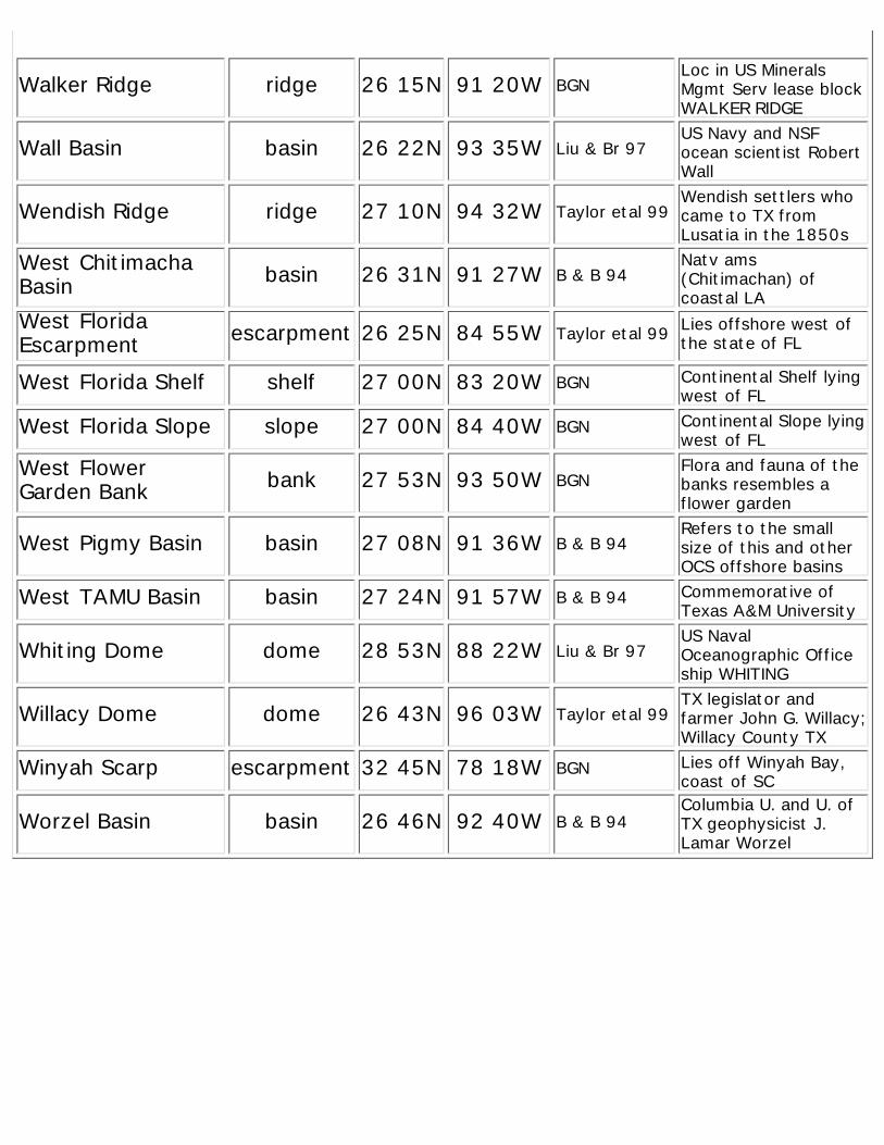
Walker Ridge ridge 26 15N 91 20W BGNLoc in US MineralsMgmt Serv lease blockWALKER RIDGE
Wall Basin basin 26 22N 93 35W Liu & Br 97US Navy and NSFocean scientist RobertWall
Wendish Ridge ridge 27 10N 94 32W Taylor etal 99Wendish settlers whocame to TX fromLusatia in the 1850s
West ChitimachaBasin basin 26 31N 91 27W B & B 94
Natv ams(Chitimachan) ofcoastal LA
West FloridaEscarpment escarpment 26 25N 84 55W Taylor etal 99 Lies offshore west of
the state of FL
West Florida Shelf shelf 27 00N 83 20W BGN Continental Shelf lyingwest of FL
West Florida Slope slope 27 00N 84 40W BGN Continental Slope lyingwest of FL
West FlowerGarden Bank bank 27 53N 93 50W BGN
Flora and fauna of thebanks resembles aflower garden
West Pigmy Basin basin 27 08N 91 36W B & B 94Refers to the smallsize of this and otherOCS offshore basins
West TAMU Basin basin 27 24N 91 57W B & B 94 Commemorative ofTexas A&M University
Whiting Dome dome 28 53N 88 22W Liu & Br 97US NavalOceanographic Officeship WHITING
Willacy Dome dome 26 43N 96 03W Taylor etal 99TX legislator andfarmer John G. Willacy;Willacy County TX
Winyah Scarp escarpment 32 45N 78 18W BGN Lies off Winyah Bay,coast of SC
Worzel Basin basin 26 46N 92 40W B & B 94Columbia U. and U. ofTX geophysicist J.Lamar Worzel