Embed Size (px)
Citation preview

1
Unclassified/FOUO
Unclassified/FOUOEngineer Research and Development Center
Integrated Hydrologic and Socio-Cultural Analysis for Water Security
24 February 2012
ME Red Team Meeting
Briefer:Distribution Statement: FOUO

FOUO
Flooding causes social unrest and potential mass migration
Drought may cause collapse of agriculture and water supply
systems
The US Army provides disaster relief and must make plans for staging and
logistics
Changes to water resources infrastructure can cause social instability
• COCOMs must:• anticipate and understand instabilities and vulnerabilities in their areas of operation• plan and execute disaster relief efforts• develop, compare, and prioritize
• Presently, hydrologic analyses to support these efforts are possible, but are slow to build, limited in size • Socio-cultural analysis tools do not identify potential socio-cultural consequences of water-related stressors.
DoD spends billions of dollars on capacity building both during and after conflict. These investment
decisions are not always made in a way that is culturally aware.
2
Water Security Baseline

Challenges
Large flows of aid affect social stability, power relationships, social and cultural norms. It is crucial to recognize the trade-offs and dynamics between goals of humanitarian assistance, stabilization, and economic development.
Consistent assessments of local conditions should be done to remain aware of changing conditions and minimize the possibility of being blindsided by unintended consequences. [Gregory Johnson, Vijaya Ramachandran, and Julie Walz. 2011. “The
Commander’s Emergency Response Program in Afghanistan: Refining U.S. Military Capabilities in Stability and In-Conflict Development Activities.”]
Water can be a resource or a threat. Any attempt to address water security must start with an assessment of existing conditions and the ability to forecast the impact of potential stressors.
4
Unclassified/FOUO
Unclassified/FOUOEngineer Research and Development Center
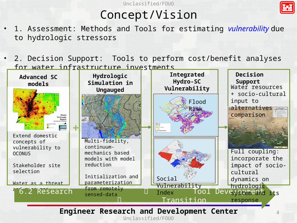
Concept/Vision• 1. Assessment: Methods and Tools for estimating vulnerability due to hydrologic stressors
• 2. Decision Support: Tools to perform cost/benefit analyses for water infrastructure investments
Extend domestic concepts of vulnerability to OCONUS
Stakeholder site selection
Water as a threat and resource
Advanced SC models Hydrologic Simulation in
Ungauged Basins
Integrated Hydro-SC Vulnerability
Assessment
Decision Support
6.2 Research Tool Development Transition
Multi-fidelity, continuum-mechanics based models with model reduction
Initialization and parameterization from remotely sensed-data
+
Flood Risk
Social Vulnerability Index
Water resources + socio-cultural input to alternatives comparison
Full coupling: incorporate the impact of socio-cultural dynamics on hydrologic system and its response
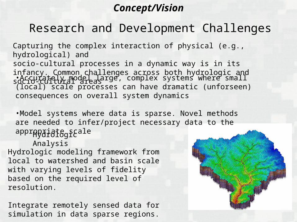
Research and Development Challenges
Concept/Vision
Hydrologic modeling framework from local to watershed and basin scale with varying levels of fidelity based on the required level of resolution.
Integrate remotely sensed data for simulation in data sparse regions.
Capturing the complex interaction of physical (e.g., hydrological) andsocio-cultural processes in a dynamic way is in its infancy. Common challenges across both hydrologic and socio-cultural areas
•Accurately model large, complex systems where small (local) scale processes can have dramatic (unforseen) consequences on overall system dynamics
•Model systems where data is sparse. Novel methods are needed to infer/project necessary data to the appropriate scale
Hydrologic Analysis
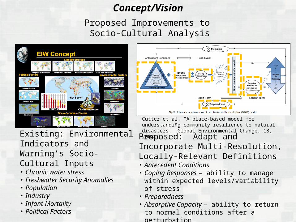
Proposed Improvements to Socio-Cultural Analysis
Existing: Environmental Indicators and Warning’s Socio-Cultural Inputs• Chronic water stress• Freshwater Security Anomalies• Population• Industry• Infant Mortality• Political Factors
Cutter et al. “A place-based model for understanding community resilience to natural disasters.” Global Environmental Change; 18; 2008.
Proposed: Adapt and Incorporate Multi-Resolution, Locally-Relevant Definitions• Antecedent Conditions• Coping Responses – ability to manage within
expected levels/variability of stress• Preparedness• Absorptive Capacity – ability to return to normal
conditions after a perturbation • Adaptive Resilience – ability to transform to a new
configuration to address changing conditions
Concept/Vision
Unclassified/FOUO
Unclassified/FOUOEngineer Research and Development Center
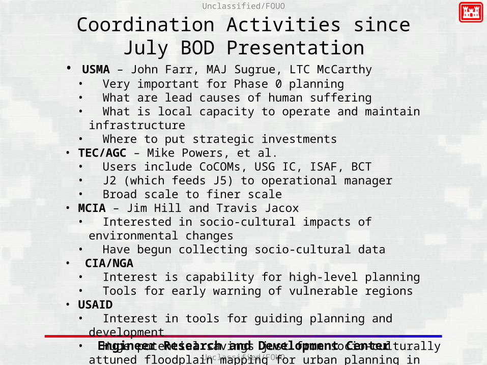
Coordination Activities since July BOD Presentation
• USMA – John Farr, MAJ Sugrue, LTC McCarthy• Very important for Phase 0 planning• What are lead causes of human suffering• What is local capacity to operate and maintain infrastructure• Where to put strategic investments
• TEC/AGC – Mike Powers, et al.• Users include CoCOMs, USG IC, ISAF, BCT• J2 (which feeds J5) to operational manager• Broad scale to finer scale
• MCIA – Jim Hill and Travis Jacox• Interested in socio-cultural impacts of environmental changes• Have begun collecting socio-cultural data
• CIA/NGA• Interest is capability for high-level planning• Tools for early warning of vulnerable regions
• USAID• Interest in tools for guiding planning and development• Huge potential savings just from socio-culturally attuned floodplain mapping
for urban planning in future mega-cities

FY11 FY12 FY13 FY14 FY15 FY16
Project Timeline
Trade-space
analysis
Advance Existing Socio-Cultural Models
Advance Existing Hydrologic Modeling Capabilities
Integrated Hydrologic and Socio-Cultural Assessment
Modeling Environments and Decision Support
Conduct demonstrations and outreach to target customers in DoD
Baseline Demonstration Integration Demonstration Decision Support Demo•Baseline evaluation of basin-scale hydrologic modeling
•Baseline evaluation of social vulnerability assessment
Demonstrations and Evaluations
•Demonstrate water infrastructure scenario analysis capability
•Demonstrate assessment and planning tool support through reachback
Hydro-SC
8FOUO
FOUO
21 December 2011
•Demonstration of flood vulnerability for COCOM basin
•Demonstration water resource vulnerability for COCOM watershed
Assessment Demonstration
•Demonstrate sparse data integration capabilities for trans-national river basin
•Demonstrate web-based delivery of mapping products

9
Unclassified/FOUO
Unclassified/FOUOEngineer Research and Development Center
Water Security Quantitative Metrics
Measure CurrentEffort
ObjectiveArmy
ObjectiveTRL or
SRL
Hydrologic and OCONUS stimuli in socio-cultural models
Only CONUS cultural data and no hydrologic forcings
Include hydrologic and local-cultural stimuli for at least 4
regions of interest
Understand social response to hydrologic events in the cultural context of AFRICOM, EUCOM,
PACOM, SOUTHCOM
3
Rapid assessment of weather and hydrologic
effects
Three weeks for inundation modeling
3-4 days or less for the same product
Process and exploit relevant data and provide real-time support to
commanders’ situational awareness and understanding
5
Coupling of hydrology and socio-cultural
models
Not coupled. Any assessment done
separately
Couple the two capabilities such that either code could be
used to drive the other
Information synthesis; process, and transform data rapidly into
usable knowledge, across a wide range of subjects from military
logistics to culture and economics
3
Development and natural disaster impact
forecasts
Country-level assessment
Sub-national (‘county-level’) assessment
Integration of water security into Theater Campaign Plans.
Improved response for disaster relief
4
Large-scale weather and hydrology
One year or more to develop a large-scale capability
One month or less to develop a large-scale model
Understanding dynamics via remote sensing and predictive
modeling4

Purpose:• Improve capability to understand and forecast risks to national
security as a result of hydrologically-related events.• Anticipate social consequences that may increase instability or
provide room to maneuver for extremist organizations• Leverage USACE’s hydrologic and socio-cultural analysis capabilities
to anticipate and safeguard against water security related issues, providing information for decision support for water infrastructure investment.
• Deliver usable capabilities to COCOM and other USG planners.
Products:• Next generation hydrology models that can:
• Identify inundated areas in days.• Execute over large domains with locally tailored physics and
resolution.• Next generation socio-cultural models that can:.
• Incorporate non-U.S. social dynamics and processes.• Integrate diverse, non-standard demographic data.• Provide locally relevant predictions of vulnerability and resilience
• Coupled hydrology & social-cultural models that can:• Identify groups significantly impacted by hydrological scenarios.• Identify hydrological consequences of social and cultural change.• Explore complex, adaptive interactions between water and society.
Payoff:• Quicker response, more complete representation for disaster relief.• Ability to forecast changes in water supply / demand that allows the
Army, COCOMs and intelligence agencies to include these factors in security policies and strategies.
• Improved ability to prioritize detailed analyses and contingency planning for water-security crises and resource allocation, based on social and cultural impacts.
Integrated Hydrologic and Socio-Cultural Analyses for Water Security
Schedule & Cost
MILESTONES FY13 FY14 FY15 FY16
Hydro-SC vulnerability assessment (threat)
Hydro-SC vulnerability assessment (resource)
Hydro-SC decision support for water infrastructure
AT40 0.5 3.5 4.0 4.0
2 5
3 5
Status: New
3 5
Total:$12.0M
Unclassified / FOUO

11
Unclassified/FOUO
Unclassified/FOUOEngineer Research and Development Center
Backup

Unclassified/FOUO
Unclassified/FOUOEngineer Research and Development Center
Team
12
POC Organization Role
Dr. Mark Jourdan ERDC-CHL Hydrologic product scope and design
Dr. Matthew Farthing ERDC-CHL Multi-scale hydrologic modeling, model coupling
Mr. Tim Perkins ERDC-CERL Socio-cultural dynamics modeling
Dr. Lucy Whalley ERDC-CERL Socio-cultural anthropological analyses
Mr. John Eylander ERDC-CRREL Weather./climate scenarios
Dr. Stacy Howington ERDC-CHL Hydrologic modeling, groundwater/surface water interaction
Ms. Amanda Hines ERDC-ITL Model integration and tool interfaces
TBD Decision support, risk analysis, reduced order modeling
13
Unclassified/FOUO
Unclassified/FOUOEngineer Research and Development Center
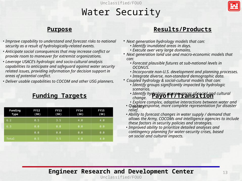
Water Security
Purpose
• Improve capability to understand and forecast risks to national security as a result of hydrologically-related events.
• Anticipate social consequences that may increase conflict or provide room to maneuver for extremist organizations.
• Leverage USACE’s hydrologic and socio-cultural analysis capabilities to anticipate and safeguard against water security related issues, providing information for decision support in areas of potential conflict.
• Deliver usable capabilities to COCOM and other USG planners.
Results/Products
Funding Targets Payoff/Transition
• Quicker response, more complete representation for disaster relief.• Ability to forecast changes in water supply / demand that allows the
Army, COCOMs and intelligence agencies to include these factors in security policies and strategies.
• Improved ability to prioritize detailed analyses and contingency planning for water-security crises, based on social and cultural impacts.
Funding TypeFY12 ($K)
FY13($K)
FY14 ($K)
FY15 ($K)
6.2 0.5 3.5 4.0 4.0
6.3 0.0 0.0 0.0 0.0
0.0 0.0 0.0 0.0
Total 0.5 3.5 4.0 4.0
• Next generation hydrology models that can:• Identify inundated areas in days.• Execute over very large domains.
• Next generation land use and macro-economic models that can:• Forecast plausible futures at sub-national levels in OCONUS.• Incorporate non-U.S. development and planning processes.• Integrate diverse, non-standard demographic data.
• Coupled hydrology & social-cultural models that can:• Identify groups significantly impacted by hydrologic scenarios.• Identify hydrologic consequences of social and cultural change.• Explore complex, adaptive interactions between water and
society.

14
Unclassified/FOUO
Unclassified/FOUOEngineer Research and Development Center
Conflict Anticipation Detailed Milestone Schedule
Milestone/ActivityMilestone A
Activity 1Activity 2Activity 3
Milestone BActivity 4Activity 5Activity 6
Milestone CActivity 7Activity 8Activity 9
FYXX FYXX FYXX FYXX
TRL or SRL: Milestone Timeline: Activity Timeline: Demo: Experiment: Transition:
3
4

Unclassified/FOUO
Unclassified/FOUOEngineer Research and Development Center
FY12 Leveraged Initiatives
MCIA reimbursable work CREATE NSF Funded CI Water Initiative
*Include both internal and external leveraged programs.
16
Unclassified/FOUO
Unclassified/FOUOEngineer Research and Development Center
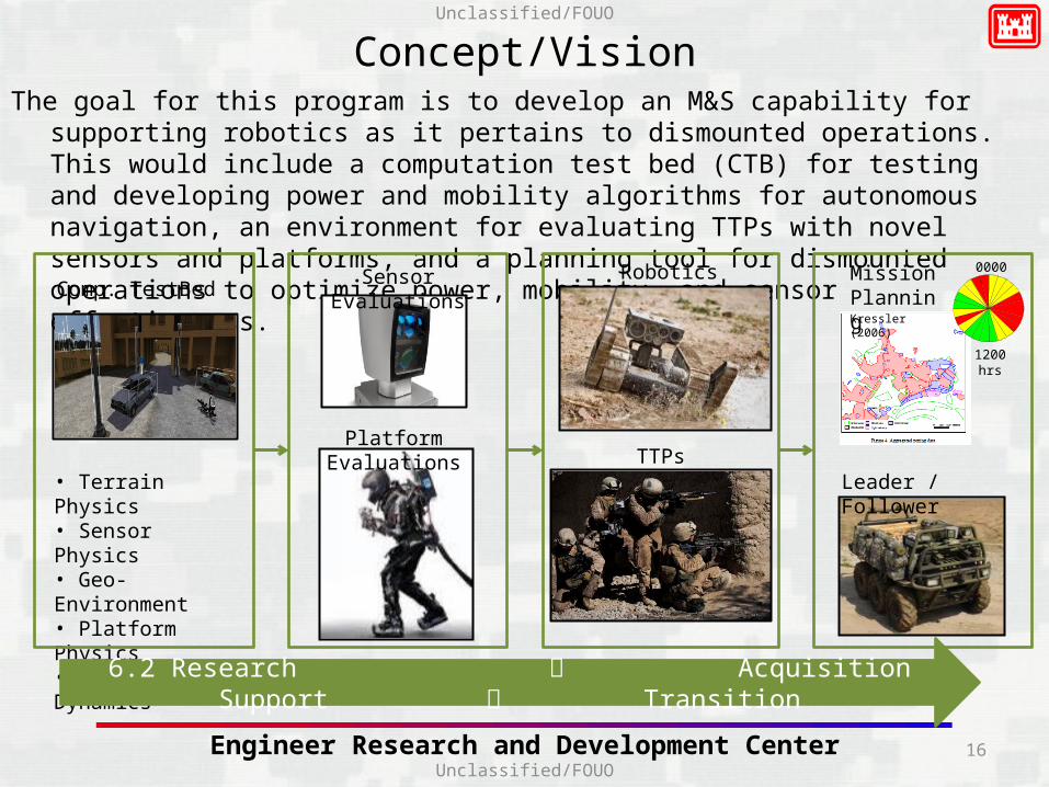
Concept/VisionThe goal for this program is to develop an M&S capability for supporting robotics as it pertains
to dismounted operations. This would include a computation test bed (CTB) for testing and developing power and mobility algorithms for autonomous navigation, an environment for evaluating TTPs with novel sensors and platforms, and a planning tool for dismounted operations to optimize power, mobility, and sensor effectiveness.
• Terrain Physics• Sensor Physics• Geo-Environment• Platform Physics• Human Dynamics
Comp. TestBedSensor Evaluations
Platform Evaluations
Robotics
TTPs
0000 hrs
1200 hrs
Kressler (2006)
Mission Planning
6.2 Research Acquisition Support Transition
Leader / Follower
17
Unclassified/FOUO
Unclassified/FOUOEngineer Research and Development Center
END TEMPLATE

18
Unclassified/FOUO
Unclassified/FOUOEngineer Research and Development Center
Water Security
Future ERDC ImpactsHow, if possible, could this opportunity potentially impact ERDC’s existing
programs? Does this program have potential for follow-on work?
Leveraged Research• AFRICOM Niger River Basin Study.• Gambia River Flood Assessment• UROC reimbursables• CREATE - Cultural Reasoning and Ethnographic Analysis for the Tactical
Environment
Equipment/Facilities Technical Risks2. What are the barriers to solving this problem?• Existing available demographic and social data (including imagery) varies by country and requires
manual processing to integrate and generate compatible datasets.• Hydrologic models have not been integrated with social or cultural models for either linear or
interdependent forecasting.• Land use and macro-economic models require methods to forecast stakeholder decision-making;
current models assume U.S. decision-making processes without consideration of social or cultural differences.
• We are often unable to obtain hydrology results at the necessary resolution in a timely manner.• Data required for existing weather & hydrology models exceed what is commonly available.
3. How will you overcome those barriers?• Apply cross-cultural water crises and development expertise to develop non-U.S.-based land use and
macro-economic models.• Create an intelligent automated process to identify flow paths and add appropriate resolution in
model preprocessing. • Develop large-scale hydrology models linked to AFWA databases with the ability to apply varying
levels of fidelity based on the required level of resolution.• Develop techniques to couple hydrology, land use and macro-economic models for use in decision,
planning and assessment tools.

19
Unclassified/FOUO
Unclassified/FOUOEngineer Research and Development Center
• In 2004, a Defense Science Board Report recommended that Stability Operations be recognized as a core mission for the US Military. This recommendation was codified in Department of Defense Directive (DODD) 3000.05 Military Support for Stability, Security, Transition, and Reconstruction (SSTR) Operations, which was published in late 2005.

20
Conflict Anticipation• Issues
– Flooding– Infrastructure changes– Drought and climate change
• Product– Web-based dynamic maps of
hydrologic state and social stress served through AGC/UROC
– Toolbox for continental-scale to village-scale simulation
• Customers– Intelligence agencies– COCOM Phase 0 planners
Infrastructure Investment • Issues
– Strategic water resources developments (CERP)
– Logistics and investments for disaster relief
• Product– Decision support toolbox with
hydro-sc modeling and analysis at the basin scale
– Water resources + socio-cultural input to alternatives comparison
– Available on reimbursable basis or through reachback
• Customers– COCOM engineers (Evans)

Unclassified/FOUO
Unclassified/FOUOEngineer Research and Development Center
West Point Discussions

22
Unclassified/FOUO
Unclassified/FOUOEngineer Research and Development Center
Water Security Baseline

Unclassified/FOUO
Unclassified/FOUOEngineer Research and Development Center
What are the risks and payoffs?
Risks
Inability to transition and generalize CONUS socio-cultural rules to provide analysis in OCONUS settings
Inability to perform meaningful hydrologic analyses using only remotely sensed data
Payoffs
Advance warning about social instabilities arising from an excess or shortage of water
Water resources projects that increase the local capacity while not creating unforeseen instabilities
Water Security
24
Unclassified/FOUO
Unclassified/FOUOEngineer Research and Development Center
Success and Transition
What are the midterm and final "exams" to check for success?
Midterm
Ability to perform one-way analysis of socio-cultural impacts (e.g., social vulnerability) driven by hydrologic conditions like seasonal flooding in a representative OCONUS basin.
Final
Availability of tools for COCOM planner to explore consequences of water infrastructure project (e.g., new well or levee) on social dynamics in a representative OCONUS region.
What is the proposed transition strategy?• PEO/PM
• Requirement(s)

What are you trying to do?
• Improve the US Army and DoD’s ability to understand and forecast threats to national security and regional stability arising from hydrologic events and water resource decisions.
• Anticipate social consequences of water insecurity that may lead to conflict or provide room to maneuver for violent extremist organizations and/or international criminal organizations.
• Improve water resources investment decisions for stability and capacity building by accounting for their social and cultural context.
• Leverage USACE’s hydrologic and socio-cultural analysis capabilities to anticipate and safeguard against water security related issues, providing information for decision support in areas of potential conflict.
• Deliver usable capabilities to COCOM and other USG planners.
How is it done today, and what are the limits of current practices?
• Existing available demographic and social data (including imagery) varies by country and requires manual processing to integrate and generate compatible datasets.
• Hydrologic models have not been integrated with social or cultural models for either linear or interdependent forecasting.
• Land use and macro-economic models require methods to forecast stakeholder decision-making; current models assume U.S. decision-making processes without consideration of social or cultural differences.
• We are often unable to obtain hydrology results at the necessary resolution in a timely manner.• Data required for existing weather & hydrology models exceed what is commonly available.
Water Security
What's new in your approach and why do you think it will be successful?• Models that can account for social consequences of hydrologic conditions and events for areas of interest are not
available..• We will apply ERDC expertise to translate analyses of risk, vulnerability to appropriate OCONUS social context and
address issues of data (e.g., demographic, economic) availability. • ERDC expertise can provide hydrologic modeling framework from local to watershed and basin scale with varying
levels of fidelity based on the required level of resolution. • We can leverage on-going collaboration and expertise to integrate remotely sensed data for simulation in data sparse
regions.• We will develop techniques to couple hydrology, socio-cultural models for use in decision, planning and assessment
tools
Who cares?• Regional Combatant Commanders (RCCs) must assess and monitor their areas of operations, engage as a partner with
Militaries of other nations, and assure capacity is there in case of natural disaster or instability. These tools will provide a strong foundation on which to build the required Theater Campaign Plans.
– Flooding analyses – J2, J5 COCOMs for prioritized contingency planning / planning disaster relief, AGC/UROC reachback– J2 multi-country plans to combat counter-terrorism, Nile River Basin Authority, Sudan
• RCCs must also make large financial decisions when executing contracts, often under the Commander’s Emergency Response Program. These tools will allow COCOM engineers and planners to include accurate hydrologic and socio-cultural factors when comparing alternative designs and prioritizing projects.
Water Security
If you're successful, what difference will it make?
This effort will
• Provide the ability to identify groups and communities at high risk to changes in hydrologic conditions, and identify potential sources of instability.
• Bring hydrologic and socio-cultural analysis to bear on key planning activities from disaster relief to the prioritization and allocation of resources in the Commander’s Emergency Response Program (CERP) efforts or US Government infrastructure.
• Facilitate collaboration among the military, other U.S. government agencies, and partner nations by identifying water security issues and providing a means to exploring outcomes of proposed actions.
• Facilitate identification and prioritization of water infrastructure projects to meet civil, diplomatic, or military objectives. It will identify water infrastructure projects most appropriate for local, regional, and national consideration with guidelines for prioritization for civil, diplomatic, or military leadership.
Water Security
![Revised Breakout LTC Thomas Stocks 315.pptx [Read-Only] · UNCLASSIFIED//FOUO UNCLASSIFIED//FOUO 3-4 April 2018 Thomas W Stocks RS3 Contract Branch Chief ACC-APG RS3 Contract Armed](https://img.pdfslide.us/doc/110x75/5ae804317f8b9a8704902a23/revised-breakout-ltc-thomas-stocks-315pptx-read-only-unclassifiedfouo-3-4-april.jpg)