Embed Size (px)
Citation preview
TWIN RIVERS PADDLE TRAILS
Craven County
2st Edition November 2006
Cal Hansen
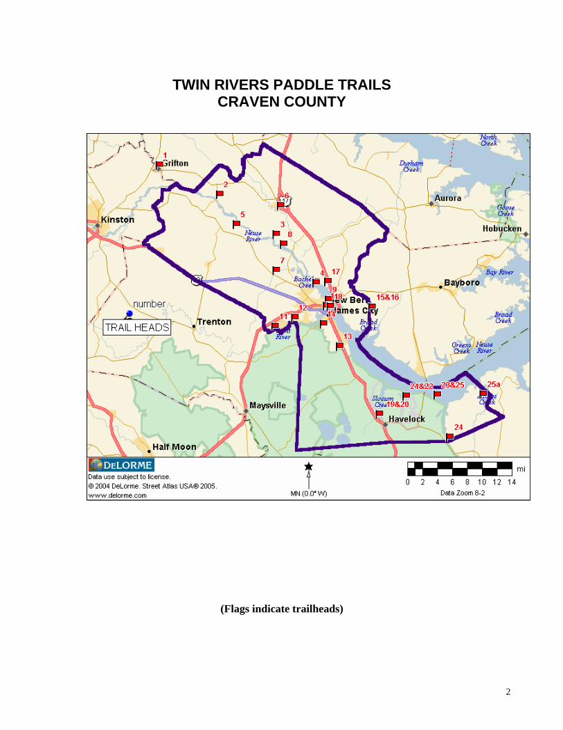
TWIN RIVERS PADDLE TRAILS CRAVEN COUNTY
(Flags indicate trailheads)
2
3
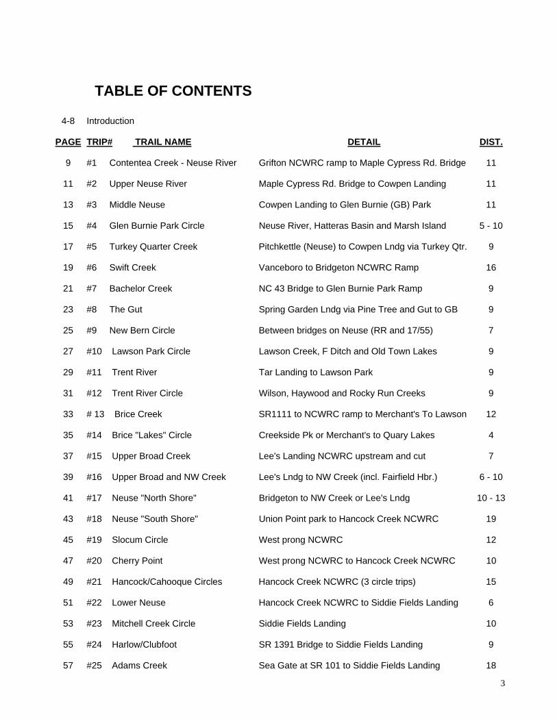
TABLE OF CONTENTS
4-8 Introduction
PAGE TRIP# TRAIL NAME DETAIL DIST. 9 #1 Contentea Creek - Neuse River Grifton NCWRC ramp to Maple Cypress Rd. Bridge 11
11 #2 Upper Neuse River Maple Cypress Rd. Bridge to Cowpen Landing 11
13 #3 Middle Neuse Cowpen Landing to Glen Burnie (GB) Park 11
15 #4 Glen Burnie Park Circle Neuse River, Hatteras Basin and Marsh Island 5 - 10
17 #5 Turkey Quarter Creek Pitchkettle (Neuse) to Cowpen Lndg via Turkey Qtr. 9
19 #6 Swift Creek Vanceboro to Bridgeton NCWRC Ramp 16
21 #7 Bachelor Creek NC 43 Bridge to Glen Burnie Park Ramp 9
23 #8 The Gut Spring Garden Lndg via Pine Tree and Gut to GB 9
25 #9 New Bern Circle Between bridges on Neuse (RR and 17/55) 7
27 #10 Lawson Park Circle Lawson Creek, F Ditch and Old Town Lakes 9
29 #11 Trent River Tar Landing to Lawson Park 9
31 #12 Trent River Circle Wilson, Haywood and Rocky Run Creeks 9
33 # 13 Brice Creek SR1111 to NCWRC ramp to Merchant's To Lawson 12
35 #14 Brice "Lakes" Circle Creekside Pk or Merchant's to Quary Lakes 4
37 #15 Upper Broad Creek Lee's Landing NCWRC upstream and cut 7
39 #16 Upper Broad and NW Creek Lee's Lndg to NW Creek (incl. Fairfield Hbr.) 6 - 10
41 #17 Neuse "North Shore" Bridgeton to NW Creek or Lee's Lndg 10 - 13
43 #18 Neuse "South Shore" Union Point park to Hancock Creek NCWRC 19
45 #19 Slocum Circle West prong NCWRC 12
47 #20 Cherry Point West prong NCWRC to Hancock Creek NCWRC 10
49 #21 Hancock/Cahooque Circles Hancock Creek NCWRC (3 circle trips) 15
51 #22 Lower Neuse Hancock Creek NCWRC to Siddie Fields Landing 6
53 #23 Mitchell Creek Circle Siddie Fields Landing 10
55 #24 Harlow/Clubfoot SR 1391 Bridge to Siddie Fields Landing 9
57 #25 Adams Creek Sea Gate at SR 101 to Siddie Fields Landing 18
4
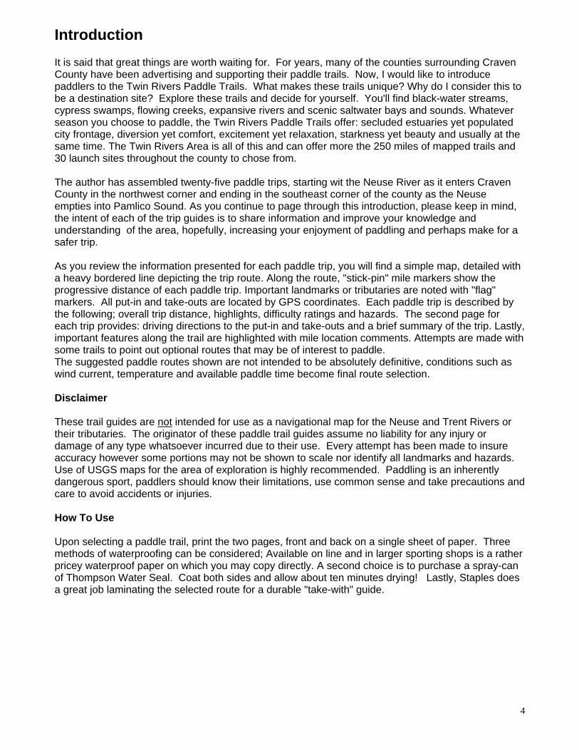
Introduction It is said that great things are worth waiting for. For years, many of the counties surrounding Craven County have been advertising and supporting their paddle trails. Now, I would like to introduce paddlers to the Twin Rivers Paddle Trails. What makes these trails unique? Why do I consider this to be a destination site? Explore these trails and decide for yourself. You'll find black-water streams, cypress swamps, flowing creeks, expansive rivers and scenic saltwater bays and sounds. Whatever season you choose to paddle, the Twin Rivers Paddle Trails offer: secluded estuaries yet populated city frontage, diversion yet comfort, excitement yet relaxation, starkness yet beauty and usually at the same time. The Twin Rivers Area is all of this and can offer more the 250 miles of mapped trails and 30 launch sites throughout the county to chose from. The author has assembled twenty-five paddle trips, starting wit the Neuse River as it enters Craven County in the northwest corner and ending in the southeast corner of the county as the Neuse empties into Pamlico Sound. As you continue to page through this introduction, please keep in mind, the intent of each of the trip guides is to share information and improve your knowledge and understanding of the area, hopefully, increasing your enjoyment of paddling and perhaps make for a safer trip. As you review the information presented for each paddle trip, you will find a simple map, detailed with a heavy bordered line depicting the trip route. Along the route, "stick-pin" mile markers show the progressive distance of each paddle trip. Important landmarks or tributaries are noted with "flag" markers. All put-in and take-outs are located by GPS coordinates. Each paddle trip is described by the following; overall trip distance, highlights, difficulty ratings and hazards. The second page for each trip provides: driving directions to the put-in and take-outs and a brief summary of the trip. Lastly, important features along the trail are highlighted with mile location comments. Attempts are made with some trails to point out optional routes that may be of interest to paddle. The suggested paddle routes shown are not intended to be absolutely definitive, conditions such as wind current, temperature and available paddle time become final route selection. Disclaimer These trail guides are not intended for use as a navigational map for the Neuse and Trent Rivers or their tributaries. The originator of these paddle trail guides assume no liability for any injury or damage of any type whatsoever incurred due to their use. Every attempt has been made to insure accuracy however some portions may not be shown to scale nor identify all landmarks and hazards. Use of USGS maps for the area of exploration is highly recommended. Paddling is an inherently dangerous sport, paddlers should know their limitations, use common sense and take precautions and care to avoid accidents or injuries. How To Use Upon selecting a paddle trail, print the two pages, front and back on a single sheet of paper. Three methods of waterproofing can be considered; Available on line and in larger sporting shops is a rather pricey waterproof paper on which you may copy directly. A second choice is to purchase a spray-can of Thompson Water Seal. Coat both sides and allow about ten minutes drying! Lastly, Staples does a great job laminating the selected route for a durable "take-with" guide.
5
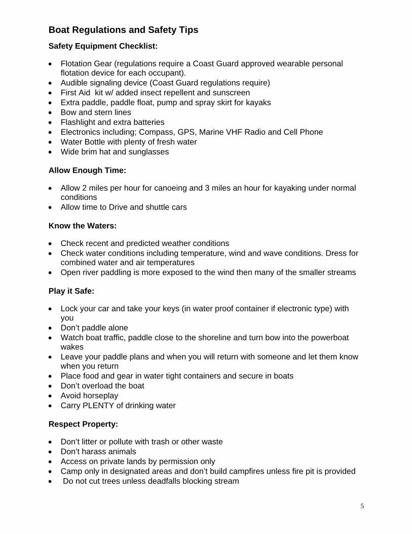
Boat Regulations and Safety Tips Safety Equipment Checklist: • Flotation Gear (regulations require a Coast Guard approved wearable personal
flotation device for each occupant). • Audible signaling device (Coast Guard regulations require) • First Aid kit w/ added insect repellent and sunscreen • Extra paddle, paddle float, pump and spray skirt for kayaks • Bow and stern lines • Flashlight and extra batteries • Electronics including; Compass, GPS, Marine VHF Radio and Cell Phone • Water Bottle with plenty of fresh water • Wide brim hat and sunglasses Allow Enough Time: • Allow 2 miles per hour for canoeing and 3 miles an hour for kayaking under normal
conditions • Allow time to Drive and shuttle cars Know the Waters: • Check recent and predicted weather conditions • Check water conditions including temperature, wind and wave conditions. Dress for
combined water and air temperatures • Open river paddling is more exposed to the wind then many of the smaller streams Play it Safe: • Lock your car and take your keys (in water proof container if electronic type) with
you • Don’t paddle alone • Watch boat traffic, paddle close to the shoreline and turn bow into the powerboat
wakes • Leave your paddle plans and when you will return with someone and let them know
when you return • Place food and gear in water tight containers and secure in boats • Don’t overload the boat • Avoid horseplay • Carry PLENTY of drinking water Respect Property: • Don’t litter or pollute with trash or other waste • Don’t harass animals • Access on private lands by permission only • Camp only in designated areas and don’t build campfires unless fire pit is provided • Do not cut trees unless deadfalls blocking stream
6
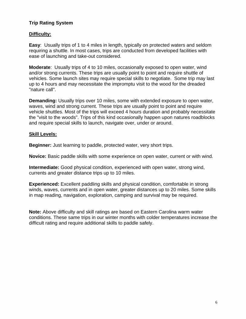
Trip Rating System Difficulty: Easy: Usually trips of 1 to 4 miles in length, typically on protected waters and seldom requiring a shuttle. In most cases, trips are conducted from developed facilities with ease of launching and take-out considered. Moderate: Usually trips of 4 to 10 miles, occasionally exposed to open water, wind and/or strong currents. These trips are usually point to point and require shuttle of vehicles. Some launch sites may require special skills to negotiate. Some trip may last up to 4 hours and may necessitate the impromptu visit to the wood for the dreaded "nature call". Demanding: Usually trips over 10 miles, some with extended exposure to open water, waves, wind and strong current. These trips are usually point to point and require vehicle shuttles. Most of the trips will exceed 4 hours duration and probably necessitate the "visit to the woods". Trips of this kind occasionally happen upon natures roadblocks and require special skills to launch, navigate over, under or around. Skill Levels: Beginner: Just learning to paddle, protected water, very short trips. Novice: Basic paddle skills with some experience on open water, current or with wind. Intermediate: Good physical condition, experienced with open water, strong wind, currents and greater distance trips up to 10 miles. Experienced: Excellent paddling skills and physical condition, comfortable in strong winds, waves, currents and in open water, greater distances up to 20 miles. Some skills in map reading, navigation, exploration, camping and survival may be required. Note: Above difficulty and skill ratings are based on Eastern Carolina warm water conditions. These same trips in our winter months with colder temperatures increase the difficult rating and require additional skills to paddle safely.
7
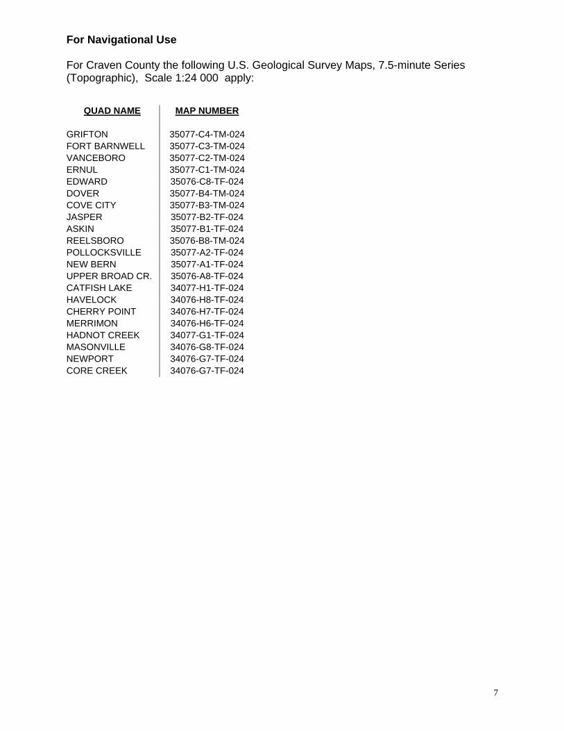
For Navigational Use For Craven County the following U.S. Geological Survey Maps, 7.5-minute Series (Topographic), Scale 1:24 000 apply:
QUAD NAME MAP NUMBER
GRIFTON 35077-C4-TM-024 FORT BARNWELL 35077-C3-TM-024 VANCEBORO 35077-C2-TM-024 ERNUL 35077-C1-TM-024 EDWARD 35076-C8-TF-024 DOVER 35077-B4-TM-024 COVE CITY 35077-B3-TM-024 JASPER 35077-B2-TF-024 ASKIN 35077-B1-TF-024 REELSBORO 35076-B8-TM-024 POLLOCKSVILLE 35077-A2-TF-024 NEW BERN 35077-A1-TF-024 UPPER BROAD CR. 35076-A8-TF-024 CATFISH LAKE 34077-H1-TF-024 HAVELOCK 34076-H8-TF-024 CHERRY POINT 34076-H7-TF-024 MERRIMON 34076-H6-TF-024 HADNOT CREEK 34077-G1-TF-024 MASONVILLE 34076-G8-TF-024 NEWPORT 34076-G7-TF-024 CORE CREEK 34076-G7-TF-024
8
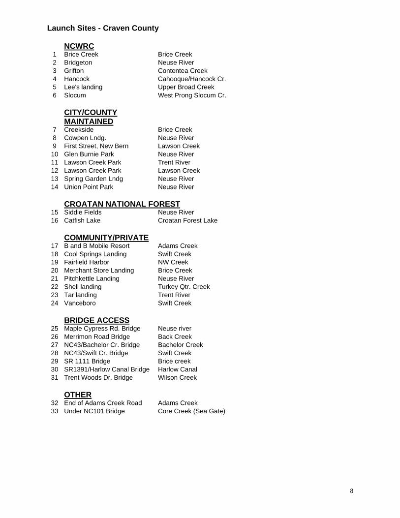
Launch Sites - Craven County
NCWRC1 Brice Creek Brice Creek 2 Bridgeton Neuse River 3 Grifton Contentea Creek 4 Hancock Cahooque/Hancock Cr. 5 Lee's landing Upper Broad Creek 6 Slocum West Prong Slocum Cr. CITY/COUNTY
MAINTAINED7 Creekside Brice Creek 8 Cowpen Lndg. Neuse River 9 First Street, New Bern Lawson Creek
10 Glen Burnie Park Neuse River 11 Lawson Creek Park Trent River 12 Lawson Creek Park Lawson Creek 13 Spring Garden Lndg Neuse River 14 Union Point Park Neuse River
CROATAN NATIONAL FOREST
15 Siddie Fields Neuse River 16 Catfish Lake Croatan Forest Lake
COMMUNITY/PRIVATE
17 B and B Mobile Resort Adams Creek 18 Cool Springs Landing Swift Creek 19 Fairfield Harbor NW Creek 20 Merchant Store Landing Brice Creek 21 Pitchkettle Landing Neuse River 22 Shell landing Turkey Qtr. Creek 23 Tar landing Trent River 24 Vanceboro Swift Creek
BRIDGE ACCESS
25 Maple Cypress Rd. Bridge Neuse river 26 Merrimon Road Bridge Back Creek 27 NC43/Bachelor Cr. Bridge Bachelor Creek 28 NC43/Swift Cr. Bridge Swift Creek 29 SR 1111 Bridge Brice creek 30 SR1391/Harlow Canal Bridge Harlow Canal 31 Trent Woods Dr. Bridge Wilson Creek
OTHER
32 End of Adams Creek Road Adams Creek 33 Under NC101 Bridge Core Creek (Sea Gate)
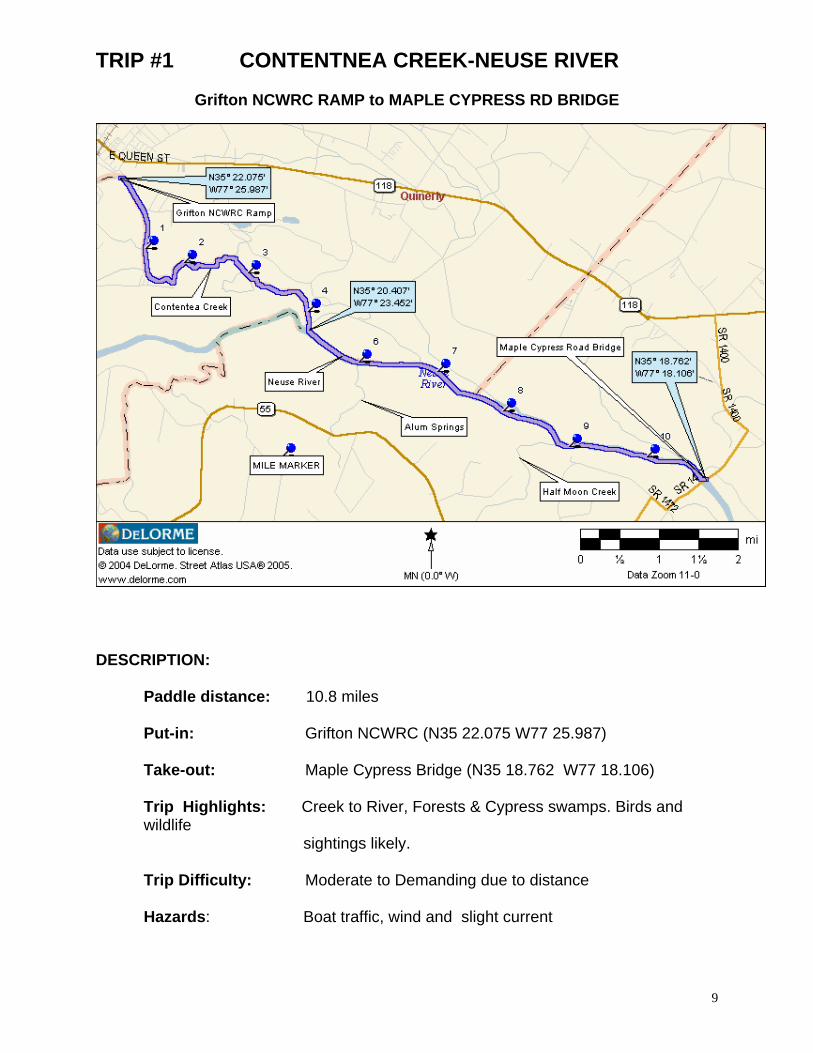
TRIP #1 CONTENTNEA CREEK-NEUSE RIVER
Grifton NCWRC RAMP to MAPLE CYPRESS RD BRIDGE
DESCRIPTION:
Paddle distance: 10.8 miles Put-in: Grifton NCWRC (N35 22.075 W77 25.987)
Take-out: Maple Cypress Bridge (N35 18.762 W77 18.106) Trip Highlights: Creek to River, Forests & Cypress swamps. Birds and wildlife sightings likely. Trip Difficulty: Moderate to Demanding due to distance Hazards: Boat traffic, wind and slight current
9

10
DRIVING DIRECTIONS TO: PUT-IN: GRIFTON NCWRC RAMP
Located in the town limits of Grifton. Follow NC118E into Grifton. Turn left on MLK Street to ramp.
TAKE-OUT: MAPLE CYPRESS ROAD BRIDGE
Follow NC 55 from New Bern about 16 miles, turn right on NC 1472 (Biddle Road) and drive about 1.9 miles to Maple Cypress Road. Turn right and continue past second bridge. Past small white house on left and just before third bridge, turn left on dirt road to landing.
PADDLE TRIP SUMMARY: This paddle starts in a Contentnea Creek (Pitt County) and eventually connects to the Neuse river (Craven County line). Due to creek and river current, it is recommended to paddle this trail downstream only. The character of the stream changes with many small streams and channels branching off the main stream. Contentnea Creek narrows from 150 feet to less then 50 feet as it winds through Cypress Swamps. Many large Cypress trees are found just before you arrive at the confluence of Contentnea Creek and the Neuse River. The Neuse River in this area is tree lined and void of all development. DETAILS: Put-in: From the NCWRC ramp, paddle down steam (to the left). Mile 2: About 2 miles from the put-in in Grifton, homes are no longer seen along the banks. Mile 2.1: A channel from the Grifton Wastewater Treatment Plant flows into the Contentnea from the left. Mile 4.3: Contentnea Creek joins the Neuse River, (N35 20.409 W77 23.452). Mile 6: Alum Springs Branch flows into the Neuse from the right. Mile 8.0: Immediately after passing an island, you will see a sandy “beach” to the left where people camp. Directly across the river, there is a landing where cars have been driven. Both areas are on private land but have not been posted. Mile 8.8: The Half Moon Creek/ Neuse River confluence is approached on the left Take-out: The take-out is along the left bank, just before the Maple Cypress Road Bridge (Total trip: 10.8 miles)

TRIP #2 UPPER NEUSE RIVER
MAPLE CYPRESS RD BRIDGE to COWPEN LANDING
DESCRIPTION:
Paddle distance: 11.2 miles Put-in: Maple Cypress Bridge (N35 18.762 W77 18.106)
Take-out: Cowpen Landing (N35 14.303 W77 10.032) Trip Highlights: River, Forests & Cypress swamps. Birds/ wildlife sightings likely. Trip Difficulty: Moderate to Demanding due to distance Hazards: Boat traffic, wind and slight current
11
12
DIRECTIONS TO: PUT-IN: MAPLE CYPRESS ROAD BRIDGE
Follow NC 55 from New Bern about 16 miles, turn right on NC 1472 (Biddle Road) and drive about 1.9miles to Maple Cypress Road. Turn right and continue past second bridge. Past small white house on left and just before third bridge, turn left on dirt road to landing.
TAKE-OUT: COWPEN LANDING
Traveling on NC 43 from New Bern, turn left onto River Road at the Weyerhauser Plant stop light. Continue 3 miles to Cow Pen Landing Road, turn left and continue .5 miles to end of road and ramp.
PADDLE TRIP SUMMARY: Due to the river current, it is recommended to travel downstream from the Maple Cypress Road Bridge put-in to the Cowpen Landing take-out. Current is dependant on recent rain totals from the Raleigh area and eastward as well as wind tide effects on the Neuse. From the put-in at Maple Cypress Bridge, the Neuse is a tree lined river, about 150 to 200 feet wide with an irregular swamp bank. Many large cypress trees line the shoreline. Details: Put-in: From the Neuse River Bridge at Maple Cypress Road, head down stream (to the left) Mile 1.5: Ditch Landing enters the Neuse River from the left. Mile 2: Core Creek enters the Neuse River from the right. Mile 3.8: Pitchkettle Landing Fishing Camp (N35 16.969 W77 15.528) is approached on the left bank and offers a place to stop and stretch the legs and perhaps purchase a soft drink. Mile 5.7 (N35 15.673 W77 14.657) Turkey Quarter Creek is approached on the right side and flows at a back angle to the Neuse River. Mile 9.3: Turkey Quarter creek returns to the Neuse at Shell Landing N35 14.138 W77 11.897 Mile 9.6: Greens Thorofare Channel at flows parallel to the Neuse and re-enters about a quarter mile below Cowpen Landing. Take-out: The take-out at Cowpen Landing is along the left shoreline. Total distance:11.2 miles
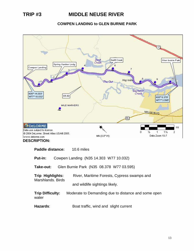
TRIP #3 MIDDLE NEUSE RIVER
COWPEN LANDING to GLEN BURNIE PARK
DESCRIPTION:
Paddle distance: 10.6 miles Put-in: Cowpen Landing (N35 14.303 W77 10.032)
Take-out: Glen Burnie Park (N35 08.378 W77 03.595) Trip Highlights: River, Maritime Forests, Cypress swamps and Marshlands. Birds and wildlife sightings likely. Trip Difficulty: Moderate to Demanding due to distance and some open water Hazards: Boat traffic, wind and slight current
13
14
DIRECTIONS TO: PUT-IN: COWPEN LANDING
Traveling on NC 43 from New Bern, turn left onto River Road at the Weyerhaeuser Plant stop light. Continue 3.0 miles to Cow Pen Landing Road. Turn left and continue .5 miles to end of road and ramp.
TAKE-OUT: Glen Burnie Park Ramp
From US 70, head north on Glenburnie Road (SR 43). Aprox. 2 miles, turn right on Oaks Rd. and follow about .5 miles. Turn left on Glenburnie Drive to end of road. Bear left into park, ramp is to right at first fork in road.
PADDLE TRIP SUMMARY: Due to the river current, it is recommended to travel down stream from the Cowpen Landing put-in to the Glen Burnie Park take-out. Current is dependent on recent rain totals from the Raleigh area and eastward as well as wind tide effects on the Neuse. Depending on wind directions, paddlers may experience the unpleasant odor from processong at the Weyerhauser Plant on a short section of this paddle. From the put-in, the Neuse River is only about 100 yards wide with high tree lined banks. Further down stream, the river opens up and is lined with islands. DETAILS: Put-in: From the put-in at Cowpen Landing paddle downstream (to the left) Mile 1/4: Greens Thorofare Channel returns to river on right Mile 2.3: Spring Garden Landing (N35 13.140 W77 08.899) appears on right. Across from this landing, you will find Pine Tree Creek which parallels the river and returns just before the NC43 bridge. Mile 3.6: NC 43 bridge (N35 12.609 W77 07.359) To the left after the bridge is the Weyerhauser Plant which continues for almost 2 miles along the river bank Mile 5.1: The Gut begins on right side of river at (N35 11.709 W77 06.583) From this point, follow river channel to the left. The right shoreline forms 4 mile long; Hog Island. Mile 5.75: Along the left shore, Swift Creek enters the Neuse river at (N35 11.527 W77 06.042). Mile 6.8: Weyerhaeuser has a picnic area with shelter and tables. This is a good place to stop, land and stretch your legs at the small sand beach in front of the picnic shelter. Mile 7.9: Overhead power lines cross the river. Note the hunting camp just before the power lines on Hog Island. No roads, everything get there by boat! Mile 9.3: Just past the end of Hog Island you will approach Marsh Island. If you paddle between the islands and toward right bank of river, you will notice a marked channel to the right, this will take the paddlers into the Hatteras Yacht Plant Take-out: Glen Burnie Park is on the right bank of the river immediately ahead. Total trip: 10.6 miles
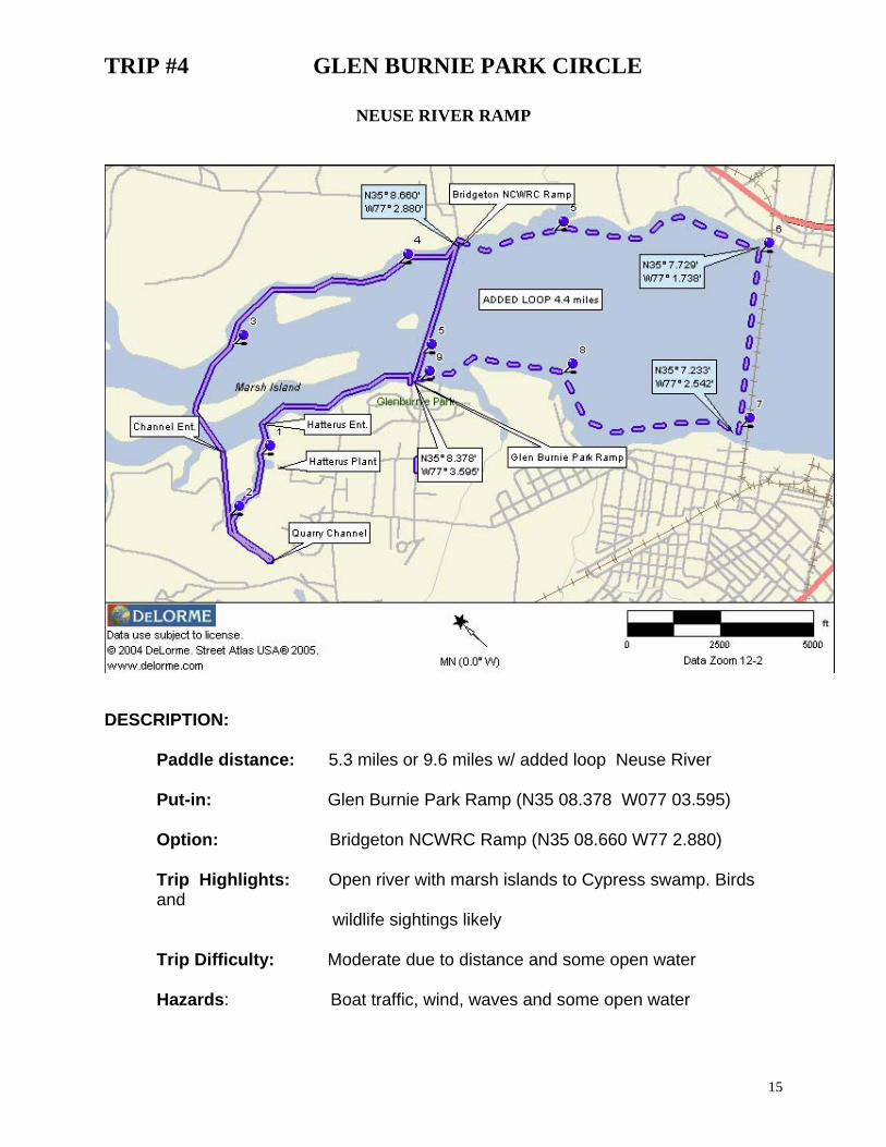
TRIP #4 GLEN BURNIE PARK CIRCLE
NEUSE RIVER RAMP
DESCRIPTION:
Paddle distance: 5.3 miles or 9.6 miles w/ added loop Neuse River Put-in: Glen Burnie Park Ramp (N35 08.378 W077 03.595)
Option: Bridgeton NCWRC Ramp (N35 08.660 W77 2.880) Trip Highlights: Open river with marsh islands to Cypress swamp. Birds and
wildlife sightings likely Trip Difficulty: Moderate due to distance and some open water Hazards: Boat traffic, wind, waves and some open water
15
16
DIRECTIONS TO: PUT-IN: Glenburnie Park Ramp
From US 70, head north on Glenburnie Road (SR 43). Aprox. 2 miles, turn right on Oaks Rd. and follow about .5 miles. Turn left on Glenburnie Drive to end of road. Bear left into park, ramp is to right at first fork in road. You may also choose to launch from the beach located just down the hill from the Shelter Building.
ALT PUT-IN: Bridgeton NCWRC Ramp
From Bridgeton east of New Bern, travel 1.0 mi north of city limits along US 17, turn left on SR 1431 (Wildlife Rd) and proceed 1.0 mile to the launch area
PADDLE TRIP SUMMARY: This circle paddle can be started at either boat ramp, Glen Burnie Park or the Bridgeton Wildlife Ramp. Direction of the paddle is best determined by the wind direction. The paddle will take you into a beautiful Cypress blackwater swamp adjacent to the Hatterus Yacht Plant. Continuing the paddle trip, it will take you through a manmade cannel dug to haul sand and stone from an adjacent quarry and then back to the river. The river paddle will take you along the marsh-grass shorelines of a number of river islands. DETAILS: Put-in: Paddle upstream re from the Glen Burnie Park along the left Mile 0.8: You will reach the marked channel l(day mark 51A) leading into the Hatterus Yacht Basin. Mile 1.0: Past the plant, your paddle will take you into a Cypress blackwater swamp. Pass the small island to the right for deeper water. Mile 1.4: As You continue, you will reach an old barge channel used to haul product from quarry ahead. Bear to left and paddle to the end of the cannel (about ¼ mile). Mile 17: At the end, reverse route and continue following cannel to it’s confluence with the Neuse River Mile 2.5: As you reenter the river, Marsh Island is directly ahead. Paddle 30 degrees and round the upstream end of the island. Mile 2.7 Once past the point of the island, paddle toward (90 degrees) the small island along the “north” left bank. Mile 3.0: Paddling from here, the shoreline will take you between four small islands and the tree lined river bank. This route offers the best wind protection and wildlife sightings (watch for the beaver lodge). Mile 4.3: Your paddle along this shore is about ¼ miles to the Bridgeton Wildlife ramp. There are no restroom facilities at this ramp. Mile 5.3 At any time you wish to return to the Glen Burnie Park take-out, simply head toward the high TV tower across the river. From the Bridgeton Ramp take a heading of 240 degrees to return to Glenburnie Park. Take-out: Head for the clearing to the right of the tower, ramp is ¾ mile from the Bridgeton ramp . (Total trip: 5.3 miles) OPTION: If you wish to increase the total paddle distance, continue your paddle along the “north” shore (downstream) to the railroad trestle. Cross the river parallel to the trestle and return along “south” shore to Glen Burnie Park. This route will add about 5 miles to the trip (Total 9.6 miles)

TRIP #5 TURKEY QUARTER
PITCHKETTLE LNDG. into TURKEY QUARTER CREEK to COWPEN LNDG.
DESCRIPTION:
Paddle distance: 8.6 miles via Greens Thorafare Put-in: Pitchkettle Landing (N35 16.969 W77 15.528
Take-out: Cowpen Landing (N35 14.303 W77 10.032) Trip Highlights: River, Maritime Forests, Cypress swamps. Birds and wildlife sightings likely. Trip Difficulty: Moderate due to distance and some open water Hazards: Boat traffic, wind and slight current
17
18
DIRECTIONS TO: PUT-IN: Pitchkettle Landing Traveling on NC 43 from New Bern, turn left onto River Road at the Weyerhaeuser Plant stop light. Continue on River Rd for about 9.3 miles and turn left at Pitchkettle Landing sign (private dirt road) TAKE-OUT: Cowpen Landing
Traveling on NC 43 from New Bern, turn left onto River Road at the Weyerhaeuser Plant stop light. Continue 3.0 miles to Cow Pen Landing Road, turn left and continue .5 miles to end of road and ramp.
PADDLE TRIP SUMMARY: River current diminishes as you travel closer to New Bern however wind tide becomes a factor. It is still recommended to travel from Pitchlettle Landing to Cowpen Landing to take advantage of the current. As you begin the paddle, the Neuse River is about 100 yards wide with high tree lined banks. As you near Turkey Quarter Creek (N35 15.673 W77 14.657), the area becomes more of a swamp river. Turkey Quarter Creek flows at a back angle from the Neuse River and confluence of the creek may be somewhat difficult to find. As you paddle Turkey Quarter Creek, you will be paddling one of the most beautiful Cypress swamps in Craven County. Turkey Quarter Creek runs about 4 mile until you reach Shell Landing (N35 14.138 W77 11.897). DETAILS: Put-in: From the put-in, paddle down stream or to your left. Mile 1.8: The entrance to Turkey Quarter Creek is found along the right bank. Note; The creek angles back from the Neuse and is difficult to locate. Mile 4.5: The cypress swamp gives way to forested high banks and you will come upon a small landing to your right. This non-posted landing is a good place to stretch the legs. Mile 5.7: Turkey Quarter Creek re-joins the Neuse River at Shell Rock Landing. Mile 5.9: Shortly after you re-enter the Neuse River, you will see Greens Thorofare along the right shoreline. Mile 7.8: If you choose to follow this channel, it returns to the Neuse about ¼ mile down stream from Cowpen Landing. This paddle will add about 1 mile to the trip and you will paddle against a light river current back to Cowpen Landing Take-out: Cowpen Landing is on the north side of the river (Total paddle distance:8.6 miles) OPTIONAL PADDLE: Should river current be minimal, an enjoyable 11.4 mile loop paddle can be done by utilizing the Cowpen Landing put-in. Paddle up stream on the Neuse to Shell Landing and upstream through Turkey Quarter Creek. You will paddle about 5.8 miles against the current before you reach the Neuse and head back toward Cowpen Landing by way of Greens Thorofare.
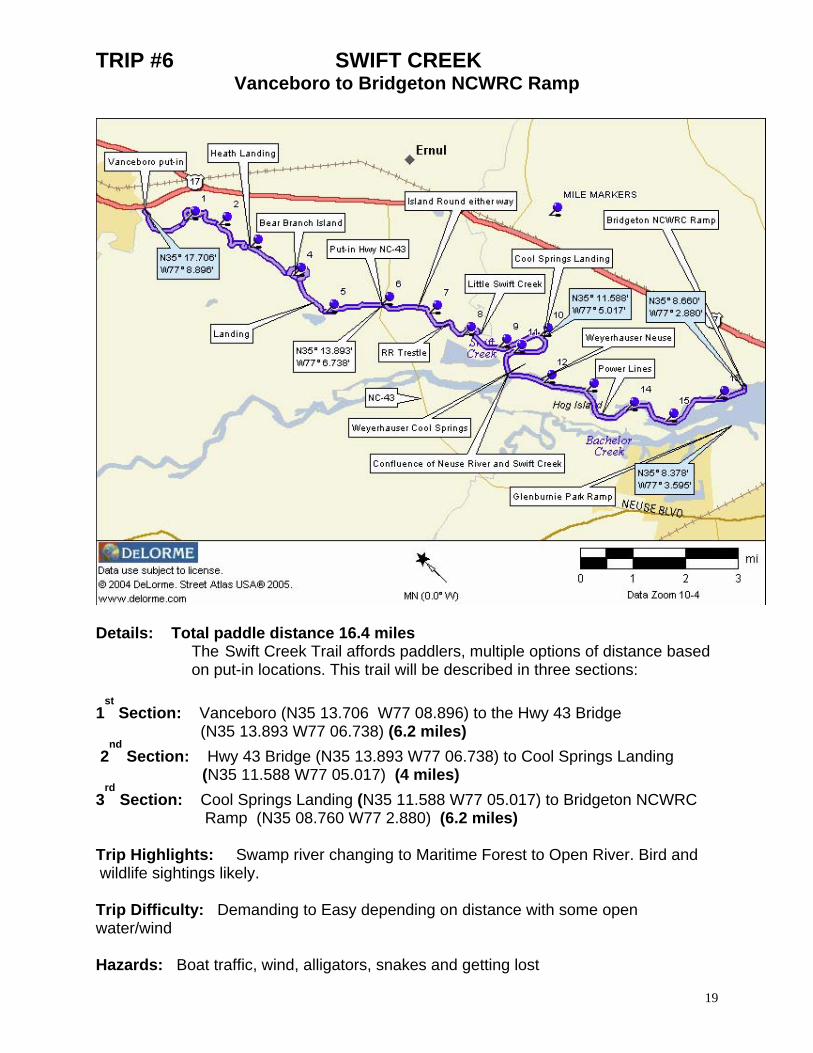
TRIP #6 SWIFT CREEK Vanceboro to Bridgeton NCWRC Ramp
Details: Total paddle distance 16.4 miles
The Swift Creek Trail affords paddlers, multiple options of distance based on put-in locations. This trail will be described in three sections:
1
st Section: Vanceboro (N35 13.706 W77 08.896) to the Hwy 43 Bridge
(N35 13.893 W77 06.738) (6.2 miles) 2
nd Section: Hwy 43 Bridge (N35 13.893 W77 06.738) to Cool Springs Landing
(N35 11.588 W77 05.017) (4 miles) 3
rd Section: Cool Springs Landing (N35 11.588 W77 05.017) to Bridgeton NCWRC
Ramp (N35 08.760 W77 2.880) (6.2 miles) Trip Highlights: Swamp river changing to Maritime Forest to Open River. Bird and wildlife sightings likely.
Trip Difficulty: Demanding to Easy depending on distance with some open water/wind
Hazards: Boat traffic, wind, alligators, snakes and getting lost
19
20
DIRECTIONS TO: Launch Site: Vanceboro
Traveling north on US17 from New Bern, turn left on NC 43 heading into Vanceboro. The launch site is about 1 ½ miles from the turn on left and is located in the vacant area just before Bob Werner’s Construction (has Kayaks out front).
Launch Site: Hwy 43 – Swift Creek Bridge Traveling north from New Bern on NC43, the Swift Creek Bridge is about 1.2 miles from the Intersection into the Weyerheauser plant. Once past the bridge and at the end of the guard rail on the left side of road, there is an access dirt road (North west side). Turn and follow to back to a launch site (about 100 yards).
Launch Site: Cool Springs Landing Traveling north on US17 from Bridgeton, about 5 miles, turn left on Askin Brick Rd. Continue about 2 miles then turn left again on Cool Springs Road. Just past the entrance to the Cool Springs Environmental Center turn left into launch area.
Take-out: Bridgeton NCWRC Ramp From Bridgeton east of New Bern, travel 1.0 mi north of city limits along US 17. Turn left on SR 1431 (Wildlife Rd) and proceed 1.0 mile to Ramp area.
PADDLE TRIP SUMMARY:
River current diminishes as you travel closer to New Bern however wind tide becomes a factor. It is recommended to travel downstream from Vanceboro to Bridgeton NCWRC Ramp to take advantage of the current. Depending on wind directions, paddlers may experience the unpleasant odor from the Weyerhaeuser Plant on a short section of this paddle
DETAILS: Put-in: Follow Swift Creek down stream (to the left) from launch site in Vanceboro Mile 2.5: Dock and collapsing shelter along right shoreline at Heath Landing Mile 3.9 to 4.2: Island formed by Bear Branch, may round in either direction Mile 4.6: Another landing along right bank Mile 6.2: Hwy 43 bridge and another Launch site. Follow Swift Creek down stream (to the left) Mile 6.8: Island may round from either direction Mile 7.8: Your paddle will take you under an old RR trestle N35 12.876 W77 06.173 with a small sand beach on the left bank. Mile 8.6: Little Swift Creek (N35 12.367 W77 05.845) will be straight ahead. To follow the Swift Creek Paddle Trail, follow waterway to the right. Note, Little Swift Creek is a nice side trip and will take you about 3+ miles and nearly to the Hwy 17 bridge Mile 10.2 Cool Springs Landing boat ramp is on the left and another launch site. Follow Swift Creek down stream (to the left) Mile 10.4: You will paddle along (the left shoreline) Weyerhaeuser’s Environmental Center’s shoreline for the next couple miles or so Mile 11.2: Swift Creek joins with the Neuse River. Hog Island forms the Right bank of the Neuse River. Mile 12.4: Along the left bank, Weyerhauser has a Picnic Shelter and port-a-potty. The small sand beach area offers a great place to stop. Mile 13.6: Passing under HV power lines, Mile 15.2: Reach the end of Hog Island, bear to the left river shoreline. Ahead is another small island, round on either side., just ahead. Take-out: The Bridgeton NCWRC Ramp is on the left bank of the Neuse River. Total trip 16.4 miles. OPTIONS: Take Out: 16.5 mile trip … Glen Burnie Park City Ramp along the Neuse River’s right shoreline
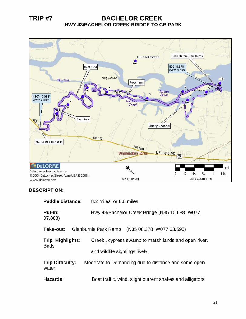
TRIP #7 BACHELOR CREEK HWY 43/BACHELOR CREEK BRIDGE TO GB PARK
DESCRIPTION:
Paddle distance: 8.2 miles or 8.8 miles Put-in: Hwy 43/Bachelor Creek Bridge (N35 10.688 W077 07.883) Take-out: Glenburnie Park Ramp (N35 08.378 W077 03.595) Trip Highlights: Creek , cypress swamp to marsh lands and open river. Birds
and wildlife sightings likely. Trip Difficulty: Moderate to Demanding due to distance and some open water Hazards: Boat traffic, wind, slight current snakes and alligators
21
22
DIRECTIONS TO: PUT-IN: Hwy 43/Bachelor Creek Bridge
Traveling north from New Bern on NC43, you will come to the Bachelor Creek Bridge about 3 miles from the NC43/55 fork. Once over the bridge and at the end of the guard rail on the left side of road, there is an access dirt road (Northwest side). Turn and follow back toward the launch site (about 100 yards)
TAKE-OUT: Glenburnie Park Ramp
From US 70, head north on Glenburnie Road (SR 43). Aprox. 2 miles, turn right on Oaks Rd. and follow about .5 miles. Turn left on Glenburnie Drive to end of road. Bear left into park, ramp is to right at first fork in road.
PADDLE TRIP SUMMARY: River and creek currents diminishes as you travel closer to New Bern, however wind tide can become a factor. It is recommended to travel from the Hwy 43 Bridge to Glen Burnie Park to take advantage of what little current you may have. Paddling down stream along Bachelor Creek, you will generally find treed wetlands along the right shoreline and high banks on the left. Nearer to the Neuse, more evidence of marsh grass shoreline exist. DETAILS: Put-in: From the put-in, paddle down stream or to your left. You may explore upstream on Bachelor Creek about 1 1/2 miles before deadfalls and the narrow stream prohibit further travel. Mile 1.1: Area along right shore line can be used for a rest stop. Mile 2.6: Another rest area (however posted) is found on the left bank but would work in an emergency. Mile 4.0: Bachelor Creek joins with a Neuse River Cut named "The Gut" (N35 10.678 W 77 06.092). Continue your paddle to the right. The left shoreline of The Gut is now formed by Hog Island. Mile 4.5: You will come upon a small cut to your left. You may paddle either waterway with nearly the same ending distance. Mile 5.5: You pass under the overhead power lines and shortly after, the two cuts rejoin. Mile 6.9: Hog Island ends, and immediately ahead is Marsh Island. Marsh Island may be rounded from either side. Take-out: The Glen Burnie Park Ramp is located at the foot of Marsh Island and along the right river shoreline OPTIONAL PADDLE: A short side trip into the Quarry Channel is always fun (mile 6.9 along right bank). Once in canal, bear to the left and continue past the Hatterus Yacht Plant/basin. Follow marked channel ahead to return to the river. You will find this loop to be most rewarding and will add about 1/2 mile to this paddle trip.
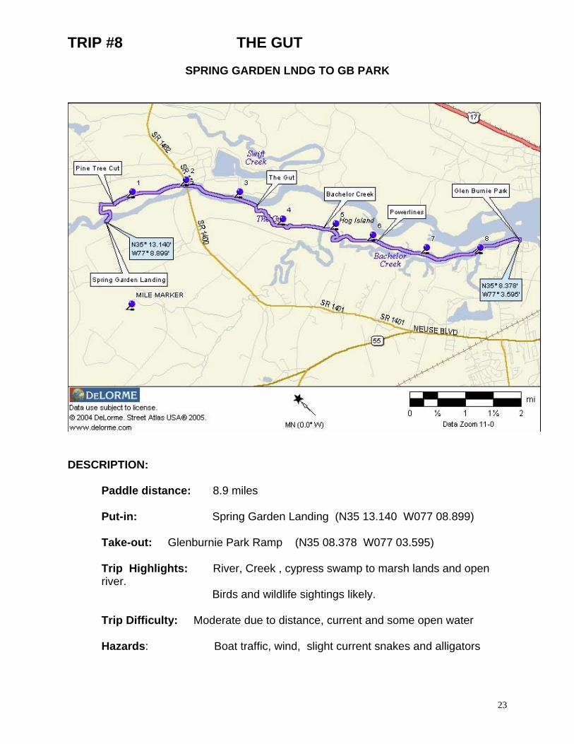
TRIP #8 THE GUT
SPRING GARDEN LNDG TO GB PARK
DESCRIPTION:
Paddle distance: 8.9 miles Put-in: Spring Garden Landing (N35 13.140 W077 08.899) Take-out: Glenburnie Park Ramp (N35 08.378 W077 03.595) Trip Highlights: River, Creek , cypress swamp to marsh lands and open river.
Birds and wildlife sightings likely. Trip Difficulty: Moderate due to distance, current and some open water Hazards: Boat traffic, wind, slight current snakes and alligators
23
24
DIRECTIONS TO: PUT-IN: Spring Garden Landing
From New Bern on NC 43, turn right on Spring Garden Road. Travel about 1.6 miles to Craven Middle School road and turn right. Continue 1.1 miles, past the middle school to boat landing at end of road
TAKE_OUT: Glen Burnie Park Ramp
From US 70, head north on Glenburnie Road (SR 43). Approximately 2 miles, turn right on Oaks Rd. and follow about .5 miles. Turn left on Glenburnie Drive to end of road. Bear left into park, ramp is to right at first fork in road.
PADDLE TRIP SUMMARY: River current diminishes as you travel closer to New Bern however wind tide becomes a factor. It is recommended to travel from Spring Garden Landing to Glen Burnie Park to take advantage of the river current. Depending on wind directions, paddlers may experience the unpleasant odor from the Weyerhaeuser Plant on a short section of this paddle. This paddle tour, directs you into of the "side channels" or cuts of the Neuse River. In most cases, paralleling the main river channel. DETAILS: Put-in: From the put-in at Spring Garden Landing, head directly across the Neuse River to the opening leading into Pine Tree Cut. Mile 0.3: Bear to the right at the "tee" intersection of Pine Tree Cut, from here the cut parallels the Neuse river for more then 1 1/2 miles. Mile 2.0: Pine Tree Cut rejoins the Neuse River Mile 2.1: The NC43 Highway Bridge. Mile 3.5: On the right, follow the entrance to The Gut (N35 11.645 W77 06.668). Mile 4.8: The Gut joins with Bachelor creek on the right (N35 10.678 W77 06.092). Mile 5.6: Follow The Gut-Side Channel to the left and which continues about 1 1/4 miles. Mile 6.8: Side Channel reconnects with Bachelor Creek Mile 8.6: Bachelor Creek rejoins with the Neuse River immediately past Marsh Island. Take-out: Immediately ahead (mile 8.9) on the right shore is the Glen Burnie Park Ramp OPTIONAL PADDLE: A short side trip into the Quarry Channel is always fun (mile 6.9 along right bank). Once in canal, bear to the left and continue past the Hatterus Yacht Plant/basin. Follow marked channel ahead to return to the river. You will find this loop to be most rewarding and will add about 1/2 mile to this paddle trip.
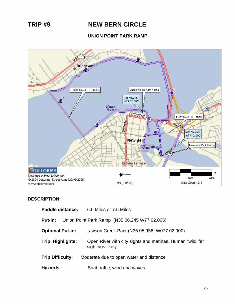
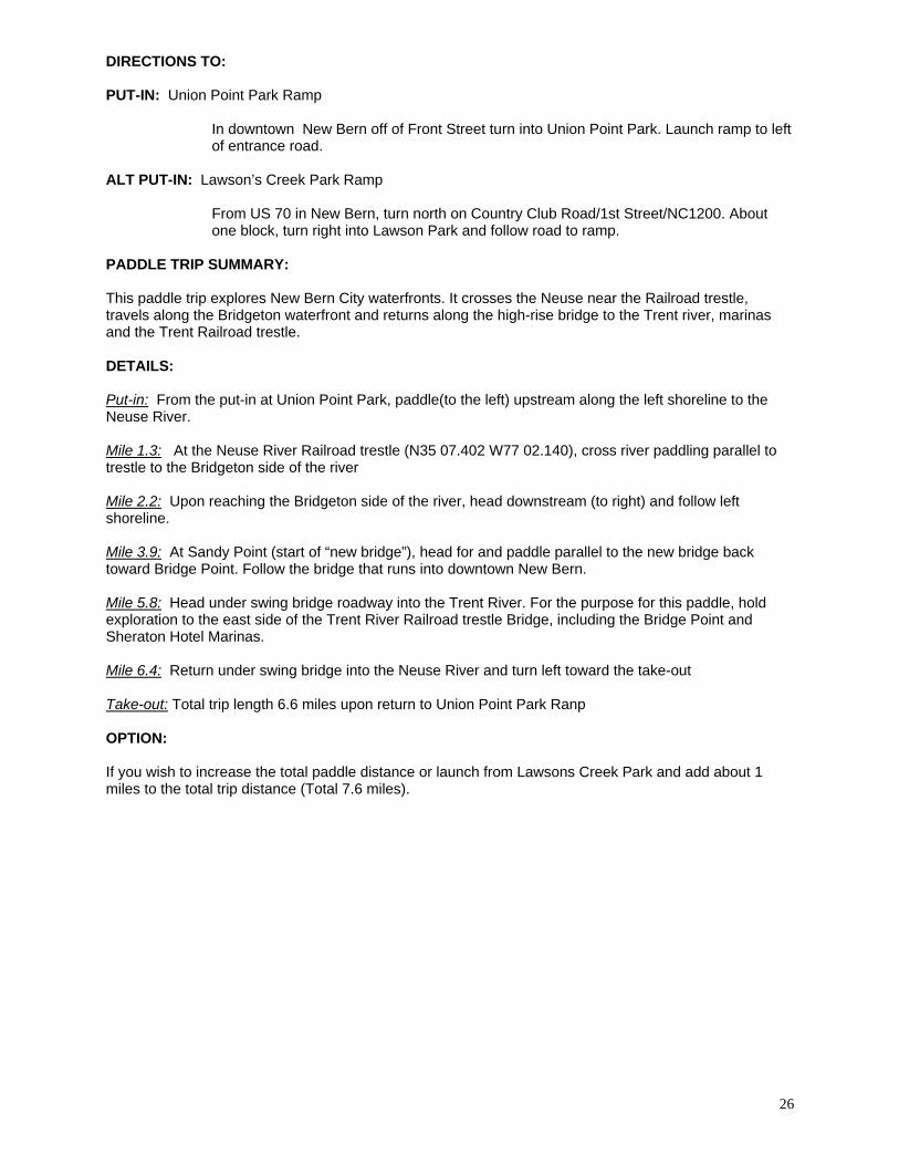
TRIP #9 NEW BERN CIRCLE
UNION POINT PARK RAMP
DESCRIPTION:
Paddle distance: 6.6 Miles or 7.6 Miles Put-in: Union Point Park Ramp (N35 06.245 W77 02.065) Optional Put-in: Lawson Creek Park (N35 05.956 W077 02.900) Trip Highlights: Open River with city sights and marinas. Human “wildlife”
sightings likely. Trip Difficulty: Moderate due to open water and distance Hazards: Boat traffic, wind and waves
25
26
DIRECTIONS TO: PUT-IN: Union Point Park Ramp
In downtown New Bern off of Front Street turn into Union Point Park. Launch ramp to left of entrance road.
ALT PUT-IN: Lawson’s Creek Park Ramp
From US 70 in New Bern, turn north on Country Club Road/1st Street/NC1200. About one block, turn right into Lawson Park and follow road to ramp.
PADDLE TRIP SUMMARY: This paddle trip explores New Bern City waterfronts. It crosses the Neuse near the Railroad trestle, travels along the Bridgeton waterfront and returns along the high-rise bridge to the Trent river, marinas and the Trent Railroad trestle. DETAILS: Put-in: From the put-in at Union Point Park, paddle(to the left) upstream along the left shoreline to the Neuse River. Mile 1.3: At the Neuse River Railroad trestle (N35 07.402 W77 02.140), cross river paddling parallel to trestle to the Bridgeton side of the river Mile 2.2: Upon reaching the Bridgeton side of the river, head downstream (to right) and follow left shoreline. Mile 3.9: At Sandy Point (start of “new bridge”), head for and paddle parallel to the new bridge back toward Bridge Point. Follow the bridge that runs into downtown New Bern. Mile 5.8: Head under swing bridge roadway into the Trent River. For the purpose for this paddle, hold exploration to the east side of the Trent River Railroad trestle Bridge, including the Bridge Point and Sheraton Hotel Marinas. Mile 6.4: Return under swing bridge into the Neuse River and turn left toward the take-out Take-out: Total trip length 6.6 miles upon return to Union Point Park Ranp OPTION: If you wish to increase the total paddle distance or launch from Lawsons Creek Park and add about 1 miles to the total trip distance (Total 7.6 miles).
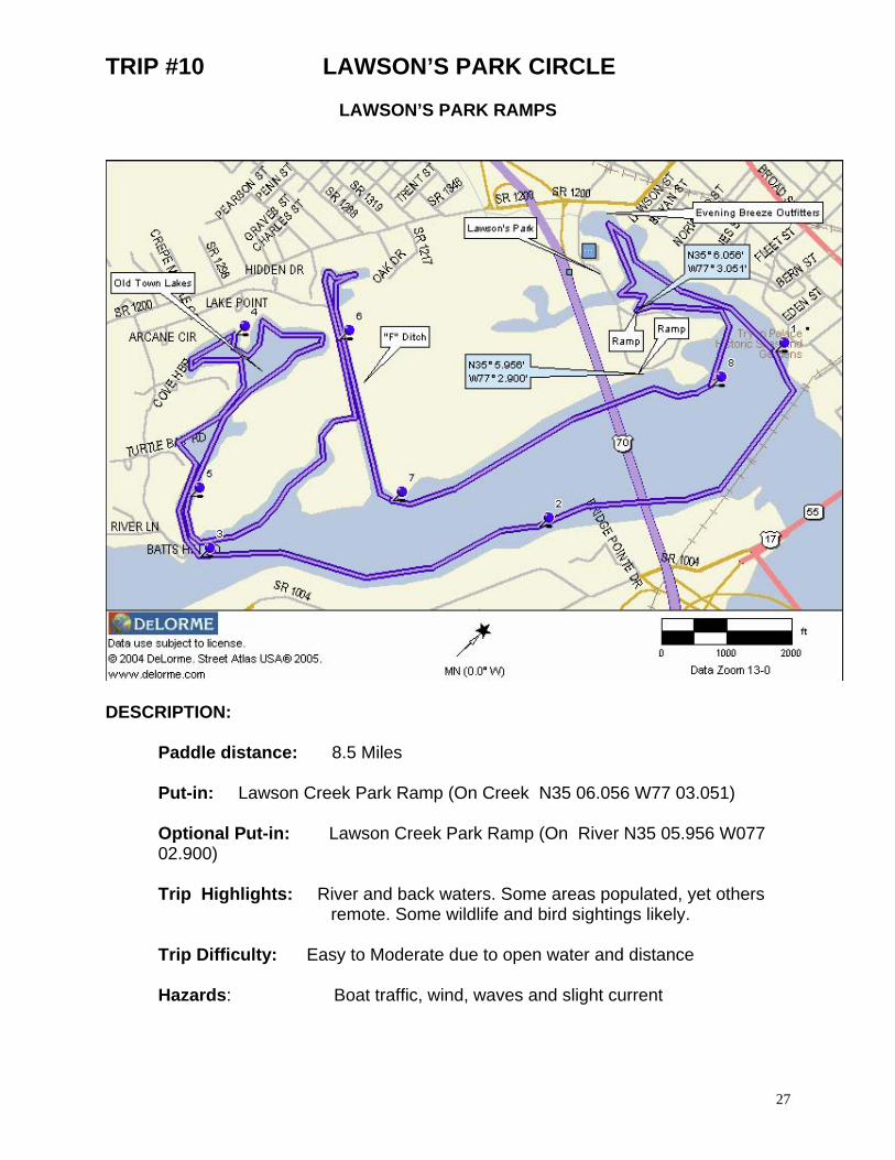
TRIP #10 LAWSON’S PARK CIRCLE
LAWSON’S PARK RAMPS
DESCRIPTION:
Paddle distance: 8.5 Miles Put-in: Lawson Creek Park Ramp (On Creek N35 06.056 W77 03.051) Optional Put-in: Lawson Creek Park Ramp (On River N35 05.956 W077 02.900) Trip Highlights: River and back waters. Some areas populated, yet others
remote. Some wildlife and bird sightings likely. Trip Difficulty: Easy to Moderate due to open water and distance Hazards: Boat traffic, wind, waves and slight current
27
28
DIRECTIONS TO: PUT-IN: Lawson’s Creek Park Ramps and ALTERNATE: From US 70 in New Bern, turn north on Country Club Road/1st Street (NC1200). About
one block, turn right into Lawson Park and follow road to either ramp. Ramp on creek to left as you drive in and the ramp on river is straight ahead.
PADDLE TRIP SUMMARY: The Lawson Creek paddle offers a loop paddle trip that does not venture much over 1 1/2 miles from the put-in. As a mater of fact, there are two paved boat ramps located in Lawson Park and a variety of other locations to launch within this140 acre park and a new city launch site at the end of 1
st Street. This trip
takes you to the extreme end of Lawson Creek, then past the Tryon Palace, upstream in the Trent River to the Old Town Lakes. The return trip allows you to explore the Trent marshes and backwaters of the "F Ditch" before returning to the put-in. DETAILS: Put-in: From the launch, paddle to your left to explore the backwaters of Lawson Creek. At the very end of this stream you will find, Evening Breezes (Kayak, Canoe and Camping) Outfitters. Mile 1.0: As you paddle back toward the Trent River, follow the left shoreline and loop in front of the Tryon Palace Mile 1.2: Cross the river parallel to the trestle., Mile 1.5: Once to opposite shoreline , turn and head upstream (to the right). Mile 1.7: Paddle under the US Hwy 17/70 high-rise bridge and along shoreline. Mile 3.0: You will notice a large condo complex on the opposite shore. Cross the river watching for boat traffic as you head for right side of the complex. There you will find the cut that takes the paddlers into the Old Town Lakes. Mile 5.2: After exploration of the bays of Old Town Lake, depart the same way that you paddled in. Upon reaching the river, turn to the left and follow shoreline into the bay. Mile 5.6: as the bay narrow and forms a stream, note a "tee intersection" left will take you to a dead end. Look up at the huge Osprey nest . The right cut will take you into the "F Ditch. Mile 5.8: Turn left to explore “F” Ditch, retrace route straight back toward river, do not retrace route through narrow opening, continue straight ahead to the river. Mile 7.0: Once to river, turn left and follow shoreline back toward bridge. Mile 7.6: Passing under Hwy. 17/70 Bridge Mile 8.0: As you pass the Lawson’s Park, Trent River Boat Ramp, an island extending into the Trent River, that’s Jack’s Island. Mile 8.5: Paddle around Jack's Island to take-out on left side shoreline.
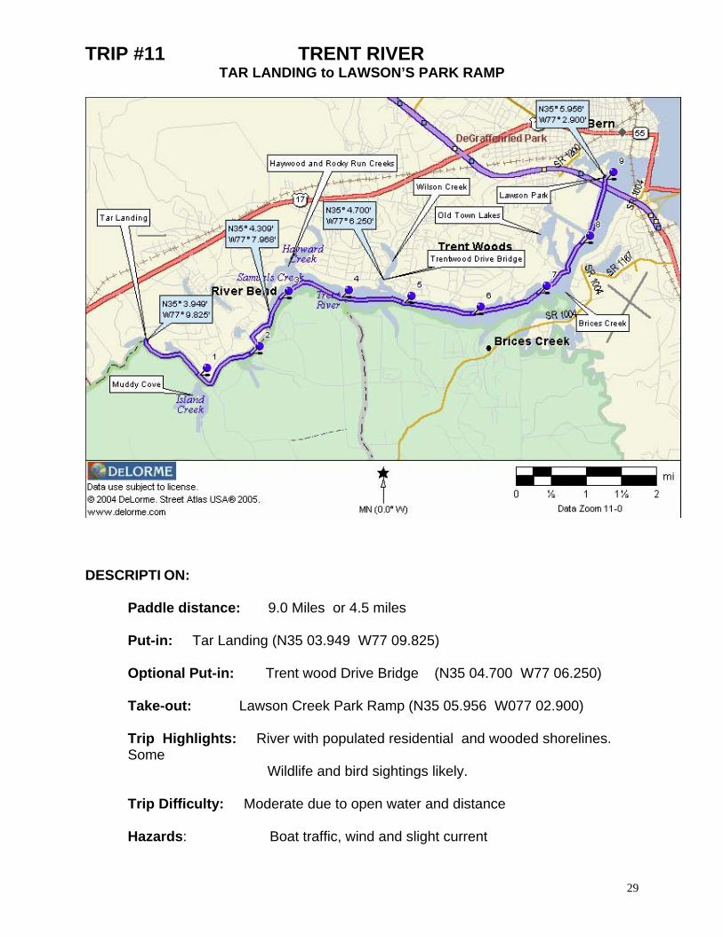
TRIP #11 TRENT RIVER TAR LANDING to LAWSON’S PARK RAMP
DESCRIPTI ON:
Paddle distance: 9.0 Miles or 4.5 miles Put-in: Tar Landing (N35 03.949 W77 09.825) Optional Put-in: Trent wood Drive Bridge (N35 04.700 W77 06.250) Take-out: Lawson Creek Park Ramp (N35 05.956 W077 02.900) Trip Highlights: River with populated residential and wooded shorelines. Some
Wildlife and bird sightings likely. Trip Difficulty: Moderate due to open water and distance Hazards: Boat traffic, wind and slight current
29
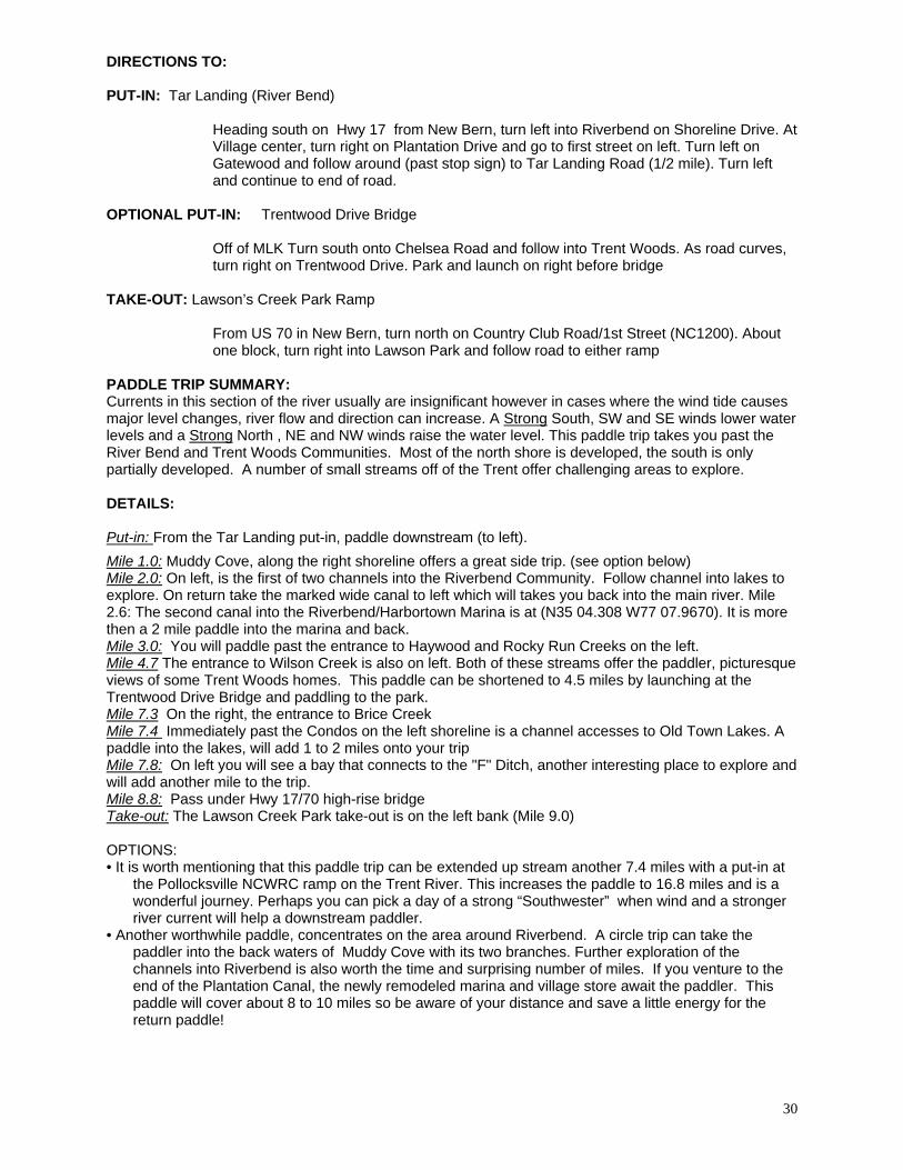
30
DIRECTIONS TO: PUT-IN: Tar Landing (River Bend)
Heading south on Hwy 17 from New Bern, turn left into Riverbend on Shoreline Drive. At Village center, turn right on Plantation Drive and go to first street on left. Turn left on Gatewood and follow around (past stop sign) to Tar Landing Road (1/2 mile). Turn left and continue to end of road.
OPTIONAL PUT-IN: Trentwood Drive Bridge Off of MLK Turn south onto Chelsea Road and follow into Trent Woods. As road curves, turn right on Trentwood Drive. Park and launch on right before bridge
TAKE-OUT: Lawson’s Creek Park Ramp
From US 70 in New Bern, turn north on Country Club Road/1st Street (NC1200). About one block, turn right into Lawson Park and follow road to either ramp
PADDLE TRIP SUMMARY: Currents in this section of the river usually are insignificant however in cases where the wind tide causes major level changes, river flow and direction can increase. A Strong South, SW and SE winds lower water levels and a Strong North , NE and NW winds raise the water level. This paddle trip takes you past the River Bend and Trent Woods Communities. Most of the north shore is developed, the south is only partially developed. A number of small streams off of the Trent offer challenging areas to explore. DETAILS: Put-in: From the Tar Landing put-in, paddle downstream (to left).
Mile 1.0: Muddy Cove, along the right shoreline offers a great side trip. (see option below) Mile 2.0: On left, is the first of two channels into the Riverbend Community. Follow channel into lakes to explore. On return take the marked wide canal to left which will takes you back into the main river. Mile 2.6: The second canal into the Riverbend/Harbortown Marina is at (N35 04.308 W77 07.9670). It is more then a 2 mile paddle into the marina and back. Mile 3.0: You will paddle past the entrance to Haywood and Rocky Run Creeks on the left. Mile 4.7 The entrance to Wilson Creek is also on left. Both of these streams offer the paddler, picturesque views of some Trent Woods homes. This paddle can be shortened to 4.5 miles by launching at the Trentwood Drive Bridge and paddling to the park. Mile 7.3 On the right, the entrance to Brice Creek Mile 7.4 Immediately past the Condos on the left shoreline is a channel accesses to Old Town Lakes. A paddle into the lakes, will add 1 to 2 miles onto your trip Mile 7.8: On left you will see a bay that connects to the "F" Ditch, another interesting place to explore and will add another mile to the trip. Mile 8.8: Pass under Hwy 17/70 high-rise bridge Take-out: The Lawson Creek Park take-out is on the left bank (Mile 9.0) OPTIONS: • It is worth mentioning that this paddle trip can be extended up stream another 7.4 miles with a put-in at
the Pollocksville NCWRC ramp on the Trent River. This increases the paddle to 16.8 miles and is a wonderful journey. Perhaps you can pick a day of a strong “Southwester” when wind and a stronger river current will help a downstream paddler.
• Another worthwhile paddle, concentrates on the area around Riverbend. A circle trip can take the paddler into the back waters of Muddy Cove with its two branches. Further exploration of the channels into Riverbend is also worth the time and surprising number of miles. If you venture to the end of the Plantation Canal, the newly remodeled marina and village store await the paddler. This paddle will cover about 8 to 10 miles so be aware of your distance and save a little energy for the return paddle!
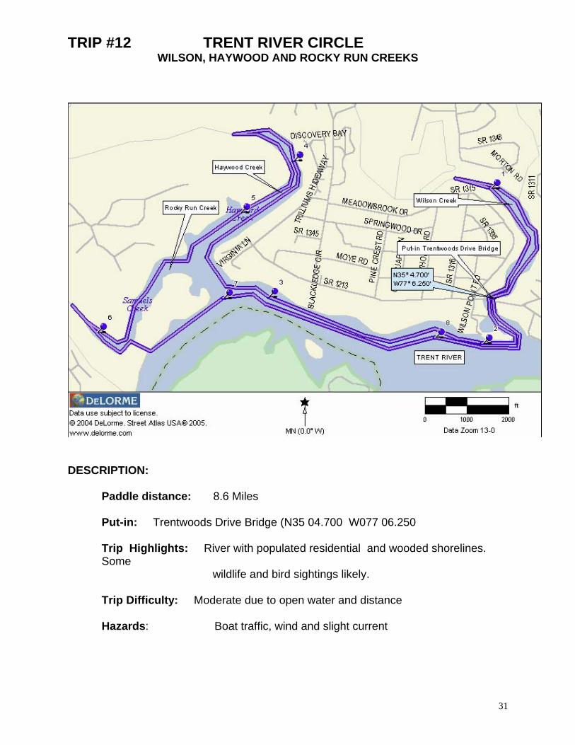
TRIP #12 TRENT RIVER CIRCLE WILSON, HAYWOOD AND ROCKY RUN CREEKS
DESCRIPTION:
Paddle distance: 8.6 Miles Put-in: Trentwoods Drive Bridge (N35 04.700 W077 06.250 Trip Highlights: River with populated residential and wooded shorelines. Some
wildlife and bird sightings likely. Trip Difficulty: Moderate due to open water and distance Hazards: Boat traffic, wind and slight current
31

32
DIRECTIONS TO: PUT-IN: Trent Woods Road Bridge
On Martin Luther King Blvd (Hwy17) turn left (south) on McCarthy Blvd. Road name changes to Chelsea Rd. Just before sharp curve, turn right on Trentwood Drive and follow to bridge. Launch before crossing bridge on right side. DO NOT BLOCK FIRE HYDRANT.
PADDLE TRIP SUMMARY: Current in this section of the river are usually insignificant however in cases where the wind tide will causes major changes in river flow and direction. STRONG South, SE and SW winds lower river levels and STRONG North, NW and NE winds lower river levels. This paddle tours the paddler past the river front section of Trent Woods and Haywood Creek Communities. The shoreline is developed until you reach the extremes of Rocky Run and Haywood Creeks. There's even a resident alligator sighted far up Haywood Creek! DETAILS: Put-in: From the Trent Wood Rd. bridge put-in (N35 04.688 W77 06.265), paddle to your right and explore the residential area along Wilson Creek(about 1 ½ miles round trip) . Mile 1.6: Paddle under bridge toward the Trent River Mile 1.8: You are at the confluence with the Trent River. Turn right and heading up-stream following the right shoreline. Mile 3.3: Ahead is the “Y” intersection of Rocky Run and Haywood Creeks. You can paddle about 1 mile up each stream and explore. Haywood Creek has homes along the right shoreline about 2/3’s of the way but Rocky Run is quite the opposite. Mile 6.4: As you paddle back from your exploration of the extremes of Rocky Run Creek, you will come upon a small cut along the right bank that will take you back to the Trent River. Mile 7.0: You may choose to paddle the right shore line of the Trent River on your return to avoid the residential landscape however be on the watch for powerboats as you cross the river. Mile 8.3: Return to the mouth of Wilson Creek and follow to take-out Take-out: Total distance 8.6 miles however may be reduced depending on degree of exploring
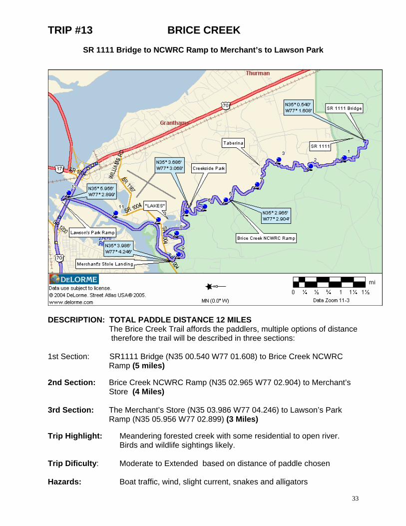
TRIP #13 BRICE CREEK
SR 1111 Bridge to NCWRC Ramp to Merchant’s to Lawson Park
33
ESCRIPTION: TOTAL PADDLE DISTANCE 12 MILES
1st Section: SR1111 Bridge (N35 00.540 W77 01.608) to Brice Creek NCWRC
nd Section: Brice Creek NCWRC Ramp (N35 02.965 W77 02.904) to Merchant’s
rd Section: The Merchant’s Store (N35 03.986 W77 04.246) to Lawson’s Park
Trip H Meandering forested creek with some residential to open river.
rip Dificulty: Moderate to Extended based on distance of paddle chosen
azards: Boat traffic, wind, slight current, snakes and alligators
D
The Brice Creek Trail affords the paddlers, multiple options of distance therefore the trail will be described in three sections:
Ramp (5 miles) 2 Store (4 Miles) 3 Ramp (N35 05.956 W77 02.899) (3 Miles)
ighlight:
Birds and wildlife sightings likely.
T H
34
DIRECTIONS TO: LAUNCH SITE: SR 1111 Bridge From US 70 from New Bern toward Havelock turn right on Thurman Lane. At intersection of SR 1111 (Old Airport Road), turn left and follow to bridge over Brice Creek. LAUNCH SITE: Brice Creek NCWRC Ramp From US70E in James City turn right on SR1167 and travel 1.4 miles to SR1004. Turn left on SR 1104 and proceed 1.7 miles to SR1140. Turn left on SR1140 travel 1.5 miles, turn left on gravel road entering the Croatan National Forest. Proceed 1.1 miles to the end of the gravel road to which the area is located. LAUNCH SITE: Creekside Park In James City, take Airport Road from Hwy 70 going east. Go .4 mile and turn left on Old Airport Road. The park will be .6 mile on the right. LAUNCH SITE: Merchants Store Ramp From US70E in James City turn right on SR1167 (Williams Road) and travel 1.4 miles to SR1004 (Madame Moores Road then changes to Brice’s Creek Rd). Turn left on SR 1104 and proceed 1.7 miles to the intersection of SR1140 (Perrytown Rd) Turn left, launch is on immediate left . TAKE-OUT SITE: Lawson’s Creek Park Ramp From US 70 in New Bern, turn north on Country Club Road/1st Street NC1200. About one block, turn right into Lawson Park and follow road to ramp PADDLE TRIP SUMMARY: The Brices Creek Paddle Trail signage and access points are maintained by the Craven County Department of Parks and Recreation. 12 miles in length, this trail starts deep in the Croatan National Forest and eventually meanders past sparse development before finally entering the New Bern riverfront area. DETAIL: FIRST SECTION (5 miles) Up-stream: Imediately up stream from put-in is the new residential community of Carolina Colors Put-in: A somewhat primitive launch site is located at the SE side of the SR1111 bridge (N35 00.540 W77 01.608) in the Croatan Forest. Unfortunately, the first mile or so from the put in, there are a number of dead falls which may block the very narrow stream depending on water level, a portage may be necessary. Mile 0.3: High ground forest land reverts to Cedar, Oak, and Poplar wetlands. This 20 - 50 foot wide stream wanders and turns for almost the full length of this section of the paddle. Mile 2.0: Early indications of future development ( pier and concrete ramp!) on this “remote” section of creek Mile 3.5: A few houses (Tabernia) appear on the right, HOWEVER, that is about to change with the Carolina Colors Project. All lands on the left bank belongs to the Croatan National Forest but land on the other side are open to development. Mile 4.9: Brice Creek NCWRC Ramp (N35 02.965 W77 02.904) take-out. SECOND SECTION (4 miles) Put -in: Brice Creek NCWRC Ramp (N35 02.965 W77 02.904) Mile 6.4: Creekside Park (N35 03.686 W77 03.068) appears on the right bank and defined by a fishing pier and Canoe/Kayak launch float. Mile 7.7: Watch for a very small opening along the right shoreline. This opening (N35 04.038 W77 03.494) lead the paddlers into a series of 4 or 5 quarry lake that make for some great explorations. Don’t pass this up! Mile 9.0: The Merchant’s Store (N35 03.986 W77 04.246) is on the left bank just before the bridge. The sand bank offers an excellent take-out or a great place to grab something to eat! THIRD SECTION (3 miles) Put-in: The Merchants Store put-in (N35 03.986 W77 04.246) Mile 9.2: Paddle under the Brice Creek Road / Williams Road Bridge. Mile 10.2: Enter the Trent River to the right. Mile 11.8: Pass beneath the Hwy 70/17 bridge Take-out: The Lawson Park Boat ramp (N35 05.956 W77 02.899) is directly ahead.
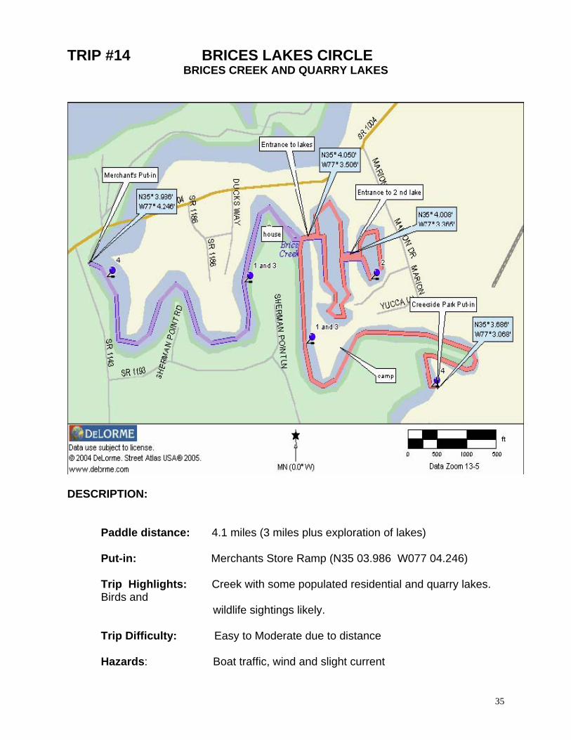
TRIP #14 BRICES LAKES CIRCLE
BRICES CREEK AND QUARRY LAKES
DESCRIPTION:
Paddle distance: 4.1 miles (3 miles plus exploration of lakes) Put-in: Merchants Store Ramp (N35 03.986 W077 04.246) Trip Highlights: Creek with some populated residential and quarry lakes. Birds and wildlife sightings likely. Trip Difficulty: Easy to Moderate due to distance Hazards: Boat traffic, wind and slight current
35

36
DIRECTIONS TO: PUT-IN: Creekside Park
In James City, take Airport Road from Hwy 70 going east. Go .4 mile and turn left on Old Airport Road. The park will be .6 mile on the right.
ALT. PUT-IN: Merchant’s Store Ramp
From US70E in James City turn right on SR1167 (Williams Road) and travel 1.4 miles to SR1004 (Madame Moores Road then changes to Brice’s Creek Rd). Turn left on SR 1104 and proceed 1.7 miles to the intersection of SR1140 (Perrytown Rd) Turn left, launch is on immediate
PADDLE TRIP SUMMARY: This circle paddle can be started at either launch site. Distance to the “lakes” from each launch site is about the same. Each trip will take you to the lakes from the respective launch site. Once in the lakes, your free to explore however make a mental note where the entrances to each lake is. Launching from the Merchant’s Store, you may incur a small charge for using the facility. Inquire at the Gas Station/store. DETAILS: (Creekside) Put-in: Launching from the Creekside Park, paddle downstream or to your right while facing stream. Mile 0.7: As you paddle downstream, note the “fishing camp” on the right bank where you will see about 3 or 4 travel trailers and mobile homes. You are half way to the lakes. Mile 1.4: About .7 miles past this camp, start your watch for the entrance to the lakes. The entrance to the lakes is along the right shoreline, is small (50' wide) and may be difficult to find. Upon entering the lakes, it appears that there is only one body of water however by paddling a direction of 120 degrees, access to another lake will be found. Exploration along the shoreline in all of the quarry lakes will eventually return you to the point where you entered. You can’t get lost however you may think so! Take-out: To return to Creekside Park, retrace the route 1.4 miles OPTION DETAILS: (Merchant's) Put-in: You may also begin this paddle from the Merchant's Store. Begin by paddling upstream or to the right as you face the creek. Mile 1.5: Just after rounding the fourth bend in the creek, watch for a small (50 feet wide) opening along the left shore. Another landmark that may help is a home built near the point (on the last bend). This home overlooks both sides of the bend in the creek. The entrance to the lakes is directly across from this home. Upon entering the lakes, it appears that there is only one body of water however by paddling a direction of 120 degrees, access to another lake will be found. Exploration along the shoreline in all of the quarry lakes will eventually return you to the point where you entered. You can’t get lost however you may think so! Take-out: To return to the Merchant’s Store, retrace the route 1.5 miles.
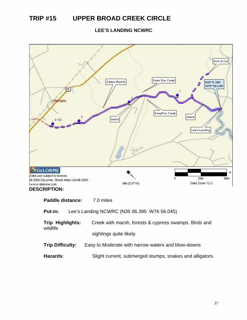
TRIP #15 UPPER BROAD CREEK CIRCLE
LEE’S LANDING NCWRC
DESCRIPTION:
Paddle distance: 7.0 miles Put-in: Lee’s Landing NCWRC (N35 06.395 W76 56.045) Trip Highlights: Creek with marsh, forests & cypress swamps. Birds and wildlife sightings quite likely. Trip Difficulty: Easy to Moderate with narrow waters and blow-downs Hazards: Slight current, submerged stumps, snakes and alligators.
37
38
DRIVING DIRECTIONS: PUT-IN: LEE’S LANDING NCWRC
From Bridgeton, travel east on NC 55, turn right on SR 1131(Chair Road) in Reelsboro. Travel 1.2 miles along SR 1131 to stop sign, turn right on SR 1103, proceed 1.7 miles to ramp.
PADDLE TRIP SUMMARY: The Upper Broad Creek paddle traverses three distinct ecosystems, fresh water marsh, open cypress swamp and than into a heavy hardwood forest swamp. All of this change in less than 3 miles. Upper Broad Creek begins as a open stream, more than a two hundred yards wide to a stream nearly wide enough to turn a boat around. DETAILS: Put-in: From the NCWRC ramp at Lee’s landing, paddle upstream (to your right). Mile 0.3: First of a number of small island (.2 miles long) that may be rounded on either side. Mile 0.7: Broad Creek continues to left however, the small stream to your right is great for exploring and will take you nearly a half mile deep into the woodlands before becoming too narrow and shallow to continue. Mile 0.9 and 1.2: Two more small islands rounded either way. The second appears as though the stream splits, follow stream to left for ease. Mile 1.6: Small and almost inconspicuous, Deep Run Creek enters from left. Mile 1.7: Shortly, another small and almost inconspicuous stream enters from the right, also part of Deep Run Creek. Mile 1.8: A split in the stream is noted, follow left stream around yet another island. At this point, you will notice a change in scenery, from the marsh grass lined shoreline to open Cypress stands. Mile 2.6: Sasses Branch enters Broad Creek from the right. At this point of the paddle, Broad Creek begins to close in. You will experience an increasing number of blow-downs, submerged tree stumps and limbs in the stream. Paddling becomes a bit more difficult from this point on. Mile 3.5: Turn around, you are less than ½ mile from Hwy 55 and Broad Creek is now less than a swamp with little definition as a stream. Mile 7.0: Return to Lee’s Landing and a total paddle distance of 7 miles plus explorations.

TRIP #16 UPPER BROAD CREEK - NW HARBOR LEE'S LANDING TO NW CREEK RAMP
DESCRIPTION:
Paddle distance: 6 to 10 miles Put-in: Lee’s Landing (N35 06.395 W76 56.045)
Take-out: Fairfield Harbor (N35 03.981 W76 58.079)
Trip Highlights: Creek to River into Canal Development, Some birds and wildlife sightings likely .
Trip Difficulty: Moderate to Demanding due to distance and some open water Hazards: Boat traffic, wind and slight current
39
40
DRIVING DIRECTIONS TO: PUT-IN: LEE'S LANDING NCWRC RAMP
From Bridgeton, travel east on NC 55, turn right on SR 1131(Chair Road) in Reelsboro. Travel 1.2 miles along SR 1131 to stop sign, turn right on SR 1103, proceed 1.7 miles to ramp.
TAKE-OUT: NORTHWEST CREEK RAMP
Traveling on NC 55 from New Bern, turn right onto Broad Creek Road. Follow into Fairfield Harbor and Turn right on Barkentine Dr. Go two streets to Harborside Drive and turn right. Follow to ramp
PADDLE TRIP SUMMARY: This paddle begins at Lee's Landing in the Upper Broad Creek which eventually connects to the Neuse river. Shortly after you enter Northwest Creek and the Fairfield Harbor Community, you will pass the Northwest Creek Marina. The Fairfield Harbor community was developed with many of the homes located on the more then 2 miles of canals. DETAILS: Put-in: From the NCWRC ramp, paddle down steam (to the left) toward the Neuse River. Mile 4.1: The Black Beard Sailing Club facility is seen along the right shoreline. Mile 4.3: Shortly after the Sailing Club you will round Rowland Point and the confluence of the Neuse River Mile 5.2: Following the right shoreline you will enter Northwest Creek and the Fairfield Harbor Community Mile 5.8: Immediately past the Northwest Creek Marina, you will see the ramp along the right shoreline Mile 6.0: In less then 1/4 mile from the marina, you may begin to explore the more then 2 miles of canals in Fairfield Harbor. You will see a split of the waterway, one canal continues straight ahead while the other leads off to your right. Following the right canal, allows you to wander deeper into the communities waterway system. TAKE-OUT: As previously noted, the take out ramp is located to the North of the marina. Trip length is 6 miles plus 4 miles of exploring the canals of Fairfield Harbor
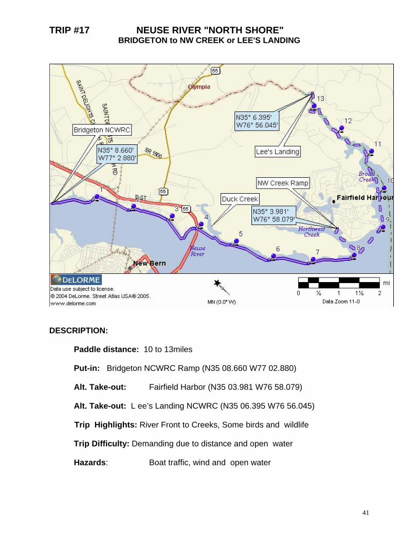
TRIP #17 NEUSE RIVER "NORTH SHORE" BRIDGETON to NW CREEK or LEE'S LANDING
DESCRIPTION:
Paddle distance: 10 to 13miles Put-in: Bridgeton NCWRC Ramp (N35 08.660 W77 02.880) Alt. Take-out: Fairfield Harbor (N35 03.981 W76 58.079) Alt. Take-out: L ee’s Landing NCWRC (N35 06.395 W76 56.045)
Trip Highlights: River Front to Creeks, Some birds and wildlife Trip Difficulty: Demanding due to distance and open water Hazards: Boat traffic, wind and open water
41
42
DRIVING DIRECTIONS TO: PUT-IN: Bridgeton NCWRC Ramp
From Bridgeton east of New Bern, travel 1.0mi north of city limits along US 17 then turn left on SR 1431 (Wildlife Rd) and proceed 1.0 mile to area
TAKE-OUT: NORTHWEST HARBOR RAMP
Traveling on NC 55 from New Bern, turn right onto Broad Creek Road. Follow into Fairfield Harbor and Turn right on Barkentine Dr. Go two streets to Harborside Drive and turn right. Follow to ramp
ALT. TAKE-OUT: LEE'S LANDING NCWRC RAMP
From Bridgeton, travel east on NC 55, turn right on SR 1131(Chair Road) in Reelsboro. Travel 1.2 miles along SR 1131 to stop sign, turn right on SR 1103, proceed 1.7 miles to ramp.
PADDLE TRIP SUMMARY: This paddle begins at the launch ramp in Bridgeton. Follow the Neuse River North Shore through the railroad trestle and under the Hwy 17 - 55 bridge. If you choose to explore Duck Creek, add about 2 miles to this trail. Past McCotter Point, paddler must decide to end the trip at NW Creek or continue on to Lee's Landing and Upper Broad Creek. DETAILS: Put-in: From the NCWRC ramp, paddle down steam (to the left) toward the Rail Road Trestle. Mile 0.8: Pilings from the old Lewis Ferry Docks. Mile 3.6: Sandy Point to the left Mile 1.7: Paddle through opening in the Rail Road Trestle Mile 4.0: Continue following the left shoreline as you pass under the Hwy. 17 - 55 highrise bridge Mile 4.5: At the mouth of Duck Creek, paddler can make the decision to explore the far reaches of this creek. At the end (about 1mile), is Duck Creek Marina and repair yard. Mile 8.1: Mouth of Northwest Creek . If you put in here, ramp is about 1 mile on the or continue on to: Mile 9.0: Mouth of Upper Broad Creek. Lee Landing is 4 miles from this point TAKE-OUTS: Fairfield Harbor Ramp at Mile 9 and Lee's Landing is at Mile 13
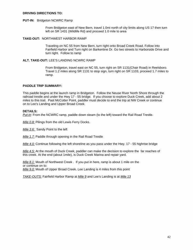
Trip #18 NEUSE RIVER "SOUTH SHORE" Union Point Park to Hancock Creek NCWRC
DESCRIPTION:
Paddle distance: 18.5 miles Put-in: Union Point Park Ramp (N35 06.254 W77 02.070) Take-out: Hancock Creek NCWRC (N34 55.022 W76 51.173)
Trip Highlights: River Front to Creeks, Some birds and wildlife Trip Difficulty: Very Demanding due to distance and open water Hazards: Boat traffic, wind and open water
43

44
DRIVING DIRECTIONS TO: PUT-IN: Union Point Park Ramp
In downtown New Bern off of Front Street in Union Point Park TAKE-OUT: Hancock Creek NCWRC
Travel east along NC101 4.9 miles from US70 at Havelock, turn left onto Cahoogue Road/SR1717 and proceed 3.5 miles to area. Last 1.6 miles of trip is by gravel road.
PADDLE TRIP SUMMARY: This paddle should ONLY BE CONSIDERED BY EXPERT PADDLERS due to the distance , wind, open water and changing weather conditions. The paddle begins at the launch ramp in downtown New Bern. Follow the Neuse River "SouthShore under the Hwy 17 - 55 high-rise bridge, past shorefront developments, golf course, National Forest lands and Cherry Point MAS. The 5 miles of base shoreline property is NO TRESSPASSING. Please plan accordingly! DETAILS: Put-in: From the ramp, paddle down steam (to the right) toward the high-rise bridge. Mile 2.1: Black Point Mile 5.1: Johnson's Point to the right Mile 8.6: Croatan National Forest - Fishers Landing offers a rest stop, port-o-lets and picnic tables (N35 00.038 W76 58.496) Mile 10.2: Croatan National Forest -Flanner's Beach or Neuse River Camp Ground (N34 59.091 W76 57.013) has camping, restrooms, water, swimming and showers. Both facilities (Fishers and Neuse River) do not have actual launch or take-out sites but will offer refuge and/or take-out if necessary but it is necessary to carry boats up stairs. Mile 12: Paddlers will reach the beginning of military property on the Neuse (Cherry Point Marine Air Station). The military property extends about 5 miles to the mouth of Hancock Creek. Mile 14.0: Mouth of Slocum Creek (N34 57.136 W76 53.742) Mile 17.0: Mouth of Hancock Creek. (N34 56.312 W76 51.302) Follow creek past Marine Supply Dock Facility and into mouth of creek. Ahead the creek forks in three directions. Follow left fork (not into marina). Mile 18.0: Ahead you will see another split in the waterway .. to left is Cahooque and right is Hancock Creeks. Head toward point between creeks. TAKE-OUT: The take-out (Hancock NCWRC Ramp) is to the right of the point about 1/4 mile ahead.
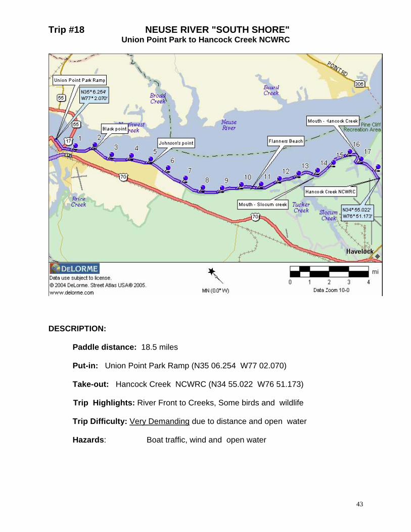
Trip #19 SLOCUM CREEK CIRCLE
SW PRONG OF SLOCUM CREEK NCWRC
DESCRIPTION:
Paddle distance: 12 miles Put-in: Slocum Creek NCWRC (N34 53.460 W76 55.420)
Trip Highlights: Narrow stream to open Creek. Birds and wildlife sightings likely. Trip Difficulty: Moderate to Demanding due to distance and some open water Hazards: Boat traffic wind and open water
45

46
DRIVING DIRECTIONS TO: PUT-IN: Slocum Creek NCWRC Ramp
Traveling east on US 70 just north of SR 101 is service road and markings to Visitor’s Center/Hotel. The ramp is located off the service road near the Slocum Creek Bridge.
PADDLE TRIP SUMMARY: With the exception of the beginning ¾ mile of the paddle (in the West Prong of Slocum Creek), the entire paddle is on the Cherry Point Marine Air Station property. DO NOT attempt to go ashore unless emergency or with personnel cleared on base. The circle trip can be utilized for any distance with the first couple miles (to the bridge) being the most interesting. DETAILS: Put-in: From the NCWRC ramp, paddle down steam (to the left) and under the Hwy 70 bridge. Mile0.8: The West Prong of Slocum Creek opens up and you are now paddling Slocum Creek Mile1.8: Approaching bridge, hug the left bank. It is unusually shallow to the right Mile 2.1: Slocum Road Bridge, (N34 55.060 W76 54.709). Mile 2.5: Ordnance point Mile 4.3: Slocum Creek continues straight ahead while Tucker Creek heads off to the left. You may explore more then 1 1/2 miles into Tucker Creek before turning around. Mile 6.8: The mouth of the Neuse Rivere is about 1 mile beyond the confluence of Slocum and Tucker Creeks and to the left as you leave Tucker Creek. TAKE-OUT: From the confluence of Slocum and Tucker Creeks, you are 4 miles from the take-out. The total trip distance is 12 miles with exploration
OPTION: Upon return, you may continue past ramp into a very unique Cypress Swamp but only about ½ mile..

Trip #20 CHERRY POINT
SLOCUM CREEK NCWRC to HANCOCK CREEK NCWRC
DESCRIPTION:
Paddle distance: 10miles Put-in: Slocum Creek NCWRC (N34 53.460 W76 55.420)
Take-out: Hancock Creek NCWRC (N34 55.022 W76 51.173)
Trip Highlights: Narrow stream to open Creek to exposed open water again to
protected creeks. Birds and wildlife sightings likely. Trip Difficulty: Moderate to Demanding due to distance and some open water Hazards: Boat traffic wind and open water
47
48
DRIVING DIRECTIONS TO: PUT-IN: Slocum Creek NCWRC Ramp
Traveling east on US 70 just north of SR 101 is service road and markings to Visitor’s Center/Hotel. The ramp is located off the service road near the Slocum Creek Bridge.
TAKE-OUT: Hancock Creek NCWRC
Travel east along NC101 4.9 miles from US70 at Havelock, turn left onto Cahooque Road/SR1717 and proceed 3.5 miles to area. Last 1.6 miles of trip is by gravel road.
PADDLE TRIP SUMMARY: With the exception of the beginning ¾ mile of the paddle (in the West Prong of Slocum Creek) and the (ending) east shore of Hancock creek, the entire paddle is bordered by Cherry Point Marine Air Station property. DO NOT attempt to go ashore unless emergency or with personnel cleared on base. This paddle takes you from the small protected prong of Slocum Creek, into a fairly wide portion of Slocum Creek. You are exposed to about 3 miles of the Neuse River which can be very challenging to paddle if there are strong wins from any direction but south. The final couple miles are again in protected waters. DETAILS: Put-in: From the NCWRC ramp, paddle down steam (to the left) and under the Hwy 70 bridge. Mile0.8: The West Prong of Slocum Creek opens up and you are now paddling Slocum Creek Mile1.8: Approaching bridge, hug the left bank. It is unusually shallow to the right Mile 2.1: Slocum Road Bridge, (N34 55.060 W76 54.709). Mile 2.5: Ordnance point Mile 4.0: Slocum Creek continues straight ahead while Tucker Creek heads off to the left. Mile 5.0: The mouth of the Neuse River is about 1 mile beyond the confluence of Slocum and Tucker Creeks. Continue to bear right as you pass Tucker Creek Immediately after passing Marine Supply Dock, round point and paddle into mouth of Hancock Creek Mile 8.0: Ahead you will see Hancock Creek split in three directions. Paddle into the left fork, not toward marina or adjacent bay. Mile 9.2: Ahead, you will see a point. To the left of this point is Cahooque Creek and to the right is Hancock Creek. Continue following Hancock Creek TAKE-OUT: The take-out ramp is found on the right side of previously mentioned point at 9.6 miles.
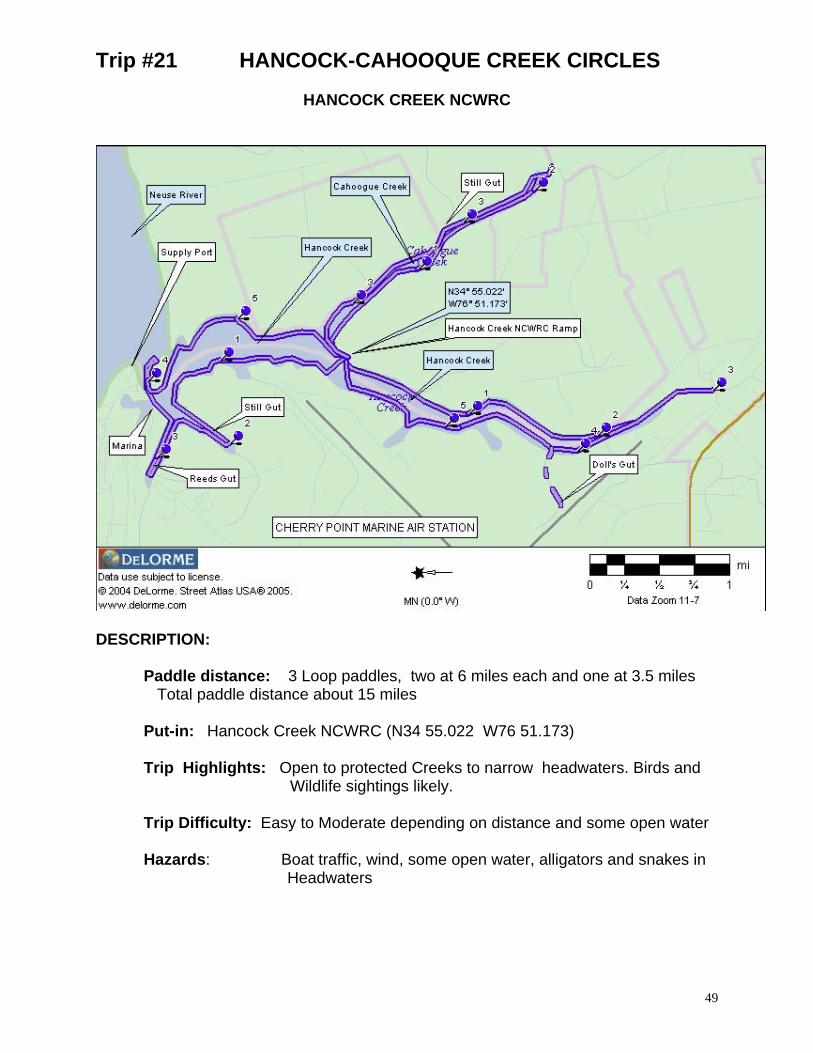
Trip #21 HANCOCK-CAHOOQUE CREEK CIRCLES
HANCOCK CREEK NCWRC
DESCRIPTION:
Paddle distance: 3 Loop paddles, two at 6 miles each and one at 3.5 miles Total paddle distance about 15 miles Put-in: Hancock Creek NCWRC (N34 55.022 W76 51.173)
Trip Highlights: Open to protected Creeks to narrow headwaters. Birds and Wildlife sightings likely. Trip Difficulty: Easy to Moderate depending on distance and some open water Hazards: Boat traffic, wind, some open water, alligators and snakes in
Headwaters
49
50
DRIVING DIRECTIONS TO: PUT-IN/TAKE-OUT: Hancock Creek NCWRC
Travel east along NC101 4.9 miles from US70 at Havelock, turn left onto Cahoogue Road/SR1717 and proceed 3.5 miles to area. Last 1.6 miles of trip is by gravel road.
PADDLE TRIP SUMMARIES and DETAILS: Hancock Headwaters Circle (6 miles):
The headwaters of Hancock creek will take the paddler deep into Cherry Point Marine Air Station Property. Your exploration ends at a military property bridge and the route reversed.
Put-in: From the NCWRC ramp, paddle up steam (to the left) and following the left shore line Mile 0.5: Little John Creel offers little to explore Mile 2.5: End of the13/32 runway and approach lights seen on both sides of creek Mile 2.9: Bridge blocks further exploration of the headwaters of Hancock Creek RETURN: Along left shoreline Mile 4.2: Doll's Gut extends toward the 13/32 runway and 1/2 mile in to the heart of Cherry Point END: Ramp on right, 6 miles total trip Hancock to the Neuse, Circle (6 miles)
This circle trip takes the paddler toward the Neuse river. About one and one-half miles into the trip, Hancock Creek branches in three directions. To the left; Still Gut and in the center; Reeds Gut. Past the Cherry Point Hancock Creek Marina is the mouth of Hancock Creek. A short side- trip along the Neuse river shoreline takes you to a spectacular beach. Each "branch" offers about one, round trip mile of exploration.
Put-in: From the NCWRC ramp, paddle down steam (to the right), cross to west shore and following the left shore- line Mile 1.5: Ahead are three branches: each allowing paddlers to explore about 1 round-trip mile To left, Still Gut, in center, Reeds Gut and ahead and to right, past Marina and out the Hancock Creek Inlet Mile 2.5: If you choose to paddle out to the inlet, you will pass a Marine Base "Shipping Port" on the left Mile 2.6 If you follow the right Neuse River shoreline about 300 yards, you will see a great little sand beach suited for a picnic of even camping. Someone placed a little carpet in the woods, it makes a great tent platform! RETURN: As you return to the launch ramp, follow the left shoreline until you reach Cahooque Creek Mile 5.5: Head for the right side of the point separating Cahooque and Hancock Creeks END: The ramp is located on the right side of the point, 6 miles total trip distance Cahooque Creek Circle (4.5 miles)
The Cahooque Creek paddle offers the most protected waters of the area. All lands are part of the Croatan NF except for a small portion privately owned. The swamp grass along the far end of this paddle is home to a family of alligators sited on a recent paddle.
Put-in: From the NCWRC ramp, paddle around the point following the right shoreline into Cahooque Creek Mile 1.25 As you follow Cahooque Creek, you will pass Still's Gut to your left Mile 2.2 Flowing off to the left is Barney Branch, continue to the right Mile 2.5 Continuing to follow Cahooque Creek, you will run out of navigable water and force a turn-a-round RETURN: As you return to the launch ramp, follow the right shoreline until you reach Hancock Creek Mile 5.5: Bear to the left past the point separating Cahooque and Hancock Creeks END: The ramp is located on the right side of the point, 4.5 miles total trip distance.
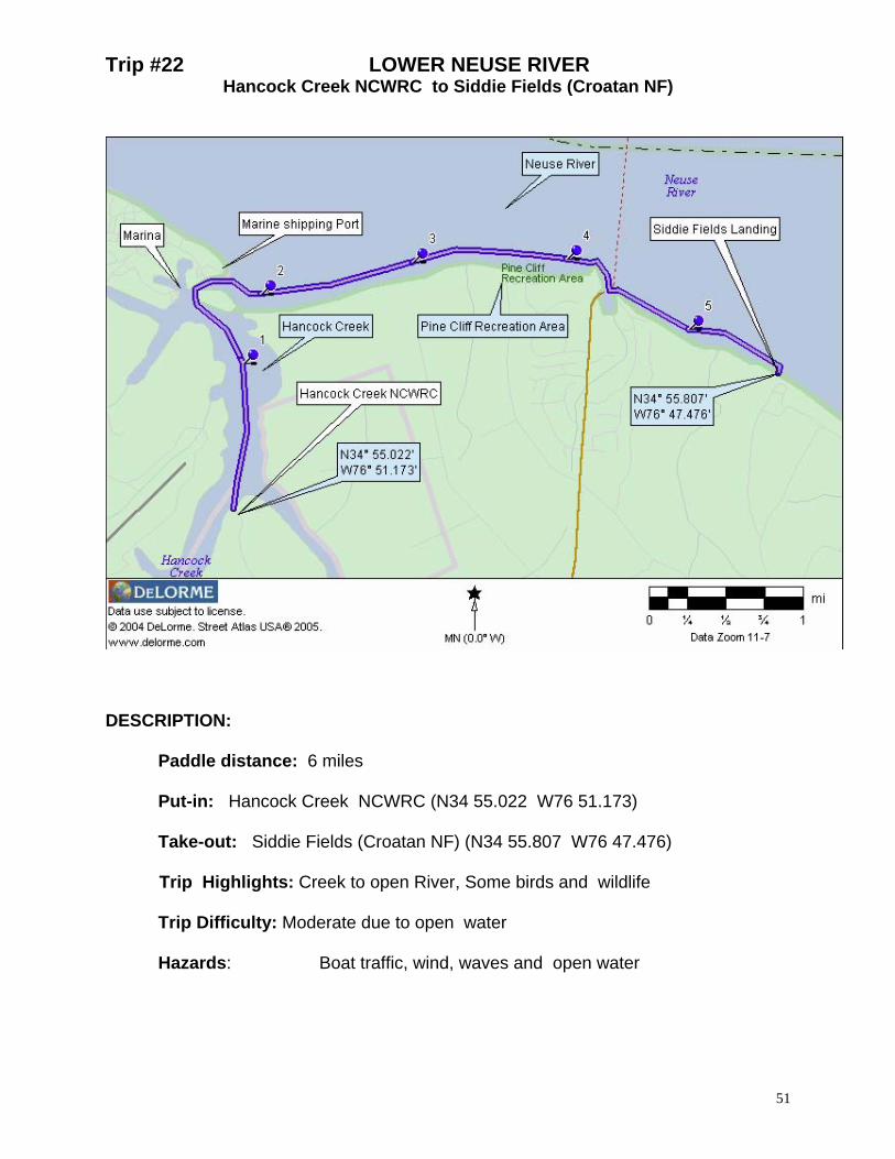
Trip #22 LOWER NEUSE RIVER Hancock Creek NCWRC to Siddie Fields (Croatan NF)
DESCRIPTION:
Paddle distance: 6 miles Put-in: Hancock Creek NCWRC (N34 55.022 W76 51.173) Take-out: Siddie Fields (Croatan NF) (N34 55.807 W76 47.476)
Trip Highlights: Creek to open River, Some birds and wildlife Trip Difficulty: Moderate due to open water Hazards: Boat traffic, wind, waves and open water
51
52
DRIVING DIRECTIONS TO: PUT-IN: Hancock Creek NCWRC
Travel east along NC101 4.9 miles from US70 in Havelock. Turn left onto Cahoogue Road/SR1717 and proceed 3.5 miles to end of paved road.Bear left onto gravel road, ramp is 1.6 miles ahead.
TAKE-OUT: Siddie Fields (Croatan NF)
From Havelock, take NC 101 toward Beaufort to (SR1711) Temple Point Road and turn left (at Church/cemetery). Travel 2.0 miles to NC1762 and turn left. Follow 1.5 miles past Pine Cliff Rd to FR 167 (gravel road) and turn left and continue bearing left to end of road. Launch on beach
PADDLE TRIP SUMMARY: The paddle begins at the launch ramp in Hancock Creek. Following a short paddle to the Neuse River, the balance of the trip is in exposed waters of the Neuse River. Paddle conditions should be considered before continuing as this section of the River can become quite rough. The paddle will take you past the Pine Cliff Recreation Area and the Hwy 306 Ferry Terminal before reaching your take-out. The Siddie Fields take-out can be difficult to find as you paddle eastward along the shoreline. DETAILS: Put-in: From the ramp, paddle down steam (to the left) toward the Neuse River. Mile 1.5: As Hancock Creek branches into four directions, continue to bear to the right around point and into the Neuse. Mile 1.7: As you reach the mouth of the confluence of Hancock Creek and the Neuse River turnright and follow the right shoreline Mile 3.5: Croatan National Forest -Pine Cliff Recreation Area offers restroom, swimming and picnic tables. This is the Trailhead for the Neusiok Hiking Trail Mile 4.5: Hwy 306 Ferry Terminal and mooring facility. Paddle past this area carefully, watch for ferry traffic. Their waves can easily cause you to overturn. Mile 5.7 The TAKE-OUT at the Saddie Fields Beach Area is found along the right shoreline and can be difficult to spot.
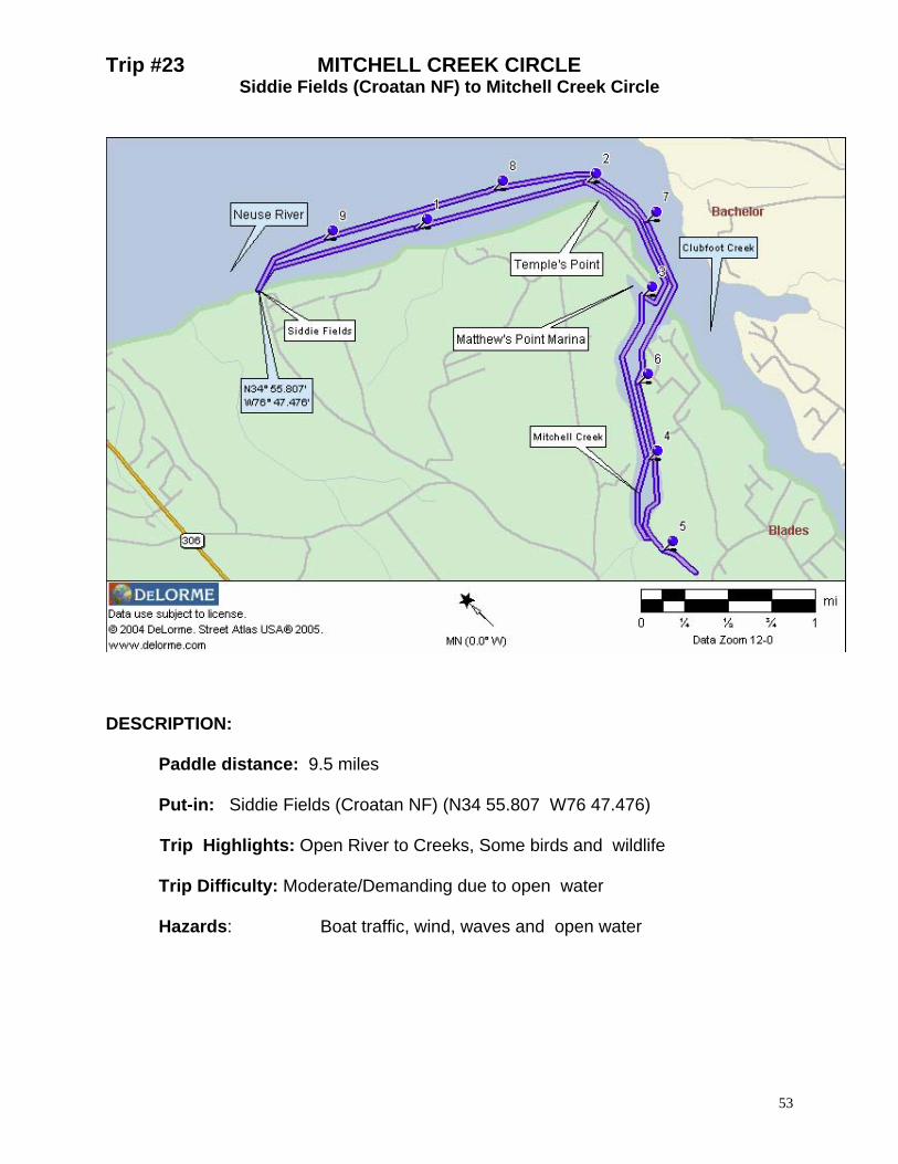
Trip #23 MITCHELL CREEK CIRCLE Siddie Fields (Croatan NF) to Mitchell Creek Circle
DESCRIPTION:
Paddle distance: 9.5 miles Put-in: Siddie Fields (Croatan NF) (N34 55.807 W76 47.476)
Trip Highlights: Open River to Creeks, Some birds and wildlife Trip Difficulty: Moderate/Demanding due to open water Hazards: Boat traffic, wind, waves and open water
53
54
DRIVING DIRECTIONS TO: PUT-IN: Siddie Fields (Croatan NF)
From Havelock, take NC 101 toward Beaufort to (SR1711) Temple Point Road and turn left (at Church/cemetery). Travel 2.0 miles to NC1762 and turn left. Follow 1.5 miles past Pine Cliff Rd to FR 167 (gravel road) and turn left and continue bearing left to end of road. Launch on beach
PADDLE TRIP SUMMARY: The paddle begins at the beach at Siddie Fields (a primitive camping area of the Croatan National Forest) and heads down the Neuse River (to the right). After a short paddle in the Neuse River, you will find the balance of the trip is in the protected waters of Clubfoot and Mitchell Creeks. The Siddie Fields take-out can be difficult to find as you paddle back along the Neuse River shoreline. DETAILS: Put-in: From the beach launch, paddle down steam (to the right) toward Clubfoot Creek Mile 2.0: As you round Temple's Point, the paddler enters Clubfoot Creek the creek channel is marked by navigation day marks until you reach Matthew's Point Marina. Mile 3.0: As you Pass Matthew's Point Marina on the right , you enter mouth of Mitchell Creek Mile 4.8: Mitchell Creek offers more then 2 miles of exploration before the paddler runs out of navigable waters. Mile 5.0 Upon reaching the narrows of Mitchell Creek, you will come upon a fork in the waterway. To the left is Big Branch, the widest and most navigable of the streams. On the right is Snake Branch actually guarded by it's namesake on our last paddle. Thus I can only speculate on the short distance you can paddle in this stream. Return: Your return follows same route as you paddled in to Mitchell Creek. A stop over is possible at Matthew's Point marina however as a courtesy, advise the Dockmaster; Jesse Schmucker of your intent. Mile 9.5 The TAKE-OUT at the Siddie Fields Beach Area is found along the left shoreline and can be difficult to spot.

Trip #24 HARLOW CANAL
SR 1391 Bridge to Siddie Fields Recreation Area
DESCRIPTION:
Paddle distance: 8.2 miles Put-in: SR 1391 Bridge over the Harlow Canal (N34 50.195 W76 44.937) Take-out: Siddie Fields Recreation Area (N34 55.807 W76 47.476) Trip Highlights: Historic Canal to marsh lands, creeks and open river. Birds and wildlife sightings likely. Trip Difficulty: Moderate to experienced due to distance and some open water Hazards: Boat traffic, wind and tidal current
55
DRIVING DIRECTIONS TO: PUT-IN: SR 1391 Bridge
From Havelock, follow NC 101 toward Beaufort. After you drive through Harlow, turn left at the first road you come to (SR 1391 about .9 miles). The bridge over the canal is about .2 miles from turn. Launch at the south east side of the bridge and park along road.
TAKE-OUT: Siddie Fields (Croatan NF)
From Havelock, take NC 101 toward Beaufort to (SR1711) Temple Point Road and turn left (at Church/cemetery). Travel 2.0 miles to NC1762 and turn left. Follow 1.5 miles past Pine Cliff Rd to FR 167 (gravel road) and turn left and continue bearing left to end of road. Launch on beach
PADDLE TRIP SUMMARY: This paddle begins in narrow tree lined canal, connects with Clubfoot Creek and eventually connects to the Neuse river. Paddling the canal, you will experience current dependant on tides in the Newport River. Approaching high tide, current flows toward Clubfoot Creek and following high tide, current reverses. Currents are up to 2 mph maximum and decrease as you reach the junction of the Harlow Canal and Clubfoot Creek (about 1 ½ miles). The Siddie Fields take-out can be difficult to find as you paddle back along the Neuse River shoreline. DETAILS: Put-in: Begin the paddle by heading to right (north) of the put-in and toward Clubfoot Creek Mile 0.8: As you travel along the canal, you will reach the first bridge Mile 1.6: The high treed banks continue until you reach the confluence with Clubfoot Creek . At this junction, bear to the left to continue. Paddlers may venture right to explore the far reaches of Clubfoot Creek for about a mile or so. Mile 2.0: Shortly you will see a large bay to your left. Proceed straight ahead to continue the trail however see option below for information to explore Morton’s Mill Pond Mile 5.0: Continue your paddle along the left shoreline of Clubfoot Creek, you will notice the confluence of Gulden Creek to the right and Mitchell Creek to the left. Straight ahead is a large marina known as Mathew’s Point Marina and a friendly stop for paddlers. I would suggest contacting the Dockmaster; Jesse Schmucker if you plan to go ashore use the marina facilities. Mile 6.0: Approximately 1 mile past the marina is the mouth of Clubfoot Creek and the Neuse River (N34 54.946 W76 45.576). Continue your paddle to the left or upstream on the Neuse River. Mile 8.2: Your paddle will take you a little more then two miles in the Neuse river before you reach the take-out Mile 9.5 The TAKE-OUT at the Siddie Fields Beach Area is found along the left shoreline and can be difficult to spot. Options: Morton's Mill Pond: This side trip can add up to 3 miles to the paddle trail. As you paddle into this area, you will reach the Blades Road bridge in less then ½ mile . Past the bridge and pilings, a possible launch site is noted on the right shoreline. You may find it very interesting following the stream for about another mile before turning around. Mitchell Creek: A similar stream to explore, Mitchell Creek, extends nearly 1 1/2 miles from Clubfoot Creek before it forks into Snake Branch and Big Branch streams. This side trip also adds about 3 miles to the paddle. 56
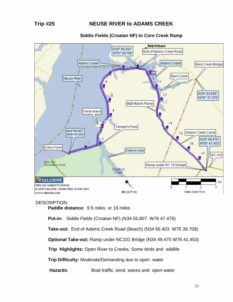
Trip #25 NEUSE RIVER to ADAMS CREEK
Siddie Fields (Croatan NF) to Core Creek Ramp
DESCRIPTION: Paddle distance: 9.5 miles or 18 miles
Put-in: Siddie Fields (Croatan NF) (N34 55.807 W76 47.476)
Take-out: End of Adams Creek Road (Beach) (N34 56.403 W76 39.709)
Optional Take-out: Ramp under NC101 Bridge (N34 49.475 W76 41.453)
Trip Highlights: Open River to Creeks, Some birds and wildlife
Trip Difficulty: Moderate/Demanding due to open water Hazards: Boat traffic, wind, waves and open water
57
DRIVING DIRECTIONS TO: PUT-IN: Siddie Fields (Croatan NF)
From Havelock, take NC 101 toward Beaufort to (SR1711) Temple Point Road and turn left (at Church/cemetery). Travel 2.0 miles to NC1762 and turn left. Follow 1.5 miles past Pine Cliff Rd to FR 167 (gravel road) and turn left and continue bearing left to end of road. Launch on beach
TAKE-OUT: Beach at end of Adams Creek Road
From Havelock, take NC 101 toward Beaufort, turn left on Adams Creek Road in Harlow. Follow Adams Creek Road to end of road (about 11 miles), Launch from beach
OPTIONAL TAKE-OUT: Under NC101 Bridge
From Havelock, turn into the Sea Gate Development before crossing the ICW. Follow Old Bridge Road, .7 miles to Sea Gate and turn right. Go about 5o yards, turn left on Church Gate Lane. Once under bridge, ramp on left
PADDLE TRIP SUMMARY: The paddle starts at the beach at Siddie Fields (a primitive camping area of the Croatan National Forest) and heads down(to the right) the Neuse River. Passing Clubfoot Cr. and Great Island you reach the entrance into Adams Creek (part of ICW). Adams Creek is more then 1 mile wide but reduces to a narrow manmade canal in less than 6 miles. The last five miles of the trail are in Adams Creak Canal, a narrow section of the Intra-Coastal Waterway with unusually heavy boat/barge traffic. Tidal current can be STRONG, check tide before entering Adams Cr. Canal. DETAILS: PUT-IN: From the beach launch, paddle down steam on the Neuse River(to the right) toward Clubfoot Creek Mile 3.2: After crossing Clubfoot Creek, Paddle between Great Island and shoreline Mile 3.8: Mouth of Long Creek (can explore less then 1/2 mile) Mile 5.4: After passing the mouth of Courts Creek, continue to follow the right shoreline Mile 6.2 After passing Great Neck Point, and about 1 mile later the mouth of Godfrey and Delamar Creeks you enter Adams Creek, Mile 9.3: Along the right shoreline, you will see a sand beach and the end of Adams Creek Road which is a convenient place to pull-out or take a lunch break or rest stop. Across Adams Creek (about 1 mile) is the entrance to Cedar Creek with its explorable tributaries; Jonaquine and Cullie Creeks. At the point before entering Jonaquine Creek is a community ramp, park, picnic tables and porta-potty. Mile 11.3: Continuing south , you will see the opening into Back Creek along the east shoreline. If you decide to explore this area, you can paddle more then 3 miles from the confluence of Back and Adams Creeks. At that point, you will pass under the Merrimon Road bridge. Actually, this is the extreme end of the Craven County line and one can launch from the drainage ditches along the side of the road. One could launch from here and enjoy a day of exploration on Back Creek and south to Isaac Creek. Mile 12.8: Continuing along Adams Creek and along the right shore is B&B Mobile Resort (off of Adams Creek Road and 7.9 miles from NC101) with its private boat ramp ($5 launch fee) Mile 13.0: Enter Adams Creek Canal Mile 14.5: Craven - Carteret County line and the start of SeaGate Residential Development Mile 16.0: Entrance to Sea Gate Marina and another boat launch ramp ($5 launch fee) TAKE-OUT: As you approach the 65' high NC101 Bridge, there is a small take-out along the right bank, behind bridge pilings. Another place to pull out is across ICW at a private ramp with fee box. (TOTAL TRIP 18 MILES)
58