Embed Size (px)
Citation preview

Pre-Application Document (PAD)
Turners Falls Hydro Project
Project No: 2622
Applicant: Turners Falls Hydro LLC
Date: February 28, 2016

2
PRE-APPLICATION DOCUMENT
Applicants must file a Pre-Application Document (PAD) (18 C.F.R. § 5.6) that provides existing
information relevant to the project that is in the applicant's possession or that the applicant can
obtain with the exercise of due diligence. This existing, relevant, and reasonably available
information is distributed in the form of the PAD to the Commission and interested stakeholders
to enable these entities to identify issues and related information needs, develop study requests
and study plans, and prepare documents analyzing any license application that may be filed with
the Commission. In summary, the PAD must contain the following information:
A description of the project's facilities and operation;
A description of the existing environment and any known and potential project effects on specific
resources including: geology and soils; water resources; fish and aquatic resources; wildlife and
botanical resources; wetlands, riparian, and littoral habitats; rare, threatened, and endangered
species; recreation and land use; aesthetic resources; cultural resources; socioeconomic
resources; tribal resources; and a description of the river basin;
A list of preliminary issues and studies that may be needed at the project;
An appendix summarizing contacts with stakeholders sufficient to enable the Commission to
determine if due diligence has been exercised in obtaining relevant information;
A process plan and schedule for consulting stakeholders, gathering information, developing and
conducting studies, obtaining permits and completing all pre-filing licensing activities; and
If applicable, a statement of whether or not the applicant will seek benefits under section 210 of
the Public Utility Regulatory Policies Act of 1978 (PURPA).
Applicants do not have to conduct studies in order to generate information for inclusion in the
PAD. Rather, an applicant must exercise due diligence in determining what information exists
that is relevant to describing the existing environment and potential impacts of the project
(including cumulative impacts), obtaining that information if the applicant does not already
possess it, and describing or summarizing this information in the PAD. Due diligence includes,
but is not limited to, contacting appropriate stakeholders that may have relevant information and
reviewing Federal and state comprehensive plans.
All sources of information must be referenced in the appropriate sections of the PAD and must be
contained in an appendix to the PAD.

3
§ 5.6 (d)(1) - Process plan and schedule The process plan must include:
Time frames for pre-application consultation, information gathering, and studies
First a public meeting to present the PAD, ask for comments and concerns in October 2016.
The next meeting will be to hold the scoping meeting in November 2016.
Proposed location and date for scoping meeting and for the site visit [§ 5.8 (b)(3)(viii)]
The scoping meeting will be held in the powerhouse on site in November 2016.
§ 5.6 (d)(2) - Project location, facilities, and operations. The potential applicant must include in the
Pre-Application Document:
Contact information of each person authorized to act agent for applicant (exact name, business
address, and phone number)
Peter B. Clark, Manager of Turners Falls Hydro LLC: P.O. Box 149A, Hamilton, MA 01936
Telephone: (978) 469-3999, Fax: (978) 469-1210
Martha Brennan, Regulatory Coordinator: P.O. Box 149A, Hamilton, MA 01936
Tel: (978) 468-3999, Fax: (978) 468-1210
Maps of land use within project boundaries (township, range and section, state, county, river,
river mile, and closest town) and, if applicable, Federal and Tribal lands, and location of proposed
facilities.
4
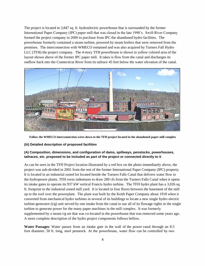
The project is located in 3,847 sq. ft. hydroelectric powerhouse that is surrounded by the former
International Paper Company (IPC) paper mill that was closed in the late 1990’s. Swift River Company
formed the project company in 2000 to purchase from IPC the abandoned hydro facilities. The
powerhouse formerly contained a steam turbine, powered by steam boilers that were removed from the
premises. The interconnection with WMECO remained and was also acquired by Turners Fall Hydro
LLC (TFH) the project company. The 4-story TFH powerhouse is shown in yellow colored area of the
layout shown above of the former IPC paper mill. It takes is flow from the canal and discharges its
outflow back into the Connecticut River from its tailrace 45 feet below the water elevation of the canal.
Follow the WMECO interconnection wires down to the TFH project located in the abandoned paper mill complex
(iii) Detailed description of proposed facilities
(A) Composition, dimensions, and configuration of dams, spillways, penstocks, powerhouses,
tailraces, etc. proposed to be included as part of the project or connected directly to it
As can be seen in the TFH Project location illustrated by a red box on the photo immediately above, the
project was sub-divided in 2001 from the rest of the former International Paper Company (IPC) property.
It is located in an industrial zoned lot located beside the Turners Falls Canal that delivers water flow to
the hydropower plants. TFH owns indentures to draw 289 cfs from the Turners Falls Canal when it opens
its intake gates to operate its 937 kW vertical Francis hydro turbine. The TFH hydro plant has a 3,026 sq.
ft. footprint in the industrial zoned mill yard. It is located in four floors between the basement of the mill
up to the roof over the powerplant. The plant was built by the Keith Paper Company about 1918 when it
converted from mechanical hydro turbines in several of its buildings to locate a new single hydro electric
turbine-generator (t/g) unit served by one intake from the canal to use all of its flowage rights in the single
turbine to generate power for the many paper machines in the mill complex. It was formerly
supplemented by a steam t/g set that was co-located in the powerhouse that was removed some years ago.
A more complete description of the hydro project components follows bellow.
Water Passages: Water passes from an intake gate in the wall of the power canal through an 8.5
foot diameter, 50 ft. long, steel penstock. At the powerhouse, water flow can be controlled by two
TFH
Project

5
mechanically operable (rack and pinion) slide gates. In November 2012, a new gate lifter was
fabricated and installed at an approximate cost of $14,000. At the turbine gate case, inflow is further
controlled by the openings of the wicket gates.
Water Power Turbine: The property contains a single, vertical, Francis-type turbine with a nominal
installed capacity of 225 rpm or 1340 rated horsepower capacity.
Electric Equipment consists of a single G E synchronous generator directly connected to the
turbine, with a nameplate capacity of 937 k W. We believe the generator and turbine were
manufactured together and both date back to 1918. In 2009, the generator stator was rewound, at
accost of approximately $33,800.
Other Electrical Equipment includes switchgear and controls, breakers , transformers , and station
service. The PLC control system was installed in 2008 and improved in 2011 by the addition of a new
Dell computer. In addition, in 2009 an automated trash rack blow out system was installed.
Ancillary Equipment in the powerhouse consists of a governor with supporting hydraulics (by
Woodward), a 70-ton overhead bridge crane by Whiting, pumps, compressors (including a new
compressor installed in November 2010), fire suppression systems (relocated in 2010), and HVAC
systems.
Powerhouse. The turbine and generating equipment, associated controls, and ancillary equipment are
installed in a multi-story, brick powerhouse located within the former Strathmore Paper mill complex, on
the west side of the power canal, approximately 1,300 feet downstream from the Turners Falls Dam and
Gatehouse. Sitting on two, fee-owned land parcels, of 3,026 sf and 821 sf respectively (combined area is
3,847 sf), the powerhouse structure is integral to the surrounding paper mill, with which it shares several
common walls. In March 2012, the powerhouse roof was rehabilitated and new skylights and windows
were installed, at a total cost of approximately $30,000. This section of the building is thought to have
been built around 1890.
In addition, access to both properties is regulated by multiple cross easements between International
Paper Company and TF Hydro LLC. The Town tax card indicates that the structure contains three floors,
with variable square footage, above ground and two subterranean levels. There is a half bath located on
the second floor. The lowest level sits just above an open flume into which water is discharged from the
turbine. The west side of the structure abuts Canal Street and holds a large doorway sufficient in size to
permit removal of machinery for offsite repair. The main floor of the powerhouse holds all the generator
as well as switchgear and controls and is directly connected to the turbine on the lower level, via a vertical
shaft.
Tailrace. After passing through the waterpower turbine, water flows through a flume underneath the
adjacent mill complex approximately 50 feet to an excavated , walled, tailrace, approximately 80
additional feet back into the Connecticut River .
Land and Rights. The amount of land associated with this property is minimal, and essentially
constitutes the land underneath the powerhouse. The subject land is identified in Montague Town records
as Map 02, Lot 1C. There is no additional vacant land associated with the hydro facility, though
numerous cross-easements exist, related to access, maintenance of common walls, operation of the power
canal, specification of liabilities, etc.

6
(B) Reservoir normal maximum water surface area and elevation and gross storage capacity
The project of TFH has no control of the impoundment above the Turners Falls Dam on the Connecticut
River, nor of the elevation of water in the Turners Falls Canal. TFH owes indentures to draw 289 cfs
from the canal at any time that its intake gates are open (allowing generation at full gate when the project
is on water. The dam and impoundment are owned by FERC Project -1889 that includes the dam, canal
intake and the Cabot and Turners Falls projects owned by GDS Suez, formerly named First Light Hydro
Generating Company. The elevation of the impoundment behind the Turners Falls Dam is controlled as
the tailwater reservoir of the Northfield Mountain Pump Storage project. TFH is operated without any
storage area in its project and has no control over adjustments in the elevation of water in the Turners
Falls Canal.
(C) Number, type and capacities of turbines and generators, and installed (rated) capacity of
proposed turbines or generators
The project has only one turbine that uses 289 cfs hydraulic capacity. It is thought to be a 1919 GE
vertical Francis turbine and generator set with a nameplate capacity of 938 kW at 43 to 44 ft of net head.
(D) Number, length, voltage, and interconnections of any primary transmission lines proposed to
be included as part of the project, including a single-line diagram showing the transfer of energy
from the project to the transmission grid or point of use
TFH is interconnected to WMECO (now Eversource Electric) at 23 kVA using a step up transformer after
generating at 600 volts. The interconnection agreement is an ISO SGIA last amended on 9/24/2014. The
one line diagram is attached to the SGIA found in Appendix A. The length of the wire to the point of
interconnection is estimated as 1000 ft from the front of the powerhouse building and is located on the
opposite side of the Turners Falls Canal from the island location of the abandoned paper mill.
(E) Energy production (estimate of dependable capacity, average annual, and average monthly
energy production)
The production is made up of a combination of energy generated by TFH that is sold to RMLD during the
2014 (1,595 MWh) and 2015 (1,857 MWh) plus revenue earned from by selling the TFH flowage rights
to First Light whenever canal flow rates are less than 15,000 cfs as required by a WEA (Water Exchange
Agreement) that requires TFH to allow flow to pass by its intake to benefit Cabot Station, which is 2
miles downstream and has a higher head than TFH. First Light makes payment to TFH that includes a
benefit of half the extra head differential (equivalent to 1100 kW of capacity in place of TFH’s 937 kW
capacity). The extra output credited to TFH was 7,855 MWh in 2014 and 7,597 in 2015 valued at ISO-
NE’s hourly marginal energy prices at the Turners Falls location. The average monthly production and
generation equivalent paid by First Light and RMLD from 2011 through 2015 is found in Appendix B.
(iv) Current (if applicable) and proposed project operation, including any daily or seasonal
ramping rates, flushing flows, reservoir operations, and flood control operations
TFH operates at 100% wicket gate opening when it is “on water” utilizing all of its 289 cfs water rights.
When it is ordered off water by the Northfield Mountain dispatcher, it closes its intake gates to allow flow
to pass by the intake continuing downstream to be utilized by the Cabot Station. Since TFH draws its

7
flow from the Turners Falls Canal, it does not need to ramp up or down then starting to generate or stops
generating power. As a water taker from the canal, it has no ability to control flood flows in the
Connecticut River because it does not control the impoundment upstream of the Turners Falls Dam. In
periods of high flows on the Connecticut River, the taitor gates on the Turners Falls Dam are opened thus
significantly increasing the elevation of TFH’s tailwater pool, which is the bypass reach of the dam.
(v) Existing license and project operations (if applicable)
(1) Description of current license requirements (i.e., the requirements of the original license as
amended during the license term)
There will be no change in the operation of the TFH project when it is re-licensed in 2021. We expect to
see a continuation of the WEA as it is described above and has continued since 1951.
(2) A summary of project generation and outflow records for the five years preceding filing of the
Pre-Application Document
A record of the project’s monthly output with energy and water sales average prices and revenue during
2011 to 2015 can be found in Appendix B.
(3) Current net investment
Total depreciated Equity value of TFH is estimated as $1,168,655 at the end of 2015. This value is before
the accountants have finished their annual review of the project’s books and includes depreciation with a
value of over a half million dollars since the project was purchased from International Paper Company.
(4) Project compliance history, if applicable, including a description of any recurring situations of
non-compliance
TFH has always been in compliance with its FERC license over the last hundred years of operations.
(vi) A description of any new facilities or components to be constructed, plans for future
development or rehabilitation of the project, and changes in project operation.
There are no plans for changing the capacity or mode of operation of the TFH project or its license.
There remains about a decade of slowly escalating energy prices in the PPA with RMLD held by the TFH
project. The project may install automated gate lifters to replace the manually operated rack and pinon
gears of the two gate lifters. All other maintenance is up to date, including remote sensors and controls
for automatic control when operators are no on site.
§ 5.6 (d)(3)(i) - Existing environment and resource impacts. A potential applicant must, based on
the existing, relevant, and reasonably available information, include a discussion with respect to
each resource that includes:
(A) Description of existing environment (See 5.6 (d)(3)(ii)-(xiii) below)
TFH does not control a dam or its impoundment, nor control the flow through the Turners Falls Canal.
Therefore, its operations do not impact the environment in and around the project. However, consultation
with the USFWS and MADFW does suggest that the timing and drawing of flow from the canal may have

8
to be mitigated to avoid impact on shad migration upstream for fish using the canal to ascend up over the
Turners Falls Dam. If the project were to operate during the upstream migration season for shad, the
agencies recommended that strobe lights be installed to keep passing shad away from the project intake.
Further, it was suggested that screens be installed in TFH’s tailrace in the bypass reach of the Turners
Falls Dam so that upstream migrating Atlantic salmon and shad do not become stalled by TFH’s turbine
discharge when and if the project were to operate during the summer migration season. However,
because of the WEA that prevents the operation of the project when canal flow is less than 15,000 cfs, it
is very unlikely that TFH would operate during summer months. If that condition were to change, then the
project would have to shut down frequently each day to insure that migrants were not stalled in the
project’s tailrace.
(B) Summaries (with references to sources of information or studies) of existing data or studies
regarding the resource (Include here or incorporate into resource sections 5.6 (d)(3)(ii)-(xiii)
below)
None
(C) A description of any known or potential adverse impacts and issues associated with the
construction, operation or maintenance of the proposed project, including continuing and
cumulative impacts (Include here or incorporate into resource sections 5.6 (d)(3)(ii)-(xiii) below)
None
(D) A description of any existing or proposed project facilities or operations, and management
activities undertaken for the purpose of protecting, mitigating impacts to, or enhancing resources
affected by the project, including a statement of whether such measures are required by the
project license, or were undertaken for other reasons. The type and amount of the information
included in the discussion must be commensurate with the scope and level of resource impacts
caused or potentially caused by the proposed project. Potential license applicants are
encouraged to provide photographs or other visual aids, as appropriate, to supplement text,
charts, and graphs included in the discussion. (Include here or incorporate into the resource
sections ii-xiii below)
The Project FERC license (P-2622) does not contain mitigation measures to make project operations more
compatible with the operation of the Turners Falls license (P-1889) due to the WEA between the two
projects. Thus, it is not contemplated that there will be further impacts on the operation of TFH from
changes in license P-1889 that is being relicensed at this time. TFH is not a party to that relicensing, but
when and if there will be changes ordered by FERC that impact the way the Canal is operated, TFH will
have to adjust its mode of operations to comply with such mitigation measures in the future. The project
does not contemplate any changes to its equipment or the way it operates to comply with the WEA that
was first signed in 1951.
§ 5.6 (d)(3)(ii) - Geology and soils. Descriptions and maps showing the existing geology,
topography, and soils of the proposed project and surrounding area. Components of the
description must include:
(A) Description of geological features, including bedrock lithology, stratigraphy, structural
features, glacial features, unconsolidated deposits, and mineral resources
9
The powerhouse owned by TFH is installed between the walls of the adjacent buildings in the mill
complex. The powerhouse has a footprint of 3,026 sq ft between two buildings in the mill site. The
floors and roof of the powerhouse are supported by those buildings. TFH signed a cross easement with
the owners of the adjacent parcels of land where those building stand, so that no structural changes can
take place, nor can buildings be removed without the approval of the owner of the TFH property. The
tailrace is constructed on land that is maintained by an easement right over the adjoining property. There
is no anticipation of changes in the structures or foundations of the adjoining mill buildings or the Turners
Falls Canal owned by FERC license (P-1889).
(B) Description of soil types, occurrence, physical and chemical characteristics, erodability and
potential for mass soil movement, and soil characteristics
NA
(C) Description of reservoir shorelines and stream banks, including
(1) Steepness, composition (bedrock and unconsolidated deposits), and vegetative cover
NA
(2) Existing erosion, mass soil movement, slumping, or other forms of instability, including
identification of project facilities or operations that are known to or may cause these conditions
NA
§ 5.6 (d)(3)(iii) - Water resources. A description of the water resources of the proposed project
and surrounding area. This must address the quantity and quality (chemical/physical parameters)
of all waters affected by the project, including but not limited to the project reservoir(s) and
tributaries thereto, bypassed reach, and tailrace. Components of the description must include:
(A) Drainage area
The project takes water from the Turners Falls Canal that is owned by the abutting Turners Falls Project
(P-1889) with whom TFH holds a cross-easement and an indenture agreement that protects its rights to
draw flow of 289 cfs from the flow in the canal managed by First Light. TFH can use 100% of its water
rights whenever it is generating, but it has no storage rights in the impoundment of Turners Falls Dam.
Thus, drainage area is not relevant to the generation of TFH.
(B) The monthly minimum, mean, and maximum recorded flows in cubic feet per second of the
stream or other body of water at the powerplant intake or point of diversion, specifying any
adjustments made for evaporation, leakage, minimum flow releases, or other reductions in
available flow
NA, see answer to 5.6 (d)(3)(iii)(A) above.
(C) A monthly flow duration curve indicating the period of record and the location of gauging
station(s), including identification number(s), used in deriving the curve; and a specification of the
critical stream flow used to determine the project's dependable capacity

10
NA, see answer to 5.6 (d)(3)(iii)(A) above.
(D) Existing and proposed uses of project waters for irrigation, domestic water supply, industrial
and other purposes, including any upstream or downstream requirements or constraints to
accommodate those purposes
All flow is used for hydro generation and then returned to the Connecticut River.
(E) Existing in stream flow uses of streams in the project area that would be affected by project
construction and operation; information on existing water rights and water rights applications
potentially affecting or affected by the project
NA, see answer to 5.6 (d)(3)(iii)(A) above.
(F) Relevant federally-approved water quality standards applicable to project waters
TFH does not control water quality of the water it draws from the Turners Falls Canal. That is the
obligation of FERC P-1889.
(G) Project effects on seasonal variation of water quality data, including
(1) Water temperature and dissolved oxygen, including seasonal vertical profiles in the reservoir
TFH does not control water quality of the water it draws from the Turners Falls Canal. That is the
obligation of FERC P-1889.
(2) Other physical and chemical parameters to include, as appropriate for the project; total
dissolved gas, pH, total hardness, specific conductance, cholorphyll a, suspended sediment
concentrations, total nitrogen (mg/L as N), total phosphorus (mg/L as P), and fecal coliform (E.
Coli) concentrations
TFH does not control water quality of the water it draws from the Turners Falls Canal. That is the
obligation of FERC P-1889.
(H) The following data with respect to any existing or proposed lake or reservoir associated with
the proposed project; surface area, volume, maximum depth, mean depth, flushing rate, shoreline
length, substrate composition
TFH does not control water the impoundment from which the Turners Falls Canal its flow. That is the
obligation of FERC P-1889, which is in the process of relicensing its project.
(I) Gradient for affected downstream reaches
TFH does not control water discharged from its turbine into the bypass reach of the Turners Falls Project.
It is the obligation of FERC P-1889.
§ 5.6 (d)(3)(iv) - Fish and aquatic resources. A description of the fish and other aquatic resources,
including invasive species, in the project vicinity. This section must discuss the existing fish and
macroinvertebrate communities, including the presence or absence of anadromous, catadromous,

11
or migratory fish, and any known or potential upstream or downstream impacts of the project on
the aquatic community. Components of the description must include:
(A) Identification of existing fish and aquatic communities
TFH does not control flow in the Turners Falls Canal, or the impoundment above the Turners Falls Dam
and its minimum flow discharge into the bypass reach of the Connecticut River between the dam and
Cabot Station, which is the subject of the relicensing of FERC P-1889. The water discharged from TFH’s
single turbine adds a minimal increment to the bypass flow in the Connecticut River. This too is the
obligation of FERC P-1889.
(B) Identification of essential fish habitat as defined under the Magnuson-Stevens Fishery
Conservation and Management Act and established by the National Marine Fisheries Service
TFH has no essential fish habitat that it controls. Water flows between its intake on the Turners Falls
Canal, through its turbine and is discharged through its tailrace into the bypass reach of the Turners Falls
Dam controlled by FERC P-1889. If TFH were to terminate its use of the WEA, it would have to install
fish screens in its tailrace to prevent upstream migrating Atlantic salmon and shad from stalling by
attraction to the turbine discharge from the TFH project. However, TFH intends to continue use of the
WEA that was first signed in 1951.
(C) Temporal and spatial distribution of fish and aquatic communities and trends with respect to:
(1) Species life stage composition
TFH does not control water discharged from its turbine into the bypass reach of the Turners Falls Project.
That is the obligation of FERC P-1889. Further, it has no control over fish and aquatic communities in the
canal or bypass reach of Project P-1889.
(2) Standing crop
NA
(3) Age and growth data
NA
(4) Spawning run timing
NA
(5) Extent and location of spawning, rearing, feeding, and wintering habitat
NA
§ 5.6 (d)(3)(v) - Wildlife and botanical resources. A description of the wildlife and botanical
resources, including invasive species, in the project vicinity. Components of this description
must include:
12
(A) Upland habitat(s) in the project vicinity, including the project's transmission line corridor or
right-of-way and a listing of plant and animal species that use the habitat(s)
NA. The project owns only 3,847 sq. ft. of a hydroelectric powerhouse located in an abandoned mill yard.
The building has four floors, all of which are concrete and are not habitat for plant nor animal species.
The project also owns access rights across abutting industrial buildings and property, including a
transmission line that interconnects with a WMECO transformer on the other side of the Turners Falls
Canal. The transmission line does not interfere with plant or animal species habitat.
(B) Temporal or special distribution of commercially, recreationally, or culturally important
species
NA There is no recreational or commercially important species located on the property controlled by the
TFH project.
§ 5.6(d)(3)(vi) Description of floodplains, wetlands, riparian, and littoral habitat. A description of
the floodplain, wetlands, riparian habitats, and littoral in the project vicinity. Components of this
description must include:
(1) A list of plant and animal species, including invasive species, that use the wetland, littoral, and
riparian habitat
NA
(2) Map of wetlands, riparian and littoral habitat
NA
(3) Estimates of acreage for each type of wetland, riparian, or littoral habitat, including variability
in such availability as a function of storage at a project that is not operated in run-of-river mode
NA
§ 5.6 (d)(3)(vii) - Rare, threatened, and endangered species. A description of any listed rare,
threatened and endangered, candidate, or special status species that may be present in the
project vicinity. Components of this description must include:
(A) Description of listed rare, threatened and endangered, candidate, or special status species in
the project vicinity.
NA There is no habitat for any species on the property owned by the Project.
(B) Identification of habitat requirements
NA
(C) References to known biological opinion, status reports, or recovery plans pertaining to a listed
species
NA

13
(D) Extent and location of federally-designated critical habitat or other habitat for listed species in
the project area
The project area does not contain any habitat for listed species.
(E) Temporal and spatial distribution of the listed species within the project vicinity
The project (P-2662) does not know of the temporal and spatial distribution of listed species within the
project vicinity because it draws flow from under water of the Turners Falls Canal and it operates in an
enclosed space that is inside an industrial powerhouse and without emissions that could impact species
within the vicinity of the project.
§ 5.6 (d)(3)(viii) - Recreation and land use. A description of the existing recreational and land uses
and opportunities within the project boundary. The components of this description include:
(A) Text description illustrated by maps of existing recreational facilities, type of activity
supported, location, capacity, ownership and management
There are no recreational facilities within the project powerhouse. The public has no access to the project
property within the project boundary. Therefore, the project does not have a capacity to provide
recreational facilities or land use for the public within the project boundary.
(B) Recreational use of lands and waters compared to facility or resource capacity: NA
(C) Existing shoreline buffer zones within the project boundary
None
(D) Current and future recreation needs from existing state or regional plans
None within an industrial zoned powerhouse surrounded by abutting property with abandoned paper mill
buildings now controlled by the Town which made a tax taking of the abandoned property.
(E) If the potential applicant is an existing licensee, its current shoreline management plan or
policy, if any, with regard to permitting development of piers, boat docks and landings, bulkheads,
and other shoreline facilities on project lands and waters
NA
(F) A discussion of whether the project is located within or adjacent to a:
(1) Designated or under study for inclusion in the National Wild and Scenic River system
The abutting property is industrial and not under study for inclusion in the NWSR system.
(2) A state-protected river segment
No
14
(G) Description of project lands under study for inclusion in the National Trails System or as a
Wilderness Area
No
(H) Regionally or nationally important recreation areas
No
(I) Non-recreational land use and management within the project boundary
None
(J) Recreational and non-recreational land use and management adjacent to the project boundary
Property within the canal, dam and impoundment of the adjacent FERC project (P-1889) is undergoing
relicensing and it is involved in recreational planning and management of the project that controls flows
within the Turners Falls Canal.
§ 5.6 (d)(3)(ix) – Aesthetic Resources. A description of the visual characteristics of the lands and
waters affected by the project. Components of this description include a description of the dam,
natural water features, and other scenic attractions of the project and surrounding
vicinity. Potential applicants are encouraged to supplement the text description with visual aids.
NA
§ 5.6 (d)(3)(x) - Cultural Resources. A description of the known cultural or historical resources of
the proposed project and surrounding area. Components of this description include:
(A) Identification of any historic or archaeological site in the proposed project vicinity, with
particular emphasis on sites or properties either listed in, or recommended by the State Historic
Preservation Officer or Tribal Historic Preservation Officer for inclusion in, the National Register
of Historic Places
TFH consulted with the Mass Historic Preservation Officer the property is listed in the National Register
of Historic Places.
(B) Existing discovery measures, such as surveys, inventories, and limited subsurface testing
work, for the purpose of locating, identifying, and assessing the significance of historic and
archaeological resources that have been undertaken within or adjacent to the project boundary
No independent studies have been undertaken since FERC transferred the license from IPC to TFH. A
21E study was made before purchasing the project from IPC. We are doing another Phase I study in 2016.
(C) Identification of Indian tribes that may attach religious and cultural significance to historic
properties within the project boundary or in the project vicinity; as well as available information
on Indian traditional cultural and religious properties, whether on or off of any Federally-
recognized Indian reservation. Do not disclose any information that would create a risk of harm,
theft, or destruction of archeological or Native American cultural resources or to the site at which

15
the resources are located, or would violate any Federal law, including the Archaeological
Resources Protection Act and the National Historic Preservation Act.
NA for this small property that is an Industrial zoned property.
§ 5.6 (d)(3)(xi) - Socio-economic Resources. A general description of socio-economic conditions
in the vicinity of the project. Components of this description include general land use patterns
(e.g., urban, agricultural, forested), population patterns, and sources of employment in the project
vicinity.
The following passages were copied from the PAD of FERC P-1889.
4.10.3.1 Federal and Early Industrial Periods (1776-1870)
Transportation improvements in Montague begun after the Revolution include the Upper Locks and
Canal (1792-98) from Turners Falls to Montague City. The canal, designed by Benjamin Prescott of
Northampton, was first completed in 1798 by the Proprietors of the Upper Locks and Canals on the
Connecticut River under a charter granted on February 23, 1792, by the Massachusetts legislature. After
completing the South Hadley Canal, many of the earlier Proprietors turned their attention to extending
navigation to regions above Turners Falls (Bacon, 1906, p. 814; MHC, 1982, p. 8).
Construction work included a log-crib dam extending across the Connecticut River at a place called
"Great Falls" (now Turners Falls), a canal 2.5 miles long and 20 feet wide from there to a point
downstream near the Deerfield River, and a towpath on its east shore. The canal had ten locks as finally
completed. Upstream, a dam and single-lock canal near the confluence of the Connecticut and Millers
Rivers allowed barges to bypass the French King rapids. The canals were opened for business in 1798
and by 1802 supported regular freight traffic by boat from Long Island Sound to Bellows Falls, Vermont.
The canal’s principal investors were Dutch capitalists, who, in their enthusiasm for the project planned a
manufacturing and commercial city at the outlet of the canal at Montague City (MHC, 1982a, p.
8).Related transportation improvements included the east-west road from Montague City via the Fifth
Massachusetts Turnpike (completed by 1799) to Millers Falls and the opening of the Connecticut River
Bridge to Greenfield in 1802.
The Montague Canal was profitable for 30 years, returning a 4% dividend to its investors, and even in
1826 was briefly considered as part of a larger system from Boston to the Hudson River. Within a few
decades, however, railroads had become the favored means of transport, and the canal eventually closed
to navigation in 1856 (Bacon, 1906, p. 820).
Established as a town from Greenfield in 1793, Gill has its western boundary along the Fall River.
Location of the meetinghouse at Gill Center in 1794 established it as the center of the town’s
population. A secondary settlement was maintained at Turners Falls (Riverside) and along Country
Road to West Gill and the farming area in the Fall River Valley. The northeast section of the town
(Mount Hermon) was annexed from Northfield in 1795 and Great Island was annexed from Montague in
1801 (MHC, 1982, p.2).

16
The first settlement within the limits of the town of Erving was probably not made until 1801, when
Col. Asaph White of Heath located there (Everts, 1879, p. 308). In 1803, White erected a dam across
Millers River, built a saw-mill, and later kept a public-house. Before moving to Erving, in 1797, he was
one of the incorporators of the Second Massachusetts Turnpike Corporation, and later, in 1799, one of
the incorporators of the Fifth Massachusetts Turnpike Corporation. The road laid out by the Fifth
Massachusetts Turnpike Corporation in 1799 passed from Greenfield to Athol by way of Erving.
The four Franklin County townships experienced healthy population growth during the first few decades
of the nineteenth century, with Gill being typical. Between 1800 when it stood at 700 and 1830, Gill’s
population grew by 23 percent, reaching 864 in the latter year (MHC, 1982, p. 4). Not until the 1880s
would Gill again report as many residents. The town’s economy during this period was almost entirely
agricultural, with a few small saw- and gristmills established on Fall River and Dry Brook. The town
was noted for “rich grazing and tillage soils and developed a reputation for producing abundant corn and
rye crops” (MHC, 1982, p. 6). Excess agricultural produce was sent overland to Boston or to river towns
to the south. One writer noted: “As an agricultural town, Gill is more than ordinarily fruitful, and the
chief support of her inhabitants is gained from the soil. The soil is deep and strong, and in the
Connecticut Valley is especially valuable for the production of tobacco, of which, however, the
cultivation has latterly materially diminished” (Everts, 1879, p. 204).
Tobacco was also extensively grown in Northfield in the years before the Civil War, although it
declined sharply in importance after the war. Noted one writer: “Tobacco-growing upon the river
bottomlands, which extend north and south through the town, was pursued to a great extent, and
previously it was a highly profitable industry but it has latterly much declined, and during 1878 but
about 100 acres of tobacco were grown, or less than one-fourth of the amount planted in 1868” (Everts,
1879, p.304).
The railroad proved to be a much more reliable form of regional transportation than the Upper Locks
and Canal and its construction in the 1840s and 1850s greatly aided in the development of Montague
and Gill. The primary east-west railroad route through Montague was constructed in 1848 as the
Fitchburg line of the Boston & Maine Railroad. It ran along the south bank of Millers River gorge to
Millers Falls, with an extension to Greenfield built in 1851 by the Massachusetts & Vermont (Pressey,
1910, p. 186). An additional route looped south to the Sawmill River and Montague depot along
Hannegan Brook and Lake Pleasant including a bridge across the Connecticut River to East Deerfield.
In 1855, a north-south route from Amherst to Millers Falls was built by the New London & Northern
Railroad. Development of Turners Falls by the Fitchburg Railroad required a branch line from
Greenfield across Connecticut River to Montague City and Turners Falls, completed in 1868 (Everts,
1879, p. 208).
The Fitchburg paper and railroad magnate John Alvah Crocker was responsible for the development of
Turners Falls and of the Fitchburg Railroad. The main line of the road, completed in1848, ran west only
as far as Millers Falls, before turning north toward Vermont. According to Crocker's plan, Millers Falls,
not Turners Falls, would have been the center of manufacturing for an area including Northfield Farms,
Factory Village (Greenfield), Montague City, Montague Center, and Farley (in Wendell and Erving)
(Pressey, 1910, p. 198).

17
Agriculture was in decline in Erving by the Civil War. Tobacco and small grains were grown to only a
limited extent. Manufacturing was the chief source of revenue in Erving during the last half of the
nineteenth century, with the most important enterprise being carried on at Millers Falls by the Millers
Falls Company, controlled principally by Greenfield industrialists. The company’s extensive works
were built on Millers River, opposite Millers Falls village in Montague, and at one time employed about
150 in the manufacture of saws and small hardware. The company was organized in 1868, and the
location of the manufactory at Millers Falls in that year gave that locality its first substantial growth.
The water- power gained at this point from Millers Falls was controlled by the Miller's Falls Company,
whose dam and canal were constructed in 1868 (Stone, 1930, pp. 48, 52).
4.10.3.2 Late Industrial and Modern Periods (1871-1960)
As a result of the development of Riverside and Turners Falls across the river, and the founding of the
Mount Hermon School, Gill experienced a rising population during the Late Industrial period, recording
a growth rate of 45.6 percent (MHC, 1982, p. 8). Between 1870 and 1895, the town grew by 65.7
percent, reaching a high of 1,082 persons in the latter year. After 1895, however, this advance stopped,
and by 1915 the number of residents stood at only 951.
Several factors gave Gill an economic boost during the industrial period. In the 1860s, with the re-
establishment of the Connecticut River log drives, Holmes, Wood & Co. began the extensive sawmills
at Riverside which five years later were incorporated as the Turners Falls Lumber Company (MHC,
1982, p. 8). In 1875, the lumber company reported an annual product value of $17,000 - a figure which
also represented the total value of Gill's manufactured product that year (MHC, 1982, p. 9). In 1879, it
was reported: “Running to its full capacity, the company's mill employs the services of forty men, and
produces from 30,000 to 40,000 feet of lumber daily” (Everts, 1879, p. 204).
A second factor in the development of Gill was the establishment of the Turners Falls Company, and the
laying out of what was hoped would be an extensive manufacturing city in the early 1870s. With the
completion of a suspension bridge connecting Turners Falls and Riverside in 1878, Riverside rapidly
grew in favor among the businessmen of Turners Falls as a place of suburban residences. The founding
of the Mt. Hermon School in 1881 both increased the town's population and opened up a new market for
farm and dairy products (MHC, 1982, p. 8).
In the Late Industrial period, Montague's population had the highest growth rate, 256.3%, of any town in
Franklin County, although most of this growth occurred during the boom period of Turners Falls
between 1870 and 1890, when the town grew on average by over 200 persons a year. By 1915, with the
population at 7,925, Montague was the second largest town in the county, after Greenfield (MHC,
1982a, p. 10).
In 1866, Crocker’s Turners Falls Company purchased land in Montague, lying on the river-front and
adjacent to the falls. They then built a bulkhead at a cost of $24,000, and on March 20, 1867, a dam,
costing $105,000, was completed (Fogg, 1912, p. 291). The width from shore to shore was upward of
500 feet, with Great Island located about midway between the banks. The fall over the dam was nearly
thirty feet, with the entire fall controlled by the company about eighty vertical feet. The company's
power canal occupied a portion of the bed of the old canal. In 1879, the company’s assets included,

18
besides the dam and canal, upward of 1,300 acres of land, covering a long stretch of mill-sites on the
river-front, and building-sites and other real estate in the village, as well as the water-right at Factory
Village, in Greenfield, on Fall River, just above Turners Falls (Everts, 1879, p. 310).
Among the earliest new industries at Turners Falls was the cutlery factory of the John Russell
Manufacturing Company, which relocated from Greenfield with a dramatic expansion of its plant in
1868-70. Despite a reorganization of the company, by 1880 it still only employed half of the plant’s
designed capacity (MHC, 1982b, pp. 13-14). The company’s 600 cutlery employees made up almost
half the manufacturing work force of Montague that year. Three paper companies: Montague Paper
(1871), Keith Paper (1874), and Turners Falls Paper (1879) employed another 485 workers. All three
were part of an interlocking directorate including directors of the Turners Falls Company itself. For the
paper mills, the Turners Falls Company purchased the water and water rights of the Falls River between
Greenfield and Gill. The Turner Falls Company also attracted one cotton manufacturer, Joseph
Griswold, who built a cotton mill at Turners Falls in 1879 (MHC, 1982a, p. 10).
Each of these new companies built impressive manufacturing plants, with the factory and mill of the
Montague Paper Company being typical. In 1871, a three-story brick mill, 128 by 55 feet, was erected
just west of the Russell Company's works, and the work of manufacturing news-printing paper began
(MHC, 1984, p. 187). In 1872 the manufacture of book-paper was inaugurated. In 1874, the works were
enlarged by the addition of a three-story wing, 100 by 55 feet; in 1875, the company purchased the
works of the Turners Falls Pulp Company, directly east, and consisting of a two-story brick building,
200 by 55 feet. The latter was soon enlarged, and by 1879 the company had a front on the river of 560
feet (Fogg, 1912, p. 292; Everts, 1879, pp. 308-310).
In the 1890s, Turners Falls continued to expand with a new paper mill (Marshall Paper), shoe factory
(G.F. Littlefield), and leather manufacturer (Shawmut Mfg. Co.). The Turners Falls Company
capitalized on the hydroelectric potential of the canal and in 1904 the firm extended the original canal
by 1,000 feet to a hydroelectric plant on the Connecticut River shore (Fogg, 1912, p. 292). In 1914-15 a
new dam was constructed, and the canal was widened from 50 to 130 feet, extending it two miles along
the Connecticut River. Completion of the new Cabot Station, ca. 1915, gave the company the largest
hydroelectric production capability in the Connecticut River Valley (MHC, 1982a, p. 10).
In 1905, the wooden crib dam at Turners Falls was replaced with a concrete dam with the same
elevation. By 1907, electricity generated in Turners Falls was being transmitted to Amherst. The
elevation of the dam was raised to 172 feet in 1913 which extended the impoundment upstream to the
French King Gorge (Fogg 1912, p. 292). By 1915, flashboards had been added to the dam raising the
water level to 179 feet and extending the impoundment to the confluence of the Ashuelot River in
Hinsdale, New Hampshire. Power generated in Turners Falls could now be used in the greater
Springfield, Massachusetts area. Just ten years later, due to the expansion of transmission facilities and
increases in generation efficiency, the Connecticut River at Turners Falls supplied electricity to homes
and businesses as far south as Hartford, Connecticut and as far west as Pittsfield, Massachusetts.

19
Turners Falls and Montague essentially reached the peak of their industrial development in the pre-
World War I period; with the exception of several new industrial plants along the lower end of the canal
in Turners Falls, relatively little new industrial development occurred after the war (MHC, 1982, p. 12).
The 1920s saw an increased demand for electricity, so the Turners Falls Company expanded its
transmission system southward and by 1923 had reached the Springfield area. Another line went
westward across the Berkshires to Pittsfield. In 1925 the company interconnected with other utilities by
means of a line going south from Agawam. This was their first interconnection with a neighboring
major utility. Also in 1925, the Turners Falls group became one of the originators of the
Connecticut Valley. Power Exchange for the purpose of coordinating hydro generation in
Massachusetts with thermal generation at Springfield and Hartford (Northeast Utilities, 1991).
Significant improvements of the east-west highway corridor from Greenfield to Boston occurred during
the 1920s and 1930s, with Route 2 and the Mohawk Trail bypass around Turners Falls completed by
1931, including the monumental Art Deco-style concrete bridges over the Connecticut River at French
King Rock and at Turners Falls Dam with a short span over the Fall River. The Riverdale suspension
bridge was destroyed in the 1936 flood although the piers remain intact at Bridge Street (MHC, 1982, p.
12).
In 1942, Western Massachusetts Electric Company (WMECO) was formed following the consolidation
of several electric companies. The Federal Power Commission then issued WMECO a license to operate
the Turners Falls power generating facility. In 1965, three Connecticut River valley power companies,
including WMECO, merged to form Northeast Utilities Service Company (NU). Projected energy
deficits and the 1965 power blackout led NU to develop plans to increase generating capacity. One of
the projects proposed by NU was the Northfield Mountain Pumped Storage Project (Northeast Utilities,
1991).
§ 5.6 (d)(3)(xii) - Tribal Resources. A description of Indian tribes, tribal lands, and interests that
may be affected by the project Components of this description include:
(A) Identification of information on resources specified in paragraphs (d)(2)(ii)-(xi) of this section
to the extent that existing project construction and operation affecting those resources may
impact tribal cultural or economic interests, e.g., impacts of project-induced soil erosion on tribal
cultural sites
NA
(B) Identification of impacts on Indian tribes of existing project construction and operation that
may affect tribal interests not necessarily associated with resources specified in paragraphs
(d)(3)(ii)-(xi) of this section, e.g., tribal fishing practices or agreements between the Indian tribe
and other entities other than the potential applicant that have a connection to project construction
and operation.
NA
§ 5.6 (d)(3)(xiii) – River Basin Description. A general description of the river basin or sub-basin, as
appropriate, in which the proposed project is located, including information on:
20
(A) Area of river basin and sub-basin and length of stream reaches
As stated above the project is located beside and within the project boundary of FERC P-1889.
(B) Major land and water use in project area
None of the project, but the canal and bypass reach of P-1889 is adjacent to this project FERC P-2622.
(C) All dams and diversion structures in the basin or sub-basin, regardless of function
None, the project does not own a dam, but receives is flow from the adjacent Turners Falls Canal of P-
1889.
(D) Tributary rivers and streams, the resources of which are or may be affected by project
operations
None
§ 5.6 (d)(4) - Preliminary issues and studies list for each resource area. Based on the resource
description and impacts discussion required by paragraphs (d)(1) and (d)(2) of this section; the
Pre-Application Document must include with respect to each resource area identified above, a list
of:
(i) Issues pertaining to the identified resources
The only study mentioned a decade ago was to study mitigation measures to avoid upstream migrating
Atlantic salmon and shade from stalling in the tailrace of the TFH project. Also, there was discussion of
installing strobe lights near the intake of the TFH project to minimize entrainment of shade migrating
upstream in the Turners Falls Canal of P-1889.
(ii) Potential studies and information gathering requirements associated with the identified issues;
Must await agency consultation to obtain more detail about changes in FERC P-1889 before it is possible
to detail the information needs of the studies that may be required.
(iii) Relevant qualifying Federal and state or tribal comprehensive waterway plans
NA
(iv) Relevant resource management plans
NA
§ 5.6 (d)(5) - Summary of contacts. An appendix summarizing contacts with Federal, state, and
interstate resource agencies, Indian tribes, non-governmental organizations, or other members of
the public made in connection with preparing the Pre-Application Document sufficient to enable
the Commission to determine if due diligence has been exercised in obtaining relevant
information.

21
Indian tribes
Unknown
Non-governmental organizations and members of the public
§ 5.6 (e) PURPA Benefits. If applicable, the applicant must also provide a statement of whether or
not it will seek benefits under section 210 of the Public Utility Regulatory Policies Act of 1978
(PURPA) by satisfying the requirements for qualifying hydroelectric small power production
facilities in § 292.203 of this chapter. If benefits under section 210 of PURPA are sought, a
statement of whether or not the applicant believes the project is located at a new dam or diversion
(as that term is defined in § 292.202(p) of this chapter), and a request for the agencies' view on
that belief, if any.
The applicant will not be seeking benefits under PURPA. The project is located at an existing dam
which has occupied the site since the early 1800s.

22