Embed Size (px)
Citation preview

Feasibility Study
Trout Brook Trail North Extension
City of Little Canada • City of Maplewood
Prepared by:
Sanders Wacker Bergly, Inc. ‐ Landscape Architects and Planners 365 Kellogg Boulevard E ‐ Saint Paul MN 55101‐1411
(651) 221‐0401
March 2011

TABLE OF CONTENTS
Feasibility Study Trout Brook Trail North Extension Cities of Little Canada and Maplewood March 2011
PAGE
Section 1. Introduction ...................................................................................................... 1
Section 2. Goals and Objectives......................................................................................... 3
Section 3. Inventory and Analysis...................................................................................... 6
Section 4. Alignment Alternatives ..................................................................................... 8
Section 5. Preferred Alignment ....................................................................................... 10
Section 6. Partnerships .................................................................................................... 26
Section 7. Implementation .............................................................................................. 27 EXHIBITS Opportunities and Constraints Maps 1 through 5 ........................................................... 28 – Prepared by the National Park Service Cost Estimates................................................................................................................... 33
ACKNOWLEDGEMENTS Assistance was provided by the following: City of Little Canada City of Maplewood National Park Service – Rivers, Trails and Conservation Assistance Program Holly Larson, Outdoor Recreation Planner

SECTION 1: Introduction
Feasibility Study Trout Brook Trail North Extension Page ~ 1 ~ Cities of Little Canada and Maplewood March 2011
BACKGROUND In 2008, the City of Little Canadawas in the process of updatingthe Parks and Trails Plan for thCity. A trail and bikeway grouorganized through Active LRamsey County, was also looking at potential north‐sobikeway routes to connect the northern suburbs with downtown Saint Paul. Most of the potential north‐south roufollowed heavily travelled streets and were poorly linketo the downtown area. RaBorens, at that time, a Shoreview resident and bikewayadvocate, was familiar with theefforts of both the bikeway group and the City of Little Canada. Ray suggested that there might be a potential corridor through Maplewood and Little Canada that could link the northern suburbs to the proposed Trout Brook Regional Trail to Downtown Saint Paul.
e p,
iving
uth
tes
d y
The City of Little Canada agreed that a north‐south trail corridor had potential and decided to take the lead in looking at the initial feasibility of the trail. With support from Active Living Ramsey County, Ramsey County Parks and the City of Maplewood, the City of Little Canada applied for, and received, planning assistance for the trail study, through the Rivers, Trails and Conservation Assistance Program of the National Park Service.
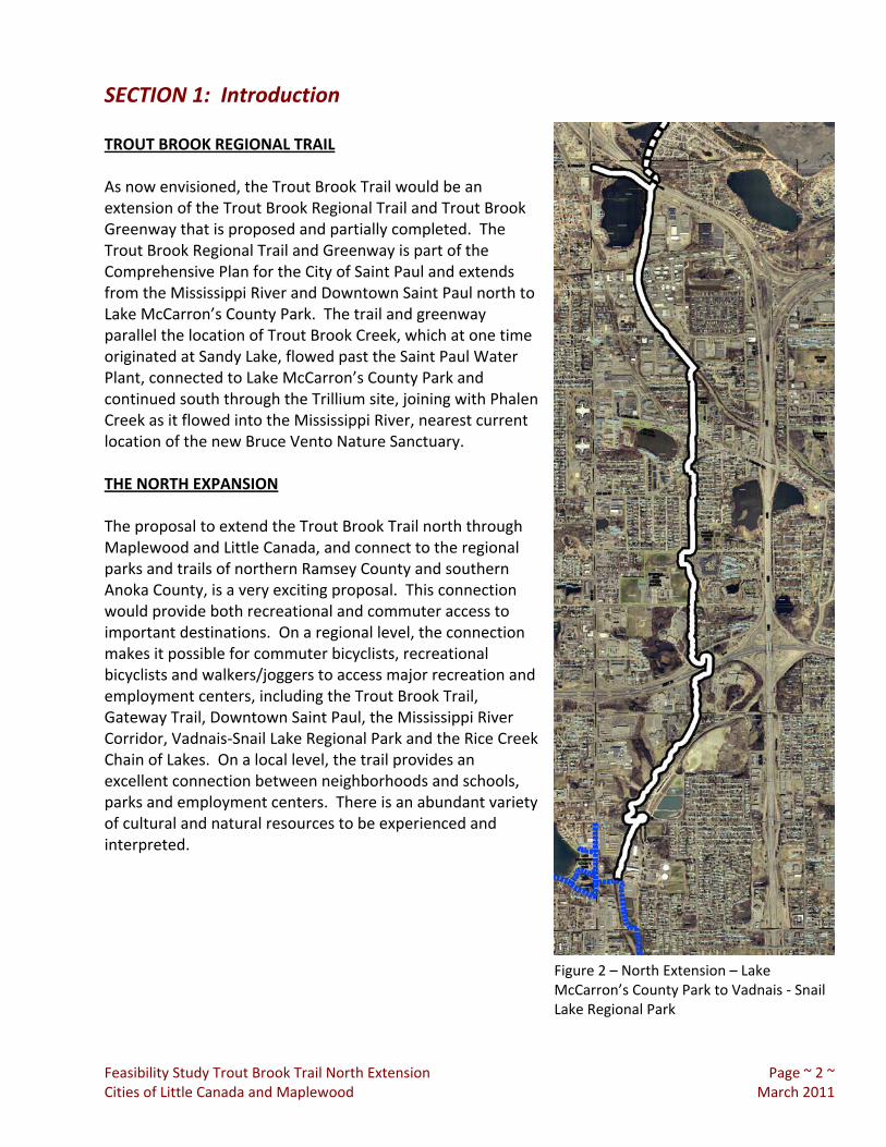
Figure 1 – South Portion – Mississippi River to Lake McCarron’s County Park
SECTION 1: Introduction
Feasibility Study Trout Brook Trail North Extension Page ~ 2 ~ Cities of Little Canada and Maplewood March 2011
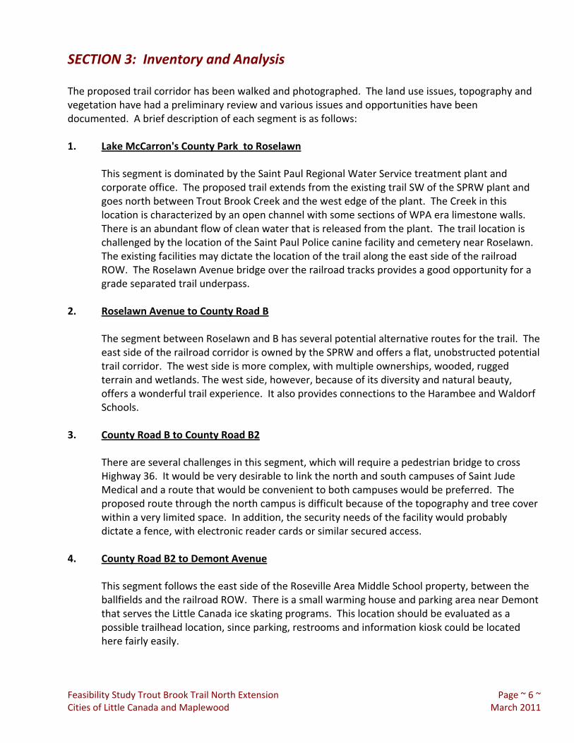
Figure 2 – North Extension – Lake McCarron’s County Park to Vadnais ‐ Snail Lake Regional Park
TROUT BROOK REGIONAL TRAIL As now envisioned, the Trout Brook Trail would be an extension of the Trout Brook Regional Trail and Trout Brook Greenway that is proposed and partially completed. The Trout Brook Regional Trail and Greenway is part of the Comprehensive Plan for the City of Saint Paul and extends from the Mississippi River and Downtown Saint Paul north to Lake McCarron’s County Park. The trail and greenway parallel the location of Trout Brook Creek, which at one time originated at Sandy Lake, flowed past the Saint Paul Water Plant, connected to Lake McCarron’s County Park and continued south through the Trillium site, joining with Phalen Creek as it flowed into the Mississippi River, nearest current location of the new Bruce Vento Nature Sanctuary. THE NORTH EXPANSION The proposal to extend the Trout Brook Trail north through Maplewood and Little Canada, and connect to the regional parks and trails of northern Ramsey County and southern Anoka County, is a very exciting proposal. This connection would provide both recreational and commuter access to important destinations. On a regional level, the connection makes it possible for commuter bicyclists, recreational bicyclists and walkers/joggers to access major recreation and employment centers, including the Trout Brook Trail, Gateway Trail, Downtown Saint Paul, the Mississippi River Corridor, Vadnais‐Snail Lake Regional Park and the Rice Creek Chain of Lakes. On a local level, the trail provides an excellent connection between neighborhoods and schools, parks and employment centers. There is an abundant variety of cultural and natural resources to be experienced and interpreted.

SECTION 2: Goals and Objectives
Feasibility Study Trout Brook Trail North Extension Page ~ 3 ~ Cities of Little Canada and Maplewood March 2011
GOAL 1 Encourage An Active Lifestyle For Both Adults And Children. Objectives: 1.1 Connect neighborhoods to
schools. 1.2 Connect neighborhoods to parks. 1.3 Connect neighborhoods to major
employment centers. 1.4 Educate residents on the
opportunities and benefits of healthy lifestyles that include exercise and outdoor activities.
GOAL 2 Provide An Attractive And Diverse Recreational Experience. Objectives: 2.1 Select a trail alignment that
provides optimum views and experiences.
2.2 Provide a diversity of landscape types, including woodlands, wetlands, water, prairie and urban. 2.3 Provide opportunities for wildlife observation and birding. 2.4 Use variations in topography and horizontal alignment to provide a variety of views and conditions. GOAL 3 Provide A Multi‐Purpose Trail That Can Be Used By All Ages And Abilities. Objectives: 3.1 Meet all applicable standards for accessibility. 3.2 Provide a smooth, all‐season surface.

SECTION 2: Goals and Objectives
Feasibility Study Trout Brook Trail North Extension Page ~ 4 ~ Cities of Little Canada and Maplewood March 2011
GOAL 4 Provide An Alternative Commuter Bike Trail That Will Connect The Northern Suburban Communities To Downtown Saint Paul.
Objectives: 4.1 Provide a north/south connection that offers an alternative to the on street
routes that currently exist. 4.2 Provide appropriate trail widths and other design standards that will
accommodate commuter biking as well as multi‐recreation use. 4.3 Provide good access to trail‐head sites and other services. GOAL 5 Provide opportunities for the identification and interpretation of cultural resources Objectives: 5.1 Interpret the history of the Saint Paul Regional Water Utility, which parallels the
proposed trail from Vadnais Heights to the main treatment plant. 5.2 Interpret the history of the Little Canada and Maplewood neighborhoods
adjacent to the trail. 5.3 Interpret the history of the major institutions along the trail, such as the
Roseville Area Middle School, the Harambee Elementary School, the Waldorf School and Saint Jude's Medical.
GOAL 6 Provide Opportunities for the Identification and Interpretation of Natural Resources. Objectives: 6.1 Interpret the origin and
changing configuration of Trout Brook Creek.
6.2 Interpret the oak, maple,
basswood Forest areas that are scattered along the trail corridor.
6.3 Interpret the wetlands, ponds,
lakes and streams along the trail corridor.
6.4 Interpret the stormwater drainage patterns and functions along the corridor.

SECTION 2: Goals and Objectives
Feasibility Study Trout Brook Trail North Extension Page ~ 5 ~ Cities of Little Canada and Maplewood March 2011
GOAL 7 Provide Opportunities for the Identification and Interpretation of Wildlife and Wildlife Habitat along the Corridor.
Objectives: 7.1 Design the trail to minimize the impact on wildlife and habitat. 7.2 Provide opportunities to improve the habitat throughout the corridor. 7.3 Provide opportunities to view wildlife. 7.4 Provide opportunities for public education.
SECTION 3: Inventory and Analysis
Feasibility Study Trout Brook Trail North Extension Page ~ 6 ~ Cities of Little Canada and Maplewood March 2011
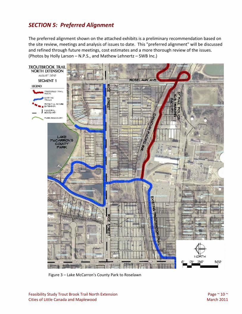
The proposed trail corridor has been walked and photographed. The land use issues, topography and vegetation have had a preliminary review and various issues and opportunities have been documented. A brief description of each segment is as follows: 1. Lake McCarron's County Park to Roselawn
This segment is dominated by the Saint Paul Regional Water Service treatment plant and corporate office. The proposed trail extends from the existing trail SW of the SPRW plant and goes north between Trout Brook Creek and the west edge of the plant. The Creek in this location is characterized by an open channel with some sections of WPA era limestone walls. There is an abundant flow of clean water that is released from the plant. The trail location is challenged by the location of the Saint Paul Police canine facility and cemetery near Roselawn. The existing facilities may dictate the location of the trail along the east side of the railroad ROW. The Roselawn Avenue bridge over the railroad tracks provides a good opportunity for a grade separated trail underpass.
2. Roselawn Avenue to County Road B
The segment between Roselawn and B has several potential alternative routes for the trail. The east side of the railroad corridor is owned by the SPRW and offers a flat, unobstructed potential trail corridor. The west side is more complex, with multiple ownerships, wooded, rugged terrain and wetlands. The west side, however, because of its diversity and natural beauty, offers a wonderful trail experience. It also provides connections to the Harambee and Waldorf Schools.
3. County Road B to County Road B2
There are several challenges in this segment, which will require a pedestrian bridge to cross Highway 36. It would be very desirable to link the north and south campuses of Saint Jude Medical and a route that would be convenient to both campuses would be preferred. The proposed route through the north campus is difficult because of the topography and tree cover within a very limited space. In addition, the security needs of the facility would probably dictate a fence, with electronic reader cards or similar secured access.
4. County Road B2 to Demont Avenue
This segment follows the east side of the Roseville Area Middle School property, between the ballfields and the railroad ROW. There is a small warming house and parking area near Demont that serves the Little Canada ice skating programs. This location should be evaluated as a possible trailhead location, since parking, restrooms and information kiosk could be located here fairly easily.

SECTION 3: Inventory and Analysis
Feasibility Study Trout Brook Trail North Extension Page ~ 7 ~ Cities of Little Canada and Maplewood March 2011
5. Demont Avenue to County Road C
The segment between Demont Avenue and County Road C follows an existing trail along Jackson Street, through a neighborhood to Australian Avenue. The existing trail would need to be upgraded to meet regional standards. An alternate route to connect to and cross County Road C needs to be evaluated. From a topographic standpoint, it would seem to be feasible to have a pedestrian bridge cross County Road C near the location of the railroad bridge. However, right‐of‐way would need to be acquired and the existing homes are on fairly small lots. The intersection of Little Canada Road, County Road C and Lakeshore Avenue is a four‐way stop. However, the high traffic volume make it a difficult area for bikes and pedestrians to cross.
6. County Road C to South Owasso Boulevard
The preferred route from County Road C to South Owasso Boulevard is along Jackson Street to the water department corridor, to South Owasso Boulevard. This segment has sidewalks and trails already existing, which could be up‐graded to Regional Trail status. There is a steep grade between the north end of Jackson Street and the waterworks right‐of‐way, which probably cannot meet accessibility standards. Special signage will be needed in this section.
7. South Owasso Boulevard to Country Drive
The proposed trail follows the waterworks right‐of‐way and the general alignment of the existing trail. The water utility has installed some wells and pumping equipment in the right‐of‐way, which will require some re‐routing and improvement of the existing trail. The existing trail is also interrupted by the railroad track, which has limited use but is still an active track. An appropriate crossing, either on‐grade or by tunnel, will need to be constructed.
8. Country Drive to Vadnais Lake Regional Park
This segment will require a pedestrian bridge over I‐694. The trail would continue on waterworks right‐of‐way to the regional park. Although an expensive part of the project, the bridge would greatly enhance the value of the trail by providing direct access to the northern system of regional parks. An alternate route would be to utilize the Rice Street / I‐694 bridge crossing.

SECTION 4: Alignment Alternatives
Feasibility Study Trout Brook Trail North Extension Page ~ 8 ~ Cities of Little Canada and Maplewood March 2011
Some alignment alternatives exist at several locations throughout the corridor, but primarily in the area south of Highway 36. The following is a brief description of some of these alignment alternatives, which are also illustrated on the Opportunities and Constraints Maps: 1. Lake McCarron’s County Park to Roselawn – (See Figures 3, 4, & 5)
Both the east and the west sides of Trout Brook Creek are valid alternatives for the trail route. A trail alignment on the west side would be located parallel to the railroad tracks on the west side of the tracks. Most of the property west of the tracks is owned by the Comfort Bus Company and acquisition of trail right‐of‐way would be required. The east side alignment is primarily SPRW property, who has expressed their preliminary support for the trail at the staff level. It seems likely that a trial alignment on the east side would be easier to negotiate although there have not been any discussions with Comfort Bus Company at this time. The interpretive opportunities are also much better on the east side.
2. Roselawn Avenue to County Road B
The analysis section discusses the basic advantages and disadvantages of the alignments on the east and the west sides of the railroad tracks. We won't repeat this analysis here, but essentially the east side is a flat, easily constructed trail alignment, while the west side is a more attractive, diverse but more challenging alignment. If the east side alignment is chosen, there is a question of where to cross County Road B and whether to locate the trail on the east and north perimeter of the Saint Jude's Medical Site.
On the west side of the tracks, there are several alignments that have been reviewed. Each of these alignments is shown on the Opportunities and Constraints Map and each has a different impact on the schools and on the potential crossings of both County Road B and Highway 36. The alignment that is closest to the railroad right‐of‐way has many advantages, including scenery, diversity, access and direct alignment with major destinations.
3. County Road B to County Road B2
There are several potential locations for a trail crossing of County Road B, including the west property line of the Harambee School, the east and the west sides of the railroad right‐of‐way, and the east property line of Saint Jude's Medical on SPRW right‐of‐way. The alignments near the railroad right‐of‐way are advantageous for their simplicity and for direct alignment with major destinations. The railroad tracks also provide a logical place for vehicles to slow or stop for pedestrians and bicyclists.
There are at least three (3) potential locations for the crossing of Highway 36, including the new bridge at Rice Street, the extension of the west property line of the Harambee School and the area immediately west of the railroad crossing. The location at Rice Street would not require the construction of a separate pedestrian bridge; however, it is substantially out of the

SECTION 4: Alignment Alternatives
Feasibility Study Trout Brook Trail North Extension Page ~ 9 ~ Cities of Little Canada and Maplewood March 2011
preferred trial alignment and would be difficult in terms of safely accommodating trail users. The location near the railroad crossing would be the most direct and provide the most convenience to trail users.
The trail alignment alternatives between Highway 36 and County Road B2 include the area between the East Metro Area Leaning Center and the Saint Jude's Medical property, the east property line of Saint Jude's Medical and some variations of that alignment.
4. County Road B2 to Demont Avenue
No alternative alignments are described. The alignment of the existing trail is appropriate for this segment.
5. Demont Avenue to County Road C
The major challenge to this segment is a safe, convenient crossing of County Road C. Ideally, this would be a new pedestrian bridge over County Road C near the railroad overpass. Some alternatives are discussed in the analysis section and on the Opportunities and Constraints Map.
6. County Road C to South Owasso Boulevard
Alternative alignments in this segment include improving the existing trail along Jackson Street to the Water R.O.W. and extending the trail east along Little Canada Road and north along Country Drive to the Water R.O.W. Both of these alternatives follow existing trails. However, the Jackson Street alignment would be much more direct.
7. South Owasso Boulevard to Country Drive
The only alignment alternative in this segment is whether to cross the existing railroad tracks by making on‐grade improvements or by constructing a tunnel.
8. Country Drive to Vadnais Lake Regional Park
A pedestrian bridge over I‐694 would be the most desirable and direct connection to Vadnais Lake Regional Park, but also more expensive. An alternative alignment would be to follow the existing trail to Rice Street, then cross I‐694 on the existing Rice Street bridge and along local streets back to the regional park.
SECTION 5: Preferred Alignment
Feasibility Study Trout Brook Trail North Extension Page ~ 10 ~ Cities of Little Canada and Maplewood March 2011
The preferred alignment shown on the attached exhibits is a preliminary recommendation based on the site review, meetings and analysis of issues to date. This "preferred alignment" will be discussed and refined through future meetings, cost estimates and a more thorough review of the issues. (Photos by Holly Larson – N.P.S., and Mathew Lehnertz – SWB Inc.)
Figure 3 – Lake McCarron's County Park to Roselawn

SECTION 5: Preferred Alignment
Feasibility Study Trout Brook Trail North Extension Page ~ 11 ~ Cities of Little Canada and Maplewood March 2011
Figure 4 ‐ SPRWS North to Roselawn ‐ Adjacent to Police Canine Training Facility
Figure 5 ‐ Conceptual Section
SECTION 5: Preferred Alignment
Feasibility Study Trout Brook Trail North Extension Page ~ 12 ~ Cities of Little Canada and Maplewood March 2011
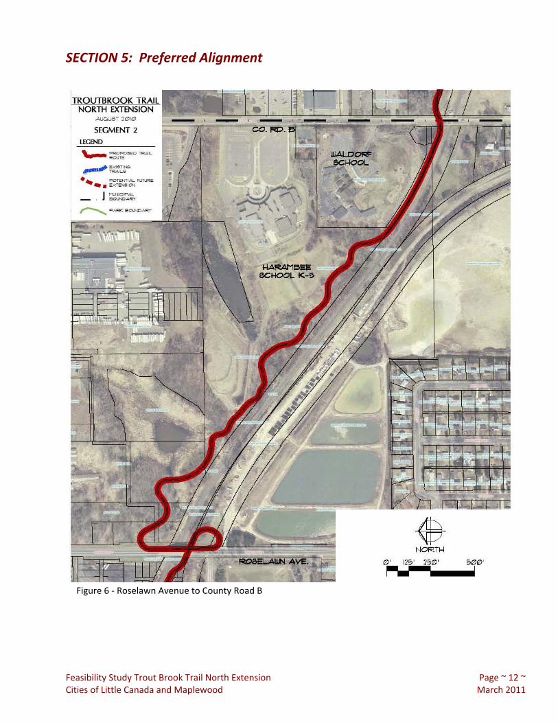
Figure 6 ‐ Roselawn Avenue to County Road B

SECTION 5: Preferred Alignment
Feasibility Study Trout Brook Trail North Extension Page ~ 13 ~ Cities of Little Canada and Maplewood March 2011
Figure 7 ‐ S.E. of hill from Minnesota Waldorf School
Figure 8 ‐ Conceptual Section

SECTION 5: Preferred Alignment
Feasibility Study Trout Brook Trail North Extension Page ~ 14 ~ Cities of Little Canada and Maplewood March 2011
Figure 9 ‐ County Road B to County Road B2

SECTION 5: Preferred Alignment
Feasibility Study Trout Brook Trail North Extension Page ~ 15 ~ Cities of Little Canada and Maplewood March 2011
Figure 10 ‐ Highway 36 R.O.W. from Viking Drive
Figure 11 ‐ Conceptual Section

SECTION 5: Preferred Alignment
Feasibility Study Trout Brook Trail North Extension Page ~ 16 ~ Cities of Little Canada and Maplewood March 2011
Figure 12 ‐ County Road B2 to Demont Avenue/Demont Avenue to County Road C

SECTION 5: Preferred Alignment
Feasibility Study Trout Brook Trail North Extension Page ~ 17 ~ Cities of Little Canada and Maplewood March 2011
Figure 13 ‐ Roseville Area Middle School Trail
Figure 14 ‐ Trail Connection to Nadeau Wildlife Area

SECTION 5: Preferred Alignment
Feasibility Study Trout Brook Trail North Extension Page ~ 18 ~ Cities of Little Canada and Maplewood March 2011
Figure 15A ‐ County Road C to South Owasso Boulevard

SECTION 5: Preferred Alignment
Figure 15B ‐ South Owasso Boulevard to Country Drive
Feasibility Study Trout Brook Trail North Extension Page ~ 19 ~ Cities of Little Canada and Maplewood March 2011

SECTION 5: Preferred Alignment
Feasibility Study Trout Brook Trail North Extension Page ~ 20 ~ Cities of Little Canada and Maplewood March 2011
Figure 16 ‐ Rondeau Park
Figure 17 ‐ Connection to Waterworks Trail
SECTION 5: Preferred Alignment
FeCi
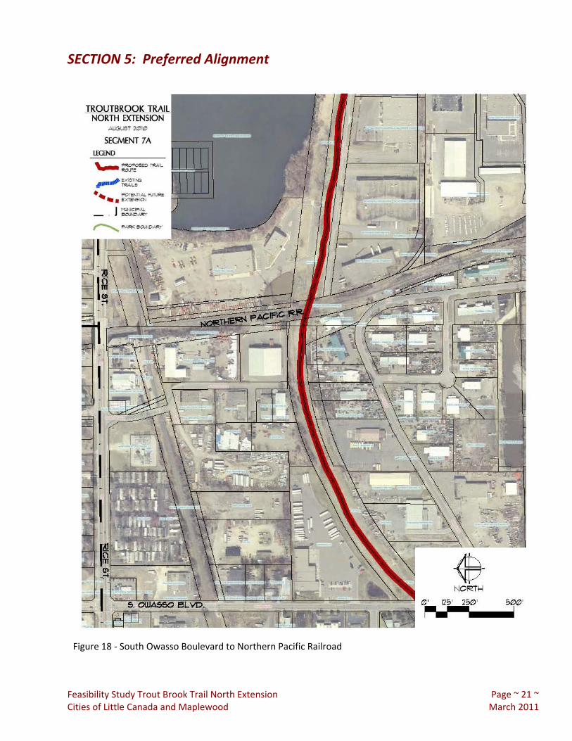
Figure 18 ‐ South Owasso Boulevard to Northern Pacific Railroad
asibility Study Trout Brook Trail North Extension Page ~ 21 ~ ties of Little Canada and Maplewood March 2011

SECTION 5: Preferred Alignment
Feasibility Study Trout Brook Trail North Extension Page ~ 22 ~ Cities of Little Canada and Maplewood March 2011
Figure 19 ‐ Northern Pacific Railroad to Country Drive

SECTION 5: Preferred Alignment
Feasibility Study Trout Brook Trail North Extension Page ~ 23 ~ Cities of Little Canada and Maplewood March 2011
Figure 20 ‐ Blacktern Lake
Figure 21 ‐ Country Drive Trail Connection

SECTION 5: Preferred Alignment
Feasibility Study Trout Brook Trail North Extension Page ~ 24 ~ Cities of Little Canada and Maplewood March 2011
Figure 22 ‐ Country Drive to Vadnais‐Snail Lake Regional Park

SECTION 5: Preferred Alignment
Feasibility Study Trout Brook Trail North Extension Page ~ 25 ~ Cities of Little Canada and Maplewood March 2011
Figure 23 ‐ Right Of Way S. of Vadnais Boulevard
Figure 24 ‐ Sucker Lake Road Entry to Vadnais ‐ Snail Lake Regional Park
SECTION 6: Partnerships
Feasibility Study Trout Brook Trail North Extension Page ~ 26 ~ Cities of Little Canada and Maplewood March 2011
The feasibility study for the north extension of the Trout Brook Trail has identified many potential partners. Many of these potential partners have participated in early meetings and have provided input into the trail planning. Potential partners in the Trout Brook Trail project include: City of Little Canada City of Maplewood National Park Service Ramsey County Parks and Recreation Active Living Ramsey County Roseville Area School District East Metro Integration District St. Jude’s Medical Saint Paul Regional Water Service
City of Shoreview City of Vadnais Heights City of St. Paul Ramsey County Public Works Mn DOT Ramsey‐Washington Watershed District Capitol Region Watershed District Waldorf School
The role of the potential partners will vary based upon their interest and responsibility in the project. Some partners may be involved in the funding and implementation of the trail, some in the maintenance and operations, and some in the planning and design review. The trail will extend across municipal boundaries and will connect many varied interests. It is important to the overall system of trails, both locally, and regionally. It has multiple layers of objectives, including transportation, recreation, active living, healthy lifestyles, safe routes to schools, interpretation of history, and interpretation of natural resources. Working closely with many partners, the trail can build stronger relationships and achieve many objectives.
SECTION 7: Implementation
Feasibility Study Trout Brook Trail North Extension Page ~ 27 ~ Cities of Little Canada and Maplewood March 2011
Based upon the findings of the Trout Brook Trail Feasibility Study, we are recommending that the project proceed. The implementation of the project may require the following actions:
1. Concept approval by the City of Little Canada and the City of Maplewood. 2. Concept approval by Ramsey County Parks and Recreation and acceptance of a leadership role
in advancing the Trout Brook Trail Extension from its current concept stage to implementation. 3. Concept approval by the Metropolitan Council to extend the current Trout Brook Regional Trail
north as proposed in this study. The Trout Brook Trail Extension, as currently visualized, is a regional facility and will require both local and regional support for its implementation. It is appropriate for this effort to be led by Ramsey County Parks and Recreation. Although most of the required right‐of‐way is already in public ownership, there is a substantial cost for the construction of a new pedestrian bridge over Highway 36. An additional pedestrian bridge over I‐694 to connect Vadnais – Snail Lake Regional Park may also be recommended. These significant projects will require regional funding sources

EXHIBIT: Opportunities and Constraints Maps
Feasibility Study Trout Brook Trail North Extension Page ~ 28 ~ Cities of Little Canada and Maplewood March 2011 2011
Map 1

EXHIBIT: Opportunities and Constraints Maps
Feasibility Study Trout Brook Trail North Extension Page ~ 29 ~ Cities of Little Canada and Maplewood March 2011 2011
Map 2

EXHIBIT: Opportunities and Constraints Maps
Feasibility Study Trout Brook Trail North Extension Page ~ 30 ~ Cities of Little Canada and Maplewood March 2011
Map 3

EXHIBIT: Opportunities and Constraints Maps
Feasibility Study Trout Brook Trail North Extension Page ~ 31 ~ Cities of Little Canada and Maplewood March 2011
Map 4

EXHIBIT: Opportunities and Constraints Maps
Feasibility Study Trout Brook Trail North Extension Page ~ 32 ~ Cities of Little Canada and Maplewood March 2011 2011
Map 5

EXHIBIT: Cost Estimates
Feasibility Study Trout Brook Trail North Extension Page ~ 33 ~ Cities of Little Canada and Maplewood March 2011
PRELIMINARY COST ESTIMATES Trout Brook Trail North Extension from Lake McCarron’s County Park to Vadnais – Snail Lake Regional Park The Feasibility Study for the northerly extension of the Trout Brook Regional Trail from Lake McCarron’s County Park to Vadnais – Snail Lake Regional Park discusses many variations and alternatives which impact the final cost of the project. The preliminary cost estimate that is presented makes an assumption of certain costs based upon a preferred alignment. There are many options that can be discussed and many options for phasing the project. The following cost estimate provides information on the general scope of the project so that informed decisions can be made as the project planning continues. The cost estimates are provided by segment as follows: Segment 1 Lake McCarron’s County Park to Roselawn Segment 2 Roselawn Avenue to County Road B Segment 3 County Road B to County Road B2 Segment 4 County Road B2 to Demont Avenue Segment 5 Demont Avenue to County Road C Segment 6 County Road C to South Owasso Boulevard Segment 7 South Owasso Boulevard to Country Drive Segment 8 Country Drive to Vadnais Lake Regional Park

EXHIBIT: Cost Estimates
Feasibility Study Trout Brook Trail North Extension Page ~ 34 ~ Cities of Little Canada and Maplewood March 2011
ITEM/SEGMENT Qty Unit Unit Price TOTAL
1. Lake McCarron’s County Park to Roselawn a. Site Preparation/Grading 1500 lf $20.00 $30,000.00 b. Trail 1500 lf $40.00 $60,000.00 c. Boardwalk 0 lf $250.00 $0.00 d. Pedestrian/Bicycle Bridge 0 ls $0.00 $0.00 e. Directional/Safety Signage 1 ls $3,000.00 $3,000.00 f. Interpretive Signage 1 ls $5,000.00 $5,000.00 g. Fencing 500 lf $80.00 $40,000.00 h. Furnishings and Features 1 ls $5,000.00 $5,000.00 i. Site Restoration 1500 lf $20.00 $30,000.00 j. Landscape 1 ls $15,000.00 $15,000.00
k. Lands Acquisition/Easements 12000 sf $12.00 $144,000.00
Sub‐Total $332,000.00 ITEM/SEGMENT Qty Unit Unit Price TOTAL
2. Roselawn Avenue to County Road B
a. Site Preparation/Grading 3600 lf $30.00 $108,000.00 b. Trail 3600 lf $40.00 $144,000.00 c. Boardwalk 600 lf $150.00 $90,000.00 d. Pedestrian/Bicycle Bridge 0 ls $400,000.00 $0.00 e. Directional/Safety Signage 1 ls $7,200.00 $7,200.00 f. Interpretive Signage 1 ls $5,000.00 $5,000.00 g. Fencing 800 lf $80.00 $64,000.00 h. Furnishings and Features 1 ls $5,000.00 $5,000.00 i. Site Restoration 3600 lf $30.00 $108,000.00 j. Landscape 1 ls $15,000.00 $15,000.00
k. Lands Acquisition/Easements 45000 sf $12.00 $540,000.00
Sub‐Total $1,086,200.00

EXHIBIT: Cost Estimates
Feasibility Study Trout Brook Trail North Extension Page ~ 35 ~ Cities of Little Canada and Maplewood March 2011
ITEM/SEGMENT Qty Unit Unit Price TOTAL
3. County Road B to County Road B2
a. Site Preparation/Grading 3400 lf $30.00 $102,000.00 b. Trail 3400 lf $40.00 $136,000.00 c. Boardwalk 0 lf $250.00 $0.00 d. Pedestrian/Bicycle Bridge 1 ls $900,000.00 $900,000.00 e. Directional/Safety Signage 1 ls $6,800.00 $6,800.00 f. Interpretive Signage 1 ls $5,000.00 $5,000.00 g. Fencing 1500 lf $80.00 $120,000.00 h. Furnishings and Features 1 ls $5,000.00 $5,000.00 i. Site Restoration 3400 lf $30.00 $102,000.00 j. Landscape 1 ls $15,000.00 $15,000.00
k. Lands Acquisition/Easements 0 sf $0.00 $0.00
Sub‐Total $1,391,800.00 ITEM/SEGMENT Qty Unit Unit Price TOTAL
4. County Road B2 to Demont Avenue
a. Site Preparation/Grading 1600 lf $20.00 $32,000.00 b. Trail 1600 lf $40.00 $64,000.00 c. Boardwalk 0 lf $250.00 $0.00 d. Pedestrian/Bicycle Bridge 0 ls $0.00 $0.00 e. Directional/Safety Signage 1 ls $3,200.00 $3,200.00 f. Interpretive Signage 1 ls $5,000.00 $5,000.00 g. Fencing 0 lf $80.00 $0.00 h. Furnishings and Features 1 ls $5,000.00 $5,000.00 i. Site Restoration 1600 lf $20.00 $32,000.00 j. Landscape 1 ls $5,000.00 $5,000.00
k. Lands Acquisition/Easements 0 sf $0.00 $0.00
Sub‐Total $146,200.00

EXHIBIT: Cost Estimates
Feasibility Study Trout Brook Trail North Extension Page ~ 36 ~ Cities of Little Canada and Maplewood March 2011
ITEM/SEGMENT Qty Unit Unit Price TOTAL
5. Demont Avenue to County Road C
a. Site Preparation/Grading 2100 lf $20.00 $42,000.00 b. Trail 2100 lf $40.00 $84,000.00 c. Boardwalk 0 lf $250.00 $0.00 d. Pedestrian/Bicycle Bridge 0 ls $400,000.00 $0.00 e. Directional/Safety Signage 1 ls $4,200.00 $4,200.00 f. Interpretive Signage 1 ls $5,000.00 $5,000.00 g. Fencing 200 lf $80.00 $16,000.00 h. Furnishings and Features 1 ls $5,000.00 $5,000.00 i. Site Restoration 2100 lf $20.00 $42,000.00 j. Landscape 1 ls $5,000.00 $5,000.00
k. Lands Acquisition/Easements 0 sf $12.00 $0.00
Sub‐Total $203,200.00 ITEM/SEGMENT Qty Unit Unit Price TOTAL
6 County Road C to South Owasso Boulevard
a. Site Preparation/Grading 3200 lf $20.00 $64,000.00 b. Trail 3200 lf $40.00 $128,000.00 c. Boardwalk 0 lf $250.00 $0.00 d. Pedestrian/Bicycle Bridge 0 ls $0.00 $0.00 e. Directional/Safety Signage 1 ls $6,400.00 $6,400.00 f. Interpretive Signage 1 ls $5,000.00 $5,000.00 g. Fencing 200 lf $80.00 $16,000.00 h. Furnishings and Features 1 ls $5,000.00 $5,000.00 i. Site Restoration 3200 lf $20.00 $64,000.00 j. Landscape 1 ls $5,000.00 $5,000.00
k. Lands Acquisition/Easements 0 sf $12.00 $0.00
Sub‐Total $293,400.00

EXHIBIT: Cost Estimates
Feasibility Study Trout Brook Trail North Extension Page ~ 37 ~ Cities of Little Canada and Maplewood March 2011
ITEM/SEGMENT Qty Unit Unit Price TOTAL
7. South Owasso Boulevard to Country Drive
a. Site Preparation/Grading 3600 lf $20.00 $72,000.00 b. Trail 3600 lf $40.00 $144,000.00 c. Boardwalk 0 lf $250.00 $0.00 d. Pedestrian/Bicycle Bridge 0 ls $200,000.00 $0.00 e. Directional/Safety Signage 1 ls $7,200.00 $7,200.00 f. Interpretive Signage 1 ls $5,000.00 $5,000.00 g. Fencing 0 lf $0.00 $0.00 h. Furnishings and Features 1 ls $5,000.00 $5,000.00 i. Site Restoration 3600 lf $20.00 $72,000.00 j. Landscape 1 ls $5,000.00 $5,000.00
k. Lands Acquisition/Easements 0 sf $12.00 $0.00
Sub‐Total $310,200.00 ITEM/SEGMENT Qty Unit Unit Price TOTAL
8. Country Drive to Vadnais Lake Regional Park
a. Site Preparation/Grading 4000 lf $20.00 $80,000.00 b. Trail 4000 lf $40.00 $160,000.00 c. Boardwalk 0 lf $250.00 $0.00 d. Pedestrian/Bicycle Bridge 0 ls $1,200,000.00 $0.00 e. Directional/Safety Signage 1 ls $8,000.00 $8,000.00 f. Interpretive Signage 1 ls $5,000.00 $5,000.00 g. Fencing 500 lf $80.00 $40,000.00 h. Furnishings and Features 1 ls $5,000.00 $5,000.00 i. Site Restoration 4000 lf $20.00 $80,000.00 j. Landscape 1 ls $5,000.00 $5,000.00
k. Lands Acquisition/Easements 0 sf $15.00 $0.00
Sub‐Total $383,000.00
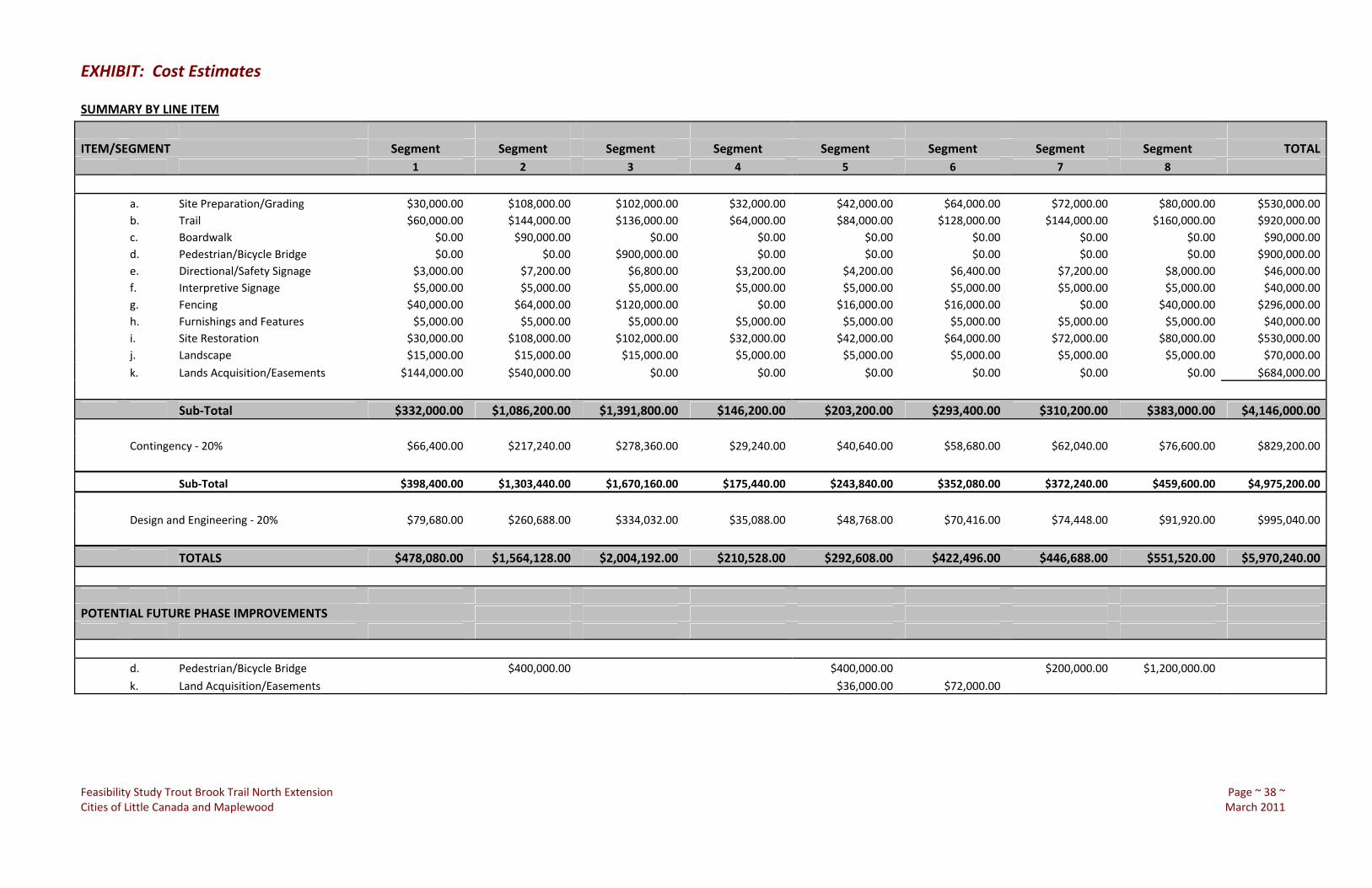
EXHIBIT: Cost Estimates
Feasibility Study Trout Brook Trail North Extension Page ~ 38 ~ Cities of Little Canada and Maplewood March 2011
SUMMARY BY LINE ITEM
ITEM/SEGMENT Segment Segment Segment Segment Segment Segment Segment Segment TOTAL 1 2 3 4 5 6 7 8
a. Site Preparation/Grading $30,000.00 $108,000.00 $102,000.00 $32,000.00 $42,000.00 $64,000.00 $72,000.00 $80,000.00 $530,000.00 b. Trail $60,000.00 $144,000.00 $136,000.00 $64,000.00 $84,000.00 $128,000.00 $144,000.00 $160,000.00 $920,000.00 c. Boardwalk $0.00 $90,000.00 $0.00 $0.00 $0.00 $0.00 $0.00 $0.00 $90,000.00 d. Pedestrian/Bicycle Bridge $0.00 $0.00 $900,000.00 $0.00 $0.00 $0.00 $0.00 $0.00 $900,000.00 e. Directional/Safety Signage $3,000.00 $7,200.00 $6,800.00 $3,200.00 $4,200.00 $6,400.00 $7,200.00 $8,000.00 $46,000.00 f. Interpretive Signage $5,000.00 $5,000.00 $5,000.00 $5,000.00 $5,000.00 $5,000.00 $5,000.00 $5,000.00 $40,000.00 g. Fencing $40,000.00 $64,000.00 $120,000.00 $0.00 $16,000.00 $16,000.00 $0.00 $40,000.00 $296,000.00 h. Furnishings and Features $5,000.00 $5,000.00 $5,000.00 $5,000.00 $5,000.00 $5,000.00 $5,000.00 $5,000.00 $40,000.00 i. Site Restoration $30,000.00 $108,000.00 $102,000.00 $32,000.00 $42,000.00 $64,000.00 $72,000.00 $80,000.00 $530,000.00 j. Landscape $15,000.00 $15,000.00 $15,000.00 $5,000.00 $5,000.00 $5,000.00 $5,000.00 $5,000.00 $70,000.00
k. Lands Acquisition/Easements $144,000.00 $540,000.00 $0.00 $0.00 $0.00 $0.00 $0.00 $0.00 $684,000.00
Sub‐Total $332,000.00 $1,086,200.00 $1,391,800.00 $146,200.00 $203,200.00 $293,400.00 $310,200.00 $383,000.00 $4,146,000.00 Contingency ‐ 20% $66,400.00 $217,240.00 $278,360.00 $29,240.00 $40,640.00 $58,680.00 $62,040.00 $76,600.00 $829,200.00
Sub‐Total $398,400.00 $1,303,440.00 $1,670,160.00 $175,440.00 $243,840.00 $352,080.00 $372,240.00 $459,600.00 $4,975,200.00
Design and Engineering ‐ 20% $79,680.00 $260,688.00 $334,032.00 $35,088.00 $48,768.00 $70,416.00 $74,448.00 $91,920.00 $995,040.00
TOTALS $478,080.00 $1,564,128.00 $2,004,192.00 $210,528.00 $292,608.00 $422,496.00 $446,688.00 $551,520.00 $5,970,240.00
POTENTIAL FUTURE PHASE IMPROVEMENTS
d. Pedestrian/Bicycle Bridge $400,000.00 $400,000.00 $200,000.00 $1,200,000.00
k. Land Acquisition/Easements $36,000.00 $72,000.00

Feasibility Study Trout Brook Trail North Extension Page ~ 39 ~ Cities of Little Canada and Maplewood March 2011