Embed Size (px)
Citation preview
Some of our recent work undertaken on tree root investigations:
Assessment of rotting or voiding in a tree trunk, Wahroonga, NSW—Winspace Homes (2006) Mapping of roots emenating from a large Angophora, Clontarf, NSW— Caroline Pidcock Architects (2006) Tree root mapping to delineate en-croaching roots on proposed develop-ment work areas, Wahroonga, NSW—Winspace Homes (2006) Mapping of four (4) Hills Figs at Bal-main Town Hall, Balmain, NSW—Leichardt Council (2007) Mapping of 18 Norfolk Pine Trees, Sydney, NSW — Footprint Green (2008) Mapping of 4 trees possibly causing pavement cracking on the Pacific Highway, NSW—Tree Wise Men (2008) Tree root mapping to delineate en-croaching roots on proposed founda-tions, Warrawee, NSW— Rupez (2008) Mapping of tree roots prior to under-ground pipe installation at Chelten-ham Girls High School, Cheltenham, NSW—National Buildplan Group (2008)
GBG Australia
Sydney 18 Fennell Street
North Parramatta NSW 2151 Telephone: 02 9890 2122
Fax: 02 9890 2922
Contact Simon Williams
Perth 2nd Floor, 2 Hardy Street
South Perth WA 6151 Telephone: 08 6436 1599
Fax: 08 6436 1500
Contact Rob Hunn
Website http://www.gbgoz.com.au
Non-destructive techniques for
TREE ROOT INVESTIGATIONS Mapping and Location
Tree root location / mapping
Determination of Depth of Cover to tree roots
Determination of the level of encroaching tree roots to existing foundations
Condition
Determination of trunk rot or voiding
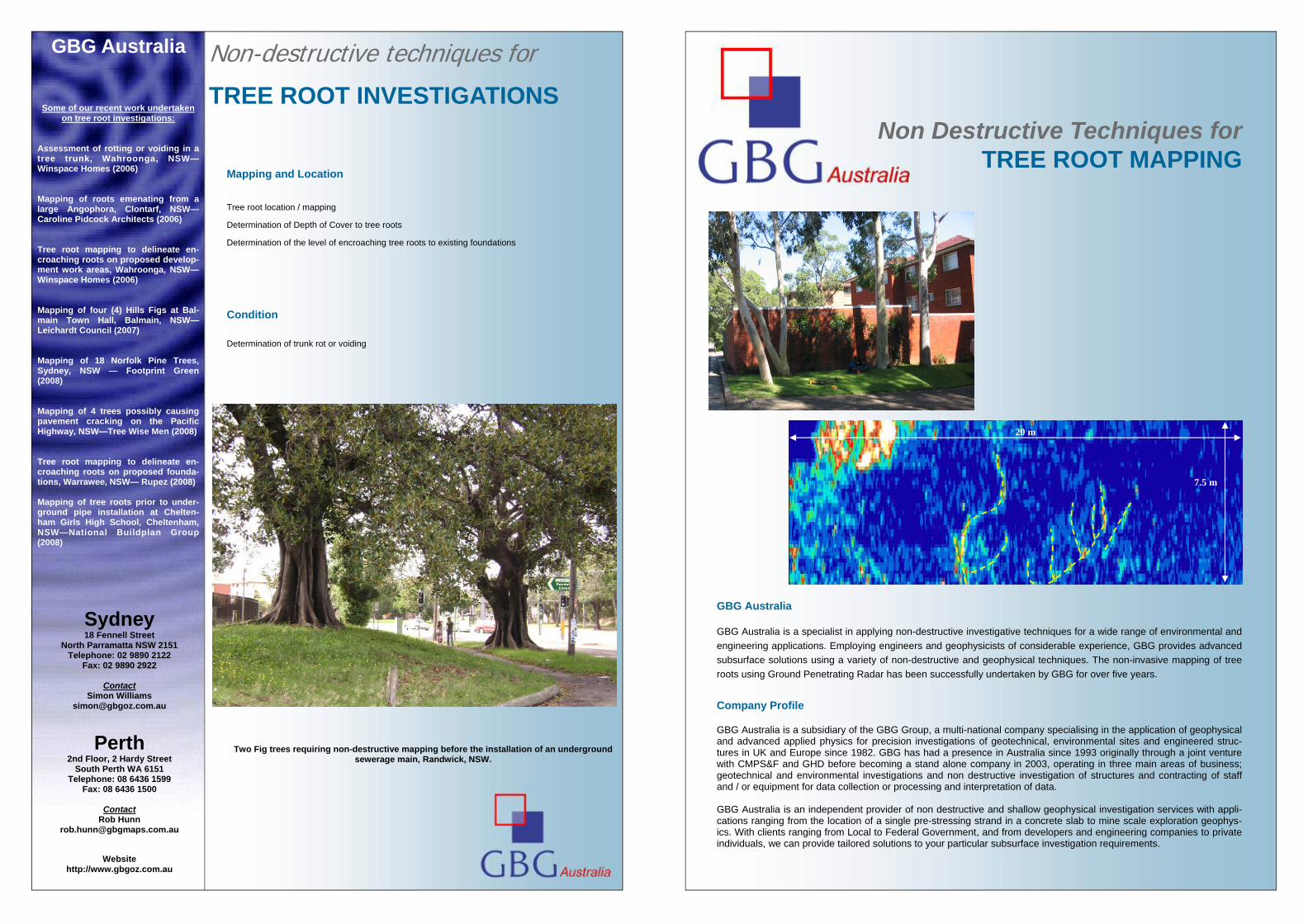
Two Fig trees requiring non-destructive mapping before the installation of an underground sewerage main, Randwick, NSW.
Non Destructive Techniques for TREE ROOT MAPPING
GBG Australia GBG Australia is a specialist in applying non-destructive investigative techniques for a wide range of environmental and engineering applications. Employing engineers and geophysicists of considerable experience, GBG provides advanced subsurface solutions using a variety of non-destructive and geophysical techniques. The non-invasive mapping of tree roots using Ground Penetrating Radar has been successfully undertaken by GBG for over five years. Company Profile GBG Australia is a subsidiary of the GBG Group, a multi-national company specialising in the application of geophysical and advanced applied physics for precision investigations of geotechnical, environmental sites and engineered struc-tures in UK and Europe since 1982. GBG has had a presence in Australia since 1993 originally through a joint venture with CMPS&F and GHD before becoming a stand alone company in 2003, operating in three main areas of business; geotechnical and environmental investigations and non destructive investigation of structures and contracting of staff and / or equipment for data collection or processing and interpretation of data. GBG Australia is an independent provider of non destructive and shallow geophysical investigation services with appli-cations ranging from the location of a single pre-stressing strand in a concrete slab to mine scale exploration geophys-ics. With clients ranging from Local to Federal Government, and from developers and engineering companies to private individuals, we can provide tailored solutions to your particular subsurface investigation requirements.
20 m
7.5 m
Applications for Non-destructive techniques Tree Root Mapping
The preservation of mature trees is of an ever growing importance. More and more frequently local councils require detailed
reporting on the impact proposed urban development will have on the health of trees within a site. Knowledge on the loca-tion and extent of a tree’s structural root system is critical in determining whether development will have a long term affect on a tree’s condition. GBG Australia provides non-destructive tree root mapping which greatly assists the arborist in ensur-ing the continued good health of the tree.
NON DESTRUCTIVE METHODS FOR MAPPING TREE ROOTS.
Background GBG Australia carried out Non Destructive Testing (NDT) using Ground Penetration Radar (GPR) . The object of the inves-tigation was to locate roots emanating from a tree which may be of concern during the proposed construction of a concrete block boundary wall and associated piers and footings.
Methodology
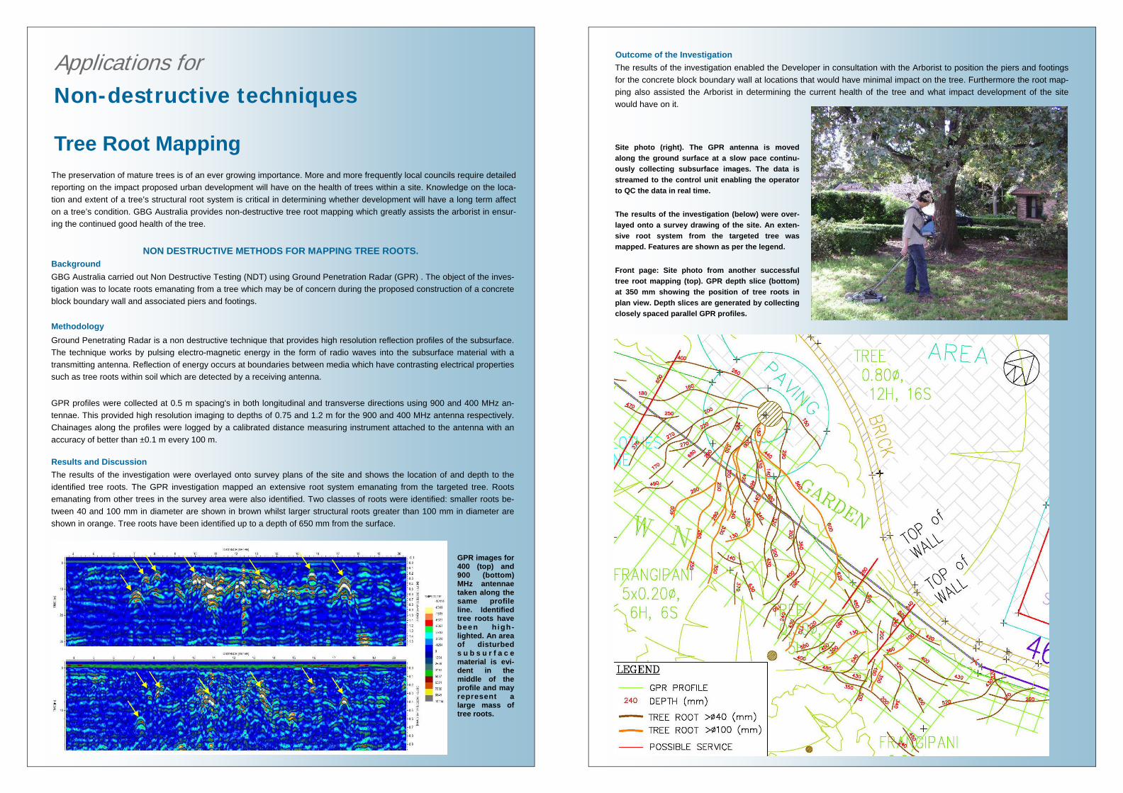
Ground Penetrating Radar is a non destructive technique that provides high resolution reflection profiles of the subsurface. The technique works by pulsing electro-magnetic energy in the form of radio waves into the subsurface material with a transmitting antenna. Reflection of energy occurs at boundaries between media which have contrasting electrical properties such as tree roots within soil which are detected by a receiving antenna. GPR profiles were collected at 0.5 m spacing's in both longitudinal and transverse directions using 900 and 400 MHz an-tennae. This provided high resolution imaging to depths of 0.75 and 1.2 m for the 900 and 400 MHz antenna respectively. Chainages along the profiles were logged by a calibrated distance measuring instrument attached to the antenna with an accuracy of better than ±0.1 m every 100 m. Results and Discussion The results of the investigation were overlayed onto survey plans of the site and shows the location of and depth to the identified tree roots. The GPR investigation mapped an extensive root system emanating from the targeted tree. Roots emanating from other trees in the survey area were also identified. Two classes of roots were identified: smaller roots be-tween 40 and 100 mm in diameter are shown in brown whilst larger structural roots greater than 100 mm in diameter are shown in orange. Tree roots have been identified up to a depth of 650 mm from the surface.
GPR images for 400 (top) and 900 (bottom) MHz antennae taken along the same profile line. Identified tree roots have been h igh-lighted. An area of disturbed s u b s u r f a c e material is evi-dent in the middle of the profile and may represent a large mass of tree roots.
Outcome of the Investigation The results of the investigation enabled the Developer in consultation with the Arborist to position the piers and footings for the concrete block boundary wall at locations that would have minimal impact on the tree. Furthermore the root map-ping also assisted the Arborist in determining the current health of the tree and what impact development of the site would have on it. Site photo (right). The GPR antenna is moved along the ground surface at a slow pace continu-ously collecting subsurface images. The data is streamed to the control unit enabling the operator to QC the data in real time. The results of the investigation (below) were over-layed onto a survey drawing of the site. An exten-sive root system from the targeted tree was mapped. Features are shown as per the legend. Front page: Site photo from another successful tree root mapping (top). GPR depth slice (bottom) at 350 mm showing the position of tree roots in plan view. Depth slices are generated by collecting closely spaced parallel GPR profiles.