Embed Size (px)
Citation preview
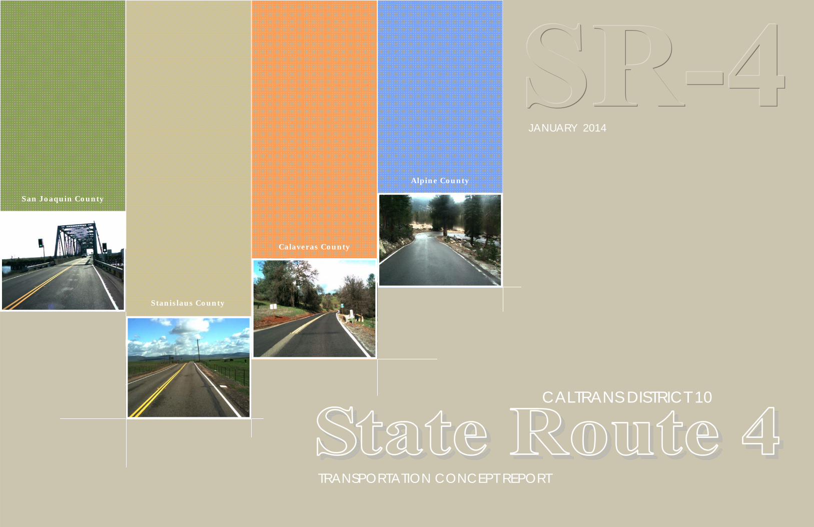
TRANSPORTATION CONCEPT REPORT
CALTRANS DISTRICT 10
JANUARY 2014
Calaveras County
Stanislaus County
San Joaquin County
Alpine County

2
3 S t a t e R o u t e 4 t r a n s p o r t a t i o n c o n c e p t r e p o r t
C a l t r a n s D e p a r t m e n t o f T r a n s p o r t a t i o n D i s t r i c t 1 0
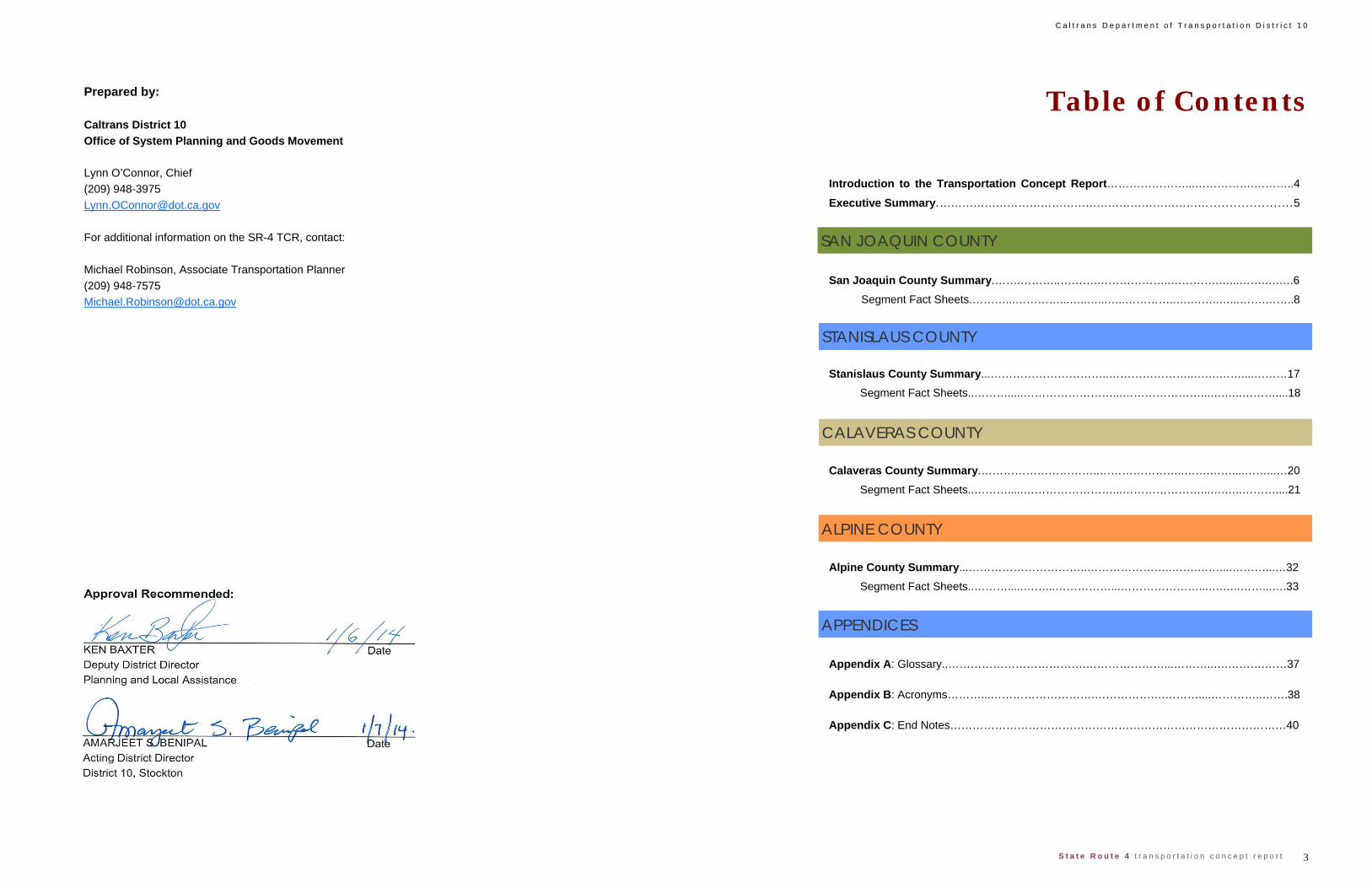
Table of Contents Introduction to the Transportation Concept Report…………………...…………….………..4
Executive Summary.……………………………………………………………….....................5
San Joaquin County Summary.…….………..……….………………..………….…...…….….….6
Segment Fact Sheets.………...…………...…..…...…..…………..….……..…...…….……..8
Stanislaus County Summary...…………………………..…………………..…….……....………17
Segment Fact Sheets..……….....……………………...…………………...….…..………....18
Calaveras County Summary.…………………………..…………………..…….……....……...…20
Segment Fact Sheets..……….....……………………...…………………...….…..………....21
Alpine County Summary...…………………………..…………………..…….……....………...…32
Segment Fact Sheets..……….....……...……………...…………………...….…..……...….33
Appendix A: Glossary..……………………………….…………………...………..….……….……37
Appendix B: Acronyms………...……………………….……………….………....…………..…….38
Appendix C: End Notes………………………………………………………………………………40
SAN JOAQUIN COUNTY
Prepared by: Caltrans District 10 Office of System Planning and Goods Movement Lynn O’Connor, Chief (209) 948-3975 [email protected] For additional information on the SR-4 TCR, contact: Michael Robinson, Associate Transportation Planner (209) 948-7575 [email protected]
STANISLAUS COUNTY
ALPINE COUNTY
CALAVERAS COUNTY
APPENDICES

C a l t r a n s D e p a r t m e n t o f T r a n s p o r t a t i o n D i s t r i c t 1 0
4 S t a t e R o u t e 4 t r a n s p o r t a t i o n c o n c e p t r e p o r t
What is a Transportation Concept Report?
The Transportation Concept Report (TCR) is a long-term planning docu-
ment that each Caltrans district prepares for every State highway, or por-
tion thereof, in its jurisdiction, and is where long-range corridor planning in
Caltrans usually begins. The purpose of a TCR is to determine how a
highway will be developed and managed so that it delivers the targeted
level of service (LOS) and quality of operations that are feasible to attain
over a twenty-year period as indicated in the route concept.
The concept facility will provide the amount of vehicle-carrying capacity
necessary to achieve the concept LOS and, in some cases, people-
carrying capacity will also be incorporated. Auxiliary lanes are not consid-
ered a part of the mainline roadway and, therefore, are not included in the
number of travel lanes indicated in a concept.
In addition to the 20-year route concept, the TCR includes an ultimate con-
cept, which is the ultimate goal for the route beyond the twenty-year plan-
ning horizon. Ultimate concepts must be used cautiously however, be-
cause unforeseen changes in land use and other variables make forecast-
ing beyond twenty years difficult.
How does the TCR fit in with local and regional planning efforts?
As owner/operator of the State Highway System (SHS) Caltrans estab-
lishes a long-range vision for its highways and determines overall strate-
gies for their management. This is achieved by taking into consideration
the numerous factors encompassed in the human and natural environ-
ments in which a particular route exists. During development of a TCR,
Caltrans’ objective is to have local, regional, private sector, and State con-
sensus on corridor concepts, planning strategies, and improvement priori-
ties.
State highways within each local jurisdiction should be recognized and
included in the circulation element of the general plan. The jurisdiction
should also adopt the concept LOS standard (the minimum level or quality
of operations that is appropriate for each route segment and is considered
to be reasonably attainable within the 20-year planning period) indicated in
the TCR, along with the concept improvements described in the TCR as
necessary to meet the concept LOS. The jurisdiction has the option of
adopting a higher LOS standard and acknowledging the inconsistency with
the TCR and the associated funding participation limitations by the State
for State highway improvements. Typical concept LOS standards in Dis-
trict 10 are LOS ‘C’ in rural areas and LOS ‘D’ in urban areas.
Does the TCR have to be read from cover to cover in order to get per-tinent information about a route segment?
Caltrans does not intend for TCRs to be read from cover to cover as one
would read a book. Rather, the TCR is a reference document with seg-
ment-specific information presented in a concise and readable format that
allows the user to easily access, in one place in the document, all the nec-
essary data and information that pertains to a particular segment of the
route.
This format creates a certain amount of repetition in the TCR, as the route
is divided into segments for analysis. Each segment’s fact sheet contains
a variety of technical, statistical, cultural, environmental and other useful
information that provide a deeper understanding of the route and a context
for the concepts developed for it.
TCRs also include estimated right-of-way widths, and a scan of environ-
mental resources and issues known to exist in the vicinity of the highway.
Right-of-way and environmental information provided in a TCR are relative
to the route or route segment and are not to be considered project specific.
Precise right-of-way needs and environmental resources cannot be de-
fined until the appropriate environmental and engineering studies are com-
pleted.
In the back of the TCR is a glossary of terms and acronyms used for this
report.
Concept Improvements
The range of improvements available to achieve a route concept is heavily
influenced by environmental, political, and fiscal conditions. In many ar-
eas, planned projects are subject to meeting air quality conformity stan-
dards. Unanticipated safety projects and routine roadway maintenance
are not included in route concept improvements, although both will occur
throughout the corridor as needed.
Because a highway is but one part of an interconnected transportation
network, District 10 takes a corridor approach to developing TCRs. The
corridor may include additional transportation systems, such as bus or rail
transit service, bicycle and pedestrian facilities, heavy rail, ports, airports,
interregional bus service, local roadways, and facilities for neighborhood
electric vehicles, used occasionally by older citizens for local mobility. All
of these systems reduce excess highway demand by providing travelers
and shippers of goods with non-highway or non-driving options. Expan-
sion of those that can provide a notable improvement to mobility within the
corridor are included as concept improvements.
Where a LOS is ‘F’, the TCR recommends general operational improve-
ments and alternate modes of travel as starting places for further study.
However, because the number of route segments with a concept LOS ‘F’
is expected to increase, operational (that is, non-capacity-increasing) im-
provements are now the primary strategy for optimizing the operation of
the existing highway infrastructure. To fully integrate this strategy, future
TCRs will include an operational analysis of heavily-congested urban route
segments. The results of this analysis will determine which specific opera-
tional improvements will become concept improvements.
District 10 strives to improve the quality and usefulness of its TCRs. Fu-
ture updates will be expanded to include performance measures and, if
available, plans that help incorporate specific, context-sensitive features
into highway projects.
INTRODUCTION TO THE TRANSPORTATION CONCEPT REPORT
5 S t a t e R o u t e 4 t r a n s p o r t a t i o n c o n c e p t r e p o r t
C a l t r a n s D e p a r t m e n t o f T r a n s p o r t a t i o n D i s t r i c t 1 0
The TCR provides long range system planning for highways,
and identifies the potential future need for capacity increasing
improvements. Employing Highway Capacity Manual (HCM
2010) methodologies, the TCR projects current traffic vol-
umes twenty years into the future and compares future out-
comes with the current facility and concept LOS, recommends
future concept facilities, and defines the Ultimate Transporta-
tion Corridor (UTC) needed for the preservation of future right
of way beyond its twenty year planning horizon.
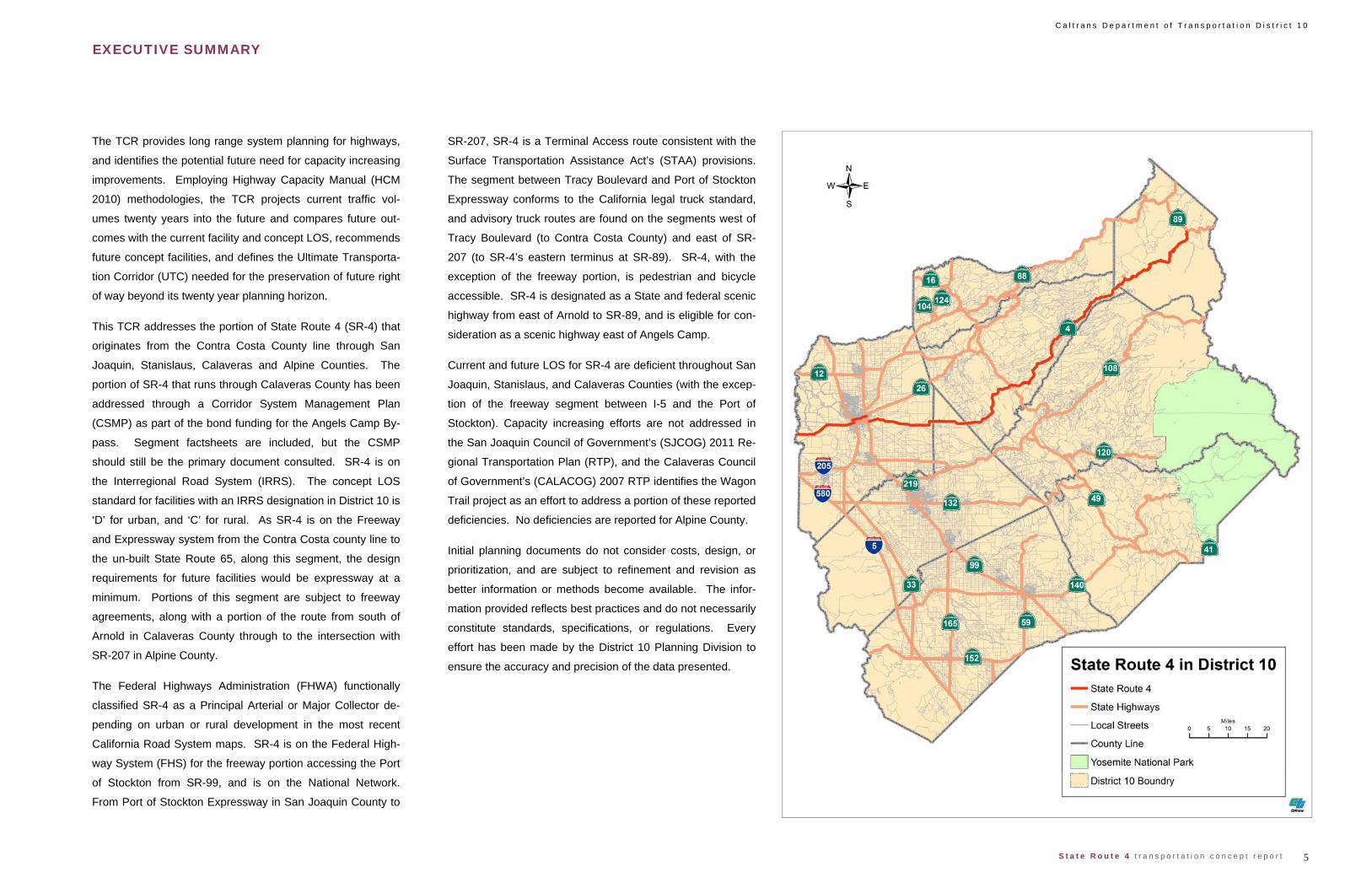
This TCR addresses the portion of State Route 4 (SR-4) that
originates from the Contra Costa County line through San
Joaquin, Stanislaus, Calaveras and Alpine Counties. The
portion of SR-4 that runs through Calaveras County has been
addressed through a Corridor System Management Plan
(CSMP) as part of the bond funding for the Angels Camp By-
pass. Segment factsheets are included, but the CSMP
should still be the primary document consulted. SR-4 is on
the Interregional Road System (IRRS). The concept LOS
standard for facilities with an IRRS designation in District 10 is
‘D’ for urban, and ‘C’ for rural. As SR-4 is on the Freeway
and Expressway system from the Contra Costa county line to
the un-built State Route 65, along this segment, the design
requirements for future facilities would be expressway at a
minimum. Portions of this segment are subject to freeway
agreements, along with a portion of the route from south of
Arnold in Calaveras County through to the intersection with
SR-207 in Alpine County.
The Federal Highways Administration (FHWA) functionally
classified SR-4 as a Principal Arterial or Major Collector de-
pending on urban or rural development in the most recent
California Road System maps. SR-4 is on the Federal High-
way System (FHS) for the freeway portion accessing the Port
of Stockton from SR-99, and is on the National Network.
From Port of Stockton Expressway in San Joaquin County to
SR-207, SR-4 is a Terminal Access route consistent with the
Surface Transportation Assistance Act’s (STAA) provisions.
The segment between Tracy Boulevard and Port of Stockton
Expressway conforms to the California legal truck standard,
and advisory truck routes are found on the segments west of
Tracy Boulevard (to Contra Costa County) and east of SR-
207 (to SR-4’s eastern terminus at SR-89). SR-4, with the
exception of the freeway portion, is pedestrian and bicycle
accessible. SR-4 is designated as a State and federal scenic
highway from east of Arnold to SR-89, and is eligible for con-
sideration as a scenic highway east of Angels Camp.
Current and future LOS for SR-4 are deficient throughout San
Joaquin, Stanislaus, and Calaveras Counties (with the excep-
tion of the freeway segment between I-5 and the Port of
Stockton). Capacity increasing efforts are not addressed in
the San Joaquin Council of Government’s (SJCOG) 2011 Re-
gional Transportation Plan (RTP), and the Calaveras Council
of Government’s (CALACOG) 2007 RTP identifies the Wagon
Trail project as an effort to address a portion of these reported
deficiencies. No deficiencies are reported for Alpine County.
Initial planning documents do not consider costs, design, or
prioritization, and are subject to refinement and revision as
better information or methods become available. The infor-
mation provided reflects best practices and do not necessarily
constitute standards, specifications, or regulations. Every
effort has been made by the District 10 Planning Division to
ensure the accuracy and precision of the data presented.
EXECUTIVE SUMMARY
C a l t r a n s D e p a r t m e n t o f T r a n s p o r t a t i o n D i s t r i c t 1 0
6 S t a t e R o u t e 4 t r a n s p o r t a t i o n c o n c e p t r e p o r t
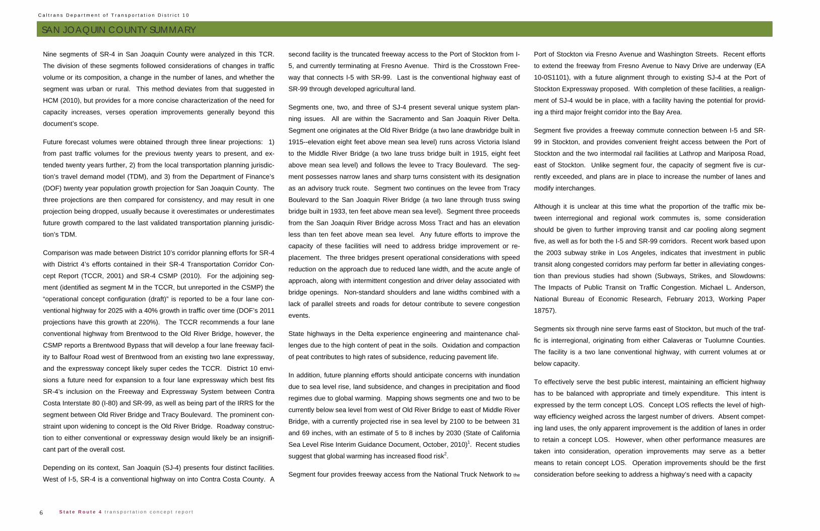
Nine segments of SR-4 in San Joaquin County were analyzed in this TCR.
The division of these segments followed considerations of changes in traffic
volume or its composition, a change in the number of lanes, and whether the
segment was urban or rural. This method deviates from that suggested in
HCM (2010), but provides for a more concise characterization of the need for
capacity increases, verses operation improvements generally beyond this
document’s scope.
Future forecast volumes were obtained through three linear projections: 1)
from past traffic volumes for the previous twenty years to present, and ex-
tended twenty years further, 2) from the local transportation planning jurisdic-
tion’s travel demand model (TDM), and 3) from the Department of Finance’s
(DOF) twenty year population growth projection for San Joaquin County. The
three projections are then compared for consistency, and may result in one
projection being dropped, usually because it overestimates or underestimates
future growth compared to the last validated transportation planning jurisdic-
tion’s TDM.
Comparison was made between District 10’s corridor planning efforts for SR-4
with District 4’s efforts contained in their SR-4 Transportation Corridor Con-
cept Report (TCCR, 2001) and SR-4 CSMP (2010). For the adjoining seg-
ment (identified as segment M in the TCCR, but unreported in the CSMP) the
“operational concept configuration (draft)” is reported to be a four lane con-
ventional highway for 2025 with a 40% growth in traffic over time (DOF’s 2011
projections have this growth at 220%). The TCCR recommends a four lane
conventional highway from Brentwood to the Old River Bridge, however, the
CSMP reports a Brentwood Bypass that will develop a four lane freeway facil-
ity to Balfour Road west of Brentwood from an existing two lane expressway,
and the expressway concept likely super cedes the TCCR. District 10 envi-
sions a future need for expansion to a four lane expressway which best fits
SR-4’s inclusion on the Freeway and Expressway System between Contra
Costa Interstate 80 (I-80) and SR-99, as well as being part of the IRRS for the
segment between Old River Bridge and Tracy Boulevard. The prominent con-
straint upon widening to concept is the Old River Bridge. Roadway construc-
tion to either conventional or expressway design would likely be an insignifi-
cant part of the overall cost.
Depending on its context, San Joaquin (SJ-4) presents four distinct facilities.
West of I-5, SR-4 is a conventional highway on into Contra Costa County. A
second facility is the truncated freeway access to the Port of Stockton from I-
5, and currently terminating at Fresno Avenue. Third is the Crosstown Free-
way that connects I-5 with SR-99. Last is the conventional highway east of
SR-99 through developed agricultural land.
Segments one, two, and three of SJ-4 present several unique system plan-
ning issues. All are within the Sacramento and San Joaquin River Delta.
Segment one originates at the Old River Bridge (a two lane drawbridge built in
1915--elevation eight feet above mean sea level) runs across Victoria Island
to the Middle River Bridge (a two lane truss bridge built in 1915, eight feet
above mean sea level) and follows the levee to Tracy Boulevard. The seg-
ment possesses narrow lanes and sharp turns consistent with its designation
as an advisory truck route. Segment two continues on the levee from Tracy
Boulevard to the San Joaquin River Bridge (a two lane through truss swing
bridge built in 1933, ten feet above mean sea level). Segment three proceeds
from the San Joaquin River Bridge across Moss Tract and has an elevation
less than ten feet above mean sea level. Any future efforts to improve the
capacity of these facilities will need to address bridge improvement or re-
placement. The three bridges present operational considerations with speed
reduction on the approach due to reduced lane width, and the acute angle of
approach, along with intermittent congestion and driver delay associated with
bridge openings. Non-standard shoulders and lane widths combined with a
lack of parallel streets and roads for detour contribute to severe congestion
events.
State highways in the Delta experience engineering and maintenance chal-
lenges due to the high content of peat in the soils. Oxidation and compaction
of peat contributes to high rates of subsidence, reducing pavement life.
In addition, future planning efforts should anticipate concerns with inundation
due to sea level rise, land subsidence, and changes in precipitation and flood
regimes due to global warming. Mapping shows segments one and two to be
currently below sea level from west of Old River Bridge to east of Middle River
Bridge, with a currently projected rise in sea level by 2100 to be between 31
and 69 inches, with an estimate of 5 to 8 inches by 2030 (State of California
Sea Level Rise Interim Guidance Document, October, 2010)1. Recent studies
suggest that global warming has increased flood risk2.
Segment four provides freeway access from the National Truck Network to the
Port of Stockton via Fresno Avenue and Washington Streets. Recent efforts
to extend the freeway from Fresno Avenue to Navy Drive are underway (EA
10-0S1101), with a future alignment through to existing SJ-4 at the Port of
Stockton Expressway proposed. With completion of these facilities, a realign-
ment of SJ-4 would be in place, with a facility having the potential for provid-
ing a third major freight corridor into the Bay Area.
Segment five provides a freeway commute connection between I-5 and SR-
99 in Stockton, and provides convenient freight access between the Port of
Stockton and the two intermodal rail facilities at Lathrop and Mariposa Road,
east of Stockton. Unlike segment four, the capacity of segment five is cur-
rently exceeded, and plans are in place to increase the number of lanes and
modify interchanges.
Although it is unclear at this time what the proportion of the traffic mix be-
tween interregional and regional work commutes is, some consideration
should be given to further improving transit and car pooling along segment
five, as well as for both the I-5 and SR-99 corridors. Recent work based upon
the 2003 subway strike in Los Angeles, indicates that investment in public
transit along congested corridors may perform far better in alleviating conges-
tion than previous studies had shown (Subways, Strikes, and Slowdowns:
The Impacts of Public Transit on Traffic Congestion. Michael L. Anderson,
National Bureau of Economic Research, February 2013, Working Paper
18757).
Segments six through nine serve farms east of Stockton, but much of the traf-
fic is interregional, originating from either Calaveras or Tuolumne Counties.
The facility is a two lane conventional highway, with current volumes at or
below capacity.
To effectively serve the best public interest, maintaining an efficient highway
has to be balanced with appropriate and timely expenditure. This intent is
expressed by the term concept LOS. Concept LOS reflects the level of high-
way efficiency weighed across the largest number of drivers. Absent compet-
ing land uses, the only apparent improvement is the addition of lanes in order
to retain a concept LOS. However, when other performance measures are
taken into consideration, operation improvements may serve as a better
means to retain concept LOS. Operation improvements should be the first
consideration before seeking to address a highway’s need with a capacity
SAN JOAQUIN COUNTY SUMMARY

7 S t a t e R o u t e 4 t r a n s p o r t a t i o n c o n c e p t r e p o r t
C a l t r a n s D e p a r t m e n t o f T r a n s p o r t a t i o n D i s t r i c t 1 0
SAN JOAQUIN COUNTY SUMMARY
increase, as they are less expensive, and, on average, require less time to
implement. The most prominent operational improvement for conventional
highways would be the development and implementation of access manage-
ment plans, particularly for those segments where turning movements play a
significant role in accidents or diminished operations. Increased passing op-
portunities on expressways, and auxiliary lanes on freeways that reduce
weaving are other examples of operation improvements that retain or en-
hance concept LOS.
At the time of the 2010 Census, Stockton’s population (291,707) was com-
prised of these general ethnic racial categories: 37% White, 12.2% African-
American, 1.1% Native American, 21.5% Asian, and 0.6% Pacific Islander.
Of the population, 40.3% self identified as Latino or Hispanic. Median house-
hold income is $35,453 (below both the County and State averages of
$41,282 and $47,493). For Stockton, 23.9% of the population is below the
federal poverty line (17.7% for San Joaquin County as a whole; 2000 Cen-
sus). Currently, the Stockton—Lodi Metropolitan Statistical Area (MSA, which
was the seventy-sixth largest MSA by population) has been combined into the
San Jose—San Francisco—Oakland MSA, which is the fifth largest MSA in
the country.
Land uses along the SJ-4 corridor are highly variable. Since, local agency
general plans characterize and distribute future population density, and would
influence future traffic volumes, SJ-4 is subject to the adjacent land uses of
the San Joaquin County General Plan for segments one, two, seven, eight,
and nine; and the City of Stockton’s General Plan for segments three through
six. For the San Joaquin General Plan, the land uses fall under agricultural
and rural residential uses which permit numerous access points on the high-
way. These present some challenge when upgrading a conventional highway
to expressway, as highway access rights need to be restricted when meeting
design criteria of the Highway Design Manual. Within the Stockton General
Plan most freeway portions of SJ-4 and the adjacent land uses and neighbor-
hood values constrain capacity increases, since these are in areas of devel-
oped neighborhoods or industrial use. Only segments three and six might
see resolution of conflicting uses through the implementation of bypasses to
avoid adverse affects to existing commercial or residential development.
SJ-4 is a principal connection to non-automobile transportation in San Joa-
quin County. Lacking light rail and other dedicated transit along most of the
route, near segment five, commuters may access both Amtrak and the Alta-
mont Commuter Express (ACE) to San Jose (which can transfer to the Bay
Area Rapid Transit (BART) stations in Livermore and Pleasanton); and the
Stockton Greyhound Bus Station. Regional and local transit routes 51, 52,
90, 91, and 380 have portions of their routes on SJ-4. With the exceptions of
segments four and five, SJ-4 is bicycle accessible (though access may be
constrained at the Delta bridges), and within the city limits of Stockton, the
route employs sidewalk and pedestrian crossings. Outside of Stockton, SJ-4
serves Farmington as the community’s main street. It is only there that con-
siderations of complete streets and context sensitive solutions would apply,
elsewhere on the route they are not at the forefront of planning consideration.
On segment six there is an at grade rail crossing. Located at PM 19.940 be-
tween Stagecoach Road and South Olive Avenue, the at grade crossing was
improved by a local street improvement project on Stagecoach Road. The at
grade crossing is not currently addressed as either a tier I or tier II project on
the 2011 RTP.
Other than its service as a direct truck route to the Port of Stockton, SJ-4
plays a secondary role in the movement of goods and services compared to
other National Network routes such as I-5, I-205, I-580, and SR-99 in San
Joaquin County. Much of its role serves as a connector between the I-5 and
SR-99, though in the future, an important parallel terminal access route to the
envisioned light industrial and commercial development along Sperry Road
will exist. SJ-4’s role as a feeder route to other local terminal access routes
may be enhanced by intersection improvements (for example Jack Tone
Road) or interchange improvements with currently designated truck routes to
enable truck movement in all directions.
Modeling and analysis indicate that all segments will be deficient by 2030 ex-
cept for segment four. For segments one through three, and five, the defi-
ciency appears directly related to future growth within San Joaquin County.
Segments six through nine appear related to growth in interregional traffic
originating from Calaveras and Tuolumne Counties. Currently, efforts to ex-
tend SJ-4 into the Port of Stockton may effectively realign the highway, and
bypass segment three and the eastern portion of segment two.
Segment five presents several planning issues. Current planned projects in
the SJCOG RTP conform to a concept facility of an eight lane freeway. The
current UTC is eight lanes as well. Modeling based upon the forecast vol-
umes for 2030 suggest that at that date, should the facility be eight lanes, the
concept LOS will still be exceeded, and the concept facility may be ten lanes.
The need for ten lanes depends upon three factors:
Within the Stockton area, alternate truck and commuter
routes will remain un-built. Construction of Sperry Road and
Arch Road improvements between I-5 and SR-99 would poten-
tially redirect truck and commuter traffic away from the Cross-
town Freeway.
The forecast volumes reflect assumptions of population
growth prior to the economic recession. AADT volumes have
declined since 2008, and with a large volume of unoccupied
housing units, growth in San Joaquin County commuter traffic
has declined. If such a trend persists, it will require a reduction
in the forecast future population growth rate.
Segment five was constructed in an urban setting, with
adequate set asides for future expansion. Without adequate
set asides, the cost for expansion of the facility would be un-
feasible, and require development of new routes in a rural con-
text (e.g. unconstructed traversable routes 234 and 235).
In considering these three factors, the concept facility will remain eight lanes,
but the UTC will change to ten lanes.

C a l t r a n s D e p a r t m e n t o f T r a n s p o r t a t i o n D i s t r i c t 1 0
8 S t a t e R o u t e 4 t r a n s p o r t a t i o n c o n c e p t r e p o r t
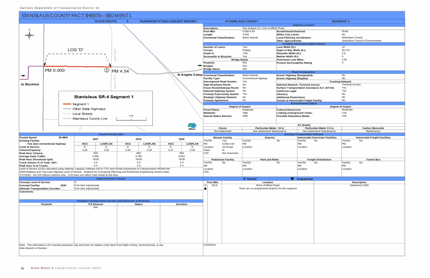
SAN JOAQUIN COUNTY FACT SHEETS—SEGMENT 1 4
0.000-5.965.960Minor Arterial
Two Lane Width (ft.): 12Rolling Right of Way Width (ft.): 50-140N/A Shoulder Width (ft.): 0-8Yes Median Width (ft.): None
Distressed Lane Miles 11.00 0-0.1; 4.42
29-0045; 29-0049Old River, Middle River
Minor Arterial Scenic Highway (Designated):Conventional highwayYesNoNoNoYesNoNo Access to Intermodal Freight Facility
HighHighHigh
55 MPH Intermodal Commuter FacilitiesYes Yes/No No Yes/No No Yes/No No
HCS LOSPLAN HCS LOSPLAN HCS LOSPLAN PM 0.000-5.96 PM PM PMLevel of Service: D D E E E E Location On Route Location Location Location
0.43 0.43 0.53 0.56 0.89 0.56 Class IIINot Assessed
No Yes/No No Yes/No No Yes/No NoPM PM PMLocation Location Location
PlannedConcept Level of Service: C
2030 4.1-4.9 TBD-TBD
7.3 7.39.19.1
4.4214.525
Level of Service (LOS) calculated using Highway Capacity Software (HCS+T7F) and Florida Department of Transportation HIGHPLAN 2009 Multilane and Two-Lane Highway Level of Service. Analysis for Conceptual Planning and Preliminary Engineering Version Data: 7/17/2010. All LOS reflects vehicles only. LOS does not reflect multi modal at this time.
Truck Volume % of Total ADT: 9.1Peak Hour % of Trucks:
Concept Facility: Four lane expressway
7.3
Existing Both
Status
70/3070/30Average Daily Traffic:Peak Hour Volume:
Peak Hour Directional Split:9,200
1080830 180512,000 20,070
70/30
Posted Speed:
Volume/Capacity:
Existing Facility: Two lane conventional highway
No
Surface Transportation Assistance Act (STAA) California Legal:
Strategic Highway Network
2007 2015 2030 Yes/No
Length:Functional Classification:
Non Attainment/Maintenance Maintenance
Park and Rides Freight Distribution
Airports
Non Attainment
Intermodal Freight Facilities
Air Quality
NoYes KPRA = 34 ft
Roadbed Information (approximate)
Route Designations
Bridge NeedsAccessible to Bicycles:
Particulate Matter 10 m Particulate Matter 2.5 m Carbon Monoxide
Leaking Underground Tanks:
National Network, Terminal Access
Postmile
LocationLOS
Ozone
High Emphasis Route:No
Degree of Impact
Advisory
Cultural Resources:
Focus Route/Gateway Route:National Highway System
NoneFreeway Expressway System
Degree of ImpactModerateFlood Plains:
Wetlands:Special Status Species:
Yes/NoPM
Bicycle Facility
3Present Serviceability Rating
Additional Restrictions
No
No
Bridge#
Trucking Network
Bridge Name:
Transit BusPedestrian Facility
LOS
Interregional Road System:
Functional Classification:
Freeway Agreement: Environmental Status
Scenic Highway (Eligible)Facility Type:
STATE ROUTE SAN JOAQUIN COUNTY
Travel Forecast DataNon Attainment
SEGMENT 1
San Joaquin Co. Line to Tracy Blvd.Rural/Urban/Urbanized: Rural
NoSan Joaquin Council of Governments (SJCOG)San Joaquin County
Segment Location:Description:Post Mile:
Within City Limits:Local Planning Jurisdiction:Other Agency/Entity
TRANSPORTATION CONCEPT REPORT
No
Number of Lanes:Terrain:Grade %
Location DescriptionMiddle River Bridge Traffic control, installation and widening shoulders
I-5 to the City of Brentwood (Study only) Corridor improvement project for safety and capacityThere are no programmed projects in this segment
Commentsother Branch or Division.Note: This information is for overview purposes only and does not replace a full report from Right of Way, Environmental, or any
Programmed Segment Route ConceptPost Mile
Ultimate Transportation Corridor: Four lane expresswayComments:
Intelligent Transportation System (ITS) Elements & Detection
TMS
LowLowPossible Hazardous Waste:
Existing Transportation Network
DirectionTMS Existing
PostmileBoth
ITS Element

9 S t a t e R o u t e 4 t r a n s p o r t a t i o n c o n c e p t r e p o r t
C a l t r a n s D e p a r t m e n t o f T r a n s p o r t a t i o n D i s t r i c t 1 0
SAN JOAQUIN COUNTY FACT SHEETS—SEGMENT 2
4
5.96-14.1478.085Minor Arterial
Two Lane Width (ft.): 12Flat Right of Way Width (ft.): 50-140N/A Shoulder Width (ft.): 0-8Yes Median Width (ft.): None
Distressed Lane Miles 12.63N/AN/AN/A
Minor Arterial Scenic Highway (Designated):Conventional highwayYesNoNoNoYesNoYes Access to Intermodal Freight Facility
HighHighHigh
55 MPH Intermodal Commuter FacilitiesYes Yes/No No Yes/No No Yes/No No
HCS LOSPLAN HCS LOSPLAN HCS LOSPLAN PM 5.96-14.147 PM PM PME E E E E E Location On Route Location Location Location
0.47 0.45 0.56 0.55 0.82 0.80 Class IIINot Assessed
No Yes/No No Yes/No No Yes/No NoPM PM PMLocation Location Location
PlannedConcept Level of Service:
2030 TBD-TBD
Local Planning Jurisdiction: San Joaquin Council of Governments (SJCOG)
Route Designations Functional Classification:
Bridge# Present Serviceability Rating 2
Accessible to Bicycles:Bridge Needs
No
STATE ROUTE SAN JOAQUIN COUNTY SEGMENT 2Segment Location:
Description: From Tracy Blvd. to San Joaquin River BridgePost Mile: Rural/Urban/Urbanized: Rural
Terrain:Grade %
Other Agency/Entity San Joaquin CountyRoadbed Information (approximate)
Number of Lanes:
Bridge Name:
Postmile
TRANSPORTATION CONCEPT REPORT
Length: Within City Limits: NoFunctional Classification:
Facility Type: NoInterregional Road System:
Terminal Access PM 8.67 to 14.147Trucking Network
Scenic Highway (Eligible)
National Highway System California Legal: YesFreeway Expressway System Advisory No
Additional Restrictions
High Emphasis Route: National Network, Terminal AccessFocus Route/Gateway Route: Surface Transportation Assistance Act (STAA) Yes
Environmental StatusDegree of Impact Degree of Impact
Flood Plains: Cultural Resources: Moderate
Strategic Highway Network NoneFreeway Agreement: No
Wetlands: Leaking Underground Tanks: LowSpecial Status Species: Possible Hazardous Waste: Low
Air QualityOzone
Non Attainment Non Attainment Non Attainment/Maintenance MaintenanceParticulate Matter 10 m Particulate Matter 2.5 m Carbon Monoxide
Two lane conventional highwayLevel of Service:
Peak Hour Volume: 990 1,205 1,760 LOS
Yes/No2007 2015 2030
Travel Forecast DataBicycle Facility Airports Intermodal Freight Facilities
Existing Transportation NetworkPosted Speed:Existing Facility:
Programmed Projects
Volume/Capacity:
Average Daily Traffic: 8,660 10,570 15,420
Level of Service (LOS) calculated using Highway Capacity Software (HCS+T7F) and Florida Department of Transportation HIGHPLAN Location
Park and Rides Freight Distribution Transit BusTruck Volume % of Total ADT: 9.2 9.2 9.2 Yes/NoPeak Hour Directional Split: 70/30 70/30 70/30 Pedestrian Facility
Peak Hour % of Trucks: 7.4 7.4 7.4 PM
2009 Multilane and Two-Lane Highway Level of Service. Analysis for Conceptual Planning and Preliminary Engineering Version Data: LOS7/17/2010. All LOS reflects vehicles only. LOS does not reflect multi modal at this time.
Segment Route Concept
Concept Facility:Ultimate Transportation Corridor:
CFour lane expresswayFour lane expressway There are no programmed projects in this segment
Post Mile Location DescriptionI-5 to the City of Brentwood (Study only) Corridor improvement project for safety and capacity
Comments:
Intelligent Transportation System (ITS) Elements & DetectionPostmile ITS Element Status DirectionT14.045 TMS Existing Both
Comments:Note: This information is for overview purposes only and does not replace a full report from Right of Way, Environmental, or anyother Branch or Division.
C a l t r a n s D e p a r t m e n t o f T r a n s p o r t a t i o n D i s t r i c t 1 0
10 S t a t e R o u t e 4 t r a n s p o r t a t i o n c o n c e p t r e p o r t
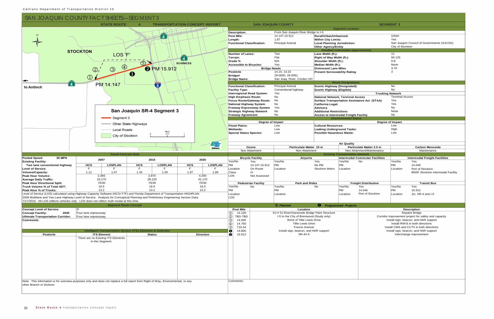
SAN JOAQUIN COUNTY FACT SHEETS—SEGMENT 3 4
14.147-15.9121.87Principal Arterial
Two Lane Width (ft.): 12Flat Right of Way Width (ft.): 50-125N/A Shoulder Width (ft.): 0-8Yes Median Width (ft.): None
Distressed Lane Miles 3.70 14.15. 14.22
29-0050, 29-0051San Joaq. River, Cordes U/C
Principal Arterial Scenic Highway (Designated):Conventional highwayYesNoNoNoYesNoNo Access to Intermodal Freight Facility
LowLowLow
35 MPH Intermodal Commuter FacilitiesYes Yes/No Yes Yes/No No Yes/No Yes
HCS LOSPLAN HCS LOSPLAN HCS LOSPLAN PM 14.147-15.912 PM No PM PM PM 14.045F F F F F F Location On Route Location Stockton Metro Location Location
1.11 1.07 1.34 1.29 1.97 1.89 Class IIINot Assessed
No Yes/No No Yes/No Yes Yes/No YesPM PM 14.045 PM 15.912Location Location Location Jct. SR-4 and I-5
PlannedD
2030 Four lane expressway 14.100Four lane expressway TBD-TBD
14.500 14.700 T15.54 14.800 15.912
Bridge Name:
Strategic Highway Network NoneFreeway Agreement: No
Present Serviceability Rating
National Highway System California Legal: YesFreeway Expressway System Advisory No
Additional Restrictions
High Emphasis Route: National Network, Terminal AccessFocus Route/Gateway Route: Surface Transportation Assistance Act (STAA) Yes
Route Designations Functional Classification: NoFacility Type: No
TRANSPORTATION CONCEPT REPORT
Length: Within City Limits: YesFunctional Classification: Local Planning Jurisdiction: San Joaquin Council of Governments (SJCOG)
3
Accessible to Bicycles:Bridge Needs
STATE ROUTE SAN JOAQUIN COUNTY SEGMENT 3Segment Location:
Description: From San Joaquin River Bridge to I-5 Post Mile: Rural/Urban/Urbanized: Urban
Terrain:Grade %
Scenic Highway (Eligible)Trucking Network
Other Agency/Entity City of StocktonRoadbed Information (approximate)
Number of Lanes:
PostmileBridge#
Wetlands:
Interregional Road System:Terminal Access
Leaking Underground Tanks: HighSpecial Status Species: Possible Hazardous Waste: Low
Environmental StatusDegree of Impact Degree of Impact
Flood Plains: Cultural Resources: Low
Air QualityOzone
Non Attainment Non Attainment Non Attainment/Maintenance MaintenanceParticulate Matter 10 m Particulate Matter 2.5 m Carbon Monoxide
Level of Service:
Peak Hour Volume: 2,365 2,870 4,200 LOS
Travel Forecast DataBicycle Facility Airports Intermodal Freight Facilities
Existing Transportation Network
Yes/NoPosted Speed:
Volume/Capacity:
Existing Facility: Two lane conventional highway
2007 2015 2030
Port of StocktonBNSF Stockton Intermodal Facility
Transit BusTruck Volume % of Total ADT: 16.5 16.5 16.5 Yes/NoPeak Hour Directional Split: 70/30 70/30 70/30 Pedestrian Facility
2009 Multilane and Two-Lane Highway Level of Service. Analysis for Conceptual Planning and Preliminary Engineering Version Data: LOS7/17/2010. All LOS reflects vehicles only. LOS does not reflect multi modal at this time.
Segment Route Concept Programmed Projects
Location
Concept Facility:Location Description
SJ-4 SJ River/Garwoods Bridge Paint Structure Repaint Bridge
Peak Hour % of Trucks: 13.2 13.2 13.2 PM
Postmile SR-4/I-5 Interchange improvement
Tillie Lewis Drive Install RWIS in both directionsFresno Avenue Install CMS and CCTV in both directions
West of Tillie Lewis Drive Install sign, beacon, and HAR support
Port of Stockton
Ultimate Transportation Corridor:Comments:
Comments:Note: This information is for overview purposes only and does not replace a full report from Right of Way, Environmental, or anyother Branch or Division.
Install sign, beacon, and HAR support
I-5 to the City of Brentwood (Study only)
Average Daily Traffic: 23,170 28,120 41,170
Level of Service (LOS) calculated using Highway Capacity Software (HCS+T7F) and Florida Department of Transportation HIGHPLAN
Park and Rides Freight Distribution
Concept Level of Service:
Install sign, beacon, and HAR support
Corridor improvement project for safety and capacity
Post Mile
Intelligent Transportation System (ITS) Elements & DetectionITS Element Status Direction
There are no Existing ITS Elements in this Segment.
11 S t a t e R o u t e 4 t r a n s p o r t a t i o n c o n c e p t r e p o r t
C a l t r a n s D e p a r t m e n t o f T r a n s p o r t a t i o n D i s t r i c t 1 0
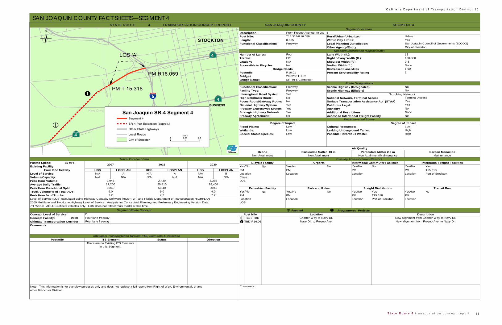
SAN JOAQUIN COUNTY FACT SHEETS—SEGMENT 4
4
T15.318-R16.0590.665Freeway
Four Lane Width (ft.): 12Flat Right of Way Width (ft.): 100-300N/A Shoulder Width (ft.): 0-8No Median Width (ft.): None
Distressed Lane MilesR16.0129-0235 L & RSR-4/I-5 Connector
Freeway Scenic Highway (Designated):Freeway Scenic Highway (Eligible)YesNoNoYesYesYesNo Access to Intermodal Freight Facility
LowLowLow
65 MPH Intermodal Commuter FacilitiesNo Yes/No No Yes/No No Yes/No Yes
HCS LOSPLAN HCS LOSPLAN HCS LOSPLAN PM PM PM PM T15.318N/A A N/A A N/A B Location Location Location Location Port of StocktonN/A N/A N/A N/A N/A N/A Class
No Yes/No No Yes/No Yes Yes/No NoPM PM T15.318 PMLocation Location Port of Stockton Location
Planned
2030 14.6-TBD TBD-R16.06
STATE ROUTE SAN JOAQUIN COUNTY SEGMENT 4Segment Location:
Description: From Fresno Avenue to Jct I-5Post Mile: Rural/Urban/Urbanized: Urban
Terrain:
Other Agency/Entity City of StocktonRoadbed Information (approximate)
Number of Lanes:
Environmental StatusDegree of Impact Degree of Impact
Flood Plains: Cultural Resources:
TRANSPORTATION CONCEPT REPORT
Length: Within City Limits: YesFunctional Classification: Local Planning Jurisdiction: San Joaquin Council of Governments (SJCOG)
Terminal Access
Bridge# 1
Facility Type: NoInterregional Road System:
Postmile
Accessible to Bicycles:Bridge Needs
Trucking Network
Grade %
Bridge Name:
5.60
Strategic Highway Network NoneFreeway Agreement: No
Present Serviceability Rating
National Highway System California Legal: YesFreeway Expressway System Advisory No
Additional Restrictions
High Emphasis Route: National Network, Terminal AccessFocus Route/Gateway Route: Surface Transportation Assistance Act (STAA) Yes
Route DesignationsFunctional Classification: No
Low
Air QualityOzone
Non Attainment Non Attainment Non Attainment/Maintenance MaintenanceParticulate Matter 10 m Particulate Matter 2.5 m Carbon Monoxide
Wetlands: Leaking Underground Tanks: HighSpecial Status Species: Possible Hazardous Waste: High
Level of Service:
Peak Hour Volume: 2,045 2,430 3,385 LOS
Travel Forecast DataBicycle Facility Airports Intermodal Freight Facilities
Existing Transportation Network
Yes/NoPosted Speed:Existing Facility:
Four lane freeway
2007 2015 2030
28,460
Level of Service (LOS) calculated using Highway Capacity Software (HCS+T7F) and Florida Department of Transportation HIGHPLAN Location
Park and Rides Freight Distribution Transit BusTruck Volume % of Total ADT: 9.0 9.0 9.0 Yes/NoPeak Hour Directional Split: 60/40 60/40 60/40 Pedestrian Facility
Peak Hour % of Trucks:
Concept Level of Service:Concept Facility:Ultimate Transportation Corridor:
DFour lane freewayFour lane freeway
Programmed Projects
Volume/Capacity:
7.2 7.2 7.2 PM
2009 Multilane and Two-Lane Highway Level of Service. Analysis for Conceptual Planning and Preliminary Engineering Version Data: LOS7/17/2010. All LOS reflects vehicles only. LOS does not reflect multi modal at this time.
Segment Route Concept
Navy Dr. to Fresno Ave. New alignment from Fresno Ave. to Navy Dr.
Average Daily Traffic: 17,200 20,410
Post Mile Location DescriptionCharter Way to Navy Dr. New alignment from Charter Way to Navy Dr.
Comments:
Postmile Intelligent Transportation System (ITS) Elements & Detection
ITS Element Status DirectionThere are no Existing ITS Elements
in this Segment.
Note: This information is for overview purposes only and does not replace a full report from Right of Way, Environmental, or any Comments:other Branch or Division.
C a l t r a n s D e p a r t m e n t o f T r a n s p o r t a t i o n D i s t r i c t 1 0
12 S t a t e R o u t e 4 t r a n s p o r t a t i o n c o n c e p t r e p o r t
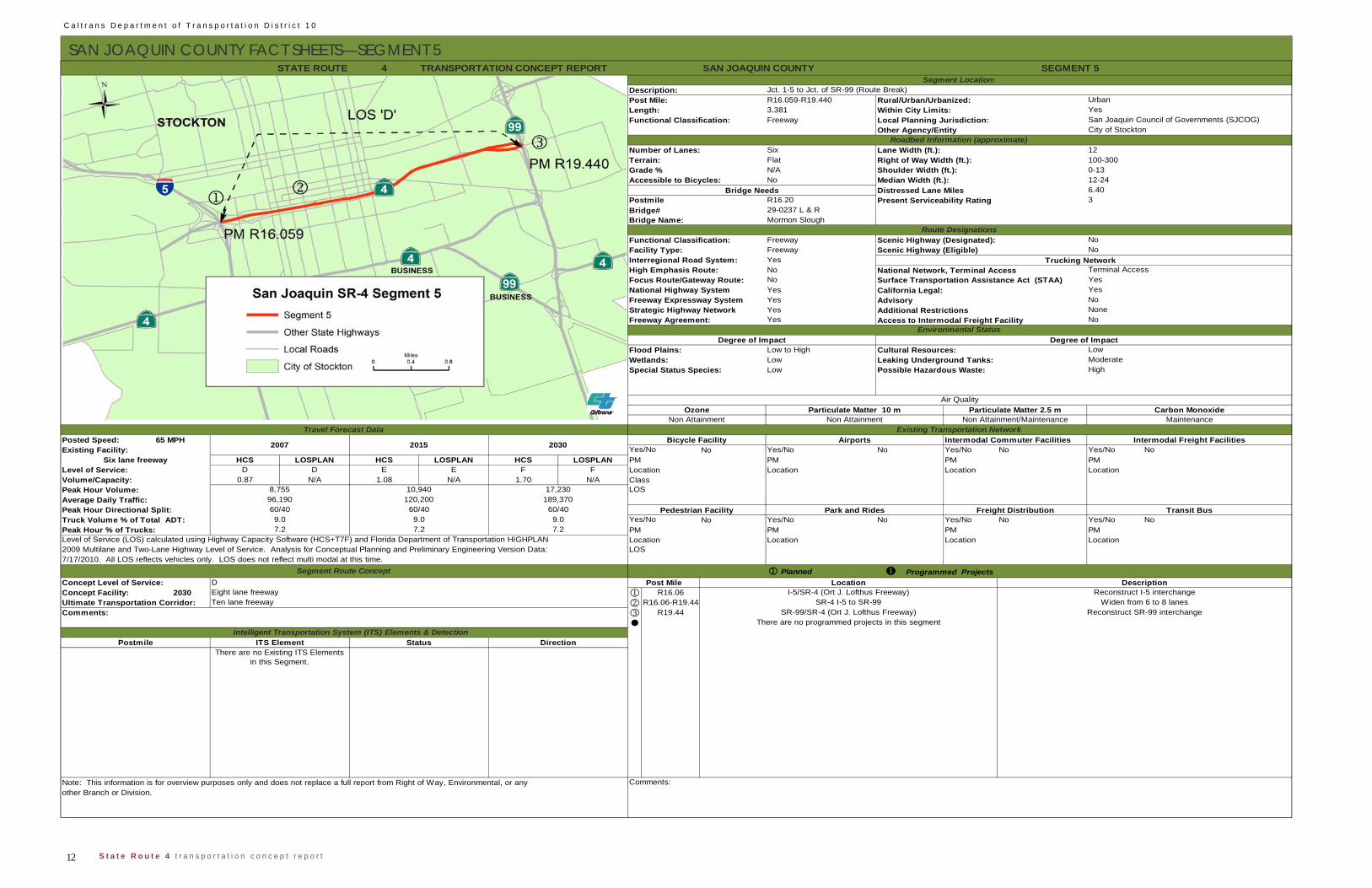
SAN JOAQUIN COUNTY FACT SHEETS—SEGMENT 5 4
R16.059-R19.4403.381
Functional Classification: Freeway Local Planning Jurisdiction:
Number of Lanes: Six Lane Width (ft.): 12Flat Right of Way Width (ft.): 100-300N/A Shoulder Width (ft.): 0-13No Median Width (ft.): 12-24
Distressed Lane Miles 6.40 R16.20
Bridge# 29-0237 L & R Mormon Slough
Functional Classification: Freeway Scenic Highway (Designated):Freeway
Interregional Road System: YesHigh Emphasis Route: No National Network, Terminal AccessFocus Route/Gateway Route: NoNational Highway System YesFreeway Expressway System YesStrategic Highway Network YesFreeway Agreement: Yes Access to Intermodal Freight Facility
Low to HighLowLow
65 MPH Intermodal Commuter FacilitiesNo Yes/No No Yes/No No Yes/No No
HCS LOSPLAN HCS LOSPLAN HCS LOSPLAN PM PM PMD D E E F F Location Location Location Location
0.87 N/A 1.08 N/A 1.70 N/A Class
No Yes/No No Yes/No No Yes/No NoPM PM PMLocation Location Location
PlannedConcept Level of Service: D
2030 R16.06 R16.06-R19.44 R19.44
SEGMENT 5STATE ROUTE SAN JOAQUIN COUNTY
Description: Jct. 1-5 to Jct. of SR-99 (Route Break)Post Mile: Rural/Urban/Urbanized: Urban
Other Agency/Entity City of StocktonRoadbed Information (approximate)
Length: Within City Limits: YesSan Joaquin Council of Governments (SJCOG)
Accessible to Bicycles:
Terrain:Grade %
NoFacility Type: No
Bridge Needs
Terminal Access
Postmile Present Serviceability Rating 3
Scenic Highway (Eligible)Trucking Network
California Legal: Yes
Bridge Name:
Advisory No
Surface Transportation Assistance Act (STAA) Yes
Environmental StatusDegree of Impact Degree of Impact
Flood Plains: Cultural Resources: Low
NoneNo
Additional Restrictions
Wetlands: Leaking Underground Tanks: ModerateSpecial Status Species: Possible Hazardous Waste: High
Travel Forecast DataBicycle Facility Airports Intermodal Freight Facilities
Air QualityOzone
Non Attainment Non Attainment Non Attainment/Maintenance MaintenanceExisting Transportation Network
Particulate Matter 10 m Particulate Matter 2.5 m Carbon Monoxide
Posted Speed:
Volume/Capacity:
Average Daily Traffic: 96,190 120,200 189,370
Yes/No
Level of Service:PMSix lane freeway
2007 2015 2030Existing Facility:
Park and Rides Freight Distribution Transit BusTruck Volume % of Total ADT: 9.0 9.0 9.0 Yes/No
Peak Hour Volume: 8,755 10,940 17,230 LOS
Peak Hour Directional Split: 60/40 60/40 60/40 Pedestrian Facility
2009 Multilane and Two-Lane Highway Level of Service. Analysis for Conceptual Planning and Preliminary Engineering Version Data: LOS7/17/2010. All LOS reflects vehicles only. LOS does not reflect multi modal at this time.
Segment Route Concept
Peak Hour % of Trucks: 7.2 7.2 7.2 PMLevel of Service (LOS) calculated using Highway Capacity Software (HCS+T7F) and Florida Department of Transportation HIGHPLAN Location
Post Mile Location DescriptionI-5/SR-4 (Ort J. Lofthus Freeway) Reconstruct I-5 interchangeConcept Facility: Eight lane freeway
Ultimate Transportation Corridor: Ten lane freeway SR-4 I-5 to SR-99 Widen from 6 to 8 lanesSR-99/SR-4 (Ort J. Lofthus Freeway) Reconstruct SR-99 interchange
Programmed Projects
There are no programmed projects in this segment
There are no Existing ITS Elements in this Segment.
Note: This information is for overview purposes only and does not replace a full report from Right of Way, Environmental, or any Comments:other Branch or Division.
Segment Location:
Route Designations
TRANSPORTATION CONCEPT REPORT
Comments:
Intelligent Transportation System (ITS) Elements & DetectionPostmile ITS Element Status Direction

13 S t a t e R o u t e 4 t r a n s p o r t a t i o n c o n c e p t r e p o r t
C a l t r a n s D e p a r t m e n t o f T r a n s p o r t a t i o n D i s t r i c t 1 0
SAN JOAQUIN COUNTY FACT SHEETS—SEGMENT 6
4
19.750-20.6900.944Principal Arterial
Two Lane Width (ft.): 12Flat Right of Way Width (ft.): 80-200N/A Shoulder Width (ft.): 8-12 Yes Median Width (ft.): 6-60
Distressed Lane Miles 1.7019.75029-0155SR-4/SR-99 Separation
Principal Arterial Scenic Highway (Designated):Conventional highwayYesNoNoYesYesNoNo Access to Intermodal Freight Facility
LowLowLow
40 MPH Intermodal Commuter FacilitiesYes Yes/No No Yes/No No Yes/No No
HCS LOSPLAN HCS LOSPLAN HCS LOSPLAN PM 19.750-20.690 PM PM PMD C D C E D Location On Route Location Location Location
0.29 0.31 0.37 0.39 0.60 0.64 Class IIINot Assessed
No Yes/No No Yes/No Yes Yes/No NoPM PM 19.880; 20.240 PMLocation Location Location
PlannedConcept Level of Service: D
2030
TRANSPORTATION CONCEPT REPORT
Note: This information is for overview purposes only and does not replace a full report from Right of Way, Environmental, or any Comments:other Branch or Division.
There are no Existing ITS Elements in this Segment.
Postmile Intelligent Transportation System (ITS) Elements & Detection
ITS Element Status Direction
There are no programmed projects in this segmentUltimate Transportation Corridor: Four lane expresswayComments:
Post Mile Location DescriptionThere are no planned projects in this segment
2009 Multilane and Two-Lane Highway Level of Service. Analysis for Conceptual Planning and Preliminary Engineering Version Data: LOS7/17/2010. All LOS reflects vehicles only. LOS does not reflect multi modal at this time.
Segment Route Concept Programmed Projects
Concept Facility: Four lane expressway
Peak Hour % of Trucks: 3.7 3.7 3.7 PMLevel of Service (LOS) calculated using Highway Capacity Software (HCS+T7F) and Florida Department of Transportation HIGHPLAN Location
Park and Rides Freight Distribution
Stagecoach Road and Sinclair Street
Transit BusTruck Volume % of Total ADT: 4.6 4.6 4.6 Yes/No
Peak Hour Volume: 740 955 1,555 LOS
Peak Hour Directional Split: 55/45 55/45 55/45 Pedestrian Facility
Volume/Capacity:
Average Daily Traffic: 7,000 9,020 14,680
Yes/No
Level of Service:Two lane conventional highway
2007 2015 2030Existing Facility:
Travel Forecast DataBicycle Facility Airports Intermodal Freight Facilities
Air QualityOzone
Non Attainment Non Attainment Non Attainment/Maintenance MaintenanceExisting Transportation Network
Particulate Matter 10 m
Posted Speed:
Particulate Matter 2.5 m Carbon Monoxide
Wetlands: Leaking Underground Tanks: ModerateSpecial Status Species: Possible Hazardous Waste: Moderate
Environmental StatusDegree of Impact Degree of Impact
Flood Plains: Cultural Resources: Low
Strategic Highway Network NoneFreeway Agreement: No
Additional Restrictions
National Highway System California Legal: YesFreeway Expressway System Advisory No
High Emphasis Route: National Network, Terminal AccessFocus Route/Gateway Route: Surface Transportation Assistance Act (STAA) Yes
Grade %
Route DesignationsFunctional Classification: NoFacility Type: NoInterregional Road System:
Terminal Access
PostmileBridge#
Present Serviceability Rating 3
Trucking Network Scenic Highway (Eligible)
Bridge Name:
STATE ROUTE SAN JOAQUIN COUNTY SEGMENT 6Segment Location:
Description: Jct. of SR-99 to Walker Ln. (End of Urban Boundaries)Post Mile: Rural/Urban/Urbanized: Urbanized
Other Agency/Entity City of StocktonRoadbed Information (approximate)
Number of Lanes:
Length: Within City Limits: YesFunctional Classification: Local Planning Jurisdiction: San Joaquin Council of Governments (SJCOG)
Accessible to Bicycles:Bridge Needs
Terrain:
C a l t r a n s D e p a r t m e n t o f T r a n s p o r t a t i o n D i s t r i c t 1 0
14 S t a t e R o u t e 4 t r a n s p o r t a t i o n c o n c e p t r e p o r t
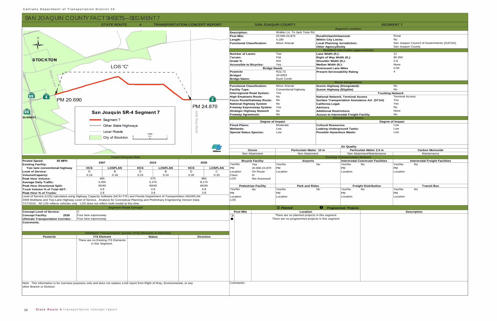
SAN JOAQUIN COUNTY FACT SHEETS—SEGMENT 7 4
20.690-24.8704.180Minor Arterial
Two Lane Width (ft.): 12Flat Right of Way Width (ft.): 80-350N/A Shoulder Width (ft.): 2-8Yes Median Width (ft.): None
Distressed Lane Miles 0.00R22.7229-0053Duck Creek
Minor Arterial Scenic Highway (Designated):Conventional highwayYesNoNoNoYesNoNo Access to Intermodal Freight Facility
ModerateLowLow
55 MPH Intermodal Commuter FacilitiesYes Yes/No No Yes/No No Yes/No No
HCS LOSPLAN HCS LOSPLAN HCS LOSPLAN PM 20.690-24.870 PM PM PMD B D B D C Location On Route Location Location Location
0.19 0.18 0.23 0.24 0.35 0.33 Class IIINot Assessed
No Yes/No No Yes/No No Yes/No NoPM PM PMLocation Location Location
PlannedConcept Level of Service: C
2030
TRANSPORTATION CONCEPT REPORT
Note: This information is for overview purposes only and does not replace a full report from Right of Way, Environmental, or any Comments:other Branch or Division.
There are no Existing ITS Elements in this Segment.
Postmile Intelligent Transportation System (ITS) Elements & Detection
ITS Element Status Direction
There are no programmed projects in this segmentUltimate Transportation Corridor: Four lane expresswayComments:
Programmed ProjectsPost Mile Location Description
There are no planned projects in this segment
2009 Multilane and Two-Lane Highway Level of Service. Analysis for Conceptual Planning and Preliminary Engineering Version Data: LOS7/17/2010. All LOS reflects vehicles only. LOS does not reflect multi modal at this time.
Segment Route Concept
Concept Facility: Four lane expressway
Level of Service (LOS) calculated using Highway Capacity Software (HCS+T7F) and Florida Department of Transportation HIGHPLAN Location
Park and Rides Freight Distribution Transit BusTruck Volume % of Total ADT: 4.8 4.8 4.8 Yes/NoPeak Hour Directional Split: 60/40 60/40 60/40 Pedestrian Facility
Peak Hour % of Trucks: 3.8 3.8 3.8 PM
Volume/Capacity:
Average Daily Traffic: 4,450 5,470 8,170
Yes/No
Level of Service:
Peak Hour Volume: 465 575 860 LOS
Two lane conventional highway
2007 2015 2030Existing Facility:
Travel Forecast DataBicycle Facility Airports Intermodal Freight Facilities
Air QualityOzone
Non Attainment Non Attainment Non Attainment/Maintenance MaintenanceExisting Transportation Network
Particulate Matter 10 m Particulate Matter 2.5 m Carbon Monoxide
Posted Speed:
Wetlands: Leaking Underground Tanks: LowSpecial Status Species: Possible Hazardous Waste: Low
Environmental StatusDegree of Impact Degree of Impact
Flood Plains: Cultural Resources: Low
Strategic Highway Network NoneFreeway Agreement: No
Additional Restrictions
National Highway System California Legal: YesFreeway Expressway System Advisory No
High Emphasis Route: National Network, Terminal AccessFocus Route/Gateway Route: Surface Transportation Assistance Act (STAA) Yes
Grade %
Route DesignationsFunctional Classification: NoFacility Type: NoInterregional Road System:
Terminal Access
PostmileBridge#
Present Serviceability Rating 4
Scenic Highway (Eligible)Trucking Network
Bridge Name:
STATE ROUTE SAN JOAQUIN COUNTY SEGMENT 7Segment Location:
Description: Walker Ln. To Jack Tone Rd.Post Mile: Rural/Urban/Urbanized: Rural
Other Agency/Entity San Joaquin CountyRoadbed Information (approximate)
Number of Lanes:
Length: Within City Limits: NoFunctional Classification: Local Planning Jurisdiction: San Joaquin Council of Governments (SJCOG)
Accessible to Bicycles:Bridge Needs
Terrain:
15 S t a t e R o u t e 4 t r a n s p o r t a t i o n c o n c e p t r e p o r t
C a l t r a n s D e p a r t m e n t o f T r a n s p o r t a t i o n D i s t r i c t 1 0
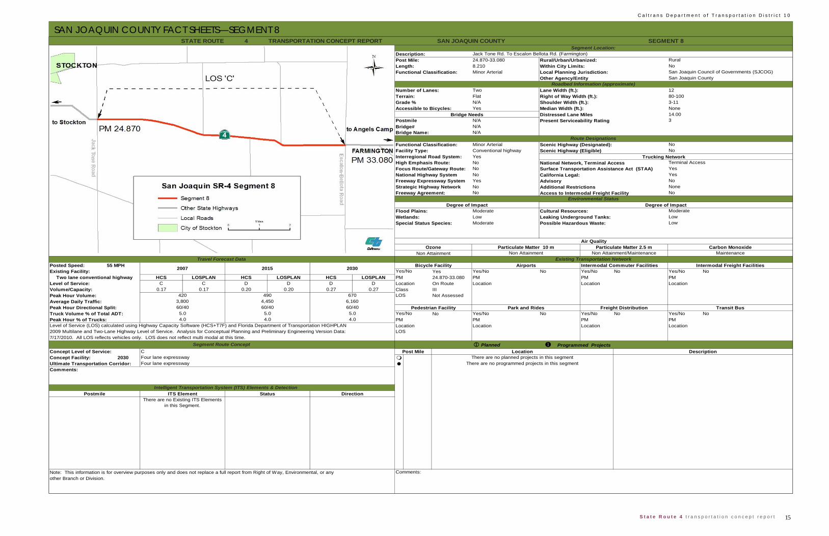
SAN JOAQUIN COUNTY FACT SHEETS—SEGMENT 8
4
24.870-33.0808.210Minor Arterial
Two Lane Width (ft.): 12Flat Right of Way Width (ft.): 80-100N/A Shoulder Width (ft.): 3-11Yes Median Width (ft.): None
Distressed Lane Miles 14.00N/AN/AN/A
Minor Arterial Scenic Highway (Designated):Conventional highwayYesNoNoNoYesNoNo Access to Intermodal Freight Facility
ModerateLowModerate
55 MPH Intermodal Commuter FacilitiesYes Yes/No No Yes/No No Yes/No No
HCS LOSPLAN HCS LOSPLAN HCS LOSPLAN 24.870-33.080 PM PM PMC C D D D D Location On Route Location Location Location
0.17 0.17 0.20 0.20 0.27 0.27 Class IIINot Assessed
No Yes/No No Yes/No No Yes/No NoPM PM PMLocation Location Location
PlannedConcept Level of Service: C
2030
TRANSPORTATION CONCEPT REPORT
Programmed Projects
There are no programmed projects in this segment
Post Mile Location DescriptionThere are no planned projects in this segmentConcept Facility: Four lane expressway
Ultimate Transportation Corridor: Four lane expressway
2009 Multilane and Two-Lane Highway Level of Service. Analysis for Conceptual Planning and Preliminary Engineering Version Data:
Existing Transportation Network
Note: This information is for overview purposes only and does not replace a full report from Right of Way, Environmental, or any Comments:other Branch or Division.
Postmile Intelligent Transportation System (ITS) Elements & Detection
ITS Element Status DirectionThere are no Existing ITS Elements
in this Segment.
Comments:
LOS7/17/2010. All LOS reflects vehicles only. LOS does not reflect multi modal at this time.
Segment Route Concept
Peak Hour % of Trucks: 4.0 4.0 4.0 PMLevel of Service (LOS) calculated using Highway Capacity Software (HCS+T7F) and Florida Department of Transportation HIGHPLAN Location
Park and Rides Freight Distribution Transit BusTruck Volume % of Total ADT: 5.0 5.0 5.0 Yes/No
Peak Hour Volume: 420 490 670 LOS
Peak Hour Directional Split: 60/40 60/40 60/40 Pedestrian Facility
Volume/Capacity:
Average Daily Traffic: 3,800 4,450 6,160
Yes/No
Level of Service:PMTwo lane conventional highway
2007 2015 2030Existing Facility:
Travel Forecast DataBicycle Facility Airports Intermodal Freight Facilities
Non Attainment Non Attainment Non Attainment/Maintenance Maintenance
Posted Speed:
Air QualityOzone Particulate Matter 10 m Particulate Matter 2.5 m Carbon Monoxide
Wetlands: Leaking Underground Tanks: LowSpecial Status Species: Possible Hazardous Waste: Low
Environmental StatusDegree of Impact Degree of Impact
Flood Plains: Cultural Resources: Moderate
Strategic Highway Network NoneFreeway Agreement: No
National Highway System California Legal: YesFreeway Expressway System Advisory No
Additional Restrictions
PostmileBridge#
Present Serviceability Rating 3
Accessible to Bicycles:Bridge Needs
High Emphasis Route: National Network, Terminal AccessFocus Route/Gateway Route: Surface Transportation Assistance Act (STAA) Yes
Route DesignationsFunctional Classification: NoFacility Type: NoInterregional Road System:
Terminal AccessTrucking Network
Scenic Highway (Eligible)
Length: Within City Limits: NoFunctional Classification: Local Planning Jurisdiction: San Joaquin Council of Governments (SJCOG)
STATE ROUTE SAN JOAQUIN COUNTY SEGMENT 8Segment Location:
Description: Jack Tone Rd. To Escalon Bellota Rd. (Farmington)Post Mile: Rural/Urban/Urbanized: Rural
Terrain:Grade %
Other Agency/Entity San Joaquin CountyRoadbed Information (approximate)
Number of Lanes:
Bridge Name:

C a l t r a n s D e p a r t m e n t o f T r a n s p o r t a t i o n D i s t r i c t 1 0
16 S t a t e R o u t e 4 t r a n s p o r t a t i o n c o n c e p t r e p o r t
SAN JOAQUIN COUNTY FACT SHEETS—SEGMENT 9 4
33.080-38.0594.979Minor Arterial
Two Lane Width (ft.): 12Flat Right of Way Width (ft.): 80-130N/A Shoulder Width (ft.): 4-16 Yes Median Width (ft.): None
Distressed Lane Miles 10.90N/AN/AN/A
Minor Arterial Scenic Highway (Designated):Conventional highway Scenic Highway (Eligible)YesNoNoNoYesNoNo Access to Intermodal Freight Facility
Moderate/HighModerateModerate
55 MPH Intermodal Commuter FacilitiesYes Yes/No No Yes/No No Yes/No No
HCS LOSPLAN HCS LOSPLAN HCS LOSPLAN PM 33.080-38.059 PM PM PMD C D D E D Location On Route Location Location Location
0.23 0.18 0.27 0.22 0.40 0.32 Class IIINot Assessed
No Yes/No No Yes/No No Yes/No NoPM PM PMLocation Location Location
PlannedConcept Level of Service: C
2030
TRANSPORTATION CONCEPT REPORT
Existing Transportation Network
Note: This information is for overview purposes only and does not replace a full report from Right of Way, Environmental, or any Comments:other Branch or Division.
Postmile Intelligent Transportation System (ITS) Elements & Detection
ITS Element Status DirectionThere are no Existing ITS Elements
in this Segment.
Comments: There are no programmed projects in this segment
Post Mile Location DescriptionThere are no planned projects in this segmentConcept Facility: Four lane expressway
Ultimate Transportation Corridor: Four lane expressway
2009 Multilane and Two-Lane Highway Level of Service. Analysis for Conceptual Planning and Preliminary Engineering Version Data: LOS7/17/2010. All LOS reflects vehicles only. LOS does not reflect multi modal at this time.
Segment Route Concept
Peak Hour % of Trucks: 4.0 4.0 4.0 PMLevel of Service (LOS) calculated using Highway Capacity Software (HCS+T7F) and Florida Department of Transportation HIGHPLAN Location
Park and Rides Freight Distribution Transit BusTruck Volume % of Total ADT: 5.0 5.0 5.0 Yes/No
Peak Hour Volume: 565 680 1,005 LOS
Peak Hour Directional Split: 60/40 60/40 60/40 Pedestrian Facility
Volume/Capacity:
Average Daily Traffic: 4,020 4,830 7,110
Yes/No
Level of Service:
Existing Facility: Two lane conventional highway
2007 2015 2030
Air QualityOzone
Non Attainment Non Attainment Non Attainment/Maintenance Maintenance
Posted Speed:
Particulate Matter 10 m
Travel Forecast DataBicycle Facility Airports Intermodal Freight Facilities
Carbon MonoxideParticulate Matter 2.5 m
Wetlands: Leaking Underground Tanks: LowSpecial Status Species: Possible Hazardous Waste: Low
Environmental StatusDegree of Impact Degree of Impact
Flood Plains: Cultural Resources: Moderate/High
NoneFreeway Agreement: No
National Highway System California Legal: YesFreeway Expressway System Advisory No
Additional Restrictions
STATE ROUTE SAN JOAQUIN COUNTY SEGMENT 9Segment Location:
Description: Escalon Bellota Rd. To The San Joaquin/Stanislaus Co. LinePost Mile: Rural/Urban/Urbanized: Rural
Terrain:Grade %
Other Agency/Entity San Joaquin CountyRoadbed Information (approximate)
Number of Lanes:
Bridge Name:
Postmile
High Emphasis Route: National Network, Terminal AccessFocus Route/Gateway Route: Surface Transportation Assistance Act (STAA) Yes
Programmed Projects
Length: Within City Limits: NoFunctional Classification: Local Planning Jurisdiction: San Joaquin Council of Governments (SJCOG)
Bridge# Present Serviceability Rating 3
Accessible to Bicycles:Bridge Needs
Route DesignationsFunctional Classification: NoFacility Type: NoInterregional Road System:
Terminal AccessTrucking Network
Strategic Highway Network

17 S t a t e R o u t e 4 t r a n s p o r t a t i o n c o n c e p t r e p o r t
C a l t r a n s D e p a r t m e n t o f T r a n s p o r t a t i o n D i s t r i c t 1 0
STANISLAUS COUNTY SUMMARY
For the portion of SR-4 that runs through Stanislaus County, much of the traf-
fic can be considered interregional as no population or work centers exist on
or near the segment. The context is rural and agricultural.
SR-4 was divided into two segments. This division followed considerations of
change in traffic volume, its composition, or its flow, and conforms with the
methodology suggested in HCM (2010).
To characterize LOS, two software applications were employed—HCS 5.4
and FDOT 2009 software (both are packaged together under the McTrans
HCS trademark). Typically the two softwares provide equivalent results and
serve as a useful means to assess possible modeling errors.
Future forecast volumes were obtained through three linear projections: 1)
from past traffic volumes for the previous twenty years to present, and ex-
tended twenty years further, 2) from the local transportation planning jurisdic-
tion’s TDM, and 3) from the Department of Finance’s twenty year population
growth projection for Stanislaus County. The three projections are then com-
pared for consistency, and may result in one projection being dropped, usu-
ally because it overestimates or underestimates future growth compared to
the last validated transportation planning jurisdiction’s TDM.
Land uses along the SR-4 corridor conform to the Stanislaus County General
Plan. General plans typically characterize and distribute future population
density, and would influence future traffic volumes, however this influence is
negligible for SR-4 given there is no current or future proposed development
along these segments. As the current and likely future land uses are agricul-
tural, increased traffic from access to the facility is not anticipated.
SR-4 supports few multimodal opportunities. There is no current transit ser-
vice on the route at this time. Although the route supports moderate recrea-
tional bicycle use, the narrow lane widths and lack of shoulders might pre-
clude bicycle use if traffic volumes were greater. No sidewalks are present.
The route plays a role in the interregional transport of goods and services, by
linking Stockton (along with the Bay Area) to Angels Camp, Copperopolis,
and Sierra Nevada recreational areas. The route is STAA compliant to Cop-
peropolis. The route provides recreational travel to local wineries, lakes, and
forests.
Modeling and analysis indicate both segments will experience a deficient LOS
by 2030. As both segments are subject to concerns with vertical sight dis-
tance, operational improvements such as passing lanes may address most of
the forecast deficiency. There are currently no projects in the StanCOG RTP
to address this deficiency. Future analysis may be required.
C a l t r a n s D e p a r t m e n t o f T r a n s p o r t a t i o n D i s t r i c t 1 0
18 S t a t e R o u t e 4 t r a n s p o r t a t i o n c o n c e p t r e p o r t
STANISLAUS COUNTY FACT SHEETS—SEGMENT 1 4-
0.000-4.544.540Minor Arterial
Two Lane Width (ft.): 12Rolling Right of Way Width (ft.): 45-175<3% Shoulder Width (ft.): 2-5Yes Median Width (ft.): 0
Distressed Lane Miles 4.60N/AN/AN/A
Minor Arterial Scenic Highway (Designated):Conventional highwayYesNoNoNoYesNoNo Access to Intermodal Freight Facility
ModerateHighHigh
55 MPH Intermodal Commuter FacilitiesYes Yes/No No Yes/No No Yes/No No
HCS LOSPLAN HCS LOSPLAN HCS LOSPLAN PM 0.000-4.54 PM PM PMLevel of Service: D D D D E E Location On Route Location Location Location
0.30 0.26 0.34 0.32 0.47 0.45 Class IIINot Assessed
No Yes/No No Yes/No No Yes/No NoPM PM PMLocation Location Location
PlannedConcept Level of Service: C
2030 R3.5
4.3 4.35.45.4
Level of Service (LOS) calculated using Highway Capacity Software (HCS+T7F) and Florida Department of Transportation HIGHPLAN 2009 Multilane and Two-Lane Highway Level of Service. Analysis for Conceptual Planning and Preliminary Engineering Version Data: 7/17/2010. All LOS reflects vehicles only. LOS does not reflect multi modal at this time.
Truck Volume % of Total ADT: 5.4Peak Hour % of Trucks:
Concept Facility: Four lane expressway
4.3
ITS Element
Posted Speed:
Volume/Capacity:
Existing Facility: Two lane conventional highway
No
Surface Transportation Assistance Act (STAA) California Legal:
Strategic Highway Network
2007 2015 2030
70/3070/30Average Daily Traffic:Peak Hour Volume:
Peak Hour Directional Split:4,000
660550 9554,780 6,910
70/30
Length:Functional Classification:
Non-attainment/ Maintenance Maintenance
Park and Rides Freight Distribution
Airports
Non-attainment/ Maintenance
Intermodal Freight Facilities
Air Quality
YesNo
Roadbed Information (approximate)
Route Designations
Bridge NeedsAccessible to Bicycles:
Particulate Matter 10 m Particulate Matter 2.5 m Carbon Monoxide
Leaking Underground Tanks:
National Network, Terminal Access
Transit Bus
LocationLOS
Ozone
High Emphasis Route:Yes
Degree of Impact
Advisory
Cultural Resources:
Focus Route/Gateway Route:National Highway System
NoFreeway Expressway System
Degree of ImpactModerateFlood Plains:
Wetlands:Special Status Species:
Yes/NoPM
Grade %
Postmile
Bicycle FacilityYes/No
Pedestrian Facility
LOS
Interregional Road System:
Functional Classification:
Freeway Agreement: Environmental Status
Scenic Highway (Eligible)Facility Type:
3Present Serviceability Rating
Additional Restrictions
No
Terminal Access
Bridge#
Trucking Network
STATE ROUTE STANISLAUS COUNTY
Travel Forecast DataNon-attainment
SEGMENT 1
San Joaquin Co. Line to Milton RoadRural/Urban/Urbanized: Rural
NoStanislaus CountyStanislaus Council of Governments
Segment Location:Description:Post Mile:
Within City Limits:Local Planning Jurisdiction:Other Agency/Entity
TRANSPORTATION CONCEPT REPORT
No
Bridge Name:
Number of Lanes:Terrain:
Location DescriptionWest of Milton Road Eastbound CMS
There are no programmed projects for this segment
Commentsother Branch or Division.Note: This information is for overview purposes only and does not replace a full report from Right of Way, Environmental, or any
Programmed Segment Route ConceptPost Mile
Ultimate Transportation Corridor: Four lane expresswayComments:
Intelligent Transportation System (ITS) Elements & Detection
LowLowPossible Hazardous Waste:
Existing Transportation Network
Status DirectionN/A
Postmile
19 S t a t e R o u t e 4 t r a n s p o r t a t i o n c o n c e p t r e p o r t
C a l t r a n s D e p a r t m e n t o f T r a n s p o r t a t i o n D i s t r i c t 1 0
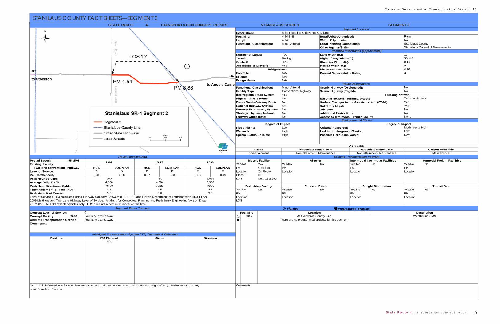
STANILAUS COUNTY FACT SHEETS—SEGMENT 2
4-
4.54-8.884.340Minor Arterial
Two Lane Width (ft.): 12Rolling Right of Way Width (ft.): 50-190<3% Shoulder Width (ft.): 0-11Yes Median Width (ft.): 0
Distressed Lane Miles 4.20N/AN/AN/A
Minor Arterial Scenic Highway (Designated):Conventional highwayYesNoNoNoNoNoNo Access to Intermodal Freight Facility
LowHighHigh
55 MPH Intermodal Commuter FacilitiesYes Yes/No No Yes/No No Yes/No No
HCS LOSPLAN HCS LOSPLAN HCS LOSPLAN PM 4.54-8.88 PM PM PMD D D D E E Location On Route Location Location Location
0.31 0.28 0.37 0.34 0.53 0.49 Class IIINot Assessed
No Yes/No No Yes/No No Yes/No NoPM PM PMLocation Location Location
PlannedConcept Level of Service:
2030 R8.7
Local Planning Jurisdiction: Stanislaus County
Route Designations Functional Classification:
Bridge# Present Serviceability Rating 3
Accessible to Bicycles:Bridge Needs
No
STATE ROUTE STANISLAUS COUNTY SEGMENT 2Segment Location:
Description: Milton Road to Calaveras Co. LinePost Mile: Rural/Urban/Urbanized: Rural
Terrain:Grade %
Other Agency/Entity Stanislaus Council of Governments Roadbed Information (approximate)
Number of Lanes:
Bridge Name:
Postmile
TRANSPORTATION CONCEPT REPORT
Length: Within City Limits: NoFunctional Classification:
Facility Type: NoInterregional Road System:
Terminal AccessTrucking Network
Scenic Highway (Eligible)
National Highway System California Legal: YesFreeway Expressway System Advisory No
Additional Restrictions
High Emphasis Route: National Network, Terminal AccessFocus Route/Gateway Route: Surface Transportation Assistance Act (STAA) Yes
Environmental StatusDegree of Impact Degree of Impact
Flood Plains: Cultural Resources: Moderate to High
Strategic Highway Network NoFreeway Agreement: None
Wetlands: Leaking Underground Tanks: LowSpecial Status Species: Possible Hazardous Waste: Low
Air QualityOzone
Non-attainment Non-attainment/ Maintenance Non-attainment/ Maintenance MaintenanceParticulate Matter 10 m Particulate Matter 2.5 m Carbon Monoxide
Two lane conventional highwayLevel of Service:
Peak Hour Volume: 600 730 1,095 LOS
Yes/No2007 2015 2030
Travel Forecast DataBicycle Facility Airports Intermodal Freight Facilities
Existing Transportation NetworkPosted Speed:Existing Facility:
Programmed Projects
Volume/Capacity:
Average Daily Traffic: 4,600 4,784 6,900
Level of Service (LOS) calculated using Highway Capacity Software (HCS+T7F) and Florida Department of Transportation HIGHPLAN Location
Park and Rides Freight Distribution Transit BusTruck Volume % of Total ADT: 4.5 4.5 4.5 Yes/NoPeak Hour Directional Split: 70/30 70/30 70/30 Pedestrian Facility
Peak Hour % of Trucks: 3.6 3.6 3.6 PM
2009 Multilane and Two-Lane Highway Level of Service. Analysis for Conceptual Planning and Preliminary Engineering Version Data: LOS7/17/2010. All LOS reflects vehicles only. LOS does not reflect multi modal at this time.
Segment Route Concept
Concept Facility:Ultimate Transportation Corridor:
CFour lane expresswayFour lane expressway There are no programmed projects for this segment
Post Mile Location DescriptionAt Calaveras County Line Westbound CMS
Comments:
Intelligent Transportation System (ITS) Elements & DetectionPostmile ITS Element Status Direction
N/A
Comments:Note: This information is for overview purposes only and does not replace a full report from Right of Way, Environmental, or anyother Branch or Division.

C a l t r a n s D e p a r t m e n t o f T r a n s p o r t a t i o n D i s t r i c t 1 0
20 S t a t e R o u t e 4 t r a n s p o r t a t i o n c o n c e p t r e p o r t
CALAVERAS COUNTY SUMMARY
Caltrans produced a CSMP (The State Route 4 Corridor System Management
Plan (2007)), for the portion of SR-4 from the Stanislaus County line in the
west to the Alpine County line in the east. Data provided in that report is sum-
marized and updated in the following segment fact sheets, but the report
should be consulted as the primary document on current conditions and
needs on the corridor. The purposes of CSMPs differ from TCRs as they con-
sider the gains of a specific capital project in enhancing a local transportation
system’s performance and outline means to conserve those improvements,
rather than attempting to assess future needs for an entire corridor. After the
Angels Camp Bypass traffic volumes stabilize, revisions to current and future
forecasts will need to be updated in the next CSMP update and future TCRs.
Twelve segments of SR-4 were analyzed in the CSMP 2007, in the TCR
these were changed to eleven. For TCRs, division of highways into segments
for purposes of system evaluation and analysis follow considerations of
changes in traffic volume or its composition, a change in the number of lanes,
whether the segment was urban or rural, and changes in transportation plan-
ning or land use planning agency in order to develop a level of service per-
formance measure. However, for the CSMP the division into segments fol-
lowed a scheme in that segments broke at major intersections where the
change in traffic volume did not necessarily change by 10% or that the lane
configuration of the highway did not change. This reflects the CSMP’s em-
phasis on identifying parallel routes in part to conserve the project’s reduction
in traffic delay. Both methods deviate from that suggested in HCM (2000, p.
21-13). In future TCRs, it is anticipated that fewer segments will be em-
ployed, as none of the current modeling software make significant distinctions
between two lane conventional highways and two lane expressways as is the
condition for SR-4 east of Angels Camp.
Due to different methods of analysis between the CSMP and that used in this
reports’ fact sheet for the now constructed Angels Camp Bypass, results may
differ. The future CSMP update will address any inconsistencies in the analy-
sis.

21 S t a t e R o u t e 4 t r a n s p o r t a t i o n c o n c e p t r e p o r t
C a l t r a n s D e p a r t m e n t o f T r a n s p o r t a t i o n D i s t r i c t 1 0
CALAVERAS COUNTY FACT SHEETS—SEGMENT 1
4
0.000/R8.1438.143Minor Arterial
Two Lane Width (ft.): See CSMPRolling Right of Way Width (ft.): See CSMP<3% Shoulder Width (ft.): See CSMPYes Median Width (ft.): See CSMP
Distressed Lane Miles See CSMPSee CSMPSee CSMPSee CSMP
Minor Arterial Scenic Highway (Designated):ExpresswayYesNoNoNoNoNoYes Access to Intermodal Freight Facility
100 YearsModerateModerate
55 MPH Intermodal Commuter FacilitiesYes Yes/No No Yes/No No Yes/No No
HCS LOSPLAN HCS LOSPLAN HCS LOSPLAN PM 0.000-R8.413 PM PM PMLevel of Service: D D D D E E Location On Route Location Location Location
0.29 0.28 0.46 0.45 0.93 0.93 Class IIINot Assessed
No Yes/No No Yes/No No Yes/No YesPM PM PM R7.323-R8.413Location Location Location Copperopolis
PlannedConcept Level of Service: C
2030
3.9 3.94.94.9
Level of Service (LOS) calculated using Highway Capacity Software (HCS+T7F) and Florida Department of Transportation HIGHPLAN 2009 Multilane and Two-Lane Highway Level of Service. Analysis for Conceptual Planning and Preliminary Engineering Version Data: 7/17/2010. All LOS reflects vehicles only. LOS does not reflect multi modal at this time.
Truck Volume % of Total ADT: 4.9Peak Hour % of Trucks:
Concept Facility: Four lane expressway
3.9
ITS Element
Posted Speed:
Volume/Capacity:
Existing Facility: Two lane expressway
No
Surface Transportation Assistance Act (STAA) California Legal:
Strategic Highway Network
2006 2015 2030
57/4357/43Average Daily Traffic:Peak Hour Volume:
Peak Hour Directional Split:5,058
1140652 23708,800 18,200
57/43
Length:Functional Classification:
Attainment Unclassified Attainment Unclassified
Park and Rides Freight Distribution
Airports
Attainment Unclassified
Intermodal Freight Facilities
Air Quality
YesNo
Roadbed Information (approximate)
Route Designations
Bridge NeedsAccessible to Bicycles:
Particulate Matter 10 m Particulate Matter 2.5 m Carbon Monoxide
Leaking Underground Tanks:
National Network, Terminal Access
Transit Bus
LocationLOS
Ozone
High Emphasis Route:Yes
Degree of Impact
Advisory
Cultural Resources:
Focus Route/Gateway Route:National Highway System
NoFreeway Expressway System
Degree of ImpactModerate to HighFlood Plains:
Wetlands:Special Status Species:
Yes/NoPM
Grade %
Postmile
Bicycle FacilityYes/No
Pedestrian Facility
LOS
Interregional Road System:
Functional Classification:
Freeway Agreement: Environmental Status
Scenic Highway (Eligible)Facility Type:
See CSMPPresent Serviceability Rating
Additional Restrictions
No
Terminal Access
Bridge#
Trucking Network
STATE ROUTE CALAVERAS COUNTY
Travel Forecast DataNonattainment
SEGMENT 1
Stanislaus Co. Line to O'Byrnes Ferry RoadRural/Urban/Urbanized: Rural
NoCalaveras CountyCalaveras County Council of Governments
Segment Location:Description:Post Mile:
Within City Limits:Local Planning Jurisdiction:Other Agency/Entity
TRANSPORTATION CONCEPT REPORT
No
Bridge Name:
Number of Lanes:Terrain:
Location DescriptionFor planned and programmed projects, consult CSMP
Commentsother Branch or Division.Note: This information is for overview purposes only and does not replace a full report from Right of Way, Environmental, or any
Programmed Projects Segment Route ConceptPost Mile
Ultimate Transportation Corridor: Four lane expresswayComments:
Intelligent Transportation System (ITS) Elements & Detection
LowLow to Moderate Lead, NOAPossible Hazardous Waste:
Existing Transportation Network
Status DirectionConsult CSMP
Postmile
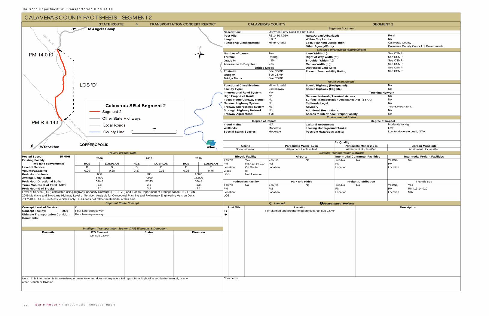
C a l t r a n s D e p a r t m e n t o f T r a n s p o r t a t i o n D i s t r i c t 1 0
22 S t a t e R o u t e 4 t r a n s p o r t a t i o n c o n c e p t r e p o r t
CALAVERAS COUNTY FACT SHEETS—SEGMENT 2 4
R8.143/14.0105.867Minor Arterial
Two Lane Width (ft.): See CSMPRolling Right of Way Width (ft.): See CSMP<3% Shoulder Width (ft.): See CSMPYes Median Width (ft.): See CSMP
Distressed Lane Miles See CSMPSee CSMPSee CSMPSee CSMP
Minor Arterial Scenic Highway (Designated):ExpresswayYesNoNoNoNoNoYes Access to Intermodal Freight Facility
N/AModerateModerate
55 MPH Intermodal Commuter FacilitiesYes Yes/No No Yes/No No Yes/No No
HCS LOSPLAN HCS LOSPLAN HCS LOSPLAN PM R8.413-14.010 PM PM PMD D D D E E Location On Route Location Location Location
0.29 0.28 0.37 0.36 0.75 0.76 Class IIINot Assessed
No Yes/No No Yes/No No Yes/No YesPM PM PM R8.413-14.010Location Location Location N/A
PlannedConcept Level of Service:
2030
Local Planning Jurisdiction: Calaveras County
Route Designations Functional Classification:
Bridge# Present Serviceability Rating See CSMP
Accessible to Bicycles:Bridge Needs
No
STATE ROUTE CALAVERAS COUNTY SEGMENT 2Segment Location:
Description: O'Byrnes Ferry Road to Hunt RoadPost Mile: Rural/Urban/Urbanized: Rural
Terrain:Grade %
Other Agency/Entity Calaveras County Council of GovernmentsRoadbed Information (approximate)
Number of Lanes:
Bridge Name:
Postmile
TRANSPORTATION CONCEPT REPORT
Length: Within City Limits: NoFunctional Classification:
Facility Type: NoInterregional Road System:
NoTrucking Network
Scenic Highway (Eligible)
National Highway System California Legal: NoFreeway Expressway System Advisory Yes--KPRA =30 ft.
Additional Restrictions
High Emphasis Route: National Network, Terminal AccessFocus Route/Gateway Route: Surface Transportation Assistance Act (STAA) No
Environmental StatusDegree of Impact Degree of Impact
Flood Plains: Cultural Resources: Moderate to High
Strategic Highway Network NoFreeway Agreement: No
Wetlands: Leaking Underground Tanks: LowSpecial Status Species: Possible Hazardous Waste: Low to Moderate Lead, NOA
Air QualityOzone
Nonattainment Attainment Unclassified Attainment Unclassified Attainment UnclassifiedParticulate Matter 10 m Particulate Matter 2.5 m Carbon Monoxide
Two lane conventionalLevel of Service:
Peak Hour Volume: 650 900 1,920 LOS
Yes/No2006 2015 2030
Travel Forecast DataBicycle Facility Airports Intermodal Freight Facilities
Existing Transportation NetworkPosted Speed:Existing Facility:
Programmed Projects
Volume/Capacity:
Average Daily Traffic: 5,900 7,500 16,000
Level of Service (LOS) calculated using Highway Capacity Software (HCS+T7F) and Florida Department of Transportation HIGHPLAN Location
Park and Rides Freight Distribution Transit BusTruck Volume % of Total ADT: 3.8 3.8 3.8 Yes/NoPeak Hour Directional Split: 57/43 57/43 57/43 Pedestrian Facility
Peak Hour % of Trucks: 3.1 3.1 3.1 PM
2009 Multilane and Two-Lane Highway Level of Service. Analysis for Conceptual Planning and Preliminary Engineering Version Data: LOS7/17/2010. All LOS reflects vehicles only. LOS does not reflect multi modal at this time.
Segment Route Concept
Concept Facility:Ultimate Transportation Corridor:
CFour lane expresswayFour lane expressway
Post Mile Location DescriptionFor planned and programmed projects, consult CSMP
Comments:
Intelligent Transportation System (ITS) Elements & DetectionPostmile ITS Element Status Direction
Consult CSMP
Comments:Note: This information is for overview purposes only and does not replace a full report from Right of Way, Environmental, or anyother Branch or Division.

23 S t a t e R o u t e 4 t r a n s p o r t a t i o n c o n c e p t r e p o r t
C a l t r a n s D e p a r t m e n t o f T r a n s p o r t a t i o n D i s t r i c t 1 0
CALAVERAS COUNTY FACT SHEETS—SEGMENT 3
4
14.010/19.0004.99Minor Arterial
Two Lane Width (ft.): See CSMPMountainous Right of Way Width (ft.): See CSMP>3% Shoulder Width (ft.): See CSMPYes Median Width (ft.): See CSMP
Distressed Lane Miles See CSMPSee CSMPSee CSMPSee CSMP
Minor Arterial Scenic Highway (Designated):ConventionalYesNoNoNoNoNoYes Access to Intermodal Freight Facility
N/AModerate to HighModerate to High
40 MPH Intermodal Commuter FacilitiesYes Yes/No No Yes/No No Yes/No No
HCS LOSPLAN HCS LOSPLAN HCS LOSPLAN PM 14.010-19.000 PM PM PMD D D D E E Location On Route Location Location Location
0.29 0.28 0.36 0.34 0.66 0.58 Class IIINot Assessed
No Yes/No No Yes/No No Yes/No YesPM PM PM 14.010-19.000Location Location Location N/A
PlannedC
2030 Four lane expressway Four lane expressway
Strategic Highway Network NoFreeway Agreement: No
Present Serviceability Rating
National Highway System California Legal: NoFreeway Expressway System Advisory Yes--KPRA=30 ft.
Additional Restrictions
High Emphasis Route: National Network, Terminal AccessFocus Route/Gateway Route: Surface Transportation Assistance Act (STAA) No
Route Designations Functional Classification: NoFacility Type: NoInterregional Road System:
No
TRANSPORTATION CONCEPT REPORT
Length: Within City Limits: NoFunctional Classification: Local Planning Jurisdiction: Calaveras County
See CSMP
Accessible to Bicycles:Bridge Needs
STATE ROUTE CALAVERAS COUNTY SEGMENT 3Segment Location:
Description: Hunt Road to Stockton Road (West)Post Mile: Rural/Urban/Urbanized: Rural
Terrain:Grade %
Scenic Highway (Eligible)Trucking Network
Other Agency/Entity Calaveras County Council of GovernmentsRoadbed Information (approximate)
Number of Lanes:
Bridge Name:
PostmileBridge#
Wetlands: Leaking Underground Tanks: LowSpecial Status Species: Possible Hazardous Waste: Low to Moderate Lead, NOA
Environmental StatusDegree of Impact Degree of Impact
Flood Plains: Cultural Resources: Moderate
Air QualityOzone
Nonattainment Attainment Unclassified Attainment Unclassified Attainment UnclassifiedParticulate Matter 10 m Particulate Matter 2.5 m Carbon Monoxide
Level of Service:
Peak Hour Volume: 650 862 1,698 LOS
Travel Forecast DataBicycle Facility Airports Intermodal Freight Facilities
Existing Transportation Network
Yes/NoPosted Speed:
Volume/Capacity:
Existing Facility: Two lane conventional
2006 2015 2030
Transit BusTruck Volume % of Total ADT: 3.8 3.8 3.8 Yes/NoPeak Hour Directional Split: 57/43 57/43 57/43 Pedestrian Facility
Post Mile Location DescriptionFor planned and programmed projects, consult CSMP
Peak Hour % of Trucks: 3.1 3.1 3.1 PM
2009 Multilane and Two-Lane Highway Level of Service. Analysis for Conceptual Planning and Preliminary Engineering Version Data: LOS7/17/2010. All LOS reflects vehicles only. LOS does not reflect multi modal at this time.
Segment Route Concept Programmed Projects
Location
Concept Facility:
Postmile
Comments:Note: This information is for overview purposes only and does not replace a full report from Right of Way, Environmental, or anyother Branch or Division.
Average Daily Traffic: 5,900 7,212 14,168
Level of Service (LOS) calculated using Highway Capacity Software (HCS+T7F) and Florida Department of Transportation HIGHPLAN
Park and Rides Freight Distribution
Concept Level of Service:
Ultimate Transportation Corridor:Comments:
Intelligent Transportation System (ITS) Elements & DetectionITS Element Status Direction
Consult CSMP
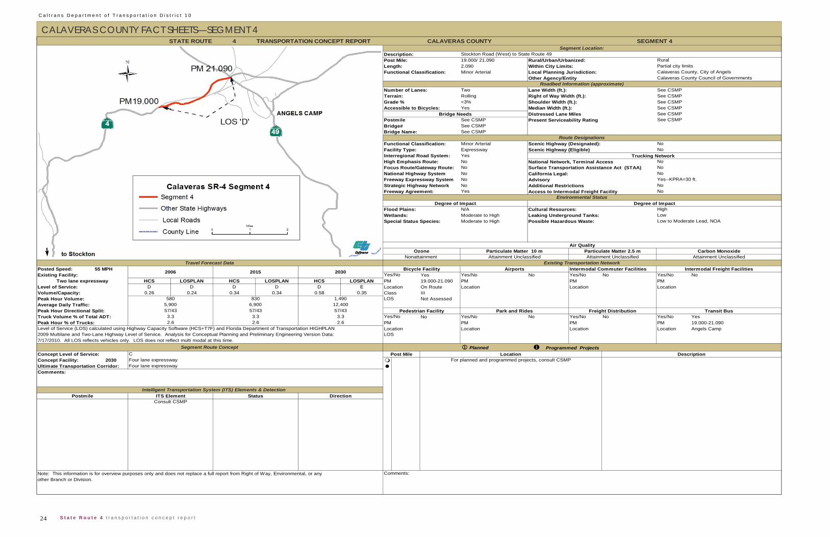
C a l t r a n s D e p a r t m e n t o f T r a n s p o r t a t i o n D i s t r i c t 1 0
24 S t a t e R o u t e 4 t r a n s p o r t a t i o n c o n c e p t r e p o r t
CALAVERAS COUNTY FACT SHEETS—SEGMENT 4 4
19.000/ 21.0902.090Minor Arterial
Two Lane Width (ft.): See CSMPRolling Right of Way Width (ft.): See CSMP<3% Shoulder Width (ft.): See CSMPYes Median Width (ft.): See CSMP
Distressed Lane Miles See CSMPSee CSMPSee CSMPSee CSMP
Minor Arterial Scenic Highway (Designated):Expressway Scenic Highway (Eligible)YesNoNoNoNoNoYes Access to Intermodal Freight Facility
N/AModerate to HighModerate to High
55 MPH Intermodal Commuter FacilitiesYes Yes/No No Yes/No No Yes/No No
HCS LOSPLAN HCS LOSPLAN HCS LOSPLAN PM 19.000-21.090 PM PM PMD D D D D E Location On Route Location Location Location
0.26 0.24 0.34 0.34 0.58 0.35 Class IIINot Assessed
No Yes/No No Yes/No No Yes/No YesPM PM PM 19.000-21.090Location Location Location Angels Camp
Planned
2030
STATE ROUTE CALAVERAS COUNTY SEGMENT 4Segment Location:
Description: Stockton Road (West) to State Route 49Post Mile: Rural/Urban/Urbanized: Rural
Terrain:
Other Agency/Entity Calaveras County Council of GovernmentsRoadbed Information (approximate)
Number of Lanes:
Bridge Name:
Environmental StatusDegree of Impact Degree of Impact
Flood Plains: Cultural Resources:
TRANSPORTATION CONCEPT REPORT
Length: Within City Limits: Partial city limitsFunctional Classification: Local Planning Jurisdiction: Calaveras County, City of Angels
No
Bridge# See CSMP
Facility Type: NoInterregional Road System:
Postmile
Accessible to Bicycles:Bridge Needs
Trucking Network
Grade %
Strategic Highway Network NoFreeway Agreement: No
Present Serviceability Rating
National Highway System California Legal: NoFreeway Expressway System Advisory Yes--KPRA=30 ft.
Additional Restrictions
High Emphasis Route: National Network, Terminal AccessFocus Route/Gateway Route: Surface Transportation Assistance Act (STAA) No
Route DesignationsFunctional Classification: No
High
Air QualityOzone
Nonattainment Attainment Unclassified Attainment Unclassified Attainment UnclassifiedParticulate Matter 10 m Particulate Matter 2.5 m Carbon Monoxide
Wetlands: Leaking Underground Tanks: LowSpecial Status Species: Possible Hazardous Waste: Low to Moderate Lead, NOA
Level of Service:
Peak Hour Volume: 580 830 1,490 LOS
Travel Forecast DataBicycle Facility Airports Intermodal Freight Facilities
Existing Transportation Network
Yes/NoPosted Speed:Existing Facility:
Two lane expressway
2006 2015 2030
12,400
Level of Service (LOS) calculated using Highway Capacity Software (HCS+T7F) and Florida Department of Transportation HIGHPLAN Location
Park and Rides Freight Distribution Transit BusTruck Volume % of Total ADT: 3.3 3.3 3.3 Yes/NoPeak Hour Directional Split: 57/43 57/43 57/43 Pedestrian Facility
Peak Hour % of Trucks:
Concept Level of Service:Concept Facility:Ultimate Transportation Corridor:
CFour lane expresswayFour lane expressway
Programmed Projects
Volume/Capacity:
2.6 2.6 2.6 PM
2009 Multilane and Two-Lane Highway Level of Service. Analysis for Conceptual Planning and Preliminary Engineering Version Data: LOS7/17/2010. All LOS reflects vehicles only. LOS does not reflect multi modal at this time.
Segment Route Concept
Average Daily Traffic: 5,900 6,900
Post Mile Location DescriptionFor planned and programmed projects, consult CSMP
Comments:
Postmile Intelligent Transportation System (ITS) Elements & Detection
ITS Element Status DirectionConsult CSMP
Note: This information is for overview purposes only and does not replace a full report from Right of Way, Environmental, or any Comments:other Branch or Division.
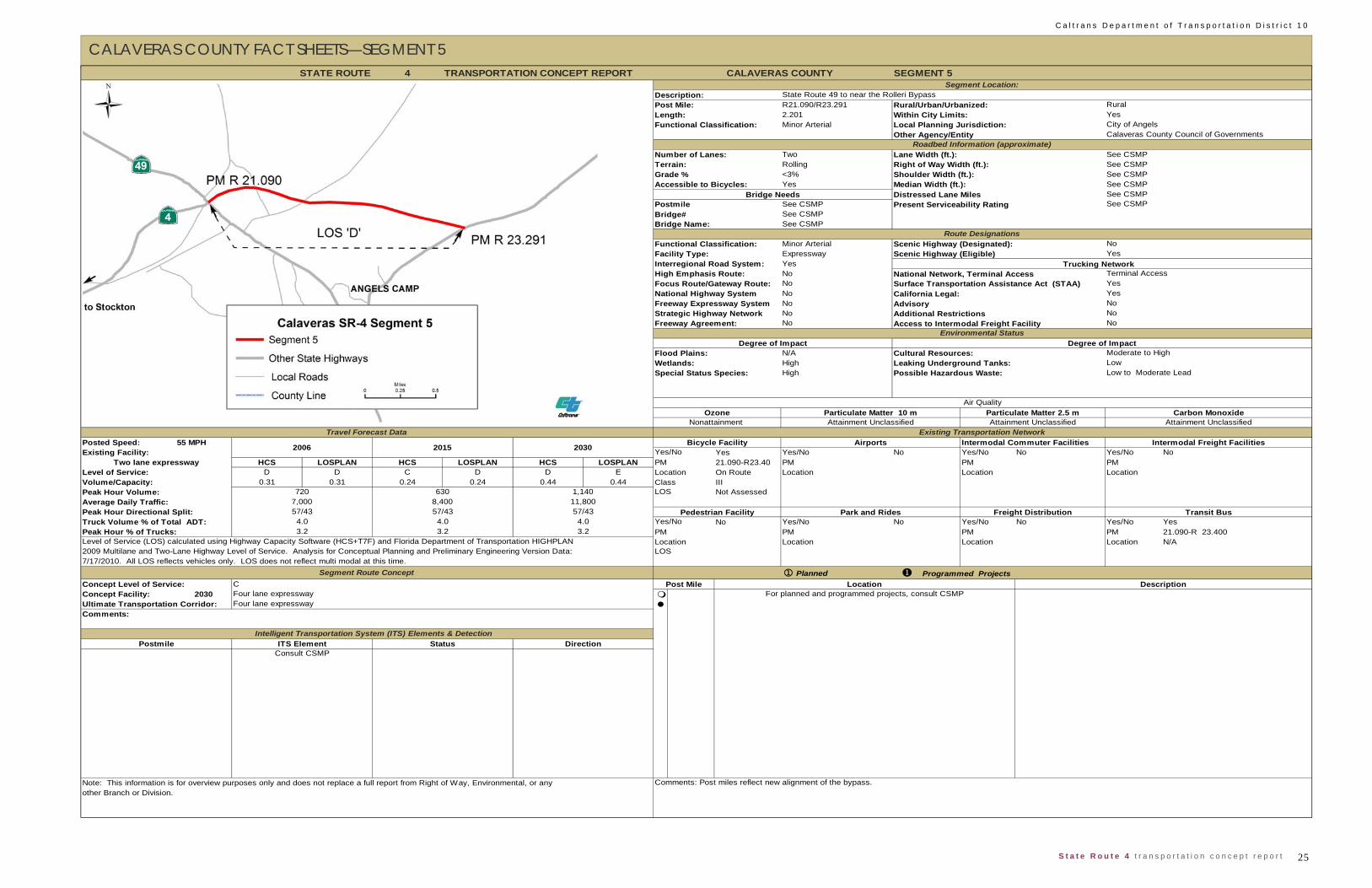
25 S t a t e R o u t e 4 t r a n s p o r t a t i o n c o n c e p t r e p o r t
C a l t r a n s D e p a r t m e n t o f T r a n s p o r t a t i o n D i s t r i c t 1 0
CALAVERAS COUNTY FACT SHEETS—SEGMENT 5
4 SEGMENT 5
R21.090/R23.2912.201
Functional Classification: Minor Arterial Local Planning Jurisdiction:
Number of Lanes: Two Lane Width (ft.): See CSMPRolling Right of Way Width (ft.): See CSMP<3% Shoulder Width (ft.): See CSMPYes Median Width (ft.): See CSMP
Distressed Lane Miles See CSMPSee CSMP
Bridge# See CSMPSee CSMP
Functional Classification: Minor Arterial Scenic Highway (Designated):Expressway
Interregional Road System: YesHigh Emphasis Route: No National Network, Terminal AccessFocus Route/Gateway Route: NoNational Highway System NoFreeway Expressway System NoStrategic Highway Network NoFreeway Agreement: No Access to Intermodal Freight Facility
N/AHighHigh
55 MPH Intermodal Commuter FacilitiesYes Yes/No No Yes/No No Yes/No No
HCS LOSPLAN HCS LOSPLAN HCS LOSPLAN 21.090-R23.40 PM PM PMD D C D D E Location On Route Location Location Location
0.31 0.31 0.24 0.24 0.44 0.44 Class IIINot Assessed
No Yes/No No Yes/No No Yes/No YesPM PM PM 21.090-R 23.400Location Location Location N/A
PlannedConcept Level of Service: C
2030
STATE ROUTE CALAVERAS COUNTY
Description: State Route 49 to near the Rolleri BypassPost Mile: Rural/Urban/Urbanized: Rural
Other Agency/Entity Calaveras County Council of GovernmentsRoadbed Information (approximate)
Bridge Name:
Length: Within City Limits: YesCity of Angels
Accessible to Bicycles:
Terrain:Grade %
NoFacility Type: Yes
Bridge Needs
Terminal Access
Postmile Present Serviceability Rating See CSMP
Scenic Highway (Eligible)Trucking Network
California Legal: YesAdvisory No
Surface Transportation Assistance Act (STAA) Yes
Environmental StatusDegree of Impact Degree of Impact
Flood Plains: Cultural Resources: Moderate to High
NoNo
Additional Restrictions
Wetlands: Leaking Underground Tanks: LowSpecial Status Species: Possible Hazardous Waste: Low to Moderate Lead
Travel Forecast DataBicycle Facility Airports Intermodal Freight Facilities
Air QualityOzone
Nonattainment Attainment Unclassified Attainment Unclassified Attainment UnclassifiedExisting Transportation Network
Particulate Matter 10 m Particulate Matter 2.5 m Carbon Monoxide
Posted Speed:
Volume/Capacity:
Average Daily Traffic: 7,000 8,400 11,800
Yes/No
Level of Service:PMTwo lane expressway
2006 2015 2030Existing Facility:
Park and Rides Freight Distribution Transit BusTruck Volume % of Total ADT: 4.0 4.0 4.0 Yes/No
Peak Hour Volume: 720 630 1,140 LOS
Peak Hour Directional Split: 57/43 57/43 57/43 Pedestrian Facility
2009 Multilane and Two-Lane Highway Level of Service. Analysis for Conceptual Planning and Preliminary Engineering Version Data: LOS7/17/2010. All LOS reflects vehicles only. LOS does not reflect multi modal at this time.
Segment Route Concept
Peak Hour % of Trucks: 3.2 3.2 3.2 PMLevel of Service (LOS) calculated using Highway Capacity Software (HCS+T7F) and Florida Department of Transportation HIGHPLAN Location
Post Mile Location DescriptionFor planned and programmed projects, consult CSMPConcept Facility: Four lane expressway
Ultimate Transportation Corridor: Four lane expressway
Programmed Projects
Consult CSMP
Note: This information is for overview purposes only and does not replace a full report from Right of Way, Environmental, or any Comments: Post miles reflect new alignment of the bypass.other Branch or Division.
Segment Location:
Route Designations
TRANSPORTATION CONCEPT REPORT
Comments:
Intelligent Transportation System (ITS) Elements & DetectionPostmile ITS Element Status Direction

C a l t r a n s D e p a r t m e n t o f T r a n s p o r t a t i o n D i s t r i c t 1 0
26 S t a t e R o u t e 4 t r a n s p o r t a t i o n c o n c e p t r e p o r t
CALAVERAS COUNTY FACT SHEETS—SEGMENT 6 4
22.788/29.2406.452Minor Arterial
Two Lane Width (ft.): See CSMPFlat Right of Way Width (ft.): See CSMP<3% Shoulder Width (ft.): See CSMPYes Median Width (ft.): See CSMP
Distressed Lane Miles See CSMPSee CSMPSee CSMPSee CSMP
Minor Arterial Scenic Highway (Designated):ConventionalYesNoNoNoNoNoNo Access to Intermodal Freight Facility
N/AModerate to HighModerate to High
55 MPH Intermodal Commuter FacilitiesYes Yes/No No Yes/No No Yes/No No
HCS LOSPLAN HCS LOSPLAN HCS LOSPLAN PM 22.516-29.240 PM PM PMD D E D E E Location On Route Location Location Location
0.30 0.30 0.35 0.35 0.56 0.60 Class IIINot Assessed
No Yes/No No Yes/No No Yes/No YesPM PM PM 22.790-29.240Location Location Location N/A
PlannedConcept Level of Service: C
2030
STATE ROUTE CALAVERAS COUNTY SEGMENT 6Segment Location:
Description: Rolleri Bypass to Pennsylvania GulchPost Mile: Rural/Urban/Urbanized: Rural
Other Agency/Entity Calaveras County Council of GovernmentsRoadbed Information (approximate)
Number of Lanes:
Bridge Name:
Length: Within City Limits: NoFunctional Classification: Local Planning Jurisdiction: Calaveras County
Accessible to Bicycles:Bridge Needs
Terrain:Grade %
Route DesignationsFunctional Classification: NoFacility Type: YesInterregional Road System:
Terminal Access
PostmileBridge#
Present Serviceability Rating See CSMP
Trucking Network Scenic Highway (Eligible)
National Highway System California Legal: YesFreeway Expressway System Advisory No
High Emphasis Route: National Network, Terminal AccessFocus Route/Gateway Route: Surface Transportation Assistance Act (STAA) Yes
Environmental StatusDegree of Impact Degree of Impact
Flood Plains: Cultural Resources: High
Strategic Highway Network NoFreeway Agreement: No
Additional Restrictions
Wetlands: Leaking Underground Tanks: Low to ModerateSpecial Status Species: Possible Hazardous Waste: Low to Moderate Lead
Travel Forecast DataBicycle Facility Airports Intermodal Freight Facilities
Air QualityOzone
Nonattainment Attainment Unclassified Attainment Unclassified Attainment UnclassifiedExisting Transportation Network
Particulate Matter 10 m
Posted Speed:
Particulate Matter 2.5 m Carbon Monoxide
Volume/Capacity:
Average Daily Traffic: 6,050 7,865 13,310
Yes/No
Level of Service:Two lane conventional
2006 2015 2030Existing Facility:
Transit BusTruck Volume % of Total ADT: 8.5 8.5 8.5 Yes/No
Peak Hour Volume: 675 875 1,485 LOS
Peak Hour Directional Split: 57/43 57/43 57/43 Pedestrian Facility
Peak Hour % of Trucks: 6.8 6.8 6.8 PMLevel of Service (LOS) calculated using Highway Capacity Software (HCS+T7F) and Florida Department of Transportation HIGHPLAN Location
Park and Rides Freight Distribution
Post Mile Location DescriptionFor planned and programmed projects, consult CSMP
2009 Multilane and Two-Lane Highway Level of Service. Analysis for Conceptual Planning and Preliminary Engineering Version Data: LOS7/17/2010. All LOS reflects vehicles only. LOS does not reflect multi modal at this time.
Segment Route Concept Programmed Projects
Concept Facility: Four lane expresswayUltimate Transportation Corridor: Four lane expresswayComments:
Postmile Intelligent Transportation System (ITS) Elements & Detection
ITS Element Status DirectionConsult CSMP
TRANSPORTATION CONCEPT REPORT
Note: This information is for overview purposes only and does not replace a full report from Right of Way, Environmental, or any Comments: Post miles reflect resumption of old alignment past intersection with bypass.other Branch or Division.
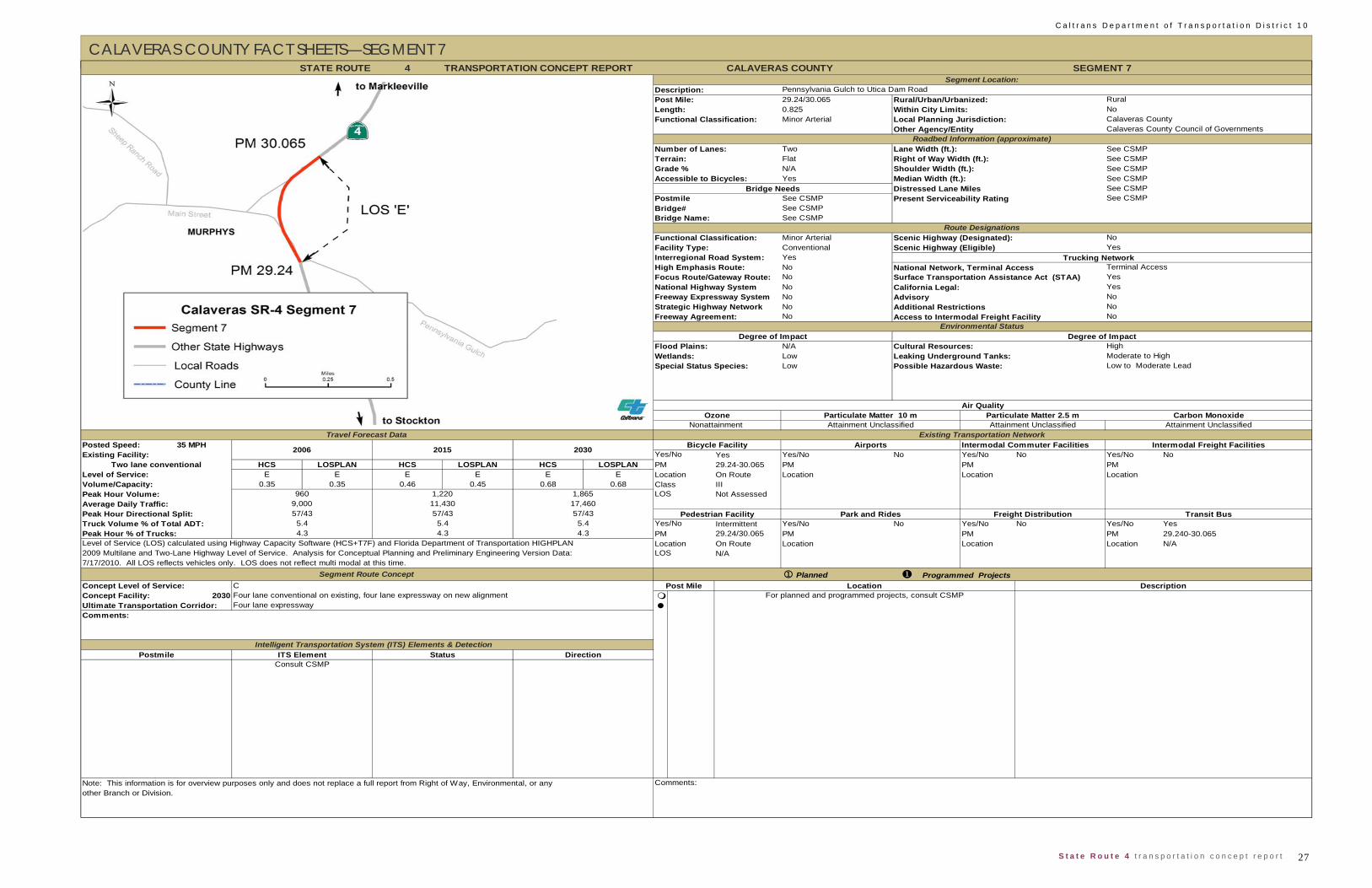
27 S t a t e R o u t e 4 t r a n s p o r t a t i o n c o n c e p t r e p o r t
C a l t r a n s D e p a r t m e n t o f T r a n s p o r t a t i o n D i s t r i c t 1 0
CALAVERAS COUNTY FACT SHEETS—SEGMENT 7
4
29.24/30.0650.825Minor Arterial
Two Lane Width (ft.): See CSMPFlat Right of Way Width (ft.): See CSMPN/A Shoulder Width (ft.): See CSMPYes Median Width (ft.): See CSMP
Distressed Lane Miles See CSMPSee CSMPSee CSMPSee CSMP
Minor Arterial Scenic Highway (Designated):ConventionalYesNoNoNoNoNoNo Access to Intermodal Freight Facility
N/ALowLow
35 MPH Intermodal Commuter FacilitiesYes Yes/No No Yes/No No Yes/No No
HCS LOSPLAN HCS LOSPLAN HCS LOSPLAN PM 29.24-30.065 PM PM PME E E E E E Location On Route Location Location Location
0.35 0.35 0.46 0.45 0.68 0.68 Class IIINot Assessed
Intermittent Yes/No No Yes/No No Yes/No Yes29.24/30.065 PM PM PM 29.240-30.065On Route Location Location Location N/AN/A
PlannedConcept Level of Service: C
2030
STATE ROUTE CALAVERAS COUNTY SEGMENT 7Segment Location:
Description: Pennsylvania Gulch to Utica Dam RoadPost Mile: Rural/Urban/Urbanized: Rural
Other Agency/Entity Calaveras County Council of GovernmentsRoadbed Information (approximate)
Number of Lanes:
Bridge Name:
Length: Within City Limits: NoFunctional Classification: Local Planning Jurisdiction: Calaveras County
Accessible to Bicycles:Bridge Needs
Terrain:Grade %
Route DesignationsFunctional Classification: NoFacility Type: YesInterregional Road System:
Terminal Access
PostmileBridge#
Present Serviceability Rating See CSMP
Scenic Highway (Eligible)Trucking Network
National Highway System California Legal: YesFreeway Expressway System Advisory No
High Emphasis Route: National Network, Terminal AccessFocus Route/Gateway Route: Surface Transportation Assistance Act (STAA) Yes
Environmental StatusDegree of Impact Degree of Impact
Flood Plains: Cultural Resources: High
Strategic Highway Network NoFreeway Agreement: No
Additional Restrictions
Wetlands: Leaking Underground Tanks: Moderate to HighSpecial Status Species: Possible Hazardous Waste: Low to Moderate Lead
Travel Forecast DataBicycle Facility Airports Intermodal Freight Facilities
Air QualityOzone
Nonattainment Attainment Unclassified Attainment Unclassified Attainment UnclassifiedExisting Transportation Network
Particulate Matter 10 m Particulate Matter 2.5 m Carbon Monoxide
Posted Speed:
Volume/Capacity:
Average Daily Traffic: 9,000 11,430 17,460
Yes/No
Level of Service:
Peak Hour Volume: 960 1,220 1,865 LOS
Two lane conventional
2006 2015 2030Existing Facility:
Level of Service (LOS) calculated using Highway Capacity Software (HCS+T7F) and Florida Department of Transportation HIGHPLAN Location
Park and Rides Freight Distribution Transit BusTruck Volume % of Total ADT: 5.4 5.4 5.4 Yes/NoPeak Hour Directional Split: 57/43 57/43 57/43 Pedestrian Facility
Peak Hour % of Trucks: 4.3 4.3 4.3 PM
Programmed ProjectsPost Mile Location Description
For planned and programmed projects, consult CSMP
2009 Multilane and Two-Lane Highway Level of Service. Analysis for Conceptual Planning and Preliminary Engineering Version Data: LOS7/17/2010. All LOS reflects vehicles only. LOS does not reflect multi modal at this time.
Segment Route Concept
Concept Facility: Four lane conventional on existing, four lane expressway on new alignmentUltimate Transportation Corridor: Four lane expresswayComments:
Postmile Intelligent Transportation System (ITS) Elements & Detection
ITS Element Status DirectionConsult CSMP
TRANSPORTATION CONCEPT REPORT
Note: This information is for overview purposes only and does not replace a full report from Right of Way, Environmental, or any Comments:other Branch or Division.

C a l t r a n s D e p a r t m e n t o f T r a n s p o r t a t i o n D i s t r i c t 1 0
28 S t a t e R o u t e 4 t r a n s p o r t a t i o n c o n c e p t r e p o r t
CALAVERAS COUNTY FACT SHEETS—SEGMENT 8 4
30.065/39.799.725Minor Arterial
Two Lane Width (ft.): See CSMPMountainous Right of Way Width (ft.): See CSMP>3% Shoulder Width (ft.): See CSMPYes Median Width (ft.): See CSMP
Distressed Lane Miles See CSMPSee CSMPSee CSMPSee CSMP
Minor Arterial Scenic Highway (Designated):ConventionalYesNoNoNoNoNoNo Access to Intermodal Freight Facility
N/AHighHigh
55 MPH Intermodal Commuter FacilitiesYes Yes/No No Yes/No No Yes/No No
HCS LOSPLAN HCS LOSPLAN HCS LOSPLAN 30.065-39.79 PM PM PMD D E E E E Location On Route Location Location Location
0.41 0.39 0.50 0.49 0.75 0.75 Class IIINot Assessed
No Yes/No No Yes/No No Yes/No YesPM PM PM 30.065-39.790Location Location Location N/A
PlannedConcept Level of Service: C
2030
TRANSPORTATION CONCEPT REPORT
Programmed ProjectsPost Mile Location Description
For planned and programmed projects, consult CSMPConcept Facility: Four lane expresswayUltimate Transportation Corridor: Four lane expressway
2009 Multilane and Two-Lane Highway Level of Service. Analysis for Conceptual Planning and Preliminary Engineering Version Data:
Existing Transportation Network
Note: This information is for overview purposes only and does not replace a full report from Right of Way, Environmental, or any Comments:other Branch or Division.
Postmile Intelligent Transportation System (ITS) Elements & Detection
ITS Element Status DirectionConsult CSMP
Comments:
LOS7/17/2010. All LOS reflects vehicles only. LOS does not reflect multi modal at this time.
Segment Route Concept
Peak Hour % of Trucks: 4.3 4.3 4.3 PMLevel of Service (LOS) calculated using Highway Capacity Software (HCS+T7F) and Florida Department of Transportation HIGHPLAN Location
Park and Rides Freight Distribution Transit BusTruck Volume % of Total ADT: 5.3 5.3 5.3 Yes/No
Peak Hour Volume: 990 1,250 1,910 LOS
Peak Hour Directional Split: 57/43 57/43 57/43 Pedestrian Facility
Volume/Capacity:
Average Daily Traffic: 9,500 11,970 18,335
Yes/No
Level of Service:PMTwo lane conventional
2006 2015 2030Existing Facility:
Travel Forecast DataBicycle Facility Airports Intermodal Freight Facilities
Nonattainment Attainment Unclassified Attainment Unclassified Attainment Unclassified
Posted Speed:
Air QualityOzone Particulate Matter 10 m Particulate Matter 2.5 m Carbon Monoxide
Wetlands: Leaking Underground Tanks: Moderate to HighSpecial Status Species: Possible Hazardous Waste: Low to Moderate Lead
Environmental StatusDegree of Impact Degree of Impact
Flood Plains: Cultural Resources: High
Strategic Highway Network NoFreeway Agreement: No
National Highway System California Legal: YesFreeway Expressway System Advisory No
Additional Restrictions
High Emphasis Route: National Network, Terminal Access
Length: Within City Limits: NoFunctional Classification: Local Planning Jurisdiction: Calaveras County
Focus Route/Gateway Route: Surface Transportation Assistance Act (STAA) Yes
Route DesignationsFunctional Classification: NoFacility Type: YesInterregional Road System:
Terminal AccessTrucking Network
Scenic Highway (Eligible)
STATE ROUTE CALAVERAS COUNTY SEGMENT 8Segment Location:
Description: Utica Dam Road to Lakemont DrivePost Mile: Rural/Urban/Urbanized: Rural
Terrain:Grade %
Other Agency/Entity Calaveras County Council of GovernmentsRoadbed Information (approximate)
Number of Lanes:
Bridge Name:
PostmileBridge#
Present Serviceability Rating See CSMP
Accessible to Bicycles:Bridge Needs
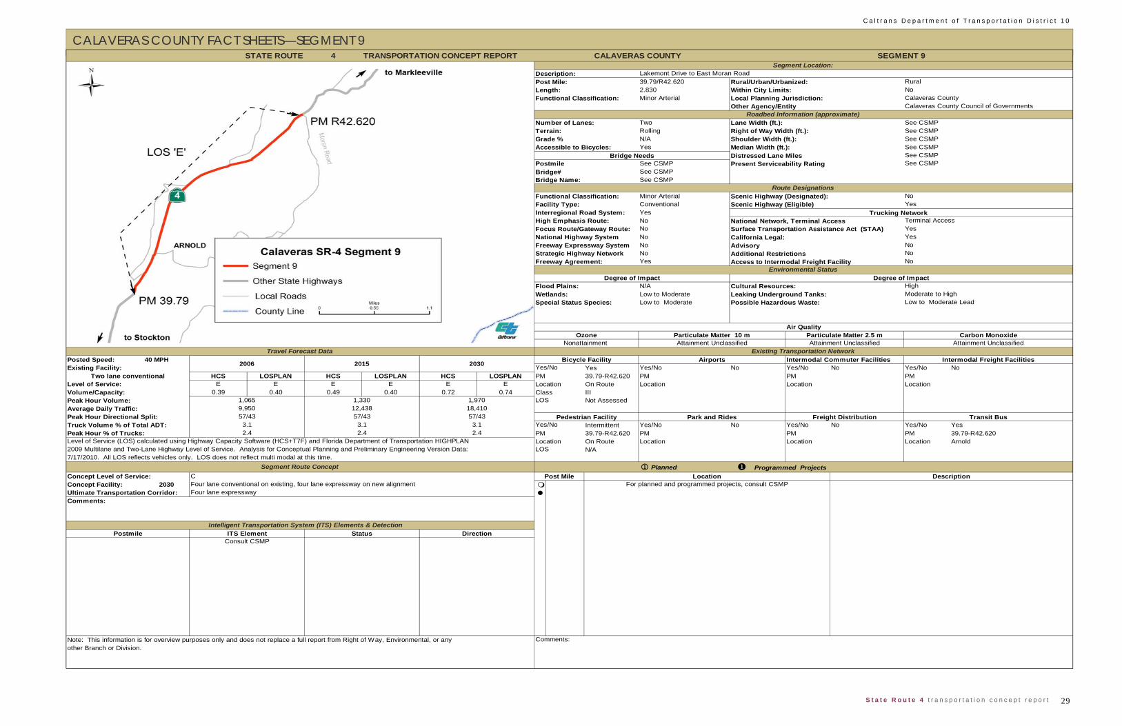
29 S t a t e R o u t e 4 t r a n s p o r t a t i o n c o n c e p t r e p o r t
C a l t r a n s D e p a r t m e n t o f T r a n s p o r t a t i o n D i s t r i c t 1 0
CALAVERAS COUNTY FACT SHEETS—SEGMENT 9
4
39.79/R42.6202.830Minor Arterial
Two Lane Width (ft.): See CSMPRolling Right of Way Width (ft.): See CSMPN/A Shoulder Width (ft.): See CSMPYes Median Width (ft.): See CSMP
Distressed Lane Miles See CSMPSee CSMPSee CSMPSee CSMP
Minor Arterial Scenic Highway (Designated):Conventional Scenic Highway (Eligible)YesNoNoNoNoNoYes Access to Intermodal Freight Facility
N/ALow to ModerateLow to Moderate
40 MPH Intermodal Commuter FacilitiesYes Yes/No No Yes/No No Yes/No No
HCS LOSPLAN HCS LOSPLAN HCS LOSPLAN PM 39.79-R42.620 PM PM PME E E E E E Location On Route Location Location Location
0.39 0.40 0.49 0.40 0.72 0.74 Class IIINot Assessed
Intermittent Yes/No No Yes/No No Yes/No Yes39.79-R42.620 PM PM PM 39.79-R42.620On Route Location Location Location ArnoldN/A
PlannedConcept Level of Service: C
2030
Programmed Projects
Length: Within City Limits: NoFunctional Classification: Local Planning Jurisdiction: Calaveras County
Bridge# Present Serviceability Rating See CSMP
Accessible to Bicycles:Bridge Needs
Route DesignationsFunctional Classification: NoFacility Type: YesInterregional Road System:
Terminal AccessTrucking Network
Strategic Highway Network
STATE ROUTE CALAVERAS COUNTY SEGMENT 9Segment Location:
Description: Lakemont Drive to East Moran RoadPost Mile: Rural/Urban/Urbanized: Rural
Terrain:Grade %
Other Agency/Entity Calaveras County Council of GovernmentsRoadbed Information (approximate)
Number of Lanes:
Bridge Name:
Postmile
High Emphasis Route: National Network, Terminal AccessFocus Route/Gateway Route: Surface Transportation Assistance Act (STAA) Yes
NoFreeway Agreement: No
National Highway System California Legal: YesFreeway Expressway System Advisory No
Additional Restrictions
Wetlands: Leaking Underground Tanks: Moderate to HighSpecial Status Species: Possible Hazardous Waste: Low to Moderate Lead
Environmental StatusDegree of Impact Degree of Impact
Flood Plains: Cultural Resources: High
Air QualityOzone
Nonattainment Attainment Unclassified Attainment Unclassified Attainment Unclassified
Posted Speed:
Particulate Matter 10 m
Travel Forecast DataBicycle Facility Airports Intermodal Freight Facilities
Particulate Matter 2.5 m Carbon Monoxide
Volume/Capacity:
Average Daily Traffic: 9,950 12,438 18,410
Yes/No
Level of Service:
Existing Facility: Two lane conventional
2006 2015 2030
Transit BusTruck Volume % of Total ADT: 3.1 3.1 3.1 Yes/No
Peak Hour Volume: 1,065 1,330 1,970 LOS
Peak Hour Directional Split: 57/43 57/43 57/43 Pedestrian Facility
Peak Hour % of Trucks: 2.4 2.4 2.4 PMLevel of Service (LOS) calculated using Highway Capacity Software (HCS+T7F) and Florida Department of Transportation HIGHPLAN Location
Park and Rides Freight Distribution
Concept Facility: Four lane conventional on existing, four lane expressway on new alignmentUltimate Transportation Corridor: Four lane expressway
2009 Multilane and Two-Lane Highway Level of Service. Analysis for Conceptual Planning and Preliminary Engineering Version Data: LOS7/17/2010. All LOS reflects vehicles only. LOS does not reflect multi modal at this time.
Segment Route ConceptPost Mile Location Description
For planned and programmed projects, consult CSMP
Comments:
Postmile Intelligent Transportation System (ITS) Elements & Detection
ITS Element Status DirectionConsult CSMP
TRANSPORTATION CONCEPT REPORT
Existing Transportation Network
Note: This information is for overview purposes only and does not replace a full report from Right of Way, Environmental, or any Comments:other Branch or Division.
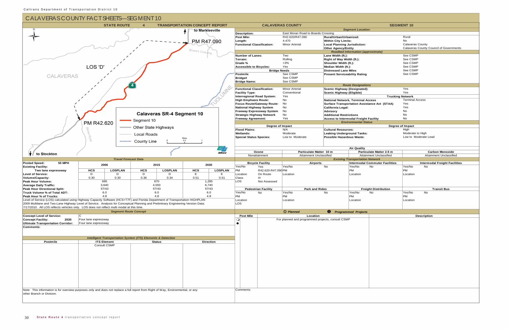
C a l t r a n s D e p a r t m e n t o f T r a n s p o r t a t i o n D i s t r i c t 1 0
30 S t a t e R o u t e 4 t r a n s p o r t a t i o n c o n c e p t r e p o r t
CALAVERAS COUNTY FACT SHEETS—SEGMENT 10 4
R42.620/R47.0904.470Minor Arterial
Two Lane Width (ft.): See CSMPRolling Right of Way Width (ft.): See CSMP<3% Shoulder Width (ft.): See CSMPYes Median Width (ft.): See CSMP
Distressed Lane Miles See CSMPSee CSMPSee CSMPSee CSMP
Minor Arterial Scenic Highway (Designated):Conventional Scenic Highway (Eligible)YesNoNoNoNoNoYes Access to Intermodal Freight Facility
N/AModerateLow to Moderate
55 MPH Intermodal Commuter FacilitiesYes Yes/No No Yes/No No Yes/No No
HCS LOSPLAN HCS LOSPLAN HCS LOSPLAN PM R42.620-R47.090 PM PM PMD D D D E E Location On Route Location Location Location
0.30 0.30 0.36 0.34 0.51 0.51 Class IIINot Assessed
No Yes/No No Yes/No No Yes/No NoPM PM PMLocation Location Location
Planned
2030
Comments:Note: This information is for overview purposes only and does not replace a full report from Right of Way, Environmental, or anyother Branch or Division.
Segment Route Concept
Peak Hour % of Trucks: 4.8 4.8
Intelligent Transportation System (ITS) Elements & DetectionPostmile
Concept Facility: Four lane expresswayUltimate Transportation Corridor:
TRANSPORTATION CONCEPT REPORT
Programmed Projects
ITS Element Status DirectionConsult CSMP
Park and Rides Freight Distribution
Four lane expresswayComments:
For planned and programmed projects, consult CSMP
Transit BusTruck Volume % of Total ADT: 6.0 6.0 6.0 Yes/No
Concept Level of Service: C Post Mile Location Description
Peak Hour Directional Split: 57/43 57/43 57/43 Pedestrian Facility
4.8 PMLevel of Service (LOS) calculated using Highway Capacity Software (HCS+T7F) and Florida Department of Transportation HIGHPLAN Location2009 Multilane and Two-Lane Highway Level of Service. Analysis for Conceptual Planning and Preliminary Engineering Version Data: LOS7/17/2010. All LOS reflects vehicles only. LOS does not reflect multi modal at this time.
Volume/Capacity:
Average Daily Traffic: 3,640 4,550 6,740
Yes/No
Level of Service:Two lane expressway
2006 2015 2030Existing Facility:
Peak Hour Volume: 695 870 1,285 LOS
Travel Forecast DataBicycle Facility Airports Intermodal Freight Facilities
Air QualityOzone
Nonattainment Attainment Unclassified Attainment Unclassified Attainment Unclassified
Posted Speed:Existing Transportation Network
Particulate Matter 10 m Particulate Matter 2.5 m Carbon Monoxide
Wetlands: Leaking Underground Tanks: Moderate to HighSpecial Status Species: Possible Hazardous Waste: Low to Moderate Lead
Environmental StatusDegree of Impact Degree of Impact
Flood Plains: Cultural Resources: High
Strategic Highway Network NoFreeway Agreement: No
National Highway System California Legal: YesFreeway Expressway System Advisory No
Additional Restrictions
High Emphasis Route: National Network, Terminal Access
Length: Within City Limits: NoFunctional Classification: Local Planning Jurisdiction: Calaveras County
Focus Route/Gateway Route: Surface Transportation Assistance Act (STAA) Yes
Route DesignationsFunctional Classification: YesFacility Type: YesInterregional Road System:
Terminal AccessTrucking Network
STATE ROUTE CALAVERAS COUNTY SEGMENT 10Segment Location:
Description: East Moran Road to Boards CrossingPost Mile: Rural/Urban/Urbanized: Rural
Terrain:Grade %
Other Agency/Entity Calaveras County Council of GovernmentsRoadbed Information (approximate)
Number of Lanes:
Bridge Name:
PostmileBridge#
Present Serviceability Rating See CSMP
Accessible to Bicycles:Bridge Needs
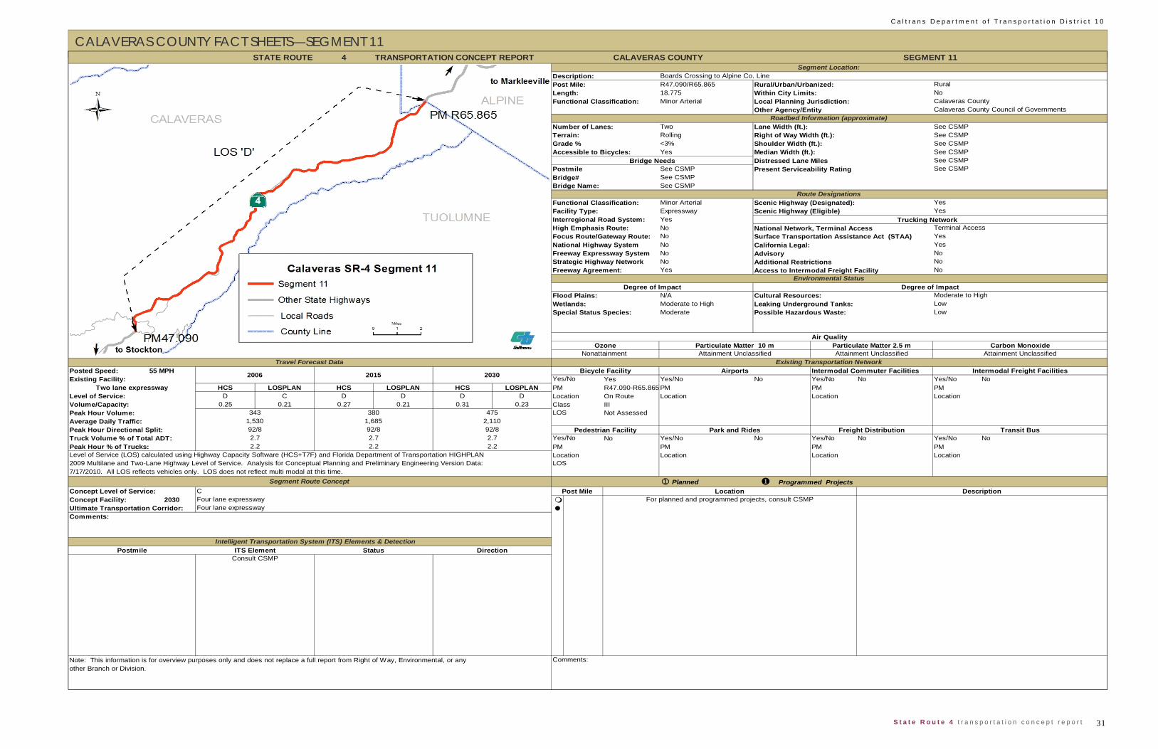
31 S t a t e R o u t e 4 t r a n s p o r t a t i o n c o n c e p t r e p o r t
C a l t r a n s D e p a r t m e n t o f T r a n s p o r t a t i o n D i s t r i c t 1 0
CALAVERAS COUNTY FACT SHEETS—SEGMENT 11
4
R47.090/R65.86518.775Minor Arterial
Two Lane Width (ft.): See CSMPRolling Right of Way Width (ft.): See CSMP<3% Shoulder Width (ft.): See CSMPYes Median Width (ft.): See CSMP
Distressed Lane Miles See CSMPSee CSMPSee CSMPSee CSMP
Minor Arterial Scenic Highway (Designated):Expressway Scenic Highway (Eligible)YesNoNoNoNoNoYes Access to Intermodal Freight Facility
N/AModerate to HighModerate
55 MPH Intermodal Commuter FacilitiesYes Yes/No No Yes/No No Yes/No No
HCS LOSPLAN HCS LOSPLAN HCS LOSPLAN PM R47.090-R65.865 PM PM PMD C D D D D Location On Route Location Location Location
0.25 0.21 0.27 0.21 0.31 0.23 Class IIINot Assessed
No Yes/No No Yes/No No Yes/No NoPM PM PMLocation Location Location
PlannedConcept Level of Service: C
2030
TRANSPORTATION CONCEPT REPORT
Note: This information is for overview purposes only and does not replace a full report from Right of Way, Environmental, or any Comments:other Branch or Division.
Postmile Intelligent Transportation System (ITS) Elements & Detection
ITS Element Status DirectionConsult CSMP
Comments:
Programmed ProjectsPost Mile Location Description
For planned and programmed projects, consult CSMPConcept Facility: Four lane expresswayUltimate Transportation Corridor: Four lane expressway
2009 Multilane and Two-Lane Highway Level of Service. Analysis for Conceptual Planning and Preliminary Engineering Version Data: LOS7/17/2010. All LOS reflects vehicles only. LOS does not reflect multi modal at this time.
Segment Route Concept
Peak Hour % of Trucks: 2.2 2.2 2.2 PMLevel of Service (LOS) calculated using Highway Capacity Software (HCS+T7F) and Florida Department of Transportation HIGHPLAN Location
Park and Rides Freight Distribution Transit BusTruck Volume % of Total ADT: 2.7 2.7 2.7 Yes/No
Peak Hour Volume: 343 380 475 LOS
Peak Hour Directional Split: 92/8 92/8 92/8 Pedestrian Facility
Volume/Capacity:
Average Daily Traffic: 1,530 1,685 2,110
Yes/No
Level of Service:Two lane expressway
2006 2015 2030
Travel Forecast DataBicycle Facility Airports Intermodal Freight Facilities
Existing Transportation NetworkPosted Speed:Existing Facility:
Air QualityOzone
Nonattainment Attainment Unclassified Attainment Unclassified Attainment UnclassifiedParticulate Matter 10 m Particulate Matter 2.5 m Carbon Monoxide
Wetlands: Leaking Underground Tanks: LowSpecial Status Species: Possible Hazardous Waste: Low
Environmental StatusDegree of Impact Degree of Impact
Flood Plains: Cultural Resources: Moderate to High
Strategic Highway Network NoFreeway Agreement: No
National Highway System California Legal: YesFreeway Expressway System Advisory No
Additional Restrictions
High Emphasis Route: National Network, Terminal Access
Length: Within City Limits: NoFunctional Classification: Local Planning Jurisdiction: Calaveras County
Focus Route/Gateway Route: Surface Transportation Assistance Act (STAA) Yes
Route DesignationsFunctional Classification: YesFacility Type: YesInterregional Road System:
Terminal AccessTrucking Network
STATE ROUTE CALAVERAS COUNTY SEGMENT 11Segment Location:
Description: Boards Crossing to Alpine Co. LinePost Mile: Rural/Urban/Urbanized: Rural
Terrain:Grade %
Other Agency/Entity Calaveras County Council of GovernmentsRoadbed Information (approximate)
Number of Lanes:
Bridge Name:
PostmileBridge#
Present Serviceability Rating See CSMP
Accessible to Bicycles:Bridge Needs
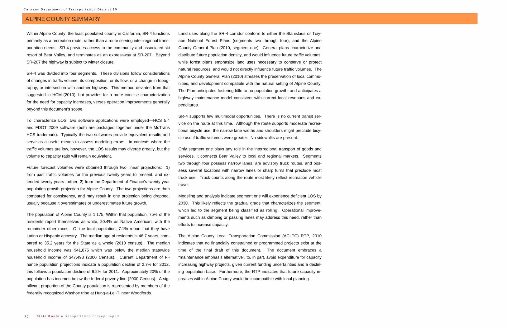
C a l t r a n s D e p a r t m e n t o f T r a n s p o r t a t i o n D i s t r i c t 1 0
32 S t a t e R o u t e 4 t r a n s p o r t a t i o n c o n c e p t r e p o r t
ALPINE COUNTY SUMMARY
Within Alpine County, the least populated county in California, SR-4 functions
primarily as a recreation route, rather than a route serving inter-regional trans-
portation needs. SR-4 provides access to the community and associated ski
resort of Bear Valley, and terminates as an expressway at SR-207. Beyond
SR-207 the highway is subject to winter closure.
SR-4 was divided into four segments. These divisions follow considerations
of changes in traffic volume, its composition, or its flow; or a change in topog-
raphy, or intersection with another highway. This method deviates from that
suggested in HCM (2010), but provides for a more concise characterization
for the need for capacity increases, verses operation improvements generally
beyond this document’s scope.
To characterize LOS, two software applications were employed—HCS 5.4
and FDOT 2009 software (both are packaged together under the McTrans
HCS trademark). Typically the two softwares provide equivalent results and
serve as a useful means to assess modeling errors. In contexts where the
traffic volumes are low, however, the LOS results may diverge greatly, but the
volume to capacity ratio will remain equivalent.
Future forecast volumes were obtained through two linear projections: 1)
from past traffic volumes for the previous twenty years to present, and ex-
tended twenty years further, 2) from the Department of Finance’s twenty year
population growth projection for Alpine County. The two projections are then
compared for consistency, and may result in one projection being dropped,
usually because it overestimates or underestimates future growth.
The population of Alpine County is 1,175. Within that population, 75% of the
residents report themselves as white, 20.4% as Native American, with the
remainder other races. Of the total population, 7.1% report that they have
Latino or Hispanic ancestry. The median age of residents is 46.7 years, com-
pared to 35.2 years for the State as a whole (2010 census). The median
household income was $41,875 which was below the median statewide
household income of $47,493 (2000 Census). Current Department of Fi-
nance population projections indicate a population decline of 2.7% for 2012,
this follows a population decline of 6.2% for 2011. Approximately 20% of the
population has incomes below the federal poverty line (2000 Census). A sig-
nificant proportion of the County population is represented by members of the
federally recognized Washoe tribe at Hung-a-Lel-Ti near Woodfords.
Land uses along the SR-4 corridor conform to either the Stanislaus or Toiy-
abe National Forest Plans (segments two through four), and the Alpine
County General Plan (2010, segment one). General plans characterize and
distribute future population density, and would influence future traffic volumes,
while forest plans emphasize land uses necessary to conserve or protect
natural resources, and would not directly influence future traffic volumes. The
Alpine County General Plan (2010) stresses the preservation of local commu-
nities, and development compatible with the natural setting of Alpine County.
The Plan anticipates fostering little to no population growth, and anticipates a
highway maintenance model consistent with current local revenues and ex-
penditures.
SR-4 supports few multimodal opportunities. There is no current transit ser-
vice on the route at this time. Although the route supports moderate recrea-
tional bicycle use, the narrow lane widths and shoulders might preclude bicy-
cle use if traffic volumes were greater. No sidewalks are present.
Only segment one plays any role in the interregional transport of goods and
services, it connects Bear Valley to local and regional markets. Segments
two through four possess narrow lanes, are advisory truck routes, and pos-
sess several locations with narrow lanes or sharp turns that preclude most
truck use. Truck counts along the route most likely reflect recreation vehicle
travel.
Modeling and analysis indicate segment one will experience deficient LOS by
2030. This likely reflects the gradual grade that characterizes the segment,
which led to the segment being classified as rolling. Operational improve-
ments such as climbing or passing lanes may address this need, rather than
efforts to increase capacity.
The Alpine County Local Transportation Commission (ACLTC) RTP, 2010
indicates that no financially constrained or programmed projects exist at the
time of the final draft of this document. The document embraces a
“maintenance emphasis alternative”, to, in part, avoid expenditure for capacity
increasing highway projects, given current funding uncertainties and a declin-
ing population base. Furthermore, the RTP indicates that future capacity in-
creases within Alpine County would be incompatible with local planning.
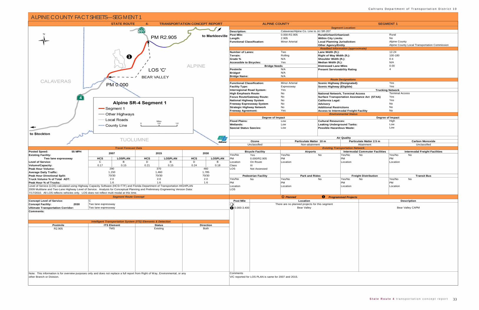
33 S t a t e R o u t e 4 t r a n s p o r t a t i o n c o n c e p t r e p o r t
C a l t r a n s D e p a r t m e n t o f T r a n s p o r t a t i o n D i s t r i c t 1 0
ALPINE COUNTY FACT SHEETS—SEGMENT 1
4-
0.000-R2.9052.905Minor Arterial
Two Lane Width (ft.): 12-24 Rolling Right of Way Width (ft.): 100-180N/A Shoulder Width (ft.): 0-4Yes Median Width (ft.): N/A
Distressed Lane Miles 0.00N/AN/AN/A
Minor Arterial Scenic Highway (Designated):Expressway YesNoNoNoNoNoYes Access to Intermodal Freight Facility
LowLowLow
55 MPHYes Yes/No No Yes/No No Yes/No No
HCS LOSPLAN HCS LOSPLAN HCS LOSPLAN PM 0.000/R2.905 PM PM PMLevel of Service: C B D B D B Location On Route Location Location Location
0.17 0.15 0.21 0.15 0.24 0.18 Class IIINot Assessed
No Yes/No No Yes/No No Yes/No NoPM PM PMLocation Location Location
PlannedConcept Level of Service: C
2030 0.000-3.400
1.6 1.62.02.0
R2.905
Level of Service (LOS) calculated using Highway Capacity Software (HCS+T7F) and Florida Department of Transportation HIGHPLAN 2009 Multilane and Two-Lane Highway Level of Service. Analysis for Conceptual Planning and Preliminary Engineering Version Data: 7/17/2010. All LOS reflects vehicles only. LOS does not reflect multi modal at this time.
Truck Volume % of Total ADT: 2.0Peak Hour % of Trucks:
Concept Facility: Two lane expressway
1.6
ITS Element
Posted Speed:
Volume/Capacity:
Existing Facility: Two lane expressway
No
Surface Transportation Assistance Act (STAA) California Legal:
Strategic Highway Network
2007 2015 2030 Intermodal Commuter Facilities
70/3070/30Average Daily Traffic:Peak Hour Volume:
Peak Hour Directional Split:1,150
370290 4601,460 1,785
70/30
Length:Functional Classification:
Attainment Unclassified
Park and Rides Freight Distribution
Airports
Non-attainment
Intermodal Freight Facilities
Air Quality
YesNo
Roadbed Information (approximate)
Route Designations
Bridge NeedsAccessible to Bicycles:
Particulate Matter 10 m Particulate Matter 2.5 m Carbon Monoxide
Leaking Underground Tanks:
National Network, Terminal Access
Transit Bus
LocationLOS
Ozone
High Emphasis Route:Yes
Degree of Impact
Advisory
Cultural Resources:
Focus Route/Gateway Route:National Highway System
NoFreeway Expressway System
Degree of ImpactHighFlood Plains:
Wetlands:Special Status Species:
Yes/NoPM
Grade %
Postmile
Bicycle FacilityYes/No
Pedestrian Facility
LOS
Interregional Road System:
Functional Classification:
Freeway Agreement: Environmental Status
Scenic Highway (Eligible)Facility Type:
4Present Serviceability Rating
Additional Restrictions
Yes
Terminal Access
Bridge#
Trucking Network
STATE ROUTE ALPINE COUNTY
Travel Forecast DataUnclassified
SEGMENT 1
Calaveras/Alpine Co. Line to Jct SR-207Rural/Urban/Urbanized: Rural
NoAlpine County Alpine County Local Transportation Commission
Segment Location:Description:Post Mile:
Within City Limits:Local Planning Jurisdiction:Other Agency/Entity
TRANSPORTATION CONCEPT REPORT
Yes
Bridge Name:
Number of Lanes:Terrain:
Location DescriptionThere are no planned projects for this segment
Bear Valley Bear Valley CAPM
CommentsV/C reported for LOS PLAN is same for 2007 and 2015.other Branch or Division.
Note: This information is for overview purposes only and does not replace a full report from Right of Way, Environmental, or any
Programmed Projects Segment Route ConceptPost Mile
Ultimate Transportation Corridor: Two lane expresswayComments:
Intelligent Transportation System (ITS) Elements & Detection
LowLowPossible Hazardous Waste:
Existing Transportation Network
Status DirectionTMS Existing
PostmileBoth

C a l t r a n s D e p a r t m e n t o f T r a n s p o r t a t i o n D i s t r i c t 1 0
34 S t a t e R o u t e 4 t r a n s p o r t a t i o n c o n c e p t r e p o r t
ALPINE COUNTY FACT SHEETS—SEGMENT 2 4-
R2.905-3.8900.985Minor Arterial
Two Lane Width (ft.): 9-10 Flat Right of Way Width (ft.): 110-290N/A Shoulder Width (ft.): 0-4 Yes Median Width (ft.): N/A
Distressed Lane Miles 0.00N/AN/AN/A
Minor Arterial Scenic Highway (Designated):Conventional HighwayYesNoNoNoNoNoNo Access to Intermodal Freight Facility
LowLowModerate
55 MPH Intermodal Commuter FacilitiesYes Yes/No No Yes/No No Yes/No No
HCS LOSPLAN HCS LOSPLAN HCS LOSPLAN PM R2.905/3.890 PM PM PMC C C C D C Location On route and in Lake Alpine Area Location Location Location
0.13 0.15 0.16 0.17 0.21 0.17 Class IIINot Assessed
Yes Yes/No No Yes/No No Yes/No NoPM 3.890 PM PM PMLake Alpine Area Location Location LocationNot Assessed
PlannedConcept Level of Service:
2030 0.000-3.400
Comments:Note: This information is for overview purposes only and does not replace a full report from Right of Way, Environmental, or anyother Branch or Division.
R2.951 TMS Existing Both
Intelligent Transportation System (ITS) Elements & DetectionPostmile ITS Element Status Direction
Comments: Bear Valley Bear Valley CAPM
Post Mile Location DescriptionThere are no planned projects for this segment
2009 Multilane and Two-Lane Highway Level of Service. Analysis for Conceptual Planning and Preliminary Engineering Version Data: LOS7/17/2010. All LOS reflects vehicles only. LOS does not reflect multi modal at this time.
Segment Route Concept
Concept Facility:Ultimate Transportation Corridor:
CTwo lane conventionalTwo lane conventional
Peak Hour Directional Split: 70/30 70/30 70/30 Pedestrian Facility
Peak Hour % of Trucks: 1.6 1.6 1.6 PM
Travel Forecast DataBicycle Facility Airports Intermodal Freight Facilities
Existing Transportation NetworkPosted Speed:Existing Facility:
Programmed Projects
Volume/Capacity:
Average Daily Traffic: 1,100 1,400 1,705
Level of Service (LOS) calculated using Highway Capacity Software (HCS+T7F) and Florida Department of Transportation HIGHPLAN Location
Park and Rides Freight Distribution Transit BusTruck Volume % of Total ADT: 2.0 2.0 2.0 Yes/No
Two lane conventionalLevel of Service:
Peak Hour Volume: 270 350 440 LOS
Yes/No2007 2015 2030
Wetlands: Leaking Underground Tanks: LowSpecial Status Species: Possible Hazardous Waste: Low
Air QualityOzone
Unclassified Non-attainment Attainment UnclassifiedParticulate Matter 10 m Particulate Matter 2.5 m Carbon Monoxide
Environmental StatusDegree of Impact Degree of Impact
Flood Plains: Cultural Resources: Moderate
Strategic Highway Network NoFreeway Agreement: No
Freeway Expressway System Advisory Yes KPRA =30 feet Additional Restrictions
High Emphasis Route: National Network, Terminal AccessFocus Route/Gateway Route: Surface Transportation Assistance Act (STAA) No
Facility Type: YesInterregional Road System:
NoTrucking Network
Scenic Highway (Eligible)
National Highway System California Legal: No
STATE ROUTE ALPINE COUNTY SEGMENT 2Segment Location:
Description: Jct. SR-207 to Lake AlpinePost Mile: Rural/Urban/Urbanized: Rural
Terrain:Grade %
Other Agency/Entity Alpine County Local Transportation CommissionRoadbed Information (approximate)
Number of Lanes:
Bridge Name:
Postmile
TRANSPORTATION CONCEPT REPORT
Length: Within City Limits: NoFunctional Classification: Local Planning Jurisdiction: Alpine County
Route Designations Functional Classification:
Bridge# Present Serviceability Rating 3
Accessible to Bicycles:Bridge Needs
Yes
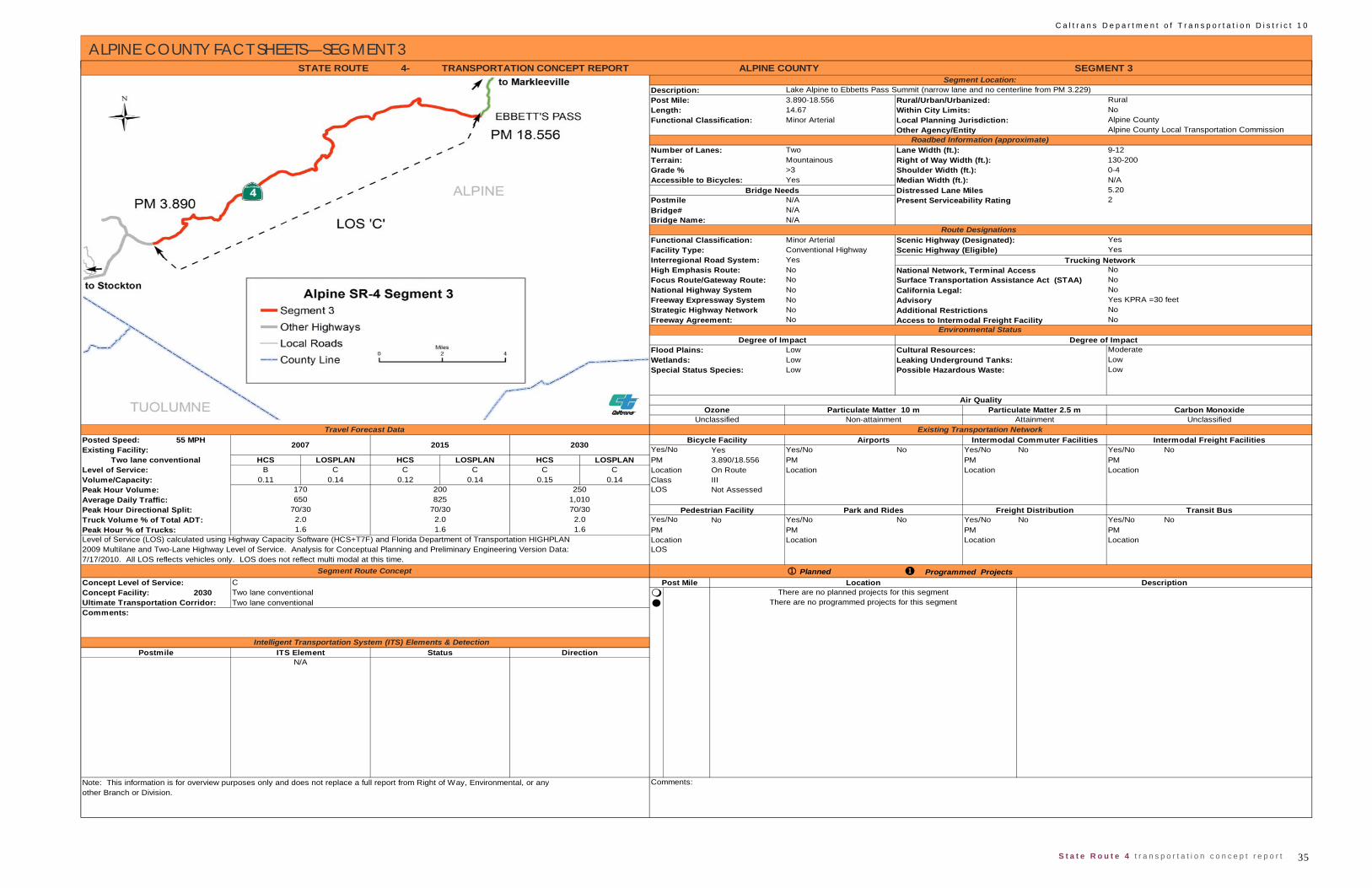
35 S t a t e R o u t e 4 t r a n s p o r t a t i o n c o n c e p t r e p o r t
C a l t r a n s D e p a r t m e n t o f T r a n s p o r t a t i o n D i s t r i c t 1 0
ALPINE COUNTY FACT SHEETS—SEGMENT 3
4-
3.890-18.55614.67Minor Arterial
Two Lane Width (ft.): 9-12 Mountainous Right of Way Width (ft.): 130-200>3 Shoulder Width (ft.): 0-4Yes Median Width (ft.): N/A
Distressed Lane Miles 5.20N/AN/AN/A
Minor Arterial Scenic Highway (Designated):Conventional HighwayYesNoNoNoNoNoNo Access to Intermodal Freight Facility
LowLowLow
55 MPHYes Yes/No No Yes/No No Yes/No No
HCS LOSPLAN HCS LOSPLAN HCS LOSPLAN PM 3.890/18.556 PM PM PMB C C C C C Location On Route Location Location Location
0.11 0.14 0.12 0.14 0.15 0.14 Class III Not Assessed
No Yes/No No Yes/No No Yes/No NoPM PM PMLocation Location Location
PlannedC
2030 Two lane conventional Two lane conventional Ultimate Transportation Corridor:
Comments:
Intelligent Transportation System (ITS) Elements & DetectionITS Element Status Direction
N/A
There are no programmed projects for this segment
Average Daily Traffic: 650 825 1,010
Level of Service (LOS) calculated using Highway Capacity Software (HCS+T7F) and Florida Department of Transportation HIGHPLAN
Park and Rides Freight Distribution
Concept Level of Service:
Comments:Note: This information is for overview purposes only and does not replace a full report from Right of Way, Environmental, or anyother Branch or Division.
Postmile
Post Mile Location DescriptionThere are no planned projects for this segment
Peak Hour % of Trucks: 1.6 1.6 1.6 PM
2009 Multilane and Two-Lane Highway Level of Service. Analysis for Conceptual Planning and Preliminary Engineering Version Data: LOS7/17/2010. All LOS reflects vehicles only. LOS does not reflect multi modal at this time.
Segment Route Concept Programmed Projects
Location
Concept Facility:
Transit BusTruck Volume % of Total ADT: 2.0 2.0 2.0 Yes/NoPeak Hour Directional Split: 70/30 70/30 70/30 Pedestrian Facility
Level of Service:
Peak Hour Volume: 170 200 250 LOS
Travel Forecast DataBicycle Facility Airports Intermodal Freight Facilities
Existing Transportation Network
Yes/NoPosted Speed:
Volume/Capacity:
Existing Facility: Two lane conventional
2007 2015 2030 Intermodal Commuter Facilities
Air QualityOzone
Unclassified Non-attainment Attainment UnclassifiedParticulate Matter 10 m Particulate Matter 2.5 m Carbon Monoxide
Wetlands: Leaking Underground Tanks: LowSpecial Status Species: Possible Hazardous Waste: Low
Environmental StatusDegree of Impact Degree of Impact
Flood Plains: Cultural Resources: Moderate
STATE ROUTE ALPINE COUNTY SEGMENT 3Segment Location:
Description: Lake Alpine to Ebbetts Pass Summit (narrow lane and no centerline from PM 3.229)Post Mile: Rural/Urban/Urbanized: Rural
Terrain:Grade %
Scenic Highway (Eligible)Trucking Network
Other Agency/Entity Alpine County Local Transportation CommissionRoadbed Information (approximate)
Number of Lanes:
Bridge Name:
PostmileBridge#
TRANSPORTATION CONCEPT REPORT
Length: Within City Limits: NoFunctional Classification: Local Planning Jurisdiction: Alpine County
2
Accessible to Bicycles:Bridge Needs
Strategic Highway Network NoFreeway Agreement: No
Present Serviceability Rating
National Highway System California Legal: NoFreeway Expressway System Advisory Yes KPRA =30 feet
Additional Restrictions
High Emphasis Route: National Network, Terminal AccessFocus Route/Gateway Route: Surface Transportation Assistance Act (STAA) No
Route Designations Functional Classification: YesFacility Type: YesInterregional Road System:
No
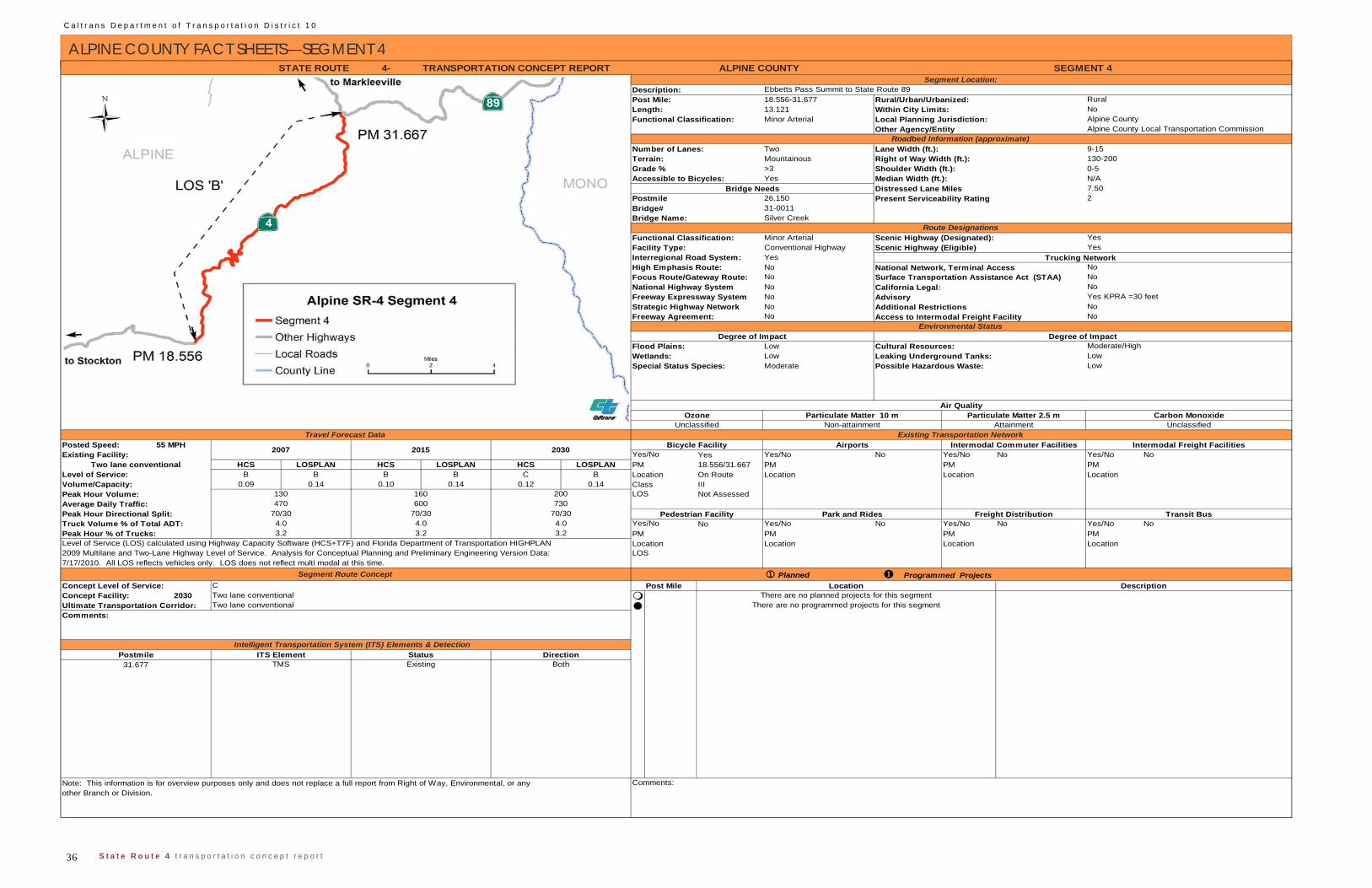
C a l t r a n s D e p a r t m e n t o f T r a n s p o r t a t i o n D i s t r i c t 1 0
36 S t a t e R o u t e 4 t r a n s p o r t a t i o n c o n c e p t r e p o r t
ALPINE COUNTY FACT SHEETS—SEGMENT 4 4-
18.556-31.67713.121Minor Arterial
Two Lane Width (ft.): 9-15Mountainous Right of Way Width (ft.): 130-200>3 Shoulder Width (ft.): 0-5Yes Median Width (ft.): N/A
Distressed Lane Miles 7.5026.15031-0011Silver Creek
Minor Arterial Scenic Highway (Designated):Conventional Highway Scenic Highway (Eligible)YesNoNoNoNoNoNo Access to Intermodal Freight Facility
LowLowModerate
55 MPHYes Yes/No No Yes/No No Yes/No No
HCS LOSPLAN HCS LOSPLAN HCS LOSPLAN PM 18.556/31.667 PM PM PMB B B B C B Location On Route Location Location Location
0.09 0.14 0.10 0.14 0.12 0.14 Class IIINot Assessed
No Yes/No No Yes/No No Yes/No NoPM PM PMLocation Location Location
Planned
2030
Note: This information is for overview purposes only and does not replace a full report from Right of Way, Environmental, or any Comments:other Branch or Division.
31.677 TMS Existing Both
Comments:
Postmile Intelligent Transportation System (ITS) Elements & Detection
ITS Element Status Direction
Post Mile Location DescriptionThere are no planned projects for this segment
Concept Level of Service:Concept Facility:Ultimate Transportation Corridor:
CTwo lane conventionalTwo lane conventional
Programmed Projects
Volume/Capacity:
3.2 3.2 3.2 PM
2009 Multilane and Two-Lane Highway Level of Service. Analysis for Conceptual Planning and Preliminary Engineering Version Data: LOS7/17/2010. All LOS reflects vehicles only. LOS does not reflect multi modal at this time.
Segment Route Concept
There are no programmed projects for this segment
Average Daily Traffic: 470 600 730
Level of Service (LOS) calculated using Highway Capacity Software (HCS+T7F) and Florida Department of Transportation HIGHPLAN Location
Park and Rides Freight Distribution Transit BusTruck Volume % of Total ADT: 4.0 4.0 4.0 Yes/NoPeak Hour Directional Split: 70/30 70/30 70/30 Pedestrian Facility
Peak Hour % of Trucks:
Level of Service:
Peak Hour Volume: 130 160 200 LOS
Travel Forecast DataBicycle Facility Airports Intermodal Freight Facilities
Existing Transportation Network
Yes/NoPosted Speed:Existing Facility:
Two lane conventional
2007 2015 2030 Intermodal Commuter Facilities
Moderate/High
Air QualityOzone
Unclassified Non-attainment Attainment UnclassifiedParticulate Matter 10 m Particulate Matter 2.5 m Carbon Monoxide
Wetlands: Leaking Underground Tanks: LowSpecial Status Species: Possible Hazardous Waste: Low
Strategic Highway Network NoFreeway Agreement: No
Present Serviceability Rating
National Highway System California Legal: NoFreeway Expressway System Advisory Yes KPRA =30 feet
Additional Restrictions
High Emphasis Route: National Network, Terminal AccessFocus Route/Gateway Route: Surface Transportation Assistance Act (STAA) No
Route DesignationsFunctional Classification: Yes
Within City Limits: NoFunctional Classification: Local Planning Jurisdiction: Alpine County
No
Bridge# 2
Facility Type: YesInterregional Road System:
Postmile
Accessible to Bicycles:Bridge Needs
Trucking Network
Grade %
STATE ROUTE ALPINE COUNTY SEGMENT 4Segment Location:
Description: Ebbetts Pass Summit to State Route 89Post Mile: Rural/Urban/Urbanized: Rural
Terrain:
Other Agency/Entity Alpine County Local Transportation CommissionRoadbed Information (approximate)
Number of Lanes:
Bridge Name:
Environmental StatusDegree of Impact Degree of Impact
Flood Plains: Cultural Resources:
TRANSPORTATION CONCEPT REPORT
Length:

37 S t a t e R o u t e 4 t r a n s p o r t a t i o n c o n c e p t r e p o r t
C a l t r a n s D e p a r t m e n t o f T r a n s p o r t a t i o n D i s t r i c t 1 0
APPENDIX A: GLOSSARY
Bicycle Routes: Refers to travel ways specific to users employing bicy-cles. There are three general classifications: ‘III’--bicycles share street with automobiles without separation; ‘II’--bicycles share street within their own des-ignated lane; and ‘I‘--bicycles travel independent of automobile traffic, often sharing right of way with pedestrians or equestrians.
California Environmental Quality Act (CEQA): Passed in 1971, CEQA provides the framework in which undertakings that may affect the envi-ronment are evaluated and if found to be adverse are to be mitigated for, as part of the governmental decision making process. For local governments, implementation of general plans and land use designations became a require-ment and a bench mark for which changes in zoning or land uses could be assessed.
Census Designation: The designation of rural (population below 5,000), or urbanized (population between 5,000 and 50,000), or urban (populations of 50,000 or greater) highways are obtained from the California Road System Maps published by FHWA, based upon census designed urbanized areas, and urbanized clusters. The most recent version dates from 2007.
Class I Two Lane Highway, see Highway Capacity Manual.
Class II Two Lane Highway see Highway Capacity Manual.
Class III Two Lane Highway see Highway Capacity Manual.
Concept Level of Service: see Level of Service.
Concept Facility: Highway facility that best maintains the Concept LOS at the end of the twenty year planning period.
Conventional Highway: Highway which permits direct access by both road intersections and driveways.
Environmental Status: A qualitative risk inventory of costs and time re-quired to address impacts of highway improvements to resources of environ-mental value, often given in five parameters (low, low to moderate, moderate, moderate to high, and high).
Expressway: Highway, usually an arterial, typically with access limited to at grade road intersections.
Federal Highway System: Designated by the Federal Highway Admini-stration, these segments of state highways serve to either support interstate commerce, national defense, or other responsibilities of the federal govern-ment. As such they are eligible for federal funding, and subject to the Na-
tional Environmental Policy Act (NEPA).
Focus Route: see Interregional Road System.
Freeway: A divided arterial highway with full access control and grade separations at intersections.
Highway Capacity Manual (HCM): Published by the National Re-search Council’s Transportation Research Board, the HCM is the national standard for methodologies to evaluate and estimate highway performance. Approved software packages developed to reduce the computation effort as-sociated with the HCM are Highway Capacity Software’s (HCS) various mod-ules and the Florida Department of Transportation’s ARTPLAN, FREEPLAN, and HIGHPLAN. The most recent update of HCM is for 2010, though several of the software interfaces are not yet currently available. Several analyses performed for this document were consistent with the older HCM 2000.
Contained in the manual are three classifications of two lane highways. Class I reflects driver behavior and expectations where high rates of speed can be attained, associated with arterials. Class II and III reflects driver behavior with in areas of steep and winding grades, usually associated with recreation ar-eas and collector routes. Class III reflects conditions where intermixing of local traffic and interregional traffic occur typical of main street highways.
High Emphasis Route: see Interregional Road System.
Highway Capacity Software (HCS): see Highway Capacity Manual.
Interregional Road System (IRRS): A State planning effort that em-phasized highways within the Freeway and Expressway system that provided network connections to urban places statewide, but were not yet constructed to freeway or expressway standards. The most recent expression of this plan (1998) discussed Focus and High Emphasis routes, and established short term and long term improvements for these specific routes.
Level: see Terrain.
Level of Service (LOS): A qualitative performance measure that de-scribes the perception of the commuter (driver, bicyclist, pedestrian, transit) of the operational conditions within a traffic stream on a highway segment. Gen-erally scaled in a range from A through F, and historically as a performance measure for automobiles, the LOS targets optimal utility expressed as the concept LOS (C for rural highways on the IRRS, D for urban highways on the IRRS and all routes not on the IRRS). Although the current version of the Highway Capacity Manual includes LOS calculations for users other than driv-ers, standards have yet to be established by the State.
Mountainous: see Terrain.
National Environmental Policy Act (NEPA): Established in 1971, this environmental policy applies to federal undertakings or efforts that have a federal nexus. Federal agencies were tasked to develop policies and stan-dards to evaluate and assess the environmental impacts of federal undertak-ings, while the Act established general policies regarding public notification and report standards.
Rolling: see Terrain.
Rural: see Census Designation.
Terrain: refers to topography specific to its affect on trucks and other heavy vehicle operation (see HCM). Level terrain contains any combination of grades or horizontal or vertical alignments that permit heavy vehicles to main-tain the same speed as passenger cars; rolling terrain contains any combina-tion of grades or horizontal or vertical alignments that causes heavy vehicles to reduce their speed substantially below that of passenger car speeds, but not to where they crawl for a significant length of time; mountainous terrain is any combination of grades or horizontal or vertical alignment that causes heavy vehicles to operate at crawl speed for significant distances or at fre-quent intervals. HCM methodologies address highway segments with level or rolling terrain with a set of constant values. Mountainous terrain requires separate upgrade or downgrade analysis, and recommends that any segment with grades between 2% and 3% with a length of more than half a mile be considered a separate segment.
Surface Transportation Assistance Act (STAA): Federal highway legislation that included federal design standards and requirements for trucks (see Truck Routes).
Truck Routes: may refer to either federal standards (contained in STAA) or California standards. Routes with an STAA designation permit travel by tractor trailers with a fifty five foot long trailer, or tandems with trailers no greater than twenty eight and a half feet, while California legal routes permit limit the overall truck length to sixty five feet total for single and seventy five for tandems. Advisory truck routes usually possess highway geometrics that limit truck length for safe operation. Restricted truck routes have legal restric-tions on the type of truck or activity.
Urban: see Census Designation.
Urbanized: see Census Designation.
C a l t r a n s D e p a r t m e n t o f T r a n s p o r t a t i o n D i s t r i c t 1 0
38 S t a t e R o u t e 4 t r a n s p o r t a t i o n c o n c e p t r e p o r t
APPENDIX B: ACRONYMS
AADT Annual Average Daily Traffic
ACE Altamont Commuter Express
ACOE U.S. Army Corps of Engineers
ADA Americans with Disabilities Act of 1990
ADT Average Daily Traffic
AHS Automated Highway System
ACLTC Alpine County Local Transportation Commission
APE Area of Potential Effects
ATIS Advance Transportation Information System
ATSD Advanced Transportation System Development
AVI Automated Vehicle Identification
BART Bay Area Rapid Transit
BN&SF Burlington Northern and Santa Fe Railroad
BMS Bridge Management System
CALACOG Calaveras Council of Governments
CCTV Closed Circuit Television
CEQA California Environmental Quality Act
CFR Code of Federal Regulations
CHIN California Highway Information Network
CHP California Highway Patrol
CMIA Corridor Mobility Improvement Account
CMS Changeable Message Sign
CNDDB California Natural Diversity Data Base
CO Carbon Monoxide
COG Council of Governments
CSMP Corridor System Management Plan
CSS Context Sensitive Solutions
CTC California Transportation Commission
CY Calendar Year
DOT Department of Transportation
DSMP District System Management Plan
EB Eastbound
E/O East Of
EPA Environmental Protection Agency
EXPW Expressway
F&E Freeway and Expressway System
FHWA Federal Highway Administration
FHS Federal Highway System
FY Fiscal Year
HAR Highway Advisory Radio
HCM Highway Capacity Manual
HPMS Highway Performance Monitoring System
I/C Interchange
IIP Interregional Improvement Program
IRRS Interregional Road System
ISTEA Intermodal Surface Transportation Efficiency Act
IT Information Technology
ITMS Intermodal Transportation Management System
ITS Intelligent Transportation Systems
ITSP Interregional Transportation Strategic Plan
JCT Junction
KPRA King Pin to Rear Axle
LOS Level of Service
LU Legacy for Users
MOU Memorandum of Understanding
MVTM Million Vehicle Miles Traveled
NB Northbound
NHS National Highway System
NAC Noise Abatement Criteria
N/O North Of
NTN National Truck Network
OC Over-crossing
OH Overhead
OTS Office of Traffic Safety
OWP Overall Work Program
PA&ED Project Approval and Environmental Document (phase)
PCS Pavement Condition Survey
PD&E Project Development and Environment
PeMS Performance Measurement System (Detection)
PHV Peak Hour Volume
PM Post Mile
PMS Pavement Management System
PM-10 Particulate Matter
PR Project Report
PS&E Plans, Specifications and Estimates
PSR Project Study Report
RCR Route Concept Report
RIP Regional Improvement Plan
ROW Right-of-Way
RT Regional Transit
RTE Route
RTIP Regional Transportation Improvement Plan
RTIF Regional Transportation Impact Fee
RTL Ready to List
RTP Regional Transportation Plan
RTPA Regional Transportation Planning Agency
R/W Right of Way
RWIS Roadside Weather Information System
SAFETEA-LU Safe, Accountable, Flexible, Efficient, Transportation
Equity Act: A Legacy for Users
SB Southbound
SHOPP State Highway Operations Protection Program
SHS State of California Highway System
SJCOG San Joaquin Council of Governments
S/O South of
SOP Status of Projects
SOV Single Occupancy Vehicle
SPRR Southern Pacific Railroad
SR State Route
STAA Surface Transportation Assistance Act
STANCOG Stanislaus County Council of Governments
STIP State Transportation Improvement Program
39 S t a t e R o u t e 4 t r a n s p o r t a t i o n c o n c e p t r e p o r t
C a l t r a n s D e p a r t m e n t o f T r a n s p o r t a t i o n D i s t r i c t 1 0
APPENDIX B: ACRONYMS
STRAHNET Strategic Highway Network
TA Terminal Access
TCM Transportation Control Measure
TCCR Transportation Corridor Concept Report
TCR Transportation Concept Report
TDM Transportation Demand Management, Travel Demand Model
TIP Transportation Improvement Plan
TMC Transportation Management Center
TMP Transportation Management Plan
TMS Traffic Monitoring Station/Transportation
Management System
TOS Traffic Operations System
TSDP Transportation System Development Plan
TSI Transportation System Information
TSM Transportation System Management
UC Under-crossing
UPRR Union Pacific Railroad
USC United States Code
UTC Ultimate Transportation Corridor
V/C Volume to Capacity
VMT Vehicle Miles Traveled
WB Westbound
W/O West of
C a l t r a n s D e p a r t m e n t o f T r a n s p o r t a t i o n D i s t r i c t 1 0
40 S t a t e R o u t e 4 t r a n s p o r t a t i o n c o n c e p t r e p o r t
APPENDIX C: END NOTES
1 This estimate is a lower bound, as ice melt from glaciers and icesheets have yet to be parameterized. Recent studies suggest the contribution from glaciers and icesheets might double the rate of sea level rise.
2 “Delta Subsidence in California--”The Sinking Heart of the State” USGS FS-05-00, April 2000.


![IMMUNOGLOBULINE E T CELL RECEPTOR T. Strachan e A.P. … · B cell antigen receptor tetramero [ IgH 2 + IgL 2 (Ig oppure Ig )] T cell receptor (TCR) eterodimero TCR /TCR TCR /TCR](https://img.pdfslide.us/doc/110x75/5c017b5c09d3f26f1e8cc6a0/immunoglobuline-e-t-cell-receptor-t-strachan-e-ap-b-cell-antigen-receptor.jpg)