Embed Size (px)
Citation preview

Tracking diagentic history in mixed volcanic and
reefal sedimentary system in Triassic-Jurassic
transition sequence in the northern Israel subsurface
Dorit Korngreen, Yehudit Harlavan
Report GSI/08/2016 Jerusalem, January 2016
Ministry of National infrastructures
Energy and Water Resources
Geological Survey of Israel


3
Contents ABSTRACT ......................................................................................................... 5
1.INTRODUCTION .............................................................................................. 6
1.1 The association of volcanic and carbonate rocks ............................................ 6
1.2 Sr stratigraphy .............................................................................................. 9
1.3 THE AIMS OF THIS WORK ...................................................................... 11
2.GEOLOGICAL SETTING ................................................................................. 11
3.METHODS ....................................................................................................... 13
3.1 Sampling and sample preparation ................................................................. 13
3.2 Cathodoluminescence (CL). ......................................................................... 13
3.3 Sr stratigraphy ............................................................................................. 14
4 RESULTS ......................................................................................................... 15
4.1 ASHER-ATLIT BOREHOLE (5600 – 5450m) ............................................. 15
4.1a Biostratigraphy ...................................................................................... 15
4.1b Reefal and Algal facies in the intermittent carbonate horizons .................. 15
4.1c 87
Sr/86
Sr ratio and chronostratigraphy ...................................................... 19
4.2 ELIJHA-3 BOREHOLE (2700-2950 m) ....................................................... 23
4.2a Biostratigraphy ...................................................................................... 23
4.2b Algal-mats and ooids facies in the post volcanic platform in Elijha 3
borehole. ...................................................................................................... 24
4.2c The 87
Sr/86
Sr ratio .................................................................................. 26
4.3 GA’ASH 2 BOREHOLE ............................................................................. 28
4.3a Cathodoluminescence (CL) .................................................................... 28
4.3b Biostratigraphy ...................................................................................... 28
4.3c The 87
Sr/86
Sr ratio .................................................................................. 31
5. DISCUSSION .................................................................................................. 34
5.1 Assiniging numerical age to the boreholes .................................................... 34
5.2 The T-J transition Biostratigraphy ................................................................ 36
5.3 Facies recorded in the late Triassic to early Jurassic, northern coastal plain of
Israel ................................................................................................................ 37
5.4 Pangea rifting and the reefal facies. .............................................................. 39
6.CONCLUSIONS ............................................................................................... 40
REFERENCES .................................................................................................... 43
APPENDIX ......................................................................................................... 48

4
List of Figures:
Figure 1 Paleogeographic reconstruction of the Late Triassic ................................... 7
Figure 2: Map location of the boreholes penetrated the Triassic strata in Israel. ......... 8
Figure 3 : The 87
Sr/86
Sr ratio of the oceans at the deep-time past ............................ 10
Figure 4: Foraminifers mentioned in text ............................................................... 17
Figure 5: Interval 5600-2350 m depth in Asher Atlit 1 borehole. ............................. 18
Figure 6: Late Triassic reef Facies Asher Atlit 1, interval 5265 – 5180 m depth.. ..... 19
Figure 7: Asher Atlit 1 Borehole 87
Sr/86
Sr ratio values in 5600 - 5445 m interval. .... 20
Figure 8: Correlations of major elements. .............................................................. 21
Figure 9: The values of 87
Sr/86
Sr ratio in 5600 - 5450 m interval of Asher Atlit 1
borehole ............................................................................................................... 22
Figure 10: Foraminifera recovered from interval 2199-3002 m in Elijah 3 borehole. 24
Figure 11: Log Elijah 3: lithology, Sedimentary components, foraminifera .............. 25
Figure 12: Elijh Borehole, Sr87
/Sr86 ratio versus depth. .......................................... 26
Figure 13: The 87
Sr/86
Sr ratio of 2700-2950 m depth interval in Elijah 3 borehole. ... 27
Figure 14: CL of 4422 – 4451 m samples in T-J transition interval at Ga’ash 2. ...... 29
Figure 15: Composite log of interval 5030- 4300 m depths in Ga’ash 2 borehole ..... 30
Figure 16: Ga’ash Borehole, Sr87
/Sr86
ratio versus depth. ....................................... 31
Figure 17: The 87
Sr/86
Sr ratio of 4400-4600 m depth interval in Ga’ash 2 borehole .. 32
Figure 18: Facies of the Triassic – Jurassic transition in Elijah 3 and Ga’ash 2
boreholes ...................................................................................................................... 33

5
ABSTRACT
The major aim of this research is to characterize the Triassic-Jurassic transition in the
subsurface of western northern Israel in terms of biostratigraphy, depositional
environments, diagenetic processes, and when possible to assigned numeric ages
using Sr stratigraphy method. Three boreholes were chosen two that include volcanic
activity (Elijah 3 and Asher Atlit 1), and one without (Ga’ash 2). This work made the
first regional attempt to define the T-J transition in the subsurface of northern Israel
by 87
Sr/86
Sr ratio chronostratigraphy, anchored by the biostratigraphy when it was
available. Some 240 thin-section of boreholes’ cuttings in total were examined for
micropaleontology and paleo- depositional environments analyses by PL and CL
microscopes. In addition, from the same intervals, 140 samples were analyzed for
87Sr/
86Sr ratio along with elemental analysis. It can be concluded that applying Sr
stratigraphy can be done on boreholes but extra care should be taken when calculating
the age. In Elijah 3 borehole, the T-J transition is positioned at 2855 m depth, above
the volcanics, and above the base of Nirim Fm., indicating Late Triassic pulse of
volcanism with no later volcanic activity. In Ga’ash 2 borehole, the results yield early
Jurassic ages (197 Ma) at depth of 4532 m, but the T-J transition couldn’t be
identified. Finally, In Asher Atlit 1 borehole, an upper interval of reefal environment
was identified using Pl and Cl microscopes, indicating strong connection between
occurrence of reef environment and the volcanic activity. Based on the biostratigraphy
it can be concluded that the T-J boundary is this borehole is up higher than previously
thought. The Sr stratigraphy failed to predict ages probably either because of the poor
constrains of the samples themselves or more probably as a result of the associated
volcanism. The Late Triassic transitioned into the Jurassic found in Elijah 3 and
Ga’ash 2 boreholes, display similar and typical deposition environments of relatively
proximal carbonate environment which is composed of algal mats and ooids
preceding, during and post the transition. These observations are similar to the
extensive stromatolitic limestones of the inner shelfs of the Late Triassic of the Alps
and the entire Tethyian shallow environments. This wide-scale carbonate platform
during the T-J transition (where no sedimentary gaps were recognized yet) may
specifically affirm that regionally, the T-J transition had occurred during volcanic and
tectonic quiescence, probably at the turning point from active rifting to basin sagging.
6
1. INTRODUCTION
1.1 THE ASSOCIATION OF VOLCANIC AND CARBONATE ROCKS
The T-J transition is one of the five major Earth-Life Transitions (ELT) of the
Phanerozoic Earth history that characterized by decreasing in speciation in the seas
where 34% of the marine genera vanished and ammonoids, brachiopods, bivalves,
gastropods, reef building corals, sponges and foraminifera were sever reduced (e.g.
Flügel, 2002; Stanley, 2003). On land, all pseudosuchians and many of the large
amphibians became extinct. The cause of this mass-extinction, remains under debates,
but the general scheme is that the T-J transition had happened during the major
breakup of Pangea, associated with volumetric volcanic eruptions, and followed by
the failure of the carbonate factory.
Large igneous activity consisted mainly of eruptions of basalts in flows and dykes
preceded the breakup of Pangaea near the end of the Triassic and at the early Jurassic
period. This activity is linked to the initial formation stages of the Atlantic Ocean
generally termed the “Central Atlantic Magmatic Province” (CAMP; Fig. 1). The
CAMP expanded over northeast South and southeast North America, northwest
Africa, and southwest Europe. It is widely excepted that it had begun 201 million
years ago and lasted for over 0.6Ma (Blackburn et al. 2013), and is tied to the
Triassic–Jurassic (T-J) extinction event (e.g. Pálfy, 2003; Olsen et al., 2003; Marzoli
et al., 2004; Galli et al., 2005; Schoene et al., 2010; Whiteside et al., 2010). Whiteside
et al. (2007) estimated based on following δ13
Corg, that the palynological extinction
might precede the oldest CAMP flow. Since contemporary rifting of the Late Triassic
and Early Jurassic is known to underlie many southern Tethyan and as well on the
Levant margin, the Late Triassic – earliest Jurassic (T-J) volcanism is frequently tied
to tensional basins.
Because of that, the T-J transition events and the associated volcanism is at the heart
of many recent researches tying the Triassic and the Early Jurassic mass extinction to
a climate crisis associated with the activity of the CAMP.

7
Figure 1 Paleogeographic reconstruction of the Late Triassic (reconstructed by Ron Blakey, NAU
Geology), shown are the known range of the CAMP, Proto-Atlantic and Tethyan rifting and the area of
this research.
Late Triassic and early Jurassic successions in Israel are mostly known from the deep
subsurface (Fig. 2) but are exposed in few outcrops in the Negev and in the Hermon
region (Mouty, 2000). While in northern Israel the base of the Jurassic succession was
considered as associated with volcanism, in other areas, the T-J boundary is truncated
and covered by lateritic palaeosols and is considered to be post-erosional exposure
features with no volcanic contribution (Mish'hor Fm; Goldberg, 1964; Goldbery,
1979). In in the Negev, the post Triassic lithostratigraphy begins with the pedogenic
lateritic Mish’hor Fm (Heller-Kallai et al., 1973, Goldbery, 1982) overlaid by Ardon
Formation with considerably wide stratigraphic gap of 28 Ma (Buchbinder and le
Roux, 1993); in the southern coastal plain, the Brur Formation is overlaid the
Mish’hor Formation (Nevo 1963; Goldberg, 1964; Derin, 1974). Northward, the
lateral carbonate suites associated with dolomite and evaporites overlaid the Triassic
section of Qeren and Haifa Fms (Hirsch et al., 1998) which are timed to accumulate in
rifting period. The thick carbonate platform, up to 1500 m that overlaid the Asher
volcanics (see 1.1.2.) in northern Israel and in the central coastal plain defined as
Nirim Formation (Derin, 1974, Hirsch and Picard, 1988), and following this definition
was identified in Elijah 1-3 and Ma’anit 1-3 boreholes also. This formation is
considered as the northward- westward equivalent of the southern dominant to
bearing siliciclastic formations (Mish’hor, Ardon, Inmar and Daya), and were
assigned to the Pleinsbachian (lower Nirim - Derin, 1974) and Torcian - Aalenian
(Upper Nirim, Derin and Reiss, 1966; Derin, 1974).

8
Figure 2: Map location of the boreholes penetrated the Triassic strata in Israel. The three studied
boreholes in this work (northern Israel) are marked by a square: among them, only Ga’ash 2 borehole is
absent volcanism in the T-J transition. Volcanism had been tracked in Meged 2 and Ma’anit 1-3 prior
to T-J transition and in Devora 2, the volcanics assigned to Late Jurassic-Cretaceous volcanic phase.
About 2500 m thick mostly basaltic succession is penetrated by the Asher Atlit 1
borehole and the volcanics were named “the Asher Volcanics” (Dvorkin and Kohn,
1989) and was related to a Mesozoic phase of rifting and development of a deep basin
with a possible ocean-like crust between the Levant and the Tauride block (Ben-
Avraham and Hall, 1977; Garfunkel and Derin, 1984; Garfunkel, 1989). The oldest
age found in Asher Volcanics is 202 ± 4 Ma, and 206.8 ± 3.0 Ma for one sample
(cuttings, ~4840 m; Kohn et al., 1993), but comprehensively, the volcanic section as a
whole was assigned to an Early Jurassic phase (Gvirtzman and Steinitz, 1983).

9
Thinner sections of Asher volcanics were penetrated also in other boreholes (Haifa 1,
Rosh-Pina 1 and Yagur 1 boreholes) and all were assigned to the early Jurassic age,
and are all overlaid by the Nirim Formation (assigned to Pleinsbachian of the early
Jurassic).
The base of the Volcanic Asher succession interlayered with thick carbonates interval
and was assigned to the Late Triassic (Carnian-early Norian; Korngreen and
Benjamini, 2001, 2011). The carbonates shows a development of reef and circum-
reef facies, that had interbedded with volcanics eruptions and which indicating reef-
volcanic genetic connection (Korngreen and Benjamini, 2001) very similar to other
paleo-seamount and rifting phases associated with reefs around the Tethys in the Late
Triassic, such as the parts of the Dolomites (Bosellini and Rossi, 1974), Oman (Searle
and Graham, 1982), Antalya (Robertson, 1993) and Tibet (Fu et al., 2010). The upper
part of the volcanic section (3000-4800 m depth interval) which was attributed to an
early Jurassic volcanic phase (Gvirtzman and Steinitz, 1983, Khon et al., 1993) is
absent of intermittent carbonate horizons and had been described as exchanges of
basalts and clayey horizons (Sherman, 1983). In addition, the volcanic sequences that
had been previously attributed to Asher Volcanics in Devora 2, Haifa 1, Rosh-Pina 1
and Yagur 1 boreholes, actually were assigned to a much younger and different later
magmatic phase. Recently, 1000 m above the base of the reefal/volcanic sequence of
Asher Atlit 1 (at about 4840 m depth) yield a zircon-based Late Triassic (late Norian)
age of 205.5 - 206.5 Ma (Golan, per. comm., Katzir et al., 2015).
1.2 SR STRATIGRAPHY
Strontium is homogeneously distributed in the oceans due to its long residence time of
4*106yr (Holland, 1978), but the isotopic composition of Sr (
87Sr/
86Sr ratio) in the
oceans is known to fluctuate since the beginning of the Phanerozoic eon.
Measurements of the87Sr/86
Sr ratio in the ocean by numerous studies were integrated
to plot the change of this ratio with time. This plot is based on measurements of
the87
Sr/86
Sr ratio in biogenic carbonates, and the Sr isotopic composition is used for
chronostratigraphic correlation of marine sediments, based upon the 87
Sr/86
Sr
variation of the ocean’s water with time. Smalley et al., (1994) introduced a statistical
method for fitting a curve to the available data using Weighted Scattered plot
Smoother (LOWESS) software. The software uses ca. 4100 data pairs (age - 87
Sr/86
Sr
ratio), data screening, corrections for inter-laboratory bias and overlap segmentation.
10
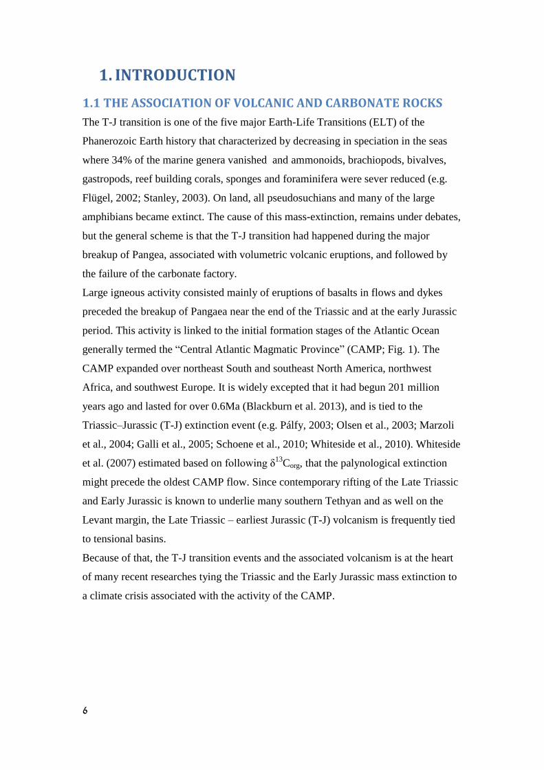
The assigned age is within 95% confidence meaning 0.000001 intervals for the
87Sr/
86Sr ratio. Most important are the prospective candidates for determining the Sr
isotopic composition of the ocean water at the time of deposition; belemnites,
brachiopods shells, carbonate cement, foraminifera (calcite) and conodonts, provided
that they show no evidence for alteration or diagenetic processes. Nevertheless, in this
study, in the absence of such candidates we use the carbonate rocks with attention to
the fact that they may had gone some diagenesis. The stratigraphic age is calculated
using comparison to the updated compilation by McArthur et al., 2012 (LOWESS:5;
Fig. 3).
The age of the Triassic-Jurassic boundary is widely accepted at around 200 Ma (e.g.
Gradstein et al., 2004). Based on samples from localities around the globe, the
compiled curve predicts the actual seawater 87
Sr-86
Sr ratio as a function of time for
this period. Increase in the rate of decline of the seawater curve from mid-Norian
probably corresponds with the development of the Atlantic spreading center in the
Mid - Jurassic. The 87
Sr/86
Sr ratio of the ocean 200 Ma ago was ca. 0.7075 while that
of the T- J boundary is ca. 0.7076 (Koepnick et al., 1990, McArthur et al., 2012). This
ratio reflects the tectonic, eustatic and climatic changes during this period. One
important change was the breakup of Pangea which led to seafloor spreading
accompanied by hydrothermal circulation of seawater through oceanic crust.
Following the approach, carbonate deposited during the T- J boundary period should
yield 87
Sr/86
Sr ratio of ca. 0.7076 (Fig. 3).
Figure 3 : The 87
Sr/86
Sr ratio of the oceans at the deep-time past following Koepnick et al. (1990),
McArthur et al. (2012).
11
1.3 THE AIMS OF THIS WORK
The major goal of the current study is to characterize the Triassic-Jurassic transition
in the subsurface of northern Israel, by analyzing cutting material recovered from
three boreholes: Asher Atlit 1, Elijah 3 and Ga’ash 2. In specific:
1. Characterize the biostratigraphy and depositional environments in the T-J
transition.
2. Identify diagenetic processes in carbonates that can be associated with
volcanic fluids.
3. Describe the affinity of the physical processes with the regional T-J transition.
4. Making first regional attempt to define the T-J transition in the subsurface of
northern Israel by 87
Sr/86
Sr ratio chronostratigraphy.
5. Illuminate to some extent, the affinity between the regional sedimentary record
and its extirpations with the regional volcanism.
2. GEOLOGICAL SETTING
The chosen boreholes in this study, is each is important as described below:
The Atilt- 1 borehole is located at coordinates EI4425I/N234500 (Israel Grid), and
was drilled in stages between 1981 and 1983. Unpublished reports on this borehole
are by Cousminer (1982), Gerry and Derin (1981) and Sherman (1983). The section
under focus was placed biostratigraphically at the Late Triassic, based on ostracods
(Gerry and Derin, 1981), by palynomorphs (Cousminer, 1981), and by foraminifers
(Korngreen and Benjamini, 2001). The section that composes of basaltic volcanics
and reefal carbonates is unknown from the other Triassic outcrops of the Negev, Sinai
and Jordan but the association of carbonates interbedded with volcanics was found in
many thick Triassic successions around the Tethys. The T- J transition in Asher Atlit
1 borehole is in the absence of any equivalent to Mis’hor formation was determined at
the transition into the massive part of the volcanic succession at 5464 m depth.
The Ga’ash 2 borehole was drilled in 1980-81 in the coastal plain of Israel (coord:
N181435, E133836) by Oil Exploration company, on what is today an elevated block
bounded by two faults directed NW–SE (Garfunkel, 1998; Gardosh and Druckman,
2006). The borehole penetrated Late to Middle Triassic carbonates and shales in the
interval from 4583–5505 m. The Triassic strata in Ga’ash-2 have a significantly
reduced thickness in comparison with other Triassic succession in Israel (Druckman,

12
1974). Bio- and chronostratigraphy was reported by Korngreen and Benjamini (2006).
This borehole is marked at 4560 – 4595 m depth by about 35 m of colored shale and
clay (core 1) interpreted as “…deeply weathered residual detritus including
mineralized vascular tissue strands…” (Cousminer, 1981) and was assigned to
exposure event and to the Mish’hor formation equivalent. Following that, the overlaid
carbonates were assigned to the Jurassic Nirim Fm. (Gvirtzman et al., 1984), although
no other identical microfossils were recovered at the base of the formation.
The Elijah 3 borehole site is located on the northern coastal plain of Israel near Mount
Carmel, between Caesarea and Haifa, in the banana orchards of Kibbutz Ein Karmel,
eastward to Road 40. The borehole was drilled by Zion Oil & Gas Company, 2009,
2012 and sealed at 2013. Three rock types were found to dominate the volcanic
section (530 m) of the Elijah 3 borehole (following Golan, per. comm.; Katzir et al.,
2015): dolerite (at 2909 2906 m interval), olivine basalt and seriate basalt to the
borehole base (3332 m depth). A transition zone of mixed layer volcanic-carbonate
interval overlaid the volcanic succession (2906-2873 m depth), and a sequence of
carbonates above it. Previously, the carbonate samples from the 2199-2702 m
interval of Elijah 3 borehole (~800 m) had been studied briefly by thin sections made
at 100 m intervals of the borehole cuttings (Korngreen et al., 2010). The borehole
penetrated a primarily carbonate section underlain by volcanics (considered as Asher
Volcanics; 2897-3002 m interval). The deduced age for the carbonate section was
Aalenian - Bajocian according to foraminifera and palynomorphs, and the absence of
dinocysts. Intra Jurassic subaerial exposure event was identified at depth 2500 m, and
the downhole transition from carbonates to volcanics was characterized by a
monomictic micro-breccia, possibly marking contact with volcanic fluids, and loosely
packed dolomite interleaves. The carbonate facies immediate above the volcanic
section indicate a marine carbonate platform developed with indications to shifting
from outer ramp through high-energy shoals, to restricted peritidal nearshore
environments and was assigned to Nirim Formation.
Recent dating the top of the volcanics at the borehole base to the latest Triassic (ca.
200 Ma; Katzir, Golan et al., 2015), encourage to look for the T-J transition above the
magmtic section.
13
3. METHODS
3.1 SAMPLING AND SAMPLE PREPARATION
In general, the sampled material of this work was produced as the rock was
fragmented while a drill bit had been proceeding through the interval. The rock
fragments (“cuttings”) were pumped up-hole by the drilling’s circulating cooling
fluids and mud; following their monitored rate of circulation and their viscosity, the
sample’s depth was deduced by calculation, each sample typically, are caught or
collected as composite samples that reflect the various lithologies drilled over 3 m
interval. To keep on with good monitoring of the subsurface, the borehole should not
lose water, and any stop of the pumping or the drilling can cause fluids and material
lost or mixed with other intervals. Moreover, weakly consolidated rocks will change
the rate of circulation, subsurface caves might cause loss of circulation and material
will not reach the surface; highly brittle rocks (e.g. volcanics) might be erode easily
and may fall downhole (caved) or to be re-transported up hole by the mud circulation
and may attribute to different depths. Many is relying on the well-sitter skills, as the
fragments themselves should be treated in highly cautions when they drop out of the
borehole into the settling pits and when they isolated from the mud; although these
descriptions and the derived uncertainties that fragments might be out of their original
locations, it should be always considered, that in absence of recovered cores, the
majority of the material fragments are the only direct physical lithological data for
examination and analyzes deep subsurface intervals, and general trend in any of the
results will help to avoid mistakes, and to display the sample at its approximate
relevance.
Ca. 240 thin-section of boreholes’ cuttings in total were examined for
micropaleontology and paleo- depositional environments analyses; for Elijah-3, 40
were new made and 11 from the archive; for Ga’ash 2, 75 were new made and 21
from the archive; for Asher Atlit 1, 71 new made and 20 from the archive. Thin
sections were examined by petrographic microscope and documented by a digital
camera for foraminifers, skeletal and non-skeletal components identification.
3.2 CATHODOLUMINESCENCE (CL).
The slides were examined under CL microscope CITL-mk5 mounted on Olympus
petrographic microscope to observe features visible through their diagenetic overprint.

14
Use of CL is justified by luminescence features imparted during crystal growth by
incorporation of trace amounts of elements; Mn++, Fe++, are most common in
sedimentary system; the Mn+2 is the most important activator ion of CL, while the
ion Fe+2 is a luminescence’s quencher (e.g. Pagel et al., 2000), when Intensity of
luminescence can depend on the Fe/Mn ratio, and their incorporation into the lattice is
dependent on the Eh conditions (Pierson, 1981; Richter and Zinkernagel, 1981; Frank
et al., 1982, etc). Exotic luminescence occurs when rare activated ions, or common
ion in are present in the participating solution effected by hydrothermal or volcanic
3.3 SR STRATIGRAPHY
Some 140 87
Sr/86
Sr ratio analyses were carried out on the boreholes’ material based
on one grain of the chips (the fragments of the rocks) from each sample interval at
selected studied interval: 33 of Asher Atlit 1 at the base of the volcanic succession; 44
samples from the T-J transition at Ga’ash 2 and 62 samples of the T-J transition at
Elijah 3. Chips were chosen under binocular and handpicked carefully to consist of
calcite as much as possible. Chips were rinsed using distilled water to remove any
borehole mud and then placed in a 50 ml clean tube (ca. 0.1gr). Selective dissolution
of carbonate (calcite or dolomite) was accomplished by using ultra clean 0.5M acetic
acid. Dissolution took place under room temperature for 24 hours until no release of
CO2 could be observed. The solution was then separated from the residual and dried
using clean Teflon beakers on hot plate under clean condition. The salt was dissolved
by 0.1 HNO3 ultrapure-acid and prepared for elemental analysis. An liquate was used
for elemental analysis of Al, Si, Ca, Mg, K, SO4, Sr using ICP-AES at the Geological
Survey of Israel. The Sr isotopic ratio analysis followed
The isotopic composition of Sr was measured using a Nu Plasma MC-ICP-MS
instrument. Mass discriminations were corrected using repeated measurements of the
SRM-987 standard. The long-term precision of isotopic ratio determination (2
relative standard error) was 0.002% for 87
Sr/86
Sr.

15
4 RESULTS
The Elemental chemistry, 87
Sr/86
Sr ratio and assigned ages when relevant appear in
the appendix.
4.1 ASHER-ATLIT BOREHOLE (5600 – 5450M)
4.1a Biostratigraphy
The base of the studied section in this borehole (5464–5481 m) recovered
foraminiferal species indicating Carnian – Rhaetian age (Korngreen and Benjamini,
2001): Aulotortus pokornyi - Norian– Rhaetian (Piller, 1978); Amphorella
lageniformis – Carnian – Norian (Salaj et al., 1983). These two species were
associated with Diplotremina sp.; Endothyra sp.; Valvulina sp.; Meandrospiranella
irregularis. Following the foraminifera assemblage, the Carnian – Norian transition
occurred at about 6260 m depth (Korngreen and Benjamini, 2006). The thick
sequence of volcanics overlaid this interval were assigned to the Early Jurassic
(following broad agreement of Jurassic age of the volcanics; Gerry and Derin, 1981;
Cousminer, 1982; Lang and Steinitz, 1989; Kohn et al., 1993; Korngreen and
Benjamini, 2001).
Following the novel radioactive dates from the main phase of Asher Volcanics
(Golan, per. comm., Katzir et al., 2015), work was focused on the intermittent
carbonate intervals in the massive continues volcanic section (Figs. 4 and 5). The
recorded foraminifera of this work were Aulotortus tumidus (late Norian – Rhaetian
(Mancinelli et al., 2005); Fig. 4, 5-6), associated with Dustominidae (Late Triassic; Pl.
1, 2) Earlandia sp. (Fig. 4, 3-4), Agathammina sp. (Fig. 4, 10), Planiinvoluta sp. (Fig.
4, 9), Ophthalmidium sp. (Fig. 4, 7) and Endothyra sp. (Fig. 4, 8) in 5260-5180 m
depth interval; in 5212-15 m depth interval, a Late Triassic (Norian) Urnulinella cf.
andrusovi (Fig. 4, 1) was recorded, considered as a typical reefal foraminifer
(Chablais et al., 2011;). The first “Siphovalvulina” sp. that usually marks the Triassic
– Jurassic transition occurred at depth 2780, bur more work need to be done on this
interval. The foraminifers’ assemblage of these intervals is matching the evaluated
Norian age of the Interval.
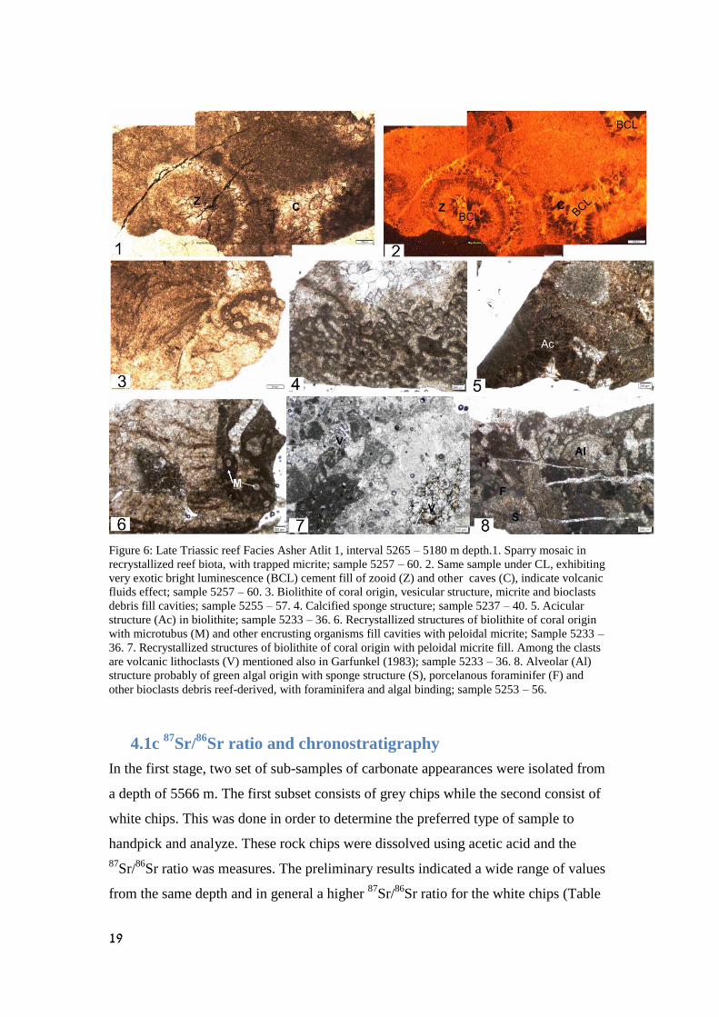
4.1b Reefal and Algal facies in the intermittent carbonate horizons
Fig. 5 shows the log of the interval 5600-2350 m depth in Asher Atlit 1 borehole
comprises the T – J transition. The log displays radioactive dates (Golan, per.
comm.), lithology, micro-sedimentary components and recovered foraminifera from

16
previous and this works. Since some of the work is still under processing and
studding, not all the planed results are included in this report, but they will be
integrated in a final one.
The base of the volcanic sequence is inserted in carbonate and volcanics exchange
interval (5400-5600 m depth) briefly described in Gerry, 1983 and in details in
Korngreen and Benjamini (2001) as Late Triassic reefal and volcanic association.
Examination of the carbonate dominant interval overlay 125 m thick of separating
entirely volcanic sequence (85 m thick; 5265 – 5180 m depth) found to be composes
also of Late Triassic reef components and foraminifera, extending the intimate
interlayering alternations of extrusive volcanism and reef establishment from the base
of the volcanic succession at about 6250 m depth up to 5180 m depth – 1070 m,
before the volcanism become the dominant lithology upwards (up to 3000 m depth,
2180 m of volcanic activity). The interval contains also recrystallized reef biota of
coral origin, sponge structures, typical reef acicular structure, Microtubus, alveolar
green algae structure, foraminifera, algal binding, and vesicular structure all trapped
by micrite (Fig. 6, 1-8). Under the CL, exotic bright luminescence indicating
carbonate cement fills under volcanic fluids effect (Fig. 6, 1-2). Reef debris found to
be associated with volcanic lithoclasts (Fig. 6,7) indicates adjacent volcanic sea
mount stabbed out of the sea level.

17
Figure 4: Foraminifers mentioned in text: 1. Urnulinella cf. andrusovi ; (Samuel and Borza, 1981);
Carnian; Asher-Atlit 1 5212 -15. 2. Dustominidae; Asher-Atlit 1 5212 -15. 3. Eaerlandia sp.; Asher-
Atlit 1 5229 -32. 4. Eaerlandia sp.; Asher-Atlit 1 5233 -36. 5. Aulotortus tumidus; Asher-Atlit 1 5233 -
36. 6. Aulotortus tumidus; Asher-Atlit 1 5240 -43. 7. Ophthalmidium sp.; Asher-Atlit 1 5240 -43. 8.
Endothyra sp.; Asher-Atlit 1 5233 -36. 9. Planiinvoluta sp.; Asher-Atlit 1 5240 -43. 10. Agathammina
sp.; Asher-Atlit 1 5243-46. 11. Unidentified foraminifer; Gaash-2 4400-03. 12. Turrispirilina sp.?;
Gaash-2 4400-03. 13. Endothyranella sp.; Gaash-2 4400-03. 14. Aulotortus sp.; Gaash-2 4416-28. 15.
Tetrataxis sp.; Gaash-2 4425-28. 16. Valvulinids; Gaash-2 4428- 40. 17. Siphovalvulina sp.; Gaash-2
4428- 40. 18. Tetrataxis sp.; Gaash-2 4458- 40. 19. Oberhouserella sp. Gaash-2 4458- 40. 20.
Austrocolombia sp.; Gaash-2 4660- 03. 21. Pilamminella kuthani; Gaash-2 4657- 60. 22. Pilamminella
kuthani; Gaash-2 4621- 24. 23. Siphovalvulina sp.; Asher-Atlit 1 2439 -42. 24. Valvulina metula or
Textulariopsis sp.; Gaash-2 4325- 28. 25. Miliolids; Gaash-2 4325- 28. 26. Paleomayncina termieri
(Hottinger) or Endothyra sp.; Gaash-2 4325- 28. 27. Orbitopsella praecursor? (Gümbel); Gaash-2
4470 (caved). 28. Lituosepta compressa Hottinger; Gaash-2 4340- 43.

18
Figure 5: Interval 5600-2350 m depth in Asher Atlit 1 borehole comprises the Triassic – Jurassic
transition. 1 – Age used in this work is following preliminary results of radioactive dates after Golan,
per. comm., Katzir et al., 2015; Age in previous works is after Derin and Gerry, 1981; Sherman, 1983.
The T-J transition in this interval is preliminary determined following the results in Ga’ash 2 and Elijah
3 boreholes. Lithology column shows dominant volcanics and some smaller intermediate carbonate
intervals. Micro-sedimentary components and recovered foraminifera displayed by the lithology. Note
that 1250 m of entire volcanisc exchange with clayey horizons sequence had been cut off from the log.
19
Figure 6: Late Triassic reef Facies Asher Atlit 1, interval 5265 – 5180 m depth.1. Sparry mosaic in
recrystallized reef biota, with trapped micrite; sample 5257 – 60. 2. Same sample under CL, exhibiting
very exotic bright luminescence (BCL) cement fill of zooid (Z) and other caves (C), indicate volcanic
fluids effect; sample 5257 – 60. 3. Biolithite of coral origin, vesicular structure, micrite and bioclasts
debris fill cavities; sample 5255 – 57. 4. Calcified sponge structure; sample 5237 – 40. 5. Acicular
structure (Ac) in biolithite; sample 5233 – 36. 6. Recrystallized structures of biolithite of coral origin
with microtubus (M) and other encrusting organisms fill cavities with peloidal micrite; Sample 5233 –
36. 7. Recrystallized structures of biolithite of coral origin with peloidal micrite fill. Among the clasts
are volcanic lithoclasts (V) mentioned also in Garfunkel (1983); sample 5233 – 36. 8. Alveolar (Al)
structure probably of green algal origin with sponge structure (S), porcelanous foraminifer (F) and
other bioclasts debris reef-derived, with foraminifera and algal binding; sample 5253 – 56.
4.1c 87
Sr/86
Sr ratio and chronostratigraphy
In the first stage, two set of sub-samples of carbonate appearances were isolated from
a depth of 5566 m. The first subset consists of grey chips while the second consist of
white chips. This was done in order to determine the preferred type of sample to
handpick and analyze. These rock chips were dissolved using acetic acid and the
87Sr/
86Sr ratio was measures. The preliminary results indicated a wide range of values
from the same depth and in general a higher 87
Sr/86
Sr ratio for the white chips (Table

20
3, Appendix). Since the elemental chemistry was not determined at that stage the
white chips were chosen for further work.
In the second stage a set of ca. 45 samples were analyzed for Sr isotopic composition
and elemental chemistry (Table 4, Appendix). In this case, the elemental chemistry
was determined and the percent of anhydrite, dolomite and calcite in the solutions
were calculated. Calculations were done in the following order, first the % dolomite
using the Mg concentrations, and then the % anhydrite using the SO4 concentrations
and finally the %CaCO3 after subtraction the Ca associated with dolomite and
anhydrite (Table 4, Appendix). No correlation was found between one of the major
constitutes of the dissolve sample (i.e. Ca, Mg, 1/Sr and SO4) and the 87
Sr/86
Sr ratio,
which suggests no mixing of phases.
Not like Elijah 3 and Ga’ash 2 boreholes, no systematic was observed for this section
(Fig. 7). A more detailed study shows that Sr concentration has good and positive
correlation with Ca and SO4, which may suggests contribution from anhydrite that is
known to consist of thousands of ppm of Sr (Fig. 8). However, the minor amount of
anhydrite (less than 1%) is probably not enough to alter the 87
Sr/86
Sr ratio. Fig. 9
shows the inconsistent pattern of the values distribution with the world curve,
excluding 8 samples that shows fitting with the Norian – Rhaetian curve, in agreement
with the micropaleontology indications.
Figure 7: Asher Atlit 1 Borehole 87
Sr/86
Sr ratio values in 5600 - 5445 m interval. No systematic can be
observed.
0.7068
0.7070
0.7072
0.7074
0.7076
0.7078
0.7080
0.7082
0.7084
0.7086
5400 5450 5500 5550 5600 5650
87
Sr/8
6Sr
Depth m

21
Figure 8: A good correlations between Sr, Ca, Mg and SO4 concentrations in the dissolutions
suggesting that carbonate dissolution was accompanied by anhydrite dissolution

Figure 9: The values of
87Sr/
86Sr ratio in 5600 - 5450 m interval of Asher Atlit 1 borehole (yellow) on the global curve of McArthur et al., 2012. The values distribution
shows no consistency with the world Curve excluding a quarter of the values (8 samples) that fit the Norian – Rhaetian curve.

4.2 ELIJHA-3 BOREHOLE (2700-2950 M)
4.2a Biostratigraphy
Previous work on the 2199-3002 m interval of the borehole (~800 m. thick;
Korngreen et al., 2010) yield age Aalenian - middle Bajocian (Jurassic) to 2199-2702
m depth mainly by palynomorphs. This interval was associated with valvulinids and
glomospirids, and the actually first appearance of Lucasella sp., Orbitopsella
praecursor, and the planktonic foraminifer "Protoglobigerinid" was at 2700 m depth.
The depositional environments of the 2199-2702 m interval shifted from below
FWWB on the ramp (valvulinid mudstones), through high energy shoal barriers,
restricted peritidal proximal environments, to nearshore supratidal environments. A
Subaerial exposure event was identified at 2498-2502 m in fenestral bindstones of the
peritidal sequence. Monomictic microbreccia indicating contact with volcanic fluids,
and loosely packed dolomite crystals suggest replacement of precursor evaporitic
lithology.
The carbonate interval downhole from 2702 m to 2906 m recovered no age
indications; since it was overlaid a thick volcanic interval (base of borehole at 3332 m
depth; at least 426 m thick of volcanic section), this part was attributed to the post
volcanic Nirim formation carbonate platform and to the early Jurassic in age. The
abandons of the infauna valvulinids (Fig. 9, 1-4) in the post volcanic carbonate
platform is indicating relatively harsh eutrophic conditions deep in the sediments
(anoxia? following Fugagnoli, 2004), and the epifauna glomospirids point to
oxic/dysoxic sediment/water interface but both are not age indications. The
involutinids (Aulotortus type, Fig. 9, 7-8) due their badly preservation, do not
contribute to age determination but the bad preserved probably Triasina species with
some remains of pillars on top left (Fig. 9, 10) indicates Norian-Rheatian age to the
interval. The occurrence of Orbitopsella sp. at 2799 m depth is attributed to caving,
and its first occurrence should be with the increasing variety of the Jurassic species at
2700 m depth. The occurrence of the Triasina might be controversial due its
preservation if it not reinforced by the upper part 200.9 M.Y (Rhaetian) radiometric
age of the underlain volcanic phase (Fig. 10; age from Golan, pers. Comm.).

24
Figure 10: Foraminifera recovered from interval 2199-3002 m in Elijah 3 borehole. 1- 4 - Valvulina
sp., sample 2810. 5-6 - Orbitopsella praecursor (Jurassic), sample 2699. 7-8 – Aulotortus sp., sample
2828. 9. “Siphovalvulina” sp., sample 2903. 10. Triasina? Sp., sample 2864.
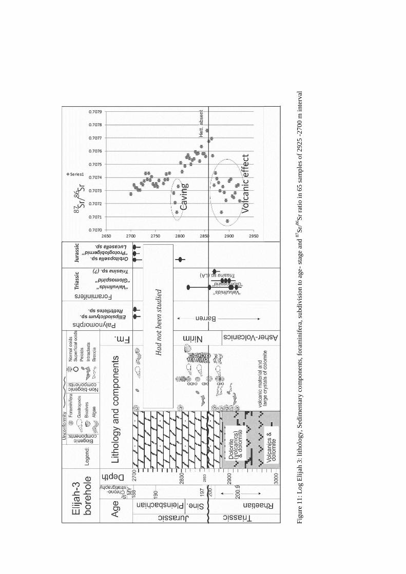
4.2b Algal-mats and ooids facies in the post volcanic platform in
Elijha 3 borehole.
Fig. 10 shows a composite log of the interval and typical base of Nirim Fm.
Radiometric age provided by Golan (pers. Comm.). The 40 m at the base of the post-
volcanic carbonate have late Triassic foraminifers associated with species that can be
related to the Triassic and to the Jurassic as well (the valvulinids and the
glomospirids). The sedimentary components displaying a transition from brecciated
dolomites affected by volcanic fluids (Fig. 10) to shallow platform alternate between
energetic ooid environments to algal bounding associated with Taumathoporella sp.
F
igure
11
: L
og E
lija
h 3
: li
tho
log
y,
Sed
imen
tary
co
mp
onents
, fo
ram
inif
era,
sub
div
isio
n t
o a
ge-
stag
e and
87S
r/86S
r ra
tio
in 6
5 s
am
ple
s o
f 2
92
5 -
27
00
m i
nte
rval

4.2c The 87
Sr/86
Sr ratio
For this borehole 72 samples were analyzed for Sr isotopic composition and ca. 60%
for elemental chemistry (Table 1, Appendix). The results of the elemental analyses
indicate that the dominant mineral in the dissolved sample range widely from pure
dolomite (1% CaCO3) to ca. to near pure calcite (97%CaCO3). No correlation was
found between the calculated %CaCO3 and the 87
Sr/86Sr ratio. In addition, no
correlation was found between one of the major constitutes of the dissolve sample
(i.e. Ca, Mg, 1/Sr) and the 87
Sr/86
Sr ratio, which suggests no mixing of phases (i.e.
calcite with dolomite). Finally, a minor release of Al-Si and Fe-Mn is observed
suggesting some contribution if any of these phase during dissolution and possibly to
the Sr isotopic composition. Nevertheless, the 87
Sr/86
Sr ratio increase systematically
with depth from 2700 m to 2866 m below surface. Below 2866 m the ratio decreases
systematically (Fig. 12A).
Basalt sample taken from basket related to depth 2900-3000 m depth of the volcanic
interval was analyzed for Sr isotopic composition and concentration. The results are
87Sr/
86Sr = 0.70532 and 202 ppm Sr. Fig. 10A shows a significant constant decline of
the ratio values between 2840 m to 2700 m depth, and two groups of values deviate
out of the curve. Fig. 10B show the results projected on McArthur global curve.
Figure 12: Elijh Borehole, Sr87
/Sr86 ratio versus depth. Blue symbols represent samples with age
calculation while in red symbols are for excluded samples.
y = 2E-06x + 0.7019 R² = 0.9045
0.7071
0.7072
0.7073
0.7074
0.7075
0.7076
0.7077
0.7078
2650 2700 2750 2800 2850 2900 2950
87
Sr/8
6Sr
Depth m

Fig
ure
13
: T
he
87S
r/8
6S
r ra
tio
of
27
00
-29
50
m d
epth
inte
rval
in E
lija
h 3
bo
reho
le.
A.
The
iso
top
es r
atio
dis
trib
uti
on i
n t
he
stud
ied
inte
rval
. B
. T
he
bo
reho
le’s
iso
top
es r
atio
pro
ject
ed o
n t
he
glo
bal
87S
r/8
6S
r ra
tio
curv
e o
f M
cA
rthur
et a
l.,
20
12
. N
ote
that
the
curv
es
do
no
t en
tire
ly f
it d
ue
the
dif
fere
nt
X a
xis
val
ues
(yea
rs v
ersus
met
ers)
. E
ach d
ot
sho
uld
be
pro
ject
ed f
oll
ow
ing h
er v
alue
on t
he
curv
e to
def
ine
the
age
of
its
dep
th.

4.3 GA’ASH 2 BOREHOLE
4.3a Cathodoluminescence (CL)
No volcanic sequence was found in the borehole and indeed the general CL of the
borehole material appeared dull (DCL). The large dolomite crystals at 4422 m depth
(Fig. 12, 1-2) display DCL without and overprint of hydrothermal fluids. Only one
sample, at a depth of 4451 m (Fig. 12, 3-6) showed cementation with large Ca-rich
concentric zoned dolomite exhibiting differences in luminescence intensity. This
sample indicates hydrothermal activity that filled the sediment cavities and fractures.
4.3b Biostratigraphy
The studied interval with the T-J transition in Ga’ash 2 borehole is illustrated in Fig.
11 following lithology, sedimentary components, deposition environments and the
distribution of foraminifers’ species as recorded. Previous studies suggested that the
expected T-J transition should be posited in the interval 4562 – 4300 m depth. Hence
this interval was restudied in details by new thin sections. The disappearance of
Aulotortus friedli and A. sinuosus filled by the continued occurrence of the Late
Triassic species Aulutortus tumidus associated with valvuliniids, tetrataxis and
Turrispirilina sp. indicating the continue of Triassic species in relatively strained
conditions (Valvulininae, Tetrataxidae), before the occurrence of typical Jurassic
species (Litosepta sp.). Hence, the T-J transition should be shifted from the clayey
horizon

29
Figure 14: CL of 4422 – 4451 m samples in T-J transition interval at Ga’ash 2 borehole. 1. Few phases
of dolomitization, small crystal in sediment, large in caves, were 2., very dull luminescent (DCL; 4422
m depth). 3, Crystal growth on bioclastic sediment displays very bright luminescence (BCL) at 4., the
sediment itself and with sharp differences in luminescence intensity of the large crystals (4451 m
depth). 5. Same depth as above, with similar phenomenon.

Fig
ure
15
: C
om
po
site
lo
g o
f in
terv
al 5
03
0-
43
00
m d
epth
s in
Ga’a
sh 2
bo
reho
le. T
rias
sic
fora
min
ifer
s up
to
46
00
m a
fter
Ko
rngre
en a
nd
Ben
jam
ini,
20
06
; Ju
rass
ic f
ora
ms
1 a
fter
Buchb
ind
er a
nd
Sho
mro
ny
, 1
98
8;
mix
ass
em
bla
ge
of
fora
min
ifera
occ
urs
abo
ve
Mis
h’h
or
(?)
Fo
rmat
ion
(4
560
- 4
34
0 m
inte
rval)
, th
at c
an b
e as
signed
to
the
Lat
e T
rias
sic.

4.3c The 87
Sr/86
Sr ratio
For this borehole, 44 samples were dissolved and analyzed for elemental chemistry.
Amongst these samples 50 samples were analyzed for Sr isotopic composition (Table
2, Appendix). The results of the elemental analyses indicate that the dominant
minerals in the dissolved sample are down to 4577 m is dolomite (less than 10%
CaCO3) and below is calcite (>90%). This change is very abrupt. No correlation was
found between the calculated %CaCO3 and the 87
Sr/86
Sr ratio. In addition, no
correlation was found between one of the major constitutes of the dissolve sample
(i.e. Ca, Mg, 1/Sr) and the 87
Sr/86
Sr ratio, which suggests no mixing of phases (i.e.
calcite with dolomite). Finally, no significant release of Al-Si and Fe-Mn is observed.
The 87
Sr/86
Sr ratio increase systematically with depth (Fig. 16).As be seen two parallel
linear lines describe the sample. This could either represent small section duplication
or step out of the drilling.
Figure 16: Ga’ash Borehole, Sr87
/Sr86
ratio versus depth. Two set of samples can be seen; blue and
green symbols. The both have the same slope and initial.
y = 3E-06x + 0.6995 R² = 0.9221
y = 3E-06x + 0.7001 R² = 0.7213
0.7073
0.7073
0.7074
0.7074
0.7075
0.7075
0.7076
0.7076
0.7077
0.7077
0.7078
2650 2700 2750 2800 2850 2900 2950
87
Sr/8
6Sr
Depth m

32
Figure 17: The
87Sr/
86Sr ratio of 4400-4600 m depth interval in Ga’ash 2 borehole. The borehole’s
isotopes ratio projected on the global 87
Sr/86
Sr ratio curve of McArthur et al., 2012.

Figure 18: Facies of the Triassic – Jurassic transition in Elijah 3 and Ga’ash 2 boreholes: 1. Well sorted
ooid grainstone; Elijah 3 borehole, sample 2801 m depth.2. Algal mats associate with valvulininae (V)
and the algal species Thaumathoporella (Th), inner ramp; Elijah 3 borehole, sample 2810 m depth. 3.
Chaetid sponge (Sphinctozoan) polygonal morphology (appear also at 2822 and 2846, 2849, 2855 m
depths and filled with crude oil at 2873); Elijah 3 borehole, sample 2813 m depth. 4. Mixing of
moderate sorted normal ooids and peloids bounded by algae; Elijah 3 borehole, sample 2831 m depth
(appear also at 2858 m depth). 5. Algal mats associate with valvulininae (V), inner ramp; Ga’ash 2
borehole, sample 4428 m depth.6. Carbonate sand near dasyclad green algae (D) bioherm; the sand
with large pores indicating semi restricted part of marine barrier, under wave action of the innermost
platform. Ga’ash 2 borehole, sample 4482 m depth. 7. Aggregate grain carbonate (grapestone) bounded
by algae; seaward face of marine lagoon in wave action zone, in the photic zone. Ga’ash 2 borehole,
sample 4541 m depth; filled with crude oil at 4547 m depth. 8. Radial-fibrous concentric ooid
grainstone, relatively low energy shallow marine environment. Ga’ash 2 borehole, sample 4621 m
depth.
33

34
5. DISCUSSION
5.1 ASSINIGING NUMERICAL AGE TO THE BOREHOLES
In this study, we sought to apply Sr stratigraphy on samples taken from boreholes as
appose to exposed succession. In addition, because of the absence of fauna we could
only apply this method to bulk rock. The problems arise from working with cuttings
are two: (1) relative poor resolution which is inherent in cutting recovery. In the
studied boreholes the intervals were 3m (2) perturbations such as changing bits and
change in the rate of pumping can cause caving, material loss and drifting material to
higher levels.
Nevertheless, the studied intervals in the above boreholes are the best for the purposed
aim of this study i.e. understanding the T-J transition.
The problems in recovering relatable material from the boreholes as stated above were
taken into consideration when assigning numerical age to the measured 87
Sr/86
Sr ratio.
In addition the following was also taken into considerations: One of the three
boreholes, Ga’ash 2 show continues section along the T-J transition and has no
volcanics while the other two include volcanics between the Triassic and Jurassic
carbonate sequence. In addition, Elijah borehole is fresh borehole which preserved the
original material.
As indicated in the above results the method used indeed dissolved the CaCO3 with
no significant contribution from clay. This suggests that the measured 87
Sr/86
Sr ratio is
accurate and representative. However, many of the studied samples do not fall on the
curve of 87
Sr/86
Sr ratio change with time. This could be explained either as
perturbations or presence of volcanic sequence.
After confirming that the dominant contributor of Sr is CaCO3, using elemental
analysis, the measured 87
Sr/86
Sr ratio was compared to the sea water curve which
displays the change of the 87
Sr/86
Sr ratio with time (LOWESS, 3.3). Since samples
represent 3 m interval, the running average of 2 was calculated. Intervals which show
a distinct deviation from the expected evolution line of 87
Sr/86
Sr ratio with time were
removed and are discussed in details below.
Asher-Atlit 1: The analyzed intervals show no systematic with depth and the data
points are scattered. This is probably caused by the documented bit changes every 50
m and the fishing of drilling instruments. The possible contribution of Sr by volcanic
activity should also be considered. The measured 87
Sr/86
Sr ratio of the basalt from

35
Elija is 0.70532 with 202 ppm Sr. Any mixture should bring down the expected
values however there is no correlation between 1/Sr and the 87
Sr/86
Sr ratio (no
mixture) which may be a result of a similar Sr concentrations of the two components
(basalt and CaCO3; ca. 200 ppm). The presence of Anhydrite in the dissolved
solutions may explain the heterogeneous values and the high 87
Sr/86
Sr ratio. However,
up to date the Late Triassic sections was considered to be absent of evaporites,
although is well know from other Late Triassic sections in Eastern part of Israel
(Mohila Fm., Devora 2a, and in the Negev outcrops). To conclude a more specific
work is need in which the anhydrite must be removed prior to analyzing the 87
Sr/86
Sr
ratio.
Ga’ash 2: The chemistry of the analyzed samples indicates that the rock is dolomite
down to ~4577 m (~10% CaCO3) but below is calcite (80-90% CaCO3).
In this borehole there are many successive results which can indicate the age of the
section (Fig.17). The large interval of ca. 100 m (4440-4560) indicate a narrow range
of ages 194-196.5 Ma well suited to the Jurassic time. The calculated rate of
deposition is quite average, some 60 m per million years compare to 10-100 m per
million year (in tropical carbonate systems; summarized by Scholle et al., 1983). The
87Sr/
86Sr ratios below 4560 m vary but generally high. These ratios indicate ages of
between 200 to 204 Ma. If indeed these results are reliable, then the stratigraphic gap
is as large as 7 Ma. In order to confirm this section below must be further
investigated.
Elijah 3: The chemistry of the analyzed samples indicates that section becomes more
dolomite toward the surface. Some of the samples indicate high content of Mn (2903-
2921 m) which agreed with the stratigraphic position above and within volcanics. In
this borehole there are many successive results which can indicate the age of the
section (Fig.19). The large interval of ca. 150 m (2700-2850m depth) indicate a
narrow range of ages 187-198 Ma well suited to the Jurassic time. Again, the
calculated rate of deposition, some 14 m per million years is with agreement with the
known rates. The 87
Sr/86
Sr ratios below 2850 m vary but generally low. These results
may be attributed to the volcanic activity which should reduce the Sr isotope ratio
toward 87
Sr/86
Sr = 0.7054 of basalt. These ratios indicate ages of between 200 to 204
Ma.
It can be concluded that applying Sr stratigraphy can be done on boreholes but extra
care should be taken when calculating the age.

36
5.2 THE T-J TRANSITION BIOSTRATIGRAPHY
In general, the studied intervals are relatively poor in fauna remains and also are badly
preserved. Biostratigraphy recovered from the three intervals studied allowed to
define the Triassic and the Jurassic sections however, the boundary between the two
could have not determined because of lack of fauna remain (barren dolomite, base
Nirim Fm.).
In Asher-Atlit borehole Norian-Rhaetian reefs were discovered in two carbonate
break intervals within the volcanic sequence. This indicates that at least up to 5170,
the section is Triassic, contrary to previous work (Sherman, 1983) that determined the
T-J transition in this borehole is at depth of 5397 m. Indeed, Katzir et al., (2015)
reported a Norian age (205 Ma, volcanics) at 4840 m depth, some 5Ma prior to the T-
J boundary. Hence the section above should be further investigated.
The Triassic section in the Ga’ash borehole is topped by clayey horizon ascribed to
Mish’hor formation by Gerry and Derin (1981) claiming to mark the Triassic-Jurassic
transition. Hence, the 908 m thick Triassic section, interval 4600–5508 m in the
borehole, was assigned to Middle-Late Triassic using palynomorphs (Cousminer,
1981) and foraminifera (Korngreen and Benjamini, 2006). The immediate overlaid
dolomitic interval (4562 – 4335 m depth) above the clayey horizon was assigned to
the lower part of Nirim Formation, considered Jurassic in age, where Orbitopsella
praecursor zone lower appearance is at 4335 m depth (Buchbinder and Shomrony,
1988), 227 m above the base of the Formation.
However, in this study, foraminifera of Late Triassic were found above 4590 m
changing gradually to cosmopolitan foraminifera species that can related either to
Triassic or to Jurassic times.
The biostratigraphy of Elijah borehole was first published in Korngreen et al., (2010)
and in the current study the section above the volcanics was studied and Late Triassic
foraminifera were recovered up to 2850 m. In addition, at depth of 2700 m typical
Jurassic foraminifera were recovered. Hence the T-J transition should be between
2850 and 2700 m.
Based on the biostratigraphy it can be concluded that the T-J boundary is up well than
previously thought and probably should positioned at the lower part of the Nirim Fm.
37
5.3 FACIES RECORDED IN THE LATE TRIASSIC TO EARLY JURASSIC, NORTHERN COASTAL PLAIN OF ISRAEL
The Late Triassic reefal carbonates occur in Asher Atlit 1 borehole in the carbonate
breaks of the continuum volcanic eruptions at two intervals: one (5400 – 5550 m
depth) known from previous works and in higher interval (5180 – 5250 m depth). The
deepest one is 150 m thick and includes volcanic horizons and the other is 70 m thick
and composes of carbonate only. Both reefal intervals contain abundant calcified
sponges, typical to the Norian- Rhaetian reef structure known from the western
margins of the Tethys (Northern calcareous Alps and the West Carpathians; Flügel
1981, 1982), from the southern margins of the Tethys and as from the Late Triassic
margins faced the Panthalassa ocean too (Senowbari-Daryan et al., 2015).
Characteristically, the reefs carbonate are buildup structures containing infinite
number of voids, caves and pores in all sizes from micron to meter scales. These
voids can compose up to 80% of the structure and can later filled with carbonate
cement as can be seen in Figure 6. These fillings can alter the 87
Sr/86
Sr isotopic
signature of the sample. In the current case, volcanic eruption or related hydrothermal
activity probably changed the water isotope signal in the proximity environment, and
thus the sample values of Asher-Atalit. Similarly, this could be the explanation for the
reduced values in the Elijah borehole. Below 2860 m depth values are lower than
expected. Indeed, the volcanics in borehole appear just tens meters below. In both
boreholes (Asher-Atlit and Elijah) the exotic luminescence under the CL is associated
with corporation of active ions such as Mn, Pb and U (not studied in this work). Both
effects are attributed to the involved volcanic fluids and hence were named “the
volcanic effect”.
The end-Triassic event which devastated corals and reefs caused their absent 4-10 Ma
(Hettangian-Early Sinemurian stages of the Early Jurassic; Stanley, 1988; Kiessling et
al., 1999; Leinfelder et al., 2002). Hence the occurrence of Sphinctozoan (Fig. 13/3)
which is assign to a reefal environment indicates that this part of the section is of Late
Triassic age. The Sr stratigraphic age is ca. 198 to 202 Ma which is close enough to
the T-J transition.
In contrary to the above boreholes, in the Late Triassic interval of Ga’ash 2 borehole
no evidences of reefal structures were observed. Instead, the Late Triassic carbonate
interval is abruptly broken by clayey horizon (4555 – 4580 m depth), absent any
recovered fauna; the interval was assigned to Mish’hor Fm. It’s stratigraphic position,

38
the high probability of small interval of Triassic fauna continue above it and the
apparently ages gap between the Sr ratio (at 4532 m depth of 197.1 Ma) and the
faunal indication below it, positioned it parallel to volcanic activity, that may cause
the carbonate factory break down (acidification?). The absence of reef components
in Ga’ash 2 (as from other known Late Triassic sections from the Negev and central
Israel) further affirms that the regional Late Triassic reefal structures are tightly
connected to spatial distribution of the volcanism which elevated the sea floor,
increased nutrients accessibility etc.). Following the CL pattern, each colonization
occurred at ceasing of the activity, and the filling cement recorded the volcanic
influence.
During the Late Triassic transitioned into the Jurassic both the Elijah 3 and Ga’ash 2
boreholes display similar deposition environments of relatively proximal carbonate
environment composed of algal mats and ooids (Fig. 13, 1-8). Indeed, the occurrence
of Dacycladacean, Valvulininae, mollusks and other foraminifera is associated with
the microbial facies proceeding the T-J transition in Ga’ash 2 borehole (Fig. 11, up to
4700 m depth and Fig. 13,7), followed by interval of microbialic mats associated with
radial-fibrous concentric ooid grainstone (Fig. 11 and Fig. 13,8). During the T-J
transition the depositional environment had changed to Thaumathoporella and
dacycladacean algal mats that were absent the ooid component (Fig. 13/6). In Elijah 3
borehole (Fig. 9), the mixed radial-fibrous concentric ooids (Fig. 13,1,4) appears
immediately post the volcanic phase, within the algal mats environment (Fig. 13,2,5),
and hence may correlate with the middle zone of Ga’ash 2 in the T-J transition. Hence
the T-J transition as recorded in both Elijah 3 and Ga’ash 2 boreholes, in this work
indicate typical deposition environment of shallow carbonate environment dominant
by microbial facies, similar to the extensive stromatolitic limestones of the Late
Triassic of the Alps (Mancinelli et al., 2005) which and highly characterizes the entire
inner shelfs of the Tethys (Ritterbush et al., 2015).
The associated foraminifera assemblage is indicating high supply of organic matter to
the sediment and relatively low availability of oxygen (following Fugagnoli, 2004).
These restricted lagoonal-like conditions on a carbonate platform had been continued
into the Jurassic, characterized by biomicritic limestones containing the algae
Thaumatoporella sp. and ostracods, similar to many T-J transition’s sites of the Alps
(see Mancinelli et al., 2005).
39
The absence of noticeable sedimentary change in the transition suggests that the
sedimentary environment was stable and the eutrophic conditions continued from the
late Triassic and at least into the Sinemurian, until the occurrence of much richer
assemblage of foraminifera including the first appearance of the species Orbitopsella
(indicated in Elijah 3 and Ga’ash 2 boreholes).
5.4 PANGEA RIFTING AND THE REEFAL FACIES.
The age of the volcanism is essential in understanding the rifting and break-up of
Pangaea in our region. The accepted understanding is that rifting begun during the
Late Permian to Early Triassic and continued and intensified at the beginning of the
Norian (Ziegler, 1982, 1988; Veevers, 1994; Withjack et al., 1998; Golonka and Ford,
2000; Golonka, 2002; Veevers, 2004). During the Early and Middle Jurassic, the
North America and Gondwana begun separating, opening the Atlantic Ocean,
(Golonka and Ford, 2000; Golonka, 2002; Ford and Golonka, 2003). Some studies
suggest that the opening of Alpine Tethys was concurrently (Golonka, 2004) which
was forced by mantle plume activity (following Marzoli et al., 1999; Golonka and
Bocharova, 2000; Marzoli et al., 2004). The northwestern Neotethys region consisted
of numerous horst blocks capped by carbonate platforms and reefs with adjacent
grabens filled with deeper-water black mudstone and organic-rich shale facies. These
tensional structures were essentially non volcanic (Ziegler, 1982).
Since the 35 meters above the base of the volcanic-free carbonate sequence (base
Nirim formation), that overlaid the mixed volcanic/carbonate succession in Elijah 3,
yield Sr ratio age of 198-202 Ma, the volcanic succession bellow is found to be of
Triassic age, and no late volcanic phases were recorded in the borehole (Korngreen et
al., 2010). This study indicates that the volcanism at least in Elijah 3, is of Late
Triassic age older than previously suggested.
The volcanics preceded the T-J transition, and the transition itself, following the
spatially distributions of shallow water environments, occurred specifically during
volcanic and tectonic quiescence (opposing claims of rifting phases; e.g. Garfunkel,
1989; Hirsch et al., 1998). The volcanic time-constrains, does not indicate oceanic-
like crust development (Ben-Avraham and Hall, 1977; Garfunkel and Derin, 1984;
Garfunkel, 1989) at least not in this location. The base of Nirim Formation that is
assigned here to the Hettangian, Sinemurian and the Pliensbachian, and not indicating
a sedimentary gap at the Early Jurassic (following Derin and Reiss, 1966; Derin,

40
1974) was probably deposited at a tectonic turning point, when the region changed
from active rifting to basin sagging. Apparently, the volcanics in Elijah 3 borehole is
coincident with the earliest pulses of the CAMP volcanism that precede the T–J
boundary (e.g. Marzoli et al., 2004; Cirilli et al., 2009; Deenen et al., 2010; Ruhl et
al., 2010, 2011; Schaller et al., 2011), bur this is all its participation in the Tethys and
the Atlantic opening.
This Late Triassic volcanic phase can explain the extirpation event of part of the
micro-fauna at the Late Triassic, but as well stimulated the occurrence of
sphinctozoan reefs.
Although the partially successful and unaccomplished study on the Sr isotopes ratio
and facies analyzes of the T-J in Asher Atlit 1 (Fig.5), the volcanics succession there
ends at the same depth as in Elijah 3 borehole (Fig. 9; 3000 m depth), which may
imply to a same geological history.
6. CONCLUSIONS
1. It can be concluded that applying Sr stratigraphy can be done on boreholes but
extra care should be taken when calculating the age.
2. In Elijah 3 borehole, a significant constant decline of the Sr ratio values between
2840 m to 2700 m depth, yielded early Jurassic ages and determined the T-J
transition positioned at ca. 2855 m depth, above the volcanics, and above the base
of Nirim Fm.
3. The volcanics in Elijah 3 were intruded prior to the Triassic-Jurassic transition
and coincident with the earliest pulses of the CAMP volcanism, however, no later
volcanic phases were recorded in the borehole.
4. In Ga’ash 2 borehole, similar significant results yield early Jurassic ages (197
Ma) at depth 4532, but the T-J transition couldn’t be identified.
5. Asher Atlit 1: This work shows that higher carbonate break of the volcanic
succession (the 5270 – 5180 m interval), is still Norian – Rhaetian in age and
represent reefal environment with Late Triassic components contemporary with
volcanic eruptions; together with the radioactive ages of about 205 M.Y., 550 m
above it (~ 4860 m depth, Fig. 5), indicates that the Norian-Rhaetian transition is
still up-hole; indicating with is no doubt, that the Triassic-Jurassic transition
should be far higher.

41
6. In Asher Atlit 1 the Sr stratigraphy failed to predict ages , and the assumption is
that it is a result of “Volcanic Effect”.the carbonate interval overlaid the volcanic
succession (interval 3000-2900 should be re-study in terms of Sr isotopes’
chronostratigraphy and facies interpretation to figure out the extent of similarity
with the carbonates overlaid the volcanics in Elijah 3 borehole.
7. The Late Triassic transitioned into the Jurassic ( Elijah 3 and Ga’ash 2 boreholes)
display similar and typical deposition environments of relatively proximal
carbonate environment composed of algal mats and ooids preceding, during and
post the transition; similar to the extensive stromatolitic limestones of the inner
shelfs of the Late Triassic of the Alps and the entire Tethyian shallow
environments.
8. Following the results in Elijah3 and Ga’ash 2 boreholes, the regional T-J
transition may considered as occurring simultaneously with volcanic and tectonic
quiescence; probably at the turning point from active rifting to sagging.
9. It is concluded that the base of Nirim Formation is assigned here to the
Hettangian, Sinemurian and the Pliensbachian, indicates no sedimentary gap at
the Early Jurassic.
10. The early Jurassic carbonates were probably deposited at a tectonic turning point.
11. The volcanics in Elijah 3 borehole is coincident with the earliest pulses of the
CAMP volcanism that preceded the T–J. However, no other activity is observed
related to the Tethys and the Atlantic opening.
12. This Late Triassic volcanic phase can explain the extirpation event of part of the
micro-fauna at the Late Triassic, but as well stimulated the occurrence of
sphinctozoan reefs.

43
REFERENCES
Ben‐Avraham, Z., Hall, J.K., 1977. Geophysical survey of Mount Carmel structure
and its extension into the eastern Mediterranean. Journal of Geophysical
Research, 82, 793-802.
Blackburn, T. J., Olsen, P. E., Bowring, S. A., McLean, N. M., Kent, D. V., Puffer, J.,
McHone, G., Rasbury. T.E., Et-Touhami, M., 2013. Zircon U-Pb geochronology
links the end-Triassic extinction with the Central Atlantic Magmatic
Province. Science, 340, 941-945.
Bosellini, A., Rossi, D., 1974. Triassic carbonate buildups of the Dolomites, northern
Italy, Special Publications of SEPM, Reef in time and space, 209-.
Buchbinder, B., Shomrony, A. 1988. Sedimentology, porosity development and
genetic subdivision of the lower Jurassic Nirim formation in the Ga’ash 2
borehole. Report GSI/4/88 (umpub.), 10 pp.
Buchbinder, B., le Roux, J.P., 1993. Inner platform cycles in the Ardon formation:
Lower Jurassic, southern Israel. Israel journal of earth-sciences, 42(1), 1-16.
Chablais, J., Martini, R., Kobayashi, F., Stampfli, G. M., Onoue, T., 2011. Upper
Triassic foraminifers from Panthalassan carbonate buildups of southwestern Japan
and their paleobiogeographic implications. Micropaleontology, 93-124.
Cirilli, S., Marzoli, A., Tanner, L., Bertrand, H., Buratti, N., Jourdan, F., Bellieni, G.,
Kontak, D., Renne, P.R., 2009. Latest Triassic onset of the Central Atlantic
Magmatic Province (CAMP) volcanism in the Fundy Basin (Nova Scotia): new
stratigraphic constraints. Earth and Planetary Science Letters 286, 514–525.
Cousminer, L.H., 1981. Palynostratigraphy, thermal alteration index and kerogen
characteristics of the Ga’ash 2 well sequence. State of Israel, ministry of energy
and Infrastructure, geological survey report P/2/81, 21 pp.
Cousminer, L.H., 1982. Palynology and TAI of samples from Atlit 1 well (cutting
from 5180-5240m), report submitted to Oil Exploration (Investments) LTD, 3 p.
Deenen, M.H.L., Ruhl, M., Bonis, N.R., Krijgsman, W., Kuerschner, W.M., van
Reitsma, M., Bergen, M.J., 2010. A new chronology for the end-Triassic mass
extinction. Earth and Planetary Science Letters 291, 113–125.
Derin, B., Reiss, Z., 1966. Jurassic microfacies of Israel, Israel Program for Sci.
Israel Ins. Petrol. Tel Aviv, Spec. Publ.
Derin, B., 1974. The Jurassic of central and northern Israel. Isr. Inst. Petrol. Rep.
Dvorkin, A., Kohn, B. P., 1989. The Asher Volcanics, northern Israel: petrography,
mineralogy, and alteration. Israel journal of earth-sciences, 38(2-4), 105-123.
Fugagnoli, A., 2004. Trophic regimes of benthic foraminiferal assemblages in Lower
Jurassic shallow water carbonates from northeastern Italy (Calcari Grigi, Trento
Platform, Venetian Prealps). Palaeogeography, Palaeoclimatology,
Palaeoecology, 205(1), 111-130.
Flügel, E., 2002. Triassic reef patterns. In: Phanerozoic Reef Patterns, SEPM Special
Publication No. 72, 391-463.

44
Galli, M. T., Jadoul, F., Bernasconi, S. M., & Weissert, H., 2005. Anomalies in global
carbon cycling and extinction at the Triassic/Jurassic boundary: evidence from a
marine C-isotope record. Palaeogeography, Palaeoclimatology,
Palaeoecology, 216, 203-214.
Garfunkel, Z., 1983. Examination of cuttings from Atlit 1 borehole (Appendix A, p.
67), in: Sherman, J. (1983), Completion report Asher Atlit 1 (Deepened), Energy
exploration, Huston, Texas.
Garfunkel, Z., Derin, B., 1984. Permian-early Mesozoic tectonism and continental
margin formation in Israel and its implications for the history of the Eastern
Mediterranean. Geological Society, London, Special Publications, 17(1), 187-201.
Garfunkel, Z., 1989. Tectonic setting of phaneroozoic magmatism in Israel. Israel
journal of earth-sciences, 38(2-4), 51-74.
Gerry, E., Derin, B., 1981. Late Permian-Late Triassic in Israel and its significance to
oil exploration, in: Symposium on Oil Exploration in Israel, Israel Geological
society abstract vol., 9-11.
Gerry, E., 1983. Upper Triassic microfauna & microfacies in Asher Atlit 1 (Appendix
B, p.68), in: Sherman, J. (1983), Completion report Asher Atlit 1 (Deepened),
Energy exploration, Huston, Texas.
Goldberg, M., 1964. The Arad Group (Jurassic) in the Northern Negev, Geol. Survey
report No. OD, 1, 64.
Goldbery, R., 1979. Sedimentology of the Lower Jurassic flint clay bearing Mishhor
Formation, Makhtesh Ramon, Israel. Sedimentology, 26(2), 229-251.
Goldbery, R., 1982. Palaeosols of the Lower Jurassic Mishhor and Ardon Formations
(‘Laterite Derivative Facies’), Makhtesh Ramon, Israel.Sedimentology, 29(5),
669-690.
Golonka, J., & Ford, D. (2000). Pangean (late Carboniferous–Middle Jurassic)
paleoenvironment and lithofacies. Palaeogeography, Palaeoclimatology,
Palaeoecology, 161(1), 1-34.
Golonka, J., Bocharova, N.Y., 2000. Hot spot activity and the break-up of
Pangea. Palaeogeography, Palaeoclimatology, Palaeoecology, 161(1), 49-69.
Golonka, J., 2004. Plate tectonic evolution of the southern margin of Eurasia in the
Mesozoic and Cenozoic. Tectonophysics, 381(1), 235-273.
Golonka, J., 2007. Late Triassic and Early Jurassic palaeogeography of the
world. Palaeogeography, Palaeoclimatology, Palaeoecology, 244(1), 297-307.
Gradstein, F.M., Ogg, J.G., Smith, A.G., 2004. A geologic time scale 2004 (Vol. 86).
Cambridge University Press.
Gvirtzman, G., Steinitz, G., 1983. The Asher volcanics—an early Jurassic event in
northern Israel. Israel Geological Survey Current Research, 1982, 28-33.
Gvirtzman, G., Teleman, E., Klang, A., 1984. Ga’ash-2, geological completion report.
Oil Exploration (Investments) LTD., report 84/33, 37 pp., 32 figs.
Ford, D., Golonka, J., 2003. Phanerozoic paleogeography, paleoenvironment and
lithofacies maps of the circum-Atlantic margins. Marine and Petroleum
Geology, 20, 249-285.

45
Frank, J.R., Carpenter, A.B., Oglesby, T.W., 1982. Cathodoluminescence and
composition of calcite cement in the Taum Sauk Limestone (Upper Cambrian),
southeast Missouri. Journal of Sedimentary Research, 52, 631-638.
Fu, X.G., Wang, J., Tan, F.W., Chen, M., & Chen, W. B., 2010. The Late Triassic
rift-related volcanic rocks from eastern Qiangtang, northern Tibet (China): age
and tectonic implications. Gondwana Research, 17, 135-144.
Heller‐Kallai, L., Nathan, Y., Zak, I., 1973. Clay mineralogy of Triassic sediments in
southern Israel and Sinai. Sedimentology, 20, 513-521. ,
Hirsch, F., Picard, L., 1988. The Jurassic facies in the Levant. Journal of Petroleum
Geology, 11, 277-308.
Hirsch, F., Bassoullet, J. P., Cariou, E., Conway, B., Feldman, H. R., Grossowicz, L.,
Honigstein, A., Owen, E.F., Rosenfeld, A., 1998. The Jurassic of the southern
Levant. Biostratigraphy, palaeogeography and cyclic events. Mémoires du
Muséum national d'histoire naturelle, 179, 213-235.
Holland, H. D., 1978. The Chemistry of the Atmosphere and Oceans: New York,
Wiley Interscience, The geologic history of seawater, in Elderfield, H., Volume
Editor, The Oceans and Marine, 351 p.
Katzir, Y., Golan, T., Coble, M., (2015). The timing of rifting-related magmatism in
the Levant margins: U-Pb dating of zircons from deep boreholes in the coastal
plain of Israel. Geophysical Research Abstracts, 17, EGU2015-4438, 2015.
Kiessling, W., Flügel, E., Golonka, J., 1999. Paleoreef maps: evaluation of a
comprehensive database on Phanerozoic reefs. AAPG bulletin, 83, 1552-1587.
Kohn, B.P., Lang, B., Steinitz, G., 1993. 40
Ar/39
Ar dating of the Atlit-1 volcanic
sequence, northern Israel. Israel Journal of Earth Sciences, 42, 17-28.
Korngreen, D., and Benjamini, C., 2001. Upper Triassic reef facies in the Asher-Atlit-
1 borehole, northern Israel: microfacies, cement stratigraphy and paleogeographic
implications. Facies, 45, 1-23.
Korngreen, D., and Benjamini, C., 2006. Foraminiferal assemblage-based
biostratigraphy and correlation of the Triassic of northern Israel. Israel Journal of
Earth Sciences, 55.
Korngreen, D., and Benjamini, C., 2010. The epicontinental subsiding margin of the
Triassic in northern Israel, north Arabian Plate. Sedimentary Geology, 228, 14-45.
Korngreen, D., and Benjamini, C., 2011, Platform to shelf edge transect, Triassic of
Northern Israel, North Arabian Plate. Sedimentary Geology, 236, 164–184.
Leinfelder, R.R., Schmid, U.D., Node, M., Werner, W., 2002. Jurassic reef patterns—
the expression of a changing globe. In: Phanerozoic Reef Patterns, SEPM Spec.
Pub. 72, 465-520.
Mancinelli, A., Chiocchini, M., Chiocchini, R. A., Romano, A., 2005.
Biostratigraphy of Upper Triassic-Lower Jurassic carbonate platform sediments of
the central-southern Apennines (Italy). Rivista Italiana di Paleontologia e
Stratigrafia, 111, 271-283.
Marzoli, A., Bertrand, H., Knight, K. B., Cirilli, S., Buratti, N., Vérati, C., Nomade,
S., Renne, R.P., Youbi, N., Martini, R., Allenbach, K., Neuwerth, R., Rapaille, C.,

46
Zaninetti, L., Bellieni, G., 2004. Synchrony of the Central Atlantic magmatic
province and the Triassic-Jurassic boundary climatic and biotic
crisis. Geology, 32, 973-976.
McArthur, J. M., Howarth, R. J., Shields, G.A., 2012. Strontium isotope
stratigraphy. The geologic time scale, 1, 127-144.
Mouty, M., 2000. The Jurassic in Syria: an overview. Lithostratigraphic and
biostratigraphic correlations with adjacent areas. Mémoires du Muséum national
d'histoire naturelle, 182, 159-168. Nevo 1963;
Olsen, P.E., Kent, D.V., Et-Touhami, M., Puffer, J., 2003. Cyclo-, magneto-, and bio-
stratigraphic constraints on the duration of the CAMP event and its relationship to
the Triassic-Jurassic boundary. The Central Atlantic Magmatic Province: Insights
from Fragments of Pangea, 7-32.
Pagel, M., Barbin, V., Blanc, P., Ohnenstetter, D., 2000. Cathodoluminescence in
geosciences: an introduction. InCathodoluminescence in Geosciences (pp. 1-21).
Springer Berlin Heidelberg.
Pálfy, J., 2003. Volcanism of the Central Atlantic Magmatic Province as a potential
driving force in the end-Triassic mass extinction. GEOPHYSICAL
MONOGRAPH-AMERICAN GEOPHYSICAL UNION, 136, 255-267.
Pierson, B.J., 1981. The control of cathodoluminescence in dolomite by iron and
manganese. Sedimentology, 28(5), 601-610.
Ruhl, M., Deenen, M.H.L., Abels, H.A., Bonis, N.R., Krijgsman, W., Kürschner,
W.M., 2010. Astronomical constraints on the duration of the early Jurassic
Hettangian stage and recovery rates following the end-Triassic mass extinction (St
Audrie's Bay/East Quantoxhead, UK). Earth and Planetary Science Letters 295,
262–276
Ruhl, M., Kürschner, W.M., 2011. Multiple phases of carbon cycle disturbance from
large igneous province formation at the Triassic–Jurassic transition. Geology 39,
431–434.
Richter, D.K., Zinkernagel, U., 1981. Zur Anwendung der Kathodolumineszenz in der
Karbonatpetrographie. Geologische Rundschau,70, 1276-1302.
Ritterbush, A.K., Ibarra, Y., Bottjer, D. J.,Corsetti, A.F.,Rosas, S.,Wesr, A.J.,
Berelson, M.W., Yager, A,J., 2015. Marine ecological-shifts following the
Triassic-Jurassic mass extinction. The Paleontological Society Papers, 21, 121-
136.
Robertson, A.H.F., 1993. Mesozoic–Tertiary sedimentary and tectonic evolution of
Neotethyan carbonate platforms, margins and small ocean basins in the Antalya
Complex of Southwest Turkey. Tectonic Controls and Signatures in Sedimentary
Successions, 415-465.
Searle, M.P., Graham, G.M., 1982. “Oman Exotics”—Oceanic carbonate build-ups
associated with the early stages of continental rifting. Geology, 10(1), 43-49.
Schaller, M.F., Wright, J.D., Kent, D.V., 2011. Atmospheric PCO2 perturbations
associated with the Central Atlantic Magmatic Province. Science 331, 1404–1409.

47
Sherman, J., 1983. Completion report Asher Atlit 1 (Deepened), Energy exploration,
Huston, Texas.
Schoene, B., Guex, J., Bartolini, A., Schaltegger, U., Blackburn, T.J., 2010.
Correlating the end-Triassic mass extinction and flood basalt volcanism at the 100
ka level. Geology, 38, 387-390.
Scholle, P.A., Arthur, P.A., Ekdal, A.A., 1983. Pelagic. In: Scholle, P.A., Bebout,
D.G., Moore, C.H. (Eds.), Carbonate Depositional Environments: AAPG Memoir
33, P. 640.
Senowbari-Daryan, B., Di Stefano, P., Abate, B., 2015. Hypercalcified sponges from
the upper Triassic reefs of Sicily, museo Geologico “G.G.Gemmallaro”, Univ.
Degli studi di Palermo, ISSN 1121-1415, 300 p.
Smalley, P. C., Higgins, A. C., Howarth, R. J., Nicholson, H., Jones, C. E.,
Swinburne, N. H. M., & Bessa, J. (1994). Seawater Sr isotope variations through
time: a procedure for constructing a reference curve to date and correlate marine
sedimentary rocks. Geology, 22(5), 431-434.
Stanley, G.D., 2003. The evolution of modern corals and their early history. Earth-
Science Reviews, 60, 195-225.
Veevers, J.J., 1994. Pangea: Evolution of a supercontinent and its consequences for
Earth’s paleoclimate and sedimentary environments. Geological Society of
America Special Papers, 288, 13-24.
Veevers, J.J. 2004. Gondwanaland from 650–500 Ma assembly through 320 Ma
merger in Pangea to 185–100 Ma breakup: supercontinental tectonics via
stratigraphy and radiometric dating. Earth-Science Reviews, 68, 1-132.
Whiteside, J.H., Olsen, P.E., Kent, D.V., Fowell, S.J., Et-Touhami, M., 2007.
Synchrony between the Central Atlantic magmatic province and the Triassic–
Jurassic mass-extinction event? Palaeogeography, Palaeoclimatology,
Palaeoecology, 244, 345-367.
Whiteside, J.H., Olsen, P.E., Eglinton, T., Brookfield, M.E., Sambrotto, R.N., 2010.
Compound-specific carbon isotopes from Earth’s largest flood basalt eruptions
directly linked to the end-Triassic mass extinction. Proceedings of the National
Academy of Sciences, 107, 6721-6725.
Withjack, M.O., Schlische, R.W., Olsen, P.E., 1998. Diachronous rifting, drifting, and
inversion on the passive margin of central eastern North America: an analog for
other passive margins. AAPG bulletin, 82, 817-835.
Ziegler, P.A., 1982. Triassic rifts and facies patterns in Western and Central
Europe. Geologische Rundschau, 71(3), 747-772.
Ziegler, P.A., 1988. Post-Hercynian plate reorganization in the Tethys and Arctic-
North Atlantic domains. Triassic-Jurassic rifting: New York, Elsevier, 71.

AP
PE
ND
IX
Tab
le 1
: E
lem
enta
l co
mp
osi
tion (
mg/L
) an
d8
7S
r/86S
r ra
tio o
f A
sher
Atl
it 1
bore
hole
De
pth
m
8
7Sr
/86
Sr
Ca
Mg
Mn
N
a K
SO
4
Al
Fe
Ba
Sr
SiO
2
f C
aCO
3
54
45
0
.70
75
59
9
03
6
75
5
2
2
2
06
5
2
9
15
5
1
5
0.9
7
54
48
0
.70
76
49
3
35
10
3
16
1
7
19
3
7
91
1
7
10
4
34
1
6
19
0
.97
54
51
0
.70
76
13
1
69
04
2
22
9
6
4
3
92
1
6
81
2
2
9
29
0
.95
54
54
0
.70
74
74
2
81
42
3
89
1
3
8
-2
64
8
9
10
5
20
1
5
21
0
.95
54
57
0
.70
76
32
3
45
88
3
77
1
2
16
7
8
23
2
5
81
4
1
19
2
2
0.9
6
54
60
0
.70
72
37
2
82
50
1
49
4
23
1
3
5
64
5
11
6
08
1
6
15
2
0
0.8
4
54
69
0
.70
75
83
1
99
79
2
45
7
9
6
4
69
2
4
87
2
4
12
2
0
0.9
6
54
75
0
.70
74
52
54
78
0
.70
73
9
54
81
0
.70
82
26
2
59
51
2
74
7
1
0
5
64
1
27
6
4
70
2
0
32
0
.96
54
84
0
.70
77
85
4
46
80
5
94
9
2
5
7
10
74
2
8
81
3
7
30
1
7
0.9
5
54
87
0
.70
74
92
6
51
23
3
94
3
44
4
3
15
7
17
42
5
96
1
13
4
74
4
3
7
0.8
2
54
90
0
.70
81
27
1
49
11
2
39
5
1
9
4
35
6
21
6
0
33
1
1
31
0
.95
54
93
0
.70
72
6
25
92
1
19
8
9
6
-1
59
9
7
62
7
1
5
23
0
.97
54
96
0
.70
77
33
2
11
32
2
74
7
7
5
4
89
2
3
74
1
8
13
3
5
0.9
5
54
99
0
.70
78
46
1
50
96
1
43
3
7
2
3
38
9
1
9
16
9
2
9
0.9
7
55
08
0
.70
79
16
1
70
46
3
44
1
3
24
0
4
10
1
2
12
8
29
1
2
29
0
.93
55
11
0
.70
76
04
1
58
24
2
18
1
0
22
3
3
73
1
1
76
9
1
0
30
0
.95
55
23
10
39
2
12
5
4
6
8
25
9
35
3
3
24
8
3
2
0.9
6
48

55
26
0
.70
79
48
2
04
52
2
64
1
6
14
5
5
20
4
7
12
7
28
1
3
27
0
.95
55
28
55
33
0
.70
74
34
1
74
89
1
28
3
22
9
1
5
39
5
12
4
19
5
5
12
2
8
0.7
9
55
34
0
.70
80
49
6
89
19
1
11
9
40
4
3
5
16
95
4
8
44
7
56
3
5
1
0.9
4
55
40
0
.70
77
53
1
73
71
1
48
6
1
1
0
39
3
6
33
9
1
1
18
0
.97
55
43
0
.70
76
46
1
62
58
1
18
6
5
5
3
69
7
3
9
14
1
1
20
0
.97
55
52
0
.70
81
11
3
04
63
4
53
7
1
5
9
73
0
46
7
4
33
2
1
8
0.9
5
55
60
0
.70
79
07
1
20
36
1
33
3
2
1
4
27
9
11
2
1
9
8
27
0
.96
55
66
55
72
0
.70
76
32
1
20
26
7
9
18
8
2
2
73
6
2
1
23
7
2
0
0.9
7
55
75
0
.70
72
66
2
00
03
1
54
1
6
5
5
45
7
15
2
9
7
13
3
2
0.9
7
55
81
0
.70
82
92
1
15
36
1
22
1
9
17
8
2
74
4
0
46
2
6
8
27
0
.96
55
94
0
.70
74
48
2
10
69
1
62
3
0
4
2
49
0
11
1
9
4
13
2
8
0.9
7
55
97
0
.70
77
06
1
12
33
1
45
2
9
6
3
26
7
82
6
9
16
7
2
0
0.9
5
49

Tab
le 2
: E
lem
enta
l co
mposi
tion (
mg/L
) an
d8
7S
r/86S
r ra
tio o
f E
lija
h 3
bore
hole
Dep
th
m
87S
r /8
6S
r
Ca
M
g
Mn
N
a
K
SO
4
Al
Fe
Ba
Sr
SiO
2
f C
aC
O3
Ass
. A
ge
±0
.75 M
a
27
00
0.7
072
7
27
03
0.7
073
0
18
8.4
27
06
0.7
073
4
18
9.1
27
09
0.7
073
2
18
9.3
27
12
0.7
073
2
18
9.0
27
15
0.7
073
0
18
8.9
27
18
0.7
073
0
18
8.7
27
21
0.7
073
6
18
9.2
27
24
0.7
073
4
18
9.6
27
27
0.7
073
7
18
9.7
27
30
0.7
074
3
19
0.4
27
33
0.7
073
9
19
0.5
27
36
0.7
074
3
27
39
0.7
073
8
19
0.1
27
42
0.7
074
1
27
45
0.7
073
5
27
48
0.7
073
3
18
9.4
27
51
0.7
073
5
18
9.4
27
54
0.7
073
3
18
9.5
27
57
0.7
073
8
18
9.6
27
60
0.7
073
7
27
66
0.7
073
5
18
9.8
27
69
0.7
073
8
18
9.9
27
72
0.7
074
3
19
0.9
50

27
75
0.7
073
8
19
0.5
27
78
0.7
074
3
19
0.5
27
81
0.7
073
1
27
84
0.7
072
1
27
87
0.7
072
8
27
90
0.7
072
1
27
93
0.7
071
4
27
96
0.7
073
3
28
00
0.7
073
1
28
01
0.7
075
1
14
014
59
27
5.0
13
0
11
08
3.9
8
.1
24
.0
1.1
1
94
.2
28
04
0.7
074
4
42
880
45
34
4.6
15
5
61
4.7
5
8.6
1
4.9
8
.8
19
1.3
28
10
0.7
074
9
28
054
58
18
4.0
34
1
63
3.3
4
7.4
1
8.1
4
.6
19
1.4
28
13
0.7
075
5
22
127
13
241
7.2
24
3
21
7
1.9
6
.4
16
.3
0.1
1
96
.6
28
16
0.7
075
7
22
550
10
375
5.4
72
5
12
7
3.6
2
1.1
1
2.3
1
.4
19
6.2
28
19
0.7
075
5
18
691
10
675
5.5
2
8.8
1
5.5
4
67
65
87
3.6
6
.8
20
.9
0.3
1
95
.9
28
22
0.7
075
0
17
268
88
68
4.9
4
8.6
7
1.0
6
36
21
5
94
3.4
1
4.9
2
1.4
0
.7
19
4.5
28
25
0.7
075
3
16
365
89
62
5.4
3
7.8
9
6.8
4
88
24
8
13
5
3.1
1
2.9
1
7.0
0
.4
19
6.2
28
28
0.7
075
4
11
095
56
91
3.8
3
5.2
1
37
.3
36
8
34
1
93
1.8
1
1.5
2
9.6
0
.4
19
4.4
28
31
0.7
075
9
23
230
12
793
9.2
6
2.8
2
92
.8
72
5
79
2
28
0
5.8
2
1.4
2
0.0
0
.5
19
7.0
28
34
0.7
075
8
16
591
92
06
6.7
4
4.1
1
02
.3
53
8
29
1
14
4
2.0
1
0.9
9
.3
0.4
1
97
.5
28
37
0.7
075
8
44
102
45
37
4.6
1
5.9
5
0.7
1
06
5
14
1
55
4.4
5
7.8
1
8.7
9
.1
19
6.6
28
40
0.7
075
2
35
787
19
875
13
.0
10
7.4
1
00
.3
17
99
26
3
35
4
2.5
2
7.4
1
1.8
0
.8
19
5.7
28
43
0.7
076
3
17
952
96
25
6.9
5
4.3
2
00
.1
70
3
56
4
24
5
4.4
2
4.4
2
2.1
0
.5
19
7.6
28
46
0.7
075
8
14
865
78
13
6.1
4
6.1
2
09
.8
54
2
45
8
15
4
2.9
1
2.2
2
4.8
0
.5
19
6.5
28
49
0.7
075
8
12
775
66
55
5.9
2
9.9
7
5.2
9
42
22
5
26
9
1.4
1
0.6
2
7.8
0
.4
19
6.6
28
52
0.7
075
6
12
366
67
19
5.6
2
6.8
7
7.0
4
85
24
9
13
5
1.8
9
.3
27
.0
0.3
1
96
.2
28
55
0.7
077
6
19
460
10
948
15
.4
55
.1
18
8.1
7
97
61
1
34
6
8.4
1
1.4
1
6.3
0
.4
20
2.1
51

28
58
0.7
076
7
12
816
63
24
11
.3
42
.0
12
3.5
7
98
40
7
26
0
6.5
1
0.4
3
0.7
0
.6
19
7.6
28
64
0.7
077
0
17
300
91
15
18
.7
61
.3
19
4.3
9
52
71
5
35
5
15
.7
18
.9
17
.2
0.6
2
03
.2
28
66
0.7
075
7
32
868
46
61
3.8
2
5.2
4
0.5
9
35
11
7
55
0.3
1
4.5
1
6.5
6
.3
28
69
0.7
073
4
33
112
44
6
1.0
8
.3
3.1
8
21
18
8
0.1
1
1.9
2
0.8
8
.1
28
72
0.7
074
3
14
551
35
8
0.6
1
4.1
5
.9
35
5
18
11
0.1
6
.4
33
.3
3.5
28
75
0.7
073
9
32
733
51
10
3.9
3
0.1
6
8.6
1
04
3
18
5
96
0.3
2
5.8
1
7.6
6
.1
28
78
0.7
073
6
31
263
22
37
6.9
1
1.8
2
2.9
8
78
10
0
81
0.2
1
5.4
1
9.5
6
.9
28
81
0.7
073
0
15
513
18
30
4.5
9
.7
7.1
4
09
36
60
0.2
8
.2
31
.4
3.1
28
84
0.7
071
4
18
572
35
99
5.9
1
0.7
1
6.9
4
90
58
64
0.2
9
.7
34
.1
3.2
28
87
0.7
073
3
30
263
28
32
5.2
1
9.8
8
4.3
9
70
25
1
13
6
0.3
1
5.9
1
8.7
6
.4
28
90
0.7
072
9
37
203
36
6
0.7
1
2.2
6
.4
95
0
35
13
0.2
1
9.3
1
8.0
9
.1
28
93
0.7
072
2
27
386
30
0
2.4
3
0.8
1
4.1
6
89
23
5
11
9
0.3
1
3.5
1
7.0
6
.7
28
96
0.7
070
7
15
200
39
96
67
.7
11
.6
25
.4
43
6
92
21
9
0.2
8
.5
28
.4
2.2
29
00
0.7
073
7
20
364
10
692
13
6.7
4
0.1
6
6.7
6
10
17
7
48
3
0.4
2
0.5
1
8.7
0
.7
29
03
0.7
073
9
13
574
31
60
48
.9
11
.1
24
.6
38
4
78
21
3
0.2
9
.4
29
.3
2.1
29
06
0.7
072
6
31
579
65
24
31
.9
34
.9
86
.2
88
8
32
3
39
9
0.6
2
9.4
2
1.8
5
.2
29
09
0.7
072
5
23
457
46
6
14
.0
14
.1
42
.3
63
3
17
0
20
3
0.3
1
9.8
3
2.0
5
.7
29
12
0.7
072
8
33
412
48
9
3.3
1
2.6
5
3.4
8
36
15
9
80
0.3
1
5.7
2
0.9
8
.1
29
15
0.7
073
3
21
753
16
88
5.1
9
.4
4.4
5
46
21
23
0.2
1
2.4
2
8.5
4
.7
29
18
0.7
073
4
18
971
73
05
51
.7
39
.9
13
1.7
8
63
81
6
97
8
8.2
1
1.9
2
1.0
1
.7
29
21
0.7
072
2
30
947
11
058
42
.0
60
.2
10
8.6
9
99
37
9
45
3
1.8
2
1.8
1
4.8
3
.2
Note
the
erro
r on t
he
assi
gned
age
is e
stim
ate
to b
e 0.7
5 M
a.
52

Tab
le 3
: E
lem
enta
l co
mposi
tion (
mg/L
) an
d8
7S
r/86S
r ra
tio o
f G
a’as
h 2
bore
hole
Dep
th m
8
7S
r/8
6S
r
SiO
2
Ca
M
g
Mn
F
e A
l S
r N
a
K
SO
4
f C
aC
O3
Ass
. A
ge
±0
.75 M
a
44
13
0.7
074
2
74
29
410
1
48
60
10
81
72
36
76
<1
4
04
2
0.1
0
44
16
0.7
074
5
54
19
470
1
02
90
4
24
<1
1
8
24
<1
2
12
4
0.0
7
44
19
0.7
073
8
8
21
180
1
03
80
4
21
<1
2
5
22
<1
2
56
2
0.1
1
44
22
0.7
073
8
80
29
320
1
50
50
10
36
<1
3
9
78
<1
3
86
2
0.0
9
44
25
0.7
074
6
98
27
550
1
39
20
6
47
<1
2
8
41
<1
3
67
9
0.1
0
89
19
950
1
01
20
4
43
<1
1
9
13
<1
2
56
8
0.1
0
44
31
0.7
075
1
29
1
30
150
1
51
30
9
14
5
<1
3
7
56
<1
4
75
8
0.1
0
19
2.8
44
34
0.7
075
6
22
3
21
910
1
11
30
7
78
<1
2
6
42
<1
3
15
5
0.1
0
19
4.9
44
37
0.7
074
8
33
8
27
940
1
38
50
8
11
7
<1
4
5
57
<1
3
01
4
0.1
1
19
4.1
44
43
0.7
075
5
25
5
31
250
1
59
80
8
15
1
<1
3
6
11
4
<1
4
49
4
0.0
9
19
4.2
44
46
0.7
075
2
19
3
27
730
1
39
80
8
17
8
<1
4
0
56
<1
4
71
6
0.1
0
19
5.0
44
49
0.7
075
1
18
9
28
670
1
46
70
7
98
<1
3
0
12
<1
3
99
4
0.0
9
19
4.5
44
52
0.7
075
1
27
6
26
770
1
31
10
8
10
4
<1
3
0
59
<1
3
79
9
0.1
1
19
4.2
44
55
0.7
075
2
49
8
36
960
1
97
10
8
13
6
<1
4
3
42
<1
4
17
1
0.0
7
19
4.5
44
58
2
54
40
200
1
99
20
8
59
<1
4
5
53
<1
4
60
8
0.1
1
44
70
0.7
075
5
65
22
260
1
07
90
5
17
<1
1
9
-23
<
1
27
60
0.1
2
19
4.6
44
73
0.7
075
4
15
9
35
840
1
70
20
6
55
<1
2
8
9
<1
4
23
7
0.1
3
19
5.4
44
76
0.7
075
0
76
21
800
1
09
10
4
25
<1
2
7
-1
<1
2
98
4
0.1
0
19
4.5
44
79
2
1
24
810
1
21
70
2
19
<1
1
7
-11
<
1
24
00
0.1
1
44
80
0.7
073
8
56
29
680
1
49
20
9
76
<1
3
5
31
<1
3
75
7
0.1
0
44
82
0.7
074
7
32
28
960
1
41
80
4
19
<1
2
3
-13
<
1
36
67
0.1
1
44
85
0.7
074
8
15
2
35
200
1
73
50
7
10
5
<1
3
2
42
<1
4
91
4
0.1
1
53
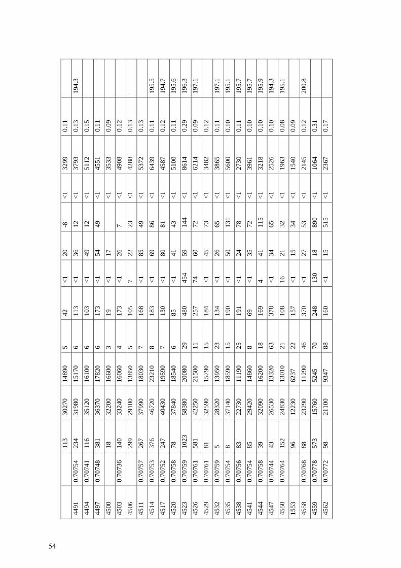
11
3
30
270
1
48
90
5
42
<1
2
0
-8
<1
3
29
9
0.1
1
44
91
0.7
075
4
23
4
31
980
1
51
70
6
11
3
<1
3
6
12
<1
3
79
3
0.1
3
19
4.3
44
94
0.7
074
1
11
6
35
120
1
61
00
6
10
3
<1
4
9
12
<1
5
11
2
0.1
5
44
97
0.7
074
8
38
1
36
370
1
78
20
6
17
3
<1
5
4
49
<1
4
55
1
0.1
1
45
00
1
8
32
200
1
66
00
3
19
<1
1
7
<
1
35
33
0.0
9
45
03
0.7
073
6
14
0
33
240
1
60
60
4
17
3
<1
2
6
7
<1
4
90
8
0.1
2
45
06
2
99
29
100
1
38
50
5
10
5
7
22
23
<1
4
28
8
0.1
3
45
11
0.7
075
7
26
7
37
990
1
80
30
7
16
8
<1
8
5
49
<1
5
37
2
0.1
3
45
14
0.7
075
3
37
6
46
720
2
32
10
8
18
3
<1
6
9
86
<1
6
43
9
0.1
1
19
5.5
45
17
0.7
075
2
24
7
40
430
1
95
90
7
13
0
<1
8
0
81
<1
4
58
7
0.1
2
19
4.7
45
20
0.7
075
8
78
37
840
1
85
40
6
85
<1
4
1
43
<1
5
10
0
0.1
1
19
5.6
45
23
0.7
075
9
10
23
58
380
2
00
80
29
48
0
45
4
59
14
4
<1
8
61
4
0.2
9
19
6.3
45
26
0.7
076
1
58
1
42
250
2
15
00
11
25
7
74
60
72
<1
6
21
4
0.0
9
19
7.1
45
29
0.7
076
1
81
32
590
15
790
15
18
4
<1
4
5
73
<1
3
48
2
0.1
2
45
32
0.7
075
9
5
28
320
1
39
50
23
13
4
<1
2
6
65
<1
3
86
5
0.1
1
19
7.1
45
35
0.7
075
4
8
37
140
1
85
90
15
19
0
<1
5
0
13
1
<1
5
60
0
0.1
0
19
5.1
45
38
0.7
075
6
83
22
730
1
11
90
25
19
1
<1
2
4
78
<1
2
73
0
0.1
1
19
5.7
45
41
0.7
075
4
85
29
420
1
48
60
8
69
<1
3
5
72
<1
3
96
1
0.1
0
19
5.7
45
44
0.7
075
8
39
32
090
1
62
00
18
16
9
4
41
11
5
<1
3
21
8
0.1
0
19
5.9
45
47
0.7
074
4
43
26
530
1
33
20
63
37
8
<1
3
4
65
<1
2
52
6
0.1
0
19
4.3
45
50
0.7
076
4
15
2
24
830
1
30
10
21
10
8
16
21
32
<1
1
96
3
0.0
8
19
5.1
15
53
9
6
12
230
6
23
7
22
15
7
<1
1
5
34
<1
1
54
0
0.0
9
45
58
0.7
076
8
88
23
290
1
12
90
46
37
0
<1
2
7
53
<1
2
14
5
0.1
2
20
0.8
45
59
0.7
077
8
57
3
15
760
5
24
5
70
24
8
13
0
18
89
0
<1
1
06
4
0.3
1
45
62
0.7
077
2
98
21
100
9
34
7
88
16
0
<1
1
5
51
5
<1
2
36
7
0.1
7
54

45
65
0.7
076
9
43
6
25
920
1
50
00
92
22
8
11
17
12
4
<1
2
85
2
0.0
3
45
68
6
1
34
090
1
65
30
19
88
<1
4
9
20
5
<1
4
55
7
0.1
2
45
71
8
5
30
750
1
55
60
96
25
8
<1
1
9
13
8
<1
3
59
9
0.1
0
45
77
6
1
31
240
1
38
40
78
70
8
1
21
11
0
<1
3
35
9
0.1
7
45
80
4
8
47
050
1
56
80
80
65
8
<1
3
7
11
0
<1
5
63
9
0.3
1
45
83
1
8
87
990
3
25
9
89
32
7
<1
2
22
17
7
<1
9
91
5
0.8
9
45
86
1
0
74
430
1
49
1
82
32
3
<1
1
41
71
<1
8
38
1
0.9
4
45
89
2
6
97
450
1
12
3
42
26
9
<1
1
51
68
<1
1
15
57
0.9
7
45
92
4
2
90
990
2
29
8
48
34
7
<1
1
83
21
5
<1
1
06
37
0.9
3
45
98
3
9
79
890
4
73
9
44
26
8
<1
9
5
18
5
<1
1
02
44
0.8
3
46
01
3
9
95
840
1
10
4
63
27
9
<1
1
42
15
1
<1
1
16
59
0.9
7
46
05
5
5
65
450
4
95
2
31
33
5
<1
9
7
12
5
<1
7
56
9
0.7
9
46
08
8
9
29
570
1
38
20
8
65
<1
3
5
55
<1
3
57
8
0.1
4
46
11
2
4
90
070
9
95
57
21
5
<1
1
11
76
<1
1
04
45
0.9
7
46
15
1
6
92
640
1
12
5
38
29
7
<1
1
74
51
<1
1
04
87
0.9
6
46
18
7
6
89
070
1
98
0
51
28
2
<1
1
28
16
3
<1
1
01
33
0.9
3
46
21
7
1
24
150
1
11
70
10
18
1
<1
1
9
37
7
<1
3
71
5
0.1
4
46
24
5
9
83
70
1
29
6
40
25
8
39
12
3
10
9
<1
1
11
67
0.9
6
46
27
4
6
79
330
2
54
5
28
33
3
<1
1
14
34
7
<1
8
69
2
0.9
1
46
30
-6
9
59
70
9
12
28
11
8
<1
1
46
75
<1
9
95
1
0.9
7
46
33
3
8
61
810
2
63
4
22
16
8
<1
9
5
42
4
<1
6
82
0
0.8
8
46
36
4
0
95
180
1
10
5
18
10
1
<1
1
00
92
<1
1
08
50
0.9
7
46
39
3
1
93
140
1
09
3
33
43
1
<1
1
23
26
4
<1
1
00
62
0.9
6
46
42
5
0
66
580
7
48
7
25
28
2
<1
6
8
29
7
<1
7
72
1
0.7
0
46
45
3
1
90
130
2
40
7
25
12
6
<1
1
41
15
2
<1
9
87
3
0.9
2
55

46
48
9
8
95
90
1
20
1
23
77
<1
1
59
70
<1
9
35
7
0.9
6
46
51
2
1
92
860
1
08
1
10
56
<1
1
66
33
<1
9
14
5
0.9
7
46
54
3
1
98
620
1
23
6
28
16
5
<1
1
94
25
9
<1
1
13
32
0.9
6
46
57
4
4
30
960
1
35
50
77
69
8
<1
2
1
11
1
<1
4
02
7
0.1
7
46
60
98
050
1
14
6
13
70
<1
2
11
31
<1
1
03
01
0.9
7
46
63
90
850
2
75
2
16
41
<1
8
3
22
<1
9
26
5
0.9
1
46
66
1
7
95
170
1
72
8
13
42
<1
2
04
14
3
<1
1
10
17
0.9
5
Note
: th
e er
ror
on t
he
assi
gned
age
is e
stim
ate
to b
e 0.7
5 M
a.
56

תקציר
יורא בתת הקרקע של מערב צפון -המטרה העיקרית של מחקר זה הייתה לאפיין את המעבר טריאס
ובמידת האפשר לשייך גילים ישראל בעזרת ביוסטרטיגרפיה, סביבות השקעה, תהליכים דיאגנטיים
–מעבר טריאסשניים מהם ב. שלושה קידוחים נבחרו למחקר; Srנומריים בעזרת כרונוסטרטיגרפיה של
(, וקידוח אחד ללא 1ואשר עתלית 3 הו)אלי בסביבת המעבר פעילות וולקניתל יורא מכיל עדויות ישירות
שה הניסיון האזורי הראשון להגדיר את בעבודה זו נע(. 2געש ) במעבר שום עדות לפעילות וולקנית
, מעוגנים ע"י 87Sr/86Srכרונוסטרטיגרפיה של יחסי יורא בתת הקרקע של צפון ישראל ע"י-מעבר טריאס
שקפי סלע של מטחני קידוח 240ביוסטרטיגרפיה כאשר ניתן. מיקרופאליאונטולוגיה ומיקרופציאסים של
דוגמאות מטחן 140. בנוסף, CLוסקופים של אור חודר ו מהאינטרוולים הרלוונטיים נבחנו תחת מיקר
יחד עם הגדרת אלמנטים 87Sr/86Sr ימאותם אינטרוולים עברו אנליזה להגדרת יחס שלמות שהוצאו
Srאחת המסקנות העיקריות של עבודה זו היא כי ניתן בהחלט ליישם סטרטיגרפיית עיקריים וקורט בהם.
על חומר מקידוחים עם הזהירות הראויה כאשר מחשבים את הגיל לפיה.
מ', מעל הפאזה הוולקנית העיקרית, והיחידות 2855יורא מוקם בעומק -, מעבר טריאס3 הובקידוח אלי
הקרבונטיות המתחלפות עם וולקנים ומעל בסיס תצורת נירים )בתוך החלק הדולומיטי התחתון(; בכך
ליורא תחתון. ליחסהלקנית בעיקרה כטריאסית ללא פעילות וולקנית מאוחרת שניתן הוגדרה הפאזה הוו
-מ', אך המעבר טריאס 4532מ.ש.( בעומק 197, התוצאות העלו גילים של יורא תחתון )2בקידוח געש
.עדין יורא לא אובחן
סביבה ריפית עם הוולקנים אינטרוול קרבונטי המכיל עדויות ל בסיס, נמצאה מעל 1בקידוח אשר עתלית
פורמיניפרים טריאסיים, המחזק את הקשר בין האירועים הוולקנים להופעה של המערכת הריפית. על
שוב.בסיס הביוסטרטיגרפיה, גבול טריאס יורא צריך להיות גבוה בהרבה ממה שהיה מקובל לח
ום הדוגמאות במשך נכשלה בחיזוי גילים של קרבונטים בסביבה וולקנית, יתכן עקב זיה Srסטרטיגרפיית
השנים אך בהחלט יתכן שנוכחות הוולקנים שינתה יחס האיזוטופים במי החללים בעת השקעת הצמנטים
בהם.
מראה מעבר טיפוסי של 2וגעש 3המעבר של הטריאס העליון אל תוך היורא התחתון בקידוחי אליהו
לופין עם סביבות אואואידיות סביבת השקעה פרוקסימלית קרבונטית רדודה שהכילה מרבדי אצות לחי
לפני, במשך ואחרי המעבר בין התקופות. תצפיות אלו דומות להופעה הנרחבת של גיר סטרומטוליטים
הרדודים. התטיס אזורישל פנים המדף הקרבונטי שאפיין את הטריאס העליון של האלפים ושאר
יורא, ללא פער -יאסהפלטפורמה הקרבונטית הרדודה שהתקיימה בקנה מידה נרחב במעבר טר
סטרטיגרפי ניכר )נכון לעבודה זו( מאשר בעיקר שאזורית המעבר טריאס יורא התרחש דווקא תחת
מתקופת מתיחה אקטיבית לפאזת שקיעה פסיבית של שולי שקט טקטוני ווולקני, והא כנראה מציין מעבר
(.saggingיבשת )

משרד התשתיות הלאומיות האנרגיה והמים
המכון הגיאולוגי
בסביבה בתת הקרקע של צפון ישראל, יורא -מאפייני מעבר טריאס
קרבונטית תחת השפעה וולקנית: סביבות השקעה, היסטוריה דיאגנטית
Srוהכרונוסטרטיגרפיה של
דורית קורנגרין ויהודית הר לבן
Report GSI/08/2016 2016 ינואר, ירושלים