Embed Size (px)
Citation preview

Town of Labrador City Muncipal Plan 2016-2026
Prepared By:
LABRADOR CITY MUNICIPAL PLAN
Table of Contents
1 INTRODUCTION ............................................................................................................. 1
1.1 PURPOSE OF THE MUNICIPAL PLAN................................................................................. 1
1.2 PLAN PREPARATION .......................................................................................................... 1 1.2.1 Changes to the Municipal Plan .................................................................... 1 1.2.2 Aligning with Other Plans ............................................................................... 2 1.2.3 Public Review/Consultation .......................................................................... 3
2 COMMUNITY BACKGROUND INFORMATION .............................................................. 4
2.1 INTRODUCTION .................................................................................................................. 4 2.1.1 History & Planning Context ............................................................................ 4 2.1.2 Economy .......................................................................................................... 4
2.2 CONSTRAINTS AND OPPORTUNITIES ................................................................................ 5 2.2.1 Labrador City Constraints .............................................................................. 5 2.2.2 Land Ownership .............................................................................................. 5 2.2.3 Land Suitability ................................................................................................ 5 2.2.4 Mineral Buffers ................................................................................................. 5 2.2.5 Environmental Protection .............................................................................. 6 2.2.6 Protected Watershed Area ........................................................................... 6 2.2.7 Protected Municipal Watershed Area ........................................................ 6 2.2.8 Municipal Wetland Stewardship Agreement ............................................. 6 2.2.9 Habitat Management Unit ............................................................................ 6
2.3 POTENTIAL FOR GROWTH ................................................................................................. 8 2.3.1 Population ....................................................................................................... 8 2.3.2 Uncertainty & Temporary Growth ................................................................ 9
2.4 LAND USE DEMAND .......................................................................................................... 9 2.4.1 Residential ....................................................................................................... 9 2.4.2 Commercial .................................................................................................. 11 2.4.3 Industrial ......................................................................................................... 11 2.4.4 Recreation ..................................................................................................... 11 2.4.5 Public Use ....................................................................................................... 11
2.5 MUNICIPAL SERVICES ...................................................................................................... 12 2.5.1 Public Works .................................................................................................. 12 2.5.2 Solid Waste Management .......................................................................... 13 2.5.3 Fire Protection Services ................................................................................ 13
2.6 TRANSPORTATION ........................................................................................................... 13 2.6.1 Air Transportation .......................................................................................... 13 2.6.2 Railway ........................................................................................................... 13 2.6.3 Highways and Road Network ..................................................................... 14 2.6.4 Alternative Transportation ........................................................................... 14 2.6.5 Snowmobiling & Winter Trails ....................................................................... 14
2.7 ENVIRONMENT & ENVIRONMENTAL PROTECTION ...................................................... 16 2.7.1 General Description ..................................................................................... 16 2.7.2 Subsistence Activity and Land Use ............................................................ 16

LABRADOR CITY MUNICIPAL PLAN
2.7.3 Climate Change ........................................................................................... 16 2.7.4 Wetland Stewardship Areas ........................................................................ 17
2.8 MUNICIPAL FINANCE ...................................................................................................... 17 2.8.1 Tax base and Budget ................................................................................... 17 2.8.2 Expenditures .................................................................................................. 17
3 REGIONAL VISION AND SHARED PLANNING PRINCIPLES ......................................... 18
3.1 VISION ............................................................................................................................... 18
3.2 GUIDING PRINCIPLES ...................................................................................................... 18 3.2.1 Embrace the Principles of Smart Growth .................................................. 18 3.2.2 Foster Attractive Communities with a Strong Sense of Place ................ 18 3.2.3 Encourage Shared Resources and Services between Labrador
City and Wabush .......................................................................................... 18 3.2.4 Intensify and Strengthen the Town Centres .............................................. 19 3.2.5 Create Walkable Neighbourhoods ........................................................... 19 3.2.6 Provide a Variety of Transportation Choices ............................................ 19 3.2.7 Protect Natural Areas .................................................................................. 19 3.2.8 Embrace the Winter City ............................................................................. 19 3.2.9 Strengthen Community Engagement ....................................................... 19 3.2.10 Enhance Community Identity ..................................................................... 19 3.2.11 Ensure a Safe Community ........................................................................... 19 3.2.12 Support a Diverse Economy ........................................................................ 19
4 GENERAL LAND USE INTENT AND POLICIES ................................................................ 20
4.1 GENERAL INTENT .............................................................................................................. 20 4.1.1 Urban Containment Boundary ................................................................... 20 4.1.2 Compact Town Centre ............................................................................... 20 4.1.3 Connected, Walkable and Active Streetscapes .................................... 20 4.1.4 Housing Variety and Increased Density .................................................... 20 4.1.5 Environment................................................................................................... 20
4.2 GENERAL POLICIES .......................................................................................................... 21 4.2.1 Growth Strategy ............................................................................................ 21 4.2.2 Town Land Use .............................................................................................. 21 4.2.3 Non-Conforming Uses .................................................................................. 22 4.2.4 Infill Development ......................................................................................... 22 4.2.5 Backlot Development .................................................................................. 22 4.2.6 Development Design ................................................................................... 23 4.2.7 Subdivision Policies ....................................................................................... 23 4.2.8 Building Setbacks .......................................................................................... 23 4.2.9 Development Criteria for Non-Residential Sites ....................................... 24 4.2.10 Public Land Use Dedication ........................................................................ 24 4.2.11 Protection of Archaeological Sites ............................................................ 25 4.2.12 Environmental Preservation and Enhancement ...................................... 25 4.2.13 Habitat Management Plan ......................................................................... 26 4.2.14 Upgrading of Municipal Services ............................................................... 27

LABRADOR CITY MUNICIPAL PLAN
4.2.15 Municipal and Public Utility Works and Easements ................................. 28 4.2.16 Soils and Drainage ....................................................................................... 28 4.2.17 Access to a Public Street ............................................................................. 28 4.2.18 Property Maintenance ................................................................................ 28 4.2.19 Referral of Applications ............................................................................... 28
5 LAND USE ..................................................................................................................... 29
5.1 LAND USE DESIGNATIONS .............................................................................................. 29
5.2 RESIDENTIAL ..................................................................................................................... 29 5.2.1 Residential Medium Density ........................................................................ 30 5.2.2 Residential Small Lot ..................................................................................... 30 5.2.3 Cabin Development .................................................................................... 30 5.2.4 Residential Land Use Development Policies ............................................. 30
5.3 COMMERCIAL ................................................................................................................. 32 5.3.1 Commercial General ................................................................................... 33 5.3.2 Commercial Highway .................................................................................. 33 5.3.3 Commercial General and Highway Land Uses Development
Policies ............................................................................................................ 33 5.3.4 Core Commercial Development and Design Standards ....................... 34
5.4 INDUSTRIAL ....................................................................................................................... 36 5.4.1 Light Industrial ................................................................................................ 36 5.4.2 General Industrial ......................................................................................... 37 5.4.3 Industrial Land Use Development Policies ................................................ 37
5.5 OPEN SPACE .................................................................................................................... 39 5.5.1 Open Space .................................................................................................. 39 5.5.2 Open Space Buffer ...................................................................................... 39 5.5.3 Open Space Land Use Development Policies ......................................... 40
5.6 MINERAL RESOURCE ....................................................................................................... 40 5.6.1 Mineral Workings ........................................................................................... 41 5.6.2 Mining Reserve .............................................................................................. 41 5.6.3 Mining Land Use Development Policies .................................................... 41
5.7 PUBLIC USE ....................................................................................................................... 42 5.7.1 Public Use ....................................................................................................... 42 5.7.2 Public Use Land Use Development Policies .............................................. 43
5.8 CONSERVATION .............................................................................................................. 43 5.8.1 Conservation ................................................................................................. 44 5.8.2 Conservation Land Use Development Policies ........................................ 44
5.9 PROTECTED WATERSHED ................................................................................................ 45 5.9.1 Protected Watershed Land Use Development Policies .......................... 45
6 INFRASTRUCTURE ......................................................................................................... 47
6.1 GENERAL POLICIES .......................................................................................................... 47
6.2 TRANSPORTATION POLICIES ........................................................................................... 47
6.3 SANITARY SEWER SYSTEM................................................................................................ 48
6.4 WATER SYSTEMS ............................................................................................................... 48
LABRADOR CITY MUNICIPAL PLAN
6.5 STORM SEWER SYSTEM .................................................................................................... 48
7 GOVERNANCE ............................................................................................................ 49
7.1 SHARE INFRASTRUCTURE ................................................................................................. 49
7.2 SHARED SERVICES ........................................................................................................... 49
7.3 SHARED BRANDING AND IDENTITY ................................................................................ 49
8 ECONOMY .................................................................................................................. 50
8.1 DEVELOPMENT POLICIES ................................................................................................ 50
9 IMPLEMENTATION ........................................................................................................ 51
9.1 DEVELOPMENT PROPOSALS ........................................................................................... 51
9.2 DEVELOPMENT REGULATIONS ....................................................................................... 52
9.3 GENERAL REGULATIONS ................................................................................................. 52
9.4 GENERAL DEVELOPMENT STANDARDS ......................................................................... 52
9.5 ADVERTISEMENTS ............................................................................................................. 52
9.6 SUBDIVISION OF LAND .................................................................................................... 52
9.7 LAND USE ZONES ............................................................................................................. 52
9.8 CAPITAL WORKS PROGRAM .......................................................................................... 53
9.9 DEVELOPMENT CONTROL .............................................................................................. 53
9.10 ADOPTION OF DEVELOPMENT SCHEMES ..................................................................... 54
9.11 MUNICIPAL PLAN AMENDMENT PROCEDURE.............................................................. 54
LABRADOR CITY MUNICIPAL PLAN – DRAFT #2
1
1 INTRODUCTION
This document and the Future Land Use Map comprise the Municipal Plan of the Town of Labrador
City (the Municipal Plan). The Municipal Plan is a legal document and is binding on Council and
any person or group using or proposing to use land within the Planning Area as illustrated on the
Future Land Use Map. The Municipal Plan is developed under the Urban and Rural Planning Act,
2000 and repeals and replaces the Town of Labrador City Municipal Plan 2007-2017.
1.1 PURPOSE OF THE MUNICIPAL PLAN
A Municipal Plan guides growth and development within a planning area. It provides a means of
preventing incompatible land uses, it directs future growth to ensure the use of municipal services
and land resources efficiently and it considers aspects of land development like safety, aesthetics,
and environmental protection.
1.2 PLAN PREPARATION
The Municipal Plan was prepared as per the requirements of Section 13 of the Urban and Rural
Planning Act, SN, 2000. It governs development within the Planning Area, including future land
use, streets, water supply, sewage disposal, public buildings, schools, parks, recreation areas, and
other public requirements. The Municipal Plan provides the basis for the Development Regulations,
which Council will administer through development and subdivision control.
1.2.1 Changes to the Municipal Plan
The Municipal Plan and Development Regulations update process was conducted by planners
with Stantec Consulting Ltd. between [DATE] and [DATE]. The Municipal Plan update for Labrador
City was an opportunity to implement the regional plan for Labrador West known as Plan BIG. This
included the opportunity to get both communities working together toward shared goals
identified in Plan BIG while streamlining local policies to promote good development within the
region. Specifically, Labrador West Regional Growth Strategy (Plan BIG) identified opportunities in
community planning to make responsive policies to mitigate the boom and bust cycle that
characterizes the region’s resource-based economy and protect the built integrity of its
communities.

LABRADOR CITY MUNICIPAL PLAN – DRAFT #2
2
1.2.2 Aligning with Other Plans
In addition to Plan BIG, other plans considered in the update of the Municipal Plan and
Development Regulations include:
Municipal Documents:
• Town of Labrador City Municipal Plan and Development Regulations, 2007-2017
• Town of Wabush Municipal Plan and Development Regulations, 2004-2014
• Labrador City Municipal Budget Submission Forms and Auditor’s Reports, 2009-2014 and
2014-2016
• Wabush Municipal Budget Submission Forms and Auditor’s Reports, 2009-2014 and 2014-
2016
• Wabush Building Permit Records, 2011-2014
• Labrador City Building Permit Records, 2008-2014
• Town of Labrador City Emergency Management Plan, April 24, 2012
• Town of Labrador City and Town of Wabush Integrated Community Sustainability Plan,
Plan-tech Environment, March 2010
• Labrador West Recreation & Parks Master Plan for the Labrador West Region, July 2011
Development Plans:
• Wabush Business Park Phase II, Tract Consulting, March 2014
• Jean Lake Subdivision Expansion, Tract Consulting, March 2014
• Osprey Landing Residential Development, Labrador City, Clayton Development
• Labrador City Business Park Master Plan, Stantec Consulting
• Airport Masterplan: Wabush Airport, Genivar & WHW Architects, November 23, 2012
Studies and Reports:
• Economic Impact Analysis of Iron Ore Mining Industry in Labrador 2011-2031, Dr. Wade
Locke and Strategic Concepts Inc., September 24, 2012
• Labrador West Community Investment Strategies, Amec, June 1, 2006
• Water and Wastewater Infrastructure Assessment: Wabush, CBCL Consulting Engineers,
December 20, 2013
• Labrador West Multi-Use Complex: Feasibility Study, dmA Planning & Management
Services, July 2013
• Labrador West Mapping Exercise, Department of Natural Resources, 2012
• Iron Ore Company of Canada Expansion Projects Traffic Studies, Amec, December 2012
• Collection of Baseline Traffic Data for Labrador City and Wabush, OPEC International
Consultants, December 7, 2011

LABRADOR CITY MUNICIPAL PLAN – DRAFT #2
3
1.2.3 Public Review/Consultation
The public consultation process for this plan began with the Labrador West Regional Growth
Strategy (Plan BIG), which involved 14 different public events alongside a website and social
media. The process included events for children, stakeholders, and four public open houses
commenting on the Background Report, Vision Statement, Alternative Scenarios, and Regional
Growth Strategy and Implementation Plan. The consultation events spanned from January 14,
2014, to January 21, 2015, with events in both Labrador City and Wabush throughout the one-year
consultation period. The Municipal Plan was created using the feedback, vision, and policies
outlined in Plan BIG.
As per section 14 of the Urban and Rural Planning Act, 2000, during the preparation of a plan and
development regulations, an opportunity for interested persons, community groups,
municipalities, local service districts, is required. The existing Facebook page and 420 followers
were used to create a new Municipal Plan Engagement Website. A community meeting is
planned for January 2017 to consult on the Draft Plan.
LABRADOR CITY MUNICIPAL PLAN – DRAFT #2
4
2 COMMUNITY BACKGROUND INFORMATION
2.1 INTRODUCTION
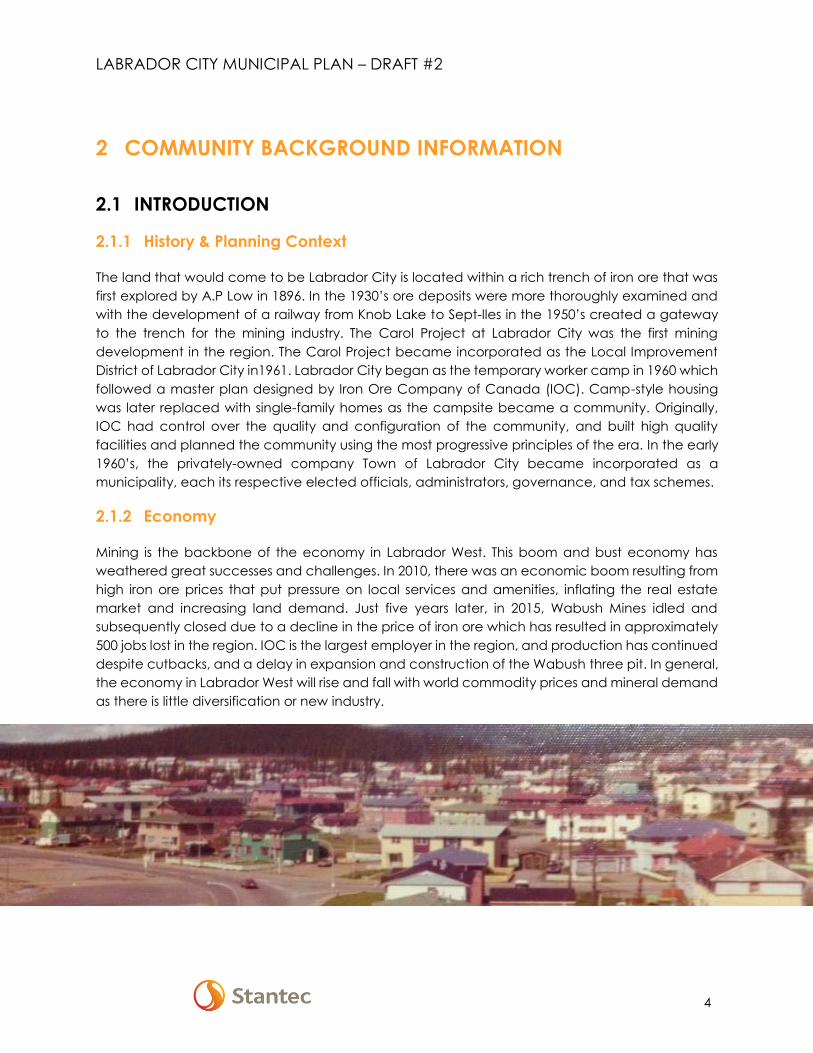
2.1.1 History & Planning Context
The land that would come to be Labrador City is located within a rich trench of iron ore that was
first explored by A.P Low in 1896. In the 1930’s ore deposits were more thoroughly examined and
with the development of a railway from Knob Lake to Sept-Iles in the 1950’s created a gateway
to the trench for the mining industry. The Carol Project at Labrador City was the first mining
development in the region. The Carol Project became incorporated as the Local Improvement
District of Labrador City in1961. Labrador City began as the temporary worker camp in 1960 which
followed a master plan designed by Iron Ore Company of Canada (IOC). Camp-style housing
was later replaced with single-family homes as the campsite became a community. Originally,
IOC had control over the quality and configuration of the community, and built high quality
facilities and planned the community using the most progressive principles of the era. In the early
1960’s, the privately-owned company Town of Labrador City became incorporated as a
municipality, each its respective elected officials, administrators, governance, and tax schemes.
2.1.2 Economy
Mining is the backbone of the economy in Labrador West. This boom and bust economy has
weathered great successes and challenges. In 2010, there was an economic boom resulting from
high iron ore prices that put pressure on local services and amenities, inflating the real estate
market and increasing land demand. Just five years later, in 2015, Wabush Mines idled and
subsequently closed due to a decline in the price of iron ore which has resulted in approximately
500 jobs lost in the region. IOC is the largest employer in the region, and production has continued
despite cutbacks, and a delay in expansion and construction of the Wabush three pit. In general,
the economy in Labrador West will rise and fall with world commodity prices and mineral demand
as there is little diversification or new industry.

LABRADOR CITY MUNICIPAL PLAN – DRAFT #2
5
2.2 CONSTRAINTS AND OPPORTUNITIES
The availability of land is vital to the health, growth, and sustainability of Labrador City. Change
and growth are hindered when land is scarce and opportunities cannot be realized. The
availability and suitability of land is vital to support industry, commerce, and all those amenities
and necessities of life that create communities in which people chose to live, to raise families and
to retire.
2.2.1 Labrador City Constraints
The Town has been built upon ore deposits and may be considered for active mining sometime in
the future; however, the Town has progressed beyond a mining Town. Mineral Activity surrounding
the Town and both Little Wabush and Harrie Lakes to the south, the Town of Labrador City is
confined to its existing administrative footprint or a reduced footprint. There are several areas
within the Town which could be suitable for infill development, but these parcels of land either
privately owned or may require subdivision.
2.2.2 Land Ownership
Although various tracts of land seem available for potential land use activities, many of the larger
parcels more suited to development, are in fact privately owned. The municipality is in ongoing
negotiations for the sale or conveyance of lands. Smaller parcels of land, such as the rear yards
of block housing are also owned by IOC and Wabush mines. In Labrador City, this network of
green space has been eroded by the extension of residential uses to develop sheds, garages,
and private gardens.
2.2.3 Land Suitability
When assessing land availability, land suitability is also considered. Constraints to growth and
development are multiple and layered. Major constraints include: mineral pits, buffers and
tenures, rural zoning, environmental protection, protected watershed areas, and habitat
management units. The overlaying of regional constraints identifies sites for potential infill within
the municipal boundaries of Labrador City. Criteria such as size, slope, geology, water, proximity
to infrastructure, ecological value, and other site analysis tools must be applied to the lands which
are not impacted by major constraints in the next phases of the project.
2.2.4 Mineral Buffers
Mineral buffers limit development opportunities for housing and other land use activities. The
constraints include land ownership and uncertainty of future mining activities.
LABRADOR CITY MUNICIPAL PLAN – DRAFT #2
6
2.2.5 Environmental Protection
Development is not allowed in environmentally sensitive areas such as shorelines, waterways,
steep slopes, drainage areas and bogs.
2.2.6 Protected Watershed Area
Residential development of 4 or more lots; vehicle maintenance facilities, warehouses; service
stations; industries; and storage of chemicals or salt are not permitted in the large protected
watershed areas as shown on the Future Land Use Map. The Department of Environment and
Conservation regulate all activities.
2.2.7 Protected Municipal Watershed Area
Any application for development may be referred to the Water Resources Division of Department
of Environment and Conservation for comments and recommendations to protect the water
quality and integrity.
2.2.8 Municipal Wetland Stewardship Agreement
This area protects significant wetlands and waterfowl habitat and prior to approving a
development within the Stewardship Zone Council will refer application to Department of
Environment and Conservation, Wildlife Division for review. Council may establish mitigation
techniques to be used by the developer to reduce any habitat degradation.
2.2.9 Habitat Management Unit
Land in the Habitat Management Unit requires a 15 metre buffer from the high water mark along
shorelines of ponds, rivers or identified wetlands. Any proposal for development will be sent to
Wildlife Division Department of Environment and Conservation for review.

LABRADOR CITY MUNICIPAL PLAN – DRAFT #2
7
Planning Boundary
Study Area – 13 km Radius
Low Suitability
Figure 1 Labrador West Land Suitability Analysis
Source: Plan BIG

LABRADOR CITY MUNICIPAL PLAN – DRAFT #2
8
2.3 POTENTIAL FOR GROWTH
2.3.1 Population
Historic and current population demographics as well as the population projection is shown in the
table below. The population projection based on the 2006 to 2011 shows moderate growth, which
is cause for optimism in Labrador West. This moderate growth (2.8% increase in the local
population) reflects the continuation of the positive trend for the local iron ore industry. Population
growth was experienced in 2006 to 2011 and from 1986 to 1991 the Towns grew by 0.8%. However,
the population has generally been in decline in Labrador City and Wabush since their
establishment in the 1960s. It is likely that population trends in Labrador City will result in a significant
reduction in population to approximately 5,000 people by the end of the 10-year planning cycle.
For Labrador West to sustain growth over the 20 years from 2011 to 2031, the region will require
stable or growing demand for iron ore and/or growth of other sectors within the Labrador West
economy. One possibility might be to cultivate Labrador West as a regional centre to serve a
growing mining region.
1996 2001 2006 2011 2016 2021 2026 2031 2036
Based on 1996-2011
Lab West 10,490 9,630 8,995 9,210 8,025 7,330 6,725 6,370 5,835
Lab City 8,460 7,745 7,245 7,360 6,405 5,610 5,045 4,710 4,240
Based on 2006-2011
Lab West 10,490 9,630 8,995 9,210 9,250 9,485 9,610 9,650 9,885
Lab City 8,460 7,745 7,245 7,360 7,255 7,220 7,070 6,825 6,745
Based on 2001-2006
Lab West 10,490 9,630 8,995 9,210 8,225 7,285 6,410 5,540 4,975
Lab City 8,460 7,745 7,245 7,360 6,635 5,830 5,155 4,365 3,900
Figure 2 Population Projections Source: Plan BIG

LABRADOR CITY MUNICIPAL PLAN – DRAFT #2
9
2.3.2 Uncertainty & Temporary Growth
Due to the uncertain nature of the iron ore industry, it is essential for the region to be prepared for
sudden changes in the economy. Temporary growth or decline can have severe impacts on
industry, the municipalities, and their residents. A boom in the mining industry results in increased
land demand for residential and industrial demands as companies struggle to house employees
and build facilities to service the mineral industry. While many workers are housed in temporary
camp or hotel-style dwellings, booms can place pressure on the local housing market. The cycles
of boom and bust have historically happened on a 10-year cycle. The recent boom and
subsequent bust cycle has oversupplied the region with housing, while industrial land is still in
demand. It is important to identify land to meet potential temporary needs that does not impact,
as well as long-term sustainable growth. The image below shows potential regional population
decline and actual population growth due to fluctuations in the iron ore industry.
Figure 3 Potential population fluctuations from boom and bust scenarios
Source: Plan BIG
2.4 LAND USE DEMAND
2.4.1 Residential
Existing housing stock in Labrador City is the original housing from construction of worker’s housing
for IOC in the 1960’s, 70’s and 80’s. During the recent boom, many of these existing structures were
renovated, extending their lifespan, and increased the quality of the housing stock; however, in
general the stock is aging. The 2011 census indicates a total of 2,860 dwelling units. Half of the
existing dwellings are single detached family homes, while the other half of dwelling units are
categorized as row houses and duplexes (30%), or apartments (20%) which allows for a variety of
options to accommodate the population.

LABRADOR CITY MUNICIPAL PLAN – DRAFT #2
10
Most of the recent development has occurred to the west of the Town, with Osprey Ridge
development expanding the residential areas, and several hotels, camps, and apartments built
to meet the boom demand for temporary accommodations. The Osprey Ridge development has
a planned 196 dwelling units in a mix of single detached, apartments and duplexes. Since the
2011 census, 78 new dwellings, 138 apartments and 108 hotel/motel units were developed in
Labrador City. There have also been dwellings added within the Harrie Lake Subdivision.
With developments since 2011 not yet occupied, and the potential build-out of Osprey Ridge,
there should be more than sufficient residential land to accommodate future development. These
developments should not be started until there is sufficient demand, and although greenfield
developments have been planned, focus on infill and densification should take priority to reduce
infrastructure costs.
Infill and Densification
Labrador City offers significant unrealized opportunities for urban infill, secondary dwelling units
and granny flats to satisfy future residential development and demographic changes. This design
strategy can strengthen the core of the Town by maximizing opportunities for infill, revitalization,
and adaptive reuse while reducing the need to extend costly infrastructure. These can take the
form of mixed use developments, mid-rise condominium infill, accessory dwelling units, single-
detached redevelopments, conversions, and a variety of other measures that could help to
accommodate temporary demands, or changing needs for aging populations. The community
can enhance economic opportunities by encouraging denser building types, walkable
commercial areas, and revitalizing the centralized business district.
Temporary Camp Development
There may be a future need to accommodate fly-in fly-out workers for the construction of new
mines or large expansions. The mining companies and contractors are responsible to build camps
to house temporary workers; however, the Town can direct development towards ideal locations
for these camp sites. There are currently approximately 435 temporary camp rooms in Labrador
City.
LABRADOR CITY MUNICIPAL PLAN – DRAFT #2
11
Cabin Development
There is a demand for new cabin lots. The Towns of Wabush and Labrador City shall work with
Province to identify new cabin areas within the planning boundary. Cabin development is meant
to be seasonal and is non-serviced.
2.4.2 Commercial
The need for new commercial land is closely tied to the population change. Considering the
projected downturn in the economy, it is likely that minimal additional land will be required for
commercial uses during the term of this plan. Vacancies in existing commercial properties should
satisfy demand in Labrador City. Commercial demand is anticipated to have a five-year lag in
responding to growth for businesses to enter the market, purchase and develop land. With recent
layoffs in the mining sector, there has been an increase in the number of registered home based
businesses. Most commercial activity in Labrador City is within in the Town core.
2.4.3 Industrial
Unlike commercial land in Labrador City, the demand for industrial land has shown not to be solely
dependent on population increase. There continues to be inquiries for industrial land in Labrador
City despite the decline in the mining industry. The Town of Labrador City has completed the
concept design of a 27 ha industrial park to meet future light industrial demands. Data centres
are a potential growth area which could be accommodated within the park.
2.4.4 Recreation
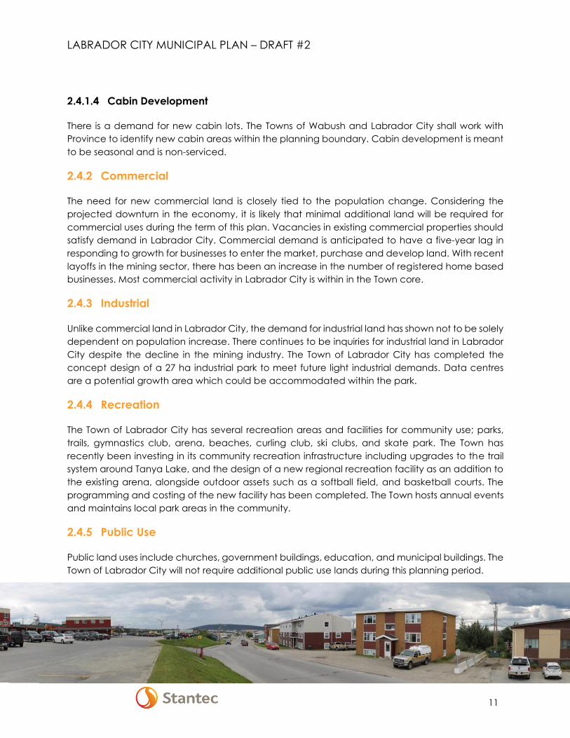
The Town of Labrador City has several recreation areas and facilities for community use; parks,
trails, gymnastics club, arena, beaches, curling club, ski clubs, and skate park. The Town has
recently been investing in its community recreation infrastructure including upgrades to the trail
system around Tanya Lake, and the design of a new regional recreation facility as an addition to
the existing arena, alongside outdoor assets such as a softball field, and basketball courts. The
programming and costing of the new facility has been completed. The Town hosts annual events
and maintains local park areas in the community.
2.4.5 Public Use
Public land uses include churches, government buildings, education, and municipal buildings. The
Town of Labrador City will not require additional public use lands during this planning period.

LABRADOR CITY MUNICIPAL PLAN – DRAFT #2
12
2.5 MUNICIPAL SERVICES
Much of the water distribution and waste water collection systems in Labrador City were
constructed in the 1960s and 1970s. The water distribution systems are primarily constructed of cast
iron pipe ranging in size from 100 mm to 400 mm. The waste water collection systems are primarily
constructed of asbestos cement pipe ranging in size from 200 mm to 450 mm. Based on the
construction period of construction much of this infrastructure is nearing the end of its service life.
Harrie Lake Waste Water Treatment Plant (WWTP): The Harrie Lake WWTP is a contact stabilization
package plant including an integral clarifier. Chlorine gas is used for disinfection. The plant is rated
at an average day flow 1,323 m3/d. While the tank and piping process infrastructure is in average
condition, the electrical and chlorination equipment are in very poor condition and require
upgrades. In 2016, improvements have been implemented to upgrade the system including the
construction of a new pre-engineered building, interior space development and building systems
to current applicable codes. Additional improvements are in process and scheduled for 2017.
Drake Waste Water Treatment Plant (WWTP): The Drake WWTP is a primary treatment plant that
consists of the following unit processes:
• Aerated grit removal
• Primary clarification
• Chlorine disinfection
• Aerobic digestion
• Sludge filter press
Based on limited flow data, the existing average daily flow experienced at the plant is
approximately 4,000 m3/day. The approved average daily flow in the operating permit is
8,172 m3/day. Based on a unit process evaluation from an earlier study, all unit processes are sized
to meet at least the permitted flow of 8,172 m3/day except for the chlorine and aerobic digestion
systems which can only accommodate average daily flows of 1,200 m3/day and 5,000 m3/day.
Therefore, these two processes will require upgrades in the future.
2.5.1 Public Works
Public Works are responsible for the following services; snow clearing, blackfly control program,
water and sewer mains and storm drain maintenance, land maintenance, street signage, street
and road maintenance and excess garbage collection, maintenance of vehicle fleet, building
maintenance, hydrant maintenance, delivery of clean safe drinking water, sewerage treatment
plant operation and maintenance.
LABRADOR CITY MUNICIPAL PLAN – DRAFT #2
13
2.5.2 Solid Waste Management
The former teepee incinerator and waste disposal site in the Town of Wabush has been closed
and the development of a newly engineered landfill in Labrador City has opened as a regional
facility.
2.5.3 Fire Protection Services
The Labrador City Fire Department is a composite department consisting of six fulltime staff
including the Fire Chief and twenty-eight dedicated volunteer firefighters. The fire station is staffed
twenty-four hours a day, seven days a week providing immediate response in fire protection to
residents and when required serve as back up to The Iron Ore Company of Canada and The Town
of Wabush.
2.6 TRANSPORTATION
2.6.1 Air Transportation
Air service connects to St. John’s,
Montreal, and Halifax oftentimes
with connections in Goose Bay.
The Wabush Airport also services
Labrador City and Fermont, and
sometimes provides connections
to Schefferville. Fly-in/fly-out
practices are a major factor for the
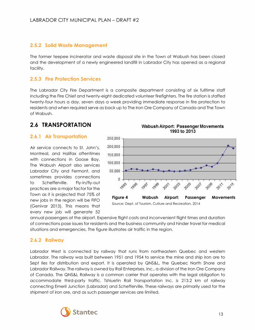
Town as it is projected that 75% of
new jobs in the region will be FIFO
(Genivar 2013). This means that
every new job will generate 52
annual passengers at the airport. Expensive flight costs and inconvenient flight times and duration
of connections pose issues for residents and the business community and hinder travel for medical
situations and emergencies. The figure illustrates air traffic in the region.
2.6.2 Railway
Labrador West is connected by railway that runs from northeastern Quebec and western
Labrador. The railway was built between 1951 and 1954 to service the mine and ship iron ore to
Sept Iles for distribution and export. It is operated by QNS&L, the Quebec North Shore and
Labrador Railway. The railway is owned by Rail Enterprises, Inc., a division of the Iron Ore Company
of Canada. The QNS&L Railway is a common carrier that operates with the legal obligation to
accommodate third-party traffic. Tshiuetin Rail Transportation Inc. is 213.2 km of railway
connecting Emeril Junction (Labrador) and Schefferville. These railways are primarily used for the
shipment of iron ore, and as such passenger services are limited.
Figure 4 Wabush Airport: Passenger Movements
Source: Dept. of Tourism, Culture and Recreation, 2014
LABRADOR CITY MUNICIPAL PLAN – DRAFT #2
14
2.6.3 Highways and Road Network
The Trans Labrador Highway and route 389 connect the region to Quebec and Eastern Labrador
by road. The roads connect Labrador West to Baie Comeau and Goose Bay with an 8-hour trip.
These routes are remote, with no communications infrastructure and limited rest and service areas.
Route 500 provides access to wilderness areas outside the region with popular areas for hunting,
fishing and winter activity.
The Trans Labrador Highway connects the Towns of Labrador City and Wabush via a bridge
crossing referred to as “The Narrows”. This bridge provides a motor vehicle connection between
Labrador City and Wabush. As there are currently no sidewalks, dedicated cycling lanes, or multi-
use pathways along this bridge connection this represents a large barrier to active modes of
travel. Through anecdotal observations it has been noted that this barrier is circumvented during
the winter months when snowmobile riders ride across the frozen Little Wabush Lake.
2.6.4 Alternative Transportation
To encourage the residents to use alternative transportation modes (i.e. cycling, walking,
snowmobiling etc.), the Towns of Wabush and Labrador City have provided numerous walking
trails, pathways, and snowmobile trails throughout the Towns. There is currently a project to
connect Labrador City to Wabush with a multi-use trail separating alternate modes from highway
traffic. There are sidewalks along one side of most the streets. More information on existing
alternative transportation networks and planned enhancements can be found in the Regional
Growth Strategy within the report titled ‘Labrador West 2040’.
2.6.5 Snowmobiling & Winter Trails
Snowmobiling is the most prevalent outdoor recreational activity in Labrador West. There is an
extensive trail network system maintained in Labrador and Quebec plus additional locations that
include frozen water bodies and other wilderness areas. Approximately 1,800 snowmobile trail
passes are usually issued for Labrador and 500 in Québec annually providing access to 800 km of
maintained trails in both provinces.
LABRADOR CITY MUNICIPAL PLAN – DRAFT #2
15
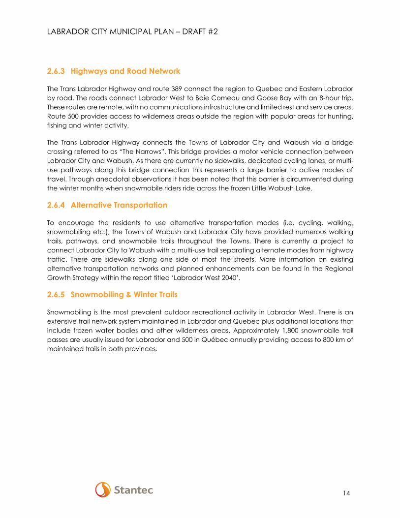
Figure 5 Transportation
Source: Plan BIG
LABRADOR CITY MUNICIPAL PLAN – DRAFT #2
16
2.7 ENVIRONMENT & ENVIRONMENTAL PROTECTION
2.7.1 General Description
Labrador West is within the mid-subarctic forest ecoregion referred to as Michikamau that
encompasses the upland plateaus of central and western Labrador. Eskers and drumlin ridges are
characteristic as the entire area was covered with ice during the last glaciation. Glacial till is the
most common surface material. Organic deposits (wetlands) from decaying plant materials
accumulate in poorly drained sites. These features are common in depressions overlying bedrock
and till or at the base of slopes. The continental subarctic climate has an average winter
temperature of -16.8⁰C and represents one of the coldest locations in the province. Average
monthly snow fall amount is 65.1 cm (Environment Canada 2012).
Black spruce is the dominant tree species with secondary occurrence of balsam fir, larch, white
birch and white spruce. Open lichen woodlands occur in dryer locations while extensive ribbed
fen-string bog complexes bordered by black spruce-sphagnum forest stands occur in areas with
less relief. Burns, particularly from recent fires such as the 1990s, cover large expanses of the
landscape. Wildlife in the area is typical of Labrador. Common mammals include black bear, red
fox, wolf, river otter, lynx, squirrel, ermine, porcupine, beaver and snowshoe hare. Western
Labrador is part of the Atlantic flyway for migratory waterfowl. Resource managers recognize two
groups: early- nesting dabbling ducks and geese and late-nesting sea ducks and diving ducks
that may vary in their annual life-cycle stages by several weeks.
2.7.2 Subsistence Activity and Land Use
Land-use interviews were conducted by Alderon (2012) which indicated extensive recreational
activity throughout the Labrador West area primarily by residents. Fishing within the municipal
boundaries occurs on many of the large water bodies including the Long Lake and Waldorf River
area, south along the Waldorf River to Swanson and Strawberry Lakes, the Riordan and Harrie
Lakes area, Rectangle Lake, and Wahnahnish Lake. Many of the preferred fishing locations are
situated close to existing access roads and travel corridors using a boat, or from shorelines during
ice-free conditions or through the ice during winter. Because of the number of cabins and land-
use activity, trapping tends to occur away from the communities. Berry picking is a popular
seasonal activity occurring near cabins and other accessible areas.
2.7.3 Climate Change
Climate change projections anticipate a doubling in the number of storms across the province by
2050 (NL 2013). These projections specifically reference an 11% increase in spring precipitation in
Labrador West that would influence vegetation cover and the associated fish, wildlife, and land
use activity in the region.

LABRADOR CITY MUNICIPAL PLAN – DRAFT #2
17
2.7.4 Wetland Stewardship Areas
Due in part to the industrial demands on land in the region and the abundance of suitable habitat
and use by migratory waterfowl, habitat conservation plans were developed for the Town of
Labrador City (2006) in cooperation with the Eastern Habitat Joint Venture (EHJV). The future
Habitat Management Plan will aim to restore, enhance, and/or protect the important wetlands in
Labrador City; promote a greater appreciation of wetlands and wetland values; and have
wetland values included in the municipal plan.
2.8 MUNICIPAL FINANCE
2.8.1 Tax base and Budget
Of the 25-million-dollar budget for 2016, a grant in lieu of the taxes from Rio Tinto (IOC) comprises
approximately 25% of revenue at just over six million. The municipality receives nearly half of its
revenue from its own sources, taxes, businesses and services, and government and other transfers
make up approximately 30% of revenue.
2.8.2 Expenditures
Municipal expenditures have doubled from 2009-2013, mainly due to capital expenditures.
Expenditures continue to increase from 2014 and 2016 by 24.4%. While municipal services have
increased at a steady rate of approximately 7.5% per year, fiscal services, which include debts
and capital expenditures, have increased much more rapidly, and have inflated municipal
expenditures.

LABRADOR CITY MUNICIPAL PLAN – DRAFT #2
18
3 REGIONAL VISION AND SHARED PLANNING PRINCIPLES
3.1 VISION
The Vision Statement was created through the Plan Big process.
We are collaborative. We are one region, working together on common ground.
We are young. Our history is still being created. We are forging our future.
We are adventurous. We are a frontier community with leading-edge possibilities.
We are permanent. We are here to stay, and everyone is welcome.
We are Labrador West.
Labrador West will become the quintessential sustainable northern community with dense, vibrant,
and walkable downtown Town centres, connected and diverse open space networks; a range
of active and passive park types; respect and appreciation for the lakes and lakeside resources;
a strong, diversified and self-sufficient local economy; engaged and responsive residents; a
resilient eco-tourism industry; and the ability to respond more rapidly to fluctuations in industrial
growth and decline.
3.2 GUIDING PRINCIPLES
The following principles will guide decision- making.
3.2.1 Embrace the Principles of Smart Growth
We will support the integration of residential and commercial land uses to achieve compact,
vibrant communities. We will encourage growth while containing sprawl.
3.2.2 Foster Attractive Communities with a Strong Sense of Place
New development and construction will respond to community values of architectural beauty
and distinctiveness, as well as expanded choices in housing and transportation.
3.2.3 Encourage Shared Resources and Services between Labrador City and
Wabush
The Towns of Wabush and Labrador City will collaborate and make decisions that enhance the
stewardship of resources and the development of opportunities considering the region.

LABRADOR CITY MUNICIPAL PLAN – DRAFT #2
19
3.2.4 Intensify and Strengthen the Town Centres
Encourage new development towards the existing Town centre.
3.2.5 Create Walkable Neighbourhoods
Compact and walkable new development in close proximity to existing amenities will be
encouraged.
3.2.6 Provide a Variety of Transportation Choices
Support choices in transportation where residents can walk, bike, blade, board, bus, or drive to
their destinations.
3.2.7 Protect Natural Areas
Protect nature, community watersheds, tributaries, and lakes. Areas of important and
representative significance will be preserved so that future development does not compromise
the beauty and functionality of existing natural systems.
3.2.8 Embrace the Winter City
Embrace the opportunities created by northern climates. Opportunities may include innovation
for snow removal, energy efficiency, design, outdoor sports such as hockey and cross-country
skiing, the use of ice and snow for art, winter festivals, and tourism opportunities.
3.2.9 Strengthen Community Engagement
We will engage often, and encourage community and stakeholder collaboration.
3.2.10 Enhance Community Identity
We will foster community identity in residents and visitors to create a connection to place.
3.2.11 Ensure a Safe Community
Interspersing residential populations throughout the Town makes all areas safer by encouraging
activity and interaction.
3.2.12 Support a Diverse Economy
Direct local investment toward diversification of the economy and encouragement of sustainable
local businesses.

LABRADOR CITY MUNICIPAL PLAN – DRAFT #2
20
4 GENERAL LAND USE INTENT AND POLICIES
4.1 GENERAL INTENT
The general intent of the Municipal Plan is to shape future land use and development in the
Planning Area using the regional vision and the guiding principles as presented in Section 3. The
growth in Labrador City shall consider the Labrador West Region and will focus on the following
general intent and land use policies:
4.1.1 Urban Containment Boundary
The urban containment boundary created through the Plan BIG process will discourage sprawl as
well as identify key areas where development should occur. Growth boundaries will support
nearby existing infrastructure and services while controlling expansion into greenfield lands and
will be frequently reassessed based on development requirements and demands, and to verify
development is occurring at an appropriate rate.
4.1.2 Compact Town Centre
Promote strategic infilling, additional density, street related development, and mixed use
development. Compact building design preserves space while encouraging buildings to better
utilize space and resources. Compact building design facilitates wider transportation options. The
Town Centre will include civic uses like libraries, civic centre, recreation complexes, Town halls, as
well as residential units above retail ground floors wherever possible. Offices and other institutional
uses should be encouraged in these core areas. Each Village Core will be programmed around
a central village core which would be a signature open space designed for every type of resident,
from young to old.
4.1.3 Connected, Walkable and Active Streetscapes
Ensure the streetscapes in the each of Town Centres are walkable, animated, furnished, and
branded. Sidewalks will be at least 8 feet wide and furnishings should include street trees, benches,
pedestrian scale lighting, banners, signage, and other urban amenities. Connect the Town
Centres by open space networks to other parks, gardens and natural areas surrounding the
community. Create opportunities for motorized and shared use trails for bicycles, snowmobiles,
ATVs, walkers, and joggers.
4.1.4 Housing Variety and Increased Density The Town Centre will provide a wide range of housing opportunities from small bachelor units, to
family units to townhomes and multi-unit condominiums and apartments. Single-family homes are
not well suited to the denser Town Centres.
4.1.5 Environment
Protected the limited land resources, the special places and enhance the quality of the built
environment. The policy of preserving the natural environment extends to all natural systems within

LABRADOR CITY MUNICIPAL PLAN – DRAFT #2
21
the Planning Area, including natural drainage systems, wetlands, bogs, wildlife, and plant and fish
habitats. The preservation of watercourses and shoreline areas are a priority within the Planning
Area.
4.2 GENERAL POLICIES
The land use policies set out in this section apply throughout the Planning Area, and are generally
applicable to more than one land-use designation.
4.2.1 Growth Strategy
It is the general policy of this plan to support development takes on a regional approach with
Labrador City and contributes to efficient growth of Wabush through infill, intensification, and
revitalization of existing buildings, infrastructure, and lands.
4.2.2 Town Land Use
Land uses are in accordance with the Future Land Use Map attached to this Municipal Plan. It is
the policy of Council to promote Labrador City as an attractive and healthy residential and
commercial community within the Labrador West Region.
Development within the Planning Area will be managed in accordance with the Development
Regulations, in concurrence with the policies, acts, and regulations of the Province.
Zone Abbreviation
Residential Medium Density RMD
Residential Small Lot RSL
Cabin Development CD
Commercial – General CG
Commercial - Highway CH
Commercial - Core CC
Industrial – General IG
Industrial – Light IL
Public Use PU
Open Space OS
Open Space Buffer OSB
Conservation CON
Protected Watershed PW
Mineral Workings MW
Mining Reserve - Rural MRR

LABRADOR CITY MUNICIPAL PLAN – DRAFT #2
22
4.2.3 Non-Conforming Uses
Nothing in the Municipal Plan shall affect the continuation of land uses that are lawfully
established on the date that the Municipal Plan comes into effect. Where a building or use that
does not comply with the intent of the Municipal Plan legally exists, it shall not be substantially
expanded. Minor extensions may be approved provided there will be no adverse effects on
surrounding properties or the environment, and the application is consistent with the Urban and
Rural Planning Act, SN, 2000.
4.2.4 Infill Development
The Planning Area has many significant infill opportunities, particularly in the Town core. New infills
are encouraged to provide ground floor retail with up to eight storeys of residential or office space
above retail. Council will monitor all infill development to ensure that appropriate standards are
maintained with respect to lot size, frontages, road widening, alignments, and any other matters
concerning current or future public works. In older developed sections of the Town, infill lots may
not meet current standards. Council shall review any proposed development on a lot-by-lot basis.
Lots that do not meet current frontage or minimum lot area standards may be approved for infill
residential development under Council’s discretionary authority provided they meet all other
development standards for the appropriate residential land use designation.
4.2.5 Backlot Development
Development of back land areas (backlot development) accessible to piped services will be
encouraged. Access to a backlot shall be by private driveway, which shall be in the same
ownership as the remainder of the lot. Construction and maintenance of the driveway will be the
responsibility solely of the property owner. The standards for driveways for this purpose will be
prescribed in the Development Regulations and will be required to accommodate snow clearing,
stormwater management measures, buffering, and any other measures Council deems necessary
to ensure that the proposed backlot development does not negatively affect adjacent
properties. Detailed site assessment will be required for backlot development applications and
shall include:
a) Height and placement of the dwelling
b) Driveway placement, standards, and stormwater management
c) Effect on adjacent properties
d) Landscaping and privacy buffering
e) Compatibility with the streetscape
f) Effect on Town infrastructure and services

LABRADOR CITY MUNICIPAL PLAN – DRAFT #2
23
4.2.6 Development Design
The Town is committed to improving the quality and design of development:
a) The Town will consider the aesthetic of the building in the approval of site plans within all land
use designations. All development must be in keeping with the Design Standards as described
in the Development Regulations.
b) No proposed development shall be permitted where Council reasonably expects that the
development will detract from the quality of the community and is not in keeping with this
plan and/or the development regulations.
4.2.7 Subdivision Policies
All proposed subdivision developments will be subject to a comprehensive evaluation by Council.
Subdivision development proposals are subject to the applicable policies of Council as outlined
below:
a) Conformity to the vision, guiding principles, and policies of this Municipal Plan.
b) Conformity to an area concept plan as approved by Council, which accounts for the
development of lands abutting the site.
c) A description of the subject lands.
d) Consideration of land ownership as it will affect the layout of streets and the optimal use of
land and municipal services.
e) Access to the site from existing roads and internal road layout.
f) Design of municipal servicing systems including water supply, sanitary sewer, and storm
drainage.
g) Provision for lotting.
h) Public Land Use Dedication.
i) Adherence to the Town's development standards for streets, building lots, accesses,
landscaping, open space, etc.
j) Description of impacts on adjacent land uses.
k) Phasing scheme and timelines for each phase of the development.
l) Winter city design.
m) Other details and information that Council may require.
4.2.8 Building Setbacks
Building setbacks from roads will be sufficient to allow appropriate landscaping, snow clearing,
and off-street parking for vehicles. Infill development will be sited to adhere to existing building
line setbacks where applicable. Allowances may be made for varied building lines on existing
streets.
LABRADOR CITY MUNICIPAL PLAN – DRAFT #2
24
4.2.9 Development Criteria for Non-Residential Sites
All development of non-residential land uses will conform to the following criteria:
a) Each site will have direct frontage on a public road.
b) Development will be located and designed in a manner that minimizes the impact of traffic,
noise, lighting, and signage on adjacent residential areas. Where necessary, screening will be
required through the provision of trees, shrubs, banks and berms, landscaping, or fencing.
c) Properties will be designed and maintained to a high standard regarding safety,
appearance, and compatibility with surrounding land uses.
d) Access points to the public street will be limited in number and designed for maximum safety
for pedestrians and vehicles.
4.2.10 Public Land Use Dedication
As per the Urban and Rural Town Planning Act (2000) and the policy of council developers are
required to dedicate 10% of suitable land of the subdivision for public use. Where it is not feasible
or desired by Council to have the land, the applicant shall pay an amount of money to the council
that is equivalent to the 10% value of the land in that subdivision after subdivision.
Developers may be required to enter into a development agreement with the Town, which will
specify the terms for the development and outfitting of public use lands within new residential
areas. The design criteria for the public use areas shall be agreed to between Council and
developers during the subdivision review and approval process.
Council shall consider the adoption of usability standards that may include:
a) A continuous minimum road frontage of 20 metres to prevent parks from being in rear
yards where there could be security concerns and to ensure the visibility of the park.
b) Not a wetland and does not have a flood frequency of greater than 1:10 year
recurrence unless the land fronts on a lake larger than 30 acres.
c) Only lands that do not exceed 10% slope are feasible for public land use dedication.
d) The lands must be free of any encumbrances that might limit their use for community
use.
e) Other attributes as determined by Council.

LABRADOR CITY MUNICIPAL PLAN – DRAFT #2
25
4.2.11 Protection of Archaeological Sites
No archaeological sites have been identified within the Labrador City Planning Area Boundary;
however, there is potential for archaeological remains, especially near the shores of larger lakes
and rivers. Any proposal for development within 50 metres of Wabush Lake, Little Wabush Lake,
Duley/Long Lake, Mills Lake, Lac Virot, and the Walsh River may be referred to the Provincial
Archaeology Office, Department of Business, Tourism, Culture, and Rural Development, for advice
before issuing of a permit for development. The discovery of any archaeological sites or remains
within the Planning Area Boundary shall be reported to the Provincial Archaeology Office as soon
as possible.
4.2.12 Environmental Preservation and Enhancement
Council will place high importance on environmental preservation and enhancement. Residents
place a high value on access to natural areas. This Plan protects the basic building blocks of
nature starting with the community watersheds and the streams, tributaries, wetlands, and lakes
within them. Natural areas of importance should be identified and preserved so that future
development does not compromise the beauty and functionality of existing natural systems.
Natural Environment
Development proposals shall include plans for grading, ditching, and landscaping. Significant
alterations to the natural environment (such as changing the drainage pattern or removing
vegetation) will be considered during the evaluation of development proposals. Alterations that
will adversely affect adjacent property, shall not be permitted.
Built Environment
Council will encourage partnerships and initiatives aimed at changing environmental attitudes,
awareness and promoting projects, which will enhance the built environment. Initiatives include
the following:
a) Preservation of trees on sites for new development (i.e., to discourage the traditional practice
of clearing development sites of all trees and vegetation).
b) Designation of open space or playground areas in new residential development areas.
c) Development of walking trails within green spaces and new developments in the Town.
d) Reduction and recycling of solid waste within the Town.
e) Other initiatives that are in keeping with the principles of the Plan.
LABRADOR CITY MUNICIPAL PLAN – DRAFT #2
26
Protection of Watercourses and Fish Habitat
Rivers, streams, ponds, and shorelines shall be protected from pollution and development. The
existing vegetation shall be maintained along banks and shorelines where possible. No
development shall be permitted within 15 metres of a watercourse without approval from the
Departments of Environment and Conservation and, if fish habitat is affected, from Fisheries and
Oceans Canada.
Council shall encourage the preservation and protection of sensitive wetlands that are valuable
for controlling flooding, provide habitats for water fowl, or have aesthetic value. Any development
proposal within sensitive wetland areas may be referred to the Department of Environment and
Conservation, Water Resources Division, for comments before Council approves any
development.
4.2.13 Habitat Management Plan
The Town of Labrador City signed a Municipal Wetland Stewardship Agreement in March 2006
and is now an important component in wetland conservation. Through this agreement, the Town
agrees to manage wetlands within its authority with technical advice from the partners of the
Eastern Habitat Joint Venture. The Town has developed a Habitat Management Plan in
coordination with Eastern Habitat Joint Ventures.
The Habitat Management Plan aims to restore, enhance, and/or protect the important wetlands
in Labrador City; promote a greater appreciation of wetlands and wetland values; and
incorporate wetland values in the municipal plan. The Town has committed to providing habitat
protection within the policies of this Plan. The following polices shall provide protection for sensitive
wetland habitats within the Town of Labrador City Planning Area.
Stewardship Zone
A Stewardship Zone has been established within the entire Town of Labrador City Planning Area
Boundary except for the active mining sites and the main Town site that is already developed. The
Stewardship Zone shall include all undeveloped lands within the Planning Area Boundary.
Applications for development located within the Stewardship Zone and adjacent to or on
wetland areas shall be reviewed by Council to ensure that sensitive waterfowl habitats are
preserved and protected. Council may refer development proposals within sensitive wetland
habitat to Wildlife Division, Department of Environment and Conservation, for review and
comment. Council may use mitigating measures to reduce any habitat degradation that may
result from development within the Stewardship Zone.
a) Stewardship Zone Development Proposal Process
Where a development is proposed within the Stewardship Zone, and the Town is unsure of the
impacts to the conservation of the area, the Town shall refer the proposal to the Wildlife Division

LABRADOR CITY MUNICIPAL PLAN – DRAFT #2
27
for a 15-day review. The Wildlife Division shall provide advice to the Town on the possible impacts
of the proposed development and mitigation measures that can be implemented to eliminate or
reduce those impacts. The Town’s decision in approving any development shall be consistent with
the spirit of the Stewardship Agreement to preserve and protect waterfowl habitat and wetlands.
Habitat Management Units
The Labrador City Habitat Management Units consists of nine sites within the Planning Area
boundary (Future Land Use Map). Any applications for development located within a Habitat
Management Unit shall be referred to Wildlife Division, Department of Environment and
Conservation for review and comments. Council shall take all comments and concerns raised into
consideration when considering approving any development within any of the Management
Units. Any loss of habitat within the Management Unit shall be compensated either by improving
existing habitat, identifying a new habitat area or by offset through programming or financial
compensation for unavoidable losses. The location can be within the existing wetland, an
adjoining wetland or in another appropriate location within the Town. Passive recreation uses are
permitted provided they do not disturb or destroy wetlands or waterfowl habitat.
b) Habitat Management Unit Development Proposal Process:
Where a proposed Municipal Plan amendment, regulation or bylaw may affect land within the
Management Units, that proposal shall be referred to the Wildlife Division for a 15-day review and
comments.
Proposed development within a Management Unit that may potentially threaten or negatively
affect the habitat of the unit shall be referred to the Wildlife Division for a 15-day review and
comments. Council shall not approve any development that would result in the net loss of habitat
or habitat degradation.
4.2.14 Upgrading of Municipal Services
Council will continue to upgrade municipal services, particularly municipal water, and sewerage,
to realize the growth potential of Labrador City. The Town shall establish a listing of priorities for
servicing and new infrastructure.
New roads associated with residential subdivision development must be constructed to Council
standards before Council will take responsibility for them and before further development is
allowed along the roads. The road standards are outlined in the Town of Labrador City Subdivision
Development Standards.
Council may establish future road reservations to ensure that new road construction is laid out to
facilitate efficient future piped servicing, optimal use of the land, and the necessary connection
of existing roads. Prior to the development of new roads or extension of existing roads, an

LABRADOR CITY MUNICIPAL PLAN – DRAFT #2
28
engineering plan will be prepared to prescribe the precise road alignments necessary to achieve
efficient servicing, drainage, and utilization of developable land.
4.2.15 Municipal and Public Utility Works and Easements
Municipal and public utility works such as electrical power, telephone, water treatment, and
pollution control facilities may be permitted in all land use designations if no adverse effect on
adjacent land uses or the environment is created. Buffering, where appropriate shall be provided
in the form of a suitably landscaped area between any such works and adjacent land uses. Where
land is required for utility easements or emergency access, such land may be obtained for the
appropriate utility or agency (e.g., Newfoundland and Labrador Hydro) during approving
subdivision or other development applications.
4.2.16 Soils and Drainage
Development shall be permitted only on lands having soil and drainage conditions suitable to
permit the proper siting and development of the proposed uses.
4.2.17 Access to a Public Street
All development must have direct frontage on a publicly owned and maintained street unless
otherwise specified in the Municipal Plan.
4.2.18 Property Maintenance
Properties will be maintained in accordance to Residential Occupancy Regulations.
4.2.19 Referral of Applications
All development applications where required, will be referred to appropriate government
departments or agencies and Council will take their comments or recommendations into
consideration in their decision making processes. The positions of government departments or
agencies having legislated responsibilities will be respected in any decision of Council when
considering development applications.
LABRADOR CITY MUNICIPAL PLAN – DRAFT #2
29
5 LAND USE
5.1 LAND USE DESIGNATIONS
The lands within the Planning Area shall be managed per the designations shown on the Future
Land Use Map and the policies of this Municipal Plan. The Future Land Use Map divides the
Planning Area into the following designations:
Residential
o Residential Medium Density
o Residential Small Lot
o Cabin Development
Commercial
o Commercial – General
o Commercial – Highway
o Commercial - Core
Industrial
o Industrial – Light
o Industrial - General
Open Space
Mineral Resource
Public Use
Conservation
Protected Watershed
5.2 RESIDENTIAL
The purpose of the Residential designation is to preserve the amenity and character of existing
residential areas and to reserve lands for future residential use throughout the Planning Area.
Residential areas include the older Labrador City Town site, which includes the lands east of Tanya
Lake and Quartzite Lake, south of the Trans Labrador Highway and north of Little Wabush Lake
and Harrie Lake Subdivision area. The Town has lands designated Residential to accommodate
future residential development and are indicated on the Future Land Use Map.
It is the goal of the Town to provide housing options that support families, and continue to build a
trusting and friendly community. While the Town has a population of seniors for the first time, there
is also increasing birth rates and numbers of children and therefore aim to keep families and friends
close by providing additional services for youth and seniors.
LABRADOR CITY MUNICIPAL PLAN – DRAFT #2
30
This Municipal Plan establishes the following land use designations to accommodate present and
future residential use:
5.2.1 Residential Medium Density
(1) The intent of this designation is to recognize existing neighbourhoods of primarily single
detached dwelling as well as encourage higher density forms of housing including double
dwellings and small multi-unit dwellings.
5.2.2 Residential Small Lot
(1) Within this designation, new large-scale mobile home developments shall be discouraged.
It is the intent that when mobile homes are removed from existing lots, Council will allow
single residential dwellings to replace the mobile home, which conforms to development
standards and the overall aesthetics of the neighbourhood. Small lot development will be
encouraged within this zone, providing the opportunity for a single dwelling on a smaller
lot.
5.2.3 Cabin Development
(1) Cabin Development shall be permitted within the Cabin Development Zone by Council in
consideration of the following parameters:
a) setbacks from environmentally-sensitive areas (e.g., waterbodies, streams,
wetlands);
b) lot area requirements and distance between lots;
c) lot coverage;
d) Environmental Control Water and Sewage Regulations, 2003 under the Water
Resources Act; and
e) private road development.
5.2.4 Residential Land Use Development Policies
(1) The predominant use of land in areas designated Residential shall be single and double
dwellings. Other types and densities of residential development such as row dwellings and
apartment buildings may be permitted in some residential areas.
(2) Other uses such as open space and conservation shall also be permitted.
(3) Within areas designated Residential, non-residential uses that are complimentary to and
serve the everyday convenience needs of residential neighbourhoods may be permitted.
Complementary uses such as row dwellings, apartment buildings, child care facilities,
home based businesses, bed and breakfast establishments, homes for the aged, churches,
and schools, may be permitted throughout the area under the discretion of Council. These

LABRADOR CITY MUNICIPAL PLAN – DRAFT #2
31
may be permitted if their scale and use will not interfere with the prevailing residential
character and density of the area.
(4) Compatible recreation uses such as playgrounds for small children may be located within
a Residential designation provided that there is adequate screening from nearby
properties, and safe setback distances from the roads can be obtained.
Multiple Dwelling Units
(1) Where demand exists for multiple dwelling units such as double dwellings and townhouses,
this type of development will be integrated into areas with single detached housing. This
will be done by ensuring the scale, design, and site layout is compatible with and sensitive
to the surrounding residential environment.
Apartment Buildings
(1) Apartment buildings may be permitted in appropriate locations, preferably close to
commercial areas, schools, and recreational facilities. They will be subject to the following
criteria:
a) Design, size, and site layout must be compatible with and sensitive to the character
of surrounding residential areas.
b) There must be sufficient on-site parking to accommodate tenants and visitors.
c) There must be adequate, landscaped buffers along any property line that adjoins
residential properties which have lower density.
d) There must be adequate water, sewer, and other municipal services available at
the site to accommodate the proposed development.
Home Based Businesses (Office Use)
(1) Home based businesses will only be permitted if they are contained inside the residence,
are clearly subsidiary to the residential use, and do not adversely affect the residential
quality of the area in which they are located through increased traffic, noise, unsightly
premises, and similar considerations.
Childcare Facilities
(1) Childcare/day care centres must not adversely affect the residential quality of an area
through excessive traffic, noise, or similar considerations.

LABRADOR CITY MUNICIPAL PLAN – DRAFT #2
32
Bed and Breakfast Establishments
(1) Bed-and-breakfast business may be permitted within some residential designated lands.
(2) Bed and breakfast operations must be clearly subsidiary to the residential use and must
not adversely affect the residential quality of the area through excessive traffic, noise, or
parking of an excessive number of vehicles.
(3) The owner/operator shall reside at the residence.
Medical Treatment and Special Care
(1) Medical Treatment and Special Care shall be limited to homes for the aged and homes
for children.
(2) The scale and the number of residences shall be compatible with the surrounding
neighbourhood.
Convenience Store
(1) Convenience stores maybe permitted at the discretion of Council provided the use does
not compromise the residential character of the neighbourhood.
5.3 COMMERCIAL
Labrador City will diversify commercial opportunities to enhance our economic sustainability by
supporting and developing our small business community and local entrepreneurship through an
appropriate mix of retail, office, and service facilities to serve residents. The Town will strive to
strengthen the Town Centre, consisting of an urban park, mixed use buildings with commercial
and residential uses with a civic focus and an improved pedestrian environment.
OBJECTIVES:
Encourage infill and serviced greenfield development for commercial land uses.
Provide access to land or leasing opportunities within the Town Centre to encourage small
business start-ups.
Promote strategic infilling, additional density, street related development, and mixed use
development in the Town Centre.
Encourage streetscapes in the Town Centre to be walkable, animated, furnished, and
branded.

LABRADOR CITY MUNICIPAL PLAN – DRAFT #2
33
This Municipal Plan establishes the following land use designations to accommodate present and
future commercial use:
5.3.1 Commercial General
(1) This designation exists to maintain a core area for larger retail type businesses such as Wal-
Mart, Canadian Tire and Building Supply stores that anchor larger shopping centres. The
Commercial General designation shall accommodate the development of a compatible
mix of commercial uses, assembly uses, and business and personal services uses.
Permitted uses include: shopping centre, theatre, convenience store, office,
communications, veterinary shop, general service, taxi stand, passenger assembly,
personal service, catering (not lounges), medical and professional, police station, child
care, cultural and civic, and indoor market.
5.3.2 Commercial Highway
(1) The Commercial Highway designation shall accommodate commercial uses that are
developed primarily as retail and service activities oriented toward highway users.
Commercial Highway sites require locations with good visual exposure to passing traffic
and efficient, safe vehicular access. Permitted uses include: shop, convenience store,
office, personal service, medical and professional, catering (not lounges), general service,
commercial residential (excludes temporary worker’s housing), medical treatment and
special care, education, service station, passenger assembly, veterinary, and
communications.
5.3.3 Commercial General and Highway Land Uses Development Policies
Site Plan
(1) The Town Council may require developers to provide site plans for proposed
developments, indicating where building locations, delivery areas, parking spaces,
accesses, landscaped and buffer areas, and other development components are to be
located. In assessing proposals, Council will be primarily concerned with aesthetic factors,
conformity with the desired character of the area, and compatibility with other land uses
in the vicinity.
Access Trans Labrador Highway
(1) Development along the Trans Labrador Highway will require approval from Department of
Transportation and Works.
(2) It shall be Council’s intent that the number of accesses be limited, and where possible the
sharing of accesses shall be encouraged for all new developments.
LABRADOR CITY MUNICIPAL PLAN – DRAFT #2
34
Development Control
(1) Within the development control limit of the Trans Labrador Highway or any other
designated Provincial highway, no development shall proceed without the approval of
the Provincial Department of Transportation and Works, and the Development Control Unit
of the Department of Government Services. This includes the current signage restrictions
on the Trans Labrador Highway.
5.3.4 Core Commercial Development and Design Standards
(1) The Core Commercial designation shall be developed as a central, consolidated,
commercial core within the Town. Permitted uses include: shop, convenience store,
shopping centre, theatre, culture and civic, passenger assembly, office, catering (not
lounges), medical and professional, personal service, general service, taxi stand,
communications, and veterinary.
(2) It is the intent of this Plan to develop the lands within the Core Commercial area in a
planned, comprehensive manner, with the result being a high quality commercial centre
capable of attracting retail facilities.
(3) The development shall be in a manner that preserves the environmental and social
integrity of surrounding areas.
(4) Before development is approved, a site plan shall be submitted for the consideration of
Council. Site plans will provide dimensional layouts indicating location, scale, and design
of proposed facilities and landscaping. In assessing proposals, Council will be primarily
concerned with aesthetic factors, conformity with the desired character for the area, and
compatibility with other land uses in the designation. The following policies where
applicable will be applied.
Pedestrian Mobility
Any development of land within this designation shall be in accordance with Council’s intent of
maximizing pedestrian mobility. This shall be done through an emphasis on consolidated
development and provision of above standard sidewalks, development of other walking trails
within the overall Town Center, adjoining residential areas, and recreation lands.
Building Design
The Council shall encourage the design and building of retail enterprises with a high standard for
physical appearance. Council shall encourage the development of a façade that provides a
pleasant appearance to the traveling public. Building design and siting shall also take into
consideration the winter climate and snow management.

LABRADOR CITY MUNICIPAL PLAN – DRAFT #2
35
Landscaping
All development shall be required to have landscaping around the properties. Council may
require Landscaping Plans prior to approval of any development. Council may require that
Landscaping of properties be completed before issuing an occupancy permit. To enhance the
appearance of retail business and other developments Council shall encourage the
development of green spaces or planting of shrubs, bushes and flowers along the frontage of
properties to enhance their appearance and increase the amount of green space development.
Apartment Buildings
Apartment buildings shall be limited to apartments located above a main floor of permitted
commercial uses. Apartment development shall be required to meet parking requirements as
outline in Town Development Regulations. As well, parking shall be located at either the side yard
or rear yard of the property or underground and be considered separately from parking
requirements of the permitted commercial use.
Signage
One of the most distracting features in urban areas, in particular Town centers is the overwhelming
presence of signage associated with retail and business uses within central retail areas and
business districts. Council shall encourage the best possible siting of signs within commercial areas
to ensure that visual aesthetics are maintained. All signage shall comply with Council’s signage
regulations. Council shall limit the use of portable signs and other signs that are low lying and
interfere with the view planes of drivers and pedestrians. Within the Central Business District,
Council shall encourage designs that are more appropriate for the area and proper siting of signs.
Compatibility of Development
Development that requires extensive lands or for other reasons, is not appropriate to the desired
image of the CBD area shall be directed to areas within the Commercial Highway or Light
Industrial designation areas of the Town.
Public Uses
The grouping of public uses within the Town Commercial Center will be encouraged by Town
Council so these uses are within reasonable walking distance from each other. The development
of standard sidewalks and walking trails shall be encouraged to increase pedestrian use within this
area and make the area a place where Town residents have a feeling of connectivity with all the
uses within the center.
Buffer
Council shall require adequate buffers between commercial developments and any other non-
compatible uses. Buffers may be open space, planting screens, privacy fences, or any other

LABRADOR CITY MUNICIPAL PLAN – DRAFT #2
36
means to reduce the negative impacts between two non-compatible uses. The siting of the new
development may also be controlled by Council to ensure that activities on the property do not
cause negative impacts such a noise, odours, fumes, and light pollution and other visual effects.
Potential measures could include controls on the siting of loading doors and exhaust gas vents/air
condition units, garbage bins, and similar building features that may have effect abutting
properties.
Offensive Uses
Commercial uses judged to be incompatible with the surrounding developments owing to
excessive emissions of noise, smell, chemicals, or other impacts, shall not be permitted. Such uses
may be permitted in other areas of the Town where their impacts can be more effectively
managed.
Outdoor Storage
Any development that requires outside storage shall be required to maintain the property in a
high standard of appearance.
5.4 INDUSTRIAL
There is sufficient land within the urban development area to meet the industrial demands placed
during the time of this plan.
OBJECTIVES:
Provide industrial development area outside the developed areas of the Town for
industries not suitable or compatible within the developed areas of the Town.
Encourage infill and serviced greenfield development for commercial land uses.
Encourage industrial development both in manufacturing, data centres and resources
development in addition to iron ore mining.
This Municipal Plan establishes the following land use designations to accommodate present and
future industrial use.
5.4.1 Light Industrial
(1) This designation is established to facilitate development of light industrial uses and
compatible commercial uses. The Light Industrial designation shall accommodate a mix
of light industry and commercial activities. Permitted uses shall include light industry,
transportation, passenger assembly, service station, outdoor market, and agriculture.
Other uses may be permitted include general industry, data centre, shopping centre,
shop, office, indoor market, convenience store, education, commercial residential,

LABRADOR CITY MUNICIPAL PLAN – DRAFT #2
37
takeout food service, taxi stand, and catering. Outdoor markets shall be limited to
roadside fish or vegetable markets, vehicle sales lots, and automotive sales lots. The only
uses permitted under agriculture shall be retail nurseries and greenhouses.
5.4.2 General Industrial
(1) This designation is suitable for development of industries that are not suitable in areas that
have surrounding developments, such uses include metal recycling, scrap yards and
industries using hazardous products or having odours, etc. This designation shall
accommodate a variety of general heavy and light industries, service stations, office uses,
and transportation uses. Other accessory uses and complimentary uses may be permitted
such as hazardous industry, scrap yard, shop, and education.
5.4.3 Industrial Land Use Development Policies
Property Design and Character
(1) A high standard of property design and maintenance shall be required to realize a high
quality visual environment, especially in high-traffic areas. Council shall assess aesthetic
impacts when considering site plans for approval within Industrial designations.
(2) New greenfield industrial development shall comply with Smart Growth principles including
application of street design guidelines, provision of adequate open space, trail
connectivity, and landscaping.
Site Plans
(1) Council shall require developers to provide site plans for proposed developments,
indicating where building locations, delivery areas, parking spaces, accesses,
landscaping, paving, buffer areas, and other development components are to be
located. In assessing proposals, Council will review aesthetic factors, conformity with the
desired character of the area, and compatibility with other land uses in the vicinity.
Parking
(1) Adequate off street parking, loading and safe access to the street shall be provided.
Parking shall meet requirements as outline in Section 4.0 of the Town Development
Regulations.
Education
(1) Only education uses associated with industrial training shall be permitted within the
Industrial designations.
LABRADOR CITY MUNICIPAL PLAN – DRAFT #2
38
Commercial Residential
(1) This use shall be limited to hostels, temporary worker’s residences, or private dormitory
accommodations for students in conjunction with an approved industrial training program.
Offensive Uses
(1) Industrial uses judged to be incompatible with the surrounding developments owing to
excessive emissions of noise, smell, chemicals, or other impacts, shall not be permitted.
(2) Where a proposed industrial development abuts lands used for residential or public
purposes, or is located next to a high traffic corridor, buffers such as open space, planting
screens, and fencing shall be required as necessary to preserve the amenity of the
surrounding area.
Outdoor Storage
(1) Any development that requires outside storage shall be required to maintain the property
in a high standard of appearance.
(2) Scrap yards, laydown areas or inoperable vehicles shall be screened from view from the
street by appropriate fencing.
Worker Campsites
(1) Worker campsites may be permitted in the Industrial designation at the discretion of
Council.
(2) Scale, location, and housing type shall be defined in the Town’s Development Regulations.

LABRADOR CITY MUNICIPAL PLAN – DRAFT #2
39
5.5 OPEN SPACE
The predominant use of land within areas designated Open Space shall be for recreation uses
and facilities, public, private, and commercial parks, and natural areas. Labrador City will offer
public spaces that are attractive and offer opportunities for interaction, encouraging people to
linger, and increase the level of human activity in the area. Open spaces shall be connected
using trails, greenways, widened sidewalks, linear parkways, and/or staggered park spaces.
OBJECTIVES:
Encourage the creation of a wide variety of park types and sizes from active recreation
parks to passive use parks.
Locate sufficient open space and recreational facilities conveniently accessible to all
residential areas.
Provide opportunities for motorized and shared use trails for bicycles, snowmobiles, ATVs,
walkers, and joggers.
Protect access to trails and wilderness from inside Town boundaries.
This Municipal Plan establishes the following land use designations to accommodate
present and future open space use:
5.5.1 Open Space
(1) Open Space designated lands shall include developed recreation areas such as downhill
skiing facilities, hiking and cross country skiing trails, groomed snowmobile trails, camping
grounds, golf courses, and open natural spaces. This designation is intended to
accommodate recreation uses that access large tracts of open spaces. The designation
takes a linear shape to accommodate trail corridors. Other uses may be permitted that
do not negatively affect the environment such as agriculture, mineral exploration, and
transportation.
5.5.2 Open Space Buffer
(1) The Open Space-Buffer shall provide a safe separation distance between conflicting land
uses and incorporate the natural terrain and vegetation to buffer the negative impacts
from uses such as industrial or mineral working activities from non-compatible uses like
residential and commercial. The open space buffer also provides green spaces and
natural recreation opportunities to residents within the Town.
(2) Within an Open Space-Buffer area, existing uses may be operated and maintained. Other
uses that will not detract from the area's primary function as a buffer between
incompatible adjacent land uses may be permitted. Examples include passive outdoor

LABRADOR CITY MUNICIPAL PLAN – DRAFT #2
40
recreational activities, vegetable plots, and similar non-obtrusive uses. Natural screening
such as trees will not be removed unless Council is satisfied that this will not interfere with
the area's function as a buffer.
5.5.3 Open Space Land Use Development Policies
Development Criteria
(1) Council shall ensure that facilities are designed and maintained to a high standard
regarding safety, appearance, and compatibility with surrounding land uses.
(2) Adverse effects of any proposed development shall be prevented or minimized through
proper site layout and buffering. An appropriate buffer depth shall be provided between
residential areas and active recreational uses such as snowmobile trails.
(3) Where necessary, screening may be required, including appropriate trees, shrubs, earthen
banks or berms, landscaping, and fences to protect residential areas.
Existing Facilities
(1) Existing recreational facilities shall be properly equipped and maintained.
Protection of Natural Environment
(1) The development of passive recreation facilities such as walking or nature trails, and
associated interpretation programs may be permitted provided they will not have an
adverse impact on the natural environment.
5.6 MINERAL RESOURCE
The Labrador City Planning Area covers an area greater than 446 square kilometres in the
Labrador West Region. Almost the entire landmass within the Town’s planning area has either
commercial mineral reserves or high potential to contain mineral resources that are economically
feasible to develop. Because of these valuable mineral reserves, the Council’s intent is to protect
these areas from development that would hinder future developments of these mineral reserves.
The current Iron Ore Company of Canada mineral extraction area is located east of Carol Lake,
west of Lorraine Lake and north of White Lake and covers an area of approximately 2800 hectares.
The mining extraction site is on lands owned or leased by the Iron Ore Company of Canada and
Labrador Mining and Exploration Company. Other mineral workings are located about 1 km
northwest of Dumbell Lake. The quarry site is owned and operated by Shabogamo Mining and
Exploration Limited, and mines quartzite.
Labrador City will continue to build on the history as a mining community, protecting mineral
resources and mineral lands to ensure our economic future.

LABRADOR CITY MUNICIPAL PLAN – DRAFT #2
41
OBJECTIVES:
Preserve our mining heritage and partnerships with the mining community.
Work with the mining companies on appropriate locations for temporary work camps
associated with mineral workings.
Encourage mining practices consider environmental effects on adjacent lands and
protected areas.
This Municipal Plan establishes the following land use designations to accommodate present and
future mining activity:
5.6.1 Mineral Workings
(1) The intent of the Mineral Workings designation is to reserve land for mining, quarrying and
associated processing and industrial production. Within this designation, no development
shall be permitted except mineral workings and associated uses. The general land use
activities of the mining operation shall be permitted. The mineral working use shall be
permitted within this mining industrial designation. Other uses associated with the mining
operations may also be permitted. These uses shall include light industrial, general industry,
and hazardous industry.
5.6.2 Mining Reserve
(1) Mining Reserve – Rural: The intent of this designation is to protect areas of valuable mineral
reserves from development that would hinder future development of these mineral
reserves. Permitted land use in the Mining Reserve - Mineral workings within this zone shall
be limited to those mineral workings which do not required an Environmental Assessment
under the Environmental Assessment Act, excepting the Use Class, Quarry.
5.6.3 Mining Land Use Development Policies
Impacts on Adjacent Areas
(1) Mineral Workings sites shall be located to minimize the impact of visual appearance,
traffic, noise, and dust, on adjacent areas.
(2) Minimum separation distances shall be specified by Council between existing urban
development and mining operations. Buffering and screening may also be required,
including appropriate retention of treed areas, earthen banks or berms, landscaping, and
fences.
LABRADOR CITY MUNICIPAL PLAN – DRAFT #2
42
Environmental Effects
(1) Mineral extraction shall not cause pollution or detract from the capacity of the existing
Beverly Lake Protected Municipal Water Supply.
Cabin Development
(1) A cabin shall be permitted within the Mining Reserve – Rural designation.
(2) The location of the residence shall be a minimum 2 km from any mining extraction
operations or greater distance if required by provincial authority.
(3) For cabin lots on crown land, applications shall be submitted to the regional Crown Lands
office for approval.
(4) Council shall take into consideration other lands uses, environmental preservation of rural
lands, stewardship management zone, and the possible hindrance to future mineral
development in rural areas should seasonal cottages be developed.
5.7 PUBLIC USE
Labrador City will provide, where possible, an adequate supply of land to support a full range of
municipal services to residents in the most economical manner.
OBJECTIVES:
Ensure that adequate public spaces and facilities are provided at suitable locations to
meet the needs of residents.
5.7.1 Public Use
(1) Within the Public Use designation, the predominant use of land shall be for community-
oriented facilities such as cultural and civic uses, educational facilities, places of worship,
offices, medical treatment and special care facilities, cemeteries, funeral homes, indoor
assembly uses, outdoor assembly uses, police stations, conservation uses, clubs and
lodges, and recreational open spaces and their accessory uses.
(2) Complimentary uses may be permitted, provided they will not conflict with the satisfactory
operation of existing facilities or the future development of public uses. The complimentary
uses may include childcare facilities, transportation uses, collective residences, and
general assembly uses.

LABRADOR CITY MUNICIPAL PLAN – DRAFT #2
43
5.7.2 Public Use Land Use Development Policies
Compatibility with Residential Uses
(1) The development and operation of facilities and buildings for public use will not impose
adverse effects on adjacent residential areas in terms of traffic, noise, and hours of
operation.
Public Uses in the Town Core
(1) Public buildings and uses are encouraged to locate in the central part of the community
and within easy walking distance of most residents.
Access
(1) Access points to the public street shall be limited in number and properly designed, to
keep the street safe and efficient for both vehicles and pedestrians.
Redevelopment of Public Buildings
(1) It is the intention of Council to see former public buildings, such as schools, redeveloped
for public uses.
Recreational Development
(1) It is Council’s intention to develop and maintain recreation facilities including buildings,
sport fields, and playgrounds that meet the needs of the residents.
(2) Recreation development shall consider both the needs of the diverse local users as well as
requirements for sports facilities that can handle larger regional scale sports activities.
5.8 CONSERVATION
The Conservation designation is applied around the shorelines of Little Wabush Lake, Tanya Lake,
Quartzite, Beverly Creek, and the unnamed brook adjacent to Circular Road as well as several
wetlands through the Town. Along the shore of a water body, the Conservation area includes all
land within 15 m of the high water mark along the shoreline and along watercourses. The
Conservation are around the Duley Lake Park Reserve will include all land as shown on the Future
Land Use Map.
OBJECTIVES:
• Lands of environmental or aesthetic value shall be preserved and development shall be
managed to minimize its impact on these important natural areas.

LABRADOR CITY MUNICIPAL PLAN – DRAFT #2
44
• Prevent development in environmentally sensitive areas such as shoreline and waterways,
steep slopes, drainage areas and bogs.
• Enforce site-clearing standards to preserve our forests and habitats.
• Encourage residents to take pride in their property and support greening of the Town
through composting programs and ‘plant a tree’ campaign.
5.8.1 Conservation
(1) The Conservation designation shall protect areas that are environmentally sensitive due to
steep or unstable slopes, riverbanks and shorelines, flood plains, rock outcrops, or for other
reasons that are not conducive to development. Within urban areas, certain lands should
be preserved from development to provide passive outdoor recreation opportunities, act
as natural buffers between non-compatible uses, and/or protect scenic areas or
landmarks that may be threatened by urban development. This can add to the open
space system, complement urban development, and serve to meet additional needs of
the community.
(2) Passive recreational uses such as walking trails may be permitted, if they will have no
adverse environmental effect on the site. Council shall take into consideration the
preservation of the lands around shorelines and water bodies and in issuing any
development permits encourage landowners/developers to take it into consideration in
their concept plans for site development these conservation areas.
(3) Proposed developments affecting water bodies or watercourses, such as stream crossings,
watercourse alterations, and public works such as sewer lines, may be permitted in limited
circumstances where it is shown they will have minimal adverse impact. The number and
size of such activities will be minimized. Any such proposed development shall be referred
for review and approval to the Department of Environment and Conservation, the
Department of Fisheries and Oceans, and other relevant agencies.
5.8.2 Conservation Land Use Development Policies
Areas of Scenic Attraction
(1) Areas of scenic attraction with recreational potential shall be preserved and protected.
(2) All visual amenities and areas that cannot be developed such as, flood plains and
shorelines, steep slopes, and rock outcrops shall be preserved and retained in their natural
state.

LABRADOR CITY MUNICIPAL PLAN – DRAFT #2
45
Duley Lake Park Reserve
(1) The Duley Lake Provincial Park Reserve is located within the southern planning area of the
Town. This park reserve is 6.90 km² in size and is located 10km from Labrador City along the
Trans Labrador Highway. The park reserve purpose is to protect the open lichen woodland
which is representative of Ecoregion V (Labrador).
5.9 PROTECTED WATERSHED
The Protected Water Supply area includes the water catchments area for Beverly Lake as well as
the water catchments area of Dumbell Lake. The Department of Environment and Conservation
has designated the Beverly Lake Watershed area a protected public water supply area under the
Water Resources Act. Beverly Lake is the water supply for the Town’s municipal water system. The
Town has designated the Dumbell Lake Watershed area a municipal backup protected water
supply area. The lake is a backup reservoir to the main Beverly Lake municipal water supply system.
The Protected Watershed designation protects the public water supply area from the negative
impacts of development. Land designated Protected Watershed around Beverly Lake shall be
protected and the only permitted uses shall be conservation, municipal infrastructure associated
with water supply and passive recreational pursuits. For land designated Protected Watershed
around Dumbell Lake, existing uses may be maintained and continue to operator, however new
development will be restricted to conservation uses and passive recreation provided there is no
negative impacts.
OBJECTIVES:
• Labrador City will manage the watershed to ensure safe and healthy water quality for the
communities.
• Protect the community watersheds, including their streams, tributaries, wetlands, and
lakes.
5.9.1 Protected Watershed Land Use Development Policies
Beverly Lake
(1) Prior to the commencement of any development activity inside the protected water
supply area, a proponent shall obtain a permit under section 39 (6) of the Water Resources
Act.
(2) Within the Protected Watershed area of Beverly Lake, part of the developed urban area
of the Town lies inside this watershed area. The area is south of the Trans Labrador Highway,
northeast of Vanier Avenue, northwest of the hospital annex, and the Labrador City Arena.
This area of land is currently designated under other land use designations in the Municipal
Plan.

LABRADOR CITY MUNICIPAL PLAN – DRAFT #2
46
(3) Any application for development within this area shall be referred to the Water Resources
Division of the Department of Environment and Conservation for approval under section
39 (6) of the Water Resources Act.
Dumbell Lake
The Dumbell Lake protected water supply area is currently the location of two large recreation
areas, Smokey Mountain Down Hill Skiing Club, and the Menihek Nordic Cross Country Skiing
Club. Both these recreation facilities have existing infrastructure within the protected
watershed area. These facilities have existed for many years and provide a valuable resource
to the local community as well as the Labrador West region. It is the intention of this Plan to
allow these recreation uses to continue within the area.
Future developments shall be reviewed to determine the long-term impacts on the quantity
and quality of water in Dumbell Lake and its future potential as a back-up water supply for the
Town. Operations and maintenance activities at these facilities should be reviewed to ensure
that there is limited risk in any pollution entering the environment, in particular the surface and
ground water discharges going into Dumbell Lake.
(1) Prior to the commencement of any development activity inside the Dumbell Lake
protected water supply area, a proponent shall obtain a permit from Council.
(2) Council may also refer any development application to the Water Resources Division,
Department of Environment and Conservation for review and comments.
(3) Council shall take into consideration any comments received in processing an application
for development.
Public Utilities
(1) Public Utilities may be permitted provided they do not cause any adverse effect on the
quality or quantity of the water available from the water supply catchments area.

LABRADOR CITY MUNICIPAL PLAN – DRAFT #2
47
6 INFRASTRUCTURE
As an isolated northern region, the Town’s infrastructure connects the community. It connects
people to resources; or to each other through roads, pipes, power, and communications
networks. The way in which we design, maintain, and organize our infrastructure influences our
economic, social, and cultural connections.
Private developers will be responsible for extension of roads, sidewalks, and municipal piped
systems for newly designated areas for future development. Several areas of the Town have
distinctive servicing issues that must be considered in future planning and development. These
include increase in water pressure and upgrading of lines.
OBJECTIVES:
• To create environmental, economic, cultural, and socially sustainability infrastructure that
responds to the needs of the people in the region.
6.1 GENERAL POLICIES
(1) Examine the lifespan and feasibility of improving existing aging infrastructure, prior to
building additional infrastructure.
(2) Implement Smart Cities Coverage of Wi-Fi in public spaces to promote communications
and business.
6.2 TRANSPORTATION POLICIES
(1) Find a balance between improving and extending the existing road network.
(2) Create opportunities for active transportation, such as a multi-use trail (i.e.
walking/biking/skiing) between Labrador City and Wabush.
(3) Improve signage on our roadways to communicate rules of the road to visitors and
increase safety for residents.
(4) Resolve conflicts between vehicles and skidoos
(5) Accesses from individual properties onto roads will be limited to preserve the long-term
efficiency of such roads in moving traffic. Access points will be limited where possible to
public road intersections and limited site accesses.
(6) Council will encourage any future developments along the Trans Labrador Highway to
share access to reduce the numbers.

LABRADOR CITY MUNICIPAL PLAN – DRAFT #2
48
(7) Future road reservations shall be identified and reserved by Council.
(8) Developers shall provide public walkways for pedestrian access to recreational and public
use areas.
(9) Protect and enhance existing pedestrian corridors.
(10) Where deemed necessary by Council, developers will be required to erect fencing
between public walkways and adjoining properties.
(11) All roadways, sidewalks, public walkways, and access points to public buildings will
be designed to facilitate easy access and mobility for disabled persons.
6.3 SANITARY SEWER SYSTEM
(1) It is the policy of Council to supply sanitary sewer services to the existing developed areas
of the Town.
6.4 WATER SYSTEMS
(1) It is the policy of Council to extend water services to all areas of the Town at the same time
as sanitary sewer services.
6.5 STORM SEWER SYSTEM
(1) It is the policy of Council that curb and gutter, catch basins, and a storm sewer system be
installed for new serviced subdivision developments and major upgrades of existing roads.
(2) It is a policy of Council to preserve streams in their natural state if possible. In areas where
stream improvement or re-alignment is necessary, fish habitat shall be preserved and all
work is to adhere to the requirements of the Provincial Department of Environment and
Conservation.
LABRADOR CITY MUNICIPAL PLAN – DRAFT #2
49
7 GOVERNANCE
Labrador City is an isolated community in a vast wilderness and therefore it is vital that the Town
work together with the Town of Wabush to co-ordinate services and expenditures to assure the
collective future of both Towns. The Towns of Labrador City and Wabush share the same vision
and guiding principles.
7.1 SHARE INFRASTRUCTURE
A wide variety infrastructure improvements are needed that would benefit from cost sharing
between the Towns of Labrador City and Wabush. Sewage treatment plants and recreation
centres are just some of the potential shared facilities.
The Towns will collaborate to share municipal infrastructure.
7.2 SHARED SERVICES
Many municipal services would create cost efficiencies and user efficiencies if shared. Shared
policies and bylaws would streamline development and permitting within each community.
The Town of Labrador City will work explore the opportunities to share municipal services with
Wabush. Services to be examined include and are not limited to: planning, parks and recreation,
engineering and fire and police. The opportunities should examine costs, efficiencies, capacity,
and duplication of services.
7.3 SHARED BRANDING AND IDENTITY
Strengthen the Labrador West Region as a brand with common brand standards that shall include
a signage strategy, eco-tourism enhancement initiatives, and shared regional festivals and
events.
LABRADOR CITY MUNICIPAL PLAN – DRAFT #2
50
8 ECONOMY
Labrador City’s economy is founded on the mining industry. There is an opportunity and need to
diversify the economy to ensure long-term sustainability. Locally owned businesses create jobs
and services and goods available locally keep dollars in the community. Diversity of services, jobs,
amenities, housing, and residents is the formula for the long-term strength of a community. Diverse
communities are more resilient.
The Town will explore new opportunities to develop the tourism industry to diversify the economy.
8.1 DEVELOPMENT POLICIES
(1) Engage in an active business recruitment strategy to identify gaps in potential businesses
and encourage new businesses – locally and/or from away.
(2) The Town will support economic diversity by supporting and developing the local small
business community and entrepreneurship.
(3) Support and encourage the private sector and governments and associates work
together to implement Smart Growth.

LABRADOR CITY MUNICIPAL PLAN – DRAFT #2
51
9 IMPLEMENTATION
It is the intention of Council to collaborate with the Town of Wabush, where possible, to ensure the
effective implementation of respective Municipal Plans and Development Regulations of both
Towns. Proposed amendments to a Municipal Plan or Development Regulations shall be
considered, where applicable, by Councils of both Wabush and Labrador City.
The Municipal Plan will be implemented over the next ten years through decisions of Council and
affected agencies. Of particular importance to Council are the following:
Effective administration of the Municipal Plan
Adopting land use zoning, subdivision and advertisement regulations
The adoption of annual capital works program
Adopting development schemes
The procedure for considering amendments to the Municipal Plan
For the purposes of administering the Municipal Plan, the Future Land Use Map shall be read
considering the objectives and policies outlined in this document. All development approved
within the Planning Area must conform to the policies of this Plan. Nothing in this Plan shall affect
the continuation of land uses that are lawfully established on the date that the Municipal Plan
comes into effect.
9.1 DEVELOPMENT PROPOSALS
Council will ensure that all development proposals are given a comprehensive review, including
circulation to affected members of the public, businesses, the Town of Labrador City and
government departments and agencies. All persons wishing to develop land for any purpose
within the Planning Area shall apply to Council for permission through the established procedure.
Council may refuse or approve applications, with or without conditions. Decisions of Council
made according to the provisions of this Plan and the accompanying Development Regulations
may be appealed to the appropriate Appeal Board as established under section 40 of the Urban
and Rural Planning Act, 2000.
Council shall require that a Development Agreement for major land developments within the
Planning Area be agreed to and signed by the developer and Council. This agreement shall
establish the conditions under which development may proceed and shall be binding on both
parties. Conditions may also be attached to the development permit.
LABRADOR CITY MUNICIPAL PLAN – DRAFT #2
52
9.2 DEVELOPMENT REGULATIONS
Development Regulations ensure development takes place in accordance with the Municipal
Plan pursuant to section 35 of the Urban and Rural Planning Act, 2000. The Development
Regulations will set out the administrative procedures for dealing with applications and will provide
municipal-wide standards and requirements for land use development and zoning.
Development Regulations consist of five parts: General Regulations, General Development
Standards, Advertisement, Subdivision of Land, and Land Use Zones. The first four are similar for all
towns and communities in the province; however, the Land Use Zone section (Section 6 of the
Development Regulations) is tailored individually for each municipality. All land within the Planning
Area will be covered by land use zones, which provide detailed requirements such as lot size,
frontage, building setbacks, and parking standards.
9.3 GENERAL REGULATIONS
Among other things, the General Regulations govern matters relating to the power and council
of a municipality to regulate development within its Planning Area and establish conditions
relating to the issuing of permits.
9.4 GENERAL DEVELOPMENT STANDARDS
The General Development Standards relate to such matters as the siting of building lots, building
heights, setbacks from the street, buffers between certain types of development, parking and
access requirements, non-conforming uses, and other related matters.
9.5 ADVERTISEMENTS
Advertisement regulations control the size, shape, location, siting, illumination, and material
construction of advertisement for the protection of the safety and convenience of the general
public and neighboring properties and the general aesthetics of the Planning Area.
9.6 SUBDIVISION OF LAND
Subdivision regulations govern the development and division of larger parcels of land into
individual building lots. They include standards for street improvements, lot sizes, and lot layouts;
procedures for dedicating land for public purposes; and other necessary requirements.
9.7 LAND USE ZONES
Zoning is a means of ensuring that development conforms with the Municipal Plan, and that it is
properly situated and does not conflict with or adversely affect neighbouring uses. It can ensure
that new growth is concentrated within or adjacent to developed area, promoting a compact
form to make the most efficient use of public services and utilities. Land Use Zones are presented
LABRADOR CITY MUNICIPAL PLAN – DRAFT #2
53
in Section 6 of the Development Regulations. For each land use district, a list of Permitted and
Discretionary uses is presented, as well as conditions to which development must conform before
it may take place.
9.8 CAPITAL WORKS PROGRAM
A capital works program shall be adopted annually and implemented by Council. Capital works
programs must conform with applicable policies and land use designations of the Municipal Plan.
Capital works projects must not contribute to sprawl, since that would conflict with the Municipal
Plan goal of promoting compact development. It should be recognized that extensions to
roads/new roads required for or as a part of new development (including residential subdivisions)
are the responsibility of developers and not the municipal or provincial governments.
Improvements to local roads should be undertaken in accordance with the Town's financial
capability (and in conformity with the Municipal Plan) on a priority basis. The scheduled
completion of this work is dependent on the receipt of adequate capital works funding and
municipal financing. The development of additional recreational facilities should also be carried
out on a year-to-year basis subject to the Town's financial capabilities.
9.9 DEVELOPMENT CONTROL
The Municipal Plan is a legal document that is binding on all persons, groups, or organizations,
including the municipal Council. Before any land development can take place, an application
must first be made to Council. Development may take place only after Council has reviewed the
application and granted approval. Anyone who fails to follow the required application process
or who otherwise violates the Municipal Plan or Development Regulations can be prosecuted and
ordered to remove any illegal structure, and restore the site and buildings on it to their original
state.
Day-to-day administration of both the Municipal Plan and Development Regulations is the
responsibility of Council and its staff. It is their duty to implement the Municipal Plan through the
Development Regulations, to make recommendations to Council regarding compatibility of
development proposals with Plan policies, refer development applications to outside agencies,
and to issue all required permits when approval is granted.
An application to develop must be made on the proper application form prescribed by Council.
All applications must show as accurately as possible the location of the proposed development
and include a plot plan showing the location of existing and proposed buildings and structures on
the proposed site. Council will examine the application and determine whether or not it conforms
with the requirements of the Development Regulations, and the policies of the Municipal Plan.
Development applications will be referred to appropriate government departments or agencies,
or other organizations. Approval of the application will be subject to their recommendations. If
the proposed development conforms with all requirements Council will approve the application
and inform the applicant, and state any conditions that may apply. If the proposed development
does not conform to the Municipal Plan or Development Regulations, the application must be

LABRADOR CITY MUNICIPAL PLAN – DRAFT #2
54
refused. Any applicant who is dissatisfied with the decision of Council may appeal to an Appeal
Board. The Appeal Board shall either confirm the decision or determine that Council's decision be
varied or reversed.
9.10 ADOPTION OF DEVELOPMENT SCHEMES
The Municipal Plan may also be implemented through development schemes adopted by
Council. Development schemes may be prepared at any time during the planning period in order
to amplify the policies of the Municipal Plan or specify the development of particular areas.
Development schemes are prepared under sections 30 and 31 of the Urban and Rural Planning
Act. After being adopted by Council, they are subject to a public hearing in the same manner as
the Municipal Plan and approval by the Minister of Municipal Affairs.
9.11 MUNICIPAL PLAN AMENDMENT PROCEDURE
Since conditions in the Town may change during the planning period, amendments to the
Municipal Plan may be adopted by Council from time to time. Council may consider
amendments to the Municipal Plan when:
• there is an apparent need to change policy due to changing circumstances;
• studies have been undertaken which contain recommendations or policies which
should be incorporated into the Municipal Plan;
• a Provincial Land Use Policy has been released that requires a change in policy by
the Town; and
• there is a development proposal which provides sufficient information and rationale
to support a change in the Municipal Plan.
If an amendment to the Municipal Plan is considered, it shall be subject to public consultation
prior to being adopted, evaluated through a public hearing process, and approved in the same
manner as the Municipal Plan. An evaluation of the proposed amendment will be compiled in a
background report. The proposed amendment shall include a policy statement and an
accompanying Future Land Use Map.
Any requests by an applicant for an amendment to the Municipal Plan or Development
Regulations, the Town may charge the total cost to complete the amendment(s) to the applicant.
The authority to charge and collect the total cost for the amendment(s) is granted to the Town
under section 27, Urban and Rural Planning Act, 2000.
After five years from the date on which this Plan comes into effect, Council shall review the
Municipal Plan and revise it if necessary. Revisions will take account of development which can
be foreseen during the following 10 years.

!
!(
_̂
!(!(
!(
!(
!(
!( !(
!(
CornerBrook
St.John's
GanderGrand
Falls-Windsor
Cartwright
Nain
St.Anthony
Channel-Portaux Basques
Marystown
Happy Valley- Goose Bay
Land Use Zoning Residential 1
Residential 2
Central Business District
Commercial General
Commercial Highway
General Industrail
Light Industrial
Public Use
Mixed Development
Mineral Extraction
Mineral Reserve-Rural
Conservation
Open Space Buffer
Open Space Recreation
Protected Municipal Watershed
Protected WatershedOverlays
Watershed Policy Area
Habitat Management UnitOther Features
Municipal BoundaryMunicipal PlanningArea BoundaryProvincial Border
Road
Walking Trail (existing)
Walking Trail (purposed)
Snowmobile Trail
Railway
DRAFT
Disclaimer: Stantec assumes no responsibility for data supplied in electronic format. The recipient accepts full responsibility for verifying the accuracy and completeness of the data. The recipient releases Stantec, its officers, employees, consultants and agents, from any and all claims arising in any way from the content or provision of the data.
0 2,000 4,000metres
1:34,485 (At original document size of 34x44)
($$¯
XXXXXXXXX-XXXX REVAPrepared by ABC on 2015-07-01
Technical Review by ABC on 2015-07-01Independent Review by ABC on 2015-07-01
T11N, R12E, S05T. of Dane, Dane Co., WI
DRAFT
ClientTitleProject
1
Project Location
Title
Client/Project
Figure No.
Land Use Zoning - DevelopmentRegulation
Figure X-X.X
Nichols-Adam Highway
Bartlett D
riveTamarack Drive
Circular Road
Lakeside Drive
Avalon Drive
Carol Drive
Hudson Drive
Willow Drive
Drake Avenue
Rave
n Ave
nue
Humphrey Road
Booth Avenue
Churchill Street
Luce Street
Vanier Avenue
Airport Road
Birch Street
McParland Drive
Harrie Lake Drive
Centennial Drive
Walsh River Road
Stirli
ng C
resce
nt
Tanya Crescent
Elm Avenue
Campbell Drive
Waxw
ing Av
enue
Malakof
f Cres
cent
Cartw
right
Aven
ue
Field Street
Retty Street
Dineen Crescent
Neal DriveDule
y Cres
cent
Baden Powell Road
Durrell Street
Massey Crescent
Canning Avenue
Smokey Mountain Road
Flora Crescent
Oak Avenue
Matthew Avenue
Howley Avenue
Quartzite Crescent
Cook Crescent
Cedar Avenue
Mills Crescent
Hamilton Street
Cash
in Cr
esce
nt
Elizabeth Avenue
Viking Crescent
Moss Crescent
Alde
rdice
Aven
ue
D'Aigle Crescent
Cartier Avenue
Caribou Crescent
Curtis Crescent
Amherst Avenue
Cavendish Crescent
Beothuck Street
Smallwood Road
Poplar Avenue
Gilbert Avenue
Maple Crescent
Cabot Crescent
Richards Crescent
Jackson Avenue
Carson Avenue
Sparrow Street
Scheffer Street
Beaver Avenue
Redpoll Street
Sutton Way
Booth Avenue
B e v e r l e y L a k e
T a n y a L a k e
Q u a r t z i t e L a k e
Labrador City