Embed Size (px)
Citation preview

Master Course in Urban Management and DevelopmentSpecialization: Urban Environment and Infrastructure Management
October 2007 - September 2008
Towards Interactive Urban Flood Management:A Case of Dhaka, Bangladesh
Sudipta BaruaBangladesh
Supervisor: Dr. Jacko van AstFaculty of Social Sciences
Erasmus Centre for Sustainability & ManagementErasmus University Rotterdam, The Netherlands
UMD 4 Report Number:Rotterdam, September 2008

Towards An Interactive Urban Flood Management: A Case of Dhaka, Bangladesh ii
Summary
Geographically Bangladesh has a strong relationship with water resources. Flood isa recurrent event in Bangladesh and one of the most well known natural disasters.Dhaka, the capital, is located on the drainage path of the Ganges-Brahmaputra-Meghna basin and annually suffers from river flood due to spill over from theperipheral rivers and storm-water flooding by local rainfall during monsoonseason. Since its early days it has faced a number of severe floods. The 1988, 1998and 2004 were the most catastrophic. As to the urban situation in Bangladesh, thehigh rate of urbanization in Dhaka has put a serious strain on natural resources(water and land), infrastructures and built environment. To accommodate theinflux of people, Dhaka has been steadily expanding on filled-up water bodies andwetlands without a concern for adverse environmental impacts and additionalinfrastructures and services required to sustain the new developments. The drasticreduction in natural water storage areas, inadequate drainage paths and theirimproper operation and maintenance are worsening the flooding situation. Aplanned management of Dhaka city needs an integrated and coordinated floodmanagement. In this light, this research aims at the analysis of the interactive waterresources management approaches on potential improvement for urban floodmanagement in Dhaka.
Different theories on water resources management are studied to get insight of theconcept and elements that are involved in its functioning. The literature study alsofocused on flood management theories, as it is an important subset of integratedwater resources management. The Urban Flood Risk Management based on threeconcepts: IFM, Total Water Cycle Management and Land use planning. The focusof this concept is to mainstreaming flood risks into the development process.
The empirical part of this research is conducted by semi-structured in-depthinterviews with open-ended questions regarding the urban flood management inDhaka. The main finding of the research states that the urban floods in Dhaka aremanaged in ad hoc manner. Historically, the water resources management inBangladesh is aimed at flood control to protect crops. This stand-alone approach isalso applied in Dhaka to control flood aiming at reducing economic loss and savinghuman lives. The flood control projects in Dhaka exhibits only short-termeconomic development. A comprehensive approach for long-term perspectives oneconomic development with social, ecological environmental conservatorymeasures are left behind. In addition, the urbanization and flood prevention areclosely interlinked in Dhaka. The top-down decision making process together withthe less functional integration of the water institutions, failed to manage the urbanfloods in an integrated manner. The mainstreaming of the flood risks intodevelopment planning of Dhaka cannot stand-alone. The introduction of interactiveflood management in Dhaka largely depends on the change in political decision-making process. For sustainable urban flood management in Dhaka, there is anurgent need for interaction with societal actors in decision-making process.
The interactive approach involves participation of both citizen and stakeholders.Thereby it combines top-down and bottom-up inputs of local knowledge and
Towards An Interactive Urban Flood Management: A Case of Dhaka, Bangladesh iii
objectives to develop local solutions to the water resources management. Thecontinuous monitoring of the water system helps assessing management strategiesand supports the decision-making process. This interaction helps to develop newpolicy approaches.
With response to the current situation of Dhaka, the water and flood mangers needto govern in an interactive way both with society and water system. A coordinatedand comprehensive management approach along with strong institutionalframework is very important for sustainable development in urban floodmanagement of Dhaka.
Keywords: Water resources, Urban Flood, Urban Flood Management, InteractiveWater Resources Management, Dhaka.

Towards An Interactive Urban Flood Management: A Case of Dhaka, Bangladesh iv
Acknowledgement
I would first and foremost like to thank my family for their moral support; inparticular my father, without his support this work may not have been possible.
I would like to express my gratitude to NUFFIC for providing me the opportunityto pursue my master’s degree. My heartfelt thanks go out to the Lecturers at IHS,and to the staff at IHS: Wouter, Ruud, Cocky, Sharon, Nigel, Trudi and Parmelia.
I am thankful to my thesis supervisor Dr. Jacko van Ast for his guidance andcritical comments throughout the thesis period. I would also like to thank MarcJansen and Marijk Huysman to help me in shaping my thesis.
I would like to specially thank to Mr. Giasuddin Ahmed Choudhury, ExecutiveDirector, CEGIS, Professor Shah Alam Khan of BUET, Bushra Nishat from IWMand all those who made time to share information during the field work; my sincereappreciation to you all.
I would like to express my appreciation to the following: my friends at IHS and inparticular Azizah, Maureen and my roommates Sweesa and Suniana for yoursupport and encouragement.
Last but not least, my deepest gratitude goes out to Lord Buddha to show me theright path.
Towards An Interactive Urban Flood Management: A Case of Dhaka, Bangladesh v
Abbreviations
BWFMS Bangladesh Water and Flood Management Strategy
BWDB Bangladesh Water Development Board
CUMEC Cubic Meter Per Second
DoE Department of Environment
DAP Detail Area Plan
DCC Dhaka City Corporation
DMDP Dhaka Metropolitan Development Plan
DSP Dhaka Structure Plan
DWASA Dhaka Water Supply and Sewerage Authority
FAP Flood Action Plan
FC Flood Control
FCD Flood Control and Drainage
FCDI Flood Control and Drainage and Irrigation
FPCO Flood Plan Coordination Organization
FM Flood Management
GoB Government of Bangladesh
GIS Geographic Information System
GBM Ganges, Brahmaputra and Megna
IFM Integrated Flood Management
IWRM Integrated Water Resource Management
JICA Japan International Cooperation Agency
MLGRDC Ministry of Local Government, Rural Department and Cooperatives
MoWR Ministry of Water Resources
msl Mean Sea Level
NWMP National Water Management Plan
NWPo National Water Policy
RBM River Basin Management
SPARRSO Space Research and Remote Sensing Organization
SUDS Sustainable Urban Drainage System
TWCM Total Water Cycle Management
WRM Water Resource Management
WARPO Water Resources Planning Organization
UAP Urban Area Plan
UWM Urban Water Management
UFM Urban Flood Management
UFRM Urban Flood Risk Management

Towards An Interactive Urban Flood Management: A Case of Dhaka, Bangladesh vi
Glossary
Aman A term used in India and Bangladesh for rice crop sown in monsoonand maturing after the monsoon
Aquifer A stratum of permeable rock, sand, etc which contains undergroundwater.
Biodiversity The variety and variability among the living organisms including thegenetic variability within species and populations, of their interactionsand the ecological processes.
Boro Rice sown, transplanted and maturing in the fry monsoon season.
Culvert A structure that connects two waterways and passes underneath a roador railway.
Ecosystem The basic ecological unit made up of a community of organismsinteracting with their inanimate environment.
Infiltration A process by which water on the ground surface enters the soil.
Khal Bengali term for a drainage channel, minor river or a tidal creek.
Polder Land enclosed by an embankment.
Regulator A structure built to control water flow across an embankment at thehead of a khal or a structure built in a river or khal to control water.Water is controlled by flap gates, vertical lift gates, fall boards or acombination of these.
Riparian Belonging to rivers.
Sluice A structure to convey water through an embankment only.
Storm waterrunoff
Unfiltered water that reaches streams, lakes, by means of flowingacross impervious surfaces such as roads, parking lots, driveways androofs.

Table of Contents
Summary ............................................................................................. ii
Acknowledgement.............................................................................. iv
Abbreviations .......................................................................................v
Glossary .............................................................................................. vi
Table of Contents.............................................................................. vii
List of Boxes .........................................................................................x
List of Figures ......................................................................................x
List of Tables ...................................................................................... xi
Chapter 1 Introduction .......................................................................1
1.2 Background ....................................................................................................11.2 Problem statement..........................................................................................21.2.1 Problem definition: Vulnerability to Urban Flood in Dhaka......................2
1.2.2 Rationale of the Study.............................................................................41.3 Research Objective ........................................................................................51.4 Research Questions........................................................................................51.5 Description of the Research area ...................................................................8
1.5.1 Bangladesh..............................................................................................81.5.3 Dhaka: The Capital City .........................................................................9
1.6 Thesis Structure ...........................................................................................10
Chapter 2 Development of Water Resources Management ..........12
2.1 Introduction..................................................................................................122.2 Integrated Water Resource Management.....................................................122.3 The Ecosystem Approach in Water Resources Management ......................142.4 Adaptive Water Resource Management ......................................................152.5 Interactive Water Resource Management ....................................................152.6 Flood Management ......................................................................................16
2.6.1 Flood and its nature...............................................................................172.6.2 Urban Flood Risk..................................................................................172.6.3 Urban Flood Risk Management ............................................................182.6.3.1 Integrated Flood Management (IFM) ................................................192.6.3.2 Total Water Cycle Management ........................................................212.6.3.3 Land use planning ..............................................................................21
2.7 Participation .................................................................................................222.8 Interactive Institutional Arrangements ........................................................242.9 River Basin Management.............................................................................272.10 Theoretical Framework..............................................................................282.11 Water Resources and Flood Management Trends in Bangladesh .............292.12 Summary....................................................................................................31

Towards An Interactive Urban Flood Management: A Case of Dhaka, Bangladesh viii
Chapter 3 Research Methodology................................................... 32
3.1 Introduction .................................................................................................323.2 Research Design...........................................................................................323.3 Research Framework ...................................................................................33
3.3.1 Definitions of variables.........................................................................333.3.2 Variables and Indicators .......................................................................33
3.4 Research Methods and strategy ...................................................................353.5 Unit of analysis: Water and flood institutions .............................................353.6 Data collection .............................................................................................35
3.6.1 Primary data collection .........................................................................353.6.2 Secondary data collection .....................................................................36
3.7 Data quality..................................................................................................363.8 Research Population and sample .................................................................373.9 Instrument Design........................................................................................373.10 Data analysis ..............................................................................................373.11 Scope and limitations of the study.............................................................38
Chapter 4 Urban Flood in the Context of Dhaka .......................... 39
4.1 Introduction..................................................................................................394.2 Geographic context of Dhaka ......................................................................394.3 Climate of Dhaka .........................................................................................394.4 History and growth of Dhaka.......................................................................394.5 Hydrology of Dhaka ....................................................................................40
4.5.1 Surface Water Hydrology .....................................................................404.5.1.1 Rainfall-runoff ...................................................................................404.5.1.2 Drainage System ................................................................................414.5.1.3 River system.......................................................................................41
4.5.2 Ground Water Hydrology .........................................................................414.6 Urban Flood and its impact..........................................................................434.7 Summary......................................................................................................44
Chapter 5 Perspectives of Urban Flood Management in Dhaka . 45
5.1 Introduction..................................................................................................455.2 Urban Floods and its Nature ........................................................................45
5.2.1 River Flood ...........................................................................................455.2.2 Storm-water Flood ................................................................................45
5.3 History of Urban Floods ..............................................................................465.4 Urban Flood Management: Aims and Approaches......................................48
5.4.1 Structural Measures ..............................................................................485.4.2 Non-structural Measures.......................................................................49
5.5 Flood Mitigation Measures: Studies and Actions........................................495.6 Institutional Framework for Urban Flood Management..............................52
5.6.1 Institutional Arrangements....................................................................525.6.2 Policies, Acts and Regulations..............................................................545.6.2.1 Water Sector Policies and Plans ........................................................545.6.2.2 Water Sector Legislations ..................................................................56
5.7 Summary......................................................................................................57

Towards An Interactive Urban Flood Management: A Case of Dhaka, Bangladesh ix
Chapter 6 Analytical Perspectives of Urban Flood Management inDhaka........................................................................................58
6.1 Introduction..................................................................................................586.2 Analysis of Dhaka Urban Flood Management framework ..........................58
6.2.1 Planning Integration..............................................................................586.2.2 Sustainability Approach........................................................................606.2.3 Institutional Integration.........................................................................626.2.3.1 Weak Institutional Arrangement: Its Shortcomings and Gaps ..........626.2.3.2 The Legal and Regulatory Framework ..............................................656.2.4 Participatory Approach .........................................................................676.2.5 Flood Risk Management Strategies ......................................................686.2.6 Water System Approach .......................................................................70
6.3 SWOT Analysis ...........................................................................................70
Chapter 7 Conclusions and recommendations ...............................72
7.1 Introductions ................................................................................................727.2 Conclusion ...................................................................................................727.3 Learning from literature...............................................................................757.4 Recommendations........................................................................................757.5 Questions for Further Research ...................................................................79
References...........................................................................................81
Annexes ...............................................................................................87
Annex 1 Interview Questionnaire ......................................................................87Annex 2 List of Interviewee ..............................................................................89Annex 3 The drainage map of Dhaka city (50 year back) .................................90Annex 4 The River System of Dhaka City ........................................................91Annex 5 The inundation map of Greater Dhaka: 1988 Flood ...........................92Annex 6 The inundation map of Greater Dhaka: 2004 Flood (September).......93Annex 7 The Conversion of Drainage khal to Box Culvert...............................94Annex 8 The Industrial sector damage map of 1998 flood...............................95Annex 9 National Water Code...........................................................................96
Towards An Interactive Urban Flood Management: A Case of Dhaka, Bangladesh x
List of Boxes
Box 2.1: The Water Resources Management and Planning in Australia 13
Box 2.2: A Sustainable Integrated Flood Management in Japan 20
Box 2.3: Integrated Water Cycle Planning and Management in Australia 22
Box 2.4: Water Management Institutions in Different Countries 26
List of Figures
Figure 1.1: The Extent of 1998 flooding in Dhaka city 3
Figure 1.2: The Problem Tree 6
Figure 1.3: The Catchment Areas of the GBM river system 8
Figure 1.4: The Map of Dhaka City 9
Figure 2.1: Three subsystem of the socio-ecological system 14
Figure 2.2: The Conceptual Model of Interactive WRM 16
Figure 2.3: The Conceptual Framework of Urban Flood Risks Management 18
Figure 2.4: The Conceptual Model of IFM 19
Figure 2.5: The Conceptual Model of Total Water Cycle Management 21
Figure 2.6: Water Institutional Environment 25
Figure 2.7: The Theoretical Framework 28
Figure 3.1: The Research Design 32
Figure 3.2: The Data Analysis Framework 37
Figure 4.1: The present Drainage System of Dhaka 42
Figure 4.2: Flood affected streets in Kalachadpur, Dhaka 43
Figure 4.3: Water crises during flood 43
Figure 4.4: Disruption of traffic movement 44
Figure 4.5: Flooded Baridhara residential area 44
Figure 4.6: Flooded streets of Dhaka 44
Figure 4.7: Flood affected shopkeepers in the water logged shop 44
Figure 5.1: The Greater Dhaka East is flooded 46
Figure 5.2: The Commercial Hub of Dhaka city under knee-deep water 46
Figure 5.3: The inundation map of Greater Dhaka: 1998 flood 47
Figure 5.4: Dhaka City Flood Control and Drainage Map 50
Figure 6.1: The Analytical Framework of Dhaka UFM 58
Figure 6.2: The non-interactive, non-interactive relationship between drainage planand DAP and their consequences
59
Figure 6.3: The encroachment of the Gulshan Lake and unplanned urbanization 60
Figure 6.4: The absence of DAP turned Dhaka into a concrete jungle 60
Figure 6.5: The Gopibagh Khal turned into a road 61
Figure 6.6: The Mohammadpur Khal filled with Garbage 61
Figure 6.7: Pollution and encroachment is choking the Buriganga River 62
Figure 6.8: The consequences of politics on UFM in Dhaka 63
Figure 6.9: Polluted discharge through the Rampura Regulator 64
Figure 6.10: The clogged surface drain 64
Figure 6.11: The construction work of BTCL in the Buriganga River 66
Figure 6.12: A six-storied building on the Kallayanpur Khal 66
Figure 6.13: Filling up the Rupnagar Khal at Pallabi 66

Towards An Interactive Urban Flood Management: A Case of Dhaka, Bangladesh xi
Figure 6.14: The land filling in low-lying areas near the western embankment 68
Figure 6:15: Illegal structures on the western embankment 68
Figure 6.16 The temporary pump station at Rampura with 20 sluice gates 68
Figure 6.17: The sluice gate near the Goran Chatbari Pump Station 68
Figure 6.18: The inefficient drainage management 70
Figure 6.19: The Pollution of the Buriganga River 70
Figure 6.20: The SWOT Analysis 71
Figure 7.1: The Conceptual Framework for Interactive UFM in Dhaka 76
Figure 7.2: The Conceptual Institutional Framework for Interactive UFM in Dhaka 80
List of Tables
Table 2.1: Factors contributing to Flooding 17
Table 2.2: The Ladder of Citizen’s Participation 23
Table 2.2: Interactive Institutional Arrangements for Flood Management 26
Table 3.1: The Variables and their Operational Definitions 33
Table 3.2: The Variables and Indicators 34
Table 3.3: The list of Respondent Organizations 36
Table 4.1: Area and Population of Dhaka City (1600-2001) 40
Table 4.2: Major Retention areas of Dhaka City 41
Table 5.1: The Flood Control and Drainage (FCD) and Flood Control andDrainage and Irrigation projects of Dhaka
51
Table 5.2: The Institutional Framework for UFM in Dhaka 53
Table 5.3: Water and Flood related policies and plans 55
Table 5.4: Water sector Legislations 57
Table 6.1: Imperviousness of land surface and runoff ratios for some areas inDhaka city
61


Towards An Interactive Urban Flood Management: A Case of Dhaka, Bangladesh 1
Chapter 1 Introduction
“Water is an environmental resource and it is the basis for social and economicdevelopment.” (Hooper, 2005)
1.2 Background
Water is a natural resource like air, solar energy, minerals, soil, fauna and flora. Itis a unique substance for life and to sustain natural ecosystems. In humandevelopment, water has played a very critical role. As a resource, water is both anatural component of nature and a commodity (Lavkulich & Ulazzi 2008). Forbetter livelihood, societies, communities and households seek to make the best useof the natural resources available to them. However, they are also subject to avariety of natural disasters like floods, droughts, storm surges etc.
Throughout the history, droughts and floods have periodically inflicted seriousdamage to society (Biswas 2006). In the developing countries, during the secondhalf of the 20th century, the natural resources of earth became highly threatened byincreasing population growth, rapid urbanization, inadequate levels of economicdevelopment and the absence of appropriate management and technical capacities.Statistics show that around 70 percent of all global disasters are linked to hydro-meteorological events (APFM 2004). Floods are some of the largest naturaldisasters known to human kind. Floods cause much misery, especially indeveloping countries where low-income economies are greatly stressed by theirrecurrence (APFM 2004). Flood loss is not limited to individual households; it haseffect on the nation as a whole. The 1982 floods in Bolivia are reported to haveresulted in a loss equivalent to 19.8 percent of the country’s GDP (APFM 2004).In the flood history of Bangladesh, the 1988 and 1998 floods were catastrophic.In 1988, approximately two-thirds of the country and 85 percent of the capital cityDhaka was inundated. During the 1998 flood, about 56 percent of the city wasinundated. Total economic damage recorded to nearly 3 billion dollars (US).
At present days, the general picture of global warming is reasonably clear.Climate variability has an impact on water resources and their management.Climate change is rendering its vulnerability to natural disasters. Bangladesh islikely to be one of the most vulnerable countries in the world to climate change,considering its low topography, disadvantageous geographic location, high densityof population etc (Islam 2008). In Bangladesh the possible damaging impact ofclimate change will be increased frequency of floods, salinity intrusion, droughts,riverbank erosion, sea level rise and lack of fresh water in coastal zones (Mallick2007) (Koudstaal et al. 1999). Bangladesh is located in the Ganges, theBrahmaputra and the Meghna (GBM) delta-the world’s largest Delta. Due to itsgeographic location, Bangladesh is dominated by its water resource system.Dhaka, the capital and largest city of Bangladesh, is located on the eastern banksof the Buriganga River and the periphery is bounded by the distributaries of theBrahmaputra and the Meghna. The city is connected with the rest of the countrythrough network of rivers.

Towards An Interactive Urban Flood Management: A Case of Dhaka, Bangladesh 2
The strategic location of Dhaka has played a significant role in the urbanizationprocess of the city. After independence in 1971, Dhaka has experienced rapidexpansion in size and population. At present, Dhaka is one of the most denselypopulated cities in the world, which accommodate more than 13.1 million, peoplewithin 1,353 square kilometre area (Alam & Rabbani 2007). The unprecedentedrate of unplanned urbanization in Dhaka together with rural-urban migration hasput serious strain on space, infrastructure and built environment. To accommodatethe influx of population, Dhaka is expanding on filled-up water bodies, canals andwetlands without concern for adverse environmental impacts and additionalinfrastructures and services required to sustain the new developments. Thedisparity and unequal development and management of utility services andimproper management of natural resources degraded the environment of Dhaka.
In Dhaka water resources are threatened due to both human activities as well asnatural causes. Climate change is affecting Dhaka in two ways: through increasedfrequency of flood flows, drainage congestion and through heat stress. Because ofits geographic location, Dhaka suffers from river floods annually. The city alsosuffers from frequent storm water flooding. The illegal encroachment of rivers,water bodies, lands fillings, the indiscriminate dumping of domestic and industrialwaste into rivers and canals are accelerating the drainage congestion. As a result,Dhaka is facing storm water flooding during heavy rainfall leaving parts of thecity inundated for several days and cause severe economic damages and healthhazards. The city governments of Dhaka and the institutions empowered withvarious planning and management responsibilities are weak in developinginnovative approaches and regime to manage and sustain development in thisrapidly urbanizing city.
1.2 Problem statement1.2.1 Problem definition: Vulnerability to Urban Flood in Dhaka
Threats to peripheral rivers of Dhaka date back to the early history of civilizationand development. Dhaka was established by the Mughal Rulers on the bank ofRiver Buriganga as a provincial capital. Besides its strategic location in theBengal, the Buriganga River is important for riverine communication, watersupply, and flood control and drainage capabilities. Until 1960s, Dhaka city wasconcentrated on the north and eastern banks of the Buriganga River (Khorshed2003). After independence in 1971, Dhaka started to expand towards the North.Since then human interventions in peripheral rivers have greatly influenced thenatural flow and function of those rivers. The real estate developers started toencroach the offshore lands, fill it with earth and other materials because ofscarcity of land. Such expansion of the city is even further increasing the risk offloods.
Dhaka suffers from river flood and storm water flood annually. River floodsgenerally take place in the low-lying fringe areas outside the protectiveembankments once in every five to ten years. Floods caused by local rainfall occurin the built-up areas of the city several times a year. In recent history, Dhaka has

Towards An Interactive Urban Flood Management: A Case of Dhaka, Bangladesh 3
experienced the largest and devastating flooding1 in the year of 1988, 1998 (Figure1.1) and 2004. The 1988 flood was the trigger for the total embankment of thecity. Under the Dhaka Integrated Flood Protection Project (DIFPP) the GreaterDhaka West is protected from the river flood. But Greater Dhaka East remains
Figure 1.1: The Extent of 1998 flooding in Dhaka citySource: Alam & Rabbani 2007
1 Dhaka has experienced major floods in 1954, 1955, 1970, 1974, 1980, 1987, 1988, 1998 and2004, due to overflowing of surrounding rivers.

Towards An Interactive Urban Flood Management: A Case of Dhaka, Bangladesh 4
unprotected. The embankment has increased the internal drainage problem of thecity resulting into a management problem. The drainage is mostly dependent onthe water levels of its peripheral river systems. During monsoon season from Mayto October river water levels generally remain higher than the internal drainagelevel. This affects the surface drainage system within the city. Afterimplementation of the flood-control project in Dhaka West, unplanned urbanexpansion stretched rapidly towards low-lying areas and flood plains adjacent tothis protection and river. Land development through land-filling in these areas hascaused drastic reduction in water storage area (Huq & Alam 2003). The existingcanals (khals) have poor drainage capacity causing long flood duration in inlandareas and aggravated the flood damage. Inadequate drainage paths and theirimproper operation and maintenance mainly cause these floods.
Excessive rainfall and flood posing adverse effects on different sectors includinginfrastructure (road, rail, housing), industry (large, medium and small), physicaland mechanical functioning, trade and commerce (through a disruption ofcommunications), utility services (water supply and sanitation), sewagemanagement and the supply of electricity and gas. The unprecedented andunplanned urbanization and the expected effects of climate change are causes forincreasing vulnerability to floods. In order to address all these interrelated causesand effects of flooding, Dhaka city requires an integrated and coordinated floodmanagement. The interrelation of causes and effects of flooding is reflected in theproblem tree (figure 1.2) overview on the next page.
1.2.2 Rationale of the Study
It is evident from the above stated problems that the growing population pressureon the environment, leads to over-exploitation of natural resources particularlywater resources whereas the unplanned construction of buildings andinfrastructures has increased the effects of natural disasters in terms of humanloss, physical and economic damages. Among the major risks, floods areconsidered to be of main importance with regard to their consequences (APFM2004).
The present structure and method of operation of the national and localgovernment is unable to create an environment suitable for human habitation andprotection against the flood risks. A number of organizations are involved in waterand different stages of flood management of Dhaka city. Although there are anumber of laws and policies in place, the concerned organizations and regulatorybodies failed to reflect an integrated and coordinated management approachtowards planned development of Dhaka including its flood management.
To deal with the emerging problems of peripheral rivers and canals to reduce theimpact of urban flooding, requires an understanding of the existing institutionalsystem and inefficiencies in water management approach. Dhaka is changing itslandscape at a fast pace (Islam 2008) and the flood management approach has notevolved in pace with this change. This research aims to acquire a clearerunderstanding of all underlying causes related to the management process of floodprotection.
Towards An Interactive Urban Flood Management: A Case of Dhaka, Bangladesh 5
The research is undertaken at the right moment, since the Government ofBangladesh is planning to implement an integrated project entitled the “DhakaIntegrated Flood Control Embankment Cum Eastern Bypass Road MultipurposeProject”. The project is aimed at protecting the eastern side of the Dhaka. Thisresearch adds value by providing useful literature on Urban Flood RiskManagement as an approach for sustainable Urban Flood Management, which hasbeen adopted in various countries with various levels of success. This studyhighlights the social and institutional aspects associated with urban floodmanagement in the context of Dhaka and aims to recommend some possiblesolutions that may serve as a guideline for implementing future Urban FloodProjects.
1.3 Research Objective
Theoretically Flood Management (FM) is an important aspect of Integrated WaterResources Management (IWRM). In available literatures on IWRM, however, theaspect is not well addressed. Water resources management trends are developedtowards Interactive Water Resources Management (Interactive WRM) in whichkey concerns are to establish a dialogue between water managers and the policysubjects (participation of citizens, NGOs, and total water system dynamics) (VanAst 2000).
Flood is a natural phenomenon and cannot be fully controlled. Hence it isimperative to develop interactive approaches to flood management, which canplay an important role in sustainable development. The objective of this researchis __
‘To analyze the Interactive Water Resources Management approaches onpotential improvements for Urban Flood Management in Dhaka’.
This analytical research work will contribute to further development ofunderstanding on dealing with flood management issues within the context ofInteractive WRM. This study will also reflect upon the approaches to reduce thevulnerability and risk by developing a participatory and transparent decision-making processes, particularly in terms of institutional integration in planning andimplementation.
1.4 Research Questions
The research objective focuses on the analysis of the interactive approaches tourban flood management in Dhaka. This objective leads to the formulation of thefollowing research question:
“Which elements of Interactive Water Management can improve Urban FloodManagement in Dhaka?”

Towards An Interactive Urban Flood Management: A Case of Dhaka, Bangladesh
p
HUMAN INTERVENTION MANAGEMENT INEFFECIENCY
D
Enc s
a
InF y In
c e
o
Weakenforcement
of law
p
c n
c
mContaminated
water insupply pipes
t i
d
Figure 1.2: The Problem Tree
Loss ofland, crop,roperty &
livelihood
Infrastructure
ImproperevelopmentActivities
Illegalroachment
Land filling
Vulnerability to Urban Flood in Dhak
Weakstitutionalramework
Weak PolicWeakstruments
Lack ofompetenc
Lack oftechnical
skill
Lack offunding
Lack ofperational
rules
Lack ofarticipation
No naturalresourceplanning
No naturalresource
conservation& restoration
policy
Lack ofoordinatio
Globalwarming
MeltingGlaciers
Lack ofooperation
Increased noof HealthHazards
Drinkingwater crisis
Damageto roads
&railways
Disruption physical,echanical & electronicfunctioning of small,
medium & large-scaleindustries
Slowdownthe
mechanisms
Damaged solidwaste & sewerage
network
Disruptions inelectricity, gas &elephone services
Damagedlocal healthnfrastructure
Damage toformal,
informal &institutions
IndustryTrade &Commerce
Utility Services
Health & LivelihoodsWeakMeans
Lack ofHuman
Resource
Economy
Excessiverainfall
Industrial &omestic Waste
disposal
6

Towards An Interactive Urban Flood Management: A Case of Dhaka, Bangladesh 7
Five sub-questions are formulated from the main research question that togethergive a complete overview of all different aspects that form the main researchquestion:
Sub-question 1:The development towards interactive policy-making in water resourcesmanagement is becoming essential to address the social and environmental interconnections and thereby sustainable management of water resources. Therefore, itis important to understand the concept and aspects of Interactive WRM approach.This understanding requires the following sub-question:
‘What is Interactive Water Resource Management?’
Sub-question 2:The sustainable management of floods in urban areas is increasingly becoming achallenge. Floods in urban areas are additionally influenced by human activitiesbesides meteorological and hydrological extremes. The damage potentials ofurban floods are high. Therefore, it is important to understand the different aspectsof urban floods and its sustainable management. This appreciation is revealedthrough the following sub-question:
‘What is Urban Flood Management?’
Sub-question 3:When public participation is considered in management institutions, it becomesvery complex and challenging. Institutional arrangements of water managementare strongly connected to general trends in society (Van Ast 1999). To integrate anew water management approach in the near future, it is always important tounderstand the common trends in society. In Bangladesh the national waterplanning dates back to 1950s. Ever since the management system is changedconsiderably. To identify the possibilities of institutionalizing Interactive WRM inBangladesh, the clear understanding of the development of the water resourcesmanagement system is also important. This leads to the following research sub-question:
‘What are the trends of flood management in Bangladesh?’
Sub-question 4:One of the profound damaging impacts of climate change in Dhaka will be in theform of increased frequency of flood flows (Alam & Rabbani 2007). Therefore, itis imperative to strengthen the FM approaches in Dhaka to withstand the disaster.Thus it is important to understand the aims and approaches, existing institutionalframework with respect to urban flood management, policies with legislation andinstruments for its effective implementation within the framework of InteractiveWRM. This understanding directs to the sub-question:
‘What are the Urban Flood Management approaches in Dhaka in the context ofUrban Flood Risk Management within the framework of Interactive WaterResources Management?’

Towards An Interactive Urban Flood Management: A Case of Dhaka, Bangl
Sub-question 5:With the clear understanding of the Urban Flood Management (UFM) approaches,it is also important to identify the opportunities and challenges of the presentmanagement approaches to develop policy recommendations for possibleimprovements of UFM in Dhaka. This is explored through the following sub-question:
‘What are the potentials and limitations of present Urban Flood Managementin Dhaka?’
1.5 Description of the Research area1.5.1 Bangladesh
Bangladesh is situated within the floodplains (Figure 1.3) of three great rivers: theGanges, the Brahmaputra and the Meghna (GBM) and their tributaries, Teesta,Dharla, Surma. These three rivers also give Bangladesh ‘one of the worlds’ mostcomplex river systems’ (Jansen et al. 1989 in Khorshed 2003). The three riversystems drain to the Bay of Bengal through Bangladesh. There are two hundredand thirty rivers including tributaries and distributaries criss-cross the country.Fifty seven of which are transboundary Rivers, of which fifty four including theGanges, Brahmaputra and Meghna coming from India and three from Myanmar.
The delta growth is striving to keep pace with local relative sea-level rise, thepeople are repeatedly confronted by natural and human-made catastrophes such ascyclones, tornadoes, earthquakes, riverbank erosion, surface and groundwaterpollution, air pollution, droughts, wetland loss, coastal erosion, and floods(Khalequazzaman n.a.). In Bangladesh there are two types of floods occur: annualflood (Barsha) that inundate up to 20% of the land area and low frequency floodsof high magnitude inundates more than 35% area (banna) (Khalequazzaman n.a.).
GANGES BASIN 1,087,300 sq.km.
BRAHMAPUTRA BASIN 552,000 sq.km.
MEGHNABASIN 82,000 sq.km.
Figure 1.3: The Catchment areas of the GBM riSource: Hossain, 2007
adesh 8
ver system
DHAKA
Towards An Interactive Urban Flood Management: A Case of Dhaka, Bangladesh 9
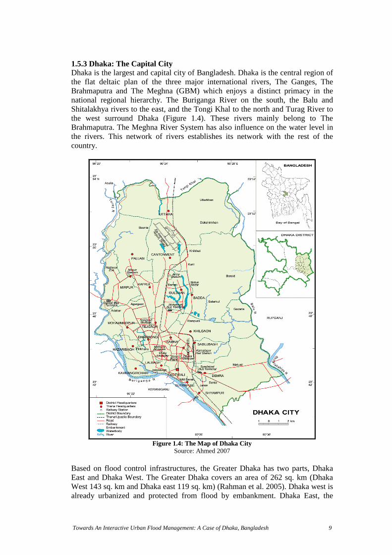
1.5.3 Dhaka: The Capital CityDhaka is the largest and capital city of Bangladesh. Dhaka is the central region ofthe flat deltaic plan of the three major international rivers, The Ganges, TheBrahmaputra and The Meghna (GBM) which enjoys a distinct primacy in thenational regional hierarchy. The Buriganga River on the south, the Balu andShitalakhya rivers to the east, and the Tongi Khal to the north and Turag River tothe west surround Dhaka (Figure 1.4). These rivers mainly belong to TheBrahmaputra. The Meghna River System has also influence on the water level inthe rivers. This network of rivers establishes its network with the rest of thecountry.
Figure 1.4: The Map of Dhaka CitySource: Ahmed 2007
Based on flood control infrastructures, the Greater Dhaka has two parts, DhakaEast and Dhaka West. The Greater Dhaka covers an area of 262 sq. km (DhakaWest 143 sq. km and Dhaka east 119 sq. km) (Rahman et al. 2005). Dhaka west isalready urbanized and protected from flood by embankment. Dhaka East, the

Towards An Interactive Urban Flood Management: A Case of Dhaka, Bangladesh 10
floodplain of the Balu River is mainly a rural area. However, the urban growth isalso evident in this floodplain.
In 1960 the population was 1 million. And at present Dhaka is the 11th largest cityin the world with 13 million residents. The population statistics of Dhaka showthat the annual growth rate was 2.9 percent from 1951 to 1961, 10.2 percent from1961 to 1974, and 8.1 percent from 1974 to 1981(Huq & Alam 2003). Thereby itis expected that the population will increase to 23 million by 2015. As a mega cityDhaka is stretching around an area of 1,353 square kilometres. Rapid expansion inarea and population took place in Dhaka, after independence in 1971. The highpopulation growth is caused by the high rate of rural-to-urban migration. Presently30 percent of the urban population are below the poverty level and live in slums,mostly the low-lying areas of the city. With such high growth rates, urbanizationin Dhaka is to a large degree unplanned.
1.6 Thesis Structure
This research report is comprised of seven chapters.
Chapter one, entitled 'Introduction', introduces the research topic with thedefinition of problem. It also discusses the need for the given research in the lightof possible improvements of UFM in Dhaka and states the objective with anintention to develop understanding on interactive dealing with FM within thecontext of IWRM. The research questions and brief introduction of the researcharea are also presented in this chapter.
Chapter two entitled ‘Development in Water Resources Management’ reviews andstudied the theories on integrated, adaptive, ecosystem and Interactive WRM,River Basin Management and Integrated Flood Management that are studied forthis research. Some relevant case studies and experiences are also presented due totheir participatory approaches in flood management. The chapter is concludedwith the brief discussion on water resources and flood management inBangladesh.
Chapter three entitled 'Research Methodology' gives an overview on how theresearch process is designed and applied. It also contains details on the methods toanswer the research questions, data collection and the analysis of data.
Chapter four entitled ‘Urban Food in the context of Dhaka’ describes the contextof urban floods in Dhaka. The geographical setting, historical background,hydrological aspects of Dhaka city are discussed in this chapter. The chapterconcludes addressing the relationship of Dhaka’s urban floods and impacts ofurban floods.
Chapter five entitled ‘Perspectives of Urban Flood Management in Dhaka’describes the aims and approaches of current FM practices. This also provides ashort discussion on the institutional framework and the legislative framework ofcurrent FM.
Towards An Interactive Urban Flood Management: A Case of Dhaka, Bangladesh 11
Chapter six entitled ‘Analytical Perspectives of Urban Flood Management inDhaka’, which analyses the research findings, based on acquired knowledge fromliterature reviews and fieldwork.
Chapter seven entitled 'Conclusions and Recommendations' is drawn from thereflection upon the reviewed literature and analysis. The research sub-questionsare answered and in accordance recommendations are made for possibleimprovements in FM within the context of Interactive WRM. An outlook onpossible future challenges for further research development will follow theconclusion.

Towards An Interactive Urban Flood Management: A Case of Dhaka, Bangladesh 12
Chapter 2 Development of Water Resources Management
2.1 Introduction
Water is a vital substance, essential for human existence and unique in its role onEarth; chemically, physically and biologically (Lavkulich & Ulazzi 2008). Wateris one of the natural resources, like air and solar energy. Water resources aresources of water, which maintain ecological processes, sustain functions and thusprovide services. As resource, water is also useful to humans for household,agricultural, industrial, recreational activities. Therefore, a planned development,distribution and use of water resources are essential and required. The waterresource management (WRM) is about ‘functioning of the water system’. Thewater system can be seen as a kind of reactor, directing the precipitation throughdifferent pathways (physical, chemical and biological processes) back to theatmosphere or sinks like deep groundwater (Meire et al. 2008). And the watermanagement is about water chain (Meire et al. 2008) management. The waterchain is the process of water uses like water supply, irrigation, wastewatertreatment etc. A balance between the “functioning of the water system” and “theimpact of the water chain” (Meire et al. 2008) is important to sustain theenvironment.
The emergence of new paradigms has brought substantial changes in WRM. Thetraditional approaches were primarily hydro-centric. In recent years the WRM isperceived as an integrated approach. It addresses the social and environmentalinterconnections. Resource management is also a decision-making process toallocate resources according to the needs, aspirations, and desires of people withinthe framework of society’s technological inventiveness; political and socialinstitutions; and legal and administrative arrangements (O'Riordan 1971, Hooper,2005). As the limits of the physical and technical approaches to water resourcemanagement are becoming more and more transparent, policy attention is shiftingincreasingly towards institutional arrangement and reforms (Saleth 2006).
2.2 Integrated Water Resource Management
An integrated approach to water resources management emerged in 1980s.According to the Global Water Partnership (GWP), “Integrated WRM is a processwhich promotes the co-coordinated development and management of water, landand related resources in order to maximize the resultant economic and socialwelfare in an equitable manner without compromising the sustainability of vitalecosystems.” This demands a holistic approach for sustainability linking social,economical development with the protection of natural ecosystems and land andwater uses.
Integration is the central theme in WRM. The GWP considers this theme undertwo categories (GWP 2000): Integration of the natural system, with its critical importance for resource
availability and quality and

Integration of the human system, which fundamentally determines theresource use, waste production and pollution of the source, and which mustalso set the development priorities.
Integrated management is an approach to land and water resources planning andmanagement. It implies the inclusion of physical, biological and socio-economicvariables involved in natural system and human system, which addresses societalgoals and functioning of the ecosystem and participation of stakeholders. Itencourages participation to bring together a diverse array of knowledge ofindividuals as well as stakeholders include government entities, nongovernmentorganizations, community groups, business and industry with a particular interestin the system. According to the geographer Mitchell, integrated approach is moreselective and focused (Hooper 2003). Through participation it produces strategiesthat are more coordinated, more cognizant of interconnections and more inclusiveof the diversity of goals, support and commitment and also increases thelikelihood of implementation (Hooper 2005). Thereby integrated approach is acoordinated management approach towards maximizing equitable socio-economicwelfare along with the sustainability of ecosystems.
Add to the urbanization and the fast socio-economic development, the waterresources all over the world is severely threatened. For example, in Australia,nation-wide, governments recognized that Australia’s water resources are limited.Therefore, to ensure water supplies for both the environment and futuregenerations, State and Territory water policies viewed water resources as potentialresource and aiming at integrated management (Box 2.1) of all water resources.
Box 2.1: The Water Resources Management and Planning in Australia
In Australia, the water resources management is designed to ensure that water resources aremanaged to support sustainable economic development and conservation of the environment, forthe long-term benefit of the community. The State water resource departments are responsible forwater resource management and others like private landowners also undertake watermanagement activities either based on their interests or to comply with the legal obligations. Themajor activities undertaken by the State encompasses the following water resources issues: Planning: the development of whole-of-catchment plans for the allocation and sustainable
management of the resource; Water allocation: the allocation of entitlements to water users; Management and compliance: activities to ensure that water is being shared and used in
accordance with the entitlements and water plans. Key functions include: water resourceaccounting, administering water entitlements and licenses, and facilitating and administeringwater trading.
Monitoring: a range of water monitoring, water resource assessment and informationmanagement activities are undertaken to support water resource planning and management (egreporting on progress against water plans, monitoring of ambient networks, stream gaugingand water quality monitoring, and management and publication of water resource data).
Assessment: review of water plans, and adoption of new plans.
In Australia, the water resource planning and management frameworks are a central part of theNational Water Initiative (NWI) which aimed at nationally-compatible, market, regulatory andPlanning based systems for managing surface and groundwater resources for rural and urban usethat optimizes economic, social and environmental outcomes.
Towards An
Source: (AC
Interactive Urban Flood Management: A Case of Dhaka, Bangladesh 13
IL Tasman 2005)

Towards An Interacti
2.3 The Ecosystem Approach in Water Resources Management
The concept of ecosystem has developed both as discipline and approach(UNU/IAS 2003). As an approach it addresses the environmental relationshipsacross varying spatial, biological and organizational scales (figure 2.1), ascompared to more traditional approaches looking at individual projects and singlecomponents of a plan or a single species (Szaro et al. 1998). The movement forecosystem approaches in WRM started since 1970s. This new paradigmrecognized river basins as large, complex, integrated ecological systems (Hooper2003) to make sustainable use of water resources within a river basin. Thefundamental concept is to integrate all physical, chemical and biologicalcomponents and processes (the water and human system) which sustain theinteractive phenomenon of environmental, social, economical, institutionalfactors. It is a comprehensive approach aimed to achieve balance betweenconservation, sustainable use and equitable distribution of benefits (Van Ast et al.2008) among living things and non-living environments. Ecosystem managementimplies the involvement of different stakeholders and institutions in definingalternatives to establish the interactions between society and environments. Thereis no single way to implement an ecosystem approach in WRM. Because itemphasizes place-or-region based objectives, with scopes and approaches definedappropriately for each given situation (Szaro et al. 1998).
Land and water control subsystemFunction and responds through:A. Institutions Legal Arrangements Financial arrangements Functional arrangements
B. Technology Physical infrastructure
C. Knowledge and Human capacity Information and communication Scientific & local knowledge
Trigger
DemandManagement
SupplyManagement
Resource subsystem
Water Resources Land Resources Climate Biological Resources
Perceivedimbalancesin supply
and demandrequire
intervention
Social subsystem Agriculture Public water supply Fisheries Nature conservation Etc.
ValuesFunction
ve Urban Flood Management: A Case of Dhaka, Bangladesh 14
Source: Chowdhury, 2008Figure 2.1: Three subsystem of the Socio-ecological System

Towards An Interactive Urban Flood Management: A Case of Dhaka, Bangladesh 15
2.4 Adaptive Water Resource Management
The concept of ‘adaptive management’ was developed by ecologists to shelter theuncertainty, the complexity and the coming of unexpected happenings in thenatural ecosystems (Rosa 2008). The human beings are an integral part of thenatural ecosystem. All organisms modify their environment and humans are notexception (Vitousek et al. 1997). Human alteration of earth is creating pressure onwater resources. These are high rate of population growth and their increasingdemands of available resources, changing land use, changing land usemanagement practices and the climate change. All these changes have impacts onwater cycle and which in turn having significant impacts across many sectors ofthe economy, society and the environment. Sustainable water resourcemanagement demands ecological integrity, social equity and economic efficiency.Thereby a more holistic approach is needed because the water systems should beunderstood and managed as living ecosystems, characterized by its greatcomplexity and uncertain (Rosa 2008). Facing all the complexity, uncertaintyinherent to ecosystems, Lee (1999) advocates for the adaptive approach tostrengthen the ecosystems management strategies (Van Ast et al. 2008). Thisapproach requires a continuous participation, capacity building and governance.Adaptive model demands choices and tradeoffs (Rosa 2008). This selection can beachieved through distributing the social responsibility among the different actors-authorities, stakeholders, experts-which contribute to all process by theinformation sharing, analysis, decision-making, planning, implementing andcapacity building, monitoring and evaluating projects. In fact, adaptivemanagement is a type of application, which enables learning through experience.In this approach the information is not just an initial input, it also pervades thedecision-making process in all its phases. The monitoring information supportsthe assessing of the decisions and evaluating the efficiency of the managementaction. The monitoring based information can be integrated with the stakeholderbased information. This brings together the local and scientific knowledgesystems together into single structure information system. Adaptive ecosystemmanagement facilitates the ‘two-way’ flow of information, which recognizesparticipation and capacity building to have collaborative knowledge in the localcontext to reduce conflict.
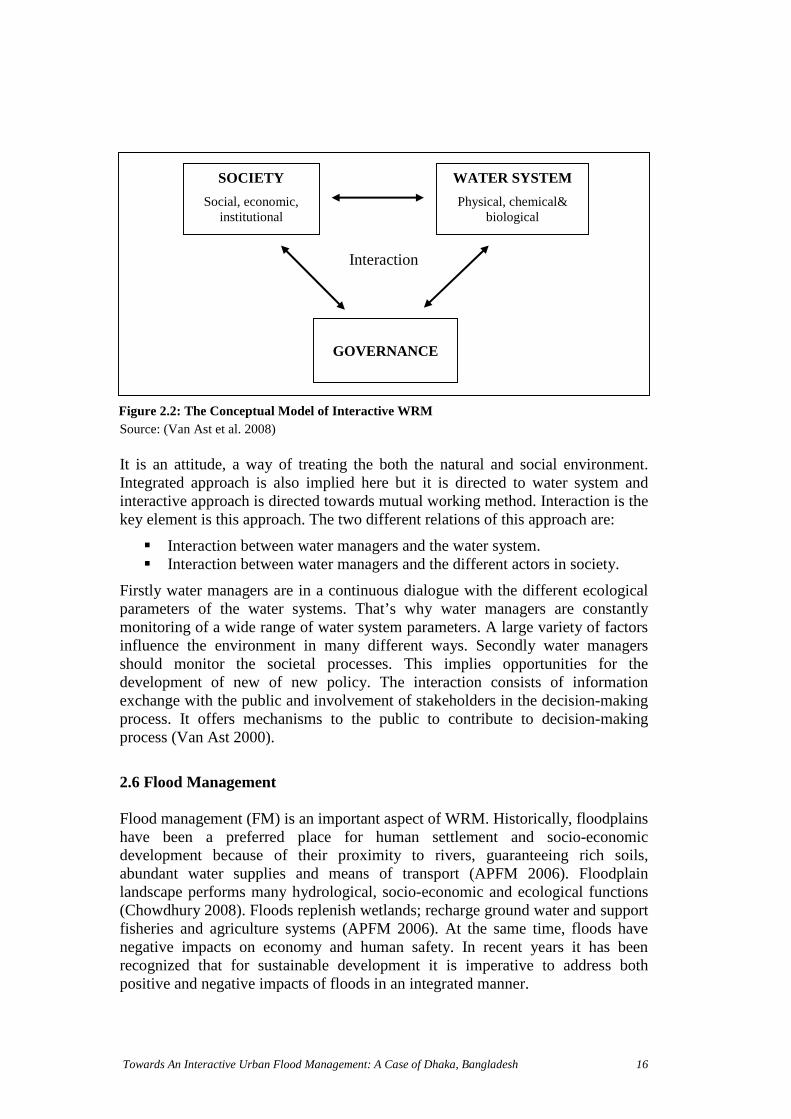
2.5 Interactive Water Resource Management
Interactive water resources management is relatively a new development in watermanagement. This refers to the interactive dialogue (Figure: 2.2) between thewater managers and the policy subjects. The basic elements are interaction,integrated approach, sustainability and water system approach (Van Ast 1999).Water managers are in interaction with the society in one hand and water systemon the other hand. The interaction with the society is taking place in the form ofparticipation of citizens and Nongovernmental organizations (NGOs) in decision-making process. The interaction with the water system approach refers to theconcept of natural dynamics of river systems, to be taken into account.
SOCIETY
Social, economic,institutional
WATER SYSTEM
Physical, chemical&biological
Interaction
GOVERNANCE
F
Towards An Interactive Urban Flood Management: A Case of Dhaka, Bangladesh 16
Source: (Van Ast et al. 2008)
It is an attitude, a way of treating the both the natural and social environment.Integrated approach is also implied here but it is directed to water system andinteractive approach is directed towards mutual working method. Interaction is thekey element is this approach. The two different relations of this approach are:
Interaction between water managers and the water system. Interaction between water managers and the different actors in society.
Firstly water managers are in a continuous dialogue with the different ecologicalparameters of the water systems. That’s why water managers are constantlymonitoring of a wide range of water system parameters. A large variety of factorsinfluence the environment in many different ways. Secondly water managersshould monitor the societal processes. This implies opportunities for thedevelopment of new of new policy. The interaction consists of informationexchange with the public and involvement of stakeholders in the decision-makingprocess. It offers mechanisms to the public to contribute to decision-makingprocess (Van Ast 2000).
2.6 Flood Management
Flood management (FM) is an important aspect of WRM. Historically, floodplainshave been a preferred place for human settlement and socio-economicdevelopment because of their proximity to rivers, guaranteeing rich soils,abundant water supplies and means of transport (APFM 2006). Floodplainlandscape performs many hydrological, socio-economic and ecological functions(Chowdhury 2008). Floods replenish wetlands; recharge ground water and supportfisheries and agriculture systems (APFM 2006). At the same time, floods havenegative impacts on economy and human safety. In recent years it has beenrecognized that for sustainable development it is imperative to address bothpositive and negative impacts of floods in an integrated manner.
igure 2.2: The Conceptual Model of Interactive WRM

Towards An Interactive Urban Flood Management: A Case of Dhaka, Bangladesh 17
2.6.1 Flood and its nature
A Flood is a deluge. It is an overflow of water submerging land. Floodplains, ingeneral, are the adjacent lands to rivers, streams, and lakes subject to recurringfloods. Floods occur most commonly when water from heavy rainfall, frommelting ice and snow, or from a combination of these exceeds the carryingcapacity of the river system, lake, or ocean. The frequency depends on the climatevariability. In a particular season, where there is substantial rainfall (monsoon),the floodplains experience flood nearly every year, like Bangladesh. Humanactivities on floodplain also influence flood. Flood in built environment is theconsequence of both natural and man-made factors (Table 2.1). The differentcombination of casual factors results into four categories of flood namely localflood, river flood, coastal flood and flash flood. Any one or combination of anytwo of these floods contributes to the floods in urban areas. For example, urbanflood in Dhaka is the combination of river flood and local flood.
Table 2.1: Factors contributing to Flooding
MeteorologicalFactors
Hydrological factors Human factors aggravating natural floodhazards
Rainfall Soil moisture level Land-use changesCyclone storms Groundwater level prior to storm Occupation of the flood plain obstructing
the flowsSmall-scale storms Natural surface infiltration rate Inefficiency or non-maintenance of
infrastructureTemperature Presence of impervious rate Too efficient drainage of upstream areas
increases flood peaksSnowfall andsnowmelt
Presence of impervious coverHigh tide impeding drainage
Climate change affects magnitude andfrequency of precipitations and floods
Channel cross-sectional shape androughness
Urban microclimate may enforceprecipitation events
Presence or absence of over bank flow,channel networkSynchronization of run-offs from variousparts of watershed
Source: APFM, 2008
2.6.2 Urban Flood Risk
Urban Flood risks are a function of exposure of people and economic activitiesalong with the vulnerability of social and economic fabric (APFM 2008).Exposure refers to whether or not people or values are in range of flood water(APFM 2008). Unprecedented rural-to-urban migration has caused uncontrolledurban sprawl in cities of developing countries like Dhaka with increasing informalsettlements, high concentration of industrial and economic activities,infrastructure development in riversides, wetlands, low-lying areas, retentionponds. In the case of Dhaka, the urban growth took place in filled-up waterbodies, canals, flood-flow zones, sub-flood flow zones, and low-lying areas nearembankment ignoring its impact on flood. Vulnerability of flood is crucial interms of exposure to hazard, which may or may not constitute a risk that mayactually result in a disaster. Physical vulnerability of people and infrastructureincreases with urban development. This is also affected by socio-spatialsegregation. With urbanization, land prices increase and as a result low-income

T
people are forced to choose flood prone areas. These people are alwayssuppressed to get support from government for the betterments of their livingconditions.
2.6.3 Urban Flood Risk Management
Traditionally, flood management has been problem driven. Flood managementwas largely focused on reducing flood and vulnerability to flood damage throughvariety of engineering interventions with very little or no long-term considerationfor economic sustainability. The need for a paradigm shift from flood control toflood management has been recognized during the past decade. This shift isenshrined in the Integrated Flood Management (IFM) concept (APFM 2004).Floods, particularly in urban areas, are rising in terms of frequency andmagnitude, due to urbanization process coupled with population growth. Thedevelopment activities in urban areas, such as water supply and sanitation,housing settlements, pollution control, transport systems, industrial activities;health and social welfare etc., all influence and interact with each other and affectthe flood risks to a large degree. To reduce this urban flood risks, it is imperativeto mainstream flood risks in all these related activities, which requires acoordinated action to address and understand the following issues (APFM 2008): The affect of potential flood hazards on various development programmes
and projects; How the policies and programs in other development sectors influence:
• The magnitude of the flood hazards; and• The vulnerability of the society to the flood hazards
The conceptual framework of urban flood risk management (UFRM) (figure 2.3)is based on three concepts (APFM 2008):
Integrated Flood Management (IFM); Total Water Cycle Management (TWCM); Land-use Planning
S
IWRMPlans
Basin FloodManagement Plans
Storm WaterManagement Plans
Basin FloodManagement Plans
Integrated FloodManagement
Coastal ZoneManagement
Total Water CycleManagement
Sustainable UrbanDrainage Systems
PLANS
PRINCIPLES
CONCEPTS
LAND USE PLANNING
SPATIAL PLANNING
owards An Interactive Urban Flood Management: A Case of Dhaka, Bangladesh 18
ource: APFM, 2008
Figure 2.3: The conceptual framework of Urban Flood Risk Management

Towards An Interactive Urba
2.6.3.1 Integrated Flood Management (IFM)
The insight of the IFM (figure 2.4) concept is the re-orientation of the socialperception of floods (APFM 2006). It concerns more proactive responses thanreactive responses towards floods.
IFM is a process promoting an integrated approach to flood management aimed atmaximizing the net benefits of flood plains and minimizing the loss of the life fromflooding in a river basin within the framework of Integrated Water ResourcesManagement (IWRM). (APFM 2004)
The aim of IFM is to put in place well-functioning integrated measures for floodmanagement (APFM 2004). Integration, the defining characteristic of IFM, isperceived in terms of institutional integration and expressed in different forms asfollows: Manage the water cycle as a whole; Integrate the land and water management; Adopt a best mix of strategies; Ensure a participatory approach; Adopt integrated hazard management practice.
The IFM concept is bain a river basin. The rariver basin managemeand deposition–are iupstream urbanizationoccurrences in downscharacteristics (APFMunderstood to adopt riv
Water ResourcesManagement
Integrated FloodManagement
Land Use Management
HazardManagement
Coastal ZoneManagement
F
n Flood Management: A Case of Dhaka, Bangladesh 19
Source: APFM, 2004
sed on integration of land and water resources managementtionale of this integration is that the three main elements ofnt-water quantity, water quality, and the process of erosionnherently interlinked (APFM 2004). For example, the
causes an accentuation of flood peaks and their earlytream. It also change water quality and sediment transport
2004). Therefore, the linkages need to be recognized ander basin based approach to IFM.
igure 2.4: The Conceptual Model of IFM

To
Ja&mtococoflo
Jastsecaan
Aimandepla
Toapfacrelap
Bobrohyresflo
Sou
CoFloMa
wards An Inte
pan applies bthe Flood F
anagement paccommoda
mbination omprises botod retardatio
panese introorm water ruwer system.pacity of thed sports field
participatory approach in decision-making process of flood management is anportant key component of IFM. This includes the involvement of individualsd different ranges of stakeholders of all levels. This requires decentralization ofcision-making with full public consultation and involvement of stakeholders innning and implementation (APFM 2004).
address all hazards holistically, the integrated natural hazard impact mitigationproach is required. The risk management strategy should integrate IFM. Thisilitates structured information exchange and effective organizationalationships, which ensures efficient use of resources, and consistency inproaches to natural hazard management in all relevant national and local plans.
th in developed and developing countries, the process of rapid urbanizationught change in the urban landscape. This has caused radical change in
drological cycle and as a result flood risks are increased enormously. Withponse to this, the Japan government has adopted the policy of comprehensiveod management (Box 2.2).
rce: (Yoshit
B
mprehensiveodnagement
ractive Urban Flood Management: A Case of Dhaka, Bangladesh 20
oth structural and non-structural measures for flood protection. The River Lawighting Laws is the main legislative instrument determining flood and waterolicies within the country. The Basic Policy for River Improvement is enactedte public opinion. The Japanese comprehensive flood management is thef river improvement, run-off control and drainage mitigation measures. Thish conventional measures and innovative measures with special attention ton and retention.
duced Experimental Sewer System (ESS), which is capable of controllingnoff by adding infiltration and storage facilities to the conventional combinedIn this process the ground water is also recharged. To increase the retardingarea Japan has constructed ponds and regulation reservoirs, such as stadiumss, such as tennis courts which are used for temporary storage.
ani et al. 2006), (Stalenberg & Kikumori 2008)
ox 2.2: A Sustainable Integrated Flood Management in Japan
River Improvement
Runoffcontrol
DamageMitigationmeasures
Channel improvement (e.g. embankment)Construction of retarding basin & floodway
Maintenance of controlled urbanizationdistricts, conservation of nature, constructionof reservoirs and regulating basins,installation of permeable pavements.
Preservation of urbanization control zones,control of landfill, promotion of conditionsfavourable to agriculture.
Preservation of urbanization control zones,control of landfill, promotion of conditionsfavourable to agriculture.
Establishment of warning and evacuationsystem, growth of flood fighting managementsystem: use of CCTV cameras, river patrols,optical fibre network etc, publication ofhazard maps, use of flood proof buildings,dissemination of information among localresidents through media, fax, telephone etc.
Retentionareas
Detentionareas
Low-lyingareas
Towards An
2.6.3.2 Total Water Cycle Management
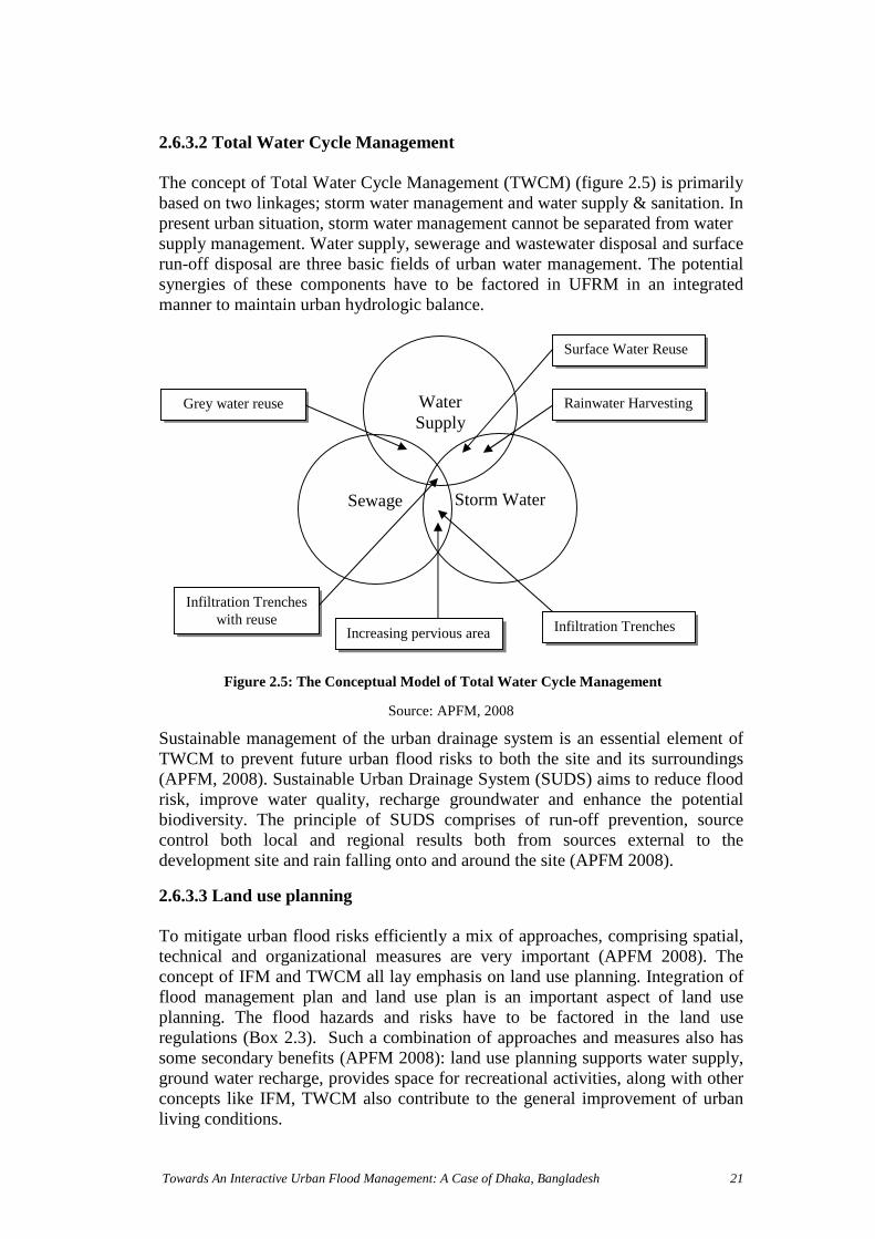
The concept of Total Water Cycle Management (TWCM) (figure 2.5) is primarilybased on two linkages; storm water management and water supply & sanitation. Inpresent urban situation, storm water management cannot be separated from watersupply management. Water supply, sewerage and wastewater disposal and surfacerun-off disposal are three basic fields of urban water management. The potentialsynergies of these components have to be factored in UFRM in an integratedmanner to maintain urban hydrologic balance.
SustainabTWCM t(APFM, 2risk, impbiodiverscontrol bdevelopm
2.6.3.3 L
To mitigatechnicalconcept oflood maplanning.regulationsome secground wconceptsliving con
WaterSupply
Storm WaterSewage
Infiltration TrenchesIncreasing pervious area
Surface Water Reuse
Rainwater Harvesting
Infiltration Trencheswith reuse
Grey water reuse
Interactive Urban Flood Management: A Case of Dhaka, Bangladesh 21
Source: APFM, 2008
le management of the urban drainage system is an essential element ofo prevent future urban flood risks to both the site and its surroundings008). Sustainable Urban Drainage System (SUDS) aims to reduce floodrove water quality, recharge groundwater and enhance the potentiality. The principle of SUDS comprises of run-off prevention, sourceoth local and regional results both from sources external to theent site and rain falling onto and around the site (APFM 2008).
and use planning
te urban flood risks efficiently a mix of approaches, comprising spatial,and organizational measures are very important (APFM 2008). Thef IFM and TWCM all lay emphasis on land use planning. Integration ofnagement plan and land use plan is an important aspect of land use
The flood hazards and risks have to be factored in the land uses (Box 2.3). Such a combination of approaches and measures also has
ondary benefits (APFM 2008): land use planning supports water supply,ater recharge, provides space for recreational activities, along with otherlike IFM, TWCM also contribute to the general improvement of urbanditions.
Figure 2.5: The Conceptual Model of Total Water Cycle Management

S
2
Ppvpimw
Box 2.3: Integrated Water Cycle Planning and Management in Australia
The water sector in Australian is giving attention to the concepts of Integrated Water CycleManagement (IWCM) and Water Sensitive Urban Design (WSUD), which emphasize the needto integrate the conservation and sustainable use of the various water sources in urbanplanning and development. To manage all water effectively and use optimally within acatchment resource, IWCM involves the integration of water supply, sewerage and stormwater. The complex linkages between different elements of the urban water cycle both withinthe urban area and between the urban area and its water related catchment.
Water Sensitive Urban Design (WSUD) is the integration of urban planning and developmentwith the management, protection and conservation of water within a consideration of the watercycle as a whole. It establishes links between water management and urban design, landscapeand architectural considerations. This aims to keep the water balance in urban areas as close aspossible to predevelopment values.
IWCM uses a range of tools to emphasize the different facets of urban water management: Water conservation and efficiency; WSUD; Utilization of non-conventional water sources including roof runoff, Storm water, grey water and wastewater; The application of fit-for-purpose principles; Storm water and wastewater source control and pollution prevention; Storm water flow and quality management;
The use of mixtures of ‘soft’ (ecological) and ‘hard’ (infrastructure technologies); Education; Pricing incentives; and Regulations and restriction regimes.
As part of institutional and regulatory arrangements, the State Governments have adopted awide range of initiatives under the ambit of sustainable water resource management policies,which is being pursued, by a range of parties across all jurisdictions. For example:
State governments, water authorities and economic regulators are overseeing pricingreforms to better reflect the value of water (e.g. higher volumetric tariffs, often withincreasing blocks as consumption rises);
Public education programs promoting water conservation and efficiency are beingundertaken;
Increasingly stringent water restrictions are being adopted (e.g. ‘permanent’ watersavings measure in Victoria prohibiting certain water uses);
Governments across Australia have developed formal policies and/or action plans topromote recycled water projects, often with financial subsidies, public education andawareness programs, and in some cases through mandating specific targets forrecycled water.
Towards An
ource: (AC
.7 Partic
ublic paarticipaterb ’caarticipatndividuaaking dords, it
Interactive Urban Flood Management: A Case of Dhaka, Bangladesh 22
IL Tasman, 2005)
ipation
rticipation has become an important aspect to policy makers. The wordion comes from the Latin word ‘Pars’, which means ‘a part’, and thepere’, which means ‘to take’ (Van Ast et al. 2008). In generalion means ‘to take part’. Public participation is processes in whichls, groups, and organizations have the opportunity to participate inecisions that affect them, or in which they have an interest. In otheris the redistribution of power that enables the have-not citizens, presently

Towards An Interactive Urban Flood Management: A Case of Dhaka, Bangladesh 23
excluded from the political and economic processes, to be deliberately included inthe future.
Forms ofparticipation
Role of participants
8CitizenControl
Participants govern aprogram or an institution
To provide have-not citizens handleplanning, policy making & managingprogram.
Citizens have full managerial power
7DelegatedPower
Holding a clear majority ofseats on committees withdelegated powers to makedecision.
To assure citizens accountability to thedecision-making
Full participation with decision-makingauthority.
Cit
izen
Po
wer
6 Partnership
Establish negotiationbetween citizen & powerholders.
To share planning & decision-makingresponsibilities between citizen & powerholders.
Full participation with two way flow ofcommunication (official-citizen-official)
Conflict in planning & decision making
5 Placation
Power holders judge thelegitimacy or feasibility ofthe citizens’ advice.
To involve the citizens in planning &policy making only to get their advise
Full participation with one way flow ofcommunication (official-citizen)
Citizens have limited power.
4 Consultation
Through attitude surveys,meetings, public hearingsinvites citizens’ opinion
To involve the citizens in planning &policy making only to get their advise
Full participation with one way flow ofcommunication (official-citizen)
No channel for feedback.
To
ken
ism
3 Informing
Informing the citizens oftheir rights, responsibilitiesand allow to advise
To legitimate participation Full participation with one way flow of
communication (official-citizen) Not assure the accountability of the
citizens’ ideas.
2 Therapy
no
npar
tic
ipat
ion
1 Manipulation
Achieve public support bypublic relations in the nameof participation
Not to enable people to participate butenable power holders to educate theparticipants
Non-participative
Source: Arnstein, 1969
There are mainly two types of interactive policy-making processes. First thePluralistic type in which the every citizen in a democratic society has the power toexert direct influence on decision-making processes. Secondly, the Corporatisttype involves different stakeholders related to specific policy issues in decision-making process. In this case the representatives of specific interest group sharemore or less the same power/authority equal to government bodies. In an idealisticparticipative democracy, the citizens should enjoy the highest degree ofinteraction in policy-making process directly or indirectly at possible stages of thepolicy process.
Arnstein introduced the concept of ‘A Ladder of Citizen Participation’ (table 2.2)in 1969, which indicates the government’s attitude towards participation. In theladder, the roles of participants are understood as hierarchical steps on a ‘ladder ofparticipation’. The interaction between government and participants becomesintense with the every step up on the ladder.
Table 2.2: The Ladder of Citizen's Participation
Towards An Interactive Urban Flood Management: A Case of Dhaka, Bangladesh 24
The bottom of the ladder, the societal actors have no participation in decision-making process. At the first level the actors have the access to the information,which defines smallest degree of participation. In the second level, the role ofgovernment is consultative and they consult with society for possible actiontowards the solution of the problem. In the third level the society plays role of anadvisor. At the forth level the actors become co-decision makers. At the fifthlevel, the society is treated as partners in policy-making. At the highest, the sixthlevel the society plays the role of initiator. From the third step up the interactiontakes place in its true meaning, active participation of society in policy-makingprocesses.
In Interactive Water Management, the relation between Government and othersocietal actors is much more horizontal (Van Ast 2000), i.e. individual andstakeholders can participate actively in decision-making process. The informationexchange like sharing of visions, ideas, behavioural patterns and solutions toproblems can be incorporated into the decision-making process. This offersempowerment to the public to contribute into decision-making process.Participation can be successful if it is well considered and embedded within aclear framework and right tools and methods are applied. In theory, there are twopotential advantages of well-organized interaction: The high quality decisions, which incorporates different views and ideas. The exchange of information leads to better understand of the ins and outs
of the specific situation thus contributing to public support. Clear understanding and identification of local needs, preferences and
priorities. Promoting supports for the identified objectives and solution proposed.
Involvement of stakeholders should take place at the early stage of decision-making. The instruments, which facilitate interaction with the public, arecommunity meetings, questionnaire survey, interviews and internet. Among all,internet is a new medium that facilitates the perfect open decision-making andalso allows direct publication of relevant information.
2.8 Interactive Institutional Arrangements
Institutions are usually understood as sets of rules which structure the relationshipbetween individuals by determining their range of actions in certain situations(Bressers & Kuks 2004). Institutional arrangements structure the activity domainsand interaction among the actors (Borrett & Cowie 2005).
During the past decade the institutional arrangements governing water sector haveexperienced remarkable changes in many countries around the world. Waterinstitutions can be defined as rules that define action situations delineates actionsets, provide incentives and determine outcomes both in individual and collectivedecision setting in the context of water development, allocation, use andmanagement (Saleth 2006). According to Saleth and Dinar (2004), the analyticalcategorizations of these rules are legal rules, policy rules and organizational rules.The institutional features have two implications. First, the technical features ofinstitutions characterize different forms of institutional linkages in a structural and

Towards An Interactive Urb
functional sense (Saleth 2006). Second, the institutional system refers the variouslevels and contexts of institutions. Following this principle, water institutions canbe decomposed into water institutional structure (governance structure) and waterinstitutional environment (governance framework) (figure 2.6). The institutionalstructure can be decomposed into its legal, policy and organizational components(Saleth 2006). Water institutional structure includes the structurally nested andembedded legal, policy and organizational rules governing various factors ofwater resources management. And water institutional environment characterizesthe overall social, economic, political and resource context within which the waterinstitutional structure evolves and interacts with the water sector.
The four basic eleminteraction and sustainstarting point, the rivestyle and sustainabilitoutline the institutionThe underlying aspeinstitutional elements:
For effective governaactivities must be con The vertical plane
and resources. The horizontal pla
Water Sector Performance
Political System
Legal System
Demography
Economic Development &Policies
Resources/ Environment
Water Law WaterPolicy
Water Organization
Water Institution
F
an Flood Management: A Case of Dhaka, Bangladesh 25
Source: (Saleth 2006)
ents of Interactive WRM; water system, integration,ability, can be perceived as the water system approach as ar basin concept as a policy object, interactive management
y as a policy goal (Van Ast 1999). These combinations canal arrangement (table 2.3) for water resources management.cts of the four elements are connected with the mainorganization type, policy and instruments.
nce, decentralization policies, strategies, instruments andceived from two planes:, involves transfer of authority, functions, responsibilities
ne, involves empowerment of local communities.
igure 2.6: Water Institutional Environment

Tow
Table 2.3: Interactive institutional arrangements for flood management
Main lines Organization Policy Instruments
Starting point=Flood water use
National Floodplain management Floodplain regulation
Policy object= floodmanagement in riverbasin
Nationalmultidisciplinary
Integration of regionalplanning
Floodplain locationand resource use.
Style ofmanagement=interactive
Open & democratic Mutual & communicative Participation
Policy goal=sustainability
Long term Strategical Collective
Adopted from (Van Ast 1999)
Vertical decentralization requires shift in the central government policy, laws aswell as institutional and structural agreements, which will lead to political andadministrative decentralization. Horizontal decentralization may takes placewithout any adjustments in laws to socio-political economical and technicalempowerment.
Box 2.4: Water Management Institutions in Different Countries
Sour
The seven commissions in China cover the six major international river basins and onelake basin. They are centralized agencies under the Ministry of Water with importantplanning and regulatory functions. The Yellow River Conservancy Commission alsohas specific responsibility for flood management in the lower Yellow River.
In India the Damodar Valley Corporation, began in 1948, has the responsibility ofdeveloping water and managing flood protection, irrigation and power. The commissionfocuses on integrated area development: promoting and operating schemes forirrigation, water supply and drainage, generation of electrical energy, flood control,navigation, reforestation and controls of soil erosion (Hooper, 2005).
Some of the basin authorities, like the Tennessee Valley Authority (TVA) in the UnitedStates, have very broad charter to develop multiple resources including water, power,navigation, etc. Others have more narrowly focused functions such as operation andmaintenance of mainstream facilities for water supply and power generation.
The European Commission is the entity responsible for the enactment of the EuropeanWater Framework. Within this, the Directive on River Basin Management applies toriver basins throughout the EU, therefore encompasses major and smaller river basinssuch as Rhine, Danube, Guadiana, Oder and Rhone. The aim is to maintain and improvethe quality of the aquatic environment, in both national and international settings(Hooper, 2005)
Another common use of basin authority is to simply coordinate basin planning,operation and regulatory activities. In France, river basin committees have operatedsuccessfully for over twenty-five years doing long-term planning for developing waterresources. Regulation and enforcement over there are conducted by various nationalministries, while operation and maintenance of different components of the water
ards An Interactive Urban Flood Management: A Case of Dhaka, Bangladesh 26
ce: Faruqee & Choudhry, 1996
system are left primarily to regulated private sector entities and public utilities.

Towards An Interactive Urban Flood Management: A Case of Dhaka, Bangladesh 27
This bottom-up participation of inhabitants is found in the work of InternationalJoint Commission between Canada and the USA (IJC, 1996, Dworsky et al. 1995in Van Ast 2000). The Great Lakes Water Quality Agreement was a great success.In the early seventies the people who live in the Great Lake area addressed theissue to the concerned authority. The use of horizontal policy instruments wasquite new at that time, still the experiences of the IJC were positive. This changein governance can be seen as a paradigm shift.
2.9 River Basin Management
The river basin approach is the key to IFM. A river basin is a dynamic systemwhere a series of interactions between the land and water environment takes place.These interactions also involve sedimentation, pollutants. The functioning of theriver basin as a whole is governed by the nature and extent of these interchanges(APFM 2004). Water quantity, water quality, the processes of erosion anddeposition-the three main elements of river basin management are closely linkedto each other. This interrelationship is the primary reasons for adopting river basinbased approach to IFM.
Rivers and their source basins has been the site of human occupation and manycities and towns throughout the world have been established on the banks of riverspredominantly to take the advantage of riverine communication. So for manyyears the river basins have been focus of management. River basin management ismacro-scale natural resources management (Hooper 2005). The expert groupstatement on Integrated River Basin Management for the 2nd World Water Forumand Ministerial Conference in the Hague, 2000, maintained,
“River basins are the paramount source of freshwater. To preserve andmaintain this precious resource for present and future generations, there isthe need for sustainable river basin management (Hooper 2005).
River basin management (RBM) is the subset of IWRM. Integrated River BasinManagement (IRBM) is defined as an integrated and coordinated approach to theplanning and management of natural resources of a river basin, one thatencourages stakeholders to consider a wide array of social and environmentalinterconnections, in a catchments context (Hooper 2005).
In RBM, river basin is the common pool where the natural resources are sharedamongst multiple users. There are three levels of decision-making in river basinmanagement (Hooper 2005): strategic/policy levels, implementation level andoperational level. For instance, the peripheral river basins (the Buriganga, Baluand Turag River) of Dhaka are dominated by industrial activities. In this settingthe three levels would be represented by industries (individual), environmentalregulatory agency (Department of Environment, DoE), Dhaka City Corporation(DCC) (operational) and water Resource Planning and Organization (WARPO)sets policy (strategic). In all three levels the decision makers (individuals, NGOs,public and private organizations) functions vary in time and space. Their decisionsare driven by market demand; government policy on resource use, political

Towards An Interactive Urban Flood Management: A Case of Dhaka, Bangladesh 28
Vulnerability to UrbanFlood in Dhaka
Interactive Approaches andUrban Flood Management
InteractionWater System
ApproachIntegration Sustainability
Interaction withsociety and
water systemInstitutionalIntegration
PlanningIntegration
Long TermPlanning
River BasinManagement
Total water cyclemanagement
Interactive Urban FloodManagement
RESEARCH FOCUS
processes and operation takes place within existing institutional setup andadministration for resource exploitation and conservation.
2.10 Theoretical Framework
Figure 2.7: The Theoretical framework
The research focuses on two key elements: interaction and integration interactiveto identify the possible opportunities to enhance the performance of UFM inDhaka. The theoretical framework illustrates the interactive approaches and UFMin terms of interaction, Integration, sustainability and water system approach.
Interaction is the defining characteristic of Interactive WRM. The researchanalyzes the degree of citizen and stakeholders involvement in decision-making process. This interaction offers a mechanism to the public tocontribute to decision-making through exchanging information with theinvolved stakeholders. It also focuses on interaction between watermanagers and monitoring of the water system.

Towards An Interactive Urban Flood Management: A Case of Dhaka, Bangladesh 29
The fundamental feature of UFRM is integration. This study identifies theinstitutional integration for FM at river basin scale. Institutional integrationorganizes the cooperation among all the stakeholders. It concerns relevantcompetences and means as an important support for the efficiency of theFM.
Sustainable water resource development is perceived as long term andshort-term interventions in planning. Therefore this research has focusedthe perspectives of long-term strategies in water resources and floodmanagement and planning in Dhaka.
The concept of Interactive WRM is based on water system approach,which recognizes river basin as a large and highest level ecosystem withthe total of the water system. And UFM depends on the hydraulic balanceof the urban water management components. This study analyzes thesetwo key elements in the context of Dhaka.
Participation represents the required competences and contributes in decision-making providing basic information about the maximizing the positive aspect offloods. Institutional integration facilitates the decision-making process leading toIFM and implementation within the given institutional structure. This way boththe elements affect each other and the whole management system. Therefore, inorder to ensure effective, sustainable FM in the light of interactive WRM,widespread coordination between various institutions, interaction in terms ofinformation sharing and networking of actors is imperative.
2.11 Water Resources and Flood Management Trends in Bangladesh
In Bangladesh, the major water management challenges are floods during themonsoon and water scarcity in the dry season. The floods cause damage to thecropping pattern, crop yields as well as fisheries, transportation, and economicactivities. The water resources planning in Bangladesh were largely dominated bythe flood control (FC) and irrigated agriculture to achieve the goal of increasingagricultural production to achieve national self-sufficiency. Bangladesh hasapproximately 14.8 million hectare of cultivable land, which is nearly 60% ofcountry’s total area.
The large public sector investments on water resources developments like FC,drainage and irrigation projects were implemented between the mid-1960s andlate-1980s. The driving force was to protect floodplain agricultural lands fromriverine floods and reduce damage of Aman (monsoon rice) production. In the1990s, with the private sector initiatives, the dry season pump irrigation for theproduction especially the Boro (dry season rice) has risen sharply, resulting innear self-sufficiency in rice production (P. Wester & Bron, n.a.). The irrigationtechnologies for dry season irrigation includes irrigation from groundwater bydeep tube well (DTW), shallow tube well (STW) and surface water bodies by lowlift pump (LLP).
In Bangladesh, the national water planning started in the 1950s. Following thefloods of 1954 and 1955, based on the United Nations mission (the Krug Mission)

Towards An Interactive Urban Flood Management: A Case of Dhaka, Bangladesh 30
recommendations the East Pakistan Water and Power Development Authority(EPWAPDA) was created in 1959 (P. Wester & Bron n.a.). The authority wasresponsible for the planning, design, operation and management of all waterdevelopment schemes (DFID n.a.). In 1964, EPWAPDA prepared the 20-yearWater Master Plan with United States Agency for International Development(USAID) assistance (DFID n.a.). The main concept of the Master Plan was FloodControl to increase agricultural production by the construction of embankments,pumping stations and canal irrigation. The bias towards agriculture meant thatsolutions tend to be in the form of flood control drainage and irrigation (FCDI)projects (DFID n.a.). However, in reality, the flood control was mainlyemphasized and attention was given to the drainage improvement and irrigationfor agricultural development.
Following the devastating floods of 1987 and 1988, the Government ofBangladesh (GoB) has formulated Flood Action Plan (FAP) with World Bankassistance. The five-year programme aimed at a long-term programme forachieving a permanent and comprehensive solution to flood problem. The GoB setup the Flood Plan Coordination Organization (FPCO) to coordinate FAP studiesin 1990. The FAP study was highly criticised due to the absence of the activeparticipation of civil society during the formulation stage. The study wasculminated with the formulation of the Bangladesh Water and Flood ManagementStrategy (BWFMS).
Following the BWFMS, the National Water Policy (NWPo) and National WaterManagement Plan (NWMP) was formulated and approved by the GoBrespectively in 1999 and 2004. Based on the recommendations of the BWFMS,the Guidelines for Participatory Water Management were formulated within theframework of NWPo in 1999, to ensure participatory water management inBangladesh. According to the recommendations of the BWFMS, the FPCO wasmerged with Water Resources Planning Organization (WARPO) in 1996 forplanning of water resources. After Independence in 1971, EPWAPDA evolved asBangladesh Water Development Board (BWDB), which is responsible forimplementation of surface water projects within a command area above 1000 ha(Chowdhury 2008). The Local Government Engineering Development (LGED) isresponsible for areas of 1000 ha or less.
Different researches and studies on water and flood management projects inBangladesh show that the projects failed to prove efficacy in long-termsustainability issues. The FC projects, aimed to prevent flooding of agriculturalland and urban areas in floodplain have actually shifted the flood risk elsewhererather than reducing risk such as the reduction of retention ponds, pumpeddrainage of rainfall-runoff from the protected areas increases flood level in theadjacent areas. A study carried by Rahman and Chowdhury shows that there is nosignificant correlation between the percentage increases in Amon production andFC coverage for the greater districts (Chowdhury 2008). The adverse impacts ofthese projects on WRM are due to lack of an integrated approach to WRM andcoordination among the relevant organizations. Hydro morphologic features,socio-economic condition, and cultural heritage should be taken into account forsustainable WRM in Bangladesh. This requires participation of people in

Towards An Interactive Urban Flood Management: A Case of Dhaka, Bangladesh 31
planning and management of water resources. Although the GoB has taken someinitiatives to develop WRM, including the formulation of the NWPo and theNWMP which consider social and environmental consequences of WRMinterventions, the situation has not much improved. A detailed discussion on thisis presented in chapter 6 of this report.
In recent years there is a major policy change took place in flood management inBangladesh. The flood policy has shifted from its narrow focus on ‘flood control’to ‘flood management’ and further to water management over 30 years. ThePlanning Commission of the Government of Bangladesh makes five-year plansproviding guidelines for all development sectors including water resourcessectors, as flood is considered the most important annual disaster at national scale.The Ministry of Water Resources management also formulates guidelines forParticipatory Water Resources Management, though it is not practiced at fulllength. Therefore it is important that GoB to takes the necessary initiatives tocreate an enabling environment for participatory decision-making processconcerning effective implementation of NWPo in order to ensure socio-economicand environmental sustainability.
2.12 Summary
The practical application of IFM is not universal. The hydrological and hydrauliccharacteristics of the river system and the regional characteristics refer to theadoption of particular strategies. It is suggested that the adoption of layered floodmanagement strategy is often best strategy than the isolated one. This should bedone in a way that it includes both the long-term as well as short-terminterventions in the whole plan. The form of participation depends on social,political and cultural setup of the society. This is facilitated by the integration ofinstitutions. Therefore the challenge is to promote co-ordination and co-operationacross functional and administrative boundaries (APFM 2004).

Towards An Interactive Urban Flood Manag
Chapter 3 Research Methodology
3.1 Introduction
The research focuses on two important issues: interactive water resourcesmanagement and integrated urban flood management. The strategic location ofDhaka in the GBM basin makes it vulnerable for flood flows. Besides river floodDhaka also suffers from storm water flooding. A clear understanding of existingflood management practice in urban flood protection is necessary to reduceeconomic, physical and environmental impacts. Flood management is a subset ofwater resources management. This requires the study of water resources and floodmanagement trend in Bangladesh. A case study approach is applied to study thecurrent institutional framework with relation to flood management in urban floodprotection. The concept of participatory water resources management and itsinteractive aspects are explored in chapter two to analyze the degree to which theinteractive approaches exist in urban flood protection of Dhaka.
3.2 Research Design
The research design is summarized in figure 3.1 giving a general overview of theresearch process.
Chapter 1Introduction
Chapter 2Development in WaterResources Management
Chapter 3Research Methodology
FORMULATION OF RESEARCH OBJECTIVES
PROBLEM STATEMENT
ISSUES AND MOTIVATION
FORMULATION OF RESEARCH QUESTIONS
LITERATURE REVIEW
DEVELOPMENT OF THEORETICAL FRAMEWORK
DATA COLLECTION
A
SELECTION OF RESEARCH TOPIC
UNIT OF ANALYSIS: WATER & FLOOD INSTITUTIONS
CONTEXT
key
Chapter 7Conclusions andRecommendations
Chapter 4, 5 & 6Urban Flood Managementin the context of Dhaka &its analysis
Figure
PRIMARY DAT
ement: A Case of Dhaka, Bangladesh
DATA ANALYSIS
CONCLUSIONS AND RECOMM
FORMULATION OF RE
actors r
& FINDINGS
3.1: The Research Design
SECONDARY DATA
In-depth interviews with
Literature study/ desk esearchRESEARCH CONTEXT
ENDATIONS
SULTS
32

Towards An Interactive Urban Flood Management: A Case of Dhaka, Bangladesh 33
3.3 Research Framework3.3.1 Definitions of variables
The following table 3.1 provides the operational definition of the variables.
Table 3.1: The variables and their operational definitions
Variables Operational definitions
Water ResourcesManagement(WRM)
Water Management refers to the process of water use i.e. the water chain(Meire et al. 2008).Water Resources Management refers to the functioning of the water system(Meire et al. 2008).
Integrated WaterResourcesManagement(IWRM)
Integrated Water Resource Management is a process which promotes thecoordinated development and management of water, land and relatedresources, in order to maximize the resulting economic and social welfare inan equitable manner without compromising the sustainability of vitalecosystems (GWP 2000).
Interactive WaterManagement
A process in which the water institutions are in a continuous interactivedialogue both with the water system and the society system.
Integrated FloodManagement(IFM)
Integrated Flood Management is a process promoting an integrated ratherthan fragmented approach to flood management. It integrates land and waterresources development in a river basin, within the context of IWRM, andaims at maximizing the net benefits from flood plains and minimizing loss
to life from flooding (APFM 2004).
Institutionalarrangement
Institutions are usually understood as sets of rules, which structure therelationship between individuals by determining their range of actions incertain situations. Institutions are both the result of past actions and theframework within which new activities take place (Bressers & Kuks 2004).Institutional arrangements structure activity domains and interactions amongactors (Cowie & Borrett 2005).
ParticipationIn water resourcemanagement
The involvement or taking part of all people of a community in an equitable,efficient and sustainable use and management of available water systems(Van Ast et al. 2008).
3.3.2 Variables and Indicators
The following table 3.2 is a summary of the research framework outlining thestrategies are used in answering the five (5) research sub-questions.
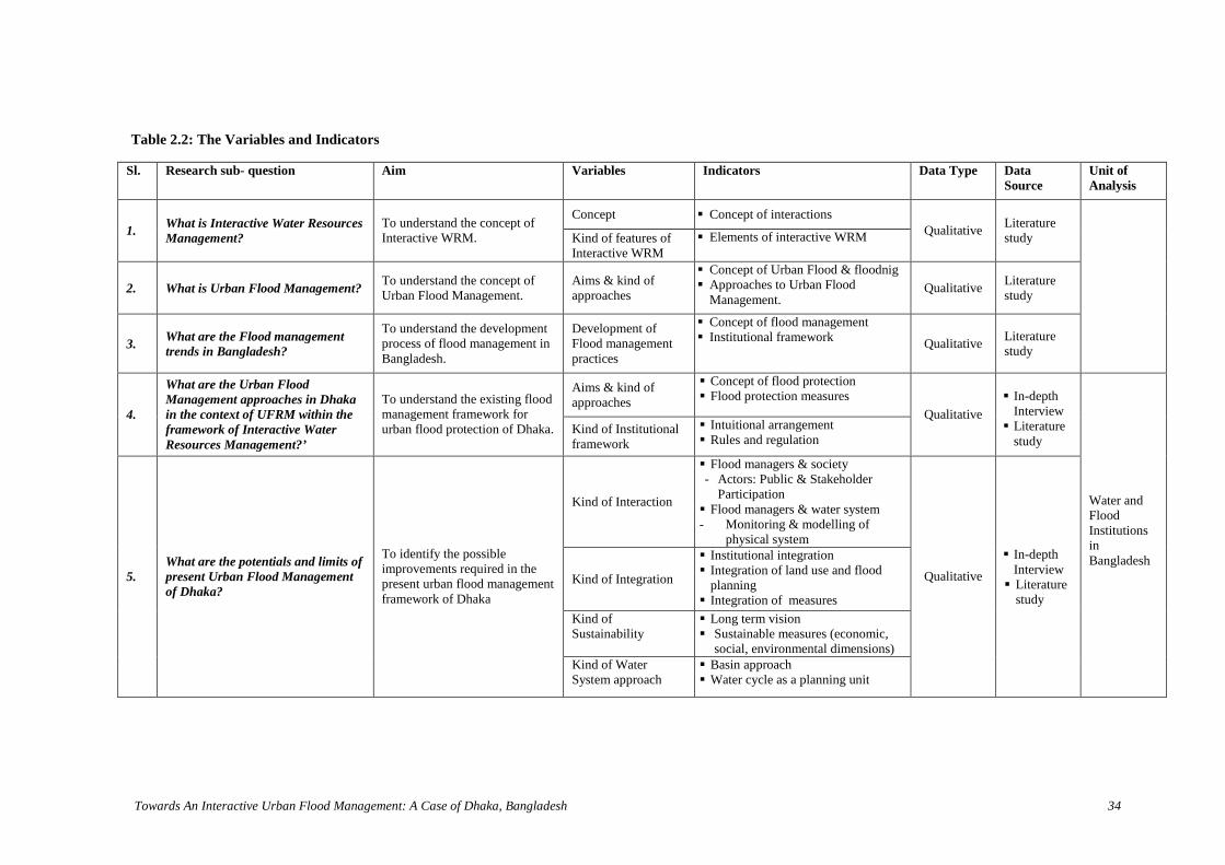
Towards An Interactive Urban Flood Management: A Case of Dhaka, Bangladesh 34
Table 2.2: The Variables and Indicators
Sl. Research sub- question Aim Variables Indicators Data Type DataSource
Unit ofAnalysis
Concept Concept of interactions
1.What is Interactive Water ResourcesManagement?
To understand the concept ofInteractive WRM. Kind of features of
Interactive WRM Elements of interactive WRM
QualitativeLiteraturestudy
2. What is Urban Flood Management?To understand the concept ofUrban Flood Management.
Aims & kind ofapproaches
Concept of Urban Flood & floodnig Approaches to Urban Flood
Management.Qualitative
Literaturestudy
3.What are the Flood managementtrends in Bangladesh?
To understand the developmentprocess of flood management inBangladesh.
Development ofFlood managementpractices
Concept of flood management Institutional framework
QualitativeLiteraturestudy
Aims & kind ofapproaches
Concept of flood protection Flood protection measures
4.
What are the Urban FloodManagement approaches in Dhakain the context of UFRM within theframework of Interactive WaterResources Management?’
To understand the existing floodmanagement framework forurban flood protection of Dhaka. Kind of Institutional
framework
Intuitional arrangement Rules and regulation
Qualitative
In-depthInterview Literature
study
Kind of Interaction
Flood managers & society- Actors: Public & Stakeholder
Participation Flood managers & water system- Monitoring & modelling of
physical system
Kind of Integration
Institutional integration Integration of land use and flood
planning Integration of measures
Kind ofSustainability
Long term vision Sustainable measures (economic,
social, environmental dimensions)
5.What are the potentials and limits ofpresent Urban Flood Managementof Dhaka?
To identify the possibleimprovements required in thepresent urban flood managementframework of Dhaka
Kind of WaterSystem approach
Basin approach Water cycle as a planning unit
Qualitative
In-depthInterview Literature
study
Water andFloodInstitutionsinBangladesh

Towards An Interactive Urban Flood Management: A Case of Dhaka, Bangladesh 35
3.4 Research Methods and strategy
This is a qualitative exploratory and descriptive type of research, which leads tothe identification of the elements of interactive water management approach thatcan contribute to the improvement of flood management in Bangladesh.
In this research the case study is used as a main research strategy. The concepts ofinteractive water resources management and its possibilities in Bangladesh areillustrated by a case study of flood management in Dhaka. As part of internationalcase study Australia and Japan water and flood management approaches andinstitutional perspectives on public participation that are in practice are alsostudied through desk research. In addition to this, historical data are used to learnabout the development of water management systems with a particular focus onflood management in the world in order to compare this with flood managementin Dhaka.
3.5 Unit of analysis: Water and flood institutions
Unit of analysis for the research is the Water and flood institutions that areinvolved in water resources management in Bangladesh and flood management inDhaka. The focus of the research is the understanding of the concept of InteractiveWater Resource Management. The research aim is to analyze the interactiveapproaches that can be used in flood management in Dhaka. To be successful,IFM should be based on a firm legal framework and supporting institutionalarrangements (APFM 2004). This requires the analysis of the existing institutionalframework for flood management within the context of water resourcesmanagement.
3.6 Data collection
This qualitative research is based on primary and secondary data collection tounderstand the trends of the water resources management in Bangladesh and toanalyze the interactive approaches towards flood management and how suchapproaches can improve flood management in Dhaka.
3.6.1 Primary data collection
The primary data are collected through fieldwork between July 3 and August 31 inDhaka, Bangladesh. The data are collected through in-depth interviews andobservational study.
In-depth interviewIn-depth interviews are conducted with open-ended and semi-structured questions.This is done to explore views and perspectives of the water resources managementauthorities. The interview is also carried out with urban planners, water managers,academicians, researchers (Annex 2) from government, private and internationalorganizations, universities and research institutes to understand the trends of waterresources management, flood management practices and to explore their way of

Towards An Interactive Urban Flood Management: A Case of Dhaka, Bangladesh 36
thinking towards how to integrate network of actors and institutions. Theresponses are recorded with written notes and audiotape.
Table 3.3: The list of Respondent OrganizationsRespondent OrganizationsBangladesh Water Development Board (BWDB)Water Resources Planning Organization (WARPO)Flood Forecasting and Warning Center (FFWC)Dhaka Water and Sewerage Authority (DWASA)Local Government Engineering Departments (LGED)Rajdhani Unnayan Katripakkya (RAJUK)Center for Environment and Geographic Information Service (CEGIS)Institute of Water Modelling (IWM)The International Union for Conservation of Nature (IUCN), BangladeshInstitute of Water and Flood Management, Bangladesh University of Engineering and Technology(BUET)
Observational Study
An observation study was carried by the author to observe the conditions floodcontrol structures includes the western embankment, regulators and two Pumpstations namely Goran Chatbari and Rampura Pump stations. The study focusedon the conditions of the embankment, how the pump works and the surroundingland use development. These areas are purposively selected for observation.During field visit to the pump stations an unstructured interview is carried outwith the Sub-assistant engineer of Goran Chatbari pump station and pumpoperator and Gauge Recorder of Rampura pump station. The interview with themwas useful in gaining a perspective of the situation. A digital camera is used tokeep record of observation for later analysis and illustration of the results.
3.6.2 Secondary data collection
The secondary data source for the research is literature study. Literature studyincludes published papers, theses, journal articles, government reports, books onwater resources management, flood management, water governance, newspaperarticles and internet sources.Trends of water resources management, institutional arrangements, publicparticipation, stakeholder participation, flood management of developed anddeveloping countries are discussed in the theoretical part of this research.
3.7 Data quality
Qualitative data is used for this research. The data quality is evaluated throughvalidity, reliability and its objectivity.
Validity: The fieldwork is demonstrated entirely by the researcher. The interviewsare conducted with semi-structured questions. Audio recording is carried outduring interviews with the respondents. Therefore it is expected that consistentand quality data is assembled. In addition to this, the validity of this qualitativeresearch is controlled by the use of data triangulation (interview review, deskstudies, and project reports) to measure the validity of the collected data.

Towards An Interactive Urb
Reliability: The nature of the interview questions intend to be based on real facts,not on subjective opinions. This is to ensure the collected information will notchange over time.
Objectivity: The maximum neutrality is maintained in introducing the questions toensure the objectivity of the instruments.
3.8 Research Population and sample
The population of the research is 13 million inhabitants of Dhaka city.Purposively selected sampling technique is implemented in the study to identifythe interactive approaches to water resources management with a particular focuson urban flood management in Dhaka. This is a non-probability sampling and theinterviewees are selected from government, private organizations and researchinstitutions that are involved in water resources and flood management in Dhaka.
3.9 Instrument Design
Semi-structured questionnaire (Annex 1) is used to carry out the in-depthinterviews. The questionnaire is designed in a logical order and organized it in away to be able to answer the research sub-questions. Greater cares are taken todetermine which questions are needed to measure the research variables andobjectives, as well as to avoid leading questions.
3.10 Data analysis
This qualitative data a
Data Collection
Primary: semi-structured interviewswith open-endedquestions regardingresponses
Secondary: Literaturereview, reports,journals, books,internet, newspaperetc.
SWOT analysis ofthe present UrbanFlood Managementof Dhaka
Learning relevantto local context
Conclusion &Recommendations
Learning fromtheories & case studies
Identification of factors:constrain or facilitate theeffective and efficientmanagement of UrbanFlood Protectionactivities.
an Flood Management: A Case of Dhaka, Bangladesh 37
nalysis (empirical) part of the study has two stages;
Figure 3.2: The Data Analysis Framework

Towards An Interactive Urban Flood Management: A Case of Dhaka, Bangladesh 38
1. First stage: At this stage the factors are identified that constrain orfacilitate the effective and efficient management of UF protectionactivities in the light of Interactive WRM in Dhaka.
2. Second stage: The SWOT analysis is carried out to identify the potentialsand limits of the current Integrated Flood Management based on literaturestudy and in-depth interviews.
The analysis of the Interactive WRM approach is carried out to get insight of theapproaches applied in Dhaka, with regards to UFM. The basic information aboutthe functioning of the water systems and water chains are also revealedconsidering other different dimensions like participation, institutional integration,long term planning in the line of sustainability.
The data obtained from interviews and desk studies reveals the possibilities ofdeveloping policy recommendations on development of interactive floodmanagement in Dhaka.
3.11 Scope and limitations of the study
The research has focused only on the defining interactive approaches indevelopment of Urban Flood Management in Dhaka. This study can form a usefuland important knowledge base for further intervention in water resourcesconservation, water services and flood issues.
The research is conducted in an extensive manner within a limited time period.The field work is carried out in the month of July. In Dhaka the monsoon (rainyseason) is from May to September. And heavy rainfall occurs in June, July andAugust which is the peak time for urban flooding. Therefore the governmentofficials were very busy in managing the flood situation and attending meetings.In that way the weather was not in favour of conducting the field work.

Towards An Interactive Urban Flood Management: A Case of Dhaka, Bangladesh 39
Chapter 4 Urban Flood in the Context of Dhaka
4.1 Introduction
This chapter begins with a brief description of the Dhaka city. It includesgeographical context of Dhaka, its climatic features and a short discussion onhistory and urban expansion. This description is followed by a brief description ofthe hydrological features of Dhaka in the urban flood context. The chapterconcludes with urban flood and its impact.
4.2 Geographic context of Dhaka
Dhaka, the capital of Bangladesh, is confined between latitudes 24°40' N to24°54' N and longitudes 90°20' E to 90°30' E. The periphery is bounded bydistributaries of the GBM basin. The elevation of Greater Dhaka ranges from 2 to13 meters above mean sea level (msl) and most of the built-up areas are onelevation of 6 to 8 meters above the msl. The general slope of the city is visibletowards the east west direction. The city and adjoining areas are composed ofalluvial terraces and low-lying areas.
4.3 Climate of Dhaka
The climate of Dhaka is characterized by hot humid sub tropical climate. The cityhas four seasons: Pre-Monsoon (March-May), Monsoon (June –September), Post-monsoon (October-November) and Dry season (December-February). The cityexperiences cool and short winter and hot, humid and long summers. Thetemperature in summer varies from 21.1°C to 36.7°C and in winter from 10.5°C to31.7°C. The monthly rainfall varies between 300 and 450 mm. In dry season themean rainfall is about 50mm/day and 300-450mm/day from June to August. Themean monthly evaporation varies between about 80 mm in November and about130 mm in August (JICA 1991).
4.4 History and growth of Dhaka
The history of Dhaka dates back to 7th century. Under Mughal rule in 1608 A.D.,Dhaka, also known as Jahangir Nagar, was founded as the Provincial capital ofBengal. The city was established on the north-eastern bank of the BurigangaRiver. The Mughal Rulers were attracted to the Buriganga River forcommunication and defense against enemies. Since then, Dhaka city has grownmainly on the northern and eastern banks of the Buriganga River until 1960s,mainly because of easy transportation (Khorshed, 2003). In 1765 the city cameunder British control and Dhaka became the capital of Eastern Bengal and Assamprovince (1905-12). In 1947 the city emerged as administrative capital of EastPakistan. Later in 1972, after the victory in the War of Liberation in 1971, Dhakabecame the capital of the People’s Republic of Bangladesh.

Towards An Interactive Urban Flood Management: A Case of Dhaka, Bangladesh 40
At present, Dhaka is one of the most densely populated cities in the world. Dhakaaccommodates the major share of 43% of total urban population (BBS 2003 inIslam 2008). In Dhaka city the urban population density is 4795person/sq.km(Islam 2008). Between 1947 and 1971, the city grew from an area of 1,800 ha to18,000 ha, and by 1991, the city boundary embraced an area of almost 26,500 ha(160 sq km) (Khorshed 2003). Dhaka’s population has grown from 4 million in1980 to 6.5 million in 1990 and an estimated 10 million in 2001 (BBS 2001 in(Khorshed 2003). The table 4.1 shows the population of Dhaka since 1700s.
Table 4.1: Area and Population of Dhaka City (1600-2001)
Year Period Area(Sq. m)
Source Population Source
1600 Pre-Mughal Period 1 Islam, 1974 Unknown --1700 Mughal Capital 50 Taylor, 1840 9,00,000 Taylor, 18401800 British Town 8 Islam, 1974 2,00,000 Taylor, 18401867 British Town 8 Islam, 1974 51,000 Census of Bengal, 1901
1911 British Town -- -- 1,25,733 Census of Bengal, 19111947 Capital of East
Pakistan12 Islam, 1974 2,50,000 Census of Pakistan, 1951
1951 Pakistan Period -- -- 3,35,928 Census of Pakistan, 1951
1961 Pakistan Period 28 Census of Pakistan,1951
5,50,143 Census of Pakistan, 1951
1971 Capital ofBangladesh
40 Census of Bangladesh,1974
15,00,000 Census of Bangladesh, 1974
1974 Capital ofBangladesh
40 Census of Bangladesh,1974
16,00,000 Census of Bangladesh, 1974
1981 Dhaka Municipality 62.4 Census of Bangladesh,1981
24,75,710 Census of Bangladesh, 1981
1981 Dhaka SMA 155.4 Census of Bangladesh,1981
34,40,147 Census of Bangladesh, 1981
1991 Dhaka SMA -- -- 69,50,920 Census of Bangladesh, 1991
2001 Dhaka SMA -- -- 99,12,908 Census of Bangladesh, 2001
Source: (Tawhid, 2004)
4.5 Hydrology of Dhaka4.5.1 Surface Water Hydrology
4.5.1.1 Rainfall-runoff
Average annual rainfall ranges from 1700 to 2200mm. More than 80% of theannual rainfall occurs in the monsoon season (May to September). June, July andAugust are the months of heavy rainfall. The urban Dhaka has many impervioussurfaces like paved roads and parking, roof of buildings, paved walkways etc. as aresult the runoff rate is higher than in the rural areas. Even the rate varies betweenresidential areas and commercial areas. It is seen that in the year 1996 and 1997the commercial areas had 80% higher runoff ratios2 than those of residential areas(Chowdhury et al. 1998b).
2 Runoff ratio is the percent of impervious area and fraction of rainfall.

Towards An Interactive Urban Flood Management: A Case of Dhaka, Bangladesh 41
4.5.1.2 Drainage System
The low-lying areas, canals, lakes and ponds of Dhaka city act as detention basins(Figure 4.1) and perform the drainage function. The storm water is accumulated inthe low-lying areas and lakes; flows through the storm channel i.e khals (Annex 3)and discharged to the surrounding rivers. The functioning of the drainage systemdepends on the water level of surrounding rivers. Generally during monsoon thesurrounding river water remains high. Therefore, the drainage system is under theinfluence of backwater effect from surrounding rivers. The Greater Dhaka hasmore than 40 khals that drain 80% storm water of the city to the surroundingrivers (Khan 2006). The major khal systems are (Chowdhury et al. 1998b):
a) Degun-Ibrahimur-Kallyanpur khal system that drains to Turag River;b) Dhanmondi-Paribagh-Gulshan-Banani-Mohakhali-Begunbari khal system
that drains to Balu River;c) Segunbagicha-Gerani-Dholai khal system that drains to Balu and Buriganga
rivers.
The Dhaka west has 13 khals of total length of more than 31km and the DhakaEast has 27 khals of total length of about 60 km (Table 4.2).
Table 4.2: Major Retention areas of Dhaka CityName Length (m) Avg. Depth
(m)Area
(Km2)Volume
(m3)Dhanmondi Lake 2,400 2.5 0.176 440,000Ramna Lake 400 4.5 0.020 90,000Crescent Lake 650 2.5 0.016 40,000Gulshan Lake 3,800 2.5 0.480 1,200,000Hateer Jheel 3,000 2.0 1.078 2,160,000
Source: (Khan, 2006)
In the master plan of flood protection Dhaka city is divided into 12 drainage zonesfor storm water drainage (JICA 1992). Dhaka Water Supply and SewerageAuthority (DWASA) manage 140 km2 storm water drainage networks (Figure4.1), from which the natural drainage system receives the storm water and drainsthrough regulators at the embankment to the rivers.
4.5.1.3 River system
Dhaka is surrounded by rivers namely Turag River, Tongi khal, Balu River andBuriganga River (Figure 4.1). River Turag, Buriganga and Balu are connectedwith the Dhaleshwari River (Annex 4). The Turag and Buriganga rivers aredistributaries of the Old Brahmaputra River and The Balu river is the tributary ofthe Lakhya River (Chowdhury et al. 1998b). The Tongi khal is connects the TuragRiver with the Balu River.
4.5.2 Ground Water Hydrology
The aquifer system of Dhaka is recharged by infiltration of rainwater, floods,leakage from urban water distribution and sewerage systems and water transfer. Itis discharged by aquifer drainage to the rivers, direct evapo-transpiration, andground water abstraction (BCEOM 1992 in Chowdhury et al. 1998b). Dhaka’s
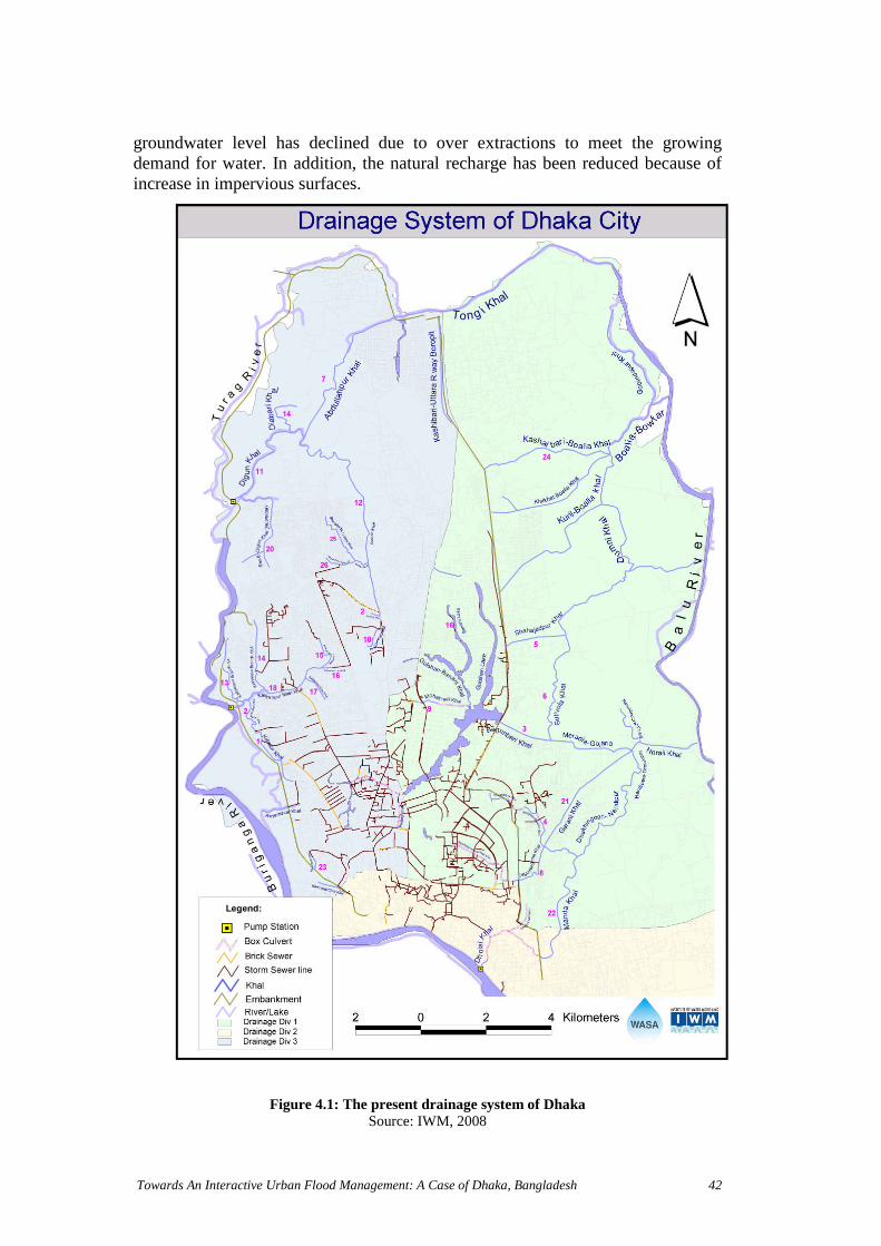
Towards An Interactive Urban Flood Management: A Case of Dhaka, Bangladesh 42
groundwater level has declined due to over extractions to meet the growingdemand for water. In addition, the natural recharge has been reduced because ofincrease in impervious surfaces.
Figure 4.1: The present drainage system of DhakaSource: IWM, 2008

Towards An Interactive Urban Flood Management: A Case of Dhaka, Bangladesh 43
4.6 Urban Flood and its impact
Geographically Dhaka has a strong relationship with water resources like rivers,canals, lakes, and wetlands. Due to its location on the drainage path of The GBMbasin Dhaka is subjected to annual flooding. One-fifth of Dhaka is categorized asflood free high ground with 38% being subject to annual flooding. The remaining42% is subject to flooding at intervals between five and one hundred years (Alam2004). During the month (June-August) of heavy rainfall Dhaka becomesinundated. In recent years vulnerability to flood has increased. During last 50years Dhaka experienced significant urban growth. With this unplanned urbanexpansion Dhaka has gone through a drastic land use change. This change in landuse reduced infiltration, storage area for storm water, construction of roads andbuildings modified the pattern of drainage flow. Even with an hour long rainfallDhaka inundates due to the poor conditions of drainage channels that aredestroyed by encroachments and land-filling. As a result the degree of floodinghas become a fact of life for the citizens of Dhaka.
The inhabitants of Dhaka are experiencing floods since its early dates. Thedisastrous floods affect physical settings, environment, quality of life and mostimportantly the economy of urban settlements. Dhaka being a capital city is theconcentration of resources, infrastructures, service facilities, and economicactivities. Consequently the impact of flood results in a high degree of economicloss, property loss, physical damages, and health hazards. The most vulnerablegroup in the city, the people living in slums are forced to live in flood risk areas.
In 1988, the most severe flood in the flood history of Dhaka, 2.2 million peoplewere affected and the death toll was 150 (Huq & Alam 2003). Around 14000institutions and 400000 houses were damaged in this flood (Annex 8). Thedamage costs were Tk. 4 billion for residential buildings and more than Tk. 400billion for institutions (Alam & Rabbani 2007). In the flood of 1998 the damagecosts were tk. 2.311 million (Huq & Alam 2003).
Both flooding and water logging, cause serious damage to infrastructure likeroads, railways, formal and informal housing and institutions. They also disruptcommunication, slow down economic activities. The water logging especially
Figure 4.3: Water crises during flood
Source:www.cnn.com/.../29/southasia.floods/index.html
Figure 4.2: Flood affected streets inKalachadpur,DhakaSource:ochaonline.un.org/.../tabid/1775/Default.aspx

To
befunrepaffbil
4.7
FloaspAspriaccanbeco
FigSo
wards An Interactive Urban Flood Management: A Case of Dhaka, Bangladesh 44
comes a burden for the dwellers of Dhaka city as it poses challenges to socialctioning, the environment and economic activities (Alam & Rabbani 2007). Aort of DWASA states that during the flood of 2004, storm water floodingected 250 schools, 681 garment factories and the garment sector lost Tk. 632lion and road repair costs Tk 12.8 billion (Tawhid 2004).
Summary
oding in Dhaka is mostly seen as an unpleasant event. Flood affects almost allects of human life. In the flood history of Dhaka, the damages were enormous.an economic centre of Bangladesh, flood prevention in Dhaka implies high
ority. The process of urbanization has altered the natural system andelerated the flooding vulnerability. Therefore measures to prevent flood events
d measures, which reduce economical & social damage, are very important toconsidered in development activities of Dhaka with regard to their
nsequences.
Figure 4.7: Flood affected shopkeepers sit inWater logged shopSource:http://news.bbc.co.uk/.../newsid_6923500/6923552.stm
Figure 4.5: Flooded Baridhara residential areaSource: http://commons.wikimedia.org
Figure 4.6: Flooded streets of DhakaSource:
http://www.thedailystar.net/magazine/2004/09/04/cover.htm
ure 4.4: Disruption in traffic movementurce: The Daily Star, 24 September, 2007

Towards An Interactive Urban Flood Management: A Case of Dhaka, Bangladesh 45
Chapter 5 Perspectives of Urban Flood Management in Dhaka
5.1 Introduction
This chapter starts with a brief background on urban floods in Dhaka and itsnature. It also provides a short description of recent major flooding events ofDhaka. This is followed by a brief discussion on urban flood managementpractices in Dhaka. In addition, institutional framework, legislative and policyframework for urban flood management are also presented here.
5.2 Urban Floods and its Nature
Dhaka city suffers from two types of urban flooding: river floods and storm waterfloods.
5.2.1 River Flood
The main cause of river flooding in Dhaka is the spill over from the surroundingrivers: Turag, Buriganga, Balu, Tongi canal, Shitalakya. Once in every five to tenyears river floods take place in the low-lying fringes areas outside the protectiveembankment of Dhaka. The water level of rivers flowing around Dhaka is affectedby both discharge from the upstream rivers (Dhaleswari, Bangsi and OldBrahmaputra) and also by the backwater effect from downstream rivers(Daleswari, Meghna, Lakhya and Padma River) (Islam 2008). The Balu, Turagand Buriganga rivers are under the influence of tides in the Lower Megna and therecession of flood is delayed if peak flood occurs during spring tides (Chowdhuryet al. 1998b). River flood generally occurs in the month of July to September.During this period the surrounding river stages remain high and cannotaccommodate the water flow within the main watercourse.
5.2.2 Storm-water Flood
A flood caused by excessive rainfall is termed as storm-water flooding. Thefollowing are the causes of storm water flooding in Dhaka: During the monsoon season the water level of the surrounding rivers
generally remains higher than the water level inside the city and gravitydrainage is not possible;
Inadequate drainage paths, improper operation and maintenance of theexisting storm water drainage system;
Increasing impervious areas reduce infiltration and in turn increase surfacerunoff;
The existing drains are subjected to increased inflow of storm water and failto carry the increased discharge due to the change in drainage flow by theconstruction of roads and other infrastructures;
The catchment capacity to retain the excess runoff generation by heavyrainfall is reduced because of filling up low-lying areas and natural drainagesystems (canal, lakes).

To
5.3
Byha
19
Thfloinflotha
19
InfloAlcaucorunbeenalsDhnoinacau
20
DuBafloregclo
FigflooSouMa
wards An Interactive Urban Flood Management: A Case of Dhaka, Bangladesh 46
History of Urban Floods
virtue of being surrounded by the distributaries of several major rivers, the citys been subjected to periodic flooding since its early days (Huq & Alam, 2003).
88 Flood
e 1988 flood (Annex 5) was the largest ever recorded and catastrophic. Thisod was mainly caused by inflows from the upstream areas, which caused a risethe river water levels (Faisal et al. 2003). The flood peaks were higher in thisod compared to the 1998 flood but the areas surrounding Dhaka received lessn average rainfall (Faisal et al. 2003).
98 flood
1998, Dhaka (figure 5.1) was affected both by river and storm water flood. Thisod was most severe in terms of extent and duration (two months) (Huq andam 2003). Excessive rainfall over the catchment areas of the GBM river basinsed the 1998 flood. The rainfall was 40% higher in July and 35% in August
mpared to normal rainfall in the July-August period (Faisal et al. 2003). Theoff generated by excessive rainfall could not flow to the surrounding rivers
cause the river water level was higher than the inside flow. During this flood thetire eastern part of Dhaka went under water. The protected western Dhaka waso flooded due to hydraulic leakage in incomplete flood wall in the southernaka and flood water intrusion through open underground pipes and drains in therthern part. The failure in timely operation of the Rampura regulators anddequate pumping failed to prevent the backflow from the Balu River andsed storm water flooding.
04 flood
ring the 2004 flood Dhaka east was inundated by spill floodwater from thelu River. In Dhaka West, the river flood was caused due to the intrusion ofodwater from Balu River through some unblocked culverts and unclosedulators. In July 2004 storm water flooding occurred when the regulators weresed to protect Dhaka from river flood. A second spell of storm water flooding
Figure 5.2: The commercial hub of Dhakaunder knee-deep water.Source:http://www.thedailystar.net/magazine/2004/09/04/cover.htm
ure 5.1: The Greater Dhaka east isdedrce: Shafiq Alam, Star Weekendgazine, 10 August, 2007.
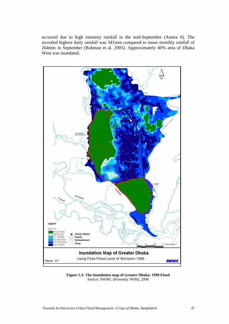
Towards An Interactive Urban Flood Management: A Case of Dhaka, Bangladesh 47
occurred due to high intensity rainfall in the mid-September (Annex 6). Therecorded highest daily rainfall was 341mm compared to mean monthly rainfall of264mm in September (Rahman et al. 2005). Approximately 40% area of DhakaWest was inundated.
Figure 5.3: The Inundation map of Greater Dhaka: 1998 FloodSource: SWMC (Presently IWM), 2008

Towards An Interactive Urban Flood Management: A Case of Dhaka, Bangladesh 48
5.4 Urban Flood Management: Aims and Approaches
The flood management in Dhaka aims to reduce the damages of properties,infrastructure and saving lives from river flood and also the improvement ofdrainage khal to reduce damage from storm water flooding. The floodmanagement approaches that are in practice are mainly two types, structural andnon-structural measures. The measures are mostly physical in nature.
5.4.1 Structural Measures
The structural measures are mainly to control the flood with the help ofengineering interventions, which include construction of embankments, and floodwalls (for dense area) with regulators and sluice gates on riverbanks to preventover-bank spillage. The improvements of drainage condition are undertaken byvarious methods to protect storm-water flood, which include replacement ofnatural khal by concrete box culvert, pumping stations (permanent andtemporary), and retention pond to accumulate the storm water. After the floodhazard in 1988, Dhaka west has been encircled by embankments, flood walls andraised roads to give protection against riverine flood. The protection comprises ofthe following components (Chowdhury et al. 1998b) (figure 5.3):
1. Approximately 30 km of earthen embankment along Tongi canal, TuragRiver and Buriganga River.
2. Approximately 37 km of raised road and floodwall.3. A total number of 11 regulators at the outfall of canals to the surrounding
rivers along the embankment.4. One regulator and 12 sluice gates on the canals at the crossing with Biswa
Road, DIT road, Pragati Sarani, Mymensingh road and railway line atUttar Khan.
5. Three pump stations
The present storm water drainage network under Dhaka WASA covers an area ofapproximately 150 sq. km. the important components of the drainage network are:
1. 22 open canals having width of 10-30 m and total length of approximately65km.
2. 250 km of underground pipes having diameter ranging from 450 to3000mm.
3. 12 km of box culverts of sizes from 2.5m x 3.4m to 6m x 4.1m.4. 3 pumping stations, of capacity of 22, 9.6, 22 cumec (cubic meter per
second)5. 151 temporary pumping stations of capacity of 25, 5 cumec.
In addition, the Dhaka City Corporation (DCC) has constructed and maintainsapprox. 2,460 km surface drains, which carry storm water to the main sewer lines.Rajdhani Unnayan Katripakkhya (RAJUK) also constructs roadside undergrounddrainage lines during the construction of new roads.

Towards An Interactive Urban Flood Management: A Case of Dhaka, Bangladesh 49
5.4.2 Non-structural Measures
The non-structural measure are employed to improve the capacity to manage theconsequences of floods and reduce the vulnerability of the flood affected peopleand their property. This includes: Flood Forecasting and Warning (FFW), FloodPlain management measures like flood proofing, flood-plain zoning.
The major activities FFW includes data management and processing, weatheranalysis, model operation and forecasting, flood maps generation, website updateand information dissemination. The data is disseminated via Internet, email, fax,telephone, radio and television.
Flood proofing and flood plain zoning is not in practice in Dhaka. Dhaka StructurePlan (DSP) broadly demarcates the flood flow zones without detail planningproposal. The plan proposed actions for the preservation of the retention pondsaround the city limits for rainwater retention and to maintain ecological balance. Italso highlights the land use controls and building regulations but those have notbeen adopted. In terms of flood proofing Bangladesh National Building Codeprovides flood proofing measures to reduce physical vulnerability with referenceto flood resilient housing, infrastructure, construction material etc. butunfortunately the codes are not well practiced.
5.5 Flood Mitigation Measures: Studies and Actions
Following the severe flood of 1987 and 1988, The World Bank initiated the FloodAction Plan (FAP) in 1989 to find a long-term strategic solution to deal withflooding problem. Under the FAP a number of projects were undertaken for theflood protection of Dhaka city.
The Greater Dhaka Flood Protection Project (FAP-8A) covers the highest priorityareas like East Dhaka, the Dhaka-Narayanganj-Demra (DND) Project area andwest Narayanganj. The DND project was developed as an irrigation project in1968. But due to its proximity to the city of Dhaka and Narayanganj, the projectarea converted into residential area. Unplanned development took place and theagriculture has been largely abandoned. At present drainage and water logging hasbecome a major problem for DND area.
The Dhaka Integrated Flood Protection Project (FAP-8B) covers about 262sq. kmof the city. As part of this plan, the project was partially implemented in theWestern Dhaka by construction of embankments and rising of roads to giveprotection from river flood. The plan has not been implemented in the remaining124 sq. km of Eastern Dhaka to date primarily due to funding constraints.
After the second devastating flood of 1998 the government of Bangladesh gavehigh priority to reduce the extent of suffering and damages in the eastern part ofthe Dhaka city and pledged to implement an integrated project entitled ‘DhakaIntegrated Flood Control Embankment Cum Eastern Bypass Road MultipurposeProject’ to protect the Greater Dhaka East.

Towards An Interactive Urban Flood Management: A Case of Dhaka, Bangladesh 50
The table 5.1 and figure 5.4 provides the brief description of the above mentionedthree flood projects.
Figure 5.4: Dhaka city flood control & drainage mapSource: CEGIS, 2008
DHAKA WEST
Dhaka Integrated FloodProtection Project
(1991-2003)Project Components Embankment 30km Pump Station 3nos. Flood Wall 4.50km Access Road 16.50 km Drainage khal
improvement 13.00kmImplementing AgencyBWDB, DWASA, DCC
DHAKA EAST
Dhaka Integrated FloodControl Embankment
cum Eastern Bypass RoadMultipurpose Project
(Proposed)Project Components Embankment 24km Pump Station 3nos. Flood Wall 3.4km Access Road 18.60 km Drainage khal
improvement 80.40km A forestation 40km
Retention Ponds 6nos.(927 ha)
DND FCDI Project
Dhaka-Narayanganj-Demra Project(1962-1968)
Project Components Embankment 31.25km Drainage khal 45.40km Irrigation khal 55.20km Pump House 1no.Implementing AgencyBWDB

Towards An Interactive Urban Flood Management: A Case of Dhaka, Bangladesh 51
Table 5.1: The Flood Control and Drainage (FCD) and Flood Control Drainage and Irrigation projects of Dhaka
DHAKA WEST DHAKA EAST DND FCDI PROJECT
Dhaka Integrated FloodProtection Project
(1991-2003)
Dhaka Integrated Flood ControlEmbankment cum Eastern Bypass Road
Multipurpose Project(Proposed)
Dhaka-Narayanganj-Demra Project(1962-1968)
Objectives:
Provide flood protection & Drainageimprovement
Deliver transport benefits
Provide flood protection & Drainageimprovement
Deliver transport benefits Planned urbanization
Provide flood protection Drainage improvement Irrigation
Project cost: Tk 8369 million Tk 27504million (US$393million)
ProjectComponents:
Embankment 30km Pump Station 3nos. Flood Wall 4.50km Access Road 16.50 km Drainage khal improvement 13.00km
Flood embankment 24km Floodwall 3.4km Bypass road 18.60km Pump station 3nos. 165m3/sec Khal improvement 80.40 km A forestation 40km Retention pond 6nos (927ha)
Embankment 31.25km Drainage khal 45.40km Irrigation khal 55.20km Pump House 1no. 14.52m3/sec
Present Problem Flooding due to congestion of storm water/waste water. Insufficient pump capacity Land use changed due to rapid urbanization Encroachment of drainage khal Pollution Lack of public awareness
Benefits:
(achieved/
expected)
Flood protection improved Drainage Network Improved Employment & occupational opportunities
improved Increased income level & reduced poverty level Communication network improved Environmental Management improved Benefitted population 10 million
(Approx.)Present Problem Flooding due to congestion of storm
water/waste water. Encroachment of drainage khal Pollution
Flood protection and drainage improvement Urbanization would be accelerated in a planned
manner Employment & occupational opportunities
would be increased Increase level of income & decrease poverty
level Communication network will improve Positive social and environmental impact EIRR 23.9% Benefit cost ratio 1.76 Benefitted population 23 million (approx.)
Proposed solution Comprehensive drainage management plan Rehabilitation of existing pump house Construction of new pump house Solid waste management & pollution control Eviction of unauthorized encroachments Benefited Population 1.2 million (approx.)

Towards An Interactive Urban Flood Management: A Case of Dhaka, Bangladesh 52
5.6 Institutional Framework for Urban Flood Management
5.6.1 Institutional ArrangementsA number of organizations from different ministry are responsible for Dhaka cityflood protection and drainage management. At national level the Ministry ofWater Resources (MoWR) and at local level Ministry of Local Government, RuralDevelopment and Co-operatives is directly involved in flood management inDhaka (Table 5.2).
Bangladesh Water Development Board
Bangladesh Water Development Board is the leading organization for waterresources management and development. BWDB is responsible for floodprotection and mitigation for the entire country including Dhaka. It constructs andmaintains embankments and flood walls, operates regulators and pump stations.BWDB also deals with irrigation; river bank and town protection; floodforecasting and warning services; hydro-meteorological data management; landreclamation; protection against tidal surge. BWDB collects and maintains data onsurface water (water level, discharge, sediment data, and water quality),groundwater (level measurement, quality), morphology (river cross section) andmeteorology (rainfall, evaporation, climatologically station).
Flood Forecasting and Warning Center (FFWC)
Flood Forecasting and Warning Center (FFWC) was established in 1972. It worksunder Planning Wing of BWDB headed by chief engineer hydrology. FFWC hasestablished hydrological monitoring stations on rivers across the country. Theproducts of this centre are satellite image, Rainfall distribution map, Daily bulletin& river summary, Forecast bulletin & Hydrograph, Inundation Map, Riversituation map, Thana status map. The disseminate the data via internet, email, fax,telephone, radio and television to President’s office, prime Minister’s office,Ministry of Water Resources, Disaster Management Bureau, Public InformationDepartment, news agencies, NGO’S & local administration. Their majorlimitations include insufficient Forecast Lead Time, Forecast in major rivers only,Weak dissemination up to village level, lack of Review and Response.
Water Resources Planning Organization (WARPO)
The Water Resources Planning Organization (WARPO) is an institution under theMinistry of Water Resources. WARPO is a key organization of the Governmentdealing with nationwide water resources planning and management and thusforming an apex body in the water sector. It is an institution for macro-level waterresources planning. It provides administrative, technical and legal support toECNWRC3, and advises them on policy planning and regulatory matters of waterresources and environment. The core tasks of WARPO includes: monitoring,implementation of the NWMP and its impacts, monitoring the application of
3 According to National Water Policy 1999, WARPO is the secretariat to the Executive Committeeof the National Water Resources Council (ECNWRC).

Towards An Interactive Urban Flood Management: A Case of Dhaka, Bangladesh 53
Guidelines of Participatory Management and update it etc. The periodic functionsof WARPO include periodic update of NWMP, ad hoc advice on policy, strategy,institutional and legal issues assist other agencies in planning, monitoring, studiesand investigations etc.
Table 5.2: The Institutional Framework for Flood Management in Dhaka
Ministry Organizations
Bangladesh Water Development Board(BWDB)
Water Resources Planning Organization(WARPO)
Ministry of Water Resources(MoWR)
Flood Forecasting and Warning Center(FFWC)
Dhaka Water and Sewerage Authority(DWASA)
Dir
ectl
yIn
vo
lved
Org
aniz
atio
ns
Ministry of Local Government,Rural Development and Co-operatives Dhaka City Corporation (DCC)
Dhaka Capital Development Authority(RAJUK)
Ministry of Housing and PublicWorks
Public Works Department (PWD)
Bangladesh Space Research and RemoteSensing Organization (SPARRSO)
Ministry of Defence
Bangladesh Meteorological DepartmentMinistry of LandIn
dir
ectl
yIn
volv
edO
rgan
izat
ion
s
Ministry of Communications Roads and Highways Department (RHD)
Center for Environmental and Geographic Information Services (CEGIS)An independent public trust running under the Ministry of Water Resources chairedby the Secretary of the MoWR.
Pri
vat
eO
rgan
izat
ion
s
Institute of Water Modelling (IWM) A centre of excellence and research in the field of Water Modelling, Computational
Hydraulics and allied Sciences Also supports FFWC.
Source: Author, 2008
There is a steering committee to ensure better services. These committees areformed of executives of different organizations and stakeholders. Thesecommittees take decision and monitor implementation. They establishcoordination among the responsible organizations by arranging discussion.
Besides these committees there are Inter-ministerial Committee to take decisionon urgent matters.
Dhaka Water Supply and Sewerage Authority (DWASA)
Dhaka Water Supply and Sewerage Authority (DWASA) manage the WaterSupply and Sewerage network of Dhaka. DWASA was established in 1963.According to the Water Supply and Sewerage Authority Act 1996, the mainfunctions of DWASA are: construct, improve and maintain water works forcollecting, purifying, pumping, storing & distributing potable water, construct,improve and maintain sewerage works for collecting, pumping, treating anddisposing of sanitary sewage and industrial wastes, construct and maintaindrainage works for drainage facilities including storm water drainage and levywater, sewer and storm water rates. The drainage circle of DWASA is the key role

Towards An Interactive Urban Flood Management: A Case of Dhaka, Bangladesh 54
player in keeping the city free from drainage congestion. They are responsible fordrainage and operation of the pumping stations. They also construct, maintaindrainage infrastructures like deep drains, box culverts.
Dhaka City Corporation (DCC)
In 1990 Dhaka Municipal Corporation was renamed to Dhaka City Corporation(DCC). Prior to this, in 1978 Dhaka Municipality was awarded the status ofCorporation. DCC is the key organization responsible for keeping theenvironment of Dhaka city healthy and comfortable. Elected Mayor and 90 CityCouncillors administer DCC. The administrative set-up is decentralized into ten(10) zonal offices. There are 16 departments headed by Chief Executive Officer(CEO). The other functions of DCC performs wide range of functions like publicheath, public safety, urban planning, social welfare, education, public spaces(parks, gardens, forests, trees), water supply and drainage, street lighting, culture,development etc. According to its jurisdiction, DCC is also responsible forremoval, collection and disposal of solid wastes, provide public drains, control,regulate and inspect surface drains and construction and maintains roads.
Dhaka Capital Development Authority (RAJUK)
Dhaka Capital Development Authority (RAJUK) is indirectly involved in floodmanagement. RAJUK is an important agency under Ministry of Housing andPublic Works who is primarily responsible for the planning and development ofthe Greater Dhaka and surrounding areas, a total of 1528 sq. km. In the year 1987RAJUK was established by replacing Dhaka Improvement Trust (DIT). RAJUKcontrol all the development activities of Dhaka City under the provisions of TownImprovement Acts, Building Construction Rules and Land Use Regulations withinthe area under its jurisdiction (http://www.rajukdhaka.gov.bd). RAJUK is theprincipal actor to guide and control urban expansion through the Detail Area plan.In RAJUK is also obliged to preserve the natural depressions and water bodies inurban areas.
5.6.2 Policies, Acts and Regulations5.6.2.1 Water Sector Policies and Plans
In Bangladesh the major water issues are cross-sectoral, affecting almost alldevelopment sectors (Khorshed 2003). The ministry of Water Resources andMinistry of Local Government, Rural Development and Co-operatives haveframed some policies and plan which act as guidelines to different organizationsworking in the field of water resources under the administration of relevantministries. The table 5.3 presents the lists of water and flood related policies andplans. Both in National Water policy (NWPo) and National Water ManagementPlan (NWMP), the flood control and management issues are emphasized. Theflood control issues, particularly urban flood, are discussed with reference toNWPo and NWMP.

Towards An Interactive Urban Flood Management: A Case of Dhaka, Bangladesh 55
Table 5.3:Water and Flood Related Policies and PlansMinistry Policies & Plan Year
Master Plan 1964National Water Plan 1986National Water Policy 1999National Water Management Plan 2001
Ministry of Water Resources
Integrated Coastal Zone Management 2005
National Policy for Safe Drinking Water Supplyand Sanitation
1998
National Arsenic Mitigation Policy 2004
Ministry of Local Government,Rural Development and Co-operatives
Drainage Master Plan 2006
Source: Haque, 2008
National Water Policy
The Ministry of Water Resources published the National Water Policy to ensureoptimal development and management of water. It is a guideline for all concernedministries, agencies, departments, and local bodies that are responsible for thedevelopment, maintenance and delivery of water and water related services aswell as the private users and developers of water resources. The key focus areas ofthe policy are follows:
River Basin Management Water and Fisheries and Wildlife
Planning and Management of WaterResources
Water for Preservation of Haors,Baors and Beels
Water Rights and Allocation Water for Hydropower andRecreation
Public and Private involvement Water for the Environment
Public Water Investment Water and Navigation
Water Supply and Sanitation Economic and FinancialManagement
Water and Agriculture Research and InformationManagement
Water and Industry Stakeholder Participation
The policy aims to ensure progress towards fulfilling national goals of economicdevelopment, poverty alleviation, food security, public health and safety, decentstandard of living for the people and protection of the natural environment. Thepolicy addresses the issues with regards to flood management; some importantissues include: Regions of economic importance, such as metropolitan areas, sea and
airports, and export processing zones will be fully protected against floodsas a matter of first priority.
In future all national and regional highways, railway tracks and publicbuildings and facilities will be constructed above the highest ever-recordedflood level in the country.

Towards An Interactive Urban Flood Management: A Case of Dhaka, Bangladesh 56
All plans for roads and railways embankment will adequately provide forunimpeded drainage.
National Water Management Plan
The National Water Management Plan is prepared to operationalize the directivesgiven by the National Water Policy. The Water Resources Planning Organization(WARPO) prepared the plan in 2001 and was adopted by the Government isMarch 2004. The NWMP is a framework, spanning 25 years through whichvarious organizations related to water will be implementing various programmesand projects in a coordinated manner. The plan has three phases: in the short term(2000-05), it considered a firm plan of ongoing and new activities: in the medium-term (2006-10) it is an indicative plan, and in the long term (2011-25) aperspective plan. The key objectives of NWMP are:
Rational Management and wise-use of Bangladesh’s water resources. People’s quality of life improved by the equitable, safe and reliable access to
water for production, health and hygiene. Clean water in sufficient and timely quantities for multipurpose use and
preservation of the aquatic and water dependent eco-systems.
The Water Resources Planning Organization (WARPO) is responsible to monitorprogress and impacts and draw to council’s attention issues that require theirfurther considerations. At national level the key issues of NWMP are:
River Bank Erosion Post monsoon drainage
River Siltation Shortage of water for Irrigation Water Quality (Surface and
Ground) Encroachment of river, canal, beel,
pond.
The plan comprises of 84 programmes, which are grouped into 8 sub-sectoralclusters, spatially distributed across 8 planning regions of the country. Dhaka isNorth Central region of Bangladesh. The north central regional key issues are:
Bulk water supplies and pollutionclean-up for Dhaka city
Environmental management of theHaor Basin
Encroachment on Buriganga and otherrivers
Flash flooding and remedial actionsfor existing FCD schemes.
Flood proofing in charlands and low-lying areas
Flood proofing of villages in theHaor Basin
Flooding and drainage problem Erosion of old Brahmaputra leftBank
5.6.2.2 Water Sector Legislations
There are several acts and rules are in place in Bangladesh related to water sector.Some water sector legislations are dating back over a century. The table 5.4provides the water sector legislations are in place in Bangladesh.

Towards An Interactive Urban Flood Management: A Case of Dhaka, Bangladesh 57
Table 5.4:Water Sector LegislationsMinistry Legislations Year
The Canals Act 1864The Irrigation Act 1876The Embankment & Drainage Act 1952The Irrigation Water Rate Ordinance 1963The River Research Institute Act 1990The Bangladesh Irrigation Water Rate Act 1992The Irrigation Water Rate Rules 1992The Water Resources Planning Act 1992Bangladesh Water Development Board Act 2000
Ministry of Water Resources
The Irrigation Service Charges Rules 2003
Water Supply & Sewerage Authority Act 1996Ministry of Local Government,Rural Development and Co-operatives
The City Public Lands Protection Act 2000
Source: Haque, 2008
When a policy is enacted as a law in the legislative assembly of the country itbecomes obligatory for the citizens within the notified jurisdiction (Haque, 2008).The laws are predominantly oriented towards the development of agriculture. Thenew policy encourages a revised system of water allocation giving greater priorityto non-agricultural uses and securing both individual and community rights, whilststill ensuring that self-sufficiency in food is maintained (WARPO 2000). Anappropriate legislative framework is fundamental for effective implementation ofNWPo. The NWPo requires a National Water Code to be enacted to revise andconsolidate the laws governing ownership, development, appropriation,utilization, conservation, and protection of water resources. The purpose of theNational Water Code is to establish the Government’s obligation to manage andadminister the country’s water resources. It is mentioned in NWMP where thelegislations need to be reviewed and it make recommendations for change, or newlegislation, where considered necessary. The summary of the National water Codeis provided at the annex 9.
5.7 Summary
Flood prevention has been a high priority in Dhaka because of its pronouncedvulnerability to floods during the monsoon season. A number of plans have beenprepared. But the present UFM planning has not evolved with the pace of urbangrowth. The current institutional framework with legal loopholes is unable tocoordinate with relevant organizations and lacks in adequate supportingmechanisms to implement plans taking into account the extent of urbanization.Proper planning and implementation of flood protection measures can largelyreduce the vulnerability to urban floods in Dhaka.

Towards A
Chapter 6 Analytical Perspectives of Urban Flood Management inDhaka
6.1 Introduction
This chapter focuses on the analysis of the results of the sub questions obtainedfrom the empirical study. The Sub questions no 4 and 5, namely ‘What is theapproach to manage Urban Floods in Dhaka in the context of IFM within theframework of Interactive WRM?’, and ‘What are the potentials and limits ofpresent Urban Flood Management in Dhaka?’ are discussed collectively, as theyencompass a range of related issues.
The analytical framework comprises of two parts: analysis of Dhaka Urban FloodManagement framework and SWOT analysis.
6.2 Analysis of Dhaka Urban Flood Management framework
Dhaka UFM framework is analysed with respect to the elements of Urban FloodRisk Management within the framework of Interactive Water ResourcesManagement. The analysis is based on the interviews conducted and a study ofexisting literature.
6.2.1 Pla
Water Rmanagemcreates limpact o
FollowinMitigatio
Urban FloodManagement
PlanningIntegration
SustainabilityApproach
Water SystemApproach
Flood RiskManagement
Strategies
InstitutionalIntegration
ParticipatoryApproach
Resources ManagementInteractive Water
F
n Interactive Urban Flood Management: A Case of Dhaka, Bangladesh 58
nning Integration
esource Management is best conceptualized as a “Land-resource-ent” interaction system (Hooper 2003). Any change in water regime
and use opportunities. While in turn, the changes in land use also haven water regime and result in different demands.
g the flood of 1987 and 1988 in Bangladesh, according to the Floodn and Drainage Master Plan, the greater Dhaka West was protected by
igure 6.1: The Analytical Framework of Dhaka Urban Flood Management
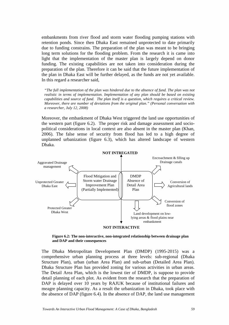
Agg
Unpr
Towards An Interactive Urban Flood Management: A Case of Dhaka, Bangladesh 59
embankments from river flood and storm water flooding pumping stations withretention ponds. Since then Dhaka East remained unprotected to date primarilydue to funding constrains. The preparation of the plan was meant to be bringinglong term solutions for the flooding problem. From the research it is came intolight that the implementation of the master plan is largely depend on donorfunding. The existing capabilities are not taken into consideration during thepreparation of the plan. Therefore it can be said that the future implementation ofthe plan in Dhaka East will be further delayed, as the funds are not yet available.In this regard a researcher said,
“The full implementation of the plan was hindered due to the absence of fund. The plan was notrealistic in terms of implementation. Implementation of any plan should be based on existingcapabilities and source of fund. The plan itself is a question, which requires a critical review.Moreover, there are number of deviations from the original plan.” (Personal conversation witha researcher, July 12, 2008)
Moreover, the embankment of Dhaka West triggered the land use opportunities ofthe western part (figure 6.2). The proper risk and damage assessment and socio-political considerations in local context are also absent in the master plan (Khan,2006). The false sense of security from flood has led to a high degree ofunplanned urbanization (figure 6.3), which has altered landscape of westernDhaka.
The Dhaka Metropolitan Development Plan (DMDP) (1995-2015) was acomprehensive urban planning process at three levels: sub-regional (DhakaStructure Plan), urban (urban Area Plan) and sub-urban (Detailed Area Plan).Dhaka Structure Plan has provided zoning for various activities in urban areas.The Detail Area Plan, which is the lowest tier of DMDP, is suppose to providedetail planning of each plot. As evident from the research that the preparation ofDAP is delayed over 10 years by RAJUK because of institutional failures andmeagre planning capacity. As a result the urbanization in Dhaka, took place withthe absence of DAP (figure 6.4). In the absence of DAP, the land use management
Figure 6.2: The non-interactive, non-integrated relationship between drainage planand DAP and their consequences
NOT INTREGATED
Conversion offlood zones
Flood Mitigation andStorm water Drainage
Improvement Plan(Partially Implemented)
DMDPAbsence ofDetail Area
Plan
Conversion ofAgricultural lands
Encroachment & filling upDrainage canalsravated Drainage
management
Land development on low-lying areas & flood plains near
embankment
otected GreaterDhaka East
Protected GreaterDhaka West
NOT INTERACTIVE

Towards An Interactive Urban Flood Management: A Case of Dhaka, Bangladesh 60
functions are supposed to be governed by the DSP and UAP. An interview with anurban planner states that,
“These plans only demarcate the broad areas for future development but without cleardelineation. These loopholes in development plan have allowed the illegal encroachment ofrivers, canals, lakes, land development in low-lying areas, flood flow zones and aggravated thestorm water flooding.” (Personal conversation with an urban planner, 16 July 2008)
Although the NWPo recommended formulating rules, procedures and guidelinesfor combining water use and land use planning, until now no such step has beentaken. In Dhaka, the urbanization process and flood prevention strategies areclosely interlinked (Oosterberg et al. 2005). This requires integrated approachtowards land use and flood management aiming at efficient use of floodplains andreduction of physical vulnerability and loss of human lives.
6.2.2 Sustainability Approach
Water resources developments, land use, infrastructure development, ecosystemall are interdependent and part of socioeconomic development. But unfortunately,not only in Dhaka but also in whole Bangladesh, all the flood control projects areexecuted with the aim of short-term economic development. The economic,social, ecological and environmental conservancy measures are neglected from thelong term perspective. Presently, the valuable natural resources of Dhaka such aswater resources, land, and habitat are seriously threatened due to absences of long-term planning for flood management. Based on the gathered information, theconsequences of shortcomings of the short-term planning are discussed below.
The implementation of DIFPP in the Greater Dhaka West has also added value tothe drainage problem. Additionally, as part of drainage master plan, the naturalcanals like Dhanmodi canals, Dholai Khal, Paribagh Khal, Mahakhali Khal,Begunbari khal, Segunbagicha khal, are converted into box culvert (Annex 7)(figure 6.5) without considering its negative environmental impact. This has
Figure 6.4: The absence of DAPturned Dhaka into a concrete jungle
Source: Syed Zakir Hossain, TheDaily Star, 8 June, 2008
Figure 6.3: The encroachment of the GulshanLake and unplanned urbanization
Source:http://flickr.com/photos/tanbir/332007922/

Towards An Interactive Urban Flood Management: A Case of Dhaka, Bangladesh 61
altered the natural drainage system. With reference to this, a recent reportappeared in the national daily newspaper entitled The Daily Star, in Bangladesh ispresented below.
“In the last 17 years, the DWASA authorities spent more than Tk 300 crore in the name ofdevelopment of canals and the drainage system of the city. Under two development projects theauthorities turned several natural canals into box culverts to 'develop' the city's storm seweragesystem. Currently the WASA authorities are implementing a project titled The Project for EndingWater logging in the Capital. But the idea of making box culverts proved to be wrong as the citycontinued to be inundated every year during monsoons even after conversion of open naturalcanals into box culverts. "Natural open canals are better than box culverts, maintenance of thoseis easier. On the outskirts of the city we keep the canals open but in the city it is not possible forus to protect open canals from encroachers," said Md Zahurul Alam, superintendent engineer ofDWASA and project director of The Project for Ending Water logging in the Capital.”(Roy 2007).
The water demand and waste production has increased in the urban and peri-urbanareas. The urban population is subjected to water shortage. 95% water supply ofDhaka comes from underground and its average annual decline within the cityarea during 1995 to 1999 varied from 1.02m to 2.46 m (Islam 2008).
After reviewing the report, ‘Impact of 1998 flood on Dhaka city and Performanceof Flood Control Works’, it became clear that the urbanization has resulted insubstantial increase in impervious surface and reduces infiltration which in turncausing high surface runoff (table 6.1). High storm-runoff coupled withinappropriate drainage infrastructures; Dhaka city is facing rising storm waterflood hazards.
Table 6.1: Imperviousness of land surface and runoff ratios for some areas in Dhaka cityLocation Land use Sewer type Impervious
area (%)Runoff ratio
New Elephant Road& adjoining area
Commercial cumresidential
Under ground sewer 85 .04-0.8
Dhanmondi &Shatmosjid Road
High class residential Under ground sewer 65 0.4-0.7
Zigatala Unplanned highdensity residential
Under ground sewer 90 0.3-0.6
Azimpur Planned andunplanned residential
Surface drain 80 0.2-0.5
BUET University campus Surface and subsurface 55 0.1-0.3
Source: (Chowdhury et al. 1998a, Chowdhury et al. 1998b)
Figure 6.5: The Gopibagh Canal turned intoroadSource: The Daily Star, 24 August 2008
Figure 6.6: The Mohammadpur Canal filledwith garbage
Source: Haque, 2008

Towards An Interactive Urban Flood Management: A Case of Dhaka, Bangladesh 62
Figure 6.7: Pollution and encroachment ischoking the Buriganga River
Source: http://www.sos-arsenic.net/english/environment/index.html
The water quality of the peripheral rivers is also deteriorated due to disposal ofdomestic wastes and industrial affluent. From a study by Khan and Chowdhury1998, has showed that the sediment samples collected from storm sewers showpresence of polythene bag, plastic, cloth, rubber, metal strips, glass, paper, sticks,leaves, bones and brick and stone chips (figure 6.6) (Chowdhury et al. 1998b). Inaddition, the lack of maintenance of the drainage infrastructure also deterioratedthe situation.
The agricultural value of the land is destroyed with the land use change. Theselands are used for cultivation in the dry season and in the wet season these landsbecome fishing grounds for the fisherman. The loss of natural canals hassignificantly affected the local ecology and biodiversity. The vast flood plain areasat the periphery of Dhaka city play a significant role as a recreational site. But it isevident from the research that these sites are ill maintained, illegally encroachedby land grabbers and slums, and turned into dumping site for liquid waste (Islam2008).
With the construction of embankment the surroundingrivers: The Buriganga, The Turag, The Tongi khal,have lost connectivity with the flood plain andexchange of nutrients and carbon with flood plain.Before the construction of the embankment thecontaminants of the Hazaribag Tannery Complex andother industry wastes were washed into theBuriganaga River (figure 6.7) by annual flooding(www.sos-arsenic.net). The natural way of pollutionassimilation capacity of the river is hindered with theembankment. The impact is severe water and airpollution.
The aim of short-term objectives has positive impacts on certain sectors for certainperiod such as; the western embankment is protecting Dhaka from river flood andsaving human lives, reducing economic, social damages from flood. But asdiscussed above, these short-term economic gains jeopardized by catastrophicenvironmental, social, biodiversity malfunctions in one hand and on the otherhand imposing high investment to upgrade the deteriorated infrastructures,environment to achieve sustainability.
6.2.3 Institutional Integration6.2.3.1 Weak Institutional Arrangement: Its Shortcomings and Gaps
A Good institutional framework stands out as a prime factor for proper urbanflood management. This includes proper institutional arrangement, organizationalstructures and strong legislative framework.

Towards An Interactive Urban Flood Management: A Case of Dhaka, Bangladesh 63
From the research it is evident that there are six different ministries and a total of10 different organizations are directly and indirectly involved in river flood andstorm water flooding management of Dhaka. It is evident in the research that thereis hardly any cooperation/coordination exists among these ministries. Accordingto an interviewee from DWASA
‘The power exercise of these ministries and their organizations are different from each other
which results in poor inter-agency coordination.’ (Author, 30 July, 2008)
The rigid institutional framework has hindered the effort for coordination as wellas information sharing which often leads to undesirable conflicts among theorganizations. The following newspaper article published in the national dailynewspaper entitled The Prothom-alo, regarding the preparation for the ‘UrbanFlood 2008’ shows more light on the fact:
DCC claimed that the DWASA has broken the DCC drainage channels while maintaining thestorm sewer lines. The channels have been filled up with mud. On the contrary, DWASA isclaiming that DCC has unauthorized connection with storm sewer line. This creates the blockagein the storm sewer line and storm water cannot drain out through these. The DCC has approx.2500km surface drains around the city, which are not being maintained for long time. This iscausing blockage in the storm sewer and therefore water logging in the city. The coordinationmeeting is taking place regularly but implementation is not happening. (Datta 2008)
The implementation of any development plan requires coordination amongrelevant agencies. RAJUK, BWDB, DWASA, DCC all the concernedorganization should work together to implement the plans. The present haphazardurban development advocates their lack of coordination in management andcooperation in implementation. The implementation of plans also depends on theability to enforce plans in terms of financial and institutional capacity. In general,all these organizations suffer from inadequate manpower, funding and logistics.The existing strength of these organizations is inadequate to cope with the presenturban growth.
Figure 6.8: The consequences of politics on UFM in Dhaka
Lack ofPolitical Will
&Commitment
InterestGroups
(Real EstateCompany)
Weak Enforcementof Law
Poor maintenanceand operation of
Infrastructure
Poor coordinationamong organizations
Illegal LandDevelopment
Encroachmentof rivers
Destruction ofNatural Drainage
Canals

Towards An Interactive Urban Flood Management: A Case of Dhaka, Bangladesh 64
A large part of physical, functional and managerial gaps in urban floodmanagement are also because of weak political system and administrativebureaucracy. No formal mechanism (figure 6.8) is evident in urban developmentand flood management of Dhaka. In general, the performance of government andthe elected representatives is perceived as unsatisfactory due to lack of politicalwill and commitment. The effective implementation of plans and policies,enforcement of existing law, efficient management of the overall floodmanagement is largely depends on the political system.
RAJUK, the most important agency in planning and development of the GreaterDhaka, poses meagre manpower. Moreover high rates of corruption are evident.Due to the influence of interest groups, the organization is basically serving theupper-income group. With its weak planning capacity, RAJUK has failed tocontrol the land development.
The development and provision of drainage system in Dhaka is inadequate. Due tolack of coordination between DCC and DWASA, the drainage system is illmaintained. 50% of city’s domestic and municipal waste is collected by the DCC.Lack of innovative ideas, modern equipments and manpower, the conservancydepartment of DCC failed to manage Dhaka’s solid waste. The DWASA also hasnot succeeded in performing its basic functions of providing sewerage and stormdrainage system. Lack of systematic management efficiencies, weak planning andimplementation procedure contributed to DWASA’s failure to provide growingdemands of sewerage networks. Lack of financial and organizational strength,BWDB also failed to operate and maintain the flood infrastructures properly.There is no such apex body to monitor all activities related to planning,implementation of actions including the compliance with guidelines andlegislation, and management at national level except some coordination committeethat also failed in their role. In this regard, Ishrat Islam, an associate professor ofthe department of Urban and Regional Planning of Buet, during a discussion onconservation of wetlands at the city's Brac Centre Inn, stated that:
"An authority with executive power is crucial to conserve the city's flood plains, lakes, canalsand wetlands as per the DMDP," (The Daily Star, 18 February, 2007)
Figure 6.9: Polluted discharge through theRampura Reguator
Figure 6.10: The clogged surface drain
Source: Author, 2008Source: Haque, 2008

Towards An Interactive Urban Flood Management: A Case of Dhaka, Bangladesh 65
Being a developing country, fund constraints are a common phenomenon forBangladesh. The implementation of any development plan largely depends on thedonor funding. As mentioned before, due to the funding constraints Dhaka Eastembankment could not be implemented. Any development plan should state clear,overall workable targets and measures (APFM 2008). The dearth of the water andflood institutions of Dhaka is inadequate funding. In general, the maintenancedivision of any development works occupies a small percentage of NationalBudget. The following statements delivered by water managers during a pressmeeting on ‘Flood 2008 and its Probability’ explain the above mentioned fact:
“For MoWR, the development work budget is approximately 3% of the National Budget. And thebudget for maintenance division of BWDB is only Tk 200 crore/yr, whereas for RHD themaintenance budget is 800crore/yr and that of LGED is 300crore/yr, which is not compatible. Ifthe flood prevention measures could have gained more preferences, the road maintenance costwould be relatively less. But we do the opposite. We always look for short-term solutions. Longterm visioning requires institutional strengthening and substantial financial strength.” (Pressmeeting attended by author, 23 July 2008)
In our economic system financial allocation for maintenance purpose does not exist. TheMinistry of Finance and Planning Commission make financial arrangement only forimplementation of the project work. But subsequent maintenance cost is not allocated for thoseprojects. (Press meeting attended by author, 23 July 2008)
The proper maintenance and operation of the flood control structures are hindereddue to shortage of fund. For instance, the drainage capacities of Dhaka city isinadequate and are also need to be replaced. However, with the existing financialstrength DWASA is simply unable to carry out these improvements (Datta 2008).
6.2.3.2 The Legal and Regulatory Framework
Legislation provides the basis for action by government or non-governmententities and individuals (Faruqee & Choudhury 1996). The natural resources areowned by the state. Although there are number of laws are in place, themanagement practice does not reflects its proper application in right place. Ingeneral the legal framework for water and flood management sector is very weak.
It is evident from research that there is no law (chapter 5: table 5.4) within theexisting legal framework for effective implementation of NWPo and NWMP. Apolicy cannot be implemented unless it is enacted as a law by the legislativeassembly the country (Haque, 2008). There is some legislation related to urbanflood management such as The Embankment & Drainage Act 1952, The CanalAct 1864, which are several years old. These acts hardly play any role in floodmanagement.
Needless to say, the rapid urbanization and illegal encroachments have alreadyaltered the city planning. The dearth of necessary laws and planning has resultedin unplanned Dhaka city. The RAJUK is empowered to prepare master plan andregulate land use in the Metropolitan Dhaka city. But the findings of research haveshown that the encircling rivers, natural canals, lakes being encroached and filledup with prior concern of RAJUK. The encroachers are not only politically andsocially influential people; it also includes government organization like

Towards An Interactive Urban Flood Management: A Case of Dhaka, Bangladesh 66
Bangladesh Telecommunication Company Limited (BTCL) that has encroachedthe Buriganga River (figure 6.11). The following examples published in dailynewspaper entitled The Prothom-alo are presented below.
To stop the unplanned urbanization, the Government of Bangladesh hasformulated “The Private Housing Land Development Rules” in the year 2004.These rules are applicable only within RAJUK areas, which are of 1,528 squarekm. There are about 250 Real Estate Companies, which are active in and around
Figure 6.11: The construction work ofBTCL building in the Buriganga River
The BTCL is constructing its office buildingon the encroached land from the RiverBuringanga. The states own the land. 30% ofthe river is filled up. According to the localpeople of Kamranggirchar electedpoliticians, city councilor are involved in thisland development (Sarker, 2008).
Photographer: Monirul Alam
Figure 6.12: A six-storied building onKallayanpur canal
The Shapla Housing Residential Area hasencroached the both banks of KallanyanpurCanal and constructed multi-storeyed buildings.Due to encroachment the DWASA could notimplement the proposed 40foot wide box culvertin this canal (Datta, 2008).
Photographer: Monirul Alam
Figure 6.13: Filling up the Rupnagarcanal at Pallabi
Photo: Syed Zakir Hossain
According to the master plan of 1984, thewestern parts of the Rupnagar residentialarea allotted for the main drainage canal.This natural canal carries sewages and stormwater of surrounding areas and dischargesthem into the river Turag. It also helps ingroundwater recharge for the area. Thecanal has virtually turned into a sewerageline at several places (Sabuktagin, 2008).

Towards An Interactive Urban Flood Management: A Case of Dhaka, Bangladesh 67
Dhaka city in housing development. According to this rule the housing companiesacross the country would have to get approval from the concerned authorities todevelop and advertise their projects. It is needless to mention that this is asignificant step of GoB towards regulating the activities of private housingdevelopment companies. But the implementation of this rule is much moreimportant for future of Dhaka. In a discussion, director of BELA, Syeda RizwanaHasan stated that,
“After the formulation of this rule RAJUK has used the rules as means to collect toll from thehousing companies.”
According to the Wetland Protection Act 2000, development is prohibited onnatural canals, lakes, water bodies, canals, lakes and flood plain zones and sub-flood plain zones. But the real scenario is opposite. Despite the act the city canalsare depleting fast due to illegal land development by private housing companies(Figure 6.12) (figure 6.13). The practice of law and its enforcement is notsystematic. Corruption, legal loopholes are also worsening the situation. Whilesome initiatives such as eviction of the illegal constructions and reclamation of thedead canals etc, have taken by the government is welcoming and may improve thestorm water flooding of Dhaka.
6.2.4 Participatory Approach
Rigid, inefficient bureaucratic practice, procedure orientation and lack of publicparticipations all these events resist the formation of alternatives to manage floodsin Dhaka city and its consequences by the decision-makers. A guideline forParticipatory Water Resource Management is prepared by WARPO. But it is notin practice. There is limited and in most cases no participation is evident inplanning, policy and decision making phases.
The flood management of Dhaka is driven by top-down decision-making. Theflood control measures are planned without the participation of the affected peopleand other stakeholders. The conventional public participation can be perceived asconsultation to improve the project details that the authority has designed them.The existing informal practice of participatory planning process is not based onprinciples of participation. Due to lack of participation, the development plans failto address the people need and integrate their demand in the plan. The absence ofpublic involvement in operation and maintenance of control measures and lack ofawareness about their role often pose problem in proper management of the flood.It is noticed that people often attempt to open sluice gates, or force pumpoperators to run the pumps even though pumping is not required (Khan 2006). Itis needs to be mentioned that, according to some interviewees, the inhabitants arenot willing to participate in city development. If this is the case then thegovernment should take some initiatives to motivate people to increase theirinvolvement in decision-making process. Participation of stakeholders other thangovernment is not evident in decision-making process.
In general it can be said that public participation and stakeholders participation inthe decision-making of flood management is limited only to discussions with civil

Towards An Interactive Urban Flood Management: A Case of Dhaka, Bangladesh 68
society. Although few discussions take place among different stakeholders buttheir views are often not considered in planning.
6.2.5 Flood Risk Management Strategies
An integrated approach to flood management means the best mix of structural andnon-structural measures. These measures are mostly physical in nature. Thoughurban flood in Dhaka is managed by both the measures, integration between themis not noticeable. Flood control measures are emphasized than the non-structuralmeasure.
Dhaka is protected from river flood by earthen embankment and floodwall.According to the experts, the construction quality of the embankment is notstandard. Moreover the embankment is subjected to frequent breaching. Fromfield observation it is noted that embankment itself is also not beyondencroachments (figure 6.15). Illegal settlements, temporary small sheds, loading& unloading of goods are happening without the concern of embankment. BWDB,who is responsible for the maintenance of the embankment, is reluctant in theseunauthorized constructions. The embankment top is used as road. The future planof government is to covert it into 80 feet wide raised road. However, according tothe water experts and engineers the embankment was not built with proper
Figure 6.17: The Sluice gate near GoranChatbari pump station
Figure 6.16: The temporary pumpstation at Rampura with 20 sluice gates
Source: Author, 2008
Figure 6.14: The land filling in low-lyingareas neat the western embankment.
Figure 6.15: illegal structures on thewestern embankment
Source: Author, 2008
Towards An Interactive Urban Flood Management: A Case of Dhaka, Bangladesh 69
engineering strength. Then the question arises, what is the future of this floodprotection embankment? Further, it is noticed from the field observation thatmanually operated regulators (figure 6.17) are still in use. These regulators weredesigned in 1968. There is no such measure undertaken till date to improve thetechnology of these regulators in last 40 years.
To mitigate the internal flooding electric pumps are used. There are threepermanent pump stations in Dhaka West at Goran Chatbari, Kalyanpur and DholaiKhal. The combined pumping capacity of these pumps is 54m3/sec-1 compared toestimate peak storm runoff of 140m3/sec-1. The required capacity is 180m3/sec-1.So the pumping capacity is not compatible for the extreme situation. There areseveral temporary pump stations (Figure 6.16) in Dhaka at different locationhaving a total capacity of 70m3/sec-1, which is also inadequate. Retarding pond isalso being encroached by the private housing developers. In Dhaka, the stormsewer network of DWASA has 225 km of underground pipes and 8 km of boxculvert (Khan, 2006). The conveyance capacities of these storm sewers are verylow because of accumulation of solids from the sanitary sewerage. The largeportion of these solids includes construction debris, solid waste dumped in thecatchment areas (Chowdhury et al. 1998b). The storm sewer water also containspollutants. The indiscriminate dumping of solid wastes into the surface drains,overflow due to blockage, sanitary sewer breakdown, unauthorized connection ofstorm sewer and sanitary sewer are largely accounts for the storm water qualitydegradation as well as water logging problem in the Greater Dhaka. The lack ofregular maintenance of the surface drainage lines (approx. 2000 km.) of DCC alsoadds to the problem (Figure 6.18). Even though approximately taka 40 croreinvestment was made in the last six years to improve the storm and sanitarysewerage system, the situation remains the same (Datta 2008).
Non- Structural MeasuresThe Flood Forecasting and Warning is the one of important non-structuralmeasures that has been in practice since 1972. The Flood Forecasting andWarning Center under BWDB is forecasting 72 hrs forecast of flood situation.According to the experts the 24 hours forecasting is more reliable compared to 72hours forecast. The information dissemination medium is English, which is notunderstandable to general people. Adding to that the use hydrologic terminologyin the forecast often arise confusion among the people, media and otherorganizations due to wrong interpretation of the information.
Among other non-structural measures Flood Proofing, Flood Zoning and FloodInsurance are important. But Flood Insurance is not yet in practice. BangladeshNational Building Code 1993 provides regulations with reference to buildingelevation and flood resilient construction in flood prone areas. However, thepractice and enforcement of these codes are absent. Flood zoning is important toreduce to exposure. In DMDP the flood-plain zones and sub-flood plain zones areembarked. But the juridical delineation of these zones has not been ensured andtherefore unplanned development in these zones is going on (figure 6.14). Theabsence of Detail Area Plan forms a major bottleneck in reducing exposure.

Towards An Interactive Urban Flood Management: A Case of Dhaka, Bangladesh 70
6.2.6 Water System Approach
River basin management approach is not yet in practice at full length. Basinmanagement is hard to apply in Bangladesh. The rivers are transboundary. Itneeds regional cooperation with India. Though some action has been taken placelike Ganges treaty at Farakka. This treaty has been signed by India andBangladesh in 1996 for sharing dry flow of the Ganges at Farakka. A recentconcern is the River Link Project of India that transfers of water from basins ofthe Brahmaputra and the Ganges to Haryana, Rajasthan and Gujrat in the west andpeninsular region in the south (Chowdhury 2008).
In terms of Water Cycle Management (WCM), the urban water managementcomponents in Dhaka are not interlinked. There is no long-term resourceutilization scheme has developed in the system to make the best possible use ofthe floodwater. Often there is mismanagement observed in planning,implementation and maintenance of the entire water management system. TheTWCM requires integrated framework, participation from of the potential users,stakeholders both public and private organizations, industries.
6.3 SWOT Analysis
The development of flood management requires an assessment of the existingurban flood management of Dhaka. As a result the SWOT analysis is carried outin the context of Urban Flood Risk Management, within the framework ofInteractive WRM. Based on the empirical findings, the internal strengths andweaknesses and external opportunities and threats of the present urban floodmanagement practices are identified. Internal strengths and weaknesses consider anumber of factors related to the capacity of the institutions involved in urban floodmanagement, their interrelationships and management efficiency. The externalopportunities and threats consider the outside factors that have an impact on itsfunctioning.
Figure 6.18: The inefficient drainagemanagement
Figure 6.19: The Pollution of The BurigangaRiver
Source: Author, 2008 Source: The Daily Star, 2008

Towards An Interactive Urban Flood Management: A Case of Dhaka, Bangladesh 71
NWPo & NWMP Drainage Master Plan
Structural and Non-Structural Measures
Water Modelling & Flood Mapping
Skilled Water Managers
Lack of political good will &
commitment.
Top-down decision-making process
Corruption
Lack of Accountability
Lack of transparency of activities
Weak institutional arrangement
Lack of institutional integration
Less accessibility to information
Lack of land use planning
Lack of integration between land and
water resource management
Lack of legal framework
Weak enforcement of law
Fund constraints
Weak monitoring of the physical system
Lack infrastructure maintenance
Lack of participatory approach
Lack of integration between structural &
non-structural measures
Lack of water system approach
Increasing public awareness
Policy advocacy of the civil society
Growing number of water professionals
Political unrest
Unprecedented Rural-urban migration
Rapid urbanization
Land development through land filling
process
Illegal encroachment of river, canals,
lakes.
Indiscriminate dumping of industrial,
clinical, domestic waste into rivers,
canals, lakes, roads.
Climate change
STRENGTH WEAKNESSES
THREATSOPPORTUNITIES
Figure 6.20: The SWOT Analysis

Towards An Interactive Urban Flood Management: A Case of Dhaka, Bangladesh 72
Chapter 7 Conclusions and recommendations
7.1 Introductions
Based on empirical findings and insights in literature, answer is provided for theresearch question, which is revealed through the answers of five research sub-questions. Reflection on the literature and recommendations are put forwarded.
7.2 Conclusion
Under this section the research sub-questions are listed below are addressedsubsequently.
Interactive Water Resources Management
The concept of interactive WRM demands for a dialogue between the watermanager and society on the one hand, and with water systems on the other hand.Keeping into account the important aspects like integration, sustainability andwater system approach, the interactive relation makes it possible to respond toopportunities for the development of the new approaches. Principally, it is alearning process in which two different types of tools should be employed:monitoring and participation.
In an interactive management perspective, monitoring establishes the relationshipbetween water managers and the water system. Monitoring is the primary tool forlearning about the hydrological functions of the floodplain landscape and theeffects of land use activities on the hydrologic functions. This helps assessingmanagement strategies. In flood management monitoring plays a significant rolein terms of flood warning since it reduces the vulnerability of the people and buildup capacity to manage the consequences of floods. Monitoring information isrequired to support the decision-making process, evaluate the managementefficiency and the development of new policy approaches.
Interaction between water managers and the society can be achieved throughparticipation. The society is made up of citizen and all stakeholders with particularstake in WRM or FM, including government entities, NGOs, private organizations(business & industry), community organizations and others. The participation as aplatform combines elements of both top-down and bottom-up inputs of localknowledge, needs and objectives to jointly develops local situations to waterresource problem.
Urban Flood Management
The urban flood management approaches advocate for mainstreaming flood risksinto development activities. In order to achieve this, an integrated andcomprehensive management is imperative for urban flood. Human settlements,economic activities and in particular urban water infrastructures like water supply,sewerage, drainage etc. in urban areas have additional influences on floodsbeyond meteorological and hydrologic factors. In urban flood management, urbanhydrologic balance is the key factor. The potential synergies in UFM can beachieved through integrated urban water management; drinking water supply,sewerage and waste water disposal and surface run-off disposal. Broadly the water

Towards An Interactive Urban Flood Management: A Case of Dhaka, Bangladesh 73
processes is recognized as Total Water Cycle Management. Being a subset ofIFM, UFM embraces all its principles. IFM lays emphasis on the integrationbetween land use and water resources, which enable the proactive approachestowards a flood management.
Water and flood management trends in Bangladesh
Historically, the water resources management issues in Bangladesh are mainlyflood control and agriculture oriented. The main objectives of these projects wereto increase agriculture production (Aman, monsoon rice), controlling floodwaterby constructing embankments on both banks of the river and establishing drainagefacilities to drain out excessive rainfall during monsoons. Although, theinstantaneous and short-term objectives of these projects have brought somepositive impacts in certain sectors, the long-term perspectives of economic, social,ecological and environmental sustainability of the city were left behind. Themanagement approach rather fragmented than integrated and holistic. This stand-alone approach to flood control rather than flood management caused aquaticimbalance, pollution, arsenic contamination, lowering ground water table in dryseason and loss of aquatic habitat. In general, the FC projects have failed toaddress the other sectors related to water resources utilization and developmentsin line with Integrated WRM.
Urban Flood Management in Dhaka
In urban flood management, the GoB has followed the same ideology as explainedabove. Flood control used the flood mitigation measures, which are similar toother FC projects around the country. The main objective is to reduce economicloss and to save human lives. In line with these objectives, structural measureslike embankment constructions are given more emphasis than non-structuralmeasures. This has added complexity to the rising storm water-flooding hazard inDhaka. The non-structural measures like land use planning, flood zoning andother non-water sector issues are not taken into account in flood management.Moreover, lack of integration between urban water management and urban floodmanagement, is equally creating stress on urban water infrastructures and theoverall flood situation. In general, it can be said that urban flood managementissues are not mainstreamed into the urban development activities of Dhaka city.Urban floods in Dhaka are managed in an ad hoc manner. The encroachment ofwetlands, unplanned development, inadequate infrastructure, lack of appropriatelegislation and enforcement, all illustrate the inability of the responsibleorganizations to manage the urban floods in a coordinated manner. This is mainlydue to a poor institutional framework, a lack of institutional capacity within theresponsible organizations, and above all, the political decision-making process.There is no central authority at national level that coordinates the organizationsand fosters the cooperation among them in implementation of plans, policies, andmanagement. Moreover, the role of national government in policy developmentalso shows signs of bureaucratic rigidity. The power relation of the state with thesociety does not support participatory water resources management in Dhaka.

Towards An Interactive Urban Flood Management: A Case of Dhaka, Bangladesh 74
bureaucrats and government officials in decision-making, all together have madethe entire flood management of the city inefficient.
Opportunities and challenges for potential improvements of UFM in Dhaka
Opportunities
The GoB has formulated the Wetland Protection Act 2000 and The PrivateHousing Land Development Rules 2004. This legislative progress can be seen as astrength which has made it possible to protect the natural canals and to prevent thereal estate developers from land development on low-lying areas and in flood-flow zones. The formulation of the Private Housing Land Development Rules2004 can also be seen as an opportunity for the government to take into accountthe extent of urbanization through control over the activities of private housingdevelopers.
The civil society of Dhaka has undertaken the policy advocacy for manyimportant issues including flood management. They initiated public litigation as amean to preserve and conserve flood zones. Public awareness is also increasingconcerning urban flooding problem. The print media has played an important rolein this matter. Though the awareness is still rather low, it is encouraging thatpeople recognize the consequences of filling up canals and low-lying areas and itsimpact on urban flooding.
Although the urban flood problem is in acute state, Bangladesh is well known forher qualified water managers. The dialogue among the water managers, urbanplanners and government organizations has increased; but the flood managementsituation is not yet improved accordingly. The quality of flood and water relatedresearch is improved. Different water and flood research institutes have carriedout a number of model studies. The Institute of Water Modelling provides servicesin water modeling by means of tools such as GIS, MIKE 11 etc., computationalhydraulics and allied sciences for integrated water resources management.
Challenges
Commitment of political leaders plays a key role in development of urban floodmanagement in Dhaka. The effective implementation of flood mitigation andstorm water management plans largely depend on strong political good will andcommitment.
The city administration and the responsible organizations in flood managementface numerous institutional challenges in terms of funding and institutionalcapacity. To make them more interactive towards effective urban floodmanagement, the institutions require vertical and horizontal integration among andwithin the organizations, skilled leadership, and transparency in actions. Thisrequires capacity building of the institutions.
Towards An Interactive Urban Flood Management: A Case of Dhaka, Bangladesh 75
7.3 Learning from literature
In recent years, there have been substantial changes in water resourcesmanagement approaches. The hydro-centric concept shifted to complex-physicalsystem such as river basin orientation. The concepts of water resourcesmanagement mainly advocates for the concept of integrated and interactivemanagement of land, water and natural resources. The main objective is to achievein economic, social, environmental sustainability. According to theories, thevarious issues like institutional organization, communication, stakeholder’sinvolvement, information sharing, legal framework, financial means, ideally eachof these is to be fulfilled, but in practice this is hardly be the case.
There is always a large gap between theory and practices. The applications ofthese theories are context specific. Political, socio-cultural setups have greatinfluence on their application. The concepts like IWRM, interactive WRM,adaptive WRM, ecosystem approach, all are inevitably ideological. In practice,these concepts have limited role to play. The concepts prioritize the issues to linkup with the worldview and values of individuals or organizations. Themanagement process involves judgment, preferences and commitment to achievedesired output. The implementation requires technical and political knowledgeand skills.
The Review of all these concepts has provided with a deep insight of thedevelopment in water resources management and also helped to critically analyzethe current flood management practices in Dhaka. The promotion of Interactiveresource management demands participation from all levels of society. Withregard to Arnstein’s ‘ladder of participation’, public participation in floodmanagement in Dhaka stands at the bottom level of the ladder i.e. literally noparticipation at all. At this level people are enabling to participate but only toenable the power holders to cure the participants. The informal practice of publicparticipation reaches the third level of the ladder, when the policy makers consultwith them to improve the plan they have prepared for them. This is a one-wayflow of communication without any feedback.
In the context of Dhaka, the implementation of Interactive WRM largely dependson political decision-making process where political good will and commitment isthe key concern. Platforms to establish negotiation between citizen and powerholders is needed to mainstream water and flood management in the developmentactivities.
7.4 Recommendations
The research shows that the urban flood in Dhaka is managed in an ad hocmanner. It is not only the very nature of the urban development activities, but alsothe management inefficiencies of the relevant organizations and their individualpiecemeal strategy is unlikely to provide any effective solution to the urbanflooding problem. Hence, in the light of current situation, the following someactions (figure 7-1) are recommended for urban flood management in Dhaka toachieve potential developments.

Towa
S
Intu
Amminma7enima
C
Tobtafod
rds An Interactive Urban Flood Management: A Case of Dhaka, Bangladesh 76
trengthening Institutional Framework
itional arrangements
strong institutional framework is the prerequisite for efficient wateranagement. Strong cooperation and a coordinated, comprehensiveanagement approach towards urban floods are possible only with strongstitutional arrangement and legislations. The current state of floodanagement in Dhaka strongly demands for the involvement of the national
uthority with strong, competent leadership. An apex level organization (Figure.2) namely Executive Body at national level may bring good results instablishing coordination among the responsible organizations from bothational and municipal level, uniting efforts in formulation of policies, and
plementation of plans, monitoring the management activities and in creatingn enabling environment for participation from society.
ontent of urban flood management policies and plans
he responsible organizations should give attention to the content and qualityf flood management policies and plans from long-term perspectives. Theeneficial aspects and negative socio-economic impacts of flood should beken into consideration during the preparation of the flood management plan,r example, by optimizing long-term utilization of floodwater. This can be
one by means of:
Construction of retention ponds to retain and store water flows duringflood to reduce the flood damages as well as meet users need during dryseasons and thereby maintaining the aquatic ecosystem;
Figure 7.1: Conceptual Framework for UFM in Dhaka
Towards An Interactive Urban Flood Management: A Case of Dhaka, Bangladesh 77
Stored water can also be used for hydropower generation, which maycontribute to the dearth of the current electricity problems in Dhaka.
Rainwater harvesting can be adopted in Dhaka city to supplement thewater supply, replenish the groundwater table and its quality improvement,and increase soil moisture levels for urban greenery and above all tomitigate urban flooding.
Implementation process
The implementation of policies and plans depends on the responsibleinstitution’s ability in terms of financial and organizational capacities. Theorganizations, which are responsible for urban flood management in Dhaka,need to be strengthened financially and organizationally. Capacity buildingprogrammes like training and workshops should be arranged in a regularmanner to properly equip the organizations in all respects; policy making,planning, implementing, operating and maintenance, evaluating themanagement activities.
Legislative framework
An appropriate legislative framework is fundamental for effectiveimplementation of the National Water Policy. Some of the existing laws, such asEmbankment and Drainage Act 1952, Canal Act 1864 etc., date back over acentury and also do not complement the need of the city. These laws needrevision. Moreover, most of the existing laws are agriculture oriented. Thus newlaws for non-agricultural uses are needed securing both individual andcommunity rights. The government has already taken the initiatives to formulateThe National Water Code should consolidate the laws governing ownership,development, appropriation, utilisation, conservation, and protection of waterresources. With a strong legal framework, systematic enforcement of the lawcan be ensured.
Participatory Planning
MoWR in Bangladesh formulates the guidelines of participatory water resourcesmanagement but these have not yet put into practice. Participatory planning cancontribute to public acceptance and support avoiding potential conflicts. Fromthe institutional perspective, the Local Government administration ofBangladesh is very week. In order to ensure participation of all relevantstakeholders, the government should take the following initiatives:
- Ensure empowerment of the local government administration with propera institutional framework;
- Carefully identify relevant stakeholders who have direct and indirectstakes in urban flood problem;
- Arrange special means to encourage urban area people for participation.

Towards An Interactive Urban Flood Management: A Case of Dhaka, Bangladesh 78
Basin management
An integrated basin wide approach to flood management is essential. A riverbasin is a large, complex, dynamic system. The large-scale urbanization andindiscriminate water use activities have impact on flood flows in Dhaka. Theimprovements in functioning of the river basin largely depend on theinteractions between land use and water environment.
Moreover, geographically Bangladesh is a lower riparian country. Theunilateral water use activities by the upper riparian are depriving Bangladeshfrom their legitimate use of the shared watercourse. Therefore, regionalcooperation should be strengthened to employ basin level management fordevelopment in water resource utilization and conservation. This is alsoimportant for dealing with possible impacts of climate change.
Land use planning
Land use planning and regulation together with building and infrastructurecodes and design practices can substantially reduce the vulnerability of thepeople and other urban activities. The Structure Plan and Urban Area Plan ofDhaka only demarcate the broad areas of future development but without cleardefinition of development principles. The completion of the Detail Area Plan(DAP) can prevent the loopholes for manipulation and encroachment of thelow-lying areas and flood flow zones. The land use legislation is also notstrong to establish standards for the use, development control and protection ofland. Though a number of legislations have been formulated like WetlandProtection Act 2000, The Private Housing Land Development Rules 2004,their enforcement is not yet strong due to weak enforceable directives.Therefore RAJUK should take necessary initiatives to ensure the completionof DAP for effective management of urban flood. The land use legislationsshould be strengthened to enforce Bangladesh National Building Code(BNBC) in building and infrastructure constructions in flood prone areas.
Long term planning
For sustainable water resources development and integrated floodmanagement the long term and short term planning should be incorporated.The factors rendering the vulnerability to floods should be identified andprioritized concerning immediate response and planning should be carried outaccordingly.
Practice of Good Governance
The local government administration is very weak in Bangladesh. No matterwhat approach is employed for effective management it will not work unlessthe principles of good governance are being practiced. This includestransparency in actions, delegation of power, and decentralization of decision-making through participation, optimal mix of bottom-up and top-downapproaches, accountability and equity. These principles support theeffectiveness and sustainability of responsible organizations.

Towards An Interactive Urban Flood Management: A Case of Dhaka, Bangladesh 79
Building public awareness
Environmental education should be emphasized to build civic responsibilityamong the citizens. There should be a regular awareness campaign to build uppublic awareness towards environment. Environmental education should getemphasis in the education system of Bangladesh. Environmental educationand development of environmental expertise is needed for future sustainabilityof Bangladesh.
7.5 Questions for Further Research
This research is a macro-level study on interactive approaches to urban floodmanagement in Dhaka. The interactive approaches are conceptualized in twoways: participation and monitoring. Previously there is much research has carriedout on different types of monitoring in water resources and flood management. Sothis study can be linked with further micro-level study on participation within thecontext of Bangladesh, such as institutionalization of interactive water resourcemanagement. This will be useful continuation of this research since IntegratedFlood Management strongly advocates for participatory approach in floodmanagement.

Towards An Interactive Urban Flood Management: A Case of D
To secure coordination in pla
Figure 7.2: The conce
Engineering DeUrban Planning Dept.
L
Ministryof
Planning
Ministryof Land
Ministry ofHousing &
Public Works
Ministry ofPower,
Energy &Mineral
Resources
Ministryof
Defense
Ministry of LocalGovernment,
RuralDevelopment &Co-operatives
Ministryof
Communications
Ministryof WaterResources
Ministry ofEnvironment
& Forest
Ministryof
Shipping
BWDB
WARPO
RAJUKSPARRSODWASA DoE BRTC BIWTA BPDB PlanningCommission
MinistryOf
Finance
Inter-Departmental Coordination Boardnning, implementation, operation and maintenance, monitoring and evaluation
Transport Dept. Conservancy Dept. Law Dept.pt. Public Relation Dept.
haka
ptu
Water Resource Development BoardMoWR, MLGRDC, MoP
NATIONA
LOCAL
, Bangl
al Inst
Dhaka City Corporation
Interest groups Private
investors,industries
Land Owners NGOs CBOs
adesh 80
itutional Framework for Interactive UFM in Dhaka

Towards An Interactive Urban Flood Management: A Case of Dhaka, Bangladesh 81
References
Alam, M. & Rabbani, M. G., 2007, Vulnerabilities and Responses to ClimateChange for Dhaka. Environment and Urbanization, vol. 19, pp. 81-97.
Alam, M. S., 2004, Flood Implications and Dhaka City Planning, NationalWorkshop on Options for Flood Risk and Damage Reduction in Bangladesh,2004, Dhaka Bangladesh, pp.1-10.
ACIL Tasman, 2005, 2005-last updated, Institutional Arrangements in theAustralian Water Sector: Information Paper, [Homepage of AustralianGovernment National Water Commission], [Online], Available:http://www.nwc.gov.au/www/html/564-institutional-arrangements-in-the-australian-water-sector-information-paper.asp [23 April, 2008]
APFM, 2004, Integrated Flood Management, Concept Paper, The AssociateProgramme on Flood Management, Geneva, Switzerland,
APFM, 2006, Social Aspects and Stakeholder Involvement in Integrated FloodManagement, Flood Management Policy Series, WMO/GWP The AssociateProgramme on Flood Management, Geneva, Switzerland.
APFM, 2008, Urban Flood Risk Management, A Tool for Integrated FloodManagement, WMO/GWP The Associated Programme on Flood Management,Geneva, Switzerland.
BBS, 2001, Population Census 2001: Preliminary Report, Dhaka: Government ofBangladesh.
BBS, 2003, Brief Statistics of Population Census 2001, Statistical Year Book ofBangladesh.
BCEOM French Engineering Consultants, 1992, Dhaka City Emergency WaterSupply Project, Feasibility Study, Main Report, Dhaka WASA, Dhaka.
Biswas, A. K., 2006, Water Management for Major Urban Centres, in ed.Tortajada, C., Varis, O., Lundqvist, Biswas, A.K., Water Management for LargeCities, Routledge, London and New York, pp. 3-17.
Bressers, H. & Kuks, S., 2004, Governance of Water resources. in ed. Bressers, H.& Kuks, S., Integrated Governance and Water Basin Management, Conditions forRegime Change and Sustainability, Kluwer Academic Publishers,Dordrecht/Boston/London, pp.1-21.
Chowdhury, J.U., 2008, Integrated Water Resources Management Concept andActions needed for Bangladesh, Institute of Water and Flood Management,BUET, Dhaka.

Towards An Interactive Urban Flood Management: A Case of Dhaka, Bangladesh 82
Chowdhury, J. U., Khan, M. U. & Hossain, M. S. A.,1998a, Measurement andAnalysis of Rainfall-Runoff in Selected Catchments of Dhaka City, Main Report,Vol. 1,IFCDR, BUET, Dhaka.
Chowdhury, J. U., Rahman, R., Bala, S. K. & Islam, A. K. M. S.,1998b, Impact of1998 Flood on Dhaka City and Performance of Flood Control Works, ReportNovember 2008, Institute of Flood Control and Drainage Research, BangladeshUniversity of Engineering and Technology, Dhaka, Bangladesh.
Cowie, G. M. & Borrett, S. R. 2005, Institutional Perspectives on Participationand Information in Water Management, Environmental Modelling & Software,vol. 20, pp. 469-483.
Datta, A., 2008, Canals, Wetlands are encroached: The Capital will be Floodedwith Heavy Rain, The Protom-alo, [Online]. http://www.prothom-alo.com/archive/news_details_home.php?dt=2008-07-02&issue_id=971&nid=MTcxMjk=, [26 August, 2008].
DFID,n.a.,Water Resource Management in Bangladesh: A Policy Review,Livelihood-Policy Relationships in South Asia, Working Paper 1, Department forInternational Development, UK. [Online] Available:http://www.leeds.ac.uk/cwpd/pdf/waterpolweb.pdf, [28 May 2008]
Dworsky, Leonard B., Albert E. Utton and David J. Allee, 1995, The Great Lakes:Transboundary issues for the mid-90s, University of Toledo Law Review, Vol.26, Winter 1995, pp. 347-386.
Faisal, I. M., Kabir, M. R. & Nishat, A., 2003, The Disastrous Flood of 1998 andLong Term Mitigation Strategies for Dhaka City. in ed. Mirza, M. M. Q., Dixit, A.& Nishat, A., Flood Problem and Management in South Asia. The Netherlands,Kluwer Academic Publishers, pp. 85-97.
Faruqee, R. & Choudhry, Y. A., 1996, Improving Water Resource Management InBangladesh, Policy Research Working Paper 1569, The World Bank, NW,Washington, DC. [Online] Available:http://unpan1.un.org/intradoc/groups/public/documents/APCITY/UNPAN025525.pdf [3February 2008]
GWP, 2000, Integrated Water Resources Management, TAC Background PapersNo. 4. Stockholm, Sweden, Prepared by Technical Advisory Committee, GlobalWater Partnership, Stockholm, Sweden.
Haque, M. I., 2008, Water Resources Management in Bangladesh, Anushilan,Chuadanga & Dhaka, Bangladesh.
Hasnat, M. A., 2004, Flood Disaster Management in Dhaka City, in NationalWorkshop on Options for Flood Risk and Damage Reduction In Bangladesh,Working Papers, 2004, Dhaka, Bangladesh. pp. 1-14

Towards An Interactive Urban Flood Management: A Case of Dhaka, Bangladesh 83
Hooper, B. P., 2003, Integrated Water Resources Management and River BasinGovernance, Universities Council On Water Resources, Water Resources Update,pp. 12-20, [Online] Available: Available:http://www.ucowr.siu.edu/updates/126/126_A2.pdf [23 June, 2008]
Hooper, B.P., 2005, Integrated River basin Governance, Learning fromInternational experience, IWM Publishing, London, Seattle.
Huq, S. & Alam, M. , 2003, Flood Management and Vulnerability of Dhaka Cityin ed. Kreimer, A., Arnold, M. & Carlin, A., Building Safer Cities: The Future ofDisaster Risk, Disaster Risk Management Series., The World Bank, Washington,D.C, pp. 121-135.
IJC, 1996, Indicators to evaluate progress under the Great Lakes Water QualityAgreement, International Joint Commission, Canada/USA.
Islam, I., 2008, Wetlands of Dhaka Metro Area: A Study from Social, Economicand Institutional Perspectives, PhD Thesis, Japan Society of Promotion of Science(JSPS). Japan, College of Policy Science Ritsumeikan University.
Jansen, E. G., Dolman, A. J., Morten, A. & Rahman, N., 1989, The Country Boatsof Bangladesh, Intermediate Technology Publications, London.
JICA (Japan International Cooperation Agency), 1991, Dhaka Integrated FloodProtection, FAB 8B, Final Report, Flood Plan Coordination Organization,(presently WARPO), Dhaka, Bangladesh.
JICA (Japan International Cooperation Agency), 1992, Feasibility Study onGreater Dhaka Protection Project (Study in Dhaka Metropolitan Area) ofBangladesh Flood Action Plan 8A, Main Report, Flood Plan CoordinationOrganization, Ministry of Irrigation, Water Development & Flood Control,People's Republic of Bangladesh.
Yoshitani, J., NaKao, T., & Merabtene, T., 2006, A New Mechanism for Soundand Sustainable Integrated Flood Management. 4th Annual Mekong Flood ForumSiem Reap, 18-19 May 2006, Cambodia, pp. 164-167 [Online] Available:http://www.mrcmekong.org/download/free_download/AFF-4/poster_session/new_mechanism.pdf [16 August, 2008]
Khalequazzaman, M.,n.a., December 2007-last updated, Flood Control inBangladesh through Best Management Practices, Homepage of ExpatriateBangladeshi 2000, [Online] Available:http://www.eb2000.org/short_note_17.htm, [15September, 2008].
Khan, M. S. A., 2006, Storm water Flooding in Dhaka City: Causes andManagement, Journal of Hydrology and Meteorology, vol. 3, no. 1, pp. 77-85.
Khorshed, A., 2003, Cleanup of the Buriganga River: Integrating the environmentinto Decision making, PhD Thesis, Murdoch University, Perth.

Towards An Interactive Urban Flood Management: A Case of Dhaka, Bangladesh 84
Koudstaal, R., Werners, S. E., Rahman, A., Huq, S., Ahmed, A., 1999,Considering Adaptation to Climate Change Towards a Sustainable Developmentof Bangladesh, South Asia Region, The World Bank, Washington, DC. [Online]Available: http://www.mungo.nl/CC_Bangla.htm [ 17September, 2008]
Lavkulich, L. M. & Ulazzi, E., 2008, Environmental Indicators for WaterResources Management. in ed. Meire, P., Coenen, M., Lombardo, C., Robba, M.& Sacile, R., Integrated Water Management, Springer, Dordrecht, TheNetherlands, pp. 325-341.
Mallick, D., 2007, Bangladesh Faces devastating impacts of climate change, TheNew Nation, Bangladesh's Independent News Source, 22 October, 2007.
Meire, P., Coenen, M., Lombardo, C., Robba, M. & Sacile, R., 2008, TowardsIntegrated Water management. in ed. Meire, P., Coenen, M., Lombardo, C.,Robba, M. & Sacile, R., Integrated Water Management, Springer, Dordrecht, TheNetherlands, pp. 1-8.
Oosterberg, W., Drimmelen, C. v. & Vlist, M. v. d., 2005, Strategies toHarmonize Urbanization and Flood Risk Management in Deltas. Land Use andWater Management in a Sustainable Network Society in 45th Congress of theEuropean Regional Science Association, 23-27 August 2005, Amsterdam, pp. 1-31, [Online], Available: http://www.ersa.org/ersaconfs/ersa05/papers/174.pdf [13August 2008].
O'Riordan, T., 1971, Perspectives on Resource Management, Pion, London, UK.
P. Wester & Bron, J., n.a, Coping with Water: Water Management in FloodControl and Drainage Systems in Bangladesh, [Online] Available:http://www2.alterra.wur.nl/Internet/webdocs/ilri-publicaties/special_reports/Srep7/Srep7.pdf [28 May, 2008]
Rahman, R., Haque, A., Khan, S. A., Salehin, M. & Bala, S., 2005, Investigationof Hydrological Aspects of Flood-2004 With Special Emphasis on Dhaka City,Final Report April 2005, Institute of Water and Flood Management, BangladeshUniversity of Engineering and Technology, Dhaka, Bangladesh.
Rosa, M. P., 2008, Towards an Adaptive Approaching Planning and ManagementProcess. in ed. Meire, P., Coenen, M., Lombardo, C., Robba, M. & Sacile, R.,Integrated Water Management, Springer, Dordrecht, The Netherlands, pp. 23-32.
Roy, P., 2007, WASA turns canals into box culverts ignoring impact, The DailyStar, 30 June, 2007, [Online]. Available:http://www.thedailystar.net/2007/06/30/d7063001065.htm, [14 September, 2008].
Sabuktagin, R., 2008, Land Grabbers gobbling up Rupnagar main canal, TheDaily Star, [Online] Available: http://www.thedailystar.net/story.php?nid=51982,[27August, 2008].

Towards An Interactive Urban Flood Management: A Case of Dhaka, Bangladesh 85
Saleth, R. M., 2006, Understanding Water Institutions: Structure, Environmentand Change Process, in Perret, S., Farolfi, S. & Hassan, R., Water GovernanceFor Sustainable Development: Approaches and Lessons from Developing andTransitional Countries. Earths, London, UK, pp. 3-20.
Sarkar, S., 2008, A Canal is Leased Against President's Wife, The Prothom-alo,[Online]. Available: http://www.prothom-alo.com/archive/news_details_home.php?dt=2008-07-23&issue_id=992&nid=MTc2MzA=, [1 September, 2008].
Sarker, S., 2008, Government Itself is Encroaching Buriganga, The Prothom-alo,[Online], Available: http://www.prothom-alo.com/archive/news_details_home.php?dt=2008-07-05&issue_id=974&nid=MTcyMTE=, [28 August, 2008].
Stalenberg, B., Kikumori, Y., n.a., Japanese Lessons for Dutch FloodManagement, proceeding of Water Down Under 2008,University of Adelaide, pp.66-75, [Online] Available:http://www.citg.tudelft.nl/live/pagina.jsp?id=504d248b-fadc-4351-a9aa-bd5c5a5d0f03&lang=en [16 September, 2008].
Szaro, R. C., Sexton, W. T. & Malone, C. R.,1998, The Emergence of EcosystemManagement as a Tool for Meeting People’s Needs and Sustaining Ecosystems,Landscape and Urban Planning, Vol. 40, pp. 1-7.
Tarafdar, M. R., 2007, Floods, Rains and Dhaka city drainage, The Daily Star, 14September, [Online]. Available: http://www.thedailystar.net/story.php?nid=3883,2008, 16 August.
Tawhid, K. G.,2004, Causes and Effects of Water Logging in Dhaka City,Bangladesh, Department of Land and Water Resource Engineering. RoyalInstitute of Technology, Stockholm.
The Daily Star, 2007, Civil movement needed to stop encroaching on wetlands,The Daily Star, [Online], Available:http://www.thedailystar.net/2007/02/18/d7021801148.htm, [August 27, 2008].
UNU/IAS,2003, Defining an Ecosystem Approach to Urban Management andPolicy Development, United Nations University Institute of Advanced Studies,Tokyo, Japan.
Van Ast, J. A., 1999, Trends towards Interactive water Management;Developments in International River Basin Management, Physics and Chemistryof the Earth (B), Vol. 24, pp. 597-602.
Van Ast, J. A., 2000, Interactive Management of International Rive basin;Experiences in Northern America and Western Europe. Physics and Chemistry ofthe Earth (B), Vol. 25, pp. 325-328.

Towards An Interactive Urban Flood Management: A Case of Dhaka, Bangladesh 86
Van Ast, J. A., Rosa, M. P. & Santbergen, L. L. P. A., 2008, Development inParticipation within Integrated Water Management in Meire, P., Coenen, M.,Lombardo, C., Robba, M. & Sacile, R., Integrated Water Management. Springer,Dordrecht, The Netherlands, pp.343-354.
Vitousek, P. M., Mooney, H. A., Lubchenco, J. & Melillo, J. M., 1997, HumanDomination of Earth’s Ecosystems, Science, Vol. 277, pp. 494-499.
WARPO, 2000, National Water Management Plan Project: Draft DevelopmentStrategy, vol. 7, Water Resources Planning Organization, Ministry of WaterResources, Government of the People’s Republic of Bangladesh.

Towards An Interactive Urban Flood Management: A Case of Dhaka, Bangladesh 87
Annexes
Annex 1 Interview Questionnaire
This questionnaire is a research instrument of the research on “TowardsInteractive Flood Management: A Case of Dhaka, Bangladesh”.
This survey is strictly confidential and your answers will only appear as totalscombined with those of other respondents for academic purposes only.
Purpose of the interview:_ To understand the trends of water resources management in Bangladesh and_ To identify the potentials and limits of the current flood management system._ To analyze the interactive approaches in flood management in Dhaka._ To analyze the institutional arrangements of the water and flood institutions._ To know how the present institutional arrangement is dealing with the flood
Management in Dhaka.
Date and time of interview: _ _ _ _ _ _ _ _ _ _ _ _ _ _ _ _ _ _ _ _ _ _ _ _ _ _Background of the interviewee:Name:Telephone:E-mail address:Name of organization you work for:Type of the organization:Your position in the organization:Location of the organization:
Water resources management:1. What elements of water resources are given more emphasis while formulatingwater policies?2. What issues and conflicts do you face related to water policy, planning andproject development?3. What are the existing water instruments?
Flood management:1. What are the key concerns of flood management? (River basin approach)2. What is the application of flood management?3. How flood issues are addressed in Flood Management?4. How is the flood management issues dealt within the framework IWRM?
(Measures)5. What development has occurred in the flood management of Dhaka?
Water and flood Institutions:1. What is the goal of your institution?2. What is your approach towards achieving the goal?3. What is your organizational structure?4. What are the organizations dealing with flood management? Please explaintheir roles & responsibilities.

Towards An Interactive Urban Flood Management: A Case of Dhaka, Bangladesh 88
5. How do the organizations deal (co-operation, co-ordination & integration) withthe flood management?6. Which organizations are involved in decision-making processes in planning andpolicy formulation for flood management and how much control do they have?7. How do you evaluate the involvement of the organizations in decision-makingprocess?
Participation:1. Who are the actors in water resources management?2. At which level and to what end do you involve the actors?3. Does your organization involve individuals/ encourage public participation indecision-making process? If so please explain how?
Opinions:1. What are some of your concerns regarding water resources management/floodmanagement?2. How can the interaction among water managers/flood managers, watersystem/(of river basin) and society be improved?3. What is your perception regarding public participation in flood management?4. How can flood management be more interactive?

Towards An Interactive Urban Flood Management: A Case of Dhaka, Bangladesh 89
Annex 2 List of Interviewee
Organization Respondents
Chief Planning
Director Planning-1
Superintending Eng, O&MCircleExecutive Eng., FFWC
Assistant programmer, FFWC
Sub-assistant Engineer, Goran ChatbariPump-station
1. BWDB
Gauge Recorder, Rampura Pump-station
Deputy Managing Director, O&M
Deputy Managing Director, R,P&D
2. DWASA
Executive Eng., O&M
3. RAJUK Chief Town Planner
Chief Town Planner, Urban PlanningDepartmentAdditional Chief Engineer
4. DCC
Superintending Eng., Environment circle
5. WARPO Principle Scientific Office
6. BIDS Senior Research fellow and ProjectDirectorExecutive Director7. CEGIS
Head Database/IT Division
Executive Director8. IWM
Principal Specialist & Head, FloodManagement Division
9. IWFM & Urban PlanningDepartment,
BUET
Professor
10. IUCN Country Representative

Towards An Interactive Urban Flood Management: A Case of Dhaka, Bangladesh 90
Annex 3 The drainage map of Dhaka city (50 year back)
Dhaka used to have about 40-50 canals. At present 17 canals out of 43 canals arefilled up and rest 26 canals have narrowed down due to unplanned urbanization.

Towards An Interactive Urban Flood Management: A Case of Dhaka, Bangladesh
Annex 4 The River System of Dhaka City
Dhaka
91

Towards An Interactive Urban Flood Management: A Case of Dhaka, Bangladesh 92
Annex 5 The inundation map of Greater Dhaka: 1988 Flood

Towards An Interactive Urban Flood Management: A Case of Dhaka, Bangladesh 93
Annex 6 The inundation map of Greater Dhaka: 2004 Flood (September)

Towards An Interactive Urban Flood Management: A Case of Dhaka, Bangladesh 94
Annex 7 The Conversion of Drainage khal to Box Culvert

Towards An Interactive Urban Flood Management: A Case of Dhaka, Bangladesh 95
Annex 8 The Industrial sector damage map of 1998 flood
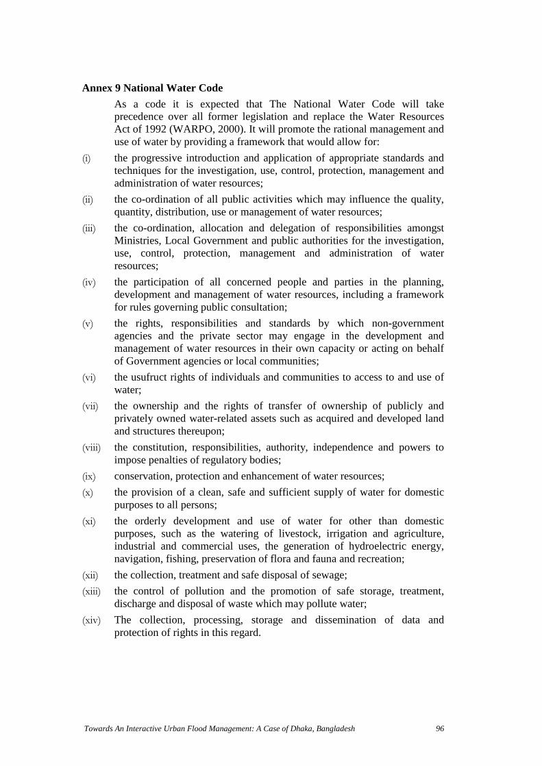
Towards An Interactive Urban Flood Management: A Case of Dhaka, Bangladesh 96
Annex 9 National Water Code
As a code it is expected that The National Water Code will takeprecedence over all former legislation and replace the Water ResourcesAct of 1992 (WARPO, 2000). It will promote the rational management anduse of water by providing a framework that would allow for:
(i) the progressive introduction and application of appropriate standards andtechniques for the investigation, use, control, protection, management andadministration of water resources;
(ii) the co-ordination of all public activities which may influence the quality,quantity, distribution, use or management of water resources;
(iii) the co-ordination, allocation and delegation of responsibilities amongstMinistries, Local Government and public authorities for the investigation,use, control, protection, management and administration of waterresources;
(iv) the participation of all concerned people and parties in the planning,development and management of water resources, including a frameworkfor rules governing public consultation;
(v) the rights, responsibilities and standards by which non-governmentagencies and the private sector may engage in the development andmanagement of water resources in their own capacity or acting on behalfof Government agencies or local communities;
(vi) the usufruct rights of individuals and communities to access to and use ofwater;
(vii) the ownership and the rights of transfer of ownership of publicly andprivately owned water-related assets such as acquired and developed landand structures thereupon;
(viii) the constitution, responsibilities, authority, independence and powers toimpose penalties of regulatory bodies;
(ix) conservation, protection and enhancement of water resources;
(x) the provision of a clean, safe and sufficient supply of water for domesticpurposes to all persons;
(xi) the orderly development and use of water for other than domesticpurposes, such as the watering of livestock, irrigation and agriculture,industrial and commercial uses, the generation of hydroelectric energy,navigation, fishing, preservation of flora and fauna and recreation;
(xii) the collection, treatment and safe disposal of sewage;
(xiii) the control of pollution and the promotion of safe storage, treatment,discharge and disposal of waste which may pollute water;
(xiv) The collection, processing, storage and dissemination of data andprotection of rights in this regard.