Embed Size (px)
Citation preview

THE POWER OF ONE.
One surveyor.
One system.
One company.1T O T A L S T A T I O N 5 6 0 0
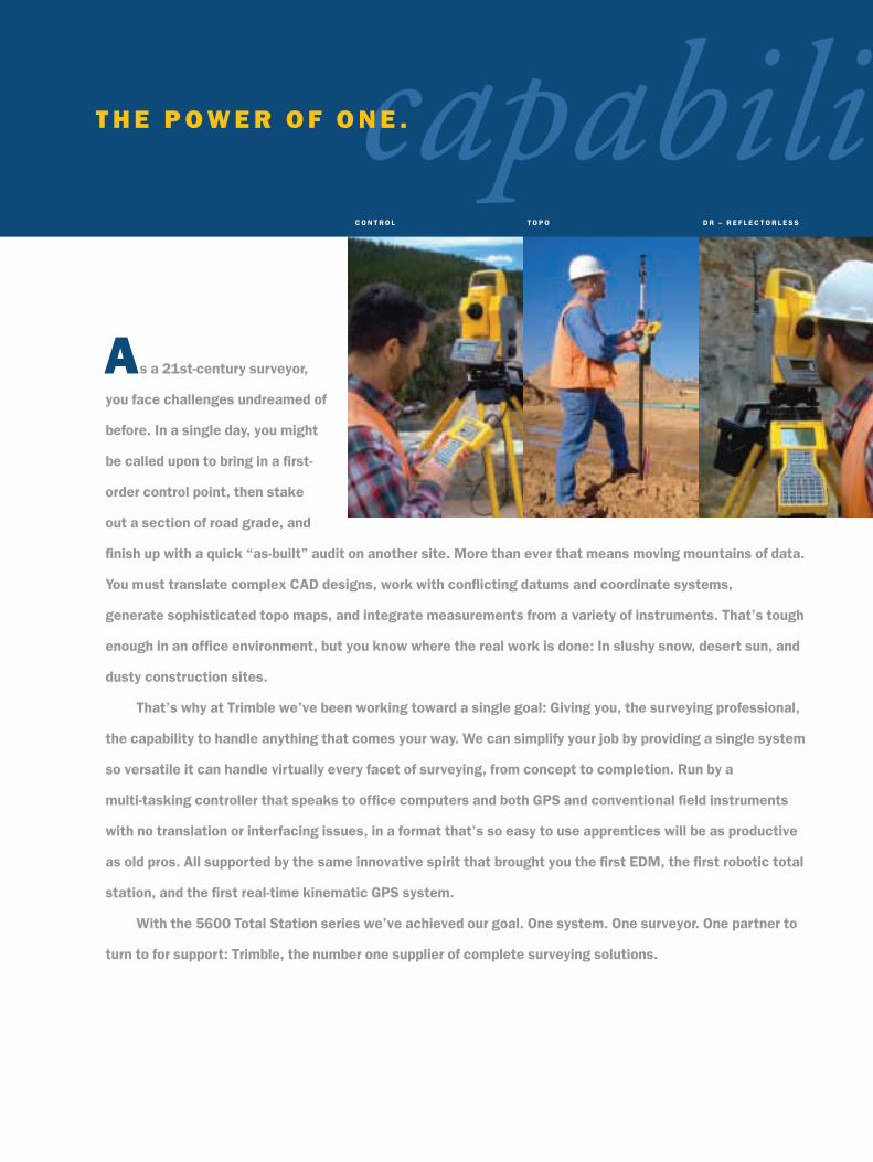
As a 21st-century surveyor,
you face challenges undreamed of
before. In a single day, you might
be called upon to bring in a first-
order control point, then stake
out a section of road grade, and
finish up with a quick “as-built” audit on another site. More than ever that means moving mountains of data.
You must translate complex CAD designs, work with conflicting datums and coordinate systems,
generate sophisticated topo maps, and integrate measurements from a variety of instruments. That’s tough
enough in an office environment, but you know where the real work is done: In slushy snow, desert sun, and
dusty construction sites.
That’s why at Trimble we’ve been working toward a single goal: Giving you, the surveying professional,
the capability to handle anything that comes your way. We can simplify your job by providing a single system
so versatile it can handle virtually every facet of surveying, from concept to completion. Run by a
multi-tasking controller that speaks to office computers and both GPS and conventional field instruments
with no translation or interfacing issues, in a format that’s so easy to use apprentices will be as productive
as old pros. All supported by the same innovative spirit that brought you the first EDM, the first robotic total
station, and the first real-time kinematic GPS system.
With the 5600 Total Station series we’ve achieved our goal. One system. One surveyor. One partner to
turn to for support: Trimble, the number one supplier of complete surveying solutions.
C O N T R O L T O P O
capabiliD R – R E F L E C T O R L E S S
T H E P O W E R O F O N E .

G I S & A S - B U I LTD E S I G N / D ATA E X C H A N G E S TA K E O U T D T M S & V O L U M E SI N T E G R AT E D S U R V E Y I N G
tyT O T A L S T A T I O N 5 6 0 0
To be competitive these days, you
need to work fast and work smart—
every step of the way. If you want to be
profitable, you can’t waste time fiddling
with finicky instruments or manually
juggling complex data translations.
Getting the job done fast while still
producing accurate, high-quality results
is critical for you and your clients. The
Trimble 5600 Total Station series gives
you access to the best, most-productive
measuring methods available—ideal for
a wide range of applications.
Each Trimble 5600 Total Station is an
advanced surveying system for today’s
surveyor. With its innovative technology,
each instrument allows you and your
survey crews to survey faster, easier,
and better than ever before.
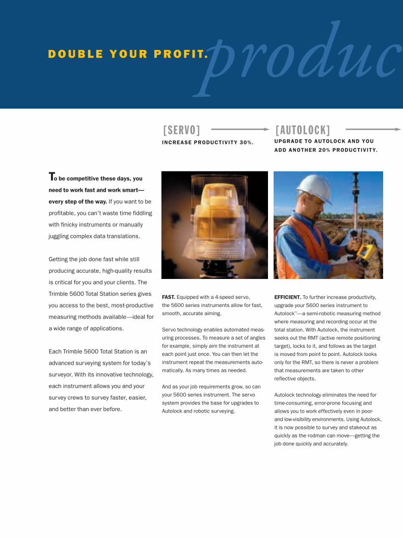
[SERVO]INCREASE PRODUCTIVITY 30%.
FAST. Equipped with a 4-speed servo,
the 5600 series instruments allow for fast,
smooth, accurate aiming.
Servo technology enables automated meas-
uring processes. To measure a set of angles
for example, simply aim the instrument at
each point just once. You can then let the
instrument repeat the measurements auto-
matically. As many times as needed.
And as your job requirements grow, so can
your 5600 series instrument. The servo
system provides the base for upgrades to
Autolock and robotic surveying.
[AUTOLOCK]UPGRADE TO AUTOLOCK AND YOU
ADD ANOTHER 20% PRODUCTIVITY.
EFFICIENT. To further increase productivity,
upgrade your 5600 series instrument to
Autolock™—a semi-robotic measuring method
where measuring and recording occur at the
total station. With Autolock, the instrument
seeks out the RMT (active remote positioning
target), locks to it, and follows as the target
is moved from point to point. Autolock looks
only for the RMT, so there is never a problem
that measurements are taken to other
reflective objects.
Autolock technology eliminates the need for
time-consuming, error-prone focusing and
allows you to work effectively even in poor-
and low-visibility environments. Using Autolock,
it is now possible to survey and stakeout as
quickly as the rodman can move—getting the
job done quickly and accurately.
producD O U B L E Y O U R P R O F I T.
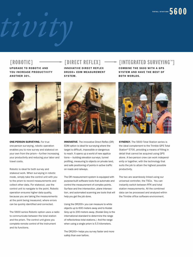
[ROBOTIC]UPGRADE TO ROBOTIC AND
YOU INCREASE PRODUCTIVITY
ANOTHER 30%.
ONE-PERSON SURVEYING. For true
one-person surveying, robotic operation
enables you to now survey and stakeout on
your own from the prism—further increasing
your productivity and reducing your labor and
travel costs.
Robotic is ideal for both survey and
stakeout work. When surveying in robotic
mode, simply take the control unit with you
to the prism to record measurements and
collect other data. For stakeout, use the
control unit to navigate to the point. Robotic
operation ensures higher data quality,
because you are taking the measurements
at the point being measured, where errors
can be quickly identified and corrected.
The 5600 series Robotic option uses a radio
to communicate between the total station
and the prism. The control unit gives you
complete remote control of the instrument
and its functions.
INNOVATIVE. The innovative Direct Reflex (DR)
EDM option is ideal for surveying where the
target is difficult, impossible or dangerous
to reach. It opens up a world of new applica-
tions— building elevation surveys, tunnel
profiling, measuring to objects on private land,
and safe positioning of points in active traffic
on roads and railways.
The DR measurement system is equipped with
purpose-built software tools that automate and
control the measurement of complex points.
Surface and line intersection, plane intersec-
tion, and automated scanning are tools that will
help you get the job done.
Using the DR200+ you can measure to white
objects up to 600 meters away and to Kodak
Grey up to 200 meters away. (Kodak Grey is the
international standard to determine the range
of reflectorless total stations.) And the range
when using a single prism is 5.5 kilometers.
The DR200+ helps you survey faster and more
safely than ever before.
[DIRECT REFLEX]INNOVATIVE DIRECT REFLEX
DR200+ EDM MEASUREMENT
SYSTEM.
[INTEGRATED SURVEYING™]COMBINE THE 5600 WITH A GPS
SYSTEM AND HAVE THE BEST OF
BOTH WORLDS.
SYNERGY. The 5600 Total Station series is
the ideal complement to the Trimble GPS Total
Station® 5700, providing a means of filling in
detail that cannot be acquired using GPS
alone. A two-person crew can work independ-
ently or together, with the technology that
suits the job to attain the highest possible
productivity.
The two are seamlessly linked using our
universal controller, the TSCe. You can
instantly switch between RTK and total
station measurements. All the combined
data can be processed and analyzed within
the Trimble office software environment.
tivityT O T A L S T A T I O N 5 6 0 0
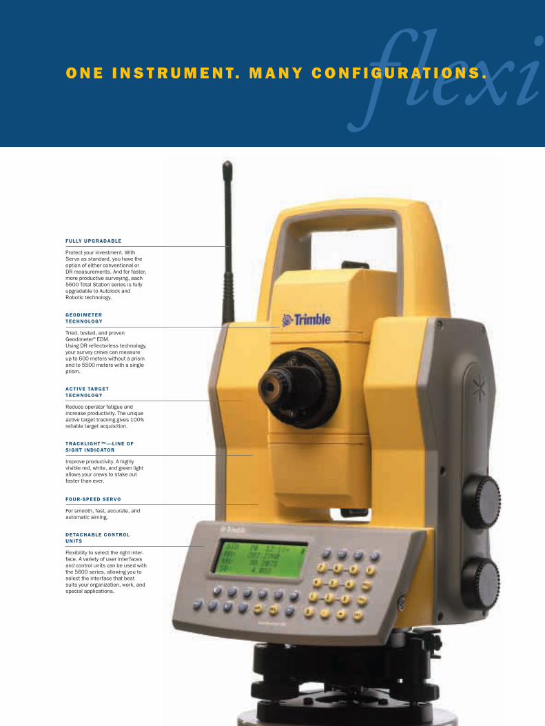
FULLY UPGRADABLE
Protect your investment. WithServo as standard, you have theoption of either conventional orDR measurements. And for faster,more productive surveying, each5600 Total Station series is fullyupgradable to Autolock andRobotic technology.
GEODIMETER TECHNOLOGY
Tried, tested, and provenGeodimeter® EDM. Using DR reflectorless technology,your survey crews can measureup to 600 meters without a prismand to 5500 meters with a singleprism.
ACTIVE TARGETTECHNOLOGY
Reduce operator fatigue andincrease productivity. The uniqueactive target tracking gives 100%reliable target acquisition.
TRACKLIGHT™—LINE OFSIGHT INDICATOR
Improve productivity. A highly visible red, white, and green lightallows your crews to stake outfaster than ever.
FOUR-SPEED SERVO
For smooth, fast, accurate, andautomatic aiming.
DETACHABLE CONTROLUNITS
Flexibility to select the right inter-face. A variety of user interfacesand control units can be used withthe 5600 series, allowing you toselect the interface that bestsuits your organization, work, andspecial applications.
f lexiO N E I N S T R U M E N T. M A N Y C O N F I G U R AT I O N S .
Flexibility is built in.
At Trimble our goal is to design and build surveying tools that give you the flexibility to meet
all your challenges today and tomorrow. Tools that simplify your complex tasks. Tools that
are intuitive, easy to use, and meet your requirements—whatever the situation.
Advanced technology, upgrade options, and a selection of user interfaces from the Trimble
Toolbox to best suit your work give you the versatility you need for highly productive opera-
tions. And you can be sure you have made a sound investment—upgrade options can adapt
your instrument to your changing needs as your work challenges change.
At Trimble we know that the real key to productive survey and stakeout work is in the soft-
ware—the user interface. That’s why we offer you the flexibility to select from a variety of
interfaces available in the Trimble Toolbox. You can work with the tool that is most familiar
and best suited to your operations—whether that be graphical or text-based, an on-board
control unit or a separate controller.
Additionally, you can use the same interfaces with our other surveying instruments. Simply
take the control unit or controller with you as you change from working with your 5600 Total
Station series instrument to the GPS Total Station 5700.
The Total Station 5600 series can be operated with your preferred data collection or field
computation system—Geodimeter, Zeiss Elta and Trimble. Or you can take advantage of
our Open System DOS control unit to run your favorite software—TDS, SMI and more—
directly on board.
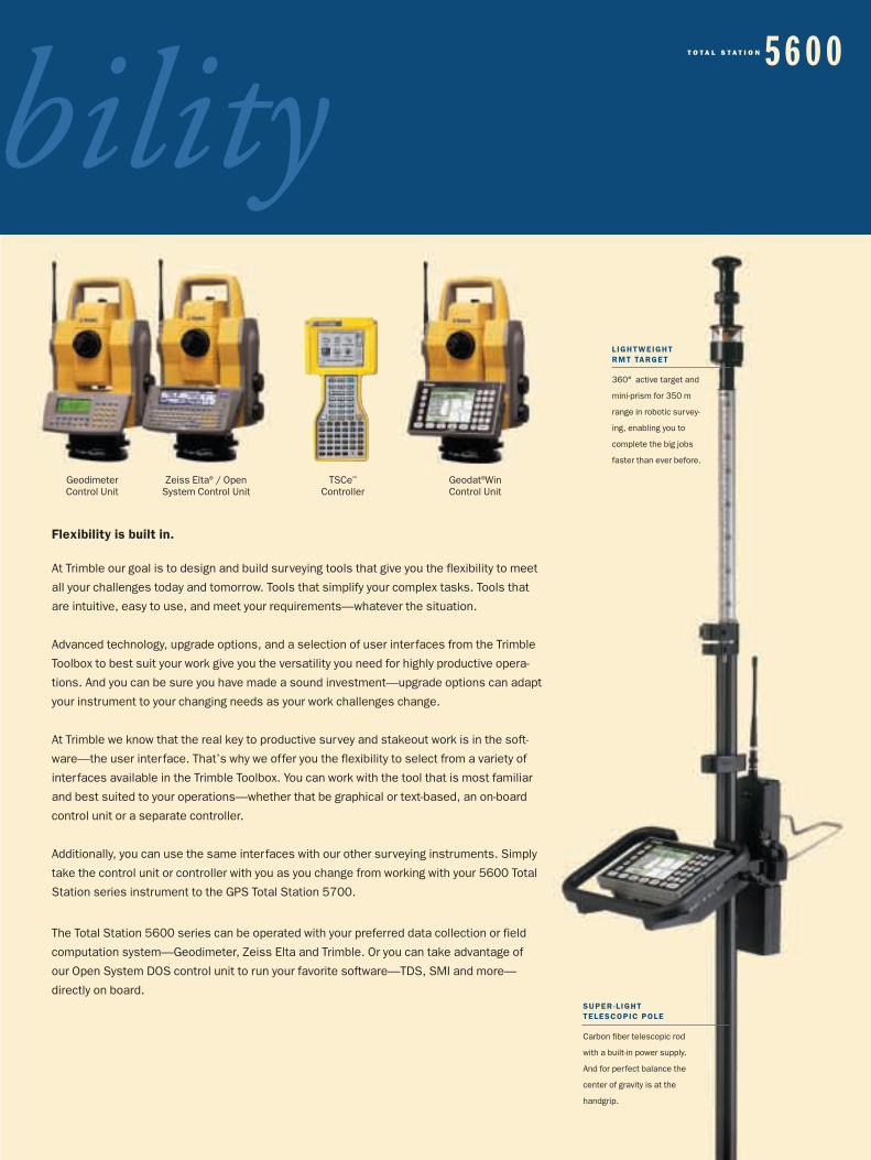
Zeiss Elta® / OpenSystem Control Unit
TSCe™
ControllerGeodat®Win Control Unit
Geodimeter Control Unit
LIGHTWEIGHT RMT TARGET
360° active target and
mini-prism for 350 m
range in robotic survey-
ing, enabling you to
complete the big jobs
faster than ever before.
SUPER-L IGHT TELESCOPIC POLE
Carbon fiber telescopic rod
with a built-in power supply.
And for perfect balance the
center of gravity is at the
handgrip.
bilityT O T A L S T A T I O N 5 6 0 0
advanced tA S Y S T E M Y O U C A N R E LY O N .
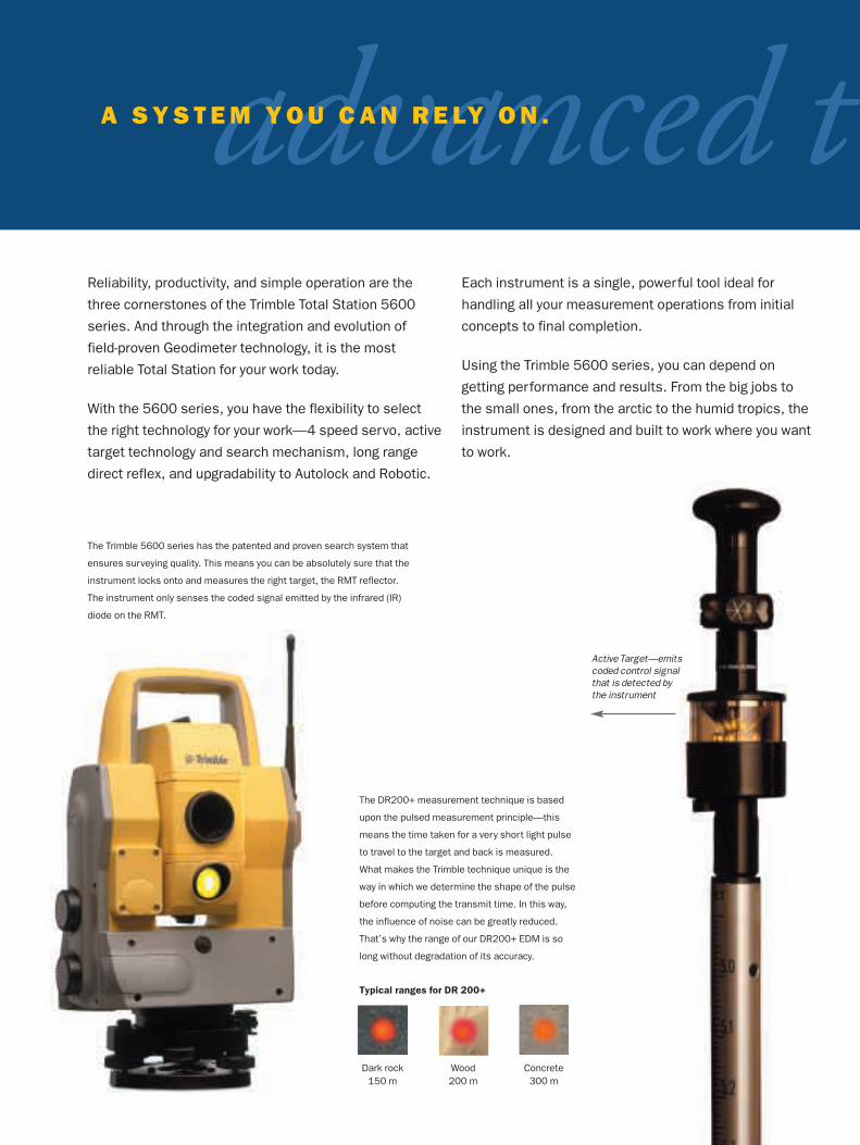
The DR200+ measurement technique is based
upon the pulsed measurement principle—this
means the time taken for a very short light pulse
to travel to the target and back is measured.
What makes the Trimble technique unique is the
way in which we determine the shape of the pulse
before computing the transmit time. In this way,
the influence of noise can be greatly reduced.
That’s why the range of our DR200+ EDM is so
long without degradation of its accuracy.
Reliability, productivity, and simple operation are the
three cornerstones of the Trimble Total Station 5600
series. And through the integration and evolution of
field-proven Geodimeter technology, it is the most
reliable Total Station for your work today.
With the 5600 series, you have the flexibility to select
the right technology for your work—4 speed servo, active
target technology and search mechanism, long range
direct reflex, and upgradability to Autolock and Robotic.
Each instrument is a single, powerful tool ideal for
handling all your measurement operations from initial
concepts to final completion.
Using the Trimble 5600 series, you can depend on
getting performance and results. From the big jobs to
the small ones, from the arctic to the humid tropics, the
instrument is designed and built to work where you want
to work.
The Trimble 5600 series has the patented and proven search system that
ensures surveying quality. This means you can be absolutely sure that the
instrument locks onto and measures the right target, the RMT reflector.
The instrument only senses the coded signal emitted by the infrared (IR)
diode on the RMT.
Typical ranges for DR 200+
Dark rock150 m
Wood200 m
Concrete300 m
Active Target—emitscoded control signalthat is detected bythe instrument
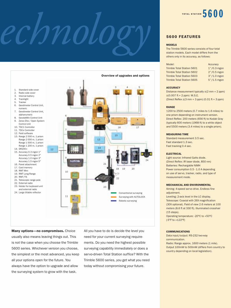
technology1. Standard side cover2. Radio side cover3. Internal battery4. Tracklight5. Tracker6. Geodimeter Control Unit,
numeric7. Geodimeter Control Unit,
alphanumeric8. GeodatWin Control Unit9. Zeiss Elta / Open System
Control Unit10. TSC1 Controller11. TSCe Controller12. Field software13. Range 2 500 m, 1 prism
Range 2 000 m, 1 prismRange 1 500 m, 1 prismRange 1 200 m, 1 prism
14. DR200+15. Accuracy 0.3 mgon 1"
Accuracy 0.5 mgon 2"Accuracy 1.0 mgon 3"Accuracy 1.5 mgon 5"
16. Panel attachment17. Card memory18. RMT Mini 19. RMT Long Range20. RMT/TS21. Telescopic range pole22. External radio 23. Holder for keyboard unit
and external radio24. Large tiltable reflector
1 2 3 4 5
16 17
6
7
8
9
10
11
21
23
13
12
15
18 19 20
22
14DR200+
24
Many options—no compromises. Choice
usually also means leaving things out. This
is not the case when you choose the Trimble
5600 series. Whichever version you choose,
the simplest or the most advanced, you keep
all your options open for the future. You
always have the option to upgrade and allow
the surveying system to grow with the task.
All you have to do is decide the level you
need for your current surveying require-
ments. Do you need the highest possible
surveying capability immediately or does a
servo-driven Total Station suffice? With the
Trimble 5600 series, you get what you need
today without compromising your future.
5600 FEATURES
MODELSThe Trimble 5600 series consists of four total station models. Each model differs from the others only in its accuracy, as follows:
Model: AccuracyTrimble Total Station 5601 1”/0.3 mgonTrimble Total Station 5602 2”/0.5 mgonTrimble Total Station 5603 3”/1.0 mgonTrimble Total Station 5605 5”/1.5 mgon
ACCURACYDistance measurement typically ±(2 mm + 2 ppm)±(0.007 ft + 2 ppm) M.S.E. (Direct Reflex ±(3 mm + 3 ppm) (0.01 ft + 3 ppm)
RANGE1200 to 2500 meters (0.7 miles to 1.6 miles) toone prism depending on instrument version.Direct Reflex: 200 meters (656 ft) to Kodak Gray(typically 600 meters (1968 ft) to a white objectand 5500 meters (3.4 miles) to a single prism).
MEASURING TIMEStandard measurement 3.5 sec.Fast standard 1.3 sec.Fast tracking 0.4 sec.
ELECTRICALLight source: Infrared GaAs diode. (Direct Reflex: IR laser diode, 850 nm)Batteries: Rechargable NiMH Power consumption 0.5 - 1.0 A depending on use of servo, tracker, radio, and type of measurement mode.
MECHANICAL AND ENVIRONMENTALAiming: 4-speed servo drive. Endless fine adjustment.Leveling: 2-axis level in the LC display.Telescope: Coaxial with 26X magnification (30X optional). Field of view 2.6 meters at 100meters (8.6 ft at 330 ft). Illuminated crosshair (15 steps). Operating temperature: -20°C to +50°C (-5°F to +122°F)
COMMUNICATIONSData input/output: RS-232 two-way communication.Radio: Range approx. 1600 meters (1 mile).Output 100mW to 500mW (differs from country tocountry depending on local legislation).
Overview of upgrades and options
Conventional surveying
Surveying with AUTOLOCK
Robotic surveying
T O T A L S T A T I O N 5 6 0 0
Total Station. Total solution. When you
invest in a Trimble 5600 Total Station
series, you get more than just an
advanced survey instrument—much
more. Because a 5600 series instrument
is really a complete surveying solution.
A servo-driven total station, which,
through modular upgrades, can become
an Autolock or robotic total station. With
DR200+ technology built in, the
instrument is capable of measuring to
any object up to 600 m away—without
a prism!
All Trimble products are supported with
powerful field and office software, which
integrate seamlessly with the instrumen-
tation. All are designed by Trimble and
linked together through the Trimble
Toolbox environment, which is rapidly
becoming the world standard for
high-performance surveying.
Seamless data flow. In the Trimble
Toolbox environment, a single controller
handles all of your instruments from
mechanical and robotic total stations to
RTK GPS receivers, even instruments
from other manufacturers. All with seam-
less “plug and play” simplicity. You can
change instrument types on the fly—the
survey controller automatically combines
and correlates the different measure-
ments into a single, unified dataset.
Back in the office, the control unit
interfaces directly to Trimble Geomatics
Office™ software—a single comprehen-
sive program for all your data processing
needs. No matter how your clients want
their data delivered, the software is ready
to automatically translate your field data
into more than 50 design, CAD, GIS, and
survey formats. There‘s even a Trimble
Link™ module that lets you directly move
your field data into the AutoDesk
AutoCAD Land Development Desktop
interopeI N T E G R AT E D S U R V E Y I N G
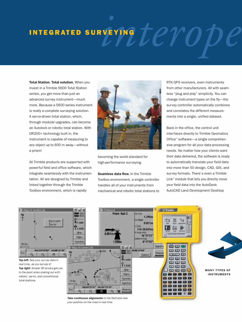
Top left: See your survey data inreal time, as you survey it!Top right: Simple 3D arrows get youto the point when staking out withrobotic, servo, and conventionaltotal stations.
Take continuous alignments to the field and viewyour position on the road in real time.
MANY TYPES OFINSTRUMENTS

design package for analysis. Or, for in-
house design work, use the Terramodel®
software, Trimble’s advanced design
application for complete concept-to-com-
pletion integration. When your clients are
ready to give their construction designs
back to you for stakeout, the translation
is just as seamless. Our new RoadLink™
Wizard automates the process for more
than 30 road design software formats.
Field efficiency. The tight integration of
the Trimble 5600 series will radically
boost your productivity in the field. The
combination of robotic and DR200+
measurement techniques creates the
ultimate measuring machine, making it
easy for a single surveyor to go anywhere
and carry out any job previously carried
out by an entire crew.
You can upload your entire continuous
3-dimensional design to the survey con-
troller, which allows you to put the pole
down anywhere on site and instantly see
the station, offset, cut or fill. Even if
someone parks a bulldozer in your path,
you can work right around it. And if you
find it more productive, you can add a
Trimble GPS Total Station system and
continue surveying by yourself without
any interruption.
For large sites, add a Trimble GPS
system to rapidly cover open areas and
positions not readily accessed with the
total station, and continue surveying by
yourself with no interruption.
Integration, interoperability, and
seamless compatibility. It all ads up
to the power of one—one surveyor,
one system, one company. Trimble.
50 TYPESOF DATA
rabilityT O T A L S T A T I O N 5 6 0 0
Process GPS and Conventional survey data with Trimble Geomatics Office and link to more than50 types of survey, GIS, CAD & design data.
The Trimble Toolbox alsoincludes power ful software for civil engineering design, visualization, geodetic surveying and real timedeformation monitoring.
TRIMBLE.THE WORLD LEADER IN INTEGRATED SURVEY SOLUT IONS
In the 20th century, Geodimeter, Trimble, and Zeiss revolutionized the world of
surveying—with the first automatic level, the first EDM, the first Robotic Total
Station, the first commercial GPS receiver, and the first Real-Time Kinematic
surveying system.
Now in the 21st century, the new combined force of Trimble is bringing that
same pioneering spirit to bear on practical solutions for the new challenges
that will face the surveyor in the new millennium. We’re closing the gap
between field and office with integrated products that offer real-time data
management, real-time data exchange, and real-time quality control— from
Concept to Completion.
The new Trimble Toolbox offers the most comprehensive survey toolset in the
world. With sales and support facilities around the globe, all interconnected
with advanced global communications technology, we’re ready to provide expert
support anywhere your work takes you, 24 hours a day.
Welcome to the 21st century.
Your Local Trimble Office or Representative
© Copyright 2001, Trimble Navigation Limited. All rights reserved. Elta, Geodat, Geodimeter, GPS Total Station and Terramodel are trademarksof Trimble Navigation Limited registered in the United States Patent and Trademark Office. The Globe and Triangle, Trimble, Autolock, Tracklight,Integrated Survey, RoadLink, Trimble Geomatics Office, Trimble Link, Trimble Survey Controller, TSC1 and TSCe are trademarks of TrimbleNavigation Limited. All other trademarks are the property of their respective owners. TID 12411B (07/01)
N O R T H A M E R I C ATrimble Navigation LimitedEngineering and Construction5475 Kellenburger RoadDayton, Ohio 45424-1099800-538-7800 Toll Free937-233-8921 Main937-233-9441 Faxwww.trimble.com
E U R O P ETrimble GmbHAm Prime Parc 11D-65479 RaunheimGermany+49-6142-2100-0 Main+49-6142-2100-220 Fax
L AT I N A M E R I C ATrimble Navigation Limited6505 Blue Lagoon DriveSuite 120Miami, FL 33126800-865-3994 Toll Free305-263-9033 Main305-263-8975 Fax
A F R I C A & M I D D L E E A S TTrimbleP.O. Box 17760Jebel Ali Free ZoneDubaiUAE+971-4-881-3005 Main+971-4-881-3007 Fax
A S I A - PA C I F I CTrimble Navigation Australia
PTY LimitedLevel 1/123 Gotha StreetSpring Hill, QLD 4004AUSTRALIA+61-7-3216-0044 Main+61-7-3216-0088 Fax
C H I N ATrimble Export LimitedRepresentative OfficeSuite 16D, Building 2, Epoch Center4 Beiwa Road, Haidian DistrictBeijing, P.R. China, 100081+86-10-6847-7756 Main+86-10-6847-7786 Fax