Embed Size (px)
Citation preview
Knowledge cartographies Tools for the social structures of knowledge
Marco Quaggiotto1
Abstract This paper aims to propose a ‘cartographic’ approach to the representation of knowledge in
its present configurations, with the aim to visually represent not so much a disciplinary partitioning, as the interconnection of the its composing entities, the paths that develop, the thematic and transdisciplinary domains that emerge.
A cartography of knowledge spaces that takes advantage of the experience developed by maps in the representation of complex and open spaces, historically able to hold heterogenous, natural and social elements together in the same picture.
The first section of the paper is devoted to the rhetoric of cartography in its traditional meaning. In the second section of the paper a proposal for a ‘knowledge atlas’ is discussed.
1 Politecnico di Milano (ITALY) - INDACO department. Phd candidate, [email protected]
2
1. Introduction In recent years, the methods of creation, organization and management of knowledge are
changing. The causes for this global transformation of knowledge dynamics are multiple, varied, and complex in nature.
On the one hand, starting from the second post-war period, an epistemological change has revolutionized the way science is being done by introducing (or at least by revealing), a social dimension in the processes of knowledge construction. The individualistic models of early XX century epistemology give way to models that describe the creation of new knowledge in terms of social processes. Disciplines such as social epistemology and sociology of scientific knowledge, with some contributions from anthropology, describe a convincing scenario that connects knowledge and society, inextricably linking knowledge to the society that produces it and, conversely, proposing a model of society based on knowledge and skills.
On the other hand, technological changes brought by the digital revolution in the ’80s and by ICTs in the ’90s, have transformed channels, tools and methods for the creation, diffusion and management of knowledge. The democratization of publishing, the immediate distribution of knowledge, the emergence of alternative economies for intangible goods, the proliferation of free information and the transformation of the very concept of author, revolutionize the dynamics of knowledge.
Knowledge thus assumes the structure of an heterogeneous space, consisting of physical and digital resources, both textual and human, in permanent evolution. Both in the case of new digital forms (websites, blogs, databases), and in traditional formats of knowledge (libraries, books, files), authors and users interact, albeit indirectly, in the management and creation of new knowledge: they classify, link, comment, amend, edit, supplement.
Both in the contexts of scientific research and in everyday life, science and knowledge are changing shape and behavior.
− Besides centralized information collected in books and universities, a new kind of diffuse information (similar in form to once-forgotten oral knowledge), is emerging in forums, blogs and websites, or in implicit form through persons, groups, companies.
− Besides universal classifications defined aprioristically by experts, imperfect categorizations are appearing, emerging from the aggregation of the personal opinions of thousands of individuals.
− Besides rigid and permanent disciplinary structures, dynamic and fluid structures in permanent evolution, are helping describe the thematic routes cross-cutting disciplines and areas of interest.
− Knowledge is less and less manageable in terms of possession, and increasingly in terms of access to information and skills. Knowing means having access to social networks and technology able to provide necessary information and insight at the time of need.
In research focused on knowledge tools, this new cultural shift transforms needs and purposes of research. Today, the challenge is no longer that of looking for the perfect classification, a permanent structure able to divide and sort disciplines and skills into cultural sectors. On the contrary, the current urgency is trying to ‘keep together’ different kinds of knowledge resources: to gather social and cultural elements, people, research groups,
3
texts, designs and concepts in a single knowledge space. As a direct result, in the Communication Design field, the urgency concerns the creation of tools enabling the exploration, the description and the design of such spaces.
2. Knowledge spaces The space metaphor, increasingly common in research relating to knowledge tools, is
anything but random. Unlike the structures used over the centuries to manage knowledge by subdividing it in discrete areas, space is a continuous substrate: it doesn’t divide culture in sections, it doesn’t create hierarchies or define order in absolute terms, but on the contrary, it defines relations, proximities. Space defines groups, creates clusters, identifies pathways and highlights priorities in a dynamic structure, and likewise it allows to locate, to remember, to order.
The use of space as a metaphorical concept is not a recent invention, as it may be considered an ancestral knowledge strategy exploiting sensorial experience and spatial abilities to tackle abstract problems. Confirmation of this cognitive role of space – as reported by Lakoff and Johnson – is found in the lexicon widely used in referring to abstract domains: “Orientational metaphors give a concept a spatial orientation; for example, happy is up. The fact that the concept HAPPY is oriented up leads to English expressions like «I’m feeling up today»” (Lakoff e Johnson 1982, 31). The topics covered by the space metaphor are so many, that it can be said to organize, according to Lakoff and Johnson, most fundamental concepts. Unlike most other metaphors, space constitutes an analog based on direct physical experience, and not culturally mediated (Lakoff e Johnson 1982, 34).
Even when referring to knowledge itself, the analogy keeps strong: theories that differ are said to depart, researches can be large or small, students follow study paths, scientists are exploring new territories, going beyond the frontiers of research, sometimes even going too far. The metaphor of space was used in ancient and medieval times in order to remember and organize orations and texts, creating imaginary palaces and gardens of memory in which the speaker arranges columns, arches and statues to represent arguments and sections of the speech. Later, during the oration, he would then retrace his steps through the space of memory choosing the most suitable path, dwelling in depth on a subject or jumping whole shares.2
Even though, with the diffusion of the printed book, these mnemotechnics have lost much of their usefulness, the use of abstract spaces inhabited by non-geographical concepts and entities has never declined, and with the arrival of post-modernism their victory over trditional spaces has been announced. At present times, since the development of a post-modern society, abstract spaces are taking the place of geographic territories: we are therefore talking about multiple spaces, which arrange cultural actors of a society according to systems of values. The same elements can appear close in a semantic space and further apart in a disciplinary space, two authors may be colleagues (relational space) but interested in different topics (thematic space), etc.
In this context, the need is to find adequate practices and tools for complex and multidimensional spaces. Tools able to describe them, to make them navigable, to allow their exploration.
2 For a thorough discussion of mnemonic devices and ‘memory palaces’ cf. (Illich 1994) and (Yates 2001)
4
3. Tools for knowledge spaces Like any good metaphor, the spatial-territorial analogy applied to knowledge is not a mere
lexical transfer from a ‘literal domain’ to a ‘figurative domain’, on the contrary it allows to transfer concepts, procedures and tools from a known area to a still unexplored area.
As far as knowledge spaces is concerned, metaphors of this kind are multiple and varied: the popular concept of computer desktop, mixing the personal space of the desk with the work space of the office, is still dominant and despite the obvious shortcomings still seems to work pretty well. The metaphor of navigation and the spatial terminology used in the description of activities related to the use of the Internet (website, site map, IP address, to visit a site, to follow a link), although less imaginative than those used in the ‘90s (electronic highway, cyberspace, to surf) remain on par with more ‘bookish’ analogies (web pages, index of the site, to browse).
Even the map, spatial instrument par excellence, is not a recent metaphor. In addition to the famous image evoked by D’Alembert (D’Alembert 1978) in the ‘Preliminary speech’ to the Encyclopédie, and its appearance in the founding work of Paul Otlet (1934), one of the fathers of information science, in the last 30 years (in connection with the outburst of issues and potentials related to digital information management), we have witnessed a surge in academic research in the field of information visualization and abstract domain mapping. The approach to representation proposed by disciplines like information visualization, however, is mainly technical and computer-oriented, targeted mostly at the design of suitable algorithms for the display of enormous data quantities, with a perceptual-functionalist attitude toward representation. The term ‘map’, used quite often in this field’s scientific literature, is therefore often a poor metaphor, applied more on an evocative and linguistic level than on a structural and cultural level.
The aim of this paper, on the contrary, is to extend the cartographic metaphor beyond visual analogy, and to expose it as a narrative model and tool to intervene in complex, heterogeneous, dynamic realities, just like those of human geography. The map, in this context, is not only a passive representation of reality but a tool for the production of meaning. The analogy, in this case, becomes not so much visual as structural and methodological in nature: it rests upon modalities, languages and tools developed by cartographic discourse over thousands of years to represent open spaces in constant evolution, both social and cultural at the same time.
The map is thus analyzed as a communication device: a mature representation artefact, aware of its own language and its own rhetoric, equipped with it its own tools, languages, techniques and supports.3 A model that recovers the narrative abilities of pre-scientific maps and presents itself not as a mere mimetic artefact, but as a poetic and political tool: “Make maps, not tracings.—write Deleuze and Guattari in ‘A thousand Plateaus’—The map does not reproduce an unconscious closed on itself; it constructs it. The map is open, connectable in all its dimensions, and capable of being dismantled; it is reversible, and susceptible to constant modification. It can be torn, reversed, adapted to montages of every kind, taken in hand by an individual, a group or a social formation. It can be drawn on a wall, conceived of as a work of art, constructed as a political action or as a mediation. Contrary to a tracing, which always returns to the ‘same’, a map has multiple entrances.” (Deleuze e Guattari 1987)
The map as narration, is thus the expression of a communicative purpose. Just like a text, the map makes selections on reality, distorts events, classifies and clarifies the world in order to better tell a particular aspect of a territory, an event, a space. When used with malice, it can hide, conceal, falsify or diminish a reality through the construction of an ideological discourse, in which the communicative aims are hidden to the user. In this context, the term ‘map’ is a synonym of
3 Cfr (Baule 2007b)
5
visual narration of space: a cultural artefact created by an author to describe a space according to an objective.
The map as a tool appears instead as a means that enables the user to reach an otherwise unattainable goal. It allows not only to do things better, more efficiently, but also to create new realities. As an instrument, the map expects a user using it to achieve an end, and similarly a designer, who must ensure that the structure of the instrument is as suited as possible for the achievement of the planned tasks.
In this delicate relationship, the designer’s responsibility as creator of a cultural instrument becomes clear: operations of abstraction, scale choice and language work together in the narration of a virtual reality which constitutes the basis for potential action. The designer thus assumes the role of co-author of each subsequent action taking the responsibility to decide what exists, what is important. By drawing the territory, he distinguishes the significant from the secondary, the transitory from the permanent, the visible from the invisible.
In this context, the role of the communication designer is to provide methods and tools for designing images able to combine both narrative and instrumental dimensions. In a time of ever increasing power of the image (even in scientific contexts), the development of a model for the design of ‘visual tools’ is already a priority. A narrative for the representation of complex systems enabling not only to depict and explain, but also to act and influence the very reality that’s being represented.
Beside the development of a scientific cartography, focused on neutralizing and naturalizing the cartographer’s point of view, a need for a narrative approach to the depiction of geographic and abstract spaces is emerging: a rhetoric4 as a technique for building visual discourses, strategic tools that enable to see and act in physical and abstract territories.
4. Cartographic rhetoric Like any discourse, also cartography has its own rhetoric. Despite the negative connotations
acquired by this term (often linked to operations of persuasion and concealment through linguistic stratagems), rhetoric is, in its original meaning, a technique for the construction of speeches.
Rhetoric, in the meaning used in this text, appears as an art in the classical sense, a linguistic technique used to select and processes elements of reality in order to transform them in an effective speech. With this in mind, the rhetoric nature of cartography shouldn’t appear as a novelty: the authorial and cultural character of maps has always been one of the fundamental themes of cartographic literature and criticism, and it still is one of its major worries. The narrative component of the cartographic speech has often been regarded as a sort of unavoidable flaw, a collateral effect of an essential tool: the map. Point of view and narration manifest themselves through the operations that transform the territory in image. A rhetoric of this kind, applied both to traditional territories and to knowledge spaces can provide a meta-language, a technique conceived as method for the design on the map.
Just like in classical Aristotelian rhetoric, in this cartographic rhetoric it is possible to distinguish operations concerned with the selection of material (inventio), with the structuring and composition of speech (dispositio), and with language choice (elocutio). Obviously, the correspondence between these categories should be regarded more as a guide to the creation of a speech rather than as a deep correspondence between the operations of spoken language and those of visual discourse. In fact, while an excessive stubbornness in seeking matches at all
4 When referring to multimodal communication models Anceschi (1993) uses the term ‘registica’ (direction). Nevertheless, despite the involvement of interaction elements, when speaking about the cartographic expression the term ‘rhetoric’ has been preferred.
6
levels between the symbolic-linear language of speech and the iconic-synoptic language of images could be forced and misleading, on the contrary the exploitation of the deep structure of the rhetoric discourse underlying the entire Western literature, may be particularly useful to investigate the workings of complex communicative artefacts (such as maps and diagrams) and thus to suggest a methodology for their design.5
4.1 Inventio In Aristotle’s Rhetoric the inventio is the first of the five operations of the rhetorical techne: it
consists in the ‘invenire quid dicas’ (i.e. ‘to find what to say’), the gathering of arguments, evidence and issues to be exposed. The inventio as such is not an invention, but rather, as Barthes noted, an operation of discovery and selection of the material.
In cartography, operations of selection, collection, classification and simplification decide what to say. They define, albeit in an abstract way, the materials of the speech to be arranged in the dispositio and translated into words (or images) in the elocutio. In the depiction of an infinitely complex reality, the cartographic narrative makes selections that decide what is relevant and what is not by creating a simplified copy of the territory, retaining only the useful features.
The decision of which aspects of the territory are worth showing, allows to highlight important elements of the territory, hidden correlations, significant distributions, or also deficiencies. At the same time, however, the choice is also political and moral, and it interferes in turn on the represented reality: showing something means recognizing its importance, its relevance, and its status as part of the territory. In this context, cartography is exposed as an intrinsically partial representation model, which has incompleteness as its strong point. It allows a narrative of open and complex spaces through the creation of multiple stories that abandon any presumption of completeness in favour of the creation of local stories, valid for limited objectives.
Within knowledge representation systems, the application of a cartographic approach, partial and selective in nature, provides a substantial change when compared to historical and recent models of knowledge representation. If, on the one hand, both linear and hierarchical representation models of knowledge are built on a priori categories, on the other hand cartographic representation is based on the definition of local stories, and on the rejection of a totalizing structure.
In this context, selection represents the operation deciding the extension of the research, and the elements of the story that is going to be told: people, publications, conferences, but also professionals, forums, companies, and abstract concepts can be combined in the narrative of a space as complex as the social space of knowledge, or they may be neglected and relegated to irrelevance. Maps resulting from these choices reflect, in addition to the subject of study, the epistemic context of the cartographer. Showing, once again, means giving dignity and authority. Drawing users, next to books, authors and Dewey codes in a library map, means to recognize the users’ role in the definition of a cultural area. Drawing websites, blogs and forums in a map of academic research, communicates the awareness of the virtual communities’ function in the processes of knowledge creation.
5 This approach stems in many ways from research that analyzed visual rhetoric both as difference between natural and figurative language (Barthes, Bonsiepe, Group µ), and in the broader meaning previously specified (Anceschi, Arneim). However, unlike these contributions, in this context the focus will be on the cartographic language as a model specific to the narrative of space, developing critical cartography research (Wood, Monmonier, Harley).
7
4.2 Dispositio In the rhetoric of spoken discourse as well as in cartographic rhetoric, this first phase of
speech construction (inventio) comes to a conclusion without any use of actual words or pictures: the materials of the inventio are abstract, they are “pieces of language in a reversible state, that must be arranged in the fatally irreversible order of speech” (Barthes 1972, author's translation).
The creation of the ‘oratio’, the speech (or image in our case), is carried out by two other operations: the construction of the speech (dispositio) and its translation into words (elocutio). The dispositio is the placement of the parts of the speech, the composition. Given a series of data elements, facts, and arguments, the dispositio arranges, sorts and orders the arguments in order to convince (or touch) the spectator.
The first concrete issue in the construction of the cartographic discourse lies therefore in the construction of the analogy that enables to associate every point in space with a point on the map. The map, in other words, is useful because it constitutes an analogue of the represented object, an icon that establishes a geometric or human relation between a virtual and a real space.
In case of large-scale maps the transformation of these spaces is trivial: the projection, this rule that transforms a space in another, simply ‘shrinks’ the two-dimensional space of the territory in the two-dimensional space of the map. On the other hand, when the analogy concerns spaces of uneven nature or dimensionality (e.g. the projection of a three-dimensional globe on a two-dimensional map), than the projection can not occur without deformation. Being impossible to avoid deformations, the projection must be carefully chosen by the cartographer on the basis of its characteristics. As in a hypothetical ‘uncertainty principle’ of cartography, it’s impossible to simultaneously maintain a correspondence between angles, areas, distances and directions.
Cartography, once again, becomes an art of compromise and partial solutions. From a narrative point of view, however, projection operations give the designer a chance to highlight specific aspects of the territory at the expense of others. Finally, only the users’ needs determine the ‘better’ projection.
This importance of projection operations is not limited to geographic spaces but extends also in the realm of metaphorical mapping of abstract spaces. To project an abstract space (e.g. a knowledge space, a social space) on paper, means to identify a transformation that matches elements of a non-geometric ‘space’ to elements of a two-dimensional representation. The transformation, in this case, is therefore no longer a geometric projection, but a isomorphism that “constitutes a biunique match of points in space (and we call space also the virtual space of content).”
“The assumption in this case—writes Eco—is the acceptance of a metaphorical nature of the concept of abstract space, definable through a convention (based on mental mechanisms that make possible to imagine abstract relations in terms of spatial proximity) which stipulates that certain abstract relations are expressed by certain spatial relations.” (Eco 1975, author's translation)
Once again, the transformation between spaces is not trivial nor unique, but on the contrary it appears as an arbitrary process. The convention referenced by Eco’s definition of metaphorical space may consist of an unlimited number of different rules, potentially giving shape to unlimited types of space: semantic spaces where physical proximity indicates similarity of content, relational spaces where closeness is determined by the intensity of relations between the elements, temporal spaces in which temporal closeness is translated in concrete proximity.
As with geometric projections, space-creation operations founded on abstract values imply the choice of a criterion to be used for the transformation of space. As for the rhetoric of the speech, a change in the order of the arguments does not leave the content unchanged,
8
but on the contrary it affects the narrative. These cartographic operations strongly define the nature of space. They show, like the more traditional projections, some characteristics of the area to the detriment of others: the choice highlights a discourse, creates an order, tells a story.
4.3 Elocutio Elocutio, the third part of the rhetorical techne, deals with finding the form of concepts,
choosing the right words, picking the right images. In semiotic terms, the elocutio works on the expressive functions of signs, their denotations and connotations: the aim is on the one hand to express the content of the sign, and the other hand to define a tone of the speech and to work on its (possible) connotations.
This third part of the ars rhetorica is therefore a technique concerned with words and figures, but not limited to that as, on the contrary, “it defines a field containing language altogether: it includes our grammar and what is called diction” (Barthes 1972, author's translation). In addition to ornamental functions, elocutio therefore appears also as an operation of moulding, of in-formation of the speech. The speech’s effect on the public depends both on the careful communication of meaning, and on the connotations conveyed by stylistic choice (the greater the openness of the sign, the more powerful the connotations).
In the contexts of a cartographic rhetoric, the sign types that can be placed on the semantic space of the map represent almost any mode of visual meaning. The signification mode of each of these signs can be purely symbolic or it can assume a more or less iconic character, reproducing the look of the depicted element. In turn these signs may refer to the denoted entities in many ways: more or less realistically, more or less abstractly, representing a single specific object (a specific lighthouse) or category of items (lighthouses in general) depending on the degree of classifications established by cartographer.
The choice of these qualities defines the overall appearance of the map, and therefore affects the user’s interpretation: the creation of a strongly ‘realistic’ map, for example, contributes to the reality effect typical of the iconic mode of signification, while a schematic and highly symbolic representation will strengthen the technical connotations.
The symbolization activities therefore act on two main levels. First of all, they determine an order of the image, a value of the represented entities. In traditional and abstract maps, larger and more visible symbols express weakly codified connotations of importance with respect to less visible signs: they become the map theme, expressing the author’s intentions and the representation’s point of view. Size, chromatic contrast, brightness, formal distinctions and, in general, all the visual qualities of the image define the figure’s depth, highlighting distributions, emergencies, and exceptions. In short, they define a tone of discourse, they raise their voice on some issues and disregard others, differentiating more or less emphatically the various arguments.
On the other hand, this definition of a tone together with the establishment of a cartographic lexicon (defined by the symbolic and iconic repertoire), and together with the choice of a form which embodies the entities, defines a style of communication. The style is therefore the result of symbolization choices, the domain of form and figure, however its function is not limited to a generic search for pleasantness. On the contrary the map style defines a system of connotations that carries out a meta-communicative function: it describes the communication itself by providing clues for its interpretation.
In geographical and abstract maps, language and style expose the communicative intentions of the author. However, while with regard to geographical maps, tourist maps, and technical plans, over the centuries there has been a codification of styles in genres that match
9
form to content according to relatively stable codes, with regard to the new maps this process is still being defined, and attention to the map drawing process is rather lacking.
The current look of abstract maps is in fact often an involuntary tribute to technology, exposing the automated nature of the systems that generated them. Forms and typographical elements hardly commit to a precise stance, human intervention is excluded from connotations, and the image neutrality is ensured by the perfect naivety of the machine. Just like in scientific cartography, the rhetoric of selection, spatialization, classification and silence is hidden by the ‘neutral reality’ of language. Well-camouflaged in the database structure responsible for the collected information, in data selection queries, and in layout algorithms, the human choice never appears in the visualization’s language.
In this context, research needs to develop suitable languages for the communication of dynamic spaces and define both technical and human codes, in order to recognize the cultural role of images and of design processes.
5. Project: the Knowledge Atlas Building on these reflections concerning the use of a cartographic approach in the design of
knowledge interfaces, during the research a software (Atlas) has been developed to experimentally verify the theoretical assumptions developed during the research, and to explore the identified design methodologies in order to call them into question, and retrospectively improve the theoretical and analytical framework.
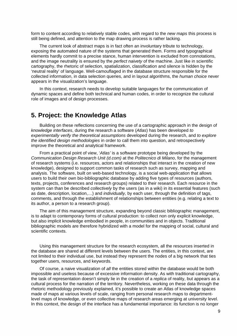
From a practical point of view, ‘Atlas’ is a software prototype being developed by the Communication Design Research Unit (d.com) at the Politecnico di Milano, for the management of research systems (i.e. resources, actors and relationships that interact in the creation of new knowledge), designed to support common tasks of research such as survey, mapping and analysis. The software, built on web-based technology, is a social web-application that allows users to build their own bio-bibliographic database by adding five types of resources (authors, texts, projects, conferences and research groups) related to their research. Each resource in the system can than be described collectively by the users (as in a wiki) in its essential features (such as date, description, location,…) and individually, by each user, through the definition of tags, comments, and through the establishment of relationships between entities (e.g. relating a text to its author, a person to a research group).
The aim of this management structure, expanding beyond classic bibliographic management, is to adapt to contemporary forms of cultural production: to collect non only explicit knowledge, but also implicit knowledge embodied in people, in communities and in objects. Traditional bibliographic models are therefore hybridized with a model for the mapping of social, cultural and scientific contexts.
Using this management structure for the research ecosystem, all the resources inserted in the database are shared at different levels between the users. The entities, in this context, are not limited to their individual use, but instead they represent the nodes of a big network that ties together users, resources, and keywords.
Of course, a naive visualization of all the entities stored within the database would be both impossible and useless because of excessive information density. As with traditional cartography, the task of representation doesn’t simply lie in the creation of a replica of reality, but appears as a cultural process for the narration of the territory. Nevertheless, working on these data through the rhetoric methodology previously explained, it’s possible to create an Atlas of knowledge spaces made of maps at various levels of scale, ranging from personal research maps to department-level maps of knowledge, or even collective maps of research areas emerging at university level. In this context, the design of the interface has a fundamental importance: its function is no longer
10
Atlas, resource page: in this page, the user can describe his resources in terms of metadata, ratings, tags, comments and through the definition of relations with other entities.
aimed exclusively at facilitating the recovery of saved entities (as in traditional bibliographic software), but on the contrary it takes on the task of representing knowledge contexts in order to allow their exploration, thus helping in their understanding.
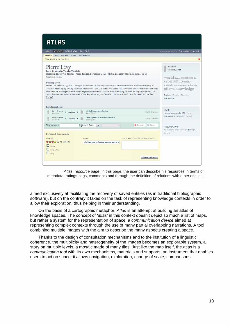
On the basis of a cartographic metaphor, Atlas is an attempt at building an atlas of knowledge spaces. The concept of ‘atlas’ in this context doesn’t depict so much a list of maps, but rather a system for the representation of space, a communication device aimed at representing complex contexts through the use of many partial overlapping narrations. A tool combining multiple images with the aim to describe the many aspects creating a space.
Thanks to the design of consultation mechanisms and to the institution of a linguistic coherence, the multiplicity and heterogeneity of the images becomes an explorable system, a story on multiple levels, a mosaic made of many tiles. Just like the map itself, the atlas is a communication tool with its own mechanisms, materials and supports, an instrument that enables users to act on space: it allows navigation, exploration, change of scale, comparisons.
11
Atlas, projection: examples of semantic, relational, temporal and geographical spaces.
12
5.1 The Atlas Specifically, in the case of Atlas, the ‘atlas of knowledge spaces’ consists of a series of
maps, visualizations and dynamic representations created by the system starting from user-chosen parameters. If compared to the traditional Atlas format (which provides the metaphor underlying the representation system), the number of maps, their type and their arrangement is not directly defined, but they are dynamically generated in accordance to specific needs and directions.
Building on a cartographic rhetoric of knowledge spaces, information and data entered by the users is selected, filtered, prepared, screened and symbolized in order to create images of the research. Selections, projections, and symbolizations, find in Atlas’ interface model their practical application: the atlas becomes a machine for the production of maps, the embodiment of a theory and methodology in which the elements of a designerly approach are clearly recognizable.
Selection: The selection process distinguishes the elements relevant to the description of space according the map intended use. Depending on the author’s choices, Atlas’ maps can display every kind of resources or only selected types: just books, people, keywords, just items that have been given a certain grade, just texts of a precise historical period. Similarly, links can be shown or hidden depending on the communication strategy. Also the extensive limits of the map are potentially manageable: it is possible to create personal knowledge maps, department-level research maps, or global maps made up of all the users who show affinities between them. As in traditional cartography, the combination of these different selection patterns has great narrative power (for good or evil), enabling the user both to explain clearly and to conceal or falsify data.
Projection: The projection process, just like in traditional cartography, aims at placing the cartographic entities on the map space in order to create the best possible image for a specific activity. In the context of knowledge spaces, the Atlas currently provides four main projection modes, allowing the user to create maps based on semantic, socio-relational, geographic and temporal substrates.
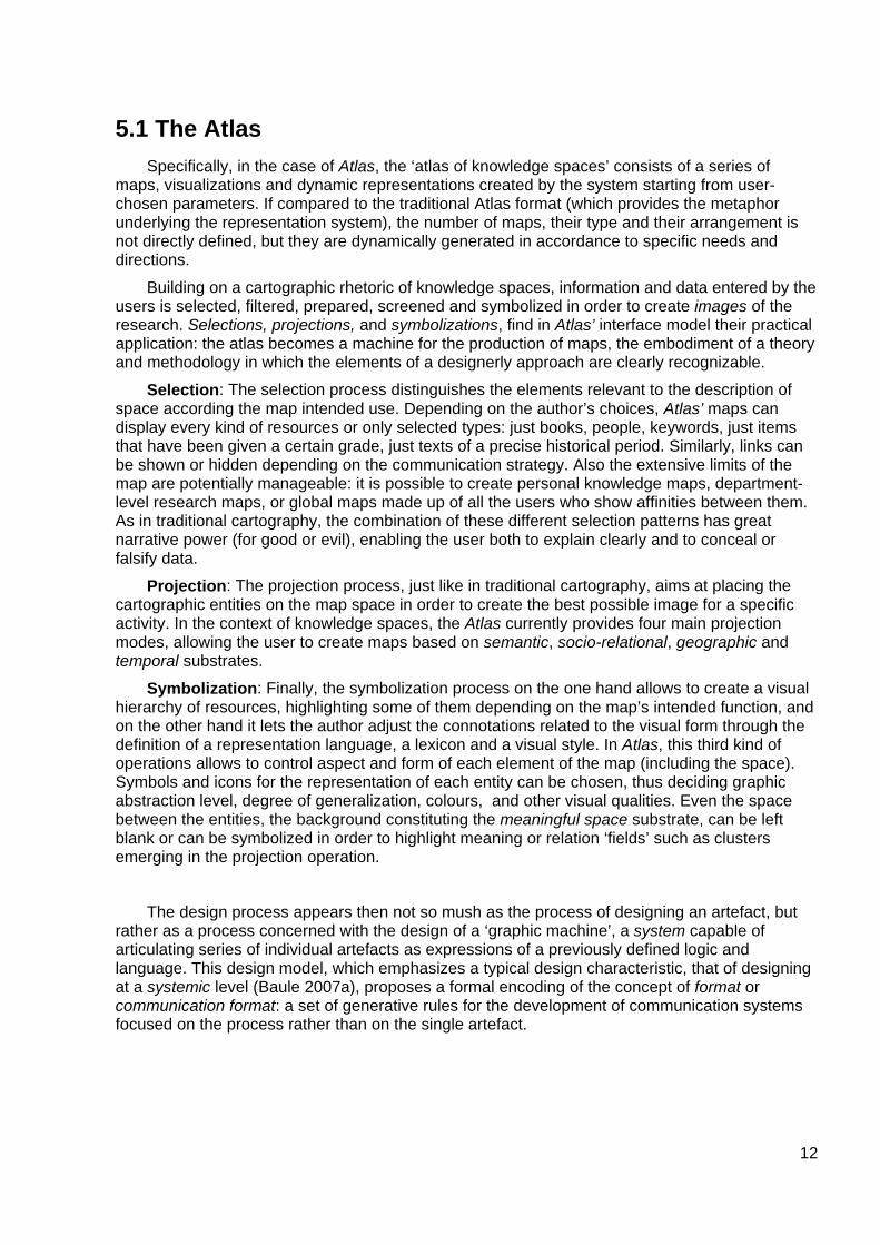
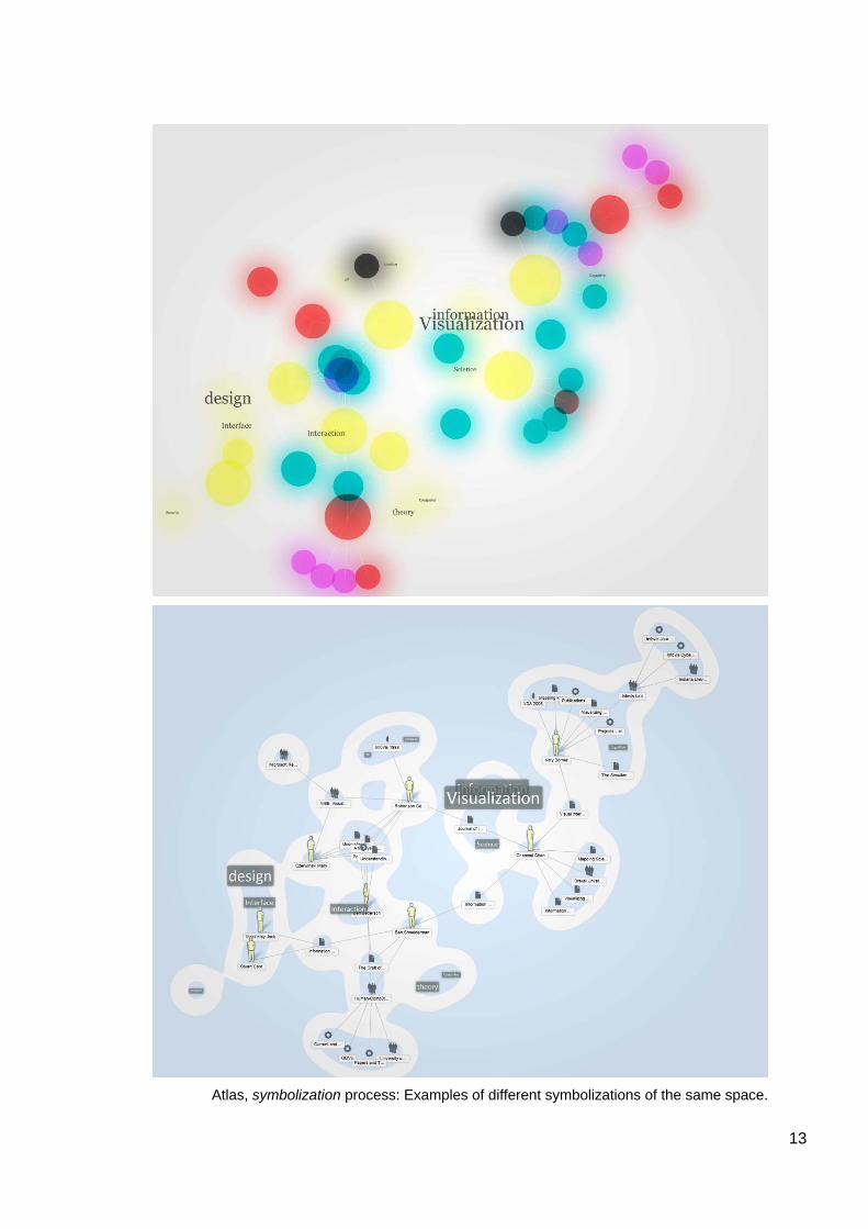
Symbolization: Finally, the symbolization process on the one hand allows to create a visual hierarchy of resources, highlighting some of them depending on the map’s intended function, and on the other hand it lets the author adjust the connotations related to the visual form through the definition of a representation language, a lexicon and a visual style. In Atlas, this third kind of operations allows to control aspect and form of each element of the map (including the space). Symbols and icons for the representation of each entity can be chosen, thus deciding graphic abstraction level, degree of generalization, colours, and other visual qualities. Even the space between the entities, the background constituting the meaningful space substrate, can be left blank or can be symbolized in order to highlight meaning or relation ‘fields’ such as clusters emerging in the projection operation.
The design process appears then not so mush as the process of designing an artefact, but rather as a process concerned with the design of a ‘graphic machine’, a system capable of articulating series of individual artefacts as expressions of a previously defined logic and language. This design model, which emphasizes a typical design characteristic, that of designing at a systemic level (Baule 2007a), proposes a formal encoding of the concept of format or communication format: a set of generative rules for the development of communication systems focused on the process rather than on the single artefact.
13
Atlas, symbolization process: Examples of different symbolizations of the same space.
14
5.2 A new kind of interaction Unlike the traditional maps and atlases, Atlas enables users not only to get involved in the
processes of space use (exploration, navigation), but also in the processes of map creation. The static structure of traditional maps is therefore replaced by maps able to change limits and scale level, maps capable of changing their appearance in order to allow deeper explorations. The user can then move in the representation space by dynamically redefining the limits of the map, zooming on areas of particular interest to gather details, or stepping away from the territory in order to obtain a more comprehensive view, heavily focused on the overall aspect of the ‘landscape’. Clicking on individual elements, finally, Atlas gives a chance to get some details on the selected resource, and to perform operations on it: to have a look at the entity’s complete file (as compiled by the community), to add any related resource or keyword to the map, to hide the selected node from the map, etc.
These operations, besides giving some tools to explore one’s own research areas, give also the possibility to explore alternative paths as identified by the Atlas community. For example, by clicking on an author’s icon in one’s personal map, the user can interact with the mapping system by asking to see related entities (entered by other users). These elements, even if they haven’t been entered by the user, become part of the map and can be further expanded to identify possible research directions. Just like ancient maps, this kind of map which at first is just a guide to known territories, then becomes an instrument of discovery for uncharted territories.
Another kind of interaction, which in the paper atlas is limited to the comparison of maps, in its digital counterpart allows not only to move between visualizations models at any time (allowing comparisons between geographical, semantic, relational and temporal distributions), but it also shares with the user the main operations of mapping rhetoric. The cartographer thus shares his role with the user, who becomes active participant in the creation of his own maps, designing them specifically to communicate the most interesting, or useful aspects of their research. The power of mapping, historically serving power centres (military, political, religious or economic), is then shared, if only partially, with the community.
6. Directions In the field of interface design and research, this paper aims to make a step towards the
definition of an approach for the design of cultural instruments. In this context there is a urgent need for a further exploration of social interfaces as means to provide instruments of interaction, exploration and knowledge in the present world. In regard to the interface model exposed in this paper, the aim is to experiment (and refine) its approach in the different spaces of knowledge, such as archives, libraries and research centers.
15
References Abrams, J., e P. Hall, eds. 2006. Else/where:mapping new cartographies of networks and territories. Minneapolis: University of Minnesota Press .
Agamben, G. 2006. Cos'è un dispositivo? Roma: Nottetempo.
Anceschi, G. 1992. L'oggetto della raffigurazione. Milano: Etaslibri.
---. 1993. Il progetto delle interfacce: oggetti colloquiali e protesi virtuali. Milano: Domus Academy edizione.
Arnheim, R. 1962. Arte e percezione visiva. Trans. by G. Dorfles. MIlano: Feltrinelli.
Barsanti , Giulio. 1992. La scala, la mappa, l'albero. Firenze: Sansoni.
Barthes, R. 1972. La retorica antica. Milano: Bompiani. Ed. fr. Barthes, R. 1970. L'ancienne rhétorique. Communications 16: 172-227.
Baule, Giovanni. 2007a. Dispositivi di comunicazione. Lineagrafica, no. 367 (Gennaio).
---. 2007b. In equilibrio con le ‘macchine grafiche’. Lineagrafica, no. 367 (Gennaio).
Bertin, J. 1967. Semiologie graphique. Paris-La Haye: Mouton.
Bonsiepe, G. 1995. Dall'oggetto all'interfaccia: mutazioni del design. Milano: Feltrinelli.
Brusatin, M. 1989. Storia delle immagini. Torino: Einaudi.
D’Alembert, JB. 1978. Il discorso preliminare all’Enciclopedia. Eds. Marcella Renzoni. Firenze: La Nuova Italia. Ed fr. D’Alembert, JB. 1751. Discours préliminaire. In Encyclopédie, ou, Dictionnaire raisonné des sciences, des arts et des métiers.
De Kerckhove, D. 1991. Brainframes: Technology, Mind and Business. Baarn: Bosch & Keuning.
Deleuze, G., e F. Guattari. 1988. A Thousand Plateaus. London: The Athlone Press. Ed. fr. Mille plateaux: capitalisme et schizophrénie. Paris: Minuit.
Eco, U. 1975. Trattato di semiotica generale. Milano: Bompiani.
Fabrikant, S. I. 2000. The Geography of Semantic Information Spaces. GIScience 2000: 28-31.
Groupe µ, 1992, Traité du signe visuel. Pour une rhétorique de l'image. Paris: Le Seuil.
Illich, I. 1994. Nella vigna del testo: per una etologia della lettura. Translation by A. Serra. Milano: Raffaello Cortina.
Lakoff, G., e M. Johnson. 1982. Metafora e vita quotidiana. Milano: Bompiani. Ed. en. Lakoff, G., e M. Johnson. 1980. Metaphors We Live by. Chicago: University of Chicago Press.
Latour, B. 1993. We have never been modern. New York ; London: Harvester Wheatsheaf.
Lévy, P. 1994. L'intelligenza collettiva: Per un'antropologia del cyberspazio. Milano: Feltrinelli.
MacEachren, A. M. 1995. How Maps Work: Representation, Visualization, and Design. New York: Guilford Publications.
Maldonado, T. 1997. Critica della ragione informatica. Milano: Feltrinelli.
---. 2005. Memoria e conoscenza. Sulle sorti del sapere nella prospettiva digitale. Milano: Feltrinelli.
Monmonier, M. S. 1996. How to lie with maps. Vol. 2. Chicago: University of Chicago Press.
Otlet, P. 1934. Traité de documentation: le livre sur le livre, theéorie et pratique. Mons: Editiones Mundaneum.
Shiffrin, R. M., e K. Börner. 2004. Mapping knowledge domains. Proceedings of the National Academy of Sciences 101, no. 1: 5183-5185.
Skupin, A. Spatial metaphors for visualizing very large data archives.
---. 2002. A cartographic approach to visualizing conference abstracts. Computer Graphics and Applications, IEEE 22, no. 1: 50-58. doi:10.1109/38.974518.
Wood, D. 1993. Power of Maps. London: Routledge.
Yates, F. A. 2001. The Art of Memory. Chicago: University Of Chicago Press.