Embed Size (px)
Citation preview
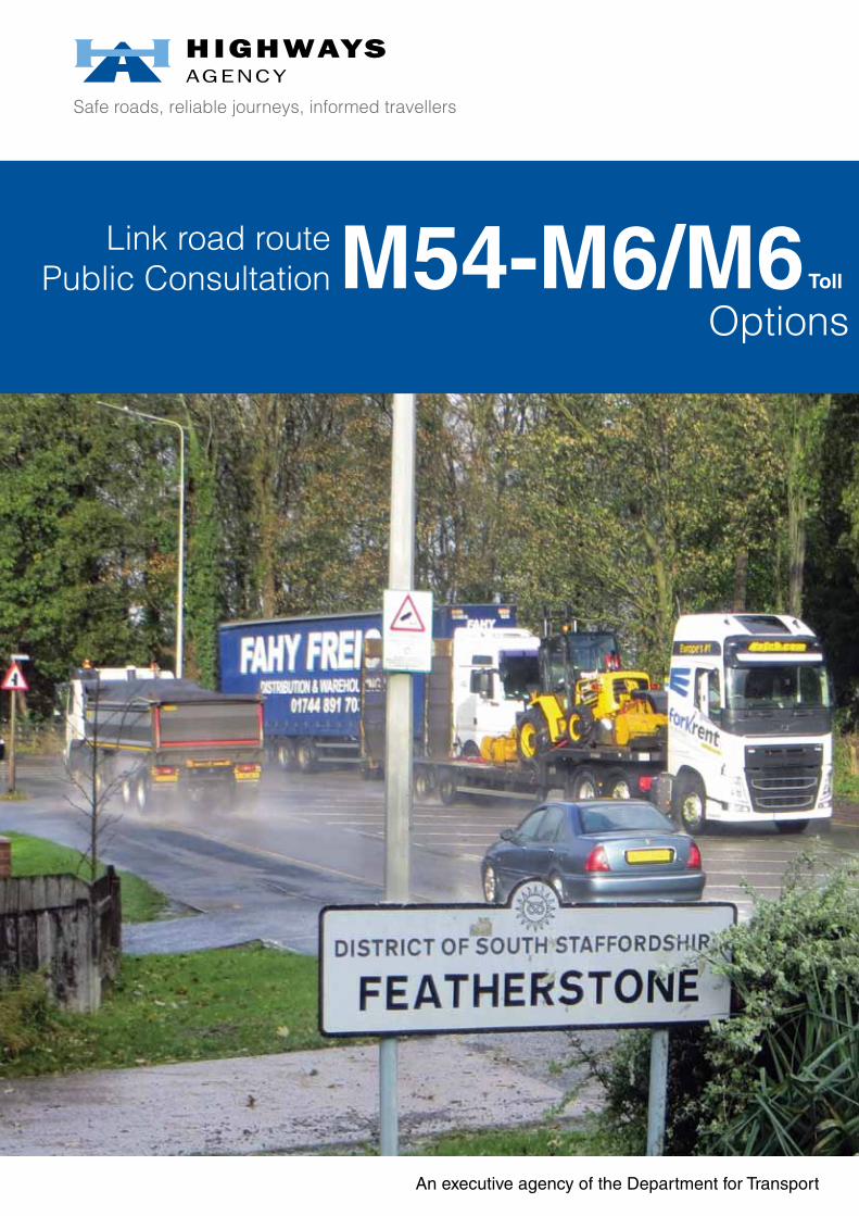
Safe roads, reliable journeys, informed travellers
An executive agency of the Department for Transport
M54-M6/M6 Toll
Link road route Public Consultation
Options

2
3
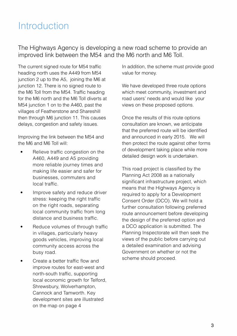
Introduction
The Highways Agency is developing a new road scheme to provide an improved link between the M54 and the M6 north and M6 Toll.
The current signed route for M54 traffic heading north uses the A449 from M54 junction 2 up to the A5, joining the M6 at junction 12. There is no signed route to the M6 Toll from the M54. Traffic heading for the M6 north and the M6 Toll diverts at M54 junction 1 on to the A460, past the villages of Featherstone and Shareshill then through M6 junction 11. This causes delays, congestion and safety issues.
Improving the link between the M54 and the M6 and M6 Toll will:
• Relieve traffic congestion on the A460, A449 and A5 providing more reliable journey times and making life easier and safer for businesses, commuters and local traffic.
• Improve safety and reduce driver stress: keeping the right traffic on the right roads, separating local community traffic from long distance and business traffic.
• Reduce volumes of through traffic in villages, particularly heavy goods vehicles, improving local community access across the busy road.
• Create a better traffic flow and improve routes for east-west and north-south traffic, supporting local economic growth for Telford, Shrewsbury, Wolverhampton, Cannock and Tamworth. Key development sites are illustrated on the map on page 4
In addition, the scheme must provide good value for money.
We have developed three route options which meet community, investment and road users’ needs and would like your views on these proposed options.
Once the results of this route options consultation are known, we anticipate that the preferred route will be identified and announced in early 2015. We will then protect the route against other forms of development taking place while more detailed design work is undertaken.
This road project is classified by the Planning Act 2008 as a nationally significant infrastructure project, which means that the Highways Agency is required to apply for a Development Consent Order (DCO). We will hold a further consultation following preferred route announcement before developing the design of the preferred option and a DCO application is submitted. The Planning Inspectorate will then seek the views of the public before carrying out a detailed examination and advising Government on whether or not the scheme should proceed.
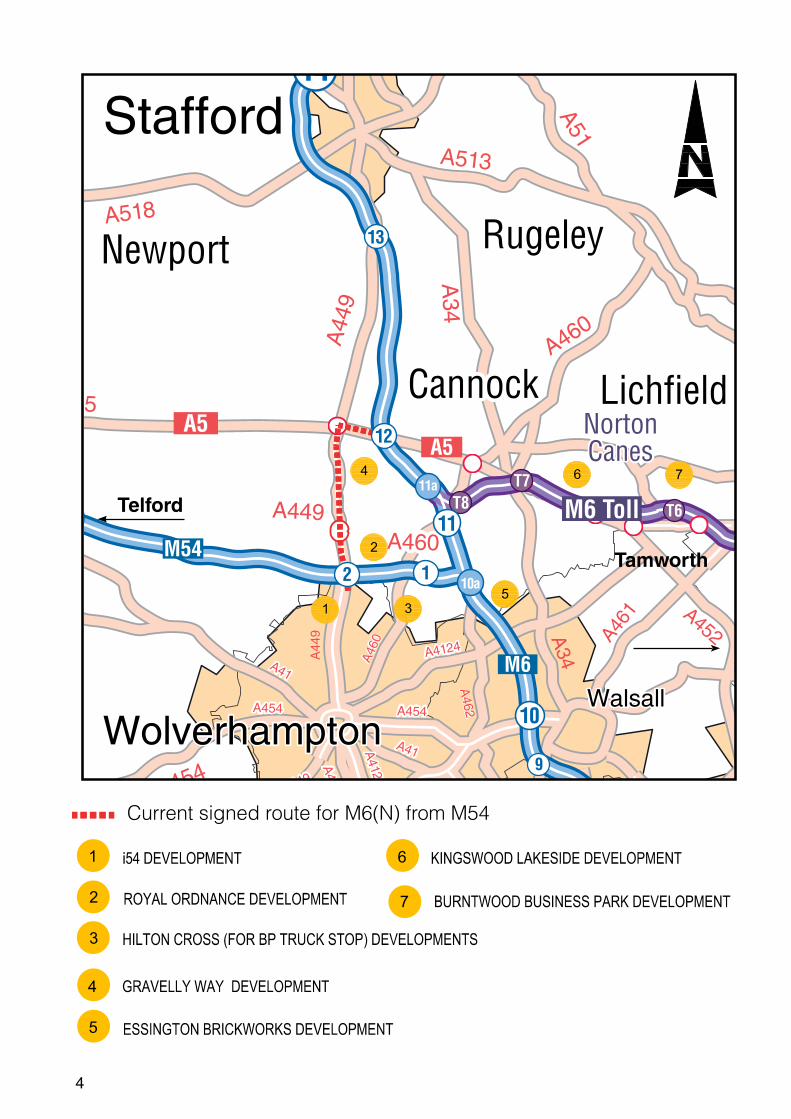
4
NortonCanes
10a
11a T7T8
A51
A44
9
A449
A460
A460
A449
A459
A4123
A41
A449
A518
A5
A518
A513
A34
A34
A454
A454
A4124
A454
A41
A44
9
A46
0
A462
A461
A461 A452
A519
A5
M54
M6 Toll
A5
M6
M5
Newport
Cannock Lichfield
Rugeley
WolverhamptonWalsall
Stafford
1
2
3
4
5
76
1
8 7
9
10
12
3 11
12
13
14
T6
5
4
6
7
Telford
Tamworth
2
1
3
Current signed route for M6(N) from M54

5
Why do we need this scheme?
Accident rates on the main routes used between the M6 and M54, the A449 and A460 through Featherstone are higher than the national average for these categories of road.
On the A460 there are six junctions connecting to local roads within a short 1.5 mile (2.5km) length and numerous properties, businesses and field entrances which have direct access onto the road. Additionally, traffic lights, pedestrian crossings and bus stops designed to manage local traffic create conflicts between local needs and the through movement of freight traffic. The A460 currently carries about 25,000 vehicles per day with heavy good vehicles making up about 10% of this figure.
The A449 / A5 is the signed route to the M6 north with properties and field entrances which have direct access onto the trunk road. The junction at Gailey roundabout has queues at peak periods.
Challenges for long distance and freight road users:
• Motorway traffic is caught in, and contributes to, congestion at roundabouts, traffic lights and junctions along the A449, A5 and A460 resulting in delays and longer, less reliable journey times.
• Long distance and local traffic is mixed, with conflicting priorities; local journeys with frequent stops and making right turns into junctions and accesses impacts on traffic wanting to re-join the motorway network quickly and smoothly.
Challenges for local road users:
• Additional freight and long distance traffic results in delays and queues.
• High traffic flows on the A460 and A449 make it more difficult to cross these routes in a vehicle or as a pedestrian or cyclist.
• The high percentage of freight traffic of up to 10% on the A460 between the M54 and M6 impacts the local community with additional noise, congestion and disruption.

6
KEY: Alternative eastern or western route alignments
FEATHERSTONE
SHARESHILL
Hilton Hall
Hilton Lane
BrookfieldFarm
Mill Lane
Hilton Park services
J11
J10a
J1
JT8
A460M6
M54
M6
Dark Lane
M6toll
Option A
This option would provide a new road between M54 junction 1 and M6 junction 11, covering approximately 1.5 miles (2.5 km).
• The proposed route would bypass the villages of Featherstone and Shareshill, and be sited to the west of Hilton Hall.
• There would be a single junction on the new road to allow local traffic to access the link road from Hilton Lane.
• There would be no access from the existing A460 to M6 junction 11 on the west side of M6 as this would be removed to move through-traffic to the new road. There would be a new local access road built to Mill Lane for local residents.
• We predict that Option A would reduce traffic on the A449, with all long distance and freight traffic on the existing A460 through Featherstone moved onto the new link road.
• There are two routes proposed for this option: eastern or western, and these are covered later.

7
Option B
This option would provide a new road between M54 Junction 1 and the M6 and M6 Toll.
• The link would follow the same route as Option A, bypassing the villages of Featherstone and Shareshill, and be sited to the west of Hilton Hall.
• The new road would then link directly with the M6, north of Junction 11 and with the M6 Toll at Junction T8. This additional link to Junction T8 would be approximately 0.6 miles (1km), giving a total length of approximately 2.2 miles (3.5km).
• M6 junction 11 would be unchanged by this option with local access to the M6 and M6 Toll remaining the same.
• We predict that Option B would reduce traffic on the A449 with traffic on the existing A460 through Featherstone significantly reduced.
• There are two routes proposed for this option: eastern or western, and these are covered later.
M6toll
FEATHERSTONE
SHARESHILL
Hilton Hall
Hilton Lane
Dark Lane
BrookfieldFarm
Mill Lane
Hilton Park services
J11
J10a
J1
JT8
A460M6
M54
M6
M6toll
KEY: Alternative eastern or western route alignments

8
Option C
This option would widen the M54 from Junction 1 to the M6, providing extra capacity through an additional traffic lane in each direction.
• New slip roads would be constructed at M6 junction 10a to provide links to and from the M6 north.
• The existing hard shoulder would be converted to a fourth traffic lane between M6 junction 10a and 11.
• Access roads to Hilton Park Services would be modified as part of the scheme and access to the services will be maintained throughout construction.
• M6 junction 11 would be demolished and replaced by a new junction 11 further north, linking to the M6 Toll junction T8. The distance travelled between M54 junction 1 and M6 Toll junction T8 would be greater than Options A and B at 3.4 miles (5.5km).
• The A460 would cross the M6 on a new bridge, linking in to the A462 and Wolverhampton Road, with a new local road provided to Saredon Road for local destinations north or east.
• We predict that overall traffic reduction on the A460 through Featherstone would be lower than the other options. This is because the A460 will remain attractive to some road users primarily due to the longer distance covered by following Option C along the M54 to the M6.
M6toll
FEATHERSTONE
SHARESHILL
Hilton Hall
Hilton Lane
Dark Lane
BrookfieldFarm
WolverhamptonRoad
Hilton Park services
J10a
J1
JT8
A460M6
M54
M6
M6toll
KEY: Existing M54 and M6 improved
SaredonRoad
9
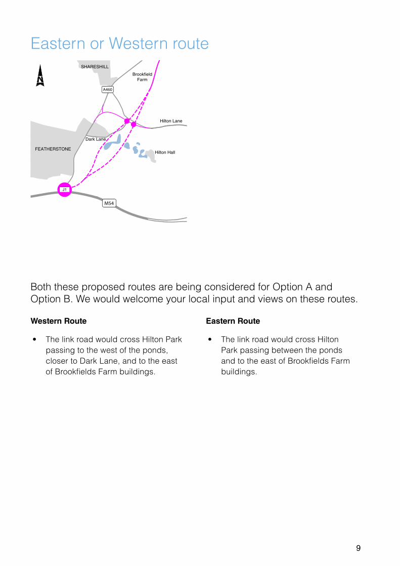
Eastern or Western route
Both these proposed routes are being considered for Option A and Option B. We would welcome your local input and views on these routes.
Eastern Route
• The link road would cross Hilton Park passing between the ponds and to the east of Brookfields Farm buildings.
Western Route
• The link road would cross Hilton Park passing to the west of the ponds, closer to Dark Lane, and to the east of Brookfields Farm buildings.
FEATHERSTONE
SHARESHILL
Hilton Hall
Hilton Lane
Dark Lane
BrookfieldFarm
J1
A460
M54
10
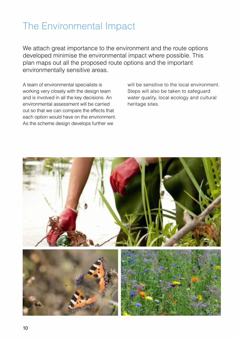
The Environmental Impact
We attach great importance to the environment and the route options developed minimise the environmental impact where possible. This plan maps out all the proposed route options and the important environmentally sensitive areas.
A team of environmental specialists is working very closely with the design team and is involved in all the key decisions. An environmental assessment will be carried out so that we can compare the effects that each option would have on the environment.As the scheme design develops further we
will be sensitive to the local environment. Steps will also be taken to safeguard water quality, local ecology and cultural heritage sites.

11
KEY
Option A
Option B
Option C
Public Rights of Way
Listed Buildings
Non-Statutory Ecological Sites
Ancient Woodlands
Shareshill
Featherstone
M54
M6 toll
J1
J11
JT8
J10a
M6

12

13
Rejected Options Reason for Rejection
Do nothing
There are already significant delays on the existing routes during the peak hours, and these would be expected to increase significantly in future years, with traffic in England forecast to increase by 26% over the next 15 years. Accident rates on the A449 and A460 are higher than the national average for these categories of road. Without an improved link there would be no improvements to safety, journey times, traffic congestion or local community connections along the A460 or A449.
Improvement of A460
Scheme would require compulsory purchase and demolition of some residential properties and businesses fronting the A460.
Widening of the A460 would provide additional lanes, but as vehicles speeds would still need to be limited due to the proximity of junctions and accesses this would provide less additional capacity than the options being progressed.Local and long distance traffic movements would not be separated by this option.
Increased traffic on the A460 would lead to noise increases and reductions in air quality for the local community. It would also increase community segregation across the A460.
Improvement of A449/A5 corridor
Improvement of this corridor may provide some of the safety and congestion benefits for north-south traffic, but this is a longer route for vehicles headed east-west. The A460 would remain in place, and as a shorter route, would remain attractive. Improvements to safety, journey times and traffic congestion on this route would therefore be minimal.
Alignment of northern end of Link Road to avoid Brookfields Farm land
While avoiding land take from Brookfields Farm, this option would additionally impact buildings and facilities at Watt Meadow Farm on the northern side of the A460. This would require a larger footprint to accommodate the tighter curves required, resulting in greater land take and increased visual impacts.
Discounted options
14
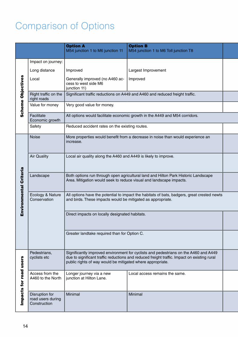
Comparison of Options
Option A M54 junction 1 to M6 junction 11
Option B M54 junction 1 to M6 Toll junction T8
Option C Additional links between M54 and M6 (north) at junction 10a
Sc
he
me
Ob
jec
tive
s
Impact on journey:
Long distance
Local
Improved
Generally improved (no A460 ac-cess to west side M6 junction 11)
Largest Improvement
Improved
Improved
Least improvement
Right traffic on the right roads
Significant traffic reductions on A449 and A460 and reduced freight traffic. Some traffic reductions on A449 and A460 and some reductions in freight traffic.
Value for money Very good value for money. Good value for money.
Facilitate Economic growth
All options would facilitate economic growth in the A449 and M54 corridors.
Safety Reduced accident rates on the existing routes. Least improvement in accident rates on the existing routes
En
viro
nm
en
tal C
rite
ria
Noise More properties would benefit from a decrease in noise than would experience an increase.
More properties would benefit from a decrease in noise than would experience an increase. Benefit not as great as options A & B.
Air Quality Local air quality along the A460 and A449 is likely to improve. Local air quality along the A460 and A449 is likely to improve. Benefit not as great as options A & B.
Landscape Both options run through open agricultural land and Hilton Park Historic Landscape Area. Mitigation would seek to reduce visual and landscape impacts.
The option runs through the southern extent of Hilton Park Historic Landscape Area. Visual and landscape impacts less than options A & B. Mitigation would seek to reduce visual and landscape impacts.
Ecology & Nature Conservation
All options have the potential to impact the habitats of bats, badgers, great crested newts and birds. These impacts would be mitigated as appropriate.
Direct impacts on locally designated habitats. Direct impact on ancient woodland.
Greater landtake required than for Option C. Less landtake required than for options A & B.
Imp
ac
ts f
or
roa
d u
sers
Pedestrians, cyclists etc
Significantly improved environment for cyclists and pedestrians on the A460 and A449 due to significant traffic reductions and reduced freight traffic. Impact on existing rural public rights of way would be mitigated where appropriate.
Some improvement in the environment for cyclist and pedestrians on the A460 and A449. No impact on exist-ing rural public rights of way.
Access from the A460 to the North
Longer journey via a new junction at Hilton Lane.
Local access remains the same. Longer journey via Saredon Road and M6 Toll junction T8.
Disruption for road users during Construction
Minimal Minimal Significant disruption and speed restrictions on the M54 and the M6

15
Option A M54 junction 1 to M6 junction 11
Option B M54 junction 1 to M6 Toll junction T8
Option C Additional links between M54 and M6 (north) at junction 10a
Sc
he
me
Ob
jec
tive
s
Impact on journey:
Long distance
Local
Improved
Generally improved (no A460 ac-cess to west side M6 junction 11)
Largest Improvement
Improved
Improved
Least improvement
Right traffic on the right roads
Significant traffic reductions on A449 and A460 and reduced freight traffic. Some traffic reductions on A449 and A460 and some reductions in freight traffic.
Value for money Very good value for money. Good value for money.
Facilitate Economic growth
All options would facilitate economic growth in the A449 and M54 corridors.
Safety Reduced accident rates on the existing routes. Least improvement in accident rates on the existing routes
En
viro
nm
en
tal C
rite
ria
Noise More properties would benefit from a decrease in noise than would experience an increase.
More properties would benefit from a decrease in noise than would experience an increase. Benefit not as great as options A & B.
Air Quality Local air quality along the A460 and A449 is likely to improve. Local air quality along the A460 and A449 is likely to improve. Benefit not as great as options A & B.
Landscape Both options run through open agricultural land and Hilton Park Historic Landscape Area. Mitigation would seek to reduce visual and landscape impacts.
The option runs through the southern extent of Hilton Park Historic Landscape Area. Visual and landscape impacts less than options A & B. Mitigation would seek to reduce visual and landscape impacts.
Ecology & Nature Conservation
All options have the potential to impact the habitats of bats, badgers, great crested newts and birds. These impacts would be mitigated as appropriate.
Direct impacts on locally designated habitats. Direct impact on ancient woodland.
Greater landtake required than for Option C. Less landtake required than for options A & B.
Imp
ac
ts f
or
roa
d u
sers
Pedestrians, cyclists etc
Significantly improved environment for cyclists and pedestrians on the A460 and A449 due to significant traffic reductions and reduced freight traffic. Impact on existing rural public rights of way would be mitigated where appropriate.
Some improvement in the environment for cyclist and pedestrians on the A460 and A449. No impact on exist-ing rural public rights of way.
Access from the A460 to the North
Longer journey via a new junction at Hilton Lane.
Local access remains the same. Longer journey via Saredon Road and M6 Toll junction T8.
Disruption for road users during Construction
Minimal Minimal Significant disruption and speed restrictions on the M54 and the M6

16
Next Steps
This consultation is your opportunity to express your views on the route options we are proposing ahead of the project team developing the scheme further and choosing a preferred route .We will need you to complete the survey, or write into the project team for your views to be taken into account.
After the consultation ends, we will publish a report summarising your views and opinions with those of local groups and organisations. From this the project team will make recommendations for further development of the scheme.
We will select and announce a preferred route option in spring 2015, after which we will be seeking your views again.This will start the preparation of a Development Consent Order (DCO) application to the Planning Inspectorate.
The DCO provides the Agency with the powers needed to construct the M54 to M6/M6 Toll link road and we plan to make this application during 2016
More information on the statutory framework for infrastructure planning can be found on the Planning Inspectorate’s website: http://infrastructure.planningportal.gov.uk
17
Share your views
We want to know your views on the proposed route options, please complete the online questionnaire available on our website:http://www.highways.gov.uk/roads/road-projects/M54-to-M6M6-Toll-Link-Road
You can request a printed copy of the questionnaire from:Highways Agency Information Line: 0300 123 5000 or email:[email protected]
If you would prefer to write into the team with your views their address is:
The M54 to M6/M6 Toll Project Team The Cube199 Wharfside StreetBirminghamB1 1RN
Or by email: M54toM6/[email protected] We will be holding exhibitions locally where you will be able to meet the team in person, please look out for details in the local press or on the scheme web page, where you can also sign up to receive updates on the scheme by email.
By commenting now, you will not prejudice your right to comment for or against any future detailed proposals subsequently published under the Planning Act. We look forward to seeing you at an exhibition.

18

19

If you need help using this or any other Highways Agency information, please call 0300 123 5000 and we will assist you.
© Crown copyright 2014. You may re-use this information (not including logos) free of charge in any format or medium, under the terms of the Open Government Licence. To view this licence: visit http://www.nationalarchives.gov.uk/doc/open-government-licence/ or write to the Information Policy Team, The National Archives, Kew, London TW9 4DU, or email: [email protected].
This document is also available on our website at www.highways.gov.uk
If you have any enquiries about this publication, please email [email protected] or call 0300 123 5000Please quote the Highways Agency publications code: PR PR60/14
Highways Agency Creative. M140277