Embed Size (px)
Citation preview
MASSACHUSETTS BAY TRANSPORTATION AUTHORITY
MASSACHUSETTS DEPARTMENT OF TRANSPORTATION
TOD POLICIES AND GUIDELINES
DRAFT
Revised
March 31, 2017
MBTA/MassDOT TOD Policies and Guidelines DRAFT: Revised March 31, 2017 i
CONTENTS Part I: Introduction ..........................................................................................................................1
What is TOD?.................................................................................................................................1
What is the role of the MBTA and MassDOT? ..................................................................................2
Why is TOD important to the MBTA and MassDOT? .......................................................................2
Part II. TOD Policies ........................................................................................................................3
The Conduct of TOD.......................................................................................................................3
Joint Development ......................................................................................................................3
Station Area Planning and Development .......................................................................................4
Value Capture .............................................................................................................................5
The Content of TOD: Foundational Principles...................................................................................5
A. Density and Mix of Uses .........................................................................................................5
B. Equitable Development ...........................................................................................................6
C. A Great Public Realm .............................................................................................................7
D. A TOD Approach to Parking ...................................................................................................8
Part III: TOD Guidelines ................................................................................................................ 10
The MBTA/MassDOT Joint Development Procedures..................................................................... 10
Substantive Guidelines: the Foundational TOD Principles ............................................................... 11
A. Density and Mixed Uses........................................................................................................ 11
B. Equitable Development ......................................................................................................... 14
C. The Public Realm ................................................................................................................. 15
D. A TOD Approach to Parking ................................................................................................. 17
Appendices
A. The MAPC Station Typology
B. MBTA/MassDOT Joint Development Procedures
C. Definitions
D. Illustrative Projects
MBTA/MassDOT TOD Policies and Guidelines DRAFT: Revised March 31, 2017 ii
Figures
Figure 1: Station Typology Map (MAPC) .......................................................................................... 22
Figure 2: Examples of Dense, Mixed-Use Development ...................................................................... 33
Figure 3: Examples of Equitable TOD................................................................................................ 34
Figure 4: Examples of TOD Supportive Public Realm ......................................................................... 35
Figure 5: Examples of a TOD Approach to Parking ............................................................................ 36
Tables
Table 1: Illustrative Density Guidelines by Station Typology............................................................... 12
Table 2: Preferred, Conditional, and Discouraged Uses in TOD Settings .............................................. 13
Table 3: The Station Typology .......................................................................................................... 21
MBTA/MassDOT TOD Policies and Guidelines DRAFT: Revised March 31, 2017 1
MASSACHUSETTS BAY TRANSPORTATION AUTHORITY
MASSACHUSETTS DEPARTMENT OF TRANSPORTATION
TOD POLICIES AND GUIDELINES
PART I: INTRODUCTION
This document is a statement by the Massachusetts Bay Transportation Authority (MBTA) and the
Massachusetts Department of Transportation (MassDOT) about how they hope to see transit-oriented
development (TOD) planned and implemented around MBTA rail and bus stations. The document is
intended for multiple audiences: MBTA and MassDOT staff; city and town governments; state and
regional agencies; community groups; and private developers. It consists of three parts:
Part I: Introduction provides a framework for understanding TOD, its value to the transit
system, and the roles of the MBTA and MassDOT as TOD sponsors, stakeholders, and advocates.
Part II: TOD Policies describes the high-level policy goals that guide the MBTA and MassDOT
in pursuing TOD.
Part III: TOD Guidelines sets forth the specific procedures that the MBTA and MassDOT will
follow in implementing TOD projects and the standards and outcomes they will seek to achieve.
This document is jointly issued by the MBTA and MassDOT. The MBTA has sponsored TOD projects
for decades, resulting in thousands of residential units, millions of square feet of commercial space, and
tens of millions of dollars in non-fare revenues to support the transit system. Many of these projects are
familiar landmarks—from the TD Garden atop North Station to the Woodland Station Apartments in
Newton; from the mixed-use community at Assembly Station to The Carruth at Ashmont Station, with its
mixed-income housing and neighborhood shops. The purpose of this document is therefore not to initiate
a TOD program, but to articulate a policy that reflects the vision and goals of an on-going effort.
As the Commonwealth’s coordinating entity for transportation policy, MassDOT supports the MBTA’s
focus on TOD. Moreover, MassDOT itself owns surplus highway and railroad properties in the vicinity of
MBTA stations. To the degree applicable, it is MassDOT’s intent that the disposition of such property
reflect the same TOD policies and guidelines as the MBTA’s.1
What is TOD?
Development in Greater Boston has organized itself around public transit since the earliest days of ferries
and horse-drawn streetcars.2 Today a disproportionate share of our housing and jobs are located near
transit.3 As our region strives for continued and sustainable growth, a new generation of TOD—applying
best practices developed in this and other transit metropolises—is an essential part of our regional vision.
One need only study the Metropolitan Area Planning Council’s (MAPC’s) guiding vision document,
1 MassDOT real property dispositions in non-TOD contexts are not affected by this document. 2 In this document, “Greater Boston” refers to the 164-municipality metropolitan region generally used by the Metropolitan Area Planning Council and the Central Transportation Planning Staff. This region contains the entire MBTA rapid transit system and nearly all of its commuter rail stations. As used in this document, there is no technical or legal significance to the designation. 3 In 2012, when the Metropolitan Area Planning Council (MAPC) published its landmark study of station area development, 25% of Greater Boston’s housing, and 37% of its jobs, were already found within a half-mile of a rapid transit or commuter rail station. (Metropolitan Area Planning Council, Growing Station Areas (2012). Since then, tens of thousands of both housing units and jobs have been built, permitted, or planned near transit.
MBTA/MassDOT TOD Policies and Guidelines DRAFT: Revised March 31, 2017 2
Metro Future, to appreciate how critical a role TOD will play in our region’s economic competitiveness,
sustainability, and quality of life.4
TOD means more than locating individual buildings or projects near transit. It is a pattern of land use that
ties development to transit in a synergistic way at the station level, the corridor level, and even the
regional level. It is axiomatic that every place is unique, but to one degree or another, successful TOD
incorporates four foundational principles:
density and mix of uses;
equitable development;
a great public realm;
a TOD approach to parking.
Development in Massachusetts is regulated by cities and towns and, when applicable, by the
Commonwealth through the Massachusetts Environmental Policy Act (MEPA) and other state
regulations. Regardless of its proximity to transit, development is not regulated by the MBTA or by
MassDOT, which do not have and do not seek any jurisdiction over zoning or land use. This is not a
regulatory document; it is a statement of policy about how MassDOT and the MBTA intend to pursue
development on their own land, subject to applicable zoning and environmental regulation, and how they
will encourage high-quality transit-oriented development on land owned by others.
What is the role of the MBTA and MassDOT?
The MBTA and MassDOT own thousands of acres of land around MBTA stations, much of it
strategically located from a transit and economic development perspective. How can the MBTA and
MassDOT leverage this position to advance TOD? They can play three complementary roles:
As TOD sponsors through joint development. Joint development is the subset of TOD that is
undertaken by developers on MBTA or MassDOT property or is connected to a station. As a
project sponsor, the MBTA or MassDOT can determine (consistent with local zoning) the
density, composition, and amenities of development on their own land and influence by example
other station area development.
As TOD stakeholders for development on land owned by others. While land use regulation is a
municipal responsibility, the MBTA and MassDOT can take an active interest in station area
planning and zoning, project reviews, or applications for development incentives.
As TOD advocates for supportive public policies. In partnership with elected officials, Regional
Planning Agencies, public interest organizations, and the development community, MassDOT
and the MBTA can advocate for Smart Growth, affordable and workforce housing, infrastructure
finance, and other policies that support TOD.
Why is TOD important to the MBTA and MassDOT?
The MBTA is a public transit agency, and the transit system is and will always be its paramount concern.
MassDOT is the Commonwealth’s overall transportation agency. Why would they promote transit-
oriented development? For four reasons:
4 MAPC, Metro Future (2008).
MBTA/MassDOT TOD Policies and Guidelines DRAFT: Revised March 31, 2017 3
TOD generates increased transit ridership. Putting people on trains, buses, and ferries can expand
everyday revenue at the farebox.
TOD can support the MBTA’s operating and capital needs in other ways as well. TOD can
generate non-farebox revenues through joint development and value capture mechanisms.
Additionally, TOD can help attract federal funding through grant programs that favor transit
projects supportive of TOD.5
From MassDOT’s larger perspective, TOD shifts some of the region’s daily travel off the
highway network, helping to mitigate both congestion and wear.
TOD is a fundamental strategy for advancing Smart Growth—economic and community
development that is successful, sustainable, healthful, and equitable. TOD allows regional growth
to occur with fewer vehicle miles traveled, lower greenhouse gas emissions, and far less impact
on undeveloped land than would otherwise be possible. MBTA and MassDOT are stewards of the
regional transportation system and are essential to this broader strategy.
PART II. TOD POLICIES
Part II describes the high-level policy goals that guide the MBTA and MassDOT in their pursuit of
transit-oriented development. These fall in two categories:
the conduct of TOD—how the MBTA and MassDOT approach their roles as TOD sponsors,
stakeholders, and advocates;
the content of TOD—the four foundational principles of TOD introduced in Part I: density and
mixed uses; equitable development; a great public realm; and a TOD approach to parking.
The Conduct of TOD
Joint Development
Joint development is the subset of TOD that is undertaken by developers on MBTA or MassDOT
property or is otherwise connected to a station through a development transaction to which the MBTA or
MassDOT is a party. It is through joint development that the MBTA and MassDOT are able to play the
role of TOD sponsors.
Among the many examples of joint development on MBTA or MassDOT property are the transformation
of North Station, Causeway Street, and the Bullfinch Triangle, and the mixed-use redevelopment of the
MBTA parking lot at North Quincy Station. Examples of joint development connected to a station
include Assembly Row and Boston Landing, where adjacent landowners participated directly in station
design and construction.
In making property available for joint development, it is the policy of both the MBTA and MassDOT that
developers will be procured competitively, through a solicitation and negotiation process that is fair,
transparent, timely, and accessible to a broad range of developers. Proposals by municipalities or
adjacent land owners to connect to a station or to participate in its funding, design, or delivery will be
5 The Federal Transit Administration’s Capital Investment Grant program uses six evaluation criteria, two of which—Land Use
and Economic Development—are TOD-related. The US Department of Transportation’s TIGER discretionary grant includes among its five primary evaluation criteria three that are TOD-related: economic competitiveness, livability, and sustainability.
MBTA/MassDOT TOD Policies and Guidelines DRAFT: Revised March 31, 2017 4
evaluated as they arise. In either case, the process will be designed to promote projects that reflect the
TOD Policies and Guidelines set forth in this document and to optimize the financial value of the
transaction for the MBTA or MassDOT, as the case may be.
Joint development proceeds can be in cash or in-kind, and they can be structured in a variety of ways.
Most joint development projects generate sale or lease payments that are applied to the MBTA or
MassDOT budget. Developers can also fund (or build) new or modernized stations. A developer may
assume responsibility for operation and maintenance, particularly where station facilities and commercial
development share common areas, as at North, South, and Back Bay Stations.
Station Area Planning and Development
As TOD stakeholders and advocates, the MBTA and MassDOT will, at their discretion, support TOD
initiatives consistent with these Policies and Guidelines. This support may include, but is not limited to,
commenting on MEPA reviews, zoning reviews, City of Boston Article 80 reviews, Growth District or
Gateway City designations, state infrastructure grant applications, or economic development and
affordable housing financial incentives.
The MBTA and MassDOT encourage cities and towns to adopt Chapter 40R zoning, TOD overlay
districts, and other zoning tools that allow density, mixed-use development, public realm design, and
parking requirements consistent with these TOD Policies and Guidelines. To this end, the MBTA and
MassDOT also encourage cities and towns to take advantage of technical assistance programs offered by
Regional Planning Agencies, the Department of Housing and Community Development, and the
Massachusetts Development Finance Agency (MassDevelopment).
A diversity of stations. The MBTA and MassDOT understands that it is not a one-size-fits-all formulation
of TOD. Density, the mix of uses, the design of the public realm, and the approach to parking vary across
different types of station areas. So do expectations of how those qualities might change over time as TOD
evolves.
Regional TOD strategies often use multi-category station typologies to help planners understand station
areas in terms of their existing conditions as well as their aspirational futures. The Metropolitan Area
Planning Council developed a ten-category station typology encompassing the MBTA’s 289 rail transit,
bus rapid transit, and commuter rail stations.6 The MBTA and MassDOT embrace the MAPC Station
Typology as an integral part of these TOD Guidelines. The ten categories, driven by data analysis and
actual development plans, are listed below; they are described in detail and mapped in Appendix A.
Metro Core Urban Gateway
Seaport/Airport Town & Village
Transformational Subway Suburban Transformation
Transit Neighborhood Commerce Park
Trolley Suburb Undeveloped.
6 MAPC, Growing Station Areas (2012).
MBTA/MassDOT TOD Policies and Guidelines DRAFT: Revised March 31, 2017 5
Value Capture. Value capture is an important element of station area planning and development. It occurs
when an infrastructure investment creates enhanced real estate value, a portion of which is “captured” as
development occurs, to help finance or maintain the infrastructure in question. Joint development is one
form of value capture. The other is district-based value capture, in which a district is drawn around the
proposed public improvement and a share of the enhanced land value is captured from all affected
properties, usually through tax increment financing or special assessment. Value capture is widely used in
the United States for public infrastructure and in general, can also be used for transit projects.7
The MBTA and MassDOT support the application of value capture to TOD infrastructure and to transit.
Massachusetts has three district-based value capture options: District Infrastructure Finance (DIF), the
Infrastructure Investment Incentive Program (I-Cubed), and the Local Infrastructure Development
Program (LIDP).8 The district infrastructure for Somerville’s Assembly Row and Worcester’s City
Square were financed in part through District Infrastructure Financing (DIF). Assembly Row,
Westwood’s University Station, and Brighton’s Boston Landing received I-Cubed support, which in the
latter case included financing of the new commuter rail station.
In 2015, Congress amended two federal transportation loan programs to support TOD. As a result, the
“TIFIA” and “RRIF” programs can be used for TOD-related infrastructure and, under certain
conditions, for TOD projects themselves. These programs provide a flexible option for structuring
value capture transactions.
The Content of TOD: Foundational Principles
A. Density and Mix of Uses
The first foundational principle of TOD is the concentration of dense, mixed-use development within
walking distance of stations. Density places more homes, jobs, stores, offices, and recreational activities
within walking distance of transit. It is essential to understand that TOD density is a relative goal,
reflecting place and context. High-density development in downtown Boston, in a Gateway City
downtown, and in a village or neighborhood center will differ markedly in scale, but each generally
exceeds the intensity of development in areas not directly served by transit.
When combined with mixed uses, density enables the transit system to make more efficient use of its
vehicular and operational capacity. During peak commuting hours, the mix of origins and destinations
creates demand for reverse commuting (from the system core outbound), and for commuting that occurs
entirely outside the system core. When non-work destinations are added—cultural or athletic venues,
“destination retail”, academic institutions—the station attracts off-peak riders from all directions.
Mixed-use development is not a cookie-cutter formulation. It can be achieved in several ways: vertically,
where individual buildings combine active uses at street level with residential or commercial uses above;
horizontally, where different uses are located within close walking distance of each other; or distributed,
among nearby stations in a corridor segment.
7 Examples are the Seattle and Portland streetcars, Denver Union Station, San Francisco’s Transbay Terminal, New York’s Number 7 Subway Extension, Washington’s New York Avenue Red Line station, and five stations on the Los Angeles Red Line. 8 TIFIA: Transportation Infrastructure Finance & Innovation Act; RRIF: Railroad Rehabilitation & Improvement Financing. For descriptions, see Definitions (Appendix C).
MBTA/MassDOT TOD Policies and Guidelines DRAFT: Revised March 31, 2017 6
An added benefit of a walkable mixed-use environment is that some daily trips are taken not by
automobile or by transit but on foot. In addition to people who can walk to work or to school, other
routine activities—going to lunch, running errands—can also become “trips not taken”. Research has
established conclusively that development which is dense, mixed-use, walkable, and transit-oriented
results in significantly lower per capita vehicle miles traveled and greenhouse gas emissions.9
B. Equitable Development
Equity is a foundational principle of transit-oriented development for the MBTA and MassDOT. The
inclusion of affordable and workforce housing can help offset gentrifying pressure on community
residents and businesses. TOD can connect housing with jobs, reducing a household’s combined cost of
housing and commuting. As employment becomes more decentralized, jobs located near transit remain
accessible to households that cannot afford to own one automobile per worker.
Affordability. Bringing TOD (or transit itself) into low-income communities, or communities
experiencing a lack of investment, is generally beneficial, but upward pressure on property values can
result in gentrification; the key is to mitigate its impacts and prevent it from turning into displacement.
This double-edged impact is an issue not only for low-income neighborhoods, but in a housing market
like Greater Boston’s, for working class neighborhoods, inner-ring suburbs, and Gateway Cities as well.
From an equity perspective, there is inherent value in producing housing at transit-supportive densities
within walking distance of stations, particularly if many of the units are rental. Greater supply helps
mitigate rent levels, and research has shown that rental apartment density is a predictor of transit use and
reduced per capita Vehicle Miles Traveled.10 However, equity is better served if a meaningful share of
housing production is affordable for low- and moderate-income or workforce households. A wide range
of projects across Greater Boston has shown that with the concerted application of available financing
tools and the participation of non-profit developers,the market can produce attractive and viable mixed-
income housing. It is the MBTA and MassDOT’s policy to require a meaningful share of affordable
and/or workforce units in their own joint development projects and to encourage similar outcomes in
other station-area projects.11
Job access. Housing costs can also be offset, to a degree, by savings in the daily work commute. The
Center for Neighborhood Technology has devised a combined metric, the H+T Affordability Index.
Rather than the traditional affordability benchmark, in which no more than 30% of household income is
devoted to housing, the H+T benchmark is that no more than 45% is devoted to housing plus
transportation costs. A neighborhood that a family might find unaffordable based on housing costs alone
may be manageable if daily commuting costs—thanks to transit—are low. In Greater Boston, as a whole,
automobile ownership and average household transportation costs are significantly higher than in the City
of Boston and other “inner core” communities with concentrated MBTA service.12
However, the affordability benefit of living near transit is only realized if one’s job is transit-accessible as
well. TOD offers two strategies for enhancing job access. One is to consciously develop concentrations of
9 Ibid. Among the many national studies is the seminal work by the Urban Land Institute (Reid Ewing et al.), Growing Cooler: the Evidence on Urban Development and Climate Change; 2008.
10 Stephanie Pollack, How Can Equity in TOD Be Defined and Measured? (Rail~Volution 2014)
11 Affordable Housing and Workforce Housing are defined in Appendix C. 12 Center for Neighborhood Technology; http://htaindex.cnt.org/map/; MAPC http://tstation.info/; MAPC, Metro Boston Regional Indicators; Transportation: Staying on Track (2017).
MBTA/MassDOT TOD Policies and Guidelines DRAFT: Revised March 31, 2017 7
jobs in high-capacity transit locations. It is significant that Partners’ HealthCare, the region’s largest
private employer, narrowed its search for a consolidated administrative headquarters site (for 4,500
workers) to two Orange Line stations in the region’s Inner Core, selecting Assembly Square. Other
examples are the location of Boston Public School Headquarters at Dudley Station; the attraction of three
shoe company headquarters and General Electric headquarters to transit settings; and the preservation of
blue-collar jobs in Boston’s Marine Industrial Park.
The other strategy is to provide seamless last-mile connections from the station to the workplace. This
challenge may arise at outlying commuter rail stations or in the very heart of the system, where thousands
of workers in the Longwood Medical Area, Kendall Square, and the South Boston Waterfront are use
district- or employer-funded shuttles to bridge the gap from the rail transit system to their jobs.
Equitable investment. Beyond affordability and job access, TOD can be structured in ways that invest in
the fabric of a community. TOD plans should provide community services and amenities. New TOD,
particularly in city, town, and neighborhood centers, should be planned in a way that adds vitality to
existing local businesses and creates opportunities for new ones. And where possible, TOD can build
equity in community institutions through the participation of Community Development Corporations.
Sustainability. A final dimension of equitable development is the project’s impact on the region’s natural
resources and carbon footprint. Where applicable, MassDOT and the MBTA will strongly encourage joint
development projects to meet the requirements for certification at a level of at least LEED Silver (or its
equivalent in a comparable rating system). In coastal locations subject to storm surge or sea level rise,
joint development projects will be required to incorporate appropriate water-resiliency measures.
C. A Great Public Realm
Every transit rider is a pedestrian, and successful TOD is pedestrian-friendly. A high-quality public realm
designed to support TOD and transit use is essential. This means that station areas have safe,
interconnected walking environments with sidewalks, plazas, lighting, way-finding, and amenities. To the
greatest degree possible, station area streets are complete streets, accommodating bicycles and feeder
transit connections as well as pedestrians and cars. Station access is prioritized for pedestrians, transit
riders, and cyclists. Based on urban design lessons learned in Greater Boston and elsewhere, a successful
TOD public realm will achieve several inter-related objectives:
Unifying the station area through a seamless pedestrian network that connects buildings to the
station or bus stop and to each other;
Providing an amenity-rich environment that encourages people to walk within the station area and
to gather in parks and plazas;
Connecting the sidewalk and the ground floors of buildings through a “streetwall” that is
permeable and emphasizes “public gathering” uses such as retail, restaurants, and cultural spaces;
Providing full, Americans with Disabilities Act (ADA)-compliant accessibility for all pedestrians,
including seniors, those with disabilities, and adults with baby carriages and strollers;
Using a pattern of complete streets and small blocks to accommodate pedestrians, bicyclists,
feeder buses, and shuttles as well as automobiles;
Where applicable, connecting “rail trails”, community paths, and other types of Alternative
Transportation Corridors directly to stations.
MBTA/MassDOT TOD Policies and Guidelines DRAFT: Revised March 31, 2017 8
Implementation. Even in established city, town, or neighborhood centers, high-quality TOD
infrastructure can be costly. In more transformational settings, a new grid of streets, sidewalks, and public
spaces may have to be built from scratch. In station areas with challenging topography or right-of-way
constraints, pedestrian and bicycle connectivity may require non-vehicular bridges or trails.
The Commonwealth provides funding for regional development and Smart Growth infrastructure
investments, on a competitive basis, through the MassWorks grant program. Among MassWorks’
principle funding targets program are TOD-related projects around MBTA transit and commuter rail
stations.13 TOD public realm investments may also be supported by value capture generated by the
projects themselves, including the three state financing programs (DIF, I-Cubed, and LIDP) and the
newly available federal loan programs (TIFIA and RRIF) described previously.
D. A TOD Approach to Parking
The policy of the MBTA and MassDOT is to “right-size” the overall parking supply in TOD settings,
encourage shared parking, and ensure that parking is designed so as not to dominate the streetscape or
permanently block development on sites most convenient to the station.
Where mixed-use development is clustered around transit, less parking is needed, for three distinct
reasons. First, many people come and go by transit rather than driving. Second, the mix of uses allows
some trips to be made on foot. And third, uses with different peak activity patterns can share parking
facilities. For example, retail and entertainment activities whose peak demand occurs at night and on
weekends can share parking with traditional workday uses like offices and park-and-ride. Parking is
costly, consuming either land (about an acre per 140 spaces in surface lots) or money (in Greater Boston,
typically $25-30,000 per space in above ground garages, $50-60,000 per space below ground). By
providing fewer physical spaces, TOD can help achieve more affordable density.
Park-and-ride. As a mode of access to the transit system, park-and-ride generally belongs at or near the
outer ends of rapid transit or commuter rail corridors; even there, the location and design of facilities is
important. The MBTA’s first generation of park-and-ride garages was built for maximum adjacency to
the station entrance. Today, when garages are built or replaced, a short walk to the entrance may be
preferable—allowing the land immediately next to the station to be developed and offering park-and-ride
customers a path lined with retail, coffee, or services. Where new park-and-ride garages are built next to
the station, the effect should be to free up the most desirable frontage for TOD; Wonderland, with parking
on the land side of the station and TOD on the ocean side, is a good example.
Surface park-and-ride lots often serve as a land bank for future joint development.14 Its replacement in
garages, however, then becomes a significant cost hurdle for the development project. The MBTA, like
several peer transit agencies, determines the appropriate replacement percentage on a case-by-case basis,
taking into account all of the transaction’s revenue and ridership components.15
Parking for TOD. TOD has never meant “no parking”. With rare exceptions, TOD does require
parking—but less of it than a comparable development program in a non-transit setting. Many local
13 See http://www.mass.gov/hed/economic/eohed/pro/infrastructure/massworks/round-results/ for the year-by-year listing.
14 In 2011, the MBTA securitized its system-wide park-and-ride revenues. The structure of that transaction does not prevent the MBTA from converting a parking lot into a joint development parcel.
15 BART, WMATA, and MARTA have formally adopted such a policy. The Federal Transit Administration has confirmed that in several circumstances, less than 100% replacement is acceptable, even where park-and-ride was part of an FTA-funded project.
MBTA/MassDOT TOD Policies and Guidelines DRAFT: Revised March 31, 2017 9
zoning jurisdictions across the United States have adopted TOD zoning districts or overlays that reduce
significantly the required parking ratios, especially within a core radius around the station. It is not
uncommon for TOD zoning to utilize maximum parking ratios alongside (or instead of) the traditional
minimums. Equally important, the TOD marketplace recognizes the reduced parking concept as an
economic advantage, as developers seek and gain approval to build at ratios far below traditional zoning
levels. In many parts of the MBTA service area, local government, non-profit organizations, and major
employers collaborate, through Transportation Management Associations (TMAs) or other Transportation
Demand Management (TDM) efforts, to reduce parking demand by promoting transit and other
commuting alternatives.
MBTA/MassDOT TOD Policies and Guidelines DRAFT: Revised March 31, 2017 10
PART III: TOD GUIDELINES
The TOD Guidelines translate the policies articulated in Part II into specific procedures and standards.
There are two sections:
The Joint Development Procedures that the MBTA and MassDOT will follow in soliciting
developers and disposing of property for joint development projects.
Substantive standards based on the four foundational TOD principles.
Applicability. As a non-regulatory statement of policy, the TOD Guidelines are not strictly tied to any
geographic boundaries. In general, however, they are meant to cover the following areas:
A half-mile radius around any MBTA rail transit, bus rapid transit, or commuter rail station.16
This radius reflects the Federal Transit Administration’s land use and economic development
metrics, as well as MAPC’s extensive research on MBTA station areas. It also approximates the
“walkshed” of a high-capacity transit station in an established transit market like Greater Boston.
A quarter-mile walkshed around key community bus corridors, such as Hyde Park Avenue, Blue
Hill Avenue, Harvard Street, Massachusetts Avenue, Arsenal Street, or Center Street.
A half-mile around any rail station or regional transit hub where MassDOT may have property
available for development. Examples include Springfield Union Station, other passenger rail
stations in western Massachusetts, and the downtown bus transit hubs operated by several
Regional Transit Authorities.
The Joint Development Procedures apply to MBTA or MassDOT property dispositions within these
areas. The substantive standards with respect to density, use, equity, the public realm, and parking will
guide MBTA and MassDOT TOD planning in these same areas, with particular focus on the quarter-mile
“core” around rapid transit and commuter rail stations.17
In terms of the MAPC Station Typology described earlier, the Guidelines apply broadly to eight of the ten
typology categories. The exceptions are the Commerce Park and Undeveloped Station categories, which
do not readily lend themselves to typical TOD standards of density, mixed uses, and parking. Some
aspects of the public realm and equitable development guidelines apply to Commerce Park stations, as
noted in the corresponding sections.
The MBTA/MassDOT Joint Development Procedures
The Joint Development Procedures are stated in their entirety in Appendix B. With minor exceptions
noted in that document, the procedures are identical for the MBTA and MassDOT. The Joint
Development Procedures include, but are not limited to, the following topics:
16 The Guidelines apply to all commuter rail stations within Massachusetts, including those located outside the MBTA district and served through contracts with Regional Transit Authorities. Several of these stations are in Gateway Cities, such as Attleboro, Brockton, Fitchburg, Leominster, Haverhill, Lowell, Lawrence, and Worcester. MBTA commuter rail stations outside Massachusetts are covered for purposes of general guidance only.
17 For planning purposes, it is also recognized that some aspects of TOD can occur outside a station’s walkshed if its zone of
influence is expanded by a reliable “first mile/last mile” connection. A specific employer or residential development may provide
a dedicated shuttle. The local road network may provide safe routes for bicycles, creating a “bikeshed” considerably larger than a
half-mile. The transit agency or a Transportation Management Association (TMA) may operate a shuttle or collector linking an
entire district to the station. Or the station itself may provide car-share, bike-share, ride-share, taxi, collector, and shuttle
services—an emerging combination often called a “mobility hub”.
MBTA/MassDOT TOD Policies and Guidelines DRAFT: Revised March 31, 2017 11
How the MBTA or MassDOT determines when to make a property available for joint
development;
The Invitation to Bid (ITB) or similar instrument that constitutes a competitive developer
solicitation;
The selection criteria to be included in a given ITB;
The internal and external consultation process to be undertaken by the MBTA or
MassDOT in connection with a Joint Development project;
The incorporation in the ITB, on a site-specific basis, of the TOD Guidelines with respect
to density and use, equitable development, the public realm, and parking;
The criteria for disposition through long-term ground lease versus sale;
The process for selecting a developer, awarding a Preliminary Developer Designation,
negotiating a Joint Development Agreement, long-term lease, or deed of sale;
The replacement of MBTA or MassDOT facilities displaced by the joint development
project;
The policy for addressing an unsolicited proposal to undertake joint development on
MBTA or MassDOT land;
The policy for addressing a proposal by an adjacent landowner to connect to a station or
participate in the funding and delivery of a station;
MBTA or MassDOT support of regulatory and funding approvals consistent with an
awarded joint development project.
Substantive Guidelines: the Foundational TOD Principles
The rest of the TOD Guidelines consist of four topical sections, each addressing one of the foundational
TOD principles discussed in Part II. These Guidelines embody the TOD outcomes that MassDOT and the
MBTA seek to implement in their own joint development projects; to that end, they will be reflected
through site-specific requirements in each Invitation to Bid and refined through the subsequent selection
process, developer negotiation, and design review. The MBTA and MassDOT will also advance these
Guidelines, as TOD stakeholders and advocates, when they participate in station area planning and
development reviews beyond their own property.
These substantive Guidelines are meant to be flexible and illustrative, so that they can be tailored to local
conditions. The MBTA and MassDOT will work cooperatively with local jurisdictions to ensure that the
Guidelines are applied flexibly to account for local needs, conditions, and policy priorities.
Each of the four topical sections concludes with three Greater Boston examples in that illustrate the
Guidelines provisions in question and their intent. These projects were chosen to represent all parts of the
region, all types of stations, and all modes of transit. Some are joint development projects; others are
TOD projects in which the MBTA or MassDOT are stakeholders but not direct participants. The
examples are listed in the text and illustrated in Appendix D.
A. Density and Mixed Uses
Guidelines. To promote dense, mixed-use development around transit, the MBTA and MassDOT will
pursue the following TOD Guidelines. As stated previously, these standards are meant to be illustrative
MBTA/MassDOT TOD Policies and Guidelines DRAFT: Revised March 31, 2017 12
rather than prescriptive and do not imply any zoning or other land use regulatory authority on the part of
the MBTA or MassDOT.
1. Reasonable density. The MBTA and MassDOT support station area development at the
approximate levels of density shown below. These levels (which refer to current and future TOD
as opposed to the entire half-mile station area) are expressed as ranges; they vary across the
community contexts described by the Station Typology. From a TOD perspective, the most useful
measures of density are the general ones shown in Table 1:
Table 1: Illustrative Density Guidelines by Station Typology
Station Typology Category 18 FAR Range Intensity Range
Metro Core, Seaport/Airport, 5.0 and above 120 - 400
Transformational Subway 2.5 and above 120 - 400
Transit Neighborhood 1.5 – 5.0 75 - 150
Trolley Suburb 1.0 – 3.0 50 - 100
Urban Gateway 1.5 – 5.0 75 - 150
Town & Village 1.0 – 3.0 50 - 100
Suburban Transformation 1.0 – 3.0 50 - 100-
o Floor Area Ratio (FAR) as a measure of overall built density, irrespective of height, lot
coverage, or other dimensional components;
o MAPC’s metric of Normalized Intensity—total population plus jobs per acre of
developable land—as a measure of overall activity.19
2. Highest density at station. In most station areas, it is appropriate to locate the highest density in
closest proximity to the station itself. The high ends of the density ranges in Table 1 should be
understood as most compatible with the quarter-mile core surrounding the station. Where
physically and contextually possible, the MBTA and MassDOT will support locating the largest
buildings and most intense activity levels in immediate proximity to the station.
3. Appropriate mix of uses. Particularly within a station area’s quarter-mile core, the MBTA and
MassDOT support a pattern of land use compatible with the principles of transit-oriented
development. This means that as-of-right mixed use development is strongly preferred, while
single-use, low-density, automobile-dependent uses are discouraged.
To the degree allowed by local zoning, the MBTA and MassDOT will provide land use guidance
in their joint development Invitations to Bid in accord with Table 2. They will encourage similar
land use outcomes in other station area development.20
4. TOD Zoning Tools. The MBTA and MassDOT, by commenting on proposed rezoning actions or
otherwise participating \ in zoning discussions, will encourage cities and towns to adopt Chapter
40R zoning, TOD overlay districts, and other zoning tools that allow TOD density levels and
mixed-use development in station areas.
18 As explained previously, Commerce Park and Undeveloped stations are not included.
19 Ibid.
20 These land use preferences generally do not apply to Commerce Park stations.
MBTA/MassDOT TOD Policies and Guidelines DRAFT: Revised March 31, 2017 13
Table 2: Preferred, Conditional, and Discouraged Uses in TOD Settings
Preferred Uses Optional Uses Discouraged Uses
Mixed-use development,
whether horizontal or vertical *
Multi-family housing
Offices
Retail, as part of a mixed-use
development or attached block
Civic and cultural facilities
Schools and libraries
Hotels
Light industry
Child care centers
Live-work units
Community meeting facilities
Cinemas as part of a mixed-use
development
Public open space and private
open space to which the public
is generally admitted
Storage, pickup, and drop-off of
shared-use automobiles
Hospitals
Laboratory or research facilities
Lower-density housing *
Retail as a single use in a
detached structure
Cinemas as a single use in a
detached structure
New stand-alone commercial
parking structures
Automotive sales, rental, or
storage
Automotive service stations
Strip commercial development
*
Drive-through facilities
Industrial, warehousing, or
distribution activities
Automotive repair, salvage, or
junkyard
Sale, rental, or repair of
industrial or construction
equipment
Self- or mini-storage (new
construction)
Very low-density housing *
* See definition in Appendix C.
Examples. Dozens of projects and places in this region could be used to demonstrate the importance of
dense, mixed-use development as a foundational component of TOD. The three that have been selected
are:21
Assembly Row in Somerville, one of the largest TOD projects in the northeast and a case study
example of joint development and value capture. The project was enabled by the location of an
Orange Line infill station.
The revitalization of historic Downtown Haverhill. This multi-project plan, anchored by the
commuter rail station, exemplifies adaptive reuse and infill in Gateway City station districts.
Similar efforts have been undertaken in Brockton, Attleboro, Beverly, and other historic rail
downtowns.
The South Boston Waterfront, largest planned waterfront TOD district in the United States.
Organized around the Silver Line and constrained by a parking freeze, the district presents a
planned mix of urban uses.
21 See further detail and graphic material in Appendix D.
MBTA/MassDOT TOD Policies and Guidelines DRAFT: Revised March 31, 2017 14
B. Equitable Development
Guidelines. To promote equitable development, the MBTA and MassDOT will pursue the following
TOD Guidelines22:
1. Affordable and workforce housing. In joint development projects on MBTA or MassDOT
property with at least 15 residential units, the Invitation to Bid will include a site-specific
requirement for affordable or workforce housing. In general, such projects will be required to
commit at least 20% of their units as affordable housing, workforce housing, or a combination of
the two. As defined in Appendix C of this document, affordable housing serves households
earning up to 60% of the applicable Area Median Income (AMI), while workforce housing serves
households earning up to 100% of AMI. In either case, a lower maximum percentage of AMI
may be applied in a particular project.
The MBTA or MassDOT, as applicable, will establish the affordable and/or workforce housing
requirement on a project-by-project basis, subject to the following:
The MBTA or MassDOT will determine the appropriate percentage of affordable units,
workforce units, or a combination of the two after consultation with the municipality in
question.
If the MBTA or MassDOT determines that a 20% affordable and/or workforce
requirement is not financially feasible due to market conditions, site conditions, or
applicable zoning, it may establish a lower requirement of not less than 10% of the units.
If a local inclusionary zoning provision requires a specific percentage of affordable or
workforce units, or a specific percentage of AMI to be applied to such units, those local
requirements will be adopted by the MBTA or MassDOT for the project in question.
In addition to requiring affordable or workforce housing in their joint development projects, as
described in the preceding paragraphs, the MBTA and Massport, in their role as stakeholders, will
encourage the inclusion of such housing in other TOD projects.
2. Employment in TOD. The MBTA and MassDOT support the development of facilities employing
large numbers of workers at locations near transit stations, and will collaborate with jurisdictions
promoting such development.23
3. Last-mile work connections. The MBTA and MassDOT will work with employer shuttle
providers to facilitate efficient station connections, and will advocate for employment districts
and their street systems to safely accommodate both MBTA and shuttle vehicles.
4. Targeting affordable housing resources. The MBTA and MassDOT will support the concerted
application of local, state, and federal mixed-income housing programs in joint development and
other high-priority TOD projects. These include the full array of resources available for land
22 While there are economic benefits to encouraging the development of affordable housing, the focus of the MBTA and MassDOT equitable development guidelines is to mitigate the negative displacement pressures that could be caused by gentrification of the areas surrounding a TOD project 23 This Guideline and the next are potentially applicable to Commerce Park stations (which include office and industrial parks, institutional campuses, and entertainment campuses).
MBTA/MassDOT TOD Policies and Guidelines DRAFT: Revised March 31, 2017 15
assembly, acquisition and preservation of existing affordable housing, and new housing
production.
5. Targeting economic development resources. The MBTA and MassDOT will support the
concerted application of economic development and workforce development programs in joint
development and other high-priority TOD projects.
6. Community services and amenities. Wherever appropriate, the MBTA or MassDOT, as
applicable, will require the inclusion of retail, community services, and high-quality public
amenities as part of their joint development projects. They will encourage similar provisions in
other TOD projects,
7. For-profit and not-for-profit developers. In their respective joint development projects, the
MBTA and MassDOT will encourage the participation of not-for-profit developers, including
Community Development Corporations, to help achieve the results outlined above.
8. Sustainable design. Where applicable, the MBTA or MassDOT will strongly encourage joint
development projects on their property to meet the requirements for certification at a level of at
least LEED Silver (or its equivalent in a comparable rating system). In coastal locations subject to
storm surge or sea level rise, joint development projects will be required to demonstrate
appropriate water-resilient sustainable design measures, and to be designed so as to not unduly
increase the risk of storm surge or sea level damage to MBTA or MassDOT facilities.
Examples. Three local examples of equitable TOD have been chosen, reflecting housing affordability,
access to employment, community equity, or a combination of these attributes:24
The revitalization of Boston’s Dudley Square, with particular focus on two projects: oston Public
School Headquarters, a major employment center adjoining the Dudley transit hub, and Bartlett
Commons, a mixed-use development on former MBTA property.
Jackson Commons, a linchpin in the economic development of the Southwest Corridor,
combining jobs, affordable housing, community facilities, and CDC investment adjoining the
Orange Line station.
Ashland Rail Transit Apartments, a large rental project with 249 two-bedroom units and 20%
affordability, on a former industrial site next to commuter rail station in the Town’s Rail Transit
TOD District.
C. The Public Realm
Guidelines. To promote a TOD-supportive public realm, the MBTA and MassDOT will pursue the TOD
Guidelines described below. These are most applicable within the quarter-mile core of rail and bus rapid
transit stations, and in the immediate walkshed of neighborhood bus corridors.
These guidelines pertain primarily to the Station Typology categories where dense, mixed-use TOD is
achievable—that is, all categories except Commerce Park and Undeveloped. Even in those cases,
pedestrian and bicycle access to the station is highly desirable, and ADA-compliant access is required;
these guidelines should be followed to the degree applicable.
24 See further detail and graphic material in Appendix D.
MBTA/MassDOT TOD Policies and Guidelines DRAFT: Revised March 31, 2017 16
1. Continuous pedestrian network. To the degree physically possible, the station area should provide
pedestrian routes that converge at the station; are marked by clear, consistent way-finding; and
are interrupted only by street crossings that are safe and appropriate for the setting. All such
routes shall be ADA-compliant.
2. Sidewalk and streetscape design. Sidewalks, particularly in the station area core, should have a
pedestrian clear zone at least 8-12 feet in width. Where physically possible, either of two
additional zones are encouraged: an amenity and furniture zone on the curb side, or a
supplemental activity zone (providing outdoor dining, retail, performance, or sitting) on the
building side.
3. Wayfinding. Clear, legible, and easily identifiable signage is an integral component of a
successful TOD district. Within the overall signage plan, wayfinding is critical—directing people
arriving at the station to surrounding destinations and vice versa. The MBTA and MassDOT
encourage local jurisdictions to install wayfinding signage systems in TOD districts; will
collaborate as appropriate in such efforts; and will include way-finding signage, appropriate to the
station in question, in the streetscape components of their joint development projects.
4. An active streetwall. In the station area core, and particularly on streets or plazas visible from or
leading to the station, the following building features are strongly encouraged:
o a zero setback from the sidewalk;
o active “public accommodation” uses on the ground floor;
o permeability in the form of glazing, frequent entrances, and avoidance of blank walls.
5. A TOD-supportive street pattern. To the greatest degree possible, the station area should be
characterized by a grid of small blocks (not exceeding 400 feet in length), with sidewalks as
described above and safe accommodations for bicycling.
6. Station access. In planning for station improvements and joint development, the MBTA will
generally seek to accommodate access in the following order of priority: pedestrians; connecting
transit services (such as buses or shuttles serving a rapid transit or commuter rail station);
bicyclists; taxi and ride-sharing services; and private cars (including drop-off and park-and-ride).
7. Alternative Transportation Corridors. Where an Alternative Transportation Corridor (such as a
rail trail or shared-use community path) is present or planned in the vicinity of a station, it should
be a priority to connect this corridor to the station in a safe and convenient manner, as an integral
component of pedestrian and bicycle access.
8. Mobility hubs. The MBTA and MassDOT will encourage the creation, near transit stations and
other appropriate locations, of mobility hubs—kiosks and similar facilities that provide way-
finding and real-time information about car- and bike-sharing, bus and shuttle schedules, and
other forms of “first mile/last mile” connections.
9. Infrastructure funding. In joint development and other high-priority station area development
projects, the MBTA and MassDOT will support the pursuit of public funding and financing
programs to facilitate implementation of a TOD-supportive public realm. These may include,
without limitation, the MassWorks state grant program; the Commonwealth’s value capture
financing programs (District Infrastructure Finance, Infrastructure Improvement Incentive, and
Local Infrastructure Development Program); and the federal “TIFIA” and “RRIF” programs as
applicable to TOD.
MBTA/MassDOT TOD Policies and Guidelines DRAFT: Revised March 31, 2017 17
Examples. Three projects have been chosen to exemplify, in very different settings, the design and
implementation of a TOD-supportive public realm:25
Brookline Village, served by two Green Line branches and multiple bus routes, where streetscape
investments and a major TOD project expanded and integrate the pedestrian network radiating
from Brookline Village station.
Wonderland, where a transformative joint development project sponsored by the MBTA and the
City of Revere is organized around a pedestrian bridge and plaza connecting the station to the
development buildings and the regional magnet of Revere Beach and its parkland.
Worcester’s City Square, where the demolition and redevelopment of a failed shopping mall and
the redesign of the public realm enabled a revitalized downtown to be connected to Union
Station, a commuter rail, Amtrak, and bus hub.
D. A TOD Approach to Parking
Guidelines. To promote a TOD-supportive approach to parking, the MBTA and MassDOT will pursue
the TOD Guidelines described below.
1. Park-and-ride location. Significant new park-and-ride capacity will be located only at stations at
or near the outer ends of transit and rail corridors. Where possible, park-and-ride will be located
at Suburban Transformation, Commerce Park, or Undeveloped stations.
2. Park-and-ride replacement: In making surface park-and-ride lots available for joint development,
the MBTA will make a case-by-case assessment of whether to replace the park-and-ride capacity
at 100%. The all-in net present value assessment will take into account utilization of the existing
surface lot; ridership and revenue generated by the park-and-ride lot itself and associated
passenger fares; ridership and revenue to be generated by the proposed joint development; and the
net real estate proceeds to be generated by the joint development project. The MBTA may opt for
partial replacement (a ratio of less than 1:1) if equivalent or greater ridership and revenue can be
attracted with fewer park-and-ride spaces. Conversely, if park-and-ride demand at a particular
station is expected to increase, the MBTA may opt for replacement at a greater than 1:1 ratio
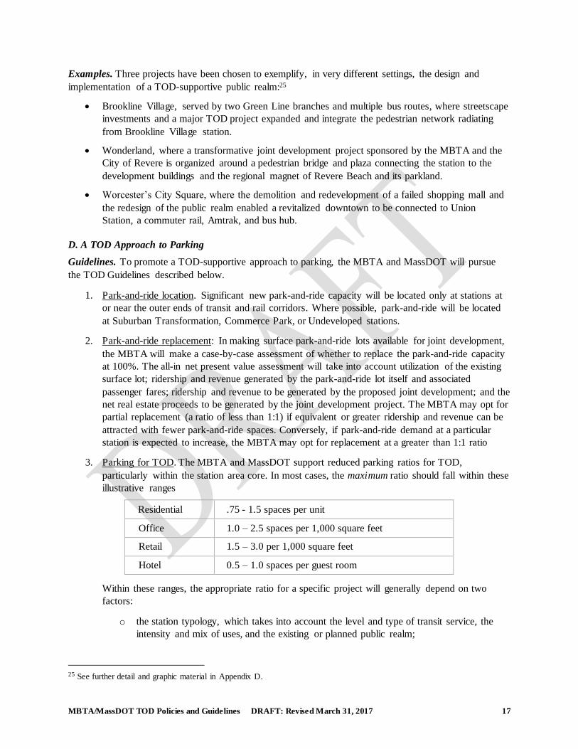
3. Parking for TOD. The MBTA and MassDOT support reduced parking ratios for TOD,
particularly within the station area core. In most cases, the maximum ratio should fall within these
illustrative ranges
Residential .75 - 1.5 spaces per unit
Office 1.0 – 2.5 spaces per 1,000 square feet
Retail 1.5 – 3.0 per 1,000 square feet
Hotel 0.5 – 1.0 spaces per guest room
Within these ranges, the appropriate ratio for a specific project will generally depend on two
factors:
o the station typology, which takes into account the level and type of transit service, the
intensity and mix of uses, and the existing or planned public realm;
25 See further detail and graphic material in Appendix D.
MBTA/MassDOT TOD Policies and Guidelines DRAFT: Revised March 31, 2017 18
o the on-foot distance between the development project and the station.
For example, a project within close walking distance of a Metro Core, Seaport, or
Transformational Subway station would be assigned parking ratios at or near the low end of the
ranges listed above; a project a half-mile walk from a similar station would be assigned somewhat
higher ratios. Projects near Transit Neighborhood, Trolley Suburb, Urban Gateway, and Town &
Village stations would fall in the intermediate range. Projects near Commerce Park and
Undeveloped stations would fall at the high end of the range.
Based on these standards, and to the extent allowed by local zoning, the MBTA or MassDOT, as
applicable, will designate a set of maximum parking ratios for each joint development project.
They will coordinate with the city or town in question to ensure that the parking standards
described here are applied flexibly in response to local needs, conditions and policy priorities.26
Where existing zoning is inconsistent with such standards, the MBTA or MassDOT may support
appropriate zoning changes or relief to achieve them.
4. Shared parking. The MBTA and MassDOT will encourage shared parking among TOD uses, and
between park-and-ride and TOD uses where feasible.
5. Multi-modal parking. The MBTA and MassDOT will require in their respective joint
development projects, and encourage in other TOD:
o provision of bicycle parking facilities of appropriate quantity and design; in joint
development projects, these will include, as applicable, both outdoor and secure, indoor
spaces for both residential and non-residential uses;
o provision of spaces for car-sharing, bike-sharing, and electric vehicle charging.
6. Garage design. Whether for park-and-ride, TOD, or a combination of the two, the MBTA
supports the location of garages so as to minimize any spatial or visual conflict with TOD.
Garages should be sited so as not to preclude development of a station’s most desirable parcels.
Where possible, garages fronting on major streets should be “wrapped” by multi-story
development; at minimum, such frontages should include retail or similar uses at street level.
7. Surface parking location and design. Surface lots should be landscaped, and should be screened
from pedestrian areas by plantings. Surface parking associated with a building should not be
located between the building and its front sidewalk.
Examples. Three projects have been chosen to exemplify an appropriate TOD approach to parking:27
Somerville’s TOD zoning for Union Square and Boynton Yards; adopted in anticipation of the
Green Line Extension, the TOD zoning reflects best practices with respect to low parking ratios,
shared parking, and design standards for parking facilities.
The MBTA’s North Quincy joint development project, where the replacement of a large surface
park-and-ride lot in a garage freed up a 5.8-acre site for mixed-use TOD.
26 These illustrative standards will be reviewed and updated every five years to account for changes in vehicle technology and market trends. 27 See further detail and graphic material in Appendix D.
MBTA/MassDOT TOD Policies and Guidelines DRAFT: Revised March 31, 2017 19
The Beverly Depot garage, where the MBTA designed a park-and-ride garage to accommodate a
joint development parcel fronting on the street, sharing the garage, and “wrapping” its street
frontage.
MBTA/MassDOT TOD Policies and Guidelines DRAFT: Revised March 31, 2017 20
APPENDICES
A. The MAPC Station Typology
B. Joint Development Procedures
C. Definitions
D. Projects Illustrating Foundational TOD Principles
MBTA/MassDOT TOD Policies and Guidelines DRAFT: Revised March 31, 2017 21
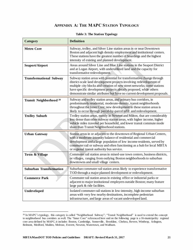
APPENDIX A: THE MAPC STATION TYPOLOGY
Table 3: The Station Typology
Category Definition
Metro Core Subway, trolley, and Silver Line station areas in or near Downtown
Boston and adjacent high density employment and institutional centers. These stations have the greatest number of boardings and the highest
intensity of existing and planned development.
Seaport/Airport Areas around Silver Line and Blue Line stations in the Seaport District and at Logan Airport, with underutilized land and the capacity for transformative redevelopment.
Transformational Subway Subway station areas with potential for transformative change through district-scale land development projects involving redevelopment of multiple city blocks and creation of new street networks; some stations have specific development projects already proposed, while others
demonstrate similar attributes but have no current development proposals.
Transit Neighborhood 28 Subway and trolley station areas, and primary bus corridors, in predominately residential, moderate-density, transit neighborhoods throughout the Inner Core; new development in these station areas is
likely to occur through parcel-by-parcel infill and redevelopment.
Trolley Suburb Trolley station areas, mostly in Newton and Milton, that are considerably less dense than other subway station areas, with higher income, higher vehicle miles traveled per household, and lower transit commute mode share than Transit Neighborhood stations.
Urban Gateway Station areas in or adjacent to the downtown of Regional Urban Centers,
with a moderate-intensity balance of residential and commercial
development and a large population of low income residents, served by commuter rail or subway and often functioning as a hub for local MBTA or regional transit authority bus service.
Town & Village Commuter rail station areas in mixed-use town centers, business districts,
or villages, ranging from outlying Boston neighborhoods to suburban downtowns and small village centers.
Suburban Transformation Suburban commuter rail station areas likely to experience transformative
TOD through a major planned development or redevelopment.
Commerce Park Commuter rail station areas in existing office or industrial parks or
adjacent to major institutional employers outside Boston; many feature large park & ride facilities.
Undeveloped Isolated commuter rail stations in low-intensity, high-income suburban areas with very few nearby destinations, incomplete pedestrian
infrastructure, and large areas of vacant undeveloped land.
28 In MAPC’s typology, this category is called “Neighborhood Subway”; “Transit Neighborhood” is used to extend the concept to neighborhood bus corridors as well. The “Inner Core” referenced here and on the following page is a 16-municipality regional
core area defined by MAPC; it includes Boston, Cambridge, Somerville, Brookline, Chelsea, Revere, Winthrop, Arlington, Belmont, Medford, Malden, Melrose, Everett, Newton, Watertown, and Waltham.
MBTA/MassDOT TOD Policies and Guidelines DRAFT: Revised March 31, 2017 22
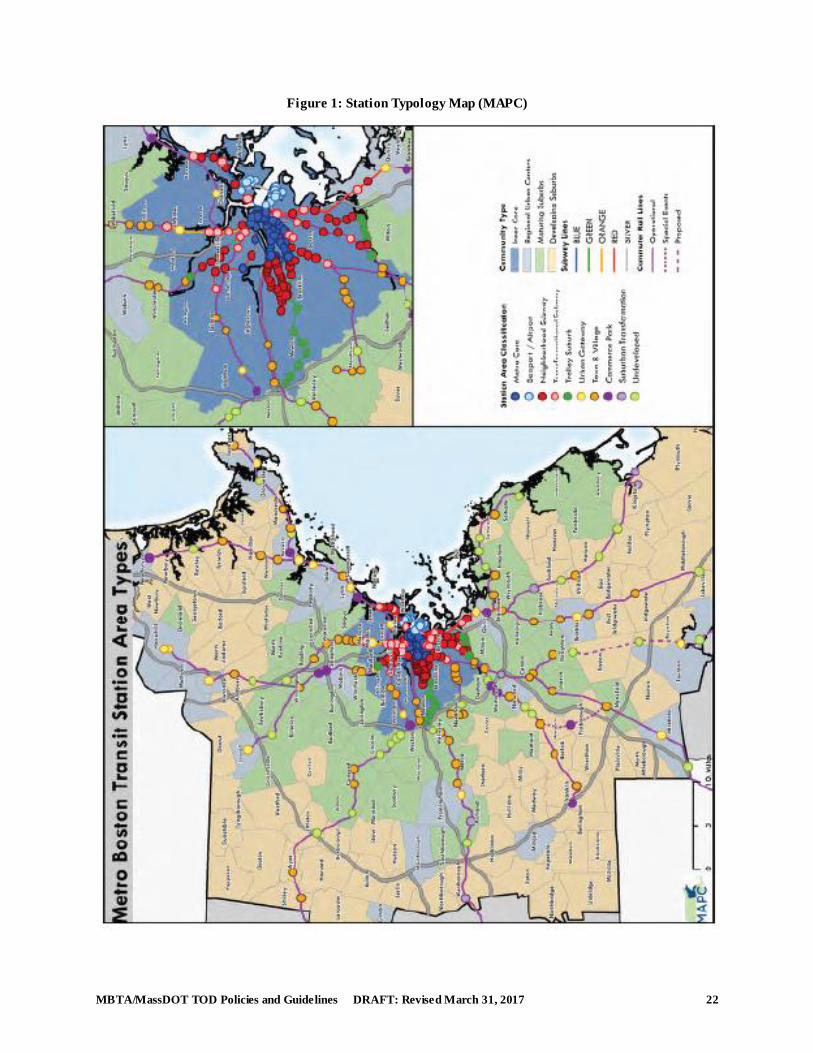
Figure 1: Station Typology Map (MAPC)
MBTA/MassDOT TOD Policies and Guidelines DRAFT: Revised March 31, 2017 23
The ten categories can be combined into four thematic groupings:
Metro Core, Seaport/Airport, and Transformational Subway. These stations are all in the
region’s Inner Core and either support, or are expected to support, the highest intensity of
development and the most robust mix of residential, employment, institutional, and recreational
activities.
Transit Neighborhood and Trolley Suburb. These categories consist of neighborhood stations
in the Inner Core. MAPC’s “Neighborhood Subway” category includes both subway and light rail
stations. Because the MBTA intends these TOD Guidelines to address key neighborhood bus
corridors as well, this category is renamed “Transit Neighborhood”. The Trolley Suburb category
consists of light rail stations in Newton and Milton. While differing in density and income level,
both of these categories provide infill TOD opportunities in a fine-grained neighborhood setting.
Urban Gateway and Town & Village. These categories encompass mixed-use city, town, and
village centers, served by commuter rail and in a few cases by rapid transit. The two categories
differ in scale and prominence, with Urban Gateway stations generally located in larger regional
downtowns. Several are in Commonwealth-designated Gateway Cities at the outer ends of
commuter rail lines. The mixed-use centers in both categories provide extensive opportunities for
infill development and adaptive reuse.
Suburban Transformation, Commerce Park, and Undeveloped. These station categories are
located on the commuter rail system, and they share the challenge of adapting TOD principles, as
applicable, in settings without a mixed-use activity base or traditional TOD street grid. Suburban
Transformation stations have comprehensive, mixed-use development plans that envision a role
for transit. Commerce Park stations include office and industrial parks, college campuses, and
major entertainment centers—single- or limited-use settings where the key activity generators are
physically spread out and may be distant from the stations themselves. Undeveloped station areas
are in rural or low-density suburban settings, where major trip generators are not within walking
distance. All three of these station types require “first-mile/last-mile” connections if they are to
utilize rail transit in a way that helps contain sprawl and reduce vehicle miles.
MBTA/MassDOT TOD Policies and Guidelines DRAFT: Revised March 31, 2017 24
APPENDIX B: MBTA/MASSDOT JOINT DEVELOPMENT PROCEDURES
These MBTA/MassDOT Joint Development Procedures are designed to ensure a joint development
solicitation and negotiation process that is fair, transparent, timely, and accessible to a broad
range of developers; to optimize the financial value of the transaction for the MBTA; and to promote
projects that reflect the MBTA/MassDOT TOD Guidelines.
a. Definitions:
MBTA: The Massachusetts Bay Transportation Authority.
MassDOT: The Massachusetts Department of Transportation.
Joint Development Project: A project in proximity to an MBTA station that is undertaken
by a developer: on MBTA or MassDOT land or air rights;
within MBTA stations; or through some other form of real
estate transaction to which the MBTA or MassDOT is a party
(including but not limited to a physical connection with a
station).
Invitation to Bid (ITB) The form of open, competitive developer solicitation
document issued by the MBTA or MassDOT to solicit
proposals for joint development projects. As used in these
Guidelines, the term ITB is understood to include other
forms of developer solicitation, such as a Request for
Qualifications (RFQ), a Request for Proposals (RFP), or a
combined Request for Qualifications and Proposals.
The Issuer: Whichever of the MBTA or MassDOT is issuing, or has
issued, a joint development Invitation to Bid.
b. Except as indicated herein, the MBTA or MassDOT, as the case may be, will undertake joint
development projects by offering properties for development through a competitive solicitation
process. The MBTA or MassDOT, as applicable (“the Issuer”) will determine if and when it is
advantageous to offer a property for development, based on a market analysis and on the Issuer’s
conclusion that the land, air rights, or premises in question are not needed for transportation
operations and that the development contemplated will not unduly interfere with such operations.
c. The solicitation process will be based on an Invitation to Bid (“ITB”) or a similar form of
developer solicitation document. The Issuer may delegate to its real estate advisory consultant the
work of preparing, issuing, and managing the ITB; evaluating proposals; and negotiating the Joint
Development Agreement; such delegation will be under the supervision of the Issuer’s Real
Estate Department.
d. The ITB will set forth the process for evaluating proposals and selecting a developer. The ITB
will state that its issuance does not obligate the Issuer to select a developer, and that the Issuer
may, at its sole discretion, cancel the ITB or reject any and all proposals.
e. The ITB shall provide sufficient information and guidance to convey the Issuer’s development
intent, while encouraging, to the degree appropriate for the project in question, flexible and
creative proposals by respondents. The ITB shall specify the type and level of information
MBTA/MassDOT TOD Policies and Guidelines DRAFT: Revised March 31, 2017 25
required to demonstrate the technical merit of the proposal and the financial capacity of the
proponent.
f. The MBTA is required by law to award competitive developer solicitations to the highest
responsible bidder, unless the public interest requires otherwise.29 MassDOT is required to award
competitive real property solicitations to the highest responsible bidder.30 The ITB shall specify
any requirements or conditions that respondents are to take into account in preparing their bids.
Depending on the instructions provided in the ITB, bids may include lump sum cash payments,
on-going payment streams, or, if applicable, in-kind replacement or improvement of MBTA
facilities or specific commitments to operate and maintain such facilities. The all-in net present
value of a responsible bid shall be at least equal to the current appraised fair market value of the
property.
g. The Issuer’s Real Estate Department will coordinate with other departments and offices,
including but not limited to Legal Counsel, Procurement, Finance, Operations, Safety, MBTA
Transit Police, MBTA Design and Construction, MBTA Systemwide Accessibility, and MBTA
Engineering and Maintenance, to ensure that the availability of the property, the contemplated
uses and site plan, the content of the ITB, the preservation or replacement of any operating
facilities, and the constructability of the proposed development are properly evaluated. Such
coordination will commence during the evaluation of a property for potential joint development
and will continue through the ITB, proposal evaluation, and preparation of the applicable
agreements.
h. The Issuer will coordinate with the city or town in which the project is located through all stages
of the joint development process, and will seek input from community stakeholders at the city or
town’s direction. The Issuer will consult with the applicable Regional Planning Agency as
appropriate.
i. The Issuer will incorporate into the ITB any applicable provisions enumerated in Part III, TOD
Guidelines, with respect to subsections A (Density and Use), B (Equitable Development), C
(Public Realm), and D (Parking). Such provisions will be tailored to the project in question; the
Issuer will coordinate with the city or town in question to ensure that these provisions are applied
flexibly in response to local needs, conditions, and policy priorities
j. Whenever feasible, it is the MBTA’s and MassDOT’s policy to retain fee ownership of joint
development parcels and convey their development rights through long-term lease rather than
sale. It is understood that a particular development project may require the outright sale of a
parcel, and the Issuer will consider such exceptions on a case-by-case basis, based on
documentary evidence that the project cannot feasibly be financed through a long-term lease and
that a sale is advantageous to the Issuer. In all cases, the Issuer will reserve such rights as it
deems necessary for the operation and maintenance of its facilities, and such reservations will be
clearly stated in the deed or ground lease.
k. If at the conclusion of its evaluation of proposals the Issuer determines that there is a highest
responsible bid which satisfies the selection criteria, that respondent shall receive the Preliminary
Developer Designation, following which the Issuer and the respondent will enter into an
29 Chapter 161A of the General Laws, the MBTA Enabling Act, states, in the case of real property sales: the highest bidder
subject to any restrictions, covenants, or conditions the authority shall find that sound reasons in the public interest require; and in the case of leases: the highest responsible and eligible bidder therefor unless the authority shall find that sound reasons in the public interest require otherwise.
30 Chapter 6C, Section 20 of the General Laws (the MassDOT Enabling Act).
MBTA/MassDOT TOD Policies and Guidelines DRAFT: Revised March 31, 2017 26
exclusive negotiation period for the purpose of concluding either: (i) a Joint Development
Agreement (“JDA”) or (ii) the long-term ground lease or deed of sale, depending on which
method was specified in the ITB. A JDA, where used, governs the legal and business relationship
between the Issuer and the designated developer until the closing, at which time the JDA is
superseded by the long-term ground lease or deed of sale conveying the development rights. The
JDA will set forth all of the conditions precedent to the closing, including the process of design
and constructability reviews by the MBTA and by MassDOT if applicable. If the Issuer and the
developer are unable to conclude a Joint Development Agreement, long-term ground lease, or
deed of sale satisfactory to the Issuer, the Issuer may at its option enter negotiations with the next
ranked respondent or cancel the ITB. Under state law, Massachusetts Environmental Policy Act
(MEPA) review, where applicable, must be completed and certified by the Secretary of Energy of
Environmental Affairs before a JDA or other final land disposition agreement may be executed.
l. In the event that the MBTA or MassDOT receives an unsolicited proposal for joint development
on its property, it shall determine: (i) whether the property is available for development under the
criteria of paragraph [b] above; (ii) whether it is advantageous to the MBTA or MassDOT, as he
case may be, to offer it for development at the current time; (iii) whether the proposed transaction
will return fair market value; (iv) whether the proposal contains sufficient information to
reasonably evaluate its technical merit and the financial capacity of the proposer; and if so, (v)
whether there is sufficient merit and capacity to entertain the proposal. If the MBTA’s or
MassDOT’s determination, as applicable, on any of the foregoing questions is negative, it shall
return the proposal and take no further action. If the MBTA’s or MassDOT’s determination is
affirmative, it may consider the proposal by making public notice that it has received an
unsolicited proposal for the property in question and soliciting alternative proposals. Such
solicitation shall be in the form of an ITB consistent, to the degree applicable in the particular
circumstance, with paragraphs [d] and [e] above.
m. The MBTA anticipates that owners of property adjacent to MBTA facilities may from time to
time request to establish a physical connection to a station or to participate in the design, funding,
improvement, construction, or operation and maintenance of a station. Such requests will be
evaluated and disposed of consistent with applicable provisions of the MBTA Enabling Act
(Chapter 161A of the General Laws) and any other applicable provision of law. The MBTA shall
be under no obligation to undertake any such transaction, but if it determines that it is
advantageous to do so may enter into a Joint Development Agreement, Memorandum of
Understanding, or other form of agreement allowed by applicable law. Under any such
agreement, the activity of the adjacent owner with respect to design, construction, or operation of
MBTA facilities shall be under the supervision, and shall comply with all applicable standards, of
the MBTA. The MBTA Legal Department shall determine whether any aspects of the transaction
in question are subject to competitive bidding.
n. The MBTA and MassDOT will support zoning approvals, MEPA review, and other regulatory
approvals associated with their respective joint development projects. Except as indicated herein
or specifically stated in the ITB, the selected developer will be responsible for securing all
regulatory approvals.
o. The MBTA or MassDOT will at their discretion support applications for federal, state, or local
grants or financing assistance associated with their respective joint development projects. If a
proposal is dependent on such assistance, the Issuer may review the proposal with the relevant
government agency in order to assess the likelihood of such assistance being obtained.
MBTA/MassDOT TOD Policies and Guidelines DRAFT: Revised March 31, 2017 27
p. The MBTA will have lead responsibility for securing any regulatory approval or grant assistance
from the Federal Transit Administration (FTA) or Federal Railroad Administration (FRA), and
any communication with the FTA or FRA with respect to such matters will be initiated and
directed by the MBTA. MassDOT will have led responsibility for securing any regulatory
approval or grant assistance from the United States Department of Transportation (USDOT), and
any communication with USDOT with respect to such matters will be initiated and directed by
MassDOT.
q. In general, a joint development project that displaces existing MBTA station access facilities—
whether pedestrian, intermodal, or park-and-ride—will replace those facilities as part of the
project. At the MBTA’s discretion, the Joint Development Agreement may provide for the
replacement to be implemented by the developer or by the MBTA using joint development
proceeds.
.
MBTA/MassDOT TOD Policies and Guidelines DRAFT: Revised March 31, 2017 28
APPENDIX C: DEFINITIONS
Affordable Housing and Workforce Housing. For-sale or rental housing that is affordable to households
earning up to a specific percentage of the applicable Area Median Income (AMI), as determined by the
US Department of Housing and Urban Development for the year in which the housing is first occupied.
For purposes of these TOD Guidelines, Affordable Housing is defined as serving households earning up
to 60% of AMI. Workforce Housing is defined as serving households earning up to 100% of AMI. In
either case, a lower percentage of AMI may be applied on a project-by-project basis.
Alternative Transportation Corridor. A dedicated or semi-dedicated corridor for pedestrian, bicycle, and
handicap accessible travel; such corridors include, but are not limited to, rail trails and community paths.
Area Median Income (AMI). The median household income estimated by the Department of Housing and
Urban Development (HUD) for each US metropolitan and non-metropolitan area, as a metric of eligibility
for participation in various affordable housing programs. HUD estimates the median family income for an
area in the current year and adjusts that amount for different family sizes so that family incomes may be
expressed as a percentage of the area median income.
Community Development Corporation (CDC). A non-profit corporation, usually based in a particular
neighborhood or jurisdiction, that participates in real estate development projects as well as other
community revitalization activities. CDCs typically have community residents and stakeholders on their
governing boards. The term is used broadly in this document to include organizations with CDC in their
names as well as similar organizations.
Complete streets. Public streets designed and operated to enable safe access for all users, including
pedestrians, bicyclists, motorists and transit riders of all ages and abilities.
Core, or Station Area Core. The area around a rapid transit or commuter rail station defined by a quarter-
mile radius. The core is a subset of the half-mile walkshed (see definition) of such stations and is the area
where certain aspects of the TOD Guidelines are identified in the text of this document as being of
particular relevance or applicability.
District Infrastructure Finance (DIF). The Massachusetts version of traditional municipal tax increment
financing, using the local property tax (Chapter 40Q of the General Laws). A municipality may place up
to 25% of its land area in a DIF district; may choose the percentage (up to 100%) of the district’s
incremental revenues to capture and dedicate to the DIF bond; and may maintain the dedicated revenue
stream for a term of up to 30 years from a projected stabilization date. (See also Value Capture.)
Employment TOD. Transit-oriented development that includes one or more large-scale employment
destinations. As used in these Guidelines, Employment TOD may consist of commercial, institutional, or
industrial uses. Particularly in the case of industrial uses, Employment TOD may lack the traditional TOD
mix of uses.
Equitable TOD (E-TOD). As used in these Guidelines, Equitable TOD is transit-oriented development
characterized by housing and transportation affordability (see definition), enhanced transit access to jobs,
and equitable investment in the community.
First mile/last mile connection. A link connecting a transit station to a passenger origin or destination
lying outside of normal walking distance. First-mile/last-mile connections may consist of employer
MBTA/MassDOT TOD Policies and Guidelines DRAFT: Revised March 31, 2017 29
shuttles; district collector/shuttles run by public agencies, residential developments, or Transportation
Management Associations; taxi or ride-share services; and shared cars or bicycles.
Gateway Cities. The Commonwealth’s older industrial cities, defined in Chapter 23A of the General Laws
as having a population of 35,000 to 250,000 and income and educational attainment levels below the
statewide average. Gateway Cities are eligible for, or have priority status in, several state economic and
community development programs. There are currently 26 Gateway Cities, 16 of which are located in the
MBTA service area or in other regional transit authority districts but with MBTA commuter rail stations.
Greater Boston. The 164-municipality metropolitan region generally used by the Metropolitan Area
Planning Council and the Central Transportation Planning Staff for planning, modeling, and projection
purposes. This region contains the entire MBTA rapid transit system and nearly all of its commuter rail
stations. As used in this document, there is no technical or legal significance to the designation.
Housing + Transportation (H+T) Affordability Index. An affordability index developed by the Center for
Neighborhood Technology that takes into account the combined cost of housing and daily commuting,
rather than housing alone. In the H+T index, the benchmark for affordability is a combined housing and
transportation cost representing not more than 45% of household income. This is in contrast to the
traditional housing affordability of 30% of household income.
Inclusionary zoning. A provision in a local zoning ordinance or similar land use regulatory code that
requires a specific percentage of affordable housing units for residential or mixed-use projects meeting
certain size or location thresholds.
Infrastructure Investment Incentive Program (I-Cubed). A form of state-level tax increment financing, in
the form of income and sales taxes to be generated by industrial or commercial development undertaken
as a result of an infrastructure investment (Chapter 293 of the Acts of 2006 and Chapter 128 of the Acts
of 2008). Bonds are issued by the Massachusetts Development Finance Agency and cannot be undertaken
without the initiative of one of more private developers. The projected incremental revenues must be
shown, through an independent third-party analysis, to be net new to Massachusetts. (See also Value
Capture.)
Invitation to Bid (ITB). The form of open, competitive developer solicitation document used by the
MBTA to solicit proposals for joint development parcels. As used in these Guidelines, the term ITB is
understood to include other forms of developer solicitation, such as a Request for Qualifications (RFQ), a
Request for Proposals (RFP), or a combined Request for Qualifications and Proposals.
Joint development. As used in these Guidelines, a subset of transit-oriented development that is built by a
developer on MBTA or MassDOT property, or that is connected to a station through some other form of
real estate transaction to which the MBTA or MassDOT is a party (including but not limited to a physical
connection with a station). (The Federal Transit Administration, for its purposes, uses a different
definition, established in its 2016 Joint Development Guidance: A public transportation project that
integrally relates to, and often co-locates with commercial, residential, mixed-use, or other non-transit
development. Joint development may include partnerships for public or private development associated
with any mode of transit system that is being improved through new construction, renovation, or
extension. Joint development may also include intermodal facilities, intercity bus and rail facilities, transit
malls, or historic transportation facilities.)
Joint Development Agreement (JDA). An agreement between a transit agency sponsoring a joint
development project (see definition) and its selected developer, establishing the terms of the transaction
MBTA/MassDOT TOD Policies and Guidelines DRAFT: Revised March 31, 2017 30
and governing the relationship between the parties from the time of execution until the closing of the
long-term lease or sale that conveys the development rights.
Local Infrastructure Development Program (LIDP). A special assessment district program that enables a
municipality to finance local economic development infrastructure through assessments on property
within a designated district. The district cannot be approved and implemented without 100% consent by
all property owners within the district. The special assessments are collected like property taxes for a term
of up to 25 years, and the tax-exempt infrastructure bonds are issued by the Massachusetts Development
Finance Agency. (See also Value Capture.)
Lower-density housing. Residential development of at least one acre containing fewer than 15 dwelling
units per acre and more than four units per acre.
Metropolitan Area Planning Council MAPC. The regional planning agency for a 111-municipality
Greater Boston district that substantially overlaps the MBTA service area.
Mixed-use development. Development within a single project, or within a cluster of projects in a single
station area, that includes different, complementary uses (both residential and non-residential) and
provides for a variety of activities throughout the day. Mixed-use development may be horizontal
(adjoining uses in separate buildings) or vertical (different uses within the same building).
Mobility hub. A transit station where several modes of passenger transportation interface, often with the
aid of real-time information technology. The connecting modes may include rapid transit and “feeder”
transit services as well as the various forms of first-mile/last-mile connections (see definition). As used in
these Guidelines, mobility hubs are often, but not necessarily, associated with substantial transit-oriented
development.
Park-and-ride replacement. The consolidation of surface park-and-ride spaces into a garage facility, in
order to free up land for joint development. Park-and-ride replacement may be on a one-for-one basis, or
on a higher or lower percentage basis determined case-by-case.
Parking ratio. A ratio of parking spaces per unit of development specified in zoning or other development
regulatory codes. Parking ratios are typically stated in terms of a number of spaces per unit of residential
development, or per square footage of non-residential development. A given zoning ordinance may
specify minimum parking ratios, maximum parking ratios, or both.
Public realm. The composition of outdoor public places in a station area (or other district), including
streets, sidewalks, trails, plazas, parks, station grounds, and the amenities located therein. The public
realm consists of areas owned by public agencies, or owned by private developers but generally open to
the public and connected to public sidewalks.
Shared parking. Parking that is utilized by two or more different uses characterized by distinct peak
parking demand hours. Shared parking may occur within a private development or a public parking
facility, and may involve commuter park-and-ride as well as development-related parking.
Special assessment district. A category of district value capture in which properties within the designated
infrastructure district are assessed an additional tax or fee. Special assessment districts stand in contrast to
tax increment districts, in which the captured revenue is a portion of the tax that each property would pay
anyway.
MBTA/MassDOT TOD Policies and Guidelines DRAFT: Revised March 31, 2017 31
Station area. A rapid transit station, commuter rail station, or high-frequency bus stop and its
surroundings. Depending on the context, the term “station area” may refer to the station’s walkshed or
zone of influence (see definitions).
Station area core. A subset of the station area that includes a rapid transit or commuter rail station and the
streets, sidewalks, public areas, and buildings in closest proximity to it. In these Guidelines, the station
area core consists, at most, of the quarter-mile radius around the station entrance(s).
Station Typology. A framework for planning transit-oriented development within a given corridor or
system in which stations are grouped into several “TOD place types”. These place types generally reflect
a station area’s density and mix of land uses, location in the metropolitan geography, and function in the
transit network. Typology categories often reflect aspirational as well as existing conditions, based on
long-term plans by the municipality or regional planning agency. These Guidelines use a 10-category
station typology previously developed by the Metropolitan Area Planning Council (see definition).
Streetwall. A segment of a street in which development is built with zero or minimal front lot-line
setbacks and the building façades are characterized by frequent entrances and substantial glazing.
Strip commercial development. Development in excess of 25,000 square feet consisting entirely or almost
entirely of retail or offices, arranged in detached one- or two-story structures with surface parking
between the street and the front entrance to the businesses.
Tax increment financing. A form of value capture in which a district is drawn around a public investment
and the resulting increase in tax revenues within the district is dedicated for a period of years to the
financing of the investment. Typically, the revenue yield within the district in “year zero” is defined as
the baseline and continues to flow to the general fund of the taxing jurisdiction(s), while some or all of the
revenue increment is set aside for either pay-as-you-go or debt financing of the infrastructure project.
Third places. Locations that are neither residential nor commute-related, such as entertainment and
cultural facilities, senior centers, or parks.
Transit-oriented development (TOD). A development pattern created around a transit station or station
that is characterized by higher density, mixed uses, a safe and attractive pedestrian environment, reduced
parking, and direct and convenient access to the transit facility.
Value capture. A form of infrastructure finance that monetizes the increased real estate land values
created by a public infrastructure investment. In the context of these Guidelines, value capture applies to
transit, TOD, or related infrastructure investments. There are two broad categories of value capture: joint
development (see definition) and district value capture. In Massachusetts, there are presently three forms
of district value capture: District Infrastructure Finance (DIF), Infrastructure Improvement Incentive
Program (I-Cubed), and the Local Infrastructure Development Program (LIDP). (See individual
definitions.)
Vehicle miles traveled (VMT). A measurement of miles traveled by vehicles within a specified region in a
specified time period. Annual VMT is often calculated per household and per acre, to illustrate the
differing automobile intensities of high-density, mixed-use development and low-density, single-use
development.
Very low-density housing. Residential development of more than one acre containing fewer than four
dwelling units per acre,
MBTA/MassDOT TOD Policies and Guidelines DRAFT: Revised March 31, 2017 32
Walkshed. The area around a transit station representing the distance that a typical work or school
commuter will walk on a regular basis. In these Guidelines, the walkshed for a rapid transit or commuter
rail station is generally considered to be a half-mile radius around the station entrance(s). For
conventional bus stops, the walkshed is generally considered to be one quarter-mile.
Workforce housing. (See the combined definitions of Affordable Housing and Workforce Housing at the
beginning of this Appendix.)
Zone of influence. The area within which land use and development may be directly influenced by the
proximity of a transit station. It consists of the station’s walkshed (see definition) plus, where applicable,
an expanded area connected to the station by a particular corridor, viewshed, bikeshed, or first-mile/last-
mile connection (see definition).
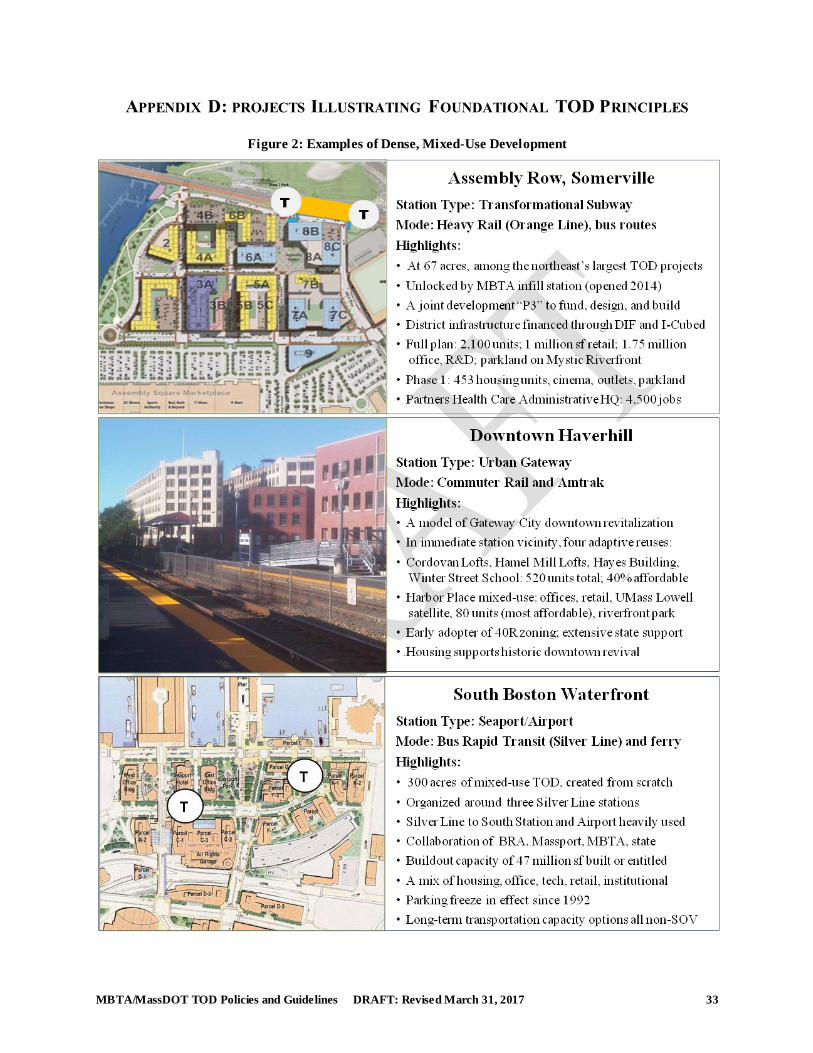
MBTA/MassDOT TOD Policies and Guidelines DRAFT: Revised March 31, 2017 33
APPENDIX D: PROJECTS ILLUSTRATING FOUNDATIONAL TOD PRINCIPLES
Figure 2: Examples of Dense, Mixed-Use Development
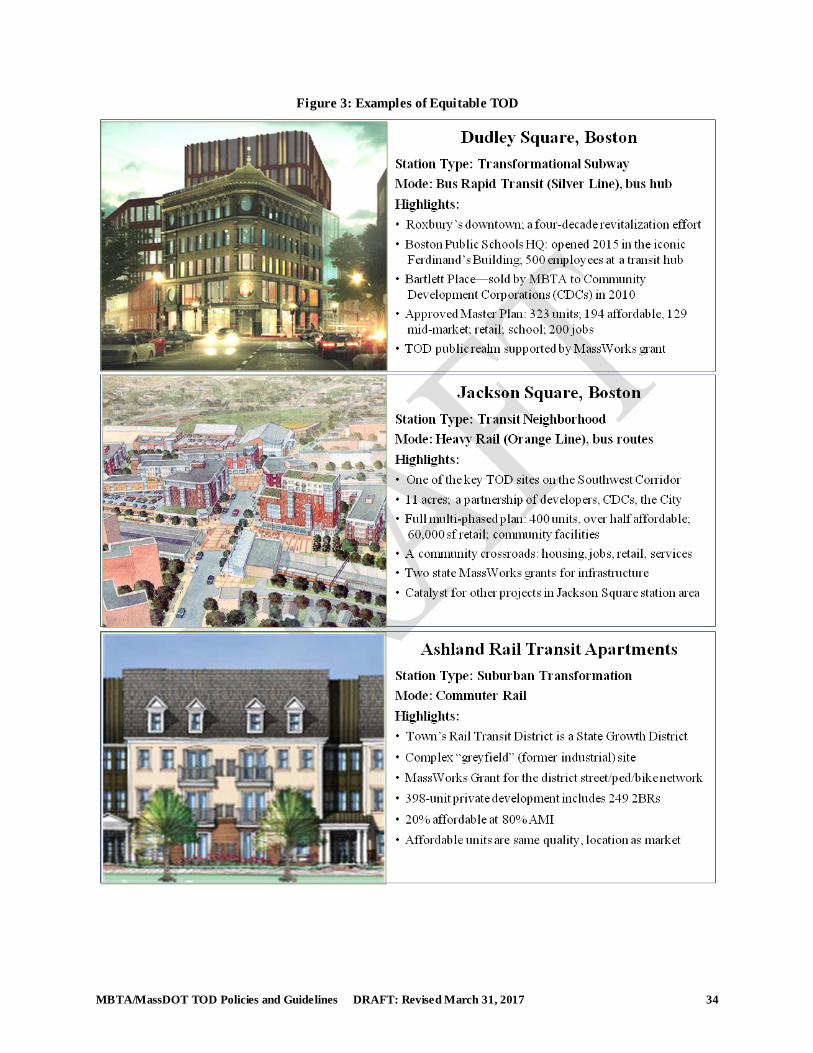
MBTA/MassDOT TOD Policies and Guidelines DRAFT: Revised March 31, 2017 34
Figure 3: Examples of Equitable TOD
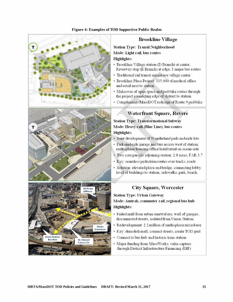
MBTA/MassDOT TOD Policies and Guidelines DRAFT: Revised March 31, 2017 35
Figure 4: Examples of TOD Supportive Public Realm
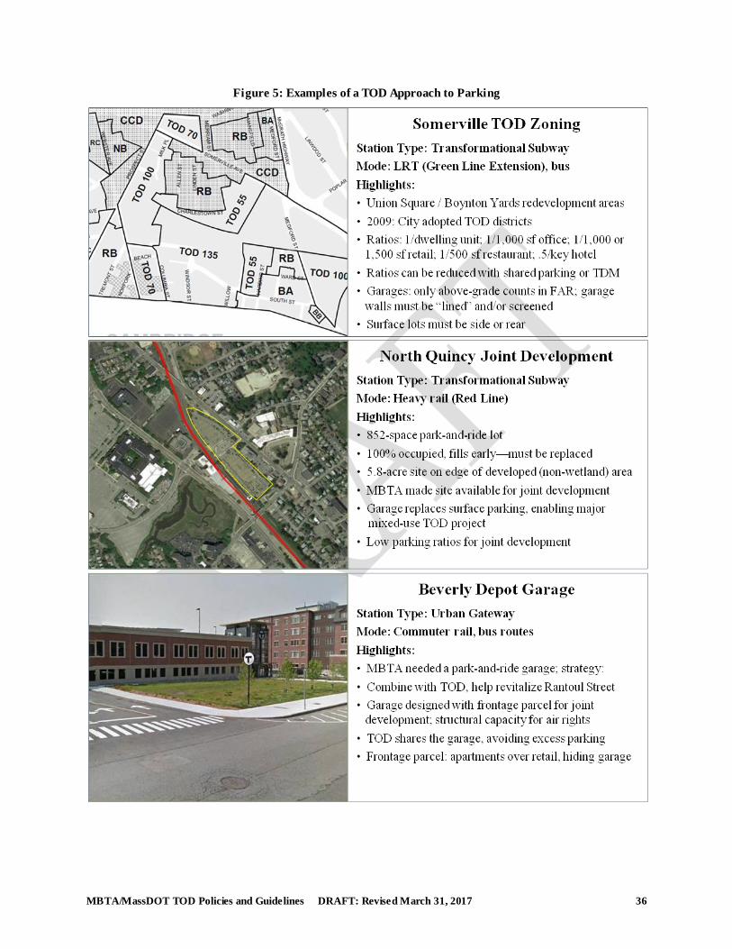
MBTA/MassDOT TOD Policies and Guidelines DRAFT: Revised March 31, 2017 36
Figure 5: Examples of a TOD Approach to Parking
MBTA/MassDOT TOD Policies and Guidelines DRAFT: Revised March 31, 2017 37
Listed below are the credits for the projects depicted in the preceding pages:.
Density and Mixed Use Development
Assembly Row: image, AECOM; data: Federal Realty Investment Trust.
Downtown Haverhill: photo, AECOM; data: City of Haverhill Department of Planning and
Economic Development and Archdiocese of Boston, Planning Office of Urban Affairs.
South Boston Waterfront: image, AECOM; data, A Better City: South Boston Transportation
Plan and AECOM.
Equitable Development
Dudley Square: photo, Boston Globe; data: BPS Headquarters, City of Boston; Bartlett
Commons, Boston Redevelopment Authority, Amended and Restated Master Plan for PDF Area
94, November 2015.
Jackson Square: image, Jamaica Plain Neighborhood Development Corporation (JPNDC); data:
JPNDC and City of Boston, Office of the Mayor, September 30, 2015.
Ashland Rail Transit Apartments: image and data: Campanelli/Thorndike, Request for Site Plan
Modification, October 2015.
Public Realm
Brookline Village: image, Children’s Hospital, presentation to Planning Board, 2015; data: ibid.
and AECOM.
Waterfront Square, Revere: image and data, Hunneman Investment Services, 2015
City Square, Worcester: image and data, City of Worcester, Office of Development
Parking
Somerville TOD Zoning: image and data, City of Somerville Zoning Code
North Quincy Joint Development: image, AECOM; data: Mass. Realty Group
Beverly Depot Garage: image and data, AECOM