Embed Size (px)
Citation preview
Title Climate Change Impact and Environment Adaptation inZeravshan River Basin
Author(s)KHUJANAZAROV, Temur; TANAKA, Kenji; TANAKA,Shigenobu; TODERICH, Kristina; TOUGE, Yoshiya;NAMURA, Ruka
Citation 京都大学防災研究所年報. B (2014), 57(B): 483-490
Issue Date 2014-06
URL http://hdl.handle.net/2433/196115
Right
Type Departmental Bulletin Paper
Textversion publisher
Kyoto University

Climate Change Impact and Environment Adaptation in Zeravshan River Basin
Temur KHUJANAZAROV, Kenji TANAKA, Shigenobu TANAKA,
Kristina TODERICH(1), Yoshiya TOUGE(2) and Ruka NAMURA(2)
(1) International Center for Biosaline Agriculture for Central Asia and Caucasus, Tashkent, Uzbekistan
(2) Graduate School of Engineering, Kyoto University
Synopsis
We investigated impact of climate change on the Zeravshan river basin and applicable
adaptation measures for the future development in the region. This study is focused on
two major goals; the first predicting future flow conditions and the second is measures
to operate marginal waters in the downstream under future decreased flow condition.
Land-surface model SiBUC future projections show a flow increase, accompanied by
precipitation decrease in summer and increase in winter. Water availability in late
summer will become the main issue as well as changes in seasonality of the runoff and
higher temperatures. In the second topic marginal waters potential and quantity
calculations has been researched to address water availability in Zeravshan River Basin
under climate change impacts. Findings show how plants interact with water and soil
environments under stressed conditions. Utilization of both marginal waters and lands
under a climate change water scarcity scenario can be a potential way of addressing
forage availability without requiring fresh waters from river and improving
environment.
Keywords: climate change, SiBUC, adaptation strategies, marginal waters, water
management, Zeravshan river basin
1. Introduction
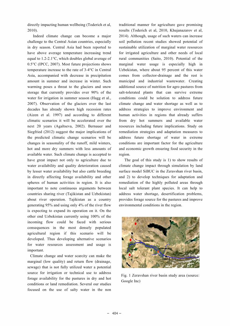
Zeravshan is a transboundary river in Central
Asia that has been profoundly affected by
mismanagement of the water resources due to the
huge diversion for irrigation, poor functioning and
maintenance of the drainage networks, as well as
high rates of water losses (fig. 1). The region relies
on conventional flooding irrigation practices and
soil leaching that requires large amounts of water.
Although, Zeravshan river is fully utilized for
irrigation use that is still not enough to cover
irrigation needs, even though 20% of return water is
reused again. On the other hand, excessive and
mostly uncontrolled use of water for irrigation
coupled with poor drainage collector system caused
large-scale land degradation and water quality
deterioration, mostly expressed in downstream
areas (Toderich et al, 2005). Soviet cotton
production race has increased water pollution that
salinized vast irrigation and pastoral lands in
downstream area. According to the official data
from the (MAWR, 2004) 12% of the irrigated lands
are classified as highly saline and 33% as medium
saline, requiring each time more water for cleaning
soils before planting. These processes may be
intensified by climate change under less water
availability and frequent droughts in Central Asia
京都大学防災研究所年報 第 57 号 B 平成 26 年 6 月
Annuals of Disas. Prev. Res. Inst., Kyoto Univ., No. 57 B, 2014
― 483 ―
directly impacting human wellbeing (Toderich et al,
2010).
Indeed climate change can become a major
challenge to the Central Asian countries, especially
in dry season. Central Asia had been reported to
have above average temperature increasing trend
equal to 1.2-2.1°C, which doubles global average of
0.5°C (IPCC, 2007). Most future projections shows
temperature increase to the rate of 3-4°C in Central
Asia, accompanied with decrease in precipitation
amount in summer and increase in winter. Such
warming poses a threat to the glaciers and snow
storage that currently provides over 90% of the
water for irrigation in summer season (Hagg et al.,
2007). Observation of the glaciers over the last
decades has already shown high recession rates
(Aizen et al. 1997) and according to different
climatic scenarios it will be accelerated over the
next 20 years (Agaltseva, 2002). Bernauer and
Siegfried (2012) suggest the major implications of
the predicted climatic change scenarios will be
changes in seasonality of the runoff, mild winters,
hot and more dry summers with less amounts of
available water. Such climate change is accepted to
have great impact not only to agriculture due to
water availability and quality deterioration caused
by lesser water availability but also cattle breeding
in directly affecting forage availability and other
spheres of human activities in region. It is also
important to note continuous arguments between
countries sharing river (Tajikistan and Uzbekistan)
about river operation. Tajikistan as a country
generating 95% and using only 4% of the river flow
is expecting to expand its operation on it. On the
other end Uzbekistan currently using 100% of the
incoming flow could be faced with serious
consequences in the most densely populated
agricultural region if this scenario will be
developed. Thus developing alternative scenarios
for water resources assessment and usage is
important.
Climate change and water scarcity can make the
marginal (low quality) and return flow (drainage,
sewage) that is not fully utilized water a potential
source for irrigation or technical use to address
forage availability for the pastures in dry and hot
conditions or land remediation. Several our studies
focused on the use of salty water in the non
traditional manner for agriculture gave promising
results (Toderich et al, 2010, Khujanazarov et al,
2014). Although, usage of such waters can increase
soil pollution recent studies showed potential of
sustainable utilization of marginal water resources
for irrigated agriculture and other needs of local
rural communities (Saito, 2010). Potential of the
marginal water usage is especially high in
Uzbekistan, where about 95 percent of this water
comes from collector-drainage and the rest is
municipal and industrial wastewater. Creating
additional source of nutrition for agro pastures from
salt-tolerated plants that can survive extreme
conditions could be solution to address future
climate change and water shortage as well as to
address strategies to improve environment and
human activities in regions that already suffers
from dry hot summers and available water
resources including future implications. Study on
remediation strategies and adaptation measures to
address future shortage of water in extreme
conditions are important factor for the agriculture
and economic growth ensuring food security in the
region.
The goal of this study is 1) to show results of
climate change impact through simulation by land
surface model SiBUC in the Zeravshan river basin,
and 2) to develop techniques for adaptation and
remediation of the highly polluted areas through
local salt tolerant plant species. It can help to
address water shortage, desertification problems,
provides forage source for the pastures and improve
environmental conditions in the region.
Fig. 1 Zeravshan river basin study area (source:
Google Inc)
― 484 ―
2. Methodology
2.1 SiBUC model set up and datasets
To address climate change impact and assess
river flow change we applied Simple Biosphere
model including Urban Canopy (SiBUC) land
surface model (Tanaka et al, 2004). The model use
"mosaic" approach to incorporate all kind of
land-use into land surface (fig. 2). In the SiBUC
model, the surface of each grid area is divided into
three land-use categories and five components. The
model helps to analyze water balance in the basin
and analyze impact of the climate change.
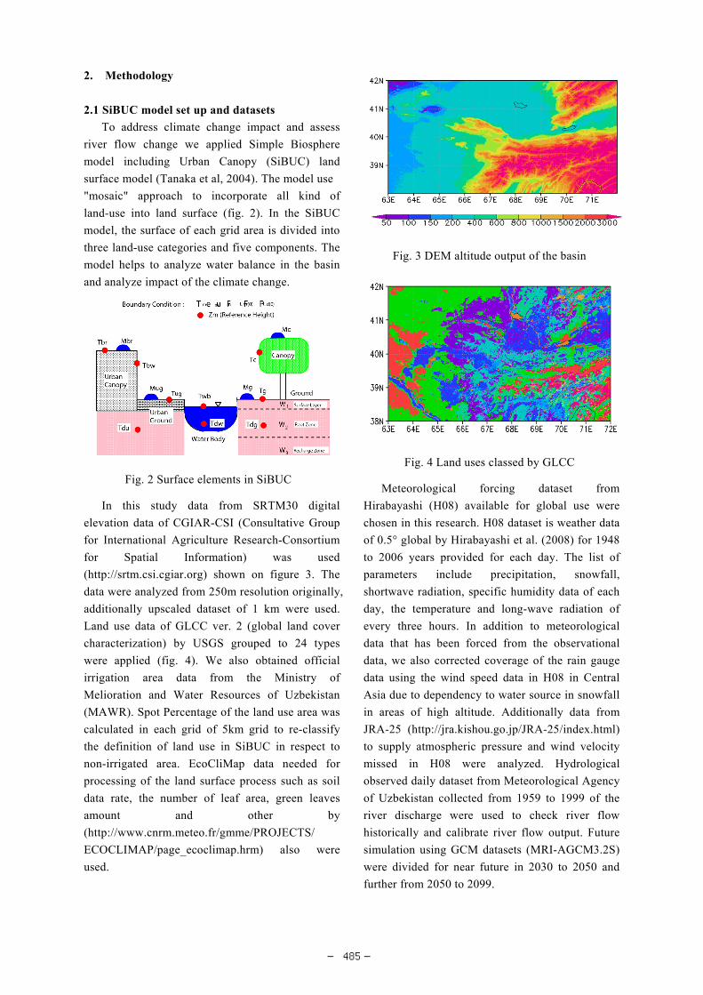
In this study data from SRTM30 digital
elevation data of CGIAR-CSI (Consultative Group
for International Agriculture Research-Consortium
for Spatial Information) was used
(http://srtm.csi.cgiar.org) shown on figure 3. The
data were analyzed from 250m resolution originally,
additionally upscaled dataset of 1 km were used.
Land use data of GLCC ver. 2 (global land cover
characterization) by USGS grouped to 24 types
were applied (fig. 4). We also obtained official
irrigation area data from the Ministry of
Melioration and Water Resources of Uzbekistan
(MAWR). Spot Percentage of the land use area was
calculated in each grid of 5km grid to re-classify
the definition of land use in SiBUC in respect to
non-irrigated area. EcoCliMap data needed for
processing of the land surface process such as soil
data rate, the number of leaf area, green leaves
amount and other by
(http://www.cnrm.meteo.fr/gmme/PROJECTS/
ECOCLIMAP/page_ecoclimap.hrm) also were
used.
Meteorological forcing dataset from
Hirabayashi (H08) available for global use were
chosen in this research. H08 dataset is weather data
of 0.5° global by Hirabayashi et al. (2008) for 1948
to 2006 years provided for each day. The list of
parameters include precipitation, snowfall,
shortwave radiation, specific humidity data of each
day, the temperature and long-wave radiation of
every three hours. In addition to meteorological
data that has been forced from the observational
data, we also corrected coverage of the rain gauge
data using the wind speed data in H08 in Central
Asia due to dependency to water source in snowfall
in areas of high altitude. Additionally data from
JRA-25 (http://jra.kishou.go.jp/JRA-25/index.html)
to supply atmospheric pressure and wind velocity
missed in H08 were analyzed. Hydrological
observed daily dataset from Meteorological Agency
of Uzbekistan collected from 1959 to 1999 of the
river discharge were used to check river flow
historically and calibrate river flow output. Future
simulation using GCM datasets (MRI-AGCM3.2S)
were divided for near future in 2030 to 2050 and
further from 2050 to 2099.
Fig. 2 Surface elements in SiBUC
Fig. 3 DEM altitude output of the basin
Fig. 4 Land uses classed by GLCC
― 485 ―
2.2 Marginal waters potential analysis
Study on adaptation to the water pollution on soils
and plants impact to study remediation strategy of
salt tolerant plants to extreme climatic conditions
were setup on experimental sites. Two sites (in
Bukhara oasis, the river downstream) were
established outside of the traditional irrigation areas,
mostly high salinated lands with brackish water
flow to assess impact of polluted waters on plants
and one site to check adaptation to the extreme
climatic conditions (dry, high temperatures, far
from fresh water sources) in Kyzyl Kum desert with
available mineralized artesian water (fig. 1). The
site in Kyzyl Kum desert is characterized with
higher temperatures variations and much dryer
conditions compared to Bukhara oasis, there is no
direct access to the fresh water, only thermal
artesian well abo100m deep. According to Uzbek
Meteorological Agency temperatures in the selected
area in Kyzyl Kum is on average 2-3°C high
compared to Bukhara oasis. To control climate
conditions meteorological station measuring wind
speed, air temperature, humidity and others were
installed. Plant adaptation to such severe climatic
conditions could support usage of the selected
plants for possible climatic change.
There is little or no information on utilization of
low quality water and salt affected lands for
alternative agriculture use. Even though such
categories of water and lands are no (in)direct
competition with food production or other uses. We
had applied marginal waters from collector
drainage system for research sites in Bukhara oasis
and artesian mineralized water source in Kyzyl
Kum were used for the site #3. Water quality on
mineralization was assessed through several annual
measurements on sites.
Plants under such environments face multiple
stresses caused by high soil salinity, heavy metals,
organic pollutants, high pH, impenetrable soil,
long-term water-shortage that will be exaggerated
in climate change. As such plants that can survive
soil and water mineralization as well as extreme dry
and high temperatures conditions should be
selected. Several plants had proved to be able to
survive and reproduce under salt contaminated
environments figure 5. Trees and shrubs seedlings
were deeply planted (sticks tap into the water table)
in early spring or late autumn seasons and irrigated
once with low quality water in the initial stage
before the trees/shrubs can rely on the available
groundwater resources on sites #1and #2. On site
#3 plants were additionally irrigated in July. Grows
rates, as well forage output and low quality water
response were through seasonal measurements. To
assess soil and chemical influence to the plants
chemical analysis of the upstream as a control
measurement were compared.
Through the first topic we could estimate
available water for re-use in future that could be
helpful in planning further activities and the second
topic addresses outcomes of the plant adaptation to
extreme condition by using waste waters.
3. Results and discussion
3.1 Simulation inputs
The simulation in the upstream by SiBUC
supported to have difficulties in the mountainous
area and glacier feed river. Due to absence of the
recent classified glacier data, high elevation over
4500m were proposed to have glacier coverage.
This assumption further was checked by glacier
coverage map available in the basin by
Meteorological Agency of Uzbekistan for the year
2000. GCM datasets were subjected to BIAS
correction for the area. The basin was divided to 4
areas: upstream - mountainous areas, irrigated areas
in downstream, non-irrigated areas and areas above
100 meters and others. Correcting coefficient were
used to match observed datasets in 1972-2000 years.
It is also important to mention that SiBUC has
0
200
400
600
800
1000
1 2 3 4 5 6 7 8 9 10 11 12
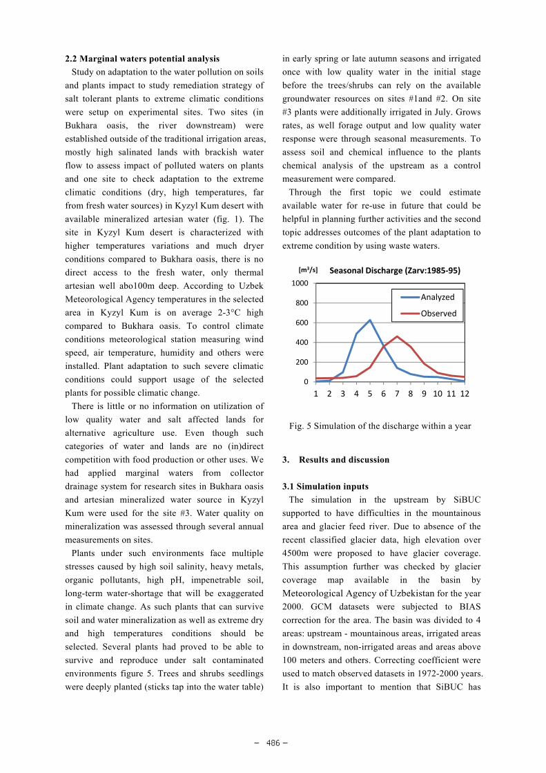
[m3/s] Seasonal Discharge (Zarv:1985‐95)
Analyzed
Observed
Fig. 5 Simulation of the discharge within a year
― 486 ―
shown great potential to reproduce water balance in
the region. The impact of the flow were analyzed
compared to the data on Dupuli station in the
upstream (fig. 1).
Results of simulation has shown reasonable
outcomes, however the peak flow is shifted to the
earlier period compared to observed dataset (fig. 5).
This is result of possible errors in the forcing
dataset (high wind speed and air pressure) or
special climatic conditions in the steep mountains
of the Zeravshan River George. Although compared
to the average annual discharge simulation results
are not significantly different from observed (fig. 6).
We concluded that total available water flow stays
reasonably close to observed data to make further
flow estimation.
It is important to address earlier water peaks on
the river with further analysis of the glacier melting
and river basin topography for altitude dependant
correction proved to be one of main factor in the
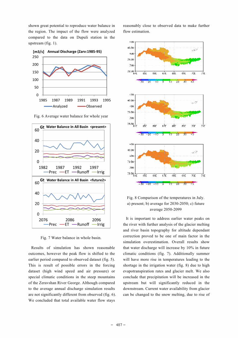
simulation overestimation. Overall results show
that water discharge will increase by 10% in future
climatic conditions (fig. 7). Additionally summer
will have more rise in temperatures leading to the
shortage in the irrigation water (fig. 8) due to high
evapotranspiration rates and glacier melt. We also
conclude that precipitation will be increased in the
upstream but will significantly reduced in the
downstream. Current water availability from glacier
can be changed to the snow melting, due to rise of
0
50
100
150
200
250
1985 1987 1989 1991 1993 1995
[m3/s] Annual Discharge (Zarv:1985‐95)
Analyzed Observed
Fig. 6 Average water balance for whole year
Fig. 7 Water balance in whole basin.
Fig. 8 Comparison of the temperatures in July.
a) present; b) average for 2030-2050; c) future
average 2050-2099
― 487 ―
temperatures in winter months. This hypothesis will
have to be proved for the future research.
3.2 Plant grows and adaptation to extreme
conditions
Simulated results and reviewed literature for past
years has shown growing rates in the temperature
and decrease in available water in most hot and dry
times of the year. Such outcomes could be very
sensible for the irrigation in Uzbekistan. We had
used the strategy to find possible solutions on
re-use of the water in the stressed conditions to
address current needs of the local community which
also can be applied in future.
Bukhara oasis vegetation contains restricted
number of species, with metal/salts removal and
successful reproduction abilities under
contaminated environments. These important
properties could address desertification issues as
well as climate change impacts of drying, high
evapotranspiration rates, water availability and soil
erosion to fix salt spreading through sand storms at
the same time in the south-eastern Kyzyl Kum
desert and settlements.
Several sites picked in this research are stated on
the salted lands and haven't been used for irrigation
practices. The soil salinity at the root zone was
about 45 dS/m-1, salinity level of the ground water
was 8.0-16.5 dS/m-1 inappropriate for the irrigation
of local agricultural crops, however, this did not
affect growth. The performance of the trees and
shrubs in saline soils and irrigated with marginal
water shows high growth rates, comparable to those
in irrigated land, although root-zone salinity
increased. Measurements of soil EC at the
beginning and the end of the vegetation season
indicated that the soil was of slight to medium
salinity, although at the upper 40cm horizon at
some points EC reached values of over 25 dS/m-1.
Most species exhibited clear distribution patterns
and their abundance varied significantly along
salinity and aridity climatic gradient. The
performance of investigated annual and perennial
plants on saline soils and irrigated with marginal
water shows high growth rates, comparable to those
in agricultural irrigated land (Khujanazarov et al,
2014). Due to low transpiration capacity, plants
communities grown near the experimental area
helped in retaining soil moisture in the top soil.
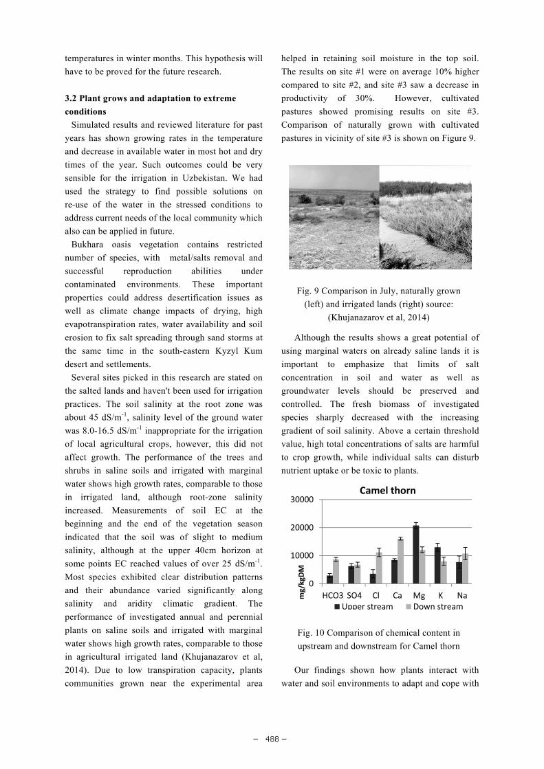
The results on site #1 were on average 10% higher
compared to site #2, and site #3 saw a decrease in
productivity of 30%. However, cultivated
pastures showed promising results on site #3.
Comparison of naturally grown with cultivated
pastures in vicinity of site #3 is shown on Figure 9.
Although the results shows a great potential of
using marginal waters on already saline lands it is
important to emphasize that limits of salt
concentration in soil and water as well as
groundwater levels should be preserved and
controlled. The fresh biomass of investigated
species sharply decreased with the increasing
gradient of soil salinity. Above a certain threshold
value, high total concentrations of salts are harmful
to crop growth, while individual salts can disturb
nutrient uptake or be toxic to plants.
Our findings shown how plants interact with
water and soil environments to adapt and cope with
Fig. 9 Comparison in July, naturally grown
(left) and irrigated lands (right) source:
(Khujanazarov et al, 2014)
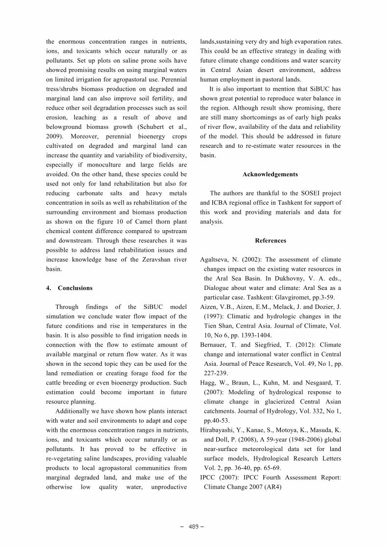
0
10000
20000
30000
HCO3 SO4 Cl Ca Mg K Namg/kgDM
Camel thorn
Upper stream Down stream
Fig. 10 Comparison of chemical content in
upstream and downstream for Camel thorn
― 488 ―
the enormous concentration ranges in nutrients,
ions, and toxicants which occur naturally or as
pollutants. Set up plots on saline prone soils have
showed promising results on using marginal waters
on limited irrigation for agropastoral use. Perennial
tress/shrubs biomass production on degraded and
marginal land can also improve soil fertility, and
reduce other soil degradation processes such as soil
erosion, leaching as a result of above and
belowground biomass growth (Schubert et al.,
2009). Moreover, perennial bioenergy crops
cultivated on degraded and marginal land can
increase the quantity and variability of biodiversity,
especially if monoculture and large fields are
avoided. On the other hand, these species could be
used not only for land rehabilitation but also for
reducing carbonate salts and heavy metals
concentration in soils as well as rehabilitation of the
surrounding environment and biomass production
as shown on the figure 10 of Camel thorn plant
chemical content difference compared to upstream
and downstream. Through these researches it was
possible to address land rehabilitation issues and
increase knowledge base of the Zeravshan river
basin.
4. Conclusions
Through findings of the SiBUC model
simulation we conclude water flow impact of the
future conditions and rise in temperatures in the
basin. It is also possible to find irrigation needs in
connection with the flow to estimate amount of
available marginal or return flow water. As it was
shown in the second topic they can be used for the
land remediation or creating forage food for the
cattle breeding or even bioenergy production. Such
estimation could become important in future
resource planning.
Additionally we have shown how plants interact
with water and soil environments to adapt and cope
with the enormous concentration ranges in nutrients,
ions, and toxicants which occur naturally or as
pollutants. It has proved to be effective in
re-vegetating saline landscapes, providing valuable
products to local agropastoral communities from
marginal degraded land, and make use of the
otherwise low quality water, unproductive
lands,sustaining very dry and high evaporation rates.
This could be an effective strategy in dealing with
future climate change conditions and water scarcity
in Central Asian desert environment, address
human employment in pastoral lands.
It is also important to mention that SiBUC has
shown great potential to reproduce water balance in
the region. Although result show promising, there
are still many shortcomings as of early high peaks
of river flow, availability of the data and reliability
of the model. This should be addressed in future
research and to re-estimate water resources in the
basin.
Acknowledgements
The authors are thankful to the SOSEI project
and ICBA regional office in Tashkent for support of
this work and providing materials and data for
analysis.
References
Agaltseva, N. (2002): The assessment of climate
changes impact on the existing water resources in
the Aral Sea Basin. In Dukhovny, V. A. eds.,
Dialogue about water and climate: Aral Sea as a
particular case. Tashkent: Glavgiromet, pp.3-59.
Aizen, V.B., Aizen, E.M., Melack, J. and Dozier, J.
(1997): Climatic and hydrologic changes in the
Tien Shan, Central Asia. Journal of Climate, Vol.
10, No 6, pp. 1393-1404.
Bernauer, T. and Siegfried, T. (2012): Climate
change and international water conflict in Central
Asia. Journal of Peace Research, Vol. 49, No 1, pp.
227-239.
Hagg, W., Braun, L., Kuhn, M. and Nesgaard, T.
(2007): Modeling of hydrological response to
climate change in glacierized Central Asian
catchments. Journal of Hydrology, Vol. 332, No 1,
pp.40-53.
Hirabayashi, Y., Kanae, S., Motoya, K., Masuda, K.
and Doll, P. (2008), A 59-year (1948-2006) global
near-surface meteorological data set for land
surface models, Hydrological Research Letters
Vol. 2, pp. 36-40, pp. 65-69.
IPCC (2007): IPCC Fourth Assessment Report:
Climate Change 2007 (AR4)
― 489 ―
(http://www.ipcc.ch/publications_and_ data/).
Khujanazarov, T., Toderich, K. and Tanaka, K.
(2014): Utilization of Marginal Water and Lands
in the Zeravshan River Basin as Part of a Climate
Change Adaptation Strategy. Journal of Arid Land
Studies (in print).
Ministry of Melioration and Water Resources
(MAWR) (2004): Annual report of Amu-Darya
Basin Hydrogeologic Melioration Expedition,
Khorezm region. Tashkent.
Saito, L. 2010. Using Stable Isotopes, Passive
Organic Samplers and Modeling to Assess
Environmental Security in Khorezm, Uzbekistan.
Final Report, NATO Science for Peace Project No.
982159, pp. 39.
Schubert, R., Schellnhuber, H.J., Buchmann, N.,
Epiney, A., Grieshammer, R., Kulessa, M.,
Messner, D., Rahmstorf, S. and Schmid, J., 2009.
In the book: Future Bioenergy and Sustainable
Land Use, WBGU, London.
Tanaka, K. (2004):Development of the new land
surface scheme SiBUC commonly applicable to
basin water management and numerical weather
prediction model, doctoral dissertation, Kyoto
University, 2004.
Toderich, K., Tsukatani, T., Shuyskaya, E.V.,
Khujanazarov, T. and Azizov, A.A., 2005. Water
quality and livestock waste management in the
arid and semiarid zones of Uzbekistan.
Proceedings of the University of Obihiro, pp.
574-583.
Toderich, K., Shuyskaya, E.V., Khujanazarov, T.,
Ismail, Sh. and Kawabata, Y., 2010. The
Structural and Functional Characteristics of
Asiatic Desert Halophytes for Phytostabilization
of Polluted Sites. In the book: Plant Adaptation
and Phytoremediation. Germany: Springer-Verlag,
pp. 245-274.
(Received June 11, 2014)
― 490 ―