Embed Size (px)
Citation preview
EXPLORATIONS IN ANTHROPOLOGYA University College London Series
Series Editors: Barbara Bender, John Gledhill and Bruce Kapferer
Joan Bestard-Camps, What's in a Relative? Household and Family in Formentera
Henk Driessen, On the Spanish-Moroccan Frontier: A Study in Ritual, Powerand Ethnicity
Alfred Gell, The Anthropology of Time: Cultural Construction of Temporal Mapsand Images
Tim Ingold, David Riches and James Woodburn (eds), Hunters and Gatherers
Volume 1. History, Evolution and Social ChangeVolume 2. Property, Power and Ideology
Bruce Kapferer, A Celebration of Demons (2nd edn.)
Guy Lanoue, Brothers: The Politics of Violence among the Sekani of NorthernBritish Columbia
Jadran Mimica, Intimations of Infinity: The Mythopoeia of the Iqwaye CountingSystem and Number
Barry Morris, Domesticating Resistance: The Dhan-Gadi Aborigines and theAustralian State
Thomas C. Paterson, The Inca Empire: The Formation and Disintegration of aPre-Capitalist State
Max and Eleanor Rimoldi, Hahalis and the Labour of Love: A Social Movementon Buka Island
Pnina Werbner, The Migration Process: Capital, Gifts and Offerings amongPakistanis in Britain
Joel S. Kahn, Constituting the Minangkabau: Peasants, Culture, and Modernity inColonial Indonesia
Gisli Polsson, Beyond Boundaries: Understanding, Translation andAnthropological Discourse
Stephen Nugent, Amazonian Caboclo Society
Barbara Bender, Landscape: Politics and Perspectives
Christopher Tilley (ed.), Interpretative Archaeology
Ernest S. Burch, Jr. and Linda J. Ellanna, Key Issues in Hunter-Gatherer Research
Daniel Miller, Modernity — An Ethnographic Approach: Dualism and MassConsumption in Trinidad
Robert Pool, Dialogue and the Interpretation of Illness: Conversations in aCameroon Village
A Phenomenology of LandscapePlaces, Paths and Monuments
Christopher Tilley
BERGOxford/Providence, USA

First published in 1994 byBerg PublishersEditorial offices:150 Cowley Road, Oxford, OX4 1JJ, UK221 Waterman Road, Providence, RI 02906, USA
© Christopher Tilley
All rights reserved.No part of this publication may be reproduced in any formor by any means without the written permission ofBerg Publishers Limited.
Library of Congress Cataloging-in-Publication DataA catalogue record for this book is available from the BritishLibrary.
British Library Cataloguing in Publication DataA catalogue record for this book is available from the BritishLibrary.
ISBN 0 85496 919 5 (Cloth)1 85973 076 0 (Paper)
Printed in the United Kingdom by WBC Bookbinders, Bridgend.
Contents
List of Illustrations vii
List of Tables xi
Introduction 1
Part I: Landscape - Theoretical and ContemporaryPerspectives
1 Space, Place, Landscape and Perception:Phenomenological Perspectives 7Introduction: Spatial Science to Humanized SpaceA Phenomenological Perspective 11Space and Place 14Locales, Social Action 17The Politics of Space 20Landscape and the Scape of Praxis 22Powers of Place 26Time, Memory and Movement 27Paths, Inscriptions, Temporality 29Spatial Stories, Landscape and the Arts of Narrative 31Conclusion 34
The Social Construction of Landscape inSmall-Scale Societies: Structures of Meaning,Structures of Power 35Introduction 35Hunter-Fisher-Gatherers and Landscape 37Subsistence Cultivators and the Land 57Conclusion 67
Part II: Prehistoric LandscapesIntroduction: Human Space and Prehistoric Landscapes 71
vi Contents
3
4
5
6
An Affinity with the Coast: Places and Monumentsin South-west WalesIntroductionLocales in the Earlier and Later MesolithicThe Mesolithic-Neolithic 'Transition'Monument Construction and the Significance of PlaceConclusion
Escarpments and Spurs: Places and Monumentsin the Black MountainsIntroductionMesolithic LocalesFlint Scatters and Occupational ContinuityChambered Cairns and the LandscapeOrientation and Ritual AxisLooking Out and Going In: Burials, Chambers andTopographyConclusion
Ridges, Valleys and Monuments on the ChalkDownlandIntroductionThe Mesolithic LandscapeLocales and the Mesolithic-Neolithic 'Transition'Earthen Long BarrowsPatterns of IntervisibilityHambledon HillThe Dorset CursusWalking the CursusThe Empty Place - A Ritual PassageConclusion
Conclusion: Ideology and Place: Restructuring theConnectionsReferences
7676778687
109
111111111117118123
136142
143143144147150156166170172196200
202209
Index 219
List of Illustrations
2.1. Dreamtime tracks, Balgo territory, Western Australia. 422.2. 'Small names' within the big name locality Luwana
Spring or Lake Lucas. 422.3. Ayers rock from the south. 442.4. The totemic geography of Ayers rock. 452.5. Tracks of fleeing carpet snakes, Ayers rock. 462.6. Walbiri circle-line design as cosmic model. 492.7. Landscape and meanings in Yolngu art. 502.8. Landscape and cosmology in the Tewa world. 64
3.0. Location of the study areas. 72
3.1. The distribution of earlier and later Mesolithic localesin south-west Wales. 78
3.2. Nab Head seen from the north-west. 793.3. Whitesands Bay seen from the chambered tombs at
Cam Llidi to the north. 813.4. View of the south Pembrokeshire coast from St.
Govan's Head, looking west. 823.5. The distribution of Mesolithic locales ('chipping floors')
south of Milford Haven. 853.6. The distribution of Neolithic monuments in south-west
Wales. 883.7. The Neolithic settlement of Clegyr Boia seen from the
north-west. 893.8. View to Carn Llidi, looking north from the top of
Clegyr Boia. 913.9. Looking east from the megalithic cemetry at Morfa
Bychan to Gilman Point. 953.10. Plan of the Morfa Bychan cemetery. 963.11. Looking north from Morfa Bychan cairn B. to the
Druid's Altar, below which cairn C. is situated. 973.12. Garnwnda chamber from the north. 983.13. Ffyst Samson chamber with 'circular' rock outcrop
beyond to the east. 100
viii List of Illustrations
3.14. Looking north from Ffyst Samson to rock outcrops onskyline. 101
3.15. Looking south across Manorbier Bay to King's Quoitchamber by the path above the cliffs. 102
3.16. Track up to the Carn Llidi chambers built up against theend of the rock outcrop to the left of the photograph. 103
3.17. Carreg Samson looking east to 'circular' rock outcropbehind and to the left of the farm. 104
3.18. Pentre Ifan looking south-west to circular rockoutcrops beyond. 106
3.19. Pentre Ifan looking west to Cam Ingli. 1073.20. Llech y Dribedd looking south to Carn Ingli3.21. Gwal y Filiast from the north-east. 110
4.1. The distribution of Mesolithic locales in south-eastWales. 112
4.2. Mesolithic locales at the head of the Rhondda valleys. 1124.3. Pant Sychbant valley from the north-east. 1144.4. The head of the Rhondda valleys looking south. 1154.5. Craig y Llyn. 1164.6. Groundplans of selected 'Cotswold-Severn' long
cairns in the Black Mountains. 1194.7. The distribution of long cairns in the Black
Mountains. 1224.8. View along the Wye valley to the north of the
Pipton long cairn. 1254.9. Looking north from Garn Coch to Table Mountain. 126
4.10. Looking south from the end of Little Lodge longcairn. 128
4.11. Ffostyll north long cairn with long axis directedtowards spur of Lord Hereford's knob in thebackground. 129
4.12. Mynydd Troed from the south-east terminal end ofPen-y-Wyrlod, Talgarth long cairn. 130
4.13. Looking north from the northern end of MynyddTroed long cairn. 131
4.14. Looking south from the southern end of MynyddTroed long cairn. 132
4.15. Patterns of intervisibility between the long cairns inthe Black Mountains. 133
4.16. Looking south from the end of Ffostyll South longcairn to Mynydd Troed. 135
List of Illustrations ix
4.17. Mynydd Troed from the road near to Talgarth. 1374.18. Arthur's Stone. 141
5.1. The distribution of Mesolithic locales in central areas ofCranborne Chase and finds of early Neolithic leaf-shaped arrowheads in relation to surface geology. 145
5.2. Penbury Knoll seen from the north-west. 1515.3. Selected groundplans of long barrows on Cranborne
Chase. 1535.4. The distribution of early Neolithic monuments on
Cranborne Chase. 1555.5. Intervisibility between the long barrows on Cranborne
Chase. 1565.6. The northern long Barrow on Gussage Cow Down seen
from the south-west from the site of long barrow onParsonage Hill 160
5.7. A barrow on the periphery of the Cranborne Chasegroup, Donhead St. Mary, near to Ashmore. 162
5.8. Track up to the ploughed down Drive Plantationbarrow situated with its long axis running along thetop of a localized ridge, seen from the north-west 163
5.9. The northern long barrow running along a spine ofHambledon Hill. 164
5.10. View looking west from the barrow at Sutton Downalong the northern escarpment of Cranborne Chase. 165
5.11. Aerial photograph of Hambledon Hill maincausewayed enclosure. 167
5.12. Plan of the earlier Neolithic enclosures onHambledon Hill. 168
5.13. The Dorset Cursus and associated long barrows. 1705.14. Longitudinal profile and plan of the Dorset Cursus. 1715.15. Sketch plan of features of the Pentridge section of the
Dorset Cursus. 1745.16. The long barrow (No 15) on the northern terminal
spur of Penbury Knoll 1765.17. Bank barrow or barrow with 'tail' marking the start
of the Pentridge section of the Cursus, (No. 16/17)seen from the prominent barrow (No 15) to its north. 177
5.18. View towards Penbury Knoll from a position justto the south of the Cursus by Salisbury Plantation inthe Pentridge section. 179
List of Illustrations
5.19. Looking south-west along the Pentridge section ofthe Cursus down the dry valley and up to BottlebushDown. 182
5.20. Sketch plan of features of the Gussage section of theCursus. 185
5.21. View along the Gussage section of the Cursus fromits beginning on Bottlebush Down up to the northernlong barrow on Gussage Cow Down. 186
5.22. View back along the Gussage section of the Cursusto Bottlebush Down with the Pleistocene rivercliff visible in the centre of the picture with roundburrows beyond. 187
5.23. The northern long barrow in the centre of the Cursuson Gussage Cow Down. 191
5.24. The southern long barrow on Gussage Cow Downseen from the northern barrow. 192
5.25. View south-west from the Gussage North barrowalong the final stretch of the Cursus up to ThickthornDown. 193
5.26. The terminal end of the Cursus on Thickthorn Downseen from the end of the Thickthorn North longbarrow. 195
List of Tables
4.1. Altitudes, orientation and length of the long cairns inthe Black Mountains group. 121
4.2. The directional orientation of the terminal ends of theBlack Mountains long cairns in relation totopographically dominant landscape features. 127
4.3. The frequency and orientation of internal chambers inthe long cairns of the Black Mountains Group. 139
5.1. Morphological characteristics of the long barrows onCranborne Chase. 152

Introduction
This book, in many ways, is an exercise in a 'blurred genre',involving insights acquired through a reading of works of aphenomenological approach in philosophy, cultural anthro-pology, and human geography and recent interpretative work inarchaeology. It is not intended to 'represent' any of these fields,or individual positions taken within them, but rather aims to setelements of them to work pragmatically in a consideration of pre-historic landscapes.
The book is divided into two Parts. In the first, Chapter 1 setsout a general theoretical perspective on the significance of spaces,places and landscapes in small-scale, non-Western societies.Chapter 2 considers issues of landscape use and perception inrelation to hunter-gatherers and subsistence cultivators from aconsideration of ethnographic literature. The second Part of thebook is an empirical exercise in attempting to develop a frame-work with which to understand long-term relationships betweenpeople and features of the landscape. Chapters 3, 4 and 5 discussthe development of archaeological landscapes from theMesolithic to the Neolithic. The key question addressed is decep-tively simple: why were particular locations chosen for habitationand the erection of monuments as opposed to others? It is of cen-tral importance for the interpretative reconstruction of prehis-toric lifeworlds. The standard approach to such a question withinthe archaeological literature has concentrated on factors of theenvironment such as relief, climate, soils, water supply and theseasonal availability of exploitable resources. These have beenrelated to factors such as demographic patterns, technologies,transhumance systems, territoriality, and control over exchangenetworks and forms of social organization facilitating environ-mental exploitation as a means of adaptation (e.g. Binford 1978,1980; Hodder and Orton 1976; Jarman, Bailey and Jarman 1982;Webley 1976; Roese 1982). The location of sites thus becomesexplained as a result of a mix of 'rational' decision-making
1
A Phenomenology of Landscape
processes involving some or all of these factors. The statisticalcorrelations and functional interdependencies arrived at are thefunction of a contemporary myth-making in which an exclusive-ly modernist Western logic has simply become superimposed onthe past. In the process how people may have perceived the land-scape in which they lived is either regarded as irrevocably lost, orirrelevant, or both. Cultural meanings are only unimportant forthose who choose to make them so. Here I wish to stress two fea-tures in particular - the symbolics of landscape perception andthe role of social memory in choice of site location. In so doing Ido not wish to set up a polar divide between a supposed eco-nomic rationality and a cultural or symbolic logic but rather tosuggest that each helps to constitute the other. People do not, ofcourse, deliberately occupy inhospitable habitats or those withfew resources by virtue of some slavish accommodation to asymbolic scheme; but the places that they do occupy take on,through time, particular sets of meanings and connotationswhich are at least partially interpretable from archaeological evi-dence and appear to be too important to be ignored.
Three study areas provide the substantive data-base for thediscussion: Pembrokeshire in south-west Wales, the BlackMountains area of south-east Wales, and Cranborne Chase inDorset. These comprise one coastal and two inland regions ofmarkedly different topography. All three major classes ofNeolithic monuments are represented in these regions: a westerntradition involving the construction of portal dolmens and cham-bered cairns in Pembrokeshire; Cotswold-Severn type cham-bered long cairns in the Black Mountains; and earthen longbarrows covering timber or turf mortuary houses in CranborneChase. All three areas have Mesolithic sites represented, in themain, by surface flint scatters.
The regions considered are all, in their different ways, distinc-tive natural landscapes with marked differences in local reliefhighlighting the relationship between sites and their settings,which, I will argue, is of fundamental importance. The primaryconcern in the book is the location of Mesolithic sites andNeolithic cairns and mounds and their internal chambers in rela-tion to dominant features in the surrounding landscape - rivers,the coast, spurs, escarpment edges, rock outcrops and ridges.This is a type of analysis that has hardly been explored in anydetail previously. Attention has tended to focus either on the sites
2
Introduction
themselves, in the form of ground plans and excavation reports,or at the much broader spatial scale of the overall distributionmap or the presumed 'site catchment territory', where locationsbecome simply dots in a two-dimensional space situated in rela-tion to drainage patterns, perhaps soil types, and a choice of con-tour intervals. The archaeologist appears as a mole whose headhardly rises above the site itself to consider wider sets of relation-ships between it and the environment in which it is situated or,alternatively, surveys everything on the distribution map as iffrom an aircraft. This is even reflected in the form of publishedphotographs in books and journals, which almost always tend toconcentrate on the sites themselves to the exclusion of their sur-roundings. The research discussed in this paper might bedescribed as 'middle-range' in so far as it is aimed at filling a gapbetween the site plan and the distribution map.
I am grateful to George Nash for help in surveying theNeolithic monuments in Wales, Julian Thomas for constructivecomments on an early draft of parts of the manuscript and StuartLaidlaw for developing and printing the photographs at shortnotice. Barbara Bender, Mark Edmonds and Mike Rowlandswere kind enough to read through a second draft of the entiremanuscript and I thank them for their constructive criticisms andcomments, to which I have tried to respond in the publishedversion.
Christopher TilleyLondon, 1994
3

Part ILandscape - Theoretical andContemporary Perspectives

Chapter 1
Space, Place, Landscape and Perception:Phenomenological Perspectives
Introduction: Spatial Science to Humanized Space
During the past thirty years a striking series of parallels and con-vergences have taken place in human geography and archaeolo-gy. Until the 1960s both disciplines were largely empiricist inoutlook and concerned with distinctiveness and difference in var-ious ways. Human geography was dominated by the study ofregions at various spatial scales - North America, Africa, Asia,regions of Britain or Canada, etc., treated in a holistic manner.The resulting syntheses tended to start by discussing geology, cli-mate and soils and ended by considering such matters as welfareprovision and political systems. This was the geographical equiv-alent of the anthropological monograph in which 'everything'was brought together into a whole. In a similar way archaeologywas concerned with space-time systematics and the ordering ofartefacts and other evidence into cultural units within a delimitedterritorial area with a putative ethnic significance.
The 'revolutions' of the 'new' geography and the 'new' archae-ology consigned such a perspective to an unenlightened DarkAge of superstition and misunderstanding. Replacing it all wasthe white heat of positivism coupled with functionalism, inwhich a notion of geography as spatial science and archaeologyas a science of the past were borne. The history of and the subse-quent disillusionment with this approach are well known, andthere is no need to rehearse them here in any detail.
As a component of the retheorization of human geographyfrom the 1970s onwards and in archaeology during the 1980s theusefulness of a 'scientific' conception of space abstracted fromhuman affairs has systematically been called into question (e.g.Harvey 1973; Relph 1976; Gregory 1978; Gregory and Urry 1985;
7
A Phenomenology of Landscape
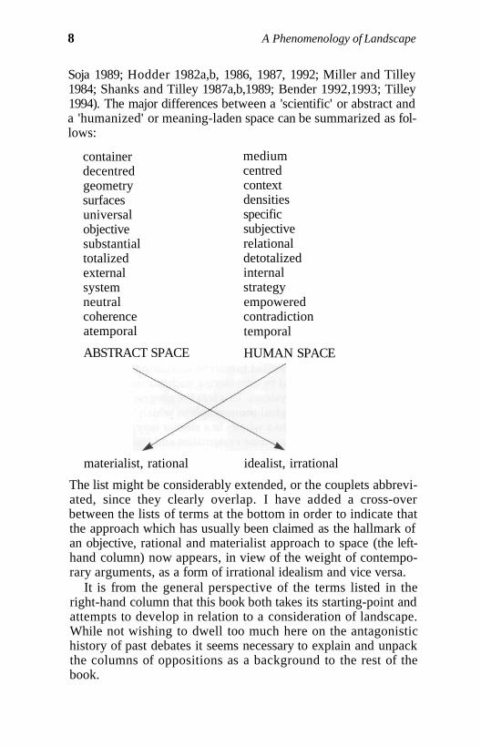
Soja 1989; Hodder 1982a,b, 1986, 1987, 1992; Miller and Tilley1984; Shanks and Tilley 1987a,b,1989; Bender 1992,1993; Tilley1994). The major differences between a 'scientific' or abstract anda 'humanized' or meaning-laden space can be summarized as fol-lows:
containerdecentredgeometrysurfacesuniversalobjectivesubstantialtotalizedexternalsystemneutralcoherenceatemporal
ABSTRACT SPACE
mediumcentredcontextdensitiesspecificsubjectiverelationaldetotalizedinternalstrategyempoweredcontradictiontemporal
HUMAN SPACE
materialist, rational idealist, irrational
The list might be considerably extended, or the couplets abbrevi-ated, since they clearly overlap. I have added a cross-overbetween the lists of terms at the bottom in order to indicate thatthe approach which has usually been claimed as the hallmark ofan objective, rational and materialist approach to space (the left-hand column) now appears, in view of the weight of contempo-rary arguments, as a form of irrational idealism and vice versa.
It is from the general perspective of the terms listed in theright-hand column that this book both takes its starting-point andattempts to develop in relation to a consideration of landscape.While not wishing to dwell too much here on the antagonistichistory of past debates it seems necessary to explain and unpackthe columns of oppositions as a background to the rest of thebook.
8
Space, Place, Landscape and Perception
New geography and new archaeology considered space as anabstract dimension or container in which human activities andevents took place. The implication of this perspective was thatactivity and event and space were conceptually and physicallyseparate from each other and only contingently related. Such aview of space decentred it from agency and meaning. It wassomething that could be objectively measured in terms of anabstracted geometry of scale. Space was quite literally a nothing-ness, a simple surface for action, lacking depth. This space wasuniversal, everywhere and anywhere the same, and had cross-cultural impact on people and society. People had to move acrossthis space, and movement through it, for example, created 'friction'limiting human potentialities. The effects of distance and thevarying potentialities of site locations could be objectively speci-fied on one and the same spatial scale of measurement. Space ascontainer, surface and volume was substantial inasmuch as itexisted in itself and for itself, external to and indifferent to humanaffairs. The neutrality of this space resulted in its being divorcedfrom any consideration of structures of power and domination. Aspace divorced from humanity and society provided a coherentand unitary backdrop for any analysis, since it was always thesame. The space of the palaeolithic was the same as the space oflate capitalism, that of Vancouver identical to that of Canberra.As a dimension in which human action took place it was directlyequivalent to and separate from time, the second primary andabstracted scale according to which societal change could be doc-umented and 'measured'.
The attraction of this perspective was, no doubt, its purity andsimplicity and the potential it offered for comparative studies ofthe organization of artefacts, sites, populations, and flows ofinformation and exchange across regions and landscapes. Allcould be objectively plotted on maps, distances measured andexpressed according to the same rigorous and quantitative scale.
Quantification, mathematization and computer modellingseemingly offered unlimited potential for unravelling the spatialfix of human affairs. Burning issues of the day in geography andarchaeology became what sampling fractions to use, how to con-struct appropriate boundaries for a nearest-neighbour analysis,what were the best statistics to use and the development of alter-native methodologies for measuring and describing the abstractgeometry of space. Lurking beneath the distribution of the dotson a map was a spatial process and causality to be discovered.
9
10 A Phenomenology of Landscape
The linkages between new geography and new archaeologywere quite explicit. Clarke's Models in Archaeology (1972) wasitself modelled on Chorley and Haggett's Models in Geography(1967), Harvey's Explanation in Geography (1969) found its archae-ological counterpart in Explanation in Archaeology (Watson et al.1971). Clarke (1972) identified a 'geographical paradigm' toarchaeological research which was simply the extension of thespatial methodology of the new geography to archaeological evi-dence, while Renfrew (1969) predicted that the texts of new geog-raphers would provide source books in methods for futuregenerations of archaeologists.
Accordingly 'new' geography was systematically used to pro-vide the basis for a mathematical spatial archaeology (Hodderand Orton 1976; Clarke 1977). The traditional archaeological dis-tribution map of sites and artefacts now became clothed withthiessen polygons, site catchments, regression lines, trend sur-faces and gravity models, all reflecting in various ways the 'fric-tion' and impact of space on human affairs (for reviews seeGoudie 1987; Wagstaff 1987a).
The alternative view starts from regarding space as a mediumrather than a container for action, something that is involved inaction and cannot be divorced from it. As such, space does notand cannot exist apart from the events and activities withinwhich it is implicated. Space is socially produced, and differentsocieties, groups and individuals act out their lives in differentspaces. Space in itself no longer becomes a meaningful term.There is no space, only spaces. These spaces, as social produc-tions, are always centred in relation to human agency and areamenable to reproduction or change because their constitutiontakes place as part of the day-to-day praxis or practical activity ofindividuals and groups in the world. They are meaningfully con-stituted in relation to human agency and activity. A humanizedspace forms both the medium and outcome of action, both con-straining and enabling it. A centred and meaningful spaceinvolves specific sets of linkages between the physical space ofthe non-humanly created world, somatic states of the body, themental space of cognition and representation and the space ofmovement, encounter and interaction between persons andbetween persons and the human and non-human environment.Socially produced space combines the cognitive, the physical andthe emotional into something that may be reproduced but isalways open to transformation and change. A social space, rather
Space, Place, Landscape and Perception 11
than being uniform and forever the same, is constituted by differ-ential densities of human experience, attachment and involve-ment. It is above all contextually constituted, providingparticular settings for involvement and the creation of meanings.The specificity of place is an essential element in understandingits significance. It follows that the meanings of space alwaysinvolve a subjective dimension and cannot be understood apartfrom the symbolically constructed lifeworlds of social actors.Space has no substantial essence in itself, but only has a relation-al significance, created through relations between peoples andplaces. Space becomes detotalized by virtue of its relational con-struction and because, being differentially understood and pro-duced by different individuals, collectivities and societies, it canhave no universal essence. What space is depends on who isexperiencing it and how. Spatial experience is not innocent andneutral, but invested with power relating to age, gender, socialposition and relationships with others. Because space is differen-tially understood and experienced it forms a contradictory andconflict-ridden medium through which individuals act and areacted upon. The experience of space is always shot through withtemporalities, as spaces are always created, reproduced andtransformed in relation to previously constructed spaces provid-ed and established from the past. Spaces are intimately related tothe formation of biographies and social relationships.
Such a notion of space is undoubtedly complex. There is andcan be no clear-cut methodology arising from it to provide a con-cise guide to empirical research. The approach requires, rather, acontinuous dialectic between ideas and empirical data. From thisperspective, the intimate connection of space with the social, withthe formation of biographies, with action, event, power, contextand subjectivity, materializes or concretizes its specificity andimpact in the social world. We move from the irrational abstractedidealism of a geometrical universal space to an ontologicalgrounding of space in the differential structuring of human expe-rience and action in the world: a perspective which now requiresexamination in more detail.
A Phenomenological Perspective
The key issue in any phenomenological approach is the mannerin which people experience and understand the world.
12 A Phenomenology of Landscape
Phenomenology involves the understanding and description ofthings as they are experienced by a subject. It is about the rela-tionship between Being and Being-in-the-world. Being-in-the-world resides in a process of objectification in which peopleobjectify the world by setting themselves apart from it. Thisresults in the creation of a gap, a distance in space. To be humanis both to create this distance between the self and that which isbeyond and to attempt to bridge this distance through a varietyof means - through perception (seeing, hearing, touching), bodi-ly actions and movements, and intentionality, emotion andawareness residing in systems of belief and decision-making,remembrance and evaluation.
Let us think for a while of a farmhouse in the Black Forest, which wasbuilt some two hundred years ago by the dwelling of peasants. Herethe self-sufficiency of the power to let earth and heaven, divinitiesand mortals enter in simple oneness into things, ordered the house. Itplaced the farm on the wind-sheltered mountain slope looking south,among the meadows close to the spring. It gave it the wide overhang-ing shingle roof whose proper slope bears up under the burden ofsnow, and which, reaching deep down, shields the chambers againstthe storms of the long winter nights. It did not forget the altar cornerbehind the community table; it made room in its chamber for the hal-lowed places of childbed and the 'tree of the dead' - for that is whatthey call a coffin there: the Totenbaum - and in this way it is designedfor the different generations under one roof the character of theirjourney through time. A craft which, itself sprung from dwelling, stilluses its tools and frames as things, built the farmhouse (Heidegger1972: 338).
The fact is that if we want to describe it, we must say that my experi-ence breaks forth into things and transcends itself in them, because italways comes into being within the framework of a certain setting inrelation to the world which is the definition of my body ... Any per-ception of a thing, a shape or a size as real, any perceptual constancyrefers back to the positing of a world and of a system of experience inwhich my body is inescapably linked with phenomena. But the sys-tem of experience is not arrayed before me as if I were God, it is livedby me from a certain point of view; I am not the spectator, I aminvolved, and it is my involvement in a point of view which makespossible both the finiteness of my perception and its opening outupon the complete world as a horizon of every perception (Merleau-Ponty 1962: 303-4).
Space, Place, Landscape and Perception 13
I have let Heidegger and Merleau-Ponty set the scene. Fromrather different phenomenological perspectives, they have bothstressed important ontological characteristics of the relationshipbetween inhabited space and social Being-in-the-world. ForHeidegger 'spaces receive their essential being from locationsand not from "space"' (1972: 332). A mathematical 'space' of mea-surement contains no spaces, places or locations, for it is nothumanized. Spaces open up by virtue of the dwelling of humanityor the staying with things that cannot be separated: the earth, thesky and the constellations, the divinities, birth and death. Spaceis that something for which room is made. Building producesthings as locations and building and thinking both belong todwelling. Heidegger proposes a topological model for thinkingabout the relationship between people and the landscape as amatter of the 'thereness' of the self-disclosure of Being in and ofthe world. Cognition is not opposed to reality, but is whollygiven over in the total social fact of dwelling, serving to linkplace, praxis, cosmology and nurture.
If 'dwelling', in Heideggerian terms, forms a primordial partof that which it is to be human, this necessarily requires a consid-eration of the body as the privileged vantage point from whichthe world is apprehended. The kinetic activities of human beingsorientate apprehension of the landscape and create it as human.Space is existential, and existence is spatial in that it opens ontoan 'outside', a series of reference points (Merleau-Ponty 1962:293). Merleau-Ponty, like Heidegger, attempts to chart a middlecourse between an empiricist objectivism and a cognitive ideal-ism. With empiricist objectivism, the perception of space and theenvironment, like everything else, is an event in nature.Perception is the causal physical or chemical action of a thing onan organ which sensation registers. Everything takes place in aworld of pure objectivity, and there is no subject who perceives.Conversely, a cognitive idealism posits an absolute subjectivityinvolving a transcendental Ego who is the subject of experience.In a relation of pure interiority the objective world exists only inrelation to a consciousness which projects that world before itself.For Merleau-Ponty the problem of both of these positions is thatthey systematically evade the problem of the phenomenon ofperception, empiricism because it makes an object of the subject,cognitive idealism because it reduces the perception of the objectto an operation of thought (ibid.: 39). Merleau-Ponty argues that
14 A Phenomenology of Landscape
the human body provides the fundamental mediation pointbetween thought and the world. The world and the subject reflectand flow into each other through the body that provides the liv-ing bond with the world. Notions of 'object' and 'subject','nature' and 'consciousness' are dialectically related moments ofa totality which is constituted through the Being of the body inthe world. The body constitutes a way of relating to, perceivingand understanding the world. It is the manner in which a subjec-tive attitude comes to both know and express itself. Perceptualconsciousness is not just a matter of thought about the world, butstems from bodily presence and bodily orientation in relation toit, bodily awareness: 'far from my body's being for me no morethan a fragment of space, there would be no space at all for me ifI had no body' (ibid.: 102).
While 'dwelling' occurs in different varieties and textures ofhumanly created space, this social existence is, of course, rootedin natural and non-humanly created environments. The conceptof dwelling, with its fourfold ontological implications as pointedout by Heidegger, the human body as a focus for the perceptionof a humanized world, and the groundedness of social Being inthat which is not humanly created constitute the fundamentalpresuppositions for beginning to think about the relationshipbetween people and landscape in a fresh manner. Subjectivityand objectivity connect in a dialectic producing a place for Being inwhich the topography and physiography of the land and thoughtremain distinct but play into each other as an 'intelligible land-scape', a spatialization of Being, which I will now examine in aless abstract manner.
Space and Place
If space allows movement, place is pause (Taun 1977: 6).
The relationship between space and place has been discussed andtheorized from one particular perspective within a phenomeno-logical 'school' of geographical research (Taun 1974, 1975,1977;Pickles 1985; Relph 1976; Buttimer and Seamon 1980; Seamonand Mugerauer 1989). The key concern in this approach is themanner in which places constitute space as centres of humanmeaning, their singularity being manifested and expressed in the
Space, Place, Landscape and Perception 15
day-to-day experiences and consciousness of people within par-ticular lifeworlds. Such an approach starts from an initial presup-position claiming the wholeness and indivisibility of a humanexperience of place, and that meaning, defined in terms of struc-tures of intentionality, is central to any understanding of place.Knowledge of place stems from human experiences, feeling andthought. Space is a far more abstract construct than place. It pro-vides a situational context for places, but derives its meaningsfrom particular places (Relph 1976: 8). Without places there canbe no spaces, and the former have primary ontological signifi-cance as centres of bodily activity, human significance and emo-tional attachment. The meaning of place is grounded inexistential or lived consciousness of it. It follows that the limits ofplace are grounded in the limits of human consciousness. Placesare as diffuse and differentiated as the range of identities and sig-nificances accorded to them. People are immersed in a world ofplaces which the geographical imagination aims to understandand recover - places as contexts for human experience, construct-ed in movement, memory, encounter and association. There maybe a strong affection for place (topophilia) or aversion (topopho-bia), but places are always far more than points or locations,because they have distinctive meanings and values for persons.Personal and cultural identity is bound up with place; a topo-analysis is one exploring the creation of self-identity throughplace. Geographical experience begins in places, reaches out toothers through spaces, and creates landscapes or regions forhuman existence.
Attempts have been made in the literature to generalize thespecificity of place by erecting typologies of particular kinds ofspaces through which the identities of place are constructed.Such classifications can only act as heuristic devices, since it canbe argued that places, by their very nature, contain sedimentedmeanings which resist such boxing and bracketing of theirnatures and significance. The following forms of space might beidentified:
1. Somatic space2. Perceptual space3. Existential space4. Architectural space5. Cognitive space
16 A Phenomenology of Landscape
Somatic space is a space of habitual and unselfconsciousaction. It is the space of sensory experience and bodily move-ment. An understanding of this space takes as its starting-pointthe upright human body looking out on the world. Space opensout before the body and is differentiable in terms of front/back;left/right; vertical/horizontal; top/bottom; within reach/beyond reach; within hearing/beyond hearing; within sight/beyond sight; here/there polarities (Relph 1976: 9; Taun 1977:35-50). The very physicality of the body imposes a schema onspace through which it may be experienced and understood. Anexperience of space is grounded in the body itself; its capacitiesand potentialities for movement. Through time-space routines ofmovement a person knows where she or he is in relation to famil-iar places and
Space, Place, Landscape and Perception 17
through life-activity, a sacred, symbolic and mythic space repletewith social meanings wrapped around buildings, objects and fea-tures of the local topography, providing reference points andplanes of emotional orientation for human attachment andinvolvement. Places in existential space are foci for the produc-tion of meaning, intention and purpose of societal significance.Boundaries are of major significance in structuring existentialspace both in and between places and regions. Boundaries are todo with creating distinctions and marking out social oppositions,mapping social and cultural difference and Otherness. The pres-ence of boundaries, obvious natural prototypes being river cours-es, mountain chains, or rock outcrops, and the coast, may be ofmajor significance in delimiting territories, the choice of localesand the networking of paths through a landscape.
Architectural space only makes sense in relation to pragmatic,perceptual and existential space, but involves a deliberateattempt to create and bound space, create an inside, an outside, away around, a channel for movement. Architecture is the deliber-ate creation of space made tangible, visible and sensible. This iswhy buildings play a fundamental role in the creation and recre-ation, production and reproduction of existential space and haveprofound structuring effects on perceptual space.
Finally, cognitive space provides a basis for reflection and the-orization with regard to understanding the others. It is the 'space'of this discussion and analysis.
Space can only exist as a set of relations between things orplaces. In this sense there is no space that is not relational. Spaceis created by social relations, natural and cultural objects. It is aproduction, an achievement, rather than an autonomous realityin which things or people are located or 'found'. Having beenconstituted by things and places spatial relations affect the way inwhich they relate. In other words, there is a sociospatial dialecticat work - space is both constituted and constitutive.
Locales, Social Action
Places may, of course, be experienced and conceptualized at anynumber of spatial levels, from personal space to communityspace to regional space and so on. Places overlap according toscales of action, interest, movement and concern. Place is an
18 A Phenomenology of Landscape
irreducible part of human experience, a person is 'in place' just asmuch as she or he is 'in culture'. Place is about situatedness inrelation to identity and action. In this sense place is context, andthere can be no non-contextual definition of context or place. Thespecificity of space always has to be understood from a particularviewpoint.
In small-scale non-Western societies place, defined as a centrefor action, intention and meaningful concern, can be best consid-ered in terms of locales and the wider context in which theselocales occur - the cultural and natural landscape. Most signifi-cant places are located or positioned in space. Locales are placescreated and known through common experiences, symbols andmeanings. They may be rooms, houses, monuments, meeting-places, camps or settlements. Locales may offer a distinct qualityof being inside, or part of, a place. People both live out their livesin place and have a sense of being part of it. Consequently, placeis fundamental to the establishment of personal and group iden-tities and the formation of biographies. Place is both 'internal'and 'external' to the human subject, a personally embedded cen-tre of meanings and a physical locus for action. All places thushave metonymic qualities (places and their contents consist ofpart-whole relations) and differential densities of meanings totheir inhabitants according to the events and actions they wit-ness, partake in and remember. A sense of attachment to place isfrequently derived from the stability of meanings associated withit.
The naming and identification of particular topographicalfeatures, such as sand dunes, bays and inlets, mountain peaks,etc., settlements and sites is crucial for the establishment andmaintenance of their identity. Through an act of naming andthrough the development of human and mythological associa-tions such places become invested with meaning and signifi-cance. Place names are of such vital significance because they actso as to transform the sheerly physical and geographical intosomething that is historically and socially experienced. Thebestowing of names creates shared existential space out of ablank environment (Basso 1984: 27; Weiner 1991: 32). By theprocess of naming places and things they become captured insocial discourses and act as mnemonics for the historical actionsof individuals and groups. Without a name culturally significantsites would not exist, but only as a raw void, a natural environ-
Space, Place, Landscape and Perception 19
ment. In a fundamental way names create landscapes. Anunnamed place on a map is quite literally a blank space. Namesmay create places of human import; but they do so in relation tothe raw material at hand. For example, the vast majority ofWestern Apache place-names are lengthy and made up ofdescriptions of the locations to which they refer, for example tsekdtú yahilíí (water flows downward on top of a series of flat rocks)or 'coarse-textured rocks lie above in a compact cluster' (Basso1984: 28, 37). Place-names are used in Apache story-telling as sit-uational or contextualizing devices for locating narrative eventsin physical settings. The description of the setting is accom-plished by the use of the place-name itself (see below).
From the perspective of structuration theory Giddens hasemphasized the role of locales in processes of social productionand reproduction (Giddens 1979, 1981, 1984). Structure consid-ered as a set of rules and resources for action is the mediumthrough which action is produced, both enabling and constrain-ing it. Structure is also a product of action, and is created, repro-duced and changed through the meaningful action of agents.Action affects structure by virtue of its temporal and spatialspecificity. Time and space are components of action rather thancontainers for it. Space plays an important part in defining themanner in which social interaction takes place and the signifi-cance it has for agents. Locales are settings in which interactiontakes place. 'A setting is not just a spatial parameter, and physicalenvironment, in which interaction occurs: it is these elementsmobilized as part of the interaction. Features of the setting ofinteraction, including its spatial and physical aspects ... are rou-tinely drawn upon by social actors in the sustaining of communi-cation' (Giddens 1979: 206). Spatial contingency and difference inthis formulation have clear effects on the manner in which agentsinterrelate, but this needs to be viewed as a dialectic rather than acausal relationship in order to avoid the pitfalls of a spatialfetishism or an environmental determinism (Saunders 1989;Duncan 1989). Actors draw on their settings; and the manner inwhich they do so depends upon the specificity of their relation-ship to place. In this manner locales, in the most general sense,can be defined as a presencing of potentialities on which actorsdraw in the daily conduct of their activities.
Giddens extends the usage of the term locale to include large-scale territorial aggregations such as nation states or empires. It
20 A Phenomenology of Landscape
thus becomes a nested concept on a sliding spatial scale, in whichdistinctions between locale, locality, region, etc. become blurred.It is far better to confine the usage of the term to the small-scaleand the specific. Locales occur in localities, regions or landscapes.Duncan (1989) seriously questions whether there is anythingsuch as locality which can be meaningfully distinguished fromthe non-local recounting the quip that regional geographers are'trying to put boundaries that do not exist around regions that donot matter' (Duncan 1989: 238). But he is writing within the con-text of the development of a theoretical geography of the modernworld system. While we might accept that it is virtually impossi-ble to distinguish distinctive spatial parameters of whatevermight be defined as 'locality' within contemporary Britain such aconclusion is anachronistic and unhelpful when transferred tothe past. A sense of 'placelessness' referred to by Relph (1976)and others in contemporary society is, in essence, to do with thesystematic erosion of locality as meaningful. This discussioninevitably brings us to the politics of space.
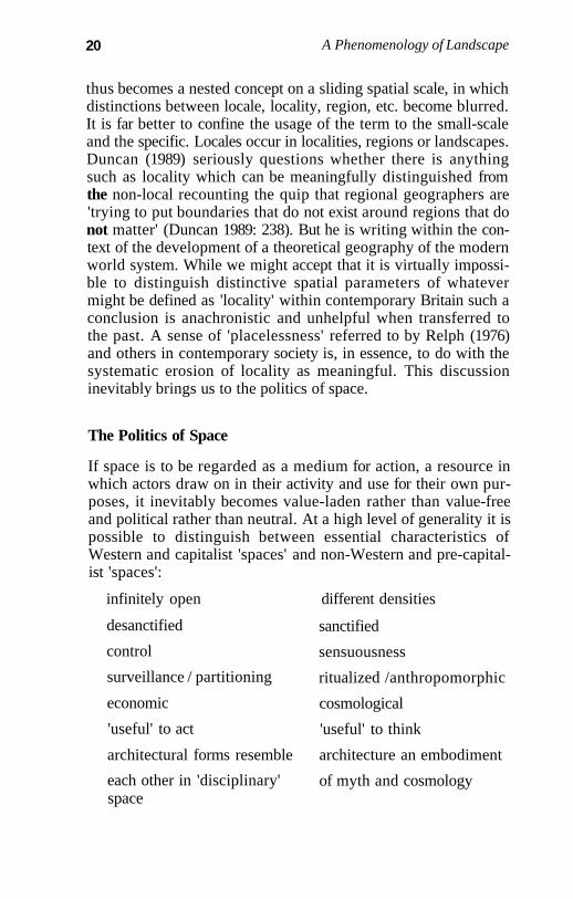
The Politics of Space
If space is to be regarded as a medium for action, a resource inwhich actors draw on in their activity and use for their own pur-poses, it inevitably becomes value-laden rather than value-freeand political rather than neutral. At a high level of generality it ispossible to distinguish between essential characteristics ofWestern and capitalist 'spaces' and non-Western and pre-capital-ist 'spaces':
infinitely open different densities
desanctified
control
surveillance / partitioning
economic
'useful' to act
architectural forms resemble
each other in 'disciplinary'space
sanctified
sensuousness
ritualized /anthropomorphic
cosmological
'useful' to think
architecture an embodiment
of myth and cosmology
Space, Place, Landscape and Perception 21
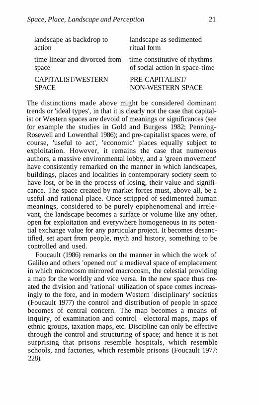
landscape as backdrop to landscape as sedimentedaction ritual form
time linear and divorced from time constitutive of rhythmsspace of social action in space-time
CAPITALIST/WESTERN PRE-CAPITALIST/SPACE NON-WESTERN SPACE
The distinctions made above might be considered dominanttrends or 'ideal types', in that it is clearly not the case that capital-ist or Western spaces are devoid of meanings or significances (seefor example the studies in Gold and Burgess 1982; Penning-Rosewell and Lowenthal 1986); and pre-capitalist spaces were, ofcourse, 'useful to act', 'economic' places equally subject toexploitation. However, it remains the case that numerousauthors, a massive environmental lobby, and a 'green movement'have consistently remarked on the manner in which landscapes,buildings, places and localities in contemporary society seem tohave lost, or be in the process of losing, their value and signifi-cance. The space created by market forces must, above all, be auseful and rational place. Once stripped of sedimented humanmeanings, considered to be purely epiphenomenal and irrele-vant, the landscape becomes a surface or volume like any other,open for exploitation and everywhere homogeneous in its poten-tial exchange value for any particular project. It becomes desanc-tified, set apart from people, myth and history, something to becontrolled and used.
Foucault (1986) remarks on the manner in which the work ofGalileo and others 'opened out' a medieval space of emplacementin which microcosm mirrored macrocosm, the celestial providinga map for the worldly and vice versa. In the new space thus cre-ated the division and 'rational' utilization of space comes increas-ingly to the fore, and in modern Western 'disciplinary' societies(Foucault 1977) the control and distribution of people in spacebecomes of central concern. The map becomes a means ofinquiry, of examination and control - electoral maps, maps ofethnic groups, taxation maps, etc. Discipline can only be effectivethrough the control and structuring of space; and hence it is notsurprising that prisons resemble hospitals, which resembleschools, and factories, which resemble prisons (Foucault 1977:228).
22 A Phenomenology of Landscape
Relph comments that 'the paradox of modern landscapes isthat they are dehumanising because they are excessively human-ised. There is almost nothing in them that has not been conceivedand planned so that it will serve those human needs which can beassessed in terms of efficiency or improved material conditions.But there is almost nothing in them that can happen sponta-neously, autonomously or accidentally, or which expresseshuman emotions and feelings' (Relph 1981: 104). This oppositionbetween a past of supposed 'spontaneity' and 'freedom' and apresent of rational calculation and control seems somewhat over-drawn. If the political qualities of a capitalist landscape relate to adominant cultural construction of a 'useful', disciplinary space ofsocial control, pre-capitalist spaces are no less invested withforms of power, but within a qualitatively different landscapeinvested with mythological understandings and ritual knowl-edges intimately linked with bodily routines and practices.
Landscape and the Scape of Praxis
Spaces and places relationally constitute wider contexts for socialpractices-landscapes. Anthropologists and archaeologists havebeen interested for a long time in the relationships between peo-ple and the landscape, conceived rather narrowly as 'environ-mental milieu', but for the most part research has tended to focuson functional and supposedly adaptive parameters of these rela-tionships, with matters such as population levels, resource 'ceil-ings' and environmental constraints. The vast majority of studiesof hunter-fisher-gatherers have tended to concentrate rather nar-rowly on issues such as the ranges of food resources exploited,food-getting technologies, seasonality and scheduling in relationto settlement size, location and group composition, and degree ofmobility. In this approach myths, cosmologies and symbolismare largely deemed irrelevant to what is really going on. Whatpeople think about the environment has little or no affect on thepractical exigencies of having to live in it. On the other hand,there exists a vast body of literature concerned with the analysisof ritual performance and cosmological and social structures inwhich the environment is equally irrelevant, a mere backdrop tothe unconstrained ramifications of the human mind.
Space, Place, Landscape and Perception 23
A naturalistic view of landscape as a neutral backdrop to activ-ity is clearly of recent origin in thought, an irrelevance in consid-ering pre-capitalist landscapes, and a hindrance in theirconceptualization. It is also a highly ideological construct whichrequires deconstruction even in the context of capitalist land-scapes. A culturalist view of landscape as a highly specific, sym-bolic and cognitive ordering of space offers far more potential inunderstanding but, as Ingold argues (Ingold 1992,1993), encloseshumanity into a series of separate cultural worlds constituted asstructured sets of shared representations divorced from 'nature'or the physical world. This external world provides a source ofraw sense data, without order or meaning and, in perception,these data become 'detached (as "stimuli") from the environmentand attached (as "sensations") to human subjects' (Ingold 1992:51). They are then ordered into cultural schemata. The line ofargument taken here is akin to parts of that recently advanced byIngold, which he terms a 'dwelling perspective'. People and envi-ronment are constitutive components of the same world, which itis unhelpful to think of in terms of a binary nature/culture dis-tinction. In the perception of the world and in the consumption ofresources (utilitarian or symbolic) from that world meaningsembodied in environmental objects are drawn into the experi-ences of subjects. Perception of the world and the constitution ofthat which is important or unimportant to people does not workin terms of a 'blank environmental slate' on which perceptionand cognition sets to work, but in terms of the historicity of livedexperiences in that world. The landscape is an anonymous sculp-tural form always already fashioned by human agency, nevercompleted, and constantly being added to, and the relationshipbetween people and it is a constant dialectic and process of struc-turation: the landscape is both medium for and outcome of actionand previous histories of action. Landscapes are experienced inpractice, in life activities.
Ingold argues that 'the cultural construction of the environ-ment is not so much a prelude to practical action as an (optional)epilogue' and 'culture is a framework not for perceiving the world,but for interpreting it, to oneself and others' (Ingold 1992: 52-3). Itseems unhelpful to polarize, as Ingold appears to do, perceptionand interpretation, practical activity and the cultural work ofexplication and discourse. To ask: 'Which comes first: practicalactivity or cultural knowledge?' is to set up artifical barriers
24 A Phenomenology of Landscape
between practical activities and discursive levels of conscious-ness that go to constitute each other, neither of which is amenableto prioritization. The cultural construction of the environment isboth 'prelude' and 'epilogue', and it does not necessarily involve'explication' or 'discourse', as Ingold assumes.
Features of the natural landscape may be held to have provid-ed a symbolic resource of the utmost significance to prehistoricpopulations. A number of ethnographies of small-scale societies,discussed in Chapter 2, of both hunter-gatherers and subsistencecultivators, indicate that rather than simply providing a back-drop for human action the natural landscape is a cognized formredolent with place names, associations and memories that serveto humanize and enculture landscape, linking together topo-graphical features, trees, rocks, rivers, birds and animals withpatterns of human intentionality. Significant locations becomecrystallized out of the environment through the production andrecognition of meanings in particular places and through eventsthat have taken place. Humanized places become fashioned outof the landscape through the recognition of significant qualitiesin that which has not in itself been culturally produced (rocks,rivers, trees, etc.) by association with current use, past socialactions or actions of a mythological character.
It is important not to forget that the contemporary term 'land-scape' is highly ideological. Cosgrove and Daniels define land-scape as 'a cultural image, a pictorial way of representing,structuring or symbolising surroundings' (Cosgrove and Daniels1988: 1). Such an image may be structured on canvas, in writingand on the ground through earth, stone and vegetation.Landscapes, in this rather limited definition, are images whichare created and read, verbal or non-verbal texts. RaymondWilliams (1973:120) notes that the very idea of landscape impliesseparation and observation. A concern with landscape is one ofpatrician control manifested in landscape painting, writing, gar-dening and architecture. Cosgrove (1984) locates the origins ofthe idea of landscape in early capitalist Italian Renaissance citystates: the city gives birth simultaneously to capitalism and land-scape. Landscape is a particular way of seeing, the linear tech-niques of perspective developed in landscape painting at thistime to create a 'realistic' image parallel the development of prac-tices such as cartography, astronomy, land surveying and map-ping involving formal geometrical rules. The whole notion of
Space, Place, Landscape and Perception 25
landscape, Cosgrove argues, propagates a visual ideology mask-ing the social forces and relations of production, relations ofexploitation and alienation.
Yet in a seemingly contradictory fashion Cosgrove also extolsthe virtues of landscape as concept and image:
landscape is a uniquely valuable concept for a humane geography.Unlike place it reminds us of our position in the scheme of nature.Unlike environment or space it reminds us that only through humanconsciousness and reason is that scheme known to us, and onlythrough technique can we participate as humans in it. At the sametime landscape reminds us that geography is everywhere, that it is aconstant source of beauty and ugliness, of right and wrong and joyand suffering, as much as it is of profit and loss' (Cosgrove 1989:122).
Daniels (1989), discussing the work of Williams and Berger inrelation to landscape and its representation through artworks,brings out a similar tension in their relation to the concept.Representations of landscape have the potential to both obscureand articulate lived experience. In other words landscape asimage has both ideological and ontological implications for theway in which we think about the world. Daniels rightly con-cludes that 'we should beware of attempts to define landscape, toresolve its contradictions; rather we should abide in its duplicity'(Daniels 1989: 218).
It is the ontological connotations of landscape stressed byCosgrove, in the passage cited above, that make it important toretain the term, to abide in the duplicity of using it at all. Asshould be clear from the preceding discussions, I reject a notionof landscape as inhering solely in the form of mental representa-tion and cognition. By 'landscape' I want instead to refer to thephysical and visual form of the earth as an environment and as asetting in which locales occur and in dialectical relation to whichmeanings are created, reproduced and transformed. The appear-ance of a landscape is something that is substantial and capable ofbeing described in terms of relief, topography, the flows of con-tours and rivers, coasts, rocks and soils, and so on. It is most usu-ally clearly defined features, such as mountain peaks, ridges,bogs and plains, that occur in geographical descriptions. Thelocales in a landscape may be natural features such as bays orinlets on a coastline or high points, or humanly created placessuch as monuments or settlements. Humanly created locales, I
26 A Phenomenology of Landscape
want to argue in this book, draw on qualities of landscape to cre-ate part of their significance for those who use them, and the per-ception of the landscape itself may be fundamentally affected bythe very situatedness of these locales. A fundamental part ofdaily experience in non-industrial societies is the physical andbiological experience of landscape - earth, water, wood, stone,high places and low places, the wind, rain, sun, stars and sky. Therhythms of the land and the seasons correspond to and areworked into the rhythms of life. A landscape has ontologicalimport because it is lived in and through, mediated, worked onand altered, replete with cultural meaning and symbolism - andnot just something looked at or thought about, an object merelyfor contemplation, depiction, representation and aestheticization.
Powers of Place
Precisely because locales and their landscapes are drawn on inthe day-to-day lives and encounters of individuals they possesspowers. The spirit of a place may be held to reside in a landscape.Familiarity with the land, being able to read and decode its signsallows individuals to know 'how to go on' at a practical level ofconsciousness or one that may be discursively formulated.People routinely draw on their stocks of knowledge of the land-scape and the locales in which they act to give meaning, assur-ance and significance to their lives. The place acts dialectically soas to create the people who are of that place. These qualities oflocales and landscapes give rise to a feeling of belonging androotedness and a familiarity, which is not born just out of knowl-edge, but of concern that provides ontological security. They giverise to a power to act and a power to relate that is both liberatingand productive.
The relationship of individuals and groups to locales and land-scape also has important perspectival effects. The experience ofthese places is unlikely to be equally shared and experienced byall, and the understanding and use of them can be controlled andexploited in systems of domination - a consideration strikinglyabsent in virtually all phenomenological theory and one that con-stitutes a major theoretical void. In small-scale societies the majoraxes of spatial domination are usually organized along the axesof age, gender, kin, and lineage. Knowledge and experience of
Space, Place, Landscape and Perception 27
particular locales and tracts of the landscape may be restrictedand hidden from particular individuals and groups. The powersof spatial experience are clearly related to the manner in whichthey are realized, to whom, when and how. Features of the set-tings of social interaction may constitute 'disciplinary' spacesthrough which knowledge is controlled or acquired in a highlystructured manner. The ability to control access to and manipu-late particular settings for action is a fundamental feature of theoperation of power as domination.
Time, Memory and Movement
Human activities become inscribed within a landscape such thatevery cliff, large tree, stream, swampy area becomes a familiarplace. Daily passages through the landscape become biographicencounters for individuals, recalling traces of past activities andprevious events and the reading of signs - a split log here, amarker stone there.
All locales and landscapes are therefore embedded in thesocial and individual times of memory. Their pasts as much astheir spaces are crucially constitutive of their presents. Neitherspace nor time can be understood apart from social practiceswhich serve to bind them together. The human experience ofencountering a new place or knowing how to act or go on in afamiliar place is intimately bound up with previous experiences.Places are always 'read' or understood in relation to others.While places and movement between them are intimately relatedto the formation of personal biographies, places themselves maybe said to acquire a history, sedimented layers of meaning byvirtue of the actions and events that take place in them. Personalbiographies, social identities and a biography of place are inti-mately connected. Memories of previous moves in a landscapeare as essential to understanding as they are in playing a game ofchess. Remembrance is a process solidified from things and spa-tial encounters. Movement in the world always involves a loss ofplace, but the gaining of a fragment of time. It sets up a series ofexpectations for the paths of the future. Memories continuallyprovide modifications to a sense of place which can never beexactly the same place twice, although there may be ideologicalattempts to provide 'stability' or perceptual and cognitive fixity
28 A Phenomenology of Landscape
to a place, to reproduce sets of dominant meanings, understand-ings, representations and images.
There is an art of moving in the landscape, a right way (social-ly constrained) to move around in it and approach places andmonuments. Part of the sense of place is the action of approach-ing it from the 'right' (socially prescribed) direction. To mentionjust one example here, the Gabbra camel herders of theKenyan-Ethiopian borderlands undertake ritual pilgrimages andperform periodic rituals at holy mountain sites surrounded byplains. These jila journeys are a return to the origin sites of indi-vidual Gabbra lineages. The journeys establish spatial linkagesbetween different mountains or mountain peaks and given lin-eages. Through the journey the lineage becomes 'mapped' in theterrain. The shortest route to a ritual mountain from any point onthe plain is not taken but rather a prescribed walk in which it canbe approached and seen from the propitious direction (Schlee1992).
A walk is always a combination of places and times- seasonaland social times. De Certeau (1984: Part III) has described an artof walking which is simultaneously an art of thinking and an artof practice or operating in the world. Movement through spaceconstructs 'spatial stories', forms of narrative understanding.This involves a continuous presencing of previous experiences inpresent contexts. Spatial knowledge requires the coupling of anaccumulated time of memory to overcome an initially hostile andalienating encounter with a new place. Flashes of memory, so tospeak, illuminate the occasion.
Pedestrian 'speech acts' may be likened to the speech acts oflanguage. Walking is a process of appropriation of the topo-graphical system, as speaking is an appropriation of language. Itis a spatial acting out of place, as the speech act is an acousticacting out of language. Walking, like language use, implies rela-tionality in terms of an overall system of differences. It is a move-ment with reference to a differentiated series of locales, just aslanguage is constituted as a system of differences between signs -'dog' is dog because it is not cat, and so on (de Certeau 1984: 98).
A spatial order of walking can be characterized in terms of anorder of possibilities - various ways in which an actor can move,and a series of restrictions, for example walls or other boundariesinhibiting passage. A walker actualizes only some of the possibil-ities, which may be relatively open or closed in terms of the over-
Space, Place, Landscape and Perception 29
all 'grammatical' system. These possibilities remain only aspotentialities in so far as they only exist in the act of their realiza-tion through movement in the world. Through movement partsof the system - places or paths - are ignored, condemned to iner-tia, while others are activated through use or presence. DeCerteau goes further than this to refer to a 'rhetoric' and 'tropes'of walking, which can be likened to turns of phrase. An art of'turning phrases' provides an analogy for an individual's follow-ing or diverging from paths; both of them constituting ways ofbeing, thinking and operating in the world. Synecdoche is an artof speaking in which a part stands for a whole (sail for ship, treefor forest, monument for landscape). In walking a street may sub-stitute for a community, a path for a network of paths. The part isexpanded into something more, a totality. Asyndeton, an art ofspeaking involving the suppression of linking words such as con-junctions between or within sentences, finds a spatial expressionin the cutting out of places. Synecdoche then creates spatial den-sities; asyndeton undermines or cuts through continuities.
A space treated in this way and shaped by practices is transformedinto enlarged singularities and separate islands. Through theseswellings, shrinkages, and fragmentations, that is through theserhetorical operations a spatial phrasing of an analogical (composed ofjuxtaposed citations) and elliptical (made of gaps, lapses and allu-sions) type is created. For the technological system of a coherent andtotalizing space that is 'linked' and simultaneous, the figures ofpedestrian rhetoric substitute trajectories ... [which are a] stylisticmetamorphosis of space (de Certeau 1984:101-2).
The important aspect of this argument is its revelation of an artof walking as simultaneously an art of consciousness, habit andpractice, that is both constrained by place and landscape and con-stitutive of them. Walking is the medium and outcome of a spa-tial practice, a mode of existence in the world. The analogy can betaken further in the consideration of paths.
Paths, Inscriptions, Temporality
If writing solidifies or objectifies speech into a material medium,a text, which can be read and interpreted, an analogy can bedrawn between a pedestrian speech act and its inscription or

30 A Phenomenology of Landscape
writing on the ground in the form of the path or track. Both aresedimented traces of activity, and both provide ways to be fol-lowed. A strong path is inscribed through a forest or across a tractof heathland through a multitude of pedestrian speech acts thatkeep it open; a strong text is also one that is kept open, read manytimes. Just as the writing of a text is dependent on previous texts(it has the characteristic of intertextuality), the creation or mainte-nance of a path is dependent on a previous networking of move-ments in particular, and reiterated directions through alandscape; it works in relation to a previous set of precedents.
The metaphor of the path is a common one in many small-scale societies, and refers beyond itself to patterns of activity andsocial organization. A path may be a way of doing something asmethod, technique, pattern or strategy. In Oceania and Indonesiafishing techniques, oratorical skills, patterns of exchange andstrategies of warfare are also termed 'paths'. Paths are also fun-damentally to do with establishing and maintaining social link-ages and relations between individuals, groups and politicalunits. Social paths and the paths followed through the forest maybecome overgrown through lack of use in any particular (physi-cal or social) direction.
Parmentier (1987: 109-11) notes three general features of thesemantic fields of paths on the island of Belau derived fromreflections on movements made along them. First, points linkedby a clear path have achieved a degree of structural homologyand hence positive cultural identity. The points linked by pathsshare sets of common elements - sacred stones, trees, artefactdepositions, names and titles referred to in myths and stories andlinked to the activities of ancestors who stopped on the journeywhich created the path. Second, linked places on paths can beunderstood in terms of sequential precedence, a hierarchy ofancestral origin points from which paths radiate to others.Priority in time is linked to the ceremonial precedence and powerof places linked by paths. Third, paths structure experiences ofthe places they link, they help to establish a sense of linear order.A path brings forth possibilities for repeated actions within pre-scribed confines. Only a high-ranking or wealthy person is likelyto be daring enough to invent a path or plant a relationship notestablished before. Such action is most usually the domain of the
Space, Place, Landscape and Perception 31
gods or heroic ancestors. Expert knowledge of ancient paths ispart of the responsibility of chiefs who can harness great powerby narrating stories recounting previous patterns of ancestralmovements (ibid.: 114-15).
A journey along a path can be claimed to be a paradigmaticcultural act, since it is following in the steps inscribed by otherswhose steps have worn a conduit for movement which becomesthe correct or 'best way to go'. Spatiotemporal linkages thusestablished become obvious templates for future movements andthe maintenance of relationships. Linked places along the journeymay be read in terms of temporal relationships of precedence andpower. There is usually a good reason for following in a particu-lar direction linking places in a serial trajectory, and the morepeople who have shared in the purpose of the path the moreimportant it becomes. Paths form an essential medium for therouting of social relations, connecting up spatial impressionswith temporally inscribed memories.
Spatial Stories, Landscape and the Arts of Narrative
In movement on a path through the landscape something is con-stantly slipping away and something is constantly gained in arelational tactile world of impressions, signs, sights, smells andphysical sensations. To understand a landscape truly it must befelt, but to convey some of this feeling to others it has to be talkedabout, recounted, or written and depicted. In the process ofmovement a landscape unfolds or unravels before an observer.Beyond one chain of hills another is revealed; the view from alocale makes sense of its positioning. The importance and signifi-cance of a place can only be appreciated as part of movementfrom and to it in relation to others, and the act of moving may beas important as that of arriving. The path may be a symbol notonly of interconnectedness and social relations but of movementthrough life. If places are read and experienced in relation toothers and through serial movement along the axes of paths itfollows that an art of understanding of place, movement andlandscape must fundamentally be a narrative understandinginvolving a presencing of previous experiences in presentcontexts. Spatial and textual stories are embedded in one another.
32 A Phenomenology of Landscape
Narrative structure and emplotment can easily be claimed tohave ontological significance for human existence, to be as uni-versal as language itself. It is precisely because narrative is seem-ingly so 'natural' a part of human existence that it is both animportant resource for analysis and understanding and some-thing whose non-critical use as merely description is something tobe wary of. A critical understanding of spatial narrative requiresthat we investigate precisely why we prefer some plots or config-urations of things rather than others. In other words attentionmust be played to the manner in which the story is creativelyorchestrated, how it guides, and what it passes through.
Narrative is a means of understanding and describing theworld in relation to agency. It is a means of linking locales, land-scapes, actions, events and experiences together providing a syn-thesis of heterogeneous phenomena. In its simplest form itinvolves a story and a story-teller. In its mimetic or phenomeno-logical form narrative seeks to capture action not just throughdescription but as a form of re-description. Events are givenmeaning through their configuration into a whole requiring theemplotment of action. A narrative must of necessity always bewritten from a certain point of view. In relation to the past andwritten from the standpoint of the present, narrative structuresplay a similar role to metaphor - they describe the world in freshways, bringing new meanings and new senses, and the produc-tivity is, in principle, endless. Ricoeur (1983) rightly emphasizesthe poetic qualities of narratives in producing configurations ofevents and objects that go far beyond a simple matter of succes-sion, i.e. this occurs after or because of that.
De Certeau (1984) points out that every story not only involvessome kind of temporal movement, but is also a spatial practice.Stories organize walks, making a journey as the feet perform it,organizing places by means of the displacements that aredescribed. They are part of a human labour that transforms anabstract homogeneous space into place - 'you go round the cor-ner, turn left and you'll see...'. In other words the story is a dis-cursive articulation of a spatializing practice, a bodily itineraryand routine. Spatial stories are about the operations and practiceswhich constitute places and locales. The map, by contrast,involves a stripping away of these things: 'it alone remains on theStage. The tour describers have dissappeared´ (de Certeau 184
Space, Place, Landscape and Perception 33
121). If stories are linked with regularly repeated spatial prac-tices they become mutually supportive, and when a storybecomes sedimented into the landscape, the story and the placedialectically help to construct and reproduce each other. Placeshelp to recall stories that are associated with them, and placesonly exist (as named locales) by virtue of their emplotment in anarrative. Places, like persons, have biographies inasmuch asthey are formed, used and transformed in relation to practice. Itcan be argued that stories acquire part of their mythic value andhistorical relevance if they are rooted in the concrete details oflocales in the landscape, acquiring material reference points thatcan be visited, seen and touched.
If naming is an act of construction of landscape, constitutingan origin point for it, then narratives introduce temporality, mak-ing locales markers of individual and group experiences. Basso(1984), in an excellent paper, demonstrates how individualApaches experience oral narratives: 'the land is always stalkingpeople. The land makes people live right' (Annie Peaches, citedin Basso 1984: 21). Narratives establish bonds between peopleand features of the landscape such as mountains, creating moralguidance for activity. Both land and language are equally sym-bolic resources drawn on to foster correct social behaviour andvalues. In narratives geographical features of the landscape act asmnemonic pegs on which moral teachings hang. The landscape isfull of named locations that act so as to fuse time and space.Through the use of historical tales events are located at namedpoints, and the tales themselves are about correct codes of moralconduct. 'Shooting someone with a story' is relating a historicaltale about misconduct that reflects back on their misdemeanours,a tale that becomes anchored in space through specifying anamed geographical location where the event took place. Storiesare intimately connected with physical places on the land, fusedwith geological elements: 'you cannot live in that land withoutasking or looking at or noticing a boulder or rock. And there'salways a story' (Silko 1981: 69, cited in Basso 1984). Features ofthe landscape become deeply symbolic of cultural lifeworlds,omnipresent moral forces rather than mere physical presences(Basso 1984: 46). Through narratives conceptions of the landaffect the way in which the Apache think of themselves and viceversa.
34 A Phenomenology of Landscape
Conclusion
A landscape is a series of named locales, a set of relational placeslinked by paths, movements and narratives. It is a 'natural'topography perspectivally linked to the existential Being of thebody in societal space. It is a cultural code for living, an anony-mous 'text' to be read and interpreted, a writing pad for inscrip-tion, a scape of and for human praxis, a mode of dwelling and amode of experiencing. It is invested with powers, capable ofbeing organized and choreographed in relation to sectional inter-ests, and is always sedimented with human significances. It isstory and telling, temporality and remembrance. Landscape is asignifying system through which the social is reproduced andtransformed, explored and structured - process organized.Landscape, above all, represents a means of conceptual orderingthat stresses relations. The concept emphasizes a conventionalmeans of doing so, the stress is on similarity to control the under-mining nature of difference, of multivocal code, found in the con-cepts of place or locale. A concept of place privileges differenceand singularity; a concept of landscape is more holistic, acting soas to encompass rather than exclude. It is to a discussion of vari-ous ways in which landscapes may be organized that the nextchapter turns.
Chapter 2
The Social Construction of Landscapein Small-Scale Societies: Structures ofMeaning, Structures of Power
Introduction
In this chapter I want to discuss relationships establishedbetween people and the landscape in small-scale 'traditional'societies, reviewing some of the discussions in the ethnographicliterature relating to hunter-fisher-gatherers and subsistence cul-tivators. The aim is to underline the affective, emotional and sym-bolic significance of the landscape and highlight some of thesimilarities and differences in the relationship between peopleand the land, and the manner in which it is culturally construct-ed, invested with powers and significances, and appropriated inwidely varying 'natural' environments and social settings.
A caveat is in order: in general terms the anthropological liter-ature, in contrast with that of human geography, is not exactlyreplete with discussions of the significance of landscape. It is rareto even find an entry in an index referring to 'landscape', or useof the term in a book, article or chapter title. Landscape hasremained a neglected area of study, and detailed accounts arefew and far between. Two books, currently in press as I write, areexceptions which prove the rule (Bender 1993; Hirsch andO'Hanlon, in press). One, I think erroneous, conclusion thatmight be drawn from this is that the landscape simply does notmatter, or the category is irrelevant to understanding the mannerin which populations in small-scale societies interact with, under-stand and relate to their physical surroundings.
However, a great number of texts do make mention of the" sig-nificance of the land. For example, Barth in his introduction to amonograph on the Baktaman of Papua New Guinea notes that'Baktaman are highly oriented towards space in ordering their
35
36 A Phenomenology of Landscape
experience. The vocabulary and grammar of their language impela speaker constantly to specify relative location (distance, direc-tion, and above/below on a slope) of observer and actor indescribing events; and they have a variety of means to describelandscape features and shapes. There is also a wealth of placenames of differing order by which to designate area and specificlocation. Places also serve to recall events in the past - stories andanecdotes that I was unable to elicit in conversation in the men'shouse would suddenly surface in the forest with the opening 'thisis the spot where ...' (Barth 1975: 18). Yet despite the evident sig-nificance of the land for the Baktaman this remains unelaboratedin Barth's otherwise excellent account. Similarly, although Hugh-Jones (1979) devotes a great deal of attention to discussing theparamount symbolic, cosmological and social significance of theriver for the Pira-parana of North-west Amazonia, it remainsuncontextualized in terms of a wider concept of the landscape, itstopographic and physiographic features, cultural and symbolicsignificances through and by means of which these peoples liveout their lives.
Turnbull (1961, 1965, 1983), discussing the Mbuti hunter-fisher-gatherers of the Ituri rain forest, Zaire, emphasizes thegeneralized significance of the forest as provider, spiritual entityand mystical force. He contrasts the Mbuti attitude to the forestwith that of the Bantu farmers, who fear and loathe it, people itwith evil forces and constantly struggle to maintain their hard-won clearings against its encroachment. To the Mbuti the forest isa vital life-engendering and empowering force, to the Bantu asymbol of everything they are struggling against. For the Mbutithe land is a subject of labour, for the Bantu an object of labour.The Mbuti are constantly moving about and changing theirencampments within the space of the forest. They view theirworld from the perspective of following and creating tracks andpaths through the forest. The Bantu, on the other hand, have afixed relationship to their environment, viewed from the vantagepoint of the village clearing. The ordered life of the village is sur-rounded by the chaotic, malevolent and unseen world of the for-est into which they are loath to venture. Yet this is about as far asTurnbull's fascinating account goes on the subject of the land-scape, and it would be unwise to generalize from it, viz: allhunter-gatherers tend to view the land from a decentredperspective in which many places within it are of equal rele-vance, while farmers have a more centred or concentric frame of
Social Construction of Landscape in Small-Scale Societies 37
reference, focused on the village looking out. These are morelikely to represent two extremes along a continuum of variationof cultural responses.
While the significance of the landscape, glossed by the use ofterms such as 'space' or 'environment' in the anthropological lit-erature, receives widespread acknowledgement as constituting afundamental part of existential existence among both huntersand farmers, it is rarely foregrounded in any discussion (withsome exceptions, see below). Why this apparent lacuna? As indi-cated in Chapter 1, the answer would seem to be that 'landscape'is an unstable category, sitting uneasily between opposed ecolog-ical or 'naturalistic' and ideological or 'culturological' approachesto human society in the literature. In my view this is precisely thecontemporary interest and power of employing such a categorytoday. It may provocatively be used to draw together approachesthat tend to be held apart in the literature or are conceptualizedas occupying radically different domains of human action andexperience which are only tangentially related. Rather thanattempting any extensive discussion of the literature as a wholein so far as it explicitly or otherwise addresses the issue of land-scape, its physical forms, perception and meanings, an enormousand possibly not very illuminating task, I have decided to con-centrate in this chapter on a number of specific examples drawnfrom widely separated geographical locations.
It would be difficult to find two more contrasting areas interms of topography, climate and resource availability thanAustralia and Alaska and subarctic North America; but despitethese differences the existential relationship between theKoyukon, the Mistassini Cree and the Aborigines and the land-scape is remarkably similar in some respects, a point whose sig-nificance I attempt to emphasize in the discussion below of therelationship between hunter-fisher-gatherer communities andthe land. In discussing subsistence cultivators my examples aredrawn from the Tewa of New Mexico and a number ofMelanesian societies.
Hunter-Fisher-Gatherers and Landscape
Landscapes of the DreamtimeIt is impossible to consider the Australian Aborigines adequatelywithout considering landscape, so strong is their relationship
38 A Phenomenology of Landscape
with it. As Morphy points out (1993: 206) this appears to be one ofthose cases in which indigenous perceptions, as opposed to theo-retical preoccupations, have actively and consistently determinedrather than constrained the nature of anthropological representa-tions of society. The Aboriginal landscape is one replete with ahighly elaborate totemic geography linking together place andpeople. Formed in the Dreamtime, the landscape provides anancestral map for human activity. It is sedimented in history andsentiment. The landscape is not something 'natural' and opposedto people, but totally socialized. It is a symbolic form, a series ofsigns relating to the ancestral past on which people draw in day-to-day experience and through which they live. According toStanner (1965: 215), the grounding basis of Aboriginal mythologyand enduring proof of its correctness was the evidence of designin the world in the sense of pattern, shape, form and structure,which was itself proof of intent. This design was manifest in thelandscape itself, its topographic features and physiographic pat-terns, flora and fauna, constituting a vast sign system whose sig-nificance was to be read and interpreted. In the processpopulations emotionally bound themselves to the land and thedesign inherent in its ordering.
Each group of Aborigines originally moved around a particu-lar area of territory in a traditional pattern, exploiting the faunaand flora of their environments. A striking feature of Aboriginallife that cannot be over-emphasized is the intense personal bondbetween groups and their home territories. Attachment to andknowledge of a particular stretch of land was a fundamental partof existence. The desert, described by Strehlow (1965), Berndt(1972) and others, is by no means uniformly arid, and includeslow undulating ridges, sand-dunes covered by grass and scrub,claypans and shallow creek beds, stretches of dry sand-hills,expanses of pebbles and rocky outcrops. During wet seasons thewhole area abounds in edible plants, roots and game. In protract-ed dry seasons populations are forced to aggregate close to per-manent water sources. A great deal of traditional Aboriginal lifewas focused on the theme of water. Berndt notes that the Balgopopulation of the southern Kimberleys of Western Australia dis-tinguish eight physiographic features which are water-produc-ing, including soaks, temporary and virtually permanent creeks,swamps and rockholes (Berndt 1972: 179). People identify specif-ic tracts of land as their 'country' not just in terms of an area with
Social Construction of Landscape in Small-Scale Societies 39
demarcated boundaries, but much more intimately in terms ofspecific locales, such as waterholes, sand ridges, claypans andcamping grounds. Specific sites are claimed to belong to individ-ual social units, and the total of these constitutes the territory of agroup. Territories are made up of significant sites, rather thanbeing conceived in a more abstract spatialized manner as rela-tively well-defined areas of land with boundaries containing sites.As Ingold puts it: 'land does not contain sites; rather the sites con-tain the land' (Ingold 1986:150). People do not, therefore, restrictthemselves to delimited territorial areas, but may wander overareas claimed in the same way by other groups. Most usuallygroups do not range beyond 300 km. from their traditional terri-torial area.
According to Dixon (1976) tribal boundaries in Australia are oftwo basic kinds. Over large tracts of Australia they are centred onwaterlines, separated by tracts of drier relatively infertile countryalong which imprecisely defined boundaries occur. In less aridcountry they may more typically lie along river courses them-selves. In a discussion of Yolngu social boundaries Williams(1982) comments that they are always marked by natural fea-tures, many of which may be far from obvious to an outsider. Themore obvious boundaries are related to prominent land formssuch as hills, mountains, cliffs, streams, rivers and watersheds.Other boundaries may be marked by changes in gradient on aslope or changes in vegetation or soil or rock types (Williams1982:141-3). Combinations embracing different types of physicalcharacteristics may be employed. A boundary may be located, forexample, just below the crest of a hill, where a slight change ingradient occurs in association with a change in soil type or vege-tation. In general terms a bounded area of land bears the name ofa dominant and striking physiographic feature which is the pri-mary referent point, and may be the most important site, such asa large pool of water in a billabong (intermittent stream).Boundaries of coastal land defined by physical features such asclusters of rocks jutting out into the sea or even changes in thecolours of offshore waters are used to extend land boundariesoutward across the sea to the horizon (ibid.: 144-5).
Boundaries, as with virtually everything else in the Aboriginalsystem of knowledge, are related to mythologies. Strehlow (1965)shows how the boundaries of each njinana (local section group) ofthe Aranda in the Western desert were demarcated by episodes
40 A Phenomenology of Landscape
in myths which relate the points at which ancestors travellingacross the landscape reached boundary points. Boundary pointswere known as 'barriers', and beyond them myths could not betold, songs sung nor a series of ceremonies be performed bymembers of a section area who shared these traditions withneighbours (Strehlow 1965:138).
The whole landscape is criss-crossed by a multitude of tracksfollowing the main watercourses and extending in a variety ofdirections from one site to the next, incorporating all topographi-cal features that are symbolically and economically significant.Mythical beings created these tracks, and present-day popula-tions move along them while hunting and gathering. Topographicfeatures of the landscape act not only as boundary-markingdevices of varying types and orientation points on tracks, butplay a central role as a sign system and are crucial in the forma-tion of Aboriginal concepts of creation, spiritual power andworld order (Berndt 1972,1974,1976; Morphy 1991, Morphy n.d.;Munn 1970,1986; Stanner 1966). The landscape both constitutes areferent for much of the symbolism and acts as a sign system formythological events. It simultaneously passes on and encodesinformation about the ancestral past and is integral to the mes-sage. The landscape is the fundamental reference system inwhich individual consciousness of the world and social identitiesare anchored. Emotional ties with the land are obviously relatedto economic dependencies, the exigencies of gathering and hunt-ing; but just as significantly to mythic beings, who create and sus-tain the fertility of the land and stimulate the natural increase ofspecies. For the Aborigines the earth came into being as a result ofthe actions of the ancestors. These ancestors continue to exist inspirit form, and in the era of creation they travelled the earth, andin their doings created the topographical features. The move-ments of the ancestral snake created the meanderings of thewatercourses, the blood of the ancestors formed red ochre and soon. Objects used by the ancestors, such as baskets or diggingsticks, may be left behind when they went into the earth.Ancestors may therefore leave behind a wide variety of indica-tions of their presence, and are not uniquely related to any onetype of transformation or metamorphosis. The landscape was onein which the ancestors hunted and gathered, and so every aspectof it has generalized ancestral connotations. It contains the bodiesof the ancestors inside it and is also the metamorphosed forms of
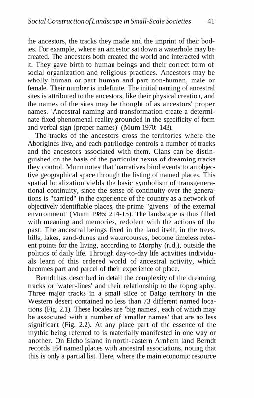
Social Construction of Landscape in Small-Scale Societies 41
the ancestors, the tracks they made and the imprint of their bod-ies. For example, where an ancestor sat down a waterhole may becreated. The ancestors both created the world and interacted withit. They gave birth to human beings and their correct form ofsocial organization and religious practices. Ancestors may bewholly human or part human and part non-human, male orfemale. Their number is indefinite. The initial naming of ancestralsites is attributed to the ancestors, like their physical creation, andthe names of the sites may be thought of as ancestors' propernames. 'Ancestral naming and transformation create a determi-nate fixed phenomenal reality grounded in the specificity of formand verbal sign (proper names)' (Mum 1970: 143).
The tracks of the ancestors cross the territories where theAborigines live, and each patrilodge controls a number of tracksand the ancestors associated with them. Clans can be distin-guished on the basis of the particular nexus of dreaming tracksthey control. Munn notes that 'narratives bind events to an objec-tive geographical space through the listing of named places. Thisspatial localization yields the basic symbolism of transgenera-tional continuity, since the sense of continuity over the genera-tions is "carried" in the experience of the country as a network ofobjectively identifiable places, the prime "givens" of the externalenvironment' (Munn 1986: 214-15). The landscape is thus filledwith meaning and memories, redolent with the actions of thepast. The ancestral beings fixed in the land itself, in the trees,hills, lakes, sand-dunes and watercourses, become timeless refer-ent points for the living, according to Morphy (n.d.), outside thepolitics of daily life. Through day-to-day life activities individu-als learn of this ordered world of ancestral activity, whichbecomes part and parcel of their experience of place.
Berndt has described in detail the complexity of the dreamingtracks or 'water-lines' and their relationship to the topography.Three major tracks in a small slice of Balgo territory in theWestern desert contained no less than 73 different named loca-tions (Fig. 2.1). These locales are 'big names', each of which maybe associated with a number of 'smaller names' that are no lesssignificant (Fig. 2.2). At any place part of the essence of themythic being referred to is materially manifested in one way oranother. On Elcho island in north-eastern Arnhem land Berndtrecords 164 named places with ancestral associations, noting thatthis is only a partial list. Here, where the main economic resource
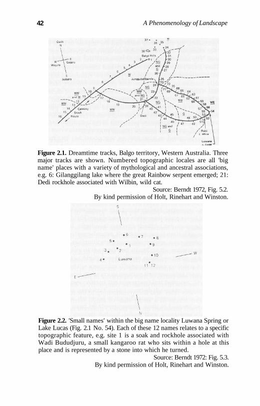
42 A Phenomenology of Landscape
Figure 2.1. Dreamtime tracks, Balgo territory, Western Australia. Threemajor tracks are shown. Numbered topographic locales are all 'bigname' places with a variety of mythological and ancestral associations,e.g. 6: Gilanggilang lake where the great Rainbow serpent emerged; 21:Dedi rockhole associated with Wilbin, wild cat.
Source: Berndt 1972, Fig. 5.2.By kind permission of Holt, Rinehart and Winston.
Figure 2.2. 'Small names' within the big name locality Luwana Spring orLake Lucas (Fig. 2.1 No. 54). Each of these 12 names relates to a specifictopographic feature, e.g. site 1 is a soak and rockhole associated withWadi Bududjuru, a small kangaroo rat who sits within a hole at thisplace and is represented by a stone into which he turned.
Source: Berndt 1972: Fig. 5.3.By kind permission of Holt, Rinehart and Winston.
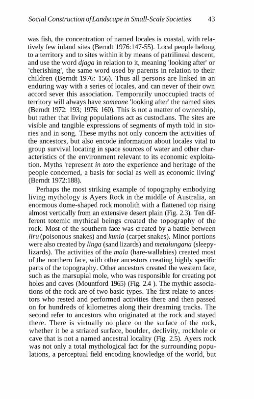
Social Construction of Landscape in Small-Scale Societies 43
was fish, the concentration of named locales is coastal, with rela-tively few inland sites (Berndt 1976:147-55). Local people belongto a territory and to sites within it by means of patrilineal descent,and use the word djaga in relation to it, meaning 'looking after' or'cherishing', the same word used by parents in relation to theirchildren (Berndt 1976: 156). Thus all persons are linked in anenduring way with a series of locales, and can never of their ownaccord sever this association. Temporarily unoccupied tracts ofterritory will always have someone 'looking after' the named sites(Berndt 1972: 193; 1976: 160). This is not a matter of ownership,but rather that living populations act as custodians. The sites arevisible and tangible expressions of segments of myth told in sto-ries and in song. These myths not only concern the activities ofthe ancestors, but also encode information about locales vital togroup survival locating in space sources of water and other char-acteristics of the environment relevant to its economic exploita-tion. Myths 'represent in toto the experience and heritage of thepeople concerned, a basis for social as well as economic living'(Berndt 1972:188).
Perhaps the most striking example of topography embodyingliving mythology is Ayers Rock in the middle of Australia, anenormous dome-shaped rock monolith with a flattened top risingalmost vertically from an extensive desert plain (Fig. 2.3). Ten dif-ferent totemic mythical beings created the topography of therock. Most of the southern face was created by a battle betweenliru (poisonous snakes) and kunia (carpet snakes). Minor portionswere also created by linga (sand lizards) and metalungana (sleepy-lizards). The activities of the mala (hare-wallabies) created mostof the northern face, with other ancestors creating highly specificparts of the topography. Other ancestors created the western face,such as the marsupial mole, who was responsible for creating potholes and caves (Mountford 1965) (Fig. 2.4 ). The mythic associa-tions of the rock are of two basic types. The first relate to ances-tors who rested and performed activities there and then passedon for hundreds of kilometres along their dreaming tracks. Thesecond refer to ancestors who originated at the rock and stayedthere. There is virtually no place on the surface of the rock,whether it be a striated surface, boulder, declivity, rockhole orcave that is not a named ancestral locality (Fig. 2.5). Ayers rockwas not only a total mythological fact for the surrounding popu-lations, a perceptual field encoding knowledge of the world, but
44 A Phenomenology of Landscape
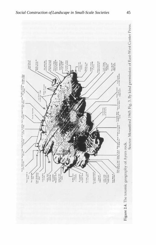
Social Construction of Landscape in Small-Scale Societies 45
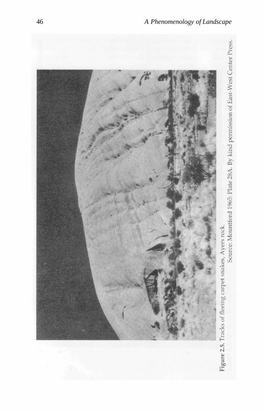
46 A Phenomenology of Landscape
Social Construction of Landscape in Small-Scale Societies 47
a focus for linking present populations to the past ancestralforces, involving rock engraving, painting and initiation rites.Both the external surfaces of the rock were decorated at specificpoints with ancestral associations, and twelve caves on the north-ern and southern sides contain paintings depicting dreamtimeevents (Mountford 1965:157 ff.).
Morphy (1991, n.d.) describes the Yolngu of North-eastArnhem Land as having a particularly rich vocabulary for topo-graphic and environmental description which serves to segregateenvironmental zones which are linked both to seasonal resourceexploitation and the mythological system. There is a close corre-spondence between topographical zone and ancestral track, andthe distribution of ancestral beings is related to that of naturalspecies. Major ritual sites correspond closely to paths of move-ment. The dreamtime tracks, as elsewhere, tend to follow thewatercourses, and the greatest density of mythological activitiesis generally associated with major camp sites. The landscape isthus represented in myth and represents the myth. It is amnemonic for past generations and a means of establishing conti-nuity with the past. Time becomes collapsed into space, in thatthe time it took ancestral beings to take their journeys is never apart of the myth. Time becomes a sequence of named places with-out the 'befores' and 'afters'. Disrepectful behaviour towards theland and its species can cause illness or death.
Layton (n.d.) discusses the intense personal and biographicalrelationship between people, the land and ancestral beings incentral Australia. While places are intimately related to ancestralactivity, so are the living. All individuals are first identified withone of the Tjukurpa beings at birth according to where the puli(stub of their umbilical cord) fell off, and their personalities areexpected to follow those of the ancestors of which they are anembodied part. In this manner people are identified with places,a connection which cannot be severed. Persons 'hold' land bymeans of this intimate personal association and by continuing tolive in and care for it. Proof of this 'holding of the land' is boundup with detailed knowledge of and interpretation of physio-graphic features linked to ancestral activities. Failure to protectsongs, ceremonies and sacred objects is equivalent to giving theland away. In other words the ancestral past has to be continual-ly brought into and related to activity in the present. Anyone whoregularly forages in a region needs to be intimately acquainted
48 A Phenomenology of Landscape
with ancestral lore, ceremony, song and sacred objects, whichbecome the grounding basis for all life movements. People can-not 'hold' a country as children, but only when they have become'big'. Those who own an estate have pre-eminent rights to it by(i) controlling access to it through controlling knowledge ofancestral lore associated with the terrain; (ii) demanding some-thing from people from another country who temporarily come tohunt there; (iii) punishing trespassers on sacred sites (Laytonn.d.). At death the living must relinquish their claims to a country,and their descendants must take care of it, perform the correctceremonies and guard the ancestral relics. Alienation of any partof the country from its rightful owners and their heirs is a viola-tion of the entire moral order, a desecration (Munn 1970:150).
Physiographic features of the landscape play a crucial role inritual practices. Within any clan territory localized sacred sitesoccur to which unauthorized access is forbidden. Only those whoknow the land can call and prepare ceremonies. Sacred sitesalways occur near to water, and while access to the water itself isnot physically defended the sites are. Senior men only may visitthese sites, take care of them, and perform rituals. Rock art localesform one such category of sites. Layton (n.d.) notes that depic-tions of the landscape in Australian Aboriginal art are notable forthe bird's-eye view they adopt, a decentred perspective in whichnumerous points have equal value. Sacred sites and ancestraltracks linking them become laid out as on a map, but these 'maps'have much more in common with the sensuous places ofmedieval 'cartography' than they do with a Euclidean geometricspace of modern cartographic representation.
Painting rocks was an important part of a process by whichpopulations could tap into ancestral powers at specific topo-graphical locations. Sites of particular importance in representa-tions of landscape frequently refer to the places where theancestors came out of and (having grown tired) went back intothe land, between these two events creating their dreaming tracksand localized features of the topography. Munn (1973, 1986)regards the processes of 'coming out' and 'going into' the land(an inside/outside distinction) as a fundamental principle ofWalbiri cosmology that is used to explain and structure the spa-tiotemporal ordering of human existence. Each of the Aranda sec-tion areas contained at least one important ceremonial centre atwhich ancestors are believed to have emerged from the ground to
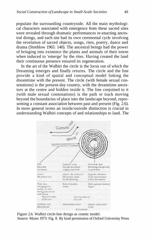
Social Construction of Landscape in Small-Scale Societies 49
populate the surrounding countryside. All the main mythologi-cal characters associated with emergence from these sacred siteswere revealed through dramatic performances re-enacting ances-tral doings, and each site had its own ceremonial cycle involvingthe revelation of sacred objects, songs, rites, poetry, dance anddrama (Strehlow 1965: 140). The ancestral beings had the powerof bringing into existence the plants and animals of their totemwhen induced to 'emerge' by the rites. Having created the landtheir continuous presence ensured its regeneration.
In the art of the Walbiri the circle is the locus out of which theDreaming emerges and finally returns. The circle and the lineprovide a kind of spatial and conceptual model linking thedreamtime with the present. The circle (with female sexual con-notations) is the present-day country, with the dreamtime ances-tors at the centre and hidden inside it. The line conjoined to it(with male sexual connotations) is the path or track movingbeyond the boundaries of place into the landscape beyond, repre-senting a constant association between past and present (Fig. 2.6).In more general terms an inside/outside distinction is crucial inunderstanding Walbiri concepts of and relationships to land. The
Figure 2.6. Walbiri circle-line design as cosmic model.Source: Munn 1973: Fig. 8. By kind permission of Oxford University Press
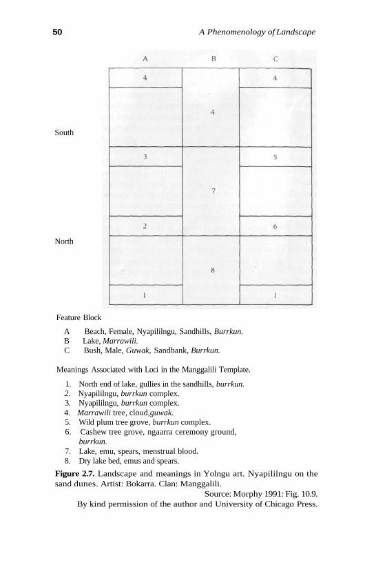
50 A Phenomenology of Landscape
South
North
Feature Block
A Beach, Female, Nyapililngu, Sandhills, Burrkun.B Lake, Marrawili.C Bush, Male, Guwak, Sandbank, Burrkun.
Meanings Associated with Loci in the Manggalili Template.
1. North end of lake, gullies in the sandhills, burrkun.2. Nyapililngu, burrkun complex.3. Nyapililngu, burrkun complex.4. Marrawili tree, cloud,guwak.5. Wild plum tree grove, burrkun complex.6. Cashew tree grove, ngaarra ceremony ground,
burrkun.7. Lake, emu, spears, menstrual blood.8. Dry lake bed, emus and spears.
Figure 2.7. Landscape and meanings in Yolngu art. Nyapililngu on thesand dunes. Artist: Bokarra. Clan: Manggalili.
Source: Morphy 1991: Fig. 10.9.By kind permission of the author and University of Chicago Press.
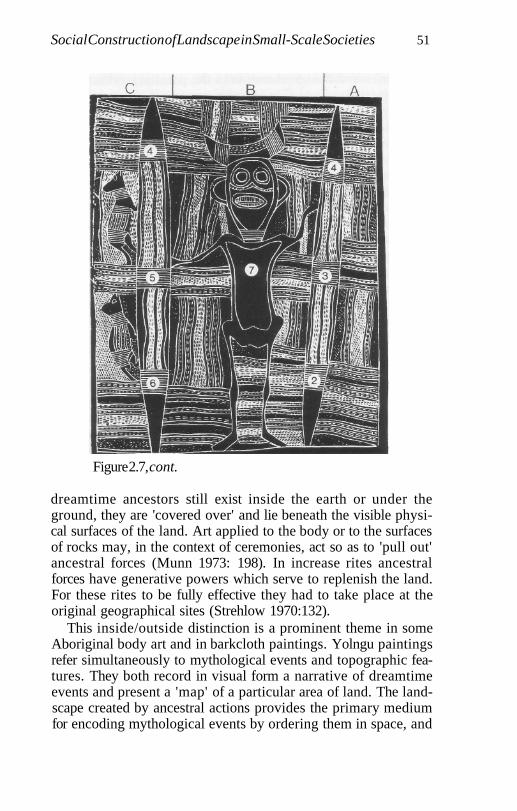
Social Construction of Landscape in Small-Scale Societies 51
Figure 2.7, cont.
dreamtime ancestors still exist inside the earth or under theground, they are 'covered over' and lie beneath the visible physi-cal surfaces of the land. Art applied to the body or to the surfacesof rocks may, in the context of ceremonies, act so as to 'pull out'ancestral forces (Munn 1973: 198). In increase rites ancestralforces have generative powers which serve to replenish the land.For these rites to be fully effective they had to take place at theoriginal geographical sites (Strehlow 1970:132).
This inside/outside distinction is a prominent theme in someAboriginal body art and in barkcloth paintings. Yolngu paintingsrefer simultaneously to mythological events and topographic fea-tures. They both record in visual form a narrative of dreamtimeevents and present a 'map' of a particular area of land. The land-scape created by ancestral actions provides the primary mediumfor encoding mythological events by ordering them in space, and
52 A Phenomenology of Landscape
boundaries and design elements in the paintings refer to thislandscape (Fig. 2.7); but, as Morphy points out, the ordering oflandscape representations in art and in mental representationsand understandings of it is a product of continual interpretationsand reinterpretations of place. The positions of places 'corre-spond to the relative positions of places in the landscape ... butthe topographical plotting of positions would produce a very dif-ferent shape' (Morphy 1991: 237). Landscape and art are bothmodels of and models for reality, i.e. they are both ordered bysomething beyond themselves (the landscape as it actually exists)and serve to order that external reality and make sense of it.
One particular type of art, X-ray paintings, depict the internalbody organs and bones of ancestral beings at an 'outside' denota-tive level of meaning. At another 'inside' level of meaning theyrefer to spatial relationships between important topographic fea-tures of clan lands. As Taylor puts it 'the metaphors of thesepaintings express the way Kunwinjku (Aborigines of westernArnhem Land) conceive of the spatial organization of sites intheir lands in terms of an abstract model of the divided yet organ-ically related body parts of the ancestral being that created thoselands' (Taylor 1989: 381). There is an intimate connectionbetween body parts of the ancestral being in these paintings andlocales of significance in the landscape. This mode of experienc-ing the world may even extend to the human body itself, throughpainting designs on it and even in relation to features such asbirthmarks' being seen as equivalent to sacred sites within clanlands. The body becomes a metaphor for the topographic organi-zation of clan lands. The significance of landscape is thusinscribed not only in day-to-day encounters with its topographicand physiographic features but in portable and non-portable artand in relation to the scars, marks, painting and surfaces of indi-vidual human bodies. It would indeed be hard to find a moreencompassing sensibility of the relationship between biography,identity and place than this. Since every person carries withinhim- or herself a life force ultimately derived from ancestralpowers, living populations and ancestral forces are inseparablyconnected. People do not, for example, actively create designs inartworks; but these designs are passed to them through dreamsand are derived from the ancestors. Among the Walbiri, womenwho sleep together may share the same yawalyu designs (Munn1986).
Social Construction of Landscape in Small-Scale Societies 53
Taçon (1991) has discussed the manner in which the land andits ancestral significances may be actively appropriated throughtechnologies such as systems of stone-tool production and use.The most significant tools, such as stone axes and spear points,controlled and used by men, embodied ancestral powers. A largenumber of these ancestors turned into stone at their final restingpoint. The Rainbow Serpent, one of the most potent of the ances-tors in western Arnhem Land, swallowed other ancestors andthen was forced to vomit their bones, forming rocky sandstoneand quartzite escarpments. Quarrying stone for axes is, therefore,quarrying the bones of the ancestors. The axes are themselvesformed from ancestral bones - hence their potency. Quartz toolsare particularly potent, as brightness and iridescence are highlyvalued. Objects and substances that shimmer and 'emit' light,such as quartz, white pigment, fat and blood, are spirituallycharged with power (Morphy 1989; Taçon 1991). It is not surpris-ing that quarries were dangerous places, and access to them andtheir products was tightly controlled in many cases. The killingpower of a stone tool is significantly linked to its ancestral source,and it is the power within it that saps the life out of the victim,causing a searing, burning pain (Jones 1990: 27, cited in Taçon1991:203-4). Stone is considered to be a male substance, while theearth and its products, such as pigments used for painting, aregendered as female. Ceremonial objects could be empowered bypainting, which created a symbolic linkage between male andfemale essences. By contrast, tools used for killing would bedulled through decoration. It was 'necessary that their "male"qualities not be covered over so that they remain potent to pene-trate flesh and, in the process, to be "painted" with blood' (Taçon1991: 205). Stone and bone were both symbols of persistence, andhence it is not surprising that clefts and holes in rock escarpmentswere frequently used for secondary burial, a placing of the bonesof the dead back inside the bones of the ancestors.
The landscape constitutes for the Aborigines a fundamentalform of mediation, in which the experience of self is rooted in theobjectified forms of ancestral transformations. Human subjectivi-ty is constituted in relation to the land. There is a constant linkageeffected between subject and object, object and subject, whichprovides a sense of an enduring moral and social order. The landis both separated from the self and incorporated. The land is acollective resource constantly being drawn on in daily life experi-
Social Construction of Landscape in Small-Scale Societies 53
Taçon (1991) has discussed the manner in which the land andits ancestral significances may be actively appropriated throughtechnologies such as systems of stone-tool production and use.The most significant tools, such as stone axes and spear points,controlled and used by men, embodied ancestral powers. A largenumber of these ancestors turned into stone at their final restingpoint. The Rainbow Serpent, one of the most potent of the ances-tors in western Arnhem Land, swallowed other ancestors andthen was forced to vomit their bones, forming rocky sandstoneand quartzite escarpments. Quarrying stone for axes is, therefore,quarrying the bones of the ancestors. The axes are themselvesformed from ancestral bones - hence their potency. Quartz toolsare particularly potent, as brightness and iridescence are highlyvalued. Objects and substances that shimmer and 'emit' light,such as quartz, white pigment, fat and blood, are spirituallycharged with power (Morphy 1989; Taçon 1991). It is not surpris-ing that quarries were dangerous places, and access to them andtheir products was tightly controlled in many cases. The killingpower of a stone tool is significantly linked to its ancestral source,and it is the power within it that saps the life out of the victim,causing a searing, burning pain (Jones 1990: 27, cited in Taçon1991: 203-4). Stone is considered to be a male substance, while theearth and its products, such as pigments used for painting, aregendered as female. Ceremonial objects could be empowered bypainting, which created a symbolic linkage between male andfemale essences. By contrast, tools used for killing would bedulled through decoration. It was 'necessary that their "male"qualities not be covered over so that they remain potent to pene-trate flesh and, in the process, to be "painted" with blood' (Taçon1991: 205). Stone and bone were both symbols of persistence, andhence it is not surprising that clefts and holes in rock escarpmentswere frequently used for secondary burial, a placing of the bonesof the dead back inside the bones of the ancestors.
The landscape constitutes for the Aborigines a fundamentalform of mediation, in which the experience of self is rooted in theobjectified forms of ancestral transformations. Human subjectivi-ty is constituted in relation to the land. There is a constant linkageeffected between subject and object, object and subject, whichprovides a sense of an enduring moral and social order. The landis both separated from the self and incorporated. The land is acollective resource constantly being drawn on in daily life experi-
54 A Phenomenology of Landscape
ences, a collective representation stabilizing the world throughthe authority of precedence and other selves embodied within it.The identities of individuals are constructed in and through thematerial remains of ancestral transformations linking them toprevious generations and their contemporaries, a world in whichevery prominent feature is associated with a mythological event.Life-spans are locked into the experience of an ancestral past thatbinds the universe in a limited topographical space. The narrativeof myth is a model of and for social action.
Forests of Eyes, Rivers of IdentitiesTanner (1979), in a discussion of religious ideology in relation tohunting practices among the Mistassini Cree Indians of Quebecprovince, Canada, notes at the beginning of his account thatMistassini is the name of a village and of a band of Indians. Thevillage is situated by a large lake, Lake Mistassini, meaning 'bigrock' and referring to a large rock along the western shore of thelake, a name traditionally also used to refer to the Indians inhab-iting the region (Tanner 1979: 6). They are thus immediately 'situ-ated' in the landscape and with reference to the details of itstopography. Tanner notes that boundaries (notional rather thanfixed or absolute) between hunting territories are generally locat-ed along high ground or large rivers, and their overall pattern isinfluenced by travel routes, themselves strongly related to inter-connected lake and river systems. Mistassini also refer to theirhunting grounds by saying 'my path' or 'my road' or 'my river'(Speck 1932: 460), indicating the temporary social appropriationof terrain within a path of movement which may vary from oneyear to the next. Territory is intimately bound up with life-pathsand movements.
Within any particular hunting territory a patchwork of differ-ent habitat types exists, each of which favours a particular mix ofanimal populations. The Cree make great use of their intimateknowledge of the vegetation in planning hunting and trapping. Acomplex system of classification exists for water bodies accordingto the type of lake or river bottom, the nature of the banks andshores, the form of the currents and types of vegetation (Tanner1979: 45). Hunting and trapping require frequent residentialchange in terms both of types of dwellings and of locales; yet inCree ideology the illusion is fostered that the place of residence isalways the same, and this is effected by a standardized internal
Social Construction of Landscape in Small-Scale Societies 55
arrangement of domestic space. Whatever the type of dwelling -log cabin, large dome tent or wooden-framed canvas-coveredtent - it is arranged internally in terms of a rigid division of spacerelated to gender, age and authority, and family units, so as toappear to occupy the same space. Whatever the actual camp-sitethe Cree, then, are always staying in the same place. Coupledwith this idea of stability despite movement there is a generalreluctance to use old camp-sites in the forest when the group ishunting. A camp-site should be placed on ground that is cleanand unpolluted by previous occupation, a place that will not beoffensive to the spirits of game animals and other magical entitiesthat aid hunting. Abandoned camps should be cleaned of refuse,and they become sacred places. A short time after the camp-site isleft the 'spirit' of the hunting group flies over the place, and if allis as it should be future hunting success will follow. The door-way, symbolically crucial transition point between the inside andoutside of the winter dwelling, should face both the rising sunand a body of water. Consequently camps are almost always onthe western shores of lakes. The rising sun is positively valued,and it is auspicious for the hunter to go out of the doorway facingthe rising sun.
In many rites and myths the dominant conception of space isframed in terms of a concentric model, with camp space at thecentre surrounded by topographical or physiographical space,the forests and lakes inhabited by animals, at the farthest reachesof which and above and below are located spiritual entitiesassociated with natural forces. A distinction is thus drawnbetween inside and outside, and the hunting journey, conceivedas a process of going out, moving in a circle and returning, medi-ates between the two domains.
Everything in the Mistassini world has a spirit - people,animals, rocks, clothes, moccasins, tents, doorways of tents andthus becomes throughly humanized. Spirits reside in anythingthat can be named, and in a manner akin to that among theAborigines the landscape by this means becomes socialized andpopulated with spiritual entities and powers, frequently byassociating or linking different ones together. For example,weather control is an important part of Cree ritual. Winds areconceived to blow from four different cardinal directions, andweather is primarily attributed to the actions of the winds andtheir spirits. There is also a strong set of beliefs about mountains,
56 A Phenomenology of Landscape
considered to be the dwelling-places of spirits and places whereshamans go to practise magic (Tanner 1979: 98). One rite involvesa summer-born or winter-born person pointing at a particularmountain in order to bring either warm weather or a snowstorm,respectively.
The Koyukon landscape of north-west interior Alaska, likethat of the Cree, is one filled with networks of paths, names andassociations. People know every feature of the landscape inminute detail. The lakes, river bends, hills and creeks are namedand imbued with personal and cultural meaning. Nelson (1983)points out that the intimacy of the relationship between peopleand the land is such that it is difficult for a Westerner to eitherbelieve or understand. People move in a world that constantlywatches - a forest of eyes: 'A person moving through nature -however wild, remote, even desolate the place may be - is nevertruly alone. The surroundings are aware, sensate, personified.They feel. They can be offended' (Nelson 1983:14). The naturaland the supernatural or the mythological are inseparable, so thatperception of the natural environment extends from the empiri-cal into the spiritual. Ideology forms a fundamental aspect ofday-to-day subsistence activities, and cannot be separated from'economic' concerns. As with the Cree, all animals, some plantsand some inanimate objects such as rocks possess spirits.
Mythologically the world and everything in it was createdduring the 'Distant Time'. Stories explain the world's origin in atime when animals and natural entities were human. In theDistant Time the landscape acquired its present form. Humansdied and were transformed into the animals and plants encoun-tered in the environment and features of the earth such as hills ormountains (Nelson 1983: 16). Relatedness among animals isrevealed by Distant Time stories and by observation of specificbehavioural characteristics, for example the bones in the head ofthe sucker fish resemble the objects it stole. A tendency to getalong means that animals are relatives. Certain landforms pos-sess a special spiritual power that must be placated or shown def-erence, and the entire earth's surface is filled with a generalizedpower, sink taala, essential for shaman's medicine (ibid.: 35). Anebulous but threatening spirit power is associated with manyplaces on the land, bodies of water and mountains. These areplaces cursed by shamans or have acquired power in a timebeyond memory. The entire system of geographical orientation is
Social Construction of Landscape in Small-Scale Societies 57
intimately connected with an intricate web of waterways thatsimultaneously threaten and sustain life. People orientate them-selves in relation to rivers and river currents (upriver; downriver;toward the water; away from the water; and four prefixes mea-sure distance, for example dodot: nearby downriver) rather thanin terms of cardinal directions. Relations of distance and nearnessare not defined in simple geometrical terms. Rivers are also usedto define and sustain social boundaries. Koyukon people identifythemselves with reference to river drainages delineating individ-ual or group terms. Despite continuous human activity for mil-lennia the Koyukon impact on the environment has been slight.The only tangible evidence of this long occupation is scatteredcamp-sites, trails, widely dispersed village clearings, and theovergrown remnants of abandoned locales. The imprint on theland is fundamentally of a cultural character - one of an invest-ment of meaning: 'the flow of land becomes also a flow of themind ... Almost nothing visible remained to associate [the aban-doned settlement] with humanity. Only the memory of peopleand events set this place apart from its surroundings and gave itspecial meaning ... Each living individual is bound into this pat-tern of land and people that extends throughout the terrain andfar back across time' (Nelson 1983: 243).
When the Koyukon people cross their land the recollection ofevents, the recognition of named places and locales, the aware-ness of boundaries, not only invest it with meaning but perpetu-ate the knowledges necessary to locate resources and orientatethemselves in space. As with the Aborigines, individual identitiesand biographies are so closely connected with the landscape thatone can act on the other.
Subsistence Cultivators and the Land
Parallel Worlds in Melanesia
'You realise that this tree isn't really a tree. It is actually a man, butyou and I can't see him because we are only living beings. Our eyesaren't clear. We are not able to see things as they really are'
(Informant cited in Harrison 1988: 325).
For subsistence cultivators in Melanesia the relationship with thelandscape is no less intimate than among Arctic or Australian
58 A Phenomenology of Landscape
hunter-gatherers. Malinowski noted the intimate relationshipbetween myth and the landscape as lived and perceived:
The mythical world receives its substance in rock and hill, in thechanges in land and sea. The pierced sea-passages, the cleft boulders,the petrified human beings, all these bring the mythological worldclose to the natives, make it tangible and permanent. On the otherhand, the story thus powerfully illustrated, re-acts on the landscape,fills it with dramatic happenings, which, fixed there for ever, give it adefinite meaning (Malinowski f 922: 330).
More recently, Guidieri and Pellizzi (1981:13) refer in a gener-al sense to two distinct 'surfaces' of existence in many Melanesiansocieties. One is fixed, the land of the dead ancestral forces; theother, the land of the living, is mobile, but always gravitating inrelation to the first. In this manner in many societies a distinctionis drawn between a perceptual order, the plane of everyday exis-tence, and an invisible and underlying order of spirit beings,including totemic ancestors and ghosts of the dead. These spiritsare not visible in their real forms, but are 'visible' in metamor-phosed transformations in the form of animal and plant species,rivers, mountains and rocks. This hidden order of existence, likethe Aboriginal Dreamtime, is atemporal, but constantly intersectswith and influences the world of the living. Among the Avatip onthe Sepik river in north-west Papua New Guinea to own land isintimately bound up with magical and ritual responsibility for itsfertility:
To the villagers all land and bodies of water are fertile because theycontain the rotted bodies and body-fluids of totemic ancestors. Manyparcels of land are criss-cross complexes of old levees left by shifts inthe course of the river; people say these have human outlines, andstill bear the shapes of the ancestors who 'fell down' upon them inmythical times (Harrison 1988: 323).
In this manner the land becomes humanized and socialized assomething replete with ancestral energies that requires care andconstant sustenance through ritual magic. Beneath the apparentsurface of the landscape, but intimately bound up with it, there isa hidden topography best known to (and influenced by) ritualexperts in these societies, but emotionally and cognitively perti-nent to all. Aspects of the social and ancestral past are bothrecorded and experienced at specific locales in terms of topo-
Social Construction of Landscape in Small-Scale Societies 59
graphic and physiographic features. Possessing detailed andaccurate knowledge of the landscape is bound up with knowl-edge of intangible worlds and ancestral powers embedded with-in it, control of which is deemed essential for group productionand reproduction.
Whereas in the West there is a tendency to privilege temporalrelationships between events in narrative accounts, typically inMelanesia it is spatial relationships that are emphasized. Eventsare anchored and given significance in terms of particular localesand their interconnections as linked points in space. Particularlocales are of essential importance in 'fixing' events and acting asmnemonics, thus creating a sense of social identity and establish-ing linkages between past and present, the worldly and thesupernatural. Kiichler (1993) has recently emphasized the pointthat landscape may act powerfully as memory, a template in theprocess of memory work that is not fixed and static, but some-thing drawn upon in social encounters and disputes over land.
Specific locales in the landscape may be powerful visualreminders of myths and themselves become, through the passageof time, objects of knowledge, the accuracy of which may validatethe myths. Landscapes anchor events, and thus act so as to ensuretheir enduring significance for populations moving around andexperiencing them on a daily basis. The landscape provides per-manent markers around which life flows and within whichmeanings become sedimented.
Poole (1986), in a particularly vivid account, discusses thisintertwining of a physical and natural and cultural and super-natural ordering of things in relation to the significance of thelandscape and the oil that seeps out of it in Bimin-Kuskusmin ter-ritory in Highland Papua New Guinea. The Bimin-Kuskusminlive in a rugged mountainous area in West Sepik province. Theirterritory is bordered to the west by the dramatic Strickland Gorgeand on all other sides by formidable mountain ranges. In theirmythology the known world is bounded and covered by thecanopy of the sky, linked to the earth by massive limestone pil-lars and trees just beyond the farthest extent of human experi-ence. A mountain chain separates the northern and southernBimin-Kuskusmin valleys, and this chain is the spine of the land;the seeping oil hidden in a hollow and issuing from a rock creviceis the marrow of the mountain spine. For the Bimin-Kuskusminthe forest is a realm of immense ritual importance and spiritual
60 A Phenomenology of Landscape
power linking the living with the dead and humans with spiritu-al entities:
Along limestone ridges and outcroppings the forest growth becomesmarkedly stunted or blighted, and jagged karst formations jutthrough this sparser foliage. Myriad streams, springs, caves, sink-holes, rock outcroppings, crevices, cliffs, and other 'natural' featuresof the lower and mid-montaine terrain are identified with ancestralevents in myths that add sacred contours to the landscape. Lightning-scarred trees and places of landslides - all sign's of Afek's [the greatcassowary, 'mother' of the game animals and father of the sacredsemen-oil] power - are remembered for the mysterious, 'supernatur-al' events that have occurred there. Tiny knolls and forest glades arevividly recalled as the sites where a hunter crouched in fear when thewhistle of a witch, the rumble of an earthquake, or the howl of ananquished spirit... was heard in the vast stillness ... At deep sinkholesthe spirits of the dead find passage to the ancestral underworld, andancestral spirits return through these passages to haunt and to blessthis domain (Poole 1986:175).
The oil was at the centre of all life and ritual practice.Dedicatory shrines were constructed in a clearing near the oilseep containing pig, human and cassowary skulls and rock crys-tals, thought to be animate, sentient and highly sacred. The oil iscarefully collected in a depression encircled by sacred redCordyline plants. In an annual cycle of rites ritual experts presentsacrificial morsels of food to the ancestral skulls and the crystals.The ancestral spirits are then said to return from the underworldto increase the flow of sacred oil. This central ritual site linkstogether all Bimin-Kuskusmin, whether living or dead, in a com-mon bond with the land and its resources. The oil represents 'thesource of fertility, growth, renewal and change for all faunae, flo-rae and humans that dwell on the land ... and even beyond to thefarthest reaches of known human settlement' (Poole 1986: 171).Only adult men who have undergone the ordeals of a ten-stageinitiation cycle taking place over a decade may approach thesacred site of the oil. The sacred oil is central to rites of regenera-tion in which the fertility of the forest is ensured. Oil-soaked tarois fed to domestic boars, the burying of bamboo tubes of oil is car-ried out to promote the growth of taro, oil is rubbed on the skin tomake it glisten and ensure personal well-being. Shrines through-out the forest are anointed with oil. The oil is conceived to flowunder the landscape itself in the realm of the spirit world. Proof
Social Construction of Landscape in Small-Scale Societies 61
and concern (attributed to white infiltration and to the dire ritualconsequences of their discovery of the source of the sacred oil)about something's being amiss are areas of unwanted expandinggrasslands in parts of Bismin-Kuskusmin territory. In these areasthe oil has ceased to flow and the forests have dried up.
For the Foi and the Kaluli of the southern highlands of PapuaNew Guinea, the relationship with the landscape is no less inti-mate. They know the course of every body of water, each ofwhich is named. Important landmarks, such as prominent hills,pools in rivers, large trees, are all named and significant places.The naming of places extends to ancestral and more recent eventsthat have taken place. Watercourses provide referents for loca-tion and direction: 'the waters, as they turn and fall, generate newlocalities for every new configuration of land. The name of alocality carries, in effect, its own geographical coordinates, whichplace it in determinate relation to the brooks and streams thatflow through the forest' (Schieffelin 1976: 30). Animals, plantsand people are all fundamentally related inasmuch as in originmyths they were all originally human. People have food andshelter by virtue of the plants and animals to which they aresimultaneously opposed and ancestrally related (ibid.: 95).
Foi territory is characterized by a twofold division: (i) that cen-trally located and permanently occupied by the longhouse soci-ety and its gardens; and (ii) the hunting grounds, Ayamo,seasonally occupied for hunting, fishing, trapping and collecting(Weiner 1991: 33). Movement between these two areas was tradi-tionally periodic. Ayamo is much larger than Foi gardening terri-tory, and the population disperses in it. Since these areas areoccupied at different seasons and are the focus of rhythmic peri-odic movements, notions of landscape and temporality becomeinterlinked. Changing topography and activities thus have aninbuilt temporal dimension. Creeks and rivers provide majorspatial boundaries used to provide a sense of orientation throughspace and forming the most common borderlines between clanterritories. Clan areas are orientated around the mouth andsource of identifying streams (ibid.: 40). Distance and nearness, asamong the Koyukon, are related to the flow of water. Virtually allplace-names have a lexical significance and make use of geo-graphically descriptive words referring to specific topographicfeatures, such as 'creek', 'ridge', 'raised ground', 'grove', 'spur','bend in river', 'mountain', 'waterfall'. They also refer to human
62 A Phenomenology of Landscape
events and activities at particular locales. The sum of a Foi per-son's existence is, in essence, the sum of the tracks he or she hasmade or used during his or her lifetime. A historical conscious-ness is thus bound up with movement through space. In Foi poet-ry, Weiner argues, the moving image occurs as a result of theserial juxtaposition of linked place-names and species, whichtogether create a sense of place. By serially listing place-namestemporal spans are automatically invoked, and a sense of lifemovement through a region is constructed. Weiner puts the pointparticularly well: in showing 'someone else the extent of his landand resource holdings, a Foi man is revealing the fundamentallived dimension of his "Being-there", through the attitudes ofcare and the actions of concernful appropriation of earthly space,the historical record of the impressions he has made on the land,the inscriptive evidence of his life' (Weiner 1991: 45).
The Foi existential landscape, like that of AustralianAboriginal groups, the Mistassini Cree, the Koyukon and theKaluli, is doubly imaged, consisting of ancestrally constitutedplaces over which and between which the day-to-day move-ments of people are transcribed. All these populations key intoand draw on ancestral powers. The life path of an individual bothiterates an ancestrally created world and creates its own particu-lar and personalized path.
In many areas of Melanesia myth is not only embodied in 'nat-ural' landforms, but also in the form of ancestral stones dottingthe landscape (Malinowski 1922; Leenhardt 1930; Riesenfeld1950; Kahn 1990). Leenhardt records that in New Caledonia 'eachstone has a name, a history, a life, we might even say a personali-ty, resulting from the spirit enclosed within it. Often in [remote]valleys I've asked the name for every detail of the land, eachnotable tree; and the landscape transposes itself into a scheme itwould be impossible to transcribe on a map, in which each nameis title to a chapter' (Leenhardt 1930: 241, cited in Kahn 1990: 54).Kahn reports that on the coastal mainland of Milne Bay Provincestones, some with incised geometric designs, are particularly fre-quent. They usually represent mythical heroes or heroines whoturned into stone, and some of them may play a prominent partin mythological narratives anchoring the stories to the ground.Sometimes the stones may represent the petrification of the per-sonal equipment of the ancestors left behind on journeys (Kahn1990: 59).
Social Construction of Landscape in Small-Scale Societies 63
Mountains, Mesas and TetradsA number of accounts have emphasized the social and cosmo-logical significance of the land among native American Indianhunter-fisher-gatherers and farmers (e.g. Brody 1981; Hallowell1955; Harrington 1916; Momaday 1974; Ortiz 1969; Parsons 1939;White 1964). Here I want to refer to one of the richest of theseaccounts, written by Ortiz, an anthropologist who also comesfrom the society he studies and interprets, the Tewa, a pueblo-dwelling population engaged primarily in subsistence horticul-ture in the American South-west. Ortiz (1969) describes the Tewaview of existence in terms of six discrete and hierarchical levels orcategories of being:
6. Dry food who never did become5. Towa é4. Dry food who are no longer3. Made people2. Towa é1. Dry food people
These are also cultural categories used to divide and classifythe entirety of Tewa social and supernatural existence. 'Dryfood people' play no official roles in political or ritual life. TheTowa e make up the core of the political organization of theTewa. The 'Made people' constitute a hierarchy of eight dis-crete but interrelated organizations, including the members oftwo moiety societies, the medicine men, the Kwirana or 'cold'clowns, the Kossa or 'warm' clowns, and the Hunt, Scalp, andWomen's societies (Ortiz 1969: 17). The other three categoriesare supernatural counterparts of the first three. When someonein category 1 dies he or she becomes a spirit of level 4; level 5represents the spirits of people in category 2; while level 6 isconstituted by the souls of the Made people and of all thedeities recognized in Tewa mythology before the emergence ofhumanity.
These social and supernatural categories are superimposed onthe landscape in the form of a series of tetrads or groups of four,and related to cardinal directions, topographical features, settle-ment locales, paths of movement and a system of colour classifi-cation (Fig. 2.8). The outer tetrad of the Tewa world is boundedby four sacred mountains, each with unique characteristics. Tothe north is the Hazy or Shimmering Mountain, to the west the
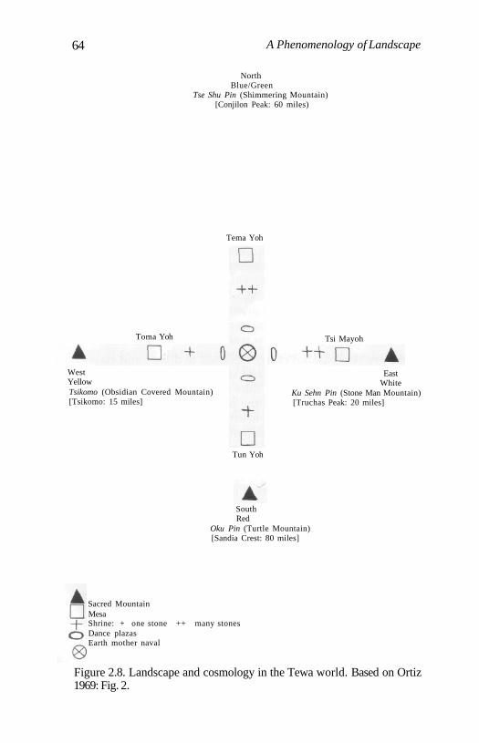
64 A Phenomenology of Landscape
NorthBlue/Green
Tse Shu Pin (Shimmering Mountain)[Conjilon Peak: 60 miles)
SouthRed
Oku Pin (Turtle Mountain)[Sandia Crest: 80 miles]
Sacred MountainMesaShrine: + one stone ++ many stonesDance plazasEarth mother naval
Figure 2.8. Landscape and cosmology in the Tewa world. Based on Ortiz1969: Fig. 2.
Tema Yoh
Tsi Mayoh
EastWhite
Ku Sehn Pin (Stone Man Mountain)[Truchas Peak: 20 miles]
WestYellowTsikomo (Obsidian Covered Mountain)[Tsikomo: 15 miles]
Toma Yoh
Tun Yoh
Social Construction of Landscape in Small-Scale Societies 65
Obsidian-covered Mountain, to the south the Turtle Mountainand to the east the Stone Man Mountain. These mountains varybetween 25 and 130 km. in distance from San Juan pueblo, thelargest of six surviving villages in New Mexico. All these foursacred mountains can be seen from some reasonably high loca-tion in Tewa country. For any particular pueblo the most sacredof them, object of repeated pilgrimages, tends to be the nearest.A lake or pond is associated with each mountain, in which the'Dry Food People Who Never Did Become', the most sacredsupernatural category of beings, dwell linked with the appropri-ate directional colour. On the top of each mountain there is a nansipu or earth navel, within which the Towa e spirits live, watchingover the world of the living. This is a keyhole-shaped stonestructure in which the bottom end is always kept open anddirectionally orientated toward one or more of the Tewa vil-lages. It constitutes a point at which the living may communicatewith the spirit world. It 'gathers blessings' from the three worldlevels and directs them through the open end back to the Tewavillages.
A second internal tetrad is constituted by making reference tofour sacred Tsin , flat-topped hills (mesas) created by the Towa eof the directions. These are located approximately midwaybetween the mountains and the village. As they are much closerto the Tewa pueblos they therefore cannot provide, on theground, a system common to all; and, in practice, different hillsconstitute cardinal reference points according to the location ofany particular village. Each of these hills is sacred because it isbelieved to be dark and foreboding, and each has a cave ortunnels running through it. These are thought to be inhabited bymasked supernatural whippers who are impersonated by theTowa e. Unlike the sacred mountains, the Tsin are very dangerousplaces for anyone but the Towa e to be, because of the presence ofthe masked whippers. As with the mountains, the hill closest toany particular pueblo is the most mythologically significant. Athird tetrad is made up of the four principal shrines of the direc-tions. These are the most important of numerous shrines found inthe landscape around each Tewa village. These shrines aremarked by large single stones or collections of stones. These areplaces in which souls live, and are endowed with sacred quali-ties. The final inner tetrad is made up of four dance plazas withinthe village. All public rituals must be performed at least four
66 A Phenomenology of Landscape
times on each of these dance areas. In addition there is a 'moth-er earth navel middle place' within the centre of a village, themost sacred ritual centre of all. Ritual dances and other perfor-mances must be initiated here, because it is at the centre of thevillage. It is circular in shape and, unlike the navels on thesacred mountains, open in all four cardinal directions.Contrasting the two types of navels, Ortiz interprets their rela-tionship in the following manner: 'The mountain earth navelsgather in blessings from all around and direct them inwardtoward the village; the mother earth navel is the source of allthese blessings, so they are directed outward in all directions. Bythe system of ideas at work here, everything good and desirablestays within the Tewa world. This is how relentless and perva-sive this tetramerous aspect of Tewa symbolic classification is'(Ortiz 1969: 21-2).
In Tewa cosmology the world is constituted by three levels,that of the middle, mapped out in the landscape as a series ofsacred tetrads; the underworld; and the above. These worldsreplicate each other, and mediation between them is achievedthrough the sacred points of the mountain lakes, the earth navelsand the shrines. These are points of entrance into other worlds,between a plane of Being and a plane of Becoming. The tops ofthe mountains are not only points of entry to the world below(conceptually more elaborated in Tewa thought than the upperworld ) but points at which the upper, middle, and underworldscome closest to intersecting. Their especial holiness is manifestedby the presence of concrete signs such as clouds (a source of pre-cious moisture) and evidence of lightning strikes on trees (Ortiz1969: 25).
From this striking example, considerably simplified fromOrtiz's rich ethnography, the significance of landscape as a con-cretization of a living mythology structuring and ordering theentirety of Tewa social existence and ritual practice could not beclearer. The myths and rituals give meaning to the land and theland itself provides constant tangible evidence of the efficacy andtruthfulness of myth as objectified mythology and mythologizedobjectivity. The landscape provides a concrete means by whichthe Tewa can understand their world and their place within it.Meaning and order are imposed on the concrete details of theland to answer basic and fundamental questions about the order-ing and nature of social existence.
Social Construction of Landscape in Small-Scale Societies 67
Conclusion
Disregarding all the particular descriptive details, what is clearfrom all these accounts, whether of hunter-gatherers or subsis-tence cultivators, is the symbolic, ancestral and temporal signifi-cance of the landscape. Writing about an economic 'base' inrelation to resource utilization or landscape use seems quite irrel-evant here. The landscape is continually being encultured, bring-ing things into meaning as part of a symbolic process by whichhuman consciousness makes the physical reality of the naturalenvironment into an intelligible and socialized form. The land-scape is redolent with past actions, it plays a major role in consti-tuting a sense of history and the past, it is peopled by ancestraland spiritual entities, forms part and parcel of mythological sys-tems, is used in defining social groups and their relationship toresources. Histories, discourses and ideologies are created andre-created through reference to the special affinity people havewith an area of land, its topography, waters, rocks, locales, pathsand boundaries.
It appears to be evident enough that the significance of land-scape for different populations cannot be simply read off fromthe local 'ecological' characteristics of a 'natural' environment,whether desert, Boreal forest, rain forest or tundra. Nor can it berelated in any simple manner to the mode of subsistence (hunter-gatherer/cultivator/mixture of the two) or pattern of dwelling(mobile/sedentary). It, rather, cross-cuts these determinisms anddistinctions. A much stronger argument can be made that, in allthe social contexts I have considered, landscape is intimatelyrelated to myth and obeys the same kind of logic as that whichstructures myth viz metaphor, allegory, synecdoche etc.Landscape is, in substantial part, a mythopoesis and using termssuch as hunter-gatherers or subsistence cultivators detracts fromrather than clarifies the relationship between peoples and land-scapes. What the cases I have discussed share is the selection formyths that stress the conventional and a form of ordering thatclassically 'resolves' contradictions in social practices.
Part IIPrehistoric Landscapes

Introduction
Human Space and PrehistoricLandscapes
It was something like that. I take it as axiomatic that relationshipsbetween peoples and landscapes in prehistory were just as inti-mate and affective as those discussed in Chapter 2. The problemis, of course, to specify exactly in what that something might con-sist. It is neither possible, nor desirable, to try to directly modelthe significance of prehistoric landscapes explicitly in terms ofany of the contemporary examples. We can be sure the situationwas different. An examination of the range of modern examplessimply provides a conceptual background for attempting to thinkthrough the archaeological evidence encountered in the field.
In this and the next three chapters I want to consider evidencefrom the Mesolithic and Neolithic in south Wales and southernEngland, attempting to demonstrate both long-term continuitiesand changes in the relationships between populations and theland. The character of the material evidence to hand is, of course,hardly ideal. For the Mesolithic it consists almost entirely of sur-face flint scatters representing various temporary and seasonallyoccupied locales and task-specific sites. Using map grid refer-ences to find these sites, there is nothing to be seen on the ground,nothing to indicate that you have even arrived, except, in a fewcases, the scars of recent excavations. For the Neolithic settlementevidence is virtually absent, and the primary evidence consists ofdifferent types of upstanding monuments in the landscape. Here,at least, you are certain that you have actually arrived and thewalk is over.
I have chosen to study three areas in detail: Pembrokeshire,south-west Wales, the Black Mountains area of south-east Walesand Cranborne Chase in southern England (Fig. 3. 0). These havethe advantage of possessing Mesolithic find material; and theNeolithic monuments found in each region - portal dolmens and
71
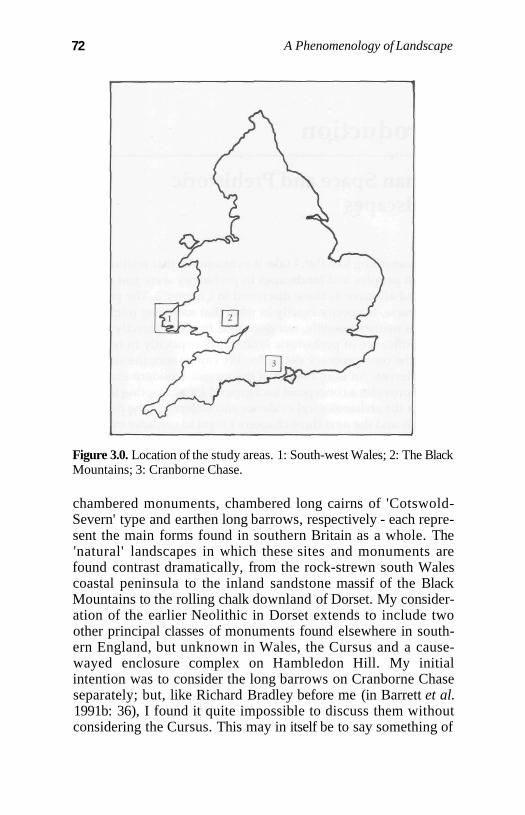
72 A Phenomenology of Landscape
Figure 3.0. Location of the study areas. 1: South-west Wales; 2: The BlackMountains; 3: Cranborne Chase.
chambered monuments, chambered long cairns of 'Cotswold-Severn' type and earthen long barrows, respectively - each repre-sent the main forms found in southern Britain as a whole. The'natural' landscapes in which these sites and monuments arefound contrast dramatically, from the rock-strewn south Walescoastal peninsula to the inland sandstone massif of the BlackMountains to the rolling chalk downland of Dorset. My consider-ation of the earlier Neolithic in Dorset extends to include twoother principal classes of monuments found elsewhere in south-ern England, but unknown in Wales, the Cursus and a cause-wayed enclosure complex on Hambledon Hill. My initialintention was to consider the long barrows on Cranborne Chaseseparately; but, like Richard Bradley before me (in Barrett et al.1991b: 36), I found it quite impossible to discuss them withoutconsidering the Cursus. This may in itself be to say something of
Part II: Human Space and Prehistoric Landscapes 73
interest about the power of that monument, even when, today, it isscarcely visible on the ground.
Although focusing on landscape the discussions also addressthe 'problem' of the Mesolithic-Neolithic 'transition', one of theblack holes of British prehistory, a chronological drawer in thetraditional archaeological filing cabinet that remains almostempty. Previous attempts to discuss the relationship between thefinal postglacial hunter-fisher-gatherer populations of theMesolithic and the early Neolithic peoples who, in the receivedwisdom, began to cultivate and garden, clear the land and keepdomesticates, have concentrated on the built environment. Theclassic example has come not from Britain, but Brittany, wheremuch has been made of adduced structural and depositional sim-ilarities between the graves in the Mesolithic cemeteries atHoedic and Teviec and early Neolithic long mounds (e.g.Renfrew 1973a: 158; Sherratt 1990; Kirk 1993). Since, in Britain,there is no architectural evidence, and very few Mesolithic buri-als apart from remains in caves, such a linkage has not been pos-sible to make in these formal terms. Here I attempt to traceinstead process rather than product, the means by which the landbecame encultured and ultimately transformed into architecturalform during the Neolithic, when there arises a need to captureand control what the landscape is about through the medium ofarchitectural morphology.
From a very contemporary perspective, visiting sites in amodern landscape, it is, of course, extremely difficult to attemptto envisage, in the mind's eye, the prehistoric settings of locales.Everything would appear to have changed; at first glance the taskseems hopeless. It is simply impossible to know exactly wherethe trees and bushes were in relation to sites and monuments,where the flowers bloomed and the rushes sighed in the wind.Even the greatest refinements in techniques such as pollen andmolluscan analysis can provide only a relatively coarse assess-ment of these matters, and, concentrating on statistics and countsof oak and lime, arboreal and non-arboreal pollen, they tell us alltoo little of what the forests and open areas actually looked likeand how the plants grew. The skin of the land has gone for good,and can only be partially recovered through the most diligent ofscientific analyses; but not its shape. The bones of the land - themountains, hills, rocks and valleys, escarpments and ridges -have remained substantially the same since the Mesolithic, and
74 A Phenomenology of Landscape
can still be observed. Only the coastline has been radicallyaltered. It is the bones of the land and their relationship to sitesand monuments with which these archaeological studies areprincipally concerned.
As a contemporary subject observer interested in interpretingthe meanings of prehistoric landscapes I make no claims to anempathetic understanding of their significance, to some incredi-ble feat of being able to find and recover meaning in prehistoricminds. To think that is either illusion or to act like God. However,I believe that the experience of place is of fundamental signifi-cance in the attempt to provide an account. There is one, all toocontemporary, experience of place with which most people willbe familiar. Locate a monument or site on a map. Drive for hoursin a car, and attempt to arrive as close as possible to the place.Walk a shorter or longer distance, if necessary, and you are there.In the case of all but a few well-preserved chambered monu-ments the result is inevitably disappointing: a few overgrownstones or a low mound covered with rank vegetation in summeris hardly inspiring. You acquire little sense of the feel and charac-ter of the land. A monument or place encountered in the course ofa walk between places is an altogether different matter.Approaching it slowly, from different directions, and anticipat-ing arriving, it is possible to observe in a much more subtle man-ner the way in which it is related to its physical surroundings, thelie of the land. Even a site which you cannot see, such as aMesolithic flint scatter, acquires in this way a greater significanceand interest. Even the most dilapidated monument becomesworth visiting. To make the point in a slightly different way, allplaces are in landscapes, but landscapes constitute the place.Walk from one place to another or approach it from a differentdirection and everything will change. Things that loomed large inyour visual field may become small, or look different. What wasat the centre may now be on the periphery; what could be seenhas now disappeared, and new horizons have come into view.
This perpetually shifting human visual experience of placeand landscape encountered in the walk has not altered since theMesolithic. Things in front of or behind you, within reach orwithout, things to the left and right of your body, above andbelow, these most basic of personal spatial experiences, areshared with prehistoric populations in our common biologicalhumanity. They provide tools with which to think and to work.
Part II: Human Space and Prehistoric Landscapes 75
Looking at the two-dimensional plane of the modern topo-graphic map with sites and monuments plotted on it, it is quiteimpossible to envisage the landscape in which these places areembedded. The representation fails, and cannot substitute forbeing there, being in place. Similarly, an unfamiliar landscaperemains invisible. You do not know where, or how, to look. Thisprocess of observation requires time and a feeling for the place.After being there, after making many visits to the same locales,the intensity of the experience heightens. Monuments that wereinitially hidden from view on a first visit to a place can now beseen, and patterned relationships between sites and their settingsbecome apparent.
An Affinity with the Coast: Places andMonuments in South-west Wales
Introduction
The geology of south-west Wales is particularly complex, consist-ing of a series of sedimentary and igneous rock formations ofPre-Cambrian to Carboniferous age. The landscape has beengreatly eroded to create a series of relatively flat surfaces atapproximately 60 m. intervals above sea level. Only small areasof the land surface are 200 m. or more above sea level. Despite thefact that this is a relatively low-lying area the coasts and someinland areas display some quite dramatic variations in relief. Thegreater part of north Pembrokeshire is made up of Ordovicianrocks, sandstones, grits and shales broken up by igneous intru-sions. These igneous rocks are exposed in narrow strips, andcommonly form the numerous headlands along the north-westcoast where sheltered bays and inlets have been cut into thesofter shales. Inland they form impressive weathered rock out-crops and ridges. Inland in the south of Pembrokeshire the land-scape is gentler and more undulating being made uppredominantly of Devonian Old Red Sandstone andCarboniferous limestone formations, locally eroded to create lowcrags and rock outcrops. Along the coast great walls of impres-sive precipitous cliffs are broken up to form sweeping bays anddramatic headlands.
The coastline of south-west Wales has long generated consid-erable interest because of the presence of submerged early post-glacial landscapes, exposed within the intertidal zone at very lowtides or when storms have eroded away more recent marinesediments. These are made up of peat deposits with fallen tree-trunks and stumps.
76
Chapter 3
Affinity with the Coast: Places and Monuments, SW Wales 77
Locales in the Earlier and Later Mesolithic
In south-west Wales the Mesolithic evidence almost entirely con-sists of flint scatters, with a paucity of faunal collections associat-ed with human activities. The surface flint findspots areremarkably prolific, and have been documented and discussedby a number of authors (Cantrill 1915; Gordon-Williams 1926;Grimes 1932; Leach 1913; 1918; 1933; Wainwright 1963; Jacobi1980; David 1990). They are almost solely confined to the coast forboth earlier and later Mesolithic assemblages. Earlier Mesolithicflint scatters are concentrated along the south coast of Pembroke,extending from Caldey island in the south-east to St David'sHead in the north-west. Later Mesolithic sites occur in the samearea, and also extend along the north coast as far east as Newport(Fig. 3.1). These assemblages vary in size from small, highly local-ized surface scatters, representing temporary occupations andresting-places, to quite massive concentrations of microliths,chipped flint, pebble tools, cores and lithic debris, suggesting fre-quently visted locales. This material is locally derived from beachshingles, and does not naturally occur on the cliff-tops borderingthe beaches where the majority of the sites are located.
The dense concentration of the Mesolithic sites along thesouthern coast of Pembrokeshire indicates that it was an area thatwas extensively exploited throughout the Mesolithic. On thebasis of a survey of 20 sites along the Pembrokeshire coasts fromwhich there have been substantial lithic collections, as opposed toisolated finds of one or a few artefacts, five broad types of localemay be distinguished:
(i) Cave and rock shelters in the faces of limestone cliffs. Fourof these are documented with Mesolithic material, three of whichare on Caldey island.
(ii) Places on flat or undulating rather exposed ground highup, situated directly on the margins of the cliff-tops and head-lands, with extensive views along the coasts and across the sea,but with restricted visibility inland. The classic case of such alocation is Nab Head, where the site is located on the heavilyeroding neck of the headland, with precipitous cliffs to the north,west and east. Inland, to the south, the land rises up, and visibili-ty is reduced to a few hundred metres. From the site there areextensive views across the sea to locales where other Mesolithicsites are found, to the south and east extending as far as Skomerisland and to the north and west to Ramsey island (Fig. 3.2).
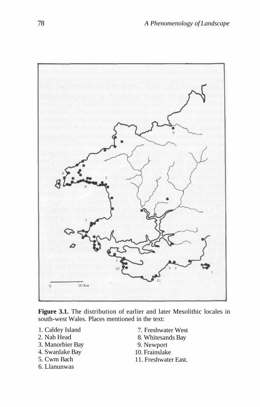
78 A Phenomenology of Landscape
Figure 3.1. The distribution of earlier and later Mesolithic locales insouth-west Wales. Places mentioned in the text:
1. Caldey Island2. Nab Head3. Manorbier Bay4. Swanlake Bay5. Cwm Bach6. Llanunwas
7. Freshwater West8. Whitesands Bay9. Newport
10. Frainslake11. Freshwater East.
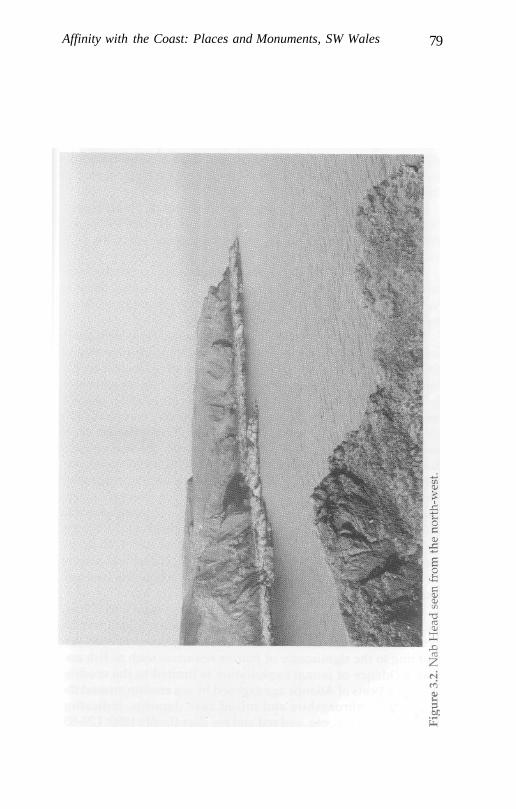
Affinity with the Coast: Places and Monuments, SW Wales 79
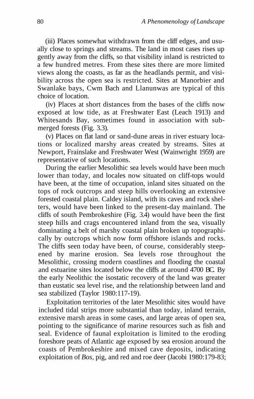
80 A Phenomenology of Landscape
(iii) Places somewhat withdrawn from the cliff edges, and usu-ally close to springs and streams. The land in most cases rises upgently away from the cliffs, so that visibility inland is restricted toa few hundred metres. From these sites there are more limitedviews along the coasts, as far as the headlands permit, and visi-bility across the open sea is restricted. Sites at Manorbier andSwanlake bays, Cwm Bach and Llanunwas are typical of thischoice of location.
(iv) Places at short distances from the bases of the cliffs nowexposed at low tide, as at Freshwater East (Leach 1913) andWhitesands Bay, sometimes found in association with sub-merged forests (Fig. 3.3).
(v) Places on flat land or sand-dune areas in river estuary loca-tions or localized marshy areas created by streams. Sites atNewport, Frainslake and Freshwater West (Wainwright 1959) arerepresentative of such locations.
During the earlier Mesolithic sea levels would have been muchlower than today, and locales now situated on cliff-tops wouldhave been, at the time of occupation, inland sites situated on thetops of rock outcrops and steep hills overlooking an extensiveforested coastal plain. Caldey island, with its caves and rock shel-ters, would have been linked to the present-day mainland. Thecliffs of south Pembrokeshire (Fig. 3.4) would have been the firststeep hills and crags encountered inland from the sea, visuallydominating a belt of marshy coastal plain broken up topographi-cally by outcrops which now form offshore islands and rocks.The cliffs seen today have been, of course, considerably steep-ened by marine erosion. Sea levels rose throughout theMesolithic, crossing modern coastlines and flooding the coastaland estuarine sites located below the cliffs at around 4700 BC. Bythe early Neolithic the isostatic recovery of the land was greaterthan eustatic sea level rise, and the relationship between land andsea stabilized (Taylor 1980:117-19).
Exploitation territories of the later Mesolithic sites would haveincluded tidal strips more substantial than today, inland terrain,extensive marsh areas in some cases, and large areas of open sea,pointing to the significance of marine resources such as fish andseal. Evidence of faunal exploitation is limited to the erodingforeshore peats of Atlantic age exposed by sea erosion around thecoasts of Pembrokeshire and mixed cave deposits, indicatingexploitation of Bos, pig, and red and roe deer (Jacobi 1980:179-83;
Affinity with the Coast: Places and Monuments, SW Wales 81
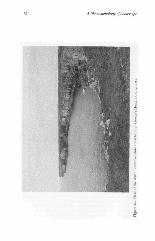
82 A Phenomenology of Landscape
Affinity with the Coast: Places and Monuments, SW Wales 83
Caseldine 1990: 40; Lewis 1990). Mollusc exploitation seems tohave been limited, although one midden site from Nanna's caveon Caldey island has been claimed (Lacaille and Grimes 1955).
The main regional woodland reflected in pollen diagramsfrom south-west Wales appears to have been dominated by oak,hazel and alder, with some local pine woodland and alder carrand sedge fen plant communities developing in valley bottomsand low-lying coastal sites (Caseldine 1990; Lewis 1990). AtMarros and Abermawr Lewis (1990) attributes increases in hazelcounts in pollen diagrams to an opening out of woodlands dur-ing the middle Neolithic and the late Mesolithic to early Neolithicrespectively. Clearance of the woodland on a large scale, princi-pally by burning, and the creation of a more open 'pastoral' land-scape does not seem to have occurred until the middle or laterNeolithic onwards. During the earlier Neolithic, when the major-ity of the chambered monuments were built and used, clearancesof the forest were of limited extent (Caseldine 1990; Lewis 1990).
Some writers on the Mesolithic of south-west Wales havestressed the great attractiveness of coastal areas as opposed toinland and upland areas with regard to both possibilities forresource exploitation and the availability of raw materials(Wainwright 1963: 126; ApSimon 1976: 41), while others havepointed to a correlation between the distribution of Mesolithicsites and areas of more frost-free days (Webley 1976: 20-1; Jacobi1980: 179; David 1990: 251). Important as factors of climate orresource availability may be, the choice of locales on, or beneath,or between, inland (in the earlier Mesolithic) or coastal (during thelate Mesolithic) landmarks - precipitous ridges and rock out-crops that must have been dominant in the local environment -seems highly significant. These, no doubt named, natural topo-graphic features would have been invested with sets of localmeanings and would have had the effect of pinpointing the posi-tions of camp sites and their inhabitants to populations movingaround in the coastal flatlands or waters and marsh areas sur-rounding them. The lack of later Mesolithic inland sites may bepartially attributable to a lack of intensive survey work, and siteson the higher ground of the Preseli mountains and elsewheremight well be expected; but the evidence that these populationshad a special affinity with particular (now coastal) locales andareas is overwhelming. The entire area along the coast was exten-sively exploited. There is, on average, a findspot every four or
84 A Phenomenology of Landscape
five hundred metres along some stretches, notably betweenAngle Bay and Linney Head, south of Milford Haven (Fig. 3.5)and between Porthlyski bay and Newgale sands, with manymore yet to be discovered.
Some locales, such as Nab Head (Jacobi 1980; David 1990) androck shelters on the island of Caldey (Lacaille and Grimes 1955),have clear indications of successive occupation of precisely thesame locality from the earlier to the later Mesolithic, despite thefact that local environmental conditions and, consequently, avail-ability of exploitable resources must have changed drasticallythroughout the Mesolithic. Clearly deciding to stop at a particu-lar place was much more than simply a matter of food acquisi-tion. At Nab Head a series of earlier and later Mesolithicindustries have been documented from both surface finds andexcavations (Gordon-Williams 1926; David 1990). The location ofthis site on the neck of a headland, whether we see it today, sur-rounded by the sea (Fig. 3.2), or envisage it jutting out into awooded coastal plain, as in the early Mesolithic, is quite striking.The stone-tool industry is particularly extensive. From recentexcavations at Nab Head II, dominated by later Mesolithicmicroliths, over 23,000 pieces of flaked flint and stone wererecovered. The assemblage is dominated by backed bladelets, butalso includes two pecked and groundstone axes of probable lateMesolithic date (David 1990: 248). Apart from the flint materialrecovered at Nab Head I a shale 'Venus' figurine was found, anda large quantity (690) of perforated shale beads are recorded bothfrom surface finds and excavation (David 1990: 245). This wasclearly a major manufacturing site for these beads. Single finds ofshale beads are known from three other sites in Pembrokeshire,and as far away as Waun-Fingen-Felen in the Black Mountains,suggesting either their inclusion in exchange systems betweenMesolithic communities or extensive population movements in aseasonal round. It is likely, as David remarks, that a cemeterymay once have existed at Nab Head, although there is no trace ofit now, and bones are not preserved in the acid soils. The pres-ence of the beads and figurine at Nab Head, its repeated occu-pancy through thousands of years, and the dramatic location ofthe site provide us with a tantalizing glimpse of the symbolicdimensions of social Being-in-the-landscape during theMesolithic, the constitution of biographies in relation to place. AsBradley notes, this period has too frequently been characterized
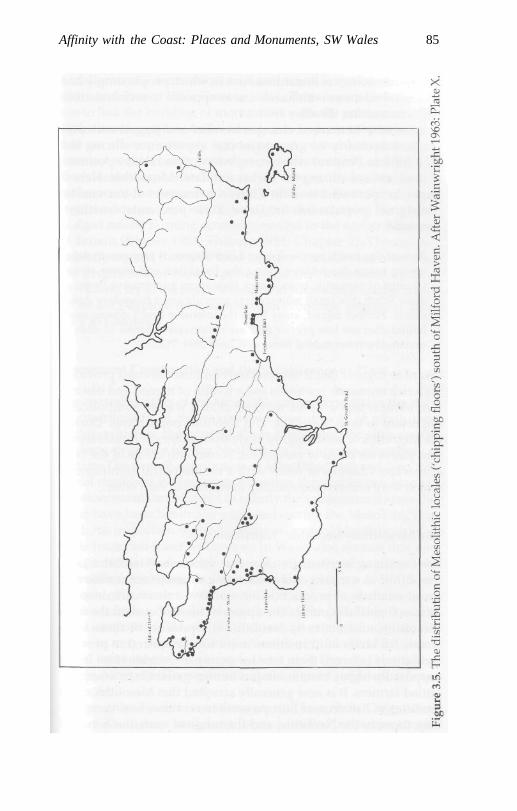
Affinity with the Coast: Places and Monuments, SW Wales 85
86 A Phenomenology of Landscape
in the archaeological literature as one in which people simply hadecological relations with hazelnuts, as opposed to social relationswith one another (Bradley 1984:11).
Proximity to marked changes in relief and jagged rock out-crops was clearly of great symbolic significance during theMesolithic in Pembrokeshire, irrespective of the relative positionsof land and sea during the earlier and later Mesolithic. Here itmight be pertinent to note Chase's comments about coastalAboriginal populations in Cape York peninsula, northernAustralia:
Present-day beach people display a high degree of precision in delin-eating estate boundaries along the beachline and major rivers.Clumps of causarine trees, a rock formation, an intrusive finger ofdune scrub or a small watercourse provide exact boundary delin-eation. Further inland, away from the intensive beach domus zone,boundaries are less precise and are conceived in terms of sites orunnamed environmental features (Chase 1984: 112).
I want to suggest that it was precisely because the coast providedboth rich economic resources and a wealth of named and distinc-tive natural topographic markers that it was so symbolicallyimportant to both Mesolithic and Neolithic populations. Duringthe Mesolithic it seems highly likely that settlement locales repre-sent places on paths of movement, bound into the lie of the landat marked changes of relief with a cosmological significance,which were ordered sequentially in relation to each other.
The Mesolithic-Neolithic 'Transition'
It is becoming increasingly clear that the terms 'Mesolithic' and'Neolithic' as a means of characterizing different economies andsocial relations of production have outlived their usefulness inarchaeological discourse. The apparent hiatus between the finalMesolithic and the early Neolithic is a product of these veryterms. All kinds of 'transitions' now seem required to providemediations between them (see for example Zvelebil 1986), fromsupposedly highly mobile 'simple' hunter-gatherers to 'complex'settled farmers. It is now generally accepted that Mesolithic com-munities in Britain and Europe were in no sense less 'complex'than those in the Neolithic, and the range of variation between
Affinity with the Coast: Places and Monuments, SW Wales 87
social groups - economic, social and ritual - was equally great(Price and Brown 1985; Gamble 1986). There is no necessary rea-son to link the building of monuments with the production of anagricultural surplus. And, indeed, it is important to rememberthat not all surpluses are agricultural. A pastoral surplus whichdoes not require being 'settled' is perfectly possible, and some ofthe 'classic' surplus societies are, of course, the hunter-fisher-gatherers of the American North-West Coast. From the archaeo-logical evidence there is little to suggest that anything like a fully-fledged mixed farming economy existed in the earlier Neolithicof Britain (Kinnes 1988; Thomas 1991: Chapter 2). Thomas hascogently argued that wild food resources contributed a substan-tial proportion of food supplies, and that a seasonal cycle ofmovement lay at the heart of social and subsistence arrangements(1991: 28). I explore the question of an economic 'transition' morefully in Chapter 6.
Monument Construction and the Significance of Place
The coastal location of the Mesolithic sites is repeated in the over-all distribution of the chambered monuments of south-westWales, which in the general absence of domestic sites are theprimary evidence for the Neolithic in the area as elsewhere inBritain. The overall distribution of Mesolithic sites and Neolithicburial chambers is complementary rather than exclusive. Many ofthe monuments are situated in exactly the same general areas thatmust have been habitually exploited during the Mesolithic (Fig.3. 6). An inspection of the distribution map of Neolithic artefactfinds from non-funerary contexts in Wales also reveals that theyare particularly densely concentrated in those regions withMesolithic findspots in Pembrokeshire (Savory 1980). Somespecific site locales, such as the Caldey rock shelters, wereutilized during both the Mesolithic and the Neolithic (Lacailleand Grimes 1955). Mesolithic locales and artefact findspots alsooccur in very close proximity to some of the individual cham-bered monuments, for example those at St David's, Manorbier,Angle, Newport (Carreg Coetan Arthur) and Longhouse (CarregSamson).
The only Neolithic settlement site known is Clegyr Boia(Fig. 3.7). It may well have been a walled settlement, with
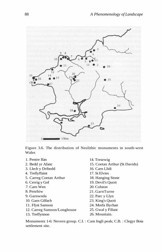
88 A Phenomenology of Landscape
Figure 3.6. The distribution of Neolithic monuments in south-westWales
1. Pentre Ifan2. Bedd yr Afanc3. Llech y Dribedd4. Trellyffaint5. Carreg Coetan Arthur6. Cerrig y Gof7. Carn Wen8. Penrhiw9. Garnwnda10. Garn Gilfach11. Ffyst Samson12. Carreg Samson/Longhouse13. Treffynnon
14. Tresewig15. Coetan Arthur (St Davids)16. Carn Llidi17. St Elvies18. Hanging Stone19. Devil's Quoit20. Colston21. GarnTurne22. Parc y Llyn23. King's Quoit24. Morfa Bychan25. Gwal y Filiast26. Mountain.
Monuments 1-6: Nevern group. C.I. : Cam Ingli peak; C.B. : Clegyr Boiasettlement site.
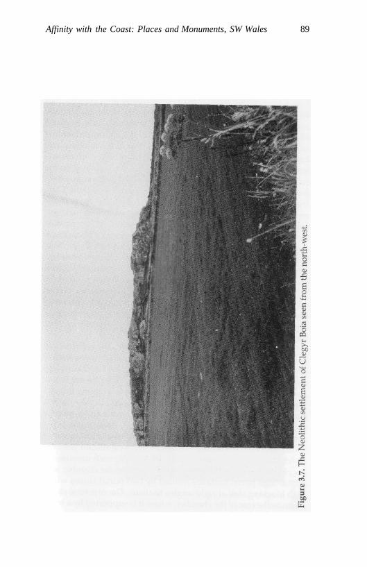
Affinity with the Coast: Places and Monuments, SW Wales 89
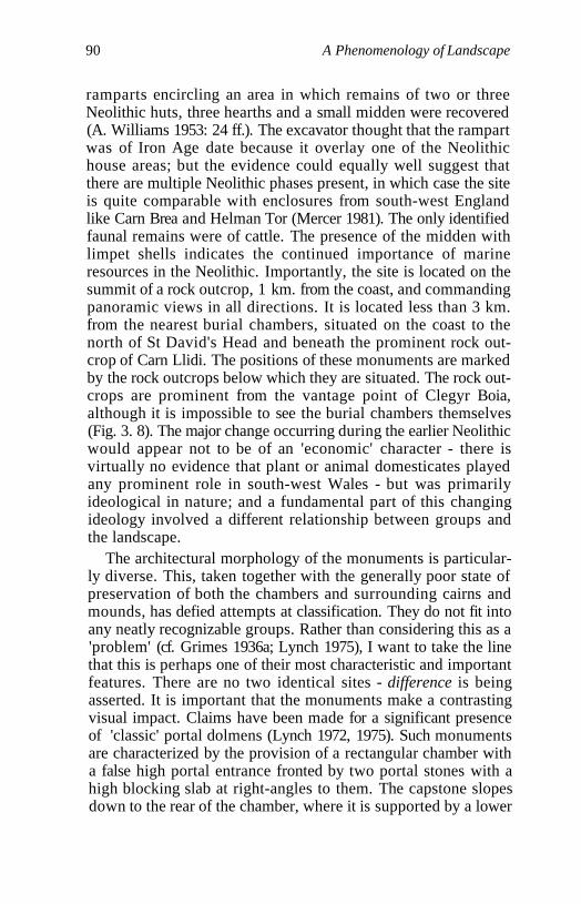
90 A Phenomenology of Landscape
ramparts encircling an area in which remains of two or threeNeolithic huts, three hearths and a small midden were recovered(A. Williams 1953: 24 ff.). The excavator thought that the rampartwas of Iron Age date because it overlay one of the Neolithichouse areas; but the evidence could equally well suggest thatthere are multiple Neolithic phases present, in which case the siteis quite comparable with enclosures from south-west Englandlike Carn Brea and Helman Tor (Mercer 1981). The only identifiedfaunal remains were of cattle. The presence of the midden withlimpet shells indicates the continued importance of marineresources in the Neolithic. Importantly, the site is located on thesummit of a rock outcrop, 1 km. from the coast, and commandingpanoramic views in all directions. It is located less than 3 km.from the nearest burial chambers, situated on the coast to thenorth of St David's Head and beneath the prominent rock out-crop of Carn Llidi. The positions of these monuments are markedby the rock outcrops below which they are situated. The rock out-crops are prominent from the vantage point of Clegyr Boia,although it is impossible to see the burial chambers themselves(Fig. 3. 8). The major change occurring during the earlier Neolithicwould appear not to be of an 'economic' character - there isvirtually no evidence that plant or animal domesticates playedany prominent role in south-west Wales - but was primarilyideological in nature; and a fundamental part of this changingideology involved a different relationship between groups andthe landscape.
The architectural morphology of the monuments is particular-ly diverse. This, taken together with the generally poor state ofpreservation of both the chambers and surrounding cairns andmounds, has defied attempts at classification. They do not fit intoany neatly recognizable groups. Rather than considering this as a'problem' (cf. Grimes 1936a; Lynch 1975), I want to take the linethat this is perhaps one of their most characteristic and importantfeatures. There are no two identical sites - difference is beingasserted. It is important that the monuments make a contrastingvisual impact. Claims have been made for a significant presenceof 'classic' portal dolmens (Lynch 1972, 1975). Such monumentsare characterized by the provision of a rectangular chamber witha false high portal entrance fronted by two portal stones with ahigh blocking slab at right-angles to them. The capstone slopesdown to the rear of the chamber, where it is supported by a lower
Affinity with the Coast: Places and Monuments, SW Wales 91
92 A Phenomenology of Landscape
upright. As Barker points out (1992: 73-6), only one site, PentreIfan, can be claimed to match such a description. Others possesssloping capstones, but without convincing evidence of a portalconstruction. No passage graves with a lengthy entrance passagehave been documented. Four monuments do, however, appear tohave been provided with very short passages leading to thechamber space (Grimes 1936a: 130-1; Lynch 1976: 75).
This study is based on a survey of 26 separate locations onwhich one or more burial chambers have been recorded (Fig. 3.6).The total number of monuments is 31, this being a complete sam-ple of all securely documented chambered monuments inPembrokeshire and the western fringe of Carmarthenshire. Allthe certain sites identified by Barker in his recent catalogue (1992)are included, and two other monuments, Morfa Bychan C andTreswig, considered by him to be 'probable' sites only. Thesemonuments are all relatively small in size and simple in construc-tion, with the exception of the two largest and most impressivesites, Pentre Ifan and Garn Turne, which possess elaborateentrance facades (Grimes 1936a: 123, 1948). Two unique andunusual sites, Cerrig y Gof and Bedd yr Afanc (Grimes 1939a;Lynch 1972: 81-2), the former with five rectangular cists arrangedin a circle in a cairn and the latter a 9 m.-long wedge-shapedgallery construction, are probably late Neolithic in date.Maximum chamber length varies between 1.7 and 4 m. Thechambers are usually rectangular or polygonal in form. The cap-stone, where it survives, is undoubtedly the most visuallyimpressive architectural component of these monuments, and inall cases was almost certainly not originally covered by mound orcairn material. All the monuments with the exception of two orthree sites originally possessed only one capstone covering thechamber, and capstone length provides a fairly reliable guide torelative monument size. At least seven of the monuments origi-nally possessed two small chambers. These were originally set inmounds or cairns; but for most sites their ruinous state makes theoriginal shape and size impossible to determine by field surveyalone. In three cases there is evidence for the construction of arectangular cairn; and in a further nine cases the cairn appears tohave been originally circular or oval in form. Two cemeteries atCarn Wen and Morfa Bychan, consisting respectively of threeand four monuments separated by distances of 70 m. or less, areknown. The other monuments are situated at distances ranging
Affinity with the Coast: Places and Monuments, SW Wales 93
between 0.6 and 18 km. from their nearest neighbours (mean:4.1 km.); but the majority of them are located within a few kilo-metres of each other.
While the architectural morphology of the monuments seemsto involve a stress on difference, their location in relation to topo-graphic features of the landscape is highly structured and repeti-tive. The relationship to the coastline, especially in relation tobays, inlets and peninsulas, of many of the monuments is obvi-ous, and must have been as important a factor in monumentplacement as it was for settlements during the Mesolithic. Themean distance from the nearest coastline is only 3.6 km., and 14 ofthem are situated within 1 km. of the sea, three of which, includ-ing the cemeteries at Carn Wen and Morfa Bychan, occur direct-ly in cliff-top locations recalling the exact positions of manyMesolithic locales.
But this relationship to the coast is more complex than a casualglance at the distribution map might imply. Only eight of themonument locations were chosen so that standing by the monu-ment it is possible to overlook the sea directly. From 14 sites (54per cent) the nearest coastline to the monument is visible at vari-ous distances away; but there are some striking anomalies. Fourmonuments are located in such a position that a distant ratherthan the nearest section of coastline is visible. In the case of themonument at St Elvies, it is located only 300 m. from the nearestcoast, yet the sea is completely invisible. Such sites might bedescribed as being coastal, but with an inland visual field. Thisplacement of some of the monuments so that they are hiddenfrom the coastline nearest to them suggests that landscape fea-tures other than the coast itself began to play an increasinglyimportant role for monument location during the Neolithic.
One possibility is that the monuments might be located so asto be intervisible with each other, rather than with features of thenatural landscape; but, despite the closeness of the location ofmany of the monuments, intervisibility between them is restrictedto a few sites in the northern area of their distribution. Only twoof the monuments are sited on the highest points in their imme-diate vicinity, with extensive views in all cardinal directions. Allthe others have restricted visibility in one or two directions, withthe land rising up immediately beyond the monument, whichmay be sited on the midpoint of a slope, at the bottom of a slope,or on a relatively high point, with rock outcrops or the land

94 A Phenomenology of Landscape
surface rising above it. The monuments, then, were clearly notsited for maximum visibility in the landscape. They were onlymeant to be seen, or approached, from certain directions.
One notable feature of the peninsulas of south-west Wales isthe presence not only of dramatic cliffs but of inland outcrops ofigneous and other rocks. Fourteen of the site locations (54 percent) were chosen in a close or direct relationship to these. A fur-ther four sites in the Nevern valley, I will argue, are intimatelyrelated to one of the highest and most dramatic craggy outcropsof the Preseli mountains, Carn Ingli, providing a central symbolicfocal point for this group of monuments.
Just to the west of Fishguard harbour a north-south row ofthree stone chambers is located on a high point with originally(the view is now blocked by houses) sweeping vistas over to theeast, with Carn Ingli visible in the distance. Immediately to thewest of the chambers a rock outcrop juts out and rises abovethem. These chambers are much ruined; but the capstones andtheir long axes seem to be orientated so that they face west-east,i.e. towards the harbour below and the rock outcrop above them.This location is duplicated in the only other case in south-westWales where a row of burial chambers occurs - Morfa Bychan onthe south coast. Here there is a north-south row of four burialchambers set high up on a sloping headland next to a long, lowand linear rock outcrop blocking all views to the west, and over-looking a small bay to the east (Fig. 3. 9). The chambers here aresurrounded by oval or circular cairn structures. These four mon-uments are situated on a slope rising from south to north, belowthe outcrop to the west. As one moves up the slope from south tonorth, the chambers get progressively closer to the outcrop itself,so that the northern chamber is actually built up against it. Thismonument has an entrance which faces east towards the baybelow. In entering the monument from the east one would beapproaching and 'entering' the rock outcrop behind it to thewest. Moving up the slope from south to north, the third monu-ment is situated directly below a natural stack of rock erodedfrom the main escarpment, known as the 'Druid's Altar' (Figs.3.10 and 3.11). This sequence of monuments, progressively situat-ed so as to be closer and closer to the rocks beyond in the courseof upward movement, must have been one which was integratedand 'made sense of through persons moving closer to the rock asthey moved from monument to monument. Such a sequence
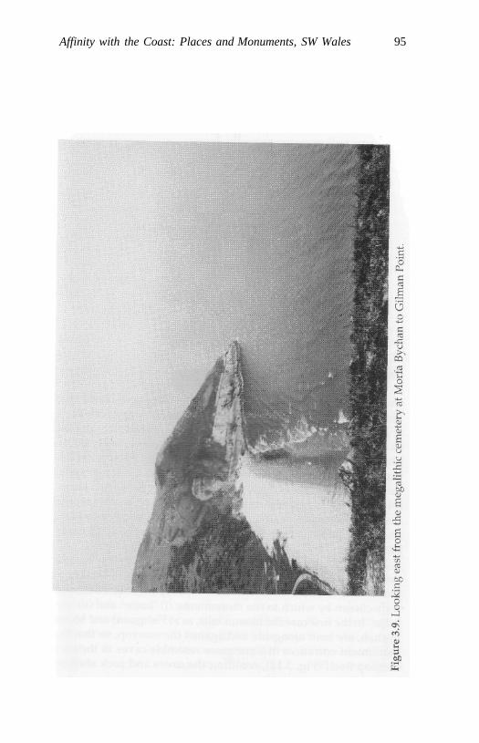
Affinity with the Coast: Places and Monuments, SW Wales 95
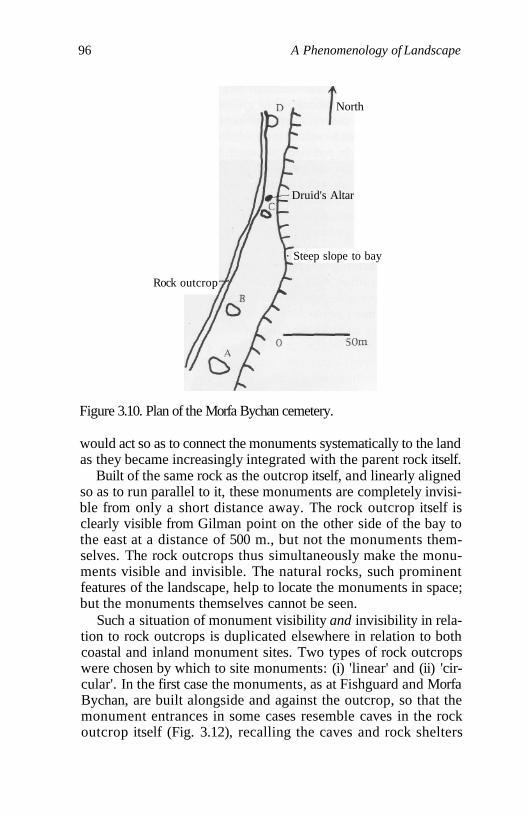
96 A Phenomenology of Landscape
North
Rock outcrop
Steep slope to bay
Figure 3.10. Plan of the Morfa Bychan cemetery.
would act so as to connect the monuments systematically to the landas they became increasingly integrated with the parent rock itself.
Built of the same rock as the outcrop itself, and linearly alignedso as to run parallel to it, these monuments are completely invisi-ble from only a short distance away. The rock outcrop itself isclearly visible from Gilman point on the other side of the bay tothe east at a distance of 500 m., but not the monuments them-selves. The rock outcrops thus simultaneously make the monu-ments visible and invisible. The natural rocks, such prominentfeatures of the landscape, help to locate the monuments in space;but the monuments themselves cannot be seen.
Such a situation of monument visibility and invisibility in rela-tion to rock outcrops is duplicated elsewhere in relation to bothcoastal and inland monument sites. Two types of rock outcropswere chosen by which to site monuments: (i) 'linear' and (ii) 'cir-cular'. In the first case the monuments, as at Fishguard and MorfaBychan, are built alongside and against the outcrop, so that themonument entrances in some cases resemble caves in the rockoutcrop itself (Fig. 3.12), recalling the caves and rock shelters
Druid's Altar
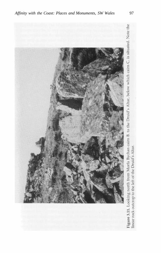
Affinity with the Coast: Places and Monuments, SW Wales 97
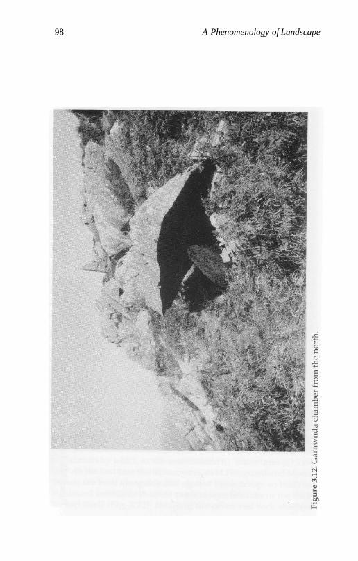
98 A Phenomenology of Landscape
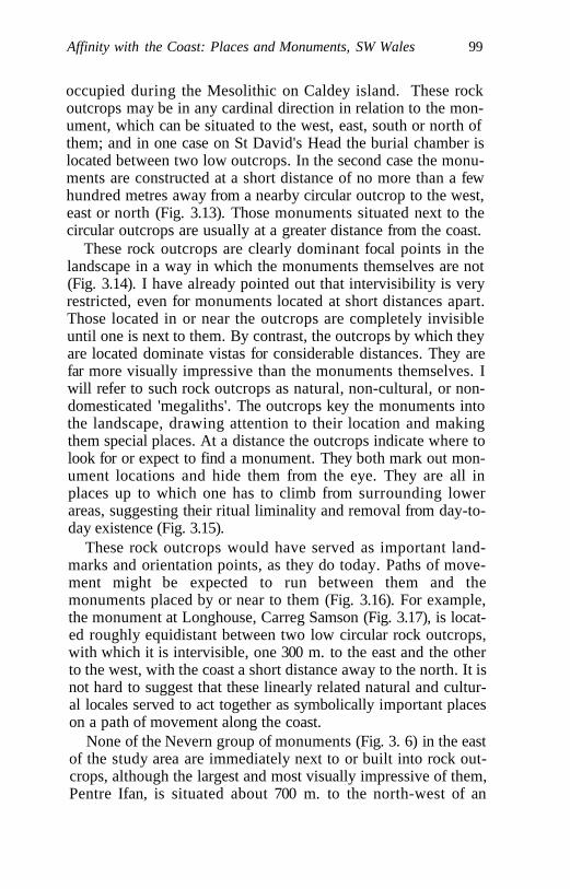
Affinity with the Coast: Places and Monuments, SW Wales 99
occupied during the Mesolithic on Caldey island. These rockoutcrops may be in any cardinal direction in relation to the mon-ument, which can be situated to the west, east, south or north ofthem; and in one case on St David's Head the burial chamber islocated between two low outcrops. In the second case the monu-ments are constructed at a short distance of no more than a fewhundred metres away from a nearby circular outcrop to the west,east or north (Fig. 3.13). Those monuments situated next to thecircular outcrops are usually at a greater distance from the coast.
These rock outcrops are clearly dominant focal points in thelandscape in a way in which the monuments themselves are not(Fig. 3.14). I have already pointed out that intervisibility is veryrestricted, even for monuments located at short distances apart.Those located in or near the outcrops are completely invisibleuntil one is next to them. By contrast, the outcrops by which theyare located dominate vistas for considerable distances. They arefar more visually impressive than the monuments themselves. Iwill refer to such rock outcrops as natural, non-cultural, or non-domesticated 'megaliths'. The outcrops key the monuments intothe landscape, drawing attention to their location and makingthem special places. At a distance the outcrops indicate where tolook for or expect to find a monument. They both mark out mon-ument locations and hide them from the eye. They are all inplaces up to which one has to climb from surrounding lowerareas, suggesting their ritual liminality and removal from day-to-day existence (Fig. 3.15).
These rock outcrops would have served as important land-marks and orientation points, as they do today. Paths of move-ment might be expected to run between them and themonuments placed by or near to them (Fig. 3.16). For example,the monument at Longhouse, Carreg Samson (Fig. 3.17), is locat-ed roughly equidistant between two low circular rock outcrops,with which it is intervisible, one 300 m. to the east and the otherto the west, with the coast a short distance away to the north. It isnot hard to suggest that these linearly related natural and cultur-al locales served to act together as symbolically important placeson a path of movement along the coast.
None of the Nevern group of monuments (Fig. 3. 6) in the eastof the study area are immediately next to or built into rock out-crops, although the largest and most visually impressive of them,Pentre Ifan, is situated about 700 m. to the north-west of an
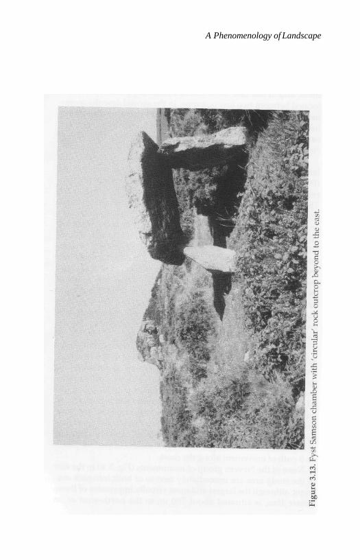
A Phenomenology of Landscape
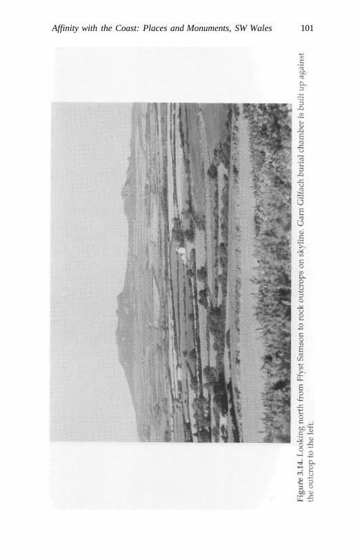
Affinity with the Coast: Places and Monuments, SW Wales 101
102 A Phenomenology of Landscape
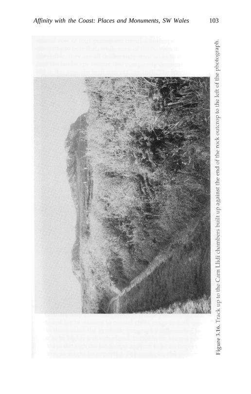
Affinity with the Coast: Places and Monuments, SW Wales 103
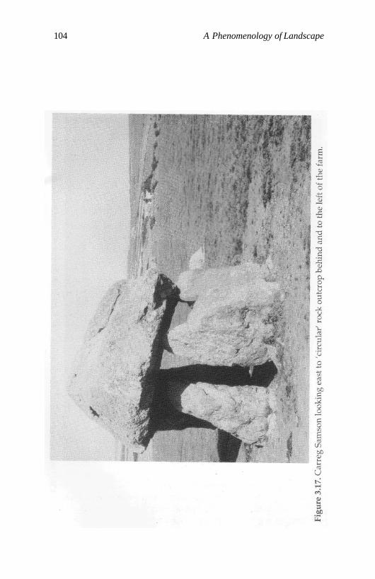
104 A Phenomenology of Landscape
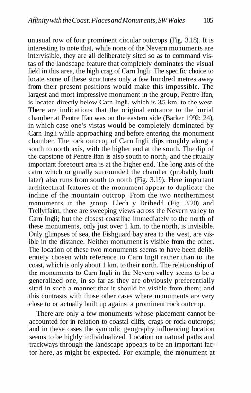
Affinity with the Coast: Places and Monuments, SW Wales 105
unusual row of four prominent circular outcrops (Fig. 3.18). It isinteresting to note that, while none of the Nevern monuments areintervisible, they are all deliberately sited so as to command vis-tas of the landscape feature that completely dominates the visualfield in this area, the high crag of Carn Ingli. The specific choice tolocate some of these structures only a few hundred metres awayfrom their present positions would make this impossible. Thelargest and most impressive monument in the group, Pentre Ifan,is located directly below Carn Ingli, which is 3.5 km. to the west.There are indications that the original entrance to the burialchamber at Pentre Ifan was on the eastern side (Barker 1992: 24),in which case one's vistas would be completely dominated byCarn Ingli while approaching and before entering the monumentchamber. The rock outcrop of Carn Ingli dips roughly along asouth to north axis, with the higher end at the south. The dip ofthe capstone of Pentre Ifan is also south to north, and the rituallyimportant forecourt area is at the higher end. The long axis of thecairn which originally surrounded the chamber (probably builtlater) also runs from south to north (Fig. 3.19). Here importantarchitectural features of the monument appear to duplicate theincline of the mountain outcrop. From the two northernmostmonuments in the group, Llech y Dribedd (Fig. 3.20) andTrellyffaint, there are sweeping views across the Nevern valley toCarn Ingli; but the closest coastline immediately to the north ofthese monuments, only just over 1 km. to the north, is invisible.Only glimpses of sea, the Fishguard bay area to the west, are vis-ible in the distance. Neither monument is visible from the other.The location of these two monuments seems to have been delib-erately chosen with reference to Carn Ingli rather than to thecoast, which is only about 1 km. to their north. The relationship ofthe monuments to Carn Ingli in the Nevern valley seems to be ageneralized one, in so far as they are obviously preferentiallysited in such a manner that it should be visible from them; andthis contrasts with those other cases where monuments are veryclose to or actually built up against a prominent rock outcrop.
There are only a few monuments whose placement cannot beaccounted for in relation to coastal cliffs, crags or rock outcrops;and in these cases the symbolic geography influencing locationseems to be highly individualized. Location on natural paths andtrackways through the landscape appears to be an important fac-tor here, as might be expected. For example, the monument at
106 A Phenomenology of Landscape

Affinity with the Coast: Places and Monuments, SW Wales 107
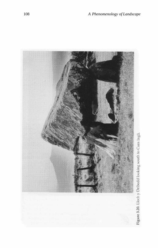
108 A Phenomenology of Landscape
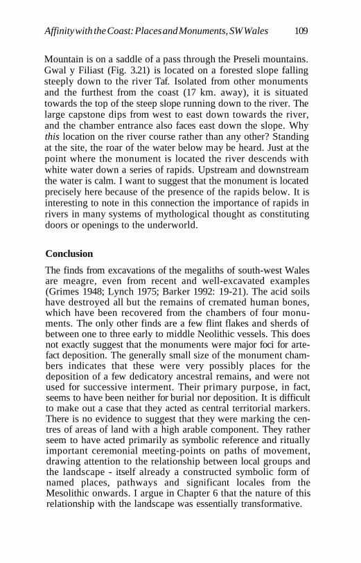
Affinity with the Coast: Places and Monuments, SW Wales 109
Mountain is on a saddle of a pass through the Preseli mountains.Gwal y Filiast (Fig. 3.21) is located on a forested slope fallingsteeply down to the river Taf. Isolated from other monumentsand the furthest from the coast (17 km. away), it is situatedtowards the top of the steep slope running down to the river. Thelarge capstone dips from west to east down towards the river,and the chamber entrance also faces east down the slope. Whythis location on the river course rather than any other? Standingat the site, the roar of the water below may be heard. Just at thepoint where the monument is located the river descends withwhite water down a series of rapids. Upstream and downstreamthe water is calm. I want to suggest that the monument is locatedprecisely here because of the presence of the rapids below. It isinteresting to note in this connection the importance of rapids inrivers in many systems of mythological thought as constitutingdoors or openings to the underworld.
Conclusion
The finds from excavations of the megaliths of south-west Walesare meagre, even from recent and well-excavated examples(Grimes 1948; Lynch 1975; Barker 1992: 19-21). The acid soilshave destroyed all but the remains of cremated human bones,which have been recovered from the chambers of four monu-ments. The only other finds are a few flint flakes and sherds ofbetween one to three early to middle Neolithic vessels. This doesnot exactly suggest that the monuments were major foci for arte-fact deposition. The generally small size of the monument cham-bers indicates that these were very possibly places for thedeposition of a few dedicatory ancestral remains, and were notused for successive interment. Their primary purpose, in fact,seems to have been neither for burial nor deposition. It is difficultto make out a case that they acted as central territorial markers.There is no evidence to suggest that they were marking the cen-tres of areas of land with a high arable component. They ratherseem to have acted primarily as symbolic reference and rituallyimportant ceremonial meeting-points on paths of movement,drawing attention to the relationship between local groups andthe landscape - itself already a constructed symbolic form ofnamed places, pathways and significant locales from theMesolithic onwards. I argue in Chapter 6 that the nature of thisrelationship with the landscape was essentially transformative.
110 A Phenomenology of Landscape
Chapter 4
Escarpments and Spurs: Places andMonuments in the Black Mountains
Introduction
The Black Mountains constitute an upland area of Old RedSandstone dividing the ancient rocks of mid-Wales from areas ofCarboniferous limestone and Millstone Grit to the south. To thenorth, west and south they rise up to around 700 m. in a series ofimpressively steep, well-defined escarpments, with spurs juttinginto the flood plains through which flow the major rivers, the Uskand the Wye. To the south-east they are irregularly split up by aseries of steep-sided valleys cut down by roughly parallel streamsystems. A series of chambered long cairns are found in a roughsemicircle along the Usk and Wye valleys, the only inland mega-lithic monuments known in Wales. For south-east Wales as awhole, including the Glamorgan lowlands and uplands, theBrecon Beacons and the Black Mountains area, a series of earlierand later Mesolithic sites have also been documented (Savory1961; Jacobi 1980: 191 ff.; Berridge 1980; Stanton 1984; Britnell1984: 136-8; Smith and Cloutman 1988; Wymer 1977). The mainconcentration of these sites occurs at the head of the Rhonddavalleys, and relatively few locales are yet known from centralareas of the Brecon Beacons or Black Mountains (Figs. 4.1 and4.2). This is almost certainly attributable to lack of field survey.The majority of the sites in the Glamorgan uplands were locatedby field-walking ploughed areas and tracks created by theForestry Commission from the 1960s onwards.
Mesolithic Locales
On the basis of visits to fifteen locales, from which there are majorflint scatters, the following general classes of places may be dis-tinguished:
111
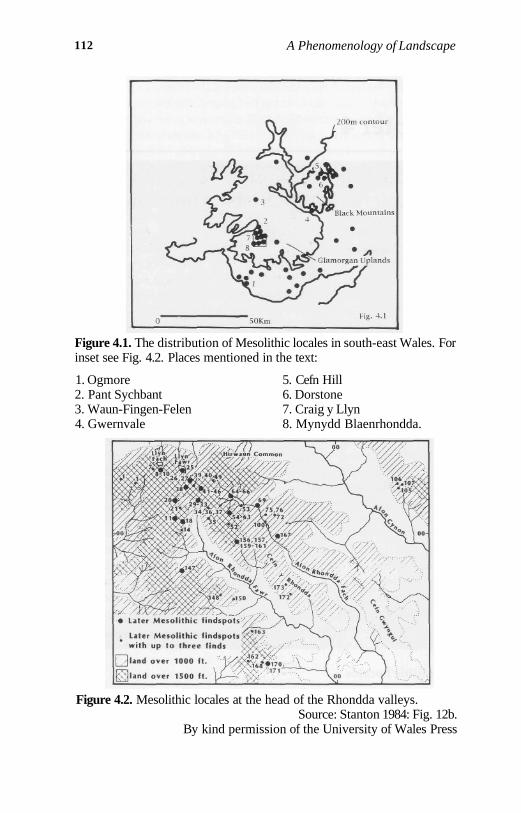
112 A Phenomenology of Landscape
Figure 4.1. The distribution of Mesolithic locales in south-east Wales. Forinset see Fig. 4.2. Places mentioned in the text:
1. Ogmore2. Pant Sychbant3. Waun-Fingen-Felen4. Gwernvale
5. Cefn Hill6. Dorstone7. Craig y Llyn8. Mynydd Blaenrhondda.
Figure 4.2. Mesolithic locales at the head of the Rhondda valleys.Source: Stanton 1984: Fig. 12b.
By kind permission of the University of Wales Press
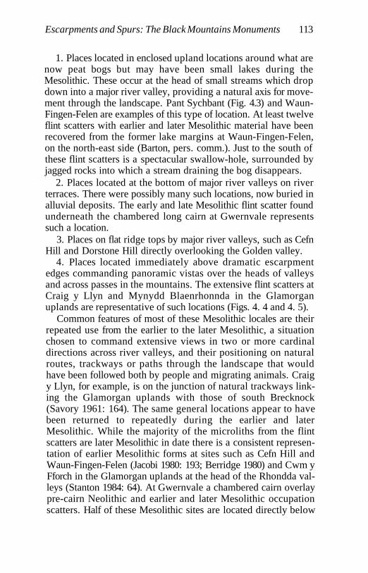
Escarpments and Spurs: The Black Mountains Monuments 113
1. Places located in enclosed upland locations around what arenow peat bogs but may have been small lakes during theMesolithic. These occur at the head of small streams which dropdown into a major river valley, providing a natural axis for move-ment through the landscape. Pant Sychbant (Fig. 4.3) and Waun-Fingen-Felen are examples of this type of location. At least twelveflint scatters with earlier and later Mesolithic material have beenrecovered from the former lake margins at Waun-Fingen-Felen,on the north-east side (Barton, pers. comm.). Just to the south ofthese flint scatters is a spectacular swallow-hole, surrounded byjagged rocks into which a stream draining the bog disappears.
2. Places located at the bottom of major river valleys on riverterraces. There were possibly many such locations, now buried inalluvial deposits. The early and late Mesolithic flint scatter foundunderneath the chambered long cairn at Gwernvale representssuch a location.
3. Places on flat ridge tops by major river valleys, such as CefnHill and Dorstone Hill directly overlooking the Golden valley.
4. Places located immediately above dramatic escarpmentedges commanding panoramic vistas over the heads of valleysand across passes in the mountains. The extensive flint scatters atCraig y Llyn and Mynydd Blaenrhonnda in the Glamorganuplands are representative of such locations (Figs. 4. 4 and 4. 5).
Common features of most of these Mesolithic locales are theirrepeated use from the earlier to the later Mesolithic, a situationchosen to command extensive views in two or more cardinaldirections across river valleys, and their positioning on naturalroutes, trackways or paths through the landscape that wouldhave been followed both by people and migrating animals. Craigy Llyn, for example, is on the junction of natural trackways link-ing the Glamorgan uplands with those of south Brecknock(Savory 1961: 164). The same general locations appear to havebeen returned to repeatedly during the earlier and laterMesolithic. While the majority of the microliths from the flintscatters are later Mesolithic in date there is a consistent represen-tation of earlier Mesolithic forms at sites such as Cefn Hill andWaun-Fingen-Felen (Jacobi 1980: 193; Berridge 1980) and Cwm yFforch in the Glamorgan uplands at the head of the Rhondda val-leys (Stanton 1984: 64). At Gwernvale a chambered cairn overlaypre-cairn Neolithic and earlier and later Mesolithic occupationscatters. Half of these Mesolithic sites are located directly below
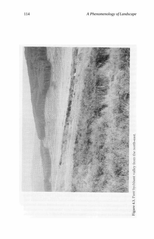
114 A Phenomenology of Landscape
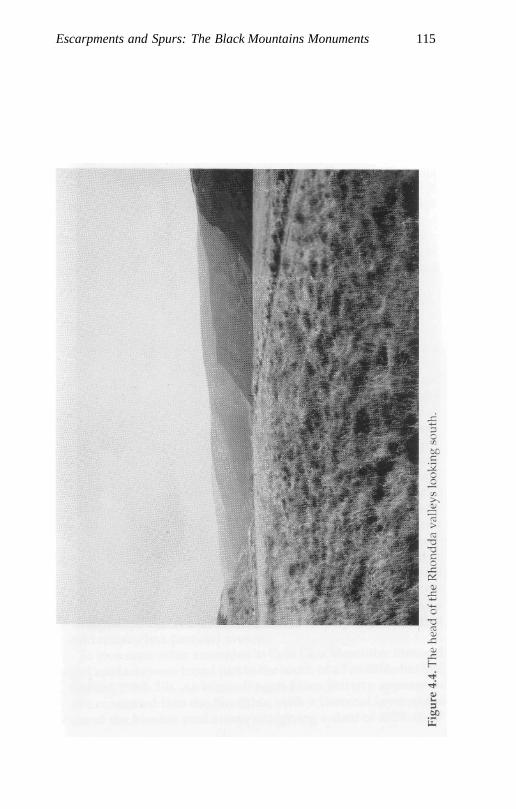
Escarpments and Spurs: The Black Mountains Monuments 115
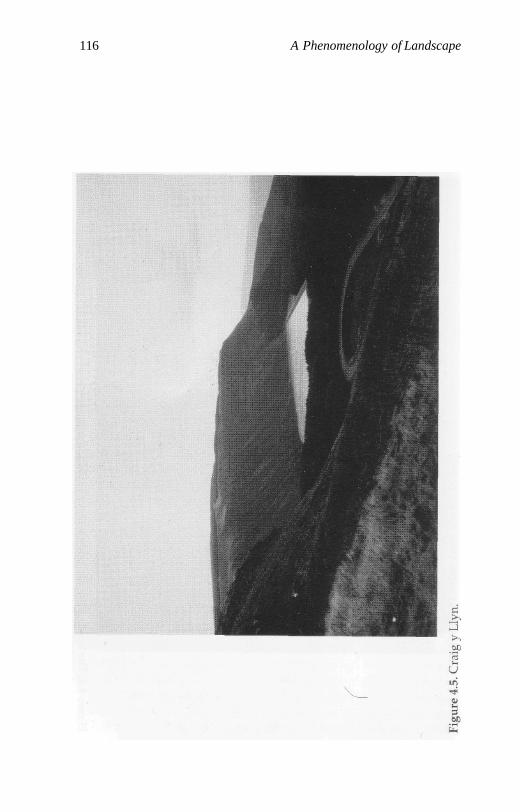
116 A Phenomenology of Landscape
Escarpments and Spurs: The Black Mountains Monuments 117
rock outcrops or on the tops of sheer escarpment edges -effectively inland versions of the cliff-tops of the Pembrokeshirecoast.
Jacobi and Stanton have proposed for south-east Wales as awhole a model of seasonal movement from coastal locationsoccupied during the winter to upland exploitation camps in thesummer similar to that postulated for the Pennines (Mellars1976), with groups following the upwards migrations of red deer.It is pertinent in this respect to note that the bulk of the flint andchert material recovered from Craig y Llyn in the Glamorganuplands may be of coastal origin (Jacobi 1980:195). Recent envi-ronmental evidence suggests perhaps the deliberate burning ofupland areas to stimulate browse (Cloutman 1983; Smith andCloutman 1988).
Flint Scatters and Occupational Continuity
Neolithic surface find material is frequently found in the samelocalities as the Mesolithic flint scatters. There is no positive evi-dence here of any direct continuity between the Mesolithic andNeolithic; but the choice of precisely the same location for theconstruction of the Gwernvale chambered monument as hadbeen occupied repeatedly during the Mesolithic suggests strong-ly something more than mere chance, as Saville has pointed out(1990: 262). One possibility here is that Mesolithic settlementactivity continued until the onset of Neolithic settlement beneaththe place where the long cairn was later built. The valleys of theUsk and the Wye have long provided routes into and from mid-Wales, providing links with the coastal lowlands of Glamorganand the Severn and forming a bridge between lowland and high-land areas. The site of Gwernvale and its use was embedded insocial memory. The fact that this area had been previously settledand cleared of woodland and obstacles, marked by the deposi-tion of cultural debris, a focus for tracks and pathways, suggestsa strong symbolic element to the choice of the location, one thatcould ritually link past and present.
To give some other examples: at Cefn Glas Mesolithic flint andchert artefacts were found just to the south of a Neolithic hut site(Stanton 1984: 59). At Waun-Fingen-Felen activity appears tohave continued into the Neolithic, with a charcoal layer at thebase of the blanket peat at one site giving a date of 4370-80 BP
118 A Phenomenology of Landscape
(Caseldine 1990: 36). Mixed Mesolithic and Neolithic flint assem-blages were recovered from Pant Sychbant and Craig y Llyn inthe Black Mountains and the Glamorgan uplands respectively(Savory 1961; Burke 1966; Webley 1976: 31). At the coastal site ofOgmore late Mesolithic material is mixed with Neolithic occupa-tion debris (Webley 1969: 289; Jacobi 1980). Microliths are record-ed from the immediate vicinity of Arthur's Stone chamberedmonument. The repeated utilization of these specific locales,when considered together with a similar overall distribution ofchambered monuments and Mesolithic sites in south-east Wales,repeating the pattern already noted for Pembrokeshire, promptsone to infer long-term regularities linking peoples and places. Itis tempting to suggest in the light of these observations thatGwernvale may not be an isolated instance, and that many otherchambered cairns may be covering locales already utilized dur-ing the Mesolithic and embedded in social memory.
Chambered Cairns and the Landscape
The megalithic monuments of the Black Mountains are the onlysubstantial inland group in Wales. At present the location of four-teen monuments is known, and there may originally have beenone or two additional sites which have now been totallydestroyed (Grimes 1936b; Corcoran 1969: 21-4; Britnell andSavory 1984: 3-9). All these monuments appear to be stone-builtlong cairns of 'Cotswold-Severn' type. There is considerablediversity in monument morphology. Seven are long moundswith terminal and/or lateral chambers. A few appear to possessadditional chambers sealed within the mound, but in the absenceof detailed investigation the precise position and nature of thechambers is uncertain in the majority of cases. One site, Arthur'sStone, differs from the rest in that a single elongated polygonalchamber with an anteroom set in an oval mound is approachedby an acutely angled passage. All the other cairns possess orwould have possessed between two and four or more chambers.Four well-excavated and documented monuments are trape-zoidal horned cairns with false portal entrances and forecourts(Grimes 1939b; Savory 1956; Britnell and Savory 1984). Cairnlength varies greatly from c.15 m. to c.60m. The lateral chamberswere normally provided with a short passage leading from theedge of the cairn revetment walls. In some cases chambers are
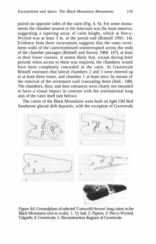
Escarpments and Spurs: The Black Mountains Monuments 119
paired on opposite sides of the cairn (Fig. 4. 6). For some monu-ments the chamber nearest to the forecourt was the most massive,suggesting a tapering away of cairn height, which at Pen-y-Wyrlod was at least 3 m. at the portal end (Britnell 1991: 14).Evidence from three excavations suggests that the outer revet-ment walls of the cairn/eontinued uninterrupted across the endsof the chamber passages (Britnell and Savory 1984: 147), at leastin their lower courses. It seems likely that, except during briefperiods when access to them was required, the chambers wouldhave been completely concealed in the cairn. At GwernvaleBritnell estimates that lateral chambers 2 and 3 were entered upto at least three times, and chamber 1 at least once, by means ofthe removal of the revetment wall concealing them (ibid.: 148).The chambers, then, and their entrances were clearly not intendedto have a visual impact in contrast with the orientational longaxis of the cairn itself (see below).
The cairns of the Black Mountains were built on light Old RedSandstone glacial drift deposits, with the exception of Gwernvale
Figure 4.6. Groundplans of selected 'Cotswold-Severn' long cairns in theBlack Mountains (not to scale). 1. Ty Isaf; 2: Pipton; 3: Pen-y-Wyrlod,Talgarth; 4: Gwernvale; 5. Reconstruction diagram of Gwernvale.
120 A Phenomenology of Landscape
and Garn Coch, which are situated on alluvial gravels and sands(Webley 1959: 291). Heavy clay soils were avoided, and the prin-cipal vegetation surrounding the sites was relatively open dryclimax oak forests, with local development of heathlands on theuplands as indicated from pollen analysis from the ancient soilsurface beneath the Mynydd Troed cairn (Crampton and Webley1966). Both Webley (1976) and Savory (1980) have called intoquestion whether there ever was any cultivation in an uplandarea much better suited to grazing such as the Black Mountains inWales. Faunal evidence from the Black Mountains is exclusivelyderived from excavations at the monuments. The presence of thebones of cattle, deer, pig and sheep from the monument cham-bers and forecourt areas suggests the ritual importance of feast-ing cycles at the monuments, which were possibly far removedfrom Neolithic settlement areas.
Webley has argued that the soils, although free-draining, wereunsuited to cultivation with a Neolithic technology, and suggest-ed a significant pastoral element in the economy based on cattleand sheep, with perhaps longer- and shorter-distance seasonaltranshumance patterns developing between the highland andlowland areas of southern Wales, and more locally between theriver valleys and upland areas within the Black Mountains them-selves. The cairns are, according to Webley (1976: 30), locatedwithin areas that would have been utilized as summer pasturesonly, with winter settlement occupying the Usk valley and thelowlands of the Welsh coast. The monuments located along theriver valleys effectively become markers along pathways fromthe lowlands to the uplands.
It does not seem necessary to invoke a fully-fledged pastoraleconomy; but the suggestion that there was a substantial degreeof population mobility during the earlier Neolithic, seasonallymoving between different landscapes, is pertinent. The overallpattern of social movement, in other words, repeats that alreadyestablished during the Mesolithic, involving winter-summer,lowland to upland movements. The significant difference wouldappear to be the substitution of some domesticates, primarilycattle and sheep or goat, for total reliance on wild food resources.
The monuments extend in an arc around the Black Mountains.In the north and west they are located along the valley of the Wyeand its tributaries, the Dore and the Llynfi; in the south, along thevalley of the Usk and one major tributary, the Rhiangoll. No sites
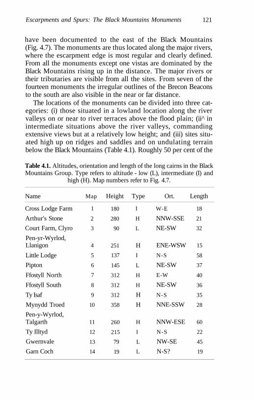
Escarpments and Spurs: The Black Mountains Monuments 121
have been documented to the east of the Black Mountains(Fig. 4.7). The monuments are thus located along the major rivers,where the escarpment edge is most regular and clearly defined.From all the monuments except one vistas are dominated by theBlack Mountains rising up in the distance. The major rivers ortheir tributaries are visible from all the sites. From seven of thefourteen monuments the irregular outlines of the Brecon Beaconsto the south are also visible in the near or far distance.
The locations of the monuments can be divided into three cat-egories: (i) those situated in a lowland location along the rivervalleys on or near to river terraces above the flood plain; (ii^ inintermediate situations above the river valleys, commandingextensive views but at a relatively low height; and (iii) sites situ-ated high up on ridges and saddles and on undulating terrainbelow the Black Mountains (Table 4.1). Roughly 50 per cent of the
Table 4.1. Altitudes, orientation and length of the long cairns in the BlackMountains Group. Type refers to altitude - low (L), intermediate (I) and
high (H). Map numbers refer to Fig. 4.7.
Name
Cross Lodge Farm
Arthur's Stone
Court Farm, Clyro
Pen-yr-Wyrlod,Llanigon
Little Lodge
Pipton
Ffostyll North
Ffostyll South
Ty Isaf
Mynydd Troed
Pen-y-Wyrlod,Talgarth
Ty Illtyd
Gwernvale
Garn Coch
Map
1
2
3
4
5
6
7
8
9
10
11
12
13
14
Height
180
280
90
251
137
145
312
312
312
358
260
215
79
19
Type
I
H
L
H
I
L
H
H
H
H
H
I
L
L
Ort.
W-E
NNW-SSE
NE-SW
ENE-WSW
N-S
NE-SW
E-W
NE-SW
N-S
NNE-SSW
NNW-ESE
N-S
NW-SE
N-S?
Length
18
21
32
15
58
37
40
36
35
28
60
22
45
19
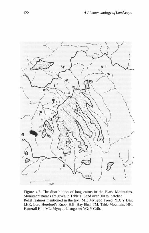
122 A Phenomenology of Landscape
Figure 4.7. The distribution of long cairns in the Black Mountains.Monument names are given in Table 1. Land over 500 m. hatched.Relief features mentioned in the text: MT: Mynydd Troed; YD: Y Das;LHK: Lord Hereford's Knob; H.B. Hay Bluff; TM: Table Mountain; HH:Hatterall Hill; ML: Mynydd Llangorse; YG: Y Grib.
Escarpments and Spurs: The Black Mountains Monuments 123
monuments are located in the first or second categories and 50per cent in the third.
Two of the monuments at Ffostyll are situated only about50 m. apart, the others are situated at a distance of between2.0 km. and 5.6 km. from their nearest neighbours (mean distance2.6 km.), thus displaying some considerable regularity in theirspacing. Second nearest-neighbour distances range between 2and 12 km. (mean distance 6 km.). Their location appears to bestrongly related to not only the major river valleys but also tribu-tary streams, in such a way that hypothetical 'territorial' demar-cation can be related to the flows of river courses (see Fig. 4.7).One of the monuments, Ty Illtyd, is comparatively isolated; theothers occur in what may be associated pairs, located in relationto specific landscape features on opposite sides of the majorrivers, apart from a small cluster of five monuments in the centreof the distribution.
Orientation and Ritual Axis
The orientations of the long cairns display a complete lack ofregularity. All the eight major orientational axes of the compassare represented between the two poles, north to south and westto east. A maximum number of 3-4 monuments share the sameorientational axis for the cairn. Cairn orientation differs for allfirst nearest-neighbours, while only three second nearest-neigh-bours share the same orientational axis. The most dramatic caseof this is the two cairns at Ffostyll situated next to each other,where the northern cairn is orientated W-E and the southern oneis almost diametrically opposed, NE-SW. Well-excavated or pre-served examples of these cairns do show some regularity in theplacement of the broad forecourt area. In the two cases where thecairn is orientated NW-SE the broad end faces SE. For the twoout of three documented cases of the cairn running NE-SW theforecourt area faces NE. So, while the orientational axes of thecairns display a complete lack of regularity, there appears to besome uniformity in the siting of the forecourt area in the cases ofthose cairns sharing the same orientational axis, irrespective oftheir location in the landscape.
When looked at in the abstract the lack of regularity in theorientation of the cairn axes would seem to suggest that the
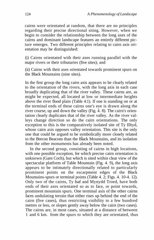
124 A Phenomenology of Landscape
cairns were orientated at random, that there are no principlesregarding their precise directional siting. However, when webegin to consider the relationship between the long axes of thecairns and dominant landscape features an entirely different pic-ture emerges. Two different principles relating to cairn axis ori-entation may be distinguished:
(i) Cairns orientated with their axes running parallel with themajor rivers or their tributaries (five sites); and
(ii) Cairns with their axes orientated towards prominent spurs onthe Black Mountains (nine sites).
In the first group the long cairn axis appears to be clearly relatedto the orientation of the rivers, with the long axis in each casebroadly duplicating that of the river valley. These cairns are, asmight be expected, all located at low or intermediate heightsabove the river flood plain (Table 4.1). If one is standing on or atthe terminal ends of these cairns one's eye is drawn along theriver course, up and down the valley (Fig. 4. 8). The cairn's orien-tation clearly duplicates that of the river valley. As the river val-leys change direction so do the cairn orientations. The onlyexception to this is the comparatively isolated site of Ty Illtyd,whose cairn axis opposes valley orientation. This site is the onlyone that could be argued to be symbolically more closely relatedto the Brecon Beacons than the Black Mountains, and its isolationfrom the other monuments has already been noted.
In the second group, consisting of cairns in high locations,with one possible exception, for which precise cairn orientation isunknown (Garn Coch), but which is sited within clear view of thespectacular platform of Table Mountain (Fig. 4. 9), the long axisappears to be intimately directionally related to particularlyprominent points on the escarpment edges of the BlackMountains-spurs or terminal points (Table 4. 2; Figs. 4. 10-4. 12).Only two of the cairns, Ty Isaf and Mynydd Troed, have bothends of their axes orientated so as to face, or point towards,prominent mountain spurs. One terminal axis of the other cairnsfaces undulating terrain that either rises up behind the end of thecairn (five cases), thus restricting visibility to a few hundredmetres or less, or slopes gently away below the cairn (two cases).The cairns are, in most cases, situated at a distance of between1 and 6 km. from the spurs to which they are orientated, thus
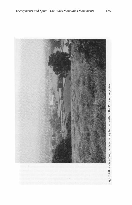
Escarpments and Spurs: The Black Mountains Monuments 125
126 A Phenomenology of Landscape
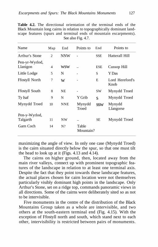
Escarpments and Spurs: The Black Mountains Monuments 127
Table 4.2. The directional orientation of the terminal ends of theBlack Mountain long cairns in relation to topographically dominant land-scape features (spurs and terminal ends of mountain escarpments).
See also Fig. 4.7.
Name
Arthur's Stone
Pen-yr-Wyrlod,Llanigon
Little Lodge
Ffostyll North
Ffostyll South
Ty Isaf
Mynydd Troed
Pen-y-Wyrlod,Talgarth
Garn Coch
Map
2
4
5
7
8
9
10
11
14
End
NNW
wswN
w
NE
N
NNE
NW
N?
Points to
-
_
-
-
-
Y Grib
MynyddTroed
_
TableMountain?
End
SSE
ESE
S
E
SW
sssw
SE
Points to
Hatterall Hill
Cussop Hill
Y Das
Lord Hereford'sKnob
Mynydd Troed
Mynydd Troed
MynyddLlangorse
Mynydd Troed
maximizing the angle of view. In only one case (Mynydd Troed)is the cairn situated directly below the spur, so that one must tiltthe head to look up at it (Figs. 4.13 and 4.14).
The cairns on higher ground, then, located away from themain river valleys, connect up with prominent topographic fea-tures of the landscape in relation to at least one terminal axis.Despite the fact that they point towards these landscape features,the actual places chosen for cairn location were not themselvesparticularly visibly dominant high points in the landscape. OnlyArthur's Stone, set on a ridge top, commands panoramic views inall directions. Some of the cairns were deliberately sited so as notto be intervisible.
Five monuments in the centre of the distribution of the BlackMountains Group taken as a whole are intervisible, and twoothers at the south-eastern terminal end (Fig. 4.15). With theexception of Ffostyll north and south, which stand next to eachother, intervisibility is restricted between pairs of monuments.
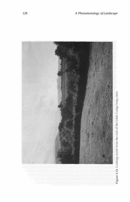
128 A Phenomenology of Landscape
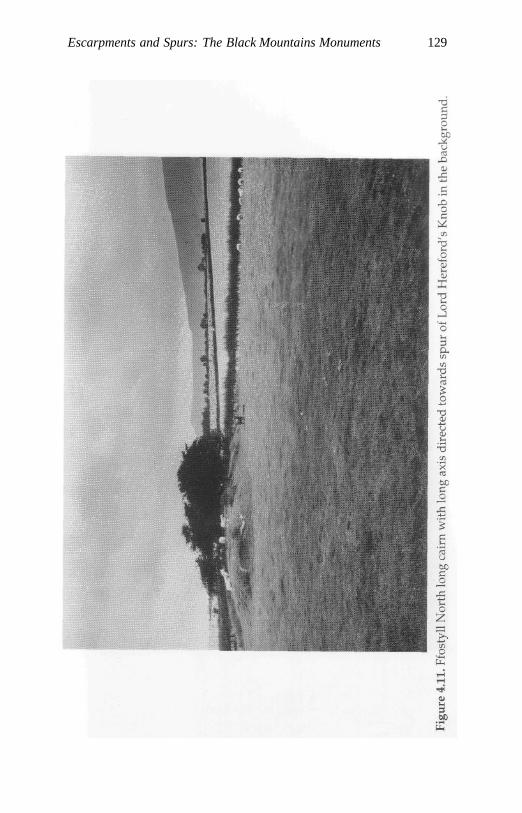
Escarpments and Spurs: The Black Mountains Monuments 129
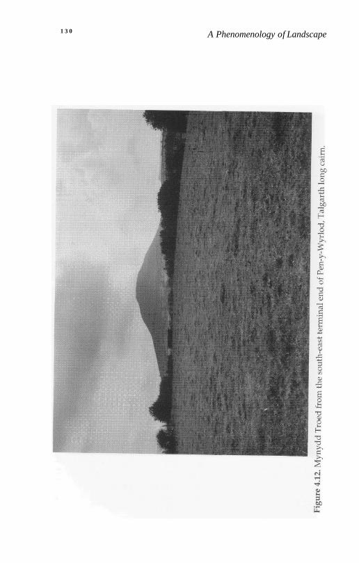
1 3 0 A Phenomenology of Landscape
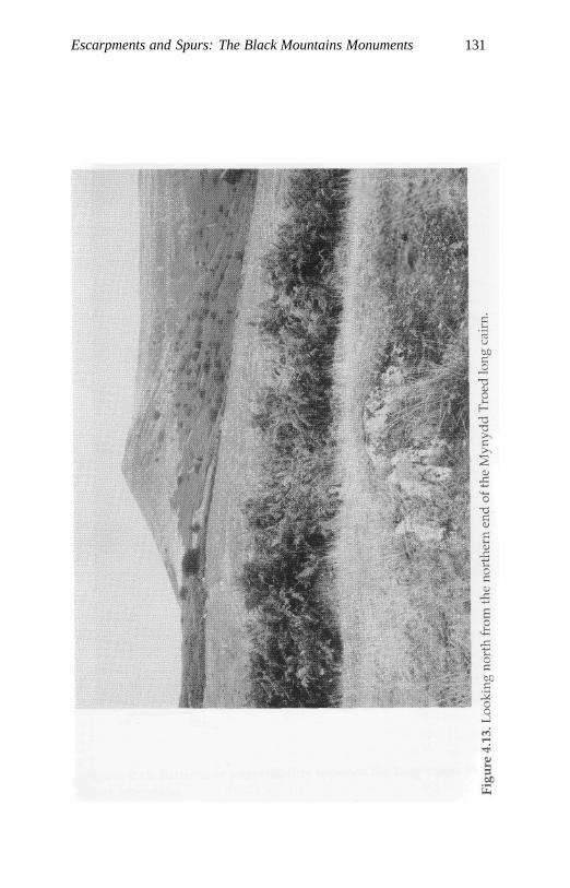
Escarpments and Spurs: The Black Mountains Monuments 131
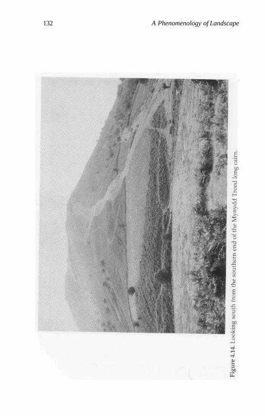
132 A Phenomenology of Landscape
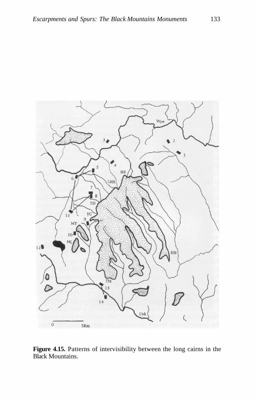
Escarpments and Spurs: The Black Mountains Monuments 133
Figure 4.15. Patterns of intervisibility between the long cairns in theBlack Mountains.
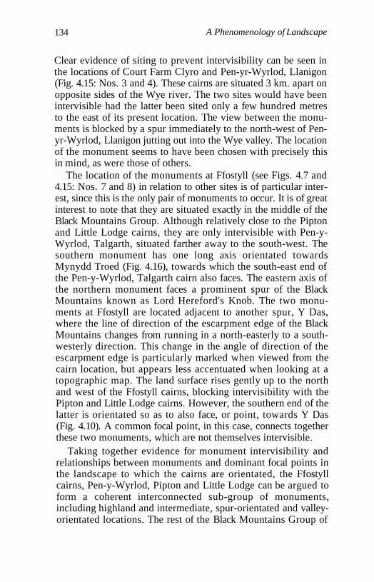
134 A Phenomenology of Landscape
Clear evidence of siting to prevent intervisibility can be seen inthe locations of Court Farm Clyro and Pen-yr-Wyrlod, Llanigon(Fig. 4.15: Nos. 3 and 4). These cairns are situated 3 km. apart onopposite sides of the Wye river. The two sites would have beenintervisible had the latter been sited only a few hundred metresto the east of its present location. The view between the monu-ments is blocked by a spur immediately to the north-west of Pen-yr-Wyrlod, Llanigon jutting out into the Wye valley. The locationof the monument seems to have been chosen with precisely thisin mind, as were those of others.
The location of the monuments at Ffostyll (see Figs. 4.7 and4.15: Nos. 7 and 8) in relation to other sites is of particular inter-est, since this is the only pair of monuments to occur. It is of greatinterest to note that they are situated exactly in the middle of theBlack Mountains Group. Although relatively close to the Piptonand Little Lodge cairns, they are only intervisible with Pen-y-Wyrlod, Talgarth, situated farther away to the south-west. Thesouthern monument has one long axis orientated towardsMynydd Troed (Fig. 4.16), towards which the south-east end ofthe Pen-y-Wyrlod, Talgarth cairn also faces. The eastern axis ofthe northern monument faces a prominent spur of the BlackMountains known as Lord Hereford's Knob. The two monu-ments at Ffostyll are located adjacent to another spur, Y Das,where the line of direction of the escarpment edge of the BlackMountains changes from running in a north-easterly to a south-westerly direction. This change in the angle of direction of theescarpment edge is particularly marked when viewed from thecairn location, but appears less accentuated when looking at atopographic map. The land surface rises gently up to the northand west of the Ffostyll cairns, blocking intervisibility with thePipton and Little Lodge cairns. However, the southern end of thelatter is orientated so as to also face, or point, towards Y Das(Fig. 4.10). A common focal point, in this case, connects togetherthese two monuments, which are not themselves intervisible.
Taking together evidence for monument intervisibility andrelationships between monuments and dominant focal points inthe landscape to which the cairns are orientated, the Ffostyllcairns, Pen-y-Wyrlod, Pipton and Little Lodge can be argued toform a coherent interconnected sub-group of monuments,including highland and intermediate, spur-orientated and valley-orientated locations. The rest of the Black Mountains Group of
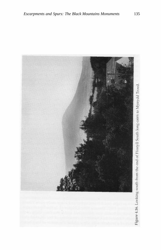
Escarpments and Spurs: The Black Mountains Monuments 135
136 A Phenomenology of Landscape
monuments form pairs, each of which includes one monumentwith its cairn orientated along a river valley and the other with aspur orientation (see Fig. 4.7). Thus within each of the five groupsmonuments align one's vision both along the valleys andtowards important dominant focal points in the Black Mountains.The orientation of the mound axes directed and focused attentionto the two features of the landscape of essential importance andsignificance - the Black Mountains and the major valleys runningaround them. The axes of the long cairns either duplicate those ofthe natural topography, in the case of those in lowland situationsfollowing the orientations of the river valleys, or point towardsstriking focal points of sacred significance. That these pointswould have been known and sedimented in social memory fromthe Mesolithic onwards, and might be associated with ancestralpowers, seems very likely.
From 7 (50 per cent) of the cairns, including all those centrallylocated, the prominent elongated mountain of Mynydd Troed isclearly visible. Two cairns, Ty Isaf and that named after themountain, flank it, and the largest and most impressive monu-ment in the Black Mountains group, Pen-y-Wyrlod, Talgarth, islocated just to the south of it, 1.5 km. away. The long axis of Pen-y-Wyrlod is orientated towards Mynydd Troed, and its high fore-court end is closest to the mountain. It is particularly fascinatingto note the similarity in visual form between Mynydd Troed andthe original shapes of the long cairns (Fig. 4.17). Could this bewhy the largest monument in the Black Mountains is built justbeneath it, and why it is visible from so many of the monumentsclustering in this area?
Looking Out and Going In: Burials, Chambers and Topography
Burial deposits in the Black Mountains cairns have been relativelywell preserved. They exhibit features typical for the Neolithic ofsouthern Britain - the differential selection and arrangement ofhuman bones in the chambers, exploiting basic body symmetriessuch as right and left and upper and lower body parts (Shanksand Tilley 1982; Thomas 1991: Chapter 6). In the Pipton cairn adeposit of bones was discovered under the floor slabs of thesouth transept in Chamber I, consisting of the crushed skullbones of a juvenile with some added fragments of long bones,
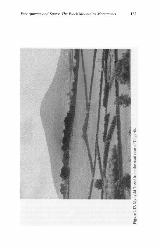
Escarpments and Spurs: The Black Mountains Monuments 137
138 A Phenomenology of Landscape
together with hazel-nut shell fragments and an unworked flintflake. In the chamber entrance there were four other discretedeposits lodged against the sidestones, consisting of a lower-jawbone, part of a humerus and part of a pelvis and a collection oflong bones. Chamber II had seven piles of bones placed againstthe walls and a further deposit underneath the chamber floor.Lower limb bones are more frequent than upper, and left bonesoutnumber right in a ratio of roughly 3:1 (Savory 1956: 21-2, 26;West 1956: 47). Chamber I at Ty Isaf contained the remains of atleast 17 individuals, with groups of bones positioned along theside slabs and others stuffed into crevices (Grimes 1939b: 126).Smaller quantities of disarticulated remains were discovered inChambers II and III. The lateral chambers NE II and NE III at Pen-y-Wyrlod, Talgarth contained the disarticulated remains of,respectively, six and seven individuals. Fragments of burnt boneand part of a human temporal bone were also recovered from thesocket of a portal orthostat. A child burial in a cist in one of thehorns of the monument indicates its secondary use after the mon-ument had been closed and blocked off (Britnell and Savory 1984:19-23; Luff et al. 1984: 36-7).
Apart from the human burial deposits finds from the monu-ments are meagre. From Pipton the only artefacts recovered werethe flint flake from the burial deposit in Chamber I and a sherd ofNeolithic pottery from beneath the cairn (Savory 1956:14-15). TyIsaf yielded a little more material: two leaf-shaped arrowheadsand an axe, a bone pin and sherds from a single bowl in ChamberI, fragments of seven bowls and a sandstone pendant fromChamber II and further Neolithic potsherds from Chamber III(Grimes 1939b: 126 ff.) From Pen-y-Wyrlod, Talgarth only threeflint artefacts were recovered, plus part of a bone flute made froma sheep's tibia from Chamber NE III and a few pot fragments,most of which were recovered in the vicinity of Chamber NE III.Of the large number of Neolithic finds recovered fromGwernvale only a few are contemporary with the use of themonument, the rest dating to pre-cairn-construction occupationlevels. Finds from the chambers are restricted to fragments ofbetween four and five pots.
Ground plans and the locations of internal monument cham-bers and passages from excavations or surface survey are knownin more or less detail for a number of sites (Table 4.3). Thosechambers orientated along the cairn axis obviously share the
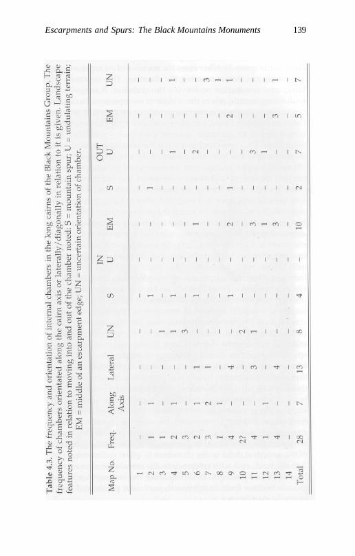
Escarpments and Spurs: The Black Mountains Monuments 139
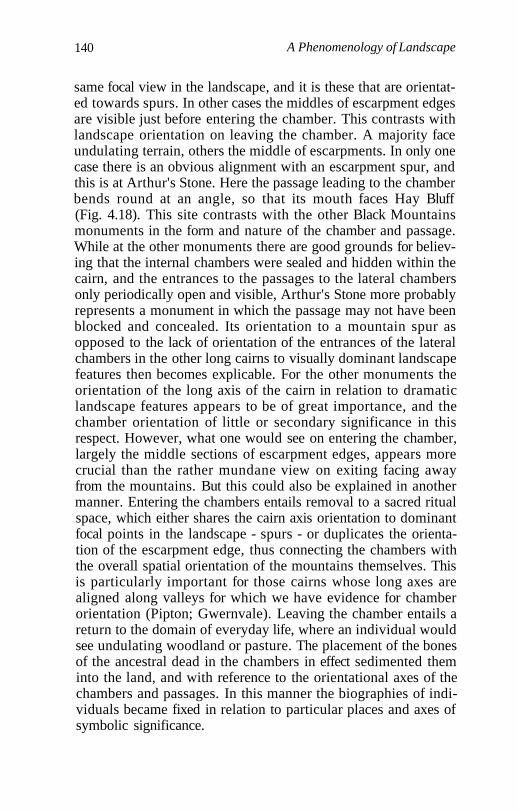
140 A Phenomenology of Landscape
same focal view in the landscape, and it is these that are orientat-ed towards spurs. In other cases the middles of escarpment edgesare visible just before entering the chamber. This contrasts withlandscape orientation on leaving the chamber. A majority faceundulating terrain, others the middle of escarpments. In only onecase there is an obvious alignment with an escarpment spur, andthis is at Arthur's Stone. Here the passage leading to the chamberbends round at an angle, so that its mouth faces Hay Bluff(Fig. 4.18). This site contrasts with the other Black Mountainsmonuments in the form and nature of the chamber and passage.While at the other monuments there are good grounds for believ-ing that the internal chambers were sealed and hidden within thecairn, and the entrances to the passages to the lateral chambersonly periodically open and visible, Arthur's Stone more probablyrepresents a monument in which the passage may not have beenblocked and concealed. Its orientation to a mountain spur asopposed to the lack of orientation of the entrances of the lateralchambers in the other long cairns to visually dominant landscapefeatures then becomes explicable. For the other monuments theorientation of the long axis of the cairn in relation to dramaticlandscape features appears to be of great importance, and thechamber orientation of little or secondary significance in thisrespect. However, what one would see on entering the chamber,largely the middle sections of escarpment edges, appears morecrucial than the rather mundane view on exiting facing awayfrom the mountains. But this could also be explained in anothermanner. Entering the chambers entails removal to a sacred ritualspace, which either shares the cairn axis orientation to dominantfocal points in the landscape - spurs - or duplicates the orienta-tion of the escarpment edge, thus connecting the chambers withthe overall spatial orientation of the mountains themselves. Thisis particularly important for those cairns whose long axes arealigned along valleys for which we have evidence for chamberorientation (Pipton; Gwernvale). Leaving the chamber entails areturn to the domain of everyday life, where an individual wouldsee undulating woodland or pasture. The placement of the bonesof the ancestral dead in the chambers in effect sedimented theminto the land, and with reference to the orientational axes of thechambers and passages. In this manner the biographies of indi-viduals became fixed in relation to particular places and axes ofsymbolic significance.
Escarpments and Spurs: The Black Mountains Monuments 141
142 A Phenomenology of Landscape
Conclusion
These monuments were clearly not major sites for the depositionof artefacts, as is the case for those in south-west Wales. Thesuccessive deposition and subsequent rearrangement of ances-tral remains in the chamber was of great significance. The natureof the burial deposits was not purely dedicatory, as may havebeen the case in the Pembrokeshire monuments. A significantpresence of domestic animal bones, sheep, pig and cattle, in thechambers and forecourt areas suggests the use of the monumentsin feasting cycles. By contrast with many of the monuments insouth-west Wales those of the Black Mountains are monumental,and, in some cases, quite massive constructions, designed tomake an indelible and permanent impact on the landscape; andthe orientation of the long axis was of the utmost significance. Inthe Black Mountains there was a will to make the monument vis-ible that is not manifested in the same form in many of the monu-ments in south-west Wales. There the landscape (the rockoutcrops) makes the monument visible. In the Black Mountainsthe reverse seems to be happening: the monuments draw out andemphasize important features of the landscape: the axes of theriver valleys and prominent spurs, paths of movement andprominent landmarks whose ancestral significance had alreadybeen established during the Mesolithic, and whose meaningswere now being re-worked through the process of monumentconstruction, a point further discussed in Chapter 6.
Chapter 5
Ridges, Valleys and Monuments on theChalk Downland
Introduction
In this chapter I want to consider the relationship between placesand monuments in an area of chalk downland in southernEngland, Cranborne Chase, straddling the county boundaries ofDorset, Hampshire and Wiltshire. While the archaeological land-scapes considered in the previous two chapters have often beenconsidered as peripheral to the main areas of early Neolithic set-tlement, Cranborne Chase has been regarded as one of the mostimportant 'core' areas of Neolithic Wessex in southern England.It is a topographically well-defined chalk plateau bounded to thewest by the river Stour, to the north by the Nadder and to the eastby the Avon. The northern and western sides have steep andimpressive escarpment edges. To the east the dip slope runningdown to the Avon valley is less sharp and precipitous. The chalkplateau is highest in the north, approaching 300 m., and gentlydips down and gradually loses itself in the sandy Dorset coastalheathlands of pine, heather and gorse to the south. From thehighest point, Win Green, in the north the Needles and the Isle ofWight can be seen some 50 km. away in the distance on a clearday.
Cranborne Chase is a bold, open landscape in which the linesof the land and its contours are far more significant than itsshades, colours and local details. The chalk plateau, roughlyrectangular in form and running for roughly 30 km. in a SW-NEdirection, is broken up by deep coombes and the Ebble valley inthe north. To the south a number of roughly parallel stream andriver valleys, the Crichel and Gussage brooks and the headwatersof the rivers Allen and Crane, break up the chalk. This gives riseto a rolling landscape of shallow open valleys separated by gentle
143
144 A Phenomenology of Landscape
rounded ridges around 100 m. high, running NW-SE. Numerousdry valleys lead off the main valleys, giving the local topographyof the southern areas of the Chase a more diverse character.
Geologically, the chalk downland is broken up on the surfaceand alleviated by alluvial deposits along the river and streamcourses, Greensand exposures along the western and northernescarpments, and areas with clay with flints in the central part ofCranborne Chase. The highest point in central and southern areasof the Chase is marked by the sandy and gravelly Readingbeds which cap Penbury Knoll, crowned today with gnarledpines and visible for up to 12 km. or more across the rollingdownland. From Penbury Knoll there are panoramic viewsacross the Chase to Win Green in the north and southwards to theDorset coast.
Cranborne Chase was, undoubtedly, one of the great ceremo-nial landscapes of the early Neolithic in Britain. It contains one ofthe major concentrations of earthen long barrows in southernEngland, and by far the two most impressive earthworks to beconstructed anywhere in Britain during the Neolithic, the 10 km.-long Dorset Cursus and a complex of causewayed enclosures onHambledon Hill on its western periphery. Field-walking over atwenty-year period has also recovered the largest and best prove-nanced collection of Mesolithic flintwork from anywhere on thechalk downland of southern Britain.
The Mesolithic Landscape
Virtually all the collections are surface flint scatters. Two smallexcavations and one more extensive one have been carried out(Catt et al. 1980; Lewis and Coleman 1984; Higgs 1959). Field sur-veys have documented 27 major flint scatters in the central areaof Cranborne Chase and in surveyed areas to the north (Arnoldet al. 1988; Ross 1987) (Fig. 5.1). The overall density of sites ishigh, ranging between 0.2 and 0.6 sites per square kilometre insurveyed areas. On the basis of the presence/absence of diagnos-tic microlith types six sites belong to the earlier Mesolithic andtwo to the later Mesolithic (Arnold et al. 1988: 120), while themajority have both earlier and later microlith forms. Takingfrequencies of microliths into consideration six sites are domi-nated by earlier material and ten by later forms.
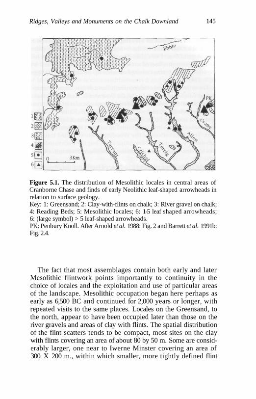
Ridges, Valleys and Monuments on the Chalk Downland 145
Figure 5.1. The distribution of Mesolithic locales in central areas ofCranborne Chase and finds of early Neolithic leaf-shaped arrowheads inrelation to surface geology.Key: 1: Greensand; 2: Clay-with-flints on chalk; 3: River gravel on chalk;4: Reading Beds; 5: Mesolithic locales; 6: 1-5 leaf shaped arrowheads;6: (large symbol) > 5 leaf-shaped arrowheads.PK: Penbury Knoll. After Arnold et al. 1988: Fig. 2 and Barrett et al. 1991b:Fig. 2.4.
The fact that most assemblages contain both early and laterMesolithic flintwork points importantly to continuity in thechoice of locales and the exploitation and use of particular areasof the landscape. Mesolithic occupation began here perhaps asearly as 6,500 BC and continued for 2,000 years or longer, withrepeated visits to the same places. Locales on the Greensand, tothe north, appear to have been occupied later than those on theriver gravels and areas of clay with flints. The spatial distributionof the flint scatters tends to be compact, most sites on the claywith flints covering an area of about 80 by 50 m. Some are consid-erably larger, one near to Iwerne Minster covering an area of300 X 200 m., within which smaller, more tightly defined flint
146 A Phenomenology of Landscape
concentrations could be identified (Summers 1941). Spreads ofmaterial locales found on the Greensand may be up to twice thissize (Arnold et al. 1988: 122). The flint scatters on the excavatedsite at Downton situated on a river terrace and dominated bylater microlith forms covered an area up to 265 sq. m. (Higgs1959: 214).
The only structural evidence from these sites is from Downtonand St Giles Field, Woodcutts. At Downton a series of 23 stakeholes in two discrete areas defining semi-circular or oval areaswere identified, together with concentrations of charcoal, workedflints and cooking holes. These may be remains of light shelterswith stakes driven into the ground to support them (Higgs 1959:231). Trial excavations at the Woodcutts site revealed traces ofsub-surface digging of Mesolithic date, but the excavated areawas too small to provide any basis for an interpretation (Catt et al.1980: 72).
Field visits were made to a sample of twelve of the Mesolithicfindspots. Four typical locales can be distinguished in relation tothe local topography and geology:
1. Places close to springheads on the Greensand in the north onsloping terrain (n = 2);
2. Places on gentle south-facing slopes in undulating terrain onareas characterized by clay with flints in central areas ofCranborne Chase (n = 5);
3. Places on alluvial deposits in valley bottoms (n = 2);
4. Places on local high points on flat or sloping terrain (n = 3).
There is nothing particularly remarkable or distinctive withregard to these places in relation to local topographical featuresof the landscape, apart from the evidence for substantialMesolithic occupation and activity on Penbury Knoll/PentridgeHill, the highest point in the central area of Cranborne Chase(Wymer 1977: 69, 76; Lewis and Coleman 1984). Field-walkingand a limited excavation here has recovered a large flint assem-blage at a number of separate locations, dominated by earlymicrolith forms, but with a small representation of later types. Ofthe locales mentioned above, Arnold et al. (1988) have noted thatthe second type (on the clay with flints) is by far the most com-mon, and there is indeed a remarkable degree of preference forareas with rich flint deposits on clay soils.
Ridges, Valleys and Monuments on the Chalk Downland 147
It is of interest to note that most of the locales are clustered in abroad NE-SW band running across the centre of CranborneChase, running from the escarpment edge by Hambledon Hill tothe west to Penbury Knoll in the east, with outlying and more iso-lated site locations on Greensand deposits to the north. This bandof Mesolithic sites is clustered between 2 and 4 km. north of theDorest Cursus and the main concentration of long barrows onCranborne Chase. They may mark an important axis of move-ment across the landscape and its alteration through local wood-land clearance - an axis which only later, in the early Neolithic,became formalized and culturally embedded by means of monu-ment construction.
Locales and the Mesolithic-Neolithic 'Transition'
Bradley and others (Bradley et al. 1984: 89; Bradley in Arnold et al.1988: 125; Barrett et al. 1991b: 30) assume that Mesolithic occupa-tion on Cranborne Chase effectively came to an end around 4,000BC, and that there was a hiatus between Mesolithic occupationand the early Neolithic settlement in which substantial areas ofthe chalk downland came into use for the first time, as opposed tothe preferential occupation of areas with clay with flints duringthe Mesolithic. Thus, in this scenario, for a period of over 1,000years Cranborne Chase was unoccupied before the first Neolithicsettlement and the construction of long barrows. One possiblereason suggested for this is that late Mesolithic settlement shiftedfrom inland to almost exclusively coastal exploitation. Why thisshould happen remains unexplained. Some sort of gap betweenthe late Mesolithic and early Neolithic remains commonplace inthe literature on southern England, but may be more a product ofarchaeological categorization and the crudeness of relative datingwith regard to flint assemblages than anything else. Indeed,Jacobi notes with reference to late Mesolithic settlement inHampshire that there were 'no obvious areas whose uptake byearly farmers will not have impinged in some way upon preexist-ing patterns of territoriality' (Jacobi 1981: 23). Looking at theoverall distribution of Mesolithic and early Neolithic locales inthe landscape, continuity rather than a hiatus may be envisagedin relation to both settlement and patterns of exploitation of ani-mal and plant food resources.
148 A Phenomenology of Landscape
The early Neolithic evidence is dominated by ceremonialmonuments - earthen long barrows, the causewayed enclosureson Hambledon Hill on the western fringe of Cranborne Chase(Mercer 1980, 1988) and the Dorset Cursus (discussed below).Apart from these sites the only evidence from 'domestic' contextsis the distribution of leaf-shaped arrowheads, one excavated flintassemblage beneath a long barrow (Drew and Piggott 1936), andsmall ceramic collections from beneath two long barrows and theDorset Cursus and from settlement pits on Handley Hill closelyassociated with Wor barrow (Barrett et al. 1991b: 30-2). Thedistribution of leaf-shaped arrowheads, like the Mesolithic flintindustries, is strongly related to areas of clay with flints, andthere is a concentration of finds on Penbury Knoll. The onlychange from the Mesolithic pattern is that some findspots nowappear on the chalk downland in areas where the long barrowsand the Cursus were built. All findspots with over five arrow-heads occur in areas already occupied during the Mesolithic (Fig.5.1). This evidence points not only to the continued use of thesame areas of the landscape, but to continuity in economic activi-ties, with hunting, fishing and gathering still playing, as in Wales,a dominant role, supplemented by limited numbers of domesti-cated animals, the remains of which have been almost exclusive-ly recovered from ritual rather than domestic sites. Moreover,metrical analysis of early Neolithic flint industries has demon-strated technological continuity with the later Mesolithic (Pittsand Jacobi 1979). Gardiner notes that later Mesolithic and earlyNeolithic flint assemblages may easily be confused in the absenceof diagnostic pieces (Gardiner 1984: 19), while Care has demon-strated that the same surface flint sources were exploited for axeproduction in both the Mesolithic and the Neolithic (Care 1979).Bradley himself notes that Mesolithic activity on CranborneChase 'set in motion an oscillation between upland and lowlandsettlement which was to continue throughout the prehistoricperiod' (in Barrett et al. 1991b: 30). Loess soils, today heavilyeroded, appear to have originally mantled the whole of the chalkdownland and areas with clay with flints on Cranborne Chase, sothat a shift of some Neolithic activity away from areas of claywith flints cannot be explained as a result of a wish to exploitbetter-quality and more easily tilled soils as part and parcel of afully-fledged agricultural system (Fisher 1991). Mesolithic activity,as noted by Care, may have substantially affected the forest
Ridges, Valleys and Monuments on the Chalk Downland 149
cover, creating regions of more open country on the chalk down-land attractive to later Neolithic occupation (Care 1979:100).
Animal bones from earlier Neolithic contexts associated withthe Thickthorn Down barrow, and primary silts in the ditch of theDorset Cursus, include ox, pig, sheep, aurochs, and red and roedeer, with wild and domestic cattle being most frequent (Jackson1936; Legge 1991). Legge notes the high proportion of wild ani-mals represented by the finds from the Cursus ditch - at least 25per cent - and that the majority of the remains were whole skullsor parts of skulls, or mandibles, i.e. they do not seem to be ordi-nary butchery deposits (Legge 1991: 55). Cattle remains alsodominate the fauna from Hambledon Hill (Mercer 1980: 61).Flotation has also recovered some evidence of wheat and barleycultivation here, on the fringes of the Chase.
Excavations under the Thickthorn Down long barrow at the endof the Cursus revealed a narrow-flake industry of early Neolithicdate, together with a leaf-shaped arrowhead and plain bowl sherds(Drew and Piggott 1936; Barrett et al. 1991b: 31). As Bradley pointsout, this probably represents an occupation site over which thebarrow was subsequently built. From the old land surfacebeneath the mound a microlith was recovered, and 'the fact that itwas found on and not under the turf-line suggests little differ-ence in age [from the Neolithic flintwork]' (Clark 1936: 91). Sincethe southern barrow on Thickthorn Down is one of only threetotally excavated examples on Cranborne Chase the associationbetween the find of a microlith and an early Neolithic flakeindustry sealed by later barrow construction is of particular interest.
Excavations on the two major ceremonial monuments of theearly Neolithic, Hambledon Hill and the Dorset Cursus, havesimilarly recovered Mesolithic material. At Hambledon Hill exca-vation of the primary silts of the ditch recovered unspecified arte-facts of Mesolithic date (Farrar 1951: 105-6). Excavations of thewest ditch of the Cursus provided two bone samples giving lateMesolithic radiocarbon dates of 4510 and 4950 BC (Barrett et al.1991b: 46); and late Mesolithic occupation of the nearby floor ofthe river Allen, over which the Cursus crosses, is well attested byflint scatters (Arnold et al. 1988; Wymer 1977: 70).
Such evidence can, of course, all be dismissed as purelyfortuitous; but at the very least it points to the long-term use andsignificance of particular locales in the landscape. Undoubtablyone of the most symbolically significant of these was Penbury
150 A Phenomenology of Landscape
Knoll, the highest point of the central area of Cranborne Chase,from which there are extensive views in all directions. As hasalready been noted, concentrations of earlier and later Mesolithicand early Neolithic flintwork occur here. It is of great interest tonote that not only does the Dorset Cursus begin due north ofPenbury Knoll (see below), but this high point can be seen fromno less than 31 of the long barrows (80 per cent) on CranborneChase. With one exception those barrows from which PenburyKnoll is not visible occur on the extreme periphery of their over-all distribution on Cranborne Chase, and are associated with theescarpment edge defining the area of chalk downland to thenorth, west and east (see the discussion below). A wish thatPenbury Knoll should be visible from the barrows seems to haveplayed a part in deciding where to place them. Shifting some ofthe barrow sites away from their present locations, sometimes amatter of only a few hundred metres or less, would have madePenbury Knoll invisible. This hill, today capped, as perhaps inthe past, by gnarled pines (Fig. 5.2), was undoubtedly steeped inancestral associations, social memories and myth.
Earthen Long Barrows
There are 39 extant or destroyed earthen long barrows knownfrom Cranborne Chase (Ashbee 1984: Chapter 2; Kinnes 1992:8-9). They have been well surveyed and documented in the liter-ature (Grinsell 1938-40, 1957, 1959; RCHM 1972, 1975, 1979;Barrett et al. 1991b: Chapter 2). Three have been totally or partial-ly excavated and a further five have been subject to antiquarianinvestigation to a limited extent (Kinnes 1992: 21-3). The barrowsexhibit considerable diversity in size, ranging in length from20 m. to just over 100 m. and from 12 to 30 m. in width (Table 5.1).Some of this variation is the result of differential denudation anddestruction. Most would originally have been up to between3 and 4 m. high at the highest end. One exceptionally long exam-ple on Martin Down, which is 150 m. long, may either be a bankbarrow or a barrow with an added earthen 'tail' (Barrett et al.1991b: 51). Mound form may be parallel-sided, trapezoidal oroval, but as a result of denudation is often impossible to assessaccurately without excavation. Most do appear to have originallybeen trapezoidal in form, tapering in size from a higher and
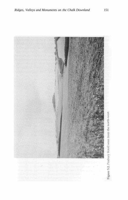
Ridges, Valleys and Monuments on the Chalk Downland 151

152 A Phenomenology of Landscape
Table 5.1. Morphological characteristics of the long barrows on CranborneChase. Map Numbers refer to Fig. 5. 4. Orientation (largest and highestend first), L = maximum recorded length; W = maximum width; D =Ditch type: A, parallel with mound; B, semicircular enclosing one end of
barrow; C, completely enclosing barrow.
Barrow Name
PimperneGussage, Parsonage HillThickthorn Down, NorthThickthorn Down, SouthThickthorn FarmChettle House (Bar)Chettle WoodGussage South-EastGussage Cow Down, SouthGussage Cow Down, NorthDonhead St MaryDrive PlantationWor BarrowSalisbury PlantationMartin Down, SouthMartin Down, CentralMartin Down, NorthMartin, Long Barrow LaneDuck's NestToyd Down, Knap BarrowToyd Down, Grans BarrowCoombe BissettWhitsbury DownRound ClumpRockbourne DownVernditch Chase, NorthVernditch Chase, SouthGiant's Grave, BreamoreGiant's Grave, NewCourt DownSutton DownWhitesheet Hill, AnstyHambledon Hill, NorthHambledon Hill, SouthTelegraph ClumpLittle DownRace DownTollard, FarnhamPistle DownFurze Down
Map
123456789
10111213141516/17181920212223242526272829
30
31323334353637383940
Ort.
SSE-NNWSSE-NNWSE-NWSE-NWSSE-NNWENE-WSWSE-NWESE-WSWSE-NWSE-NWENE-WSWSE-NWSE-NWNE-SWSSE-NNWSE-NWSE-NWSE-NWSSE-NNWSE-NWSSE-NNWE-WSSE-NNWSE-NWSSE-NNWE-WSE-NWNE-SW
NNE-SSWE-W?ENE-WSWSSE-NNWS-NE-WSE-NWSE-NWSE-NWSE-NWENE-WSW
L
106264725309858
?645040374543
102150294044955851307260233668
61
23416926963835432056
W
27192020182020?142618272318182121?
30301817192727162426
15
18231512242415151724
D
AABBA???BA??C?7
AA?AAAABBAAAA
A
AAAAAA????
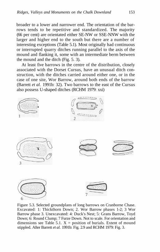
Ridges, Valleys and Monuments on the Chalk Downland 153
broader to a lower and narrower end. The orientation of the bar-rows tends to be repetitive and standardized. The majority(66 per cent) are orientated either SE-NW or SSE-NNW with thelarger and higher end to the south but there are a number ofinteresting exceptions (Table 5.1). Most originally had continuousor interrupted quarry ditches running parallel to the axis of themound and flanking it, some with an intermediate berm betweenthe mound and the ditch (Fig. 5. 3).
At least five barrows in the centre of the distribution, closelyassociated with the Dorset Cursus, have an unusual ditch con-struction, with the ditches carried around either one, or in thecase of one site, Wor Barrow, around both ends of the barrow(Barrett et al. 1991b: 32). Two barrows to the east of the Cursusalso possess U-shaped ditches (RCHM 1979: xxi)
Figure 5.3. Selected groundplans of long barrows on Cranborne Chase.Excavated: 1: Thickthorn Down; 2. Wor Barrow phases 1-2; 3 WorBarrow phase 3. Unexcavated: 4: Duck's Nest; 5: Grans Barrow, ToydDown; 6: Round Clump; 7 Furze Down. Not to scale. For orientation anddimensions see Table 5.1. X = position of burials. Extent of moundstippled. After Barrett et al. 1991b: Fig. 2.9 and RCHM 1979: Fig. 3.
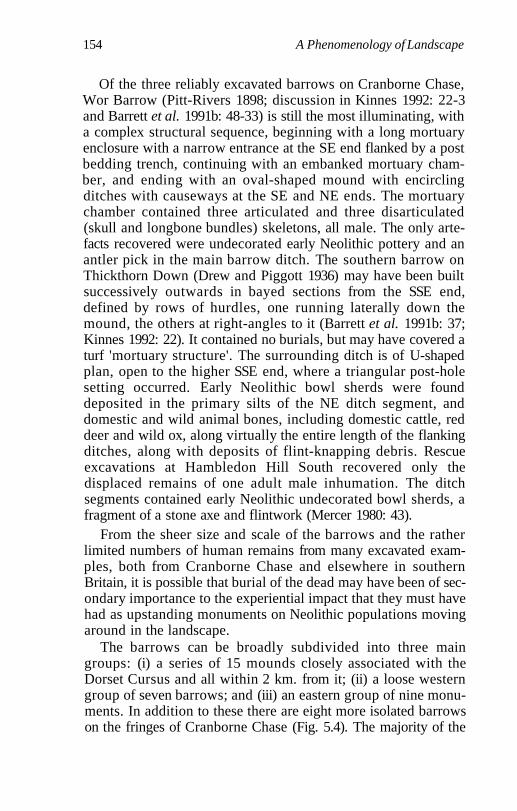
154 A Phenomenology of Landscape
Of the three reliably excavated barrows on Cranborne Chase,Wor Barrow (Pitt-Rivers 1898; discussion in Kinnes 1992: 22-3and Barrett et al. 1991b: 48-33) is still the most illuminating, witha complex structural sequence, beginning with a long mortuaryenclosure with a narrow entrance at the SE end flanked by a postbedding trench, continuing with an embanked mortuary cham-ber, and ending with an oval-shaped mound with encirclingditches with causeways at the SE and NE ends. The mortuarychamber contained three articulated and three disarticulated(skull and longbone bundles) skeletons, all male. The only arte-facts recovered were undecorated early Neolithic pottery and anantler pick in the main barrow ditch. The southern barrow onThickthorn Down (Drew and Piggott 1936) may have been builtsuccessively outwards in bayed sections from the SSE end,defined by rows of hurdles, one running laterally down themound, the others at right-angles to it (Barrett et al. 1991b: 37;Kinnes 1992: 22). It contained no burials, but may have covered aturf 'mortuary structure'. The surrounding ditch is of U-shapedplan, open to the higher SSE end, where a triangular post-holesetting occurred. Early Neolithic bowl sherds were founddeposited in the primary silts of the NE ditch segment, anddomestic and wild animal bones, including domestic cattle, reddeer and wild ox, along virtually the entire length of the flankingditches, along with deposits of flint-knapping debris. Rescueexcavations at Hambledon Hill South recovered only thedisplaced remains of one adult male inhumation. The ditchsegments contained early Neolithic undecorated bowl sherds, afragment of a stone axe and flintwork (Mercer 1980: 43).
From the sheer size and scale of the barrows and the ratherlimited numbers of human remains from many excavated exam-ples, both from Cranborne Chase and elsewhere in southernBritain, it is possible that burial of the dead may have been of sec-ondary importance to the experiential impact that they must havehad as upstanding monuments on Neolithic populations movingaround in the landscape.
The barrows can be broadly subdivided into three maingroups: (i) a series of 15 mounds closely associated with theDorset Cursus and all within 2 km. from it; (ii) a loose westerngroup of seven barrows; and (iii) an eastern group of nine monu-ments. In addition to these there are eight more isolated barrowson the fringes of Cranborne Chase (Fig. 5.4). The majority of the
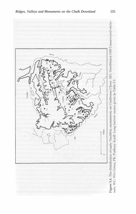
Ridges, Valleys and Monuments on the Chalk Downland 155
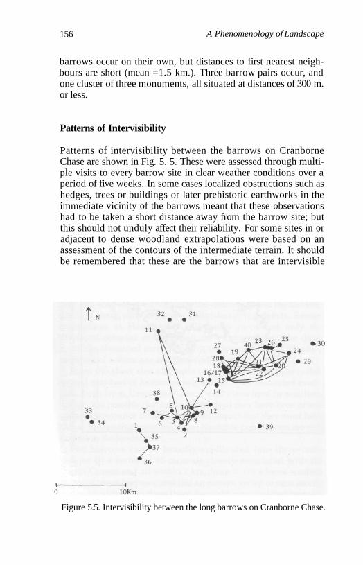
156 A Phenomenology of Landscape
barrows occur on their own, but distances to first nearest neigh-bours are short (mean =1.5 km.). Three barrow pairs occur, andone cluster of three monuments, all situated at distances of 300 m.or less.
Patterns of Intervisibility
Patterns of intervisibility between the barrows on CranborneChase are shown in Fig. 5. 5. These were assessed through multi-ple visits to every barrow site in clear weather conditions over aperiod of five weeks. In some cases localized obstructions such ashedges, trees or buildings or later prehistoric earthworks in theimmediate vicinity of the barrows meant that these observationshad to be taken a short distance away from the barrow site; butthis should not unduly affect their reliability. For some sites in oradjacent to dense woodland extrapolations were based on anassessment of the contours of the intermediate terrain. It shouldbe remembered that these are the barrows that are intervisible
Figure 5.5. Intervisibility between the long barrows on Cranborne Chase.
Ridges, Valleys and Monuments on the Chalk Downland 157
today in what is for the most part a relatively open and treelesslandscape. Judging the precise relationship between the contem-porary pattern and the prehistoric situation is difficult, since thiscrucially depends on the amount of woodland cover. A numberof factors indicate that the degree of visibility between barrowsduring the Neolithic may have been similar or indeed higherthan today. It has been argued that the Neolithic environment onthe chalk downland of Wiltshire and Dorset was characterized inthe earlier Neolithic by woodland clearance and long periods ofgrassland, possibly maintained by grazing (Evans and Jones1979). Results of analyses of the molluscan data from three exca-vations in the central area of Cranborne Chase give a more fine-grained picture. Molluscs from the buried soil surface under theThickthorn Down South long barrow suggest an open landscape,while those from two sections through the west ditch of theDorset Cursus 700 m. apart and about 4 km. to the east of theThickthorn barrow produced contrasting results, one pointingtowards an open landscape, the other a rather densely woodedlocation which remained largely unaltered until the late Neolithic(Entwistle and Bowden 1991). It is worth noting that the samplesfrom the Dorset Cursus ditch are both derived from a low-lyingstretch of the monument where it crosses a dry river valley, adamp catchment area of the river Allen. The molluscan evidencemay be interpreted as providing a picture of a relatively openupland landscape on the chalk ridges, on which the barrows wereconstructed, and a highly variable degree of clearance and activi-ty in more low-lying valley locations.
It also needs to be remembered that the present-day intervisi-bility of the barrows is actively depressed by virtue of thousandsof years of denudation and destruction, so that their profiles arelower and more blurred. They are also covered with turf and veg-etation, whereas when first constructed they would be gleamingwhite chalk masses, and, even if sited in woodland, would belikely to be surrounded by substantial clearings. Finally theirlocation on high points must surely indicate a desire that theywere meant to be seen from relatively long distances. In sumthere is little evidence to suggest that barrows which are promi-nently sited and intervisible today might not also have been dur-ing the period of their initial construction and use.
Intervisibility between the barrows is high in the centre oftheir distribution, with every barrow being intervisible with one
158 A Phenomenology of Landscape
or more barrows in the western, eastern and Cursus groups. Suchis the degree of prominence of some barrows that others up toeight or nine km. distant can be seen on the skyline (Fig. 5.5). Bycontrast, only one of the outlying barrows (Fig. 5.5: No. 11) isintervisible with the barrows in the centre of the overall distribu-tion, and in no other case are the other seven outliers intervisibleeither with each other or with those in the centre of CranborneChase. A clear contrast exists, then, between barrows being inter-visible in the centre and invisible on the periphery of their overalldistribution. Part of the process of siting barrows in the centre ofCranborne Chase was their relationship to other barrows and theCursus while, on the periphery, a relationship to topographicfeatures of the landscape, rather than to other monuments,appears to have been of paramount significance.
The barrows may be ranked according to the dominance oftheir visual field in relation to others. Being able to see other bar-rows from each mound was clearly an important factor in thelocation of many of them. In general, it is possible to distinguishbetween (i) those monuments in which visibility was a primaryconcern in their location, situated on local high points, false crestsand skylines and (ii) those in which visibility was not a dominantconcern, situated at lower points in the local terrain. This is a dis-tinction between a local field of monument visibility and a moregeneralized one. In general terms the closer the barrows are sitedto the Cursus the higher their degree of intervisibility. Barrows inthe western group are intervisible with between one and threeother sites. For some in the Cursus group the numbers of barrowsvisible from any one site increases dramatically, up to elevenother sites. Those barrows with the highest level of intervisibilitywith others occur at the terminals of either end of the Cursus onThickthorn Down (six other sites) and Martin Down, and includethe northern barrow on Gussage Cow Down (seven other sites),itself enclosed by the Cursus. The barrow with the highest degreeof intervisibility marks the beginning of the Cursus on MartinDown (11 other sites). Barrows in the eastern group have a uni-formly high degree of intervisibility, with between four andseven other barrows visible from any one site. The exception isthe two long barrows on Toyd Down (Fig. 5.5: Nos. 21 and 22),one or both of which are visible from eleven other sites.
It is of interest to note that those barrows with the highestdegree of intervisibility with others form members of pairs of
Ridges, Valleys and Monuments on the Chalk Downland 159
larger barrow groups. In the eastern group the only pair ofbarrows to occur are those mentioned above on Toyd Down. Inthe Cursus group pairs or groups of barrows sharing the samealignment are associated with the beginning, end and centralstretch of the monument, but only one of the barrows is highlyvisible, the northernmost barrow on Thickthorn and GussageCow Down and the southernmost one on Martin Down. In thewestern group, where levels of barrow intervisibility are muchlower, pairs of barrows do not occur.
One explanation for this pattern might be that sites that wereparticularly important in the prehistoric landscape and highlyvisible 'attracted' other barrows through time, and sites builtlater elsewhere were deliberately sited so as to be intervisiblewith one or more other barrows. In this manner the constructionof barrows on Cranborne Chase gradually created a series ofvisual pathways and nodal points in the landscape. While someor many barrows are visible from others in the centre of the dis-tribution, comparatively few (30 per cent) are intervisible lookingdirectly down the long axes of the barrows across the landscape.All these cases occur among the barrow pairs/groups associatedwith the Cursus and the pair on Toyd Down in the eastern group.In all, except the last case, the barrows share the same alignment.Most barrows seem to have been located, therefore, to be seenfrom the side rather than along their long axes. Looking down thelong axes of the barrows the Cursus is visible from 12 sites. Mostbarrows in the Cursus group channel or 'direct' vision towardsthis monument, with only a few exceptions.
Many barrows are today located on footpaths, and originallythe majority of these mounds may have been located along track-ways or natural paths of movement through the landscape. Thepoint at which tracks join may have been emphasized andmarked out by a small cluster (2 or 3) of barrows.
The orientation of the long axes of the barrows is closely relat-ed to that of the local topography, and in most cases they arealigned so as to run parallel to the contours along ridge axes (Fig.5.6). In other words, the form of the monument duplicates that ofthe surrounding landscape in its immediate vicinity. They are sit-uated on high points, with panoramic views in all or three out offour cardinal directions. However, fourteen sites (36 per cent) aresituated immediately below rather than on the highest point inthe local terrain that surrounds them, with the land rising up and
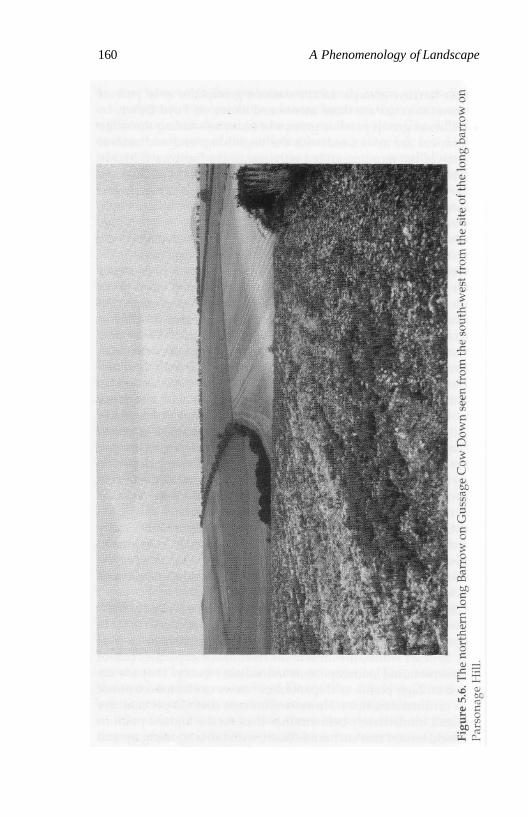
160 A Phenomenology of Landscape
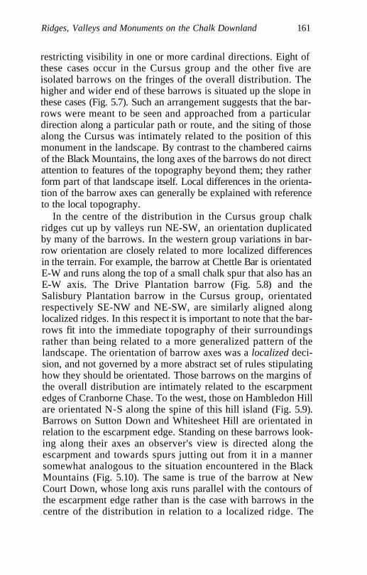
Ridges, Valleys and Monuments on the Chalk Downland 161
restricting visibility in one or more cardinal directions. Eight ofthese cases occur in the Cursus group and the other five areisolated barrows on the fringes of the overall distribution. Thehigher and wider end of these barrows is situated up the slope inthese cases (Fig. 5.7). Such an arrangement suggests that the bar-rows were meant to be seen and approached from a particulardirection along a particular path or route, and the siting of thosealong the Cursus was intimately related to the position of thismonument in the landscape. By contrast to the chambered cairnsof the Black Mountains, the long axes of the barrows do not directattention to features of the topography beyond them; they ratherform part of that landscape itself. Local differences in the orienta-tion of the barrow axes can generally be explained with referenceto the local topography.
In the centre of the distribution in the Cursus group chalkridges cut up by valleys run NE-SW, an orientation duplicatedby many of the barrows. In the western group variations in bar-row orientation are closely related to more localized differencesin the terrain. For example, the barrow at Chettle Bar is orientatedE-W and runs along the top of a small chalk spur that also has anE-W axis. The Drive Plantation barrow (Fig. 5.8) and theSalisbury Plantation barrow in the Cursus group, orientatedrespectively SE-NW and NE-SW, are similarly aligned alonglocalized ridges. In this respect it is important to note that the bar-rows fit into the immediate topography of their surroundingsrather than being related to a more generalized pattern of thelandscape. The orientation of barrow axes was a localized deci-sion, and not governed by a more abstract set of rules stipulatinghow they should be orientated. Those barrows on the margins ofthe overall distribution are intimately related to the escarpmentedges of Cranborne Chase. To the west, those on Hambledon Hillare orientated N-S along the spine of this hill island (Fig. 5.9).Barrows on Sutton Down and Whitesheet Hill are orientated inrelation to the escarpment edge. Standing on these barrows look-ing along their axes an observer's view is directed along theescarpment and towards spurs jutting out from it in a mannersomewhat analogous to the situation encountered in the BlackMountains (Fig. 5.10). The same is true of the barrow at NewCourt Down, whose long axis runs parallel with the contours ofthe escarpment edge rather than is the case with barrows in thecentre of the distribution in relation to a localized ridge. The
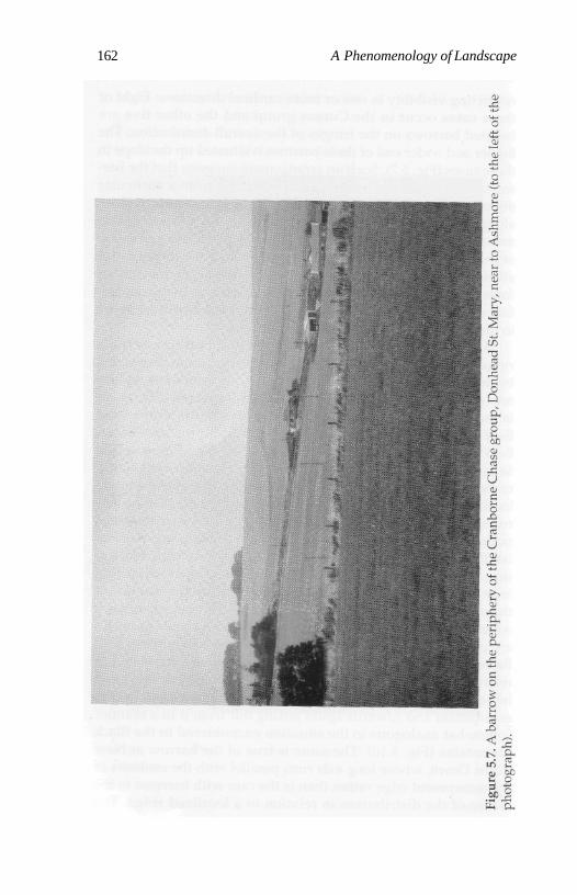
162 A Phenomenology of Landscape
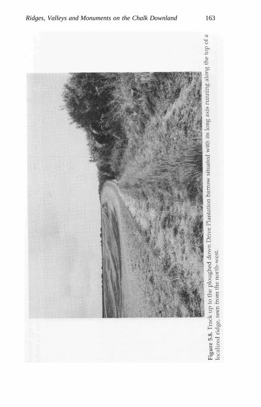
Ridges, Valleys and Monuments on the Chalk Downland 163
164 A Phenomenology of Landscape
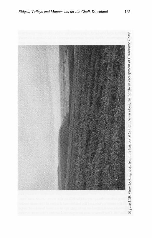
Ridges, Valleys and Monuments on the Chalk Downland 165
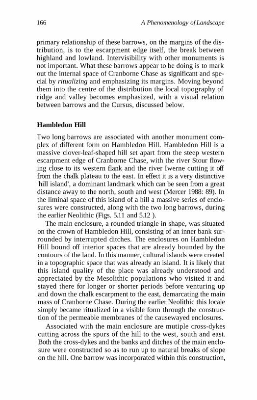
166 A Phenomenology of Landscape
primary relationship of these barrows, on the margins of the dis-tribution, is to the escarpment edge itself, the break betweenhighland and lowland. Intervisibility with other monuments isnot important. What these barrows appear to be doing is to markout the internal space of Cranborne Chase as significant and spe-cial by ritualizing and emphasizing its margins. Moving beyondthem into the centre of the distribution the local topography ofridge and valley becomes emphasized, with a visual relationbetween barrows and the Cursus, discussed below.
Hambledon Hill
Two long barrows are associated with another monument com-plex of different form on Hambledon Hill. Hambledon Hill is amassive clover-leaf-shaped hill set apart from the steep westernescarpment edge of Cranborne Chase, with the river Stour flow-ing close to its western flank and the river Iwerne cutting it offfrom the chalk plateau to the east. In effect it is a very distinctive'hill island', a dominant landmark which can be seen from a greatdistance away to the north, south and west (Mercer 1988: 89). Inthe liminal space of this island of a hill a massive series of enclo-sures were constructed, along with the two long barrows, duringthe earlier Neolithic (Figs. 5.11 and 5.12 ).
The main enclosure, a rounded triangle in shape, was situatedon the crown of Hambledon Hill, consisting of an inner bank sur-rounded by interrupted ditches. The enclosures on HambledonHill bound off interior spaces that are already bounded by thecontours of the land. In this manner, cultural islands were createdin a topographic space that was already an island. It is likely thatthis island quality of the place was already understood andappreciated by the Mesolithic populations who visited it andstayed there for longer or shorter periods before venturing upand down the chalk escarpment to the east, demarcating the mainmass of Cranborne Chase. During the earlier Neolithic this localesimply became ritualized in a visible form through the construc-tion of the permeable membranes of the causewayed enclosures.
Associated with the main enclosure are mutiple cross-dykescutting across the spurs of the hill to the west, south and east.Both the cross-dykes and the banks and ditches of the main enclo-sure were constructed so as to run up to natural breaks of slopeon the hill. One barrow was incorporated within this construction,
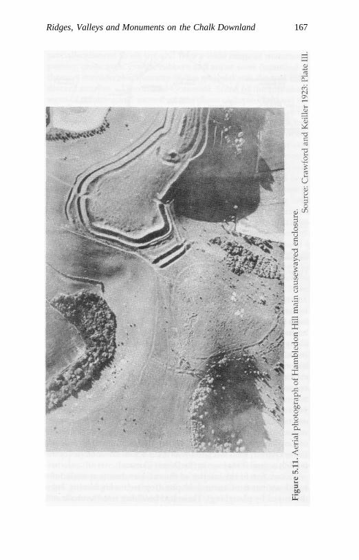
Ridges, Valleys and Monuments on the Chalk Downland 167
168 A Phenomenology of Landscape
Figure 5.12. Plan of the earlier Neolithic enclosures on Hambledon Hill.Source: Mercer 1980: Fig. 9.
By kind permission of Edinburgh University Press.
being situated in a not particularly prominent position on slopingland between the southern cross dykes and the main enclosureboundary. The other is set prominently, its long axis runningalong the spine of the northern spur of Hambledon Hill about 400m. outside the main enclosure. The main enclosure construction,like the barrows, is clearly related to the contours of the landencircling the domed summit of the hill, while the surroundingcross-dykes cut across the land between precipitous breaks ofslope on either side. Although there exists a basic contrastbetween the bounded circular form of the enclosure and the lin-earity of the long barrow axis, the placement of the enclosurerepeats the close duplicative relationship to natural topographyof long barrow location on Cranborne Chase in general, while thelinear cross-dykes associated with it cut across the contours of theland in a similar manner to the Dorset Cursus.
Excavation of the interior of the main enclosure revealed thebasal segments of around 80 pits (top segments having beendestroyed by ploughing). These had been dug into the chalk and
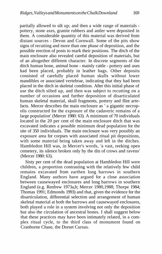
Ridges, Valleys and Monuments on the Chalk Downland 169
partially allowed to silt up; and then a wide range of materials -pottery, stone axes, granite rubbers and antler were deposited inthem. A considerable quantity of this material was derived fromdistant sources - Devon and Cornwall. Some of the pits showsigns of recutting and more than one phase of deposition, and thepossible erection of posts to mark their positions. The ditch of themain enclosure also revealed careful deposition of materials, butof an altogether different character. In discrete segments of theditch human bone, animal bone - mainly cattle - pottery and axeshad been placed, probably in leather bags. Other depositsconsisted of carefully placed human skulls without lowermandibles or associated vertebrae, indicating that they had beenplaced in the ditch in skeletal condition. After this initial phase ofuse the ditch silted up, and then was subject to recutting on anumber of occasions and further deposition of disarticulatedhuman skeletal material, skull fragments, pottery and flint arte-facts. Mercer describes the main enclosure as ' a gigantic necrop-olis constructed for the exposure of the cadaveric remains of alarge population' (Mercer 1980: 63). A minimum of 70 individualslocated in the 20 per cent of the main enclosure ditch that wasexcavated indicates a possible minimum dead population for thesite of 350 individuals. The main enclosure was very possibly anexposure area for corpses with associated ritual pit depositions,with some material being taken away and left in the ditches.Hambledon Hill was, in Mercer's words, 'a vast, reeking opencemetery, its silence broken only by the din of crows and ravens'(Mercer 1980: 63).
Sixty per cent of the dead population at Hambledon Hill werechildren, a proportion contrasting with the relatively few childremains excavated from earthen long barrows in southernEngland. Many authors have argued for a close associationbetween causewayed enclosures and long barrows in southernEngland (e.g. Renfrew 1973a,b; Mercer 1980,1988; Thorpe 1984;Thomas 1991; Edmonds 1993) and that, given the evidence for thedisarticulation, differential selection and arrangement of humanskeletal material at both the barrows and causewayed enclosures,both played a role in a system involving not only the depositionbut also the circulation of ancestral bones. I shall suggest belowthat these practices may have been intimately related, in a com-plex ritual cycle, to the third class of monument found onCranborne Chase, the Dorset Cursus.
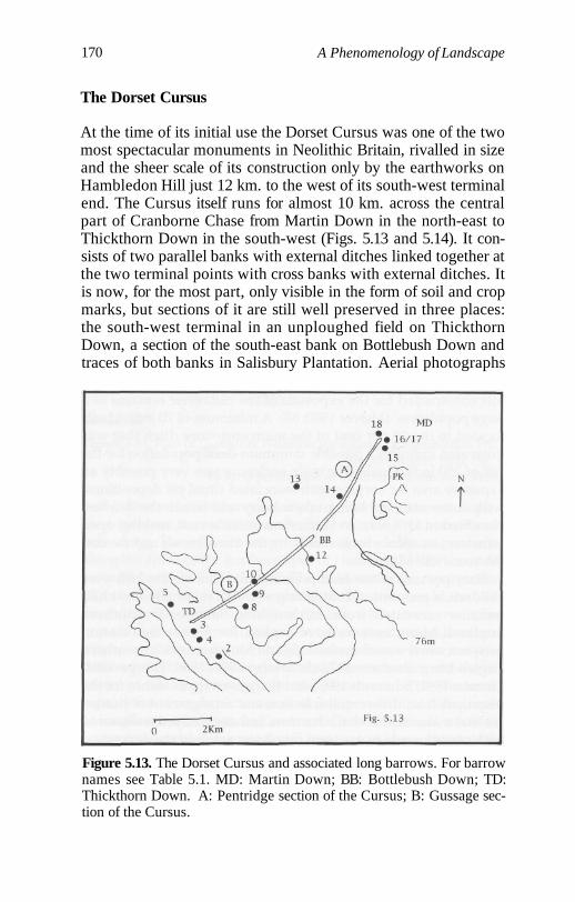
170 A Phenomenology of Landscape
The Dorset Cursus
At the time of its initial use the Dorset Cursus was one of the twomost spectacular monuments in Neolithic Britain, rivalled in sizeand the sheer scale of its construction only by the earthworks onHambledon Hill just 12 km. to the west of its south-west terminalend. The Cursus itself runs for almost 10 km. across the centralpart of Cranborne Chase from Martin Down in the north-east toThickthorn Down in the south-west (Figs. 5.13 and 5.14). It con-sists of two parallel banks with external ditches linked together atthe two terminal points with cross banks with external ditches. Itis now, for the most part, only visible in the form of soil and cropmarks, but sections of it are still well preserved in three places:the south-west terminal in an unploughed field on ThickthornDown, a section of the south-east bank on Bottlebush Down andtraces of both banks in Salisbury Plantation. Aerial photographs
Figure 5.13. The Dorset Cursus and associated long barrows. For barrownames see Table 5.1. MD: Martin Down; BB: Bottlebush Down; TD:Thickthorn Down. A: Pentridge section of the Cursus; B: Gussage sec-tion of the Cursus.
Ridges, Valleys and Monuments on the Chalk Downland 171
Figure 5.14. Longitudinal profile and plan of the Dorset Cursus.Source: Barrett et al. 1991: Fig. 2.14.
By kind permission of Cambridge University Press
172 A Phenomenology of Landscape
and probing (Atkinson 1955) have verified its course and shownit to have been constructed in two stages, an earlier and longerstretch, the Gussage Cursus, running for 5.6 km. from BottlebushDown westwards, and a later 4.3 km. stretch, the PentridgeCursus, continuing from the original north-east terminalonwards to Martin Down. On the basis of probing and excavation(Atkinson 1955; Barrett et al. 1991b) the banks appear to havebeen unbroken by causeways except for gaps near to the MartinDown end. Excavation has shown the ditch to have been steep-sided and flat-bottomed, about 3 m. wide at the top, 2 m. wide atthe bottom and 1.2 m.-1.4 m. deep (Barrett et al. 1991b: 43). Thebank was probably revetted, being located about 1 m. inside theditch, and parts of the ditch have traces of recutting. Startin(in Barrett et al. 1991b: 46) has estimated that the banks may orig-inally have stood at least 1.7 m. high and that the labour invest-ment required to dig the ditch and construct the bank would besomewhere approaching half a million worker-hours. The resultsof Atkinson's survey and excavations suggest that only one of theditches of the Cursus maintained a precise alignment, that on theSE side, the NW side having been constructed by means of aseries of offsets taken from the SE side; but in sections of theAllen valley at least the NW ditch may have been constructedfirst (Atkinson 1955: 9; Barrett et al. 1991b: 47).
The Cursus is directly associated with at least nine long bar-rows (see Figs. 5.13 and 5.14). Two are incorporated within itscourse and another seven are directly aligned in relation to its ter-minals or, as is the case on Gussage Cow Down, with a barrowincorporated by it. Of the 39 long barrows which occur onCranborne Chase the course of the Cursus would have been visi-ble from at least 14 (36 per cent). Penbury Knoll, below which theCursus starts, is visible from all but eight of the barrows (80 percent), and two particularly prominent barrows (Gussage DownNorth and Martin Down South) are intervisible with a large num-ber of barrows from which the course of Cursus itself could notbe seen (Fig. 5.5). No less than 22 barrows (57 per cent) are within5 km. of the Cursus, and only four are over 10 km. distant, on thefar fringes of Cranborne Chase to the west, north and east. Thecourse of the Cursus is unique in linking up pairs or groups ofbarrows situated no more than a few hundred metres apart onMartin Down, Gussage Cow Down and Thickthorn Down.Within the entire Cranborne Chase group of barrows there is
Ridges, Valleys and Monuments on the Chalk Downland 173
only one other site away from the Cursus, Toyd Down, wheretwo long barrows, Knap barrow and Grans barrow, occur veryclose together at a distance of less than 200 m. Contrasting withthe groups of barrows directly associated with the Cursus thelong axes of Knap and Grans barrows are not orientated on thesame axis but in different directions. The Cursus must have beendeliberately constructed so as to link up not only the maximumnumber of barrows possible but groups of barrows. If we attemptto draw imaginary straight lines for an alternative Cursus else-where in Cranborne Chase such a situation would not be possi-ble. In no other location in the landscape could so many barrowsand barrow pairs be linked together (see Fig. 5.4).
Radiocarbon dates from primary silts in the Cursus ditchesindicate that it was constructed around 2,600 BC. Dates from thebottom and primary silts of the ditch of Wor Barrow, just to thenorth of the Cursus, bracket a time-range of about 2800-2700 BC,and those from other earthen long barrows in southern Englandgenerally fall within the time span 2800-2500 BC (Barrett et al.1991b: 51-3; Barrett and Bradley 1991: 9). An exceptionally earlydate for the southern barrow on Thickthorn Down at the end ofthe Cursus of 3210 BC may be contaminated and too early. Theavailable absolute dates point to the construction of long barrowsbefore, during and after the construction of the Cursus onCranborne Chase. The occurrence of precise alignments of longbarrows in relation to the Cursus banks at its terminals and theincorporation of two barrows in the Cursus itself (see below)point to a particularly close set of relations between the two classesof monuments, and perhaps a similar ritual and funerary sym-bolic significance. In the first instance the Cursus linked barrowsalready in the landscape. Subsequently other barrows werelinked to it, an ongoing presenting of the past.
Walking the Cursus
The Pentridge section of the Cursus (Figs. 5.14 and 5.15) beginsin the north-east in a relatively flat area of Martin Down. The ter-minal of the left bank is almost exactly 2 km. due north of thehighest point of Penbury Knoll. From the vantage point ofPenbury Knoll the entire stretch of the first section of the Cursusis visible, including both the terminals on Martin Down and
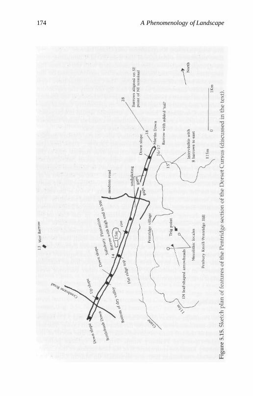
174 A Phenomenology of Landscape
Ridges, Valleys and Monuments on the Chalk Downland 175
Bottlebush Down. Parts of the second stretch of the Cursus lead-ing up to the barrow on Gussage Cow Down and the south-westterminal on Thickthorn Down are also visible from here, but notintermediate sections of the second half, where the Cursus dipsdown into the Gussage and Wyke valleys. From Penbury Knoll aspur of high ground swings round to the north and dips down,extending to about 400 m. south of the beginning of the Cursus.The terminal end of this spur is marked and further emphasizedby a large barrow, today just over 100 m. in length, the secondlargest in the entire Cranborne Chase barrow group, only exceed-ed in length by a few metres by the Pimperne barrow in theextreme west of the overall distribution. Unusually, this barrow,rather than following the contours of the immediate topography,cuts across them - i.e. the direction of the slope of the spur runsparallel with the long axis of the barrow (Fig. 5.16). Its specific sit-ing makes it highly visible both from the Cursus terminal andfrom eight of a group of nine long barrows situated to the east ofthe Cursus. Although the Cursus terminal would not be visiblefrom these barrows this barrow served as a marker for the pointat which it began. The inference that can be drawn from this isthat the group of barrows situated to the east of the Cursus maybe later in date than those associated with its NE terminal end.
The prominent barrow on the arm of Penbury Knoll,mentioned above, is orientated NNW-SSE, with its higher andbroader end up-slope at the SSE end. The NNW end is exactlyaligned on the NE end of the Cursus and clearly related to it.About 250 m. due north another massive barrow is sited onlyabout 10 m. to the south-east of the Cursus end, and again exactlyaligned on its NE end. The mound, 150 m. in length, is by far thelargest in Cranborne Chase (Fig. 5.17). It has been variously inter-preted as two conjoined long barrows with continuous sideditches set end to end (Crawford and Keiller 1928: 232; RCHM1975) or a bank barrow (Ashbee 1984: 15). Bradley has recentlyreinterpreted it as a classic long barrow, its broader end to theeast, with a 'tail' added to, but not continuous with, the easternend at a later date, the Cursus blocking possibilities for furtherexpansion to the north-eastern end, which might otherwise beexpected (Bradley in Barrett et al. 1991b: 51). About 250 m. to thenorth of the Cursus a smaller, now much ploughed-down,barrow occurs, aligned again on the north-east terminal, as doesanother small barrow in Vernditch wood, 2.4 km to the north.
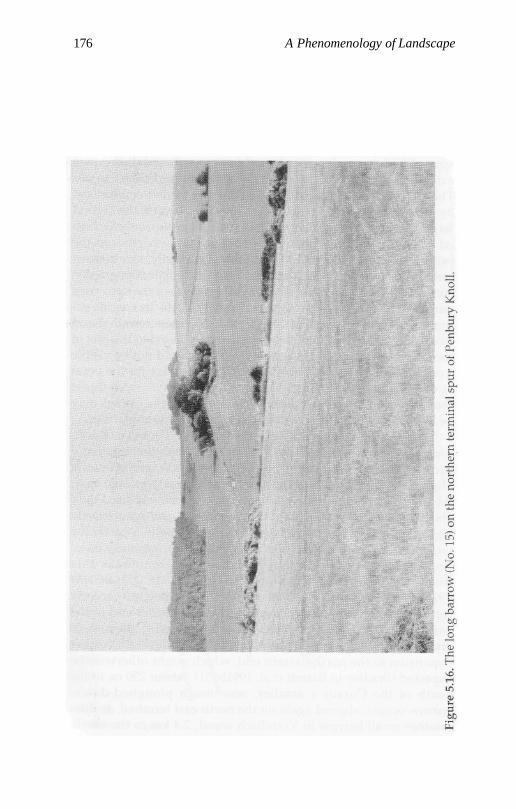
176 A Phenomenology of Landscape
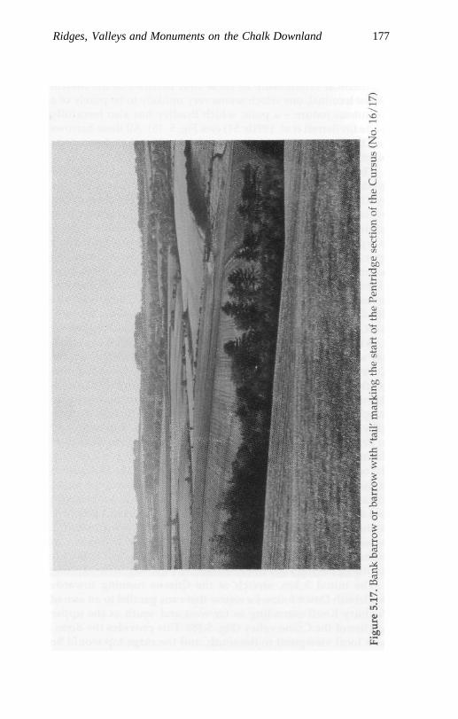
Ridges, Valleys and Monuments on the Chalk Downland 177
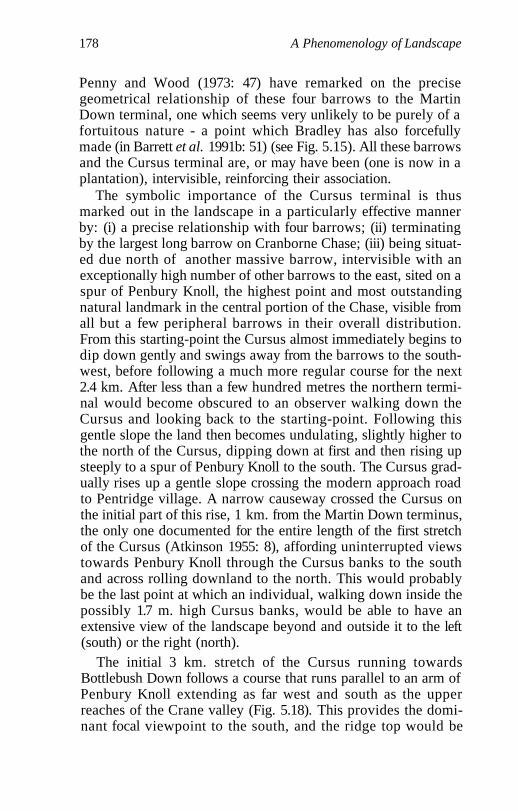
178 A Phenomenology of Landscape
Penny and Wood (1973: 47) have remarked on the precisegeometrical relationship of these four barrows to the MartinDown terminal, one which seems very unlikely to be purely of afortuitous nature - a point which Bradley has also forcefullymade (in Barrett et al. 1991b: 51) (see Fig. 5.15). All these barrowsand the Cursus terminal are, or may have been (one is now in aplantation), intervisible, reinforcing their association.
The symbolic importance of the Cursus terminal is thusmarked out in the landscape in a particularly effective mannerby: (i) a precise relationship with four barrows; (ii) terminatingby the largest long barrow on Cranborne Chase; (iii) being situat-ed due north of another massive barrow, intervisible with anexceptionally high number of other barrows to the east, sited on aspur of Penbury Knoll, the highest point and most outstandingnatural landmark in the central portion of the Chase, visible fromall but a few peripheral barrows in their overall distribution.From this starting-point the Cursus almost immediately begins todip down gently and swings away from the barrows to the south-west, before following a much more regular course for the next2.4 km. After less than a few hundred metres the northern termi-nal would become obscured to an observer walking down theCursus and looking back to the starting-point. Following thisgentle slope the land then becomes undulating, slightly higher tothe north of the Cursus, dipping down at first and then rising upsteeply to a spur of Penbury Knoll to the south. The Cursus grad-ually rises up a gentle slope crossing the modern approach roadto Pentridge village. A narrow causeway crossed the Cursus onthe initial part of this rise, 1 km. from the Martin Down terminus,the only one documented for the entire length of the first stretchof the Cursus (Atkinson 1955: 8), affording uninterrupted viewstowards Penbury Knoll through the Cursus banks to the southand across rolling downland to the north. This would probablybe the last point at which an individual, walking down inside thepossibly 1.7 m. high Cursus banks, would be able to have anextensive view of the landscape beyond and outside it to the left(south) or the right (north).
The initial 3 km. stretch of the Cursus running towardsBottlebush Down follows a course that runs parallel to an arm ofPenbury Knoll extending as far west and south as the upperreaches of the Crane valley (Fig. 5.18). This provides the domi-nant focal viewpoint to the south, and the ridge top would be
Ridges, Valleys and Monuments on the Chalk Downland 179
180 A Phenomenology of Landscape
visible on the skyline beyond the left Cursus bank. To the norththe land is gentle and undulating, and nothing would be visiblebeyond the right-hand bank of the Cursus to those moving alongwithin. Beyond the modern approach road to Pentridge theCursus crosses a 350 m. stretch of relatively flat land constitutinga localized high point, the land dipping away at first to the south,and then rising up towards Penbury Knoll. It then gradually risesup for another 750 m., crossing two shallow dips to another local-ized high point, a flat ridge top, now covered by Salisbury plan-tation, which extends for about 400 m. In the centre of this flatarea the first monument along the course of the Cursus, in theright-hand or northern bank, is encountered. This is a long bar-row, orientated NE-SW, of medium size, 43 m. long, 18 m. wideand now 2.4 m. high at the NE end, tapering off to the south-west.This barrow orientation is highly unusual for the CranborneChase group of barrows taken as a whole, and is only shared byone other barrow on the extreme periphery of the overall distrib-ution to the east, the Giant's Grave, Breamore. The barrow isclearly orientated to run parallel to the contours of the ridge top,which is the case for many others in the Cranborne Chase group;but its orientation is precisely the reverse of the norm, SE-NW,with the broader and higher end to the SE. To any observer familiarwith the usual orientation of long barrows and the placement ofthe higher forecourt end, this would constitute a striking surpriseand contrast. In comparative visual effect to the barrows at thebeginning of the Dorset Cursus, this is the world reversed.Another point of significance is that the barrow is incorporated inthe right-hand or north-west bank of the Cursus, whereas all theemphasis on alignments of the barrows at the Martin Down ter-minal was on the left-hand or south-east terminal point, anothercontrast and reversal.
Field survey (Atkinson 1955: 7; RCHM 1975) has shown thatthe north-west bank of the Cursus runs up to and is aligned onthe barrow at both ends, but that the long axis of the barrow dif-fers from that of the Cursus banks by about 10 degrees.Atkinson's inference is that the Cursus was constructed so as tobe aligned on a previously existing barrow. Bradley makes thesuggestion that because the alignments are not precise this bar-row might have been built alongside an early (marking out?)phase of the construction of the Cursus, and only incorporatedinto the bank when the earthwork was enlarged (Bradley in
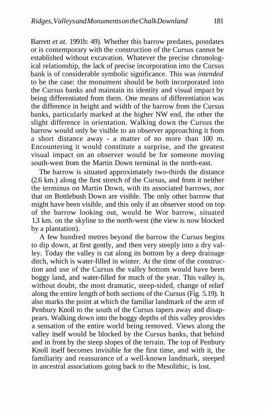
Ridges, Valleys and Monuments on the Chalk Downland 181
Barrett et at. 1991b: 49). Whether this barrow predates, postdatesor is contemporary with the construction of the Cursus cannot beestablished without excavation. Whatever the precise chronolog-ical relationship, the lack of precise incorporation into the Cursusbank is of considerable symbolic significance. This was intendedto be the case: the monument should be both incorporated intothe Cursus banks and maintain its identity and visual impact bybeing differentiated from them. One means of differentiation wasthe difference in height and width of the barrow from the Cursusbanks, particularly marked at the higher NW end, the other theslight difference in orientation. Walking down the Cursus thebarrow would only be visible to an observer approaching it froma short distance away - a matter of no more than 100 m.Encountering it would constitute a surprise, and the greatestvisual impact on an observer would be for someone movingsouth-west from the Martin Down terminal in the north-east.
The barrow is situated approximately two-thirds the distance(2.6 km.) along the first stretch of the Cursus, and from it neitherthe terminus on Martin Down, with its associated barrows, northat on Bottlebush Down are visible. The only other barrow thatmight have been visible, and this only if an observer stood on topof the barrow looking out, would be Wor barrow, situated1.3 km. on the skyline to the north-west (the view is now blockedby a plantation).
A few hundred metres beyond the barrow the Cursus beginsto dip down, at first gently, and then very steeply into a dry val-ley. Today the valley is cut along its bottom by a deep drainageditch, which is water-filled in winter. At the time of the construc-tion and use of the Cursus the valley bottom would have beenboggy land, and water-filled for much of the year. This valley is,without doubt, the most dramatic, steep-sided, change of reliefalong the entire length of both sections of the Cursus (Fig. 5.19). Italso marks the point at which the familiar landmark of the arm ofPenbury Knoll to the south of the Cursus tapers away and disap-pears. Walking down into the boggy depths of this valley providesa sensation of the entire world being removed. Views along thevalley itself would be blocked by the Cursus banks, that behindand in front by the steep slopes of the terrain. The top of PenburyKnoll itself becomes invisible for the first time, and with it, thefamiliarity and reassurance of a well-known landmark, steepedin ancestral associations going back to the Mesolithic, is lost.
182 A Phenomenology of Landscape
Ridges, Valleys and Monuments on the Chalk Downland 183
Up to this point the first section of the Cursus traverses onlyvery gently undulating terrain, the differences in relief beingslight, and the Cursus axis itself parallels and follows the axis ofthe high ground of Penbury Knoll, meeting its northern, and fol-lowing its southern ridged spurs. The Cursus is keyed into andfollows the line of the high ground running to the south of itssouth-western bank. The relationship of the axis of the culturalmonument to that established by the natural topography is one ofimitation or duplication. The Cursus is sited at a distance varyingbetween 200 and 500 m. from the point at which the much higherground of the upper parts of the ridges of Penbury Knoll rise upon its southern side. It is thus situated at an appropriate distanceaway to maximize the visual impact of the change of relief andalso to afford a comfortable angle of view over the top of theCursus banks (depending on their exact height), which are nottoo close and not too far away. The Cursus itself is dovetailed intothe contours of the immediate landscape surrounding it to thenorth and the south as if forming a natural and integral part of it.Crossing this first very steep-sided valley that relationship nowdramatically changes to one of contrast or contradiction. Ratherthan following and being situated below the orientational axes ofhigh points in the landscape the Cursus slashes and traverses itsway across them until its final termination point on ThickthornDown. The long barrow in Salisbury Plantation is thus locatedimmediately before an important transition in the relationship ofthe monument to the local topography. Another importantchange occurs from this point onwards: the course of the Cursusbecomes much less regular and more sinuous, with a number ofimportant changes of direction. From a point roughly 200 m.south of the terminal on Martin Down until just beyond thebarrow and the edge of this steep valley the course of the Cursushas a very regular alignment.
Emerging from the valley, the climb to the summit ofBottlebush Down, now traversed by the Cranborne to SixpennyHandley road, is a steep one. From the summit of BottlebushDown the impressive barrow traversing the Cursus at rightangles, on Gussage Cow Down, becomes visible for the first time,just over 3 km. distant, looking down the Cursus, and the familiarlandmark of Penbury Knoll is visible once more looking back-wards. The first section of the Cursus ends, as it began, undramati-cally, dipping away to the south-west down a gentle slope.
184 A Phenomenology of Landscape
Walking at a steady pace, and without stopping, it takes nomore than an hour to proceed along the first 4.3 km. stretch of theCursus. The terrain is gentle and easy until the steep valley justbefore the end of the first stretch. The second, Gussage, section(Figs. 5.14 and 5.20) is longer, about 5.6 km., and takes about onehour and fifteen minutes to walk. To a much greater extent thanthe first, it is characterized by long vistas along the Cursus axis asit proceeds down and up two roughly parallel ridges, on both ofwhich long barrows are sited, completely dominating the view.In the first section of the Cursus, after leaving the Martin Downterminal, monuments were absent or hidden. In this second sec-tion they were meant to stand out on Gussage Cow Down andThickthorn Down. Their presence, rather than to be hidden, andto surprise, was to be constantly felt (Fig. 5.21).
The second stretch of the Cursus begins on the midpoint of aslope and runs down to cross the base of a wide and shallow dryvalley, the source area of the river Allen. At the point at which theCursus crosses the valley bottom, where the modern road runs toWimborne St Giles, the terrain would, in the Neolithic, have beenwet and marshy for much of the year. The course of the Cursuscrosses over and drops down an ancient Pleistocene river cliff justbefore reaching the lowest point on the modern road (Fig. 5.22).The banks and ditches of the Cursus were constructed on eitherside of this topographic feature. One end of it adjoined the north-ern bank, with the southern bank enclosing the other end with agap of around 30 m. The drop in relief to anyone walking alongthe Cursus towards the south-west terminus is both sudden andunexpected. The Cursus here, then, encloses another surprise -this time not a hidden monument, but a hidden relict cliff downwhich the unwary might easily tumble. Until this point the oldfamiliar landmark of Penbury Knoll is visible looking back.Going down the cliff slope it disappears from sight once more atthe point at which marshy land is reached, a repetition of the sit-uation encountered in the dry valley towards the end of the first(Pentridge) stretch of the Cursus. Ahead the prominent barrowon Gussage Cow Down dominates the view.
Crossing the modern road the Cursus rises up to the barrow, atfirst gently and then more steeply. As it does so Penbury Knollgradually becomes visible once more looking behind.Progressively moving up the slope to approach the long barrowon Gussage Cow Down the barrow outline becomes more and
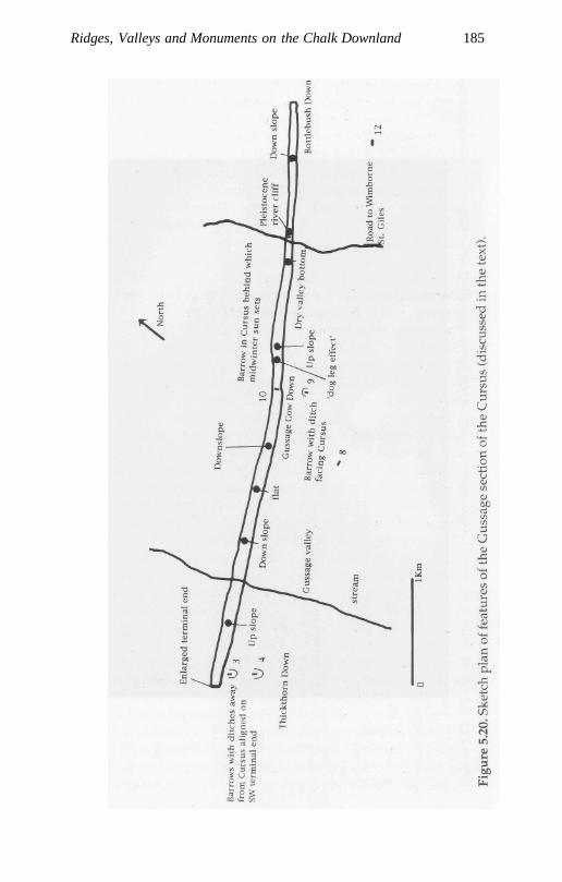
Ridges, Valleys and Monuments on the Chalk Downland 185
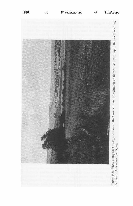
186 A Phenomenology of Landscape
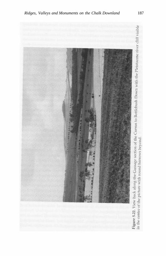
Ridges, Valleys and Monuments on the Chalk Downland 187
188 A Phenomenology of Landscape
more indistinct, fading away into the skyline. As it does, lookingbehind, the outline of Penbury Knoll and its accompanyingridges becomes clearer and clearer in the distance. That which isnear and in front successively fades away, that which is far awaybecomes more distinct. The barrow is sited in such a manner thatit is completely obscured by the upward slope of the hill until thecrest of that hill is almost reached. Altogether it is out of sight forabout 550 m. of the course of the Cursus (five minutes' walkingtime) up the steepest part of the slope. It only looms into sightagain at a distance of around 70 m. away.
The ridge of Gussage Cow Down, on which the barrow stands,marks the highest point over which the Cursus crosses from theBottlebush terminal. The barrow is situated approximately at themidpoint of this second stretch of the monument, and from it theBottlebush Down terminal and the barrow marking the terminalpoint on Thickthorn Down would also be visible (it is now con-cealed by a thick hedge immediately in front of it). As the Cursusclimbs up to the Gussage Cow Down barrow it alters directiontwice within 230 m., creating what Bradley terms a 'dogleg' effect(Bradley in Barrett et al. 1991b: 47). Bradley suggests that this isbecause the entire Cursus length from the Bottlebush Downterminus was aligned on the Gussage barrow, but that it driftedoff course and had to be corrected in the lee of the hill where thatbarrow could not be observed (ibid.). These changes in the courseof the Cursus going up the hill do not make much impressionfrom a map; but they would have had considerable visual impactwhen viewed from the Bottlebush terminal and experienced bythose walking up the Cursus. Such a 'dogleg' effect does notoccur further on at the point at which the Cursus rises up toadjoin another barrow on Thickthorn Down, where a similarsighting 'problem' occurs, nor is there any evidence for suddenchanges in direction where the Cursus crosses the narrow andsteep dry valley before climbing up to Bottlebush Down towardsthe end of the Pentridge section. The 'dogleg' effect may perhapsbe more satisfactorily understood by suggesting that it was anintentional design feature put in place to emphasize further thenow hidden approach to a monument of central social andsymbolic significance.
Gussage Cow Down is a ridge situated midway between theAllen and Gussage valleys. The ridge top itself is orientatedNW-SE. The banks of the Cursus do not climb this ridge directly
Ridges, Valleys and Monuments on the Chalk Downland 189
from the bottom of the Allen valley, at right-angles to the direc-tion of the slope, but obliquely, and are set in a roughly diagonalfashion in relation to it. The Cursus thus not only cuts across thenatural axis of the landscape as defined by the ridge of GussageCow Down with the valleys on either side of it, but it does soobliquely, while also including the 'dogleg' change of direction.Little more contrast with the overall topography, or shape of theland, could be effected than the inclusion of all these three fea-tures simultaneously.
By contrast, the two long barrows situated on the ridge top ofGussage Cow Down both duplicate the ridge axes, being orien-tated SE-NW along their long axes, with their broadest and high-est ends facing SE, the norm for Cranborne Chase. These barrowsare not sited on the highest point of the ridge top, but a little waybelow it to the north, at a distance of 240 m. from each other. Thelong axes of these two barrows are precisely aligned on eachother, and, as mentioned above, the northernmost barrow standsin the centre of the Cursus and at right-angles to it. It is this north-ern barrow that is sited so as to be particularly conspicuousviewed side-on (Figs. 5.7; 5.21 and 5.22). It is intervisible with noless than seven other barrows (see Fig. 5.6), contrasting with thesouthern barrow, which is only visible from a short distanceaway, sited as if it were only meant to be seen from the northernbarrow and the Cursus. The inference that might be drawn fromthis is that the southern barrow was intimately related to thenorthern one, and built with reference to it and its location in themiddle of the Cursus.
Penny and Wood (1973: 58-9) and Bradley (in Barrett et al.1991b: 56) have noted and emphasized that the northern barrowon Gussage Cow Down is aligned in such a manner that the mid-winter sun can be observed setting behind the barrow on the sky-line from the Bottlebush terminal. Dramatically, the rays of thedying sun move from the SE to the NW end of the barrow, withthe last flicker of light at the end of the barrow.
Both barrows on Gussage Cow Down are of medium size(50-65 m. long), the southern barrow being a little longer than thenorthern one. The southern barrow is surrounded by a well-defined U-shaped ditch open towards the northern barrow andthe Cursus. The ditches surrounding the northern barrow arenow ploughed out, but from aerial photographs (Crawford andKeiller 1923: plate XVI) appear to run parallel to the mound long
190 A Phenomenology of Landscape
axis without curving around either end. The barrow is sited off-centre to the Cursus, being much nearer to the NW bank thanthat to the SE. The reason for this would seem to be fairly obvious- that anyone walking along the Cursus should pass by the sideof the barrow rather than walk over it, and do so at the broaderand higher SE end, where the mortuary chamber and forecourtarea for ritual activities would be sited.
Approaching the northern barrow on Gussage Cow Down theview farther west along the Cursus is completely blocked untilthe barrow itself is passed (Fig. 5.23). The outline of the southernbarrow would be similarly concealed from view by the Cursusbanks until the point at which the northern barrow was reached.The Cursus thus contains another surprise: the unexpected bar-row to the south, hitherto concealed from view both by virtue ofits specific siting and by the Cursus banks. Passing around thesouthern end of the northern barrow would thus have an addedsignificance, in that this would permit the southern barrow to beseen (Fig. 5.24).
, Immediately after passing round the northern barrow the finalstretch of the Cursus to Thickthorn Down becomes visible, withthe exception of a stretch which runs over the bottom of theGussage valley and its stream, a tributary of the river Allen (Fig.5.25). Both the barrows on Thickthorn Down, one located just tothe south of the Cursus terminal, and the other aligned on it (seebelow), would be visible from this point (as mentioned above,they are now concealed by a thick hedge), but not the cross-banksof the Cursus terminal itself, which is located just below the sky-line. The impression given would be that the Cursus itself contin-ued beyond this point. From the Bottlebush Down terminal thewhole length of the Cursus up to the Gussage North long barrowincorporated within it had been visible. This contrasts interest-ingly with the situation encountered on reaching that barrow,where the view is visually truncated, concealing the next valleybottom beyond, with the Thickthorn North barrow being locatedoutside the Cursus banks to the left, and the terminus invisiblebeyond the brow of the hill.
Walking down the slope away from the barrow Penbury Knollbecomes invisible immediately, and the Gussage barrow itselfafter 300 m. The Cursus descends into a slight dip before risingup again after another 300 m., at which point the barrow behindbecomes visible once more. The Cursus then runs over relatively
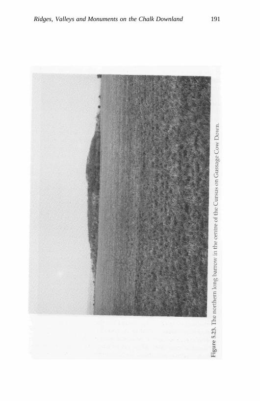
Ridges, Valleys and Monuments on the Chalk Downland 191
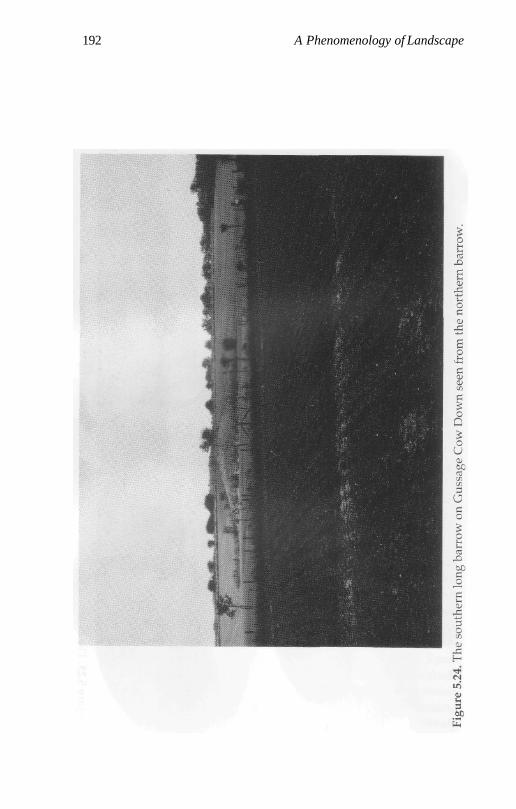
192 A Phenomenology of Landscape
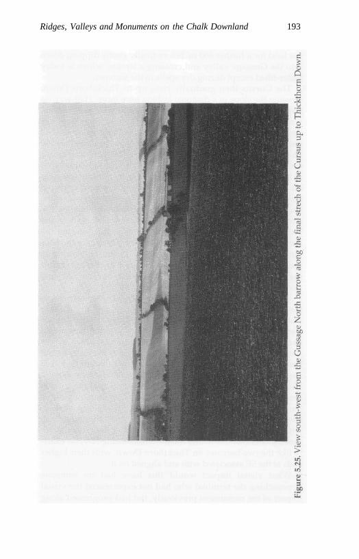
Ridges, Valleys and Monuments on the Chalk Downland 193
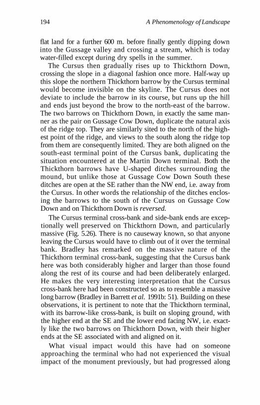
194 A Phenomenology of Landscape
flat land for a further 600 m. before finally gently dipping downinto the Gussage valley and crossing a stream, which is todaywater-filled except during dry spells in the summer.
The Cursus then gradually rises up to Thickthorn Down,crossing the slope in a diagonal fashion once more. Half-way upthis slope the northern Thickthorn barrow by the Cursus terminalwould become invisible on the skyline. The Cursus does notdeviate to include the barrow in its course, but runs up the hilland ends just beyond the brow to the north-east of the barrow.The two barrows on Thickthorn Down, in exactly the same man-ner as the pair on Gussage Cow Down, duplicate the natural axisof the ridge top. They are similarly sited to the north of the high-est point of the ridge, and views to the south along the ridge topfrom them are consequently limited. They are both aligned on thesouth-east terminal point of the Cursus bank, duplicating thesituation encountered at the Martin Down terminal. Both theThickthorn barrows have U-shaped ditches surrounding themound, but unlike those at Gussage Cow Down South theseditches are open at the SE rather than the NW end, i.e. away fromthe Cursus. In other words the relationship of the ditches enclos-ing the barrows to the south of the Cursus on Gussage CowDown and on Thickthorn Down is reversed.
The Cursus terminal cross-bank and side-bank ends are excep-tionally well preserved on Thickthorn Down, and particularlymassive (Fig. 5.26). There is no causeway known, so that anyoneleaving the Cursus would have to climb out of it over the terminalbank. Bradley has remarked on the massive nature of theThickthorn terminal cross-bank, suggesting that the Cursus bankhere was both considerably higher and larger than those foundalong the rest of its course and had been deliberately enlarged.He makes the very interesting interpretation that the Cursuscross-bank here had been constructed so as to resemble a massivelong barrow (Bradley in Barrett et al. 1991b: 51). Building on theseobservations, it is pertinent to note that the Thickthorn terminal,with its barrow-like cross-bank, is built on sloping ground, withthe higher end at the SE and the lower end facing NW, i.e. exact-ly like the two barrows on Thickthorn Down, with their higherends at the SE associated with and aligned on it.
What visual impact would this have had on someoneapproaching the terminal who had not experienced the visualimpact of the monument previously, but had progressed along
Ridges, Valleys and Monuments on the Chalk Downland 195
196 A Phenomenology of Landscape
the course o£the Cursus from the Martin Down terminus? Goingup the slope to Thickthorn Down the two long barrows would beout of sight. Coming to the brow of the hill the Cursus bankswould effectively continue to block any view of the Thickthornbarrows; but instead one's vision would be funnelled towards themassively constructed terminal cross-bank blocking any viewacross the landscape to the west - a feature entirely concealeduntil this point. On the basis of previous experience of the barrowhidden in the right Cursus bank on the ridge covered bySalisbury Plantation and the barrow placed at right-angles to theCursus on Gussage Cow Down, together with the orientation andshape of the cross-bank, the obvious (but incorrect) conclusionwould be that this was another barrow, but far more massivethan anything previously encountered from the Martin Downterminus onwards. The Cursus cross-bank on Thickthorn Downis just over 100 m. long. Emerging from the Cursus, the real longbarrows on Thickthorn Down would be visible to the south, anda number of other barrows scattered over the landscape in thedistance to the north and west; looking behind to the east, thenorthern barrow on Gussage Cow Down, and Penbury Knoll,marking the start of the Cursus on Martin Down.
The Empty Place - A Ritual Passage
The precise purpose of the Cursus has remained somewhatenigmatic. Penny and Wood (1973) attempt to explain it as agigantic astronomical observatory; but most of the solar andlunar alignments they discuss in relation to other long barrowsand round barrows in the vicinity seem unconvincing apart fromthe most basic one, mentioned above - the midwinter sunsetbehind the Gussage North barrow. Another suggestion common-ly put forward is that the Cursus must be some kind of ceremoni-al or processional way concerned with a cult of the dead(Atkinson 1955: 9). Bradley rightly stresses the manner in whichthe Cursus links together a series of long barrows, and suggeststhat there may have been an important distinction between thebarrows, possibly related to the rising moon, and the Cursus,with its solar alignment. He argues that:
Ridges, Valleys and Monuments on the Chalk Downland 197
the entire layout of the Cursus seems to be intended to exclude out-siders: only for those inside the great enclosure was the design of themonument apparent. It may be that the building of the Cursus wasthe ultimate expression of ... changes in attitudes to the dead. It inte-grated the separate long barrows scattered along the upper limits ofthe settlement pattern, and at the same time, bound them together ina complex design which could only be appreciated by those who hadaccess to certain specific points inside the monument. By incorporatinginto its structure an important astronomical alignment, those whobuilt it made those developments appear to be part of the functioningof nature (Bradley in Barrett et al. 1991b: 58).
Bradley stresses a number of important points in this passage -the ritual function of the Cursus, the fact that it could only beunderstood from the inside, and an ideological role in naturaliz-ing a set of cultural practices and relating them to the passage oftime and the seasons. Rather surprisingly, he also suggests thatthe Cursus would be unsuitable for processions, as it crossesrivers (ibid.: 47). In the account of walking the Cursus I haverepeatedly emphasized the manner in which the spatial structureof the monument and its relationship with topographic featuresof the landscape and associated barrows constantly surprisessomeone moving along it for the first time. I want to argue thatthe experience of walking along it was an essential ingredient inits meaning, and that this movement took place, as describedabove, from the NE to the SW.
The point about the direction of movement is fairly easilyestablished - the Cursus simply does not make sense when mov-ing down it from the SW end. First, the important solar alignmentis not visible from the SW. Second, it might be expected that themonument should end at a dramatic position in the landscape,and the Martin Down terminal, at the top of a gentle slope, doesnot meet this expectation. Indeed, its location in the landscapemore or less repeats that of the earlier Bottlebush terminal, with along down-slope view. Third, features such as the partially hid-den barrow in the bank of the Pentridge section of the Cursus, thehidden Pleistocene river cliff, and the massively enlarged Cursusterminal cross-bank on Thickthorn Down in the Gussage sectionwould have little or no visual or somatic impact whenapproached from the NW, and would not surprise.
The Cursus is a massive linear space bounded by banks withexternal ditches curving round at its ends, with the highest and
198 A Phenomenology of Landscape
most massive terminal cross-banks in the SW. In its linearity,external ditches and emphasized terminal point it resembles amassive unfilled long barrow. It differs from most barrows in itsoverall orientation and relationship with the landscape, crossingrather than following its contours, for much of its length. TheCursus was deliberately designed so as to include two previouslyconstructed barrows within it, and the orientations of others atboth terminals are clearly related to it. In this sense it presencedthe past in the present, and part of its meaning was constituted byits relationship to the barrows and the specific manner in which itconnected them together.
The Gussage Cursus has a clear symmetry in its arrangement.It runs down a slope, over an ancient river cliff, crosses water,moves up a slope to the ridge top where the Gussage Cow Downbarrow is located, moves down another slope, crosses water andruns up to its terminus on Thickthorn Down. It is not hard toimagine how such a monument worked in terms of initiationceremonies involving liminal states and rituals of reversal.Novices are taken out of the mundane everyday world and intothe enclosed and bounded space of the Cursus. They move along,going down-slope, shut out from the world in the direction of thedying sun, stumble down the concealed ancient river cliff, andthen cross wet land to reach the Gussage barrow in the centre ofthe Cursus. They experience it moving out of sight and changesin the Cursus direction. When they eventually approach the bar-row they move round its higher SE end with great ceremonial,and see for the first time the barrow outside the Cursus to thesouth, with its open unenclosed lower end facing them, and areinstructed with tales of the ancestors and supernatural beings.Ahead on Thickthorn Down two other barrows are visible, butoutside the Cursus. They move down the slope, cross water andcontinue up-slope to Thickthorn Down, where the barrows areconcealed and the massive barrow-like terminus blocks the view.Climbing out of the Cursus they return to the everyday worldwith the ditches around the Thickthorn barrows in the 'right'place at the lower end.
There are an obvious set of structural contrasts here: betweenhigh and low, down-slope and up-slope, wet and dry, barrowswith ditches open at the NW and then the SE ends, barrows withinthe monument and barrows outside it, and plays on the visibilityand invisibility of barrows in relation to movement, creating a
Ridges, Valleys and Monuments on the Chalk Downland 199
series of contrasts and surprises. Within the enclosed world of theCursus the Gussage Cow Down barrow is itself placed at a high,dry point within liminal space, and water must be crossed toreach and to leave it.
The Pentridge extension to the Cursus modifies the simplerpattern of the initial Gussage Cursus to introduce more contrastsand surprises. The extended Cursus from Martin Down toThickthorn Down begins, like the Gussage Cursus, down-slope;it ends up-slope. It begins just to the north of the most dominantand familiar landmark in the area, Penbury Knoll, visible fromvirtually all the long barrows in the Cranborne Chase group. Itnow both begins and ends with barrows located outside theCursus, aligned on the SE terminal point. In approximately themid-point of each stretch barrows are included within the monu-ment at high points; but their relationship to the Cursus itself isreversed, at first respecting and then cross-cutting its axis. Thefirst barrow inside the Cursus is hidden, the second highly visi-ble. The first barrow stands on its own, the second is associatedwith a barrow outside the Cursus. Both barrows on ThickthornDown are outside the Cursus. So in relationship to the long bar-rows with which it is associated the extended Cursus from itsstarting-point has varying degrees of incorporation - total in thePentridge section (the barrow forms part of the Cursus banks),partial on Gussage Cow Down (one barrow is outside the Cursus).The Pentridge section of Cursus at first parallels high ground toits left; and then, once the first barrow is reached, this relation-ship is reversed, and it crosses rather than follows valleys. Thepattern is one of symmetries and differences, repetitions andreversals, requiring, as Bradley rightly stresses, an insider'sknowledge and detailed ritual instruction to understand themand their significance. The Cursus, through its form and the con-nections it creates with other monuments, establishes throughformalized successional movement along it, a spatial story.
The Cursus represents a formalized structuring of the experi-ence of landscape by those entering and using it. It acted not onlyas a conduit of movement, but as a barrier blocking a less struc-tured encounter with the barrows on Cranborne Chase. AsBarrett (1994) has recently argued with reference to the some-what later ceremonial monuments of Durrington Walls, Aveburyand Stonehenge, it is highly unlikely that it was formally plannedand conceived. It represents rather a series of construction

200 A Phenomenology of Landscape
projects that were modified and whose meaning and significancebecame altered though time, thus transforming the biographies,myths and encounters of people with the landscape. The very actof people coming together to construct the monument, campingnearby for several weeks or months, to re-establish, augment anddevelop it, was important in itself and not simply a matter of thecreation of a container for various forms of subsequent activity.
It is not unlikely that, on Cranborne Chase, part of the narra-tive meanings of the Dorset Cursus were linked not only to initi-ation rites, but also to the themes of death and the regeneration oflife. It may have operated as a linear conduit through which bothbodies and bones were being moved between the barrows in thecentral part of the Chase and Hambledon Hill. Bodies were per-haps being taken out of Cranborne Chase to a death island of thesetting sun immediately beyond its margins to the west, andbeing allowed to decompose, with selected bones being returnedto the barrows in the central ritual arena of the Chase itself. Thepollution of death was thus being removed and dry, clean andritually pure bones returned. Given the massive effort required toconstruct the Cursus, the barrows themselves, and the enclosureson Hambledon Hill, and the long-distance movement of pottery,axes and other materials during the Neolithic, such a system ofcorpse movement does not appear inherently unlikely. OnHambledon Hill artefacts were carefully offered and deposited inthe pits inside the enclosure and in the ditches as if they werebones. In turn the bones of the skeleton became treated as arte-facts, being deposited in the barrows and circulating among theliving.
Conclusion
The slight early Neolithic 'settlement' evidence, contemporarywith the construction of the barrows, the Cursus and HambledonHill, suggests that Cranborne Chase may have been an area thatwas not permanently settled, but periodically visited by a num-ber of surrounding social groups, to perform rituals, bury thedead and manipulate ancestral bones. The escarpment periph-eries were marked out by barrows aligned along its axes, empha-sizing transition up to an important sacred space. The barrowssituated in the centre of the Chase were situated so as to duplicate
Ridges, Valleys and Monuments on the Chalk Downland 201
the contours of the land, while the Cursus dramatically cutsacross them, linking the monuments together. Hambledon Hillwas a heavily ritualized death island to the west, to which bodieswere taken in processions and from which ancestral bones werecirculated back to the barrows on the Chase. In this area thevisual relationship between monuments and their sequentialordering along the formalized path of movement marked out bythe Cursus was as essential a part of their meaning as the ritualtopography itself that these monuments helped to create andsustain.

Chapter 6
Conclusion: Ideology and Place:Restructuring the Connections
'The flow of movement is a flow of the mind.' I have argued thatduring the Mesolithic, in all three study areas, ancestral connec-tions between living populations and the past were embodied inthe Being of the landscape and an emotional attachment to placethat had a generalized power and significance in relation tohuman activity as a series of known, named and significantplaces linked by paths of movement to which populations repeat-edly returned during their seasonal activity rounds. TheseMesolithic populations made relatively little impact on the landapart from establishing clearings around their camp-sites andburning off areas of woodland to stimulate browse.
In the earlier Neolithic the relationship between populationsand the landscape became restructured and took on a differentform. The ancestral powers and meanings in the landscape nowbecame actively appropriated by individuals and groups throughthe construction and use of chambered tombs, long cairns andlong barrows, and on Cranborne Chase by the Cursus and theenclosures on Hambledon Hill. These monuments served tomake permanent, anchor, fix and visually draw out for percep-tion the connections between people and the land for the firsttime. Ancestral powers now became double. The tombs pres-enced and marked out the bones of the ancestral dead in the land-scape. In so doing they visibly brought the presence of theancestral past to consciousness. Their specific morphologicalcharacteristics and their landscape settings also served to relatethe bones of previous generations to a more generalized ancestralpower embodied in the topography and symbolic geography ofplace and paths of movement which had already been constitutedin the Mesolithic. The location of important points in the externalworld became captured in the orientation of morphological
202
Conclusion: Ideology and Place: Retracing Connections 203
features of the monuments and their placement in the landscape.Their settings were deliberately chosen to fix a certain vantagepoint in relation to perception of the world beyond. During theMesolithic the significance of place was understood in terms of itssetting in the landscape. In the Neolithic this was reversed - thelandscape was now understood in terms of its relationship to thesetting of the monuments.
In other words, the setting of place became much moreanchored. Megalith building and long barrow constructionimplies a need to represent in a physical form and capture per-manently ancestral connections with the landscape. In south-west Wales this was effected by constructing monuments near toimportant topographical markers in the land such as rock out-crops. In the Black Mountains the long axis of the chamberedcairn was of paramount significance. It imposed a form, a direc-tional line across the topography, producing an axis directingvision in a prescribed direction outward from the monumentitself and pointing towards escarpment spurs or along prescribedroutes of movements along the Usk and Wye valleys. OnCranborne Chase, the long barrows, rather than directing visionbeyond themselves, outward towards topographic features, aresedimented into the lie of the land itself, following its contours.
Discussing the three different landscapes, and moving fromwest to east across Wales and southern England, I have attemptedto take the reader on a textual journey involving a number of basictransformations. First we move from a case of a lack of monu-ment visibility to intervisibility. Second, there is an increasingemphasis on movement; and third, there is a greater emphasis onthe elimination of difference in monument form from case 1 tocase 3. Finally there is also a basic contrast between CranborneChase and the situation in south-west Wales and the BlackMountains. The relationship between monuments of fundamen-tally different forms and uses (the barrows, the Cursus and thecausewayed enclosure on Hambledon Hill) was as importanthere as was the relationship to the topography. Siting a barrowon Cranborne Chase was much more intimately linked to theposition of other previously constructed barrows than it appearsto have been in Wales. Increasingly, through the construction ofthe Cursus, formalizing one path of movement between the bar-rows, and, no doubt, blocking others, one type of monumentcould only be 'read' and understood here in relation to the others.
204 A Phenomenology of Landscape
The building of the monuments prevented the ritual andmythological significance of particular places being lost andforgotten. They stabilized both cultural memory of place andconnections between places. The cultural appropriation in theNeolithic of already established ancestral powers in the land-scape through monument building served to increase its symbolicpotency and power. Through the mediation of the tomb timebecame frozen, with the drawing of the past into the present. Thetomb objectified ancestral powers in the landscape. In this waythese powers became not just subjects of knowledge but objectsof knowledge too, resources to be worked upon and manipulatedfor the sectional social interests of individuals or particular socialgroups.
The architectural forms of cairn and barrow, Cursus andcausewayed enclosure, in their different ways, signify a will tomake ancestral powers in the land visible, to be seen and remem-bered, but always from a particular perspective provided by thevantage points of the monuments. As we move around in spaceour perspective of the landscape alters. What the monumentsdid, in their different ways, was to freeze perspective through thearchitectural lens of the monuments themselves - their orienta-tions, entrances and exits, façades, forecourts and passage-ways.They are then about establishing control over topographic per-spective and the individual's possibilities for interpreting theworld. Experience of the landscape in the Neolithic became medi-ated and channelled through fixed and permanent architecturalform. Landscape perception, now being structured throughmonuments and relationships between them, became far more'focused'. Experience of the ancestral past now came into beingwithin the specific setting of monuments and their relationshipsto the outside world. This, in turn, is linked with control ofknowledges of the ancestral past which are mediated through thecultural form of the monument and the character of the depositsleft in and around it. Ancestral powers in the landscape couldnow only be deciphered from experiencing them at the site of thetomb or by passing down the Cursus or entering a causewayedenclosure. This in effect represents a closing down and restrictionof a variety of 'points of view' - both literal and metaphorical.The monuments both deployed and captured an ancestral history.Acting as mnemonic markers they coded historicity and sacredpower in particular places, creating a hierarchy of valued points
Conclusion: Ideology and Place: Retracing Connections 205
in the landscape on pathways channelling movement through itand sustaining knowledge of it. This logic, involving a re-order-ing of the visible, constituted a vital component of power rela-tions during the Neolithic, serving to differentiate between thosewho were included in the knowledges required to decipher thelandscape and those who were excluded.
In this respect it seems pertinent to note that, considering theoverall distribution of megalithic monuments in Wales andsouthern England, where we find chambered tombs or long bar-rows we also usually have evidence of a substantial amount ofMesolithic activity. In areas where there are no monuments thereis little or no Mesolithic evidence either. Such a generalizationcould also be extended to other areas of Europe, such as Brittany,the Netherlands and much of southern Scandinavia.
'Our body, to the extent that it moves itself about, that is, to theextent that it is inseparable from a view of the world and is thatview itself brought into existence, is the condition of possibility ...of all expressive operations and all acquired views which consti-tute the cultural world' (Merleau-Ponty 1962: 388). At one levelmonument construction solved the existential problem of how toexperience the natural world and the powers embedded in itwhen none of the perspective views of it as the human bodymoves through space can exhaust it. Horizons for experience arealways open and changing. Through the culturally embeddedhorizon of the tomb and its setting the landscape became visiblyencultured. In turn, the relation of the tomb to the landscapeserved to naturalize the ancestral powers embodied in the cultur-al form of the monument and its bone and artefact deposits. Theyare being represented as part of an immutable natural order ofthings. The natural world as mediated through the tomb becomesthe horizon of all horizons, the style of all possible styles, guaran-teeing for experience a given rather than a willed unity as a frame-work for knowledge of the social and its connection with the past.The monument draws together and serves to coalesce the naturaland the cultural as a framework for experiencing and under-standing the world. What appears - the monument - 'hides'contexts in which it does not appear. It captures and draws atten-tion, domesticating the view of the landscape. The monuments,then, are to do with the formation and stabilization of attitudestoward the world. They acted as signifiers of part of a structure ofknowledge, an iconography of human intentions, a resource for
206 A Phenomenology of Landscape
power and social control. With the advent of monumentconstruction the landscape increasingly starts to become not justa subject of human symbolic labour but an object of that labourtoo.
In the above paragraph I wrote of the view of the landscape inthe Neolithic's, becoming 'domesticated', and I now want brieflyto explore how this might relate to subsistence practices. Itappears that, in the areas I have considered, cultivation wasprobably not important; but the herding of domesticates, particu-larly cattle, began to assume an increasing significance during theNeolithic. The herding and tending of animals formed part andparcel of the new 'order of thought', manifested so dramaticallythrough monument construction and use. Domestic animalsduring the Neolithic had a much greater symbolic exchange-value than their utilitarian use-value as food on the hoof. Part ofthe process of thinking about the landscape in a fresh way nowinvolved thinking it through animals. There are two main aspects tothis. First, as I have argued at length elsewhere (Tilley in press),the symbolic potential and evaluation of food derived fromdomesticates, as opposed to that acquired through foraging, con-stituted a major preoccupation in exchange, feasting and ritual. Itis not surprising, then, that the vast bulk of domestic animalbones known from the British Neolithic occur on ceremonialrather than domestic sites, and that many of these deposits arehighly structured, i.e. come from specific parts of the animal,such as the preponderance of skulls and mandibles found in theCursus ditches, discussed above. Meat from domestic animalswas exotic and highly prestigious, and became a requirement forritual practice - quite literally food for thought. Although stillprobably contributing the bulk of the subsistence base, foodacquired from foraging gradually became down-graded in statusduring the course of the Neolithic, and producing food for ritualevents provided a major stimulant for an increasing emphasis ondomesticates.
Second, in general terms, it might be expected that therewould be more ideological continuity in terms of the importanceattached to paths, as opposed to boundaries, between hunter-gatherer-fishers and populations which had incorporated apastoral component, than between hunters and settled agricul-tural societies. Herding meant changing attitudes to grazingland, to property and inheritance, to over-wintering stock, food,
Conclusion: Ideology and Place: Retracing Connections 207
ritual and ceremonial. Herding involved seasonal movementsalong pathways through the landscape, as in the Mesolithic, butwith altogether different connotations. It obviously required agreat deal more social commitment and ideological investment inthe process of this movement, which would, as did the monu-ments, increasingly serve to inscribe and 'fix' the landscape.Moving animals along paths already in use from the Mesolithicobjectified them in just the same way as I have argued that monu-ments 'captured' the ancestral connotations of topographic fea-tures of the landscape. The movements of animals wouldphysically inscribe these paths across the landscape much moreprominently than the feet of hunter-gatherers following themovements of game, and it would become increasingly difficult(both in practical and symbolic terms) to take different ways. Themonuments, then, sedimented the symbolic potency of locales inthe landscape, domestic animals the paths of movement betweenthem and the ceremonies conducted in and around them. This isnot to impy any economic determinancy. It is rather a matter of asocial, political and ideological transformation that had profoundconsequences for an entire Neolithic way of life, involving bothcontinuity and change from the Mesolithic.
I have suggested that, as cultural markers, one of the purposesof the megaliths in the Black Mountains and south-west Walesand the long barrows on Cranborne Chase would seem to havebeen to draw attention to the symbolic and social significance ofthe natural topography and markers within it, such as the coast,rivers, rock outcrops, spurs, escarpments and ridges. Such mark-ers and places were almost certainly in use during the Mesolithicpreceding the construction of these Neolithic monuments. TheMesolithic hunter-gatherers would have used them, as they canbe used today, as reference points and orientational foci. Thesewere obvious locations for stopping, resting, telling stories,observing game movements. As such they would be named andbe invested with narratives and mythologies. In a sense the rockoutcrops, cliffs and escarpment edges of South-West Wales andthe Black Mountains are natural untamed non-domesticated'megaliths' or stone groups.
The occurence of flint scatters at these locales would have hadconsiderable significance during the Mesolithic and earlyNeolithic for a recognition, reading and understanding of place.Like the difference between primary forest and regenerating
208 References
areas, differences in the composition of these scatters- waste,flakes, cores, microlith forms and discarded tools would act so asto recall memories of previous visits, activities, events and sea-sons. Reading these signs from places visited by previous genera-tions Mesolithic archaeologists would also be able to infer, likethe contemporary archaeologist, the types of activities that hadtaken place.
What happens in the Neolithic is the constitution of a differentsense of time, place and social identity, through monumentbuilding, and also by means of the herding of domesticates onpathways across the land. Cultural markers are being used to cre-ate a new sense of place, harnessed to legitimize patterns of socialcontrol relating to restricting access to knowledges deemedessential to group reproduction, while continuing to make refer-ence or lay claim to already established ancestral connectionswith, and pathways through, the landscape. An already encul-tured landscape becomes refashioned, its meanings now con-trolled by the imposition of the cultural form of the constructedmonument.
References
ApSimon, A. (1976), 'A view of the early prehistory of Wales', in G. Boonand J. Lewis (eds), Welsh Antiquity, Cardiff: University of Wales Press
Arnold, J., Green, M., Lewis, B. and Bradley, R. (1988), The Mesolithic ofCranborne Chase', Proceedings of the Dorset Natural History andArchaeological Society, 110: 117-25
Ashbee, P. (1984), The Earthen Long Barrow in Britain, Norwich: GeoBooks
Atkinson, R. (1955), The Dorset Cursus', Antiquity, 29: 4-9Barker, C. T. (1992), The Chambered Tombs of South-West Wales, Oxbow
Monograph 14, Oxford: Oxbow BooksBarrett, J. (1994), Fragments from Antiquity, Oxford: Blackwell.Barrett, J. and Bradley, R. (1991), The Cranborne Chase project and its
publication', in J. Barrett, R. Bradley and M. Hall (eds)Barrett, J., Bradley, R. and Hall, M. (eds), (1991a), Papers on the Prehistoric
Archaeology of Cranborne Chase, Oxbow Monograph 11, Oxford:Oxbow Books
Barrett, J., Bradley, R. and Green, M. (1991b), Landscape, Monuments andSociety. The Prehistory of Cranborne Chase, Cambridge: CambridgeUniversity Press
References 209
Barth, F. (1975), Ritual and Knowledge among the Baktaman, New Haven:Yale University Press
Basso, K. (1984), '"Stalking with stories": names, places and moral narra-tives among the western Apache', in E. Bruner (ed.) Text, Play andStory, Prospect Heights, Illinois: Waveland Press
Bender, B. (1992), 'Theorising landscapes, and the prehistoric landscapesof Stonehenge', Man, 27: 735-55
Bender, B. (ed.) (1993), Landscape: Politics and Perspectives, Oxford: BergBerndt, R. (1972), 'The Walmadjeri and Gugadja', in M. Bicchieri (ed.),
Hunters and Gatherers Today, New York: Holt, Rinehart and WinstonBerndt, R. (1974), Australian Aboriginal Religion, Leiden: E. J. BrillBerndt, R. (1976), 'Territoriality and the problem of demarcating socio-
cultural space', in N. Peterson (ed.), Tribes and Boundaries in Australia,New Jersey: Humanities Press
Berndt, R. and Berndt, C. (eds) (1965), Aboriginal Man in Australia,London: Angus and Robertson
Berridge, P. (1980), 'Waun Fingen Felin', Archaeology in Wales 20:19-20Binford, L. (1978), Nunamiut Ethnoarchaeology, London: Academic PressBinford, L. (1980), '"Willow smoke and dog's tails": hunter-gatherer set-
tlement systems and archaeological site formation', AmericanAntiquity, 45: 4-20
Bradley, R. (1984), The Social Foundations of Prehistoric Britain, London:Longman
Bradley, R. and Gardiner, J. (eds), (1984), Neolithic Studies. A Review ofSome Current Research, Oxford: British Archaeological Reports 133
Bradley, R., Cleal, R., Gardiner, J., Green, M. and Bowden, M. (1984),'The Neolithic sequence in Cranborne Chase', in R. Bradley and J.Gardiner (eds)
Britnell, W. (1984), 'Gwernvale: discussion', in W. Britnell and H. SavoryBritnell, W. (1991), 'Penywyrlod, Talgarth', Archaeology in Wales, 31:14Britnell, W. and Savory, H. (1984), Gwernvale and Penywyrlod: Two
Neolithic Long Cairns in the Black Mountains of Brecknock, Cardiff:Cambrian Archaeological Monographs No. 2
Brody, H. (1981), Maps and Dreams, Vancouver: Douglas and MclntyreBurke, T. (1966), 'Excavations at Pant Sychbant, Penderyn (Breckn.)',
Bulletin of the Board of Celtic Studies, 22: 78-87Buttimer, A. and Seamon, D. (eds) (1980), The Human Experience of Space
and Place, London: Croom HelmCantrill, T. (1915), 'Flint chipping floors in south west Pembrokeshire',
Archaeologia Cambrensis, Sixth Series, 15:157-210Care, V. (1979), 'The production and distribution of Mesolithic axes in
southern England', Proceedings of the Prehistoric Society, 45: 93-102Caseldine, A. (1990), Environmental Archaeology in Wales, Lampeter:
St David's University College
210 References
Catt, J., Green, M. and Arnold, J. (1980), 'Naleds in a Wessex downlandvalley', Proceedings of the Dorset Natural History and ArchaeologySociety, 102: 69-75
Chase, A. (1984), 'Belonging to country, territory, identity and environ-ment in Cape York peninsula, Northern Australia', OceaniaMonograph, 27:104-22
Chorley, R. and Haggett, P. (eds) (1967), Models in Geography, London:Methuen
Clark, J. (1936), 'Report on flint objects', Appendix in C. Drew and S.Piggott (1936)
Clarke, D. (ed.), (1972), Models in Archaeology, London: MethuenClarke, D. (ed.), (1977), Spatial Archaeology, London: Academic PressCloutman, E. (1983), Studies of the Vegetational History of the Black
Mountain Range, South Wales, Unpublished Ph.D. thesis, Universityof Wales
Corcoran, C. (1969), 'The Cotswold-Severn Group', in T. Powell, C.Corcoran, F. Lynch, and J. Scott, Megalithic Enquiries in the West ofBritain, Liverpool: Liverpool University Press.
Cosgrove, D. (1984), Social Formation and Symbolic Landscape, London:Croom Helm
Cosgrove, D. (1989), 'Geography is everywhere: culture and symbolismin human landscapes', in D. Gregory and R. Walford (eds), Horizonsin Human Geography, London: Macmillan
Cosgrove, D. and Daniels, S. (1988), 'Introduction: iconography andlandscape', in D. Cosgrove and S. Daniels (eds), The Iconography ofLandscape, Cambridge: Cambridge University Press
Crampton, C. and Webley, D. (1966), 'A section through the MynyddTroed long barrow, Brecknock', Bulletin of the Board of Celtic Studies,22: 71-7
Crawford, O. and Keiller, A. (1923), Wessex from the Air, Oxford: OxfordUniversity Press
Daniels, S. (1989), 'Marxism, culture and the duplicity of landscape' inPeet and Thrift (eds)
David, A. (1990), 'Some aspects of the human presence in west Walesduring the Mesolithic', in C. Bonsall (ed.), The Mesolithic in Europe,Edinburgh: John Donald
de Certeau, M. (1984), The Practice of Everyday Life, Berkeley: Universityof California Press
Dixon, R. (1976), 'Tribes, languages and other boundaries in northeastQueensland', in N. Peterson (ed.) Tribes and Boundaries in Australia,New Jersey: Humanities Press
Drew, C. and Piggott, S. (1936), 'Excavation of long barrow 163a onThickthorn Down, Dorset', Proceedings of the Prehistoric Society, 2:77-96.
Duncan, S. (1989), 'What is locality?', in Peet and Thrift (eds)
References 211
Edmonds, M. (1993), 'Interpreting causewayed enclosures in the pastand the present', in C. Tilley (ed.)
Entwistle, R. and Bowden, M. (1991), 'Cranborne Chase: the molluscanevidence', in J. Barrett, R. Bradley and M. Hall (eds)
Evans, A. and Jones, M. (1979), ' The plant remains', Appendix in G.Wainwright, Gussage All Saints: An Iron Age settlement in Dorset,London: HMSO
Farrar, R. (1951), 'Archaeological fieldwork in Dorset in 1951: a Neolithiccausewayed enclosure at Hambledon Hill', Proceedings of the DorsetNatural History and Archaeology Society, 73:105-6
Fisher, P. (1991), 'The physical environment of Cranborne Chase', inJ. Barrett, R. Bradley and M. Hall (eds)
Foucault, M. (1977), Discipline and Punish, New York: VintageFoucault, M. (1986), 'Of other spaces', Diacritics, 16: 22-7Gamble, C. (1986), 'Hunter-gatherers and the origin of states', in J. Hall
(ed.), States in History, Oxford: Blackwell.Gardiner, J. (1984), 'Lithic distributions and Neolithic settlement
patterns in central southern England', in R. Bradley and J. Gardiner(eds)
Giddens, A. (1979), Central Problems in Social Theory, London: MacmillanGiddens, A. (1981), A Contemporary Critique of Historical Materialism,
London: MacmillanGiddens, A. (1984), The Constitution of Society, Cambridge: Polity PressGold, J. and Burgess, J. (eds), (1982), Valued Environments, London: Allen
and UnwinGordon-Williams, J. (1926), 'The Nab Head chipping floor', Archaeologia
Cambrensis, 81:86-111.Goudie, A. (1987), 'Geography and archaeology: the growth of a rela-
tionship', in J. Wagstaff (ed.)Gregory, D. (1978), Ideology, Science and Human Geography, London:
HutchinsonGregory, D. and Urry, J. (eds), (1985), Social Relations and Spatial
Structures, London: MacmillanGrimes, W. (1932), 'Surface flint industries around Solva,
Pembrokeshire', Archaeologia Cambrensis, 86:179-220.Grimes, W. (1936a), 'The megalithic monuments of Wales', Proceedings of
the Prehistoric Society, 2:106-39.Grimes, W. (1936b), 'The long cairns of the Brecknockshire Black
Mountains', Archaeologia Cambrensis, 259-82.Grimes, W. (1939a), 'Bedd yr Afanc', Proceedings of the Prehistoric Society,
5:258Grimes, W. (1939b), 'The excavation of the Ty-Isaf long cairn,
Brecknockshire', Proceedings of the Prehistoric Society, 5: 119-42Grimes, W. (1948), 'Pentre Ifan burial chamber, Pembrokeshire',
Archaeologia Cambrensis, 100: 3-23
212 References
Grinsell, L. (1938-40), 'Hampshire barrows', Proceedings of the HampshireField Club, Vol XIV: 9-40; 195-365
Grinsell, L. (1957), 'Archaeological gazetteer', Victoria County HistoryWiltshire 1,1, London.
Grinsell, L. (1959), Dorset Barrows, Dorchester: LongmanGuidieri, R. and Pellizzi, F. (1981), 'Shadows. Nineteen tableaux on the
cult of the dead in Malekula, eastern Melanesia', Res, 2: 6-71.Hallowell, A. (1955), Culture and Experience, Philadelphia: University of
Pennsylvania PressHarrington, J. (1916), The Ethnogeography of the Tewa Indians, Washington
DC: Annual Report of the Bureau of American Ethnology 29Harrison, S. (1988), 'Magical exchange of the preconditions of produc-
tion in a Sepik river village', Man, 23: 319-33Harvey, D. (1969), Explanation in Geography, London: ArnoldHarvey, D. (1973), Social justice and the City, London: ArnoldHeidegger, M. (1972), 'Building dwelling thinking' in M. Heidegger,
Basic Writings, (ed. D. Krell), London: RoutledgeHiggs, E. (1959), 'Excavations at a Mesolithic site at Downton, near
Salisbury, Wiltshire', Proccedings of the Prehistoric Society, 25: 209-32 Hirsch, P. and O'Hanlon, M. (eds) (in press) The Anthropology of Landscape:
Between Place and Space, Oxford: Oxford University PressHodder, I. (1982a), Symbols in Action, Cambridge: Cambridge University
PressHodder, I. (ed.), (1982b), Symbolic and Structural Archaeology, Cambridge:
Cambridge University PressHodder, I. (1986), Reading the Past, Cambridge: Cambridge University
PressHodder, I. (1987), 'Converging traditions: the search for symbolic mean-
ings in archaeology and geography', in J. Wagstaff (ed.)Hodder, I. (1992), Theory and Practice in Archaeology, London: RoutledgeHodder, I. and Orton, C. (1976), Spatial Analysis in Archaeology,
Cambridge: Cambridge University PressHugh-Jones, C. (1979), From the Milk River: Spatial and Temporal Processes
in Northwest Amazonia, Cambridge: Cambridge University PressIngold, T. (1986), The Appropriation of Nature, Manchester: Manchester
University PressIngold, T. (1992), 'Culture and the perception of the environment', in E.
Croll and D. Parkin (eds), Bush Base: Forest Farm, London: RoutledgeIngold, T. (1993), 'The temporality of landscape', World Archaeology,
25 (2): 152-74Jackson, J. (1936), 'Report on the animal remains', Appendix in Drew and
PiggottJacobi, R. (1980), 'The early Holocene settlement of Wales', in J. Taylor
(ed.), Culture and Environment in Prehistoric Wales, Oxford: BritishArchaeological Reports 76
References 213
Jacobi, R. (1981), 'The last hunters in Hampshire', in S. Shennan and R.Schadla Hall (eds), The Archaeology of Hampshire, Aldershot:Hampshire Field Club and Archaeology Society
Jarman, M., Bailey, G. and Jarman, H. (eds) (1982), Early EuropeanAgriculture, Cambridge: Cambridge University Press
Jones, R. (1990), 'Hunters of the Dreaming: some ideational, economicand ecological parameters of the Australian Aboriginal productivesystem', in D. Yen and J. Mummery (eds), Pacific Production Systems:Approaches to Economic Prehistory, Canberra: Australian National
. UniversityKahn, M. (1990), 'Stone-faced ancestors: the spatial anchoring of myth in
Wamira, Papua New Guinea', Ethnology, 29: 51-66Kinnes, I. (1988), 'The cattleship potemkin: reflections on the first
neolithic in Britain', in J. Barrett and I. Kinnes (eds), The Archaeology ofContext, Sheffield: University of Sheffield
Kinnes, I. (1992), Non-Megalithic Long Barrows and Allied Structures in theBritish Neolithic, London: British Museum Occasional Paper 52
Kirk, T. (1993), 'Space, subjectivity, power and hegemony: megaliths andlong mounds in earlier Neolithic Brittany', in C. Tilley (ed.),Interpretative Archaeology, Oxford: Berg
Küchler, S. (1993), 'Landscape as memory: the mapping of process andits representation in a Melanesian society', in B. Bender (ed.),
Lacaille, A. and Grimes, W. (1955), 'The prehistory of Caldey',Archaeologia Cambrensis, 104: 85-165
Layton, R. (n.d.), 'Relating to country in the Western desert', unpub-lished manuscript. To appear in P. Hirsch and M. O'Hanlon (eds)
Leach, A. (1913), 'Stone implements from soil drifts, south Pembroke',Archaeologia Cambrensis, Sixth Series, 13: 391-433
Leach, A. (1918), 'Flint-working sites on the submerged land(Submerged Forest) bordering the Pembrokeshire coast', Proceedingsof the Geological Association, 29 (2): 46-67
Leach, A. (1933), 'Stone implements from the Nab Head, St. Bride'sPembrokeshire', Archaeologia Cambrensis, 87: 229-36
Legge, A. (1991), 'The animal remains from six sites at Down Farm,Woodcutts', in J. Barrett, R. Bradley and M. Hall (eds)
Leenhardt, M. (1930), 'Notes d'ethnologie Neo-Calédonienne', Paris:Travaux et Mémoires de l´Institut d'Ethnologie, Vol. 8
Lewis, B. and Coleman, R. (1984), 'Pentridge Hill, Dorset: trial excava-tions', Procceedings of the Dorset Natural History and Archaeology Society,104: 59-65
Lewis, M. (1990), The Prehistory of Coastal S. W. Wales 7500-3600 BP.An Interdisciplinary Palaeoenvironmental and ArchaeologicalInvestigation, University of Wales: Unpublished Ph.D. dissertation
Luff, R., Brothwell, D. and O'Connor, T. (1984), 'The human and animalremains', Appendix in Britnell and Savory
214 References
Lynch, F. (1972), 'Portal dolmens in the Nevern valley, Pembrokeshire',in F. Lynch and C. Burgess (eds), Prehistoric Man in Wales and the West,Bath: Adams and Dart
Lynch, F. (1975), 'Excavations at Carreg Samson megalithic tomb,Mathry, Pembrokeshire', Archaeologia Cambrensis, 124: 15-35
Lynch, F. (1976), 'Towards a chronology of megalithic tombs in Wales' inG. Boon and J. Lewis (eds), Welsh Antiquity: essays presented to H. N.Savory, Cardiff: National Museum of Wales
Malinowski, B. (1922), Argonauts of the Western Pacific, London:Routledge Kegan Paul
Mellars, P. (1976), 'Fire, ecology, animal populations and man: a study ofsome ecological relationships in prehistory', Proceedings of thePrehistoric Society, 42:15-45
Mercer, R. (1980), Hambledon Hill: A Neolithic Landscape, Edinburgh:Edinburgh University Press
Mercer, R. (1981), 'Excavations at Carn Brea, Illogan, Cornwall', CornishArchaeology, 20:1-204.
Mercer, R. (1988), 'Hambledon Hill, Dorset, England', in C. Burgess,P. Topping, C. Mordant and H. Maddison (eds), Enclosures andDefences in the Neolithic of Western Europe, Oxford: BritishArchaeological Reports 403
Merleau-Ponty, M. (1962), Phenomenology of Perception, London:Routledge
Miller, D. and Tilley, C. (eds) (1984), Ideology, Power and Prehistory,Cambridge: Cambridge University Press
Momaday, S. (1974),' Native American attitudes to the environment', inW. Capps (ed.), Seeing With a Native Eye: Essays on Native AmericanReligion, New York: Harper Forum Books
Morphy, H. (1989), 'From dull to brilliant: the aesthetics of spiritualpower among the Yolungu', Man, 34 (1): 21-40
Morphy, H. (1991), Ancestral Connections, Chicago: Chicago UniversityPress
Morphy, H. (n.d.), 'Landscape: the reproduction of the ancestral past',unpublished manuscript. To appear in P. Hirsch and M. O'Hanlon(eds)
Mountford, C. (1965), Ayers Rock. Its People, Their Beliefs and Their Art,Honolulu: East-West Center Press
Munn, N. (1970), 'The transformation of subjects into objects in Walbiriand Pitjantjatjara myth' in R. Berndt (ed.), Australian AboriginalAnthropology, Nedlands: University of Western Australia Press
Munn, N. (1973), 'The spatial presentation of cosmic order in Walbiriiconography', in A. Forge (ed.), Primitive Art and Society, Oxford:Oxford University Press
Munn, N. (1986), Walbiri Iconography, Chicago: University of ChicagoPress
References 215
Nelson, R. (1983), Make Prayers to the Raven, Chicago: University ofChicago Press
Ortiz, A. (1969), The Tewa World, Chicago: University of Chicago PressParmentier, R. (1987), The Sacred Remains, Chicago: University of
Chicago PressParsons, E. (1939), Pueblo Indian Religion, 2 Vols, Chicago: Chicago
University PressPeet, R. and Thrift, N. (eds) (1989), New Models in Geography, Vol. 2,
London: Unwin HymanPenning-Rosewell, E. and Lowenthal, D. (eds) (1986), Landscape Meanings
and Values, London: Allen and UnwinPenny, A. and Wood, J. (1973), The Dorset cursus complex - a Neolithic
astronomical observatory?', Archaeological Journal, 130: 44-76Pickles, J. (1985), Phenomenology, Science and Geography, Cambridge:
Cambridge University PressPitt-Rivers, A. (1898), Excavations on Cranborne Chase TV, Privately printedPitts, M. and Jacobi, R. (1979), 'Some aspects of change in flaked stone
industries of the Mesolithic and Neolithic in southern Britain', Journalof Archaeological Science, 6: 163-77
Poole, F. (1986), 'The erosion of a sacred landscape: European explo-ration and cultural ecology among the Bimin-Kuskusmin of PapuaNew Guinea', in M. Tobias (ed.), Mountain People, Oklahoma:University of Oklahoma Press
Price, T. and Brown, J. (eds) (1985), Prehistoric Hunter-Gatherers: TheEmergence of Complexity, London: Academic Press
RCHM (Royal Commission on Historical Monuments) (1972), County ofDorset, Vol. IV: North, London: HMSO
RCHM (1975), County of Dorset Vol V: East, London: HMSORCHM (1979), Long Barrows in Hampshire and the Isle of Wight, London:
HMSORelph, E. (1976), Place and Placelessness, London: PionRelph, E. (1981), Rational Landscapes and Humanistic Geography, London:
Croom HelmRenfrew, C. (1969), 'Review of "Locational Analysis in Human
Geography" by P. Haggett', Antiquity, 43: 74-5Renfrew, C. (1973a), Before Civilization, Harmondsworth: PenguinRenfrew, C. (1973b), 'Monuments, mobilisation and social organization
in Neolithic Wessex', in C. Renfrew (ed.), The Explanation of CultureChange, London: Duckworth
Ricoeur, P. (1983), Time and Narrative, Vol. I, Chicago: Chicago UniversityPress
Riesenfeld, A. (1950), The Megalithic Culture of Melanesia, Leiden: E. J. BrillRoese, H. (1982), 'Some aspects of topographical locations of Neolithic
and Bronze Age monuments in Wales', Bulletin of the Board of CelticStudies, 29: 763-75
216 References
Ross, M. (1987), 'Kington Magna and surrounding areas: a fieldwalkingsurvey of the prehistory (1979-1987)', Proceedings of the Dorset NaturalHistory and Archaeology Society, 109: 91-103
Saville, A. (1990), 'A mesolithic flint assemblage from Hazleton,Gloucestershire, England, and its implications', in C. Bonsall (ed.),The Mesolithic in Europe, Edinburgh: John Donald
Savory, H. (1956), 'The excavation of the Pipton long cairn,Brecknockshire', Archaeologia Cambrensis, 7-48
Savory, H. (1961), 'Mesolithic site on Craig y Llyn (Glam.)', Bulletin of theBoard of Celtic Studies, 19:163-5.
Savory, H. (1980), 'The Neolithic in Wales', in J. Taylor (ed.), Culture andEnvironment in Prehistoric Wales, Oxford: British ArchaeologicalReports 76
Schieffelin, E. (1976), The Sorrow of the Lonely and the Burning of theDancers, New York: St Martin's Press
Schlee, G. (1992), 'Ritual topography and ecological use: the Gabbra ofthe Kenyan/Ethiopian borderlands', in E. Croll and D. Parkin (eds),Bush Base: Forest Farm, London: Routledge
Seamon, D. (1979), A Geography of the Lifeworld, London: Croom HelmSeamon, D. (1980), 'Body-subject, time-space routines, and place-
ballets', in Buttimer and Seamon (eds)Seamon, D. and Mugerauer, R. (eds) (1989), Dwelling, Place and
Environment, New York: Columbia University PressShanks, M. and Tilley, C. (1982), 'Ideology, symbolic power and ritual
communication: a reinterpretation of Neolithic mortuary practices',in I. Hodder (ed.), Symbolic and Structural Archaeology, Cambridge:Cambridge University Press
Shanks, M. and Tilley, C. (1987a), Re-Constructing Archaeology,Cambridge: Cambridge University Press
Shanks, M. And Tilley, C. (1987b), Social Theory and Archaeology,Cambridge: Polity Press
Shanks, M. and Tilley, C. (1989), 'Archaeology into the 1990s', NorwegianArchaeological Review, 22:1-12
Sherratt, A. (1990), 'The genesis of megaliths: monumentality, ethnicityand social complexity in Neolithic north-west Europe, WorldArchaeology, 22: 147-67
Silko, L. (1981), 'Language and literature from a Pueblo indian perspec-tive', in L. Fiedler and H. Baker (eds), Opening up the Canon,Baltimore: Johns Hopkins University Press
Smith, A. and Cloutman, E. (1988), 'Reconstruction of Holocene vegeta-tion history in three dimensions at Waun-Fingen-Felen, an uplandsite in south Wales', Philosophical Transactions of the Royal Society ofLondon, Series B, 322: 159-219
Speck, F. (1923), 'Mistassini hunting territories in the Labrador peninsula',American Anthropologist, 25: 452-71
References 217
Soja, E. (1989), Postmodern Geographies, London: VersoStanner, W. (1965), 'Religion, totemism and symbolism', in R. Berndt and
C. Berndt (eds)Stanner, W. (1966), On Aboriginal Religion, Sydney: Oceania Monograph
No. 11Stanton, Y. (1984), 'The Mesolithic period: early post-glacial hunter-
gatherer communities in Glamorgan', in H. Savory (ed.) GlamorganCounty History, Vol. II, Cardiff: University of Wales Press
Strehlow, T. (1965), 'Culture, social structure, and environment inAboriginal Central Australia', in R. Berndt and C. Berndt (eds),Aboriginal Man in Australia, London: Angus and Robertson
Strehlow, T. (1970), 'Geography and the totemic landscape in centralAustralia: a functional study', in R. Berndt (ed.), Australian AboriginalAnthropology, Nedlands: University of Western Australia Press
Summers, P. (1941), 'A Mesolithic site near Iwerne Minster, Dorset,Proceedings of the Prehistoric Society, 7:145-6
Taçon, P. (1991), 'The power of stone: symbolic aspects of stone use andtool development in western Arnhem Land, Australia', Antiquity, 65:192-207
Tanner, A. (1979), Bringing Home Animals, Newfoundland: Institute ofSocial and Economic Research
Taun, Y.-F. (1974), Topophilia, Englewood Cliffs: Prentice-HallTaun, Y.-F. (1975), 'Space and place: humanistic perspective', Progress in
Human Geography, 6Taun, Y.-F. (1977), Space and Place. The Perspective of Experience, London:
ArnoldTaylor, J. (1980), 'Environmental changes in Wales during the Holocene
period', in J. Taylor (ed.), Culture and Environment in Prehistoric Wales,Oxford: British Archaeological Reports, British Series No. 76
Taylor, L. (1989), 'Seeing the 'inside': Kunwinjku paintings and thesymbol of the divided body', in H. Morphy (ed.), Animals into Art,London: Unwin-Hyman
Thomas, J. (1991), Rethinking the Neolithic, Cambridge: CambridgeUniversity Press
Thorpe, I. (1984), 'Ritual, power and ideology: a reconstruction of earlierNeolithic rituals in Wessex', in Bradley and Gardiner (eds)
Tilley, C. (ed.) (1993), Interpretative Archaeology, Oxford: BergTilley, C. (in press), An Ethnography of the Neolithic, Cambridge:
Cambridge University PressTurnbull, C. (1961), The Forest People, London: Jonathan CapeTurnbull, C. (1965), Wayward Servants, New York: Natural History PressTurnbull, C. (1983), The Mbuti Pygmies. Change and Adaptation, New York:
Holt, Rinehart and WinstonWagstaff, J. (1987a), 'The new archaeology and geography' in J. Wagstaff
(ed.)
218 References
Wagstaff, J. (ed.) (1987b), Landscape and Culture. Geographical andArchaeological Perspectives, Oxford: Blackwell
Wainwright, G. (1959), 'The excavation of a Mesolithic site at FreshwaterWest, Pembrokeshire', Bulletin of the Board of Celtic Studies, 18:196-205
Wainwright, G. (1963), 'A reinterpretation of the microlithic industries ofWales', Proceedings of the Prehistoric Society, 29: 99-132
Watson, P., LeBlanc, S. and Redman, C. (1971), Explanation inArchaeology, New York: Columbia University Press
Webley, D. (1959), 'The neolithic colonization of the BrecknockshireBlack Mountains', Bulletin of the Board of Celtic Studies, 18: 290-4
Webley, D. (1969), 'Aspects of Neolithic and Bronze Age agriculture inSouth Wales', Bulletin of the Board of Celtic Studies, 23: 285-90
Webley, D. (1976), '"How the west was won": prehistoric land use in thesouthern Marches', in G. Boon and J. Lewis (eds), Welsh Antiquity,Cardiff: University of Wales Press
Weiner, J. (1991), The Empty Place, Bloomington: Indiana University PressWest, C. (1956), 'Report on the bones from Pipton long cairn', Appendix
in SavoryWhite, L. (1964), 'The world of the Keresan Pueblo Indians', in S.
Diamond (ed.), Primitive Views of the World, New York: ColumbiaUniversity Press
Williams, A. (1953), 'Clegyr Boia, St. David's (Pemb.): excavation in1943', Archaeologia Cambrensis, 102: 20-47
Williams, N. (1982), 'A boundary is to cross: observations on Yolnguboundaries and permission', in N. Williams and E. Hunn (eds),Resource Managers: North American and Australian Hunter-Gatherers,Boulder, Colorado: Westview Press
Williams, R. (1973), The Country and the City, London: Chatto andWindus
Wymer, }. (ed.) (1977), Gazetteer of Mesolithic Sites, London: Council forBritish Archaeology Research Report 22
Zvelebil, M. (ed.) (1986), Hunters in Transition, Cambridge: CambridgeUniversity Press
Index
219
220 Index
Index 221