Embed Size (px)
Citation preview
Originally published as:
Gain, A. K., Benson, D., Rahman, R., Datta, D. K., Rouillard, J. J. (2017): Tidal river management in the
south west Ganges‐Brahmaputra delta in Bangladesh: Moving towards a transdisciplinary approach?
‐ Environmental Science and Policy, 75, pp. 111—120.
DOI: http://doi.org/10.1016/j.envsci.2017.05.020
1
Tidal river management in the south west Ganges-Brahmaputra delta in Bangladesh: moving towards a transdisciplinary approach?
Animesh K. Gain1*, David Benson2, Rezaur Rahman2, Dilip Kumar Datta3, Josselin, J.
Rouillard4,
A. K. Gain GFZ German Research Centre for Geoscience Section 5.4, Hydrology Telegrafenberg14473 Potsdam, Germany Email: [email protected] (A.K. Gain) D. Benson The Environment and Sustainability Institute, and Department of Politics, University of Exeter, Penryn Campus, Cornwall, UK; Email: [email protected] (D. Benson)
R. Rahman Institute of Water and Flood Management, Bangladesh University of Engineering and Technology, Dhaka-1000, Bangladesh Email: [email protected] (R. Rahman) D.K. Datta Environmental Science Discipline, Khulna University, Khulna-9208, Bangladesh Email: [email protected] (D. K. Datta) J.J. Rouillard Ecologic Institute, Berlin, Germany; Email: [email protected] (J.J. Rouillard)
*Correspondence to: +49 331 288 1564; Fax: +49 331 288 1570 email-address: [email protected] (A.K. Gain)
2
Abstract
Due to both natural and anthropogenic forces, the south west part of the Ganges-Brahmaputra coastal area is facing diverse problems such as waterlogging, salinity, and loss of biodiversity. In order to address these challenges, local people have identified ‘tidal river management (TRM)’ as a comprehensive approach for sustainably managing this part of the Ganges-Brahmaputra Basin. However, due to institutional limitations, mismanagement and social conflicts, application of the TRM approach is not straightforward. In order to identify existing implementation barriers and to effectively apply the TRM approach, a transdisciplinary approach is examined for its potential to inform the re-shaping of TRM governing values and actions. It is argued that a thorough application of a transdisciplinary framework is essential, supported by the active involvement of key agencies and local stakeholders. The proposed transdisciplinary framework can potentially be applied to TRM projects for solving waterlogging and associated problems in order to achieve greater sustainability of the area.
Keywords: tidal river management, transdisciplinary approach, waterlogging, social conflicts.
1. Introduction
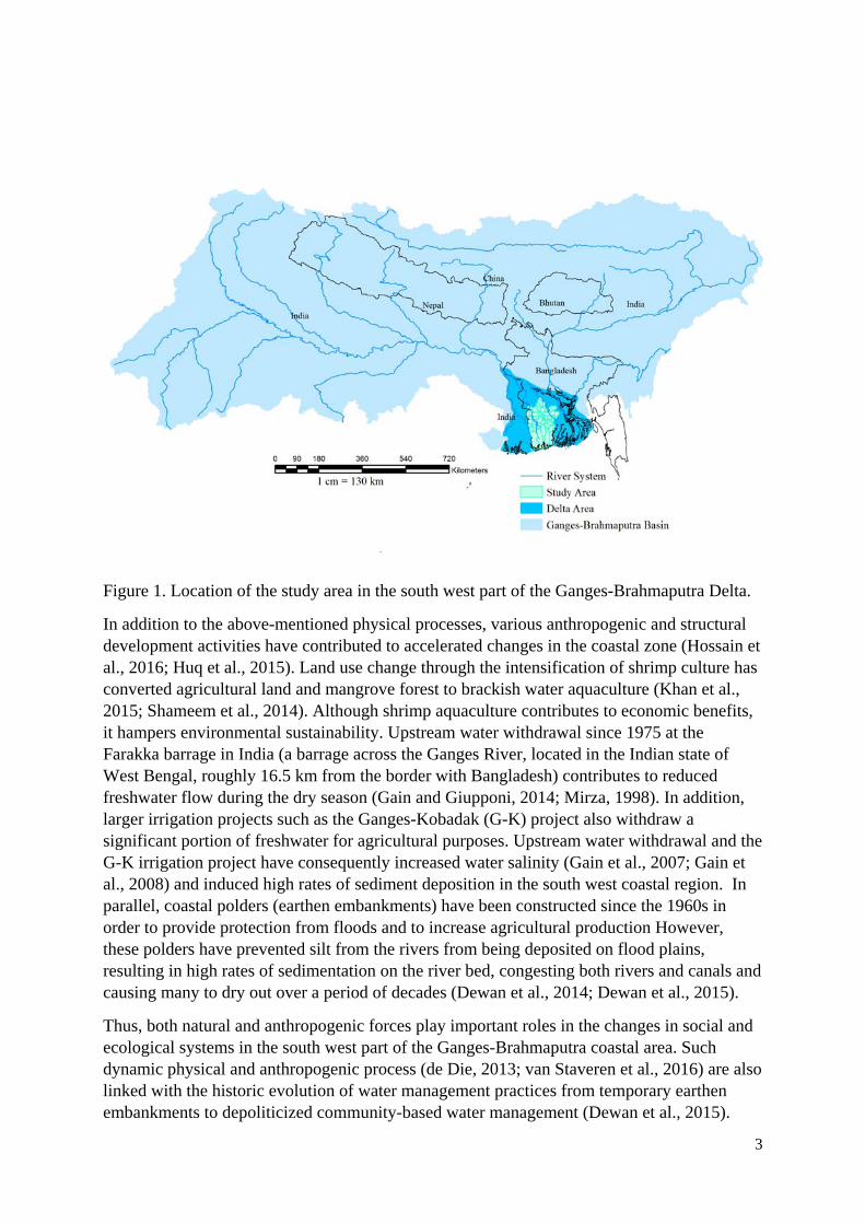
The Ganges–Brahmaputra river delta is the home of more than 170 million people within a vast and low-lying coastal plain (Auerbach et al., 2015a). The south west part of the delta (see Figure 1) in Bangladesh is comprised mainly of the Khulna, Jessore, Satkhira, and Bagerhat districts. The physical geography of the area is highly diverse and dynamic (Brammer, 2014). The history of the delta complex can be understood in terms of geological processes over 125 million years including the Gondwanaland break-up, collision of the Indian plate with the Burmese and Eurasian plate, development of the Himalayas and the evolution of the Ganges-Brahmaputra river system (Lindsay et al., 1991). The Ganges-Brahmaputra river system delivers sediment-laden water to the delta (Allison, 1998; Datta and Subramanian, 1997a) and carries the world’s highest annual sediment load (at least one billion tonnes per year). The delta is covered almost entirely by rich alluvial deposits from these rivers which are constantly shaped and reshaped through processes of river sedimentation and erosion (Datta and Subramanian, 1997b; Goodbred, 2003).
The delta faces multiple physical threats. The geological processes, crustal movements and compaction of the recent sediment have contributed to a broad regional land subsidence at a rate of 2-3 mm/year and more localised hotspots with higher subsidence (Brown and Nicholls, 2015; Nicholls et al., 2016). The eastward migration of the Ganges due to natural processes has also led to the effective cutting off of fluvial sediment and a major share of the freshwater flow in the south west coastal area (Allison et al., 2003; Hore et al., 2013). Considering future change, climate change induced sea level rise and cyclonic extreme events are also dominant physical features in the area. According to Delta Plan of Bangladesh (GoB, 2014), the sea level rise in Bangladesh will be slightly higher than the global average mean of 37 to 75 cm (Hinkel et al., 2014) by the year 2100. Considering global and regional climate scenarios, the baseline studies of Delta Plan also mention an increased projection of rainfall and temperature, with more intense events.
3
Figure 1. Location of the study area in the south west part of the Ganges-Brahmaputra Delta.
In addition to the above-mentioned physical processes, various anthropogenic and structural development activities have contributed to accelerated changes in the coastal zone (Hossain et al., 2016; Huq et al., 2015). Land use change through the intensification of shrimp culture has converted agricultural land and mangrove forest to brackish water aquaculture (Khan et al., 2015; Shameem et al., 2014). Although shrimp aquaculture contributes to economic benefits, it hampers environmental sustainability. Upstream water withdrawal since 1975 at the Farakka barrage in India (a barrage across the Ganges River, located in the Indian state of West Bengal, roughly 16.5 km from the border with Bangladesh) contributes to reduced freshwater flow during the dry season (Gain and Giupponi, 2014; Mirza, 1998). In addition, larger irrigation projects such as the Ganges-Kobadak (G-K) project also withdraw a significant portion of freshwater for agricultural purposes. Upstream water withdrawal and the G-K irrigation project have consequently increased water salinity (Gain et al., 2007; Gain et al., 2008) and induced high rates of sediment deposition in the south west coastal region. In parallel, coastal polders (earthen embankments) have been constructed since the 1960s in order to provide protection from floods and to increase agricultural production However, these polders have prevented silt from the rivers from being deposited on flood plains, resulting in high rates of sedimentation on the river bed, congesting both rivers and canals and causing many to dry out over a period of decades (Dewan et al., 2014; Dewan et al., 2015).
Thus, both natural and anthropogenic forces play important roles in the changes in social and ecological systems in the south west part of the Ganges-Brahmaputra coastal area. Such dynamic physical and anthropogenic process (de Die, 2013; van Staveren et al., 2016) are also linked with the historic evolution of water management practices from temporary earthen embankments to depoliticized community-based water management (Dewan et al., 2015).
4
Failure to recognise the complex behaviour of this system and complex inter-dynamics of physical and social processes has had negative implications for managing these vital resources. As a consequence, the south west coastal area is facing diverse problems such as salinity, waterlogging and loss of biodiversity with attendant negative impacts on the local economy and sustainability.
In order to address complex problems such as waterlogging, salinity, siltation of river beds and drainage congestion, tidal river management (TRM) has been considered as an effective approach for sustainably managing the south west coastal area of the Ganges-Brahmaputra Basin (Hossain et al., 2015; Nowreen et al., 2014; van Staveren et al., 2016). Tidal river management involves the periodic cutting and closing of polders to accelerate land accretion (or reclamation). From their own experience and observation, local people have presented their reasoned arguments to water managers for breaching or cutting away polders to allow tidal flows for solving the problems. The TRM approach is capable of elevating the flood plain area by 1-3 meters through natural siltation process within 3-5 years and hence, this can potentially solve permanent waterlogging in the floodplain and siltation of riverbeds (Jakarya et al., 2016; Khadim et al., 2013; Paul et al., 2013; Shampa and Pramanik, 2012; Tutu, 2005). Recently, several larger collaborative research projects (such as the Dynamic Deltas, see NWO (2011)) partly consider a TRM approach as an adaptation strategy.
TRM represents a departure from a sole focus on maximising agricultural development through engineered flood protection and land improvement to a more comprehensive approach that recognises the complex interplay of natural and anthropogenic forces and the importance of local knowledge and engagement. However, TRM implementation has proved to be challenging due to institutional limitations, mismanagement and social conflicts (Auerbach et al., 2015b; Rezaie et al., 2013) and has lacked interdisciplinary practice. Addressing waterlogging and flood risks, Auerbach et al. (2015a), for example, recommend a physical-based assessment of the impacts of polder construction on sediment deposition and distribution and suggest that systematically breaching embankment sections can facilitate sediment delivery and elevation recovery. Yet, such simple recommendations are based only on physical assessments and hence cannot realistically provide practical solutions without considering stakeholders’ attitudes. In contrast, Dewan et al. (2014); Dewan et al. (2015) consider public participation for resolving waterlogging issues but without undertaking scientific assessments of the problem.
It is evident that such complex approaches (such as TRM) cannot be understood by disciplinary scientific practices without taking into account an inter- and trans-disciplinary perspective. This paper argues that a transdisciplinary process is required for the successful implementation of a TRM approach and for achieving sustainability through reducing waterlogging, restoring navigability of the river, and increasing agricultural production. A transdisciplinary approach is useful when facts are contested, values in dispute, stakes high, and decisions urgent (Krueger et al., 2016). This study aims to evaluate and synthesise evidence of recently practised tidal river management in the Ganges-Brahmaputra Delta through the lens of a transdisciplinary research approach. Thus, this paper explores how a transdisciplinary approach can help integrate disciplinary paradigms and facilitate the integration of stakeholder and local community knowledge in TRM implementation.
It first discusses the history of the TRM approach, and illustrates it with three case studies of recently practised TRM in the Khulna and Jessore districts of the Ganges-Brahmaputra Delta.
5
It then presents the key features of a transdisciplinary approach, and evaluates how far it can inform better implementation of the three selected case studies. Finally, lessons for future TRM implementation are drawn. The research adopted a mixed method approach primarily involving a qualitative case study design that sought to elicit stakeholder perceptions on the causes of TRM implementation problems, factors determining success and potential policy solutions, using two workshops, stakeholder interviews and site visits, along with quantitative data on sediment deposition, river water levels and socio-economic indicators from secondary sources.
2. Evolution of the ‘tidal river management’ approach
From the 17th century to 1950, water resources in the south west coastal area were traditionally managed by Zamindars (landlords). They were responsible for the construction of temporary low earthen embankments around tidal flats during eight dry months of the year to prevent tidal intrusion and to protect their agricultural lands. During the monsoon season (after the harvest), the embankments were dismantled to open the periodically flooded land for cattle grazing and open fishing on the tidal floodplain (Nowreen et al., 2014). After the abolition of the Zamindary system in 1950 by the colonial power, the maintenance of these structures (embankments and sluice gates) became disrupted. As a result, land-water management problems became increasingly serious and crop failure occurred frequently (Dewan et al., 2015). In addition to the lack of an effective water management authority, there were disastrous floods in 1954, 1955 and 1956.
After these floods, the Krug Mission of the United Nations (Krug, 1957; Rashid and Rahman, 2010) recommended a national 20-year Water Master Plan, which was finalised by the International Engineering Company in 1964 (Pal et al., 2011). The Master Plan stimulated the construction of massive flood control structures and drainage improvements (Gain et al., 2017) to increase agricultural production in Bangladesh. As a result, the East Pakistan Water Development Authority (now called the Bangladesh Water Development Board, BWDB) was created in 1959 and it led the construction of around 4000 km of embankments through the Coastal Embankment Project (CEP). In the Khulna and part of the Jessore districts, 39 polders (comprising 410500 ha) were constructed as part of the CEP.
Through the CEP, single-crop areas were converted to two or even three crops per year. Hence, agricultural production significantly increased 2-3fold. The CEP area also achieved food security even when the whole country experienced a scarcity of food (Awal, 2014). However, due to the lack of operation and maintenance of polders, embankments and sluice gates, the negative impacts (e.g., prevention of silt deposition in the floodplain, resulting in high sedimentation in the rivers and canals) of the CEP began to appear (Rezaie et al., 2013; Tutu, 2005).
In addition, the freshwater supply from the Ganges has been significantly reduced within the Khulna-Jessore area, which affects river morphology and ecosystems. The main distributaries of that region were gradually detached from the Ganges due to the demise of the main connecting river, the Mathabhanga, through natural geologic processes (Awal, 2014). Due to the lack of adequate freshwater supply from upstream, some distributaries (e.g., Kobadak, Bhairab and Betna river) begun to lose their velocity, which eventually increased sediment deposition during ebb-tide. After construction of the Farakka dam in 1976, the drastic reduction of freshwater flows increased the siltation in the riverbed to the entire southern part of Bangladesh (Gain and Giupponi, 2014; Mirza, 1998). Freshwater withdrawal through
6
large-scale irrigation schemes (such as the Ganges-Kobadak Project) and other local human interventions (such as aquaculture practices) also contributed to siltation of river beds.
Siltation in the river bed by retardation of upstream river flow as well as deprivation of silt deposition in floodplains (known locally as beels - we use this term hereafter) due to embankment or polderisation has contributed to the disruption of river-floodplain connectivity and to changing regional hydro-morphology of the area. As a consequence, the area has become permanently water-logged. Soil may be regarded as waterlogged when it is nearly saturated with water such that its air phase is restricted and anaerobic conditions prevail (Hillel, 2004). Similar to Awal (2014), in this study an area is also regarded as waterlogged when the water level above the ground is too high and does not permit an anticipated activity, like agriculture.
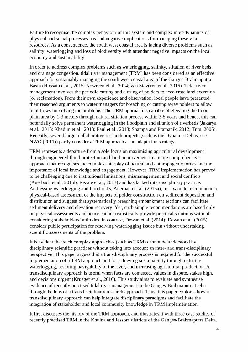
Waterlogging began to emerge in the polders fifteen years after the construction of the coastal embankments. In 1984, Beel Dakatia, part of one polder, became water-logged for the first time, due to siltation of the Solmari, Hamkura and Hari rivers. This problem then spread to more polders. By the 1980s and 1990s, coastal polder construction had led to waterlogging of an area of more than 100,000 ha in Khulna, Jessore and Satkhira districts (Awal, 2014). The distribution of major sub-districts of waterlogging locations is shown in Table 1. As a consequence of permanent waterlogging, the socio-economic conditions of the local people have been impaired and ecosystem services have been reduced through destruction of houses, disruption of communications, loss of biodiversity, loss of livestock, fuel poverty, drinking water scarcity, fecal contamination of water, water-borne diseases, deprivation of education (as many schools were closed) and migration (Hossain et al., 2016; Tutu, 2005).
Table 1. Distribution of waterlogging areas (in km2) in three districts of Bangladesh for 2013 (Jakarya et al., 2016)
Districts Sub-districts Total area (km2) Waterlogged area (km2)
Percent of total affected areas
Khulna Fultala 57 27 46.83
Dumuria 454 197 43.37
Koyra 1775 143 8.06
Paikgachha 411 162 39.55
Abhaynagar 247 61 24.68
Jessore Keshabpur 259 61 23.43
Manirampur 445 63 14.22
Satkhira Assasuni 402 145 36.13
Debhata 176 117 66.64
Kalaroa 233 24 10.29
Kaliganj 334 233 69.63
Satkhira Sadar 801 177 22.12
Tala 344 125 36.26
Shyamnagar 1988 244 12.42
Total 7906 1780 23
7
Reflecting back on the experience of traditional water management practices by Zamindars, local people identified the earthen embankment or polders as the main cause of waterlogging along with reduced freshwater supply from upstream. According to their intuition, if tidal flows could be restored in the floodplain through breaching or cutting away polders, the water stored in these tidal basins could push its way through the narrow rivers with increased flow velocity, thereby causing erosion of the riverbed and increasing the size of the rivers. Thus, the navigability of the rivers could be restored and the enclosed lands would rise through the accumulation of alluvium.
The process of temporarily inundating floodplains in order to prevent drainage congestion is termed ‘Tidal River Management (TRM)’. The TRM operation involves: (i) restoring tidal flooding (twice-daily) by means of temporary and partial removal of embankments (or polders); (ii) scouring the adjacent river bed; and (iii) depositing sediments within the beels (van Staveren et al., 2016). Local people initially organised themselves through forming a committee, known as a Paani Committee (PC). The PC was a citizen-driven initiative and its formation was facilitated by a local organisation based in Tala, Satkhira (Fakir, 2008). The PC took up the TRM as its main agenda throughout the south west region (Haque et al., 2015; Kibria, 2011). Local people within the umbrella of the PC first demonstrated their intuition in September 1990 through making four breaches in the ‘Beel Dakatia’ polder. After this local initiative, the Beel Dakatia was again connected with the river Hamkura. Within two years, from 1990–1992, 1050 ha of land were made free from permanent waterlogging (Tutu, 2005). Success in the draining of water from the Beel Dakatia through the TRM approach encouraged people from adjacent waterlogged areas to undertake similar actions.
The emphasis of the TRM approach has changed over time. Initially, the focus was on providing a solution for waterlogging problems and a means to overcome vested institutional power relations. However, these rationales have now been complemented by representations of TRM as a climate change adaptation measure, eco-engineering innovation and ecosystem valuation instrument (Kibria, 2011; Rahman and Salehin, 2013).Yet, the TRM approach has also been accompanied with conflicts among stakeholders. Although TRM is often viewed as a community-driven intervention based on unequivocal consensus, some communities rejected the cutting of embankments and favoured embankment construction and increased flood prevention (van Staveren et al., 2016) to avoid inundation induced short-term losses on agricultural production and aquaculture practices.
After the successful operation of local initiatives in the ‘Dakatia Beel’, the TRM approach has been implemented in several other locations. Some of these projects were successful in meeting their objectives. However, some projects were unsuccessful or only partially effective. The next section illustrates the challenges of implementing TRM through three contrasting case studies drawn from the Khulna-Jessore-Satkhira districts.
3. Three recent ‘tidal river management’ projects
In the study area (Khulna-Jessore-Satkhira districts), TRM is operated in only 12 out of 35 beels. Initially, local people implemented TRM in some beels and afterwards government agencies (e.g., BWDB) implemented TRM. In this study, three beels were selected for detailed investigation: one being led by a local community and the other two by national authorities (one of which is currently being implemented). They were selected to present varying leadership approaches to TRM as a basis for learning. The ongoing TRM operation in
8
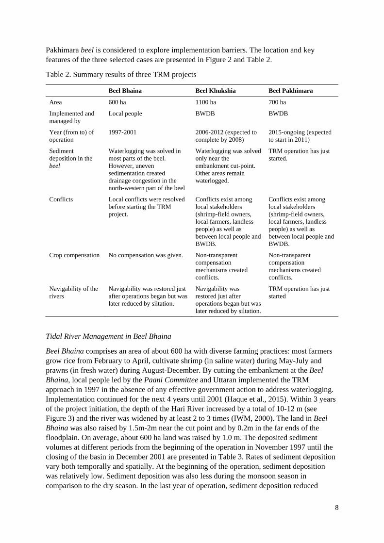
Pakhimara beel is considered to explore implementation barriers. The location and key features of the three selected cases are presented in Figure 2 and Table 2.
Table 2. Summary results of three TRM projects
Beel Bhaina Beel Khukshia Beel Pakhimara
Area 600 ha 1100 ha 700 ha
Implemented and managed by
Local people BWDB BWDB
Year (from to) of operation
1997-2001 2006-2012 (expected to complete by 2008)
2015-ongoing (expected to start in 2011)
Sediment deposition in the beel
Waterlogging was solved in most parts of the beel. However, uneven sedimentation created drainage congestion in the north-western part of the beel
Waterlogging was solved only near the embankment cut-point. Other areas remain waterlogged.
TRM operation has just started.
Conflicts Local conflicts were resolved before starting the TRM project.
Conflicts exist among local stakeholders (shrimp-field owners, local farmers, landless people) as well as between local people and BWDB.
Conflicts exist among local stakeholders (shrimp-field owners, local farmers, landless people) as well as between local people and BWDB.
Crop compensation No compensation was given. Non-transparent compensation mechanisms created conflicts.
Non-transparent compensation mechanisms created conflicts.
Navigability of the rivers
Navigability was restored just after operations began but was later reduced by siltation.
Navigability was restored just after operations began but was later reduced by siltation.
TRM operation has just started
Tidal River Management in Beel Bhaina
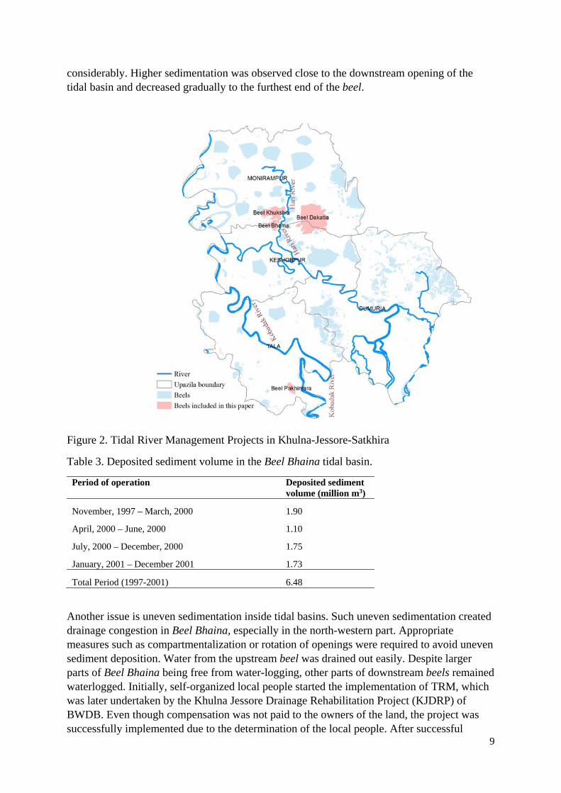
Beel Bhaina comprises an area of about 600 ha with diverse farming practices: most farmers grow rice from February to April, cultivate shrimp (in saline water) during May-July and prawns (in fresh water) during August-December. By cutting the embankment at the Beel Bhaina, local people led by the Paani Committee and Uttaran implemented the TRM approach in 1997 in the absence of any effective government action to address waterlogging. Implementation continued for the next 4 years until 2001 (Haque et al., 2015). Within 3 years of the project initiation, the depth of the Hari River increased by a total of 10-12 m (see Figure 3) and the river was widened by at least 2 to 3 times (IWM, 2000). The land in Beel Bhaina was also raised by 1.5m-2m near the cut point and by 0.2m in the far ends of the floodplain. On average, about 600 ha land was raised by 1.0 m. The deposited sediment volumes at different periods from the beginning of the operation in November 1997 until the closing of the basin in December 2001 are presented in Table 3. Rates of sediment deposition vary both temporally and spatially. At the beginning of the operation, sediment deposition was relatively low. Sediment deposition was also less during the monsoon season in comparison to the dry season. In the last year of operation, sediment deposition reduced
9
considerably. Higher sedimentation was observed close to the downstream opening of the tidal basin and decreased gradually to the furthest end of the beel.
Figure 2. Tidal River Management Projects in Khulna-Jessore-Satkhira
Table 3. Deposited sediment volume in the Beel Bhaina tidal basin.
Period of operation Deposited sediment volume (million m3)
November, 1997 – March, 2000 1.90
April, 2000 – June, 2000 1.10
July, 2000 – December, 2000 1.75
January, 2001 – December 2001 1.73
Total Period (1997-2001) 6.48
Another issue is uneven sedimentation inside tidal basins. Such uneven sedimentation created drainage congestion in Beel Bhaina, especially in the north-western part. Appropriate measures such as compartmentalization or rotation of openings were required to avoid uneven sediment deposition. Water from the upstream beel was drained out easily. Despite larger parts of Beel Bhaina being free from water-logging, other parts of downstream beels remained waterlogged. Initially, self-organized local people started the implementation of TRM, which was later undertaken by the Khulna Jessore Drainage Rehabilitation Project (KJDRP) of BWDB. Even though compensation was not paid to the owners of the land, the project was successfully implemented due to the determination of the local people. After successful
10
implementation, the Asian Development Bank (ADB), BWDB and several other agencies admitted that TRM was a better strategy for mitigating waterlogging than previously implemented engineering solutions. These agencies also realised that TRM could help raise the land through sedimentation which then increases the quality of the soil and overall agricultural productivity.
A recent field visit in 2016 shows that regular agricultural practices have been carried out in part of Beel Bhaina (where sedimentation took place), while there is still waterlogging in north-western section of the beel. However, the river again started to silt-up and after recent rainfall-induced flooding (August 2016), the water logging issue became severe in the area.
Figure 3. The depth of the Hari river near embankment cut point at Beel Bhaina before (August 1996) and after (March 2000) TRM implementation (data source: IWM).
Tidal River Management in Beel Khukshia
The size of the (East) Beel Khukshia is about 1100 ha, which is relatively larger than Beel Bhaina. Compared to local initiatives in Beel Dakatia and Beel Bhaina, TRM was implemented in Beel Khukshia much later by BWDB, in April, 2006. Before the implementation of TRM, BWDB agreed to pay compensation to farmers for their agricultural land during the project period. For this purpose, BWDB allocated 33.4 million BDT. Although there were more than five thousands farmers, BWDB enlisted only 1082. From this list, BWDB compensated only 446 farmers with a total amount of around 18.5 million BDT. BWDB committed to compensate other farmers at later stages, which was not done. Thus, the compensation process of BWDB was not transparent and local people consequently became unhappy. Due to payment delays, unfair compensation, and the untimely construction of a peripheral embankment, conflicts also arose among different users groups. Shrimp farmers, who did not want to lose their leased land under any circumstances, were also against TRM. Some landless people, who lost their day jobs cultivating the land, also did not support TRM. Thus, some local community members, especially the land owners and influential villagers opposed TRM due to the loss of their lucrative shrimp businesses and lack of government compensation. As a consequence, TRM operation continued for only seven years in Beel Khukshia. Without any economic return from their lands for such a long period, the
-11
-9
-7
-5
-3
-1
1
3
5
7
0 10 20 30 40 50 60 70 80
Distance(m)
Le
vel(
m,P
WD
)
August, 1996
March, 2000
11
management approach created a negative impression amongst farmers. A breaching point in the polder was selected by BWDB without considering local stakeholder opinions.
TRM in Beel Khukshia was mainly unsuccessful as waterlogging problems were not solved. Results were mixed compared to earlier examples. There are many fishing infrastructures (shrimp fields) in the basin that created obstructions to uniform spreading of incoming silt over the basin area. Nonetheless, about 0.9 million m3 siltation took place in the tidal basin during the first 5-month operation of the basin. It is apparent that deposition occurred mostly near the downstream area (nearest to the cut point) of the basin. People could then practice both agriculture and aquaculture near the embankment cut point due to this increased sedimentation. The land of Beel Khukshia was additionally raised by around 1.5-2 m near the cut point and by 0.5 meters towards the far end of the floodplain. The depth of the river also increased by 10-11 m near to the cut point.
Tidal River Management in Beel Pakhimara
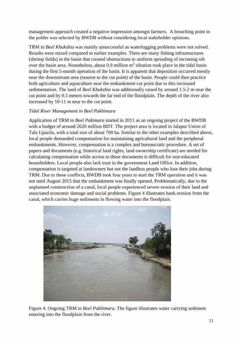
Application of TRM in Beel Pakimara started in 2011 as an ongoing project of the BWDB with a budget of around 2620 million BDT. The project area is located in Jalapur Union of Tala Upazila, with a total size of about 700 ha. Similar to the other examples described above, local people demanded compensation for maintaining agricultural land and the peripheral embankments. However, compensation is a complex and bureaucratic procedure. A set of papers and documents (e.g. historical land rights, land ownership certificate) are needed for calculating compensation while access to these documents is difficult for non-educated householders. Local people also lack trust in the government Land Office. In addition, compensation is targeted at landowners but not the landless people who lose their jobs during TRM. Due to these conflicts, BWDB took four years to start the TRM operation and it was not until August 2015 that the embankment was finally opened. Problematically, due to the unplanned construction of a canal, local people experienced severe erosion of their land and associated economic damage and social problems. Figure 4 illustrates bank erosion from the canal, which carries huge sediments in flowing water into the floodplain.
Figure 4. Ongoing TRM in Beel Pakhimara. The figure illustrates water carrying sediment entering into the floodplain from the river.
12
4. The successes and challenges of ‘tidal river management’
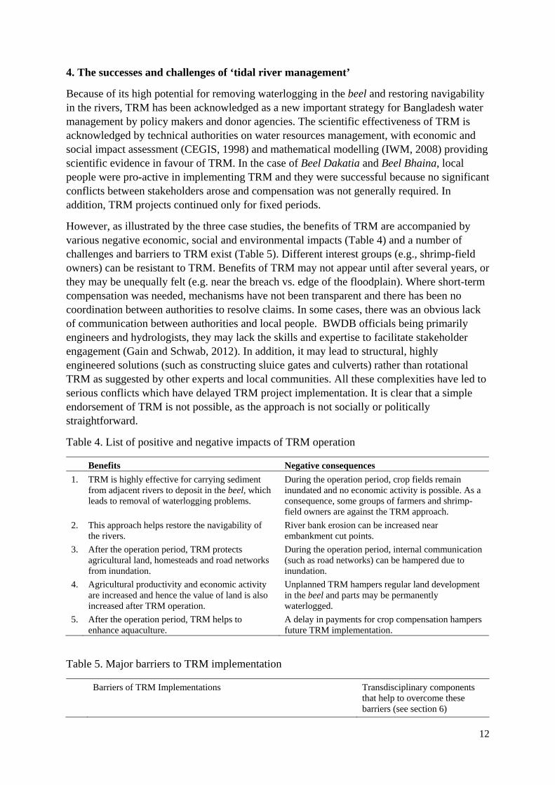
Because of its high potential for removing waterlogging in the beel and restoring navigability in the rivers, TRM has been acknowledged as a new important strategy for Bangladesh water management by policy makers and donor agencies. The scientific effectiveness of TRM is acknowledged by technical authorities on water resources management, with economic and social impact assessment (CEGIS, 1998) and mathematical modelling (IWM, 2008) providing scientific evidence in favour of TRM. In the case of Beel Dakatia and Beel Bhaina, local people were pro-active in implementing TRM and they were successful because no significant conflicts between stakeholders arose and compensation was not generally required. In addition, TRM projects continued only for fixed periods.
However, as illustrated by the three case studies, the benefits of TRM are accompanied by various negative economic, social and environmental impacts (Table 4) and a number of challenges and barriers to TRM exist (Table 5). Different interest groups (e.g., shrimp-field owners) can be resistant to TRM. Benefits of TRM may not appear until after several years, or they may be unequally felt (e.g. near the breach vs. edge of the floodplain). Where short-term compensation was needed, mechanisms have not been transparent and there has been no coordination between authorities to resolve claims. In some cases, there was an obvious lack of communication between authorities and local people. BWDB officials being primarily engineers and hydrologists, they may lack the skills and expertise to facilitate stakeholder engagement (Gain and Schwab, 2012). In addition, it may lead to structural, highly engineered solutions (such as constructing sluice gates and culverts) rather than rotational TRM as suggested by other experts and local communities. All these complexities have led to serious conflicts which have delayed TRM project implementation. It is clear that a simple endorsement of TRM is not possible, as the approach is not socially or politically straightforward.
Table 4. List of positive and negative impacts of TRM operation
Benefits Negative consequences
1. TRM is highly effective for carrying sediment from adjacent rivers to deposit in the beel, which leads to removal of waterlogging problems.
During the operation period, crop fields remain inundated and no economic activity is possible. As a consequence, some groups of farmers and shrimp-field owners are against the TRM approach.
2. This approach helps restore the navigability of the rivers.
River bank erosion can be increased near embankment cut points.
3. After the operation period, TRM protects agricultural land, homesteads and road networks from inundation.
During the operation period, internal communication (such as road networks) can be hampered due to inundation.
4. Agricultural productivity and economic activity are increased and hence the value of land is also increased after TRM operation.
Unplanned TRM hampers regular land development in the beel and parts may be permanently waterlogged.
5. After the operation period, TRM helps to enhance aquaculture.
A delay in payments for crop compensation hampers future TRM implementation.
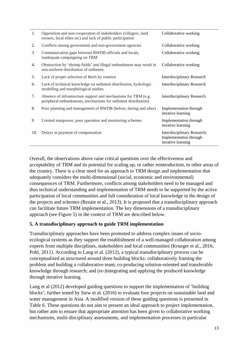
Table 5. Major barriers to TRM implementation
Barriers of TRM Implementations Transdisciplinary components that help to overcome these barriers (see section 6)
13
1. Opposition and non-cooperation of stakeholders (villagers, land owners, local elites etc) and lack of public participation
Collaborative working
2. Conflicts among government and non-government agencies Collaborative working
3 Communication gaps between BWDB officials and locals, inadequate campaigning on TRM
Collaborative working
4. Obstruction by ‘shrimp fields’ and illegal embankment may result in non-uniform distribution of sediment.
Collaborative working
5. Lack of proper selection of Beels by rotation Interdisciplinary Research
6. Lack of technical knowledge on sediment distribution, hydrologic modelling and morphological studies
Interdisciplinary Research
7. Absence of infrastructure support and mechanisms for TRM (e.g. peripheral embankments, mechanisms for sediment distribution)
Interdisciplinary Research
8. Poor planning and management of BWDB (before, during and after) Implementation through iterative learning
9 Limited manpower, poor operation and monitoring schemes Implementation through iterative learning
10. Delays in payment of compensation Interdisciplinary Research; Implementation through iterative learning
Overall, the observations above raise critical questions over the effectiveness and acceptability of TRM and its potential for scaling up, or rather reintroduction, to other areas of the country. There is a clear need for an approach to TRM design and implementation that adequately considers the multi-dimensional (social, economic and environmental) consequences of TRM. Furthermore, conflicts among stakeholders need to be managed and thus technical understanding and implementation of TRM needs to be supported by the active participation of local communities and full consideration of local knowledge in the design of the projects and schemes (Rezaie et al., 2013). It is proposed that a transdisciplinary approach can facilitate future TRM implementation. The key dimensions of a transdisciplinary approach (see Figure 5) in the context of TRM are described below.
5. A transdisciplinary approach to guide TRM implementation
Transdisciplinary approaches have been promoted to address complex issues of socio-ecological systems as they support the establishment of a well-managed collaboration among experts from multiple disciplines, stakeholders and local communities (Krueger et al., 2016; Pohl, 2011). According to Lang et al. (2012), a typical transdisciplinary process can be conceptualised as structured around three building blocks: collaboratively framing the problem and building a collaborative team; co-producing solution-oriented and transferable knowledge through research; and (re-)integrating and applying the produced knowledge through iterative learning.
Lang et al (2012) developed guiding questions to support the implementation of ’building blocks’; further tested by Siew et al. (2016) to evaluate four projects on sustainable land and water management in Asia. A modified version of these guiding questions is presented in Table 6. These questions do not aim to present an ideal approach to project implementation, but rather aim to ensure that appropriate attention has been given to collaborative working mechanisms, multi-disciplinary assessments, and implementation processes in particular
14
iterative learning. It is argued that appropriately considering these aspects in project implementation and adapting to the local context can support successful project completion and the development of more sustainable solutions. The next section evaluates how far the transdisciplinary approach can better inform TRM implementation, using the three selected case studies to illustrate its potential.
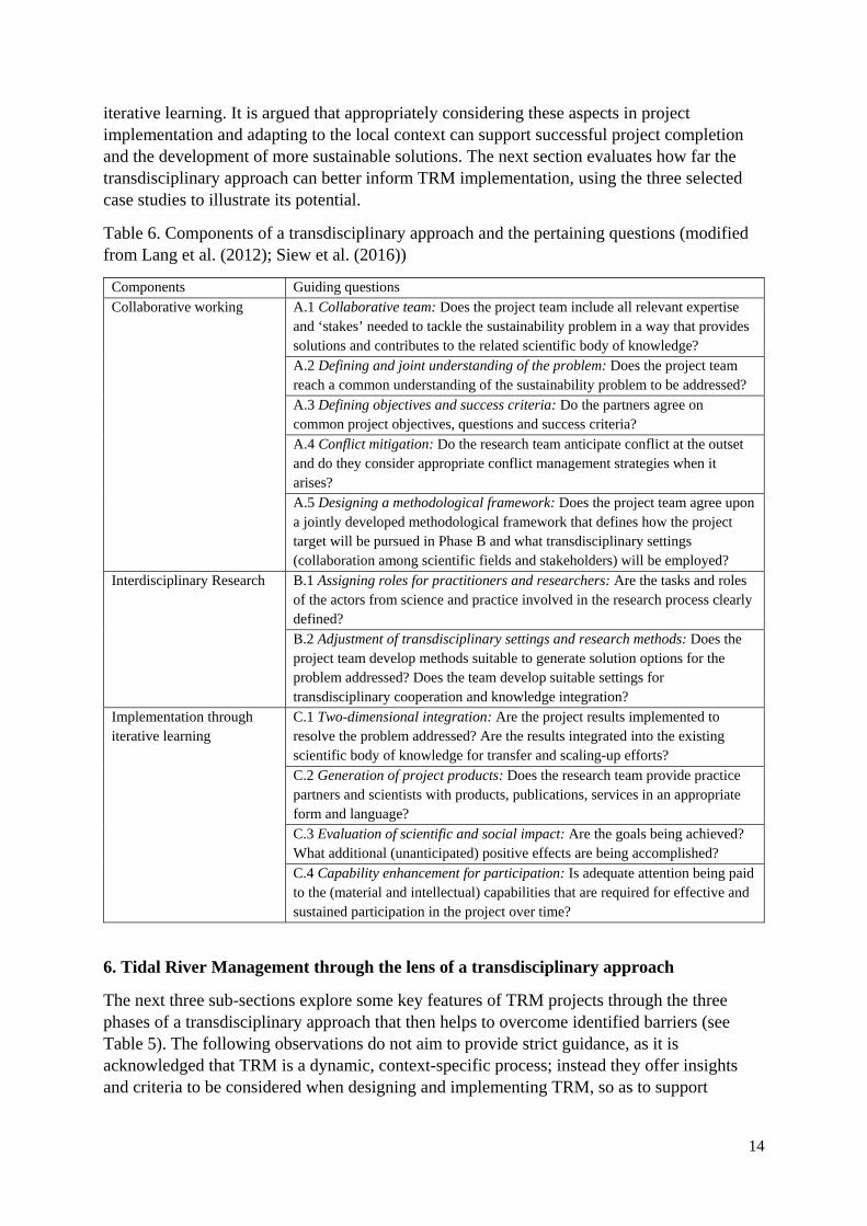
Table 6. Components of a transdisciplinary approach and the pertaining questions (modified from Lang et al. (2012); Siew et al. (2016))
Components Guiding questions Collaborative working
A.1 Collaborative team: Does the project team include all relevant expertise and ‘stakes’ needed to tackle the sustainability problem in a way that provides solutions and contributes to the related scientific body of knowledge? A.2 Defining and joint understanding of the problem: Does the project team reach a common understanding of the sustainability problem to be addressed? A.3 Defining objectives and success criteria: Do the partners agree on common project objectives, questions and success criteria? A.4 Conflict mitigation: Do the research team anticipate conflict at the outset and do they consider appropriate conflict management strategies when it arises? A.5 Designing a methodological framework: Does the project team agree upon a jointly developed methodological framework that defines how the project target will be pursued in Phase B and what transdisciplinary settings (collaboration among scientific fields and stakeholders) will be employed?
Interdisciplinary Research B.1 Assigning roles for practitioners and researchers: Are the tasks and roles of the actors from science and practice involved in the research process clearly defined? B.2 Adjustment of transdisciplinary settings and research methods: Does the project team develop methods suitable to generate solution options for the problem addressed? Does the team develop suitable settings for transdisciplinary cooperation and knowledge integration?
Implementation through iterative learning
C.1 Two-dimensional integration: Are the project results implemented to resolve the problem addressed? Are the results integrated into the existing scientific body of knowledge for transfer and scaling-up efforts? C.2 Generation of project products: Does the research team provide practice partners and scientists with products, publications, services in an appropriate form and language? C.3 Evaluation of scientific and social impact: Are the goals being achieved? What additional (unanticipated) positive effects are being accomplished? C.4 Capability enhancement for participation: Is adequate attention being paid to the (material and intellectual) capabilities that are required for effective and sustained participation in the project over time?
6. Tidal River Management through the lens of a transdisciplinary approach
The next three sub-sections explore some key features of TRM projects through the three phases of a transdisciplinary approach that then helps to overcome identified barriers (see Table 5). The following observations do not aim to provide strict guidance, as it is acknowledged that TRM is a dynamic, context-specific process; instead they offer insights and criteria to be considered when designing and implementing TRM, so as to support
15
adequate consideration of the multiple benefits and impacts of TRM projects, and the need to consider and incorporate local communities’ views, understandings and priorities.
Collaborative working
One of the main problems of TRM implementation is the lack of communication between local stakeholders and BWDB. The tides in the river need free access twice a day and the TRM must not be used for any other purpose while the landowners must set aside their land for the duration of basin preparation. Intensive consultations and a clear agreement from the concerned communities and affected landowners are also preconditions for the selection of a wetland. To address complex waterlogging issues, comprehensive understanding is therefore required of hydrology, geology, environmental science, social science and economics along with local knowledge. The BWDB cannot solve such complex problems alone. Therefore, building a comprehensive collaborative team is crucial for successful implementation of the project. In addition, existing land use conflicts (e.g., between shrimp-field owners and crop farmers) and their conflict resolution mechanisms are necessary pre-conditions in developing a collaborative team. The project team should consider including local people plus stakeholders such as local governments, members of the pannee committee, plus relevant agencies who have the necessary expertise (e.g., mathematical modelling for planning and designing of TRM, economic and social impact assessment, morphological and socio-economic studies). Involvement of local organisations can also support conflict resolution among stakeholders and among agencies.
Once a collaborative team is formed, a common understanding of the complex problems needs to be defined, with the active involvement of team members. Complex waterlogging issues create both eco-hydrological (such as drainage congestion in the beel, siltation of river beds and salinity), social and economic problems (such as loss of agriculture and fishery income, loss of biodiversity, loss of livelihood, loss of primary education). These problems are interlinked with each other and a joint understanding can help address them. Then, the project team needs to define and agree on common project objectives and success criteria. The general objectives for a TRM project are to solve waterlogging problems from the beel and to restore navigability in the nearby river. The general social objective is to increase economic activities (e.g., agricultural production, inland fisheries), livelihood opportunities and food securities in the project areas. The social objectives vary from beel to beel (e.g., to increase rice production, rice and inland fisheries production together, or expand saline water shrimp culture).
The success criteria employed can be the depth and width of rivers, the amount of deposited sediment in the beel, duration of TRM operations (3-5 years depending on the size of the beels), the optimum area of raised land that can be used for agriculture, conflict-resolution, and soil ferility. After setting objectives and success criteria, the project team then needs to design a methodological framework that defines how the project target will be pursued in the interdisciplinary research phase.
Interdisciplinary Research
Comprehensive research with the active involvement of the transdisciplinary project team can help build the evidence and information necessary to support the design of TRM projects. As TRM projects need to be implemented in several beels, practical issues need to be investigated beforehand, such as technical knowledge about discharge and potential sediment
16
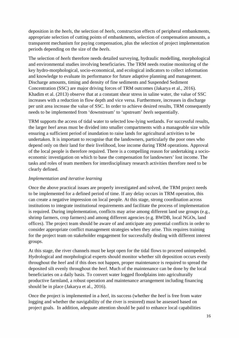
deposition in the beels, the selection of beels, construction effects of peripheral embankments, appropriate selection of cutting points of embankments, selection of compensation amounts, a transparent mechanism for paying compensation, plus the selection of project implementation periods depending on the size of the beels.
The selection of beels therefore needs detailed surveying, hydraulic modelling, morphological and environmental studies involving beneficiaries. The TRM needs routine monitoring of the key hydro-morphological, socio-economical, and ecological indicators to collect information and knowledge to evaluate its performance for future adaptive planning and management. Discharge amounts, timing and density of fine sediments and Suspended Sediment Concentration (SSC) are major driving forces of TRM outcomes (Jakarya et al., 2016). Khadim et al. (2013) observe that at a constant shear stress in saline water, the value of SSC increases with a reduction in flow depth and vice versa. Furthermore, increases in discharge per unit area increase the value of SSC. In order to achieve desired results, TRM consequently needs to be implemented from ‘downstream’ to ‘upstream’ beels sequentially.
TRM supports the access of tidal water to selected low-lying wetlands. For successful results, the larger beel areas must be divided into smaller compartments with a manageable size while ensuring a sufficient period of inundation to raise lands for agricultural activities to be undertaken. It is important to recognise that the landowners, particularly the poor ones who depend only on their land for their livelihood, lose income during TRM operations. Approval of the local people is therefore required. There is a compelling reason for undertaking a socio-economic investigation on which to base the compensation for landowners’ lost income. The tasks and roles of team members for interdisciplinary research activities therefore need to be clearly defined.
Implementation and iterative learning
Once the above practical issues are properly investigated and solved, the TRM project needs to be implemented for a defined period of time. If any delay occurs in TRM operation, this can create a negative impression on local people. At this stage, strong coordination across institutions to integrate institutional requirements and facilitate the process of implementation is required. During implementation, conflicts may arise among different land use groups (e.g., shrimp farmers, crop farmers) and among different agencies (e.g. BWDB, local NGOs, land offices). The project team should be aware of and anticipate any potential conflicts in order to consider appropriate conflict management strategies when they arise. This requires training for the project team on stakeholder engagement for successfully dealing with different interest groups.
At this stage, the river channels must be kept open for the tidal flows to proceed unimpeded. Hydrological and morphological experts should monitor whether silt deposition occurs evenly throughout the beel and if this does not happen, proper maintenance is required to spread the deposited silt evenly throughout the beel. Much of the maintenance can be done by the local beneficiaries on a daily basis. To convert water logged floodplains into agriculturally productive farmland, a robust operation and maintenance arrangement including financing should be in place (Jakarya et al., 2016).
Once the project is implemented in a beel, its success (whether the beel is free from water logging and whether the navigability of the river is restored) must be assessed based on project goals. In addition, adequate attention should be paid to enhance local capabilities
17
required for continuous monitoring of progress of TRM projects through effective participation of the transdisciplinary team over time. A fundamental requirement of TRM operation is the evaluation of project performance and preparation of reports for the stakeholders, thereby supporting trust and transparency in the project implementation.
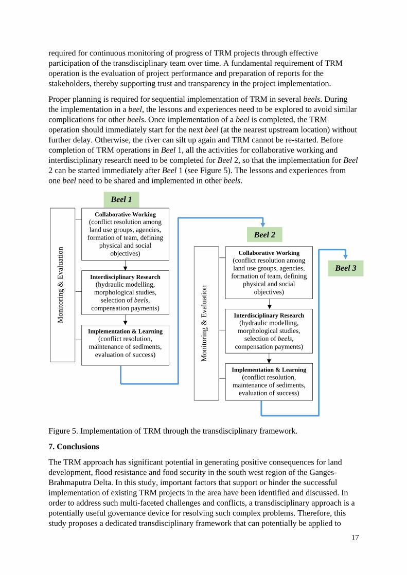
Proper planning is required for sequential implementation of TRM in several beels. During the implementation in a beel, the lessons and experiences need to be explored to avoid similar complications for other beels. Once implementation of a beel is completed, the TRM operation should immediately start for the next beel (at the nearest upstream location) without further delay. Otherwise, the river can silt up again and TRM cannot be re-started. Before completion of TRM operations in Beel 1, all the activities for collaborative working and interdisciplinary research need to be completed for Beel 2, so that the implementation for Beel 2 can be started immediately after Beel 1 (see Figure 5). The lessons and experiences from one beel need to be shared and implemented in other beels.
Figure 5. Implementation of TRM through the transdisciplinary framework.
7. Conclusions
The TRM approach has significant potential in generating positive consequences for land development, flood resistance and food security in the south west region of the Ganges-Brahmaputra Delta. In this study, important factors that support or hinder the successful implementation of existing TRM projects in the area have been identified and discussed. In order to address such multi-faceted challenges and conflicts, a transdisciplinary approach is a potentially useful governance device for resolving such complex problems. Therefore, this study proposes a dedicated transdisciplinary framework that can potentially be applied to
Beel 3
Beel 1
Collaborative Working (conflict resolution among land use groups, agencies,
formation of team, defining physical and social
objectives)
Interdisciplinary Research (hydraulic modelling, morphological studies,
selection of beels, compensation payments)
Mon
itor
ing
& E
valu
atio
n
Implementation & Learning (conflict resolution,
maintenance of sediments, evaluation of success)
Beel 2
Collaborative Working (conflict resolution among land use groups, agencies,
formation of team, defining physical and social
objectives)
Mon
itor
ing
& E
valu
atio
n
Interdisciplinary Research (hydraulic modelling, morphological studies,
selection of beels, compensation payments)
Implementation & Learning (conflict resolution,
maintenance of sediments, evaluation of success)
18
other TRM projects for resolving waterlogging and associated problems, in order to achieve greater sustainability.
Within this framework, collaborative working, interdisciplinary research and iterative learning during implementation are the key ‘building blocks’ to overcome the barriers of TRM implementation. Specifically, with collaborative working, the application of the transdisciplinary framework should resolve local land use conflicts, plus ensure the engagement of local stakeholders, relevant agencies and experts, which can thereby enhance coordination and cooperation. Multiple physical and socio-economic problems, including waterlogging and loss of agricultural production, are the major concerns in the study area. Joint understanding of these problems through the involvement of a multidisciplinary research team and local stakeholders can, critically, help identify major issues to be addressed and enhance smooth implementation of TRM projects.
With interdisciplinary research, the main activities such as the proper selection of beels (downstream to upstream), hydrological and morphological studies on sediment distribution in the beels, and socio-economic and institutional investigation of compensation mechanisms should ensure appropriate options for successful operation of TRM. During the implementation phase, proper maintenance and even distribution of sediment throughout the beels can solve waterlogging problems and can restore navigability of the rivers.
For a permanent solution to waterlogging problems in the entire south west part (Khulna, Jessore, Satkhira) of the Ganges-Brahmaputra Delta, TRM must be implemented in feasible sites. Auerbach et al. (2015b) state that suitable TRM sites should lie more than 50 km inland of the Sundarban (mangrove forests in Bangladesh) regions. Highly saline zones are unsuitable for TRM sites as sandy and saline sediment precludes agriculture. In the south west Ganges-Brahmaputra Delta, there are more than 35 suitable beels for TRM operation, which comprises an area of about 15,000 ha (Amir, 2010).
In all these beels, the key dimensions of the transdisciplinary framework can be applied to inform successful implementation of TRM projects. As after certain years of TRM operation, the river can be silted-up and the beels can be water-logged again, a medium and longer term strategy are therefore required to implement TRM in all these beels sequentially, with a duration of 3-5 years (depending on the size of the beel) operation in each beel. Bangladesh has formulated a longer term strategy (up to 2100) of Delta Development (GoB, 2014), in which the TRM approach is acknowledged for solving waterlogging problems (van Staveren et al., 2016). For a positive outcome, the TRM approach needs to be integrated with the proposed transdisciplinary framework in the Delta Plan. A transdisciplinary approach may also play a significant role in identifying planned adaptation measures within the context of TRM implementation. The framework could then be adopted within existing government policies and other regulatory mechanisms but may require further development to facilitate climate adaptation mainstreaming.
Application of TRM through a transdisciplinary framework can potentially be helpful in other developing and developed countries. For example, river widening and de-poldering have taken place at various locations in the Netherlands and to some extent, this could help restore flood dynamics in widened floodplains (van Staveren and van Tatenhove, 2016). Temporarily restoring flood dynamics and capturing sediments in polders to increase land height were also practiced in other world deltas, such as parts of the Westerschelde located in Belgium (Cox et al., 2006; Maris et al., 2007) and the Sacramento-San Joaquin in the United States (Bates and
19
Lund, 2013). Cox et al. (2006) found that flood dynamics as an opportunity to restore estuarine habitat which has important implications for nature and vegetation development. Bates and Lund (2013) state that under some circumstances flood dynamics can restore 1- to 2-m subsidized land elevation.
Further research is needed to identify the success and hindrance factors of TRM projects, and to further test through field validation the transdisciplinary framework as an enabling approach to TRM projects. Such research could also examine how to integrate a transdisciplinary approach to operational water resources management and planning, in particular with regards to institutional and technical capacity and the efficient management of collaborative and participatory approaches with technical authorities. Yet, this research provides some guidance to water managers and researchers as to how TRM projects can potentially address management issues and achieve greater long-term sustainability.
Acknowledgement
All authors would like to acknowledge the Leverhulme Trust (Project number IN-2014-014) for funding collaborative international network on IWRM. AK Gain is financially supported by the Alexander von Humboldt Foundation whose support is gratefully acknowledged. The authors also acknowledge Md. Ruhul Amin, Md. Hasan Ali and Kazi Rifat Ahmed for the GIS data. All authors equally contributed to the manuscript: A.K. Gain designed the research approach; D. Benson developed and described the transdisciplinary framework; D.K. Datta and R. Rahman researched the case studies; J. Rouillard contributed to the collection of data and preparation of the manuscript.
References
Allison, M.A. (1998) Geologic Framework and Environmental Status of the Ganges‐Brahmaputra Delta. Journal of Coastal Research 14, 827‐836. Allison, M.A., Khan, S.R., Goodbred Jr, S.L., Kuehl, S.A. (2003) Stratigraphic evolution of the late Holocene Ganges–Brahmaputra lower delta plain. Sedimentary Geology 155, 317‐342. Amir, M.S.I.I., (2010) Socio‐technical assessment of sediment management options in tidal basins in southwestern Bangladesh, Institute of Water and Flood Management. Bangladesh University of Engineering and Technology, Dhaka, Bangladesh. Auerbach, L.W., Goodbred Jr, S.L., Mondal, D.R., Wilson, C.A., Ahmed, K.R., Roy, K., Steckler, M.S., Small, C., Gilligan, J.M., Ackerly, B.A. (2015a) Flood risk of natural and embanked landscapes on the Ganges–Brahmaputra tidal delta plain. Nature Climate Change 5, 153‐157. Auerbach, L.W., Goodbred Jr, S.L., Mondal, D.R., Wilson, C.A., Ahmed, K.R., Roy, K., Steckler, M.S., Small, C., Gilligan, J.M., Ackerly, B.A. (2015b) Reply to 'Tidal river management in Bangladesh'. Nature Clim. Change 5, 492‐493. Awal, M.A. (2014) Water logging in southwestern coastal region of Bangladesh: local adaptation and policy options. Science Postprint 1, e00038. Bates, M.E., Lund, J.R. (2013) Delta subsidence reversal, levee failure, and aquatic habitat—a cautionary tale. San Francisco Estuary and Watershed Science 11, 1. Brammer, H. (2014) Bangladesh’s dynamic coastal regions and sea‐level rise. Climate Risk Management 1, 51‐62. Brown, S., Nicholls, R.J. (2015) Subsidence and human influences in mega deltas: The case of the Ganges–Brahmaputra–Meghna. Science of The Total Environment 527–528, 362‐374. CEGIS, (1998) Environmental and social impact assessment of Khulna‐Jessore drainage rehabilitation project. Centre for Environment and Geographic Information Services (CEGIS), Dhaka.
20
Cox, T., Maris, T., De Vleeschauwer, P., De Mulder, T., Soetaert, K., Meire, P. (2006) Flood control areas as an opportunity to restore estuarine habitat. Ecological Engineering 28, 55‐63. Datta, D.K., Subramanian, V. (1997a) Nature of solute loads in the rivers of the Bengal drainage basin, Bangladesh. Journal of Hydrology 198, 196‐208. Datta, D.K., Subramanian, V. (1997b) Texture and mineralogy of sediments from the Ganges‐Brahmaputra‐Meghna river system in the Bengal Basin, Bangladesh and their environmental implications. Environmental Geology 30, 181‐188. de Die, L., (2013) Tidal River Management: Temporary depoldering to mitigate drainage congestion in the southwest delta of Bangladesh, International Land and Water Management. Wageningen University, the Netherlands, Wageningen, the Netherlands. Dewan, C., Buisson, M.‐C., Mukherji, A. (2014) The imposition of participation? The case of participatory water management in coastal Bangladesh. Water Alternatives 7, 342‐366. Dewan, C., Mukherji, A., Buisson, M.‐C. (2015) Evolution of water management in coastal Bangladesh: from temporary earthen embankments to depoliticized community‐managed polders. Water International 40, 401‐416. Fakir, H.A., (2008) Tidal river management (TRM): Khulna‐Jessore drainage rehabilitation project (KJDRP) area. Position Paper Uttaran and Paani Committee, Tala, Satkhira. Gain, A.K., Aryal, K.P., Sana, P., Uddin, M.N. (2007) Effect of River Salinity on Crop Diversity: A Case Study of South West Coastal Region of Bangladesh Nepal Agriculture Research Journal 8, 35‐43. Gain, A.K., Giupponi, C. (2014) Impact of the Farakka Dam on Thresholds of the Hydrologic Flow Regime in the Lower Ganges River Basin (Bangladesh). Water 6, 2501‐2518. Gain, A.K., Schwab, M. (2012) An assessment of water governance trends: the case of Bangladesh. Water Policy 14, 821. Gain, A.K., Uddin, M.N., Sana, P. (2008) Impact of River Salinity on Fish Diversity in the South‐West Coastal Region of Bangladesh. International Journal of Ecology & Environmental Sciences 34, 49‐54. Gain, K.A., Mondal, S.M., Rahman, R. (2017) From Flood Control to Water Management: A Journey of Bangladesh towards Integrated Water Resources Management. Water 9, 55. GoB, (2014) Bangladesh Delta Plan 2100 Formulation Project, Inception Report. Planning Commission, Government of Bangladesh (GoB), Dhaka. Goodbred, S.L. (2003) Response of the Ganges dispersal system to climate change: a source‐to‐sink view since the last interstade. Sedimentary Geology 162, 83‐104. Haque, K.N.H., Chowdhury, F.A., Khatun, K.R., (2015) Participatory Environmental Governance and Climate Change Adaptation: Mainstreaming of Tidal River Management in South‐west Bangladesh, in: Ha, H. (Ed.), Land and Disaster Management Strategies in Asia. Springer India, New Delhi, pp. 189‐208. Hillel, D. (2004) Introduction to Environmental Soil Physics. Elsevier Academic Press, San Diego, California. Hinkel, J., Lincke, D., Vafeidis, A.T., Perrette, M., Nicholls, R.J., Tol, R.S.J., Marzeion, B., Fettweis, X., Ionescu, C., Levermann, A. (2014) Coastal flood damage and adaptation costs under 21st century sea‐level rise. Proceedings of the National Academy of Sciences 111, 3292‐3297. Hore, S., Sarker, M., Ferdous, M., (2013) Study of the Off‐Take Dynamics for Restoring the Gorai River 4th International Conference on Water & Flood Management, Dhaka. Hossain, F., Khan, Z.H., Shum, C.K. (2015) Tidal river management in Bangladesh. Nature Climate Change 5, 492‐492. Hossain, M.S., Dearing, J.A., Rahman, M.M., Salehin, M. (2016) Recent changes in ecosystem services and human well‐being in the Bangladesh coastal zone. Regional Environmental Change 16, 429‐443. Huq, N., Hugé, J., Boon, E., Gain, A.K. (2015) Climate Change Impacts in Agricultural Communities in Rural Areas of Coastal Bangladesh: A Tale of Many Stories. Sustainability 7. IWM, (2008) Mathematical modelling for planning and design of Beel Kapalia tidal river management (TRM) and sustainable drainage management. Institute of Water Modelling (IWM), Dhaka. Jakarya, M., Sikder, M.T., Yousuf, A.I. (2016) Review of an Integrated Strategy of Climate Change Adaptation Using Tidal River Management. Journal of Health and Environmental Research 2, 1‐4.
21
Khadim, F.K., Kar, K.K., Halder, P.K., Rahman, M.A., Morshed, A.K.M.M. (2013) Integrated Water Resources Management (IWRM) Impacts in South West Coastal Zone of Bangladesh and Fact‐Finding on Tidal River Management (TRM). Journal of Water Resource and Protection 05, 953‐961. Khan, M.M.H., Bryceson, I., Kolivras, K.N., Faruque, F., Rahman, M.M., Haque, U. (2015) Natural disasters and land‐use/land‐cover change in the southwest coastal areas of Bangladesh. Regional Environmental Change 15, 241‐250. Kibria, Z., (2011) Tidal river management (TRM): climate change adaptation and community based river basin management in southwest coastal region of Bangladesh. Uttaran, Tala, Satkhira. Krueger, T., Maynard, C., Carr, G., Bruns, A., Mueller, E.N., Lane, S. (2016) A transdisciplinary account of water research. Wiley Interdisciplinary Reviews: Water 3, 369‐389. Krug, J.A., (1957) Water and Power Development in East Pakistan, Vol. 1. Report of a United Nations Technical Assistance Mission for the Water and Power Development Board in East Pakistan. United Nations Technical Assistance Programme. Lang, D.J., Wiek, A., Bergmann, M., Stauffacher, M., Martens, P., Moll, P., Swilling, M., Thomas, C.J. (2012) Transdisciplinary research in sustainability science: practice, principles, and challenges. Sustainability Science 7, 25‐43. Lindsay, J.F., Holliday, D.W., Hulbert, A.G. (1991) Sequence Stratigraphy and The Evolution of The Ganges‐Brahmaputra Delta Complex. American Association of Petroleum Geologists Bulletin 75, 1233‐1254. Maris, T., Cox, T., Temmerman, S., De Vleeschauwer, P., Van Damme, S., De Mulder, T., Van den Bergh, E., Meire, P. (2007) Tuning the tide: creating ecological conditions for tidal marsh development in a flood control area. Hydrobiologia 588, 31‐43. Mirza, M.M.Q. (1998) Diversion of the Ganges Water at Farakka and Its Effects on Salinity in Bangladesh. Environmental Management 22, 711‐722. Nicholls, R.J., Hutton, C.W., Lázár, A.N., Allan, A., Adger, W.N., Adams, H., Wolf, J., Rahman, M., Salehin, M. (2016) Integrated assessment of social and environmental sustainability dynamics in the Ganges‐Brahmaputra‐Meghna delta, Bangladesh. Estuarine, Coastal and Shelf Science 183, Part B, 370‐381. Nowreen, S., Jalal, M.R., Shah Alam Khan, M. (2014) Historical analysis of rationalizing South West coastal polders of Bangladesh. Water Policy 16, 264. NWO, (2011) DYNAMIC DELTAS: Communities and institutions for flood resilience: enhancing knowledge and capacity to manage flood risk in the Bangladeshi and Dutch Deltas. Project number: W 01.65.339.00. http://www.nwo.nl/en/research‐and‐results/research‐projects/i/16/7316.html. The Netherlands Organisation for Scientific Research (NWO). Pal, S.K., Adeloye, A.J., Babel, M.S., Das Gupta, A. (2011) Evaluation of the Effectiveness of Water Management Policies in Bangladesh. International Journal of Water Resources Development 27, 401‐417. Paul, A., Nath, B., Abbas, M.R. (2013) Tidal River Management (TRM) and its implication in disaster management: A geospatial study on Hari‐Teka river basin, Jessore, Bangladesh. International Journal of Geomatics and Geosciences 40, 125‐135. Pohl, C. (2011) What is progress in transdisciplinary research? Futures 43, 618‐626. Rahman, R., Salehin, M., (2013) Flood Risks and Reduction Approaches in Bangladesh, in: Shaw, R., Mallick, F., Islam, A. (Eds.), Disaster Risk Reduction Approaches in Bangladesh. Springer Japan, Tokyo, pp. 65‐90. Rashid, S., Rahman, R., (2010) Water Resource Development in Bangladesh : Historical Documents. University Press Limited Dhaka, p. 502. Rezaie, A.M., Islam, T., Rouf, T., (2013) Limitations of institutional management and socio‐economic barriers of Tidal River Management, a semi‐natural process to save bhabodaho from water‐logging problem, in: Fukuoka, S., Nakagawa, H., Sumi, T., Zhang, H. (Eds.), Advances in River Sediment Research. CRC Press, Taylor & Francis Group, London, pp. 2173‐2181.
22
Shameem, M.I.M., Momtaz, S., Rauscher, R. (2014) Vulnerability of rural livelihoods to multiple stressors: A case study from the southwest coastal region of Bangladesh. Ocean & Coastal Management 102, Part A, 79‐87. Shampa, Pramanik, M.I.M. (2012) Tidal River Management (TRM) for Selected Coastal Area of Bangladesh to Mitigate Drainage Congestion. International Journal of Scientific & Technology Research 1, 1‐6. Siew, T.F., Aenis, T., Spangenberg, J.H., Nauditt, A., Döll, P., Frank, S.K., Ribbe, L., Rodriguez‐Labajos, B., Rumbaur, C., Settele, J., Wang, J. (2016) Transdisciplinary research in support of land and water management in China and Southeast Asia: evaluation of four research projects. Sustainability Science, 1‐17. Tutu, A. (2005) River management in Bangladesh: a people’s initiative to solve water‐logging. Participatory Learning Action 51, 117‐123. van Staveren, M.F., van Tatenhove, J.P.M. (2016) Hydraulic engineering in the social‐ecological delta: understanding the interplay between social, ecological, and technological systems in the Dutch delta by means of “delta trajectories.” Ecology and Society 21, 8. van Staveren, M.F., Warner, J.F., Shah Alam Khan, M. (2016) Bringing in the tides. From closing down to opening up delta polders via Tidal River Management in the southwest delta of Bangladesh. Water Policy.
23
Tables
Table 1. Distribution of waterlogging areas (in km2) in three districts of Bangladesh (Jakarya et al., 2016)
Table 2. Summary results of three TRM projects
Table 3. Deposited sediment volume in the Beel Bhaina tidal basin.
Table 4. List of positive and negative impacts of TRM operation
Table 5. Major barriers to TRM implementation.
Table 6. Components of a transdisciplinary approach and the pertaining questions (modified from Lang et al. (2012); Siew et al. (2016))
Figures
Figure 1. Location of the study area in the south west part of the Ganges-Brahmaputra Delta.
Figure 2. Tidal River Management Projects in Khulna-Jessore-Satkhira
Figure 3. The depth of the Hari river before (August 1996) and after (March 2000) TRM implementation.
Figure 4. Ongoing TRM in Beel Pakhimara. The figure illustrates water carrying sediment entering into the floodplain from the river.
Figure 5. Implementation of TRM through the transdisciplinary framework.