Embed Size (px)
Citation preview
0 [Type here] Irrigation in Africa in figures - AQUASTAT Survey - 2016
Transboundary River Basin Overview – Ganges-Brahmaputra-Meghna
Version 2011

Recommended citation: FAO. 2011. AQUASTAT Transboundary River Basins – Ganges-Brahmaputra-
Meghna River Basin. Food and Agriculture Organization of the United Nations (FAO). Rome, Italy
The designations employed and the presentation of material in this information product do not imply the expression of any opinion whatsoever on the part of the Food and Agriculture Organization of the United Nations (FAO) concerning the legal or development status of any country, territory, city or area or of its authorities, or concerning the delimitation of its frontiers or boundaries. The mention of specific companies or products of manufacturers, whether or not these have been patented, does not imply that these have been endorsed or recommended by FAO in preference to others of a similar nature that are not mentioned. The views expressed in this information product are those of the author(s) and do not necessarily reflect the views or policies of FAO. FAO encourages the use, reproduction and dissemination of material in this information product. Except where otherwise indicated, material may be copied, downloaded and printed for private study, research and teaching purposes, or for use in non-commercial products or services, provided that appropriate acknowledgement of FAO as the source and copyright holder is given and that FAO’s endorsement of users’ views, products or services is not implied in any way. All requests for translation and adaptation rights, and for resale and other commercial use rights should be made via www.fao.org/contact-us/licencerequest or addressed to [email protected]. FAO information products are available on the FAO website (www.fao.org/ publications) and can be purchased through [email protected]. © FAO 2011
1
Ganges-Brahmaputra-Meghna
transboundary river basin
GEOGRAPHY, CLIMATE AND POPULATION
Geography
The Ganges-Brahmaputra-Meghna (GBM) river basin is a transboundary river basin with a total area of
just over 1.7 million km2, distributed between India (64 percent), China (18 percent), Nepal (9 percent),
Bangladesh (7 percent) and Bhutan (3 percent) (Table 1). Nepal is located entirely in the Ganges river
basin and Bhutan is located entirely in the Brahmaputra river basin. The GBM river system is considered
to be one transboundary river basin, even though the three rivers of this system have distinct
characteristics and flow through very different regions for most of their lengths. They join only just a
few hundred kilometres upstream of the mouth in the Bay of Bengal. Not only is each of these three
individual rivers big, each of them also has tributaries that are important by themselves in social,
economic and political terms, as well as for water availability and use. Many of these tributaries are also
of a transboundary nature (Biswas, after 2006). The GBM river system is the third largest freshwater
outlet to the world’s oceans, being exceeded only by the Amazon and the Congo river systems
(Chowdhury and Ward, 2004).
TABLE 1 Country areas in the Ganges-Brahmaputra-Meghna river basin (Source: JRCB)
Basin
Area Countries included
Area of country in basin (km2)
As % of total area of the basin
As % of total are of the country km2 % of Southeast
Asia
Ganges 1 087 300 5.2
India 860 000 79 26
China 33 500 3 0.3
Nepal 147 500 14 100
Bangladesh 46 300 4 32
Bhutan - - -
Brahmaputra 543 400 2.7
India 195 000 36 6
China 270 900 50 3
Nepal - - -
Bangladesh 39 100 7 27
Bhutan 38 400 7 100
Meghna 82 000 0.4
India 47 000 57 1
China - - -
Nepal - - -
Bangladesh 35 000 43 24
Bhutan - - -
Total 1 712 700 8.3
India 1 102 000 64 33
China 304 400 18 3
Nepal 147 500 8 100
Bangladesh 120 400 7 83
Bhutan 38 400 3 100
2 Irrigation in Southern and Eastern Asia in figures - AQUASTAT Survey - 2011
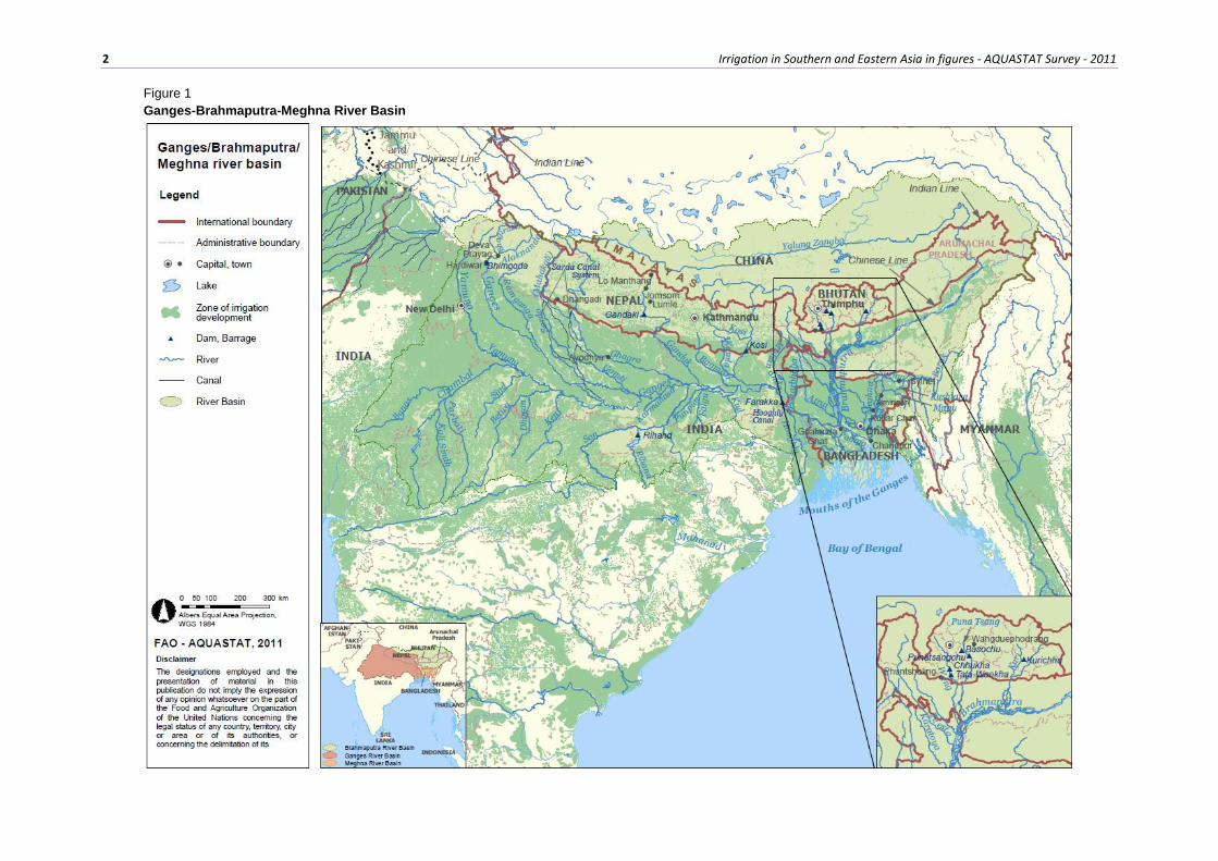
Figure 1
Ganges-Brahmaputra-Meghna River Basin
Ganges-Brahmaputra-Meghna transboundary river basin 3
The headwaters of both the Ganges river and the Brahmaputra river originate in the Himalayan mountain
range in China. The Ganges river flows southwest into India and then turns southeast, being joined by
many tributaries. After flowing into Bangladesh, the Ganges, Brahmaputra and Meghna rivers join and
flow into the Bay of Bengal as the Meghna River. The Brahmaputra river (known as Yalung Zangbo in
China) flows east through the southern area of China, then flows south into eastern India, turns
southwest, then enters Bangladesh (where it is also called Jamuna) before merging with the Ganges and
Meghna rivers. The tributaries of the Meghna river originate in the mountains of eastern India (the main
one called Barak), flow southwest and join. The Meghna river flows southwest and joins the Ganges
and Brahmaputra rivers before flowing into the Bay of Bengal (McEwen, 2008).
Bangladesh has been formed as the greatest deltaic plain at the confluence of the Ganges, Brahmaputra
and Meghna rivers and their tributaries. About 80 percent of the country is made up of fertile alluvial
lowland that becomes part of the Greater Bengal Plain. The country is flat with some hills in the northeast
and southeast. About 7 percent of the total area of Bangladesh is covered with rivers and inland water
bodies and the surrounding areas are routinely flooded during the monsoon.
Climate
The GBM river basin is unique in the world in terms of diversified climate. For example, the Ganges
river basin is characterized by low precipitation in the northwest of its upper region and high
precipitation in the areas along the coast. High precipitation zones and dry rain shadow areas are located
in the Brahmaputra river basin, whereas the world’s highest precipitation area is situated in the Meghna
river basin (Mirza et al., 2011).
Precipitation in the Ganges river basin accompanies the southwest monsoon winds from July to October,
but it also comes with tropical cyclones that originate in the Bay of Bengal between June and October.
Only a small amount of rainfall occurs in December and January. In the upper Gangetic Plain in Uttar
Pradesh (India), annual rainfall averages 760-1 020 mm, in the Middle Ganges Plain of Bihar (India)
1 020-1 520 mm, and in the delta region 1 520-2 540 mm. The delta region experiences strong cyclonic
storms, both before the commencement of the monsoon season - from March to May - and at the end of
it - from September to October. Some of these storms result in much loss of life and the destruction of
homes, crops and livestock (Ahmad and Lodrick).
Nepal, located entirely in the Ganges river basin, experiences tropical, meso-thermal, micro-thermal,
taiga and tundra types of climate. Mean annual precipitation is 1 500 mm, with a maximum of 5 581 mm
recorded in 1990 at Lumle in Kaski district at an elevation of 1 740 m and a minimum of 116 mm
recorded in 1988 at Jomsom in Mustang district. There are two rainy seasons in Nepal: one in the
summer from June to September, when the southwest monsoon brings more than 75 percent of the total
rainfall, and the other in winter from December to February, accounting for less than 25 percent of the
total. With the summer monsoon, rain first falls in the southeast of the country and gradually moves
west with diminishing intensity.
During winter, rain first enters Nepal in the west and gradually moves eastward with diminishing
intensity. Temperature increases from the high Himalayan region to the lowland terai (northern part of
the Ganges plain). Extreme temperatures recorded are -14.6°C in 1987 in Lo Manthang (Mustang
district), located at an elevation of 3 705 m, and 44°C in 1987 in Dhangadhi (Kailali district), located at
an elevation of 170 m. Precipitation falls as snow at elevations above 5 100 m in summer and above
3 000 m in winter. Temperature is a constraint to crop production in the Himalayas and the mountain
region where only a single crop per year can be grown. On the other hand, in the lowland terai three
crops per year are common where the water supply is adequate. Single rice cropping is possible up to
elevations of 2 300 m while double rice cropping is limited to areas below 800 m.
The climate in Bhutan, located entirely in the Brahmaputra river basin, is cold in the north, with year-
round snow on the main Himalayan summits, temperate in the inner Himalayan valleys of the southern
4 Irrigation in Southern and Eastern Asia in figures - AQUASTAT Survey - 2011
and central regions, and humid and subtropical in the southern plains and foothills. Bhutan’s generally
dry spring starts in early March and lasts until mid-April. Summer weather starts in mid-April with
occasional showers and continues through the early monsoon rains of late June. Autumn, from late
September or early October to late November, follows the rainy season. From late November until
March winter sets in, with frost throughout much of the country and snowfall common above elevations
of 3 000 m.
Temperatures vary according to elevation. In the capital Thimphu (elevation 2 320 m), temperatures
range from approximately 14°C to 25°C during the monsoon season of June through September but drop
to between about -4°C and 14°C in January. Most of the central portion of the country experiences a
cool, temperate climate year-round. In the south, a hot, humid climate helps maintain a fairly even
temperature range of between 15°C and 30°C year-round, although temperatures sometimes reach
beyond 35°C in the valleys during the summer. Average annual precipitation is estimated at 2 200 mm,
varying from a low of 477 mm at Gidakhom in Thimpu district to as high as 20 761 mm at Dechenling
in Samdrup Jhongkhar district. The climate of the north is severe and cold with only about 40 mm of
annual precipitation, primarily snow. In the temperate central regions, a yearly average precipitation of
around 1 000 mm is more common and 7 800 mm has been registered at some locations in the humid,
subtropical south, giving rise to the thick tropical forest. Western Bhutan is particularly affected by
monsoons that bring between 60 and 90 percent of the region’s precipitation. The winter northeast
monsoon brings gale-force winds down through high mountain passes.
Bangladesh has a tropical monsoon climate with significant variations in rainfall and temperature
throughout the country. There are four main seasons: i) the pre-monsoon during March-May, which has
the highest temperatures and experiences the maximum intensity of cyclonic storms, especially in May;
ii) the monsoon during June-September, when the bulk of rainfall occurs; iii) the post-monsoon during
October-November which, like the pre-monsoon season, is marked by tropical cyclones on the coast;
iv) the cool and sunny dry season during December-February. Average annual precipitation over the
country is 2 320 mm, of which about 80 percent occurs in the monsoon. It varies from 1 110 mm in the
extreme north-west to 5 690 mm in the northeast. The country is regularly subjected to drought, floods
and cyclones. Mean annual lake evaporation is 1 040 mm, which is about 45 percent of the mean annual
rainfall. Mean annual temperature is about 25°C, with extremes as low as 4°C and as high as 43°C.
Humidity ranges between 60 percent in the dry season and 98 percent during the monsoon.
Population
It is estimated that at least 630 million people live in the GBM river basin. This is almost two-thirds of
the population of Africa, while the size of Africa is about 18 times the size of the GBM river basin. In
2008, the total population in Bhutan, which is entirely located in the Brahmaputra river basin, was
estimated at 687 000 inhabitants, of which 66 percent is rural. About 95 percent of the population lives
in the southern subtropical zone or in the central mid-mountainous zone of Bhutan, mainly in the
relatively gentle sloping areas of the river valleys. In Nepal, located entirely in the Ganges river basin,
the total population was 28.8 million, of which almost 83 percent rural. The total population of
Bangladesh is 160 million (73 percent rural) of which 122 million inhabitants live inside the GBM river
basin approximately. The total territory of India has a population estimated at 1 181 million inhabitants
(71 percent live in rural areas), of which 476 million inhabitants live inside the GBM river basin (WB,
2010). In the total territory of China, the population is about 1 345 million, of which 57 percent are
living in rural areas. However, only 1.7 million inhabitants are estimated to be living in the GBM river
basin (WB, 2010). Population density in the basin area ranges from 6 and 18 inhabitants/km2 in China
and Bhutan respectively, to 195, 432 and 1 013 inhabitants/km2 in Nepal, India and Bangladesh
respectively.
In 2008, access of population to improved drinking water sources reached 92, 88 and 80 percent in
Bhutan, Nepal and Bangladesh respectively. In the total territory of India, 88 percent of the population
had access to improved water sources and in the total territory of China this was 89 percent.
Ganges-Brahmaputra-Meghna transboundary river basin 5
The GBM river basin contains the largest number of the world’s poor in any one region. The population
is increasing steadily, population density is very high in a large part of the basin, and, unless the current
development trends are broken, poverty will become even more pervasive. The region is endowed with
considerable natural resources that could be used to foster sustainable economic development. Water
could be successfully used as the engine to promote economic development in the region, which has
been hindered because the most populous part of the basin is shared by three countries - Bangladesh,
India, and Nepal - which have in the past been unable to agree to an integrated development plan (Biswas
and Uitto, 2001).
WATER RESOURCES
Surface water
The main Ganges river is the flow combination of two rivers, the Alaknanda and the Bhagirathi, which
meet at Deva Prayag in Uttarakhand State (India) within the mountain range of the Himalayas. During
its middle course in an easterly direction, a number of large and small tributaries join onto the northern
side (left bank) from the Himalayan sub-basin, namely, Ramganga, Sarda, Gomti, Ghagra, Gandak and
Kosi, the last five originate within the mountain range of the Himalayas in Nepal. Therefore, the
contribution of flow of these tributaries is from Nepal within the Himalayan range and from India on
the southern side of the Himalayan foothills. Another tributary, Mahananda, joins the river in
Bangladesh. On the southern, peninsular side (right bank), the tributaries are Yamuna, Kehtons, Son,
Punpun and Kiul. Amongst the Himalayan streams, the Ghagra with its tributaries contributes the
maximum annual runoff (about 94.5 km3) and the Gomti the minimum (about 7.4 km3). Amongst the
peninsular streams, the Son contributes the maximum annual runoff (about 32 km3) and the Kiul the
minimum (about 35 km3).
The Ganges river enters Bangladesh about 50 km below Farakka (left side falls in Bangladesh) and
tributaries such as Mahananda, Punarbhaba, Atrai (Boral) and Karatoya, which originate in India, join
the Ganges river on its left side. The river joins the Brahmaputra river another 220 km further
downstream, near Goalanda Ghat in Bangladesh as the Padma and further down the combined discharge
joins the Meghna river at Chandpur after travelling another 70 km. The combined stream is called the
Meghna river, which 90 km further downstream discharges into the Bay of Bengal. The total length of
the Ganges-Padma river from Deba Prayag to the sea is about 2 515 km (Parua, after 2001).
The Brahmaputra river originates on the northern slope of the Himalayas in China, where it is called
Yalung Zangbo. It flows eastwards for about 1 130 km, then turns southwards and enters Arunachal
Pradesh (India) at its northern-most point and flows for about 480 km. Then it turns westwards and
flows through Arunachal Pradesh, Assam and Meghalaya for another 650 km and then enters
Bangladesh. Then the river curves to the south and continues on this course for about 240 km until its
confluence with the Ganges river. Within Bangladesh, the river varies considerably in width ranging
from less than 2 km to more than 12 km. The Brahmaputra river is classed as a braided channel, while
the Ganges river is basically a meandering channel.
During low flows the river becomes a multiple channel stream with sand bars in between and the
channels shift back and forth between the main stream banks, which are 6 to 12 km apart. The discharge
of the Brahmaputra river mostly comes from the snowmelt in China on the other side of the Himalayas
before it enters Arunachal Pradesh. In Arunachal Pradesh, Assam and Meghalaya of India and Dinajpur
and Mymenshingh districts of Bangladesh rainfall is quite heavy and this contributes substantially to the
river flow. The river reach between Bahadurabad, where the river leaves India and enters Bangladesh,
and Aricha, where the river joins the Ganges river, is popularly known as Jamuna in Bangladesh (Parua,
after 2001). The total length of the river from its source to the sea is about 2 840 km.
The Meghna river system flows on the east of the Brahmaputra river through Bangladesh. The Barak
river divides into two branches within the Assam state in India. The northern branch is called Surma,
which flows southwards through the eastern side of Bangladesh next Sylhet town. The southern branch
6 Irrigation in Southern and Eastern Asia in figures - AQUASTAT Survey - 2011
is called Kushiara, which flows through India and then enters Bangladesh. First the northern branch
joins the Meghna river near Kuliar Char and then the southern branch joins the Meghna river near
Ajmiriganj. The lower Meghna River is one of the largest rivers in the world, being the mouth of the
three great rivers: Ganges-Padma, Brahmaputra and Meghna. The total length of the river is about
930 km. The river is predominantly a meandering channel, but in several reaches, especially where small
tributaries contribute sediment, braiding is evident with sand islands bifurcating the river into two or
more channels (Parua, after 2001).
The annual flow of the Brahmaputra river basin from China to India is 165.40 km3 and from Bhutan to
India 78 km3. The annual flow of the Brahmaputra river basin from India to Bangladesh is 537.24 km3.
The annual flow of the Ganges river basin from China to Nepal is 12.0 km3. All rivers in Nepal drain
into the Ganges river with an annual flow of 210.2 km3 to India. The annual flow of the Ganges basin
from India to Bangladesh is 525.02 km3. The annual flow of the Meghna river basin from India to
Bangladesh is 48.36 km3. This gives a total annual GBM river basin inflow into Bangladesh from India
of 1 110.6 km3.
ABased on observations of the flood cycle in the Ganges river, the flow starts decreasing in October, is
minimum between the last week of March and the last week of April and is maximum between the last
week of August and the last week of September (Parua, after 2001).
Over 138 700 m3/s of water flows into the Bay of Bengal during floods through a single outlet of the
GBM river in Bangladesh. This is the largest in the world for a single outlet to the sea and exceeds even
that the Amazon discharge into the sea by about 1.5 times (Parua, after 2001).
Groundwater
The groundwater potential in the Ganges and Brahmaputra basins is quite high but it is primarily
confined to piedmont areas in India. It has been estimated that the Ganges river basin in India and Nepal
has an annual groundwater yield of 108.5 km3, while the Brahmaputra river basin in Assam (India) has
a yield potential of 10.7 km3. Compared to India, groundwater recharge potential is lower in Bangladesh,
estimated at 21 km3/year. Except for a limited area in the northwest, the top soil in most places in
Bangladesh is composed of old alluvium with a large percentage of clay materials. The old alluvium is
dissected in old stream beds, which in turn are connected with the existing stream system (Fazal, 1990).
The groundwater resources in Bhutan are probably limited and are drained by the surface water network,
which means that they are more or less equal to overlap between surface water and groundwater.
Water quality
In all the countries of the GBM river basin, the deterioration of both surface water and groundwater
quality is now a matter of serious concern. Water is essential to sustain agricultural growth and
productivity. More than half of the morbidity in the GBM basin stems from the use of impure drinking
water. Safe water supply and hygienic sanitation are basic minimum needs, which the GBM river basin
countries are yet to meet in both rural and urban areas. A holistic approach is required to monitor the
water quality in each country together with regional initiatives, both to prevent further deterioration and
to bring about improvement in the quality of water. Monitoring of water quality in the GBM rivers is
not as extensive as it should be, except in the case of the Ganges river in India and the Buriganga river
in Bangladesh. Setting up uniform standards, relating to water quality along with establishing an
effective water quality monitoring network in all countries is important, as well as a review of their
existing water quality/pollution laws. Coordination of their actions in order to deal with transboundary
transmission of pollution and evolving a mechanism for real time water quality data exchange could
lead to efficient water quality management (Biswas, after 2006).
In Bangladesh, irrigation water quality has deteriorated owing to pollution from agrochemicals,
industrial waste and other sources. Arsenic contamination of groundwater has been reported in many
Ganges-Brahmaputra-Meghna transboundary river basin 7
government and donor agency documents (GoB, UNICEF, WB, FAO). Arsenic concentration has been
found to be at a maximum within the upper 50 m depth of aquifers in most regions of the country (Water
Aid, 2000). In many places concentration of iron and arsenic in irrigation water has gone beyond the
limit of safe water quality standards of Bangladesh and WHO. Some diseases and health hazards such
as arsenicosis, blindness, physical disability, occur as a result of arsenic toxicity to humans (RDA, 2001).
Throughout the country, about 1.44 million tubewells have been affected by arsenic contamination and
about 30 million people are exposed to arsenic toxicity (Ahmed, 2007). The mitigation of the additional
problems of salinity and arsenic in Bangladesh involves special action plans. Saline intrusion in coastal
areas could be addressed through dry season flushing of channels by means of methods such as storing
monsoon water and resuscitating moribund channels. The Bangladesh Arsenic Mitigation Water Supply
Project (BAMWSP) is presently engaged in assessing the extent, dimensions, and causes of the arsenic
problem with a view to developing a long-term strategy for supplying arsenic-free water (Biswas, after
2006).
In Bangladesh, during the dry season groundwater has become an increasingly important source of water
for irrigation, municipal and industrial purposes. Some environmental hazards have been encountered
in many areas and a number of adverse effects have emerged as a result of the over-abstraction of
groundwater, such as lowering of water tables, reduction in dry season flows of rivers and streams,
groundwater pollution, intrusion of saline water in coastal areas, ecological imbalance and possible land
subsidence. There has been evidence of permanent lowering of groundwater levels in some locations,
particularly in the Dhaka metropolitan area where the average annual decline in the groundwater level
is about 3 m (BADC, 2006) and in the northwest region of the country.
In India, the water quality of rivers in their upper reaches is good, though the importance of water use
for cities, agriculture and industries, and the lack of wastewater treatment plants in the middle and lower
reaches of most rivers cause a major degradation of surface water quality. Groundwater is also affected
by municipal, industrial and agricultural pollutants. The pollution control action plan of the Ganges
basin was formulated in 1984 and has been enforced by the Ganges Project Directorate, under the Central
Ganges Authority, to oversee pollution control and the consequent cleaning of the Ganges river. The
water quality in the middle stretch of the Ganges river, which had deteriorated to class C and D (the
worst class is E, the best A), was restored to class B in 1990 after the implementation of the action plan.
Climate change
The GBM rivers create flood problems in their respective basin areas during monsoon months almost
every year. Bangladesh, being the lower riparian country, suffers most from such floods which cause
enormous loss of life and property (Parua, after 2001).
Climate change may alter the distribution and quality of GBM river basin water resources. Some of the
impacts include occurrence of more intense rains, changed spatial and temporal distribution of rainfall,
higher runoff generation, low groundwater recharge, melting of glaciers, changes in evaporative
demands and water use patterns in agricultural, municipal and industrial sectors, etc. These impacts lead
to severe influences on agricultural production and food security, ecology, biodiversity, river flows,
floods, and droughts, water security, human and animal health and sea level rise.
Bihar is the worst flood hit state in India. Hardly a year passes without severe flood damage. With the
onset of the monsoon, rivers come down from the Himalayan hills in Nepal with enormous force,
causing rivers like Ghagra, Kamla, Kosi, Bagmati, Gandak, Ganges, Falgu, Karmanasa, Mahanadi to
rise above the danger level. This results in severe floods in North Bihar. The Kosi river, popularly known
as “the sorrow of Bihar”, has not yet matured enough to settle on a course, and has changed its course
15-16 times the last time being as recent as August 2008. About 2.8 million people were said to have
been marooned by these floods in Bihar.
8 Irrigation in Southern and Eastern Asia in figures - AQUASTAT Survey - 2011
Bangladesh is now widely recognized as one of the countries that is most vulnerable to climate change.
Increased variability of temperatures and rainfall and increased occurrence of natural hazards are
expected to affect the availability of both surface water and groundwater. Investments are needed to
ensure a continuous and sustainable access to water resources.
WATER-RELATED DEVELOPMENTS IN THE BASIN
Use of water of the Ganges river for irrigation, either by flooding or by means of gravity canals, has
been common since ancient times. Such irrigation is described in scriptures and mythological books
written more than 2 000 years ago. Irrigation was highly developed during the period of Muslim rule
from the twelfth century onward, and the Mughal kings later constructed several canals. The canal
system was further extended by the British. The cultivated area of the Ganges valley in Uttar Pradesh
and Bihar benefits from a system of irrigation canals that has increased the production of cash crops
such as sugarcane, cotton and oilseeds. The older canals are mainly in the Ganges-Yamuna Doab (doab
meaning “land between two rivers”). The Upper Ganga Canal, beginning at Hardiwar, and its branches
have a combined length of 9 575 km. The Lower Ganga Canal, extending 8 240 km with its branches,
begins at Naraura. The Sarda Canal irrigates land near Ayodhya, in Uttar Pradesh. Higher lands at the
northern edge of the plain are difficult to irrigate by canal, and groundwater must be pumped to the
surface. Large areas in Uttar Pradesh and Bihar are also irrigated by channels running from hand-dug
wells. The Ganges-Kabadak scheme in Bangladesh, largely an irrigation plan, covers parts of the
districts of Khulna, Jessore, and Kusthia that lie within the part of the delta where silt and overgrowth
choke the slowly flowing rivers. The system of irrigation is based on both gravity canals and electrically
powered lifting devices (Ahmad and Lodrick).
Total area equipped for irrigation in the GBM river basin is estimated to be around 35.1 million ha, of
which 82.2 percent in India, 14.0 percent in Bangladesh, 3.3 percent in Nepal, 0.4 percent in China and
0.1 percent in Bhutan. Area actually irrigated is estimated at 34.1 million ha. The equipped areas
irrigated by groundwater and by surface water account for 67 and 33 percent respectively.
Of the 29 million ha equipped for irrigation in India inside the GBM river basin, 67 percent is irrigated
by groundwater and 33 percent by surface water. The development of sprinkler and localized irrigation
in recent years has been considerable, mainly the result of the pressing demand for water from other
sectors, a fact that has encouraged government and farmers to find water-saving techniques for
agriculture. The Government has offered subsidies to adopt drip systems. Drip-irrigated crops are mainly
orchards (grapes, bananas, pomegranates and mangoes). Localized irrigation is also used for sugarcane
and coconut. Investment in drainage has been widely neglected in India, and where such investment has
been made, poor maintenance has caused many drainage systems to become silted up. On the eastern
Ganges plain, investment in surface drainage would probably have a greater productive impact, and at
a lower cost, than investment in surface irrigation.
In Nepal, which is entirely located in the Ganges river basin, the area equipped for irrigation was
estimated at 1 168 300 ha in 2002, of which 79.5 percent was irrigated by surface water, 19.2 percent
by groundwater and 1.3 percent by mixed surface water and groundwater. Seasonal canals accounted
for 58 percent of the area irrigated by surface water, permanent canals for 39 percent, and ponds for 3
percent. In 1992, the area equipped for irrigation accounted for 882 400 ha and in 1982 for 583 900 ha.
In 1994, 73.9 percent of the area equipped for irrigation was irrigated by surface water, 12.4 percent by
groundwater and 13.8 percent by irrigation systems not fully identified. Most irrigation systems use
surface irrigation (basin, furrow). Some areas in the hills and mountains use sprinkler irrigation, but no
figures are available. In 2005, the harvested irrigated crop area covered around 1 335 000 ha, of which
47 percent consisted of wheat, 36 percent of rice, 4 percent of maize, 3 percent of vegetables, 2 percent
oil crops, 4 percent of other annual crops and 3 percent of sugarcane.
China accounts for approximately 138 000 ha of area equipped for irrigation inside the GBM river basin
of which 98 percent is irrigated by surface water.
Ganges-Brahmaputra-Meghna transboundary river basin 9
In Bhutan, which is entirely located in the Brahmaputra river basin, most rivers are deeply incised into
the landscape and hence the possibilities for run-of-the-river irrigation are limited. The irrigated areas
are called wetland in the local classification. This means that they have been terraced for basin irrigation.
In 2007, throughout the country these areas were estimated at 27 685 ha, which corresponds to actually
irrigated area. In summer, almost all wetland is under rice cultivation. Double cropping of rice is limited
to the lowest altitudes where the winter temperatures still allow its cultivation. Where rice cannot be
cultivated, wheat, buckwheat, mustard and potatoes are cropped on wetland areas during the winter
season. The wetland areas can be cropped during the winter season, though watering of these winter
crops is generally limited to one irrigation at the time of land preparation. To a limited extent, farmers
have started to irrigate horticultural crops, including orchards, using hose pipes and surface irrigation
methods. In 1994, total irrigated cropped area was estimated at 27 900 of which 98 percent is rice and
2 percent potatoes.
In Bangladesh, though the country has abundant surface water resources, particularly in the monsoon
season, its flat deltaic topography and the instability of major rivers make large gravity irrigation systems
both technically difficult and costly. On the other hand, during the dry season irrigation using surface
water has become difficult or practically impossible owing to limited availability. Therefore the use of
groundwater for irrigation has become increasingly important. In 2008 the national irrigation coverage
was 5.05 million ha, of which approximately 4.93 million ha inside the GBM river basin where
groundwater covered 75 percent and surface water covered 25 percent of the total irrigated area. In 1993,
the total area of wetlands throughout the country was 3.14 million ha, of which almost 1.55 million ha
were cultivated and 1.38 million ha were drained by surface drains. Thus, total water managed area is
estimated at 6.59 million ha. Surface irrigation is the only technology used in large irrigation schemes.
In 2008, total harvested irrigated cropped area in Bangladesh was estimated at 5.98 million ha, of which
the most important crops are rice accounting for 4.34 million ha (73 percent), wheat 0.31 million ha
(5 percent), potatoes 0.26 million ha (4 percent) and vegetables 0.24 million ha (4 percent).
Because of the low-lying topography, each year about 18 percent of Bangladesh is inundated during the
monsoon season. During severe floods the affected area may exceed 37 percent of the country and in
extreme events like the 1998 flood about 66 percent of the country is inundated. Floods are caused by
overspills from main rivers and their distributaries, overspills from tributaries and by direct rainfall.
Flood control works can reduce floods from the first two, but only drainage can have any effect on the
latter two. The basic benefit of drainage is water control – supply as well as removal.
The particular benefits can be: i) potential increase in cropped area through earlier drainage; ii) higher
yields from transplanted Aman rice through early planting; iii) crop diversification in the wet season
through better drainage; and iv) more control over crop calendars and patterns through control of the
water regime. In 1964, a master plan was initiated for water resources development. This envisaged the
development of 58 flood protection and drainage projects covering about 5.8 million ha of land. Three
types of polders were envisaged: gravity drainage, tidal sluice drainage and pump drainage. Flood
control and drainage projects have accounted for about half of the funds spent on water development
projects since 1960. They include:
Large-scale projects such as: Coastal Embankment Project (949 000 ha), Manu River Project
(22 500 ha), Teesta Right Embankment (39 000 ha), Ganges-Kobadak Project (141 600 ha),
Brahmaputra Right Flood Embankment (226 000 ha), Chandpur Irrigation Project (54 000 ha),
and Chalan Beel Project (125 000 ha).
Medium-scale projects such as: Sada-Bagda, Chenchuri Beel and Bamal-Salimpur-
Kulabasukhali projects implemented under the Drainage and Flood Control Projects (DFC I to
DFC IV) and financed by the World Bank. These projects typically cover areas of 10 000–
30 000 ha and involve flood control and drainage with limited irrigation development.
Small-scale projects such as those implemented under the Early Implemented Project, the
Small-scale Irrigation Project and the Small-scale Drainage and Flood Control Project.
10 Irrigation in Southern and Eastern Asia in figures - AQUASTAT Survey - 2011
Total water withdrawal in the GBM river basin is estimated at 373.928 km3, of which 68 percent is
groundwater and 32 percent surface water. Irrigation withdrawal accounts for 337.728 km3, or 90 percent
of the total withdrawal. India’s total withdrawal inside the GBM river basin has been estimated around
328.2 km3, of which 90.4 percent (296.7 km3) for agriculture. In Bangladesh, in 2008 total water
withdrawal within the GBM river basin was estimated at about 35.0 km3, of which 88 percent (30.7 km3)
was for agriculture, 10 percent for municipalities and 2 percent for industries. Approximately 79 percent
of the total water withdrawal comes from groundwater and 21 percent, from surface water. In Nepal, in
2005 total water withdrawal was estimated at 9.79 km3, of which 98.2 percent (9.61 km3) for agriculture,
1.5 percent for municipalities and 0.3 percent for industry. In Bhutan, in 2008 total water withdrawal
was estimated at 0.338 km3, all surface water. This represents a mere 0.43 percent of the annual
renewable water resources. About 94 percent of this water withdrawn (0.318 km3) was used for
agriculture, while the municipal and industrial sectors used 5 percent and 1 percent respectively. Total
water withdrawal of China inside the GBM river basin has been estimated around 0.6 km3, of which
67 percent (0.4 km3) for agriculture.
In Nepal, total dam capacity is estimated at 85 million m3, although potential for at least 138 km3 exists.
Hydroelectricity accounted for more than 96 percent of total electricity generation. Theoretical
hydropower potential is estimated at about 83 000 MW. However, the identified economically feasible
potentials are about 40 000 MW (Biswas, after 2006). The two main diversion barrages are the ones of
Kosi and Gandaki reservoirs.
In Bhutan, several large dams were constructed for hydroelectric power generation. These include the
40 m high Chhukha dam (CHPP) on the Wang river in Chhukha district in the southwest, the 91 m high
Tala-Wankha dam further downstream on the Wang (Raidak) river near Phuntsholing town, the 33 m
high Kurichhu dam on the Kuri river in Mongar district in the east, the Basochu dam (BHPP) near
Wangduephodrang town in the centre-west. The 141 m high Punatsangchu dam on Puna Tsang river
downstream of Wangduephodrang town is under construction. Total hydropower generation capacity
was 477 MW in 2006, of which 336 MW from the Chhukha hydropower plant, 60 MW from the Kurichu
hydropower plant and 24 MW from the Basochu hydropower plant. Hydropower represented 96 percent
of the country’s electricity generating capacity and 99.9 percent of its electricity generation in 2006.
With the commissioning of the first two units of the Chhukha hydroprojects in 1986, and the other two
units in 1998, the electricity generation capacity has substantially increased and Bhutan became a
significant exporter of electricity to India. With the commissioning of “Tala Hydro Power Project” in
2006, there is a substantial improvement in the energy generation of the country.
The expansion of hydropower production capacity in Bhutan has had an enormous impact as by the end
of the Ninth Five-Year Plan (2002-2007), the energy sector contributed to around a quarter of GDP.
With a further doubling of capacity envisaged by the end of the Eleventh Five-Year Plan (2014-2019),
the energy sector will probably contribute close to half of GDP. The following hydroelectric projects
have been identified for future development:
Mangdue Chu Hydroelectric Project was planned in the Ninth Five-Year Plan (2002-2007)
and is expected to be completed in the Tenth Five-Year Plan (2008–2013). The project
comprises two dams.
Sunkosh Multipurpose Project (SMP) is the largest proposed hydroelectricity project in
Bhutan.
India controls the flow of the Ganges river with a dam completed in 1974 at Farakka, 18 km from the
border with Bangladesh. The Farakka barrage is a not very high diversion structure and is not classified
as a large dam. During the dry season it diverts water from the Ganges river to the Hooghly river through
the Hooghly Canal. The Bhimgoda dam at Haridwar diverts melted snow from the Himalayas to the
Upper Ganges Canal, which was built by the British in 1854. This water is used for irrigation and the
flow of the river has been greatly diminished.
Ganges-Brahmaputra-Meghna transboundary river basin 11
India is endowed with rich hydropower potential, ranking fifth in the world. The gross hydropower
potential was estimated at 148 700 MW as installed capacity, to which the Brahamaputra, Ganges and
Indus river basins contribute about 80 percent. The installed capacity of hydropower generation in India
is about 22 000 MW (Biswas, after 2006). The total water storage capacity constructed in the country is
estimated at 224 km3. Out of the seven larger dams with a reservoir capacity exceeding 8 km3 in India,
only the Rihand dam is in the GBM river basin, on the Rihand river (10.6 km3).
No large dams exist in the GBM river basin in Bangladesh. Three barrages have been constructed across
the Teesta, Tangon and Manu rivers, which are used as diversion structures for irrigation purposes only.
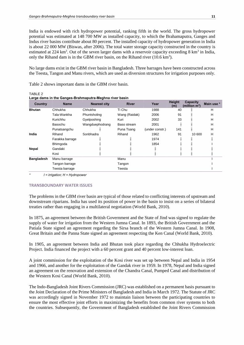
Table 2 shows important dams in the GBM river basin.
TABLE 2 Large dams in the Ganges-Brahmaputra-Meghna river basin
Country Name Nearest city River Year Height
(m) Capacity
(million m3) Main use *
Bhutan Chhukha Chhukha Ti Chu 1988 40 - H
Tala-Wankha Phuntsholing Wang (Raidak) 2006 91 - H
Kurichhu Gyelposhing Kuri 2002 33 - H
Basochu Wangduephodrang Baso stream 2001 - - H
Punatsangchu - Puna Tsang (under constr.) 141 - H
India Rihand Sonbhadra Rihand 1962 91 10 600 H
Farakka barrage - - 1974 - - -
Bhimgoda - - 1854 - - I
Nepal Gandaki - - - - - -
Kosi - - - - - -
Bangladesh Manu barrage Manu I
Tangon barrage Tangon I
Teesta barrage Teesta I
* I = irrigation; H = Hydropower
TRANSBOUNDARY WATER ISSUES
The problems in the GBM river basin are typical of those related to conflicting interests of upstream and
downstream riparians. India has used its position of power in the basin to insist on a series of bilateral
treaties rather than engaging in a multilateral negotiation (World Bank, 2010).
In 1875, an agreement between the British Government and the State of Jind was signed to regulate the
supply of water for irrigation from the Western Jumna Canal. In 1893, the British Government and the
Patiala State signed an agreement regarding the Sirsa branch of the Western Jumna Canal. In 1908,
Great Britain and the Panna State signed an agreement respecting the Ken Canal (World Bank, 2010).
In 1905, an agreement between India and Bhutan took place regarding the Chhukha Hydroelectric
Project. India financed the project with a 60 percent grant and 40 percent low-interest loan.
A joint commission for the exploitation of the Kosi river was set up between Nepal and India in 1954
and 1966, and another for the exploitation of the Gandak river in 1959. In 1978, Nepal and India signed
an agreement on the renovation and extension of the Chandra Canal, Pumped Canal and distribution of
the Western Kosi Canal (World Bank, 2010).
The Indo-Bangladesh Joint Rivers Commission (JRC) was established on a permanent basis pursuant to
the Joint Declaration of the Prime Ministers of Bangladesh and India in March 1972. The Statute of JRC
was accordingly signed in November 1972 to maintain liaison between the participating countries to
ensure the most effective joint efforts in maximizing the benefits from common river systems to both
the countries. Subsequently, the Government of Bangladesh established the Joint Rivers Commission
12 Irrigation in Southern and Eastern Asia in figures - AQUASTAT Survey - 2011
Bangladesh (JRCB) to address the issues relating to the sharing and managing of the water from
transboundary rivers with the co-riparian countries. The main activities of the JRCB are (JRCB, 2011):
Negotiating with the co-riparian countries on development, management and sharing of water
resources of common rivers.
Holding meetings with India at different levels to discuss issues on sharing of waters of
common rivers, transmission of flood-related data from India to Bangladesh, river bank
protection works along common/border rivers and other pertinent issues.
Monitoring and sharing of the Ganges waters at Farakka and monitoring at Hardinge Bridge
(Bangladesh) between 1 January and 31 May every year as per provision of the Ganges Water
Sharing Treaty of 1996.
Working jointly with Nepal for harnessing common water resources and mitigating floods and
flood damages and conducting research and technical studies.
Cooperating with China in the field of water resources, enhancing the flood forecasting
capability through exchange of flood-related data and information of the Brahmaputra river,
using and protecting the water resources of transnational rivers in the region keeping in mind
the principles of equality and fairness, conduct training in the relevant technical field, etc
As mentioned earlier, India controls the flow of the Ganges river through a dam completed in 1974 at
Farakka, 18 km from the border with Bangladesh. The Farakka barrage was originally conceived by the
British imperial government, however not implemented until after India’s independence from British
rule. This dam was a source of tension between the two countries, with Bangladesh asserting that the
dam held back too much water during the dry season and released too much water during monsoon rains.
In 1977, an agreement between Bangladesh and India was signed on sharing of the Ganges waters at
Farakka and on augmenting its flows (World Bank, 2010). In 1978, in the JRC, India and Bangladesh
had placed separate proposals for augmentation of the Ganges river flow at Farakka. While the
Bangladesh proposal concentrated on storage of Ganges water itself during floods by constructing dams
and reservoirs to be located mostly in Nepal, the Indian proposal was based on inter-basin transfer of
water from the Brahmaputra river basin to the Ganges river basin through a link canal as the
Brahmaputra has plenty of water mostly untapped. This would also minimize the flood hazards as the
floods in the Brahmaputra come more than two months before those of the Ganges.
However, none of the proposals materialized because of the objections from either side on various
grounds. After the disastrous floods in Bangladesh in 1988, the Indian Government expressed concern
about the damage and showed interest in regional cooperation for flood mitigation in both the countries
through a joint action plan. The Bangladesh Government also came closer to India and had talks on river
cooperation (Parua, after 2001). In 1996, India and Bangladesh signed the Ganges Water Sharing Treaty,
which regulates the Ganges sharing waters at Farakka. Bangladesh is ensured a fair share of the flow
reaching the dam during the dry season.
In planning and management terms, it is simply impossible to consider the GBM river system as one
system because of its sheer size, complexities and multinational character. Accordingly, following the
Ganges Water Sharing Treaty between India and Bangladesh, the main focus of bilateral negotiations
between these two countries has currently been on the Teesta river, an important tributary of the Ganges
river. In 1983, a primary agreement between India and Bangladesh was reached on the sharing of the
Teesta river waters (World Bank, 2010). These negotiations are ongoing, but no mutually acceptable
framework for the management of the Teesta river is in sight (Biswas, after 2006).
Around 1980, Bhutan initiated a plan to develop the hydropower potential of the Wangchu Cascade at
Chhukha, in close cooperation with India. Following extensive consultations, India agreed to construct
a 336 MW run-of-the-river project at Chhukha, on the basis of a 60 percent grant and 40 percent loan.
The project was commissioned in stages from 1988 onwards and was so successful that it had paid by
itself by 1993. The generating capacity was later increased to 370 MW. Because of the Indian support
Ganges-Brahmaputra-Meghna transboundary river basin 13
to the planning and construction of the project, Bhutan agreed to sell excess electricity to India at a
mutually agreed rate. A 220 kV transmission line was constructed, which linked the Bhutanese capital,
Thimpu, and the city of Phuntsholing on the Indian border, from where electricity was subsequently
supplied to four Indian states.
The agreement between the two countries is that the electricity generated will be first used to satisfy
Bhutan’s own internal needs. Before the construction of the Chhukha plant, electricity was generated by
diesel and mini-hydro plants. Thus, total electricity generated was limited. Since the construction of the
Chhukha project proved to be beneficial to both countries, they have agreed to expand their collaborative
efforts to other new hydropower projects. Bhutan realized that the revenues from the development, use
and export of its hydropower potential can accelerate the economic and social development processes
of the country, and can contribute very significantly to poverty alleviation.
The arrangement has also been beneficial to energy-thirsty India, whose electricity requirements have
been increasing in recent years at 8-9 percent per year. India and Bhutan have subsequently collaborated
with the funding and construction of a 45-MW run-of-the-river hydropower station at Kuri river. Similar
collaborative efforts have taken place, or are under active consideration, for Chhukha II (1 020 MW)
and Chhukha III (900 MW, with a storage dam). In addition, the two countries signed an agreement in
1993 to study the feasibility of a large storage dam on the Sunkosh river. Considering the fact that its
present population is only just over 2 million, this sale of hydropower to India means a very substantial
income for this relatively small country (Biswas, after 2006).
In 1996, India and Nepal ratified a treaty on the Mahakali river, located on the border between the two
countries. The treaty provides for equal entitlement in the utilization of water from the Mahakali river
without prejudice to respective existing consumptive uses.
The Punatsangchu Hydroelectric Power Project (PHPP) is a proposed project between Bhutan and India
signed in 2003. It is a run-of-the-river scheme along the course of the Puna Tsang river, downstream
from Wangduephodrang town. It will have an installed capacity of 870 MW with an annual average
generation of 4 330 GWh.
The Tala Hydroelectric Project Authority (THPA) is the largest Indo-Bhutan joint project, entirely
funded by the Government of India by way of grants and loan and fully operational since 2007.
In September 2008, the third meeting of the Nepal-India Joint Committee on Water Resources (JCWR)
took place, to resolve pending issues and pave the way both to mitigate the flood problems along the
Nepal-India border and to enhance bilateral cooperation in the water sector. The Pancheshwar
Multipurpose Project was identified as a priority project and JCWR reviewed the current status of
discussions on issues related to location of the regulating dam, unit size and installed capacity of the
power plants, assessment of project benefits in terms of irrigation and power to India and Nepal and
sharing of the project cost by the two sides. JCWR decided to set up a Pancheshwar Development
Authority (PDA) at the earliest in accordance with Article 10 of the Mahakali Treaty for the
development, execution and operation of the Pancheshwar Multipurpose Project.
In December 2008, the first meeting of the India-Nepal Joint Standing Technical Committee (JSTC)
was held. During the above-mentioned third meeting of JCWR, it was decided to have three tier joint
mechanisms to expedite the decision-making process and the implementation of decisions undertaken
at the institutional interactions. Whereas a Joint Ministerial Commission on Water Resources would be
headed by the Ministers of Water Resources of India and Nepal, a Joint Standing Technical Committee
was constituted to rationalize technical committees and subcommittees that exist to cover issues in India
and Nepal related to flood management, inundation problems and flood forecasting activities besides
project specific committees on hydropower. The JSTC coordinates all technical committees and
subcommittees under JCWR.
14 Irrigation in Southern and Eastern Asia in figures - AQUASTAT Survey - 2011
The fourth meeting of JCWR was held in March 2009 to discuss the issues of water resources
development projects in a comprehensive manner, further strengthening the ties between the two
countries. India and Nepal hoped that the works on the breach closure of the Kosi barrage would be
completed in time with the cooperation of the two governments. Nepal informed of the demands of local
people for the maintenance and rehabilitation of Main Gandak Western Canal and flood control
structures. To date, no noticeable progress on these demands could be observed. India informed that
short-term measures have already been implemented.
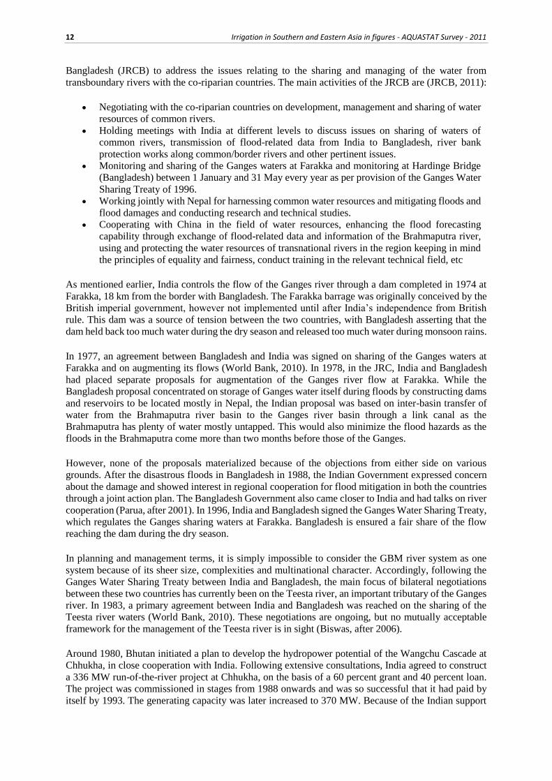
Table 3 lists the main historical events in the GBM river basin.
TABLE 3 Chronology of major events in the Ganges-Brahmaputra-Meghna river basin
Year Plans/projects/treaties/conflicts Countries involved Main aspects
1875 Agreement on Western Jumna Canal
India and United Kingdom Agreement between the British Government and The State of Jind for regulating the supply of water for irrigation from the Western Jumna Canal
1893 Agreement on the the Sirsa branch of the Western Jumna Canal
India and United Kingdom Agreement between the British Government and the Patiala State regarding the Sirsa branch of the Western Jumna Canal
1905 Agreement on Chhukha Hydroelectric project
India and Bhutan India financed the project with a 60 percent grant and 40 percent low interest loan
1908 Agreement on the Ken Canal India and United Kingdom Great Britain and the Panna State signed an agreement respecting the Ken Canal
1954-1966
Joint commission for the exploitation of the Kosi river
Nepal and India
1959 Joint commission for the exploitation of the Gandak river
Nepal and India
1964 Master plan for water resources development was developed.
Bangladesh This envisaged the development of 58 flood protection and drainage projects covering about 5.8 million ha of land
1972 Indo-Bangladesh Joint Rivers Commission (JRC) was established
India and Bangladesh Maintains liaison between the participating countries to ensure the most effective joint efforts in maximising the benefits from common river systems to both the countries.
1974 Farakka dam India and Bangladesh Located in India, 18 km from the border with Bangladesh. This dam was a source of tension between the two countries, with Bangladesh asserting that the dam held back too much water during the dry season and released too much water during monsoon rains
1977 Agreement on Ganges waters at Farakka
India and Bangladesh An agreement was signed on sharing of the Ganges waters at Farakka and on augmenting its flows
1978 Agreement on the Chandra Canal Nepal and India Agreement on the renovation and extension of the Chandra Canal, Pumped Canal and distribution of the Western Kosi Canal
1983 Primary agreement on Teesta river waters
India and Bangladesh A primary agreement was reached on the sharing of the Teesta river waters
1988 Chhukha dam Bhutan and India Around 1980, Bhutan initiated a plan to develop the hydropower potential of the Wangchu Cascade at Chhukha, in close cooperation with India. India agreed to construct a 336 MW run-of-the-river project at Chhukha, on the basis of a 60 percent grant and 40 percent loan. The project was commissioned in stages from 1988 onwards and was so successful that it had paid by itself by 1993.
1993 Agreement to study the feasibility of a large storage dam on the Sunkosh river.
Bhutan and India
1996 Treaty on the Mahakali river Nepal and India The treaty makes provision for equal entitlement in the utilization of water from the Mahakali river without prejudice to respective existing consumptive uses.
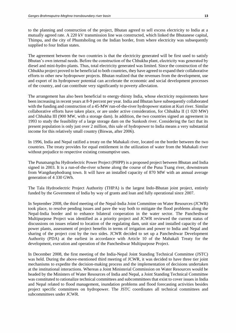
Ganges-Brahmaputra-Meghna transboundary river basin 15
TABLE 3 (continued) Chronology of major events in the Ganges-Brahmaputra-Meghna river basin
Year Plans/projects/treaties/conflicts Countries involved Main aspects
1996 Ganges Water Sharing Treaty India and Bangladesh Regulates the Ganges sharing waters at Farakka
2003 Punatsangchu Hydroelectric Power Project is proposed
Bhutan and India Proposed and signed project between Bhutan and India
2006 Tala Hydroelectric Project
constructed Bhutan and India
Is the biggest Indo-Bhutan joint project, entirely funded by the Government of India by way of grants and loan and fully operational since 2007.
2008 Third meeting of the Nepal-India
Joint Committee on Water Resources
Nepal and India The Pancheshwar Multipurpose Project was identified as a priority project
MAIN SOURCES OF INFORMATION
Ahmad N.& Lodrick D.O. 2011. Ganges river.
Ahmed, M. Feroze. 2007. Integrated water resources management in Bangladesh. RSS Workshop on IWRM,
Bangladesh University of Engineering & Technology, Dhaka.
BADC (Bangladesh Agricultural Development Corporation). 2006. Groundwater zoning map and its
application. A National Seminar Paper presented by Eftekharul Alam, April 9, Sech Bhaban, Dhaka.
Biswas, A.K. After 2006. Management of Ganges-Brahamaputra-Meghna system: way forward.
Biswas, A.K. & Uitto, J.I. 2001. Sustainable development of the Ganges-Brahmaputra-Meghna basins.
Chowdhury R. & Ward N. 2004. Hydro-Meteorological variability in the greater Ganges-Brahmaputra-Meghna
basins.
Fazal M.A. 1990. Development of water resources of the Brahmaputra basin.
JRCB (Joint Rivers Commission Bangladesh). 2011. Basin map of the Ganges, the Brahmaputra and the
Meghna river.
JRCB. 2011. About Joint Rivers Commission Bangladesh.
McEwen, T. 2008. Ganges-Brahmaputra-Meghna/Barak basin.
Mirza M. Q. , Warrick, R. A., Ericksen N. J. and Kenny G. J. 1998. Trends and persistence in precipitation in
the Ganges, Brahmaputra and Meghna river basins.
Parua, P.K. after 2001. Flood management in Ganga-Brahmaputra-Meghna basin: some aspects of regional co-
operation.
RDA (Rural Development Academy). 2001. Safe drinking water supply through RDA- developed low-cost deep
tubewell. A Report prepared by M.A. Matin, M.H. Khan and M.N.I. Khan, RDA, Bogra, November 2001.
Water Aid. 2000. An overview of the arsenic issues in Bangladesh. Edited by M. Jones Elizabeth, Water Aid
Bangladesh, Dhaka.
World Bank [WB]. 2010. Mapping the resilience of international river basins to future climate change-induced
water variability.