Embed Size (px)
Citation preview

Tibet: Landscape of Tradition and Change Tracy H. Allen, Ph.D., State University of New York, College at Oneonta - with photographs by author
Tibetans view the environment as an interrelated balance upon which humans and nature coexist. Overconsumption of resources is discouraged, and the taking of life is forbidden by Buddhist practice. However, as traditional people meet the modern world, checkerboard patterns are carved into forested mountain slopes, pollution runs freely in once pristine waters, erosion lays grasslands bare, and wildlife is stripped from the land. While Chinese annexation may lead the list of blame, globalization, modernization, and necessity are likewise responsible. This paper will explore the changing Tibetan Landscape and the fragile relationship shared between culture and environment.
Global Tibet
The Tibetan Plateau is one of the most remote regions on Earth. It is physically isolated by the world’s highest mountain ranges – the Himalayan to the south, the Karakoram to the west, and the Kunlun Shan and Altun Shan in the north. Northern access is all but blocked as the great Taklamakan desert spreads its sandy dunes beyond the Shans. Mt. Everest, or Chomolungma, meaning mother goddess of the universe in Tibetan, imposing by itself, is a small part of a much greater ocean of rock and ice (see Picture 1). Much like the mountains and desert, political isolation has long posed an absorbing barrier to the flow of outside culture. Or, so it would seem.
Environmental determinism is not the paradigm that it once was. In today’s globalizing social order, urban Tibetans trade prayer wheels for cell phones and tsampa (a traditional roasted barley flour and yak butter food staple) for pizza. Upon my arrival in Tibet, I faced a very different geography than expected. The ride from the airport to Lhasa turned into a mobile hip-hop jam session. The driver sang along with each song in gangsta-English. As Lhasa rose on the horizon, I noticed oversized billboards along the very modernly constructed road advertising American beer. I naively began to think, based on the sheer number of signs, that Tibetans must really like beer, particularly Pabst Blue Ribbon (PBR to beer aficionados), and Budweiser (see Picture 2). After, paying the cabby, who happily took U.S.
Picture 2: Pabst Blue Ribbon sign with Potala Palace in background
Picture 1: Mt. Everest and the Rongphu Glacier

dollars, I checked into a European run hostel. Adjacent to the lobby was an internet café. Along the back row of computers were three monks on the internet. As if internet-surfing monks were not surprising enough, several habit-clad youth were playing a dated version of the first-person-shooter action game called Duke Nukem. I was unable to write my email as all available computers were serving a higher purpose.
Since the early 1950’s and Chinese annexation, Tibet has been modernizing - willingly or not. Accompanying hasty development are unavoidable cultural and environmental concerns. The land, traditionally held as common property, cannot keep pace with changing technologies and economies that require more from it. But don’t be fooled - isolation runs deep, and the land is vast. Even in Lhasa, Tibet’s capital city, look past the urban core of trendy stores, hotels, and supermarkets, and find traditional folk working wood-burning food stalls and bartering at farmers markets. Indeed, Tibet is a land of both tradition and change.
Qinghai-Tibet Railway – A Case Study in Cultural and Landscape Change
Tibet faces China like a colossal mountain amphitheater - surrounded, but with its stage facing east. Through increasing exposure comes continued and inevitable change that is transforming the landscape and its people. Isolation wanes as resources are discovered and extracted, as transportation corridors are constructed, and as tourists are allowed greater access. China’s strategic focus on building roads into and out of Tibet to reduce isolation is a political passion that has continued for over 50 years (see Picture 3). Thousands of kilometers of roads now tie China’s hinterland to China.
The recent construction of the Qinghai-Tibet Railway to Lhasa provides an excellent case study of how isolation reduction and modernization activities have worked to transform Tibet’s culture and environment. When the Railway was opened for service in 2006, Tibet was effectively linked with the highly populated and industrialized eastern core of China. Cargo carried by eight trains per day in each direction now exceeds several million tons per year. Greater transferability of people and goods has stimulated the economy. China argues that transportation networks are fundamental to the development process, while Tibetans point out that resources will likely leave by the same routes with little local benefit (see Picture 4).
Picture 3: Strategic road-building to improve access and reduce isolation
Picture 4: Stuck oil tankers – old ways have advantages

According to the Tibet Tourism Bureau, in 2004 one million tourists were authorized to enter the Tibet Autonomous Region (TAR – a political sub-region of the greater Tibetan Plateau). By comparison, in 2007 when the Railway was officially operational, that number rose to just over 4 million. Annually, tourists exceed the entire population of the TAR by well over a million. Accordingly, Tibetans face cultural dilution, and the land suffers the added strain of supporting a larger population. Foreigner’s cannot help but carry cultural baggage. Tourists go home, but the diffusion of vastly different ideas and customs lingers. Even in the remote rural highlands, nomadic herdsmen wear Nike ball caps and North Face jackets along with their more functional traditional clothing (see Pictures 5 and 6). Comforts like television, computers, hot water, meat, candy bars, bottled water, and beer follow tourists and strain local resources. Tibet’s fragile ecology cannot sustain a consumptive lifestyle. Like other cultural traits, consumption is contagious, and Tibetans are not immune.
While tourism encourages cultural dilution and resource consumption, a far greater cause is Population Transfer programs. Government programs sanction Chinese civilians and military personnel to settle in Tibet in order to speed development. In Lhasa and other urban areas, the prospects of economic opportunity have led to a substantial increase in Han Chinese. Consequently, Tibetans are fearful that they may become a minority in their own land. Cheap one-way train tickets facilitate the migration stream. An increase in tourism has lead to an increase in population as out-of-work Chinese flock to Tibet to fill newly opened jobs. As tourism, population, and related infrastructure increase, local and even regional environmental issues develop in-kind.
The Qinghai-Tibet Railway is an architectural marvel, but as with all construction processes of this scale, has an environmental cost. The 1,142 kilometer (709 mile) line to Lhasa was built in five years through some of the most difficult and fragile alpine-permafrost landscapes on Earth. The railway facilitates in
Picture 5: Nike ball cap and traditional chuba outer garment on a young yak herder (note railroad
construction in background)
Picture 6: Nomad wearing North Face jacket

Tibet China’s Four Modernizations agenda - agricultural, industrial, military, and technological development. China’s economy has grown by leaps and today competes with the United States as one on the world’s leading economies. But, in the wake of China’s rush to develop are environmental concerns. For example, the World Bank reports that China is home to 16 of the Earth's 20 most air polluted cities and that air pollution has increased by approximately 50% during the past 10 years. China’s dubious environmental track record indicates that development projects like the Qinghai-Tibet Railway take precedence over nature.
Interestingly, China billed the Railway as a “green” project and many cold regions scientists agree. Construction of the Railway was accomplished with ecological protection as a major priority (Peng et al., 2007). Building materials were transported from centralized areas to minimize the construction footprint, vegetation was restored upon project completion, and sensitive ecosystems such as wetlands and high-temperature permafrost zones (warmer permafrost with temperatures that are close to 0°C) were avoided or bridged where possible. Planners and construction workers did what they could to minimize the project’s overall environmental impact (Zhang et. al., 2008). Perhaps lessons learned from building the adjacent Qinghai-Tibet Highway weighed heavily on engineers’ decisions to protect the land. When the Highway was built in the 1950s, little was known about building on permafrost or the environmental cost of it melting. Destruction of vegetation leads to permafrost melting and the formation of major slumps and irregular surfaces of marshy bottoms and small hummocks all along the road. Consequently, the Highway has been in a constant state of costly disrepair. Maintenance costs, in the case of the Railway, necessitate environmental protection by forcing state-of-the-art eco-engineering practices.
The Qinghai-Tibetan Railway intrudes upon the natural landscape of the Tibetan plateau in a procession of steel and rock. It is as intrusive as its engineering achievements are grand. Its environmental impacts are inevitable, despite genuine efforts toward protection. Aside from the obvious aesthetic concerns the Railway encourages permafrost melting, disturbs natural vegetation, impacts water quality, inhibits animal migration, and fragments nature preserves. Ecosystems that are sensitive to minor changes, such as high temperature permafrost zones, wetlands, and stream corridors are at greatest risk.
Permafrost zones with temperatures near the melting point are most readily disturbed by the Railway. Friction and changes in albedo and drainage caused by trains, construction, structures, and vegetation removal accelerate permafrost melting. If melting occurs, both the landscape and the biota it once supported will be transformed. Rather than a continuous flat surface, the ground will become irregular. Extensive surface areas will settle and slump, and lakes (thermokarst lakes) may form in the depressions as they are fed by melting permafrost.
Stream health in the form of flow alteration and water quality is also impacted by the Railway. When possible, stream floodplains were used as a natural corridor for rail construction. I visited several stream sites where railroad construction was taking place. At one site, the course of the stream was diverted and deranged due to heavy equipment in the stream mining gravel (see Picture 7). Temperature and sedimentation rates were higher than expected while desirable benthic macroinvertebrates (bugs living on the bottom of rocks) were missing.
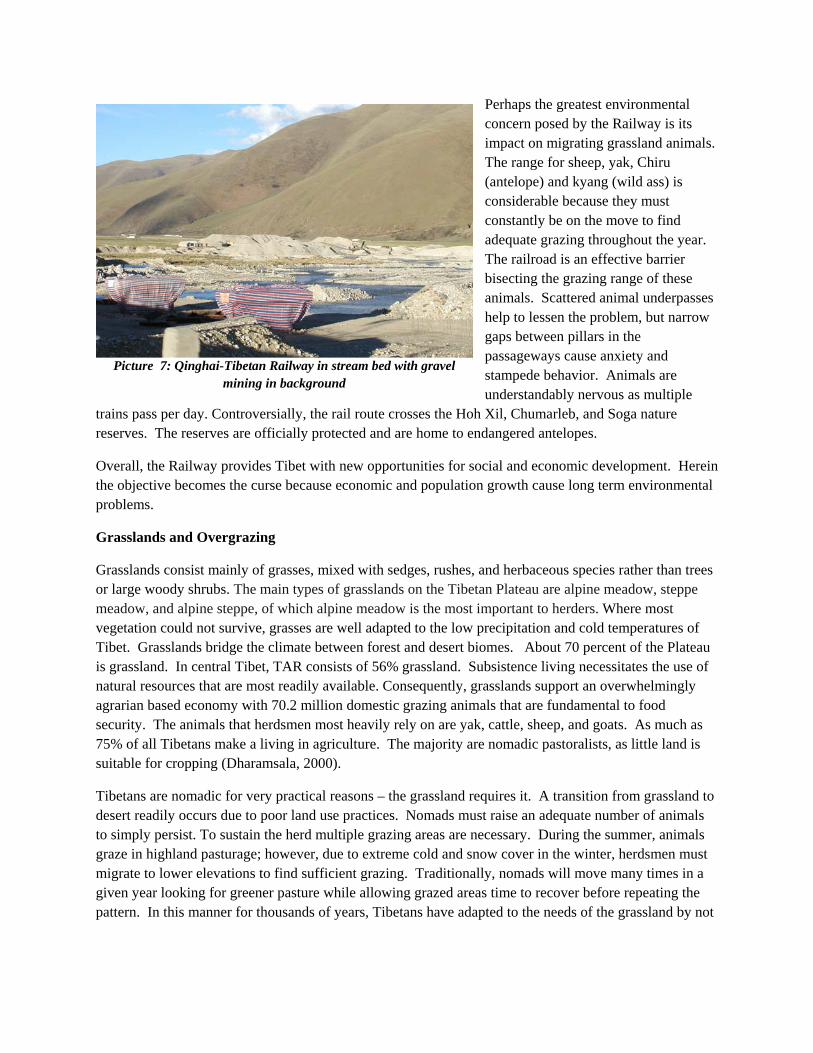
Perhaps the greatest environmental concern posed by the Railway is its impact on migrating grassland animals. The range for sheep, yak, Chiru (antelope) and kyang (wild ass) is considerable because they must constantly be on the move to find adequate grazing throughout the year. The railroad is an effective barrier bisecting the grazing range of these animals. Scattered animal underpasses help to lessen the problem, but narrow gaps between pillars in the passageways cause anxiety and stampede behavior. Animals are understandably nervous as multiple
trains pass per day. Controversially, the rail route crosses the Hoh Xil, Chumarleb, and Soga nature reserves. The reserves are officially protected and are home to endangered antelopes.
Overall, the Railway provides Tibet with new opportunities for social and economic development. Herein the objective becomes the curse because economic and population growth cause long term environmental problems.
Grasslands and Overgrazing
Grasslands consist mainly of grasses, mixed with sedges, rushes, and herbaceous species rather than trees or large woody shrubs. The main types of grasslands on the Tibetan Plateau are alpine meadow, steppe meadow, and alpine steppe, of which alpine meadow is the most important to herders. Where most vegetation could not survive, grasses are well adapted to the low precipitation and cold temperatures of Tibet. Grasslands bridge the climate between forest and desert biomes. About 70 percent of the Plateau is grassland. In central Tibet, TAR consists of 56% grassland. Subsistence living necessitates the use of natural resources that are most readily available. Consequently, grasslands support an overwhelmingly agrarian based economy with 70.2 million domestic grazing animals that are fundamental to food security. The animals that herdsmen most heavily rely on are yak, cattle, sheep, and goats. As much as 75% of all Tibetans make a living in agriculture. The majority are nomadic pastoralists, as little land is suitable for cropping (Dharamsala, 2000).
Tibetans are nomadic for very practical reasons – the grassland requires it. A transition from grassland to desert readily occurs due to poor land use practices. Nomads must raise an adequate number of animals to simply persist. To sustain the herd multiple grazing areas are necessary. During the summer, animals graze in highland pasturage; however, due to extreme cold and snow cover in the winter, herdsmen must migrate to lower elevations to find sufficient grazing. Traditionally, nomads will move many times in a given year looking for greener pasture while allowing grazed areas time to recover before repeating the pattern. In this manner for thousands of years, Tibetans have adapted to the needs of the grassland by not
Picture 7: Qinghai-Tibetan Railway in stream bed with gravel mining in background

overworking it and spoiling the source of their livelihood. So, what has changed? Why are Tibet’s grasslands suffering today?
The Tibetan Plateau is overgrazed. Livestock production is up by as much as 249% since 1978, and total meat production has increased 212% (Du et al., 2004). It does not take a trained eye to see the effects of overgrazing in Tibet. Grasses are shorn to the ground or are nonexistent and the land is deeply eroded in places (see Pictures 8). On slopes, sheet and gully erosion leave the ground completely bare. Overgrazing on marginal grasslands has caused such severe degradation that the land is becoming more desert like. Overgrazing causes desertification by destroying vegetation, decreasing soil fertility, and impeding water infiltration. Consequently, biodiversity and productivity decline. Currently, 33% of the Plateau’s grasslands are degraded, among which 16% are severely degraded (Cui, X. and Graf, H. 2009). Tibet’s grasslands have declined in size and condition as well as in their capacity to sustain the lives of
increasingly larger populations of humans and domestic livestock.
Tibet’s grasslands historically supported native perennial grasses that were highly productive and effectively stabilized the soil. A sustainable balance is achieved between livestock and grassland when grazers do not exceed nature’s ability to continually replenish desirable biomass. Because the land’s capacity to sustain a given population (carrying capacity) is not overextended, the grasslands stay healthy. However, as the number of livestock in Tibet increase, grasses are consumed in greater quantities. In time,
livestock will be forced to crop grass communities too short, and, in so doing, the metabolic reserve of plants will wane as they struggle to photosynthesize. The plants will eventually die. Further, heavy grazing will inhibit flowering and seeding, thus decreasing recruitment of new grass into the population. Native perennial grasses tend to be the most palatable and nutritious. Perennials will decline and less desirable annuals and even weedy herbs will dominate. Weedy annuals do not remain as ground cover throughout the year. Erosion will ensue, due to decreasing perennial biomass, less groundcover, and increased soil compaction from trampling. As the soil compacts, wind and water carry the productive topsoil away making it difficult for new grass or any plant to become established. It is a vicious cycle.
There are four primary reasons for overgrazing and grassland degradation: increasing human population, rising demand for meat, greater crop production, and sedentarisation. The population of Tibet is rising rapidly. Since the TAR was annexed in 1951, its population has more than doubled from 1.2 million to 2.8 million. Mortality rates have significantly dropped, and life expectancy has almost doubled to 67 years while birth rates have remained comparatively high (China Tibetology Research Center, 2008). Couple these factors with escalating migrant workers and military personnel from China, and there is little wonder as to why Tibet’s rate of population increase is so high. Resources permitting, at current rates, the TAR will once again double its population in a little over 50 years. Similar population increases have occurred throughout the greater Tibetan Plateau region. The population density of the TAR remains very
Picture 8: Severely overgrazed and eroded landscape

low at just over 2.0 people per square kilometer. This statistic leads one to believe that there is plenty of space for the growing population. In reality, overpopulation in marginal landscapes occurs in small numbers because there are few available resources. Arid and cold grasslands require large spaces for grazing animals to sustain few people. As the population of Tibet increases, people have to eke a living out of degraded land or are forced to settle in even more marginal places in search of pasturage. The land in Picture 9 is marginally too arid to support grazing. But, by necessity nomads now forage their yak here. For a sense of scale, note the tiny black yak hair tent in the top middle left of the photo. The only grazing habitats are small linear green patches of grass visible along the stream bottom. Otherwise, the land is desolate. At a very early age, children have to herd their family’s livestock great distance between suitable grazing areas.
Population increase, greater overall affluency, and changing lifestyles and food preferences are putting more demands on the production of livestock. The means to sustainably expand the market is limited. Barley, a traditional Tibetan food staple, is declining, as consumption of meat and milk rises. Food preferences in urban areas are becoming more like other provinces of China, where meat follows increasing wealth. With growing demand, pastoralists respond by raising more livestock, which further degrades the grasslands. Rather than adopting solutions which call for animal reduction and range management, the immediate needs of poverty are stronger. Those Tibetans and Chinese with the financial wherewithal have turned to irrigated pastureland to meet the need.
China’s agricultural policies in Tibet promote crop production. However, there is very little arable land. Most of the grasslands capable of supporting crops are situated along the floodplains of rivers and streams and have long been used by pastoralists. The lower elevation and microclimate of the stream valleys provide necessary forage and shelter to overwintering livestock. Agricultural polices have been successful at increasing crop yields, but at the expense of the grasslands and nomads. High yielding wheat and even rice production is particularly up, as well as other crops such as maize, mustard, millet, sorghum, buckwheat, rape-seed, and many varieties of vegetables. With improvements in dry farming techniques and irrigation, cropping has grown out the river valleys into more marginal grasslands. Consequently, available winter pasturage is especially overtaxed.
Nomadic pastoralism as a way of life is disappearing throughout the world, despite evidence that it is an effective landuse practice in marginal landscapes. The nomadic lifestyle worked very well in traditional isolated Tibet, but suffers in modern Tibet. As human population increases, survival propels herders to graze more often or raise more animals at the expense of the environment. Roads, fences, and private property further hinder the practice. In Tibet the greatest obstruction to nomadic life is direct government intervention. China sees nomadic pastoralism as a sign of being less developed. Modern countries do not have nomads. China’s official policy is one of sedentarisation, aimed at creating permanent settlements
Picture 9: Nomadic Children with marginal grazing resources in background

and improving the living standards of nomadic herders. After moving 52,000 herders and farmers in 2008, the Chinese Government plans to place 80% of Tibet’s nomads into permanent homes by 2010.
Stationary herders, in a display of affluence, tend to have more livestock than nomads (Stockholm Environment Institute United Nations Development Programme 2002). More livestock and no recovery period between gazing intervals have resulted in overgrazed and eroded grasslands adjacent to permanent settlements (see Picture 10). Without a system of grazing
rotation, settled lands are well on their way to becoming the most severely overused landscape. Modern stationary herders must borrow grazing practices from nomads to be successful.
Forest and Deforestation
The southeastern region of the Tibetan Plateau is home to extensive mountain forests. Greater precipitation, coupled with warmer temperatures, allows grasslands to transition into forests. Most of the forests on the Tibetan Plateau are located in the TAR and extend into the adjacent provinces of western Sichuan and southeast Qinghai. High elevation areas are dominated by spruce-fir forests mingled with populations of larch on cooler slopes. Rhododendrons make up the understory. In areas disturbed by cutting, fire, or wind, birch and aspen are most common. Pine-oak stands dominate at lower, moister elevations. Riparian zones support cypress and willows. Forests of evergreen oak and juniper are found at extreme elevations as high as 4,500 meters (14,763ft) before transitioning into grassland. The treeline in Tibet is the highest in the world. Amazingly, I measured scattered junipers on south facing-slopes at 4,800 meters (15,748 ft). If not for the monsoons, no forest could occupy the Plateau in such abundance and diversity and at such heights. Valley topography, functioning like a funnel, concentrates and forces the wet monsoon to travel high into the mountains. The variety and complexity of ecological niches along a highly livable altitudinal gradient make it a biodiversity hotspot. Tibetan forests are truly unique in their habitats of extremes.
Combined, the forests of Southwestern Tibet are home to China’s largest timber resource, and these forests are being cut at an alarming rate. Enormous clear-cuts fragment the landscape (see Picture 11). The sheer size of the forests perpetuated the belief that they were inexhaustible. Unlike grasslands, human population pressure is less of a reason for forest destruction. Planned commercial timber harvest is the primary culprit. China designated the region as its second major timber production base in the early 1950’s. Since that time, much indiscriminate clear cutting has proceeded. Timber is in demand to build China’s infrastructure, feed its expanding economy, and to support local government enterprise such as
Picture 10 Stationary herding causing extensive erosion around village

healthcare and education. Timber sales are one of the most important sources of revenue for local administrations in forested areas. As a result, over the past 50 years, Tibet’s forests have been reduced by nearly half (Dharamsala, H.P., 2000). Forty-five percent of all forests in the TAR have been cut. Sichuan has lost more of it trees than any other Tibetan Plateau region. Between 1950 and 1998, forest cover here fell from 30% to 6.5% (Studley, 1999).
The consequence of unregulated deforestation to culture and environment is disastrous. Deforestation displaces Tibetans that dwell in or need access to the forest to sustain their traditional way of life. They benefit the least from the sale of timber, and the source of their livelihood is depleted. Forests are traditionally regarded as common property for grazing animals, cutting fuel and construction timber, and gathering food and medicine. When wood becomes scarce, it falls to children to
range increasingly greater distances from home to find adequate supplies for cooking and heating (see picture 12). Gathering matsutake mushrooms in pine-oak forests for export to Japan or harvesting deer antlers for traditional Chinese medicines is big business, providing a large portion of the annual income to locals. The decision to cut the forests encroaches on the rights of indigenous populations and deprives them of basic resources.
The physical impacts of deforestation on the landscape are soil compaction and erosion, loss of fertility, and flooding. When trees are cut, the soil is directly exposed to the elements rather than being buffered by a protective layer of vegetation. Alternating conditions of heating and freezing and saturation and drying will cause the soil to compact. Now water will run freely over the surface causing erosion and washing out nutrients and organics that contribute to fertility, making it difficult for new plants to reestablish. In extreme
cases, where Tibetans are overworking the cleared land via intensively raising crops or grazing livestock, desertification will result.
Trees absorb water and help maintain climate and water balance in the watershed. They also impede overland flow of water during rainfall and reduce erosion by providing cover. Without trees, the occurrence, duration, and intensity of floods increase. Deforestation in multiple small tributary stream
Picture 12: Nomadic girl gathering meager wood resources using traditional basket and tumpline
Picture 11: Large spruce-fir forest clear-cut at headwaters of the Yangtze River of far western Sichuan

valleys causes a cumulative flooding effect on large downstream rivers where a billion people live. The Yangtze, Brahmaputra, Mekong, and Salween are among the mightiest rivers in the world and have source regions in the forests of southeastern Tibet. The cause of flooding is not readily apparent, as it occurs far away. However, rivers are a continuum, and what happens upstream is sure to be felt downstream. After devastating floods on the Yangtze River in 1998 that claimed more than 3,650 lives, left 14 million homeless, and cost US$30 billion in damage, the Chinese government recognized the consequences of deforestation in Tibet on flooding. A new forest policy was enacted called the Natural Forest Conservation Program that created forest protection and afforestation. Unfortunately, enforcing the policy has been problematic. Satellite imagery of protected areas since the ban reveals continued cutting. Despite concerns, commercial deforestation would be worse if not for the ban.
Most deforestation is due to commercial logging; however, other traditional human activities also contribute. Subsistence deforestation immediately adjacent to settlements is universal. Local villages require wood for building, cooking, and heating. With increasing distance from villages larger trees are cut, but are left on the ground because they are too heavy to transport. Smaller trees are cut and carried back the settlement for use. Typically, beyond an hour’s walking distance from villages, forests in well watered climates recover.
I visited a large number of forest clearings well away from settlements that were surprisingly created by subsistence dwellers. The difference between commercial and subsistence felled trees was easy to discern, as chainsaws and axes leave very different cut marks on residual stumps. Tibetans do not own chainsaws. I found it puzzling that timber in fresh-cut subsistence clearings lay on the ground where it was felled. The wood was not being used. This seemed out of character with the land ethic of Tibetans. In fact, the land was being used for grazing and the inordinate number of cows, goats, and, horses provided the evidence. Locals open the forest to promote sunshine and the growth of grasses. Grassland grazing is superior to forest browsing. Tibetans have a long history of clearing forests to create pastureland, but most of the evidence - trees- has long been removed. Consistent grazing prohibited trees from becoming reestablished. Seedstock
diminished with cutting and over time, forests converted to grassland. Historically, forests would have been found further west to regions that are now arid grassland. Patches of forest may have existed well into central Tibet and even to Lhasa. Rainfall in the Lhasa region is sufficient to support juniper forests. The existence of relict forests found around monasteries in central Tibet suggests a larger distribution. These forests survived because they were
Picture 13: Children on break from herding livestock into commercial clear-cuts to graze

sacred. Individual trees and small stands also dot scores of pasturelands providing evidence of past forests (Winkler, 1998).
I commonly found commercial clear-cuts that were made larger by subsistence cutting. Forest pastoralists will travel great distances to reach these clearings. The children in Picture 13 drove their family’s cows and horses into commercially deforested clearing each day. The clear-cuts afford pastoralist to have larger and healthier herds. Commercial deforestation benefits forest pastoralists as long as physical conditions continue to support grasslands. Issues of flooding, water quality, and biodiversity losses are less tangible than the immediate need to raise livestock.
Conclusion
In Tibet, isolation and tradition are as deep as the land is vast (see Picture 14). But, China compels modernity and, willingly or not, Tibet is going global. Development at all costs takes precedence over cultural and landscape change. Modernity is not improving the living standard of Tibetans at the same pace that it is changing and impairing the landscape. The Qinghai-Tibetan Railway has created social and economic opportunities at the expense of tradition and the environment. While the Railway is intrusive, lessons were learned - good stewardship has sustained value. Grasslands cover most of the Tibetan Plateau. They shape the region’s identity and form the basis for most livelihoods. These lands are fragile, and poor grazing practices beckon desert-like conditions. The rapidly increasing human population on the Plateau leaves little elbowroom for a landuse that requires vast amounts of space. Tibetan forests are complex and rich in life, because they range along an elevational gradient of extremes. Unfortunately, forests are being cut at an alarming rate by commercial loggers and, to a lesser degree, by pastoralists. It is easy to blame China for landscape-wide degradation of grasslands and forests; but, the reality is that traditional practices play a role. Immediate needs place more livestock on the land and fell more trees. However, with care and cooperation, landscapes can recover. Land is the stage upon which the drama of life unfolds, and like no other place, in Tibet, the stage remains uncertain.
Picture 14 Traditional Nomad on horseback traversing characteristically isolated and vast Tibet Plateau

References
China Tibetology Research Center. 2009. Report on the economic and social development of Tibet. http://en.chinagate.cn/features/2009-03/30/content_17522525.htm (last accessed 7/23/2009)
Cui, X. and Graf, H. 2009. Recent land cover changes on the Tibetan Plateau: A review. Journal of Climatic Change 94(1-2):47-61.
Dharamsala, H.P. 2000. Tibet 2000: Environment and development issues. Environment and Development Desk, DIIR, Central Tibetan Administration.
Du, M., Kawashima, S., Yonemura, S., Zhang, X., and Chen, S. 2004. Mutual influence between human activities and climate change in the Tibetan Plateau during the recent years. Global and Planetary Change 41(3–4):241–249.
Peng, C., Ouyang, H., Gao, Q., Jiang, Y., Zhang, F., Li, J., and Yu, Q. Building a “green” railway in China. Science 316:546–547.
Stockholm Environment Institute. 2002. China human development report 2002 - Making green development a choice, United Nations Development Programme, China. Hong Kong: Oxford University Press.
Studley, J. 1999. Forests and environmental degradation in SW China. International Forestry Review 1(4):260–265.
Winkler, D. 1998. Deforestation in Eastern Tibet: Human impact - Past and present. In Clarke, G.E. (Ed.). Development, society and environment in Tibet, Papers presented at the Panel of the 7th Seminar International Association for Tibetan Studies (IATS) Graz 1995. Proc. 7th Seminar IATS, vol.5, Vienna.
Zhanga, T., Harry, T., Baker, W., Cheng, G., and Wuc, Q. 2008. The Qinghai–Tibet Railroad: A milestone project and its environmental impact. Cold Regions Science and Technology 53:229-240.