Embed Size (px)
Citation preview

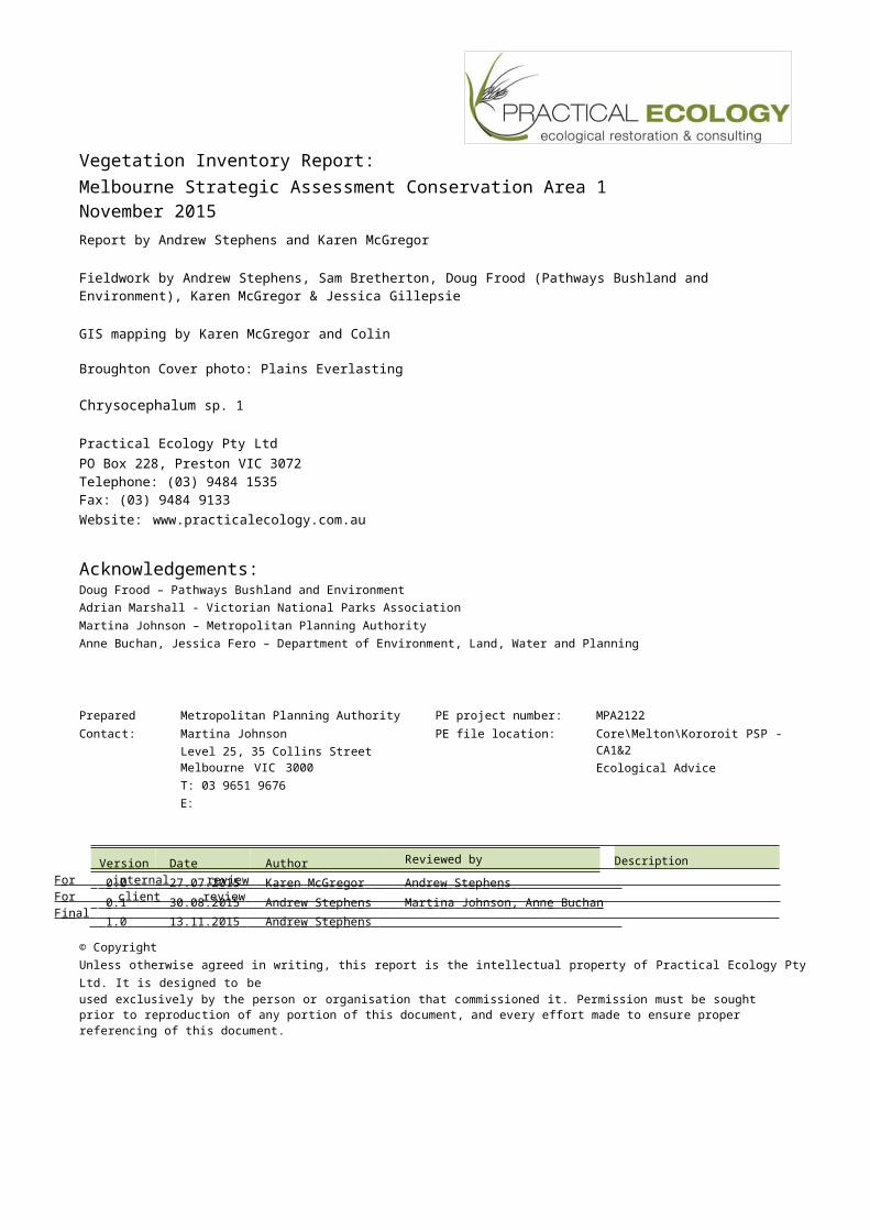
Vegetation Inventory Report:Melbourne Strategic Assessment
Conservation Area 1November 2015
Version Date Author Reviewed by 0 . 0 27 . 07 . 2 015 K a r e n M cG r e g o r A n d re w S t e p h e n s 0 . 1 30 . 08 . 2 015 A n d re w S t e p h e n s M a r t i n a J o h n s o n , A n n e B u c h a n 1 . 0 13 . 11 . 2 015 A n d re w S t e p h e n s
Vegetation Inventory Report:Melbourne Strategic Assessment Conservation Area 1November 2015Report by Andrew Stephens and Karen McGregor
Fieldwork by Andrew Stephens, Sam Bretherton, Doug Frood (Pathways Bushland and Environment), Karen McGregor & Jessica Gillepsie
GIS mapping by Karen McGregor and Colin
Broughton Cover photo: Plains Everlasting
Chrysocephalum sp. 1
Practical Ecology Pty LtdPO Box 228, Preston VIC 3072Telephone: (03) 9484 1535Fax: (03) 9484 9133Website: www.practicalecology.com.au
Acknowledgements:Doug Frood – Pathways Bushland and EnvironmentAdrian Marshall - Victorian National Parks AssociationMartina Johnson – Metropolitan Planning AuthorityAnne Buchan, Jessica Fero – Department of Environment, Land, Water and Planning
Prepared for: Metropolitan Planning Authority PE project number: MPA2122Contact: Martina Johnson
Level 25, 35 Collins StreetMelbourne VIC 3000T: 03 9651 9676E: [email protected]
PE file location: Core\Melton\Kororoit PSP - CA1&2Ecological Advice
DescriptionF o r i n t e rn a l r e v i e w F o r c li e n t re v i e w F i n a l
© CopyrightUnless otherwise agreed in writing, this report is the intellectual property of Practical Ecology Pty Ltd. It is designed to beused exclusively by the person or organisation that commissioned it. Permission must be sought prior to reproduction of any portion of this document, and every effort made to ensure proper referencing of this document.
V e g e t a t i o n I nv e n t o r y R e p o r t M S A C o n s e r v a t i o n A r e a 1
3
Rep_Footer
Terms and abbreviationsBCS Biodiversity Conservation Strategy for Melbourne’s Growth Areas (DEPI
2013a) CaLP Act The Victorian Catchment and Land Protection Act 1994
DELWP The Victorian Department of Environment, Land, Water and the Environment
DEPI The former Victorian Department of Environment and Primary Industries (now
DELWP) DSE The former Victorian Department of Sustainability and Environment (now
DELWP) EPBC Act The Federal Environment Protection and Biodiversity Conservation Act
1999
EVC Ecological Vegetation Class, the units used to describe vegetation type in Victoria
FFG Act The Victorian Flora and Fauna Guarantee Act 1988
MNES Matters of National Environmental Significance, as listed under the EPBC-
Act. NTG Natural Temperate Grassland of the Victorian Volcanic Plain
SHW Seasonal Herbaceous Wetlands (Freshwater) of the Temperate Lowland
Plains WGR Western Grassland Reserve
Rep_Footer
V e g e t a t i o n I nv e n t o r y R e p o r t M S A C o n s e r v a t i o n A r e a 1
4
Contents1. INTRODUCTION 6
1.1 Purpose and scope 71.2 Survey area 81.3 Previous survey information 9
2. SURVEY METHODS 102.1 Coverage and intensity 102.2 Definitions 10
3. SURVEY RESULTS 123.1 EPBC-listed ‘Matters of National Environmental Significance’ 12
3.1.1 Natural Temperate Grassland of the Victorian Volcanic Plain (NTG) 123.1.2 Spiny Rice-flower Pimelea spinescens subsp. spinescens 143.2 FFG-listed values 143.3 Ecological Vegetation Classes 153.4 Vegetation Patterns: Natural Temperate Grassland ‘States’ 173.5 Plant taxa 21
3.5.1 National and State significant native taxa 213.5.2 Weeds 233.6 Hot Spots 25
4. REFERENCES 26Appendix 1. List of vascular plants identified 27
TABLESTable 1. Plant taxa listed under the EPBC Act, FFG Act or on the DELWP Advisory List (VROT) (DEPI
2014b). 21Table 2. Declared noxious weeds recorded on the surveyed land 23
FIGURESFigure 1. The location of Conservation Area 1 8Figure 2. Natural Temperate Grassland (NTG) in Conservation Area 2; Wallaby Grass
Rytidosperma spp. is dominant in the foreground beyond which Kangaroo Grass Themeda triandra canbe seen to dominate much of the site. 13
Figure 3. The distribution of Natural Temperate Grassland (NTG) at CA1 13Figure 4. A young Spiny Rice-flower Pimelea spinescens subsp. spinescens at Conservation Area
1. 14Figure 5. The current distribution of native vegetation classified according to EVC 15Figure 6. The likely pre-1750 distribution of Ecological Vegetation Classes 16Figure 7. States of Natural Temperate Grassland Habitat 17Figure 8. Herb-rich Grassland: overall non-grass herb-cover is relatively low. 18Figure 9. Herb-rich Grassland: pockets dominated by non-grass herbs are scattered throughout,
such as this area dominated by Plains Everlasting Chrysocephalum sp. 1. 18Figure 10. C3 Grassland in the south-east of the site 19
Rep_Footer
V e g e t a t i o n I nv e n t o r y R e p o r t M S A C o n s e r v a t i o n A r e a 1
5
Figure 11. De-rocked Nutrient-enriched Pasture (cropped land) includes the existing (empty) dam on site. 20
Figure 12. The locations of National and State significant plant taxa (i.e. EPBC Act, FFG Act or on theDELWP Advisory List (DEPI 2014b)). 22
Figure 13. The locations of selected weed species. Note Nassella trichotoma and Cynara cardunculus are widespread and are not shown. 24
Figure 14. Distribution of ‘hot spot’ at Conservation Area 1. 25
Rep_Footer
V e g e t a t i o n I nv e n t o r y R e p o r t M S A C o n s e r v a t i o n A r e a 1
6
1. INTRODUCTION
The Victorian Government has committed to establish a series of Conservation Areas on the periphery of Melbourne for the conservation of threatened plants, animals and ecological communities (DEPI 2013a). They include a network of small areas within Melbourne’s Urban Growth Boundary, as well as the larger Western Grassland Reserve (WGR, 15,000 ha) and the Grassy Eucalypt Woodland Reserve (approximately 1,200 ha).
The establishment of the reserves is the result of the Melbourne Strategic Assessment, which aims to mitigate environmental losses caused by the expansion of Melbourne’s Urban Growth Boundary. This expansion will impact ‘Matters of National Environmental Significance (MNES)’ listed under the Federal Environment Protection and Biodiversity Conservation Act 1999 (EPBC Act). A ‘Strategic Impact Assessment’ conducted by the Victorian Government recommended ways of mitigating environmental impacts. The mitigation measures agreed to by the Victorian and Australian governments are outlined in the ‘Program Report’ and the ‘Biodiversity Conservation Strategy (DEPI 2013a; DSE 2009). The commitments include regular reporting on ecological outcomes. A Monitoring and Reporting Framework (MRF) provides the logic and basis for monitoring target species and communities. The MRF gives specific Key Performance Indicators (KPIs) for each listed species and vegetation community.
All Conservation Areas will be managed to achieve these management targets. The precise management strategy required to achieve the targets will, however, vary from place to place. Each area is different, and each supports a wide range of plant and animal species, different vegetation patterns, management issues, and other features. Detailed information about the type and distribution of assets and threats is required for each property that is protected. Much of that information will be contained in Fauna Inventory and Vegetation Inventory documents for each property.
The Metropolitan Planning Authority (MPA) is developing the Kororoit Precinct Structure Plan (PSP) which will guide development of the area for housing, local town centres (including shops, services and Council and educational facilities) and conservation areas.
Three conservation areas (CA1, 2 & 3) in the Kororoit PSP were designated for protection in the Biodiversity Conservation Strategy for Melbourne’s Growth Corridors (DEPI 2013a). Draft Conservation Concept Plans have been prepared for each of these areas, but further design work is now required for two of the designated conservation areas to:
ensure the long term viability and protection of the grasslands and Spiny Rice-flower.
increase the community’s appreciation and acceptance of the value of grassland conservation areas within residential areas.
ensure greater 'open space' benefit to the public from areas reserved for conservation through the strategic placement and use of access points, picnic and play areas, paths, trails, boardwalks, interpretive signage etc.
This Vegetation Inventory report will help to inform preparation of a landscape masterplans for Conservation Area 1 (13 ha) within the Kororoit PSP area.
Rep_Footer
V e g e t a t i o n I nv e n t o r y R e p o r t M S A C o n s e r v a t i o n A r e a 1
7
1.1 Purpose and scope
This Vegetation Inventory report forms part of the basic information required to start managing protected land. It should serve as a useful reference for managers, and also the logical basis of management actions. The specific purpose of this document is to:
Identify and map any EPBC-listed plant species or ecological communities that are the targets of conservation measures under the MSA.
Provide enough information about the distribution of vegetation on the land to allow management and landscape design planning to proceed. This information includes the distribution of native vegetation types, significant species, and exotic species which threaten natural values.
Help fulfil (for the survey area) DELWP’s commitment to produce a detailed inventory of the vegetation
This document does not:
constitute a management plan,
describe the fauna of the survey area,
make any claims about the likely presence or absence of values not recorded.
Rep_Footer
V e g e t a t i o n I nv e n t o r y R e p o r t M S A C o n s e r v a t i o n A r e a 1
8
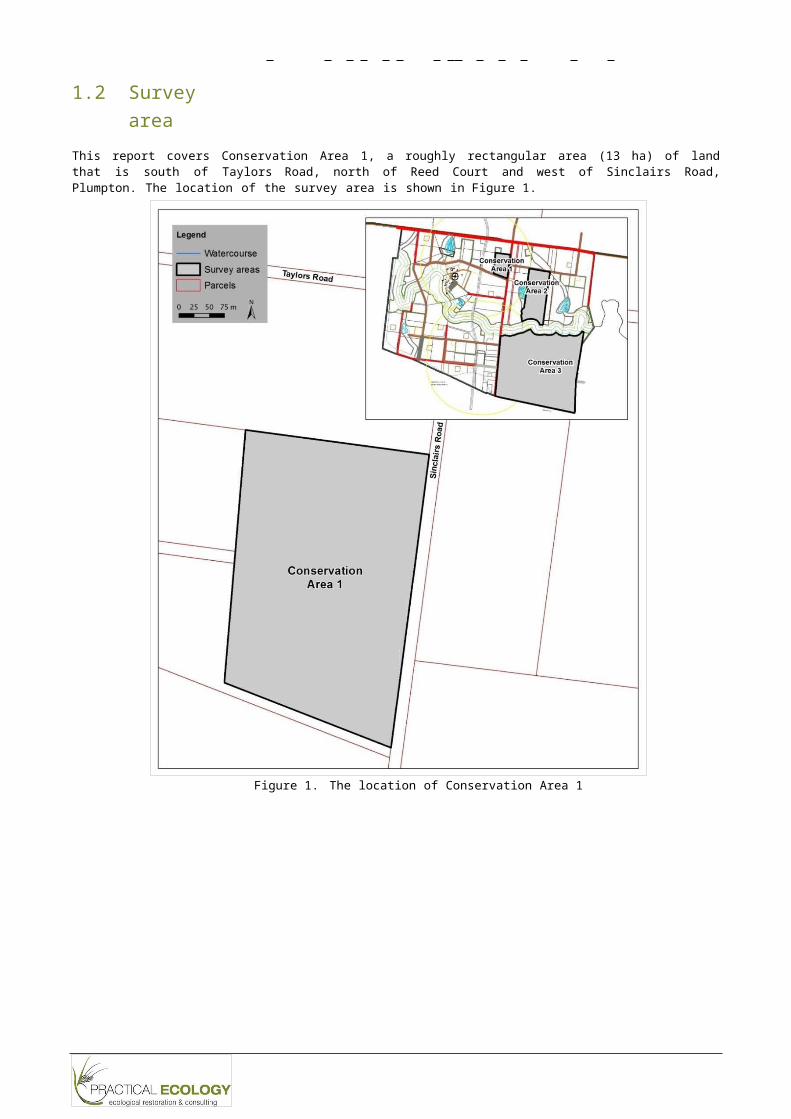
1.2 Survey area
This report covers Conservation Area 1, a roughly rectangular area (13 ha) of land that is south of Taylors Road, north of Reed Court and west of Sinclairs Road, Plumpton. The location of the survey area is shown in Figure 1.
Figure 1. The location of Conservation Area 1
Rep_Footer
V e g e t a t i o n I nv e n t o r y R e p o r t M S A C o n s e r v a t i o n A r e a 1
9
1.3 Previous survey informationThe area has been subject to the following known vegetation surveys/reports:
The Growth Areas Authority (2010a) included the area in the Melton-Wyndham Investigation Area: Section H assessed by Biosis Research; this work included habitat hectare assessment and general floristic survey.
Biosis Research (Franco and McCutcheon 2011) again surveyed the site, as it was included in the Rockbank Marsh 1080 Contract Area for the Growth Areas Authority; this work included targeted flora surveys undertaken during spring (over 5 days early November 2010), summer (5 days through February 2011) and were also proposed for autumn/early winter (May-June 2011) but no data is included in the report.
The Biodiversity Conservation Strategy (BCS) (DEPI 2013a) presents information for the site including native vegetation habitat score and records of rare or threatened species. While numerous references are included it is unclear of the source of each item of information. It is also apparent that the records of Spiny Rice-flower records presented in the BCS are not spatially correctly as they are inconsistent with the source report (i.e. Franco and McCutcheon 2011).
Rep_Footer
V e g e t a t i o n I nv e n t o r y R e p o r t M S A C o n s e r v a t i o n A r e a 1
1
2. SURVEY METHODS
The site was surveyed using the methods described in (DELWP 2015a) and also included a targeted flora survey for Spiny Rice-flower Pimelea spinescens subsp. spinescens using the methods in DSE (2010) (e.g. 5m spaced transects).
2.1 Coverage and intensity
The land was surveyed during the following days in August 2015: 23rd (8 hrs by two botanists), 27th (2 hrs by two botanists), 30th (3 hrs by two botanists). Of that time essentially 4hrs (2hrs x two botanists) was devoted to a general floristic inventory and vegetation mapping and the remainder used for targeted flora survey (e.g. transects).
2.2 DefinitionsNative vegetation
‘Native vegetation’ is defined according to DEPI (2013b) “…either…an area of vegetation where at least 25 per cent of the total perennial understory plant cover is native, or any area with three or more canopy trees where the canopy foliage cover is at least 20 per cent of the area”.
EPBC-listed communities
EPBC-listed communities are described according to the listing advice provided by the Threatened Species Scientific Committee, posted on the Department of Environment website.
Plant taxonomy
Plant taxonomy follows the Royal Melbourne Botanic Gardens Census of Vascular Plants in Victoria (Walsh and Stajsic 2007) except for departures from this standard within the Victorian Biodiversity Atlas (DEPI 2014a) due to more recent taxonomic publications.
Significance of plants
Several sources are used to describe the conservation status or significance of plant species:
EBPC listed (Critically Endangered, Endangered, Vulnerable). Follows the lists of species and communities maintained by the Australian Department of the Environment, available on the internet.
FFG listed. Follows the list maintained by DELWP (updated 2013).
Victorian Rare or Threatened (VROT; Endangered in Victoria, Vulnerable in Victoria, Rare in Victoria, Poorly Known). Defined by inclusion on either the ‘Advisory List of Rare or Threatened Plants in Victoria’ (DEPI 2014b), maintained by DELWP.
Rep_Footer
V e g e t a t i o n I nv e n t o r y R e p o r t M S A C o n s e r v a t i o n A r e a 1
1
Categories of Weeds
The Victorian Catchment and Land Protection Act 1994 (CaLP Act) lists noxious weeds in several categories, used here:
State prohibited weeds “either do not occur in Victoria but pose a significant threat if they invade, or are present, pose a serious threat and can reasonably be expected to be eradicated. If present, infestations of a State prohibited weed are relatively small. They are to be eradicated from Victoria if possible or excluded from the State.”
Regionally prohibited weeds “are not widely distributed in a region but are capable of spreading further. It is reasonable to expect that they can be eradicated from a region and they must be managed with that goal. Land owners, including public authorities responsible for crown land management, must take all reasonable steps to eradicate regionally prohibited weeds on their land”.
Restricted weeds are “plants that pose an unacceptable risk of spreading in this State and are a serious threat to another State or Territory of Australia. Trade in these weeds and their propagules; either as plants, seeds or contaminants in other materials is prohibited”.
Regionally Controlled weeds are “usually widespread in a region. To prevent their spread, ongoing control measures are required. Land owners have the responsibility to take all reasonable steps to prevent the growth and spread of Regionally controlled weeds on their land.”
Rep_Footer
V e g e t a t i o n I nv e n t o r y R e p o r t M S A C o n s e r v a t i o n A r e a 1
1
3. SURVEY RESULTS
3.1 EPBC-listed ‘Matters of National Environmental Significance’
Matters of National Environmental Significance (MNES) are those species or communities listed under the EPBC Act. MNES are the specific environmental values referred to by the Key Performance Indicators and targets (DELWP 2015b).
Two matters of national environmental significance are known to occur naturally at the study site:
Natural Temperate Grassland of the Victorian Volcanic Plain (hereafter NTG)
A population of Spiny Rice-flower Pimelea spinescens subsp. spinescens
3.1.1 Natural Temperate Grassland of the Victorian Volcanic Plain (NTG)
NTG is a treeless grassland community occurring on heavy soils on basalt terrain, dominated in intact stands by native tussock-forming grasses of the genera Themeda, Poa, Rytidosperma and/or Austrostipa. It also contains a variety of native herbs (notably daisies, Asteraceae), which may be dominant in some cases (TSSC 2008). NTG corresponds closely to ‘Western (Basalt) Plains Grassland Community’ listed under the FFG Act (see below).
In the NTG at the site Kangaroo Grass Themeda triandra is the dominant grass species with Wallaby-grasses Rytidosperma spp. and Spear-grasses Austrostipa spp. also common and more dominant in lower quality areas. Forbs can also dominate some small areas, although are often sparse across much of the site. The forbs found commonly at this site include: Narrow Plantain Plantago gaudichaudii, Cut-leaf Goodenia Goodenia pinnatifida, Plains Stackhousia Stackhousia subterranea, Grassland Wood-sorrel Oxalis perennans, Lemon Beauty-heads Calocephalus citreus, Plains Everlasting Chrysocephalum sp. 1. and Cotton Fireweed Senecio quadridentatus. Spiny Rice-flower also occurred throughout.
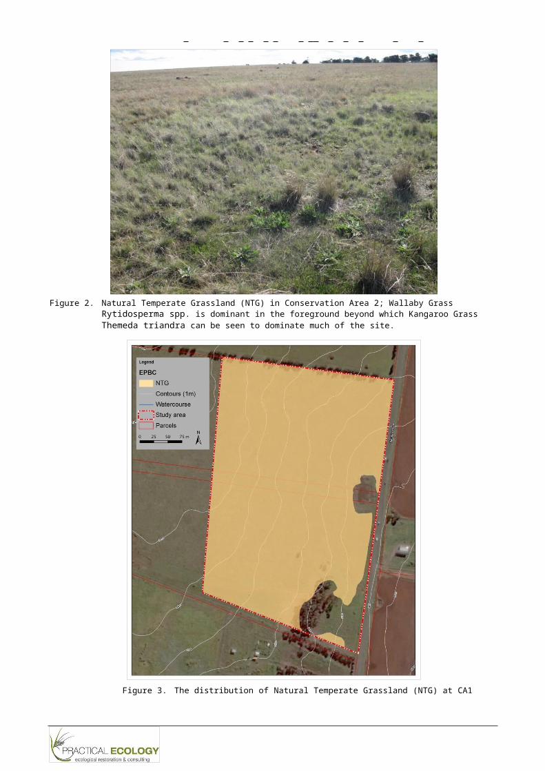
NTG covers most of the surveyed land (12 ha, 91%). An area of NTG on the property is shown in Figure 2. The distribution of the community on the property is shown in Figure 3.
Rep_Footer
V e g e t a t i o n I nv e n t o r y R e p o r t M S A C o n s e r v a t i o n A r e a 1
1
Figure 2. Natural Temperate Grassland (NTG) in Conservation Area 2; Wallaby Grass Rytidosperma spp. is dominant in the foreground beyond which Kangaroo Grass Themeda triandra can be seen to dominate much of the site.
Figure 3. The distribution of Natural Temperate Grassland (NTG) at CA1

Rep_Footer
V e g e t a t i o n I nv e n t o r y R e p o r t M S A C o n s e r v a t i o n A r e a 1
1
3.1.2 Spiny Rice-flower Pimelea spinescens subsp. spinescens
Spiny Rice-flower Pimelea spinescens subsp. spinescens is a stunted sub-shrub that grows to 30 cm high. It is limited to the basalt plains of Victoria and listed as critically endangered under the EPBC Act (Department of Environment 2015). Spiny Rice-flower is shown in Figure 4.
Habitat for the species was traversed in transects 5m apart. The total number of individuals recorded was 69. The location of these records are shown in Figure 12 (Section 3.5.1). Note that the distribution is considerably different to the locations shown in the Biodiversity Conservation Strategy (DEPI 2013a) which appears to be due to errors in the spatial data presented in the BCS(i.e. the location of the individuals has not changed).
Figure 4. A young Spiny Rice-flower Pimelea spinescens subsp. spinescens at Conservation Area 1.
3.2 FFG-listed values
The Flora and Fauna Guarantee Act 1988 (FFG Act) is the primary Victorian legislation dedicated to the conservation of threatened species and communities. Although the structure of the MSA do not directly relate to the FFG Act, FFG-listed assets provide a useful structure for considering the status of the values on the property.
One FFG-listed community occurs:- ‘Western (Basalt) Plains Grassland Community’, which corresponds directly with the EVC
Plains Grassland, discussed below (Section 3.3).

Rep_Footer
V e g e t a t i o n I nv e n t o r y R e p o r t M S A C o n s e r v a t i o n A r e a 1
1
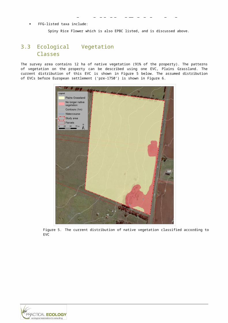
FFG-listed taxa include:Spiny Rice Flower which is also EPBC listed, and is discussed above.
3.3 Ecological Vegetation Classes
The survey area contains 12 ha of native vegetation (91% of the property). The patterns of vegetation on the property can be described using one EVC, Plains Grassland. The current distribution of this EVC is shown in Figure 5 below. The assumed distribution of EVCs before European settlement (‘pre-1750’) is shown in Figure 6.
Figure 5. The current distribution of native vegetation classified according to EVC
Rep_Footer
V e g e t a t i o n I nv e n t o r y R e p o r t M S A C o n s e r v a t i o n A r e a 1
1
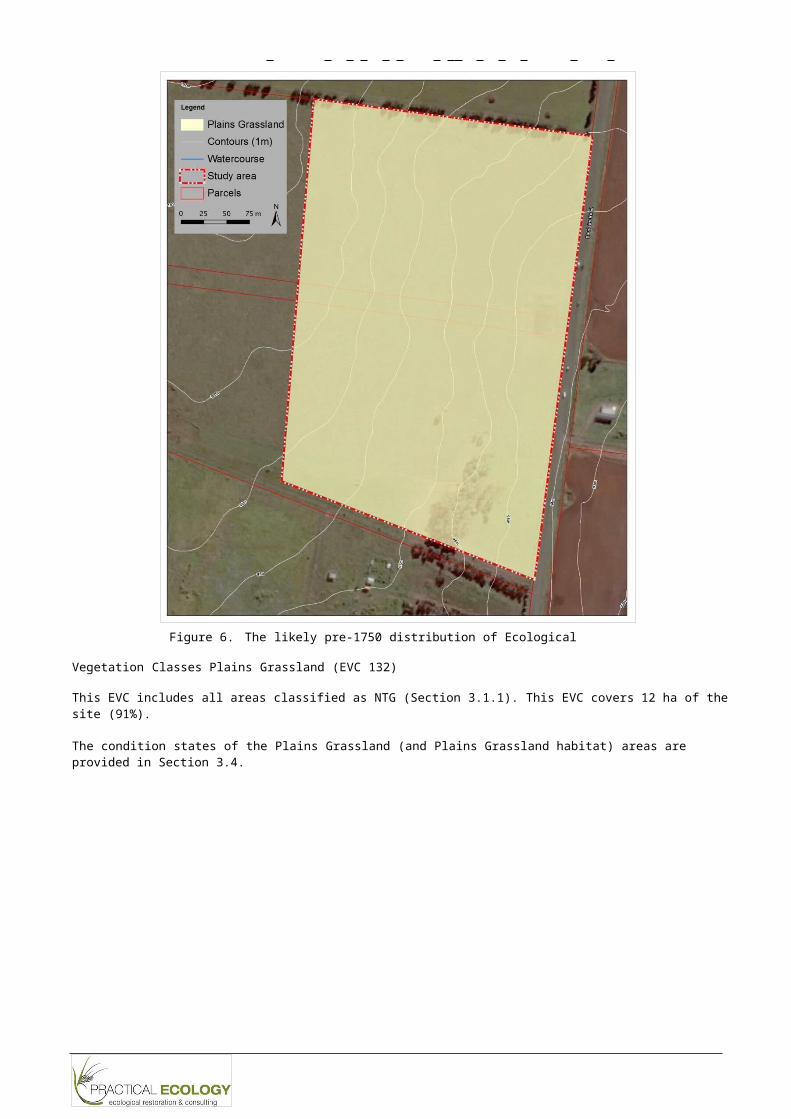
Figure 6. The likely pre-1750 distribution of Ecological Vegetation
Classes Plains Grassland (EVC 132)
This EVC includes all areas classified as NTG (Section 3.1.1). This EVC covers 12 ha of the site (91%).
The condition states of the Plains Grassland (and Plains Grassland habitat) areas are provided in Section 3.4.
Rep_Footer
V e g e t a t i o n I nv e n t o r y R e p o r t M S A C o n s e r v a t i o n A r e a 1
1
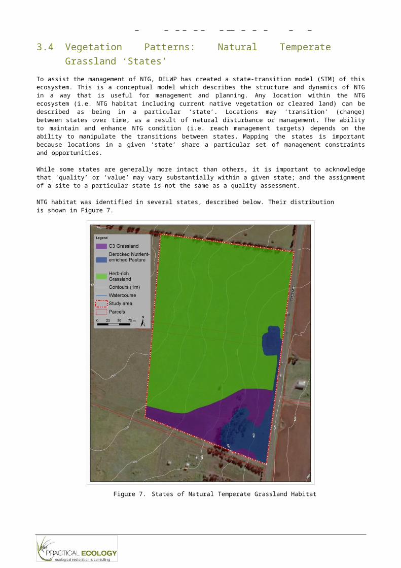
3.4 Vegetation Patterns: Natural Temperate Grassland ‘States’
To assist the management of NTG, DELWP has created a state-transition model (STM) of this ecosystem. This is a conceptual model which describes the structure and dynamics of NTG in a way that is useful for management and planning. Any location within the NTG ecosystem (i.e. NTG habitat including current native vegetation or cleared land) can be described as being in a particular ‘state’. Locations may ‘transition’ (change) between states over time, as a result of natural disturbance or management. The ability to maintain and enhance NTG condition (i.e. reach management targets) depends on the ability to manipulate the transitions between states. Mapping the states is important because locations in a given ‘state’ share a particular set of management constraints and opportunities.
While some states are generally more intact than others, it is important to acknowledge that ‘quality’ or ‘value’ may vary substantially within a given state; and the assignment of a site to a particular state is not the same as a quality assessment.
NTG habitat was identified in several states, described below. Their distribution is shown in Figure 7.
Figure 7. States of Natural Temperate Grassland Habitat
Rep_Footer
V e g e t a t i o n I nv e n t o r y R e p o r t M S A C o n s e r v a t i o n A r e a 1
1
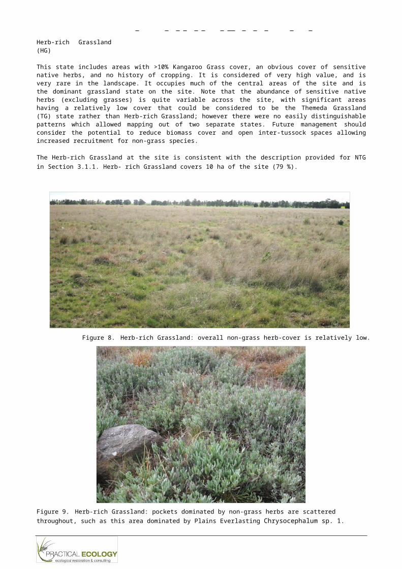
Herb-rich Grassland (HG)
This state includes areas with >10% Kangaroo Grass cover, an obvious cover of sensitive native herbs, and no history of cropping. It is considered of very high value, and is very rare in the landscape. It occupies much of the central areas of the site and is the dominant grassland state on the site. Note that the abundance of sensitive native herbs (excluding grasses) is quite variable across the site, with significant areas having a relatively low cover that could be considered to be the Themeda Grassland (TG) state rather than Herb-rich Grassland; however there were no easily distinguishable patterns which allowed mapping out of two separate states. Future management should consider the potential to reduce biomass cover and open inter-tussock spaces allowing increased recruitment for non-grass species.
The Herb-rich Grassland at the site is consistent with the description provided for NTG in Section 3.1.1. Herb- rich Grassland covers 10 ha of the site (79 %).
Figure 8. Herb-rich Grassland: overall non-grass herb-cover is relatively low.
Figure 9. Herb-rich Grassland: pockets dominated by non-grass herbs are scattered throughout, such as this area dominated by Plains Everlasting Chrysocephalum sp. 1.
V e g e t a t i o n I nv e n t o r y R e p o r t M S A C o n s e r v a t i o n A r e a 1
Rep_Footer
1
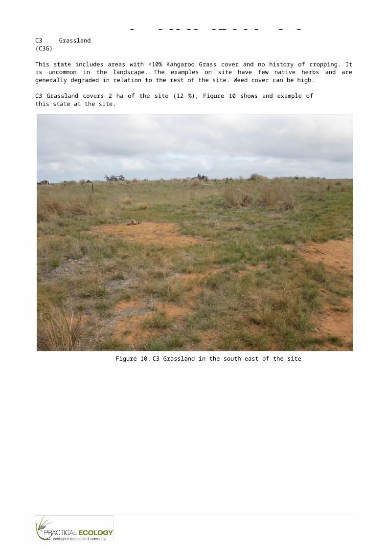
C3 Grassland (C3G)
This state includes areas with <10% Kangaroo Grass cover and no history of cropping. It is uncommon in the landscape. The examples on site have few native herbs and are generally degraded in relation to the rest of the site. Weed cover can be high.
C3 Grassland covers 2 ha of the site (12 %); Figure 10 shows and example of this state at the site.
Figure 10. C3 Grassland in the south-east of the site
V e g e t a t i o n I nv e n t o r y R e p o r t M S A C o n s e r v a t i o n A r e a 1
Rep_Footer
2
De-rocked Nutrient-enriched Pasture (DNP)
This state includes previously ploughed areas with less than 25% cover of native grasses. It includes the south- east of the site and along the eastern boundary, including an existing dam (Figure 11). The south-eastern area includes a portion with planted Sugar Gum Eucalyptus cladocalyx, which are regenerating in the adjacent grassland areas.
De-rocked Nutrient-enriched Pasture covers 1ha of the site (9 %).
Figure 11. De-rocked Nutrient-enriched Pasture (cropped land) includes the existing (empty) dam on site.

Rep_Footer
Microseris scapigera s.s. Plains Yam-daisy v Recorded in BCS, DELWP advisesrecords are from ‘GAA 3’(2010/2011) – is was not seen inthis study but likely to be not
V e g e t a t i o n I nv e n t o r y R e p o r t M S A C o n s e r v a t i o n A r e a 1
2
3.5 Plant taxa
One hundred and thirteen vascular plant taxa have been recorded as naturally occurring on the surveyed land. Forty-seven (47) of the 111 taxa are native (42%).
Appendix 1 lists all of the vascular plant species recorded. Due to the seasonality of assessment and limited survey period this should be considered a preliminary list that should be refined with future survey work (for instance Growth Areas Authority (2010b) note Chocolate Lily Arthropodium strictum occurring on the property (a larger area than CA1) but this species was not observed during this study).
3.5.1 National and State significant native taxa
One taxon recorded at the site is EPBC and FFG listed: Spiny Rice Flower (refer to Section 3.1.2).
One taxon previously recorded at the site but not recorded in this survey is listed as ‘Vulnerable’ in Victoria (VROT); another taxon listed as ‘Poorly Known’ in Victoria (VROT) was recorded in this survey.
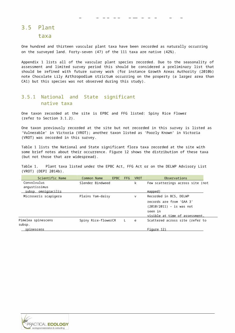
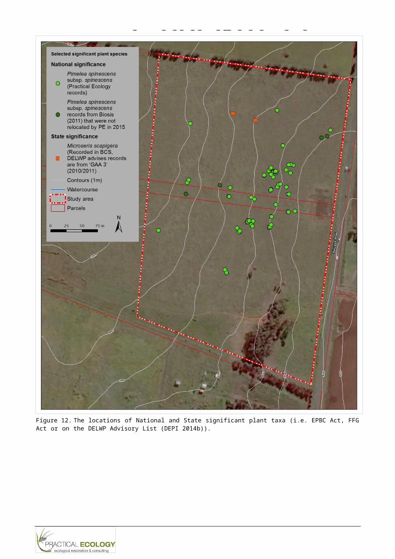
Table 1 lists the National and State significant flora taxa recorded at the site with some brief notes about their occurrence. Figure 12 shows the distribution of these taxa (but not those that are widespread).
Table 1. Plant taxa listed under the EPBC Act, FFG Act or on the DELWP Advisory List (VROT) (DEPI 2014b).
Scientific Name Common Name EPBC FFG VROT ObservationsConvolvulus angustissimus
Slender Bindweed k Few scatterings across site (not
s u bsp. o m n i g r a c ili s m a pp e d)
v i s i b l e a t t i me o f a ss e ss m e n t . Pimelea spinescens subsp. Spiny Rice-flower CR L e Scattered across site (refer to
sp i n e sc e n s F i g u r e 1 2 )
Rep_Footer
V e g e t a t i o n I nv e n t o r y R e p o r t M S A C o n s e r v a t i o n A r e a 1
2
Figure 12. The locations of National and State significant plant taxa (i.e. EPBC Act, FFG Act or on the DELWP Advisory List (DEPI 2014b)).
Rep_Footer
V e g e t a t i o n I nv e n t o r y R e p o r t M S A C o n s e r v a t i o n A r e a 1
2
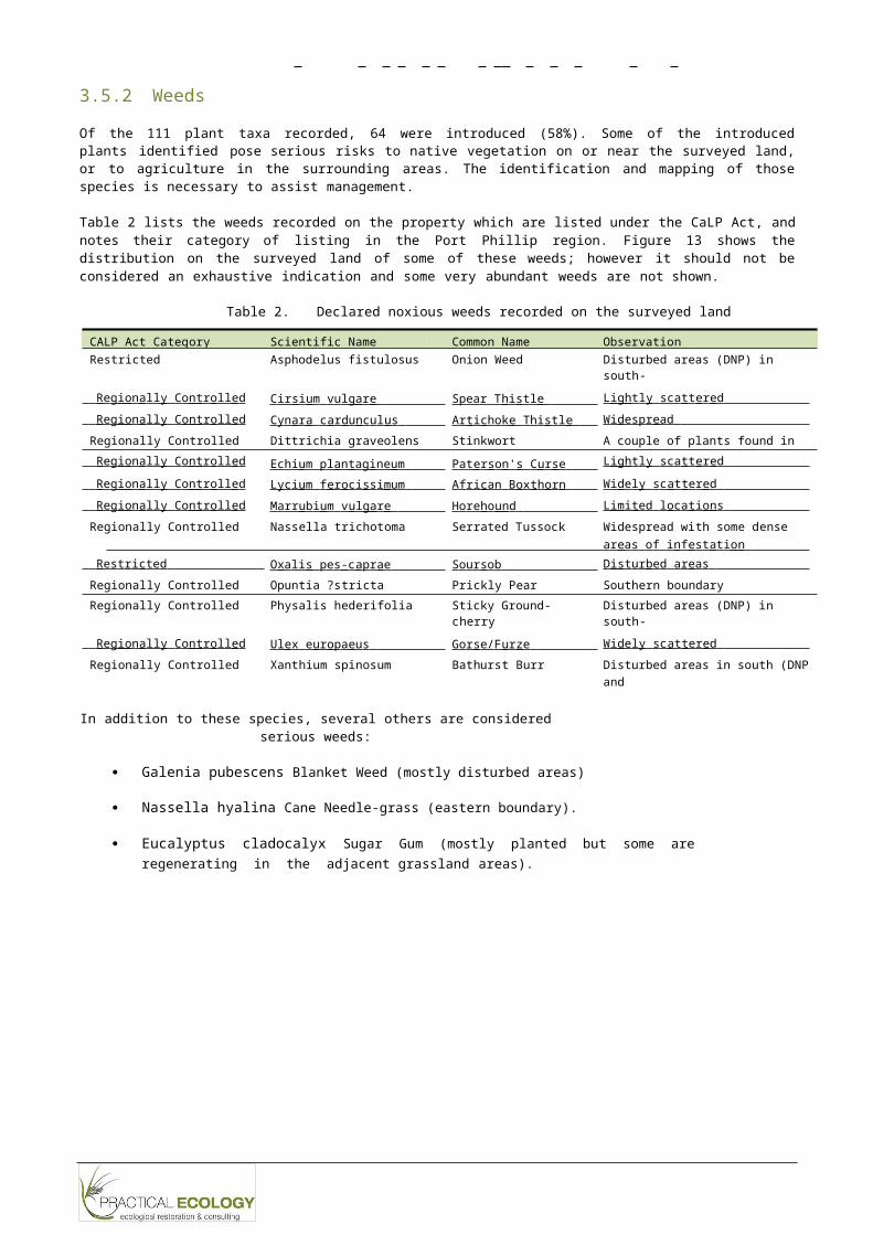
3.5.2 Weeds
Of the 111 plant taxa recorded, 64 were introduced (58%). Some of the introduced plants identified pose serious risks to native vegetation on or near the surveyed land, or to agriculture in the surrounding areas. The identification and mapping of those species is necessary to assist management.
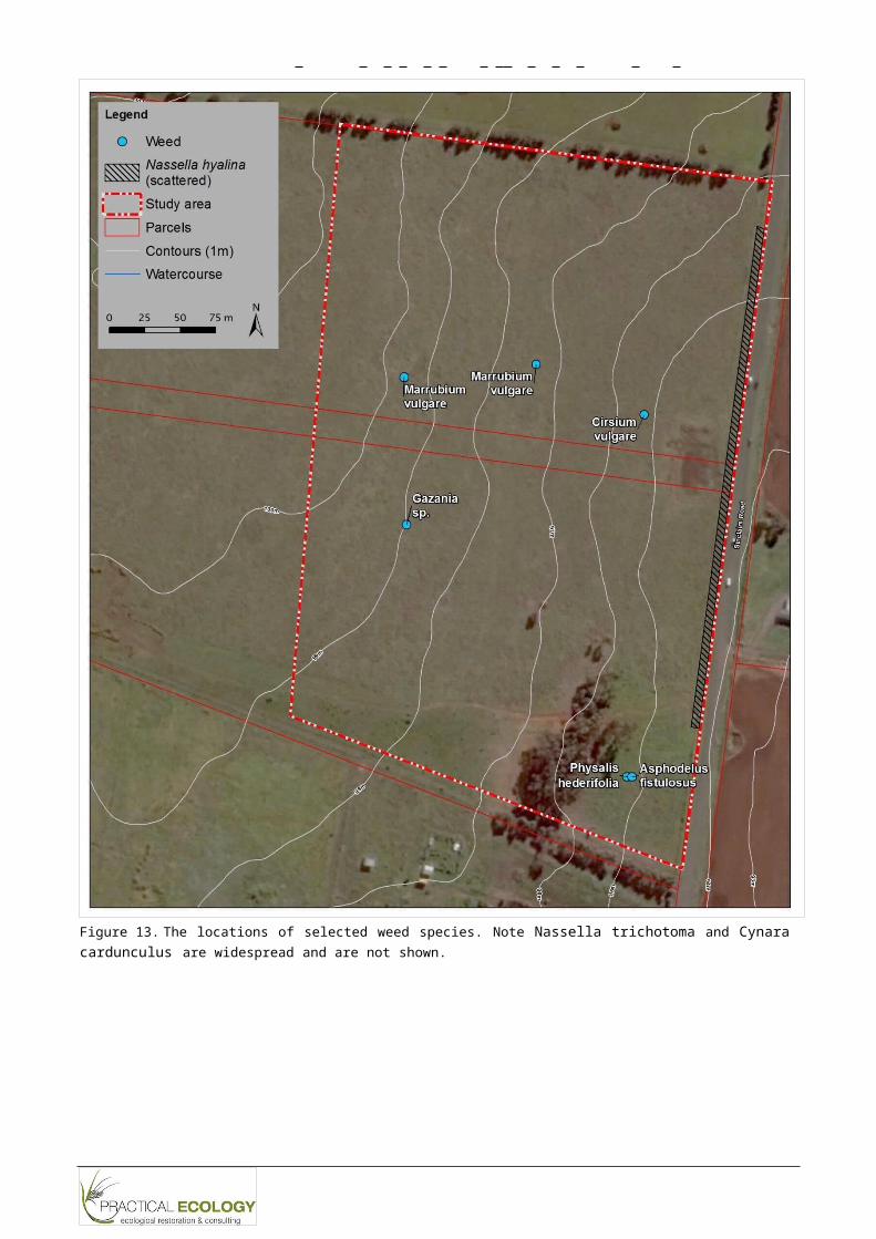
Table 2 lists the weeds recorded on the property which are listed under the CaLP Act, and notes their category of listing in the Port Phillip region. Figure 13 shows the distribution on the surveyed land of some of these weeds; however it should not be considered an exhaustive indication and some very abundant weeds are not shown.
Table 2. Declared noxious weeds recorded on the surveyed land
CALP Act Category Scientific Name Common Name ObservationRestricted Asphodelus fistulosus Onion Weed Disturbed areas (DNP) in south-
ea st
R e g i o n a ll y C o n t r o ll e d C ir s i u m v u l g a r e Sp ea r T h i s t l e L i g h t l y sc a t t e r e d R e g i o n a ll y C o n t r o ll e d C y n a r a c a r d u n c u l u s A r t i c h o k e T h i s t l e W i d e sp r ea d
Regionally Controlled Dittrichia graveolens Stinkwort A couple of plants found in C3G R e g i o n a ll y C o n t r o ll e d Ec h i u m p l a n ta g ine u m P a t e r s o n ' s C u r se L i g h t l y sc a t t e r e d R e g i o n a ll y C o n t r o ll e d L y c i u m f e r o c i ss i m u m A f ri c a n B o x t h o r n W i d e l y s c a t te r e d R e g i o n a ll y C o n t r o ll e d M a rr u b i u m v u l g a r e H o re h o u n d L i m i te d l o c a t i o n s
Regionally Controlled Nassella trichotoma Serrated Tussock Widespread with some dense a r ea s o f i n f e s t at i o n
R e s t ri c te d O xa li s p e s - c a p r a e S o u r s o b D i s t u r b e d a r ea s Regionally Controlled Opuntia ?stricta Prickly Pear Southern boundaryRegionally Controlled Physalis hederifolia Sticky Ground-cherry Disturbed areas (DNP) in south-
ea st R e g i o n a ll y C o n t r o ll e d U l e x e u r o p a e u s G o r s e/ F u r ze W i d e l y s c a t te r e d
Regionally Controlled Xanthium spinosum Bathurst Burr Disturbed areas in south (DNP and C3G)
In addition to these species, several others are considered serious weeds:
Galenia pubescens Blanket Weed (mostly disturbed areas)
Nassella hyalina Cane Needle-grass (eastern boundary).
Eucalyptus cladocalyx Sugar Gum (mostly planted but some are regenerating in the adjacent grassland areas).
Rep_Footer
V e g e t a t i o n I nv e n t o r y R e p o r t M S A C o n s e r v a t i o n A r e a 1
2
Figure 13. The locations of selected weed species. Note Nassella trichotoma and Cynara cardunculus are widespread and are not shown.
Rep_Footer
V e g e t a t i o n I nv e n t o r y R e p o r t M S A C o n s e r v a t i o n A r e a 1
2
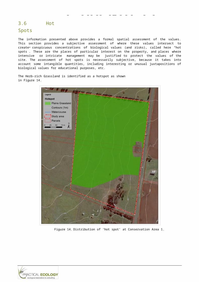
3.6 Hot SpotsThe information presented above provides a formal spatial assessment of the values. This section provides a subjective assessment of where these values intersect to create conspicuous concentrations of biological values (and risks), called here “hot spots”. These are the places of particular interest on the property, and places where intensive or intricate management may be justified to protect the values of the site. The assessment of hot spots is necessarily subjective, because it takes into account some intangible quantities, including interesting or unusual juxtapositions of biological values for educational purposes, etc.
The Herb-rich Grassland is identified as a hotspot as shown in Figure 14.
Figure 14. Distribution of ‘hot spot’ at Conservation Area 1.
V e g e t a t i o n I nv e n t o r y R e p o r t M S A C o n s e r v a t i o n A r e a 1
Rep_Footer
2
4. REFERENCESDELWP (2015a) Draft Melbourne Strategic Assessment
Survey Guidelines: Vegetation and plant DSE (2009) Delivering Melbourne’s Newest Sustainablespecies. Department of Environment, Land,Water and Planning, Government of Victoria.
DELWP (2015b) Monitoring and Reporting Framework:
Communities. Program Report. . Departmentof Sustainability and Environment, Governmentof Victoria.
Technical Protocols for Program Outcomes, DSE (2010) Biodiversity Precinct Structure Planning Kit.Melbourne Strategic Assessment. Departmentof Environment, Land, Water and Planning,Government of Victoria.
Department of Environment (2015) Pimelea spinescens subsp. spinescens in Species Profile and Threats Database. Department of the Environment, Government of Australia.
Departmaent of Sustainability andEnvironment, East Melbourne, Victoria.
Franco, J. & McCutcheon, C. (2011) Biodiversity Assessment Report Rockbank Marsh Contract Area 1080, July 2011. Biosis Research Pty Ltd, Port Melbourne.
Accessed via: Growth Areas Authority (2010a) Biodiversityhttp://www.environment.gov.au/sprat
DEPI (2013a) Biodiversity Conservation Strategy for Melbourne’s Growth Corridors Department of
Assessment Report (Native Vegetation): Melton- Wyndham Investigation Area - Section
H.Growth Areas Authority, Melbourne.
Environment and Primary Industries, Growth Areas Authority (2010b) BiodiversityGovernment of Victoria.
DEPI (2013b) Permitted clearing of native vegetation: Biodiversity assessment guidelines Department
Assessment Report (Native Vegetation): Melton- Wyndham Investigation Area - Section
G.Growth Areas Authority, Melbourne.
of Environment and Primary Industries, TSSC (2008) Advice to the Minister for theGovernment of Victoria, Melbourne.
DEPI (2014a) Victorian Biodiversity Atlas Taxa List.
Department of Environment andPrimary
Industries, Government of Victoria,East
Melbourne.
DEPI (2014b) Advisory list of rare or threatened plants in Victoria - 2014. Department of Environment and Primary Industries, Government of Victoria.
Environment, Heritage and the Arts from theThreatened Species Scientific Committee (theCommittee) on Amendment to the list ofThreatened Ecological Communities under theEnvironment Protection and
Biodiversity Conservation Act 1999 (EPBC Act): NaturalTemperate Grassland of the Victorian Volcanic Plain. ThreatenedSpecies
ScientificCommittee, Government of Australia.
Walsh, N. G. & Stajsic, V. (2007) A Census of the Vascular Plants of Victoria.
Rep_Footer
V e g e t a t i o n I nv e n t o r y R e p o r t M S A C o n s e r v a t i o n A r e a 1
2
Appendix 1. List of vascular plants identifiedINDIGENOUS
Family Scientific Name Common Name EPBC FFG VROTMONOCOTSCyperaceae Schoenus apogon Common Bog-sedgeJuncaceae Juncus flavidus Gold RushPoaceae Austrostipa bigeniculata Kneed Spear-grassPoaceae Austrostipa curticoma Short-crown Spear-
grassPoaceae Austrostipa gibbosa Spurred Spear-grassPoaceae Austrostipa scabra Rough Spear-grassPoaceae Chloris truncata Windmill GrassPoaceae Lachnagrostis filiformis s.s. Common Blown-
grassPoaceae Microlaena stipoides var. stipoides Weeping GrassPoaceae Poa sieberiana Grey Tussock-grassPoaceae Rytidosperma fulvum Copper-awned
Wallaby-grassPoaceae Rytidosperma geniculatum Kneed Wallaby-grassPoaceae Rytidosperma setaceum var. setaceum Bristly Wallaby-grassPoaceae Themeda triandra Kangaroo GrassDICOTSApiaceae Eryngium ovinum Blue DevilApiaceae Eryngium vesiculosum PrickfootAsteraceae Calocephalus citreus Lemon Beauty-headsAsteraceae Cassinia arcuata Drooping CassiniaAsteraceae Chrysocephalum sp. 1 Plains EverlastingAsteraceae Euchiton sphaericus Annual CudweedAsteraceae Helichrysum luteoalbum Jersey CudweedAsteraceae Senecio quadridentatus Cotton FireweedAsteraceae Solenogyne dominii Smooth SolenogyneAsteraceae Vittadinia cuneata Fuzzy New Holland
DaisyAsteraceae Vittadinia gracilis Woolly New Holland
DaisyAsteraceae Leptorhynchos squamatus Scaly ButtonsCampanulaceae Wahlenbergia spp. BluebellCelastraceae Stackhousia subterranea Plains StackhousiaChenopodioideae Atriplex semibaccata Berry SaltbushChenopodioideae Einadia nutans Nodding SaltbushChenopodioideae Enchylaena tomentosa var. tomentosa Ruby SaltbushChenopodioideae Maireana decalvans s.l. Black Cotton-bushConvolvulaceae Convolvulus angustissimus subsp. omnigracilis Slender Bindweed kConvolvulaceae Dichondra repens Kidney-weedCrassulaceae Crassula sieberiana s.l. Sieber CrassulaGeraniaceae Erodium crinitum Blue Heron's-billGeraniaceae Geranium retrorsum s.l. Grassland Crane's-
billGoodeniaceae Goodenia pinnatifida Cut-leaf GoodeniaGoodeniaceae Velleia paradoxa Spur VelleiaHypericaceae Hypericum gramineum spp. agg. Small St John's WortOxalidaceae Oxalis perennans Grassland Wood-
sorrelPlantaginaceae Plantago gaudichaudii Narrow Plantain

V e g e t a t i o n I nv e n t o r y R e p o r t M S A C o n s e r v a t i o n A r e a 1
Rep_Footer
2
Family Scientific Name Common Name EPBC FFG VROTPlantaginaceae Plantago varia Variable PlantainRubiaceae Asperula conferta Common WoodruffSanguisorbeae Acaena echinata Sheep's BurrThymelaeaceae Pimelea spinescens subsp. spinescens Spiny Rice-flower CR L eViolaceae Melicytus sp. aff. dentatus (Volcanic Plain variant) Tangled Shrub-violet
INTRODUCEDFamily Scientific Name Common NameMONOCOTSAsphodelaceae Asphodelus fistulosus Onion WeedIridaceae Romulea rosea Onion GrassPoaceae Aira spp. Hair GrassPoaceae Avena barbata Bearded OatPoaceae Bromus catharticus Prairie GrassPoaceae Bromus diandrus Great BromePoaceae Bromus hordeaceus subsp. hordeaceus Soft BromePoaceae Cynodon dactylon var. dactylon CouchPoaceae Dactylis glomerata CocksfootPoaceae Ehrharta erecta var. erecta Panic Veldt-grassPoaceae Ehrharta longiflora Annual Veldt-grassPoaceae Holcus lanatus Yorkshire FogPoaceae Hordeum spp. Barley GrassPoaceae Lolium perenne Perennial Rye-grassPoaceae Lolium rigidum Wimmera Rye-grassPoaceae Nassella hyalina Cane Needle-grassPoaceae Nassella trichotoma Serrated TussockPoaceae Phalaris aquatica Toowoomba Canary-grassPoaceae Vulpia bromoides Squirrel-tail FescueDICOTSAizoaceae Aptenia cordifolia Heart-leaf Ice-plantAizoaceae Galenia pubescens var. pubescens GaleniaAsteraceae Arctotheca calendula Cape weedAsteraceae Cirsium vulgare Spear ThistleAsteraceae Conyza spp. FleabaneAsteraceae Cynara cardunculus subsp. flavescens Artichoke ThistleAsteraceae Dittrichia graveolens StinkwortAsteraceae Gamochaeta purpurea s.l. Purple CudweedAsteraceae Gazania linearis GazaniaAsteraceae Helminthotheca echioides Ox-tongueAsteraceae Hypochaeris radicata FlatweedAsteraceae Sonchus oleraceus Common Sow-thistleAsteraceae Xanthium spinosum Bathurst BurrBoraginaceae Echium plantagineum Paterson's CurseBrassicaceae Brassica fruticulosa Twiggy TurnipBrassicaceae Brassica spp. TurnipBrassicaceae Capsella bursa-pastoris Shepherd's PurseBrassicaceae Lepidium africanum Common PeppercressCactaceae Opuntia spp. Prickly pearCaryophyllaceae Cerastium glomeratum s.l. Common Mouse-ear ChickweedChenopodioideae Chenopodium album Fat HenChenopodioideae Chenopodium murale SowbaneFabaceae Medicago polymorpha Burr MedicFabaceae Trifolium angustifolium var. angustifolium Narrow-leaf CloverFabaceae Trifolium glomeratum Cluster CloverFabaceae Trifolium spp. Clover

Rep_Footer
Family Scientific NameFabaceae Ulex europaeusFabaceae Vicia sativaFumariaceae Fumaria spp.Gentianaceae Centaurium erythraeaGeraniaceae Erodium botrysLamiaceae Marrubium vulgareLamiaceae Salvia verbenacaMalvaceae Malva parvifloraMalvaceae Modiola carolinianaMyrsinaceae Lysimachia arvensisMyrtaceae Eucalyptus cladocalyxOxalidaceae Oxalis pes-capraePlantaginaceae Plantago coronopusPlantaginaceae Plantago lanceolataPolygonaceae Acetosella vulgarisPolygonaceae Rumex crispusPolygonaceae Rumex spp. (naturalised)Solanaceae Lycium ferocissimumSolanaceae Physalis hederifoliaSolanaceae Solanum nigrum s.l.
V e g e t a t i o n I nv e n t o r y R e p o r t M S A C o n s e r v a t i o n A r e a 1
2
Common Name Gorse Common Vetch FumitoryCommon Centaury Big Heron's-bill HorehoundWild SageSmall-flower MallowRed-flower Mallow PimpernelSugar Gum SoursobBuck's-horn PlantainRibwort Sheep Sorrel Curled DockDock (naturalised) African Box-thorn Sticky Ground-cherry Black Nightshade