Embed Size (px)
Citation preview
This pack contains:
EEnd to End Introduction & Practical Advice EFour End to End Routes:
YHA B&B with Accommodation List Main Road or Faster Route Off-Road – Grade Black
EEnd to End Record Sheet EEnd to End Merchandise Order Form
CTC, Parklands, Railton Road, Guildford, Surrey GU2 9JX T 0844 736 8450 / 01483 238301 email: [email protected]
www.ctc.org.uk
Copyright © CTC Cyclists’ Touring Club. This information is supplied for personal use of members only. Reproduction in any form, in whole or in part, for commercial purposes is expressly forbidden unless licensing terms have been agreed with the
club.

Practical Advice 1. Introduction (pg.3) 2. Best Time of Year To Do The Ride (pg.3) 3. South to North or the other way? LEJoG or JoGLE? (pg.4) 4. How long does it take? (pg.4) 5. Where To Stay (pg.4) 6. Regional Information (pg.5) 7. Climate (pg.6) 8. Training, Food And Fitness (pg.7) 9. Route Finding (pg.11) 10. Recommended Maps (pg.16) 11. Travelling To The Start And Back From The Finish (pg.16) 12. Other Useful CTC Information Sheets (p.18) 13. Book List (pg.18) 14. Websites (pg.19) 15. Doing The End To End With Others (pg.19) 16. CTC End To End Record Sheet (pg.19) 17. Certificate, Embroidered Badge And T-Shirt (pg.20) 18. Other challenges to consider (pg.21) 19. List Of Other End To End Routes Available (pg.22) INTRODUCTION People seldom follow our routes precisely; rather they use them as a guide. All sorts of factors will have a bearing on the route you finally arrive at. (You might have relatives you want to stay with on the way, for example.) Our routes were originally created by highly experienced cycle tourers who made great efforts to devise the best route. Over the years, changes have been made as a result of changes to the road infrastructure and also as a result of recommendations by End2Enders who have kindly provided us with feedback. We sincerely hope that you’ll have no trouble following the instructions and find our routes to be good. When you deviate off one, do avoid busy main roads where possible unless you are a very experienced cyclist. Also prepare for the ride well in advance, with care and with attention to detail. You’ll enjoy it so much more if you do.
For the majority, the End 2 End is a challenging and very special undertaking. Do take time to read through these notes. The chances of them being of no value to you whatsoever are slim. Do yourself a favour and don’t make it any harder for yourself than it has to be.
We are always very pleased to receive recommendations to include additional information, so if there is something you were wondering about and were unable to find reference to in these notes, do please let us know. Bear in mind, though, that CTC publishes an extensive range of information sheets and the topic you’re interested in might be covered by another sheet. Find the full list here: http://www.ctc.org.uk/ride/touring-and-expedition for information about choosing the right bike for the trip, consult this page: http://www.ctc.org.uk/cyclists-library/bikes-and-other-cycles/cycle-styles-how-to-get-most-out-your-ride
WHAT IS THE END TO END? Land's End to John o' Groats is the traversal of the whole length of the island of Great Britain between two extremities; in the southwest and northeast. The traditional distance by road is 874 miles (1,407 km) and takes most cyclists ten to fourteen days; the record for running the route is nine days. Off-road walkers typically walk about 1,200 miles (1,900 km) and take two or three months for the expedition. Two much-photographed signposts indicate the traditional distance at each end.
• Land's End is the extreme south-westward (but not southern or western) point of Great Britain, situated in western Cornwall at the end of the Penwith peninsula, O.S. Grid Reference SW342250, Post Code TR19 7AA. The most southerly point is Lizard Point.
• John o' Groats is the traditionally acknowledged extreme northern point of mainland Scotland, in north-eastern Caithness, O.S. Grid Reference ND380735, Post Code KW1 4YR. The actual northernmost point is at nearby Dunnet Head. The point that is actually farthest by road from Land's End is Duncansby Head, about 2 miles (3 km) from John o' Groats.

Dear End to Ender
CTC’s End2End pack has earned itself a reputation over the years for the comprehensiveness and accuracy of the information contained in it, not to mention the quality of the four routes described, don’t rely just on our directions, clear though they might be, work out what route will be best for yourself and your ability.
Updates: We try to keep the pack as up-to-date as possible and, to a large extent, rely on feedback from users of the pack for this, so please let us know if you find anything wrong or which could be improved in your opinion. If you’re a member of CTC, you have the added advantage of being able to print off an updated version of the pack (or part of it) prior to setting off; check out the date in the ‘footer’ at the bottom of each page to see if it’s more recent than your original copy.
Land's End is the extreme southwestward (but not southern or western) point of Great Britain, situated in western Cornwall at the end of the Penwith peninsula, O.S. Grid Reference SW342250, Post Code TR19 7AA. The most southerly point is Lizard Point. John o' Groats is the traditionally acknowledged extreme northern point of mainland Scotland, in northeastern Caithness, O.S. Grid Reference ND380735, Postcode KW1 4YR. The actual northernmost point is at nearby Dunnet Head. The point that is actually farthest by road from Land's End is Duncansby Head, about 2 miles (3 km) from John o' Groats.
Records: The oldest person to cycle from Land's End to John O'Groats is Tony Rathbone (UK, b. 10 December 1932) who was aged 81 years and 162 days when he completed the journey on 21 May 2014. Roger Anthony "Tony" Rathbone started his journey from Land's End to John O'Groats on 7 May 2014 with his friend, William "Billy" Skipper. They cycled a total of 1,526.46 km (948.5 miles) and were riding for a total of 79 hours 34 minutes. Proof of Passage: Once you’ve completed the ride, you are entitled to purchase an End to End Certificate, embroidered badge and / or T shirt. However, we need evidence that you’ve done it, which is why there is a record sheet enclosed with this pack.
Get this record sheet stamped as you progress along the route – one at the start, one at the finish and some in between. How many you obtain in between is up to you. A stamp is available at youth hostels but can be hard to track down elsewhere. Try the hotels or B&B’s you’re staying at, or you can try garages and post offices (although the latter are sometimes not too keen to oblige). Failing stamps, photos with you and your bike in front of appropriate town or village signs, till receipts or bank ATMs which show your location are all acceptable.
When you return from your trip, fill in the Merchandise Order Form (included) and send it, together with a copy (preferably) of your record sheet – keep the original safe! – to the
address on the form. If you’ve taken photos or have till receipts, send copies and then staple them together and then on to the record sheet
We’ll return your record sheet, if requested to do so, to you along with the merchandise you have purchased.
Have a great ride! Riding LEJOG is an experience that will stay with you for a long time. Make sure it’s for the right reasons by riding safely at all times. The information contained in this pack is provided in good faith. We’ve done our best to ensure it is accurate, and the route is easy to follow. However, new roads get built & signposts can change at any time, so please be aware that the directions may not now be 100% accurate. If you discover any inaccuracies or would like to suggest any improvements to the route, we would be very pleased to hear from you.

The straight-line distance from Land's End to John o' Groats is 603 miles (970 km) as determined from O.S. Grid References, but such a route passes over a series of stretches of water in the Irish Sea.
According to a road atlas of 1964, the shortest route using classified roads was 847 miles (1,363 km). According to a road atlas of 2008, the shortest route using classified roads was 838 miles (1,349 km). In 2011 an online route planner calculated the quickest route by road as 838 miles (1,349 km), estimating a time of 15 hours 48 minutes for the journey (this uses A30, M5, M6, A74(M), M74, M73, M80, M9, A9 & A99). However, the overall shortest route by road, using minor roads in numerous places and utilising modern bridges, has been reduced to around 814 miles (1,310 km). This route is roughly follows:
Land's End, Bodmin, Okehampton, Tiverton, Taunton, Bridgwater, the M5 Avon Bridge, the M48 Severn Bridge, Monmouth, Hereford, Shrewsbury, Tarporley, St Helens, Preston, Carlisle, Beattock, Carstairs, Whitburn, Falkirk, Stirling, Crieff, Kenmore, Dalchalloch, A9,Inverness, Kessock Bridge, Cromarty Bridge, Dornoch Firth Bridge, Latheron, Wick, John o' Groats.
BEST TIME OF YEAR TO DO THE RIDE The ride can, of course, be undertaken any time, but you’ll find it easier and more pleasant when (a) the days are long – and the nights short; (b) when it’s not cold; (c) when the midges aren’t biting – or are biting less! Thus May and June are probably the best months.
If staying at YHAs, you may find that they are so booked out in school term time that you have no choice but to choose late July / August.
If staying at B&B’s, obviously it’s always safer to book in advance. B&B’s will have different busy and quiet periods based on various factors so it’s impossible to recommend a good time, although it’s more likely to be in low season (when length of day and temperature are less than good). You take your choice.
What you really want to avoid is doing the ride when certain areas could be icy. Thus, according to statistics, you should avoid late October to early May since ground frost is present in Inverness for three days in May and four in October. (See Climate further on in this booklet)
SOUTH TO NORTH OR THE OTHER WAY? LEJoG or JoGLE? This is a perennially popular question. There are a few factors to consider.
Firstly, the prevailing winds in the UK blow from the south west. This means that there is a greater likelihood of the wind blowing you towards your destination if you start from Land’s End. How much greater is the question! Note that in May, the wind more often blows from the other direction. http://www.weatheronline.co.uk/reports/philip-eden/Mays-blocking-highs.htm
Secondly, terrain: yes, of course there are hills – and plenty of them. By far the worst section in this respect is the south west. Once you’re over the Severn Bridge, you can relax in the certain knowledge that anything else you encounter on your journey north will seem a mere triviality by comparison. Don’t quote me, but it’s almost true. Cornish hills are short(ish) and steep; Devonian ones are less short…oh, and steep too! You can either choose to get this section over early, getting fit in the process or you can build up your fitness as you head south. By the time you reach Devon and Cornwall, you’ll be as fit as a flea. Then again you might be exhausted and in need of a week in bed and the final leg might put you off riding a bike ever again (which would be a shame). Navigation is also relatively tricky in the south west too, whereas in Scotland it’s pretty easy.
Thirdly, annoyingly, all four routes in this pack are described from south to north. If you choose to go the other way, then you will need to turn all the instructions on their head. (Some of the ‘other’ routes are described north to south – see page 11.)
Finally there is the question of getting to your chosen starting point and back from your finishing point. John o’Groats is by far the more difficult, with limited rail services (and spaces for bikes) plus the sheer distance (in most cases). You might want to go against the flow and get the travel challenges over with before the ride, in which case it’s JoGLE for you.

HOW LONG DOES IT TAKE? The total distance of each of our routes is a little over 1,000 miles or 1610 kilometres. Many cyclists choose to ride the End to End in two weeks, averaging 71 miles per day. In hillier areas (e.g. south west England and central Scotland) such daily mileages can be hard work, depending on your level of fitness. You may like to plan lower mileage days in these areas. If you choose to do the ride in two weeks, you may not have very much time available for stopping for refreshments, taking photos or perhaps doing a spot of sightseeing. For example if your average cycling speed is 10 miles per hour, it will take you 7 hours to ride a 70 mile day, not counting stops.
If you want to have time for all the above, then we suggest you take three weeks or longer over the route. (To cycle the route in three weeks means cycling an average of 48 miles per day). Please do give the above some thought before planning your ride and your overnight stops! Of course if you’re using YHAs your choices are much more limited and you’ll be hard pressed to shorten some days. You could always build in a rest day after a long day. WHERE TO STAY Details of accommodation are included in this pack for both our Youth Hostel and B&B routes. You could also stay in hotels or camp.
Other information sources include Cyclists Welcome, CTC’s own accommodation guide, which is accessible via the following link: www.cyclistswelcome.co.uk There is also a CTC information sheet (ref INF44) entitled ‘Where to Stay in the UK’ included in this pack (please note this is currently being updated June 2015). See also the booklist further on.
Tourist Information Centres (TICs) along the route offer another comprehensive information source on local B&B’s and might even make bookings for you. The telephone numbers of individual TICs can be obtained simply visiting the websites below:
For England: http://www.visitbritain.com/en/Travel-tips/Traveller-tips/Tourist-information-centres.html
For Scotland: http://www.visitscotland.com/
If you choose to camp, you’ll find some useful lists of campsites used by previous End2Enders in the extra routes at the end of this section, although you will need to contact us for copies of the relevant routes. Camping is obviously quite a challenging option because setting up camp and getting everything back in your panniers takes time out of your cycling day and of course you’ll have to lug your gear around with you on the bike (unless you have vehicle support). Very satisfying though!
Hotels are a good choice because they take all the hassle out of keeping yourself fuelled up (with food). Travelodge’s, Premier Travel Inns etc have helped beat the price of hotels down but you may have to stray some way off route to reach them, and this may involve cycling on busy roads. REGIONAL INFORMATION
South West England is one of nine official regions of England. It is the largest such region in area, covering 9,200 square miles (23,800 km2) and comprising Gloucestershire, Bristol, Wiltshire, Somerset, Dorset, Devon, Cornwall and the Isles of Scilly. Five million people live in South West England.
The region includes the area often known as the West Country and much of the ancient kingdom of Wessex. The size of the region is shown by the fact that the northern part of Gloucestershire, near Chipping Campden, is as close to the Scottish border as it is to the tip of Cornwall. The largest city is Bristol. Other major urban centres include Plymouth, Swindon, Gloucester, Exeter, Bath, and the South East Dorset conurbation of Bournemouth, Poole and Christchurch. All counties either include at least one unitary authority or are unitary authorities themselves, as is the case with Cornwall and the Unitary Authority of Bristol. The region has 8 cities: Salisbury, Bath, Wells, Bristol, Gloucester, Exeter, Plymouth and Truro. It includes two National Parks - Dartmoor and Exmoor - and four World Heritage Sites, including Stonehenge and the Jurassic Coast.
The region has a particularly strong cultural identity. Cornwall has its own language, Cornish, and the region is known for its rich folklore, including the legend of King Arthur and Glastonbury Tor, as well as its many centuries-old traditions and customs. Traditionally, the South West of England has been well known for producing Cheddar cheese, which originated in the Somerset village of Cheddar, for Devon cream teas, crabs, Cornish pasties, and for cider. It is also well known as the home of the Eden Project, Aardman Animations, the Glastonbury Festival, the

Bristol International Balloon Fiesta, trip hop music and Cornwall's surfing beaches. The region has by far the longest coastline in England, and is well known for its traditional seaside fishing towns.
The West Midlands is one of nine official regions of England at the first level of NUTS for statistical purposes. It covers the western half of the area traditionally known as the Midlands. It contains the second most populous British city, Birmingham, and the larger West Midlands conurbation, which includes the city of Wolverhampton and large towns of Dudley, Solihull, Walsall and West Bromwich. The city of Coventry is also located within the West Midlands County, but is separated from the conurbation to the west by several miles of green belt.
The region is geographically diverse, from the urban central areas of the conurbation to the rural western counties of Shropshire and Herefordshire which border Wales. The longest river in the UK, the River Severn, traverses the region southeastwards, flowing through the county towns of Shrewsbury and Worcester, and the Ironbridge Gorge, a UNESCO World Heritage Site, as birthplace of the Industrial Revolution. Staffordshire is home to the industrialised Potteries conurbation, including the city of Stoke-on-Trent, and the Staffordshire Moorlands area, which borders the southeastern Peak District National Park near Leek. The region also encompasses five Areas of Outstanding Natural Beauty, the Wye Valley, Shropshire hills, Cannock
Chase, Malvern Hills, and parts of the Cotswolds. Warwickshire is home to the town of Stratford upon Avon, the birthplace of the writer William Shakespeare. The West Midlands and Greater London are the only regions of England and of the United Kingdom which are landlocked.
North West England, one of nine official regions of England, consists of tfiveive counties of Cheshire, Cumbria, Greater Manchester, Lancashire and Merseyside. The North West had a population of 7,052,000 in 2011. It is the third most populated region in the United Kingdom after the South East and Greater London.
North West England is bounded to the east by the Peak District and the Pennines and to the west by the Irish Sea. The region extends from the Scottish Borders in the north to the West Midlands region in the south. To its southwest is North Wales. Amongst the better known of the North West's physiographical features are the Lake District and the Cheshire Plain. The highest point in North West England (and the highest peak in England) is Scafell Pike, Cumbria, at a height of 3,209 feet (978 m).
A mix of rural and urban landscape, two large conurbations, centred on Liverpool and Manchester, occupy much of the south of the region. The north of the region, comprising Cumbria and northern Lancashire, is largely rural, as is the far south which encompasses parts of the Cheshire Plain and Peak District.
The region includes parts of three National parks (all of the Lake District, and small parts of the Peak District and the Yorkshire Dales) and three areas of Areas of Outstanding Natural Beauty (all of Arnside and Silverdale and the Solway Coast, and almost all of the Forest of Bowland).
Scotland (/ˈskɒt.lənd/; Scots: [ˈskɔt.lənd]; Scottish Gaelic: Alba [ˈal̪ˠapə] is a country that is part of the United Kingdom and covers the northern third of the island of Great Britain. It shares a border with England to the south, and is otherwise surrounded by the Atlantic Ocean, with the North Sea to the east and the North Channel and Irish Sea to the south-west. In addition to the mainland, the country is made up of more than 790 islands, including the Northern Isles and the Hebrides.

Edinburgh, the country's capital and second-largest city, was the hub of the Scottish Enlightenment of the 18th century, which transformed Scotland into one of the commercial, intellectual, and industrial powerhouses of Europe. Glasgow, Scotland's largest city was once one of the world's leading industrial cities and now lies at the centre of the Greater Glasgow conurbation. Scottish waters consist of a large sector of the North Atlantic and the North Sea, containing the largest oil reserves in the European Union. This has given Aberdeen, the third-largest city in Scotland, the title of Europe's oil capital.
The mainland of Scotland comprises the northern third of the land mass of the island of Great Britain, which lies off the north-west coast of Continental Europe. The total area is 78,772 km2 (30,414 sq. mi), comparable to the size of the Czech Republic. Scotland's only land border is with England, and runs for 96 kilometers (60 mi) between the basin of the River Tweed on the east coast and the Solway Firth in the west. The Atlantic Ocean borders the west coast and the North Sea is to the east. The island of Ireland lies only 30 kilometers (19 mi) from the south-western peninsula of Kintyre;[145] Norway is 305 kilometers (190 mi) to the east and the Faroes, 270 kilometers (168 mi) to the north.
.
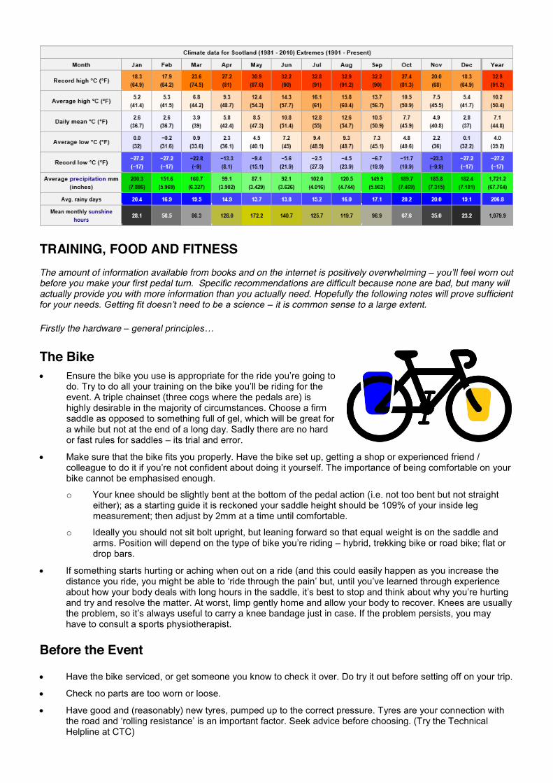
CLIMATE As you are riding on your journey you are going to encounter many geographical changes, many regional changes but what you also need to consider is the climate changes that occur across England and Scotland on your journey. Up to date climate data for the various areas you will be cycling in is available from http://www.metoffice.gov.uk/climate/uk/summaries which is updated regularly and will allow you to extra prepare for your journey ahead. Below are some summary tables for England and Scotland which are examples of the variation in temperature, rainfall and amount of potential sunshine you could experience (Data compiled in 2011). You may also find this link very helpful in planning your route and checking on the various weather conditions that could affect your journey. http://www.metoffice.gov.uk/climate/uk/summaries/anomacts
TRAINING, FOOD AND FITNESS The amount of information available from books and on the internet is positively overwhelming – you’ll feel worn out before you make your first pedal turn. Specific recommendations are difficult because none are bad, but many will actually provide you with more information than you actually need. Hopefully the following notes will prove sufficient for your needs. Getting fit doesn’t need to be a science – it is common sense to a large extent.
Firstly the hardware – general principles…
The Bike x Ensure the bike you use is appropriate for the ride you’re going to
do. Try to do all your training on the bike you’ll be riding for the event. A triple chainset (three cogs where the pedals are) is highly desirable in the majority of circumstances. Choose a firm saddle as opposed to something full of gel, which will be great for a while but not at the end of a long day. Sadly there are no hard or fast rules for saddles – its trial and error.
x Make sure that the bike fits you properly. Have the bike set up, getting a shop or experienced friend / colleague to do it if you’re not confident about doing it yourself. The importance of being comfortable on your bike cannot be emphasised enough.
o Your knee should be slightly bent at the bottom of the pedal action (i.e. not too bent but not straight either); as a starting guide it is reckoned your saddle height should be 109% of your inside leg measurement; then adjust by 2mm at a time until comfortable.
o Ideally you should not sit bolt upright, but leaning forward so that equal weight is on the saddle and arms. Position will depend on the type of bike you’re riding – hybrid, trekking bike or road bike; flat or drop bars.
x If something starts hurting or aching when out on a ride (and this could easily happen as you increase the distance you ride, you might be able to ‘ride through the pain’ but, until you’ve learned through experience about how your body deals with long hours in the saddle, it’s best to stop and think about why you’re hurting and try and resolve the matter. At worst, limp gently home and allow your body to recover. Knees are usually the problem, so it’s always useful to carry a knee bandage just in case. If the problem persists, you may have to consult a sports physiotherapist.
Before the Event
x Have the bike serviced, or get someone you know to check it over. Do try it out before setting off on your trip.
x Check no parts are too worn or loose.
x Have good and (reasonably) new tyres, pumped up to the correct pressure. Tyres are your connection with the road and ‘rolling resistance’ is an important factor. Seek advice before choosing. (Try the Technical Helpline at CTC)

x Have good / new break blocks.
x Have at least a rear mudguard, as on wet days there is nothing worse than a wet behind, especially if you are going to get up and do it all again the next day. Neither are you particularly welcome at refreshment stops if the bits that touch their chairs are covered in muck.
Clothing Buying some cycling-specific clothing is worth the investment. It needn’t be expensive if you shop around. Ron Hill tracksters on the bottom, reasonably priced padded shorts, a decent quality base layer for the top half, a cycling top (or three), cycling shoes, cycling mitts and of course, a waterproof jacket and a baseball hat. These should be your bare minimum. Check out the pages of Cycle magazine for shops, online or otherwise. If new to the game, try on before you buy! Look around, see what other cyclists wear, ask their opinions or even call the CTC Helpline for advice. That’s what we’re here for.
Training ~ general principles
x Do the training on the bike you will use, so that you get used to each other, and correct any problems.
x Gradually increase the length of your training rides up to the daily distance you will be riding, and reduce the number of days between rides; remember that eventually you’ll need to be used to riding that daily distance every day if you’re on a multi-day ride. So do get used to riding on consecutive days.
x Get used to carrying the weight of the kit / food / tools you will have on the ride.
x Build up these capabilities in advance of the event and take it easy in the week or two immediately before your ride.
x Never start training hard from your front door. Try to have a period of low intensity at the beginning of any ride to get cold muscles warmed up. A few gentle warm-up exercises before setting off will help (and amuse the rest of the household!)
x Do some stretching exercises after your rides to increase your suppleness and reduce later aches and pains.
Further Notes Create stepping stones to make your goal achievable and realistic. In principle any training you do that takes you beyond what you’ve done before pays dividends. Ideally, you should be on your bike three to four times per week throughout the year. You might ride to work, or use a turbo trainer, two or three times per week, and then cycle once or twice over the weekend. There is no substitute for ‘getting the miles in’. Every two weeks or so, increase the distance you cover at weekends by about 5-10%. Soon you’ll be covering greater distances with ease. By counting ‘hours on a bike’ rather than ‘miles covered’ you can compare different types of cycling. If you go mountain-biking at weekends, you won’t cover as many miles as if you were on your road bike, but you can compare the time and effort between the two activities. The variety is good for your mental motivation. Do remember, however, to do the long rides on the bike you’ll be using for the ride. If you just have the one bike, or ‘don’t do cycling in cold weather’ and don’t have a turbo trainer – or even know what one is! – and can’t bear gyms, don’t panic: there are plenty of exercises you can do at home and, unless you’re doing your ride very early in the year, a month or six weeks of concerted, focused training on the bike you’re using for the ride should be enough for the averagely healthy, moderately fit person. You can actually do too much and become ‘over-trained’, which occurs when you increase the distance of rides and/or reduce your recovery time between rides too quickly. So, every four or five weeks, cut your riding back by about 20-25%. In the summer time, when you are spending more hours in the saddle at weekends, you don’t need to spend so much time on your bike during the week. This is a good time to try riding shorter distances faster. You’ll find you get faster as you become fitter anyway.
You should aim to be ready for your ride about 2 weeks before the start so you can have some time to relax a bit before you set off.

Interval Training
‘Interval’ training is a useful way to increase your peak fitness level more effectively by interspersing high intensity riding with a period of steady riding. The same level of fitness can be reached quicker using this approach. Hill riding naturally consists of intervals, so on hilly rides try to really power up the hills, and use the downhill’s as a rest in between.
Training in Gym or at Home
Training in a gym or at home can be a very useful addition to your bike rides to build fitness, especially if these are organised ‘Spinning’ sessions at a gym, or well-planned home workouts with variety of pace and intensity (try using a techno soundbeat to keep to). Gym workouts are particularly good for improving your hill climbing because you tend to use your whole body when climbing.
Organised Rides
Riding with others is useful, particularly if you’re planning on riding your event with others, because it allows you time to practice riding in a group and adapting to another rider’s pace. It can also provide motivation; riding on your own can be dull. Try climbing hills at a speed that suits you. Be aware that everyone climbs hills at a different pace, so don’t try to push it too much if someone is quicker than you. If you slow down to another person’s slower speed, do so but only if it feels comfortable; it’s a good way of conserving energy if you’re able to do it.
Warm Down/Stretching
After your training rides/sessions be sure to warm down and do some stretching exercises to help keep supple and reduce muscle soreness,
Nutrition/Diet
x During your training get used to the sort of food and drink you will use on the event.
x Use of energy drinks can be effective, as these replace salts and are quickly absorbed (SIS-Science In Sport Go drink; Enervit G Sport Drink; Isostar Isotonic drink; ZipVit (discounts for CTC members); are all good – try one and see what works for you – you may wish to make them up a little weaker than instructed as this is more refreshing.
x Energy and cereal bars are useful; find a type that you enjoy and can digest easily. Expensive sports energy bars can work well but bananas, dried fruit, mixed fruit and nuts, fruit cake is all good if it works for you. Again, don’t be afraid to experiment with your body. Do avoid things like Mars and Snicker bars: owing to their high refined sugar content, you’ll get a very quick boost but then possibly suffer a dramatic drop in energy later. They’re great in an emergency however.
x On a ride eat and drink little and often; and, importantly, do so before you know you need it: if you become hungry or thirsty then it’s usually too late.
x Try to eat less fat, while increasing protein and carbohydrate proportions during your training period.
x Generally eat more carbohydrate before a ride (for energy), and …
x …more protein after a ride (for repair and build of muscles)
x Try to eat within an hour after exercise (in training and on the ride) as this replaces energy in the muscles better; when its difficult to get a meal quickly use a post-event drink such as SIS ReGo (specially designed for replenishment)

Cycling Etiquette
x If you’re wanting to keep together, then initiate a system which ensures you don’t lose anyone off the back.
x Always be aware of who is behind you on the road; if they drop back out of sight, wait for them, and the next person up the road will be doing the same for you: this way we all keep in contact. This is particularly important if a turn is made or there is an ambiguous junction of any kind.
x On hills ride at your own pace because, as mentioned previously, it can be tiring to ride at someone else’s.
x If you and / or others in the group want to put on, or shed, a layer, try to do it together in a safe and appropriate spot. Remember you’ll normally get hot when you climb and cold when you descend.
x Do point out potholes and other dangers such as parked cars or walkers, with a call and an indication of which side the danger lies.
x If you need to stop, or make any other out-of-the-ordinary or unexpected maneuver, you must advise the people behind you in good time. Shout, ‘stopping’ or ‘turning right’ or whatever and look over your shoulder before making any maneuver.
x Where there is a chance that those behind you can’t see as far up the road as you, call a warning of ‘car down’ for cars coming towards you. People at the rear may call ‘car up’ for cars approaching from the rear. However, if approaching vehicles are obvious, there is nothing more tedious than the person constantly calling ‘car up’ or ‘car down’. Only say it when important for safety purposes.
x If you spend some time getting the advantage of slipstreaming/drafting the person in front, don’t then use your rested legs to fly past them; rather cruise past and let them now slipstream you. Close slipstreaming can reduce effort needed by 20% and is commonly done. Practice riding within a foot or so of the back wheel of the rider in front of you. If you’re confronted by a stiff headwind for hours on end, do what is known as ‘bit and bit’, where you each take a turn at the front while others behind you recover. Take it in turns with the person at the front doing a mile or two, then slipping to the back and the person who was second in line then moves forward to the front for a stint. This can make a hard ride considerably less so.
General x On the ride the 2 most important aspects are cleanliness and food/drink: ensure you keep yourself and your
cycling shorts clean (Savlon wound wash – a non-iodine spray, is very good for this). They always say proper cyclists don’t wear underwear and, ideally, you shouldn’t. However, many people baulk at the thought and buy underwear that have minimally thick seams. Ensure you wash them daily.
x If you do get problems with Saddlesores use either Sudocrem or Metanium, as they sooth rather than inflame to treat soreness (both are readily available at chemists)
x If you buy no other special clothing, invest in some good cycling shorts; this will save a lot of pain and pay great rewards.
x Avoid a cotton base layer on your upper body unless it’s very loose on you and it’s hot enough to wear nothing else on top. A mildly ‘technical’ base layer is best as this will reduce discomfort and chill in wet or sweaty conditions. Outdoor shops are good sources of such garments; check out the ‘sales’ rails.
x If you have any further questions, the CTC information desk should be able to help.
FURTHER READING The Long Distance Cyclists’ Handbook [Doughty £14.99] this is an excellent book which will leave you feeling well prepared for the task ahead. Mainly aimed at the ‘audax’ rider but still good for longer events. WEBSITES Training / Getting Fit http://www.realbuzz.com/articles/top-10-cycling-training-tips/
http://cyclinginfo.co.uk/blog/cyclo-sportives/training-for-cycle-sportives/
http://www.sport-fitness-advisor.com/cycling-training.html
http://www.bikeradar.com/ Then select Guides and How To: Fitness, Nutrition and Technique
http://www.netfit.co.uk/wkmen.htm

Nutrition / Getting correctly fueled up http://www.cptips.com/nutrtn.htm
http://www.sport-fitness-advisor.com/sports-nutrition.html
http://www.bottombracket.co.uk/cycling-nutrition.html
http://bicycling.about.com/od/cyclingforabetterbody/a/nutrition_bikes.htm
http://www.bikeradar.com/fitness/article/nutrition-cereals-for-cyclists-1059
http://www.crispinbennett.freedomnames.co.uk/Nutrition.htm
http://www.ultracycling.com/nutrition/nutrition.html
For more websites, do a search on Google for ‘bicycle exercise program’ or ‘training for cycle fitness’ or ‘cycling fitness tips’ or ‘nutrition for cyclists’ etc.
This information is also available as a separate info sheet (INF46) which can be requested from the Membership Team via email ([email protected]) or by calling on 01483 238301.
ROUTE PLANNING & FINDING There’s a lot more to planning a route than just pouring over a map, whether it’s on screen or on paper. Whatever you’re planning, the most important first step is to analyse exactly what your parameters are.
Take a look at the example checklist below. A little thought will lead you quickly to appreciate that a route between two places may need to be very different, depending on a whole range of factors, including the ability of the cyclists in the group, the type of accommodation you need if it’s a multi-day route, whether you want to allow time out for sightseeing and so on.
Question Answer Notes Going from where? To where? Distance Need to ride via anywhere? Additional mileage Time available Thus est. miles per day Scenic or direct Traffic OK or as little as possible
Overnights required (where) Type of accommodation Number on ride Purpose of ride Will you have back-up? Experience of riders Weather / Climate factor Etc…
Next? The advent of GPS has led to a revolution in the matter of finding your way around. Besides the portable gadgets that are becoming increasingly popular, the internet is full of mapping sites, aimed at helping people find their way around. A significant number of them enable you to store routes too. They’re all slightly different and only by

experimentation and trying them out will you come to appreciate the differences and find the one(s) you most like to work with. Firstly let Google be your friend and start by typing in the names of the places you’re going from and to (e.g. Cambridge to Ipswich). Go to Google (www.google.co.uk), then click on Maps; type in Cambridge to Ipswich and you could be in for a surprise if you’ve not done this kind of thing before. There before you is a map and next to it, a set of directions.
So what more could you possibly want? It all depends on what you’re wanting. That was an easy example. For example the ‘via Michelin’ website (see below) offers you an option of a cycle friendly route. Just click on the ‘Options’ button underneath the ‘Destination’ menu. Don’t expect Michelin to route you down entirely cycle-friendly roads - it’s not that clever - but it does a reasonable job. Also don’t ask it for any routes over 200kms because it won’t work. Clearly it doesn’t expect anyone to want to ride a bike for any longer distance, so chop the route into segments.
Here’s a collection of sites, most of which operate along similar lines. Be aware that most of these are aimed more at car drivers than cyclists.
http://www.viamichelin.com/viamichelin/gbr/tpl/hme/MaHomePage.htm
http://www.drive-alive.co.uk/route_planner.asp
http://www.mappy.com/direct/mappy/accueil (French site)
http://www.bing.com/maps/
http://www.multimap.com/map/home.cgi?client=public&overviewmap=GB
http://www.streetmap.co.uk/
http://world.maporama.com/
http://www.rac.co.uk/web/routeplanner/
http://www.theaa.com/travelwatch/planner_main.jsp
http://route.anwb.nl/routeplanner/servlet/rp
http://journeyplanner.tfl.gov.uk/ (London based)
Here we have a number of cycle specific sites http://www.bikely.com/
http://www.cycle-route.com/
http://www.opencyclemap.org/ (Good for the National Cycle Network routes) http://www.gmap-pedometer.com/
http://bikeroutetoaster.com/Default.aspx
http://www.openrunner.com/
http://www.bikemap.net/
http://www.routeyou.com/home.en
http://ridewithgps.com/
http://www.gps-routes.co.uk/
http://www.mapmyride.com/
http://www.cyclestreets.net/
The Following sites are particularly interesting in that they both show an OS map adjacent to a Google map http://www.bikehike.co.uk/
http://wtp2.appspot.com/wheresthepath.htm
Everyone has their favourite site for planning a route – often the one they’re most familiar with using, because they can vary considerably and only by using one can you really get to know it. My favourite is http://www.bikely.com/

(otherwise known as http://www.bikeradar.com/routes/). A colleague here prefers http://www.gmap-pedometer.com/.
Utilising Other People’s Routes There’s a very good chance that someone else might have wanted to ride the route you’re planning to do and many websites offer you the option, not only of planning a route, but also of storing a route you’ve planned or already done and retained on, say, a bike-mounted GPS unit. There are various websites which specialise in providing a home for people’s cycle routes. CTC has one (available to members) although you can see what’s there before joining. Go to…
www.ctc-maps.org.uk
The unique aspect of CTC-Maps is in the variety of ways that you can input your route information. Not only can you download your GPS on to it but you can simply write text describing your trip, just like a diary. You can also click on a map and create a route with an accompanying ‘cue’ or turning instruction sheet. Have a look at it – it’s really very good. That’s the plug over. However, there are drawbacks to the CTC site. The longer the route, the flakier the system becomes. Hit the ‘save’ button at very regular intervals and remember to complete loading your route in one sitting – you can’t go back to it later if you’re inputting your route by clicking on the map. Sadly improvements to the site and remedies to the glitches have not been forthcoming owing to a lack of financial investment mainly.
Although searching for a route can be more complicated than you might at first think, it’s always worth having a root around to see if someone has already been the way you want to go because it will save you a lot of time. Most sites have a search facility which you can use: type in the name of the start place, finish place or any place on your route and routes which pass through that place should come up in a list.
When all is said and done, you’ll eventually come to realise that most of these route planning systems all come from a small number of original sources, usually Google Maps or Google Earth. The latter is quite amazing and well worth exploring: http://earth.google.com/
Dedicated Sites If you have a specific ride you want to do and want to find out about it, it could be that someone has created a website totally dedicated to that route. For example, if you’re planning on an End 2 End (Land’s End to John O’Groats) then head this way…
http://www.users.waitrose.com/~ianclare/links.htm
If it’s the Sustrans C2C ride then it’s here…
http://www.c2c-guide.co.uk/
There are quite a few sites for National Cycle Network routes and, for those people keen on identifying quiet routes, as traffic free as possible, these are definitely the routes you should be looking at. Check out Sustrans’ own website and you’ll find that you can get to most places nowadays using their routes. Do be aware that their routes are not all ‘traffic free’ but generally use minor roads. Also, don’t expect to get anywhere fast using an NCN route. Route finding is always time consuming. Often signs are removed and getting you and your bike past obstructions, designed to stop motorcycles getting on to the routes, is also time consuming. All that aside, it’s still very satisfying riding from one end to the other of a recognised route and they are very often lovely routes, make no mistake.
Mapping Tools You Can Buy What has not been discussed yet are the mapping systems you can buy and this information sheet does not intend to go into these other than mention a few names which you might wish to investigate:
Memory Map http://www.memory-map.co.uk/
Quo http://www.mapyx.com/
Anquet http://www.anquet.co.uk/
These systems are generally used in connection with a GPS device. Some of these come loaded with mapping software, some require it to be bought. CTC had a couple of very useful articles on the subject of digital mapping and GPS in 2009. Check your back numbers. However, this is getting a little off the point which was planning a cycle route.
Travellers’ Tales If its inspiration and / or ideas you’re looking for, perhaps prior to getting down to the nitty gritty of route planning, these too are readily available on the internet in massive quantity. There are some wonderful sites around where you can read about other intrepid travellers’ travels. Of course, you’re far more likely to find accounts of people cycling across the Nullarbor Plain than you are accounts of a trip from Scunthorpe to Cleethorpes, but there’s plenty of stuff there which is achievable by the likes of you and me.
Here are a few sites you might want to take a look at just for starters; some are sites populated by just one cyclist and his exploits; others tend to focus on just one part of the world; others again contain a wealth of information from a range of contributors:
http://www.trentobike.org/
http://www.lonebiker.dk/ehjem/index.html
http://www.crazyguyonabike.com./
http://www.biketouringtips.com/index.html?username=
http://www.bicyclingworld.com/templates/default.aspx
http://www.mrpumpy.net/
http://travellingtwo.com/
And not forgetting the contributions on our own site:
https://www.ctc.org.uk/article/cycling-guide/land-end-to-john-ogroats-riders-stories
This list could be never ending, but the above will get you going. Remember that websites often contain a page of useful links to other similar sites. It’s always worth having a look at these.
Other Options Another way of obtaining lots of valuable information is to post a message up on a relevant cycling forum. Think carefully about how you word your message, be aware of security issues, ensure you post your message in the most appropriate topic area and when you join a forum in order to post a message, and don’t forget to keep a note of your user name and password. Here are a few sites to look at:
http://forum.ctc.org.uk/
http://www.roadcyclinguk.com/forum/forum.asp
http://www.bikeradar.com/forums/
http://www.cyclingforums.com/
http://www.veloriders.co.uk/phpBB2/portal.php
http://www.cyclechat.co.uk/forums/
http://www.cycle-route.com/forum/
http://www.anothercyclingforum.com/index.php
http://yacf.co.uk/forum/
There are also travellers’ forums and tourist websites, both of which are quite useful. http://www.travbuddy.com/
http://www.virtualtourist.com/
http://realtravel.com/
http://www.world66.com/
http://www.lonelyplanet.com/uk
http://www.travelblog.org/Forum/For more, just google for ‘travel forums’.
None of the lists above are exhaustive – they are just an assortment of what’s out there.
Paper Maps The alternative to all this is, of course, getting back to basics and using a good old paper map. Choose the right scale for the job and you’re away. Who needs computers! For advice on what map to use when and where to purchase see Recommended maps further on in this booklet.

Maps are expensive items and if you’re planning anything but a local ride, you’ll find you’re spending a lot of money on maps. A cheaper alternative is to buy a large road atlas from a bookshop and take just the relevant pages with you. Buy ‘Philips’ atlases because they use Ordnance Survey maps which show minor roads much more clearly than other road atlases. Their ‘Motoring Atlas’ at 3 miles to the inch is adequate for most trips, although you could go mad and buy their ‘Navigator’ atlas at 1½ miles to the inch (except the Scottish Highlands where there aren’t many roads anyway).
Before your ride we strongly recommend that you highlight your route on a map of a suitable scale (see below). This exercise will enable you (a) to familiarise yourself with the route and (b) to foresee any potentially difficult sections (e.g. areas of hills or complicated road junctions in urban areas), both of which may take longer to ride. Also it will make route finding much easier. Experience suggests that studying your route on the map before your ride will save you time on the road and make your ride more enjoyable.
If you’re not used to map reading/navigating it may take you a day or so to get used to it and this will slow your pace quite a lot to start with. When riding our Youth Hostel Route or B&B Route, be aware that they avoid main roads where possible, preferring scenic lanes, which can be more complicated to follow because there will be more road junctions. Keep alert and always be on the lookout for signposts. If you’re riding with others, why not alternate responsibility for route finding. There is a real sense of achievement to be gained from successfully navigating your way through a complex network of country lanes.
Signposting: don't forget that minor roads (country lanes) in Britain do not have road numbers. Minor roads are used extensively on both our Youth Hostel Route and B & B Route. In order to find the correct road, you will need to follow signposts for the next VILLAGE on the route. Villages are normally well signposted and local people will usually be happy to provide directions if needed.
Signposts to larger places, e.g. the next town, will often direct you via the nearest main road, so follow signposts with close reference to your map & route sheet, and maintain a level of scepticism as to whether the signpost wants to get you there via lanes or via the nearest main road.
Digital mapping has really come of age and many people nowadays have GPS navigation aids on their bikes. You can buy digital mapping of various sorts and load it into your GPS - it’s often there already installed. You can print off maps from your computer or even input a route into your GPS which will then display your route and advise you of every turn. (Members of CTC will have seen articles on the subject in past editions of the magazine – Jun/Jul & Aug/Sep 09) Some digital mapping sites (including www.ctc-maps.org.uk of course!), www.bikely.com, www.gmapspedometer.com, http://maps.google.co.uk/, and http://cycle.travel) allow you to plan your routes on screen and even share them with others. You can also write a route sheet (similar to the ones in this pack). Bikely is best for this – it calls them ‘cue sheets’. Some sites will create a route for you if you key in your start and finish points, but remember their route might direct you along main roads and motorways. With www.viamichelin.com you can specify that you’re on a bike, but you’re then limited to 200km stages – it doesn’t believe you would want a longer route than this! See CTC Information Sheet INF36 for further information. Of particular use is a printed map of any cities you might be travelling through – it makes navigation so much easier. Simply download one to a suitable scale straight from your computer. Well, I say simply – they don’t actually make it that easy, so experimentation is required.
RECOMMENDED MAPS We recommend buying a road atlas for the whole of Britain and cutting out the pages you’ll need for the ride. We hope shortly to list these pages here, but it’s a useful exercise to use a highlighter pen and plot your route on the map, in which case you won’t need our help!
These road atlases are available at two scales. We recommend the larger scale, known as ‘Navigator’. ‘Navigator Britain’ costs £13.59 on Amazon. This gives you the whole route at a scale of 1.5 miles to the inch (3 miles to the inch for northern Scotland).
Alternatively, buy the ‘Complete Road Atlas Britain & Ireland’ (£7.69 Amazon) which maps the whole country at a scale of 3 miles to the inch. This is fine for much of the country, but where there is a dense network of lanes, you’re better off with the Navigator.
Both these atlases should be available at larger branches of W H Smith, Waterstones etc or you can purchase them by mail order direct from the publishers or from Stanfords in London (www.stanfords.co.uk) or the Map Shop in Upton on Severn (www.themapshop.co.uk). All are also available via www.amazon.co.uk
A word of warning: do not be tempted to buy any other make of road atlas, because none of them show minor roads as clearly as the Philip’s. Neither do we recommend using Ordnance Survey Landranger maps at a scale of 1.25 miles to the inch: its overkill – you don’t need that much detail and you would fill up a whole pannier with maps to cover the whole journey. By all means study sections of your route online or at your library in more detail before you go; the network of lanes in Cornwall and Devon certainly deserve close scrutiny: you might even find a better route than ours!
Obviously up-to-date maps are preferable to old ones. Ongoing road improvements often mean changes to road classifications, road numbers and road junction layouts.
TRAVELLING TO THE START AND BACK FROM THE FINISH TRAIN Taking your bike with you on a train, if you don’t already know, is not quite as simple as it might seem. We’ve done our best here to appraise you of the facts. Do remember that the information below can quickly go out of date so please advise us if anything written below turns out to be inaccurate or if you have any horror stories we can entertain others with. You really should have tickets and reservations for both you and your bike before travelling. Most reservations are free but where there is a charge it will cover the entire journey. Bookings may be made up to 90 days in advance and may be cheaper if you do.
Unlike other countries, Britain has many train operators. The carriage of cycles varies from operator to operator and is summarised in the leaflet Cycling By Train issued by National Rail and available online or at many railway stations or (sometimes) from the CTC. Similar information is available via these alternative transport websites: http://www.mytrainticket.co.uk/travelling-with-bicycles
You can book at any manned railway station, any train operator, National Rail (www.nationalrail.co.uk; 08457 484950) or the Train Line www.thetrainline.com. Most do not offer online cycle reservations but several including East Coast (http://www.eastcoast.co.uk/) do. Making bookings for yourself and your cycle at different times is not advisable.
The nearest railway station to Land's End is Penzance. Land's End lies some 10 miles south west of Penzance by main road, slightly further by quieter roads. There are between 25 and 30 arrivals and departures (First Great Western or Virgin) each day.
The nearest railway station to John o'Groats is Wick, which lies some 17 miles south of John o'Groats by main road, slightly further by quieter roads. However all rail services go via Thurso, which is 20 miles west of John o'Groats so the choice is yours. Do not underestimate the difficulty of getting your bike back from John o’Groats! Each day there are only 4 services (1 on Sundays). Book as soon as you know your finish date - delays of a week or more are not unknown! Full timetable information may be found here: http://www.scotrail.co.uk/sites/files/10NHL.web.pdf The timetables for services between the far north and civilization start at page 15. If desperate, consider cycling 67 miles south: there are one or two extra services which start at Tain. Ride about 100 miles south to Invergordon and there are many more. First Scot Rail telesales: 08457 50 00 33. Other enquiries 0845 601 5929 or [email protected].
Other ways of getting you and your cycle back from the north:
John o’Groats Bike Transport offer a full package of services. They’re cyclists themselves too. www.JohnOGroatsBikeTransport.co.uk
Stagecoach have taken over the operation of bus services out of Inverness which cover all of northern Scotland. A timetables may be found here: https://www.stagecoachbus.com/timetable-landing.aspx. Carry a CTC bike bag and pack the bike (or tandem) flat as you would if flying with your bike and you might get on OK – check with the bus company. Arrive in plenty of time at the bus stop. Where you get on the bus will depend on the service you’re hoping to get on. Most services end up at the bus station in Inverness.
Puffin Express offer regular minibus tours in highland Scotland and might be able to accommodate you and your bike back to Inverness. Call for further information (01463 717181). http://www.go-orkney.com/bike.htm
D&E Coaches http://www.decoaches.co.uk/ offer a hire service which is worth exploring if you are a group. Tel (0)1463 222444; they also run a regular seasonal (April – October) service which carries cycles between Inverness and Durness via Ullapool – useful if you want to include a trip to Cape Wrath in your plans. Here is the direct link to their timetables: http://www.decoaches.co.uk/timetables/
National Express operates coach services to Penzance including one from Edinburgh, which connects with a service from Inverness. Bicycles are carried subject to the company conditions of carriage and space being available (bikes must be packed flat and in a purpose made case or bag).
You could also try http://www.taxi2.co.uk/ for taxi options. Other Ideas / Reports
Royal Mail: On 26 July 2000, a member reported being stuck without a train reservation at Wick. He ended up posting his cycle home for £9.80 plus £1 for insurance (- this to cover cycles to the value of £250; you can insure them up to a value of £500). The cycle arrived home two days after its owner, who took the coach – far cheaper

than the train! Note information received from an ‘End to ender’ in Sept 2001 states that Parcel Force will no longer accept packages longer than 1.5m or larger than 3m in circumference. Carrier AJG Parcels of Inverness will convey your wrapped cycle anywhere in the UK. The cost varies depending on the destination. Note that they will not insure your cycle. http://www.ajgparcels.com/ Tel 0845 4000 300 (The cycle shop in Thurso can sometimes help with wrapping material – tel 01847 895385 & ask for Sam). Taxi (Reported in May 2005) “We pre-booked a taxi back from John O’Groats to Inverness, run by Ross`s Taxis of Thurso, 01847 891181. The company has a mini bus and a trailer that is very suitable for taking bikes; he was hoping to fit it out to take 4 bicycles. The cost was £130 for the 3hr journey.”
Another tale relates: “We went to the tourist information and finished up getting a local taxi to take the two of us and bikes (Vauxhall Cavalier estate) to Inverness Airport for £85 and then hiring a car (one-way rental) to our home in Chester for £63. With petrol costs shared between two people this was only marginally more than the train fare and in some ways better. (The TIC phoned to get three quotes for the taxi. I tried to cancel my Friday bike places on the train over the phone, but was unable to get any sense out of the rail company.”
MJ reports, “You can get a mini-bus from JO’G SYHA to Thurso railway station. YH will pre-book; takes 1 or 2 cycles at £20 each. A bargain at 6.15am!”
OTHER USEFUL CTC INFORMATION SHEETS: Buying a Bike: For all you need to know about choosing the right bike for the job, whether it’s for the End 2 End or some other purpose, go to https://www.ctc.org.uk/bikes-and-bits Where to Cycle in Britain (INF6); includes information on road classifications in Britain and route finding. Get into Cycle Touring (INF1); includes a useful list of what to take with you on a cycle tour. Bikes on Trains (INF10); a guide to the cycle carriage policies of the various railway companies in Britain + all the contact phone numbers. Ferries (INF13); lists all UK ferry routes & contact numbers. Riding for a charity (INF33); helpful hints on raising money. Finding Somewhere to Stay in the UK (INF44) Cycle Camping (INF3) Note: the above information sheets are only available to members of CTC) BOOK LIST
Land’s End to John O’Groats [Horsley £12.95 pub: Cordee] Recommended routes with suggested alternatives for the lean and hungry. On My Bike: Land’s End to John O’Groats [Jordan £ varies] David Jordan is a shining example to us all. Boundless enthusiasm. Currently only available used via Amazon.co.uk End to End Cycle Route: Land’s End to John O’Groats (Cycling) (Cicerone £10.39) by Nick Mitchell – Divided into 14 stages and contains various information on here to say with full details on numerous B&B, Campsite, Hostels etc (Printed 2012) Land’s End to John O’Groats –The Official Cyclists’ Challenge Guide [Smailes 2009 - £6.95 – available direct from the author/publisher, Brian Smailes, 7 Earlsmere Drive, Ardsley, Barnsley, S71 5HH, tel 01226 217695] Nicely produced volume that provides all the information you need. The ‘End to End’ Story – 100 years of cycling records Includes riders’ own accounts, comments and photos. Available on Amazon.co.uk in limited used quantities (Price varies) Bike Britain (Epic Guides 2002 - £ varies) by Paul Salter; ISBN 0-9582256-1-3) Printed in New Zealand but available through Amazon.co.uk on the used marketplace Land’s End to John O’Groats End to End Cycle Route A Safer Way (By Royston Wood 2014 - £8.99 Amazon.co.uk) This book is not a traditional route book: it is supported by an online series of Google maps and GPX files designed to guide you across the country using a satellite navigation device, a smart phone or similar device that can navigate using GPX files. Links to these electronic files are contained within the book, along with instructions on how to access them and adjust the route to meet your needs. The June/July 2006 issue of Cycle reviewed four new E2E books. If you don’t keep old issues, contact CTC for further information.
MORE GENERAL TITLES (INCLUDING HEALTH & FITNESS TRAINING FOR THE RIDE)
There are so many books on the subject and even your local bookshop is likely to have a title or two. Many originate from the USA which might give them a greater or lesser appeal to some, so check before you buy. The Long Distance Cyclists’ Handbook (Doughty £17.99): This is an excellent book which will leave you feeling well prepared for the task ahead.

Zinn& the Art of Road Bike Maintenance (Zim - £15.29): The world's best-selling guide to bicycle repair and maintenance. From basic repairs like how to fix a flat tyre to advanced overhauls of drivetrains and brakes The Cycle Tourers’ Handbook (Hughes £12.95): Published in 1987 and described by some as the definitive textbook on cycle touring. Not currently in print but used copies can be purchased via private sellers on Amazon
Accommodation AA Bed and Breakfast Guide 2015 (AA Lifestyle Guides) [AA Publications] £11.99
Visit www.cyclistswelcome.co.uk
*** See our E2E B&B list further on in this guide, plus our information sheet INF44 with numerous links to B&B websites etc. We are in the process of updating this list using information from our Cyclist Welcome site, it would be good practice to confirm the accommodation available on your route using this resource***
WEBSITES http://www.pewseys.co.uk/ www.users.waitrose.com/~ianclare/links.htm - Contains nearly 300 End-To-End accounts. However there’s been no additions since May 08
www.cycle-endtoend.org.uk/ - a newish website; worth a look; log your ride etc
http://www.landsend-to-johnogroats.co.uk/ a Very good and comprehensive site, well worth a look
Celebration Meal at Jo’G? Try ‘The Storehouse’ KW1 4YR – Tel: 0844 384 3166 https://www.naturalretreats.com/uk/destinations/scotland/john-ogroats/dining Another option to try is the ‘The Cabin @ John O'Groats’ which holds the record for being the most northerly food takeaway on the island of Great Britain. http://www.thecabinatjohnogroats.co.uk #1 On Trip Advisor open 7 days a week from 8am to 8pm, reduced hours operate towards the end of the season so call ahead on 01955 611400 for opening hours and to also phone ahead your order! DOING THE END TO END WITH OTHERS Riding LEJOG in company makes the job considerably easier. If you don’t have anyone to do it with, you could put up a message on the CTC Forum (http://forum.ctc.org.uk/) via our website – it’s very easy to do, but contact HQ for assistance if you find you need it. There are other message boards specifically cycling related.
Alternatively you could join an organised holiday and have all the hassle taken off your shoulders, so you can just concentrate on the riding. Try the following organisations / tour organisers: CTC Holidays & Tours: www.cyclingholidays.org Bike Adventures: http://www.bikeadventures.co.uk/ Saddle Skedaddle: www.skedaddle.co.uk
CTC END TO END RECORD SHEET To repeat briefly the notes in the introduction to the pack, the Record Sheet enables you to collect youth hostel stamps or stamps from other places where you stayed or which you passed through. Many cyclists keep their Record Sheets as a souvenir of their ride. The Record Sheets also have a practical purpose - they can be submitted to CTC in order for you to qualify for an End to End T-shirt, certificate and badge. (Please note that CTC cannot guarantee to return your Record Sheet, so it’s best to send a photocopy.)

CERTIFICATE, EMBROIDERED BADGE AND T-SHIRT Successful riders can obtain a CTC Land's End to John o'Groats certificate, cloth badge and T-shirt. Please see the Record Sheet and Merchandise Order Form for further details. The cloth badge is shown below. The T-shirt is a new design and basically white with coloured bits and a smart new logo on the front (see below).
½Old Badge New badge¾
The following organisations promote doing the End to End by whatever means people choose to do it; i.e. they are not ‘cycling specific’. The Land’s End to John O’Groats Club Find out more about this club at http://www.endtoenders.co.uk/ or by writing to The Administration Office, The Land’s End to John O’Groats Club, The Custom House, Land’s End, Sennen, Cornwall TR19 7AA (Tel 01736 871501 – ext 306) Email: [email protected] The Land’s End to John O’Groats Association Find out more about this club at http://www.landsend-johnogroats-assoc.com/
The record for riding the End to End is…
1 day, 20 hours, 4 mins & 19 seconds. Ponder on that as you struggle along!

The Cape Wrath Fellowship
Cycling to John o’Groats? Extend your journey and visit Scotland’s wild & remote north western tip – Cape Wrath. Rex Coley (alias Ragged Staff) was a cycling journalist who in July 1949 formed what became known as the 'Cape Wrath Fellowship' (C.W.F). A C.W.F. badge and certificate were produced and cyclists would submit an account of their ride to Rex for validation. It was possible to sign the Visitors Book at the lighthouse in order to further validate claims. This practice is not possible as the lighthouse is no longer manned! Interest in the Fellowship declined
when Rex Coley retired, though the records were maintained by "Cycling" magazine journalist Peter Knottley. Peter retired in 1992 and the C.W.F. all but disappeared. As of 1994 the C.W.F is in the hands of the CTC. Where it is alive and well and sometimes calls itself the Cape Wrath Challenge. Around 30 people a year apply for membership of the Fellowship, although this has declined in recent years. To become a member of the Fellowship… … Submit a brief (or longer if you wish) written account of your trip, plus a photo showing self or group next to Cape Wrath Lighthouse with cycle(s) and big grin(s) across face(s) (the ‘challenge’ is the grin – grimaces considered but grins preferred!) and receive a certificate and cloth badge. Further information is available from CTC or by visiting the following site: www.ctc-maps.org.uk.
Looking for a new challenge?
Mizen Head to Malin Head - Ireland’s very own End2End A useful and recently expanded Information Pack is now available from the Membership Team on 01483 238301 or by email at [email protected] containing information on Northern Ireland and The Republic of Ireland, maps and a route to help with your planning. A record cycling time of 19 hours 3 mins was set in 1993 by Alex Barry. However, the route is most commonly completed in around 5–6 days by cyclists. Like the Land’s End to John O’Groats this route can be undertaken in either direction, the route supplied in the pack runs from North to South.

LIST OF OTHER END TO END ROUTES AVAILABLE
These are only available to CTC members Ref Direction Accom. type Duration
(days) Year Distance Notes
EE1 S to N YHAs + 2 B&Bs 17 2005 1170+ Route description with anecdotes EE2 N to S B&B / YHA mix 33 1997 1714 Tandem. Included side trips EE3 S to N B&B 15 2000 N/A Cycle article – Aug/Sep 03 EE4 S to N Camping 24 2005 N/A Only gives details of camp sites used.
(Details of 1991 camping based E2E also included)
EE5 S to N B&B 19 2003 1022 Brief notes. No route – just night stops identified.
EE6 S to N n/a n/a n/a n/a National Cycle Network: route variations described
EE7 S to N B&B 17 2004 994 Shows night stops and classifies quality of B&Bs used.
EE8 S to N Camping (mainly wild)
11 2004 966 A road route. Basic description + some advice notes at end.
EE9 S to N Very little info 23 2003 1200 The Off-Road END2END. Comprehensive route description, details of accom etc. now included in the End to End Pack
EE10 S to N YHA / B&B mix 17 2001 986 Route goes up Pennines. Route notes & anecdotes. Good section of info at end. (See it on website above)
EE11 S to N Hotel 6 2004 846 Route sheet for fast charity ride. EE12 S to N Camping (some
wild) 7 1999 N/A Descriptive account. No route
description. EE13 S to N YHA 17 1996 N/A Same style as YHA route in CTC’s
LEJOG pack & created by same person. Different route – not updated.
EE14 S to N Hotels 4.5 2004 1002.45 Ridden as an audax at randonnée speed. Places passed through shown only
EE15 S to N None! Quick! 1985 847.2 John Woodburn’s record breaking route. Just the route.
EE16 S to N Back of van 3d 5hr 1985 847.2 Lyrical, anecdotal account of attempt at beating one-legged record by Hugh Culverhouse
EE17 N to S Hotel 5 2002 N/A Lyrical, anecdotal account of audax style randonnée ride. Route details included
EE18 S to N None! Quick 2002 840 Lynne Taylor’s route for her record breaking ride
EE19 S to N Caravan Parks / B&Bs
17 2003 1066 Copy of www.rosie.co.uk/ for those without the internet. Readable diary style account
EE20 N-S & S-N
B&B / YHA mix 30 2000 2408 Both-ways trip on recumbent tandem trike.
EE21 N to S B&Bs / Hotels 20 2005 N/A Accom info only given. Useful assessment of each place stayed in.
EE22 S to N Camping 21 2007 1041 Useful notes and campsite info EE23 S to N B&B 14 2006 901 Route info & informative account. No
B&B info EE24 N to S Camping 21 2008 1115 Campsite details and daily distances EE25 S-N-S Mainly YHA 20 2006? 879 & 886 Basic route description & night stops EE26 S to N Camping (mainly) 17 2009 1030 Plenty of useful information
All the above available by email. Otherwise, please send a suitably sized SAE.
Note: people with access to the internet can find a further 305 accounts of LEJOG rides at www.users.waitrose.com/~ianclare/links.htm.
Updated 10/06/2015 ~ Page 1
Parklands Railton Road
Guildford Surrey GU2 9JX
0844 736 8450 / 01483 238300 [email protected]
www.ctc.org.uk
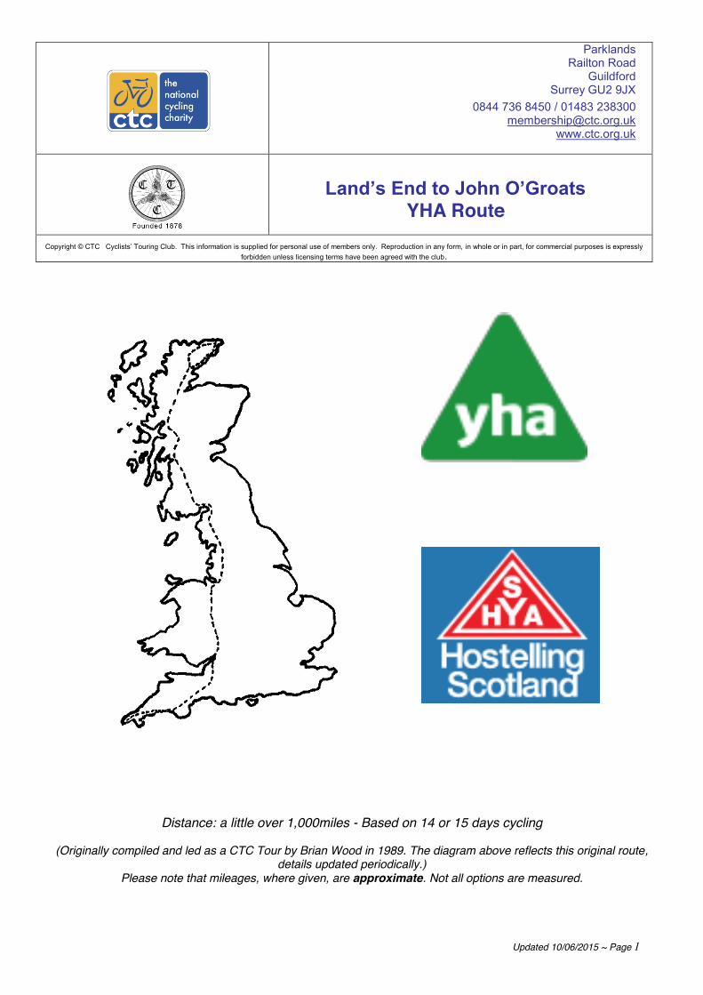
Land’s End to John O’Groats YHA Route
Copyright © CTC Cyclists’ Touring Club. This information is supplied for personal use of members only. Reproduction in any form, in whole or in part, for commercial purposes is expressly forbidden unless licensing terms have been agreed with the club.
Distance: a little over 1,000miles - Based on 14 or 15 days cycling
(Originally compiled and led as a CTC Tour by Brian Wood in 1989. The diagram above reflects this original route,
details updated periodically.) Please note that mileages, where given, are approximate. Not all options are measured.

Updated 10/06/2015 ~ Page 2
Plotted using the available GPX files from CTC-Maps and visualised using http://www.gpsvisualizer.com/
Updated 10/06/2015 ~ Page 3
You are now unfortunately unable to ride the route exactly as described below using only YHA/SYHA establishments as a number have closed over the years. The days are already too long for some and travelling to the next nearest YHA hostel will in a lot of cases seriously increase the days riding, meaning alternative accommodation must be sought. Fortunately some ex-YHA hostels are re-opening as independent hostels – see http://www.independenthostels.co.uk/ , alternative information on accommodation will be listed in each section and alternative accommodation can also be sough at www.cyclistswelcome.co.uk You are advised to book well in advance, whatever time you plan to do the ride. Bookings can be taken at individual hostels or centrally. For up-to-date opening times for each hostel, consult the websites below.
As a benefit of CTC Membership you are eligible for 50% reduction on 1st year of YHA Individual, Under 26 or Household Membership Products and also 15% discount on YHA accommodation bookings when booked online. Please be aware there are terms and conditions that do apply please see the CTC Membership Benefits page for full details (Details correct as of 10/06/2015 and discounts available to members with a current CTC membership. Discount codes are also available via the Membership Team on 01483 238301 upon validation of membership):
https://www.ctc.org.uk/membership/member-benefits
YHA Membership Details: https://www.ctc.org.uk/member-benefits/half-price-yha-membership
YHA Accommodation Discount Details: https://www.ctc.org.uk/member-benefits/15-off-yha-accommadation-bookings
Youth Hostels Association Trevelyan House, Dimple Road, Matlock, Derbyshire, DE4 3YH YHA Contact Centre Hours: Mon – Fri: 8am to 8pm, Sat: 9am – 5pm, Sun & Bank Hols: 10am – 4pm Tel: 0800 0191 700 / 01629 592700 Email: [email protected] Website: www.yha.org.uk
Scottish Youth Hostels Association 7 Glebe Crescent, Stirling, FK8 2JA General enquiries: Mon – Fri: 9am – 5pm Tel: 01786 891400 Email: [email protected] SYHA Reservations (Mon – Fri: 9am – 5pm: Tel: +44 845 293 7373 Email: [email protected] Website: www.syha.org.uk
Please note also that hostels can also be booked using: http://www.hihostels.com/
Be aware that the majority of the hostels you will be using are self-catering only -Steps Bridge (now called Blytheswood), Street, Clun, Slaidburn, Carlisle and almost all SYHA hostels, including Glencoe, Loch Ness, Tongue and John O'Groats. Do check and don’t forget to prepare accordingly! Also in Scotland, local eateries are in short supply!
If really stuck, there are over 120 independent hostels in Scotland (and some in England). See www.hostel-scotland.co.uk; the Independent Hostel Guide Tel: 01629 580 427 http://independenthostels.co.uk/ NOTES ON THE ROUTE Alternatives have been incorporated into the YHA route, this does make it more complicated, but we believe the benefits outweigh the disadvantages. Hostels are often fully booked so it could be useful to have an alternative route up your sleeve.
The ‘normal’ Youth Hostels Route uses the hostels in the left hand column. Alternatives are shown in the other column – Please note this list was compiled based on the original route information. Please check your route against the YHA map supplied for current hostels.

Updated 10/06/2015 ~ Page 4
Normal Route Alternatives Land’s End Penzance Golant Treyarnon Bay Exeter* Blytheswood (Steps Bridge) (ind),
Okehampton, Moretonhampsted (ind) Street Cheddar, Bristol Welsh Bicknor (Wye Valley)
St Briavels
Clun Mill Bridges, Leominster Chester Backpackers (ind) Liverpool Slaidburn Preston University, Kirkby Stephen (ind),
Dufton, Kendal Carlisle Birdoswald, Greenhead (ind) New Lanark Glasgow Stirling Crianlarich, Loch Lomond Glencoe Glen Nevis Loch Ness Inverness Carbisdale Castle Rogart (ind) Tongue Bettyhill Hotel, Helmsdale John O’Groats*
[Ind = independent]
YHA Route on GPS - Please contact CTC and request the GPX tracks for each stage – [email protected]
Mileage Chart: see route description for distances of routes described. Two alternative routes in Scotland have the following distances between hostels:
* Closed YHA or SYHA Kendoon YHA is now closed, alternative accommodation can be found here: http://www.lochken.co.uk/accommodation/lodge Also please note that Carlisle YH during University term time is student accommodation so check for availability in advance. A larger scale version of the map can be found at the end of the route or downloaded direct
from www.yha.org.uk/all-hostels
Alt Route 1 From To Distance
(miles) Greenhead New Lanark 88 New Lanark Stirling 42 Stirling Perth 32 Perth Pitlochry 29 Pitlochry Aviemore 62 Aviemore Inverness 39 Alt Route 2 From To Distance (miles) Carlisle (Kendoon)* 61 (Kendoon)* Lochranza
(Arran) 65
Lochranza Oban 61 Oban Glen Nevis 50 Glen Nevis Loch Ness 46 Glen Nevis Inverness 67 Loch Ness Carbisdale
Castle* 63
Inverness Carbisdale Castle*
42
Updated 10/06/2015 ~ Page 5
TTHHEE YYHHAA RROOUUTTEE ABBREVIATIONS USED IN THE ROUTE DIRECTIONS R = right L = left Thro = through Cont. = cont xrds = crossroads m = miles YH = Youth Hostel SO = straight on TJ = T-Junction Imm = immediately sp = signposted r’bt = roundabout N, S, E, W, NE = Compass Points North, South, East, West, North-East etc. (*...) = Place of interest off the route - worth a visit if you have time! (.... ) = Place of interest on the route
DAYS ONE TO THREE ~ OPTION 1 DAY 1: LAND'S END TO GOLANT (approx 65m) Land's End YHA, Letcha Vean, St-Just-in-Penwith, Penzance TR19 7NT. Tel: 0845 371 9643 Fax: 01736 787337 [email protected] From YH retrace along lane to ST JUST Join B3306 then A30 to LANDS END Leave on A30 to Return along A30 to PENZANCE. On outskirts of PENZANCE turn R at r’bt (sp Town Centre). SO at r’bt into town centre. Shortly after road bends sharp L turn R down Market Jew Street (main shopping street) L at TJ to go alongside railway lines. Follow road along railway lines to L at r’bt with A30, imm R onto Jelbert Way (parallel to A30), past heliport. SO at r’bt over A30 (sp Long Rock). SO at two r’bt (sp Marazion), follow road over railway thro MARAZION. SO at r’bt with A394 onto B3280 to GOLDSITHNEY. R at 1m from r’bt at end of village, onto Trescowe Road thro MILLPOOL. R at TJ and L at TJ to GODOLPHIN CROSS. SO at xrds then SO across B3302 & B3303 thro NANCEGOLLAN. SO across B3297 to PORKELLIS where L at 1m after B3297 (effectively SO) when road bends sharp R. Thro CARNKIE and follow main road around to L in RAME thro STITHIANS. SO across A393 thro PERANWELL STATION to CARNON DOWNS. Shortly after one-way section turn R (sp Come-To-Good), cross A39 on bridge, then SO at xrds onto B3289 (Trelissick Gardens are on R; café and restaurant) to cross River Fal using KING HARRY FERRY (charge). L at top of hill (eff SO when road bends to R, sp Treworga), onto minor road thro PHILLEIGH. L at TJ onto A3078 to TREGONY. R onto B 3287 in TREGONY. R at 2.7m to stay on B3287 then L at 0.2m to stay on it again. R at TJ with A390, imm R into HEWAS WATER to STICKER. Thro STICKER, then R at 1.5m from A390 onto Treloweth Road thro POLGOOTH to LONDON APPRENTICE. L at TJ (sp St Austell B3273). R at 0.9m (just after sewage works, sp Tregorick) stay on main road at next xrds, SO at xrds onto Duport Road (sp Charlestown). L at TJ onto Charlestown Road. R at 0.2m onto Church Road, SO at r’bt (sp Carlyon Bay and Crinnis). Road becomes Crinnis Road then Beach Road. L onto Sea Road (just before Beach Road runs out by becoming car park) under railway to R at TJ onto Par Moor Road (A3082). PAR
TYWARDREATH Cross B3269 towards GOLANT.
Golant YHA: This hostel has now closed, alternative accommodation can be found online at www.cyclistswelcome.co.uk, and suggestions include: http://www.wellhousefowey.co.uk/ http://www.breezydaze.co.uk/ http://www.cyclistswelcome.co.uk/establishment/trevanion-guest-house-0

Updated 10/06/2015 ~ Page 6
DAY 2: GOLANT TO EXETER (approx. 84m)
Retrace to B3269, L to r’bt, and then L at xrds, downhill to BODINNICK FERRY L uphill. R at 2nd green with seat (sp Polrun). SO at xrds. R at TJ past Car Park. L at TJ and L at next TJ (sp Pelynt). Take next R then bear L to WATERGATE. R and L in village and L at A387 to LOOE Leave Looe on A387, bear R B3253. At junction A387, R to HESSENFORD R A374 to TORPOINT Ferry to PLYMOUTH (*see below for alternative bad weather route) Either ~ busy main road route Follow signs A386 (Tavistock) to YELVERTON R at RBT on to B3212 Or ~ Plym Valley Cycle Route (very pleasant, rough in parts) Follow signs A379 (Yealmpton). Cross Laira Bridge and join cycle route here to end at Clearbrook. Re-join road. R at T, cross small river, L (Hoo Meavy), L at X to Yelverton. Join B3212 PRINCETOWN POSTBRIDGE MORETONHAMPSTEAD Alternative accommodation at Sparrowhawk Backpackers Hostel, 45 Ford Street, Moretonhampsted, Devon TQ13 8LN Tel: 01647 440318, Fax: 0164 440318 Email: [email protected] Web: http://www.sparrowhawkbackpackers.co.uk OR the now independent Steps Bridge hostel, a further couple of miles down the road. Tel 01647 252435 It’s now known as Blytheswood. Full information at www.blytheswood.co.uk Continue under the A30 to the city centre where either get on to the NCN route south along the river for about two miles Or take the A3015 Holloway Street / Topsham Road south. R into School Lane & shortly L into Countess Wear Road. (About 2mi from centre.) Exeter YHA: This has now permanently closed, alternative accommodation can be found online at www.cyclistswelcome.co.uk, suggestions include: http://www.parkviewexeter.co.uk/
*In case of severe weather, this alternative route avoids Dartmoor by going round the south side. From PLYMOUTH (see above)… A379 sp Kingsbridge. After 10m fork L, A3121 to ERMINGTON. After about 4.5m, minor road to AVONWICK TOTNES A381 to NEWTON ABBOT town centre KINGSTEIGNTON L B3193; R B3344 thru Chudleigh to A38 junction where minor roads via Shillingford St George to Exeter. Locate A379 (near where you enter Exeter), which passes very close to YHA. Alternative route round the north of Dartmoor from GOLANT (Recommended by Colin Langdon who says it is less hilly) From YH return to road, R at TJ and imm R onto minor road. Follow main road into LOSTWITHIEL. R at TJ (effectively SO) onto A390. R onto Fore Street. Follow road thro centre of Lostwithiel, turning R to cross bridge to re-join A390 on other side of town. Thro WEST, MIDDLE and EAST TAPHOUSE. L onto B3360 to DOUBLEBOIS. SO across A38 onto minor road. Stay on main road thro MINIONS (refreshments).Carry on main road to UPTON CROSS where L onto B3254. Stay on B3254 thro CONGDON'S SHOP. SO at xrds with B3257, thro SOUTH PETHERWIN to LAUNCESTON. SO at r’bt onto A388 Western Road. Stay on A388 (main road) to avoid Launceston town centre. At bottom of descent cross river. R at r’bt ontoA388 Dutson Road. 1st R onto Ridgegrove Lane. R at TJ. L at TJ onto A388 (eff SO). Stay on A388 as it runs parallel to A30 thro LIFTONDOWN, under A30 to LIFTON. You are now on old A30 which has been downgraded to unclassified road, but is super. Stay on main road thro LEWDOWN and BRIDESTOWE. L at TJ ontoA386, under A30, past Little Chef. 2nd R sp Meldon (1st R takes you onto A30, then there is a farm entrance), follow around to L then L at TJ onto B3260 into OKEHAMPTON. Stay on B3260 into town centre; road becomes Fore Street. Go under A30 & thro STICKLEPATH, SOUTH ZEAL to WHIDDON DOWN.

Updated 10/06/2015 ~ Page 7
Minor roads to Exeter via Crockernwell, Cheriton Bridge, Tedburn St Mary, where keep R to parallel A30 all the way into Exeter. Follow normal route directions.
DAY 3: EXETER TO STREET (approx. 52m)
Return to NCN route N or retrace on A3015 to city centre. (NCN route stops here) EXETER, cross river on one-way system. Take right-hand lane on bridge (avoiding inner ring road) then imm L onto New Bridge Street which becomes Fore Street and is main road thro town centre; part is pedestrianised and you may need to walk your cycle. Follow road until r’bt, 2nd exit is B3212 Pinhoe Road, stay on this to L at TJ onto B3181 (sp Broadclyst).
There are two options; both run roughly parallel with the A30 to Honiton. Which is better is not known, but there is a suspicion that the first may be slightly less hilly. Option 1 On B3181 pass under M5, then slip road L and follow signs & pass thro SOWTON, CLYST HONITON, JACK IN THE GREEN, FAIRMILE, WESTON to HONITON. Option 2 From DOG VILLAGE on B3181, fork R and follow signs & pass thro WHIMPLE, TALATON Turn R in village centre, sp Feniton. Join A30 at FENNY BRIDGES and proceed to HONITON Either use by-pass or ride thro HONITON & cont. on A30 to MONKTON After approx. 1m take next L fork, sp Upottery. After passing thro RAWRIDGE take 1st R fork (at Bidwell Farm) i.e. do not pass thro centre of Upottery village. Cross xrds and keep to R of River Otter. Road bears R up hill. Towards top of hill, take 1st L by farm buildings. After 1m R at Twistgates Farm and follow minor lane round to R, uphill to A303. Turn L onto A303 and follow for approx. 6m, then L thro BROADWAY R in village, cross A358 to PUCKINGTON (B3168). R to BARRINGTON SHEPTON BEAUCHAMP WEST LAMBROOK EAST LAMBROOK STAPLETON L at B3165 to LONG SUTTON R A372, L B3165 to SOMERTON thro town then L B3151. Before reaching Street at top of Ivythorn Hill turn L, sp Bridgwater. YH is 500 yards on R at public car park.
Street YHA: The Chalet, Ivythorn Hill, Street, Somerset BA16 OTZ Tel: 0845 371 9143 Fax: 01458 840 070 [email protected]
DAYS ONE TO THREE ~ OPTION 2
DAY 1: LAND’S END TO TREYARNON BAY (Approx. 65m) Leave on A30. R onto B3315. R onto minor roads via LAMORNA, MOUSEHOLE & NEWLYN into PENZANCE and onto A30. R towards MARAZION. SO across A394 on B3280 and minor roads to CAMBORNE (NCN3 weaves its way thro here – hard to follow). Cont. via REDRUTH, ST DAY, CHACEWATER to THREEMILESTONE L and SO across A390 to join B3284 at SHORTLANDSEND. L to join NCN 32 and cont. via St ALLEN to A30. SO (L and imm R) to St NEWLYN EAST, ST COLUMB MAJOR & RUMFORD. Minor roads to TREYARNON BAY via PORTHCOTHAN or SHOP. Treyarnon YHA, Tregonnan, Treyarnon, Padstow Cornwall PL28 8JR Tel: 0845 371 9664 Fax: 01841 541 457 [email protected]

Updated 10/06/2015 ~ Page 8
DAY 2: TREYARNON BAY TO OKEHAMPTON (Approx. 65m) Return inland to B3276 and L into PADSTOW. Cross to ROCK on passenger ferry. Join B3314 and follow to DELABOLE 1m further on L to join B3266. At next junction, R and cross A39 DAVIDSTOW. Follow minor roads near Tremail, St Clether and Laneast to A395.R and cont. for 1.8m before L into Under Lane. Follow to A388 where L (away from Launceston) and 1st R (Ridgegrove Lane). When met again, L onto A388 ("old" A30) and cont. on minor roads to BRIDESTOWE. Follow Granite Way (NCN 27) signs to OKEHAMPTON (which can also be reached via A386 and B3260). Okehampton YHA, Klondyke Road, Okehampton EX20 1EW Tel: 0845 371 9651 Fax: 01837 53965 [email protected] DAY 3: OKEHAMPTON TO CHEDDAR or STREET (approx. 87m or 80m) Leave on B3260 ("old" A30) and minor roads via SOUTH ZEAL to WHIDDOW DOWN Straight across A382 to A30. Straight over on minor roads via HITTISLEIGH & YEOFORD where R to CREDITON. Leave on A3072.After 1m R. onto minor roads thro SHOBROOKE, & SILVERTON to CULLOMPTON. (Note: there are major hills around Bradninch, so suggest you head E from Silverton, thru Ellerhayes to cross M5 towards Budlake). L on to B3181 & continue to jnct with A38. Cross and cont. on minor roads to WESTLEIGH. Pick up NCN route 3 which takes you thro TAUNTON, BRIDGWATER (almost) to run past STREET (turn off soon after village of ASHCOTT to reach STREET). YH is S of the town. For CHEDDAR, leave Bridgwater on A39. After 3.4m, L on B3141 which becomes B3139. At WEDMORE L onto B3151 to CHEDDAR Cheddar YHA, Hillfield, Cheddar Somerset BS27 3HN Tel: 0845 371 9730 Fax: 0 1934 744724 [email protected] DAY 4: STREET TO WELSH BICKNOR (WYE VALLEY) (approx. 75m)
From YH return to B3151 and turn L thro STREET to A39. Turn R, GLASTONBURY WELLS Exit on A39 & soon L onto minor lane (Old Bristol Road), thro UPPER MILTON Over xrds at Hunters Lodge Inn, cross B3135 onto B3134 and after ½m go SO at Castle of Comfort Inn, minor lane to WEST HARPTREE Cross A368, turn L at B3114 past Chew Valley Lake to CHEW STOKE. R onto Walley Court Road. This leads to Chew Lake and the Chew Lake Visitor Centre for refreshments. L out of Visitor Centre and imm R onto Denny Lane. L at TJ thro CHEW MAGNA. L at TJ onto B3130. SO at r’bt to stay on B3130. Thro WINFORD to SO at xrds with A38 (onto closed road, sometimes overgrown but usually passable, if you don't fancy it turn R onto A38 then L onto B3130). SO at xrds with B3130. R at TJ into LONG ASHTON. In LONG ASHTON L up Providence Lane (hill! at 0.5m from turn onto road) SO across B3128 onto Longwood Lane (sp Clifton). R at xrds onto B3129. R at TJ onto A369 then L to re-join B3129 (Bridge Road) and cross Clifton Suspension Bridge (free for cycles). 1st L onto Clifton Down, then L to stay on Clifton Down. SO across A4176 onto Ladies Mile. L at TJ onto Stoke Road and 1st R onto Saville Road. Keep SO until end, then R and imm L at r’bt onto Westbury Road. Stay on main road which becomes Falcondale Road. L at signalled junction onto Henbury Road (the B4055), pass Henbury Castle. R at r’bt onto Station Road. L at r’bt onto Avonmouth Way, this becomes Hallen Road. Go under M5 and next R onto Berwick Lane (sp NCN4).
Updated 10/06/2015 ~ Page 9
L at TJ onto B4055 thro EASTER COMPTON. R onto minor road following NCN4, pass Pilning Station, SO on main road (when NCN4 turns L towards Awkley) to TOCKINGTON (nice pub). L in Tockington, then L again (sp Aust) thro OLVESTON. L at TJ onto B4461. R at motorway junction r’bt to access M48 bridge cycle track on L of road to services. Cross Severn Estuary on bridge. From CHEDDAR YH L onto A371 and cont. to AXBRIDGE. At end of town fork R and just before A38, bear L onto NCN 26 which leads via long unlit tunnel to WINSCOMBE. (Alternatively NCN 26 can be joined (unsigned) where B3151 meets A371). Cont. to SANDFORD (A368) where SO, 1st R (Sandmead Road), and 1st L into Church Lane. L on B3133 and follow this via CONGRESBURY and YATTON. Just after crossing railway, R (Kennmoor Road). At end, L and R into Court Lane. L onto B3130 (Avon Cycleway NCN 41) and R into All Saints Lane. R on B3124 and 2nd R into Nortons Wood Lane. Cycleway is followed via CLAPTON IN GORDANO and PILL and across M5 Avon Bridge. From here there are at least 2 NCN routes (10 and 41) to "old" Severn bridge (neither is direct and minor roads (B4057, B4055) are fairly quiet). Whichever route you take, you end up on M48 crossing the Severn Estuary to end up near Chepstow. From Chepstow there are two routes of similar distance.
Option 1: SCENIC ROUTE VIA THE WYE VALLEY Follow Monmouth signs, A466 to TINTERN ABBEY, TINTERN PARVA, LLANDOGO REDBROOK Cont. almost to Monmouth. R at junction A4136 then almost imm L, minor road (with ‘No Through Road’ sign) follow until road becomes a footpath by Hadnock Court. This section to Symonds Yat is, we are informed, very pleasant cycling on a well surfaced track (2006). SYMONDS YAT L at junction, downhill, over river then R to GOODRICH L at Castle sign, R over dry arch to Welsh Bicknor. Hill up to YH. Option 2: THE HIGH ROAD R at A466 thro CHEPSTOW then L B4228 ST BRIAVELS COLEFORD ENGLISH BICKNOR Cross the river by footbridge, on old railway bridge to Welsh Bicknor YH
YHA Wye Valley (Formerly Welsh Bicknor YHA) Nr Goodrich, Ross-on-Wye Herefordshire HR9 6JJ Tel: 0845 371 9666 Fax: 01594 861276 [email protected]
DAY 5: WELSH BICKNOR (WYE VALLEY) TO CLUN (approx. 50m)
Leave YH by footbridge over River Wye. L on B4234 to ROSS-ON-WYE Cross main road at town centre, down hill steeply then fork L, minor road (past school). BRAMPTON ABBOTTS HOLE-IN-THE-WALL FOWNHOPE L B4224 to MORDIFORD 2nd R in village, minor road. After 1m L, then after ½m R. Cross A438. Cross A4103 (L then soon R), WITHINGTON R then bear L to A465. R then L to A417 at BODENHAM L to junction A49, R then bear L B4361 LEOMINSTER town centre. Leave on B4361. After ½m, L minor road. L at EYTON then after 1m turn R. Cross cross-roads. Cont for 1m bear L thro LUCTON VILLAGE to B4362. L, MORTIMERS CROSS then R on A4110 to WIGMORE ADFORTON LEINTWARDINE In village L minor road by health centre. At TJ turn R. At junction B4367, R to HOPTON HEATH STATION L B4385 to TWITCHEN PURSLOW L B4368 to CLUN
Clun Mill YHA: The Mill, Clun, Nr Craven Arms, Shropshire SY7 8NY
Updated 10/06/2015 ~ Page 10
Tel: 0845 371 9112 or 0845 293 7373 (Central Reservations & bookings more than 7 days ahead) Fax: 0845 371 9127 [email protected] this is a volunteer-run hostel.
DAY 6: CLUN TO CHESTER (approx. 60m) From YHA, leave on A488 to BISHOPS CASTLE Go past town on main road then R (sp Craven Arms). At A489 L and almost imm R, minor road. Follow road R after bridge and L then R past Oaklands up beautiful valley to BRIDGES After 2m, about 200 yards beyond top of hill, bear L HABBERLEY PONTESBURY Follow one way system then minor roads to HINTON LEA NOX R B4386, then almost imm L, FORD R onto A458. After 1m L to A5 MONTFORD BRIDGE. L then after bridge turn R FORTON YEATON BASCHURCH then minor roads to STANWARDINE-IN-THE-FIELDS BAGLEY LOWER HORDLEY LEE ELLESMERE R A495, then L A528 to OVERTON B5069 to BANGOR-on-DEE L on A525 to CROSS LANES Then R on B5130 via HOLT to CHESTER In Chester, L A41 L at r’bt, L at next r’bt, R at third r’bt (A549) YH is 500 yards from r’bt on RH side of Saltney Road
Chester YHA has closed. Fortunately there is an alternative: Chester Backpackers, 67 Boughton, Chester CH3 5AF Tel: 01244 400185 www.chesterbackpackers.co.uk) or The Bunkroom Chester: 106 Brook Street, Chester, CH1 3DU Tel: 01244 324524 www.thebunkroom.co.uk DAY 7: CHESTER TO SLAIDBURN (approx 80m)
This is a tough day. It’s long and complicated, so adding miles and time by getting lost is a possibility. Consider riding Preston (university accommodation in holiday times – Tel: 01772 892529) – Kendal, Dufton or Kirkby Stephen - Carlisle. See below for further details Leave YH turning L. L at r’bt and cross bridge. SO at r’bt thro archway then follow one-way system around to L then R to gyratory. Take road signed A41/A51 (3rd exit) onto short section of dual carriageway. Fork L at next section of one-way system staying on main road (sp A51). SO at xrds with ring road, SO at major r’bt with A55 onto Tarvin Road (still A51). L at r’bt onto A54 thro TARVIN. L onto B5393 thro ASHTON then R onto Delamere Road at Goshawk Inn. SO at xrds thro Delamere Forest to HATCHMERE. SO at xrds with B5152. R at TJ onto Norley Rd, 2nd L at Village Hall onto Maddocks Hill, L at TJ onto School Bank, L onto Onston Lane. R at TJ onto Station Rd (B5153). L imm after ACTON BRIDGE station onto Hilltop Rd (it wiggles R then L). L at TJ onto A49, cross swing-bridge. Cont on A49. At M56 r’bt take A49 (sp Warrington) to STRETTON. R in STRETTON onto B5356. SO at r’bt to stay on B5356 thro
Updated 10/06/2015 ~ Page 11
APPLETON THORN. L at TJ to stay on B5356. R at r’bt to stay on B5356. R at r’bt (sp Lymm). SO at r’bt, cross M6 and leave 2nd r’bt on B5158 to LYMM. Follow road to R; L at TJ then 1st R (sp Village Centre). Continue through village centre. L onto B5159 (sp Warburton) and over toll bridge (free for bikes). R at TJ onto A57, 1st L into HOLLINS GREEN, stay on road thro village to L at TJ onto B5212. GLAZEBROOK [After Glazebrook, see below for alternative route via Preston] then R at r’bt onto A574 (sp Leigh). Thro GLAZEBURY to SO A580 at r’bt into LEIGH. L at TJ onto A572 (sp Town Centre). SO at signalled junction to stay on Spinning Jenny Way. Pass Spinning Gate Shopping Centre and Bus Station to turn R at next signalled junction onto King Street B5215 into town centre. Head towards ATHERTON L at signals onto B5235 (Lovers Lane), SO A579 and SO A577 (L then R, sp Westhoughton) to R at TJ onto A58 then 1st L onto Park Road, R at xrds onto Bolton Road to A6 where L.
Cont along A6 for 5½m then R (Grimeford Lane) minor road. Cross main road (A673) and soon L at T. Cont to CHORLEY 2nd exit at r’bt B6228 (Eaves Lane). Cont. to T where R, downhill. At A674 turn R. Next L into WHEELTON 1st L at R hand bend sp Brindle; R (over canal), then R to BRINDLE turn R and join B5256, take L after Motorway Bridge (Hill House Lane), then 2nd R (Private Road) to HOGHTON R at T, R on to A675, then L, and then R on bend (Goosefoot Lane). In SAMLESBURY BOTTOMS R into Further Lane, R at T (A677) then L to MELLOR R at TJ, SO at traffic lights, fork L sp Whalley just before road crosses reservoir, L at shallow T, then R at the end of the road into WHALLEY Over river, SO at 1st r’bt, then L at next r’bt on B6246 to GREAT MITTON Turn R at junction B6243. After 0.7m cont SO at corner to BASHALL EAVES Bear L in Bashall Eaves. Turn R at COW ARK uphill to B6478 where turn L thro NEWTON to SLAIDBURN Slaidburn YHA, Kings House, Slaidburn, Clitheroe, Lancs BB7 3ER Tel: 0845 371 9343 Fax 0845 371 9016 [email protected] This is a volunteer-run hostel. (Central Reservations & bookings more than 7 days ahead 0845 293 7373) ALTERNATIVE ROUTE to PRESTON (& onwards to KENDAL OR KIRKBY STEPHEN) From r’bt at junction of B5212 and A574, 1st exit to CULCHETH. R in village onto B5207 & follow to GOLBORNE, ASHTON IN MAKERFIELD & BILLINGE. R onto A571 & soon L onto B5206. Follow N. L onto B5375 (sp Appley Bridge). After 1.5m, R to jnct with A5209. L & R onto B5250. Pass thro ECCLESTON. R at A581 and shortly L onto B5253. Cont to r’bt with A582. 1st exit N to centre of PRESTON. Depart PRESTON on A6 (traffic isn’t too bad). Before Catterall, R on minor road, over M6 and follow minor roads, via OAKENCLOUGH, STREET & QUERNMORE to CATON. (For speed you may wish to stay on A6.) Minor roads N to reach B6254. R to KIRKBY LONSDALE. For Kendal, stay on B6254. For KIRKBY STEPHEN, follow A683. DAY 8: SLAIDBURN TO CARLISLE (Approx 75m)
Another hard day; consider using an intermediate hostel such as Kendal, Dufton or Kirkby Stephen Leave Slaidburn on lane N to HIGH BENTHAM Cross B-road and cont N to BURTON-IN-LONSDALE Cross A687 and cont to A65 where turn L to KIRKBY LONSDALE take A683 SEDBURGH Minor road N to join A685 to TEBAY Take B6260 to ORTON Cont to minor road L to CROSBY RAVENSWORTH, KING’S MEABURN to A66. TEMPLE SOWERBY. B6412 to LANGWATHBY, LAZONBY, minor roads to ARMATHWAITE & CARLISLE. Carlisle YHA (open early July – early Sept) Old Brewery Residences Bridge Lane, Caldewgate Carlisle CA2 5SR Tel: 0870 770 5752 Fax: 01228 594631 [email protected]
[Alternative for other times: John Street Hostel, John Street, Shaddongate, Carlisle CA2 5TR Tel 01228 522435] ALTERNATIVE ROUTE THROUGH THE LAKE DISTRICT From KIRKBY LONSDALE (see above) exit on A65 soon to turn R onto B6254 & cont to

Updated 10/06/2015 ~ Page 12
OXENHOLME where L & follow lanes to BRIGSTEER UNDERBARROW CROOK where cross B5284 and bear R to INGS and TROUTBECK Join A592 to cross KIRKSTONE PASS & cont onto L at A5091. 2nd R at MATTERDALE END & keep L to cross AA66 to join B5288 to GREYSTOKE where SO (leaving B5288) to BLENCOW where SO across B5305 and cont on lanes via Hutton End, Low Braithwaite and Durdar to CARLISLE ADD AN EXTRA DAY TO YOUR TRIP AND EASE THE MILEAGE HEREABOUTS SLAIDBURN - DUFTON YHA - CARLISLE Leave Slaidburn on lane N to HIGH BENTHAM Cross B road and cont N to BURTON-IN-LONSDALE Cross and cont to A65 where turn L to KIRKBY LONSDALE Fork R in town, B6254 & soon R at KEARSTWICK & cont N along River Lune to A684 where R & soon L on B6257. Under motorway and R onto A685 to RBT where take B6280 to ORTON. Cont on B6280 to APPLEBY IN WESTMORLAND, to join B6542. Soon R to cross A66 and cont to DUFTON Dufton YHA, Dufton, Appleby, Cumbria CA16 6DB Tel: 0845 371 9734 Fax: 0845 371 9735 [email protected] Take minor roads through KNOCK, MILBURN, BLENCARN, SKIRWITH, OUSBY, MALMERBY, GAMBLESBY, RENWICK, CROGLIN NEWBIGGIN, CUMREW, CUMWHITTON & WETHERALL. SLAIDBURN - KENDAL YHA - CARLISLE From KIRKBY LONSDALE, take B6254 to KENDAL Kendal YHA, 118 Highgate, Kendal, LA9 4HE Tel: 0845 371 9641 Fax: 01539 724906 [email protected] EITHER Join above route at Crook by exiting Kendal on A591 and soon going L on B5284. OR take A685 to TEBAY, B6260 thro ORTON to L to CROSBY RAVENSWORTH, KING’S MEABURN to A66. TEMPLE SOWERBY. B6412 to LANGWATHBY, LAZONBY, minor roads to ARMATHWAITE & CARLISLE. OR take A6 direct to Carlisle, via Shap SLAIDBURN - KIRKBY STEPHEN Ind. Hostel - CARLISLE As above to A684 after KEARSTWICK (or follow A683). Reach SEDBURGH to take A683 to KIRKBY STEPHEN Kirkby Stephen Hostel (NOT YHA but still the same place & still listed on YHA website) Market Street, Kirkby Stephen CA17 4QQ Tel: 0845 371 9525 Take minor roads to SOULBY, DRYBECK, KING’S MEABURN & follow as above With the closure of Wanlockhead the route has needed to be changed and now runs from Carlisle to New Lanark to Stirling to Glencoe. One advantage is that it is no longer necessary to ride through Glasgow – seldom a pleasant experience. Alternative1 is to head west and go via the Isle of Arran – Oban – Glen Nevis – Loch Ness (or Inverness) – Carbisdale etc. This still involves main roads but these are quiet as far as Ballachulish. There is also a gap in the hostels between Carlisle and Lochranza on Arran so you’ll need to seek alternative accommodation. Alternative 2 veers off to Edinburgh and follows the NCNs 1, 77 & 7 up to Inverness, so you can enjoy a route pretty much totally free of main roads. Hostels: New Lanark – Stirling - Perth – Pitlochry – Aviemore – Inverness – Carbisdale. (See beginning of sheet for mileage chart.)
DAY 9: CARLISLE TO NEW LANARK (approx 74m)
Take the main A7 northwards out of Carlisle. Keep on the A7 past the first entrance to Kingstown industrial estate, past the BP garage and then turn left onto Parkhouse Road at HSBC. This is the last turnoff before junction 44. SO at the mini roundabout passing various car dealerships and the turnoff for Asda. Keep on this road until you have gone right round the corner at Aero Nurseries. At sign for Floriston, Metal Bridge and the refuse site (Hespen Wood), turn R. This takes you onto the new road which runs between the railway line and the motorway.
Updated 10/06/2015 ~ Page 13
Take an L and then an R, signed to GRETNA. Follow NCN74, (which should be signposted all the way) which runs close to the M6 /A74 (M), as far as the A70 where R. (approx 59 miles from Gretna). L on B7078 to HAPPENDON. After river, R on minor road. Follow this to L at 4th turn (Kirkfieldbank Road). Keep R at fork in under a mile and follow all the way to the A72 imm. After crossing river. R here and follow into LANARK. R into Wellgate and soon R again into Braxfield Road. Follow this road round two RH bends and fork L into Rosedale Street. The hostel is located at the bottom of a big hill. New Lanark SYHA Wee Row, Rosedale Street, New Lanark, ML11 9DJ Hostel Tel: 01555 666 710; Central Bookings: 0845 293 7373 [email protected] Map Reference: O.S.71 (GR 878429) DAY 10: NEW LANARK TO STIRLING (approx 42m) Return up Braxfield Road to L at Wellgate, then soon R on to Mousebank Road. Keeping R at fork cont. to R and 1st L to cross railway. Follow Craigenhill Road to KILNCADZOW. L & imm. R over A721. L & R to cross B7056. 2nd R on to Stonedyke Road. R at T on to Belstane Road. Cont. WNW on minor roads to ALLANTON. L & R to cross A71 (13.4miles). R imm into Mill Road – becomes Hartwood Road. Cross railway at HARTWOOD. Cont. to KIRK OF SHOTTS. Cross B7066 on to Duntilland Road. Pass under motorway. L at T on to Stepends Road and very shortly R on Brownieside Road. L at T on to A89 and R in 300metres on to Meadowhead Road. L at T on to Ballochney Road. AIRDRIEHILL. 2nd L on to Dykehead Road (23.9 miles). SO A73 & cont. to T at B802 where R (Glenmavis Road). AIRDRIE. R at T on to B803 Coatbridge Road. GLENMAVIS. Shortly fork L on to Condorrat Road (B802) and follow this road all the way to KILSYTH (34.4 miles). R at T and take 4th L on to Tak-ma-Doon Road. Cross the B818 at CARRON BRIDGE. Cont NE towards Stirling. At WHINS OF MILTON pass under motorway and enter STIRLING on New Line Road. R at T and shortly L on to A872. L at RBT on to Borestone Crescent B8051. Numerous road name changes but remain on this road keeping straight ahead all the way to A811 Port Street / Wellgreen Road. Keep straight ahead for a further 150 metres. A811 turns to L, you keep SO on Port Street. L on to King Street. Cont. on to Spittal Street. St John Street is on L. The hostel is located on a hill. Stirling SYHA St. John Street, Stirling, FK8 1EA Hostel Tel: 01786 473 442 Central Bookings: 0845 293 7373 [email protected] Map Reference: O.S.57 (GR 792939) DAY 11: STIRLING TO GLENCOE (approx. 80m the next two days involve riding main roads. L out of hostel to take 1st R and another two R turns on to Baker Street. R on to Corn Exchange Street to T at A811 Albert Place. R here. R at RBT on to B8051 Raploch Road. Cont. across two mini-RBTs to large RBT. Take 2nd exit on to A84 heading NW. DOUNE CALLANDER LOCHEARNHEAD. L on to A85 up Glen Ogle CRIANLARICH. Join A82 and remain on this road TYNDRUM BRIDGE OF ORCHY. Cross RANNOCH MOOR and after descending PASS OF GLENCOE (stunning but you often have to pedal downhill!) fork R on minor road. YH is in trees on L Glencoe SYHA Glencoe, Ballachulish, Argyll, PH49 4HX Hostel Tel: 01855 811 219. Central Bookings: 0845 293 7373 [email protected] Map Reference: O.S.41 (GR 118577) Option: you could split the day neatly into two more or less equal parts, stopping at Crianlarich SYHA, Station Road, Crianlarich, FK20 8QN Hostel Tel: 01838 300 260 Map Reference: O.S.50 (GR 386250).
Updated 10/06/2015 ~ Page 14
DAY 12: GLENCOE TO LOCH NESS (approx. 55m) From YH cont on minor road to GLENCOE village. R onto A82 and stay on this road via BALLACHULISH ONICH (ferry option: Corran Ferry – A861 (quiet) – Camusnagaul Ferry – warning ~ very infrequent service) FORT WILLIAM (alternative option from here: see route below) SPEAN BRIDGE INVERGARRY FORT AUGUSTUS INVERMORISTON From Fort William after 1m L A830 (Canal-side alternative to road, path on E bank. Well signposted). BANAVIE then R B8004. After approximately 6m fork L B8005 CLUNES Then forestry roads to INVERGARRY along W side of Loch Lochy. Canalside from Bridge of Oich or A82 to FORT AUGUSTUS (A CTC information sheet, The Great Glen [S12] describes the Fort William to Invermorriston section in greater detail. Much is off road but rideable on a touring cycle. Send small SAE for copy) About 1 or 2m outside Fort Augustus L into forest turning R at bottom of steep hill at end of path or take A82 to INVERMORISTON Alternative if not staying at YHA Loch Ness: take B862 running SE of Loch Ness. Less traffic, excellent scenery and views, but hillier!
Loch Ness SYHA Altsaigh, Glenmoriston, Inverness-shire IV63 7YD Tel: 01320 351 274 [email protected] YH is approximately 2½m NE of Invermoriston.
DAY 13: LOCH NESS TO CARBISDALE CASTLE (approx. 60m)
From YH cont NE on A82 to DRUMNADROCHIT L A831, R at junction A833 to MUIR OF ORD (A862) DINGWALL 1st L (Tulloch Avenue) after level crossing and at end R (Old Evanton Road). Continue to reach the B817. Pass through EVANTON. CULCAIRN to L at B9176. Then L on to A836 to ARDGAY then minor road to CULRAIN. Please note that Carbisdale Castle SYHA has since closed, the closest available accommodation will be: Balvaig Cottage Bed and Breakfast, Culrain, IV24 3DW Tel: 01549 421210 or 07969 269983 Website: http://www.explore-sutherland-and-ross.co.uk/
DAYS 14 AND 15 This route can be cycled in one day (if you're feeling energetic!) or two days at a more relaxed pace.
Firstly, the energetic "One Day to John O'Groats” option:
DAY 14: CARBISDALE CASTLE TO JOHN O'GROATS Option 1 (approx 92m) - not recommended as it uses the busy A9. Note there are some ‘interesting hills’ between Helmsdale and Dunbeath! Note: Helmsdale SYHA has re-opened so you could split the journey. If doing it in two days, the other route is much more scenic and generally more enjoyable. From accomodation cross railway bridge (as option 2) and go south on A836 OR return to ARDGAY L A836 to BONAR BRIDGE SO (hill), minor road to LITTLE TORBOLL L A9, then A99, to between Lybster and Clyth, where L onto minor road thro
Updated 10/06/2015 ~ Page 15
ROSTER L at A882 and R to pass Loch Watten. R & L onto B870. L & R to SORTAT and Brabster. R at TJ, then L to CANISBAY R onto A836 to JOHN O'GROATS
Option 2 (approx. 108m) - recommended There is a footpath (signposted Invershin) on the railway bridge (you will need to negotiate a flight of steps). From Invershin go N on A836, L onto A837, R onto B864 (spectacular waterfall), then R on A839 to LAIRG Leave on A836 (sp Tongue). At Altnaharra turn R onto B873. At Syre, cont N on B871 to A836. SO to BETTYHILL THURSO and JOHN O'GROATS
The more relaxed "Two Days to John O'Groats” option:
DAY 14: CARBISDALE CASTLE TO TONGUE (approx. 46miles)
Cont to Lairg as described in option 2 above. Leave on A836 and follow N to TONGUE Tongue SYHA Tongue, by Lairg, Sutherland IV27 4XH Tel: 01847 611789 [email protected] To reach it, leave on the A836 and follow to A838 (Tongue) where L on to A838 for village and YH.
DAY 15: TONGUE TO JOHN O’GROATS (approx. 66m)
From YH take the A836 N and E thro BETTYHILL THURSO and follow to JOHN O'GROATS The John O’Groats Hostel has now unfortunately closed alternative accommodation can be found at the following local establishments: http://www.theanchoragejohnogroats.co.uk/ http://www.seaviewjohnogroats.co.uk/ - Registered as part of the Land’s End to John O’Groats Association http://www.johnogroatsbnb.com/ http://www.johnogroatsguesthouse.com/ Or try searching on http://www.cyclistswelcome.co.uk A good site to use if you are looking at plotting your own route which will allow you to download turn by turn directions and create GPX routes is www.cycle.travel/map
CONGRATULATIONS! Looking to celebrate after your journey try the ‘The Cabin @ John O'Groats’ which holds the record for being the most northerly food takeaway on the island of Great Britain. http://www.thecabinatjohnogroats.co.uk #1 On Trip Advisor open 7 days a week from 8am to 8pm, reduced hours operate towards the end of the season so call ahead on 01955 611400 for opening hours and to also phone ahead your order! Recommendations for improvements to the route are always welcome, as is notification of errors or changes to road numbers etc; please write to: CTC HQ, Parklands, Railton Road, Guildford, Surrey, GU2 9JX or email to [email protected]

Updated 10/06/2015 ~ Page 16

E2E ~ B&BROUTE ~ Last updates performed on 12/06/2015 ~ Page 1
Parklands Railton Road
Guildford Surrey
GU2 9JX 0844 736 8450 / 01483 238300
[email protected] www.ctc.org.uk
Land’s End to John O’Groats The B&B Route
Copyright © CTC Cyclists’ Touring Club. This information is supplied for personal use of members only. Reproduction in any form, in whole or in part, for commercial purposes is expressly forbidden unless licensing terms have been agreed with the club.
E2E ~ B&BROUTE ~ Last updates performed on 12/06/2015 ~ Page 2
This route runs from Land's End to John O'Groats to take advantage of the (usually) prevailing westerly winds. A quote from a female member of the CTC should give courage to those who need it: "Having only once cycled more than 10 miles at a stretch and too busy to follow your suggested practice runs, I was delighted to actually arrive at John O'Groats! One of my best holidays ever. Having your information made me see it was easily possible and not daunting at all. What fun it was one month later to be fit, tanned and full of fantastic memories." The route is a compromise between directness and peaceful cycling, using mainly lanes and ‘B’ roads, but with no large detours to avoid busy areas. There are many opportunities for scenic diversions to visit nearby places of interest. Possible detours are marked (*). Do be aware that this is a highly scenic route, which equates to it being hilly - not all the time, but quite a lot of the time. Low gears are recommended.
Note that it is sometimes possible to get on to the National Cycle Network (NCN) route, which offers a tranquil (for the most part) signposted route. However we feel that if you intend following that route, then you would just buy the maps and go that way. For some notes on a ‘combination route’, send a small SAE to CTC National Office and ask for the NCN/LEJOG notes. You should be aware that following NCN routes can be very time consuming since they will go a mile to avoid a few yards of main road.
Maps for the ride: the following OS Landranger series (1:50 000 scale) cover the route as described: nos.203, 204, 200, 190, 180, 181, 182, 172, 162, 149, 138, 127, 118, 109, 103, 98, 97, 91, 90, 86, 85, 79, 73, 66, 65, 58,52, 53, 43, 44, 37, 36, 35, 26, 27, 21, 16, 10, 11 & 12. There may be one or two others not listed here but which cover some of the alternative sections. Carrying them all is not recommended. Do refer to the General Information sheets in this pack for further advice.
Mileages: The total distance of this route is approximately 1,000 miles. In our route itinerary we list the approximate distance between each place in column 1 and the cumulative miles in column 2. However numerous revisions over time mean that you may find anomalies.
Accommodation: Accommodation is listed separately and is in route order i.e. Land’s End accommodation is listed first, John O'Groats accommodation is listed last. B & B information includes the owner’s name, address and the national dialling code, phone and /or fax number. For more B&B’s, you can refer to the CTC’s Cyclists Welcome web based accommodation guide. www.cyclistswelcome.co.uk
Tourist Information Centres (T.I.C.'s) along the route will also be able to provide details of accommodation and make bookings for you. The telephone numbers of T.I.C.’s can be obtained on the following website:
https://www.visitengland.com/explore
Here you are able to filter to just the TIC’s in the given area, the main Visit England site (www.visitengland.com) is a good resource for various things related to your journey.
Further information on accommodation may be found in the ‘General Information’ section at the beginning of the pack.
If you discover any accommodation which is not listed in Cyclists Welcome!, or in this booklet, and which you would like to recommend to other cyclists, please follow the link below this will allow you to recommend an establishment: http://www.cyclistswelcome.co.uk/recommend-an-establishment
Terrain: If you’re not particularly familiar with the landscape of Great Britain, you may be surprised by the remoteness of some of the areas you will be passing through. A shop is not always conveniently situated in the next village; indeed the next village may be many miles distant. It’s worth being aware of this and ensure that you do have some emergency rations with you.
E2E ~ B&BROUTE ~ Last updates performed on 12/06/2015 ~ Page 3
NOTES ON ROUTE DIRECTIONS ( *... ) = Place of interest off the route - worth a visit if you have time! ( .... ) = Place of interest on the route Alternative routes are shown in a different typeface
Mileages: the approximate distance between each place is listed in column 1 and the cumulative miles in column 2.
ABBREVIATIONS R = right, L = left Thro = through Cont. = continue x-roads = crossroads m = miles sp = signposted SO = straight on or over N, S, E, W, NE = Points on the Compass - North, South, East, West, North-East etc.
GPS Users ~ GPX Files can be requested from the following email address: [email protected] please be aware that these are to only be used as a guide. Below is a list of the LEJOB B&B route sections available on the CTC Maps site:
LEJOG B&B Route 1. Land's End to Wadebridge (B&B LEJoG) 2. Wadebridge to South Molton (B&B LEJoG) 3. South Molton to Cheddar (B&B LEJoG) 4. Cheddar to English Bicknor (B&B LEJoG) 5. English Bicknor to Much Wenlock (B&B LEJoG) 6. Much Wenlock to Bucklow Hill (B&B LEJoG) 7. Bucklow Hill to Slaidburn (B&B LEJoG) 8. Slaidburn to Kirkoswald (B&B LEJoG) 9. Kirkoswald to Ettrick (B&B LEJoG) 10. Ettrick to Drum (B&B LEJoG) 11. Drum to Spittal of Glenshee (B&B LEJoG) 12. Spittal of Glenshee to Dava (B&B LEJoG) 13. Dava to Bonar Bridge (B&B LEJoG) 14. Bonar Bridge to John O'Groats (B&B LEJoG)
There is also a B&B Route track (the complete route) called LEJoG route available from www.ctc-maps.org.uk or by contacting us on email at [email protected]. If you are experiencing any issues accessing the CTC Maps site please contact the Membership Team on 01483 238301 and we can arrange for any GPX route information to be sent to you.

E2E ~ B&BROUTE ~ Last updates performed on 12/06/2015 ~ Page 4
CORNWALL
LAND’S END (County of Cornwall). After 0.5 m bear R on B3315 (*Mousehole) 11.5 NEWLYN Follow seashore road (or cyclepath) to 1.0 12.5 PENZANCE Continue (tricky navigation) around the bay to 3.0 15.5 MARAZION Continue through village, up hill and straight over A394 at roundabout to 1.5 17.0 GOLDSITHNEY After village bear R on lane. Turn R at T junction in 2 miles 4.5 21.5 GODOLPHIN CROSS Continue to cross B3302 & B3303 2.0 23.5 NANCEGOLLAN Continue E. Cross B3297 4.0 27.5 PORKELLIS There's a L here which is effectively straight on, up the side of the pub. Continue
generally East 2.0 29.5 CARNKIE 0.5m after village turn L (Northwards), effectively staying on the priority road which
bends around to the left 2.5 32.0 STITHIANS Continue forward uphill, cross A393 heading generally E through Perranwell to 4.0 36.0 PERRANWELL STATION Turn L across railway, then R & R again to cross river & cont
straight up hill generally E, pass under railway bridge and turn left (North) at crossroads by Church. Take first lane right and continue to
5.0 41.0 TRURO (Cathedral) Take B3284 NW (direction of Shortlanesend), just beyond cathedral turn right, then L under railway, follow river
3.0 44.0 IDLESS Take the next 3 R turns, then L after Tretherres farmhouse to 3.5 47.5 ST ALLEN Continue past Tolcarne, Trefronick & Trenerry farms. Don't turn left for Zelah! Turn
L on A30 then bear R on B3285, turn sharp R immediately on lane north to 3.5 51.0 FIDDLERS GREEN Turn R
Miles
Cum. miles ROUTE DIRECTIONS
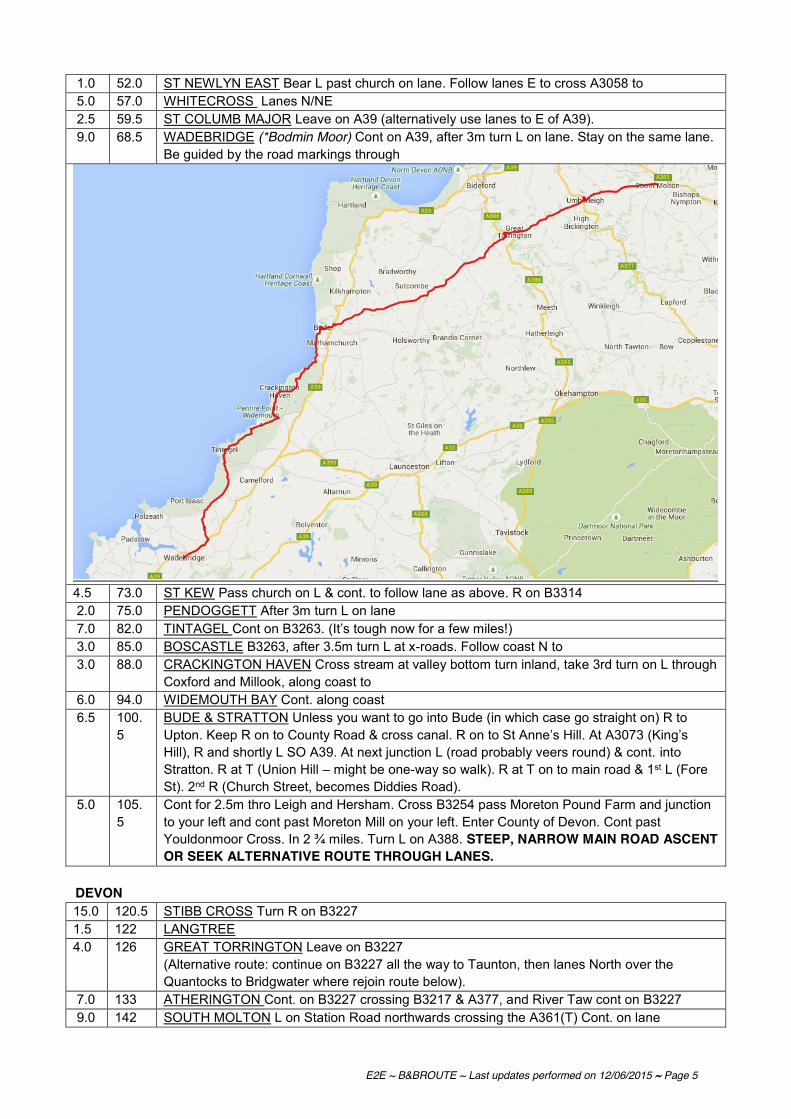
E2E ~ B&BROUTE ~ Last updates performed on 12/06/2015 ~ Page 5
1.0 52.0 ST NEWLYN EAST Bear L past church on lane. Follow lanes E to cross A3058 to 5.0 57.0 WHITECROSS Lanes N/NE 2.5 59.5 ST COLUMB MAJOR Leave on A39 (alternatively use lanes to E of A39). 9.0 68.5 WADEBRIDGE (*Bodmin Moor) Cont on A39, after 3m turn L on lane. Stay on the same lane.
Be guided by the road markings through
4.5 73.0 ST KEW Pass church on L & cont. to follow lane as above. R on B3314 2.0 75.0 PENDOGGETT After 3m turn L on lane 7.0 82.0 TINTAGEL Cont on B3263. (It’s tough now for a few miles!) 3.0 85.0 BOSCASTLE B3263, after 3.5m turn L at x-roads. Follow coast N to 3.0 88.0 CRACKINGTON HAVEN Cross stream at valley bottom turn inland, take 3rd turn on L through
Coxford and Millook, along coast to 6.0 94.0 WIDEMOUTH BAY Cont. along coast 6.5 100.
5 BUDE & STRATTON Unless you want to go into Bude (in which case go straight on) R to Upton. Keep R on to County Road & cross canal. R on to St Anne’s Hill. At A3073 (King’s Hill), R and shortly L SO A39. At next junction L (road probably veers round) & cont. into Stratton. R at T (Union Hill – might be one-way so walk). R at T on to main road & 1st L (Fore St). 2nd R (Church Street, becomes Diddies Road).
5.0 105.5
Cont for 2.5m thro Leigh and Hersham. Cross B3254 pass Moreton Pound Farm and junction to your left and cont past Moreton Mill on your left. Enter County of Devon. Cont past Youldonmoor Cross. In 2 ¾ miles. Turn L on A388. STEEP, NARROW MAIN ROAD ASCENT OR SEEK ALTERNATIVE ROUTE THROUGH LANES.
DEVON 15.0 120.5 STIBB CROSS Turn R on B3227 1.5 122 LANGTREE 4.0 126 GREAT TORRINGTON Leave on B3227
(Alternative route: continue on B3227 all the way to Taunton, then lanes North over the Quantocks to Bridgwater where rejoin route below).
7.0 133 ATHERINGTON Cont. on B3227 crossing B3217 & A377, and River Taw cont on B3227 9.0 142 SOUTH MOLTON L on Station Road northwards crossing the A361(T) Cont. on lane

E2E ~ B&BROUTE ~ Last updates performed on 12/06/2015 ~ Page 6
3.5 145.5 NORTH MOLTON Cont through village (enter County of Somerset) SOMERSET 8.0 153.5 WITHYPOOL Bear R, cross B3223 4.0 157.5 WINSFORD Turn R on road to Minehead and Dulverton. Turn L on to A396 and continue for
approx 2 miles. In wooded area, turn R on lane (sp Watchet / Taunton), then R along B3224 following Brendon Hills eastwards to
13.5 171 ELWORTHY Cont. on B3224 SE to A358 where turn R to 6.5 177.5 BISHOPS LYDEARD Turn left to centre of Bishops Lydeard where turn left on lane NE to 2.0 179.5 COTHELSTONE Cont. on lane NE. At crossroads at top of hill turn R, following lanes NE to 6.0 185.5 ENMORE Cont. on lanes NE to 4.5 190 BRIDGWATER Coming into town go R at T (Durleigh Rd); 2nd L (Oakfield Rd); R (Willoughby
Rd); R (Alfoxton Rd); L (Danesboro Rd); to T (A39 Quantock Rd). Either turn R here and follow thru & out of town on A39. OR follow quieter route by going L, then 3rd exit at RBT on to Western Way. SO to X where SO on to The Drove; R & L (Union Street); thru barrier to T where L (A39) to cross over motorway. Continue to
3.0 193 CRANDON BRIDGE where R on A39 (towards Street) 2.0 195 1st L (Crancombe Lane). At T in
WOOLAVINGTON, R & soon L on to B3141. R at grassy triangle to join B3139 and continue to 7.0 204 WEDMORE where L at TJ onto B3151. After CLEWER look out for, and take, a shallow R turn (SP Leisure Centre / Business Park) 6.0 210 CHEDDAR Turn R then L at the market cross and SO at RAB to leave on B3135 up the gorge.
At the top bear L on B3371 (unsigned as such). Ignore R fork signed Bristol. Cont on lane NE and over two X roads to

E2E ~ B&BROUTE ~ Last updates performed on 12/06/2015 ~ Page 7
AVON [now several unitary authorities] 2.5 212.5 COMPTON MARTIN (Enter County of Avon) Turn R on to A368 to WEST HARPTREE Then 1st L (SP Chew Valley Lake) Merge on to B3114 to 4.5 217 CHEW STOKE Continue on B3114 to meet B3130 at 1.5 218.5 CHEW MAGNA Go R on B3130 for 2¾ miles through Belluton where turn R on lane to A37.
Straight over A37 with care and cont on lanes to 3.5 222 PUBLOW Continue eastwards to 0.5 222.5 WOLLARD where turn R over River Chew to 1.5 224 COMPTON DANDO Turn R in village (before the R Chew bridge), on lane eastwards, then
take first L up steep hill to 1.5 225.5 BURNETT Straight ahead through village to junction with B3116. Cross straight over B3116
into Middlepiece Lane. At T junction turn L. Contine straight over crossroads along Longwood Lane to
2.0 227.5 SALTFORD Turn R on edge of Saltford and follow road round to left (Manor Road) to reach A4. Go SO A4 (BUSY ROAD) on to Beech Road. (NB Cyclists may prefer to dismount and cross the A4 at the light controlled pedestrian crossing 250 yards to the E). Then turn R to pass under railway bridge (Mead Lane). Take first L (Avon Lane) & then turn R to head N on the Bristol and Bath Railway Path. (Built by Sustrans, this path is open to pedestrians, cyclists and wheelchair users only. It provides a flat route into either Bath or Bristol for anyone wishing to detour into these cities.) Follow railway path N for 4½ miles, past Bitton Station, Oldland common and North Common to the traffic lights on the A420 (London Road). Here turn R off the Railway Path onto the A420. Follow the A420 for ½ mile to x-roads by public house. Turn L onto lane Northwards to
7.0 234.5 SISTON Follow lane thro village to 'T' junction with B4465. Turn R onto B4465 1.5 236 PUCKLECHURCH Continue on B4465 over motorway. Where B4465 bears sharp R continue
straight on, taking lane to 2.5 238.5 WESTERLEIGH Bear R in village to go northwards under railway line. Through Rodford to 2.0 240.5 NIBLEY Turn left onto A432 and first R on lane northwards. Keep left at junction in village and
continue across railway line into 1.5 242 IRON ACTON Take B4059 NW over railway to

E2E ~ B&BROUTE ~ Last updates performed on 12/06/2015 ~ Page 8
1.5 243.5 LATTERIDGE where B road bends sharp L going into the village, turn R on lane NW. Follow to ‘T’ junction where turn R and then first L passing under motorway to
3.0 246.5 ALVERSTON Keep left in Alveston and continue to junction with A38. Cross straight over A38 and follow roads through Alveston to join B4461. Turn L on B4461 to
3.0 249.5 ELBERTON Cont on B4461 towards Aust and Severn bridge. Follow B4461 to roundabout underneath motorway and follow signposts to approach road to Severn Bridge Cycle Path Northbound. Cross Severn bridge (M48) and turn right to roundabout to
GWENT 6.0 255.5 CHEPSTOW (Enter County of Gwent). Cont on A466 to TINTERN ABBEY Turn R across river 9.0 264.5 BROCKWEIR Ascend hill on lane; L (SP Coldharbour), R at T 3.5 268 ST BRIAVELS (Castle) Join B4228 6.0 274 COLEFORD (Forest of Dean) 3.5 277.5 ENGLISH BICKNOR (* Turn L across river to see Goodrich Castle) Otherwise stay on R
bank of river and join the B4234 to (Enter County of Hereford & Worcester)
HEREFORD & WORCESTERSHIRE 9.0 286.5 ROSS-ON-WYE Bear R at Market Place (SP Ledbury). 1st exit, then 2nd exit at two adjacent
mini-RBTs and immed. L on Brampton St. Cont over A40 to BRAMPTON ABBOTS HOW CAPLE (Church)
7.0 293.5 FOWNHOPE L on to B4224

E2E ~ B&BROUTE ~ Last updates performed on 12/06/2015 ~ Page 9
2.5 296 MORDIFORD Cont straight on at bottom of hill on to lane (direction Prior’s Frome). After lm turn L, cross River Lugg, then turn R. Cross A438; cross A4103 WITHINGTON Bear L in village, turn R & L across A465, cont on lane to
10.5 306.5 BODENHAM Join A417. After 0.25m R on lane. Turn L for STOKE PRIOR. Continue to join A44
5.0 311.5 LEOMINSTER ... just before the A44/A49 junction. Take a cycleway off to the right, crossing the A49 at a toucan (signaled) crossing. R at the end into Leominster. The road bends sharp left and becomes one-way as it goes through the town centre. Follow the one-way circuit all the way until L at TJ (SP Other Routes). SO at junction where you join the A44 Broad Street. L at RAB (SP RICHARDS CASTLE) onto the B4361 North Road through LUSTON.
3.0 314.5 LUSTON (* Take L for Croft Castle & Croft Ambry Camp) SHROPSHIRE 5.0 319.5 RICHARDS CASTLE (Enter County of Shropshire) 6.0 325.5 LUDLOW (Church, museum, many old houses). Bear R after bridge on to Old Street, R
into Tower St (narrow), fwd past Somerfield & bear L on to Upper Galdeford. Over TRLights into Gravel Hill. L at RH bend on to New Road. Follow to mini RBT where 2nd exit on to Fishmore Road. Fly over A49. Proceed to BOULDON Turn L across stream
10.5 336 TUGFORD (Church) Bear L out of village STANTON LONG Turn L. R on to B4368 & soon L. R on to B4378
1.5 342 BROCKTON 5.0 347 MUCH WENLOCK (Raynalds Mansion, Priory, Guildhall) (*For Wenlock Edge turn L at
Brockton, bear L at Easthope, turn R on B4371- adds 2.2m to the route). Leave on A4169. In approx 1m L (SP Cressage). (For historic Ironbridge* - 18c cast iron bridge, museum of early iron founding etc, cont. further on A4169 & go R after crossing river.)
5.0 352 CRESSAGE R on B4380. SO staggered Xroads and pass through Eaton Constantine,
Rushton & Aston to 4.0 360 WROCKWARDINE Keep R by church. R on B4394 1.5 361.5 ADMASTON Turn L on Bratton Road, turn L on B5063, take next R turn, cross canal onto
A442
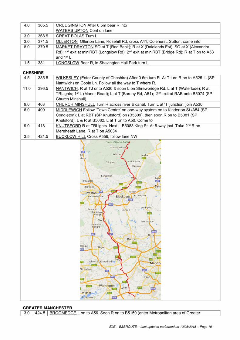
E2E ~ B&BROUTE ~ Last updates performed on 12/06/2015 ~ Page 10
4.0 365.5 CRUDGINGTON After 0.5m bear R into WATERS UPTON Cont on lane
3.0 368.5 GREAT BOLAS Turn L 3.0 371.5 OLLERTON Ollerton Lane, Rosehill Rd, cross A41, Colehurst, Sutton, come into 8.0 379.5 MARKET DRAYTON SO at T (Red Bank); R at X (Dalelands Est); SO at X (Alexandra
Rd); 1st exit at miniRBT (Longslow Rd); 2nd exit at miniRBT (Bridge Rd); R at T on to A53 and 1st L
1.5 381 LONGSLOW Bear R, in Shavington Hall Park turn L CHESHIRE 4.5 385.5 WILKESLEY (Enter County of Cheshire) After 0.6m turn R. At T turn R on to A525. L (SP
Nantwich) on Coole Ln. Follow all the way to T where R. 11.0 396.5 NANTWICH. R at TJ onto A530 & soon L on Shrewbridge Rd. L at T (Waterlode); R at
TRLights; 1st L (Manor Road); L at T (Barony Rd, A51); 2nd exit at RAB onto B5074 (SP Church Minshull).
9.0 403 CHURCH MINSHULL Turn R across river & canal. Turn L at 'T' junction, join A530 6.0 409 MIDDLEWICH Follow ‘Town Centre’ on one-way system on to Kinderton St /A54 (SP
Congleton); L at RBT (SP Knutsford) on (B5309), then soon R on to B5081 (SP Knutsford). L & R at B5082. L at T on to A50. Come to
9.0 418 KNUTSFORD R at TRLights. Next L B5083 King St. At 5-way jnct. Take 2nd R on Mereheath Lane. R at T on A5034
3.5 421.5 BUCKLOW HILL Cross A556, follow lane NW
GREATER MANCHESTER 3.0 424.5 BROOMEDGE L on to A56. Soon R on to B5159 (enter Metropolitan area of Greater
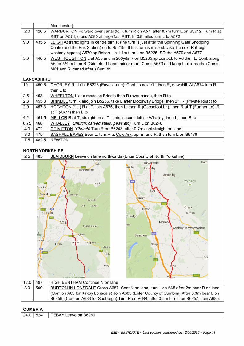
E2E ~ B&BROUTE ~ Last updates performed on 12/06/2015 ~ Page 11
Manchester) 2.0 426.5 WARBURTON Forward over canal (toll), turn R on A57, after 0.7m turn L on B5212. Turn R at
RBT on A574, cross A580 at large fast RBT. In 0.8 miles turn L to A572 9.0 435.5 LEIGH At traffic lights in centre turn R (the turn is just after the Spinning Gate Shopping
Centre and the Bus Station) on to B5215. If this turn is missed, take the next R (Leigh westerly bypass) A579 sp Bolton. In 1.4m turn L on B5235. SO the A579 and A577
5.0 440.5 WESTHOUGHTON L at A58 and in 200yds R on B5235 sp Lostock to A6 then L. Cont. along A6 for 5½-m then R (Grimeford Lane) minor road. Cross A673 and keep L at x-roads. (Cross M61 and R immed after.) Cont to
LANCASHIRE 10 450.5 CHORLEY R at r’bt B6228 (Eaves Lane). Cont. to next r’bt then R, downhill. At A674 turn R,
then L to 2.5 453 WHEELTON L at x-roads sp Brindle then R (over canal), then R to 2.3 455.3 BRINDLE turn R and join B5256, take L after Motorway Bridge, then 2nd R (Private Road) to 2.0 457.3 HOGHTON (*…) R at T, join A675, then L, then R (Goosefoot Ln), then R at T (Further Ln), R
at T (A677) then L to 4.2 461.5 MELLOR R at T, straight on at T-lights, second left sp Whalley, then L, then R to 6.75 468 WHALLEY (Church; carved stalls, pews etc) Turn L on B6246 4.0 472 GT MITTON (Church) Turn R on B6243, after 0.7m cont straight on lane 3.0 475 BASHALL EAVES Bear L, turn R at Cow Ark, up hill and R, then turn L on B6478 7.5 482.5 NEWTON NORTH YORKSHIRE 2.5 485 SLAIDBURN Leave on lane northwards (Enter County of North Yorkshire)
12.0 497 HIGH BENTHAM Continue N on lane 3.0 500 BURTON IN LONSDALE Cross A687. Cont N on lane, turn L on A65 after 2m bear R on lane.
(Cont on A65 for Kirkby Lonsdale) Join A683 (Enter County of Cumbria) After 6.3m bear L on B6256. (Cont on A683 for Sedbergh) Turn R on A684, after 0.5m turn L on B6257. Join A685.
CUMBRIA 24.0 524 TEBAY Leave on B6260.
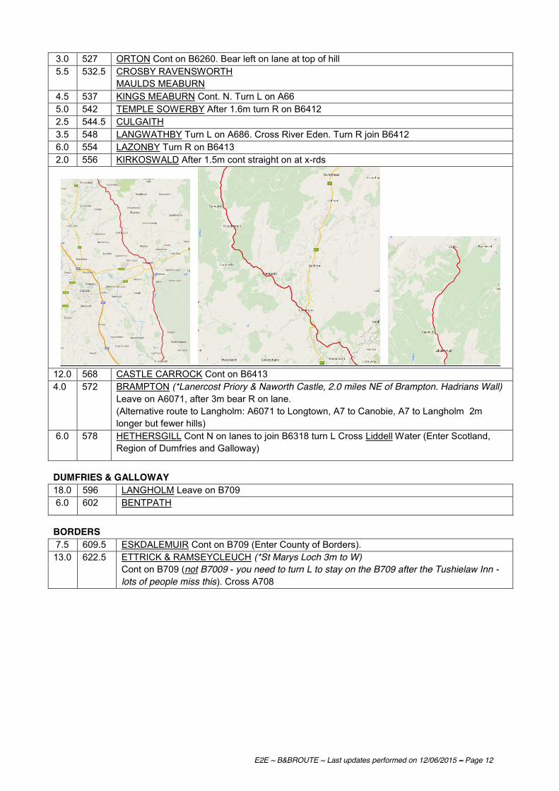
E2E ~ B&BROUTE ~ Last updates performed on 12/06/2015 ~ Page 12
3.0 527 ORTON Cont on B6260. Bear left on lane at top of hill 5.5 532.5 CROSBY RAVENSWORTH
MAULDS MEABURN 4.5 537 KINGS MEABURN Cont. N. Turn L on A66 5.0 542 TEMPLE SOWERBY After 1.6m turn R on B6412 2.5 544.5 CULGAITH 3.5 548 LANGWATHBY Turn L on A686. Cross River Eden. Turn R join B6412 6.0 554 LAZONBY Turn R on B6413 2.0 556 KIRKOSWALD After 1.5m cont straight on at x-rds
12.0 568 CASTLE CARROCK Cont on B6413 4.0 572 BRAMPTON (*Lanercost Priory & Naworth Castle, 2.0 miles NE of Brampton. Hadrians Wall)
Leave on A6071, after 3m bear R on lane. (Alternative route to Langholm: A6071 to Longtown, A7 to Canobie, A7 to Langholm 2m longer but fewer hills)
6.0 578 HETHERSGILL Cont N on lanes to join B6318 turn L Cross Liddell Water (Enter Scotland, Region of Dumfries and Galloway)
DUMFRIES & GALLOWAY 18.0 596 LANGHOLM Leave on B709 6.0 602 BENTPATH
BORDERS 7.5 609.5 ESKDALEMUIR Cont on B709 (Enter County of Borders). 13.0 622.5 ETTRICK & RAMSEYCLEUCH (*St Marys Loch 3m to W)
Cont on B709 (not B7009 - you need to turn L to stay on the B709 after the Tushielaw Inn - lots of people miss this). Cross A708

E2E ~ B&BROUTE ~ Last updates performed on 12/06/2015 ~ Page 13
16.5 639 TRAQUAIR (Traquair House) Turn L on B7062. Arrive at 7.0 646 PEEBLES R at RAB, cross river, R at RAB onto High Street; almost leave town then L at
RAB on to A703.
Bear R on A6094 after 9.6m (Enter Lothian Region) LOTHIAN 12.0 658 HOWGATE Bear L on B7026 (alternative route avoiding Edinburgh City Centre starts here –
see below) 2.5 660.5 AUCHENDINNY Join A701. Turn L onto A703, then R onto A702 to
Fairmilehead. Follow signs to City Centre (along A702)
9.0 669.5 EDINBURGH
The Edinburgh Cycle Map is a street plan of the city and extends south as far as the A720 ring road. It’s available to roder (post-free) by sending a cheque made payable to SPOKES to the following address: Spokes (the Lothian Cycling Campaign group), St Martin’s Church, 232 Dalry Road, Edinburgh, EH11 2JG, price £5.95. This indicates suggested cycling routes and contains a wealth of other useful information. http://www.spokes.org.uk/spokes-maps/ With the opening of the National Cycle Network route from the centre of town to the Forth Road Bridge, what follows is really a selection of options. Your best move is to follow the directions below until you come across NCN signs and simply follow these. Route through the City to the Forth Bridge avoiding the A720 (T) (NB. The A720 (T) Edinburgh bypass is best avoided by cyclists as it carries fast moving and heavy traffic – it is also reportedly illegal to cycle on! The A90 is OK to use going out of the city first thing in the morning, but should be avoided beyond Cramond Bridge and at other times as it is busy with fast moving traffic like the A720. Cyclists using the A90 are advised to take special care at the double roundabout at Barnton).
From centre of Edinburgh follow A90 (Forth Bridge Road) for approx 1.5 miles to 5-way junction at Craigleith, (Holiday Inn is on left hand side and Sainsburys Superstore on R). Turn R here onto South Groathill Road and after 200 yards pick up the cycle path on the left hand side. Turn L and immediately R. Follow path NW to its end.

E2E ~ B&BROUTE ~ Last updates performed on 12/06/2015 ~ Page 14
Follow the line of the path (along Silverknowes Road) down to a roundabout where L (Lauriston Farm Road) to T junction where turn R (Barnton Gardens). Follow downhill and L at fork (Gamekeeper’s Rd). L at T junction (Whitehouse Road) and then R at bottom of hill onto Braepark Road. Cross Cramond Bridge, then follow cycle path for 200yards after which there is an underpass leading to slip road to lane Westwards. Follow lane West. Pass under railway. After half a mile, just after farm on left hand side and just before bridge for disused railway turn R (no signpost), straight up and over hill and down to hamlet of Dalmeny. R then immediately L and downhill where L signposted Dalmeny Station, along Station Road to end where L then immediately R (Loch Road) to point directly under the Road Bridge. L up the path and fork R which takes you onto West side of Forth Road Bridge & cycle Path.
Route avoiding Edinburgh City Centre Leave Peebles on the A703 towards EDINBURGH, through EDDLESTON and LEADBURN.
R onto the A6094 to HOWGATE.
R to stay on the A6094 until near Rosewell on the by-pass, L onto a minor road (SP for cycles to Bonnyrigg) to POLTON.
L onto Polton Bank which leads into Polton Road, descend to cross the River North Esk and then climb the hill on the other side. SO at RAB, follow to R then L onto Clerk Street. SO at Xrds with A768 to stay on Clerk Street (B702).
R at RAB, then R at RAB again onto the A701 to cross the EDINBURGH by-pass. At the first major cross roads turn L onto the EDINBURGH Cycle Ring Road which is Frogston Road East (SP Colinton B701).
Follow the RR signs (ignore any RR signs that suggest you do a ‘U’ turn, these are for destinations back the way you came), along Frogston Road West, Oxgangs Road, Oxgangs Road North, fork Left into Redford Road, L into Bridge Road becoming Gillespie Road then Wester Hailes Road.
SO at RAB still following RR onto Bankhead Avenue, follow the RR route turning R then follow to L, then turn R onto Bankhead Drive.
Leave the RR route when it turns L (under a railway bridge), going SO, L at RAB (SP Corstorphine B701) onto Broomhouse Road. The road becomes Meadow Place Road, SO at signals, (Tesco stop is to the left here). SO at RAB onto Drum Brae South then North to BARNTON.
L onto the Queensferry Road for a short distance, move to the right-hand lane then R at Barnton Hotel (SP Cramond) onto Whitehouse Road, at the first major junction turn L onto Braepark Road and join NCN1.
Cross the old Toll Bridge at CRAMOND, stay on NCN1 along the slip roads then onto the path adjacent to the A90, then onto B924, stay on the B924 when NCN1 turns off, to ride along the Firth of Forth to QUEENSFERRY
R at the end of the cobbled section of road (effectively SO) then stay on the B924 around to the L. When you pass under the road bridge take the path to the left then R at the road up onto the bridge then cross the Firth.
FIFE 11.0 680.5 FORTH ROAD BRIDGE (Enter Fife Region) Cross the Forth Bridge. Take the first exit
off the bridge (which is down a path at the start of the car park), R onto road and turn R at the RAB then R at the next one to join the B981. Stay on the B981 through INVERKEITHING. R then L at the A921 RABs to stay on the B981 to
8.0 688.5 CROSSGATES there are two options: (The second option has much easier gradients but is 1½ miles longer). Option a) At the White House Pub turn left on B917 through Hill of Beath to KELTY. Carry straight on through the village and descend to junction. Turn left onto B996 towards Kinross. Rejoin route below at => or Option b) At White House continue straight on to Cowdenbeath Turn left at the mini-roundabout and head North up the High Street. At the mini-roundabout at the North end of the High Street turn right and at the next roundabout left towards Kelty (A909). Skirt the East of Kelty on B996 towards Kinross.
TAYSIDE

E2E ~ B&BROUTE ~ Last updates performed on 12/06/2015 ~ Page 15
6.0 694.5 =>2½ miles North of Kelty turn left onto B9097 and cross M90 at Junction (You are now in the region of Tayside). Follow B9097 for 5½ miles. Then just before (1/3 mile before) junction with A977 turn right into a narrow road which soon angles sharply left through the lanes to
7.0 701.5 DRUM village. Then this road crosses the A977 (which is very busy indeed). (SP Yetts O'Muckhart). After l½ m join A91 turning left. Follow to
3.0 704.5 YETTS O'MUCKHART Here turn right toward Crieff on A823 (junction is slightly
complicated)
Alternative route: If time is short take the A823 to Gleneagles. Cont. On A823 over A9 (bridge) to Muirton. Turn R onto A824 to Auchterarder. Turn L on B8062 to Kinkell Bridge, where cross river and immediately R on lane. Cont. For 5m to x-roads where turn L to Findo Gask. Cont. N on lane, turn R at junction and take first turn L, cross A85 to Methven and Busby. Cross R Almond and follow lane round to R to Pitcairngreen. Cont. through village take lane NE. Turn R on to B8063, cross bridge over A9 to Luncarty (33m).
Turn R shortly after joining A823 onto B934 (sp Dunning). At the summit here (a fairly gentle climb except for a short steep section early on) you get breathtaking views of Strathearn and a really exhilarating 4 mile descent to
9.0 713.5 DUNNING (13th century St Serf's Church) The next section of route takes you on a loop which will eventually lead you to Luncarty, north of Perth. If the weather is bad or you’re running late, try going straight thru Dunning and continuing to Findo Gask & Balgowan. Turn R at Balgowan and next left to Methven, then Busby, then a L to Moneydie. Just beyond Methven you should pick up the NCN Route 77 (later Route 7) and you could follow this all the way to Inverness and beyond if you wish. Many do nowadays! However we like to offer a choice, so to continue with the traditional route: The longer route from Dunning is…: Leave on B8062. Pass beneath railway and A9 and turn L on to A824 towards Auchterarder. Before the centre of village turn R onto B8062 to
7.0 720.5 KINKELL BRIDGE (*for detour to visit Britain's first public lending library (now a museum), cont. On B8062 to Innerpeffray). Cont. on B8062 and turn R on lane where B8062 bends sharp L. Cont. on lane N to A85 where straight across (R & L) to
6.0 726.5 FOWLIS WESTER (13th century Church with unusual 'lepers' squint'). Cont. up hill and turn L towards BUCHANTY. Before junction with B8063 turn R on lane Eastwards keeping River Almond on your left. Pass Trinity College on the left (where church ministers are trained). Turn L across river and R onto B8063 to
E2E ~ B&BROUTE ~ Last updates performed on 12/06/2015 ~ Page 16
12.0 738.5 MONEYDIE Cont. On B8063 cross bridge over A9 to 2.0 740.5 LUNCARTY Follow B9099 NE thro' Murthly, Gellyburn to join A984 at 5.0 745.5 CAPUTH Turn right on A984 to left turn on B947 after Spittalfield, passing thro
Lethendy and left on to the A93 The next section of this route as far as Grantown on Spey is very strenuous - plenty
of hills and a few tough climbs. It's also quite remote in places - carry food and drink! For a less strenuous (but not entirely!) and less remote alternative, here is an alternative.
LUNCARTY. From here follow the B9099 NE. At WEST TOFTS turn R on minor road to KINCLAVEN. Turn R on A93, then very soon L on minor road to COUPAR ANGUS. Leave on A94, via MEIGIE and GLAMIS to FORFAR (If you have a map, there are alternative minor roads.) Leave on B9134 to BRECHIN where continue on B966 to EDZELL and FETTERCAIRN. Take the B974 (very hilly section) to BANCHORY. Leave on A93 for Aberdeen, then bear L almost immediately on to A980 to ALFORD. Leave on A944 to join A97 to HUNTLY. (OR turn R at Bridge of Alford, then soon L and continue on minor roads over Suie Hill to Clatt and Kennethmont to join B9002 to CULTS. Soon join A97 to) HUNTLY. Leave on A920 to DUFFTOWN. (Another alternative is to cut the corner on the main road route taking the A941 from RHYNIE to DUFFTOWN: this route passes over high ground. Leave DUFFTOWN on A941 (sp Elgin). R on to A95 & soon L on to B9102 to Upper Knockando. On outskirts of CARDOW, R on to minor road to DALLAS, where L on to B9010 to FORRES. Leave on A96 and continue to AULDEARN where L on to B9101. This turns into B9090. Through CAWDOR to junction with B9091 where L. Join B9096 & continue to CULLODEN to join normal route. End of low level, bad weather alternative. Back to the normal route through the Grampians: 7.5 753 Reach BLAIRGOWRIE & RATTRAY and stay on A93. 6.0 759 BRIDGE OF CALLY Turn R on A93 GRAMPIAN 13.0 772 SPITTAL of GLENSHEE (Enter Grampian Region)
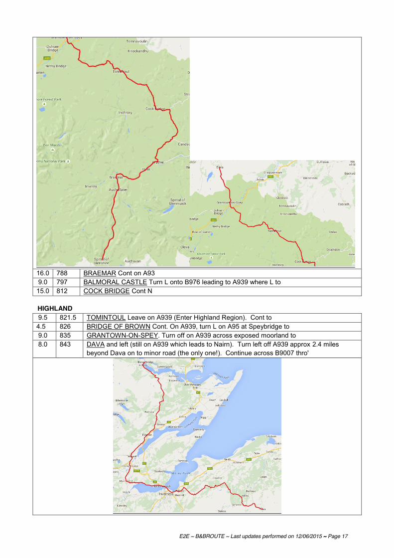
E2E ~ B&BROUTE ~ Last updates performed on 12/06/2015 ~ Page 17
16.0 788 BRAEMAR Cont on A93 9.0 797 BALMORAL CASTLE Turn L onto B976 leading to A939 where L to 15.0 812 COCK BRIDGE Cont N HIGHLAND 9.5 821.5 TOMINTOUL Leave on A939 (Enter Highland Region). Cont to 4.5 826 BRIDGE OF BROWN Cont. On A939, turn L on A95 at Speybridge to 9.0 835 GRANTOWN-ON-SPEY. Turn off on A939 across exposed moorland to 8.0 843 DAVA and left (still on A939 which leads to Nairn). Turn left off A939 approx 2.4 miles
beyond Dava on to minor road (the only one!). Continue across B9007 thro'

E2E ~ B&BROUTE ~ Last updates performed on 12/06/2015 ~ Page 18
5.5 848.5 DULSIE. Keep R to Mains of Clunas & take next left (just before Urchany), still on minor roads. Keep left just before
9.0 857.5 KIRKTON OF BAREVAN and turn L at next junction (crossroads). Cont towards Daviot and A9 to take first right (soon to descend and cross railway) to cross the B851 and very shortly the B9006 at the Culloden Battlefield site and visitor centre (* The site of the last battle fought in Britain). Alternative route from Clunas (1 mile longer):- Cont. on lane and turn left towards Kirkton of Barevan. Just before Kirkton of Barevan turn R to CAWDOR (Castle of Macbeth fame. King of Scots, died 1057). Left on B9090 and then left on B9006 to rejoin route at Culloden Battlefield).
8.0 865.5 CULLODEN BATTLEFIELD Continue on lane downhill to 1.0 866.5 BALLOCH and left to 1.0 867.5 CULLODEN (modern village) and Smithton to turn left onto the A96 towards Inverness. At
the next rbt (junction with A9) turn right and proceed over 4.0 871.5 KESSOCK BRIDGE (Cycle track on bridge) Cross bridge
Either: After bridge take the cycleway L down into NORTH KESSOCK, R onto road and follow it until just before a RAB. Take the cycle track on the R, follow it through the subway, when you exit follow around to the left then 1st R onto minor road to
DRUMSMITTAL. R onto the B9161 (SP Fortrose) to MUNLOCHY. L onto Station Brae. SO at Xrds with the A832 SP Knockbain. L at 'dead end road' sign to R when the road bends to the L into
CULBOKIE (this turn is very easy to miss, there are no signposts but you can see that the round you want bends around to the left with another road going straight on).
R at Xrds onto B9169 and 1st L onto minor road (by pub). L at TJ onto B9163 and imm R onto the A9 and cross the bridge. Follow the A9 SO at RAB at end of bridge then 2nd L onto the B817 into EVANTON.
Or: After bridge take the cycleway L down into
NORTH KESSOCK, R onto road and follow the firth bank. Bear L to pass through Charlestown, still following the firth. L at Redcastle, L on to A832. Through MUIR OF ORD (shops & café) R on to A862 to CONON BRIDGE to DINGWALL Coming into town, road crosses railway & bends to R. Go L soon on to Tulloch Avenue. R at T on to Evanton Road. Continue to EVANTON (the high road with views out over the loch) (Alternative - flatter, but slightly longer - route between Culbokie and Bonar Bridge. This route uses the Cromarty - Nigg Ferry, which currently operates a regular service, more so in summer, Off season it only works to serve local commuters at commuting (& possibly other) times. Further information: 01381 610269.] There is also NCN1 hereabouts. From CULBOKIE take B9169 north east, R on B9163 to CROMARTY where take ferry to Balnapaling. From BALNAPALING take lane R to NIGG and BALINTORE. Cont. thro. village, take lane NW, straight over B9165 to LOCHSLIN, BALCHERRY, TAIN. Turn R. on to A9, soon L on A836 to ARDGAY and BONAR BRIDGE).
16.0 888.5 EVANTON, follow lane alongside railway then left onto B9176 (just West of Alness). Stay on the B9176 over the Struie. Turn L on A 836 to
20.0 908.5 BONAR BRIDGE Cross Bridge and turn L to follow A836 N. Turn left on A837. Cont. to Inveran where turn right on to the B864 to Lairg passing the Falls of Shin (can't be seen from the A836) tearoom/shop (somewhat upmarket) at falls - quite scenic and better than A836. Join A839 turning left to

E2E ~ B&BROUTE ~ Last updates performed on 12/06/2015 ~ Page 19
10.5 919 LAIRG Cont on A836 to 21.0 940 ALTNAHARRA Turn R onto B873 to Syre where keep L to cont N on B871. At junction with
A836 turn right to 24.0 964 BETTYHILL Follow A836 E through 13.5 977.5 MELVICH (Alternative minor road route: after approx 8m turn R on lane to Shebster, R to
Broubster, and L to Halkirk. Turn R on B874 to Stemster Ho. where L on lane to B876. L on B876. Take second R thro' Greenland, Inkstack. Cont. on lanes to Canisbay (YH) and turn R on A836 to John O'Groats). Cont. to
19.5 997 THURSO to (* Detour to Dunnet Head and lighthouse - the most northerly point on the British mainland where sheer cliffs drop straight into the sea).
20.0 1017 JOHN O ‘GROATS (* Detour – mainly road - to Duncansby Head. Spectacular Coastal scenery includes the Stacks of Duncansby.)
CONGRATULATIONS! Looking to celebrate after your journey try the ‘The Cabin @ John O'Groats’ which holds the record for being the most northerly food takeaway on the island of Great Britain. http://www.thecabinatjohnogroats.co.uk #1 On Trip Advisor open 7 days a week from 8am to 8pm, reduced hours operate towards the end of the season so call ahead on 01955 611400 for opening hours and to also phone ahead your order! Recommendations for improvements to the route are always welcome, as is notification of errors or changes to road numbers etc; please write to: LEJOG, CTC, Parklands, Railton Road, Guildford, Surrey, GU2 9JX or email to [email protected]

E2E ~ B&BROUTE ~ Last updates performed on 12/06/2015 ~ Page 20
Plotted using the available GPX files from CTC-Maps and visualised using http://www.gpsvisualizer.com/

E2E - BandB List - Details are shown over two pages ................... Section 1: House name, address and name of proprietor Section 2: House name, tel no, email, internet, grid ref, no of beds, price
SECTION 1 County House Name Road District 1 District 2 Post Code Title First name Surname
1 Cornwall Sunny Bank House Sea View Hill Sennen Penzance TR19 7AR Mr & Mrs Bernard & Elleni Durrant2 Cornwall Wellington Hotel Market Square St Just Penzance TR19 7HD Mr Rod Gray3 Cornwall Garswood Guest House Alexandra Road Penzance TR18 4LX Hayley4 Cornwall Torre-Vene 11 Lescudjack Terrace Penzance TR18 3AE Mrs G Ash5 Cornwall Granary Barn & Bunkhouse Sithney Helston TR13 0AE Tom6 Cornwall Woodsedge Bed and Breakfast Gig Lane Carnon Downs Truro TR3 6JS Mrs Linda Harvey7 Cornwall Briardene Farm House Blackwater Truro TR4 8EW Mrs G A James8 Cornwall Halfway House Inn St Jidgey Nr Wadebridge PL27 7RE Mrs Lesley Wilson9 Cornwall Spring Gardens Bradfords Quay Wadebridge PL27 6DB Mrs Jenny Knightley10 Cornwall Endsleigh Whitecross Wadebridge PL27 7JD Mr George Beresford11 Cornwall Scrumptious B&B 26 Berrycombe Hill Bodmin PL31 2PW Rosemary12 Cornwall Pendrin House Atlantic Road Tintagel PL34 0DE Mrs Jo Watson13 Cornwall Polkerr Guest House Molesworth Street Tintagel PL34 0BY Mrs J A Fry14 Cornwall Bosayne Guest House Atlantic Road Tintagel PL34 0DE Mr & Mrs Julie & Keith Walker15 Cornwall Tregatherall Farm Boscastle PL35 0EQ Mrs V M Seldon16 Cornwall Sudcott Park Jacobstow Bude EX22 6XR Mr & Mrs Richard & Liz Hancock17 Cornwall Sea Jade Guest House 15 Burn View Bude EX23 8BZ Saf & Ann18 Cornwall Tee-Side Guest House 2 Burn View Bude EX23 8BY Mr & Mrs June & Ray Downes19 Cornwall Pencarrol Guest House 21 Downs View Bude EX23 8RF Mrs Edna Payne20 Devon Forda Farm Thornbury Holsworthy Beacon Holsworthy EX22 7BS Mrs Val Wood21
Devon The Bell Inn Chittlehampton Barnstaple EX37 9QL Mr & Mrs Mark & Lynn Holden23 Devon Huxtable Farm West Buckland Barnstaple EX32 0SR Mrs Jackie Payne24 Devon Fishers Down Farm South Molton EX36 3QD Mrs Diana Colman25 Somerset Cridlands Barn Brompton Ralph Taunton TA4 2RU Mr & Mrs Margaret & Adrian Armstrong26 Somerset Admirals Rest Guest House 5 Taunton Road Bridgwater TA6 3LW Ms Susan Parker27 Somerset Admiral Blake Guest House 58-60 Monmouth Street Bridgwater TA6 5EJ Mrs Pauline Paisley28 Somerset Burnt House Farm Yarrow Road Mark Nr Highbridge TA9 4LR Mrs Carmen James29 Somerset Brian & Esme's 17 Priory Road Wells BA5 1SU Mr & Mrs Brian & Esme Winter30 Somerset Arundel House Church Street Cheddar BS27 3RA Miss Anne Fieldhouse31 Somerset Anela Lower North Street Cheddar BS27 3HA Mrs Tina Darkin32 Somerset Constantine Lower New Road Cheddar BS27 3DY Mrs B Mitchell33 Somerset Neuholme B&B The Barrows Cheddar BS27 3BG Mrs Jenny Hill
Copy of E2E B&B ACCOMMODATION 230414 Page 1

E2E - BandB List - Details are shown over two pages ................... Section 1: House name, address and name of proprietor Section 2: House name, tel no, email, internet, grid ref, no of beds, price
SECTION 1 County House Name Road District 1 District 2 Post Code Title First name Surname
34 Bristol Orchard House Bristol Road Chew Stoke Bristol BS40 8UB Mrs Ann Hollomon35 Bristol Centaur B&B Ham Lane Bishop Sutton Bristol BS39 5TZ Mrs J Warden36 Bristol East View Mead Lane Saltford Bristol BS3 13EP Trish Evans37 South Gloucestershire Wilkes Farm Doynton Nr Bristol BS30 5TJ Miss Rachel Dinham38 South Gloucestershire The Old Piggery 4 Aust Road Pilning Bristol BS35 4HG39 South Gloucestershire Village Farm B&B Elberton Olverton Bristol BS35 4AG Mrs Cheryl Meredith40 Gloucestershire Prospect Cottage Lower Wye Valley Road St Briavels Nr Lydney GL15 6RR Mr & Mrs Roger & Lesley Farmer41 Gloucestershire Hillersland Nr Symonds Yat Coleford GL16 7NY Mr Chris Lathan42 Gloucestershire Brookside Rookery Farm Newland Coleford GL16 8NJ Mrs Jo Haile43 Gloucestershire Tresco Redbrook Monmouth NP25 4LY Mrs M Evans44 Hereford & Worcester Sunnymount Ryefield Road Ross-on-Wye HR9 5LU Mrs Denise Robertson45 Hereford & Worcester Vaga House Wye Street Ross-on-Wye HR9 7BS Mrs J P Gerred46 Hereford & Worcester New House Farm Much Marcle Ledbury HR8 2PH Mr & Mrs Anne & Tom Jordan47 Hereford & Worcester Tan House Ferry Lane Fownhope Hereford HR1 4NJ Ms Vera Biggs48 Hereford & Worcester Pippins Capler Lane Fownhope Hereford HR1 4PJ Mrs Ann Corby49 Hereford & Worcester Holly Tree Guest House 21 Barton Road Hereford HR4 0AY Mrs Elaine Bowkett50 Hereford & Worcester Heron House B&B Canon Pyon Road Portway Nr Burghill HR4 8NG Mrs R Huckle51 Hereford & Worcester Highgate House 29 Hereford Road Leominster HR6 8JS Mrs Margaret Merriman52 Hereford & Worcester Copper Hall South Street Leominster HR6 8JN Mrs Christine Crick53 Shropshire The Mount Guest House 61 Gravel Hill Ludlow SY8 1QS Mr Ray Foster54 Shropshire The Cecil Guest House Sheet Road Ludlow SY8 1LR Mr Ronald Green55 Shropshire The Crown Country Inn Munslow Nr Craven Arms SY7 9ET Mrs Elaine Penn56 Shropshire Peace Haven The Old School House Burwarton Nr Bridgenorth WV16 6QG Keith & Linda Wilkins57 Shropshire Yew Tree Farm Longville in the Dale Much Wenlock TF13 6 EB Mr & Mrs Anthony & Jane Hilbery58 Shropshire Old Quarry Cottage Brockton Much Wenlock TF13 6JR Mr & Mrs Tricia & Anthony Webb59 Shropshire The Fox 46 High Street Much Wenlock TF13 6AD Mrs H Davison60 Shropshire Corbet Lodge Moreton Corbet Nr Shrewsbury SY4 4DW Mrs Elizabeth Plaskett61 Shropshire Crofton 80 Rowan Road Market Drayton TF9 1RR Mrs Jill Russell62 Shropshire Millstone B&B Adderley Road Market Drayton TF9 3SW Mrs P Chinnock63 Shropshire Briar Cottage B&B Sheppenhall Lane Aston Nantwich CW5 8DT64 Cheshire Lea Farm Wrinehill Road Wybunbury Nantwich CW5 7NS Mrs Jean Callwood
Copy of E2E B&B ACCOMMODATION 230414 Page 2

E2E - BandB List - Details are shown over two pages ................... Section 1: House name, address and name of proprietor Section 2: House name, tel no, email, internet, grid ref, no of beds, price
SECTION 1 County House Name Road District 1 District 2 Post Code Title First name Surname
65 Cheshire Oakland House 252 Newcastle Road Blakelow Nantwich CW5 7ET Mr & Mrs Tony & Sue Murphy66 Cheshire Primrose Cottage Church Minshull Nantwich CW5 6DX Steven & Ruth67 Cheshire Higher Elms Farm Cross Lane Minshull Vernon Nantwich CW1 4RG Mrs A M Charlesworth68 Cheshire The Harvest Store Wimboldsley Middlewich CW10 0LN Mr & Mrs Peter & Trish Reade69 Cheshire Bridge Farm Blackden Holmes Chapel Crewe CW4 8BX Mr & Mrs Chris & Anne Massey70 Cheshire Parkdale Guest House 140 Middlewich Road Rudheath Northwich CW9 7DS Susan71 Cheshire The Hinton Guest House Town Lane Knutsford Mobberley WA16 7HH Mr & Mrs John & Rosa B ainbridge72 Lancashire The Mercury Motel 540 Manchester Road Westhoughton Bolton BL5 3JP Mr Glynn Heywood73 Lancashire Sunnydale Grimeford Lane Blackrod Bolton BL6 5LD Mr Peter Watson74 Lancashire Parr Hall Farm Parr Lane Eccleston Chorley PR7 5SL Mrs Kate Motley
75 Lancashire Rose Cottage Longsight Road (A59) Clayton-le-Dale Nr Blackburn BB1 9EX Mr & Mrs Terry & Marje Adderley76 Lancashire Whalley Abbey The Sands Whalley Clitheroe BB7 9SS Mrs Elaine Hargreaves77 Lancashire Hodder House Farm Mitton Road Bashall Eaves Clitheroe BB7 3LZ Mrs Heather Nowell78 North Yorkshire Brookhouse Café & Guesthouse Station Road Clapham Nr Settle LA2 8ER Mr Alan Whitmore79 North Yorkshire Springfield Country House 26 Main Street Ingleton Via Carnforth LA6 3HJ Mrs P V Clowes80 North Yorkshire The Dales Guest House Main Street Ingleton Via Carnforth LA6 3HH Mr Paul Weaire81 North Yorkshire The Pines Country House Ingleton Via Carnforth LA6 3HN Mr & Mrs Tim & Gloria Backhouse82 Cumbria The Copper Kettle 3/5 Market Street Kirkby Lonsdale Via Carnforth LA6 2AU Mr & Mrs Gamble83 Cumbria The Station Inn Ribblehead Nr Ingleton LA6 3AS Allan & Jo84 Cumbria Turvey House Sedbergh LA10 5DJ Mr & Mrs Derek & Elsie Liddey-Smith85 Cumbria The Cross Keys Main Street Tebay CA10 3UY Mr Anthony Gerrard86 Cumbria High Bank House Mount Pleasant Tebay CA10 3TH Mrs Wendy Perkin87 Cumbria Primrose Cottage Orton Road Tebay CA10 3TL Mrs Helen Jones88 Cumbria The George Hotel Front Street Orton Penrith CA10 3JR89 Cumbria Fell House Main Street Shap Penrith CA10 3NY Mr Louis Mushandu90 Cumbria The Limes Colby
Appleby-in-Westm. CA16 6BD Mr & Mrs Penny & Dave Orange
91 Cumbria Tufton Arms Hotel Market SquareAppleby-in-Westm. CA16 6XA Mrs Judith Mounsey
92 Cumbria Bongate House BongateAppleby-in-Westm. CA16 6UE Mr & Mrs Mary and John Geary
93 Cumbria Slakes Farm MilburnAppleby-in-Westm. CA16 6DP Mrs Christine Braithwaite
92 Cumbria Briardale Bed & Breakfast 11 Seat Hill Lazonby Penrith CA10 1BD Ms Lynda Lowthion95 Cumbria Brooklyn Lazonby Penrith CA10 1BL Mr & Mrs Robert & Eileen O'Neil
Copy of E2E B&B ACCOMMODATION 230414 Page 3

E2E - BandB List - Details are shown over two pages ................... Section 1: House name, address and name of proprietor Section 2: House name, tel no, email, internet, grid ref, no of beds, price
SECTION 1 County House Name Road District 1 District 2 Post Code Title First name Surname
96 Cumbria The Nags Head Hotel Market Place Brampton CA8 1RW Mr & Mrs T I & P S Hawkins97 Dumfries & Galloway Border House Bed & Breakfast 28 High Street Langholm DG13 OJH Mr & Mrs Gillian & Dennis Cockburn98 Dumfries & Galloway Wauchope Cottage Wauchope Street Langholm DG13 0AY99 Dumfries & Galloway Bush of Ewes Farmhouse B&B Ewes Langholm DG13 0HN Mrs Fisher100 Dumfries & Galloway Limetree House Guest House Eastgate Moffat DG10 9AE Katherine Clemmens101 Borders The Cross Keys Inn Ettrickbridge Selkirk TD7 5JN Mr & Mrs David & Penny Miles102 Borders Tushielaw Inn Tushielaw Ettrick Valley Selkirk TD7 5HT Mr & Mrs Wendy & Robin Whitehead103 Borders The School House Traquair Innerleithen Nr Peebles EH44 6PL Mrs Jennifer Caird104 Borders Caddon View Guest House 14 Pirn Road Innerleithen Nr Peebles EH44 6HH Mr & Mrs Lisa & Stephen Davies105 Borders Lindores Guest House 60 Old Town Peebles EH45 8JE Mr & Mrs Janice & Nigel Henderson106 Midlothian The Original Rosslyn Hotel Main Street Roslin Midlothian EH25 9LE107 Edinburgh Thrumbs Hotel 14-15 Minto Street Edinburgh EH9 1RQ108 Edinburgh International Guest House 37 Mayfield Gardens Edinburgh EH9 2BX109 Edinburgh Clan Walker Guest House 96 Dalkeith Road Newington Edinburgh EH16 5AF110 Perth and Kinross Blue Cedars Bed & Breakfast Drum Crook of Devon KY13 0PR Morag McKenzie111 Perth and Kinross The Willows Fowlis Wester Nr Crieff PH7 3NH Mrs Carol Sinclair112 Perth and Kinross Cherrybank Guest House 217 Glasgow Road Perth PH2 0NB Mr & Mrs Robert & Maggie Miller113 Perth and Kinross The Bankfoot Inn Main Street Bankfoot PH1 4DX Mr & Mrs Rab and Susan Wallace114 Perth and Kinross Heathpark Lodge Coupar Angus Road Rosemount Blairgowrie PH10 6JT Ruth Mitchell115 Perth and Kinross Gulabin Lodge Spittal of Glenshee by Blairgowrie PH10 7QE Mr Darren Morgan116 Perth and Kinross Dalhenzean Lodge Glenshee Blairgowrie PH10 7QD Mr & Mrs Mike & Joyce Purdie117 Aberdeenshire Morningside Kindrochit Drive Braemar AB35 5YQ Mrs I C McKellar118 Aberdeenshire Balnellan House 4 Glenshee Road Braemar AB35 5YQ Mrs F M Sharp119 Aberdeenshire Gairnshiel Lodge Glengairn Ballater AB35 5UQ Mrs Justine Buchanan120 Highland Clune House Main Street Newtonmore PH20 1DR Mrs Mary Stewart121 Highland Ravenscraig Guest House 141 Grampian Road Aviemore PH22 1RP Mrs Jill Gatenbury122 Highland Dunallan House Woodside Avenue Grantown on Spey PH26 3JN Mr G Graham123 Highland Willow Bank High Street Grantown-on-Spey PH26 3EN Mr & Mrs Anne & Chris Hirst124 Highland Parkburn Guest House High Street Grantown-on-Spey PH26 3EN Mrs Fay Hampton125 Highland The Pines Country House Duthil Carrbridge PH23 3ND Mr & Mrs Lynn & Dave Benge126 Highland Glenan Lodge Guest House Tomatin IV13 7YT Ms Lesley Smithers
Copy of E2E B&B ACCOMMODATION 230414 Page 4

E2E - BandB List - Details are shown over two pages ................... Section 1: House name, address and name of proprietor Section 2: House name, tel no, email, internet, grid ref, no of beds, price
SECTION 1 County House Name Road District 1 District 2 Post Code Title First name Surname
127 Highland Mount Pleasant B&B 16 Marine Park North Kessock Inverness IV1 3XS Mr & Mrs Anne & David Livingstone128 Highland Granite Villa Guesthouse Fountain Road Golspie KW10 6TH Jane Campbell129 Highland Kyle House Dornoch Road Bonar Bridge IV24 3EB Mrs Sheila Thomson130 Highland Mill Farm Dornoch Sutherland IV25 3NA Mrs Michelle Bowley131 Highland Carnbren Station Road Lairg Sutherland IV27 4AY Mrs Chris Powell132 Highland The Crask Inn by Lairg Sutherland IV27 4AB Mr & Mrs Mike & Kai Geldard133 Highland The Bed & Breakfast 1 MacLeod Crescent Altnaharra by Lairg Sutherland IV27 4UG Mss Mandy & Lindsay Smith134 Highland Bettyhill Hotel Bettyhill (by Thurso) Sutherland KW14 7SP Mr Andrew Carr135 Highland Dunveaden House Bettyhill (by Thurso) Sutherland KW14 7SP Mrs D M Mackenzie136 Highland Curlew Cottage Strathy Point Sutherland KW14 7RY Mrs Mackay137 Highland Tigh-Na-Clash Guest House 81 Melvich by Thurso Sutherland KW14 7YJ Mrs Joan Ritchie138 Highland Kindale Guest House 5 Lilleshall Street Helmsdale Sutherland KW8 6JF Sharon139 Highland 1 Granville Crescent Thurso Caithness KW14 7NP Mts Cath Murray140 Highland Seaview Guest House 14 Scalesburn Wick Caithness KW1 4JH Mrs June Burns141 Highland Bramhill Guest House 9 Francis Street Wick Caithness KW1 5PZ Miss Deeanne Ferrier142 Highland John o'Groats Guest House The Broo John O'Groats Caithness KW1 4YR Mr Alistair Grant143 Highland Seaview Hotel John O'Groats Caithness KW1 4YR Mr Andrew Mowat
Copy of E2E B&B ACCOMMODATION 230414 Page 5
E2E - BandB List - Details are shown over two pages ................... Section 1: House name, address and name of proprietor Section 2: House name, tel no, email, internet, grid ref, no of beds, price
SECTION 2 House Name Tel E-Mail Website Grid Ref
No of Beds-at least..
Price for one
personCW*
Listed1 Sunny Bank House 01736 871278 [email protected] www.cornwall-online.co.uk/accommodation.htm SW 36570 26388 8 35.00 CW2 Wellington Hotel 01736 787319 [email protected] www.wellington-hotel.co.uk 11 40.003 Garswood Guest House 01736 3625514 Torre-Vene 01736 364103 SW 47520 30883 8 25.00 CW5 Granary Barn & Bundhouse 07740 514 188 www.independenthostelguide.co.uk/ 8 7.50 / 15.006 Woodsedge Bed and Breakfast 01872 870269 [email protected] www.visitcornwall.co.uk SW 80236 40423 3 25.00 CW7 Briardene Farm House 01872 560384 CW8 Halfway House Inn 01208 812524 [email protected] www.halfwayhouse-stjidgey.co.uk 9 35.009 Spring Gardens 01208 813771 [email protected] www.spring-garden.co.uk SW 99086 72664 5 25.00 CW10 Endsleigh 01208 814477 [email protected] http://sites.google.com/site/endsleighbedbreakfast/ 3 35.0011 Scrumptious B&B 01208 75939 [email protected] Pendrin House 01840 770560 [email protected] www.pendrintintagel.co.uk 16 30.0013 Polkerr Guest House 01840 77038214 Bosayne Guest House 01840 770514 [email protected] www.bosayne.co.uk15 Tregatherall Farm 01840 250277 [email protected] www.boscastlebedandbreakfast.co.uk 4 28.0016 Sudcott Park 01288 341155 [email protected] www.sudcottpark.co.uk 35.0017 Sea Jade Guest House 01288 353404 [email protected] www.seajadeguesthouse.co.uk 8 30.0018 Tee-Side Guest House 01288 352351 [email protected] www.tee-side.co.uk SS 20877 06683 9 29.00 CW19 Pencarrol Guest House 01288 352478 [email protected] SS 20910 07049 7 27.00 CW20 Forda Farm 01409 261369 [email protected] www.fordafarm.com 4 28.002122 The Bell Inn 01769 540368 [email protected] http://www.thebellatchittlehampton.co.uk 4 39.5023 Huxtable Farm 01598 760254 [email protected] www.huxtablefarm.co.uk SS 66440 30848 9 34.00 CW24 Fishers Down Farm 01769 572236 [email protected] www.fishersdownfarm.com 6 27.0025 Cridlands Barn 01984 623918 [email protected] www.cridlands-barn.co.uk 3 35.0026 Admirals Rest Guest House 01278 458580 [email protected] www.admiralsrest.co.uk ST 29999 36823 7 22.50 CW27 Admiral Blake Guest House 01278 456424 www.admiralblakegh.com/ ST 30405 37240 14 25.00 CW28 Burnt House Farm 01278 641280 [email protected] www.visitsomerset.co.uk/ 8 25.0029 Brian & Esme's 01749 677300 www.smoothhound.co.uk/hotels/brian.html ST 54642 45322 6 25.00 CW30 Arundel House 01934 742264 [email protected] www.arundelhousecheddar.co.uk 9 25.0031 Anela 01934 743806 [email protected] 6 17.5032 Constantine 01934 741339 ST 45098 53179 4 24.00 CW33 Neuholme B&B 01934 742841
Copy of E2E B&B ACCOMMODATION 230414 Page 6
E2E - BandB List - Details are shown over two pages ................... Section 1: House name, address and name of proprietor Section 2: House name, tel no, email, internet, grid ref, no of beds, price
SECTION 2 House Name Tel E-Mail Website Grid Ref
No of Beds-at least..
Price for one
personCW*
Listed34 Orchard House 01275 333143 [email protected] www.orchardhouse-chewstoke.co.uk ST 56104 61925 8 28.00 CW35 Centaur B&B 01275 332321 4 23.0036 East View 01225 872526 [email protected] www.east-view.co.uk/ 4 40.0037 Wilkes Farm 0117 937 2381 www.wilkes-farm.co.uk/ 10 32.0038 The Old Piggery 01454 632504 [email protected] Village Farm B&B 01454 411065 [email protected] www.villagefarmbandb.co.uk 7 35.0040 Prospect Cottage 01594 530566 [email protected] www.prospectcottage.com GL 531 040 5 35.0041 Hillersland 01594 837893 [email protected] www.stayattherock.com SO 56853 14172 6 27.00 CW42 Brookside 01594 837166 [email protected] www.brooksidebandb.co.uk/ 4 27.0043 Tresco 01600 712325 SO 53727 10018 4 24.00 CW44 Sunnymount 01989 563880 [email protected] SO 60688 24252 6 30.00 CW45 Vaga House 01989 563024 [email protected] www.vagahouse.co.uk46 New House Farm 01531 66060447 Tan House 01432 86054948 Pippins 01432 860677 4 27.0049 Holly Tree Guest House 01432 344466 [email protected] www.hollytreehereford.co.uk SO 50524 39715 9 25.00 CW50 Heron House B&B 01432 761111 [email protected] www.theheronhouse.com SO 48731 45128 3 25.00 CW51 Highgate House 01568 614562 [email protected] www.highgate-house.co.uk 6 30.0052 Copper Hall 01568 611622 [email protected] www.copperhall.co.uk SO 49546 58468 8 36.00 CW53 The Mount Guest House 01584 874084 [email protected] www.themountludlow.co.uk SO 51501 75101 9 30.00 CW54 The Cecil Guest House 01584 872442 SO 52517 74368 10 24.00 CW55 The Crown Country Inn 01584 841205 [email protected] www.crowncountryinn co.uk SO 52231 87553 5 37.50 CW56 Peace Haven 01746 787566 [email protected] http://findpeacehaven.co.uk 657 Yew Tree Farm 01694 771866 [email protected] www.ytfarm.co.uk/Home.html 3 25.0058 Old Quarry Cottage 01746 785596 [email protected] www.oldquarrycottage.co.uk/ 3 30.0059 The Fox 01952 727292 [email protected] www.the-fox-inn.co.uk SO 62168 99825 9 32.50 CW60 Corbet Lodge 01939 250412 [email protected] www.corbetlodge.co.uk 35.0061 Crofton 01630 655484 [email protected] SJ 67995 34603 3 25.00 CW62 Millstone B&B 01630 657584 [email protected] SJ 67052 35043 5 25.00 CW63 Briar Cottage B&B 01270 781288 [email protected] www.briarcottageaston.co.uk 3 35.0064 Lea Farm 01270 841 429 [email protected] www.leafarm.co.uk/ SJ 71454 48932 4 25.00 CW
Copy of E2E B&B ACCOMMODATION 230414 Page 7

E2E - BandB List - Details are shown over two pages ................... Section 1: House name, address and name of proprietor Section 2: House name, tel no, email, internet, grid ref, no of beds, price
SECTION 2 House Name Tel E-Mail Website Grid Ref
No of Beds-at least..
Price for one
personCW*
Listed65 Oakland House 01270 567134 [email protected] www.oaklandhouseonline.co.uk/ 27.0066 Primrose Cottage 01270 522737 [email protected] www.primrosebb.co.uk 4 25.0067 Higher Elms Farm 01270 522 252 [email protected] SJ 66908 60743 6 28.00 CW68 The Harvest Store 01270 526292 [email protected] www.harveststore.co.uk/b&b.htm 10 28.0069 Bridge Farm 01477 571202 [email protected] www.bridgefarm.com 5 28.0070 Parkdale Guest House 01606 331770 9 25.0071 The Hinton Guest House 01565 873484 [email protected] www.thehintonguesthouse.co.uk 7 31.0072 The Mercury Motel 01942 810904 [email protected] www.themercurybolton.com 27 30.0073 Sunnydale 01257 48126474 Parr Hall Farm 01257 451917 [email protected] www.parrhallfarm.com SD 52067 17289 10 30.00 CW
75 Rose Cottage 01254 813223 [email protected] www.rosecottagebandb.com/ 30.0076 Whalley Abbey 01254 828400 [email protected] www.whalleyabbey.org SD 73171 36091 25 30.00 CW77 Hodder House Farm 01254 826328 [email protected] www.hodderhouse.co.uk 4 25.0078 Brookhouse Café & Guesthouse 015242 51580 [email protected] www.brookhouse-clapham.co.uk SD 74361 69019 4 25.00 CW79 Springfield Country House 01524 241280 SD 69095 72723 6 27.00 CW80 The Dales Guest House 015242 41401 [email protected] www.dalesgh.co.uk SD 69118 72779 6 25.00 CW81 The Pines Country House 015242 41252 [email protected] www.pinesingleton.com 9 29.0082 The Copper Kettle 015242 71714 SD 61114 78770 8 24.00 CW83 The Station Inn 01524 241274 (link from website) www.thestationinn.net SD 764 792 11 30.0084 Turvey House 01539 62084185 The Cross Keys 01539 624240 [email protected] www.crosskeystebay.co.uk 14 30.0086 High Bank House 01539 624651 [email protected] www.highbankhouseguesthouse.co.uk/ 6 24.0087 Primrose Cottage 015396 24791 [email protected] www.primrosecottagecumbria.co.uk/ NY 61782 04647 4 35.00 CW88 The George Hotel 01539 624229 [email protected] www.thegeorgehotelorton.co.uk/ 10 33.0089 Fell House 01931 716343 [email protected] www.coast2coast.co.uk/fellhouse/ 16 30.0090 The Limes 01768 351605 [email protected] www.orangesatthelimes.co.uk/ 4 35.0091 Tufton Arms Hotel 01768 351593 [email protected] www.tuftonarmshotel.co.uk NY 68326 20365 15 57.50 CW92 Bongate House 017683 51245 [email protected] www.bongatehouse.co.uk NY 68800 20173 12 25.00 CW
93 Slakes Farm 01768 361385 [email protected] www.slakesfarm.co.uk/ 4 30.0092 Briardale Bed & Breakfast 01768 897162 [email protected] NY 54721 39788 3 25.00 CW95 Brooklyn 01768 898357 6 25.00
Copy of E2E B&B ACCOMMODATION 230414 Page 8

E2E - BandB List - Details are shown over two pages ................... Section 1: House name, address and name of proprietor Section 2: House name, tel no, email, internet, grid ref, no of beds, price
SECTION 2 House Name Tel E-Mail Website Grid Ref
No of Beds-at least..
Price for one
personCW*
Listed96 The Nags Head Hotel 01697 7228497 Border House Bed & Breakfast 01387 380376 [email protected] www.border-house.co.uk 5 30.00
l99 Bush of Ewes Farmhouse B&B 01387 381241 3 25.00100 Limetree House Guest House 01683 220001 [email protected] www.limetreehouse.co.uk 10 42.50101 The Cross Keys Inn 01750 52224 [email protected] www.cross-keys-inn.co.uk 35.00102 Tushielaw Inn 01750 62205 [email protected] www.tushielaw-inn.co.uk NT 30564 18309 4 29.00 CW103 The School House 01896 830425 [email protected] www.stay-in-traquair.co.uk NT 33126 34477 6 25.00 CW104 Caddon View Guest House 01896 830208 [email protected] www.caddonview.co.uk 8 47.00105 Lindores Guest House 01721 722072 [email protected] www.lindorespeebles.co.uk/ NT 24803 40490 8 25.00 CW106 The Original Rosslyn Hotel 0131 440 2384 [email protected] www.theoriginalhotel.co.uk/ 8 60.00107 Thrumbs Hotel 0131 667 5545 [email protected] www.thrumshotel.com/home.htm Plenty 35.00108 International Guest House 0131 667 2511 [email protected] www.internationalguesthouse.co.uk/ 10 25.00109 Clan Walker Guest House 0131 667 1244 [email protected] www.clanwalkerguesthouse.com/ 28.00110 Blue Cedars Bed & Breakfast 01577 840396 [email protected] www.bluecedarsdrum.co.uk 4 35.00111 The Willows 01764 683202 [email protected] www.gailsinclair.co.uk/atthewillows.html 5 35.00112 Cherrybank Guest House 01738 451982 [email protected] www.cherrybankguesthouse.com/ 13113 The Bankfoot Inn 01738 787243 [email protected] www.bankfootinn.co.uk114 Heathpark Lodge 01250 874929 [email protected] www.heathparklodge.co.uk/ 4 30.00115 Gulabin Lodge 01250 885255 [email protected] www.cairnwellmountainsports.co.uk NO 10377 69928 9 17.50 CW116 Dalhenzean Lodge 01250 885217 [email protected] www.dalhenzean.co.uk NO 131 675 3 30.00117 Morningside 013397 41370 NO 15331 91237 3 24.00 CW118 Balnellan House 013397 41474 [email protected] www.geocities.com/thetropics/4921 NO 15331 91237 4 32.50 CW119 Gairnshiel Lodge 01339 755582 [email protected] www.gairnshiellodge.co.uk 16 40.00120 Clune House 01540 673359 [email protected] www.guesthousenewtonmore.co.uk NN 71797 99384 4 20.00 CW121 Ravenscraig Guest House 01479 810278 [email protected] www.aviemoreonline.com NH 89548 13162 12 30.00 CW122 Dunallan House 01479 872140 [email protected] www.dunallan.com NJ 03348 27637 10 32.00 CW123 Willow Bank 01479 872089 (email via website) www.willowbankguesthouse.co.uk 10 25.00124 Parkburn Guest House 01479 873116 [email protected] www.parkburnguesthouse.co.uk 7 32.00125 The Pines Country House 01479 841220 [email protected] www.thepines-duthil.co.uk/ 8 25.00126 Glenan Lodge Guest House 01808 511217 [email protected] www.glenanlodge.co.uk NH 79104 29618 10 27.00 CW
Copy of E2E B&B ACCOMMODATION 230414 Page 9

E2E - BandB List - Details are shown over two pages ................... Section 1: House name, address and name of proprietor Section 2: House name, tel no, email, internet, grid ref, no of beds, price
SECTION 2 House Name Tel E-Mail Website Grid Ref
No of Beds-at least..
Price for one
personCW*
Listed127 Mount Pleasant B&B 01463 731474 [email protected] www.mountpleasant-bedandbreakfast.com 5 28.00128 Granite Villa Guesthouse 01408 633146 [email protected] www.granite-villa.co.uk/ OS21 NC 833 002 10 40.00129 Kyle House 01863 766360 [email protected] NH 61096 91394 8 25.00 CW130 Mill Farm 01862 811591 [email protected] www.proncymill.com NH 915 774 3 33.00131 Carnbren 01549 402466 [email protected] CW132 The Crask Inn 01549 411241 www.letsgonorth.com/scripts/view.pl?27 5 (+12) 20.00133 The Bed & Breakfast 01549 411258 [email protected] www.altnaharra.net NC 56769 35230 6 20.00 CW134 Bettyhill Hotel 01641 521352 [email protected] www.bettyhill.info NC 70693 61826 18 20.00 CW135 Dunveaden House 01641 521273 NC 70693 61826 9 25.00 CW136 Curlew Cottage 01641 541235 [email protected] NC 82973 66909
137 Tigh-Na-Clash Guest House 01641 531262 [email protected] www.mywebpage.net/tighnaclash 6 25.50138 Kindale Guest House 01431 821415 [email protected] 1 Granville Crescent 01847 892993 [email protected] ND 11214 68370 4 25.00 CW140 Seaview Guest House 01955 602735 [email protected] ND 36976 51085 6 20.00 CW141 Bramhill Guest House 01955 602136 [email protected] www.bramhillguesthouse.co.uk 7142 John o'Groats Guest House 01955 611251 [email protected] www.johnogroatsguesthouse.co.uk ND 37894 72853 8 20.00 CW143 Seaview Hotel 01955 611220 [email protected] www.seaviewjohnogroats.co.uk ND 37894 72853 15 45.00 CW
Copy of E2E B&B ACCOMMODATION 230414 Page 10
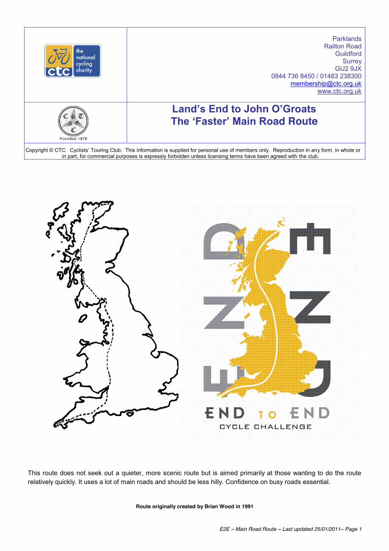
E2E ~ Main Road Route ~ Last updated 25/01/2011~ Page 1
Parklands
Railton Road Guildford
Surrey GU2 9JX
0844 736 8450 / 01483 238300 [email protected]
www.ctc.org.uk
Land’s End to John O’Groats The ‘Faster’ Main Road Route
Copyright © CTC Cyclists’ Touring Club. This information is supplied for personal use of members only. Reproduction in any form, in whole or in part, for commercial purposes is expressly forbidden unless licensing terms have been agreed with the club.
This route does not seek out a quieter, more scenic route but is aimed primarily at those wanting to do the route relatively quickly. It uses a lot of main roads and should be less hilly. Confidence on busy roads essential.
Route originally created by Brian Wood in 1991
E2E ~ Main Road Route ~ Last updated 25/01/2011~ Page 2
Travelling from Land's End to John O'Groats (or the other way) - an 'end to end' - is not a totally modern idea. Over the years, the trip has been done by many tens of thousands of people and in a number of amazing ways, however, it is a unique challenge and quite an incredible achievement. Many will remember hearing of Dr Barbara Moore and the Billy Butlin walks of the 1960's, Ian Botham did it twice and in March 2005, BBC Radio 1 DJ Chris Moyles in support of Comic Relief and James May from BBC's Top Gear in support of the RNLI. By doing this journey you will join the ranks of the famous and be able to claim your 15 minutes of fame We have previously mentioned in the introduction and practical advice section of this guide the World Record for completing the End to End by Gethin Butler of 1 day, 20 hours, 4 minutes and 19 seconds other records to take a look at are: Bicycle (Days, Hours, Minutes, Seconds) Women Single 2002 L E A Taylor 2-04-45-11 Men Tandem 1966 PM Swindon & W J Withers 2-02-14-25 UPDATE: According to the latest edition of the Tandem Club magazine, Dominic Irvine and Charlie Mitchell broke the End to End tandem record in May this year (2015) in a time of 2 days, 1 hours and 11 minutes. Women Tandem Standard to be beaten 3-12-00-00 Mixed Tandem 2000 A Wilkinson & Miss L E A Taylor 2-03-19-23 Tricycle (Days, Hours, Minutes, Seconds) Men Single 1992 R Dadswell 2-05-29-01 Women Single Standard to be beaten 4-12-00-00 Men Tandem 1954 A Crimes & J F Arnold 2-04-26-00 Women Tandem Standard to be beaten 4-00-00-00 Mixed Tandem Standard to be beaten 3-07-00-00 And don’t think the End to End is only taken on by adults: The youngest known end to end cyclist is Bow Jango Cann, aged seven and nine months, who on 21 July 2002 took the record from his brother Capability Jack Cann, aged eight, who had earned the title only ten seconds before. They did the trip in 22 days unaided using their own bikes, they rode with their teenage sisters and their parents Jim and Sam. One final thing to consider – what about riding LEJOGLE (Lands’ End to John O’Groats to Lands’ End)? This mammoth undertaking (1880 miles) was completed in a record time of 141 hours and 8 minutes by Ben Rockett on 27th Aug 2010. If you are wishing for more information on your start location or destination please see the site links below:
Land’s End: http://www.landsend-landmark.co.uk/
John O’Groats: http://www.visitjohnogroats.com/
We wish you all the luck and happy, safe cycling in your journey ahead.

E2E ~ Main Road Route ~ Last updated 25/01/2011~ Page 3
If planning your own main road route, be aware that some are very unpleasant to ride, dangerous even, including the A30 (Penzance – Exeter), the A38 (through Bristol), the A82 (Glasgow – Loch Lomond ~ on this route!) and the A9 generally ~ again on this route). Note: thanks to the National Cycle Network, the A9 and A82 can to some extent be paralleled on quiet roads and cycle paths.
Please remember this pack should only be used as a guide as this route was plotted some time ago (1991), a very helpful site where you can plot your own route including downloading GPX files to use on a sat nav system is www.cycle.travel. The map included is as an example of the route that can be plotted via this site, the route guides which can be downloaded are very concise and some may find they are too detailed but can serve as a good guide to plotting your own route. Once you have plotted your route another very handy site which will allow you to visualise your route and print screen sections for later use is http://www.gpsvisualizer.com/, here you can upload your GPX file(s) and view in a variety of map types. Please note the GPX and KMZ files on the CTC-Maps website on the CTC End to End Pack page no longer work due to their size and will only appear as straight lines. An example route produced by the www.cycle.travel site is available on this link: http://cycle.travel/map/journey/13229
In the ‘Practical Advice’ section of the E2E pack is a list of other available routes, including John Woodburn’s and Lynne Taylor’s record breaking routes. (Available only to CTC members.) These are also very much ‘main road’ routes.
Please note that this route does not include stops or accommodation information, this would be at your own discretion and information on refreshment stop and accommodation can be found on our Cyclists Welcome site: www.cyclistswelcome.co.uk
CTC currently has 46 general information sheets covering a very wide range of topics. The following ones may be of particular interest to prospective End2Enders. Please see our Touring and Expedition page at the link below: https://www.ctc.org.uk/ride/touring-and-expedition Training for the End2End (or any other event for that matter) INF46 Planning a Route INF36 Taking a Cycle by Train INF10 Maps & Books INF27 Riding for a Charity INFINF33 Cycle Security INF45 CTC Members can download route notes from an extensive library kindly supplied to us by CTC members. Offering a diary account of an individual’s trip these route notes often make for a useful addition to any forthcoming tour you may be planning.

E2E ~ Main Road Route ~ Last updated 25/01/2011~ Page 4
LIST OF OTHER END TO END ROUTES AVAILABLE
These are only available to CTC members Ref Direction Accom. type Duration
(days) Year Distance Notes
EE1 S to N YHAs + 2 B&Bs 17 2005 1170+ Route description with anecdotes EE2 N to S B&B / YHA mix 33 1997 1714 Tandem. Included side trips EE3 S to N B&B 15 2000 N/A Cycle article – Aug/Sep 03 EE4 S to N Camping 24 2005 N/A Only gives details of camp sites used.
(Details of 1991 camping based E2E also included)
EE5 S to N B&B 19 2003 1022 Brief notes. No route – just night stops identified.
EE6 S to N n/a n/a n/a n/a National Cycle Network: route variations described
EE7 S to N B&B 17 2004 994 Shows night stops and classifies quality of B&Bs used.
EE8 S to N Camping (mainly wild)
11 2004 966 A road route. Basic description + some advice notes at end.
EE9 S to N Very little info 23 2003 1200 The Off-Road END2END. Comprehensive route description, details of accom etc. now included in the End to End Pack
EE10 S to N YHA / B&B mix 17 2001 986 Route goes up Pennines. Route notes & anecdotes. Good section of info at end. (See it on website above)
EE11 S to N Hotel 6 2004 846 Route sheet for fast charity ride. EE12 S to N Camping (some
wild) 7 1999 N/A Descriptive account. No route
description. EE13 S to N YHA 17 1996 N/A Same style as YHA route in CTC’s
LEJOG pack & created by same person. Different route – not updated.
EE14 S to N Hotels 4.5 2004 1002.45 Ridden as an audax at randonnée speed. Places passed through shown only
EE15 S to N None! Quick! 1985 847.2 John Woodburn’s record breaking route. Just the route.
EE16 S to N Back of van 3d 5hr 1985 847.2 Lyrical, anecdotal account of attempt at beating one-legged record by Hugh Culverhouse
EE17 N to S Hotel 5 2002 N/A Lyrical, anecdotal account of audax style randonnée ride. Route details included
EE18 S to N None! Quick 2002 840 Lynne Taylor’s route for her record breaking ride
EE19 S to N Caravan Parks / B&Bs
17 2003 1066 Copy of www.rosie.co.uk/ for those without the internet. Readable diary style account
EE20 N-S & S-N
B&B / YHA mix 30 2000 2408 Both-ways trip on recumbent tandem trike.
EE21 N to S B&Bs / Hotels 20 2005 N/A Accom info only given. Useful assessment of each place stayed in.
EE22 S to N Camping 21 2007 1041 Useful notes and campsite info EE23 S to N B&B 14 2006 901 Route info & informative account. No
B&B info EE24 N to S Camping 21 2008 1115 Campsite details and daily distances EE25 S-N-S Mainly YHA 20 2006? 879 & 886 Basic route description & night stops EE26 S to N Camping (mainly) 17 2009 1030 Plenty of useful information
All the above available by email. Otherwise, please send a suitably sized SAE.
Note: people with access to the internet can find a further 305 accounts of LEJOG rides at www.users.waitrose.com/~ianclare/links.htm.

E2E ~ Main Road Route ~ Last updated 25/01/2011~ Page 5
ROUTE DIRECTIONS
LAND'S END A30 via PENZANCE to LONG ROCK.
A394 MARAZION BYPASS. B3280 through
LEEDSTOWN to REDRUTH. Go through town centre then follow A3047
SCORRIER, CHACEWATER, THREE MILE STONE. A390 to
TRURO, ST. AUSTELL, LISKEARD, TAVISTOCK. B3357 to
TWO BRIDGES. B3212 through
MORETONHAMPSTEAD to
EXETER B3181 through
BROADCLYST to a right turn on to the A38
WELLINGTON (by-passed), TAUNTON, BRIDGWATER. Leave on the A39 (signpost Bath). Left after about 3
miles on to B3141
BASON BRIDGE Right on to B3139 to
WEDMORE Left onto B3151 to
CHEDDAR Left at A371, but right in half mile minor road
SHIPHAM Right onto A38. Cross A368 then soon left onto B3133 through CONGRESBURY to
CLEVEDON. Leave on B3124 but soon right on minor lane
GORDANO VALLEY through CLAPTON-IN-GORDANO to
PORTBURY. At the Easton-in-Gordano M5 motorway junction, head eastwards along the A369 taking the first
turning to the left, following signs to the Avon Gorge M5 motorway bridge cycle path, or signs to the villages of
Easton-in-Gordano and Pill. Follow A403
AVONMOUTH, AUST. Cross Severn Bridge on cycle path. A466 through CHEPSTOW, MONMOUTH to
HEREFORD. Leave on A4110 (signposted Knighton) to
LEINTWARDINE. Go through village then fork left B4385 (signposted Craven Arms). Left after approx 1 mile
(signpost Hopton Heath). Right at 'T' junction on to B4367, then soon left over railway B4385. At crossroads at
Hundred House Inn go straight ahead, minor road,
KEMPTON. Left at B4385 to
BISHOPS CASTLE. A488 to
SHREWSBURY. Leave on A528 (signposted Ellesmere) but keep straight on at HARMER HILL. B5476 through
WEM to WHITCHURCH A49 WARRINGTON, WIGAN, CHORLEY. A6
PRESTON, LANCASTER, CARNFORTH A6070 and A65 KENDAL A6 PENRITH, CARLISLE. A7
LONGTOWN. A6071
*GRETNA B7076, A702 (briefly)
ABINGTON B7078
LESMAHAGOW, *KIRKMUIRHILL where left on B7086
STRATHAVEN A726
EAST KILBRIDE, PAISLEY, ERSKINE. Cross Erskine Bridge (A898).
A82 DUMBARTON, CRIANLARICH, GLENCOE, FORT WILLIAM,
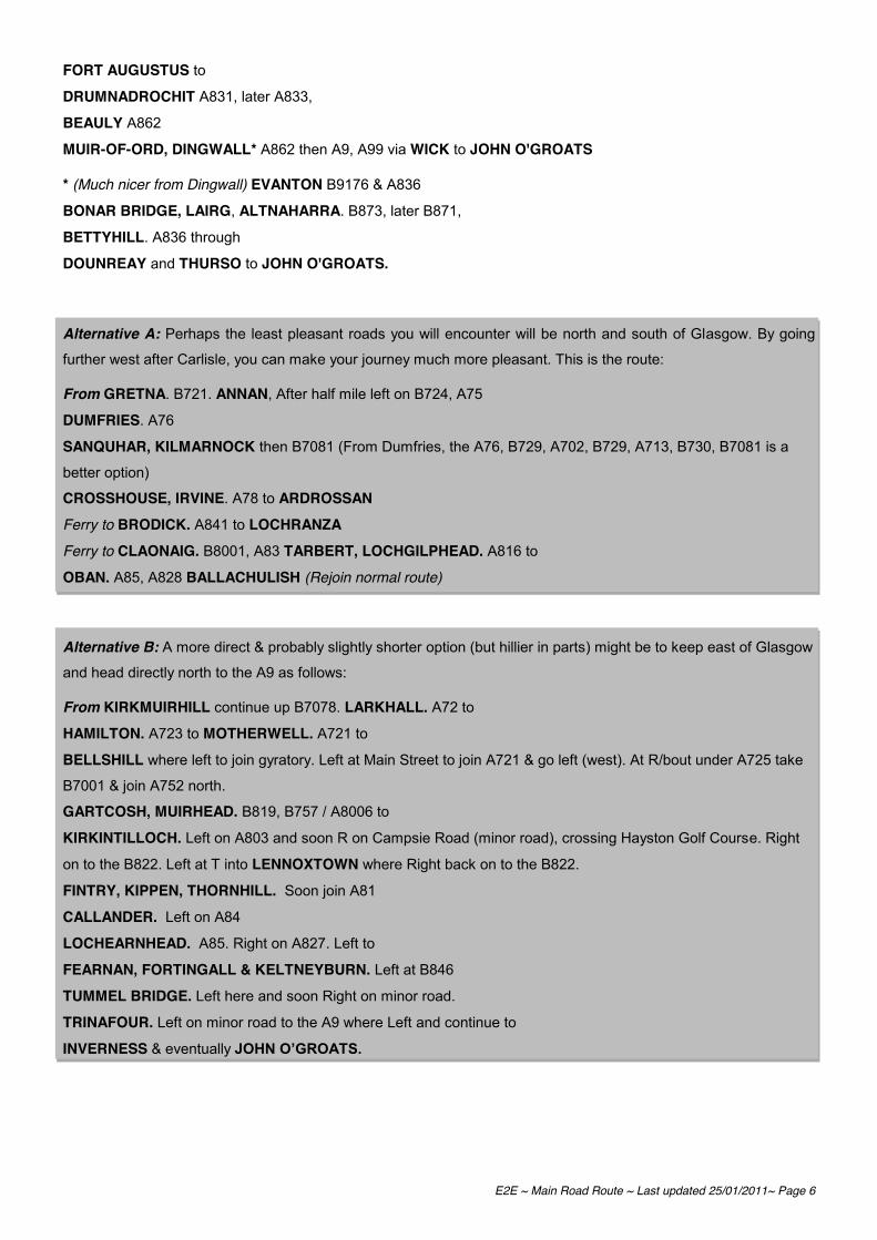
E2E ~ Main Road Route ~ Last updated 25/01/2011~ Page 6
FORT AUGUSTUS to DRUMNADROCHIT A831, later A833,
BEAULY A862
MUIR-OF-ORD, DINGWALL* A862 then A9, A99 via WICK to JOHN O'GROATS
* (Much nicer from Dingwall) EVANTON B9176 & A836
BONAR BRIDGE, LAIRG, ALTNAHARRA. B873, later B871,
BETTYHILL. A836 through
DOUNREAY and THURSO to JOHN O'GROATS.
Alternative A: Perhaps the least pleasant roads you will encounter will be north and south of Glasgow. By going
further west after Carlisle, you can make your journey much more pleasant. This is the route:
From GRETNA. B721. ANNAN, After half mile left on B724, A75 DUMFRIES. A76 SANQUHAR, KILMARNOCK then B7081 (From Dumfries, the A76, B729, A702, B729, A713, B730, B7081 is a
better option)
CROSSHOUSE, IRVINE. A78 to ARDROSSAN Ferry to BRODICK. A841 to LOCHRANZA Ferry to CLAONAIG. B8001, A83 TARBERT, LOCHGILPHEAD. A816 to
OBAN. A85, A828 BALLACHULISH (Rejoin normal route)
Alternative B: A more direct & probably slightly shorter option (but hillier in parts) might be to keep east of Glasgow
and head directly north to the A9 as follows:
From KIRKMUIRHILL continue up B7078. LARKHALL. A72 to
HAMILTON. A723 to MOTHERWELL. A721 to
BELLSHILL where left to join gyratory. Left at Main Street to join A721 & go left (west). At R/bout under A725 take
B7001 & join A752 north.
GARTCOSH, MUIRHEAD. B819, B757 / A8006 to
KIRKINTILLOCH. Left on A803 and soon R on Campsie Road (minor road), crossing Hayston Golf Course. Right
on to the B822. Left at T into LENNOXTOWN where Right back on to the B822.
FINTRY, KIPPEN, THORNHILL. Soon join A81
CALLANDER. Left on A84
LOCHEARNHEAD. A85. Right on A827. Left to
FEARNAN, FORTINGALL & KELTNEYBURN. Left at B846
TUMMEL BRIDGE. Left here and soon Right on minor road.
TRINAFOUR. Left on minor road to the A9 where Left and continue to
INVERNESS & eventually JOHN O’GROATS.

E2E ~ Main Road Route ~ Last updated 25/01/2011~ Page 7
Other Ferry Option (Continue north from ARDROSSAN on Alternative A) Gourock-Dunoon will take you via the A815 & A83 to Arrochar & Tarbet, then A82 to CRIANLARICH.
Gourock-Kilcreggan or Helensburgh will take you via the B833 & A814 to Arrochar, then A82 to CRIANLARICH.
Caledonian MacBrayne Ltd The Ferry Terminal Gourock PA19 lQP Tel: 0870 565 0000 Fax: 01475 637607 http://www.calmac.co.uk/
Western Ferries (Clyde) Ltd Hunter’s Quay Dunoon PA23 8HJ Tel: 01369 704452 [email protected]
Don’t forget to order your End to End Merchandise available using the included order form. All orders include a personalised certificate celebrating your journey. Please remember to include a copy of your End to End Record sheet with all orders to speed up processing. Merchandise available: End to End Embroidered Badge incl. free personalised certificate: £6.95 End to End Cotton t-shirt incl. free personalised certificate (available in S, M, L, XL & XXL): £15.95 Postage within the UK in included in the price above, for overseas destinations: European Destinations: £2.50 World-Wide (outside Europe): £5.50
For helpful advice and to hear stories from others who have completed the End to End please visit the CTC Forum: http://forum.ctc.org.uk/ If you found any mistakes or think you could improve the route in any way, we’d love to hear from you. If you have mapped your own route and think others could benefit from this please contact us on the email address below. Tel: 0844 736 8450 / 01483 238301or via email at: [email protected]

E2E ~ Main Road Route ~ Last updated 25/01/2011~ Page 8
Example route as plotted using http://cycle.travel visualised using http://www.gpsvisualizer.com/
Parklands Railton Road
Guildford Surrey
GU2 9JX 0844 736 8450 / 01483 238300
[email protected] www.ctc.org.uk
Land’s End to John O’Groats The Off-Road Route
Grade: Black Copyright © CTC Cyclists’ Touring Club. This information is supplied for personal use of members only. Reproduction in any form, in
whole or in part, for commercial purposes is expressly forbidden unless licensing terms have been agreed with the club.
Written by James Spencer & David Broddle, May 2003
The CTC would like to thank both James and David for providing this information. This route forms the longest Off- Road route in the UK and is a true challenge for any experienced Off-Road cyclist

The Route in 23 days: South to North
Day 1 Lands’ End to Truro
Day 2 Truro to Launceston
Day 3 Launceston to Fremington (Barnstaple)
Day 4 Fremington (Barnstaple) to Blue Anchor
Day 5 Blue Anchor to Barrow Gurney
Day 6 Barrow Gurney to Abergavenny
Day 7 Abergavenny to Forest Inn
Day 8 Forest Inn to Much Wenlock
Day 9 Much Wenlock to Fenny Bentley
Day 10 Fenny Bentley to Dunford Bridge
Day 11 Dunford Bridge to Hebden Bridge
Day 12 Hebden Bridge to Austwick
Day 13 Austwick to Appeby in Westmoreland
Day 14 Appeby in Westmoreland to Longtown
Day 15 Longtown to Tibbie Shiels Inn
Day 16 Tibbie Shiels Inn to Castlecary
Day 17 Castlecary to Kingshouse, Strathyre
Day 18 Kingshouse, Strathyre to Kinlochleven
Day 19 Kinlochleven to Ford Augustus
Day 20 Ford Augustus to Contin
Day 21 Contin to Lairg
Day 22 Lairg to Forsinard
Day 23 Forsinard to John O'Groats
A ride of 1,201 miles, ascending over 130,000 feet and enjoying along the way the delights of:
The Camel Trail, Bodmin Moor, The Tarka Trail, Exmoor, Dunkery Beacon, The Quantocks, Cheddar Gorge, The Mendips, Avon Gorge, The Black Mountains, Radnor Forest, Wenlock Edge, Ironbridge, The Way for the Millennium, Tissington Trail, Cut Gate, The Pennine Bridleway, Leeds-Liverpool Canal, Cam High Road, Lady Anne Clifford’s Highway, The Maiden Way, Craik Forest, Black Law, The Trossachs, The West Highland Way, The Great Glen, Gleann Mor and the wilds of Northern Scotland…
Riders:
The full route: James Spencer and David Broddle
Land’s End to Much Wenlock: Jon Doyle
Much Wenlock to Hebden Bridge: DT
Austwick to Castle Cary: Cameron Irving

Maps Used:
We used Ordnance Survey 1:50,000 software from Anquet Maps (http://www.anquet.com) to plan the route and then printed out, double- sided and laminated strip maps which could be fastened to a small handlebar mounted map board (see picture).
If you have specific questions on the trip, James Spencer will be happy to respond to any queries via the following email address: [email protected].
Occasionally the 1:50,000 scale maps where not detailed enough and we used the Outdoor Leisure maps for backup in places like Exmoor and the South Pennines.
We also used a Garmin GPS unit mounted on the bars to give ongoing confirmation of position and direction and, although very rarely, used the go to function to head for a known position or landmark. A GPS may seem a bit of a gadget to take on a trip like
this, but it definitely saved us time and gave us confidence of our position. They do eat batteries though, so keep stocked up with spares as we went through a set every day! Garmin sell a handlebar mount for their units, which is well worth the investment.
Accommodation:
We booked all our accommodation in advance. You will find a list at the back of this document.
Gear:
We did the trip largely unsupported in that we carried everything we needed. As we were riding full suspension bikes we could not carry any bags on the bike so we carried everything on our backs using Camelbak Transalp/RimRunner packs (hence we travelled extremely light!)
Bikes were Santa Cruz Superlights. Thanks to Stif of Leeds for supply of bikes and technical support.
The only mechanical problems were punctures (carry two spares each plus repair kit) and the need to replace brake blocks/disc pads frequently. Don’t forget to carry chain oil and use it every day.
Food:
Eat and drink as much as you can! A big breakfast is vital, try and plan a couple of food stops during the day. Keep stocked up on chocolate and snacks and always think ahead – you can’t afford to run out of fuel. The larger Camelbak backpacks are useful as they hold three litres of fluid but it’s also a good idea to carry a bottle on the bike as well.
Travel to Land’s End and from John O’Groats:
Unless you have a support vehicle and driver, the easiest way to get to each end is by train.
The nearest station to Land’s End is Penzance and the nearest to John O’Groats is either Wick or Thurso. The crucial thing is to book for people and bikes well in advance as there are limited bike spaces on trains (four on express trains, but only two on the northern Scotrail routes). We had to bully our way onto the train at Thurso as there were already other bikes on board; if we hadn’t we would have had to wait another day to leave!
The Land’s End to John O’Groats Club:
The club, based at Land’s End, provides a logbook for collecting evidence of progress along the way. Details can be found at http://www.landsend-landmark.co.uk/enders.html or write to:
The Land’s End John O’Groats Club, Custom House, Land’s End, Cornwall, TR19 7AA
Key to abbreviations in the text:
N – North, S – South, E – East, W – West
L – Left, R – Right
BW – Bridleway, MR – Minor Road
RUPP – Road Used as Public Path
NCR – National Cycle Route (numbered, on small blue signs with a bike symbol)
Day 1 - Land’s End to Truro
A varied day of sometimes complex navigation whilst enjoying some fine Cornish tracks. Plenty of accommodation to be found in Truro.
From the Theme Park at Land’s End (don’t forget to collect your documents and get your proof sheet stamped!) pick up NCR 3 and then the A30 to Treave where you take the track around Carn Brea (very thorny!) then a good BW to Grumbla. Then MR and BW (good track) to the A3071 near Jericho Farm. Where the A3071 meets the B3318 (406318) take the good track over the Beacon past the strange radar installation, then turn R along BW and MR to Bosullow. Follow track over the Nine Maidens (tricky navigation in heather on top – may have to drop into Tredinnick) past Iron Age settlement at 445354 and follow track (boggy in places) to the N of Mulfra Hill to MR. Then take farm track from Higher Kerrowe across Conquer Downs (more tricky navigation – may end up in Chysauster). Proceed via Crowlas or Canon’s Town to track/BW through Trewinnard Manor and up excellent gully climb past Tremelling. Follow MR to Gwinear Downs where you pick up the muddy farm tracks past surreal travellers settlements to Penhale Moor and here join NCR 3 on MRs and tracks passing Camborne and Redruth to Crofthandy. Here take one of the bike trails down through the splendid Goon Gumpas and follow NCR 3 into Truro.
Day 2 - Truro to Launceston
Starts off with a high tarmac content but made up for by the Camel Trail and then the assault on Bodmin Moor.
Leave Truro following NCR 32 via some quiet and pretty MRs, crossing the A30 via the BW at Tolgroggan to Zelah. Take MR via St. Newlyn East and Benny Mill past the steam railway to White Cross. More MR via Quoit and Providence to the B3274 at 975618. Go straight on along the track to the MR to Tremorebridge. Then MR to Brocton (past a collection of military vehicles in a garden!) where you join the Camel Trail in the direction of Bodmin. There is a good tea garden on the Trail at Boscarne. Ignore the fork to Bodmin and continue along the Camel through the wooded valley to Tresarrett. Here re-join the tar (NCR 3) via Blisland back to the A30 at 136736. Cross the A30 and follow MR via Temple (to avoid A30) then join the A30 (over fence!) and follow (hopefully with a good tailwind) to Jamaica Inn. Take the MR towards Codda and then pick up the BW across Bodmin Moor which starts off well defined, crosses a good ford and then disappears when you get to the Moor proper. It is recommended to use a GPS (“go to”) or compass and head for Black Rock and then the end of the BW at 205817. This is all ride able; there is just a lack of a defined track. Care is needed to pick the correct exit from the moor and avoid straying into walled fields. Follow MR via Tresmeake and the Rising Sun pub to Launceston.
Day 3 - Launceston to Fremington (Barnstaple)
The longest day of week one but not too taxing as much of the ride is on the Tarka Trail with a sweeping long descent down to the sea and a finish by the beach. Dinner in Instow is highly recommended.
Leave Launceston on MR following the Two Castles Trail. Take the white road under the A30 avoiding Liftondown, MR past Lifton staying on the Two Castles Trail to BW across fields and through woods to the Steam Village and then MR and BWs (muddy fields) to Lewdown. Follow the MR to the centre of Bridestowe village then turn R on the MR following the 2C Trail to join the BW at SX528889 which after a short while takes you to the old railway (the Tarka Trail) which you follow in a NE direction to Okehampton (tea at the steam railway). Pick up NCR 37 through Okehampton, turn L from the B3217 onto the MR at SX593963 and

then take the track on the R through Brightley Woods. Follow the Tarka Trail on MR to Hatherleigh and then take the A386 N via Hele Bridge to just before Meeth where you turn L onto a track following NCR 3. This track skirts the clay workings, picks up an old railway and re-joins the Tarka Trail which is followed all the way to Fremington.
Day 4 - Fremington (Barnstaple) to Blue Anchor
A massive day incorporating the full crossing of Exmoor. An easy start on the Tarka Trail, some great Devon coombes and two fantastic descents at the end of the day.
Take the Tarka Trail to Barnstaple and then follow NCR 3 on its traffic- free route through the town and then on MR to Goodleigh. At Goodleigh Cross pick up the challenging RUPP going E to Stoke Rivers, then the BW heading N to join the MR into Bratton Fleming. Take the MR NE, cross the A399 at Four Way Cross and then join the BW at Northland Corner (SS672392). This BW is tricky both from a riding and navigation viewpoint but should take you past the farm at Buscombe and onto the MR at SS687395. Turn L then R into Challacombe (good lunch at the pub!). Take the BW from SS692406 which climbs steadily and eventually turn L to cross the B3358 and follow the BW to Wood Barrow. Before the barrow turn R and follow the path past Pinkery Pond and Exe Head to the B3223 at SS768411. Proceed via Simonsbath to the BW at Clovenrocks Bridge to Warren Farm. From here follow the BW across Elsworthy to the MR at SS824415 which you follow NE to the BW SE across Almsworthy Common to Hillhead Cross. Follow the MR NE to join the BW to Dunkery Beacon. Descend the fast but technical BW from the Beacon to Wooton Courtenay and at SS947433 turn L and climb on the BW into the woods. When you reach the ridge turn R and follow the track down through the trees into Dunster. Follow the A39 to Carhampton and then the B319 to Blue Anchor.
Day 5 - Blue Anchor to Barrow Gurney
Combines the superb, if short Quantocks with the flat of the Somerset Levels and some surprisingly good terrain from Cheddar across the Mendips.
Take the coast road from Blue Anchor to Watchet and then the MR to West Quantoxhead where you pick up the BW at ST113414 that takes you up on to the ridge of the Quantocks. Follow the ridge along via Crowcombe Park Gate to descend past Quantock Farm on the BW through Great Wood to Pepperhill Farm then MR to join the white road at ST194374 to the MR at ST214374. From here follow the MR into Bridgewater, cross the river and leave town on the A39. Cross the M5 and turn R in Horsey on the MR to Bawdrip. In Bawdrip take the old railway NE to Cossington and then follow MR across Chilton Moor to the BW at ST388455. In the village of Mark take the B3139 to Blackford and then the BW to Middle Stoughton. Follow MR and the B3151 to Cheddar. At ST458542 take the BW N to Ashridge Farm and then the BW over Black Down to Link. Go R on the A368 and then L on the BW to the A38. Cross the A38 and follow MR through Wrington to the BW at ST475631. This BW takes you past Bristol Airport and through The Batch to the MR at ST499677 on Backwell Hill. Follow the BW via Barrow Hill to Barrow Gurney.
Day 6 - Barrow Gurney to Abergavenny
Easy going around Bristol into Wales, some Welsh hills and a pleasant towpath run into Abergavenny.
From the centre of Barrow Gurney (ST532679) follow the MR N to Long Ashton and then through the village to cross the B3128 at ST554712 and through the arch into Ashton Court Country Park. Follow the lanes through the park and exit L onto the A369 at ST558727 then R onto the MR and L to pick up the track that descends through the woods in Nightingale Valley into the Avon Gorge. Follow the track that runs alongside the River Avon all the way (W) to the M5. Take the cycle path that runs alongside the M5 on the Avonmouth Bridge and then follow NCR41 past Lawrence Weston and all the way to the Old Severn Bridge that carries the M48 into Wales. Take the cycle path alongside the motorway across the bridge and then MR into Chepstow (bike shop). Follow NCR42 on MR via Shire Newton to pick up the track into Wentwood at ST449948, turn R onto the BW through the woods to the MR at ST422948, turn R onto the BW heading NNW and descend to the MR. Turn L and follow NCR42 to Usk. Leave Usk on the B4598 to Chain Bridge and take the MR to the Monmouth and Brecon Canal at Goytre. Follow the canal towpath N to Abergavenny.

Day 7 - Abergavenny to Forest Inn
Ascend to the summit at 690m (highest point on the ride) before descending on the BW (turn R on the descent at SO198332, easily missed!) and grassy downhill to the MR at SO189348. At the crossroads at SO182347 turn R and take the white road and then MR through Velindre to Little Lodge and then white road/MR to Glasbury. Follow the A438 to Llowes and then the BW N to the MR at SO194428. Follow the MR to Painscastle and then MR NW to BW at SO144490. This BW takes you past Doctor’s Pool and Mawn Pools, over Glascwm Hill to the MR at SO166534 and straight across on the BW to Cwm Kesty. Take the RUPP and BW to the A44 and Forest Inn (or the Red Lion at Forest Inn).
Day 8 - Forest Inn to Much Wenlock
A long day with lots of hills, getting easier towards the end with the interesting crossing of Wenlock Edge and the descent into Much Wenlock.
Leaving Forest Inn take the A44 E to the RUPP on the L at SO193591. Follow this RUPP to SO165637 where you take a R on the BW to the forest and then N on the BW to SO173673. From here take the RUPP to the A488 at SO184680. At Fishpools take the RUPP to Bleddfa and then the A488 again to Monaughty where you take the RUPP to SO251702. Follow the MR to Knighton. Out of Knighton take the BW from Paupunton to SO275749 and then the BW and RUPP E past Vron and Great Hagley to Hopton Woods. Follow the trails through the woods and out to Hopton Castle. Take the MR NW via Three Ashes to Clungunford and the Roman Road to Craven Arms, and then take the MR NW to Moonwood and the BW through Wolverton Wood to SO483879. Follow the MR NW through Middlehope and then the BW to Lilywood. Then follow the BW/Jack Mytton Way along Wenlock Edge, skirt the quarry and descend into Much Wenlock.
Day 9 - Much Wenlock to Fenny Bentley
A tough day with huge climbs and wild Welsh moorland. Pray it doesn’t rain!
Take the A40 W out of town and turn R on MR at SO267155 which becomes a white road. At SO256173 turn R to take the track through the forest and then join the BW that skirts the western slopes of the Sugar Loaf before taking the BW left past Cwm-bwch to the MR at Dyffryn and then MR/BW N to Nantybedd (SO257269). At the car park at SO253285 take the BW NW to Grwyne Fawr Reservoir and then
A very long day in terms of mileage but on relatively easy terrain with some lengthy waymarked routes. A little too much tar but that’s inevitable as we cross to the start of the Pennines.
From the centre of Much Wenlock take the MR via Broseley to the famous iron bridge at Ironbridge Gorge. Then follow the NCR along the old railway to Coalport and pick up the Silkin Way which leads you through Telford on cycle paths. After leaving the Silkin Way go to the Donnington Wood roundabout at SJ709123 and go E to the car park at
Granville Country Park and then follow the track N to the golf club. Then take the MR to Lilleshall and turn R at SJ732155 onto the white road that passes through Lilleshall Park (go R at SJ761158 and then L at SJ764157). Optionally, visit the Hall which is now the National Sports Centre, for refreshments. At the A41 go L then R on the MR to Stockton and then follow the BW through Stockton Grange Farm and out across open fields (tricky navigation as the BW crosses a cornfield) to the disused railway at SJ773184. Go E on this which is now the Way for the Millennium and follow it all the way to Stafford. Go N through Stafford and at SJ930260 take the BW N to Enson. Cross the River Trent on the B5066 then follow MRs for a number of miles to Rocester and then on to Ashbourne. At SK175469 pick up the start of the Tissington Trail and head N on this old railway to Fenny Bentley.
Day 10 - Fenny Bentley to Dunford Bridge
A gentle beginning to the day along the Tissington Trail followed by climbs in the White Peak and finally the cruel Cut Gate into Yorkshire.

From Fenny Bentley village follow the A515 N for a short while to re-join the Tissington Trail at SK173512. Follow this old railway all the way to its conclusion after Street House Farm at SK110673. Take the track N to the A515, then R and L to pick up the Midshires Way. Follow this track to the MR where you go straight across and then take a L to follow the track down to the A6 at SK 129715. Follow MRs to the track downhill from SK133718 into Millers Dale. Take the track N out of Millers Dale (café) to join the MR near Monksdale House, then follow this road through Tideswell to the A623 at Lane Head. Cross onto the B6049 heading NE and then take the MRs via Great Hucklow and Hucklow Edge to Abney where you go R and join the BW over Shatton Moor and on to Offerton Hall. From here double back L along the track to Shatton village and the A6187 at SK203826. Cross the A road and the garden centre car park (café!), skirt the football field and pick up the old railway at SK201830 to the Ladybower Reservoir dam. Cross the top of the dam and follow the cycle path round the E side of the reservoir to pick up the BW N on the E end of Ashopton Viaduct. Follow this BW all the way past Ladybower, Derwent and Howden reservoirs to Slippery Stones and the start of the classic Cut Gate route at SK170954 (don’t miss the turn!). After the tough, technical crossing of Cut Gate descend to the bridge at SE198006. Follow the BW through the forest, taking care at the crossroads at SE198010 where you go straight across (not right) and on to cross the A628 at SE197014 near the Flouch roundabout. Take the short BW through the woods and turn L along the old road and R at the houses at SE192015 along the BW to join the Trans Pennine Trail going W to Dunford Bridge (there is an interesting singletrack diversion on the right a few hundred meters after joining the railway that re-joins the railway a little further on). At Dunford Bridge try the Stanhope Arms for refreshment and accommodation.
Day 11- Dunford Bridge to Hebden Bridge
A hard day in the South Pennines; lots of gritstone climbs and descents with a welcome canalside run in to Hebden Bridge.
From the old railway bridge take the track that climbs the front of the dam wall (from R to L) and then head across the top of Winscar dam and follow the MR from the car park up the hill to the BW L at SE151039. Follow the BW through the old quarry to the MR at SE145043, turn L and then take the gated track down through the woods on the concessionary path/track and take a L at SE136054 and L again at the crossroads of tracks. Go straight across the MR and follow the track with rocky downhill that eventually takes you past Yateholme Reservoir to join the A6024 Holme Moss road at SE102053. Turn R and then take the 2nd L in Holme village to cross Digley Reservoir dam and then climb on the MR to the BW that ascends Bradshaw to join the A635 Saddleworth road. Turn L (W) up the A635 and then R at the summit on Wessenden Head (tea caravan). Then follow the BW/Pennine Way descent to Marsden, then MR to Standedge at SE019095. Here pick up the Pennine Bridleway (a new national trail, see www.thepenninebridleway.co.uk) and follow it past Castleshaw, Readycon Dean and Ogden reservoirs, up the stiff climb from Ogden Reservoir and then under the M62 viaduct at SD947139. Take the MR past Hollingworth Lake and then proceed to the Rochdale Canal at Littleborough. Follow the towpath N via Todmorden to Hebden Bridge – alternatively, at Warland follow the Mary Towneley Loop (part of the Pennine Bridleway) via Mankinholes to Hebden Bridge.
Day 12 - Hebden Bridge to Austwick
Leaving the South Pennines, a taste of Lancashire before the Leeds Liverpool Canal lands you in the Yorkshire Dales proper for a feast of limestone climbs and descents.
From Hebden Bridge centre take the A6033 towards Howarth and then L on the MR towards Hardcastle Crags. When you enter the woods at SD988292 take the broad track through the woods and up the valley side to Walshaw and then the BW to the MR at SD947324. Follow the MR past Widdop Reservoir (tea at the Activity Centre SD902365) and on via MRs to Colne and the Leeds Liverpool Canal at Foulridge Wharf SD889426. Follow the canal towpath N to Gargrave and a good lunch stop at the cyclist’s café in the village centre. Take the track from Gargrave to Bell Busk and then MR to Hellifield. Take the track N across the railway that climbs onto Hellifield Moor and then turn L onto Lady Anne Clifford’s Highway (track) to the MR at Scalaber Force. Follow the BW downhill past Lodge Farm and then the B road through Settle and Giggleswick, climbing Giggleswick Scar to the BW on the R at SD797658. Follow this BW across typical limestone scenery via Feizor to Austick (stay at a B&B but eat at the Gamecock pub).

Day 13 - Austwick to Appleby in Westmoreland
A hard day with tough Dales climbing and boggy, rutted moorland tracks leading you out of Yorkshire into the ancient county of Westmoreland.
Take the walled BW from Austwick to Wharfe and then the BW over the hill via Crummock and Sulber to the B6479 at Selside. Follow the B road N to the T junction near Ribblehead Viaduct and turn R (tea van). At SD785803 follow the Dales Way (BW) up Cam Fell, re-joining the Pennine Way. Turn L at SD830834 and skirt Dodd Fell to your R and follow the (very rocky!) track down to the B6255 at SD860895. Cross the road and take the BW to Thorney Mire House and then pick up the A684 at Appersett – there is a worthwhile diversion here to the café in Hardraw. Leave the A684 at SD839923 and follow the very steep grass climb on the BW up to Cotter End. This is Lady Anne Clifford’s highway again. Follow this rutted and boggy track all the way to the B6259 at NY783004. Follow the B road N and after passing Pendragon Castle turn L onto the MR and then R along the BW which follows the River Eden N via Wharton Hall to join the A685 into Kirkby Stephen. From here follow MRs to Appleby.
Day 14 - Appleby in Westmoreland to Longtown
A Roman road and the Maiden Way take us eventually across Hadrian’s Wall and within a stone’s throw of Scotland.
From the centre of Appleby take the B6542 NW, pass under the railway and then take the BW that follows the course of the Roman Road. Then follow the MR into Long Marton where you pick up the BW which runs along the S side of the railway to the road at Stamp Hill Farm (if access is blocked follow the track alongside the conveyor to the road). From here follow MRs to Kirkland and the Maiden Way (BW) over Melmerby Fell and the white road to Alston. Alternatively, follow the Pennine Way BW from Kirkland to Garrigill and then the road to Alston. Follow the road N from Alston to Williamston and then the BW on the E of the river to Eals. Then make your way to the BW that starts near Burnfoot at NY664604 and follow this W to the A689 at Coalfell. Follow the A689 into Brampton and proceed through the village on the A6071. After crossing the River Irthing, take the MR R to Irthington and then the BW from NY496613 NW, crossing Hadrian’s Wall, to Laversdale, then the BW to the MR at NY466630. Follow the MR through Barclose and then R to the BW at NY438641. Follow this BW to Howberry and then MR to Westlinton, and then take NCR7 via the old railway to Longtown.
Day 15 - Longtown to Tibbie Shiels
Leaving England, immediately the terrain seems to change. Scottish Estates, shooting tracks and forest trails all make up the typical terrain. A tough finish but a fine descent for a well-earned pint.
Leave Longtown heading N on the A7 then at Dickstree Cottage take the MR L to Sarkhall and then across the Scottish border Milltown where you join the B6357. At NY345758 take the track N to Tomshielburn and then MR to the track NE atNY339795. Follow this track to join the A7 and then on to Langholm. From Langholm take the B709 NW to Burnfoot and then follow the estate track along the N bank of the River Esk to Kirktonhill. From here take the MR N to Glendinning where at NY300969 you take the track heading N to Loath Knowe in the forest. Pick your way through the maze of forest tracks to the B709 and follow this to Tushielaw. Turn L on the B709 and at the top of the climb (NT276201) take the track heading W to Earls Hill and then descend to the Tibbie Shiels Inn.
Day 16 - Tibbie Shiels to Castlecary
A very long, hard day with lots of climbing to start and then a good deal of tarmac in the middle section of the day, but still enough off-road to keep it interesting.
From the Inn take the A708 N alongside St Mary’s Loch. At Cappercleuch take the MR W to Meggett Reservoir dam and at NT208234 take the track N over Redsike Head and then the MR N to Macbeth’s Castle. At NT 207342 take the track WNW to Dawyck Mill. At the B712 turn L and then R on the MR to Broughton (café). From the church take the track NW to Skirling. After a short section on the A72 take the track N to Candy Mill, then the MR to Elsrickle. Follow the track N to Walston and then the MR via Weston to join the track at NT035475. Follow this track to the A70 and then on to East Yardhouses. From here follow MRs to

Forth and join the B715, following this all the way to Meadowfoot where at NS922599 you take the track L through the forest (way marked) to the B7066 at Eastfield. Take the track N out of Eastfield that crosses the M8 and takes you through fields to Blairmuckhill where you go R on the MR to join NCR75 at NS898658. Follow this former railway W all the way to Hillend Reservoir, bypass Caldercruix on the B road and take the track N at NS826684. At the MR turn L and follow MRs NW to Palacerigg Country Park. Take the track NW, on the W edge of the Park, which ends at the MR at NS776746. Follow the MR past Kilt Farm to Castlecary.
Day 17 - Castlecary to Kingshouse, Strathyre
A great days cycling leading into the Trossachs and some excellent forest trails and loch side paths.
Leaving Castlecary join the towpath of the Forth and Clyde canal at NS789787 and follow it W to the MR at NS737774. Proceed N to cross the A803 and take the track N past Banton Loch and Riskend to the MR. Follow this over the top of the hill and at NS735815 take the track L into the Carron Valley Forest. Follow the forest track that skirts the S edge of the reservoir to the B818 at Todholes. Follow this road W to Fintry and then take the B822 N to Balafark. Here take the track NW to the A811. In Buchlyvie (café) turn R onto the B835 and at NS567943 pick up the old railway which takes you NW to Barbodoes. You have to leave the railway here, as there is no bridge over the River Forth, and take the A81 N to Cobleland where you re-join the railway (now NCR) to Aberfoyle. From here join the NCR7 N through the forest all the way to Loch Venachar and Callander. Continue on NCR7 which follows the old railway as it climbs slowly up the Pass of Leny and past Loch Lubnaig to Strathyre (café). Follow the A84 N to Kingshouse (hotel).
Day 18 - Kingshouse, Strathyre to Kinlochleven
The West Highland Way – fantastic trail riding and awesome scenery – A magnificent, albeit strenuous, day.
From the hotel at Kingshouse follow NCR7 N along the old railway through Glen Ogle to where it joins the A85 at NN558284. Follow the A85 to Crianlarich where at NN384251 you take the track W into the forest and then join the West Highland Way (WHW) following it NW to Tyndrum (café). Follow the WHW to Bridge of Orchy and then take the MR (this section of the WHW isn’t passable by bike) to the Inveroran Hotel (tea!) and Forest Lodge. From here re-join the WHW off-road to the Kings House Hotel, then climb (walk) the Devil’s Staircase and eventually enjoy the long descent into Kinlochleven.
Day 19 - Kinlochleven to Fort Augustus
More West Highland Way delivers a tough start but then a flowing descent into Fort William followed by easy riding along the Great Glen.
Depart Kinlochleven on the West Highland Way and follow this all the way to Fort William (café, bike shop). From the centre of town take the cycle track at NN105744 past the castle and along the B8006 to the Caledonian Canal and Neptune’s Staircase. Now follow the Great Glen Cycle Route (GGCR) NE along the canal towpath to Gairlochy and then the B8005 and GGCR along the N shore of Loch Lochy to Laggan Swing Bridge. Continue to follow the GGCR alongside Loch Oich to Bridge of Oich and then along the towpath to Fort Augustus.
Day 20 - Fort Augustus to Contin
Great trails along the Great Glen and an easy afternoon ride leaving Loch Ness behind.
From Fort Augustus re-join the Great Glen Cycle Route and follow it along the N shore of Loch Ness to Drumnadrochit (café), then at NH531301 join the Great Glen Way as it climbs out of the glen. At the MR at NH541357 go NW via Fassock and a section of white road to Belladrum Farm. Join the A833 N at NH520427 and then the A862 to Beauly and Muir of Ord. Then take the A832 to Marybank and MR to the power station at NH446545 from where you take the track N to Contin.
Day 21 - Contin to Lairg
Superb long forest trails and shooting tracks, followed by a tarmac finish. From the centre of Contin take the forest trail that starts at NH454567 and follow this past Rogie Falls to Strathgarve Lodge where you join the MR. Cross over the A835 at NH400636 and follow the forestry track through Longart Forest to re-join the A road near Inchbae Lodge Hotel (tea). Follow the road NW to Black Bridge and then take the long track N along Loch Vaich and Gleann Mor to the MR at Glencalvie Lodge. At NH473909 turn R and follow the MR NE, E and N to Culrain. Follow the cycleway from the station, over the river and alongside the railway, to Invershin. Take the A837 and then the B864 past the Shin Falls to Lairg.
Day 22 - Lairg to Forsinard
Leave civilization truly behind and experience Scottish Wilderness. More long tracks and only one tea stop make this a lonely but rewarding ride.
Leave Lairg heading N on the A836 (NCR1) to the Crask Inn (tea). You could avoid some of this (albeit really a single lane MR) A road by finding a route via the forest tracks on the E of the road. After refreshments at the Crask Inn (the only tea opportunity of the day), backtrack slightly to NC524246 where you take the track that heads E across the moor. This starts off quite boggy and difficult but eventually becomes a good shooting track passing Loch A Bhealaich and Loch Choire to Loch Choire Lodge. From here take the long track NE to the B871 where you go R along the Helmsdale River to Kinbrace. From here follow the A897 N to Forsinard and the hotel which is by the station.
Day 23 - Forsinard to John O’Groats
A day of two halves; more endless shooting tracks at the start give way to an unavoidable tarmac finish. John O’Groats as a location may be a touch anti-climactic, but the feeling of achievement is tremendous. Phone for a taxi to Thurso and celebration!
From Forsinard follow the A897 N to NC904486 where you go R onto the track that heads SW around the S side of Sletill Hill. Follow this track to cross the railway at NC999452, go L at the junction and follow the track past Altnabreac Station and alongside the railway for a while before heading off to join the MR N of Loch More at ND091472. Follow the MR NE to Westerdale and then take the B870 to Watten (tea). Continue NE on the B870 to the B876 and then at ND265608 take the MR NE to the A836 and the finish at John O’Groats. Don’t forget to get your card stamped and if you’re still feeling energetic take the track to Duncansby Head.

Accommodation Listing
Day To Accommodation
0 Penzance Woodstock Guest House 01736 369049
1 Truro Bay Tree House 01872 240274
2 Launceston Bakers Arms 01566 772510
3 Fremington, Barnstaple Lower Yelland Farm 01271 860101
4 Blue Anchor The Langbury 01643 821 375
5 Barrow Gurney The Fox and Goose 01275 476555
6 Abergavenny Kings Arms 01873 855074
7 Forest Inn Red Lion Inn 01544 350 220
8 Much Wenlock Gaskell Arms Hotel 01952 727212
9 Fenny Bentley Bentley Brook Inn 01335 350278
10 Dunford Bridge Stanhope Arms 01226 763104
11 Hebden Bridge White Lion Hotel 01422 842197
12 Austwick Woodview b&b 015242 51268
13 Appleby in Westmoreland Royal Oak 017683 51463
14 Longtown Briar Lea Guest House 01228 791538
15 Tibbie Shiels Inn Tibbie Shiels Inn 01750 42231
16 Castlecary CastleCary Hotel 01324 840233 TPG
17 Kingshouse, Strathyre KingsHouse Strathyre 01877 384646
18 Kinlochleven MacDonald Hotel 01855 831213 LR
19 Fort Augustus Richmond Ho Hotel 01320 366719
20 Contin Achility Hotel 01997 421355 TPG
21 Lairg The Nip Inn 01549 402243
22 Forsinard Forsinard hotel 01641 571221 web
23 John O'Groats The Station Hotel, Thurso 01847 892003

UKINF5.doc ~ LEJOG Merchandise Order Form ~ this version printed 08/06/2015 ~ Page 1
LAND’S END to JOHN O’GROATS
MERCHANDISE ORDER FORM Please complete and return this form with appropriate payment to: CTC LEJOG Merchandise Orders, CTC, Parklands, Railton Road, Guildford GU2 9JX If you would like a Certificate (supplied only with a Badge or T-Shirt) please also enclose your completed Record Sheet or equivalent details of mileage and time taken.
ITEM PRICE QUANTITY SIZE (S, M, L, XL)
TOTAL
End To End Embroidered Badge incl. free Certificate
£ 6.95
End To End Cotton T-shirt incl. free Certificate
£ 15.95
TOTAL
HANDLING, POSTAGE AND PACKAGING TOTAL To UK destinations the cost is included in the prices above included To overseas destinations (via airmail) please add the following:- European destinations World-wide (outside Europe)
£2.50 £5.50
TOTAL PAYMENT
Please note: some End-to-Enders value their Record Sheets highly, since they are proof that they made the trip and they can show it to their disbelieving relatives / sponsors etc! It would be wise therefore to send a photocopy of your Record Sheet when you send off your order for merchandise.

UKINF5.doc ~ LEJOG Merchandise Order Form ~ this version printed 08/06/2015 ~ Page 2
Please tick method of payment:- � Cheque (please make payable to: CTC) � Eurocheque (cheques must be written in pounds sterling. We cannot accept cheques written in other currencies). � Please debit my Mastercard � Visa card � Switch card � (N.B. please ensure that you quote the expiry date and the issue number of your Switch Card) Card Number Expiry Date Switch Card issue number
Security number on signature strip (last 3 digits only)
Signature.......................................................... Date................................
YOUR DETAILS - PLEASE PRINT ALL DETAILS CLEARLY CTC membership number if applicable:.................................................................................................. Name (in full):......................................................................................................................................... Full postal address:................................................................................................................................. Town/city/state:....................................................................................................................................... ............................................................................................................................................................... Post/Zip code:......................................................................................................................................... Country of residence if outside of the UK:............................................................................................... Telephone number (inc code):................................................................................................................
Please return this form to:
CTC LEJOG Merchandise Orders, CTC, Parklands, Railton Road, Guildford GU2 9JX

LAND’S END TO JOHN O’GROATS RECORD SHEET
UKINF4.doc ~ LEJOG Record Sheet ~ last updated 08/07/2010

For your Land’s End to John o’Groats Certificate, please clearly print the following details: Name to appear on the certificate Your address Place where you started the ride And finished your ride Date ride started No of days taken Total mileage Please return this completed form along with your completed Merchandise Order Form to: CTC LEJOG Orders,CTC, Parklands, Railton Rd, Guildford, Surrey GU2 9JX
ACCOMMODATION RECOMMENDATIONS We are always looking to add new addresses to our B & B list.
Would you like to recommend any of the places you stayed to other cyclists? If so, please either write to CTC at Parklands,
Railton Road, Guildford GU2 9JX or email [email protected] with the details. Many thanks.