Embed Size (px)
Citation preview
Geography Vol 99 Part 3 Autumn 2014© Geography 2014
143
This ChangingWorld: Approachesto climate changeadaptation inglaciated mountainranges: HiMAP
Promotingscience-based,community-drivenapproaches toclimate changeadaptation inglaciatedmountain ranges:HiMAPAlton C. Byers, Daene C.McKinney, ShailendraThakali and MarceloSomos-Valenzuela
ABSTRACT: Glaciated mountains remain among themost under-studied regions in the world from aphysical, social and climate change perspective,which complicates the development of appropriateadaptation and hazard mitigation approaches. Thegoal of the High Mountains Adaptation Partnership(HiMAP) project is to create conditions necessary forall the stakeholders who live in, or are dependentupon glacial watersheds, to become more resilientto the impacts of climate change. This articledocuments the origins, establishment,implementation and experiences of the HiMAP in theSagarmatha (Mount Everest) National Park and
Buffer Zone in Khumbu, Nepal, from its formation inMarch 2012 up to August 2014. Regardless of thePartnership’s success, it is clear that glacier-dominated areas of the world will continue to poseunique challenges to highland and downstreamcommunities as they adapt to the impacts of globalclimate change, particularly in terms of theincreasing threats of glacial lake outburst floods.Given the critical importance of glaciatedlandscapes to the millions of people living in citiesand communities downstream, this articledemonstrates that interdisciplinary climate changeresearch approaches and applied field projects arenecessary for climate change adaptation initiativesto be effective.
This Changing World
Langmuche
Pokhalde
Lhotse8501m
Nuptse7861m
Sagarmatha(Mount Everest)8848m
Chaurikharka
ChaurikharkaVDC
NamcheVDC
Dolkha
Solukhumbu
KhumjungVDC
Lukla
C H I N A
Ramechhap
Sankhuwasabha
Imja Glacier
Khum
bu
Glacier
Ngozumpa Glacier
Nangpa Glacier
0 8 km2 4 6
N
International boundaryLegend
VDC (Village DevelopmentCommittee) boundaryNational ParkBuffer zoneSettlement
District boundary
Kathmandu
Sagarmatha(Mount Everest)
National ParkMakalu-BarunNational Park
Area shownin main map
AnnapurnaConservation Area
INDIA
CHINA
NEPAL
0 150 km50 100
N
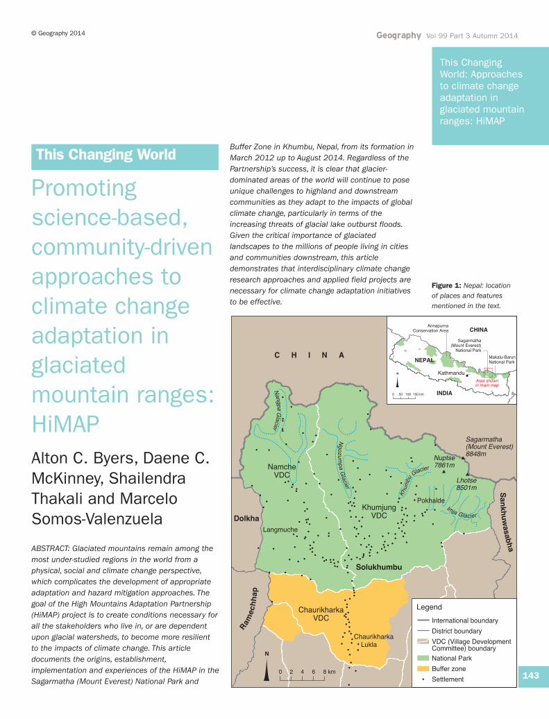
Figure 1: Nepal: locationof places and featuresmentioned in the text.
Geography Vol 99 Part 3 Autumn 2014 © Geography 2014
144
This ChangingWorld: Approachesto climate changeadaptation inglaciated mountainranges: HiMAP
IntroductionGlacier-dominated mountains play a major role inproviding water to large numbers of people,especially in the Himalayas (Barnett et al., 2005;Byers, 2007a; Viviroli et al., 2007; Armstrong,2010). Here, some 1.4 billion people livingdownstream of the Himalayas depend on waterfrom the Indus, Ganges, Brahmaputra, Yangtze andYellow Rivers (Immerzeel et al., 2010). Continuedand increasing glacier melting may initially increaserunoff in some regions, but the lack of a glacialbuffer will ultimately cause decreased reliability ofdry season streamflow (Bradley et al., 2006). Thiswill, in turn, affect future water supplies,hydropower, agricultural productivity andecosystems, and significantly impact on locallivelihoods (Bradley et al., 2006; Carey et al.,2014). These glacial-dominated areas pose uniquechallenges to downstream communities as theyadapt to recent and continuing global climatechange, particularly the increased threats fromglacial lake outburst floods (GLOFs) (Richardsonand Reynolds, 2000; Huggel et al., 2003; Carey,2005; ICIMOD, 2011). They also remain among themost under-studied regions in the world, from a
physical, social and climate change perspective(Armstrong, 2010; McDowell et al., 2014; Carey etal., 2014). Given the critical importance of theworld’s glaciated landscapes, it is increasinglyargued that interdisciplinary climate changeresearch and applied field projects – both of whichspan the natural, social and engineering sciences– are urgently needed (Carey et al., 2014).
Created in 2012, the High Mountains AdaptationPartnership (HiMAP) focuses on remote, high-altitude mountain ecosystems and communities.Its goal is to create conditions necessary for allstakeholders who live in, and are dependent upon,glacial watersheds (including local communities,government agencies and downstreampopulations), to become more resilient to theimpacts of climate change. This article documentsthe origins, establishment and implementation ofthe HiMAP in the Sagarmatha (Mount Everest)National Park and Buffer Zone (hereafter calledSagarmatha NPBZ) situated in Khumbu, Nepal(Figure 1). Covering an area of 1113km2, the Parkis bounded by mountain peaks in excess of6000m, including the world’s highest, MountEverest, at 8848m (Byers, 2005). Khumbu is thetraditional home of the Sherpa people, formerlyagro-pastoralists and traders, whose economiesare now dominated by the adventure tourism trade(trekking and climbing). The region is particularlyvulnerable to climate change impacts because ofits extreme topography, remoteness, lack oftransport facilities and tourist-driven economy.
Glaciers andcontemporary impacts ofclimate change Glaciers have been called one of the mostdramatic indicators of climate change, particularlywhen using methods like repeat photography.When such photographs are supplemented withremote sensing time-lapse images, they allow thedocumentation of contemporary glacial processessuch as recession, meltwater pond formation andthe creation of new glacial lakes.
One source of historic photographs is the archivesof early ‘climber-scientists’, who were oftenattached to the mountaineering expeditions thatbegan frequenting the Khumbu region in the early1950s. In 1953, for example, Sir Charles Evanswas Deputy Director of the British expedition thatput the first humans on the summit of MountEverest: Edmund Hillary and Tenzing Norgay. Afterthe success of the expedition, Evans stayed on forsix months conducting glacier research in theupper Imja Khola region (Byers, 2010a). In 1956,
(a)
(b)
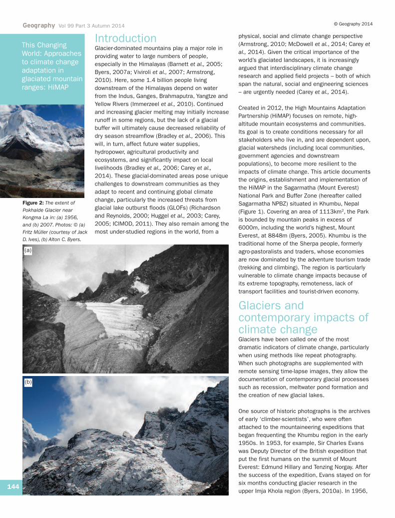
Figure 2: The extent ofPokhalde Glacier nearKongma La in: (a) 1956,and (b) 2007. Photos: © (a)Fritz Müller (courtesy of JackD. Ives), (b) Alton C. Byers.
Geography Vol 99 Part 3 Autumn 2014© Geography 2014
145
This ChangingWorld: Approachesto climate changeadaptation inglaciated mountainranges: HiMAP
following the successful climb of Everest by theSwiss, the Swiss-Canadian glaciologist, Fritz Müller,then spent nine months in the region above5000m, conducting glacier research with a team ofSherpa assistants (Müller, 1959). Starting in1956, the Austrian climber-cartographer ErwinSchneider began a terrestrial photogrammetricsurvey of the Mount Everest region with theobjective of producing a 1:125,000 scale map(Finsterwalder, 1987). All three of these climber-scientists took thousands of photographs of theglaciers and ‘alpine’ landscapes; the location ofhundreds of these photographs was identified andrepeat images were captured in 2007 and 2008(Byers, 2007b, 2010a,b, 2013a,b). The fieldchecking and photographing of features that are ofparticular interest is now repeated each year.
Comparing the historic photographs withcontemporary ones offers a unique window into thepast, and has enabled a qualitative assessment ofthe changes in glacial ice that had occurred in theinterim. The most dramatic changes observedsuggest that, since 1956, the following hadoccurred:
• Hundreds of small (<0.5km2), clean glaciers (C-Type) at lower altitudes (5200m) had either
disappeared entirely or significantly reduced insize. For example, the Pokhalde Glacier nearKongma La (Figure 2).
• North-facing clean glaciers and ice fields athigher altitudes (e.g. 6000m) had ascendedconsiderably and lost significant mass, butappeared to be temporarily stable due to theyear-round freezing temperatures found there.
• South-facing clean ice, including the icepinnacles below the Khumbu Icefall and variousparts of Everest, Nuptse and Lhotse, was eithergone or in a state of rapid recession.
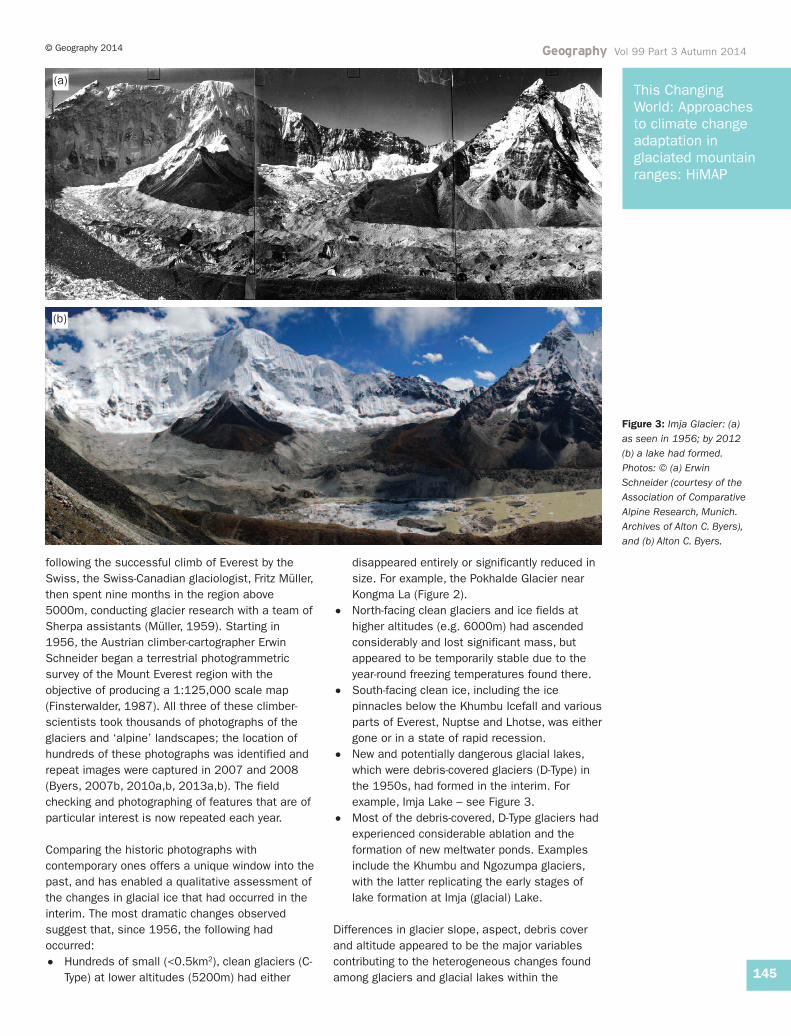
• New and potentially dangerous glacial lakes,which were debris-covered glaciers (D-Type) inthe 1950s, had formed in the interim. Forexample, Imja Lake – see Figure 3.
• Most of the debris-covered, D-Type glaciers hadexperienced considerable ablation and theformation of new meltwater ponds. Examplesinclude the Khumbu and Ngozumpa glaciers,with the latter replicating the early stages oflake formation at Imja (glacial) Lake.
Differences in glacier slope, aspect, debris coverand altitude appeared to be the major variablescontributing to the heterogeneous changes foundamong glaciers and glacial lakes within the
(a)
(b)
Figure 3: Imja Glacier: (a)as seen in 1956; by 2012(b) a lake had formed.Photos: © (a) ErwinSchneider (courtesy of theAssociation of ComparativeAlpine Research, Munich.Archives of Alton C. Byers),and (b) Alton C. Byers.
Khumbu (Hambrey et al., 2008; Kargel et al.,2012). The findings did not support a number ofpopular claims being made at the time about therate of glacial recession, such as the retreat of theKhumbu glacier by >5km since 1953 (Walters,2002); nor that rapidly melting glaciers threateneddeath to millions by making substantial areasuninhabitable (Walters, 2002); nor internet reportsof a GLOF near Kunde in 2008 (Byers, 2007b); norpredictions that all Himalayan glaciers woulddisappear by 2035 (Cruz et al., 2007). Therepeated photographing of receding glaciers andchanging alpine landscapes were among the firstof their kind from the Everest region (Nepal side).These images were displayed to internationalaudiences in photo exhibits at Everest basecampand in cities across Europe and the USA in 2008–09 (see ICIMOD).
Of particular interest to both the public andscientific community alike was the dramaticformation of new glacial lakes since the 1960s. Asmany of the larger glaciers have melted in theHimalayas, hundreds of new glacier lakes, holdingmillions of cubic meters of water, have beencreated. Usually contained by dams of looseboulders and soil, these lakes present a risk ofGLOFs. Triggering factors for GLOFs include lakearea expansion rate, up-glacier and down-valleyexpansion rate, dead-ice melting, seepage, lakewater level change and surge waves caused byrockfall and/or slide and ice calving (Watanabe etal., 2009). GLOFs unleash stored lake water, oftencausing enormous devastation downstream thatcan include high death tolls as well as destructionof valuable farmland and infrastructure (e.g.hydroelectric facilities, roads, bridges). In 1985,the Langmoche outburst in the Sagarmatha NPBZ,Nepal, destroyed the Thami hydroelectric facility,hundreds of hectares of cropland and dozens ofbridges downstream (Vuichard and Zimmerman,
1986). The 1998 outburst of the Sabai Tso in theHinku Valley, Makalu-Barun National Park, Nepal,destroyed trails and seasonal settlements for100km downstream (Cox, 1999; Osti and Egashira,2009) – damage that is still visible in satelliteimages taken over a decade after the event.
Field-based knowledge exchange: the prelude tothe HiMAPAlthough experience in reducing the risk of GLOFsthrough the lowering of water levels or othermechanisms is limited in Nepal (Bajracharya et al.,2007), Peruvian engineers have been controllingdangerous glacial lakes for more than 70 years(Carey, 2010). In the interests of sharing thisknowledge more widely, in September 2011, TheMountain Institute hosted the ‘Andean-AsianMountains Global Knowledge Exchange onGlaciers, Glacial lakes, Water and HazardManagement’ in the Mount Everest region of Nepal(The Mountain Institute, 2011). Rather than limitactivities to a conference hall in Kathmandu, this‘mobile workshop’ took place over an 18-dayperiod in the Sagarmatha NPBZ. Over the course ofthe 250km trek from the Lukla airstrip to Imjaglacial lake, 35 scientists from 15 differentcountries (including four from Peru) related theirexperiences on glacial lakes and hazards, GLOFrisk reduction methods, freshwater supply and thehuman dimensions of climate change andadaptation. ‘South-south collaboration’ waspromoted by including, for the first time in Nepal,Peruvian engineers with decades of experience inreducing the risk of dangerous glacial lakes in theCordillera Blanca region of Peru. Local communitymembers joined the workshop at Imja Lake toshare their knowledge of the lake’s history ofgrowth, expansion and prospective dangers since itfirst started forming in the 1960s. The opportunityto study first-hand the contemporary impacts ofclimate change on high altitude environments andpeoples was unprecedented. Workshopparticipants proposed that a ‘High MountainGlacial Watershed Program’ be established, onethat would focus specifically on glacial lake studyand risk reduction and climate change adaptation,as well as carry out the promotion of field researchamong young scientists.
The High Mountains Adaptation PartnershipIn March 2012, the High Mountains AdaptationPartnership (HiMAP) was officially formed withfunding from the US Agency for InternationalDevelopment (USAID). HiMAP is designed to
This ChangingWorld: Approachesto climate changeadaptation inglaciated mountainranges: HiMAP
146
© Geography 2014Geography Vol 99 Part 3 Autumn 2014
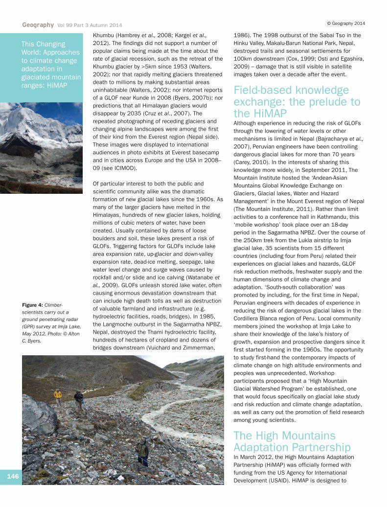
Figure 4: Climber-scientists carry out aground penetrating radar(GPR) survey at Imja Lake,May 2012. Photo: © AltonC. Byers.
This ChangingWorld: Approachesto climate changeadaptation inglaciated mountainranges: HiMAP
147
© Geography 2014 Geography Vol 99 Part 3 Autumn 2014
strengthen the scientific, social and institutionalcapacity for climate change adaptation andresilient development, as well as disaster riskmitigation and management of potentiallydangerous glacial lakes and other climate-relateddisasters. The Partnership has attempted to do sothrough a series of inter-related activities. The firstinvolves fostering the next generation of mountain-scientists and development practitioners throughcompetitive ‘climber-scientist’ small grants; thesecond, developing rapid reconnaissance fieldmethods for the study of potentially dangerousglacial lakes, including the modeling ofdownstream flood impacts and risk reductionengineering strategies; the third requires thedevelopment of climate change adaptationmechanisms for local communities; and the fourthinvolves building a global community of practice forhigh-mountain glacial watershed technical analysis,adaptation and climate-smart development.
Climber-scientist small grantsprogramme The climber-scientist competitive grant programmeprovides field-based, hands-on researchopportunities to scientists and practitionersworking in high mountain regions. Particular focusis placed on the generation of new knowledgeregarding the impacts of climate change,interaction between highland and lowlandcommunities, and methods for protecting fragilealpine ecosystems. The grant programme isparticularly interested in funding applied researchprojects that: (a) encourage the systematic use offield work to support and augment remote sensingtechnologies, (b) assist mountain communities inadapting to climate change and (c) enhance thedevelopment of the next generation of highmountain physical and social scientists, includingthose with little climbing experience. It is foundedon the belief that solutions to many of thechallenges presented by climate change today willdemand the systematic blending of the best ofmodern-day technologies with traditional, on-the-ground, field methods, including the activeparticipation of local communities.
A glacial lake rapid reconnaissance approach Compared to remote sensing analyses, field-basedstudies of glaciers and glacial lakes are relativelyrare in the Himalayas (Byers et al., 2013). This ismost likely related to popular perceptions regardingthe high cost of remote-area research, coupled withthe high altitudes and extreme environments of theglaciated world, which result in difficult workingconditions. Arguing that the best understandings of
contemporary climate change impacts can onlycome from the systematic use of both laboratoryand field techniques, HiMAP established the ‘GlacialLake Rapid Reconnaissance Team’ in May 2012(McKinney et al., 2012). To date, the Team hascompleted five field expeditions to Imja Lake in theSagarmatha NPBZ, the Makalu-Barun National Parkand the Annapurna Conservation Area of Nepal(Figure 1). The purpose of these expeditions andfollow-on analyses has been to quantify the risk ofa GLOF from Imja Lake, the potential risk todownstream communities and possible remedialmeasures to reduce that risk to an acceptablelevel. The studies included ground penetratingradar (GPR) surveys of the terminal moraine andthe Imja Glacier, a sonar bathymetric survey of thelake itself and computer modelling of a potentialGLOF from Imja Lake with consequent downstreamflooding.
In order to better understand the structure of Imja-Lhotse Shar glacier in the proximity of the easternend of Imja Lake, GPR surveys were conducted inMay and September of 2012 using a custom-built,low-frequency, short-pulse, ground-based radarsystem (Somos-Valenzuela et al., 2014) (Figure 4).The GPR surveys were performed across theglacier from north to south, over most of theterminal moraine complex and around both sidesof the lake outlet. Results show that glacierthickness varies from 40 to 60m near the lateralmoraines of the glacier to over 200m in the centre.GPR surveys were also made at the western end ofthe lake in the moraine region. The results of thesurveys show that there is extensive ice present inthe core of the terminal moraine complex at ImjaLake, with the thickest ice near the western end onthe north side of the lake’s outlet. The depth ofmixed debris and ice in the western moraine end ofthe lake was, however, difficult to determine fromthe GPR results.
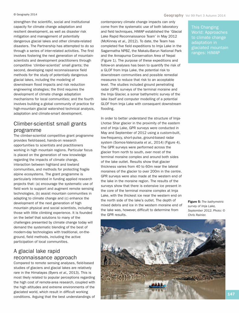
Figure 5: The bathymetricsurvey of Imja Lake,September 2012. Photo: ©Chris Rainier.
Geography Vol 99 Part 3 Autumn 2014 © Geography 2014
148
This ChangingWorld: Approachesto climate changeadaptation inglaciated mountainranges: HiMAP
A bathymetric survey of Imja Lake was conductedin September 2012 using a sonar unit mounted onan inflatable raft (Figure 5). Several transects weremade around the lake with the sonar unitmeasuring lake depth. During the survey, largeicebergs covered the eastern end of the lake,blocking much of the access to that area.Nevertheless, the results suggest that themaximum depth of the lake has increased from 98to 116m between 2002 and 2012, and theestimated volume from 35 million m3 to 61.6 million m3 during this period (Somos-Valenzuela et al., 2014). Most of the expansion ofImja Lake in recent years has taken place in theglacier terminus/lake interface to the east, wheremore than 200m of glacial ice has been lost inrecent years (see Figures 4 and 5). The decadalaverage rate of loss is 53m/yr compared toprevious estimates of 34m/yr. The result of theGPR and bathymetric surveys make it clear that theice of the glacier is significantly deeper than thelake and that the ice probably extends under thelake. The result of this is that the lake will continueto deepen in the future.
A hydraulic simulation model was developed toassess the impact of a potential GLOF from ImjaLake on downstream communities. Implications ofproposed GLOF risk reduction alternatives,including one suggested by local communitymembers, were assessed. Results of the modelingillustrate three alternatives that offer significantrisk reduction for downstream communities. Thefirst involves the construction of a 60m flood-detention dam but no lowering of the lake waterlevel, resulting in a 43% reduction of risk, butrequiring extensive infrastructure construction andexpense. The second involves lowering the lakewater level by 10m and constructing a 40m-highdam, resulting in a 58% reduction of risk. The thirdinvolves lowering the lake water level by 20m withno dam, resulting in a risk reduction of 67%. TheGovernment of Nepal, in partnership with theUnited Nations Development Programme Nepal(UNDP/Nepal), is currently considering a fourthalternative. That is to lower the lake water level by3m, which would result in approximately a 5%reduction of risk (UNDP, 2013). The latter, however,does not appear to offer significant risk reductionbenefits to downstream communities comparedwith lowering the lake water level by 20m. Resultssuggest that either the lake water level must belowered by significantly more than 3m (20m isrecommended), or that a downstream flood-detention dam be included in the project. It hasbeen suggested that siphons should be used tolower the Imja Lake water level. This would involveinstalling 13 pipes of 0.35m diameter, draining thewater level by 3m, excavating it to the new waterlevel and repeating the process until the level hasbeen lowered by 20m.
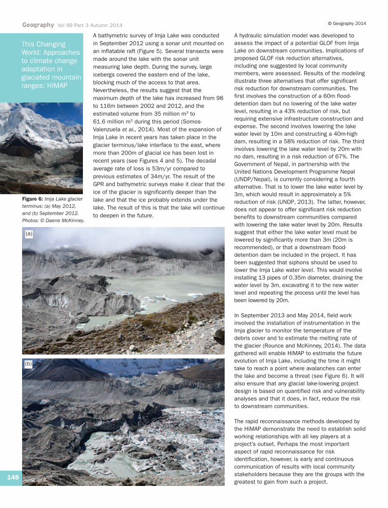
In September 2013 and May 2014, field workinvolved the installation of instrumentation in theImja glacier to monitor the temperature of thedebris cover and to estimate the melting rate ofthe glacier (Rounce and McKinney, 2014). The datagathered will enable HiMAP to estimate the futureevolution of Imja Lake, including the time it mighttake to reach a point where avalanches can enterthe lake and become a threat (see Figure 6). It willalso ensure that any glacial lake-lowering projectdesign is based on quantified risk and vulnerabilityanalyses and that it does, in fact, reduce the riskto downstream communities.
The rapid reconnaissance methods developed bythe HiMAP demonstrate the need to establish solidworking relationships with all key players at aproject’s outset. Perhaps the most importantaspect of rapid reconnaissance for riskidentification, however, is early and continuouscommunication of results with local communitystakeholders because they are the groups with thegreatest to gain from such a project.
(b)
(a)
Figure 6: Imja Lake glacierterminus: (a) May 2012, and (b) September 2012.Photos: © Daene McKinney.
Local adaptation plans of actionLocal communities in mountainous regions areparticularly vulnerable to climate change – asglobal temperatures rise glaciers recede, newglacial lakes form and the weather becomes lesspredictable. Despite this, understandings of thehuman dimensions of climate change are still intheir infancy in mountain regions where there islimited comprehension of climate change, itsimpacts, community vulnerabilities and adaptationopportunities.
In September 2010, the Government of Nepalinitiated climate adaptation planning andimplementation by endorsing the NationalAdaptation Programme of Action (NAPA). TheGovernment’s intention is to disburse at least 80%of the available budget earmarked for climatechange directly to local implementation ofidentified adaptation actions. The NAPA also aimsto ensure that national adaptation planningsupports adaptation by local communities,particularly the climate-vulnerable poor.
In 2011, recognising the enormous variabilitywithin Nepal and within its various communities,the Government of Nepal developed the LocalAdaptation Plan of Action (LAPA) process (seeFigure 7). The LAPA is designed to more fullyreflect the needs and aspirations of Nepal’sdiverse communities, as well as the wide range ofimpacts experienced from climate variability. There are a number of differences between theGovernment of Nepal (Figure 7) and the HiMAPadaptation planning approaches (see Figure 8).The first is that the HiMAP LAPA begins with anemphasis on local development needs in order toplace the climate-centric LAPA into a broaderdevelopment context. This involves a discussion oflocal assets, a ‘sensitisation’ (or introduction) toclimate change basics and finally facilitateddiscussions of how these assets have beenaffected by climate change. Second, HiMAP spenta considerable amount of time in the integration ofidentified adaptation priorities into existing or
forthcoming sources of development funding, suchas those from Village Development Committees(VDCs), or the Sagarmatha NPBZ Committee.Efforts to include aspects of the LAPA into therevised Sagarmatha National Park ManagementPlan were also pursued because the existing Parkplan contained no specific mention of, or projectsrelated to, climate change. Third, the HiMAPKhumbu LAPA incorporated scientific data andknowledge to verify or challenge local experienceand perceptions of climate change impacts andvulnerabilities. For example, results from theHiMAP glacial lake surveys and potential risks wereroutinely shared with participants and theGovernment of Nepal. This may have influencedthe ranking of GLOFs as the number one hazard interms of risks and impacts, despite a high level oflocal skepticism prior to the first years of HiMAPactivity (2011–13). Finally, the HiMAP adaptationplanning approach considered the entireSagarmatha NPBZ – including the three VDCs(Chaurikharka, Namche and Khumjung – see Figure1) inside the Park.1 The decision was madebecause all three VDCs are located in high-mountain glaciated areas, have similar socio-economic and cultural characteristics, and areexperiencing similar climate change related issuesand climate change induced hazards. (Conversely,the Nepalese Government’s approach was to usesingle VDCs.)
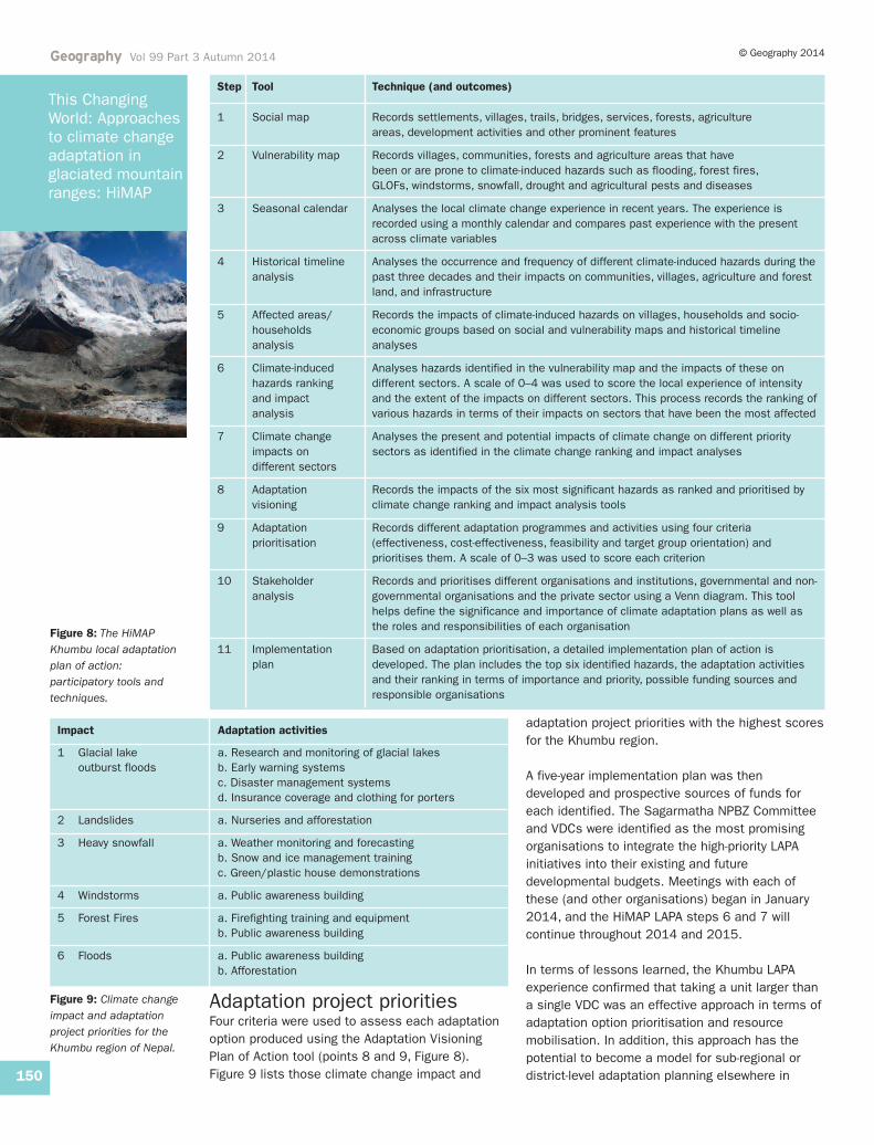
During community consultations, HiMAP employed11 different participatory tools and techniques togather and share information (see Figure 8). Thisintegrated and comprehensive approach was felt tobe more effective and efficient in the developmentof a climate change adaptation plan and tools forthe Khumbu region.
Key issues identified in theKhumbu LAPASix priority climate-induced hazards were identifiedand ranked in order of importance as follows:GLOFs, landslides, heavy snowfall, windstorms,forest fires and floods. Participants determinedthat, in the three Khumbu VDCs, a total of 1284households would likely be affected by GLOFs and927 by landslides. The impacts of heavy snowfallare more severe in Khumjung and Namche VDCsthan in Chaurikharka VDC, but windstorm impactsare increasing in all three VDCs. Due to its lowerelevation, and thus denser forests, Chaurikharka ismore sensitive to forest fires than the other twoVDCs. The occurrence of flash floods appears tobe increasing every year, particularly in theChaurikharka VDC.
Geography Vol 99 Part 3 Autumn 2014© Geography 2014
149
This ChangingWorld: Approachesto climate changeadaptation inglaciated mountainranges: HiMAP
The LAPA Framework consists of seven steps forintegrating climate change resilience into local-to-national planning processes. Briefly, these are:1 Climate change sensitisation2 Climate vulnerability and adaptation assessment3 Prioritisation of adaptation options4 Developing a local adaptation plan for action 5 Integrating the local adaptation plan for action into
planning processes 6 Implementing the local adaptation plan for action 7 Assessing progress of the local adaptation plan for
action
Figure 7: Précis of theGovernment of Nepal’s,Local Adaptation Plan ofAction (LAPA) Framework.Source: Government ofNepal, 2011.
Geography Vol 99 Part 3 Autumn 2014 © Geography 2014
150
This ChangingWorld: Approachesto climate changeadaptation inglaciated mountainranges: HiMAP
Figure 9: Climate changeimpact and adaptationproject priorities for theKhumbu region of Nepal.
Adaptation project prioritiesFour criteria were used to assess each adaptationoption produced using the Adaptation VisioningPlan of Action tool (points 8 and 9, Figure 8).Figure 9 lists those climate change impact and
adaptation project priorities with the highest scoresfor the Khumbu region.
A five-year implementation plan was thendeveloped and prospective sources of funds foreach identified. The Sagarmatha NPBZ Committeeand VDCs were identified as the most promisingorganisations to integrate the high-priority LAPAinitiatives into their existing and futuredevelopmental budgets. Meetings with each ofthese (and other organisations) began in January2014, and the HiMAP LAPA steps 6 and 7 willcontinue throughout 2014 and 2015.
In terms of lessons learned, the Khumbu LAPAexperience confirmed that taking a unit larger thana single VDC was an effective approach in terms ofadaptation option prioritisation and resourcemobilisation. In addition, this approach has thepotential to become a model for sub-regional ordistrict-level adaptation planning elsewhere in
Impact Adaptation activities
1 Glacial lake a. Research and monitoring of glacial lakesoutburst floods b. Early warning systems
c. Disaster management systems d. Insurance coverage and clothing for porters
2 Landslides a. Nurseries and afforestation
3 Heavy snowfall a. Weather monitoring and forecasting b. Snow and ice management training c. Green/plastic house demonstrations
4 Windstorms a. Public awareness building
5 Forest Fires a. Firefighting training and equipment b. Public awareness building
6 Floods a. Public awareness building b. Afforestation
Step Tool Technique (and outcomes)
1 Social map Records settlements, villages, trails, bridges, services, forests, agriculture areas, development activities and other prominent features
2 Vulnerability map Records villages, communities, forests and agriculture areas that have been or are prone to climate-induced hazards such as flooding, forest fires, GLOFs, windstorms, snowfall, drought and agricultural pests and diseases
3 Seasonal calendar Analyses the local climate change experience in recent years. The experience is recorded using a monthly calendar and compares past experience with the present across climate variables
4 Historical timeline Analyses the occurrence and frequency of different climate-induced hazards during the analysis past three decades and their impacts on communities, villages, agriculture and forest
land, and infrastructure
5 Affected areas/ Records the impacts of climate-induced hazards on villages, households and socio-households economic groups based on social and vulnerability maps and historical timeline analysis analyses
6 Climate-induced Analyses hazards identified in the vulnerability map and the impacts of these on hazards ranking different sectors. A scale of 0–4 was used to score the local experience of intensity and impact and the extent of the impacts on different sectors. This process records the ranking of analysis various hazards in terms of their impacts on sectors that have been the most affected
7 Climate change Analyses the present and potential impacts of climate change on different priority impacts on sectors as identified in the climate change ranking and impact analysesdifferent sectors
8 Adaptation Records the impacts of the six most significant hazards as ranked and prioritised by visioning climate change ranking and impact analysis tools
9 Adaptation Records different adaptation programmes and activities using four criteria prioritisation (effectiveness, cost-effectiveness, feasibility and target group orientation) and
prioritises them. A scale of 0–3 was used to score each criterion
10 Stakeholder Records and prioritises different organisations and institutions, governmental and non-analysis governmental organisations and the private sector using a Venn diagram. This tool
helps define the significance and importance of climate adaptation plans as well as the roles and responsibilities of each organisation
11 Implementation Based on adaptation prioritisation, a detailed implementation plan of action is plan developed. The plan includes the top six identified hazards, the adaptation activities
and their ranking in terms of importance and priority, possible funding sources and responsible organisations
Figure 8: The HiMAPKhumbu local adaptationplan of action:participatory tools andtechniques.
Nepal. The actual integration of the LAPA into local,district and national planning has, however, provento be challenging. This is largely due to a lack ofavailable resources. Therefore, establishing formalrelationships and memoranda of understandingwith government agencies prior to the onset ofcommunity consultations is important so thatroles, responsibilities and outcomes are clear fromthe beginning. Finally, while enthusiasm for theLAPA process among the VDCs was high, follow-through is (once again) matched by the availabilityof resources – which at present are scarce.
ConclusionsSince its official formation in March 2012, theHiMAP has successfully strengthened thescientific, social and institutional capacity forclimate change adaptation and resilience inrepresentative high-mountain glacial watersheds inNepal. Each Local Adaptation Plan of Action isbased on the principles of full communityparticipation, climate-smart development,ecosystem-based adaptation approaches, riskmitigation and disaster management planning.Development outcomes have included a portfolioof high-mountain climate change adaptationmechanisms in line with regional priorities, eachdesigned to address such priority vulnerabilities asreduced access to freshwater, increasedlandslides, increasing temperatures, GLOFs,emerging glacial lakes and geomorphic instability.The high-mountain glacial watershed internationalcommunity of scientists and practitioners ispooling its knowledge. A new generation of‘climber-scientists’ fluent in climate change andadaptation issues, field and laboratory methods,integration of traditional knowledge, activecommunity engagement and climate-smartdevelopment, is emerging. Global awareness of thecritical importance of high-mountain glacialwatersheds has been increased among donors,international agencies and governments, such thatthey now actively support climate changeadaptation and resilience-building in these regions.
Nevertheless, as promising as these results maybe, it is clear that glacier-dominated areas of theworld will continue to pose unique challenges toboth upstream and downstream communities asthey adapt to the impacts of global climate change– particularly the increasing threats of GLOFs.Glaciated mountains are among the least studiedenvironments in the world from a physical, socialand climate change perspective. As such, theprocesses of adaptation and mitigation appearmore complex and challenging. Contemporarydevelopments – such as the formation of
thousands of new and, potentially, dangerousglacial lakes – are unprecedented in humankind’sexperience of change and adaptation. Given thecritical importance of high-mountain glaciatedlandscapes to the millions of inhabitants of citiesand communities that live in or rely upon them,interdisciplinary climate change researchapproaches and applied field programmes thatactively combine the social, physical andengineering science dimensions will be required inorder to achieve the best understanding of currentand future climate-induced risks.
Note1. Village Development Committees are made up of
representatives from settlements within their locality.
ReferencesArmstrong, R. (2010) Melting Glaciers: Current status and
future concerns. Washington, DC: USAID. Bajracharya, S.R., Mool, P.K. and Shrestha, B.R. (2007)
The Impact of Climate Change on Himalayan Glacier andGlacial Lakes. Kathmandu: ICIMOD.
Barnett, T.P., Adam, J.C. and Lettenmaier, D.P. (2005)‘Potential impacts of a warming climate on wateravailability in snow dominated regions’, Nature, 438,pp. 303–9.
Bradley, R.S., Vuille, M., Diaz, H.F. and Vergara, W. (2006)‘Threats to water supply in the tropical Andes’,Science, 312, pp. 1755–6.
Byers, A.C. (2005) ‘Contemporary human impacts onalpine landscapes in the Sagarmatha (Mt. Everest)National Park, Khumbu, Nepal’, Annals of theAssociation of American Geographers, 95, pp. 112–40.
Byers, A.C. (2007a) ‘Impacts of climate change in themountains’ in Braasch, G. (ed) Earth Under Fire.Berkeley, CA: University of California Press, pp. 34–5.
Byers, A.C. (2007b) ‘An assessment of contemporaryglacier fluctuations in Nepal’s Khumbu Himal usingrepeat photography’, Himalayan Journal of Sciences, 4,pp. 21–6.
Byers, A.C. (2010a) ’Climate change: impacts andopportunities in the world’s highest mountains’ inEducation About Asia. Chattanooga, TE: University ofTennessee, pp. 9–14.
Byers, A.C. (2010b) ‘Melting glaciers, freshwater, andconservation in the Mt. Everest region of Nepal’ inStraight, S. (ed) Written in Water. Washington, DC:National Geographic Society, pp. 107–19.
Byers, A.C. (2013a) ‘Three sides of Everest: there’s moreto a mountain than its summit’, Natural HistoryMagazine, 121, 3, pp. 24–35.
Byers, A.C. (2013b) ‘The nature of Everest’ in Anker, C.,MacDonald, B., Coburn, B. and Breshears, D. (eds) TheLure of Everest. Washington, DC: National GeographicSociety, pp. 88–135.
Byers, A.C., McKinney, D.C., Somos-Valenzuela, M.A.,Watanabe, T. and Lamsal, D. (2013) ‘Glacial lakes ofthe Hongu Valley, Makalu-Barun National Park andBuffer Zone, Nepal’, Natural Hazards, 69, pp. 115–39.
Carey, M. (2005) ‘Living and dying with glaciers: people’shistorical vulnerability to avalanches and outburstfloods in Peru’, Global & Planetary Change, 47, pp.122–34.
Geography Vol 99 Part 3 Autumn 2014© Geography 2014
151
This ChangingWorld: Approachesto climate changeadaptation inglaciated mountainranges: HiMAP
Carey, M. (2010) In the Shadow of Melting Glaciers:Climate change and Andean society. New York, NY:Oxford University Press.
Carey, M., McDowell, G., Huggel, C., Jackson, M.,Portocarero, C., Reynolds, J. and Vicuña, L. (2014)‘Integrated approaches to adaptation and disaster riskreduction in dynamic socio-cryospheric systems’ inHaeberli, W. and Whiteman, C. (eds) Hazards, Risksand Disasters Related to Snow and Ice. Atlanta, GA:Elsevier.
Cox, J.H. (1999) An Assessment of Habitats and HumanInteraction in the Hinkhu, Hongu, Kasuwa and BarunKholas of Makalu-Barun National Park and ConservationArea. Kathmandu: Makalu Barun Conservation Project.Elkins, WV: The Mountain Institute.
Cruz, R.V., Harasawa, H., Lal, M., Wu, S., Anokhin, Y.,Punsalmaa, B., Honda, Y., Jafari, M., Li, C. and HuuNinh, N. (2007) ‘Asia. Climate change 2007: impacts,adaptation and vulnerability’ in Parry, M.L., Canziani,O.F., Palutikof, J.P., van der Linden, P.J. and Hanson,C.E. (eds) Contribution of Working Group II to the FourthAssessment Report of the Intergovernmental Panel onClimate Change. Cambridge: Cambridge UniversityPress, pp. 469–506.
Finsterwalder, R. (1987) ‘The new sheet Helambu-Langtang of the Nepal map series produced by theArbeitsgemeinschaft für VergleichendeHochebirgsforschung’, Mountain Research andDevelopment, 7, pp. 347–51.
Government of Nepal (2011) National Framework onLocal Adaptation Plans for Action. Kathmandu:Government of Nepal, Ministry of Science Technologyand Environment, Singha Durbar.
Hambrey, M.J., Quincey, D.J., Glasser, N.F., Reynolds, J.M.,Richardson, S.J. and Clemmens, S. (2008)‘Sedimentological, geomorphological and dynamiccontext of debris-mantled glaciers, Mount Everest(Sagarmatha) region, Nepal’, Quaternary ScienceReviews, 27, pp. 2361–89.
Huggel, C., Kaab, A., Haeberli, W. and Krummenacher, B.(2003) ‘Regional-scale GIS-models for assessment ofhazards from glacier lake outbursts: evaluation andapplication in the Swiss Alps’, Natural Hazards andEarth System Sciences, 3, pp. 647–62.
ICIMOD ‘Changing landscapes’. Available online atwww.icimod.org/changing-landscapes (last accessed 8July 2014).
International Centre for Integrated Mountain Development(ICIMOD) (2011) Glacial Lakes and Glacial LakeOutburst Floods in Nepal. Kathmandu: ICIMOD.
Immerzeel, W.W., van Beek, L.P.H. and Bierkens, M.F.P.(2010) ‘Climate change will affect the Asian watertowers’, Science, 328, p. 1382.
Kargel, J.S., Cogley, J.G., Leonarda, G.L., Haritashyac, U.and Byers, A.C. (2012) ‘Himalayan glaciers: the bigpicture is a montage’, Proceedings of the NationalAcademy of Sciences, 10, 1, pp. 14709–10.
McDowell, G., Stephenson, E. and Ford, J. (2014)‘Adaptation to climate change in glaciated mountainregions’, Climatic Change. Available online atdoi:10.1007/s10584-014-1215-z (last accessed 6August 2014).
McKinney, D., Somos-Valenzuela, M.A. and Byers, A.C.(2012) ‘The importance of field work in naturaldisaster risk assessments in high mountains’. Posterpresented at the American Geographers’ Union FallMeeting, 3–7 December.
Müller, F. (1959) ‘Eight months of glacier and soilresearch in the Everest region’ in Barnes, M. (ed) The
Mountain World 1958/59. London: George Allen &Unwin, pp. 191–208.
Osti, R. and Egashira, S. (2009) ‘Hydrodynamiccharacteristics of the Tam Pokhari glacial lake outburstflood in the Mt. Everest region, Nepal’, HydrologicalProcesses, 23, pp. 2943–55.
Richardson, S.D. and Reynolds, J.M. (2000) ‘An overviewof glacial hazards in the Himalayas’, QuaternaryInternational, 65–66, pp. 31–47.
Rounce, D.R. and McKinney, D.C. (2014) ‘Thermalresistances in the Everest Area (Nepal Himalaya)derived from satellite imagery using a nonlinear energybalance model’, The Cryosphere Discussions, 8, pp.1317–29. Available online at doi:10.5194/tc-8-1317-2014 (last accessed 25 July 2014).
Somos-Valenzuela, M.A., McKinney, D.C., Rounce, D.R.and Byers, A.C. (2014) ‘Changes in Imja Tsho in theMt. Everest Region of Nepal’, The CryosphereDiscussions, 8, pp. 1–27.
The Mountain Institute (2011) Andean-Asian MountainsGlobal Knowledge Exchange on Glaciers, Glacial Lakes,Water & Hazard Management (conferenceproceedings). Washington, DC: The Mountain Institute.
United Nations Development Programme (UNDP) (2013)Community Based Glacier Lake Outburst and Flood RiskReduction in Nepal (project document). Kathmandu:UNDP Environmental Finance Services.
Viviroli, D., Dürr, H., Messerli, B., Meybeck, M. andWeingartner, R. (2007) ‘Mountains of the world, watertowers for humanity: typology, mapping, and globalsignificance’, Water Resources Research, 43. Availableonline at doi:10.1029/2006WR005653 (last accessed10 July 2014)
Vuichard, D. and Zimmerman, M. (1986) ‘The Langmocheflash-flood, Khumbu Himal, Nepal’, Mountain Researchand Development, 6, pp. 90–4.
Walters, J. (2002) ‘Warming world on thin ice: rapidlymelting glaciers threaten death to millions by makinghuge areas uninhabitable’, The Observer, 9 June.Available online at www.theguardian.com/climatechange/story/0,12374,782780,00.html (last accessed26 June 2014).
Watanabe, T., Lamsal, D. and Ives, D.J. (2009) ‘Evaluatingthe growth characteristics of a glacial lake and itsdegree of danger of outburst flooding: Imja Glacier,Khumbu Himal, Nepal’, Norsk Geografisk Tidsskrift –Norwegian Journal of Geography, 63, pp. 255–67.
This ChangingWorld: Approachesto climate changeadaptation inglaciated mountainranges: HiMAP
152
© Geography 2014Geography Vol 99 Part 3 Autumn 2014
Dr Alton C. Byers is Director of Science andExploration at The Mountain Institute, Elkins,West Virginia, USA (email: [email protected]).
Daene C. McKinney is a Professor in theEnvironmental and Water Resources Engineeringprogramme of the Department of Civil,Architectural and Environmental Engineering atthe University of Texas at Austin, USA (email:[email protected]).
Shailendra Thakali is HiMAP LAPA Team Leaderand an independent environmental managementconsultant (email: [email protected]).
Dr Marcelo Somos-Valenzuela is a Researcher atthe Centre for Water Resources Research,University of Texas at Austin, USA (email:[email protected]).