Embed Size (px)
Citation preview
Georgia Department of Education THIS WORK IS LICENSED UNDER A CREATIVE C OMMONS ATTRIBUTION - NONCOMMERCIAL - SHAREALIKE 4.0 INTERNATIONAL LICENSE
2017 Page 1 of 14
The following instructional plan is part of a GaDOE collection of Unit Frameworks, Performance Tasks, examples of Student Work, and Teacher
Commentary for the Third Grade Social Studies Course.
Third Grade, Unit 2 – United States Geography
Elaborated Unit Focus
This unit builds a strong foundation of understanding about the geography of the area we know as the United States, including the major rivers and mountain ranges listed in the standards. Also introduced and reinforced are essential map/globe concepts related to the imaginary lines that we use to establish absolute location and the direction words we use to describe relative location. These geographic basics will be useful in all subsequent units.
Connection to Connecting Theme/Enduing Understandings
Location: The student will understand that location affects a society’s economy, culture, and development.
GSE for Social Studies
(standards and elements)
SS3G1 Locate major topographical features on a physical map of the United States.
a. Locate major rivers of the United States of America: Mississippi, Ohio, Rio Grande, Colorado, Hudson, and St. Lawrence.
b. Locate major mountain ranges of the United States of America: Appalachian, Rocky.
SS3G2 Locate and describe the equator, prime meridian, and lines of latitude and longitude on a globe.
Connection to K-5 GSE for ELA/Science/Math
ELAGSE3RI4: Determine the meaning of general academic and domain-specific words and phrases in a text relevant to a grade 3 topic or subject area.
ELAGSE3SL1: Engage effectively in a range of collaborative discussions (one-on-one, in groups, and teacher-led) with diverse partners on grade 3 topics and texts, building on others’ ideas and expressing their own clearly.
c. Ask questions to check understanding of information presented, stay on topic, and link their comments to the remarks of others.
d. Explain their own ideas and understanding in light of the discussion.
ELAGSE3W5: With guidance and support from peers and adults, develop and strengthen writing as needed by planning, revising, and editing.
ELAGSE3RI9: Compare and contrast the most important points and key details.
ELAGSE3W7: Conduct short research projects that build knowledge about a topic.
ELAGSE3W8: Recall information from experience or gather information from print and digital sources; take brief notes on sources and sort evidence into provided categories.
Connection to Social Studies Matrices
Map and Globe skills – 1 (cardinal directions), 2 (intermediate directions), 3 (use letter/number grid system to determine
Georgia Department of Education THIS WORK IS LICENSED UNDER A CREATIVE C OMMONS ATTRIBUTION - NONCOMMERCIAL - SHAREALIKE 4.0 INTERNATIONAL LICENSE
2017 Page 2 of 14
(information processing and/or map and globe skills)
location), 4 (compare/contrast categories of natural, cultural, and political features found on maps)
Information Processing Skills – 1 (compare similarities and differences) , 9 (construct charts and tables)
A Source Set of images you may find useful for this unit is included. Please note that that you will want to tell your third graders that many photos of
rivers and mountains will be very similar to one another and that it will not generally be possible to distinguish one from another on the basis of their
appearance at any given point. You will want to have your learners work to clarify similarities and differences among the land and water features we
learn about in third grade.
Georgia Department of Education THIS WORK IS LICENSED UNDER A CREATIVE C OMMONS ATTRIBUTION - NONCOMMERCIAL - SHAREALIKE 4.0 INTERNATIONAL LICENSE
2017 Page 3 of 14
Essential Questions and Related Supporting/Guiding Questions
Enduring Understanding 1:
Location
1. How can we describe our country’s land and water?
a. Why are land and water features important?
b. What are the major rivers in our country and how have they shaped culture?
c. How can mountains affect our history?
2. How can we describe locations in our country?
a. What features of globes and maps help us identify locations?
b. Why do we have an equator, prime meridian, and lines of latitude and longitude on globes and maps?
c. How can cardinal and intermediate directions help us locate features of our country?
Georgia Department of Education THIS WORK IS LICENSED UNDER A CREATIVE C OMMONS ATTRIBUTION - NONCOMMERCIAL - SHAREALIKE 4.0 INTERNATIONAL LICENSE
2017 Page 4 of 14
Sample Instructional Activities/Assessments
Activity - Ain’t No Mountain High Enough and Take Me To the River: Why Geographic Features Matter
In this activity, we will define and discuss the attributes of mountains and rivers and brainstorm why they are important to our lives.
1 – Ask students if they know the word Geography. Break it into parts and explain that geo (Greek) means earth and graphy (Greek) means a drawing or recording process. If students are keeping a visual journal or interactive notebook, have them write and draw geo + graphy and sketch a hint as to the meaning of each word part.
2 – Exploring geography means that we will take a look at some of the land and water features on the earth. Ask students to name some features they have learned before (geography standards in K-2 address some of these features.) Label in their notebooks – land features I know – and sketch and label them, then do the same with water features. This will be a good time to let them share what they already know about specific features. Tell them that we are going to focus on some land and water features in our own country. We will focus specifically on mountains and rivers.
3 – Use a Frayer model or another visual organizer to define mountain…elicit from students a definition, examples, non-examples (this might be where you have students distinguish mountains from hills), drawings, and a non-linguistic representation (drawing or photo or symbol). Deepen their thinking beyond defining the term to think about how mountains can help shape people’s lives. Brainstorm together or in small groups ways that mountains shape lives.
4 – Repeat the process used in #3 to define river. You might connect the discussion to consider how the nearest river to your community helps to shape your life or that of your neighbors. To really deepen thinking, ask your students how they think those who lived on this land earlier (American Indians,
colonists, early Americans, etc.) made decisions and lived with or in spite of the rivers and mountains near them. These questions will help bridge to upcoming units on American Indians, explorers, and the British colonies.
5 – Incorporate music into your lesson by finding and playing songs with lyrics on mountains and rivers…”Ain’t No Mountain High Enough,” “Take Me to the River,” “Proud Mary (Rolling on a River),” etc. How did the songwriters incorporate geography into their lyrics and their message?
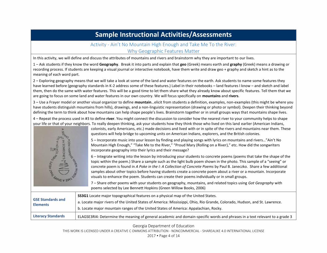
6 – Integrate writing into the lesson by introducing your students to concrete poems (poems that take the shape of the topic within the poem.) Share a sample such as the light bulb poem shown in the photo. This sample of a “seeing” or concrete poem is found in A Poke in the I: A Collection of Concrete Poems by Paul B. Janeczko. Share a few additional samples about other topics before having students create a concrete poem about a river or a mountain. Incorporate visuals to enhance the poem. Students can create their poems individually or in small groups.
7 – Share other poems with your students on geography, mountains, and related topics using Got Geography with poems selected by Lee Bennett Hopkins (Green Willow Books, 2006)
GSE Standards and Elements
SS3G1 Locate major topographical features on a physical map of the United States.
a. Locate major rivers of the United States of America: Mississippi, Ohio, Rio Grande, Colorado, Hudson, and St. Lawrence.
b. Locate major mountain ranges of the United States of America: Appalachian, Rocky.
Literacy Standards ELAGSE3RI4: Determine the meaning of general academic and domain-specific words and phrases in a text relevant to a grade 3
Georgia Department of Education THIS WORK IS LICENSED UNDER A CREATIVE C OMMONS ATTRIBUTION - NONCOMMERCIAL - SHAREALIKE 4.0 INTERNATIONAL LICENSE
2017 Page 5 of 14
Social Studies Matrices
Enduring Understanding(s)
topic or subject area.
ELAGSE3SL1: Engage effectively in a range of collaborative discussions (one-on-one, in groups, and teacher-led) with diverse partners on grade 3 topics and texts, building on others’ ideas and expressing their own clearly.
c. Ask questions to check understanding of information presented, stay on topic, and link their comments to the remarks of others.
d. Explain their own ideas and understanding in light of the discussion.
ELAGSE3W5: With guidance and support from peers and adults, develop and strengthen writing as needed by planning, revising, and editing.
Information Processing Skills – 1 (compare similarities and differences)
There is potential for science connections in this lesson as well, if you lead your students to explore geology and other earth sciences related to rivers and mountains. S3L1 about Georgia’s geographic regions offer the most relevant intersection with social studies.
Georgia Department of Education THIS WORK IS LICENSED UNDER A CREATIVE C OMMONS ATTRIBUTION - NONCOMMERCIAL - SHAREALIKE 4.0 INTERNATIONAL LICENSE
2017 Page 6 of 14
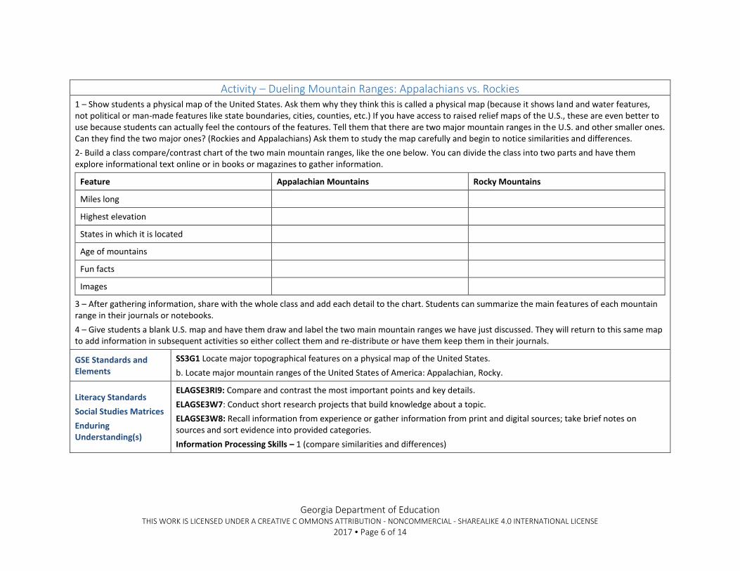
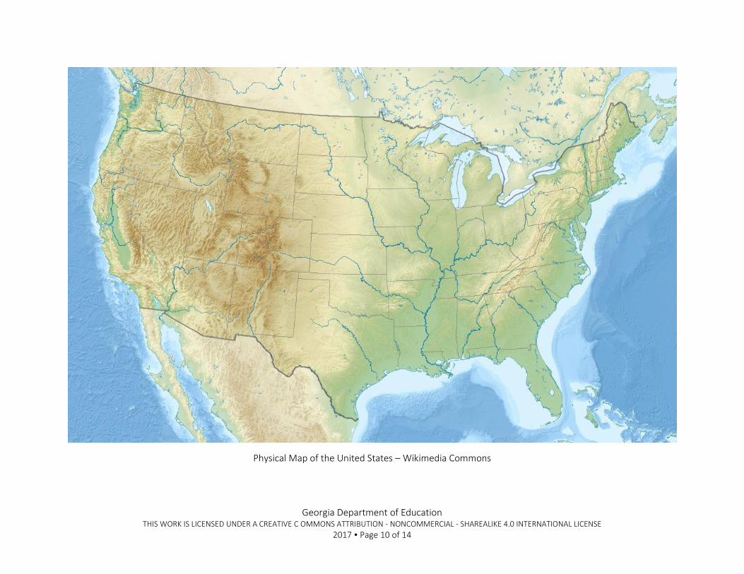
Activity – Dueling Mountain Ranges: Appalachians vs. Rockies 1 – Show students a physical map of the United States. Ask them why they think this is called a physical map (because it shows land and water features, not political or man-made features like state boundaries, cities, counties, etc.) If you have access to raised relief maps of the U.S., these are even better to use because students can actually feel the contours of the features. Tell them that there are two major mountain ranges in the U.S. and other smaller ones. Can they find the two major ones? (Rockies and Appalachians) Ask them to study the map carefully and begin to notice similarities and differences.
2- Build a class compare/contrast chart of the two main mountain ranges, like the one below. You can divide the class into two parts and have them explore informational text online or in books or magazines to gather information.
Feature Appalachian Mountains Rocky Mountains
Miles long
Highest elevation
States in which it is located
Age of mountains
Fun facts
Images
3 – After gathering information, share with the whole class and add each detail to the chart. Students can summarize the main features of each mountain range in their journals or notebooks.
4 – Give students a blank U.S. map and have them draw and label the two main mountain ranges we have just discussed. They will return to this same map to add information in subsequent activities so either collect them and re-distribute or have them keep them in their journals.
GSE Standards and Elements
SS3G1 Locate major topographical features on a physical map of the United States.
b. Locate major mountain ranges of the United States of America: Appalachian, Rocky.
Literacy Standards
Social Studies Matrices
Enduring Understanding(s)
ELAGSE3RI9: Compare and contrast the most important points and key details.
ELAGSE3W7: Conduct short research projects that build knowledge about a topic.
ELAGSE3W8: Recall information from experience or gather information from print and digital sources; take brief notes on sources and sort evidence into provided categories.
Information Processing Skills – 1 (compare similarities and differences)
Georgia Department of Education THIS WORK IS LICENSED UNDER A CREATIVE C OMMONS ATTRIBUTION - NONCOMMERCIAL - SHAREALIKE 4.0 INTERNATIONAL LICENSE
2017 Page 7 of 14
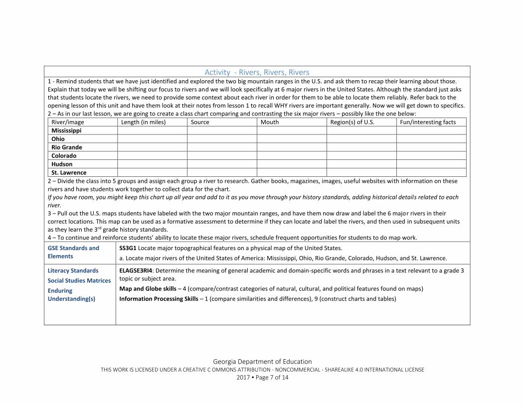
Activity - Rivers, Rivers, Rivers 1 - Remind students that we have just identified and explored the two big mountain ranges in the U.S. and ask them to recap their learning about those. Explain that today we will be shifting our focus to rivers and we will look specifically at 6 major rivers in the United States. Although the standard just asks that students locate the rivers, we need to provide some context about each river in order for them to be able to locate them reliably. Refer back to the opening lesson of this unit and have them look at their notes from lesson 1 to recall WHY rivers are important generally. Now we will get down to specifics. 2 – As in our last lesson, we are going to create a class chart comparing and contrasting the six major rivers – possibly like the one below:
River/image Length (in miles) Source Mouth Region(s) of U.S. Fun/interesting facts
Mississippi
Ohio
Rio Grande
Colorado
Hudson
St. Lawrence
2 – Divide the class into 5 groups and assign each group a river to research. Gather books, magazines, images, useful websites with information on these rivers and have students work together to collect data for the chart. If you have room, you might keep this chart up all year and add to it as you move through your history standards, adding historical details related to each river. 3 – Pull out the U.S. maps students have labeled with the two major mountain ranges, and have them now draw and label the 6 major rivers in their correct locations. This map can be used as a formative assessment to determine if they can locate and label the rivers, and then used in subsequent units as they learn the 3rd grade history standards. 4 – To continue and reinforce students’ ability to locate these major rivers, schedule frequent opportunities for students to do map work.
GSE Standards and Elements
SS3G1 Locate major topographical features on a physical map of the United States.
a. Locate major rivers of the United States of America: Mississippi, Ohio, Rio Grande, Colorado, Hudson, and St. Lawrence.
Literacy Standards
Social Studies Matrices
Enduring Understanding(s)
ELAGSE3RI4: Determine the meaning of general academic and domain-specific words and phrases in a text relevant to a grade 3 topic or subject area.
Map and Globe skills – 4 (compare/contrast categories of natural, cultural, and political features found on maps)
Information Processing Skills – 1 (compare similarities and differences), 9 (construct charts and tables)
Georgia Department of Education THIS WORK IS LICENSED UNDER A CREATIVE C OMMONS ATTRIBUTION - NONCOMMERCIAL - SHAREALIKE 4.0 INTERNATIONAL LICENSE
2017 Page 8 of 14
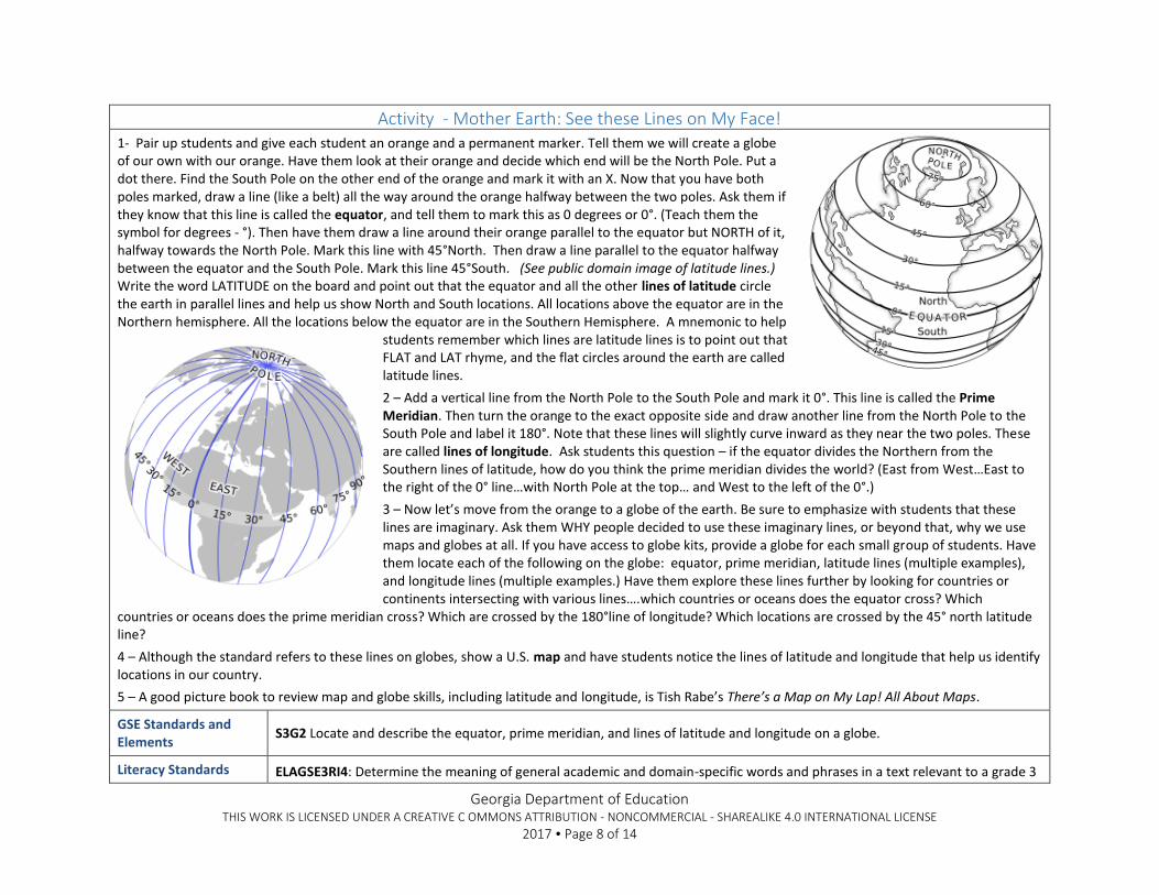
Activity - Mother Earth: See these Lines on My Face! 1- Pair up students and give each student an orange and a permanent marker. Tell them we will create a globe of our own with our orange. Have them look at their orange and decide which end will be the North Pole. Put a dot there. Find the South Pole on the other end of the orange and mark it with an X. Now that you have both poles marked, draw a line (like a belt) all the way around the orange halfway between the two poles. Ask them if they know that this line is called the equator, and tell them to mark this as 0 degrees or 0°. (Teach them the symbol for degrees - °). Then have them draw a line around their orange parallel to the equator but NORTH of it, halfway towards the North Pole. Mark this line with 45°North. Then draw a line parallel to the equator halfway between the equator and the South Pole. Mark this line 45°South. (See public domain image of latitude lines.) Write the word LATITUDE on the board and point out that the equator and all the other lines of latitude circle the earth in parallel lines and help us show North and South locations. All locations above the equator are in the Northern hemisphere. All the locations below the equator are in the Southern Hemisphere. A mnemonic to help
students remember which lines are latitude lines is to point out that FLAT and LAT rhyme, and the flat circles around the earth are called latitude lines.
2 – Add a vertical line from the North Pole to the South Pole and mark it 0°. This line is called the Prime Meridian. Then turn the orange to the exact opposite side and draw another line from the North Pole to the South Pole and label it 180°. Note that these lines will slightly curve inward as they near the two poles. These are called lines of longitude. Ask students this question – if the equator divides the Northern from the Southern lines of latitude, how do you think the prime meridian divides the world? (East from West…East to the right of the 0° line…with North Pole at the top… and West to the left of the 0°.)
3 – Now let’s move from the orange to a globe of the earth. Be sure to emphasize with students that these lines are imaginary. Ask them WHY people decided to use these imaginary lines, or beyond that, why we use maps and globes at all. If you have access to globe kits, provide a globe for each small group of students. Have them locate each of the following on the globe: equator, prime meridian, latitude lines (multiple examples), and longitude lines (multiple examples.) Have them explore these lines further by looking for countries or continents intersecting with various lines….which countries or oceans does the equator cross? Which
countries or oceans does the prime meridian cross? Which are crossed by the 180°line of longitude? Which locations are crossed by the 45° north latitude line?
4 – Although the standard refers to these lines on globes, show a U.S. map and have students notice the lines of latitude and longitude that help us identify locations in our country.
5 – A good picture book to review map and globe skills, including latitude and longitude, is Tish Rabe’s There’s a Map on My Lap! All About Maps.
GSE Standards and Elements
S3G2 Locate and describe the equator, prime meridian, and lines of latitude and longitude on a globe.
Literacy Standards ELAGSE3RI4: Determine the meaning of general academic and domain-specific words and phrases in a text relevant to a grade 3
Georgia Department of Education THIS WORK IS LICENSED UNDER A CREATIVE C OMMONS ATTRIBUTION - NONCOMMERCIAL - SHAREALIKE 4.0 INTERNATIONAL LICENSE
2017 Page 9 of 14
Social Studies Matrices
Enduring Understanding(s)
topic or subject area.
Map and Globe skills – 1 (cardinal directions), 2 (intermediate directions), 3 (use letter/number grid system to determine location)
Georgia Department of Education THIS WORK IS LICENSED UNDER A CREATIVE C OMMONS ATTRIBUTION - NONCOMMERCIAL - SHAREALIKE 4.0 INTERNATIONAL LICENSE
2017 Page 10 of 14
Physical Map of the United States – Wikimedia Commons
Georgia Department of Education THIS WORK IS LICENSED UNDER A CREATIVE C OMMONS ATTRIBUTION - NONCOMMERCIAL - SHAREALIKE 4.0 INTERNATIONAL LICENSE
2017 Page 11 of 14
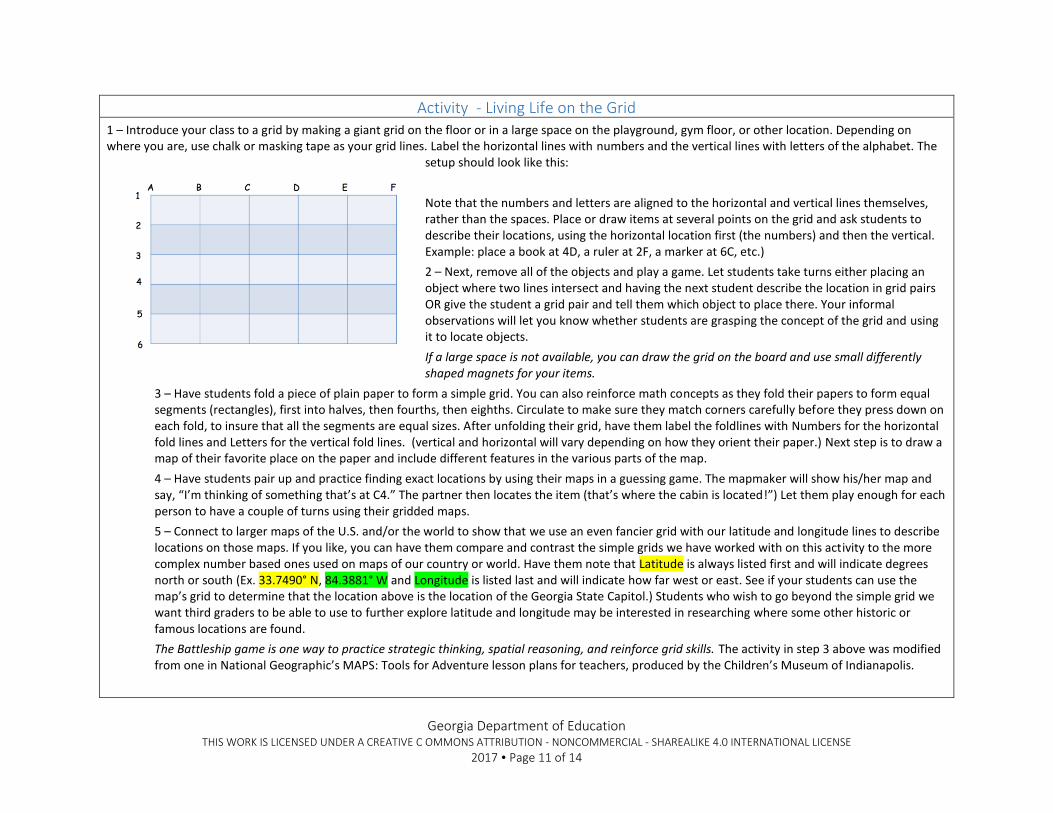
Activity - Living Life on the Grid 1 – Introduce your class to a grid by making a giant grid on the floor or in a large space on the playground, gym floor, or other location. Depending on where you are, use chalk or masking tape as your grid lines. Label the horizontal lines with numbers and the vertical lines with letters of the alphabet. The
setup should look like this:
Note that the numbers and letters are aligned to the horizontal and vertical lines themselves, rather than the spaces. Place or draw items at several points on the grid and ask students to describe their locations, using the horizontal location first (the numbers) and then the vertical. Example: place a book at 4D, a ruler at 2F, a marker at 6C, etc.)
2 – Next, remove all of the objects and play a game. Let students take turns either placing an object where two lines intersect and having the next student describe the location in grid pairs OR give the student a grid pair and tell them which object to place there. Your informal observations will let you know whether students are grasping the concept of the grid and using it to locate objects.
If a large space is not available, you can draw the grid on the board and use small differently shaped magnets for your items.
3 – Have students fold a piece of plain paper to form a simple grid. You can also reinforce math concepts as they fold their papers to form equal segments (rectangles), first into halves, then fourths, then eighths. Circulate to make sure they match corners carefully before they press down on each fold, to insure that all the segments are equal sizes. After unfolding their grid, have them label the foldlines with Numbers for the horizontal fold lines and Letters for the vertical fold lines. (vertical and horizontal will vary depending on how they orient their paper.) Next step is to draw a map of their favorite place on the paper and include different features in the various parts of the map.
4 – Have students pair up and practice finding exact locations by using their maps in a guessing game. The mapmaker will show his/her map and say, “I’m thinking of something that’s at C4.” The partner then locates the item (that’s where the cabin is located!”) Let them play enough for each person to have a couple of turns using their gridded maps.
5 – Connect to larger maps of the U.S. and/or the world to show that we use an even fancier grid with our latitude and longitude lines to describe locations on those maps. If you like, you can have them compare and contrast the simple grids we have worked with on this activity to the more complex number based ones used on maps of our country or world. Have them note that Latitude is always listed first and will indicate degrees north or south (Ex. 33.7490° N, 84.3881° W and Longitude is listed last and will indicate how far west or east. See if your students can use the map’s grid to determine that the location above is the location of the Georgia State Capitol.) Students who wish to go beyond the simple grid we want third graders to be able to use to further explore latitude and longitude may be interested in researching where some other historic or famous locations are found.
The Battleship game is one way to practice strategic thinking, spatial reasoning, and reinforce grid skills. The activity in step 3 above was modified from one in National Geographic’s MAPS: Tools for Adventure lesson plans for teachers, produced by the Children’s Museum of Indianapolis.
Georgia Department of Education THIS WORK IS LICENSED UNDER A CREATIVE C OMMONS ATTRIBUTION - NONCOMMERCIAL - SHAREALIKE 4.0 INTERNATIONAL LICENSE
2017 Page 12 of 14
GSE Standards and Elements
S3G2 Locate and describe the equator, prime meridian, and lines of latitude and longitude on a globe.
Literacy Standards
Social Studies Matrices
Enduring Understanding(s)
ELAGSE3RI4: Determine the meaning of general academic and domain-specific words and phrases in a text relevant to a grade 3 topic or subject area.
Map and Globe skills – 1 (cardinal directions), 2 (intermediate directions), 3 (use letter/number grid system to determine location)
Georgia Department of Education THIS WORK IS LICENSED UNDER A CREATIVE C OMMONS ATTRIBUTION - NONCOMMERCIAL - SHAREALIKE 4.0 INTERNATIONAL LICENSE
2017 Page 13 of 14
Connecting Themes Unit – Culminating Activity
Mapping Our Learning Our culminating performance task has two parts.
1 - Given a physical map of the U.S., ask students to locate and label the six major rivers and two mountain ranges we have learned about in this unit. Write a good paragraph explaining some of the ways that rivers and mountains help to shape our lives and that of those of came before us.
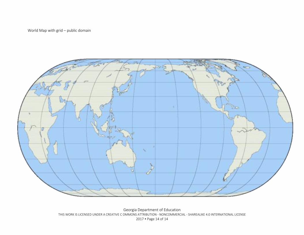
2 – On the world map, locate the following grid lines and label accordingly (modify task as needed for students unable to distinguish color):
Equator – trace in RED
Prime meridian – trace in BROWN
Latitude line (any of them other than the equator) – trace in GREEN
Longitude line - trace in PURPLE
Reinforce cardinal and intermediate directions by labeling a blank compass rose correctly.
GSE Standards and Elements
SS3G1 Locate major topographical features on a physical map of the United States.
a. Locate major rivers of the United States of America: Mississippi, Ohio, Rio Grande, Colorado, Hudson, and St. Lawrence.
b. Locate major mountain ranges of the United States of America: Appalachian, Rocky.
SS3G2 Locate and describe the equator, prime meridian, and lines of latitude and longitude on a globe.
Literacy Standards
Social Studies Matrices
Enduring Understanding(s)
ELAGSE3W5: With guidance and support from peers and adults, develop and strengthen writing as needed by planning, revising, and editing.
Map and Globe skills – 1 (cardinal directions), 2 (intermediate directions), 3 (use letter/number grid system to determine location), 4 (compare/contrast categories of natural, cultural, and political features found on maps)
Information Processing Skills – 1 (compare similarities and differences) , 9 (construct charts and tables)
Maps for use in this task are included below.
Georgia Department of Education THIS WORK IS LICENSED UNDER A CREATIVE C OMMONS ATTRIBUTION - NONCOMMERCIAL - SHAREALIKE 4.0 INTERNATIONAL LICENSE
2017 Page 14 of 14
World Map with grid – public domain