Embed Size (px)
DESCRIPTION
MOUNTAIN AND MOUNTAIN RANGES A. Mountain any part of the Earth’s surface sufficiently elevated above its surroundings to have a distinct summit and to be considered worthy of a name peaks must rise at least 300 m above the surrounding terrain B. Mountain Range - PowerPoint PPT Presentation
Citation preview
MOUNTAIN AND MOUNTAIN RANGESMOUNTAIN AND MOUNTAIN RANGESA. Mountain1. any part of the Earth’s surface sufficiently elevated above its surroundings to have a distinct summit and to be considered worthy of a name2. peaks must rise at least 300 m above the surrounding terrain
B. Mountain Range 1. a series of mountains or mountain ridges that are closely related in position, direction, age, and mode of formation 2. a group of mountain ranges found grouped together in an elongate zone is a mountain chain
C. Continents1. Shield-large areas of exposed ancient (Precambrian) rocks2. Platform-buried ancient rocks underlying each continent3. Craton-shield + platform together; nucleus of a continent4. accretion- growth; deformed rocks along edges of cratons…
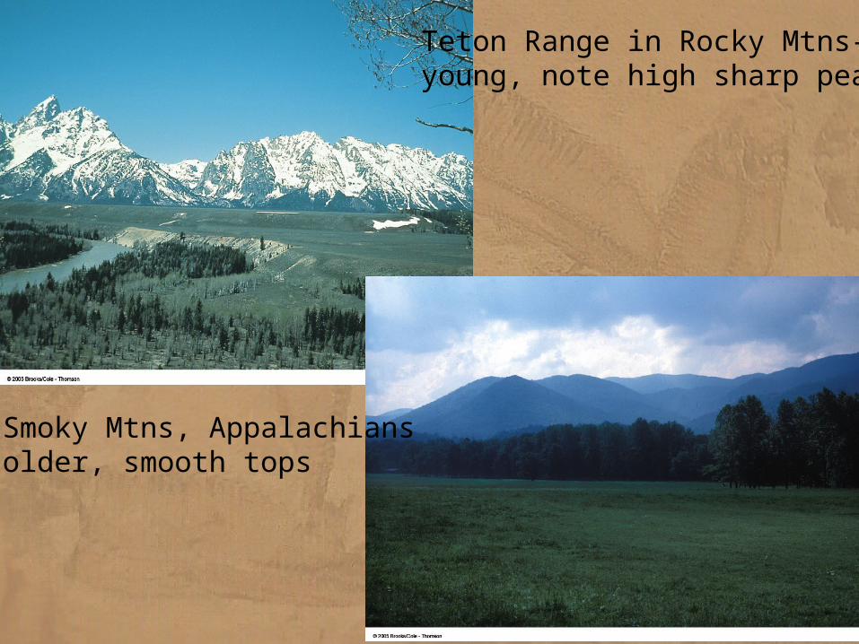
Teton Range in Rocky Mtns-young, note high sharp peaks
Smoky Mtns, Appalachiansolder, smooth tops
DEFORMATION AND RUPTURE OF ROCKS A. Tectonic Stress 1. tectonic force applied to rocks 2. three types of stress
a. compressive stress--squeezes rock and tend to shorten distances parallel to the squeezing direction b. tensional stress--pulls rock apart
--the opposite of compressive stress and tends to increase the distance parallel to the stress c. shear stress--acts in parallel but opposite directions
--deforms rock by causing one part of a rock mass to slide past anotherB. Strain
1. the distortion or deformation that results from stress 2. rocks can respond to tectonic stress in 3 different ways
a. elastic strain--directly proportional to the amount of stress: return to shape b. non-elastic strain-- a rock undergoes plastic deformation c. rupture-- rock breakageC. Factors Controlling Rock Response to Stress
1. the nature of the material -- all rocks first react to stress with small amounts of elastic deformation -- with continuing stress, different types of rocks may behave in different ways
2. temperature-- the higher the temperature, greater the tendency of rocks to behave plastically3. pressure-- high pressure favors plastic behavior 4. time-- stress applied over a long time, rather than suddenly, also favors plastic behavior of rocks
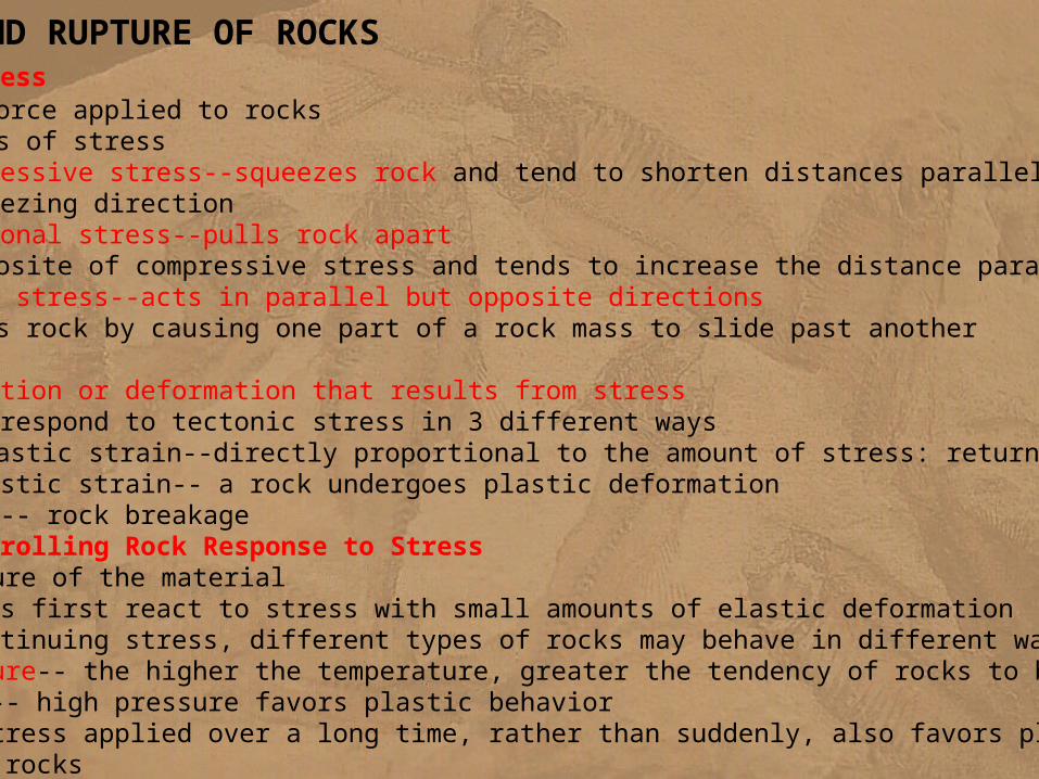
Stress and possible deformation: A. compression causes shortening of rock layers by folding and faulting. B. tension causes lengthening and
faulting. C. shear stress causes deformation along planes
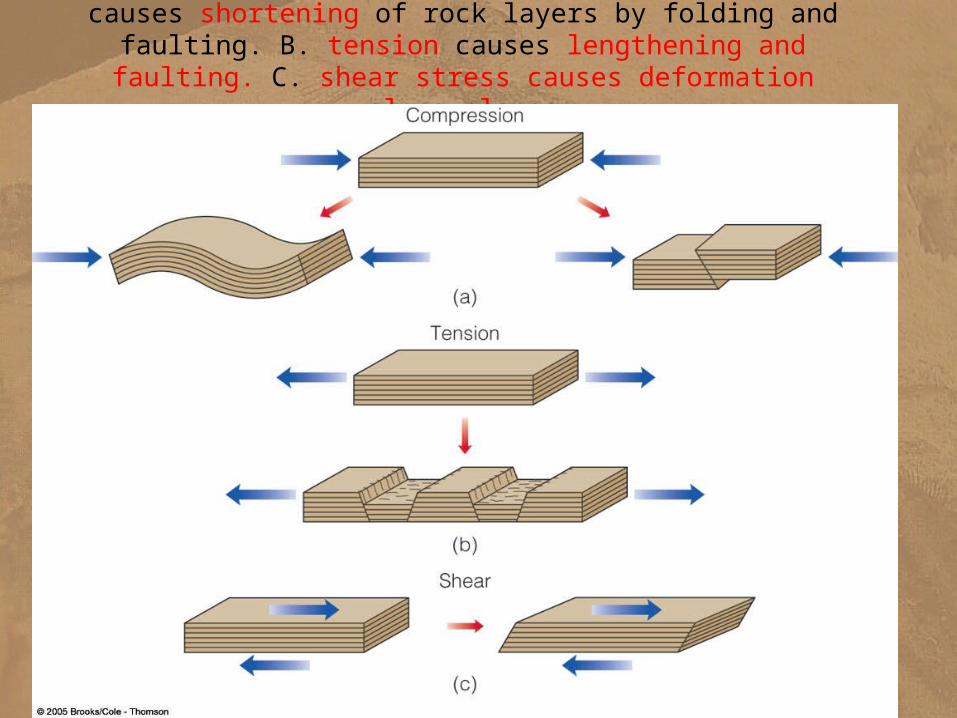
Behavior of rocksunder stress:
a. If rock is brittle, it follows B, andfractures at certain point.
b. If rock is ductile,it follows A, and isdeformed. Or it canfracture if enoughstress applied.
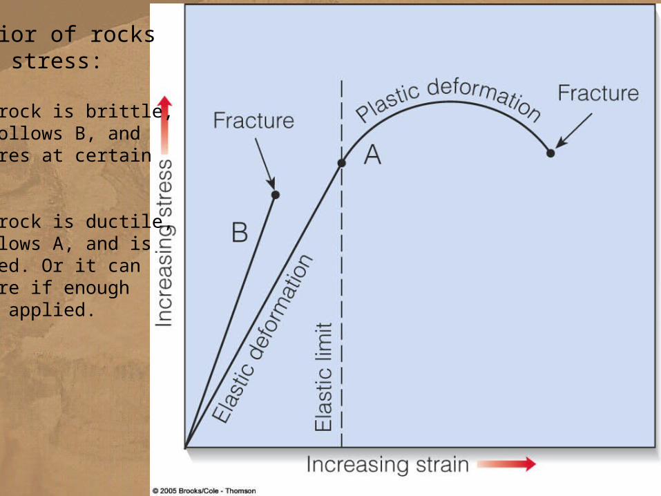
Flat lying beds= infer little deformation
GEOLOGIC STRUCTURESGEOLOGIC STRUCTURES
A. Definitions 1. geologic structure -- any feature produced by deformation of rocks 2. fold -- a bend in rock 3. fault --a fracture along which rock on one side has moved relative to rocks on the other side
4. joint -- a fracture without movement of rock on either side of the break
B. Folds1. anticline--a fold arching upward 2. syncline--a fold arching downward
(GO to slides….)
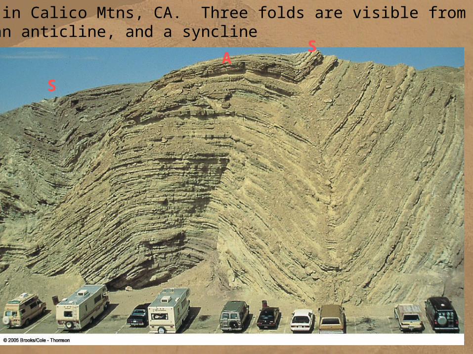
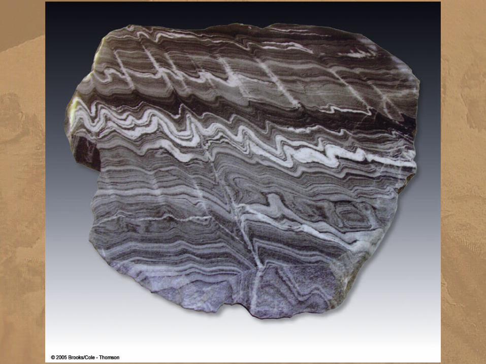
Folded rocks in Calico Mtns, CA. Three folds are visible from left to right-a syncline, an anticline, and a syncline
S
AS
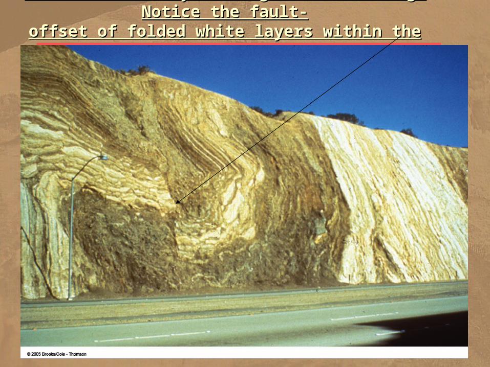
Rocks deformed by folding and fracturing. Notice the fault-Rocks deformed by folding and fracturing. Notice the fault-offset of folded white layers within the brown rocksoffset of folded white layers within the brown rocks
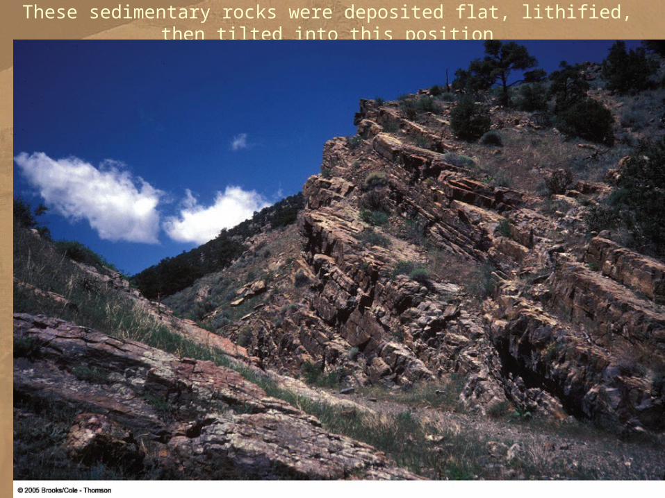
These sedimentary rocks were deposited flat, lithified, then tilted into this position
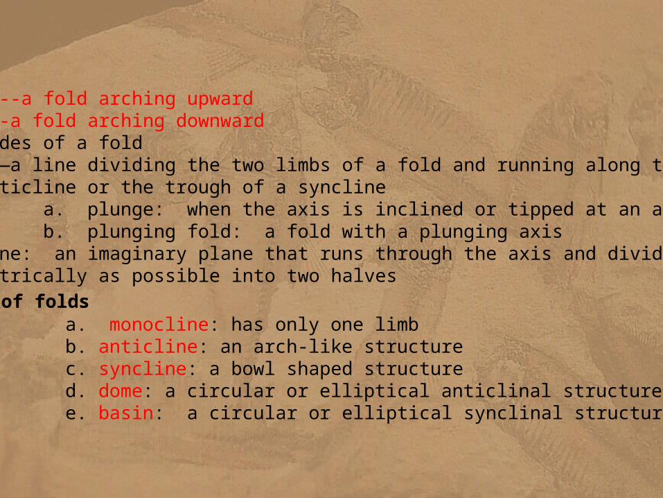
B. Folds1. anticline--a fold arching upward 2. syncline--a fold arching downward3. limbs--sides of a fold4. fold axis—a line dividing the two limbs of a fold and running along the crest of an anticline or the trough of a syncline
a. plunge: when the axis is inclined or tipped at an angle b. plunging fold: a fold with a plunging axis
5. axial plane: an imaginary plane that runs through the axis and divides a fold as symmetrically as possible into two halves
6. types of folds a. monocline: has only one limb b. anticline: an arch-like structure c. syncline: a bowl shaped structure d. dome: a circular or elliptical anticlinal structure e. basin: a circular or elliptical synclinal structure
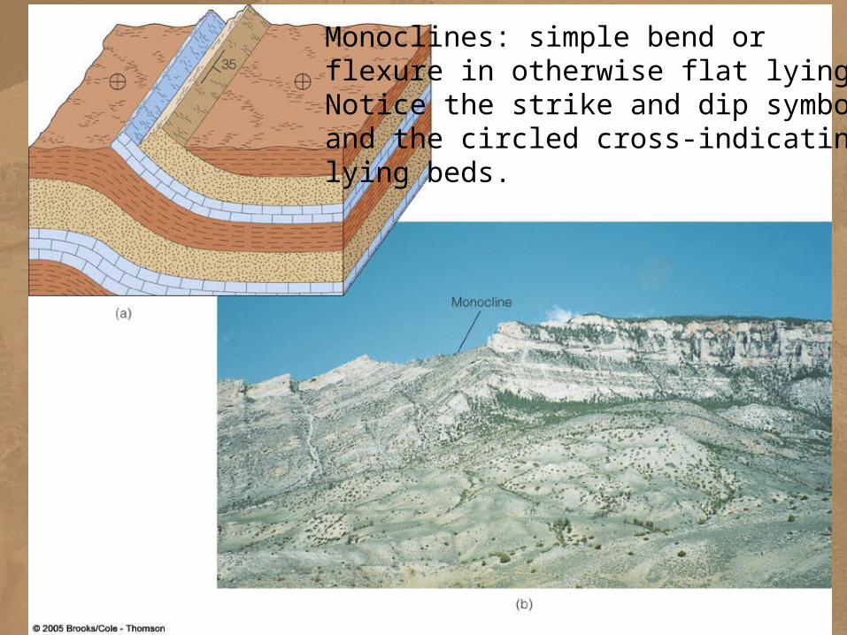
Monoclines: simple bend orflexure in otherwise flat lying beds.Notice the strike and dip symbolsand the circled cross-indicating flatlying beds.
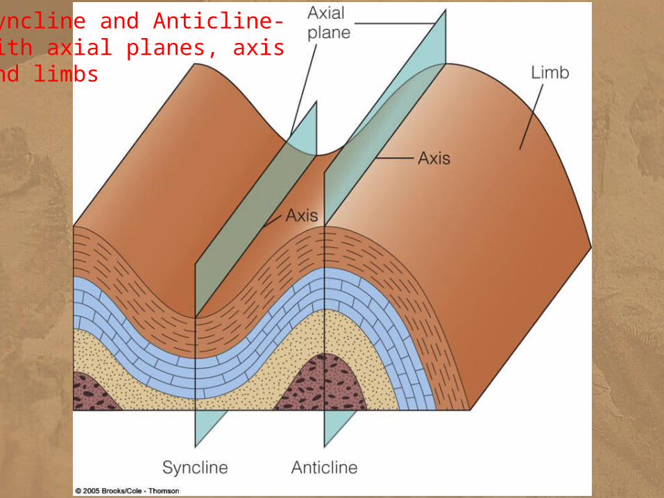
Syncline and Anticline-with axial planes, axisand limbs
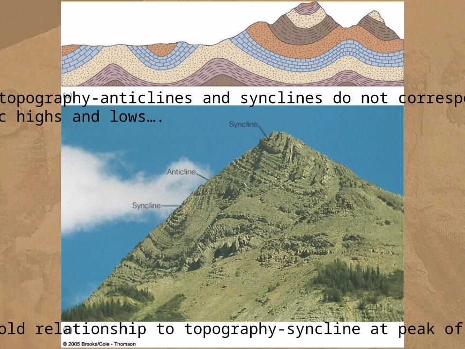
Fold relationship to topography-syncline at peak of mountain
Folds and topography-anticlines and synclines do not correspond to topographic highs and lows….
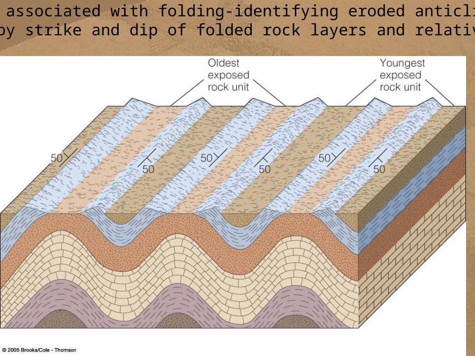
Complexity associated with folding-identifying eroded anticlines and synclines by strike and dip of folded rock layers and relative ages
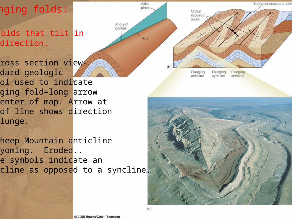
Plunging folds:
a. Folds that tilt inone direction.
B. Cross section view-Standard geologicsymbol used to indicateplunging fold=long arrowin center of map. Arrow atend of line shows directionof plunge.
c. Sheep Mountain anticlineIn Wyoming. Eroded..These symbols indicate ananticline as opposed to a syncline…
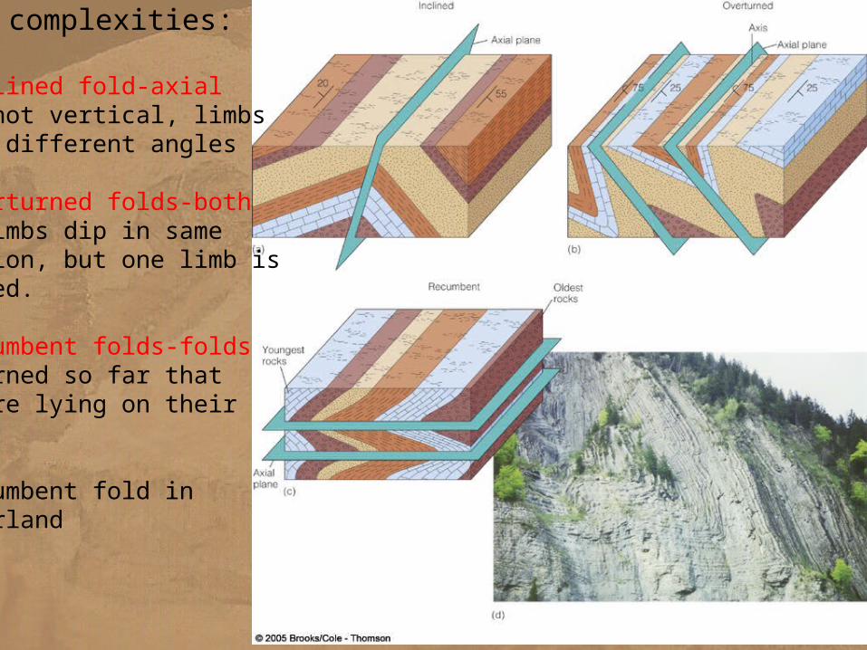
Other complexities:
a. Inclined fold-axialplane not vertical, limbsdip at different angles
b. Overturned folds-bothfold limbs dip in samedirection, but one limb isinverted.
c. Recumbent folds-foldsoverturned so far that they are lying on theirsides.
d. Recumbent fold in Switzerland
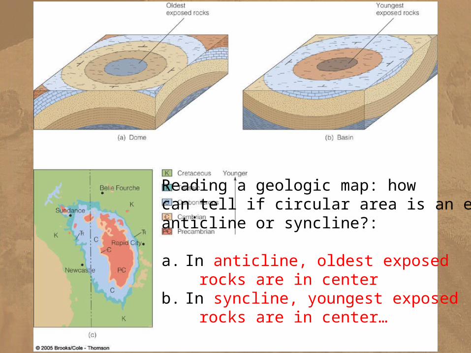
Reading a geologic map: howcan tell if circular area is an erodedanticline or syncline?:
a. In anticline, oldest exposed rocks are in centerb. In syncline, youngest exposed rocks are in center…
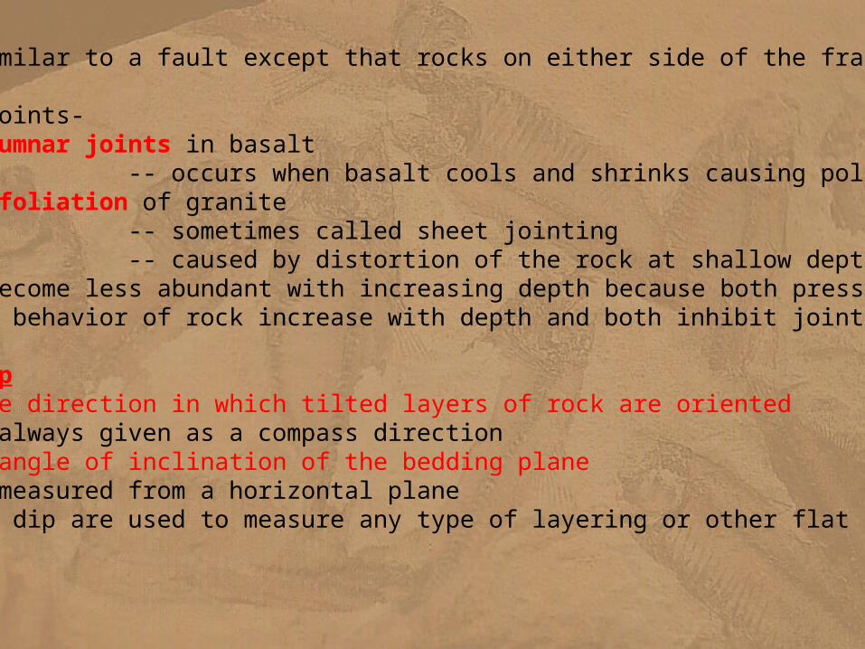
D. Joints1. a fracture similar to a fault except that rocks on either side of the fracture have not moved2. examples of joints-
a. columnar joints in basalt -- occurs when basalt cools and shrinks causing polygonal cracking
b. exfoliation of granite -- sometimes called sheet jointing -- caused by distortion of the rock at shallow depth 3. joints become less abundant with increasing depth because both pressure and plastic behavior of rock increase with depth and both inhibit jointing.
E. Strike and Dip1. strike: the direction in which tilted layers of rock are oriented
-- always given as a compass direction2. dip: the angle of inclination of the bedding plane
-- measured from a horizontal plane3. strike and dip are used to measure any type of layering or other flat surfaces in rocks
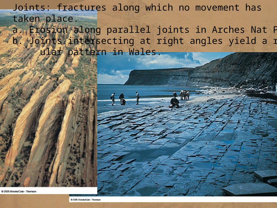
Joints: fractures along which no movement hastaken place.a. Erosion along parallel joints in Arches Nat Parkb. Joints intersecting at right angles yield a rectang- ular pattern in Wales.
Concepts of Strike and Dip:Concepts of Strike and Dip:
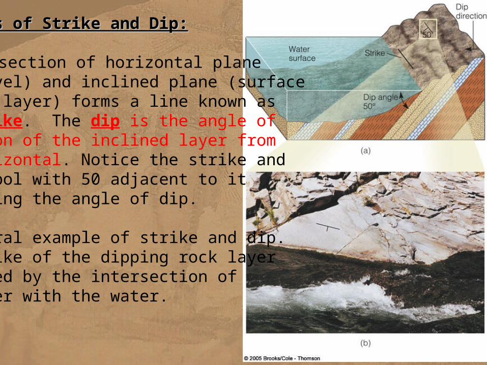
a. Intersection of horizontal plane(sea level) and inclined plane (surfaceof rock layer) forms a line known asthe strike. The dip is the angle of deviation of the inclined layer from the horizontal. Notice the strike anddip symbol with 50 adjacent to itindicating the angle of dip.
b. Natural example of strike and dip.The strike of the dipping rock layeris marked by the intersection of the layer with the water.
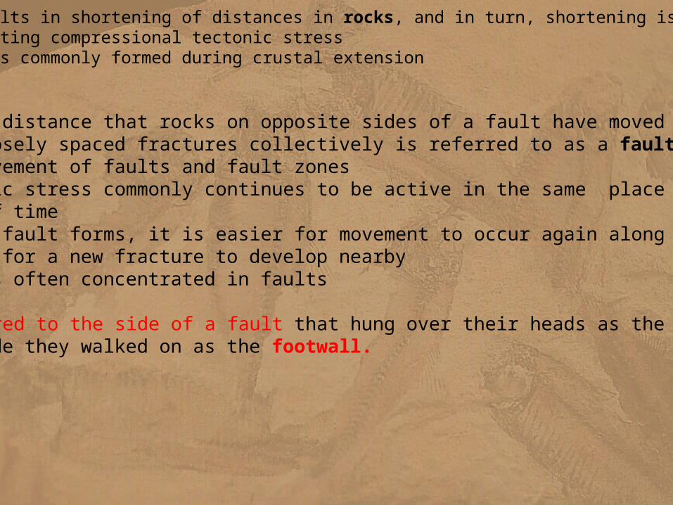
7. folding always results in shortening of distances in rocks, and in turn, shortening is produced by compression, reflecting compressional tectonic stress -- folding is less commonly formed during crustal extension
C. Faults 1. slip is the distance that rocks on opposite sides of a fault have moved 2. numerous closely spaced fractures collectively is referred to as a fault zone 3. repeated movement of faults and fault zones
a. tectonic stress commonly continues to be active in the same place over long period of time b. once a fault forms, it is easier for movement to occur again along the same fracture than for a new fracture to develop nearby
4. ore deposits often concentrated in faults
--miners referred to the side of a fault that hung over their heads as the hanging wall and the side they walked on as the footwall.
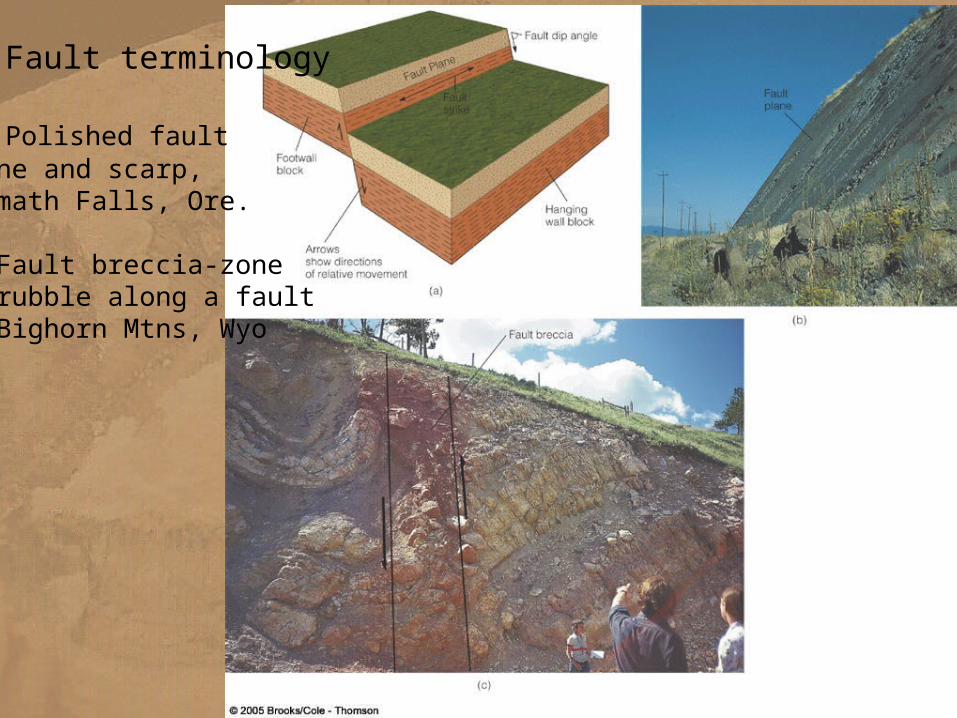
a. Fault terminology
b. Polished faultplane and scarp,Klamath Falls, Ore.
c. Fault breccia-zoneof rubble along a faultin Bighorn Mtns, Wyo
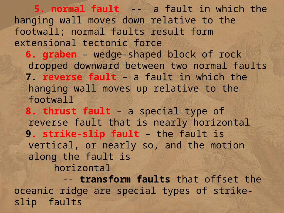
5. normal fault -- a fault in which the hanging wall moves down relative to the footwall; normal faults result form extensional tectonic force 6. graben – wedge-shaped block of rock dropped downward
between two normal faults 7. reverse fault – a fault in which the hanging wall moves up
relative to the footwall 8. thrust fault – a special type of reverse fault that is nearly
horizontal 9. strike-slip fault – the fault is vertical, or nearly so, and the
motion along the fault is horizontal
-- transform faults that offset the oceanic ridge are special types of strike-slip faults
10. horst- wedge shaped block of rocks moved upward between two normal faults
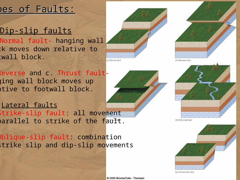
Types of Faults:Types of Faults:
I. Dip-slip faultsa. Normal fault- hanging wallblock moves down relative to footwall block.
b. Reverse and c. Thrust fault-hanging wall block moves uprelative to footwall block.
II. Lateral faultsd. Strike-slip fault: all movementis parallel to strike of the fault.
e. Oblique-slip fault: combinationof strike slip and dip-slip movements
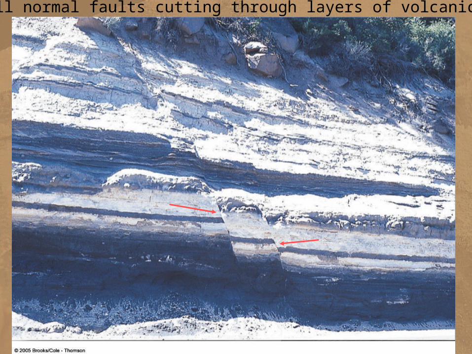
Two small normal faults cutting through layers of volcanic ash, ORE
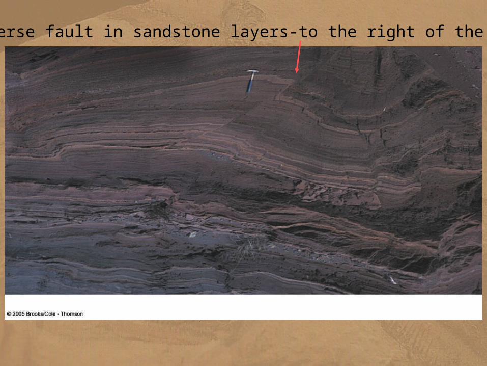
Reverse fault in sandstone layers-to the right of the hammer
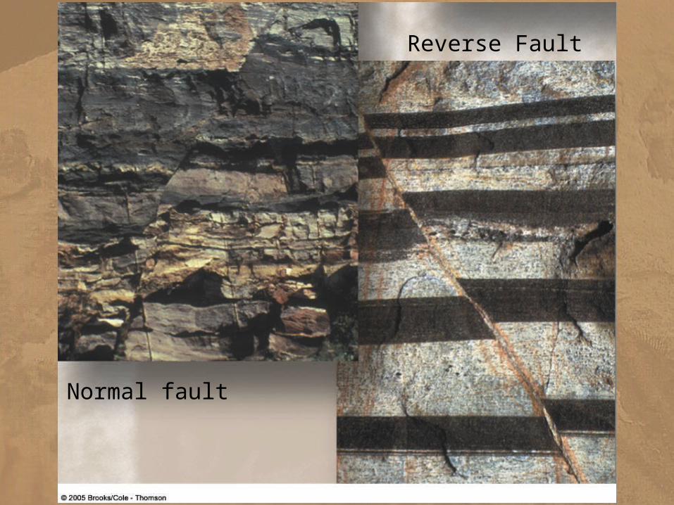
Normal fault
Reverse Fault
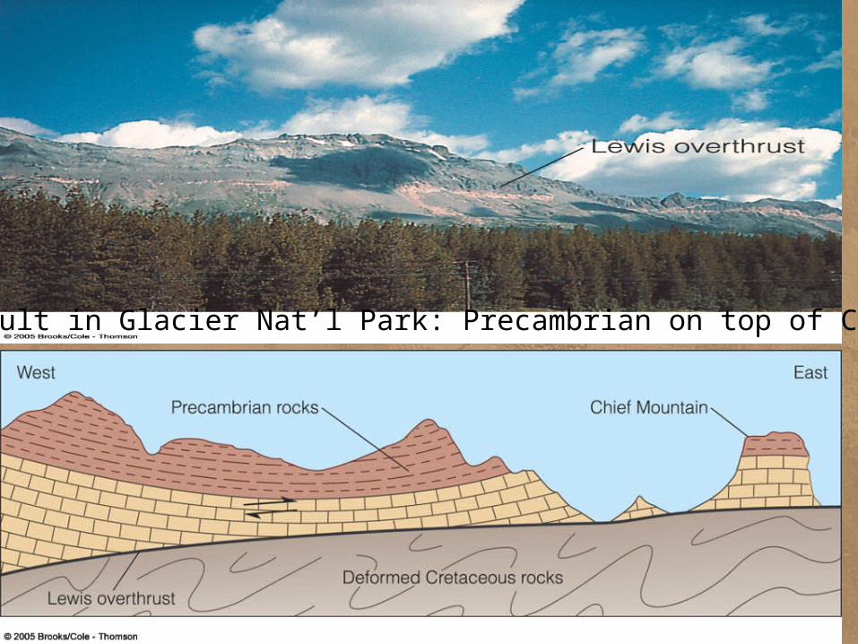
Thrust fault in Glacier Nat’l Park: Precambrian on top of Cretaceous
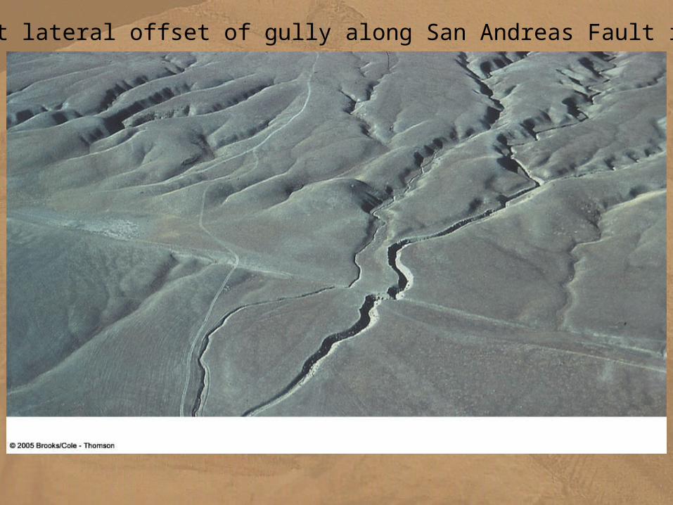
Right lateral offset of gully along San Andreas Fault in CA
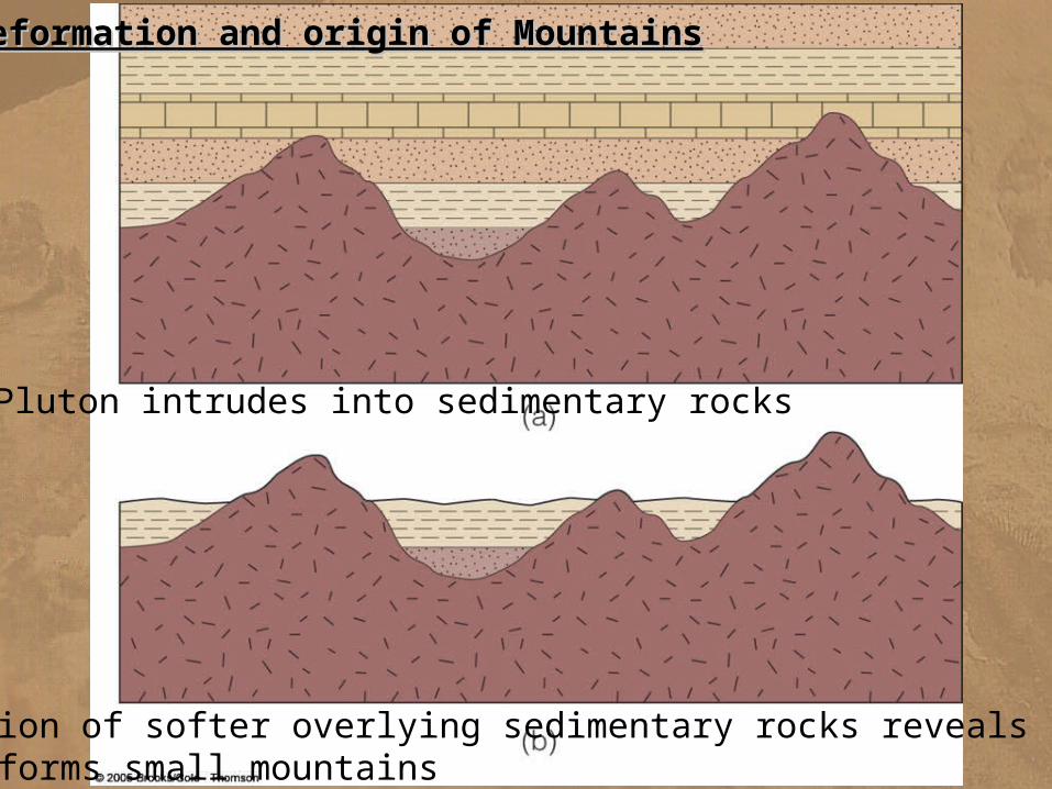
Deformation and origin of MountainsDeformation and origin of Mountains
Pluton intrudes into sedimentary rocks
Erosion of softer overlying sedimentary rocks reveals plutonsand forms small mountains
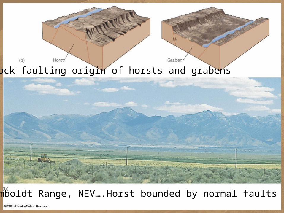
a. Block faulting-origin of horsts and grabens
Humboldt Range, NEV….Horst bounded by normal faults
PLATE TECTONICS AND MOUNTAIN BUILDINGPLATE TECTONICS AND MOUNTAIN BUILDINGA. Orogenic Activity1. orogeny refers to the process of mountain building 2. an orogen or orogenic belt is a long and relatively narrow region near a tectonically active continental margin where any or all of those processes have formed mountains
B. Orogenic Activity and Plate Boundaries1. rift boundary a. mid-oceanic ridge b. continental rifting is responsible for the uplift2. transform fault boundary a. high cliffs and escarpments form along transform faults offsetting the mid-oceanic ridge3. convergent plate boundaries’ a. ocean-ocean convergence volcanic mountain ranges b. ocean-continental convergence volcanic mountain ranges c. continental-continental convergence folded mountain belts
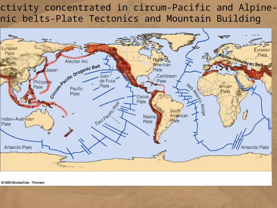
Orogenic activity concentrated in circum-Pacific and Alpine-Himalayan orogenic belts-Plate Tectonics and Mountain Building
F. Geologic Structures and Plate Boundaries1. each of the 3 different types of plate boundaries is characterized by different large-scale tectonic stresses
a. spreading centers are extensional b. transform boundaries are regions of crustal shearing c. convergent boundaries are dominated by compression.
2. different geologic structures are commonly associated with each type of boundary a. divergent boundaries produce normal faults, grabens, little or no folding of rocks b. transform plate boundaries are strike-slip faults c. convergent continent plate boundaries commonly associated with folding have reverse and thrust faulting
--at convergent continent-ocean or ocean-ocean boundaries subduction is accompanied by crustal extension and normal faultingISLAND ARCSISLAND ARCS A. Subduction Complex 1. The area in front of the island arc 2. subduction of plate highly deforms sediment and part of the oceanic crust 3. growth of the subduction complex occurs by addition of the newest slices at the plate boundary 4. bottom of the complex-underthrusting forces the subduction complex upward, forming a sedimentary basin called a forearc basin between the complex and island arc the forearc basin fills with sediment derived form erosion of the volcanic islands and becomes a part of the island arc
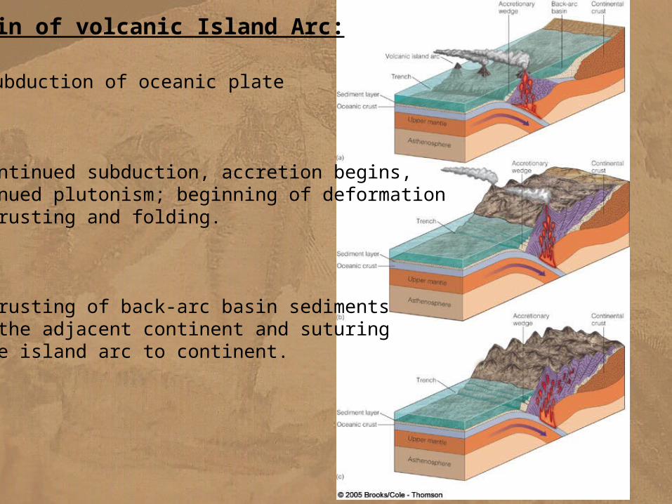
Origin of volcanic Island Arc:
a. Subduction of oceanic plate
b. Continued subduction, accretion begins,continued plutonism; beginning of deformationby thrusting and folding.
c. Thrusting of back-arc basin sedimentsonto the adjacent continent and suturingof the island arc to continent.
THE BUILDING OF TWO MOUNTIAN CHAINS: THE ANDES AND THE HIMALAYASTHE BUILDING OF TWO MOUNTIAN CHAINS: THE ANDES AND THE HIMALAYAS A. Similarities and Differences 1.immense and great height of the peaks are similar 2. both rise abruptly from adjacent low-lying regions 3. igneous rocks are the most abundant rock type in the Andes 4. highly folded and thrust-faulted sedimentary and metamorphosed sedimentary rocks dominate Himalayan geology 5. both chains formed at convergent plate boundaries
a. Andes at ocean-continental collision’ b. Himalayas at a continental-continental collision
B. The Andes: Subduction at a Continental MarginToday the Andes are a relatively narrow mountain chain consisting predominantly of volcanic and plutonic rocks produced by subduction at a continental margin 1. the chain also contains extensive sedimentary rocks deposited in basin that formed by sinking of the crust on both sides of the mountains 2. some of these rocks were deformed and metamorphosed by tectonic forces and elevated temperature and pressure related to the emplacement of huge volumes of magma into the crust
3. this type of a plate margin is called an Andean margin.
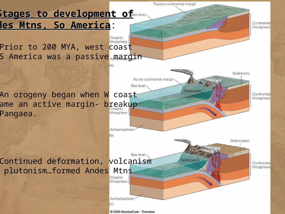
3 Stages to development of3 Stages to development ofAndes Mtns, So AmericaAndes Mtns, So America:
a. Prior to 200 MYA, west coastof S America was a passive margin
b. An orogeny began when W coastbecame an active margin- breakupof Pangaea.
c. Continued deformation, volcanismand plutonism…formed Andes Mtns
C. The Himalayan Mountain Chain: A Collision Between Continents.1.formation of an Andean-type margin2. continent-continent collision -- India and Asia3. Himalayas today a. The combination of underthrusting of India beneath Tibet and the horizontal squashing of Tibet has produced unusually thick continental crust beneath the Himalayas and the Tibetan Plateau b. Frequent moderate earthquakes and occasional large and destructive ones characterize the region.4. the junction between two welded continents is called a suture zone or a continental suture a. recognized by a lack of continuity between rock types, ages, and structures on either side of the suture b. rocks of the suture zone are commonly deformed and sheared by the collision
c. bits and scraps of oceanic crust and mantle occur in suture zones
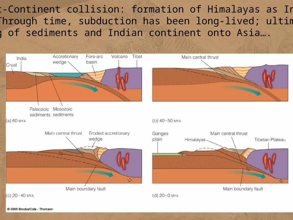
Continent-Continent collision: formation of Himalayas as India meetsAsia. Through time, subduction has been long-lived; ultimately hadthrusting of sediments and Indian continent onto Asia….
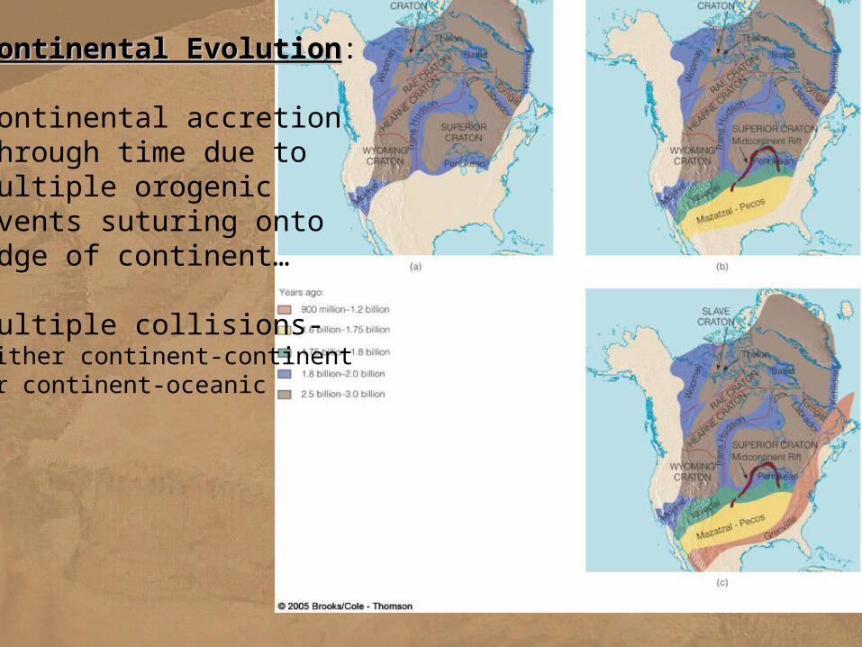
Continental EvolutionContinental Evolution:
Continental accretionthrough time due tomultiple orogenic events suturing ontoedge of continent…
Multiple collisions- Either continent-continentOr continent-oceanic
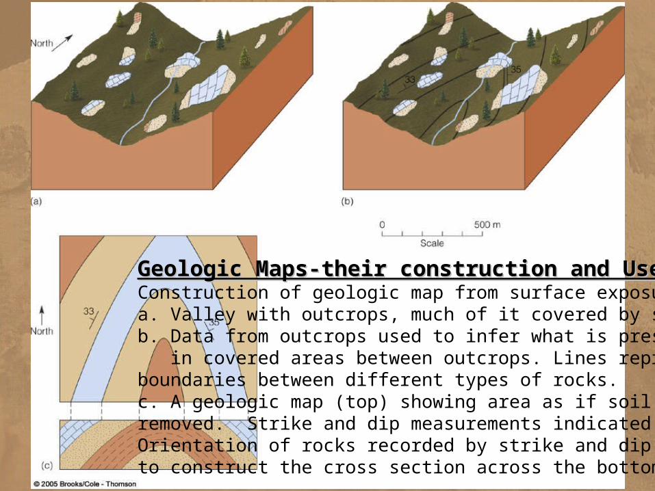
Geologic Maps-their construction and UseGeologic Maps-their construction and UseConstruction of geologic map from surface exposuresa. Valley with outcrops, much of it covered by soilb. Data from outcrops used to infer what is present in covered areas between outcrops. Lines representboundaries between different types of rocks.c. A geologic map (top) showing area as if soil wasremoved. Strike and dip measurements indicated.Orientation of rocks recorded by strike and dip usedto construct the cross section across the bottom.
Mountain Building- SUMMARYMountains and Mountain Ranges are results of tectonic Stresses applied to rocks: a. compressive stress--squeezes rock and tend to shorten distances parallel to the squeezing
direction b. tensional stress--pulls rock apart
--the opposite of compressive stress and tends to increase the distance parallel to the stress c. shear stress--acts in parallel but opposite directions
--deforms rock by causing one part of a rock mass to slide past another Strain- the distortion or deformation that results from stress
rocks can respond to tectonic stress in 3 different ways a. elastic strain--directly proportional to the amount of stress: return to shape
b. nonelastic strain-- a rock undergoes plastic deformation: changes shape c. rupture-- rock breakage
Factors Controlling Rock Response to Stress1. the nature of the rock2. temperature-- the higher the temperature, greater the tendency of rocks to behave plastically3. pressure-- high pressure favors plastic behavior 4. Time
Mountain Building- SUMMARYGEOLOGIC STRUCTURESGEOLOGIC STRUCTURES A. Definitions 1. geologic structure -- any feature produced by deformation of rocks 2. folds -- a bend in rock - limb--sides of a fold -fold axis—a line dividing the two limbs of a fold and running along the crest
of an anticline or the trough of a syncline - plunge: when the axis in inclined or tipped at an angle - plunging fold: a fold with a plunging axis - axial plane: an imaginary plane that runs through the axis and divides a fold
as symmetrically as possible into two halves types of folds a. monocline: has only one limb b. anticline: an arch-like structure c. Syncline: a bowl shaped structure d. dome: a circular or elliptical anticlinal structure e. basin: a circular or elliptical synclinal structure 3. fault --a fracture along which rock on one side has moved relative to rock on the other side a. normal fault -- a fault in which the hanging wall moves down relative to the footwall normal
faults result form extensional tectonic force b. graben – a wedge-shaped block of rock that dropped downward between two normal faults c. reverse fault – a fault in which the hanging wall move up relative to the footwall d. thrust fault – a special type of reverse fault that is nearly horizontal e. strike-slip fault – fault is vertical, or nearly so, and the motion along the fault is horizontal
-- transform faults that offset the oceanic ridge are special types of strike-slip faults
Mountain Building- SUMMARYMountain Building- SUMMARY
4. joint -- a facture without movement of rock on either side of the break 1. a fracture similar to a fault except that rocks on either side of the facture have not moved
2. examples of joints-a. columnar joints in basalt- occurs when basalt cools and shrinks causing polygonal cracking b. exfoliation of granite
Concepts of Strike and Dip: 1. strike: the direction in which tilted layers of rock are oriented
-- always given as a compass direction 2. dip: the angle of inclination of the bedding plane
-- measured from a horizontal plane 3. strike and dip are used to measure any type of layering or other flat surfaces in rocks
Types of Faults:Types of Faults:
I. Dip-slip faultsa. Normal fault-hanging wall block moves down relative to footwall block.
b. Reverse and c. Thrust fault-hanging wall block moves up relative to footwall block.
II. Lateral faultsd. Strike-slip fault: all movement is parallel to strike of the fault.
e. Oblique-slip fault: combination of strike slip and dip-slip movements
Mountain Building- SUMMARYMountain Building- SUMMARYTerms used to describe complex folds: a. plunging fold: fold that dips in one direction b. Inclined fold-axial plane not vertical, limbs dip at different angles c. Overturned folds-both fold limbs dip in same direction, but one limb is inverted. d. Recumbent folds-folds overturned so far that they are lying on their sides.
PLATE TECTONICS AND MOUNTAIN BUILDINGPLATE TECTONICS AND MOUNTAIN BUILDINGA. Orogenic Activity1. orogeny refers to the process of mountain building 2. an orogen or orogenic belt is a long and relatively narrow region near a tectonically active continental margin where any or all of those processes have formed mountains
B. Orogenic Activity and Plate Boundaries1. rift boundary a. mid-oceanic ridge b. continental rifting is responsible for the uplift2. transform fault boundary a. high cliffs and escarpments form along transform faults offsetting the mid-oceanic ridge3. convergent plate boundaries’ a. ocean-ocean convergence volcanic mountain ranges b. ocean-continental convergence volcanic mountain ranges c. continental-continental convergence folded mountain belts
Mountain Building- SUMMARYMountain Building- SUMMARY
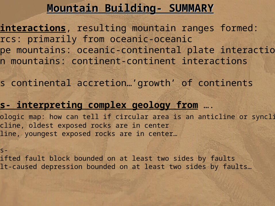
Plate-Plate interactions, resulting mountain ranges formed: a. Island Arcs: primarily from oceanic-oceanic b. Andes type mountains: oceanic-continental plate interactions c. Himalayan mountains: continent-continent interactions
End result is continental accretion…’growth’ of continents
Geologic Maps- interpreting complex geology from …. Reading a geologic map: how can tell if circular area is an anticline or syncline?: a. In anticline, oldest exposed rocks are in center b. In syncline, youngest exposed rocks are in center…
Horst and grabens- horst: an uplifted fault block bounded on at least two sides by faults graben: a fault-caused depression bounded on at least two sides by faults…
Text: Historical Geology
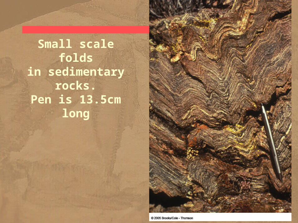
Small scale foldsin sedimentary rocks.
Pen is 13.5cm long