Embed Size (px)
Citation preview
194
THE WETLANDS – CATEGORIES, FUNCTIONS, ECOLOGICAL RECONSTRUCTION AND MANAGEMENT WITH SPECIAL REFERENCE TO ROMANIA
Petre Gâştescu, Daniel Ciupitu
Institute of Geography, Romanian Academy, D. Racoviţă Str., 12, RO-123993 Bucharest 20,
E-mail:[email protected].
ABSTRACT
A wetland is a territory saturated with water long enough to promote wetland or aquatic processes as indicated by poorly drained soils, hydrophytic vegetation, and various kinds of biological activity which is adapted to a wet environment. From this classical definition, the current range of wetlands has been widened very much, including beside natural zones (lakes, streams, marine coastal waters) also man-made ones (reservoirs, canals, irrigated grounds, etc.). The impact of human activity to recover agricultural terrain has led to the shrinking of wetlands, particularly in the floodplains and in the low overmoist areas outside the river valleys. The negative effects of such action on biodiversity, local climate, etc., called for a different approach to the role played by wetlands, that has materialised in a number of ongoing ecological reconstruction projects (eg. the Danube Green Corridor, the Danube Delta, etc.).
Keywords: wetlands, definition, clasification, ecological reconstruction.
1 INTRODUCTION
Wetlands, or excess humidity areas, are climate-dependent and closely related to the precipitation-
X/evapotranspiration-Z ratio(X/Z). Whenever the quantity of precipitation overcomes the water evaporation
capacity of a given perimetre, the conditions are ripe for the development of moist grounds or wetlands.
With the exception of some bodies of water - seas and oceans (the Planetary Ocean), such a situation
is found in three major cases:
- in the equatorial, humid tropical and sub-polar zones where precipitation exceeds the
evaporation/transpiration capacity;
- in the medium-sized and high mountain zones, in terms of latitude;
- alongside the hydrographic avenues where excess humidity is the result of the hydraulic relations
between catchments, floodplains and the corresponding deltas.
The first two cases are supposed to have a zonal character, the last one is azonal.
A brief historical overview reveals that in the Antiquity wetlands in general and marshlands, in
particular were inaccessible. But, in time, the wealth of their renewable resources (plants and animals) made
autochthonous populations develop the necessary skills to put these areas to account.
The rivers and their floodplains proved to be vital thoroughfares and at the same time the cradle of
some ancient civilisations (e.g. of the Nile, the Tigre, the Indus and the Ganges). Today, they concentrate
huge populations and numerous settlements.
However, apart from playing a positive role in the life of human society, wetlands are also foci of
disease, of catastrophic floods, etc. These negative effects and the need to reclaim terrains for agriculture led
to the construction of embankments and to the draining of many such areas. These actions have in time
triggered detrimental secondary processes (salted lands, aridisation and a depleted biodiversity), and regional
ecological imbalances.
In the latter half of the 20th century, the necessity to obtain more land for agriculture and create
defences against flooding made people build reservoirs, sometimes strings of reservoirs. So, in total
disregard of environmental protection, such structures were erected in many places of the world (e.g. on the
Tennesse, the Volga, the Don, the Dneper, and in Romania on the Olt and the Argeş) and the negative
consequences are becoming only too obvious now.
2 THE WETLANDS – DEFINITION AND CLASSIFICATION
Article 1 of the Ramsar Convention defines the wetlands as those areas of lakes, swamps and peat
bogs, being natural sites or man-made, permanent or temporary, with fresh, brackish or salted water, and also
includes in this category the areas covered by marine waters of less than 6 m depth .
According to this definition, and despite the multitude of variants, wetlands, which cover a much
wider sphere, can be classified as follows (tab.1):
3rd International Conference - Water resources and wetlands. 8-10 September, 2014 Tulcea (Romania); Available online at http://www.limnology.ro/wrw2016/proceedings.html Editors: Petre Gâştescu, Petre Bretcan; ISSN: 2285-7923; Pages:194-197; Open access under CC BY-NC-ND license
195
- marine and coastal (shallow waters, tide-governed aquatic surfaces, coral reefs, rocky shores,
sandy beaches, marine estuaries, tide-affected forests, salmastrian and salty lagoons and swamps);
- inland waters (rivers and canals with permanent discharge, rivers and canals with
intermittent and temporary discharge, lakes, temporary fresh-water lakes, marshy bushes, fresh water
boggy forests, peat-bogs, tundra and Alpine wetlands, fresh-water springs, geothermal zones);
- anthropic wetlands (big reservoirs, ponds, small water-basins, fish-farm basins, salt-rich
zones, water-filled excavations, water purificarion stations, irrigated terrains, rice plantations,
seasonally flooded arable lands).
Table 1. Classification system for wetland type
Marine and coastal wetlands
Shalow marine waters Intertidal mudflats
Subtidal aquatic beds Salt marshes
Coral reefs Mangrove/tidal forests
Rocky marine shores Brackish/saline lagoons
Sand/shingle beaches Freshwater lagoons/marshes
Estuarine waters
Inland waters
Permanent rivers/streams Seasonal freshwater ponds/marshes
Seasonal/irregular rivers streams Shrub swamps
Inland deltas Freshwater swamp forest
Riverine floodplains Peatlands
Permanent freshwater lakes Forested peatlands
Seasonal freshwater lakes Alpine/tundra wetlands
Saline lakes/marshes Freshwater springs
Freshwater ponds/marshes Geothermal wetlands
Artificial wetlands
Water storage areas Excavations
Farm ponds, small tanks Wastewater treatment
Aquaculture ponds Irrigated land, rice fields
Salt pans, salinas Seasonally flooded arable land
3 SOME MAJOR WETLAND FUNCTIONS
A habitat of high genetic and biodiversity potential as a result of the relationship between the aquatic
and the terrestrial environments which is particularly obvious in the river floodplains;
- An outlet for floods, a place of fish reproduction during the high waters;
- A filtre of excess nutrients and pollutants carried by the river itself and supplied by the riverine
terrains. Studies have shown that wetlands can retain about 100 kg total nitrogen and 10-20 kg total
phosphorus/ha/year. At the same time, the physico-chemical and hydrological processes deplete the
quantity of suspension particles, colloids and heavy metals. According to estimates, these areas can
retain daily 40 kg/ha of Fe, Zn, Pb and 1 kg/ha of Cu, Cd, Cr and Ni, also depleting the quantities of
organic micropollutants and coligerms;
- The habitat of water-fowl, irrespective of flooded area alongside the rivers, natural and anthropic lakes,
deltas, marine and coastal waters
- The air humidity produced by evapotranspiration attenuates the continental climate thus creating a
milder microclimate and topoclimate;
196
- The biological biodiversity and productivity builds vast areas of plant and animal resources which are
put to account at local and regional level.
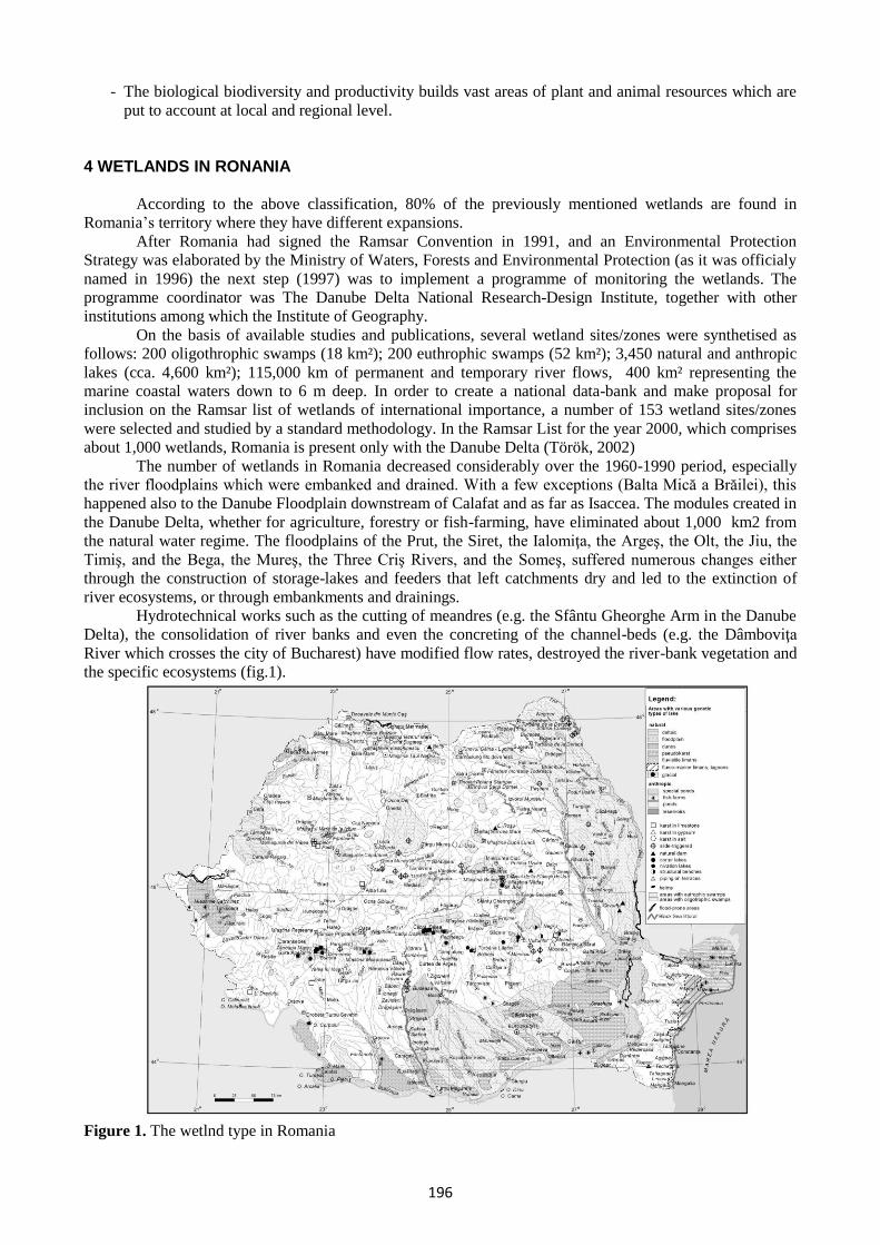
4 WETLANDS IN RONANIA
According to the above classification, 80% of the previously mentioned wetlands are found in
Romania’s territory where they have different expansions.
After Romania had signed the Ramsar Convention in 1991, and an Environmental Protection
Strategy was elaborated by the Ministry of Waters, Forests and Environmental Protection (as it was officialy
named in 1996) the next step (1997) was to implement a programme of monitoring the wetlands. The
programme coordinator was The Danube Delta National Research-Design Institute, together with other
institutions among which the Institute of Geography.
On the basis of available studies and publications, several wetland sites/zones were synthetised as
follows: 200 oligothrophic swamps (18 km²); 200 euthrophic swamps (52 km²); 3,450 natural and anthropic
lakes (cca. 4,600 km²); 115,000 km of permanent and temporary river flows, 400 km² representing the
marine coastal waters down to 6 m deep. In order to create a national data-bank and make proposal for
inclusion on the Ramsar list of wetlands of international importance, a number of 153 wetland sites/zones
were selected and studied by a standard methodology. In the Ramsar List for the year 2000, which comprises
about 1,000 wetlands, Romania is present only with the Danube Delta (Török, 2002)
The number of wetlands in Romania decreased considerably over the 1960-1990 period, especially
the river floodplains which were embanked and drained. With a few exceptions (Balta Mică a Brăilei), this
happened also to the Danube Floodplain downstream of Calafat and as far as Isaccea. The modules created in
the Danube Delta, whether for agriculture, forestry or fish-farming, have eliminated about 1,000 km2 from
the natural water regime. The floodplains of the Prut, the Siret, the Ialomiţa, the Argeş, the Olt, the Jiu, the
Timiş, and the Bega, the Mureş, the Three Criş Rivers, and the Someş, suffered numerous changes either
through the construction of storage-lakes and feeders that left catchments dry and led to the extinction of
river ecosystems, or through embankments and drainings.
Hydrotechnical works such as the cutting of meandres (e.g. the Sfântu Gheorghe Arm in the Danube
Delta), the consolidation of river banks and even the concreting of the channel-beds (e.g. the Dâmboviţa
River which crosses the city of Bucharest) have modified flow rates, destroyed the river-bank vegetation and
the specific ecosystems (fig.1).
Figure 1. The wetlnd type in Romania
197
5 THE RECONSTRUCTION AND MANAGEMENT OF WETLANDS
The importance of wetlands stated in the 1971 Ramsar Convention as habitat of water-fowl was
subsequently acknowledged by everybody.
In 1995, the European Commission, recognising the value of wetlands, elaborated the Framework
Convention 2000/60/EC aimed in principal at improving the state of the aquatic and of the riverine terrestrial
ecosystems.
Since many wetlands have been drained, several projects are underway in various parts of the Globe
to promote ecological reconstuction.
In Romania, such projects target the Danube Delta Biosphere Reserve (the Babina and Cernovca
isles, the abandoned fish-farms of Popina and Holbina-Dunavăţ) and the Danube Green Corridor.
The Danube Green Coridor Project, which was discussed at a meeting of the environment ministres
from the Lower Danube Riverine Countries (Romania, Bulgaria, Ukraine and the Republic of Moldova),
Bucharest, May, 2001, is being coordinated by the Danube Delta National Research-Design Institute in
collaboration with profile institutions and NGOs and in cooperation with the World Wildlife Fund (WWF).
The purpose of this project is to single out several areas (totalling cca 2,000 km²) important on the routes of
migratory birds and fish-spowning sites, as genetic stock reservoirs; other sites (totalling cca 1,000 km²) are
scheduled for ecological reconstruction.
Another project begun in 2002 and which targets the Mureş drainage basin, was elaborated by
ARCADIS – The Netherlands, the Mureş Waters Direction and the Romanian Waters Administration in
collaboration with ICIM – Bucharest (National Institute for Environmental Research and Engineering) and
RIZA – the Netherlands. This pilot-project has in view the structure of the permanent and temporary wetland
zones, and the network of protected areas under the Directive 2000/60/EC and is intended to become a model
for other drainage basins, too.
The management of wetland zones needs to be a long-term issue in order to combine conservation
with protection.
REFERENCES
Décamps, H., Naiman, R. (1989). L’écologie des fleuves, La Recherche, vol. 20, no 208.
Gâştescu, P., (1971), Lacurile din România. Limnologie regională, Edit. Academiei Române, Bucureşti. [in
Romanian]
Gâştescu, P., Ciupitu, D. (2001). Dunărea în cursul inferior şi proiectul de realizare a unui Coridor Verde,
Revista Geografică, Bucureşti. [in Romanian]
Pinay, G., Décamps, H., Chauvet, E., Fustec, Eliane (1990). Functions of ecotones in fluvial systems, în vol.
The Ecology and Management of Aquatic – Terrestrial Ecotones, Parthenon Press Publ.
Pop, E. (1960). Mlaştinile de turbă din R.P.R., Edit. Academiei R.P.R., Bucureşti. [in Romanian]
Stadiu, Fl., Şerban, P. (2001). Reabilitarea râurilor, Hidrotehnica, vol. 46. [in Romanian]
Török, Z. (1999). Fişa standard pentru caracterizarea zonelor umede, PETARDA, nr 5, I.N.C.D.D.D.,
Tulcea[in Romanian]
Török, Z. (2000). Zonele umede din România – tipuri, importanţă, PETARDA nr. 5, I.N.C.D.D.D., Tulcea.
[in Romanian]
Ujvary, I. (1972). Geografia apelor României, Edit. Ştiinţifică, Bucureşti. [in Romanian]
*** (1987). The Canadian Wetland Classification System, Natural Wetlands Working Group – Canada
Commitee on Ecological Land Classification, Ecological Land Classification, series no 21.
*** (2003). Directiva apei, Buletin informativ trimestrial nr. 3, Direcţia Apelor Mureş, Târgu Mureş. [in
Romanian]
*** (1996). Strategia protecţiei mediului, Ministerul Apelor, Pădurilor şi Protecţiei Mediului, Bucureşti. [in
Romanian]


![Concepts and Categories · [We use small caps to denote concepts or categories] Informatics 1 CG: Lecture 11 Concepts and Categories 6. Functions of Concepts (Rosch, 1978) The way](https://img.pdfslide.us/doc/110x75/5f25086c8a7618389b36fdd5/concepts-and-we-use-small-caps-to-denote-concepts-or-categories-informatics-1.jpg)