Embed Size (px)
Citation preview

The Weather Eye
A Southern New England Cooperative Weather Observer Newsletter
September 2009 Editor: Kimberly Buttrick Volume II, Issue 4
GREETINGS, IT’S BEEN AWHILE! It has been a year since the last issuance of this newsletter! My apologies, but once you take a look at the recognition section, you will see it has been a busy year! National Weather Service offices around the country issue many watches, advisories and warnings throughout the year. Did you ever wonder what prompts a watch, advisory or warning? If so, I include for you in this issue a reference sheet outlining the thresholds for such products to be issued. Depending on where you live in the country, these thresholds may be different; thus the reference sheet in this newsletter is specific for Southern New England. TRACE EVENTS Occasionally we have an observer phone in their morning observation and state that they have no precipitation to report, yet their current weather is drizzle. If you receive any precipitation in your 24 hour observation period, including drizzle, at a minimum you would report a trace of precipitation! You would mark a “T” in the precipitation column of your B91.
TEMPERATURE ≤ 32° WITH RAIN
Occasionally we have observers with a temperature of 32 degrees or below and they report their weather as plain rain. If it is raining or drizzling with a temperature of 32 degrees or below, that would be either Freezing Rain or Freezing Drizzle. As some folks remember from last December 2008, there was a significant freezing rain event that occurred across portions of Western Massachusetts into Southern New Hampshire. The glaze of ice was so thick and heavy; it brought down trees and power lines. Some people, including some of our observers, were without power for weeks! WX CODER FOLKS If you have a WxCoder account, you can close out your monthly records. Some folks
The Weather Eye Page 1

are already doing this but those of you that are not, I hope this section helps you. An end of month close-out in WxCoder is the digital equivalent of reviewing Weather Service forms, putting them in a sealed envelope, and dropping it in the mail. No further changes will be accepted after a month is closed. To close out your monthly form: Log onto WxCoder and go to My Observations, then look for a blue highlight that states, “Review observations for Month 2009.” Click on this highlight and it will take you to your monthly form. At that point look over your form for correctness and/or missing data. If all looks good, scroll down to the lower left of the page and click on, “Close out Month 2009.” If after looking over your form, you determine changes need to be made, unlock the row or rows to be edited, make the changes, then scroll down near the lower left of the page and click, “Save.” Confirm your edits. Now go to My Observations and click on, “Review observations for Month 2009.” If your data looks good, then scroll down to the lower left of the page and click on, “Close out Month 2009.” We ask that you close out your monthly form by the 10th of the following month. By closing out your month, you are certifying your data. The National Climate Data Center and Northeast Regional Climate Center have access to WxCoder. Thus they can view and download your data once you close out the month! If you still log your observations manually on a B91, we ask that you do a horizontal quality control making sure your manual records match what you entered in WxCoder. We want to make sure that what you intended to record in WxCoder is what gets published in the weather record.
WINTER TIME PREPARATION
As winter nears, remember to remove the funnel and inner tube from your Standard Rain Gauge. This will allow frozen precipitation to freely gain access to your overflow can! Once the frozen precipitation (which could be mixed with liquid rain) makes it into the overflow can, you can melt it down, pour the liquid water into the inner tube and get an accurate measurement. FAREWELLS AND WELCOMES Gerry D’Errico of Maynard, MA began taking weather observations in July 1963! He became an official Cooperative Weather Observer in May 1974. Gerry took his last observation from his home in Maynard on June 18, 2009, and sadly he passed away suddenly that same evening. Gerry was an excellent observer but more than that he was a loving and beloved husband, father and grandfather. Gerry’s neighbor and friend, John Flood, will continue Gerry’s weather legacy and the weather history of Maynard. We sadly say a farewell to Gerry and graciously welcome John Flood. John’s first official weather observation was on August 1, 2009. The weather community also sadly lost Charles (Chuck) Kidd of Hardwick, MA, who died suddenly in the evening on March 25, 2009. Like Gerry, Chuck took his weather observation that same morning.
The Weather Eye Page 2

The Weather Eye Page 3
And like Gerry, Chuck was a loving and beloved husband, father and grandfather. Chuck’s wife Ann has so kindly decided to continue her husband’s weather legacy and the weather history for Hardwick. Ann’s first official weather observation was on July 1, 2009. We welcome John Flood and Ann Kidd as new official Cooperative Weather Observers. In addition we welcome the following: The Foxboro Water and Sewer Department – Foxboro, MA Joe Nowicki of Leverett, MA Ron Horwood of East Sandwich, MA and a reactivated site at: U.S. Army Corps of Engineers – Edward MacDowell Lake located in Peterborough, NH
WE RECOGNITION WE (The Weather Eye) of Southern New England thank all of you for your dedication to and interest in weather data collecting. Your daily efforts are much appreciated. When it comes to weather, you are the eyes and ears of your community. Look ahead to the following pages to view a number of folks and institutions that have received length of service (LOS) awards over the past year. Those not pictured but who received awards are as follows: John Slamin of Natick, MA -20 year Length of Service Award Danvers Water Treatment Plant – Middleton, MA: -Bill Kerwin with a 30 year LOS award -Ray Ceres with a 25 year LOS award -Lou Moreau with a 15 year LOS award Marblehead Water Department – Marblehead, MA: -Bill Haskell with a 15 year LOS award

John R. Anderson of Walpole, MA proudly accepts the Dick Hagemeyer award for 45 years of dedicated
and steadfast service as a Cooperative Weather Observer for NOAA’s National Weather Service! The award is presented in honor of Dick Hagemeyer whose career in NOAA spanned 51 years.
Mr. Stacey G. Swift of North Foster, RI proudly and happily receives a 40 year Length of Service Award with his lively and lovely wife Marjory by his side.
The Weather Eye Page 4

Gerry D’Errico of Maynard, MA receives a 35 year Length of Service Award with his dog Misty by his side. Gerry began taking weather observations in July 1963
but didn’t become an official Cooperative Weather Observer until May 1974.
John J. Bagdon, Jr., a farmer from Sunderland, MA proudly receives a 35 year Length of Service Award.
The Weather Eye Page 5

Robert L. Giard, Chief Operator at the New Bedford Water Department – Quittacas Water Treatment Plant in Massachusetts, receives a 30 year Length of Service Award from Kim Buttrick.
Edward Capone of Norton, MA receives a 30 year Length of Service Award from Kim Buttrick. Besides being a Cooperative Weather Observer, Ed is the Service Coordination Hydrologist with the
Northeast River Forecast Center which is co-located with the National Weather Service in Taunton, MA.
The Weather Eye Page 6
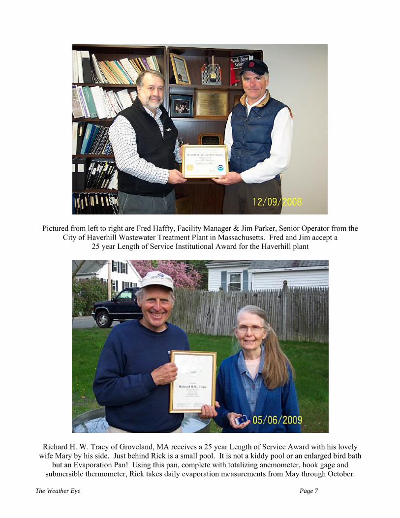
Pictured from left to right are Fred Haffty, Facility Manager & Jim Parker, Senior Operator from the City of Haverhill Wastewater Treatment Plant in Massachusetts. Fred and Jim accept a
25 year Length of Service Institutional Award for the Haverhill plant
Richard H. W. Tracy of Groveland, MA receives a 25 year Length of Service Award with his lovely wife Mary by his side. Just behind Rick is a small pool. It is not a kiddy pool or an enlarged bird bath
but an Evaporation Pan! Using this pan, complete with totalizing anemometer, hook gage and submersible thermometer, Rick takes daily evaporation measurements from May through October.
The Weather Eye Page 7

Pictured from left to right are Kim Buttrick, Wayne Plante and Maureen Dowdey all standing in front of Arcade Pond in Whitinsville, MA. Wayne receives a 25 year Length of Service Award
for his daily weather observations at the Whitinsville Water Company. The official name of this coop site is Northbridge.
Ray Whitley of Newburyport, MA receives a 20 year Length of Service Award. Ray hails (no weather pun intended) from the great state of Virginia
and has been a Southern New Englander since 1972. Ray is a 7th grade Earth Science teacher at Triton Regional Middle School in Byfield, MA.
The Weather Eye Page 8

Pam Turnbull of Ipswich, MA receives a 20 year Length of Service award. In her free time Pam is an artist. Her home is
decorated with many of her own paintings!
Pictured from left to right are Don Sullivan, Mark Lussier, Don Dunbar and James Bourcier who all work for the Ware Water Works in Massachusetts. Don receives a 20 year Length of Service award.
The Weather Eye Page 9

Steven Duchesne, Operations Superintendent at the Lowell Regional Water Utility in Massachusetts, receives a 20 year Length of Service Award from Kim Buttrick. In his free time,
Steve moonlights as a bass player and vocalist with the group Baked Naked - a popular local band!
Pictured from left to right are Dennis Morton and Richard Griffin who are Pump Station Operators at the Town of Franklin DPW - Water Department in Massachusetts.
Richard receives a 15 year Length of Service Award.
The Weather Eye Page 10

Pictured from left to right are Dana Snow and Gregory Burt employees with the Town of Marblehead Water Department in Massachusetts. Dana and Greg receive Length of Service Awards for 15 years.
Donald F. Ives of Worthington, MA pictured right, receives a 10 year Length of Service Award from Bill Simpson.
The Weather Eye Page 11
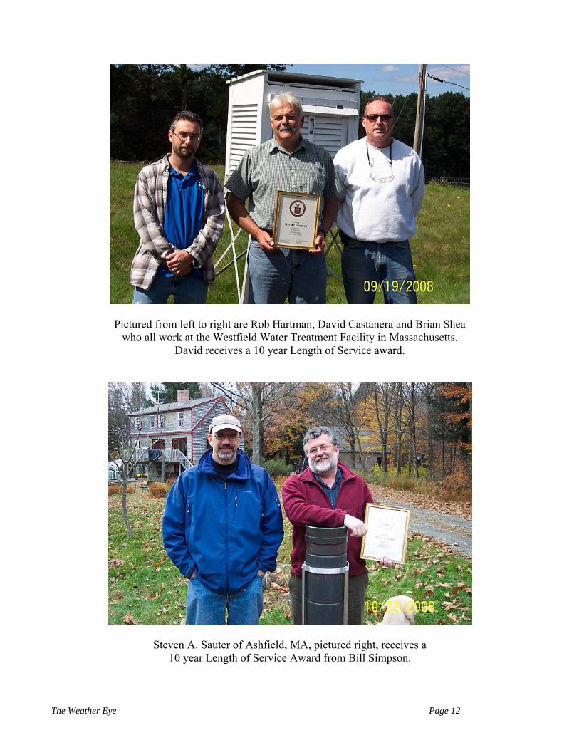
Pictured from left to right are Rob Hartman, David Castanera and Brian Shea who all work at the Westfield Water Treatment Facility in Massachusetts.
David receives a 10 year Length of Service award.
Steven A. Sauter of Ashfield, MA, pictured right, receives a 10 year Length of Service Award from Bill Simpson.
The Weather Eye Page 12

Robert Dermody receives a 10 year Length of Service Award with his co-worker Leo Dubois by his side. Robert and Leo work at the Bridgewater Correctional Complex in Massachusetts.
Doug Webster of Hudson, NH, pictured left, receives a 5 year Certificate of Appreciation from Bill Simpson. Doug works as a Senior Meteorologist with DTN Meteorlogix in Woburn, MA.
Thanks to all of You! Remember, you are nonpareil!
The Weather Eye Page 13
The Weather Eye Page 14
CONTACT INFORMATION
Have questions? In need of equipment or supplies? Equipment not working? Please call Kim or Bill.
National Weather Service 445 Myles Standish Blvd.
Taunton, MA 02780
508-823-2262 or 508-823-1983 or 800-243-1686
Fax: 508-823-2321
Email: [email protected]
Web: www.weather.gov/boston

REFERENCE SHEET FOR WARNING/ADVISORY THRESHOLDS
(Last Updated: December 18, 2008) The following are National Weather Service criteria for issuing Advisories and Warnings for various weather events. Watches generally are issued with longer lead times in expectation of meeting Warning criteria. TYPE OF ISSUANCE WHEN ISSUED FOR SOUTHERN NEW ENGLAND WINTER WEATHER ADVISORY When any of the following is expected within the next 12 to 24 hours: More than one predominant hazard
• Winter weather event having more than one predominant hazard (ie., snow and ice, snow and sleet, or snow, ice & sleet) meeting or exceeding advisory criteria for at least one of the precipitation elements, but remaining below warning criteria.
Snow, Ocean Effect Snow, and/or Sleet • 3 inches averaged over a CT, MA, RI forecast zone in 12 hours • 4 inches averaged over a NH forecast zone in 12 hours
Snow and Blowing Snow • Sustained or frequent gusts of 25 to 34 mph accompanied by
falling and blowing snow occasionally reducing visibility to ≤ 1/4 mi for > 3 hours
` Blowing Snow • Widespread or localized blowing snow reducing visibility to < ¼ mi with winds < 35 mph
Black Ice • A Special Weather Statement will usually be issued when
sufficient moisture is expected to cause a thin layer of ice on road surfaces, typically on cloudless nights (“black ice”). At forecaster discretion a formal Winter Weather Advisory may be issued instead.
FREEZING RAIN ADVISORY Any accretion of freezing rain or freezing drizzle on road surfaces
WIND CHILL ADVISORY Wind chill index between -15°F and -24°F for at least 3 hours using only the sustained wind (except -20°F to -29°F Southern NH)
WINTER STORM WARNING When any of the following is expected within the next 12 to 36 hours: More than one predominant hazard
• Winter weather event having more than one predominant hazard {ie. heavy snow and blowing snow (below blizzard conditions), snow and ice, snow and sleet, sleet and ice, or snow, sleet and ice} meeting or exceeding warning criteria for at least one of the precipitation elements.
Snow, Ocean Effect Snow, or Sleet • 6 inches averaged over a forecast zone in a 12 hour period • 8 inches averaged over a CT, MA, RI forecast zone in a 24 hour
period • 9 inches averaged over a NH forecast zone in a 24 hour period
The Weather Eye Page 15
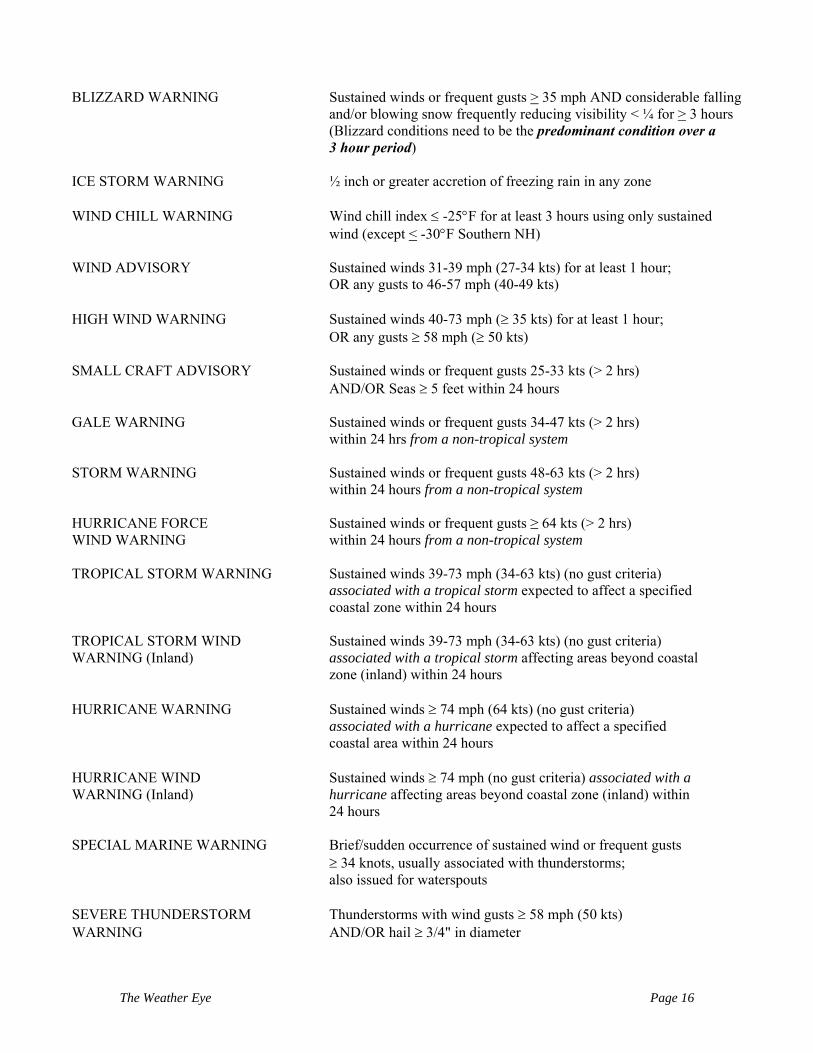
BLIZZARD WARNING Sustained winds or frequent gusts > 35 mph AND considerable falling
and/or blowing snow frequently reducing visibility < ¼ for > 3 hours (Blizzard conditions need to be the predominant condition over a 3 hour period)
ICE STORM WARNING ½ inch or greater accretion of freezing rain in any zone WIND CHILL WARNING Wind chill index ≤ -25°F for at least 3 hours using only sustained wind (except < -30°F Southern NH) WIND ADVISORY Sustained winds 31-39 mph (27-34 kts) for at least 1 hour;
OR any gusts to 46-57 mph (40-49 kts) HIGH WIND WARNING Sustained winds 40-73 mph (≥ 35 kts) for at least 1 hour;
OR any gusts ≥ 58 mph (≥ 50 kts) SMALL CRAFT ADVISORY Sustained winds or frequent gusts 25-33 kts (> 2 hrs) AND/OR Seas ≥ 5 feet within 24 hours GALE WARNING Sustained winds or frequent gusts 34-47 kts (> 2 hrs) within 24 hrs from a non-tropical system STORM WARNING Sustained winds or frequent gusts 48-63 kts (> 2 hrs) within 24 hours from a non-tropical system HURRICANE FORCE Sustained winds or frequent gusts ≥ 64 kts (> 2 hrs) WIND WARNING within 24 hours from a non-tropical system TROPICAL STORM WARNING Sustained winds 39-73 mph (34-63 kts) (no gust criteria) associated with a tropical storm expected to affect a specified coastal zone within 24 hours TROPICAL STORM WIND Sustained winds 39-73 mph (34-63 kts) (no gust criteria) WARNING (Inland) associated with a tropical storm affecting areas beyond coastal zone (inland) within 24 hours HURRICANE WARNING Sustained winds ≥ 74 mph (64 kts) (no gust criteria) associated with a hurricane expected to affect a specified coastal area within 24 hours HURRICANE WIND Sustained winds ≥ 74 mph (no gust criteria) associated with a WARNING (Inland) hurricane affecting areas beyond coastal zone (inland) within 24 hours SPECIAL MARINE WARNING Brief/sudden occurrence of sustained wind or frequent gusts ≥ 34 knots, usually associated with thunderstorms; also issued for waterspouts SEVERE THUNDERSTORM Thunderstorms with wind gusts ≥ 58 mph (50 kts) WARNING AND/OR hail ≥ 3/4" in diameter
The Weather Eye Page 16

TORNADO WARNING Likelihood of a tornado within the given area based on radar or actual sighting; usually accompanied by conditions indicated above for "Severe Thunderstorm Warning" FLOOD ADVISORY Expected inundation by water of some low lying and poor drainage areas, resulting in a nuisance to the public but not a threat to life and property. FLASH FLOOD WARNING Rapid and extreme flow of high water into a normally dry area, or a rapid water level rise in a stream or creek above a predetermined flood level, beginning within a short timeframe from the onset of heavy rain. A dam or levee failure, or water released from an ice jam is also considered. FLOOD WARNING Expected overflow or inundation by water which causes or will cause damage and/or a threat to life. RIVER FLOOD WARNING Water level at a River Forecast point along a river (such as the Merrimack, Nashua or Charles) is expected to reach or exceed flood stage. COASTAL FLOOD ADVISORY Minor coastal flooding expected within 12 hours. Examples include: splash over causing a few roads briefly impassable, standing water in parking lots, etc. COASTAL FLOOD WARNING Coastal flooding expected within 12 hours; widespread serious (moderate or major) coastal flooding which damages property AND/OR is a threat to life. EXCESSIVE HEAT WARNING Daytime heat indices of > 105°F for 2 or more hours HEAT ADVISORY Daytime heat indices of 100ºF-104ºF for 2 or more hours HEAT WAVE Issued for non-criteria warning/advisory heat. A heat wave is defined as 3 or more days of > 90ºF temperatures. DENSE FOG ADVISORY Widespread visibility ≤ 1/4 mile for at least 3 hours FREEZING FOG ADVISORY Very light ice accumulation from predominantly FZFG FROST ADVISORY Issued under clear, light wind conditions with forecast minimum shelter temperature 33-36ºF during growing season FREEZE WARNING When minimum shelter temperature drops to < 32ºF during growing season HIGH SURF ADVISORY When high surf poses a danger to life in the form of rip currents or breaking seas. 7 foot incoming seas at the buoys within the next 24 hours from Memorial Day through September.
The Weather Eye Page 17
The Weather Eye Page 18
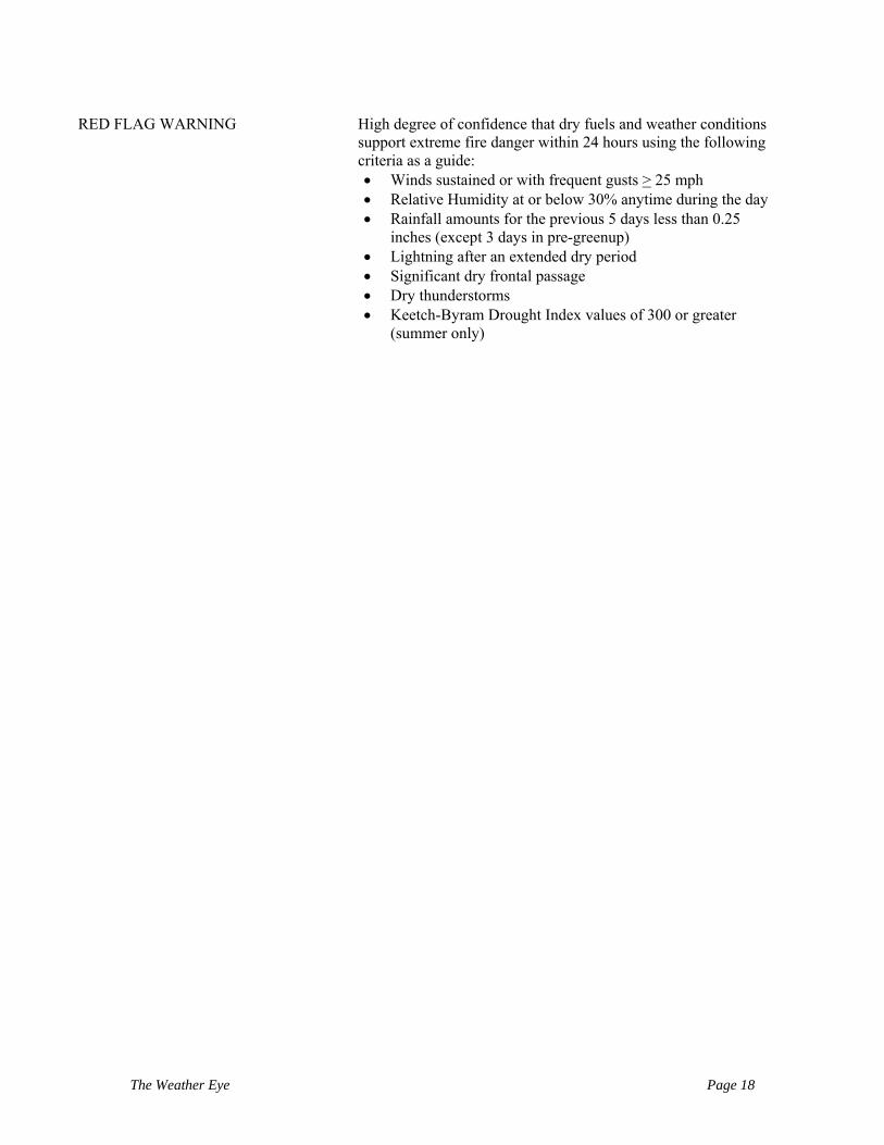
RED FLAG WARNING High degree of confidence that dry fuels and weather conditions support extreme fire danger within 24 hours using the following criteria as a guide:
• Winds sustained or with frequent gusts > 25 mph • Relative Humidity at or below 30% anytime during the day • Rainfall amounts for the previous 5 days less than 0.25
inches (except 3 days in pre-greenup) • Lightning after an extended dry period • Significant dry frontal passage • Dry thunderstorms • Keetch-Byram Drought Index values of 300 or greater
(summer only)