Embed Size (px)
Citation preview
THE UNIVERSITY OF STIRLING CAMPUS
Conservation Plan
Simpson & Brown Architects October 2009

CONTENTS
1.0 EXECUTIVE SUMMARY 5
2.0 INTRODUCTION 7
2.1 Objectives 7
2.2 Study Area 8
2.3 Designations 8
2.4 Structure of the Report 8
2.5 Limitations 8
2.6 Project Team 9
2.7 Acknowledgements 9
2.8 Abbreviations 9
3.0 HISTORICAL DEVELOPMENT 11
3.1 History Before 18th century 11
3.2 Airthrey Estate 1787 – 1889 14
3.3 Airthrey Estate 1889 – 1939 24
3.4 Airthrey Maternity Hospital 1939 – 1969 27
3.5 Establishment of the University 31
3.6 Robbins Report 32
3.7 Plate-Glass Universities 33
3.8 Expansion of the University Sector 34
3.9 The University in Context: Contemporary Comparisons 34
3.10 Development Planning 41
3.11 Landscape Design 53
3.12 Archaeology 57
3.13 Chronology 58
4.0 CHARACTER AREA ASSESSMENTS 63
4.1 Character Area 1: Pathfoot, West Entrance 63
4.1.1 Historical Development 63
4.1.2 Architectural Development 74
4.1.3 Character Assessment 90
4.1.4 Assessment of Significance 96
4.1.5 Recommendations 98
4.2 Character Area 2: Central Area 104
4.2.1 Historical Development 105
4.2.2 Character Assessment 127
4.2.3 Assessment of Significance 129
4.2.4 Recommendations 132
4.3 Character Area 3: Students’ Residences 134
4.3.1 Historical Development 134
4.3.2 Character Assessment 143
4.3.3 Assessment of Significance 146

4.3.4 Recommendations 147
4.4 Character Area 4: Sports Area 148
4.4.1 Historical Development 148
4.4.2 Character Assessment 155
4.4.3 Assessment of Significance 158
4.4.4 Recommendations 158
4.5 Character Area 5: Airthrey Castle Yards 159
4.5.1 Historical Development 159
4.5.2 Character Assessment 172
4.5.3 Assessment of Significance 177
4.5.4 Recommendations 178
4.6 Character Area 6: Airthrey Castle, Golf Course, East Playing Fields, East Lodge, East Drive
181
4.6.1 Historical Development 181
4.6.2 Airthrey Castle in 2009 209
4.6.3 Character Assessment 224
4.6.4 Assessment of Significance 235
4.6.5 Recommendations 236
4.7 Character Area 7: Walled Garden, Arboretum, Cottages 239
4.7.1 Historical Development 239
4.7.2 Character Assessment 243
4.7.3 Assessment of Significance 249
4.7.4 Recommendations 250
4.8 Character Area 8: Alexander Court Residences, Memorial Garden 252
4.8.1 Historical Development 252
4.8.2 Character Assessment 254
4.8.3 Assessment of Significance 255
4.8.4 Recommendations 256
4.9 Character Area 9: Hermitage Wood 257
4.9.1 Historical Development 257
4.9.2 Character Assessment 263
4.9.3 Assessment of Significance 265
4.9.4 Recommendations 266
4.10 Character Area 10: Factory, Maintenance Depot, Innovation Park 267
4.10.1 Historical Development 267
4.10.2 Character Assessment 271
4.10.3 Assessment of Significance 272
4.10.4 Recommendations 272

4.11 Character Area 11: Spittal Hill 273
4.11.1 Historical Development 273
4.11.2 Character Assessment 276
4.11.3 Assessment of Significance 277
4.11.4 Recommendations 278
5.0 ASSESSMENT OF SIGNIFICANCE 279
5.1 Introduction 279
5.2 Historical Significance 280
5.3 Architectural and Aesthetic Significance 280
5.4 Landscape Significance 281
5.5 Ecological Significance 282
5.6 Social and Spiritual Significance 282
5.7 Archaeological Significance 282
5.8 Summary Statement of Significance 283
6.0 SUMMARY OF RECOMMENDATIONS 284
6.1 Retention of Significance 284
6.2 Further Research 285
6.3 Physical Evidence and Recording 285
6.4 Repairs 285
6.5 Restoration 290
6.6 Work to Interiors 291
6.7 Adaptations to a New Use 291
6.8 Interventions to Existing Buildings 292
6.9 Demolitions 293
6.10 Landscape 293
6.11 Character of the Surrounding Landscape 295
6.12 Design and Location of New Buildings 295
6.13 Campus Development Plan 298
6.14 Views 299
Appendices
Appendix I Architects‟ Biographies
Appendix II Historical Information Relating to Stirling University
Appendix III Historical Information Relating to Airthrey Estate
Appendix IV 2009 Campus Plan A3

Figure 1 View of western area of Stirling University from Wallace Monument 2008

1.0 EXECUTIVE SUMMARY
The University of Stirling has recently completed its Estates Strategy, and this report is intended to
inform further development of the campus as educational and operational requirements change in the
future.
This report has examined the significance of the site, which contains outstanding university buildings,
listed by ICOMOS UK as among the top twenty 20th
century sites in the UK. There are two Category
A listed buildings, five Category B listed buildings, 2 Category C (S) listed buildings and a Scheduled
Ancient Monument, as well as several unlisted buildings. These are set within a picturesque designed
landscape of approximately 334 acres (135 hectares) of open and wooded landscape, situated to the
north east of Stirling city centre. The report concludes that there are opportunities to enhance the
significance of the historic buildings and the landscape setting, and that development of new buildings
would be possible in some areas.
The majority of the buildings on the site were constructed for educational use in the 1960s and 1970s.
If the buildings were to be extended or altered there is a clear opportunity to investigate the original
finishes, and to restore those which remain in part.
Figure 2 Inventory of Gardens and Designed Landscapes, map of Airthrey Castle site. This is also the study area boundary. HS

2.0 INTRODUCTION
2.1 Objectives
This conservation plan has been commissioned by Stirling University Estates and Campus Services Department.
The aim of this report is to inform the future conservation, repair, use and management of the buildings and landscape of the University of Stirling. It will inform future proposals for conservation and repair work to the buildings, as well as alterations that are required to facilitate their ongoing and improved use where required.
The conservation plan assesses and sets out in summary what is important about the campus, and the information gathered is then considered in an assessment of cultural significance, for the site as a whole and for its various parts, to be summarised in this report by a summary statement of significance. Eleven character areas within the campus have been identified and analysed.
The purpose of establishing the importance of the site is to identify and assess the attributes which make a place of value to our society. Once the heritage significance of the buildings and associated structures and their context within the designed landscape is understood, informed guidelines can be drawn up which will enable that significance to be retained, revealed, enhanced or, at least, impaired as little as possible in any future decisions for the site. A clear understanding of the nature and degree of the significance of the buildings and other elements of the site will not only suggest constraints on future action, but it will introduce flexibility by identifying the areas which can be adapted or developed with greater freedom. This appraisal will identify opportunities within the site.
From all of this information, a set of policies, or guidelines have been drafted which are intended to inform the future conservation, repair, management and use of the buildings and the designed landscape according to best conservation practice.
Figure 3 Location of Stirling University
2.2 Study Area
The study area is located to the north east of Stirling, adjacent to Bridge of Allan. The northern part of the estate extends into the lower foothills of the Ochil Hills, and the surrounding landscape to the north and east is a mixture of hillside and farmland. The study area boundary is shown on figure 2.

2.3 Designations
The site contains nine listed buildings and one Scheduled Ancient Monument (SAM).
Pathfoot Building Category A HB No 51327
Principal‟s House Category A HB No 51322
Airthrey Castle Yard Nuffield Staff Houses 2 and 3
Category B HB No 51323
Airthrey Castle Yard Nuffield Staff Houses 4 and 5
Category B HB No 51324
Airthrey Castle Yard Nuffield Staff Houses 6 and 7
Category B HB No 51325
Airthrey Castle Category B HB No 10412
East Lodge including Gatepiers Category B HB No 10428
Garden Cottage Category C (S) HB No 10453
Bridge over Airthrey Loch Category C (S) HB No 51326
Airthrey Castle Standing Stone SAM
The entire campus falls within the area identified by Historic Scotland as the Airthrey Castle site in the Inventory of Gardens and Designed Landscapes. The study area boundary follows this boundary exactly.
There are no statutory designated sites within the landscape. One non-statutory Wildlife Site exists, which consists of Airthrey Loch, covering an area of approximately 25 acres (9 ha). There are also areas of non-statutory Ancient Woodland (AW), and Long Established Woodland of Plantation Origin (LEWPO).
2.4 Structure of the Report
The Conservation Plan follows the guidelines set out in the Historic Scotland document Conservation Plans: A Guide to the Preparation of Conservation Plans. The reports will also follow the processes and guidelines outlined by the internationally recognised documents The Conservation Plan 5th Ed. (The National Trust of Australia, 2000) by James Semple Kerr; and The Illustrated Burra Charter: good practice for heritage places (Australia ICOMOS, 2004) by M Walker and P Marquis-Kyle.
Reference is also made to the British Standard BS 7913 – Guide to the principles of the conservation of historic buildings (1998) and the detailed guidelines prepared by the Heritage Lottery Fund – Conservation Management Plans Checklist, Conservation Management Plans Model Brief and Conservation Management Plans: Helping your application (2004).
2.5 Limitations
Thorough documentary research has been carried out for this report, however it is likely that more information may become available in the future. Research in the archives of Stirling University was limited as the archive was in the process of being relocated during the study period. It is accepted that further research may add to the historical development contained within this conservation plan, and it should be updated accordingly.
Investigation of buildings did not include any opening up. Further information about the fabric of the pre 1960s buildings within the estate is likely to come to light in the event of works being carried out.
2.6 Project Team
This report has been written by Simpson & Brown Architects. The study team for the conservation plan comprised John Sanders, Tom Parnell and Cath McFarlane.
2.7 Acknowledgements
Simpson & Brown gratefully acknowledges the assistance provided by the following persons, archives and
organisations during the completion of this report:
Karen Plouviez, University of Stirling
Andy Duncan, University of Stirling
Karl Magee, University of Stirling
Robert Steadman
RMJM
Trustees of Sir John Soane‟s Museum
Christopher Dingwall
Bob Ferguson, Ian White Associates
Antony Wells-Cole
Victoria Crake, Lyon & Turnbull Auctioneers, Edinburgh
2.8 Abbreviations
The following abbreviations have been used throughout this report.
BL British Library
HS Historic Scotland
NAS National Archives of Scotland
NLS National Library of Scotland
NMRS National Monuments Record of Scotland
S&B Simpson & Brown
SJSM Sir John Soane‟s Museum
StAU St Andrews University

UoSA University of Stirling Archive
UoS University of Stirling
Figure 4 Oblique aerial view of the university campus in the 1970s RMJM

3.0 HISTORICAL DEVELOPMENT
3.1 History Prior to Late 18th Century
The position of the Airthrey estate on gently sloping ground at the foot of the Ochil Hills, close to Stirling, has been attractive since prehistoric times. The site has a particularly long recorded history. Its prehistoric importance is clear from two surviving standing stones and recorded antiquarian finds in the vicinity.
The extent and ownership of the estate has changed frequently. At least four principal houses are known to have been built, including the present castle. Despite this long history, the landscape today is largely the product of a single picturesque conception, initially laid out in the late 18th century, and sensitively adhered to up until the present day, including the positioning and design of the university buildings.
The owner who had the single greatest impact on the present landscape was Robert Haldane, who between 1787 and 1798 created the loch, employed Thomas White (Senior) to assist with the designed landscape, and built Airthrey Castle. Prior to this, there had been alterations to the roads, and the great 18th century work of laying out plantations had begun. The appearance of the previous houses at Airthrey is unknown.
The earliest reference to „Ethereari „ dates from the 12th century. The earliest reference to a building on the estate is its destruction in 1645. During the Civil Wars, the Manor House of Airthrey, belonging to Sir John Graham of Braco (a relation of James Graham, 5th Earl of Montrose) was destroyed, under the Marquis of Argyll‟s orders, together with the nearby house of Menstrie. „Ethra’ is shown on Adair‟s 1685 manuscript map (figure 5), with a house, suggesting that the house had been rebuilt.
Figure 5 Manuscript map of Stirlingshire, John Adair 1685 NLS
The first details of landscaping works to the estate date from the early 18th century1.
John Dundas of Manour (a nearby estate to the south east) had acquired Airthrey in 1706 by exchanging it for another estate with the Earl of Hopetoun, then owner of Airthrey. His descendant
1 Information from „Airthrey Roads, Captain Haldane’s Magic Roundabout’ KJH Mackay, D Angus, in „Forth Naturalist and Historian‟ volume 9

John Ramsay of Ochtertyre (1736-1814) described2 how John Dundas‟s son Robert began to plant trees in 1716 or 1717 „but the hill was not planted until 1725’. John lived at a house outwith the estate,
„until 1747 when he built a small snug house at Airthrey. Conscious of his ignorance of country affairs, he contented himself while there with making a kitchen-garden, and having a few acres in grass, without any corn, or adding to his father’s small enclosures. He spent his time… among his books. To the want of relish for a country life rather than the extent of his debts, may be ascribed his rash sale of this sweet place to Captain Haldane, in 1759.‟
The position of the house is unknown. It is shown on a map of 1769 but it is not possible to gage its position from this (see figure 8). One clue to its position may be the remains of the walls of the stables and offices, which have a mid 18th century character, and are relatively elegant for a mere stables. It is possible that the „small snug house‟ was later extended to form offices and stables, and that the nearby walled garden was the „kitchen garden’. In 1827 it was described as „the old orchard3’.
General Roy‟s Survey of the mid 18th century (figures 6,7) shows this house, set in the fertile cultivated valley of the Forth, misnamed as „Menstry‟4. The map shows a square plantation with allées to north and south. In the centre is a square enclosure, with a house. This may be the kitchen garden described above, with trees to the north planted on „the hill’, corresponding to the present Hermitage Wood.
Figure 6 General Roy‟s Survey, detail of Forth Valley with Abbey Craig 1747-55 BL
Figure 7 General Roy‟s Survey, detail of Airthrey estate 1747-55 BL
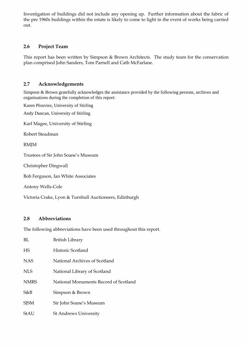
The only other indication of the estate‟s appearance before the time of Robert Haldane is a map showing alterations to the roads carried out in the 1750s and 60s (figure 8). This map shows the removal of the old road between the villages of Pathfoot to the west and Logieburn to the east of Airthrey, which had passed relatively close to the landowner‟s house (shown as a dotted line). By the mid to late 18th century it was becoming common practice for landowners to increase the distance between themselves and their tenants by any means available, including moving villages, redirecting public roads, and constructing new boundaries.
2 in „Scotland and Scotsmen of the 18th century’, quoted in „Airthrey Roads, Captain Haldane’s Magic Roundabout’ KJH Mackay, D Angus, in „Forth Naturalist and Historian‟ volume 9 3 See below section 4.5.1 4 Identified by the position of other features. „Airthrey‟ is marked to the west, also incorrectly.
Figure 8 Detail of Plan of Airthrey Roads, Farquharson 1769 NLS
This plan shows formal avenues to the south and east of the house, with the house itself a simple block. Robert Haldane (at Airthrey 1759-67) had made his fortune with the East India Company and invested in his family home at Gleneagles and Airthrey on his return – living at Airthrey. Court records state:
„He conceived to himself the fashionable modern fancy of beautifying his place in an elegant manner, and considered it as an essential requisite to get quit of these roads which intersected his ground in an ugly and inconvenient manner; and, amongst others, he was not a little hurt with the idea of one passing hard by the door of his house; a situation which, whether really incommodious in itself or not, it is well-known no person chooses to put up with if he can possibly avoid it.‟5‟
Whether or not the public road passed so close to the house (which seems unlikely), Haldane built, at his own expense, a „New Road’, placing gates on the old roads, which at the time caused local protests and a court case. The new, tree-lined route can be seen to the south and west of the house on Stobie‟s 1783 map (figure 9), with „Ethra’ reached from the north east, passing through the village of Logie.
Later developments meant the „New Road‟ was soon obsolete (see below), but the pattern of the southern part of the landscape today retains the outline of a
Figure 9 Stobie‟s map of Stirlingshire 1783 NLS
regular and mostly straight stretch of this road (figure 10), an unusual feature in the otherwise wholly serpentine and picturesque layout. The footpath between the car parks to the west of the Cottrell Building and the chalet accommodation at Pendreich Way follows approximately the route of the „New Road’ to the then village of Pathfoot.
5 Information from „Airthrey Roads, Captain Haldane’s Magic Roundabout’ KJH Mackay, D Angus, in „Forth Naturalist and Historian‟ volume 9
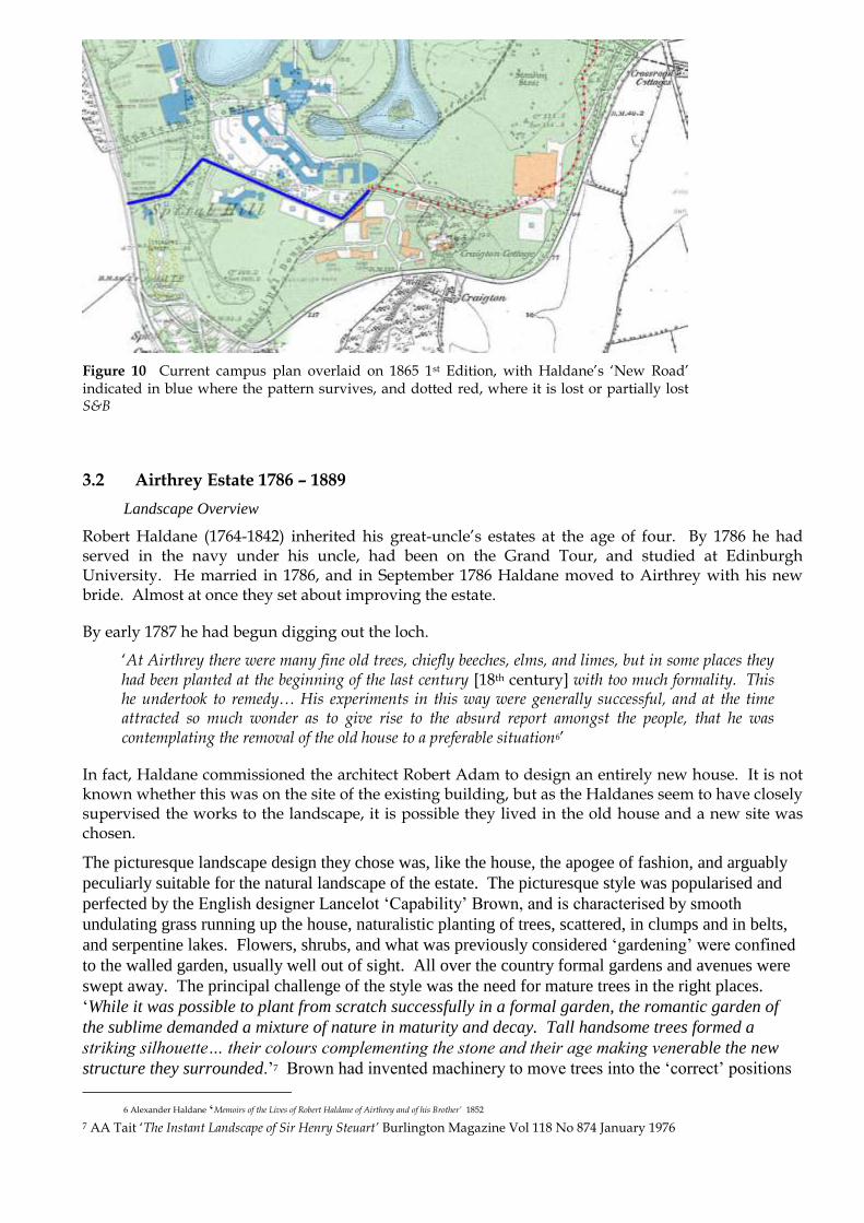
Figure 10 Current campus plan overlaid on 1865 1st Edition, with Haldane‟s „New Road‟ indicated in blue where the pattern survives, and dotted red, where it is lost or partially lost S&B
3.2 Airthrey Estate 1786 – 1889
Landscape Overview
Robert Haldane (1764-1842) inherited his great-uncle‟s estates at the age of four. By 1786 he had served in the navy under his uncle, had been on the Grand Tour, and studied at Edinburgh University. He married in 1786, and in September 1786 Haldane moved to Airthrey with his new bride. Almost at once they set about improving the estate.
By early 1787 he had begun digging out the loch.
„At Airthrey there were many fine old trees, chiefly beeches, elms, and limes, but in some places they had been planted at the beginning of the last century [18th century] with too much formality. This he undertook to remedy… His experiments in this way were generally successful, and at the time attracted so much wonder as to give rise to the absurd report amongst the people, that he was contemplating the removal of the old house to a preferable situation6‟
In fact, Haldane commissioned the architect Robert Adam to design an entirely new house. It is not known whether this was on the site of the existing building, but as the Haldanes seem to have closely supervised the works to the landscape, it is possible they lived in the old house and a new site was chosen.
The picturesque landscape design they chose was, like the house, the apogee of fashion, and arguably
peculiarly suitable for the natural landscape of the estate. The picturesque style was popularised and
perfected by the English designer Lancelot „Capability‟ Brown, and is characterised by smooth
undulating grass running up the house, naturalistic planting of trees, scattered, in clumps and in belts,
and serpentine lakes. Flowers, shrubs, and what was previously considered „gardening‟ were confined
to the walled garden, usually well out of sight. All over the country formal gardens and avenues were
swept away. The principal challenge of the style was the need for mature trees in the right places.
„While it was possible to plant from scratch successfully in a formal garden, the romantic garden of
the sublime demanded a mixture of nature in maturity and decay. Tall handsome trees formed a
striking silhouette… their colours complementing the stone and their age making venerable the new
structure they surrounded.‟7 Brown had invented machinery to move trees into the „correct‟ positions
6 Alexander Haldane „Memoirs of the Lives of Robert Haldane of Airthrey and of his Brother’ 1852
7 AA Tait „The Instant Landscape of Sir Henry Steuart’ Burlington Magazine Vol 118 No 874 January 1976

and this was developed by Sir Henry Steuart in the 1780s, who was a patron of Thomas White and son.
Haldane‟s experiments at Airthrey led to his being consulted in 1820 by the Botanic Gardens in
Edinburgh when the plant collection was moved from Leith Walk to its new site.
In his „An Encyclopaedia of Gardening’ John Claudius Loudon noted the involvement of the landscape designer Thomas White senior, a pupil of „Capability‟ Brown, in 1798. ‘From nearly the first Introduction of the new style in Scotland to the present time, annual journeys have been made into Scotland from the county of Durham by the late White, and subsequently his son. White, senior… of much information on country matters and generally respected in Scotland… Airthrey, near Stirling, and Bargany in Ayrshire, are the principal productions of this family8’
No plans for Airthrey are known to survive, but the layout of the designed landscape is consistent with the work of the Whites, particularly the approaches (see below CA6). The Whites worked all over Scotland, with the encouragement and patronage of Sir Henry Steuart.
Loudon also recalled having seen in 1802 sketches by Alexander Nasmyth (1758-1840) „an eminent landscape painter in Edinburgh’ for „planting… a part of the Ochil hills near Airthrie and Alva, which struck us as in a good and very superior taste. We believe they have only partially been carried into execution.‟ These sketches may have been earlier in date. Nasmyth was in Italy 1782-4, returning to Scotland thereafter, and at work on several landscape design projects in Scotland including Culzean Castle and Inveraray.
In summer 1798 Robert Haldane sold Airthrey to his wife‟s uncle, Robert Abercrombie, and devoted the rest of his life and fortune to missionary work, together with his brother James. He is variously reported as having been of a devout character from his infancy, and as having been converted by a mason named Carr, one of the builders working on the castle. Haldane and his brother were influential in the development of Congregationalism in Scotland.
Airthrey Castle
A detailed history of the castle is included below in Section 4.6 Character Area 6.
Buildings in the landscape
The buildings in the landscape are described in detail in character areas 5, 7, and 9.
Most of the policies were laid out as parkland, but to the north of the castle was a more intimate area, containing the pleasure grounds and the practical supporting buildings upon which the smooth running of the household depended. These were the walled garden, icehouse, stables and offices, and cottages, possibly including a wash-house. Further to the north, up the hill, a cistern was built, which was still functioning, (with extensions) in 1944 as „a gravitation water supply from natural springs,
Figure 11 Interior of Summer House 2009
collected in storage tanks.‟9 All these were built partly for display, as examples of an improved estate. From the bowling green visitors would have seen Ivy Cottage. The walled garden and Garden Cottage would have been features to be appreciated from the East Drive. Within Hermitage Wood, Haldane built two buildings to show off his views, the Hermitage and the Summer House, reached
8 JC Loudon „An Encyclopaedia of Gardening’ 1822 9 1944 Sales Particulars, UoSA

from an extensive networks of paths. Although now ruined, these are among the most interesting buildings in the estate. These buildings are described in detail in CA 9.
Icehouse
An icehouse was a typical component of an 18th century estate, and after the digging of the loch there would have been a ready supply of ice available within the estate. The frozen loch is known to have been used for curling and skating, and Haldane himself was nearly drowned after falling through the ice.
Walled Garden
The 18th century character of Garden Cottage (see below) suggests an 18th century date for the garden, as the cottage was clearly designed as a decorative feature within it. The character of the bricks in the surviving walls of the walled garden suggest a late 18th or early 19th century date. It would have been fitted with glasshouses along the north wall.
Like other aspects of the estate it was extravagantly praised: the Gardener‟s Magazine described it in 1842 as „perfect as regards culture and neatness and the abundance and fine quality of fruit‟10.
Figure 12 Walled garden 2009 Figure 13 Walled garden 2009
Stables, Home Farm
No offices were included in Robert Adam‟s designs for the new castle. At other houses Adam designed stables and offices in wings, or outbuildings within a courtyard, whereas at Airthrey the buildings he designed for the courtyard were to be merely „gatehouses‟. This suggests that at Airthrey the buildings already existed.
It is also possible that the „small snug house’ of 1747 was later adapted to form offices. The character of the surviving masonry suggests a mid 18th century date, and this site would have been a typical position for a house of that date.
10 quoted in the HS Inventory of Gardens and Designed Landscapes

It seems less likely however that the road-
building Robert Haldane of the 1760s
would have been so concerned about the
passing public had his house been as
considerably raised above the level of the
parkland as the offices were. It is
possible that the offices had been built as
part of his improvements of the 1750s
and 60s, and that the main house was on
another site.
The stables are possibly shown on
Stobie‟s 1783 map as a C-shaped block
near to Airthrey house and definitely
appear on Grassom‟s map of 1817.
Figure 14 1st Edition OS map showing steading 1865 NLS
The 1865 OS map (figure 14) shows that the main building by this date was a three-sided courtyard
containing a smaller C-shaped building, with a separate block to the north having a round horse gin to
turn a mill.
A more detailed history is included below, Section 4.6 Character Area 6.
Garden Cottage
The position of this cottage within the walled garden was carefully chosen, and its front elevation included an elegant porch. The building contains some 18th century joinery and fireplaces.
Figure 15 Garden Cottage 2008
Sir Robert Abercromby (at Airthrey 1798-1827)
Sir Robert Abercromby KB, was Governor of Edinburgh Castle, and had acquired a large amount of prize money in India11. At this date both the castle and the picturesque designed landscape would have been highly fashionable, with an additional attraction of income from the 3,000 acre estate.
He too carried out improvements to the estate, although no works to the house are recorded. These included continuing to extend the physical distance between the landowner‟s house and his tenants‟ dwellings by clearing them away, while building new improved housing for them. During his ownership the roads controversy was resolved by the construction in 1817 of a turnpike road, further south, now the B998. Abercromby also either built or extended the road between Logie and Pathfoot which gave access to the offices, allowing parishioners (and the minister) to travel in a direct route between the two places.
Abercromby moved the population of the village of Logie12, providing new houses at Causeyhead. He also „discontinued the village of Pathfoot’13. A new manse and offices were built near to the new church of Logie, to the south of the old building.
11 Prize money and trading profits from India funded the improvements at Airthrey by three owners: Robert Haldane I (1759-1768), Sir Robert Abercromby, and later Donald Graham (1889-1901) 12 At Logie one old lady persistently refused to move to the new cottages, until eventually she was promised a new cottage anywhere else on the estate, to which she agreed. Abercromby was surprised to learn that the site she had selected was in front of Airthrey Castle. She was allowed to stay in her existing house. RM Fergusson „Logie A Parish History’ 1905 13 RM Fergusson „Logie a Parish History’ 1905

Figure 16 East Lodge from south west 2009 Figure 17 East Lodge from north west 22009
Figure 18 Top of southern gatepier, East Lodge 2008
Figure 19 1st Edition OS showing West Lodge 1865 NLS
Abercromby employed the local architect William Stirling to build two smart new lodges to his estate,
one at each end of the approaches from west and east. No plans or historic images of the buildings are
known to survive. The West Lodge is shown on the 1st Edition OS 1865 (figure 19). It was
demolished in the 1960s to make way for the new University entrance. The East Lodge survives
(figure 16-17). Stirling designed similar lodges for Monzie Castle.
A report from 1827 by Andrew Hutton14, factor for the late Sir Robert Abercrombie, noted that the
mansion house and the Mains Farm were let to Thomas Duncanson, including „the Old Orchard’. This
was probably the walled garden shown on the OS map of 1865, to the east of the stable block. Hutton
also noted that a dwelling house at the offices had been fitted up, and „There are two old women who
live in part of the offices here, Widow Watson and Widow Graham.‟ Hutton also complained of the
lack of an estate plan, meaning „the information regarding it must be in many places defective‟.
Airthrey Estate 1828-1889
Airthrey remained in the hands of the Abercromby family until 1889.
Over the course of the 19th
century the building fell out of fashion, but the landscape was very little
altered, acquiring only the addition of specimen trees within the pleasure grounds north of the castle.
The Gardener‟s Magazine visited in 1842 and noted a ‘beautiful varied park with a large artificial
lake.’ In 1852 the Reverend Charles Rogers published his book „A Week in Bridge of Allan‟15, which
was intended to promote Airthrey Spa in nearby Bridge of Allan. Rogers‟ descriptions are useful. No
major alterations had been made to the landscape design established by Haldane and Thomas White in
the 1790s, and the growth of trees over the next 50 or 60 years means that Rogers was seeing the
picturesque landscape in its heyday. His descriptions of the Hermitage and Summer House are
included below.
14 NAS GD124/17/667 15 The Reverend Charles Rogers (1825-1890) was an important figure in the history of the National Wallace Monument, and established the Stirling Improvement Society.
„here the attention is at once arrested by the magnificent scenery… The precipitous side of the hill is studded by a majestic array of towering trees, which seem to raise their tops heavenwards; while the surface of the cliff is clad by the all-clustering ivy, which likewise entwines the massy trunks of the lofty timber. The hill gradually becoming less precipitous, may soon be easily ascended, and the visitor (having previously obtained permission from the gardener), by walking up its sloping and wooded banks, will experience a picturesque entertainment which he cannot fail to appreciate. Footpaths, tastefully and conveniently laid out, traverse in interesting foldings the side of the hill, penetrate its sylvan recesses, and conduct to its summit, from several points of which are commanded prospects rarely exceeded even in the more celebrated landscapes.’
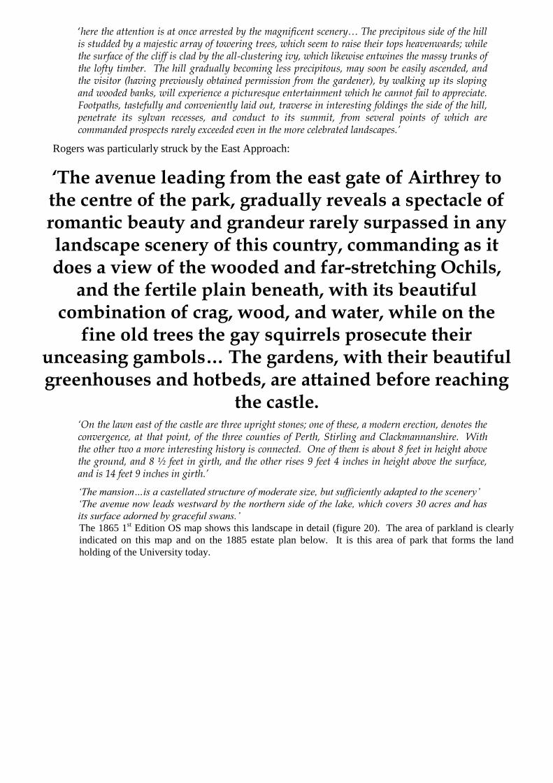
Rogers was particularly struck by the East Approach:
‘The avenue leading from the east gate of Airthrey to the centre of the park, gradually reveals a spectacle of romantic beauty and grandeur rarely surpassed in any landscape scenery of this country, commanding as it does a view of the wooded and far-stretching Ochils,
and the fertile plain beneath, with its beautiful combination of crag, wood, and water, while on the
fine old trees the gay squirrels prosecute their unceasing gambols… The gardens, with their beautiful greenhouses and hotbeds, are attained before reaching
the castle. ‘On the lawn east of the castle are three upright stones; one of these, a modern erection, denotes the convergence, at that point, of the three counties of Perth, Stirling and Clackmannanshire. With the other two a more interesting history is connected. One of them is about 8 feet in height above the ground, and 8 ½ feet in girth, and the other rises 9 feet 4 inches in height above the surface, and is 14 feet 9 inches in girth.’
‘The mansion…is a castellated structure of moderate size, but sufficiently adapted to the scenery’
‘The avenue now leads westward by the northern side of the lake, which covers 30 acres and has
its surface adorned by graceful swans.’
The 1865 1st Edition OS map shows this landscape in detail (figure 20). The area of parkland is clearly
indicated on this map and on the 1885 estate plan below. It is this area of park that forms the land
holding of the University today.

Figure 20 1st Edition OS map 1865 NLS
On this map the picturesque layout of the policies16 is clear. The serpentine loch at the centre, with
gently sloping parkland, and gently curving approaches from east and west are characteristic of this
approach to landscape design. Where trees are planted in belts, including around the boundaries of the
polices, these are irregular in outline, and the majority of the trees are widely scattered. Along the East
Drive trees are planted at some distance from each other. The immediate vicinity of the castle contains a
few widely spaced trees. The estate boundaries to the north and east are concealed by belts of trees, as is
the boundary to the west in the vicinity of the western entrance drive.
A description of the estate is recorded in a sales particulars of 188517, which includes a plan of the estate
(figure 21). At this date, the total estate was about 3100 acres imperial, including farms. The policies
are shown in pink, to the south of the plan.
16 The term is common in Scotland. The „policies‟ (from the Latin „politus‟ meaning embellished) comprise landscape areas which are laid out for aesthetic enjoyment, usually in the vicinity of a house, and often forming part of a larger estate including agricultural land, as at Airthrey. 17 1885 Airthrey Estate Particulars, T&RB Ranken WS, St Andrew Square Edinburgh, UoSA

Figure 21 Plan of the Estate of Airthrey 1885. (White line weights to hold map flat) UoSA

Figure 22 Detail of estate plan showing policies 1885 UoSA
This plan shows a slight development of the policies in a more Victorian taste. In particular, just to the south of the house a circular border with shrubs is shown, with a single tree planted very closely to the west (figure 23). Neither of these features appears on the 1880 photograph of the building.
Two small islands are shown on the loch, and there appear to be slightly more trees than on the 1865 OS. The OS Gazetteer of 1883 described the park as of „remarkable beauty, commanding superb views of the Ochils and the plain beneath them’.
Figure 23 Detail of estate plan showing possible flower border south of castle UoSA
Although by the 1880s Adam‟s symmetrical castellated house was deeply unfashionable, the 1885
Sales Particulars describe the Castle as „well suited to the character of the surrounding scenery.’ It
was in excellent order, and contained an Entrance Hall, Dining-room, Drawing-room, Library,
Boudoir, 8 Bedrooms, 2 Dressing-rooms and ample Servants‟ accommodation.
The Stabling and Offices are commodious and suitable. There are 4 Coach-houses, 2
Harness-rooms, 24 Stalls and 2 Loose-boxes, and ample accommodation for Coachmen
and Grooms.

The Garden extends to about 3 ½ acres, and has a magnificent exposure. It is well stocked and most productive with Vinery, Peach-house, Conservatories, etc. Gardeners’ Houses adjoin.
The Park, which is surrounded by a high wall and has three Lodges extends to about 315 acres imperial, and is about three miles in circumference. It is intersected by
tastefully formed Avenues and Walks, studded with stately trees, and embellished by a large Serpentine
Lake. The panoramic views from the Mansion and the lands and hills adjacent are of unrivalled grandeur.’
‘The Park is divided into enclosures, which are let annually for grazing at low rents.’
‘The Plantations on the Estate are extensive and thriving, and greatly enhance its beauty. They cover an area, outside the park, of over 620 acres, containing picturesque walks of fully 20 miles in extent.
Large portions of the lands might be advantageously feued for Building purposes, without injuring the attractions of the Estate as a residence.’
‘excellent Trout fishing which has been strictly preserved, in the Serpentine Lake within the Park, which extends to about 25 acres’
The following estate buildings were listed:
Airthrey Castle, Offices and Garden
Lodge (West Gate)
Land Steward‟s House, Garden, Croft etc
Forester‟s House, Garden, Lodge etc
Cottage (Old Logie)
Sawmill and Cottages, Pendreich
Gamekeepers‟ House and Kennels, Parkhead
3.3 Airthrey Castle 1889 – 1939
In 1889 the Airthrey Estate was bought by Donald Graham CIE (1844-1901), who brought a further
Indian-derived fortune to the estate, having worked in Bombay for a number of years. The Grahams
„built a large addition to the castle, at a cost of £15,708, and otherwise greatly improved
the grounds, cleared the loch of weeds, planted trees along its banks, ornamented the
island, put a bridge across one part, and did much more to enhance the beauty of this
lovely and delightful place18‟
18 RM Fergusson „Logie a Parish History’ 1906

Graham was the son of John Graham Esq. of Skelmorlie Castle, Ayrshire. He had been educated at Harrow and became a partner in the East Indian House of Messrs Graham, Glasgow. He married Gertrude Clara Laurence Dunsterville in 1872 and they had eight sons. His father had leased Skelmorlie from the Earl of Eglinton, and extended it in 1856 and again in 1864, adding two new wings, in an individualistic version of Scots Baronial (including Gothic dormers)19.
Donald Graham employed the architect David Thomson to extend Airthrey in 1889 and the
extensions were complete by 1891. Thomson was a prolific local architect, with an established
practice in the area and in Glasgow. The reason for the choice of architect is not clear, but because of the size of the Graham‟s family and their collection of architectural antiques, some enlargement of the house was probably essential. A detailed account of the alterations is included below at Section 4.6.1.
Landscape
It is notable that although Graham‟s extensions to the castle altered it significantly to fit a more romantic view of how a Scottish castle ought to look – asymmetrical, with a dominant tower – the alterations to the landscape were slight, and much more sympathetic. The existing combination of natural crags, woodland, parkland and loch was perhaps seen as already providing an appropriate setting for a Scottish castle.
In a photograph of 1904 (figure 24) the house is shown set in open parkland with magnificent mature trees to the east and west, and a backdrop of densely wooded hillside. The immediate setting of the house was not ornamented with borders of flowers, but climbing plants were grown over the lower levels of the basement, softening the 18th century outline.
Figure 24 View of the castle from south west 1904. Purpose of fenced area in foreground unknown. StAU
The 2nd Edition OS map of 1899 (figure 25) shows that the island was increased in size, and a boathouse, pier, and footbridge were constructed at the water‟s edge. In the pleasure grounds to the north east of the house and west of the walled garden conifers were planted to form an arboretum, and a well was added at the foot of the crag housing the stable block, close to where a small waterfall fell from the crag housing the stables and offices. These were fashionable improvements, which did not undermine the conception of the picturesque landscape.
19 The architect was probably William Railton of Kilmarnock. Further alterations were made by John Honeyman in 1876.
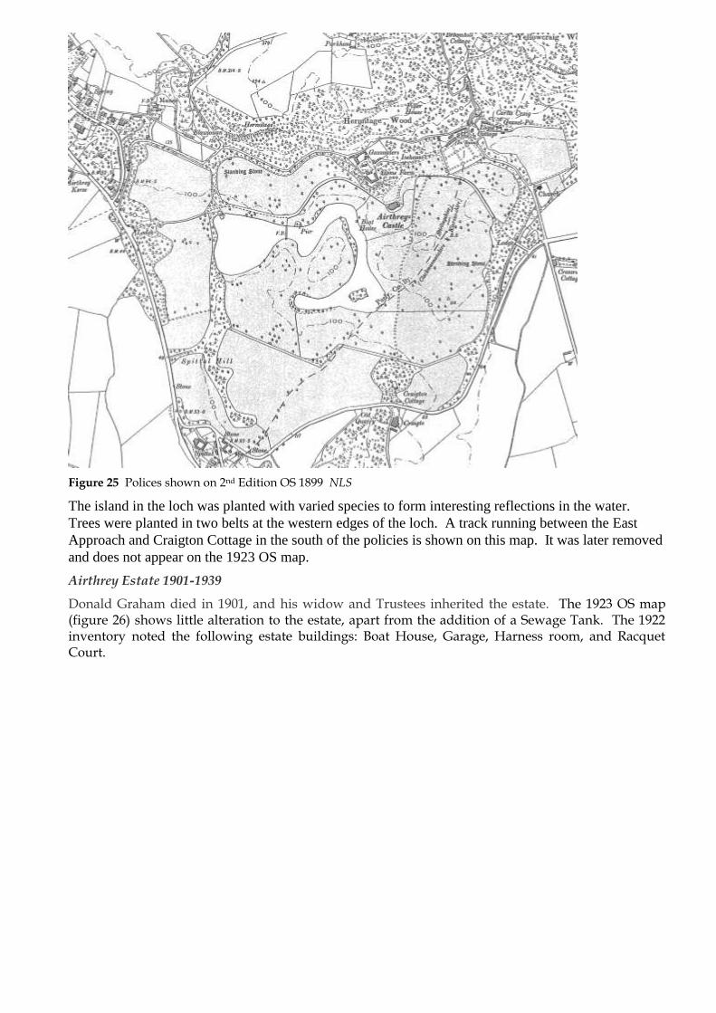
Figure 25 Polices shown on 2nd Edition OS 1899 NLS
The island in the loch was planted with varied species to form interesting reflections in the water.
Trees were planted in two belts at the western edges of the loch. A track running between the East
Approach and Craigton Cottage in the south of the policies is shown on this map. It was later removed
and does not appear on the 1923 OS map.
Airthrey Estate 1901-1939
Donald Graham died in 1901, and his widow and Trustees inherited the estate. The 1923 OS map (figure 26) shows little alteration to the estate, apart from the addition of a Sewage Tank. The 1922 inventory noted the following estate buildings: Boat House, Garage, Harness room, and Racquet Court.

Figure 26 1923 OS map NLS
3.4 Airthrey Maternity Hospital 1939 – 1969
In 1939 Mrs Donaldson offered the castle and grounds to the government as an Emergency Maternity Hospital. She herself continued to live there and assisted in its running. In 1941 she moved to a house she owned which had become vacant, leaving the whole of Airthrey Castle available for the hospital. Forty beds were now available, whereas previously there had only been room for five to ten patients. Inspection reports indicate the hospital was highly successful, with a death rate for mothers and infants well below the national average, and anecdotal reports that the mothers particularly appreciated its position away from the noise of the town. The mothers had almost all chosen to go to Airthrey, and most stayed a week before birth, some longer, and apparently wished to stay much longer. 70% of mothers were from Clydebank, which had been severely hit by enemy action, with others from Dumbarton, and evacuees from England and Wales who had settled in the area. A 1942 report from visiting Dept of Health staff and nurses reported that „in spite of the fact that it was a converted mansion house, it was surprisingly easy to run as an institution’. The report found that the women liked being at Airthrey, where they could walk in the grounds, far from the town.
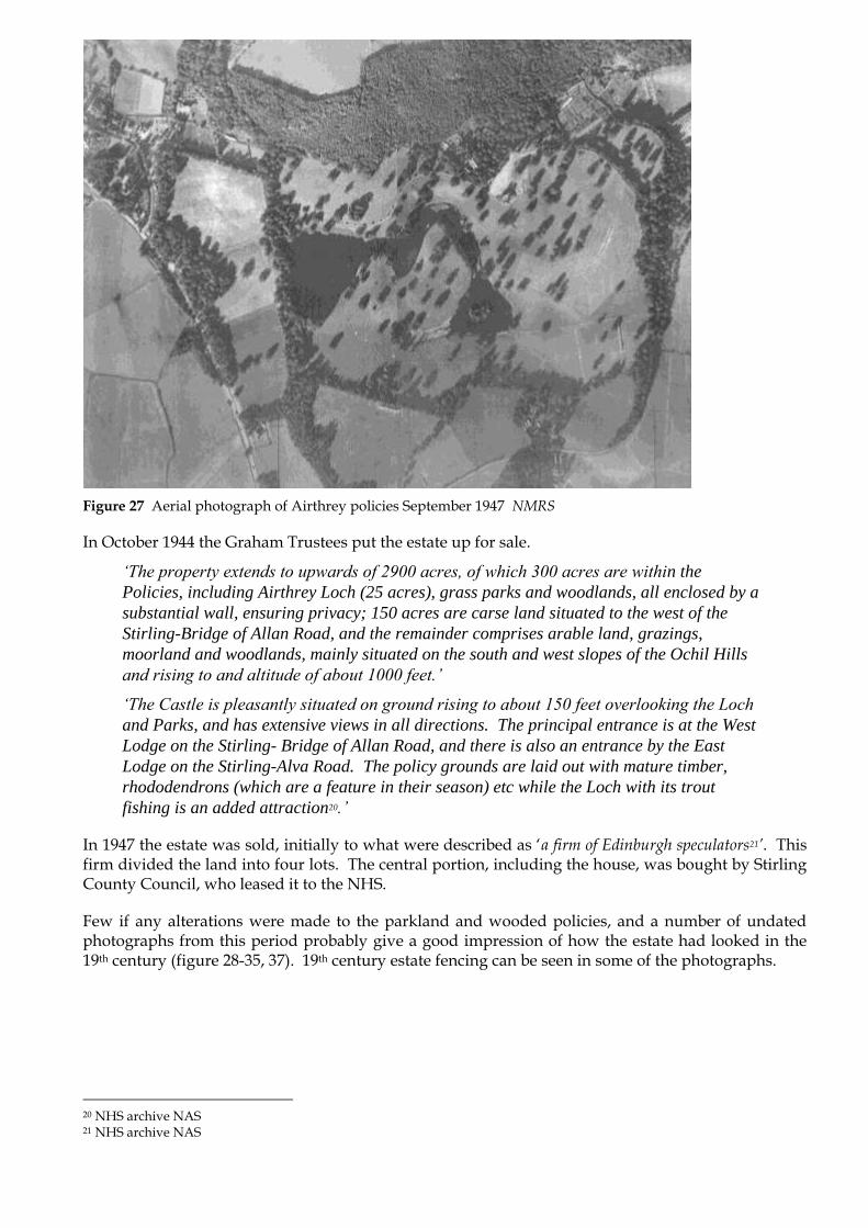
Figure 27 Aerial photograph of Airthrey policies September 1947 NMRS
In October 1944 the Graham Trustees put the estate up for sale.
‘The property extends to upwards of 2900 acres, of which 300 acres are within the
Policies, including Airthrey Loch (25 acres), grass parks and woodlands, all enclosed by a
substantial wall, ensuring privacy; 150 acres are carse land situated to the west of the
Stirling-Bridge of Allan Road, and the remainder comprises arable land, grazings,
moorland and woodlands, mainly situated on the south and west slopes of the Ochil Hills
and rising to and altitude of about 1000 feet.’
‘The Castle is pleasantly situated on ground rising to about 150 feet overlooking the Loch
and Parks, and has extensive views in all directions. The principal entrance is at the West
Lodge on the Stirling- Bridge of Allan Road, and there is also an entrance by the East
Lodge on the Stirling-Alva Road. The policy grounds are laid out with mature timber,
rhododendrons (which are a feature in their season) etc while the Loch with its trout
fishing is an added attraction20.’
In 1947 the estate was sold, initially to what were described as „a firm of Edinburgh speculators21’. This firm divided the land into four lots. The central portion, including the house, was bought by Stirling County Council, who leased it to the NHS.
Few if any alterations were made to the parkland and wooded policies, and a number of undated photographs from this period probably give a good impression of how the estate had looked in the 19th century (figure 28-35, 37). 19th century estate fencing can be seen in some of the photographs.
20 NHS archive NAS 21 NHS archive NAS
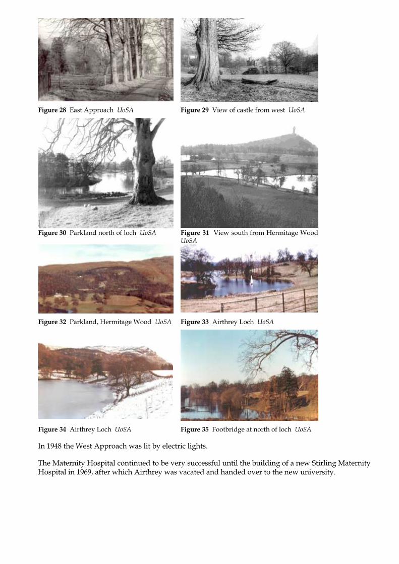
Figure 28 East Approach UoSA Figure 29 View of castle from west UoSA
Figure 30 Parkland north of loch UoSA Figure 31 View south from Hermitage Wood
UoSA
Figure 32 Parkland, Hermitage Wood UoSA Figure 33 Airthrey Loch UoSA
Figure 34 Airthrey Loch UoSA Figure 35 Footbridge at north of loch UoSA
In 1948 the West Approach was lit by electric lights.
The Maternity Hospital continued to be very successful until the building of a new Stirling Maternity Hospital in 1969, after which Airthrey was vacated and handed over to the new university.

Figure 36 Historical development of roads within the estate. Current campus map overlaid on 1st Edition OS 1865 S&B
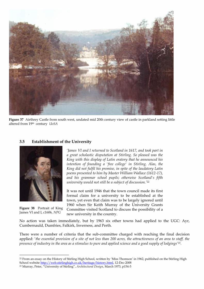
Figure 37 Airthrey Castle from south west, undated mid 20th century view of castle in parkland setting little altered from 19th century UoSA
3.5 Establishment of the University
‘James VI and I returned to Scotland in 1617, and took part in a great scholastic disputation at Stirling. So pleased was the King with this display of Latin oratory that he announced his intention of founding a 'free college' in Stirling. Alas, the King did not fulfil his promise, in spite of the laudatory Latin poems presented to him by Master William Wallace (1612-17), and his grammar school pupils; otherwise Scotland's fifth university would not still be a subject of discussion.’22
It was not until 1946 that the town council made its first formal claim for a university to be established at the town, yet even that claim was to be largely ignored until 1960 when Sir Keith Murray of the University Grants Committee visited Scotland to discuss the possibility of a new university in the country.
Figure 38 Portrait of King James VI and I, c1606, NPG
No action was taken immediately, but by 1963 six other towns had applied to the UGC: Ayr, Cumbernauld, Dumfries, Falkirk, Inverness, and Perth.
There were a number of criteria that the sub-committee charged with reaching the final decision applied: „the essential provision of a site of not less than 200 acres, the attractiveness of an area to staff, the presence of industry in the area as a stimulus to pure and applied science and a good supply of lodgings’23.
22 From an essay on the History of Stirling High School, written by „Miss Thomson‟ in 1962, published on the Stirling High School website http://web.stirlinghigh.co.uk/heritage/history.html, 12-Dec-2008 23 Murray, Peter, “University of Stirling”, Architectural Design, March 1973, p154-5

The sub-committee quickly narrowed down the shortlist to the locations within the central belt area, despite intense lobbying from Inverness, where the establishment of a university was seen as being crucial to the reinvigoration of the Highland economy. Ayr and Dumfries were also deemed unsuitable.
Of the remaining candidates, Cumbernauld was popular with many pundits, a strong contender as a result of being in easy reach of Glasgow. Nevertheless there was „a feeling at the time that Cumbernauld would be an unattractive place both for student and staff and unlikely to draw people away from the established centres’24. Perth „suffered from being too close to Dundee and St Andrews’25, and proposed an awkward site.
This left the contest between two candidates, Falkirk and Stirling. The competition between the two was fierce. Andrew Duncan, the secretary of the committee formed in Falkirk to work on the project, referred to Stirling as „just a snob town’26. Falkirk had been extremely confident of success; after all, they had collected over £1 million towards the project, a key indicator of local enthusiasm and support that was of enormous consideration to the UGC sub-committee. Falkirk was also ideally placed in the central belt, with the strong potential for a technology-focussed university with links to the industry at Grangemouth. Andrew Duncan had also been bullish enough to complain about a delay to the UGC‟s final decision to an MP: „Shilly-shally over new university decision intolerable’27.
Nevertheless Stirling „had the advantage of being a smarter location, an historical town with good middle class credentials and of having a beautiful site’28. The decision in favour of Stirling was announced on the 17th July 1964.
3.6 The Robbins Report
Lionel Robbins was a noted economist of the 20th century. Having been based at the London School of Economics from 1925, he became renowned for his work during the Second World War, advising on the economic conduct of the war, and acting as the UK delegate at conferences that took the decision to found the World Bank and the International Monetary Fund. He was also a member of the committee that negotiated the Anglo-American loan agreement of 1945 that was crucial to the recovery of the UK economy in the post-war years. He became a life peer in 1959.
The Robbins Report, published in 1963, is often referred to as the document that led to the expansion of the university sector in the UK in the 1960s. Lord Robbins, as chair of the Committee on Higher Education from 1961-64, did indeed make many recommendations, including one that the Colleges of Advanced Technologies should become universities (Strathclyde being one Scottish example).
Figure 39 1964 Portrait of Lionel Charles Robbins, Baron Robbins (1898 - 1984), NPG
24 Murray, Peter, “University of Stirling”, Architectural Design, March 1973, p155 25 Murray, Peter, “University of Stirling”, Architectural Design, March 1973 26 Murray, Peter, “University of Stirling”, Architectural Design, March 1973 27 Murray, Peter, “University of Stirling”, Architectural Design, March 1973 28 Murray, Peter, “University of Stirling”, Architectural Design, March 1973

However, with regards to the creation of new universities the report largely reflected what the University Grants Committee had already been actively engaged with since the 1950s. As an example, both Sussex and East Anglia Universities had opened prior to the publication of the Report, with York and Lancaster amongst the others already approved. Nevertheless, the report was a ringing endorsement of the UGC‟s programme, and „provoked a sensation‟29, with the government issuing a white paper within 24 hours in response. In 1963 the report „sold more copies than any other government document‟30. In the context of the establishment of the University of Stirling, the Robbins Report is crucial in that it recommend that at least one new university be built in Scotland.
3.7 The Plate Glass Universities
The term plate glass university is one that was coined by Michael Beloff in his 1968 book of the same name. Although little used today, it accurately encapsulates the era in which tertiary education in the UK expanded rapidly.
‘I had at the start to decide upon a generic term for the new universities — they will not be new for ever. None of the various caps so far tried have fitted. "Greenfields" describes only a transient phase. "Whitebrick", "Whitestone", and "Pinktile" hardly conjure up the grey or biscuit concrete massiveness of most of their buildings, and certainly not the black towers of Essex. "Newbridge" is fine as far as the novelty goes, but where on earth are the bridges? I have chosen to call them the Plateglass Universities. It is architecturally evocative; but more important, it is metaphorically accurate.’31
The foundation of the plate glass universities was to revolutionise the tertiary education sector in the UK, dramatically increasing the number of students, and changing the entire demographic of academia in general. Not only were the new universities bringing higher education to a sector of society that had not had the opportunity before, in many cases they were staffed by younger academics who embraced the unique opportunity to bring a new approach to the sector. This was not without controversy – the plate glass universities were seen as being hot-beds of student radicalism, or at least more so than older universities. At the University of Essex, which opened in 1964, student protests against Vietnam and visits by Enoch Powell and Dr Inch from Porton Down Defence Science and Technology Laboratory gained nationwide press32. The University of Stirling too saw student protest against a visit by the Queen in „who was subjected to four letter abuse and rude suggestions as to her lineage [which] put Stirling firmly on the map along with most of the other green field campuses as centres of student unrest‟33. This resulted in much criticism both in the press and amongst locals, with students even being barred from local buses in riposte.
These controversies proved however that the plate glass institutions were radical in more ways than one: the student rebellions not just acts of defiance against „the establishment‟, but a reflection of the new universities‟ differing stance in society:
‘The role of Plateglass in reviving a belief in the need for and virtues of higher education is especially important. Plateglass universities gives the lie to the view that universities are conservative, unchanging institutions. In syllabuses, examinations, teaching methods, administration, discipline, they have taken new initiatives.’34
29 http://www.lse.ac.uk/resources/LSEHistory/robbins.htm, 05-Dec-2008 30 McKean, John Maule, “RMJM at Stirling”, Architectural Review, 1973, p360 31 Beloff, Michael, The Plateglass Universities, 1968, p11 32 http://www.essex68.org.uk, 05-Dec-2008 33 Murray, Peter, “University of Stirling”, Architectural Design, March 1973, 34 Beloff, Michael, The Plateglass Universities, 1968, p207

Figure 40 The Queen speaking with student in the library during her visit, Tom Cottrell to her right, October 12 1972 Scotsman
Figure 41 Student Jack Carter drinking wine from bottle as the Queen passes on bridge, October 12 1972 Scotsman
3.8 Expansion of the University Sector in the UK
Until 1822 there had been only six institutions – the 19th century saw the addition of a further seven universities, with another five following in the first decade of the 20th. Reading was established alone in 1926, with a further five in the 1940s and 50s. Thus, prior to the wave of new universities that included Stirling, there were only 24 universities in the UK35, falling broadly in to the terms ancient and red-brick.
The plate glass expansion saw the creation of a further 24 universities, therefore doubling the UK total to 48 by 1969. With the addition of the Open University in 1969, the private University of Buckingham in 1976, and the merger of St David‟s College under the umbrella of the federal University of Wales there was a total of 49 universities by the end of the 1980s. The Further and Higher Education Act of 1992 saw the next big expansion, with 38 former polytechnics becoming universities almost immediately. Further expansion took place in the 21st century, with the current total standing at 109 universities36.
Figure 42 Graph showing growth of number of UK universities.37 S&B
35 There were a number of universities that were merged or demerged, but this total refers to the number as existing immediately prior to the plate glass expansion. 36 As of August 2008, according to http://www.universitiesuk.ac.uk/, 28-Nov-08. However this total counts the federal Universities of London and Wales as single institutions, despite some constituent institutions having been granted independent status. Some such institutions are yet to fully devolve, and/or grant their own degrees. 37 Numbers shown include applicable mergers and demergers, but not the recent demergers from federal universities.

3.9 Contemporary Comparisons with other University Campuses
Prior to the completion of the final Development Plan at the UoS, the Interim Development Committee visited a total of ten universities between the 29 January and 3 February 1967. The principal Tom Cottrell wrote a detailed report, which at the time was confidential, detailing their thoughts and findings from the trip. John Richards from RMJM accompanied the Committee.
The ten universities that the Committee visited, in order, were: Nottingham, Warwick, Oxford, Southampton, Sussex, Kent, Essex, East Anglia, York and Durham. This gave the Committee a variety of institutions from Ancient to Plate-glass, concentrating on the latter for closer comparison.
Figure 43 The University of Nottingham‟s Trent Building. Dr Eric Ritchie/Images of England
3.9.1 Thematic Comparisons
I Development Plans
Cottrell noted that of the six new universities visited, Sussex and Kent did not have development plans: „they originally had layout plans of the individual buildings, which were followed by rather general zoning ideas, derived from what had already been put on the ground.‟ Essex and East Anglia „had plans which appear to have been conceived primarily in architectural terms: the university was essentially conceived as a building, or a closely interlocking series of buildings.‟ Furthermore, „the remaining two universities, York and Warwick, had abstract development plans. The York plan is of a mainly collegiate university… [with] specialised buildings… interspersed, more or less at random, among the colleges. The Warwick plan is denser.’ Overall, Cottrell seemed to have been quite satisfied that Stirling had embraced the idea of a development plan
ii Preliminary Buildings
Another key aspect for the visits was to note how each of the new universities had managed the initial intake of students and the preliminary buildings. Although by the time of the visit Pathfoot was already under construction, Cottrell was interested to see how initial buildings had been used after the completion of further buildings. Both Kent and York used existing buildings on the site in conjunction with a building in the respective town centres – „presumably [to] be disposed of when they are finished with it” and the benefit that the “preliminary building problem is out of sight to the visitor [to the permanent campus]‟.
Warwick, Essex and East Anglia all had preliminary buildings on or close to the site. At Essex, these were cheap huts, which although the „cost will have been small‟, there was a knock-on effect in that unrealistic schedules were placed on the construction of rest of the university. East Anglia provided preliminary buildings that housed 800 students – buildings that were „too extensive to throw away‟,
yet for which an alternative use had yet to be found. Cottrell was also critical of the distance between the preliminary and main buildings, and heavy maintenance costs that would be incurred in order to accommodate future use. Cottrell was impressed by the preliminary buildings at Warwick, which seemed to be similar in nature to Pathfoot. They were close to the main buildings, intended to continue to house a growing department, and incorporated a common room which was to remain in use.
iii Student Residences
Cottrell noted that the traditional halls of residences, arranged with study-bedrooms, dining-rooms with high tables for formal dinners, libraries and common rooms for each hall, was being phased out, and did not appear at any of the new universities. There was however the notable exception of Nottingham, where, paradoxically, the university authorities said it was proving popular.
Separation of males and females was largely done on a floor-by-floor basis, with joint communal restaurants and/or common rooms. Nottingham was again a notable exception with male and female halls being at opposite ends of the campus, with the result that „undesirable characters from the town tend to hang around the women’s halls, without the deterrent of having men to deal with as well’. Cottrell highlighted the pattern of flats of 5-6 students with common pantries, with restaurants nearby as being the ideal. He noted that „we saw a horrible example in Southampton, where 22 students shared a pantry and the nearest restaurant is a mile away’.
Cottrell noted that students appeared to enjoy doing their own cooking, but qualified that by noting that they „had not been at it for very long, and this may pall; therefore easy access to good restaurants may be important in the long run.‟
iv Student Facilities
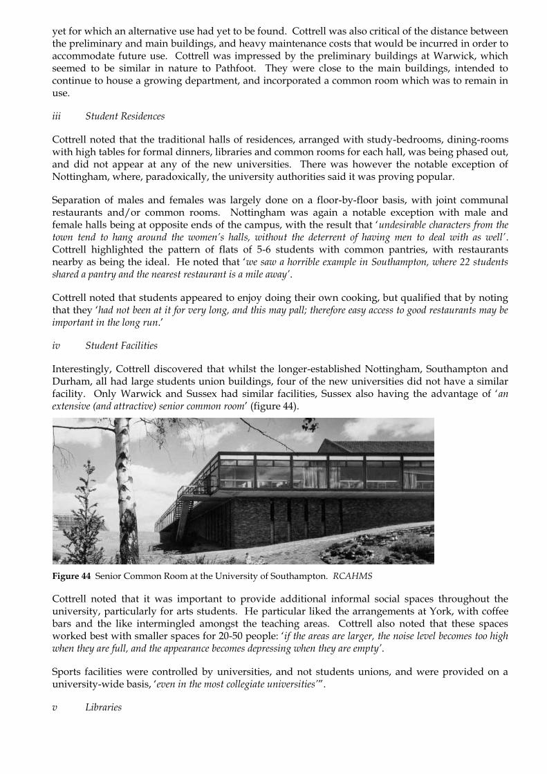
Interestingly, Cottrell discovered that whilst the longer-established Nottingham, Southampton and Durham, all had large students union buildings, four of the new universities did not have a similar facility. Only Warwick and Sussex had similar facilities, Sussex also having the advantage of „an extensive (and attractive) senior common room‟ (figure 44).
Figure 44 Senior Common Room at the University of Southampton. RCAHMS
Cottrell noted that it was important to provide additional informal social spaces throughout the university, particularly for arts students. He particular liked the arrangements at York, with coffee bars and the like intermingled amongst the teaching areas. Cottrell also noted that these spaces worked best with smaller spaces for 20-50 people: „if the areas are larger, the noise level becomes too high when they are full, and the appearance becomes depressing when they are empty’.
Sports facilities were controlled by universities, and not students unions, and were provided on a university-wide basis, „even in the most collegiate universities’”.
v Libraries

Cottrell particularly liked the libraries at Sussex, Warwick and York, in that order, despite their very different architectural treatments. Externally, he preferred York, designed by RMJM.
vi Costs
John Richards made notes on the costs and standards of each university that was visited. „One important general point was very obvious. Since the initial Sussex building, there has been a general decline in the standard of quality in the buildings provided from UGC funds. Both the appearance and wearing properties have suffered.’
3.9.2 Key Observations from individual Universities
i Nottingham
In addition to the wide-separation between male and female halls, the teaching areas were also widely separate, with five minutes between science and social science, and between social sciences and arts. Cottrell wrote that „apart from the science area… the architecture is dull and pompous to a degree, and unredeemed by the interior decoration.’
In discussion with the Vice Chancellor, it was noted that „conference letting must be taken into account‟ when designing student residences. The Vice-Chancellor also said she „saw signs already… of a swing in popularity from student flats back to traditional halls of residences’, though Cottrell pointed out that „she did not discuss a third possibility; of student flats in close association with university restaurants’, which is the approach ultimately taken at Stirling.
Traffic and parking was already proving to be a problem at Nottingham, largely because of students having to return to halls for lunch, and the dispersed nature of the site. Parking was limited to 3rd year and postgraduate students, and card had to be registered. Despite there being only 1339 registered cars (including staff), Cottrell quoted a figure from a day in 1966 when there were 1850 parked cars on site in Nottingham. Although including some visitors, it was also a result of unauthorised student usage. Cottrell was clearly interested in the potential impact for Stirling. He noted that in 1965, the ratio of male students with cars to females with cars was 10:1, and that it was likely this would even out in future, resulting in even more cars on campus.

ii Brasenose, Oxford
One feature of Brasenose College that was of particular interest to John Richards was the „traditional Oxford staircase layout‟ of the Powell & Moya accommodation blocks („staircase‟ being just a reference to a collection of rooms, ie „flat‟).
Powell & Moya „were commissioned "to fit in, squeeze in, as many rooms as you can without being antisocial about it" into a backyard full of bicycles. They showed that a British firm could build an accomplished modern design that also harmonised with its historic surroundings’38. Cottrell mentioned that „this is the sort of thing he’d like to do for Stirling’.
The complex elevations, and the rich materials (Portland stone and lead cladding) of these building, however well liked by Cottrell and Richards, was not something within reach of the University of Stirling‟s budget.
Figure 45 Powell and Moya accommodation blocks built at Brasenose College, Oxford. English Heritage NMR
The accommodation blocks, completed in 1961, were listed by English Heritage at Grade II* in 1998.
iii Southampton
Figure 46 Arts Building (left) and the Nuffield Theatre at the University of Southampton. RCAHMS
At Southampton, „the Vice-Chancellor stated that the theatre had been of great value in achieving good relations between the university and the town’ – exactly what Cottrell was aiming to achieve at Stirling.
38 „Sir Philip Powell‟ (Obituary), The Independent, 9-May-2003

The Nuffield Theatre was designed by Sir Basil Spence, and opened in 1964 as a key component in the university‟s new campus39.
iv Sussex
„The suggestion of having visiting painters in the Stirling Arts Centre is one we might usefully consider’
‘The social building supplies a range of restaurants, a range of sizes of rooms, and provision for other activities… Incidentally, within the teaching buildings there are small staff-student common rooms… and these are much appreciated. This makes me wonder if the initial Stirling development plan has said enough about social space, and has included enough at the outset.‟
The increasing pressure to lower development costs by the UGC was not new to Stirling – at Sussex „the progression of buildings shows very clearly that the expenditure limits in relation to the cost of building had been much more generous for the initial buildings at Sussex than they later became’.
Figure 47 University of Sussex, with the central meeting hall in the foreground. RCAHMS
When referring to Sir Basil Spence‟s buildings at Sussex, John Richards noted „that their appearance belongs essentially to a former generation, and that increasingly stringent cost limits would make it impossible to continue building in the same style, or would result in poor quality buildings which copy the Spence mannerisms without having their quality; there are already signs that this is happening’
Furthermore Cottrell stated that „We came away with a feeling that it would be very nice to be a student at Sussex – much more so than at Nottingham, Warwick or Southampton: but that in terms of its physical organisation and planning, Sussex was perhaps the last of the old universities rather than the first of the new.‟
vi Essex
“There is no doubt that the place looks rather fine: unlike Sussex it is of its age; unlike Kent it is not eccentric.”
Figure 48 shows the contrast between the low-rise central buildings and the residential towers.
Figure 48 Oblique aerial view of the University of Essex
vii East Anglia
Cottrell was disappointed by what he saw at East Anglia: being „perhaps in the least satisfactory state of all the universities that we visited’. This was largely as a result of the lateness of completion of the main buildings, with the end result that „mud, contractors’ men, contractors’ plant, students, staff, and service deliveries to the occupied buildings were all mixed up. Among other things, this means that it is impossible to keep the buildings clean, and standards of maintenance have dropped to a point at which deterioration is setting
39 It is now an independent producing theatre.

in before the buildings are completely occupied’. This was an interesting observation: the University of Stirling was also to experience difficulties with delayed buildings, building works and mud, albeit on a far less critical scale.
Figure 49 University of East Anglia with the distinctive forms of the residential accommodation. Multimap
Nevertheless, despite these problems, Cottrell‟s impression of the residential accommodation „was favourable’. Furthermore, „the general impression of the buildings from a distance is good: J.D.R. put it higher than that, but I found the slightly lunar landscape effect of all the concrete unrelieved by landscaping a bit oppressive’.
viii York
‘The visual impression of York on approaching it from a distance… is one of amorphous drabness, rather like a council housing estate… On the other hand, close up, the feeling was rather pleasant... To have the buildings finished in time, and the immediately surrounding area
tidied up and landscapes, before the buildings are occupied, makes a very important contribution to the well-being of the university… It looked as serene as
Sussex’ Cottrell also describes an intriguing system set up at York to counter the perceived remoteness of many teaching departments from the library: CCTV. He describes how „a member of department telephones the library, giving the exact reference he wishes to consult… The ‘reader service’ assistant finds the reference and places it under a TV camera so that the book can be read at a TV screen in the department.‟

Figure 50 University of York with the central hall in the foreground. Scran
3.9.3 Summary
Cottrell drew four main conclusions from the visits:
Nothing we saw indicated that the general basis of the Stirling Development Plan was unworkable: on the contrary, it seems to avoid some of the difficulties experiences elsewhere.
The distribution of social and study space around the university merits more careful consideration than we have so far given it.
Programming building work to give ample time for completion and landscaping before occupation is of the utmost importance.
The planned use of works of art can make a very considerable improvement to buildings. It might well be worth earmarking some of the appeal for this purpose.”
3.10 Development Planning
It is perhaps surprising that a Development Plan was not at the heart of all the new universities that were
constructed in the 1960s and 70s. However Professor Cottrell‟s visits to other universities in 1967 (see 3.9)
highlighted that, as a generalisation, other universities depended on either teaching plans alone, thus building
new accommodation as required, or went to the opposite extreme and commissioned great architectural plans
that they then fitted the university into. After seeing at first-hand the problems that had arisen from each
approach, he was satisfied that Stirling had taken a better approach – perhaps not an altogether surprising
conclusion.
The UoS Development Plans were thorough, yet concise and clear in intention. After identifying how the site at Airthrey could be used, and where different types of building were best located, the development plans then laid out a clear plan to manage the University‟s growth right through to the end of the 1970s and beyond.
1966 Interim Development Plan

The Development Plan of 1966 is the first document to be considered. This was prepared by RMJM and presented in December 1966. This was a crucial stage in the development of the University and the impact that it would have on the Airthrey Estate. The collaborative nature of this interim plan was stressed early in the report stating that it was “based on an intensive series of discussions between the University and its planning architects over the past year. In this process it was found that architectural, social and educational ideas were developed side by side.”
One such discussion was based on density study material produced for a meeting in July 1966. This considered the constraints of the site, zoning, floor-space requirements, and social groupings.
One of the first clear decisions to be made was that the University would be built around, and centred on Airthrey Loch (figure 51).
A site plan with walking distances then showed the approximate development area (figure 52). Although the centre point of the University campus is in a different
location than shown in this diagram
Figure 51 1968 schematic diagram showing how the University should develop around the loch. UoS
(further west), the principle is clearly demonstrative of what was actually built. This diagram highlights the concern of Cottrell to avoid problems experienced by other universities that had developed on a more piecemeal basis on similar sites. He had found on visits to other universities that there were sometimes great distances to be travelled between residential, dining, teaching and recreation spaces – often resulting in either enormous inconvenience to students and staff, but even traffic problems as car use increased within the campus.
Whilst developing around the loch was practical, and indeed aesthetically pleasing, the „bowl-shaped‟ nature of the surrounding land was always going to be more difficult and expensive to build on than flatter land on other parts of the estate. To build on the flat land, although perhaps cheaper, would have rendered the campus ineffective and inconvenient. The „bowl‟ also offered the possibility of acting as a natural amphitheatre – an arena where all the various functions of the university would group together, and one which maximised effective use of daylight (figure 53).

Figure 52 Diagram from 1966 discussion material showing walking distances. UoS
Figure 53 Diagram from the 1966 Interim Development Plan showing north-south section through the site. Note the decision to place the residential buildings on the south-facing slopes, and the teaching buildings on the north-facing slope. UoS

The relationships between the different functions of the university were studied in a zoning study (figure 54). Despite being captioned as showing „notional zoning relationships‟, the layout of the diagram is unmistakably related to the final layout of the RMJM masterplan, and it could therefore be argued that the diagram resembles a schematic plan of the campus.
Further studies identified the relationships between various social groupings, for example how on-campus resident and non-resident students would use the campus (figure 55).
Figure 54 Diagram from 1966 discussion material showing notional zoning relationships. UoS
Figure 55 Diagram from 1966 discussion material showing social groupings study. UoS
The discussion document from 1966 also shows an early study of the space requirements of the
individual components of the University and how this could fit within the constraints of the site. Three
diagrams were shown – one showing the site constraints, one showing the space requirements (figure
56) and a final image showing a combination of the two (figure 57).
Coupled with the other diagrams, the final form of the University begins to appear, well in advance of any architectural drawings having been produced.

Figure 56 Diagram from 1966 discussion material showing the space required for residential, communal, library and study space, and teaching areas. UoS
Figure 57 Diagram from 1966 discussion material showing the effect of site constraints on floor space requirements UoS
Note how even at this early stage, most functions are broadly in the locations shown here, with the
notable exception of „O‟ and „P‟ (Sports Hall and Pavilion) which are shown to the east of Airthrey
Loch. Students‟ Residences („F‟), Library („Q‟), Principal‟s House („C‟) and Staff Housing („A‟),
Teaching („S‟, „T‟, „U‟ & „V‟) and Arts Centre („N‟) were all located where shown. Not also that
Airthrey Castle is not shown – at this date it was still a maternity hospital.
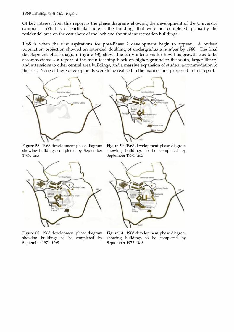
1968 Development Plan Report
Of key interest from this report is the phase diagrams showing the development of the University campus. What is of particular note is the buildings that were not completed: primarily the residential area on the east shore of the loch and the student recreation buildings.
1968 is when the first aspirations for post-Phase 2 development begin to appear. A revised population projection showed an intended doubling of undergraduate number by 1980. The final development phase diagram (figure 63), shows the early intentions for how this growth was to be accommodated – a repeat of the main teaching block on higher ground to the south, larger library and extensions to other central area buildings, and a massive expansion of student accommodation to the east. None of these developments were to be realised in the manner first proposed in this report.
Figure 58 1968 development phase diagram showing buildings completed by September 1967. UoS
Figure 59 1968 development phase diagram showing buildings to be completed by September 1970. UoS
Figure 60 1968 development phase diagram showing buildings to be completed by September 1971. UoS
Figure 61 1968 development phase diagram showing buildings to be completed by September 1972. UoS

Figure 62 1968 development phase diagram showing buildings to be completed by September 1973. UoS
Figure 63 1968 development phase diagram showing Phase 3 buildings. UoS
The proposed growth of the teaching block (Cottrell) along the principle of the „spine and rib‟ model was demonstrated in the 1968 report. More often identified as the ladder-plan layout once completed, the diagrams demonstrated not only the direction of intended growth (i.e. south, east, and west), but the way that this growth was related to the relationship between the different teaching subjects and the gradual movement from the Phase 1 building (Pathfoot).
Figure 64 Diagram from 1968 Development Plan Report showing the proposed growth of the main teaching block, now known as the Cottrell building. UoS

1973 Phase 3 Development Plan
Development plans from January 1973, also published by Architectural Design in March of the same year, show the phases completed to that point, the proposed expansion up until 1975 (considered as completion of Phase 2), and the undated expansion in Phase 3 (figures 65-68). This development plan shows the buildings as we can recognise them today, and charts the actual growth of the University up to this date, as opposed to the theoretical growth demonstrated in the earlier plans. Figure 68 shows what was intended to be built by 1975 – note the additional drive to the east, a residential block east of Airthrey Castle, the student centre projecting north-east from the central buildings, and a link bridge to the south from the Cottrell building.
Figure 65 1973 development phase diagram showing buildings completed by 1970. Architectural Design
Figure 66 1973 development phase diagram showing buildings completed by 1971. Architectural Design
Figure 67 1973 development phase diagram showing buildings completed by 1972. Architectural Design
Figure 68 1973 development phase diagram showing buildings intended to be completed by 1975. Architectural Design

Figure 69 1973 development phase diagram showing Phase 3 buildings. Architectural Design
Figure 69 shows the buildings intended to be completed by 1975 with the addition of the projected Phase 3 buildings. Of particular note is the extension to the west of the library. It appears from the diagram that the west elevation of this extension would be in line with the west elevation of Cottrell building, which would have created a gateway entrance that is almost urban in character. The positioning of the second teaching block to the south of the Cottrell building, and the link bridge between also explains the positioning of the Logie lecture theatre, which seems odd without this block. Further extensions are shown to the student centre, and a second bridge over the loch was proposed, leading to a major expansion of student residences in the east portion of the campus.
Growth in Student Population
The development plans worked to the report of the Academic Planning Board (from December 1965) which had set out the programme of growth in student numbers that could be realistically accommodated: „a population of 3,000 undergraduates, 500 postgraduate students and about 450 staff, to be reached in ten years or earlier, should be aimed at‟.
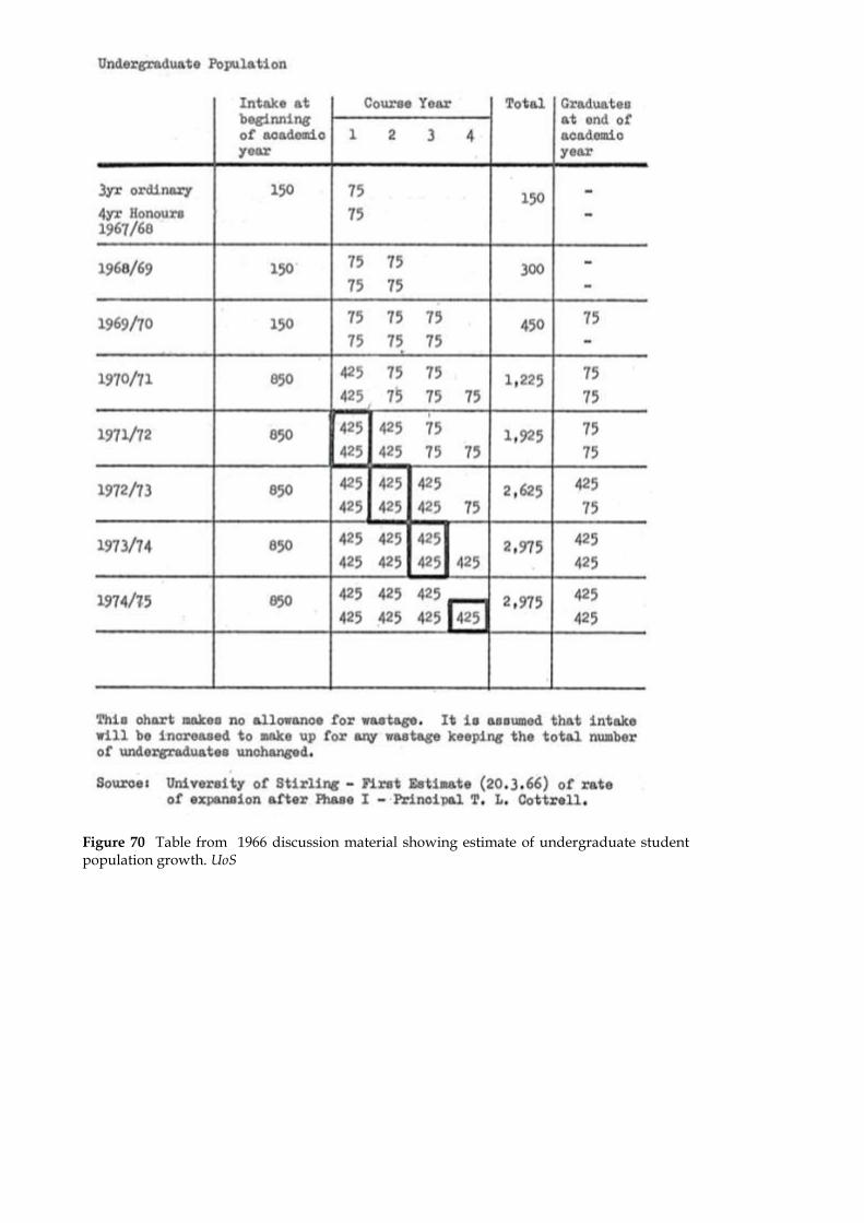
Figure 70 Table from 1966 discussion material showing estimate of undergraduate student population growth. UoS

Figure 71 Table from 1968 Development Plan showing revised estimate of undergraduate student population growth, and Phase 3 growth to 1980/81. UoS
Phase 1 Development
In terms of student numbers, this phase represented the initial three years of student intake, projected at c.150 undergraduate students per year (figure 71). After reviewing other universities, and their initial development strategies, the University decided that a permanent building would be preferable to a temporary one – the building that represented this first phase was Pathfoot (see 4.1). The gradual intake allowed for Pathfoot to be completed in stages: although it opened in September 1967, it was not completed until the following year, in time for the second intake.
Phase 2 Development
From 1970 the student intake was proposed to grow to c.750 per annum, taking the university up to around 3000 undergraduate students. This was to be the design capacity of the Phase 2 buildings.
Phase 2 was constructed from west to east, taking construction works away from the functioning university at Pathfoot. The central area, first part of the Cottrell building (see 4.2) and the first of the residences were to be built in readiness for the increased intake. As it happened, the campus was still a construction site, with students needing to be bussed to alternative accommodation as far away as Callander.
Phase 2 was planned before construction of Phase 1 commenced, as a necessity of the timetable. This also meant that post-Phase 1 use of Pathfoot had to be considered at the same time as Cottrell recognised: „Paradoxically, at the same time as I can announce that contracts have been let for Phase 1, we are considering how the transition from Phase 1 to the next phase will be made‟40.
Phase 3 Development
40 Address of Principal to the Members of the University of Stirling Ltd, on 20th October 1966, University of Stirling Archives

Phase 3 was the planned completion phase of the University estate, taking the establishment beyond 3,000 students – with the projected capacity of 6,000.
The Phase 3 extension of the University accommodation was never realised in the form originally conceived. The University now has 7,653 undergraduates and 2,668 postgraduates, the large majority of which are based at the Stirling campus.41
Finance
In 1966 Tom Cottrell addressed the members of the University of Stirling Ltd, giving an update on progress. He stated that he believed that the cost of the University at the completion of Phase 2, with 3,000 students, would be at least £8million (an equivalent investment today of around £290million42). Of this he expected the UGC grant to be a total of £6.25m, split over approximately six years. This left a clear shortfall to be met by the University‟s fundraising efforts, and had obvious implications on the construction schedule.
The University Appeal Committee was formed with the onerous task of attracting a significant amount of donations from individuals, industry, and trusts. After a campaign director was appointed, the appeal was officially launched in May 1966. The first subscription list, advertised in the Glasgow Herald in the same month showed considerable early success in attracting just over £1million towards the appeal target of £2million. The largest contributor towards the appeal was the MacRobert Trust with a donation of £250,000 – hence the naming of the Arts Centre. The Gannochy Trust appeared in the third subscription list, advertised in 1968, with the next largest donation of £100,000. This donation was recognised in the naming of the Sports Centre. The three published subscription lists are shown in Appendix X.
‘The appeal objectives were met in full as far as residential, cultural, religious, sport and recreational facilities were concerned and in allowed the University’s physical development plan to be taken forward in a positive and creative way.43‟
Later, in 1972, Cottrell emphasised how important this source of funding had been:
‘The response to the University’s Foundation Appeal enabled it to make progress at a rate which would have been impossible had it been necessary to rely solely on government finance. The value and importance of an independent income to the University cannot be overestimated as it gives a far greater degree of flexibility both in teaching and research and in physical development.‟44
The funding and government crisis of the late 1970s meant that the Phase 3 expansion of the University of Stirling was not viable. Coupled with this, the mood had turned against the new plate-glass universities, with calls even being made towards the end of the 1970s to close some of them. The dramatic cut in funding in the early years of the Thatcher government affected all universities, but it hit the new ones hardest. In subsequent years the University grew beyond even the 6,000 capacity first foreseen, despite far less additional accommodation being constructed than had been planned for that smaller figure. This was a phenomenon common to most UK universities.
3.11 Landscape Design
41 http://www.external.stir.ac.uk/visitor_info/about/facts/index.php, accessed 04-Jun-2009 42 http://www.measuringworth.com/ukcompare/result.php# - Calculator used is „Share of GDP‟ – measuring the University project in its value to the country as a whole in comparison with other major projects. 43 Bomont, R.G’The University of Stirling, Beginnings and Today’, p16 44 Cottrell‟s forward to “University of Stirling: A Survey – 1972” a report by Mr Hugh Hanning

The architects‟ approach to both the natural and the designed landscape of the Airthrey estate was highly sensitive for the time. Two landscape architects were involved: Frank Clark, at Pathfoot, and for the overall landscape, a young designer, Ed Hilliard. Stirling was to be his first project.
Approach to planting 1960s-70s
Unlike the architectural designs for the buildings, which were intended to be developed and expanded, the intentions for the planting was to create an instant effect, using plants with a comparatively short lifespan. This approach was in some ways similar to the late 18th century design, which also called for „instant‟ landscaping. Then, the effect had been achieved by moving mature trees from one spot to another, rather than planting fast-growing or smaller species. In other ways, however, the principles followed by Hilliard were in marked contrast to the existing designed landscape, in particular his approach to colour.
The five design principles used by Hilliard have been outlined as follows:45
1) to use and reinforce „the existing natural boundaries of landform, water and tree blocks as elements of continuity threading through the site‟
2) planting was to progress from west to east, coordinating with the building programme and minimizing disturbance to the existing landscape
3) colour was to be provided throughout the year, mainly through trees with seasonal changing leaf colour. Specific design for the flowering season of native cherry and hawthorn
4) to achieve a rapid, apparently mature effect through mass planting with strong blocks of colour from low level shrubs and ground-cover, mainly using white and yellow flowering species
5) to keep maintenance to a minimum. „the overall effect was of a parkland with large areas of grass framed by buildings and bold blocks of planting.‟ Mowing strips adjacent to buildings, with steep slopes planted with ground cover and shrubs, which required intensive short-term maintenance and the shrubs annual pruning - „this demonstrates a frequent problem in planting design: the conflicting demands for immediate impact, low maintenance and floristic interest‟
This approach is now considered to be characteristic of the 1960s-70s response to the existing landscape. The response to a significant 18th century landscape by an architect in 2009 would be different.
Campus landscape post 1970s
While the achievement of the architects in creating flexible and aesthetically attractive campus buildings was clear over succeeding decades, the individual components of the early 1970s planting schemes were to prove less resilient. Hilliard used fast-growing shrubs, planted very close to buildings, which rapidly led to security problems around the students‟ residences. The great majority of these were removed. It also became clear that Hilliard‟s approach to colour in the landscape would compromise the purity of the original designed landscape, which contained only green grass and green-leaved trees.
Like all designed landscapes, the continued appearance of Airthrey‟s open parkland with scattered mature trees, as laid out in the late 18th century, was the result of a careful maintenance programme.
45 S Filor „The Process of Landscape Design’ 1991
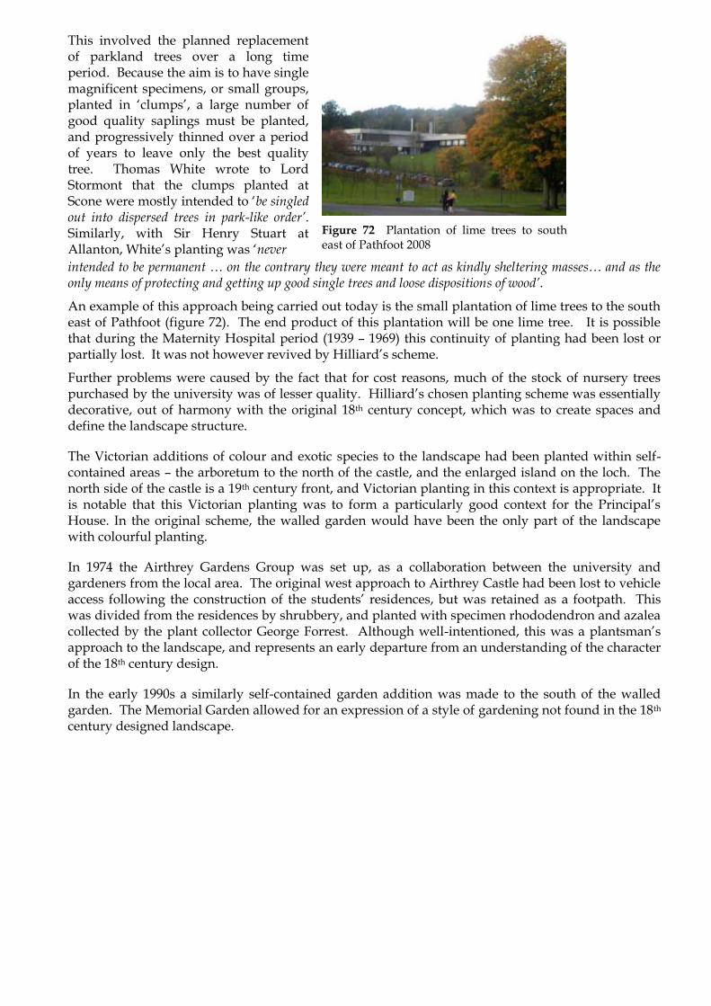
This involved the planned replacement of parkland trees over a long time period. Because the aim is to have single magnificent specimens, or small groups, planted in „clumps‟, a large number of good quality saplings must be planted, and progressively thinned over a period of years to leave only the best quality tree. Thomas White wrote to Lord Stormont that the clumps planted at Scone were mostly intended to „be singled out into dispersed trees in park-like order’. Similarly, with Sir Henry Stuart at Allanton, White‟s planting was „never
Figure 72 Plantation of lime trees to south east of Pathfoot 2008
intended to be permanent … on the contrary they were meant to act as kindly sheltering masses… and as the only means of protecting and getting up good single trees and loose dispositions of wood’.
An example of this approach being carried out today is the small plantation of lime trees to the south east of Pathfoot (figure 72). The end product of this plantation will be one lime tree. It is possible that during the Maternity Hospital period (1939 – 1969) this continuity of planting had been lost or partially lost. It was not however revived by Hilliard‟s scheme.
Further problems were caused by the fact that for cost reasons, much of the stock of nursery trees purchased by the university was of lesser quality. Hilliard‟s chosen planting scheme was essentially decorative, out of harmony with the original 18th century concept, which was to create spaces and define the landscape structure.
The Victorian additions of colour and exotic species to the landscape had been planted within self-contained areas – the arboretum to the north of the castle, and the enlarged island on the loch. The north side of the castle is a 19th century front, and Victorian planting in this context is appropriate. It is notable that this Victorian planting was to form a particularly good context for the Principal‟s House. In the original scheme, the walled garden would have been the only part of the landscape with colourful planting.
In 1974 the Airthrey Gardens Group was set up, as a collaboration between the university and gardeners from the local area. The original west approach to Airthrey Castle had been lost to vehicle access following the construction of the students‟ residences, but was retained as a footpath. This was divided from the residences by shrubbery, and planted with specimen rhododendron and azalea collected by the plant collector George Forrest. Although well-intentioned, this was a plantsman‟s approach to the landscape, and represents an early departure from an understanding of the character of the 18th century design.
In the early 1990s a similarly self-contained garden addition was made to the south of the walled garden. The Memorial Garden allowed for an expression of a style of gardening not found in the 18th century designed landscape.

Figure 73 Aerial view of campus 1972 UoSA
A Golf Course was laid out to the south of Airthrey Castle, including a large number of coniferous trees and shrubs which were planted without apparent reference to the 18th century style views to and from the castle.
Other areas of the campus were also planted with coniferous and colourful species which have unfortunately blocked important views, both of Airthrey Castle – the original focus of the picturesque designed landscape – and of the main campus buildings, whose original design and layout had been so sensitive to the picturesque aesthetic. An aerial photograph of 1972 (figure 73) shows the relationship between the landform and the buildings. At that date the new campus buildings and the 18th century castle were both set in picturesque open parkland, with long views to and across the loch, uninterrupted by smaller trees.
Views between the loch and the residences to the north had not yet been blocked by tree growth, and the setting of Airthrey Castle in open parkland with mature trees was still the same as it had been in the late 18th century.
The university‟s policy of adding sculpture to the landscape has taken effect primarily in the area to the east of the Andrew Miller building and these make a positive contribution to an area largely seen from that building. It is advisable that a scheme for locating future works in the landscape should be planned so that a pattern might be established, in the same way that future tree planting should be part of the overall landscape design.

Figure 74 Coniferous shrubs to the north east of Airthrey Castle 2009
Figure 75 Parkland south east of Airthrey Castle, with mature oak tree and open grassland. Smaller trees, including flowering species, blocking views to the castle 2009
Ecological assessment
The original landscape design of the late 18th century consisted of grassland with scattered trees from a relatively narrow range of native species. Policy woodland would have been managed to retain open vistas and views, with undergrowth generally cleared away.
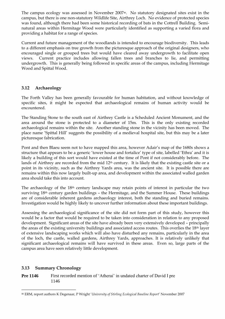
The campus ecology was assessed in November 200746. No statutory designated sites exist in the campus, but there is one non-statutory Wildlife Site, Airthrey Loch. No evidence of protected species was found, although there had been some historical recording of bats in the Cottrell Building. Semi-natural areas within Hermitage Wood were particularly identified as supporting a varied flora and providing a habitat for a range of species.
Current and future management of the woodlands is intended to encourage biodiversity. This leads to a different emphasis on tree growth from the picturesque approach of the original designers, who encouraged single or grouped trees but would have cleared away undergrowth to facilitate open views. Current practice includes allowing fallen trees and branches to lie, and permitting undergrowth. This is generally being followed in specific areas of the campus, including Hermitage Wood and Spittal Wood.
3.12 Archaeology
The Forth Valley has been generally favourable for human habitation, and without knowledge of specific sites, it might be expected that archaeological remains of human activity would be encountered.
The Standing Stone to the south east of Airthrey Castle is a Scheduled Ancient Monument, and the area around the stone is protected to a diameter of 15m. This is the only existing recorded archaeological remains within the site. Another standing stone in the vicinity has been moved. The place name „Spittal Hill‟ suggests the possibility of a medieval hospital site, but this may be a later picturesque fabrication.
Pont and then Blaeu seem not to have mapped this area, however Adair‟s map of the 1680s shows a structure that appears to be a generic „tower house and fortalice‟ type of site, labelled „Ethra‟ and it is likely a building of this sort would have existed at the time of Pont if not considerably before. The lands of Airthrey are recorded from the mid 12th century. It is likely that the existing castle site or a point in its vicinity, such as the Airthrey Yards area, was the ancient site. It is possible there are remains within this now largely built-up area, and development within the associated walled garden area should take this into account.
The archaeology of the 18th century landscape may retain points of interest in particular the two surviving 18th century garden buildings – the Hermitage, and the Summer House. These buildings are of considerable inherent gardens archaeology interest, both the standing and buried remains. Investigation would be highly likely to uncover further information about these important buildings.
Assessing the archaeological significance of the site did not form part of this study, however this would be a factor that would be required to be taken into consideration in relation to any proposed development. Significant areas of the site have already been very extensively developed – principally the areas of the existing university buildings and associated access routes. This overlies the 18th layer of extensive landscaping works which will also have disturbed any remains, particularly in the area of the loch, the castle, walled gardens, Airthrey Yards, approaches. It is relatively unlikely that significant archaeological remains will have survived in these areas. Even so, large parts of the campus area have seen relatively little development.
3.13 Summary Chronology
Pre 1146 First recorded mention of „Atherai‟ in undated charter of David I pre
1146
46 ERM, report authors K Degenaar, P Wright „University of Stirling Ecological Baseline Report‟ November 2007

1370 Estate granted to Sir John Herice, Keeper of Stirling Castle
1472 Estate granted to Lord Graham of Kincardine, made 1st Earl of
Montrose 1504. Remains in ownership of Earls of Montrose
1626 5th
Earl of Montrose inherits estate
1645 Manor house of Airthrey burned down by Marquis of Argyll; rebuilt at unknown date
1670 Sir William Stirling in possession of „villa et terris de Athrie’
1675 Airthrey returned to Marquess of Montrose by Charles II
1678 Estate sold to John Hope of Hopetoun. Western area sold.
1680 „Ethra’ shown on manuscript map by John Adair
1706 Ralph Dundas of Manour (nearby estate) buys Airthrey
1717 Ralph Dundas begins to plant trees
1725 Ralph Dundas begins to plant „the hill’, later Hermitage Wood
1747 John Dundas his son builds „a small snug house’ on estate
1759 Robert Haldane of Gleneagles buys Airthrey, moves public road, builds „New Road’
1787 Robert Haldane (great nephew) moves to estate. Extensive planting and moves existing trees, lays out picturesque designed landscape including Loch, Hermitage, Summer House. Probably also walled garden, Cistern, Icehouse, stables (or alterations to form), Ivy and Garden Cottage
1791 Airthrey Castle built to design of Robert Adam
1792 Death of Robert Adam
c1798 Thomas White, landscape designer, employed at Airthrey
1798 Estate sold to Sir Robert Abercrombie. Remains in Abercromby family until 1889
1802 Drawings for plantations near to Airthrey by Alexander Nasmyth seen by JC Loudon
1809 East Lodge and West Lodge by architect William Stirling
1817 Construction of turnpike road (now B998). „New Road’ inside policies dismantled. Road between Logie and Pathfoot opened
1842 JC Loudon visits and comments on excellence of kitchen garden and gardener‟s house
1885 Estate put up for sale

1889 Donald Graham, CIE, buys estate. David Thomson architect extends castle to fit collection, including Renaissance panelling, Indian and Persian antiques etc. Arboretum planted, boathouse built, island enlarged and replanted. Loch used by Airthrey Castle Curling Club
1901 Death of Donald Graham. Mrs Graham and Trustees remain the proprietors.
1938 Electricity installed by tenants Mr and Mrs Donaldson
1939-45 Castle used as Emergency Maternity Hospital
1944 Estate advertised for sale
1947 Estate (3,000 acres) sold and divided into four lots. Stirling County Council buys castle and policies (414 acres). Maternity Hospital transferred to NHS
1952 Sale of 98 acres of estate. Nurses Accommodation block; conservatory rebuilt
1963 Publication of The Robbins Report, supporting proposal for new university in Scotland.
17-Jul-1964 Announcement that new university would be at Stirling
1965 First University offices at Garden Cottage, and adjacent portakabins
1966 University of Stirling new owners of estate. Airthrey Castle remains in use by NHS.
Jan 1966 RMJM appointed as architects for Phase 1: Pathfoot and masterplanning of the remainder of the site.
1966 Construction of Pathfoot building commences. West Lodge demolished at widened entrance
July 1966 Morris and Steedman appointed as architects for Principal‟s House and staff housing at the former stables yard.
Dec 1966 RMJM present Interim Development Plan to the University.
Jan/Feb 1967 Professor Tom Cottrell leads a committee tour of university campuses in England, accompanied by John Richards, RMJM architect
Sep 1967 Pathfoot building opened to the first intake of students
Jan 1968 Storm blows down 40% of trees in Hermitage Wood and elsewhere
1968 Pathfoot gains Civic Trust Award. Development Plan Report published.
1969 Airthrey Castle transferred to University. Pathfoot wins RIBA Award for Scotland. Principal‟s House and 2-3 Airthrey Castle Stables Yard completed.

1970 Completion of Library building, Gannochy Trust pavilion (architect Alan Reiach), footbridge, link bridge, and three students‟ residences: Andrew Stewart Hall, H H Donnelly House and Fraser of Allander House.
1970-1 Nos 4-7 Airthrey Castle Stables Yard completed.
1970-2 „T70‟, later renamed Cottrell Building opened in phases.
1971 Opening of MacRobert Arts Centre and Robbins Centre
1972 Completion of students‟ residences
12-Oct-1972 The Queen visits the University. Central courtyard named „Queen‟s Court‟
Jan 1973 Architectural Design publishes Phase 3 Development Plans.
Jun 1973 Death of Tom Cottrell, aged 49
Sep 1973 Airthrey Castle listed Category B
1973 George Forrest Walk opened. Opening of Studies Building and Gannochy Sports Centre (swimming pool and squash courts, architect Alan Reiach)
1976 HS list East Lodge and Garden Cottage Category B
1980 Completion of Sports Hall at Gannochy Sports Centre. Opening of Golf Course south of Airthrey Castle
1981 Ten chalets at Pendriech Way completed
1983 Sale of c13 hectares of land on eastern boundary of campus to Wang Laboratories
Sep 1986 Opening of Stirling University Innovation Park
1988 Stirling Management Centre opens.
1990 23 chalets at Spittal Hill completed
1991 Gannochy Tennis Centre
1992 Alexander Court completed
1993 Docomomo place Pathfoot in list of sixty key monuments of the modern movement in Scotland. Extension block added to south.
1994 Stirling Management Centre extended.
1998 R G Bomont Building and University Court Building (architects Hurd Rolland). Atrium space completed (architects Ian Burke Associates).
c2000 Addition to Principal‟s House

2001 Opening of Golf Centre and Sports Pavilion (architects McEachearn and MacDuff). Driving ranges added 2002.
2002 MacRobert Centre reopened after refurbishment and extension. Iris Murdoch Building (architects Burnett Pollock) completed. Scottish Institute of Sport relocates to Stirling at extension to 1939 villa (architects Oberlanders). Robertson Trust swimming pool/National Swimming Academy opens (architects Faulkner Browns).
2003 Opening of Colin Bell Building (architects Burnett Pollock)
Sep 2005 Prospect readers vote Pathfoot into the top-100 modern buildings in Scotland.
2006 Opening of Scottish National Tennis Centre, a conversion and extension of earlier Tennis Centre (architects Burnett Pollock). Gannochy Bar converted to fitness studio
2007-8 Flagreca cladding and fenestration to Cottrell replaced (architects Burnett Pollock)
2008 Craig Gowans Football Centre (architects McEachern and MacDuff). Stirling Management Centre extended and refurbished (architects Burnett Pollock)
2009 Refurbishment of library commences.
15-May-2009 HS list Pathfoot and Principal‟s House Category A; Airthrey Castle Yard housing Category B; footbridge Category C(S). Garden Cottage reduced from Category B to Category C(S).

Figure 76 Landscape plan showing Character Areas S&B
Figure 76 shows the Character Areas discussed in the following section. The map uses the latest
available OS 1:25000 map, which does not show all the later extensions to buildings. For current 2009
building footprints see Appendix IV.

4.0 CHARACTER AREA ASSESSMENTS
4.1 Character Area 1: Pathfoot and West Entrance
Figure 77 Character Area 1 siteplan
4.1.1 Historical Development
The name is probably derived from the position of the site at the foot of a „peth‟, a road up a steep
brae47. The village was apparently inhabited largely by shoemakers, with their own tannery.
Roy‟s Survey of 1747-55 (figure 8) shows the village as a row of houses, with one building having a
small walled enclosure, and five other buildings, two of which are possibly wings or connected to the
larger building. Pathfoot is shown at the foot of the slope of White Hill, to the west of what is clearly
Airthrey Castle, although Roy has misnamed it „Menstry‟.
Figure 78 Detail of Roy‟s Military Survey 1747-55 BL
A late 18th
century map (figure 9) shows Pathfoot as a cluster of houses, but by 1817 Grassom‟s map
shows only two buildings, and the smart new manse built by the owner of the Airthrey estate Sir
Robert Abercromby for the minister of Logie Kirk, which he had also rebuilt. An apparently benign
clearance of the village was carried out in this period by Sir Robert, and almost all the villagers of both
Pathfoot and Logie were rehoused in Causewayhead (or Causeyhead), a village to the south of the
estate.
47 Scots Dictionary. The word is generally confined to southern and central Scotland

Figure 79 Stobie 1783 NLS Figure 80 Grassom 1817 NLS
Blairlowan, a two storey house with a dated lintel of 1731, survives and is situated outwith the policies
of Airthrey Castle, and to the north of the Pathfoot Building.
The 1st Edition OS of the area 1865 shows the manse, and one farmhouse „Blawlowan‟, a late 18
th
century house. Both are to the north of the site later occupied by the Pathfoot Building. The site itself
is shown as open parkland within the policies of Airthrey Castle (figure 11), at its north western edge
and bounded by the public road to Sherrifmuir. An estate wall and belts of trees on three sides,
concealed the public road, and to the south of the site it was crossed by the western approach to
Airthrey Castle to the south.
Figure 81 Site of Pathfoot building 1st Edition OS 1865 NLS
Unlike other areas of parkland within the policies, there is no record of scattered or grouped trees being
planted in this area (figure 12 - 13).

Figure 82 2nd
Edition OS, site of Pathfoot
Building 1899 NLS Figure 83 Site of Pathfoot Building OS 1923
NLS
i Site Selection
According to Gerard Bakker, the choice of location for Pathfoot within the Airthrey Estate was based
on three considerations:
• To avoid either inhibiting the design of or getting in the way of the construction of the main
campus.
RMJM had also been commissioned to master-plan the whole site over the subsequent years, but it was
recognised that there would be no time to include Pathfoot in this design development. It was
therefore deemed appropriate to build Pathfoot on a secluded part of the site, allowing the master-
planning design stage to be unhindered. Building Pathfoot close to the west entrance allowed the
functioning part of the university to operate without excessive disturbance to, and indeed from, the
construction of the main buildings.
• To avoid disrupting the maternity hospital still operating at Airthrey Castle.
The maternity hospital, which had been operating in Airthrey Castle since 1939, continued occupation
of the building until 1969, at which point the building was purchased by the UoS.
• To present an impressive building close to the entrance and public road, so everyone in the
local community could see the new university.
This was of particular importance to Stirling. As it was a campus, or green-field university, its
presence was not otherwise obvious in the town with which it was connected. Support for the
establishment of the university in the local community was also a key consideration in the UGC
selecting Stirling over other towns, and thus it was important to acknowledge this with a significant
piece of new architecture.
ii Pathfoot in its landscape setting – 1967-69
The site was also suitable for landscape reasons: it was gently sloping open parkland, slightly elevated
above the roads, with plantations of trees around the edge only. There was no known history of
building on the site itself, and nothing had to be cleared away.
This setting was fundamental to the design of the building48. Although some groundworks were carried
out to create the three level terraces for construction, the layout of the site – its gentle slope and the
shape of the tree belts around it – was not altered. Although Pathfoot is a very large building in terms
48 Gerrard Bakker, site visit to Pathfoot, Thursday 13 November, 2008

of floor area, it covers less than half of the ground within this area, and was positioned in the north
west corner, providing a generous area of open ground to the south and east.
The design of Pathfoot carefully exploits its setting. The intention of the architects was to create an
outstanding building, but to avoid imposing an architectural constraint on the appearance of Phase 2 of
the University buildings. From the ground, Pathfoot is strikingly discrete – only from the hills, and in
particular from the viewpoint of the Wallace Monument, is its scale apparent. Views from the rising
ground immediately behind Pathfoot are screened by a narrow belt of mature trees, originally planted
to conceal the public road which skirts the policies. At the west the building sits close to a wider belt
of trees. Only from the south and the east can any longer views of the building be had at ground level.
When first built, Pathfoot could be seen from the south and south east across gently sloping open
grassland for some considerable distance (see figure 14).
Figure 84 View of Pathfoot from south east c1968 UoSA
To the east of Pathfoot the three terraces were extended to the east for some distance beyond the edge
of the building. The ground then falls away naturally. The relationship between Pathfoot and its
surrounding natural, or semi-natural, landscape was of particular concern to the architects.
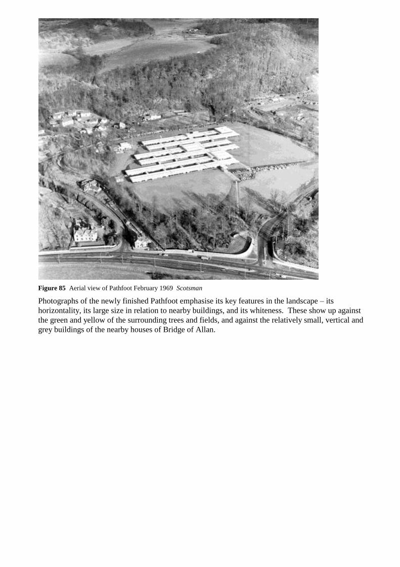
Figure 85 Aerial view of Pathfoot February 1969 Scotsman
Photographs of the newly finished Pathfoot emphasise its key features in the landscape – its
horizontality, its large size in relation to nearby buildings, and its whiteness. These show up against
the green and yellow of the surrounding trees and fields, and against the relatively small, vertical and
grey buildings of the nearby houses of Bridge of Allan.
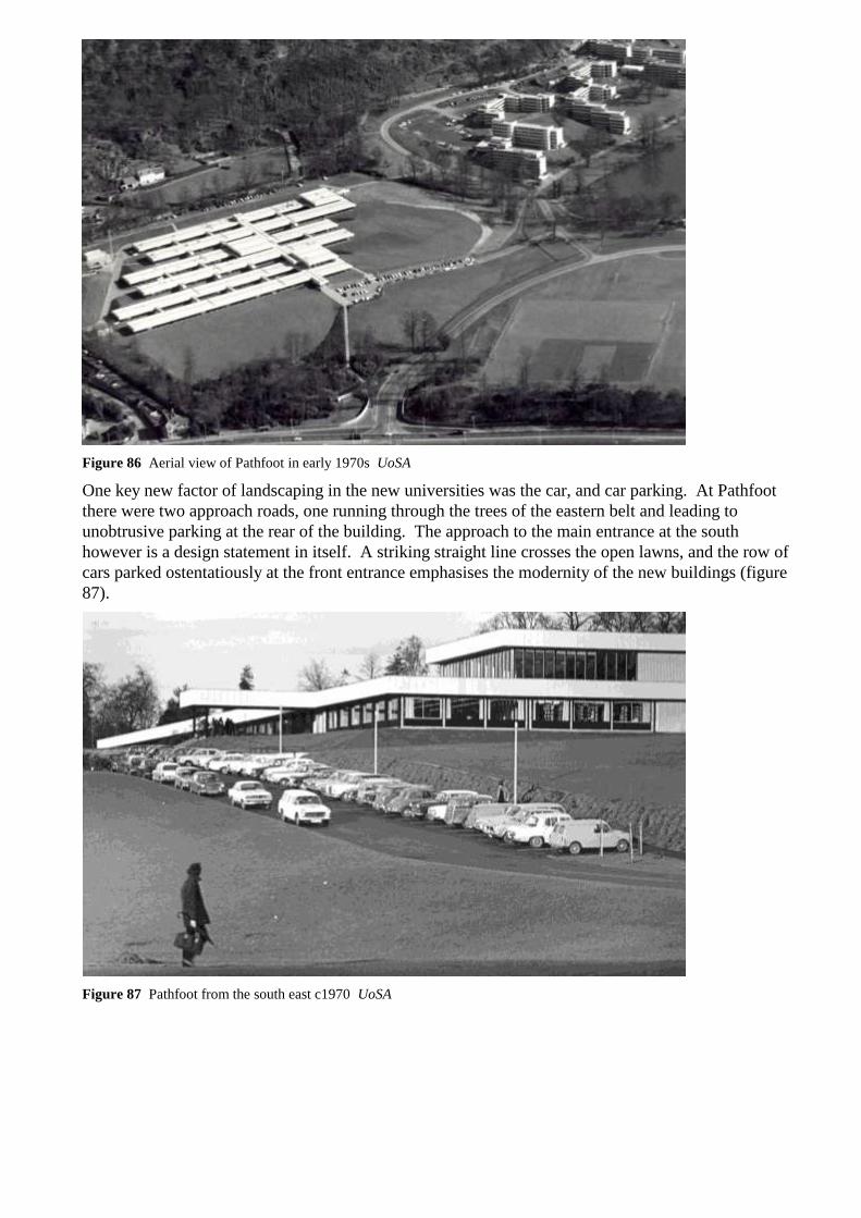
Figure 86 Aerial view of Pathfoot in early 1970s UoSA
One key new factor of landscaping in the new universities was the car, and car parking. At Pathfoot
there were two approach roads, one running through the trees of the eastern belt and leading to
unobtrusive parking at the rear of the building. The approach to the main entrance at the south
however is a design statement in itself. A striking straight line crosses the open lawns, and the row of
cars parked ostentatiously at the front entrance emphasises the modernity of the new buildings (figure
87).
Figure 87 Pathfoot from the south east c1970 UoSA

Figure 88 View of Pathfoot c1967. Note the terraces extending from the east of the building UoSA
The Old Sherrifmuir Road ran north from
the A9, parallel to Kenilworth Road.
Alterations to the road layout associated
with the construction of the new
university included taking the first
section of the Old Sherrifmuir Road out
of public use, and joining it to
Kenilworth Road at a point west of
Pathfoot. The estate wall was extended
over the former entrance to the road at the
southern end.
Figure 89 Detail of 2008 OS HS
iii Internal Landscapes
As well as being positioned so that the exterior of the building was in careful relation to its landscape
setting, from within Pathfoot the natural landscape was of great importance to the architects. The
experience of those using the building was controlled, using a graded system of landscaping for the
interior courtyards49. The landscape architect responsible for their design was Frank Clark50. The
theoretical framework for the design was that in the inner courtyards of the building the courtyards
would be more artificial in appearance, more urban, with hard materials, including whinstone cobbles,
sculptures and benches. Courtyards which were closer to the edge of the building were designed in a
more naturalistic way, and finally the planting of the outer courtyards, which were bounded by the
building on three sides only, was to merge seamlessly into the lawns and trees beyond.
49 Gerrard Bakker, site visit to Pathfoot, Thursday 13 November, 2008 50 In the time available it has not been possible to consult Frank Clark‟s archive.

Figure 90 Inner courtyard at Pathfoot, with
„urban‟ landscaping Figure 91 Inner courtyard, detail of sculpture and
cobble finish
Figure 92 View from corridor at rear of Pathfoot,
with more naturalistic planting. Figure 93 View from Crush Hall. Note how the
clerestory windows give a view of the trees to the
west.
Alterations to the building have included
extensions which block some views
through the courtyards, and alterations to
the glazing has affected the appreciation
of the horizontal qualities of the
landscaping from within some of the
teaching rooms.
The entrance hall has lost its original
open quality (see figure 24).
In general the courtyards have been
carefully maintained, and the original
Figure 94 View of entrance hall c1968
Construction Technology
scheme has been followed. In the early 1990s the Airthrey Gardens Group carried out a programme of
works to the courtyard gardens. The Oystercatcher Garden is an example of re-landscaping which is in
harmony with the character of the original scheme.51 Over the lifetime of the university sculptures have
been added to the courtyards, which is also appropriate because the courtyards were envisaged as an
extension to the gallery-like spaces of the central corridor. Trees have matured, and can be seen rising
above the level of the building.
51 Gerrard Bakker, site visit to Pathfoot, Thursday 13 November, 2008

Figure 95 View of Pathfoot from Wallace Monument c1968 UoSA
The separation of Pathfoot from the Phase 2 part of the campus is clear from a photograph of the newly
completed building (figure 25), which shows the importance of the mature trees within the landscape
acting as a screen around the loch, and around the site of the Phase 2 buildings. It is interesting to note
in this early view that Pathfoot would have been much more prominent at this date than the site of the
Phase 2 buildings. Later tree planting has considerably obscured the views of Pathfoot from the main
entrance road to the campus.
iv Alterations to Landscape Setting
A number of deliberate plantations of trees have obscured the views of the building from the south,
south east and the east.
The most significant alteration to the
landscape setting has however been the
southern extension of the building itself
in the 1990s, which has been constructed
within the previously expansive area of
open grass.
This area has also been altered since 1984
by the building of an extension to the car
park at the edge of woodland to the south
(figure 96).
Only about a third of the original area
now remains as open lawn.
Figure 96 Aerial photograph with yellow colour
indicating post 1980s alterations to landscape
south of Pathfoot
The construction of the main extension to the south has altered the relationship between Pathfoot and
the landscape to the west, which is particularly apparent at the entrance. A photograph taken for the
Architects Journal of 1968 shows how the entrance area was visually connected to the open landscape
and tree belt to the west (figure 97). This view has been lost.

Figure 97 View to west from entrance to Pathfoot 1968 Architects’ Journal
The landscape area to the east has also
been altered by tree plantations and by
extensions to the building. The extension
to the west end of the third original block
from the south has been built on a
landscaped terrace which can be seen in
early photographs of the building.
Figure 100 shows the extent of these
alterations.
Figure 98 Detail of aerial photograph showing
planting of trees to east of Pathfoot 1976 British
Geological Survey
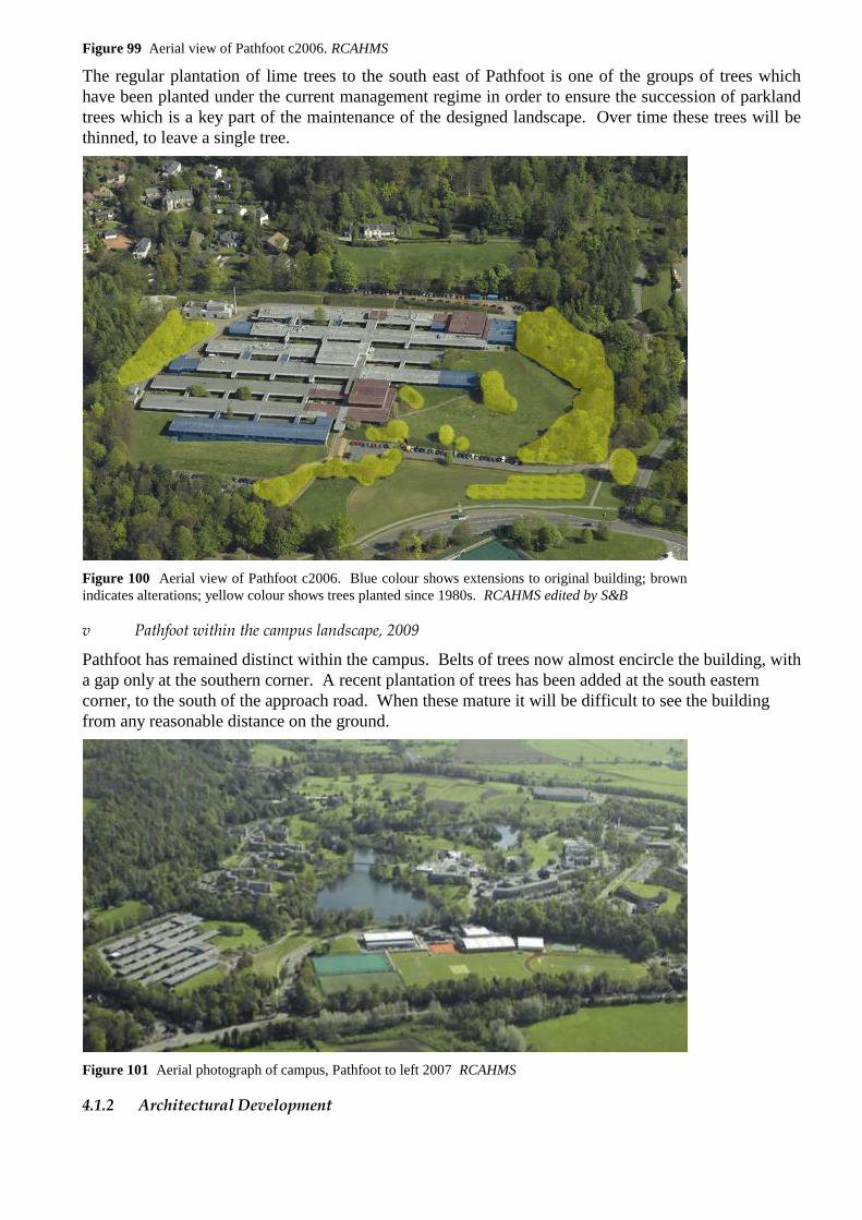
Figure 99 Aerial view of Pathfoot c2006. RCAHMS
The regular plantation of lime trees to the south east of Pathfoot is one of the groups of trees which
have been planted under the current management regime in order to ensure the succession of parkland
trees which is a key part of the maintenance of the designed landscape. Over time these trees will be
thinned, to leave a single tree.
Figure 100 Aerial view of Pathfoot c2006. Blue colour shows extensions to original building; brown
indicates alterations; yellow colour shows trees planted since 1980s. RCAHMS edited by S&B
v Pathfoot within the campus landscape, 2009
Pathfoot has remained distinct within the campus. Belts of trees now almost encircle the building, with
a gap only at the southern corner. A recent plantation of trees has been added at the south eastern
corner, to the south of the approach road. When these mature it will be difficult to see the building
from any reasonable distance on the ground.
Figure 101 Aerial photograph of campus, Pathfoot to left 2007 RCAHMS
4.1.2 Architectural Development

i Design Concept
Robert Matthew, Johnson-Marshall & Partners were commissioned by the University of Stirling in
January 1966. What is immediately remarkable about this date is that the architects were expected to
have a building designed, built and open in time for the first intake of 150 students in September 1967
– only eighteen months away. As succinctly put by Gerard Bakker, one of the architects on the project,
this was “a challenge in timing”52.
It was decided very early on that the University would not build temporary accommodation in the
interim period between opening and developing the subsequent phases: if anything temporary buildings
would not provide accommodation of a suitable standard, or set the tone for the establishment of the
university either in the eyes of the first students, or the local communities of Bridge of Allan and
Stirling on which the university owed much for their early enthusiasm.
These arguments were key to the securing of three years of funding in advance from the UGC which
was crucial to the UoS being able to build Pathfoot: the normal system of annual grants, with
subsequent years not guaranteed would normally force a new university to use temporary buildings.
The setting-out of Pathfoot over three terraces could be seen to have mirrored the potential funding
allocations, but the disruption in not having all the key facilities ready for the first year, coupled with
the disruption of near-constant building works would have rendered the building not only inefficient,
but unattractive to potential staff and students.
Figure 102 View of Pathfoot from the south-east. UoSA
Intriguingly Stefan Muthesius in his book, The Postwar University, states that “some say, [Stirling]
was an English university transplanted into the Scottish system”53. Without clarifying this any further,
and with no other source echoing this statement, it can be effectively argued that Stirling was in fact
the very apotheosis of the Scottish system, in that even from the very beginning at Pathfoot, the layout
of the buildings reflected the inter-disciplinary nature of undergraduate study found at most Scottish
universities.
52 Quoted on a site visit to Pathfoot, Thursday 13 November, 2008 53 S Muthesius, The Postwar University, 2000, p174

The layout of Pathfoot was driven both by the need to accommodate the entire university from its
opening in 1967, and the fact that the subsequent use of the building was not yet decided upon. It was
certainly going to be part of the university, function initially at least as a „balancing reservoir‟54, but
being separated from the main buildings was seen as a deciding factor in what department or
departments would be housed there. It was discussed that the building could house a semi-independent
institute, or perhaps house specific sciences. Regardless of the final decision, Pathfoot had to be able
to handle small departments expanding, others decanting, and even new ones moving in.
The idea that the university departments would not be housed in distinct buildings or grouped together
in colleges was a direct result of the anticipation that students would be able to choose diverse subjects
in their first years, only to specialise in their later years of study. This is common amongst Scottish
universities, but is often hampered by the physical location of departments, for example the split
between the main locations of the University of Edinburgh, with Arts & Social Sciences in the city
centre and Science & Engineering based at King‟s Buildings in the southern suburbs of Edinburgh.
Figure 103 Aerial view of Pathfoot 2007 NMRS
One drawback to this system is that the UoS was unable to precisely predict the numbers of students on
each course, and thus predict the space requirements of each department. Nevertheless, the architects
considered this more of a timetabling problem than an architectural one, as the building they were
designing would be flexible enough to accommodate such change55.
The aesthetics of the building were very much influenced by contemporary Scandinavian, and
specifically Danish design. Gerard Bakker refers to the Louisiana Museum of Modern Art in
Humlebæk on the north-east coast of Denmark56. The building was commissioned from the architects
Jørgen Bo and Wilhelm Wohlert in 1958, and shows a similar generosity in relationship between
architecture and landscape as was intended at Pathfoot. In addition to the wide expanse of glazing
looking out to the sculpture park, there is a clear structural dialogue between the verticality of the
narrow columns with the flat horizontality of the roof they support.
54 “Building Study”, Architects’ Journal, 5th June 1968, p1284 55 Site visit to Pathfoot, Thursday 13 November, 2008 56 Site visit to Pathfoot, Thursday 13 November, 2008

Figure 104 Exterior of the Louisiana Museum of Modern Art, showing similar arrangement of glazing,
roof structure, and clerestory as found at Pathfoot. www.louisiana.dk
Figure 105 Sculpture at the Louisiana Museum of
Modern Art. www.louisiana.dk
Figure 106 Glazed corridor with views to
external landscape at the Louisiana Museum of
Modern Art. www.louisiana.dk
Another key influence was closer to home – with another of RMJM‟s projects. At the same time as the
design and construction of Pathfoot was underway another team in the office were working on the
Royal Commonwealth Pool. Although completed after Pathfoot, the project timescales were less tight,
and there was a great degree of overlap, with John Richards being the partner in charge of both
projects. The budget was also somewhat more generous, not surprising considering the international
event for which the pool was built. The use of iroko hardwood for example for both the window
frames and the slatted ceiling in the public areas contrasts with the red pine selected for the window
frames and standard ridged tiles for the ceiling at Pathfoot. Nevertheless, the Royal Commonwealth
Pool shared many of the same aesthetics, with the overall design concept showing direct similarities: a
strong horizontal emphasis with linear white roof line above a recessed dark window line, all designed
to fit into the surrounding landscape. The construction system also employed a high degree of pre-
fabrication in order to allow rapid progress on site.

Figure 107 Royal Commonwealth Pool under
construction in 1968. Scran/Scotsman Publications
Figure 108 Aerial view of the Royal
Commonwealth Pool, 1969. Scran/Scotsman
Publications
Figure 109 Royal Commonwealth Pool in 1970. Henk Snoek/RIBA Library Photograph
ii Original Layout
As Pathfoot was to house the entire university for the first three years, it had to contain all the functions
that would be expected by the first intake of students. The plan was thus logically laid out over the
three terraces, with each terrace comprising one double-height space with two single-height blocks
extending in parallel lines on a roughly north-west/south-east axis. The main entrance was on the
south elevation, accessed directly by a path from the west entrance gate, and served by an adjacent car
park.

Figure 110 Aerial view of Pathfoot shortly after completion, with later residential blocks behind.
UoSA
The six blocks running parallel to each other in three pairs were intersected by connecting access
corridors running perpendicular on south-west/north-east axis. This generated the gridiron layout of
the building, with short blocks of accommodation connected by access corridors and separated by
courtyards. John Maule McKean said that “its open links gave the grid an immediate
comprehensibility and friendly scale; to students its virtue is still that in Pathfoot ‘one can choose
where to sit and chat’”57.
Figure 111 Section through staffrooms, administration offices and library showing layout of building
over the three terraces. Architects’ Journal
Each corridor ran on the level across each terrace, linking to the adjacent terrace via a full storey-height
flight of stairs through the courtyard. The main corridor, leading from the entrance on the south block
was widest and connected all the terraces58. In each of the subsequent grid bays to the west, a narrow
corridor also connected all six blocks, one of which contained hoists between the terraces instead of
57 J M McKean, “RMJM at Stirling”, Architectural Review, 1973, p360 58 This corridor, known as the Main Concourse, is extremely generous when seen in comparison to the rest of the University. The corridor was built within the cost restraints (derived from the cost of a single bay and single gable multiplied by 570), but the UGC ‟had a fit‟ when they saw it (Gerard Bakker, Pathfoot visit, 13th November, 2008). In subsequent years the grant fell, as it matched the lowest of all the new university buildings being built at the time in the UK. The width of corridors was narrowed accordingly in order to meet these constraints, creating the marked difference between Phase 1 and Phase 2 buildings on the campus.

stairs. As the paired blocks were staggered, further narrow corridors at either extremity of the terraces
connected decreasing numbers of blocks and terraces.
The south terrace, the lowest of the three, contained a generous entrance canopy, leading to the
entrance hall which opened out around the adjacent sculpture courtyard. The double-height space in
the east-most grid bay housed the library, with the projecting single-storey blocks containing staff-
rooms.
The centre terrace contained a large lecture theatre and crush hall in the double-height space, sensibly
locating the lecture theatre to the west of the main corridor as it need not take advantage of the views
offered at the extremity of the terrace. The crush hall was located on the alignment of the courtyards,
thus affording it views through to the wider landscape on either side. The blocks at this terrace
originally housed research laboratories, administrative offices, and further lecture rooms.
The third terrace, the highest of the three, contained the teaching laboratories and the social facilities,
with the lounge area being afforded the best views from the east-most end of the terrace, with the
double-height restaurant located directly behind.

Fig
ure
11
2
Pla
n o
f P
ath
foo
t sh
ort
ly a
fter
op
enin
g.
Arc
hit
ects
’ Jo
urn
al
iii Construction

Figure 113 Pathfoot under construction, c1968. UoSA
In order to meet the construction deadline, RMJM conceived a custom-designed prefabrication system.
Several other construction systems had been considered, including CLASP, but these were complicated
by the fact they were designed to support several stories and so were unsuitable to the single-storey
Pathfoot.
The construction process involved the erection of the steel framework first, followed by the roof, with
walls following on, and the floor being finished last. As a result, the building was watertight at a very
early stage. One subsequent drawback however was that the concrete floors did not have time to
mature fully before the building was opened.
The exterior walls consisted of pre-
fabricated panels, of which there were a total
of five types, set between structural I-beams
supporting the overhanging roof. These
standard panels were repeated throughout
the whole building, with a result that 80% of
the building was built to this generic
standard. In order to maintain a generosity
in the elevations, all the windows extended
to the full width of each structural bay.
Where a window opening was required, a
single narrow casement was provided to one
side. The remainder of the panel was
horizontal black-stained redwood cladding.
Some panels were solidly clad in timber, and
a further generic type had full-width
clerestory lights.
Figure 114 A typical prefabricated panel with
full-width window. UoSA
The interior walls were constructed with blockwork to ceiling height only, leaving the entire roof space
open to allow for unimpeded access for services. Customised demountable partitions were considered
to be unnecessary and expensive: it was more economical just to use blockwork which could be easily
demolished and rebuilt as necessary. Doorway openings on the interior walls went to the full height,
and were filled above door height with timber panels to match the door. The timber used throughout
was red pine.
The corridor walls to the external courtyards were all built with full-height windows, with red pine
frames. At the changes in level between the terraces, the higher roof line continued over the stair,

creating a clerestory above the lower level. Although this was criticised at the time, these windows
provide dramatic views at the head of the stairs over the building towards the Wallace Monument59.
Figure 115 Pathfoot under construction, showing
area between different terrace levels. UoSA Figure 116 View over roof of lower terrace from
stair between levels. UoSA
All of the services are contained in the roof void, apart from drainage, which was the only fixed
service. Although the cost of installing such services when the building was built only for them to be
removed when the building changed use was foreseen to be a potential problem by the UoS, in practice
this was not critical.
iv Subsequent Additions and Alterations
“The building has got to evolve and change, as that is integral to its design, but this should be done in
accordance with the very simple rules of the original design. Then you can’t go wrong.”60
In general the original architecture of Pathfoot has been treated well, just as the building has served the
University well over four decades. Nevertheless the building has undergone a significant number of
alterations, and been enlarged by major extensions.
59 The Architects‟ Journal suggested “that a raking line might perhaps have been preferable”, “Building Study”, Architects’ Journal, 5th June 1968, p1290 60 Gerard Bakker, quoted on a site visit to Pathfoot, Thursday 13 November, 2008

Figure 117 Plan showing additions (blue) and areas which have undergone major alteration (brown).
Architectural Review, edited by S&B
The most major change that is clearly seen on both the approach to the building, and on the plan, is the
addition of a seventh linear block to the south. In effect, this has added a third line to the lower terrace.
The extension was added in 1993 and appears to fit well with the original building. The overall
dimensions derived from the grid have been followed, and the generosity of the wide windows has
been repeated. Although not appearing in the original building, the oriel windows to the new south
elevation take the full width of the bay, so work well.
The use of materials on closer inspection begins to reveal the differences between the original building
and the extension. The concrete panels with exposed aggregates have been copied but the original
panels are much thicker, and appear more substantial, especially at the junction between old and new.
The interior construction detail with full-height doorways comprising red pine door and panel above
has also not been copied, either here, or in other altered parts of the building.
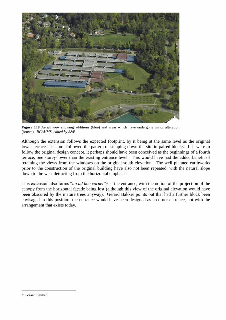
Figure 118 Aerial view showing additions (blue) and areas which have undergone major alteration
(brown). RCAHMS, edited by S&B
Although the extension follows the expected footprint, by it being at the same level as the original
lower terrace it has not followed the pattern of stepping down the site in paired blocks. If it were to
follow the original design concept, it perhaps should have been conceived as the beginnings of a fourth
terrace, one storey-lower than the existing entrance level. This would have had the added benefit of
retaining the views from the windows on the original south elevation. The well-planned earthworks
prior to the construction of the original building have also not been repeated, with the natural slope
down to the west detracting from the horizontal emphasis.
This extension also forms “an ad hoc corner”61 at the entrance, with the notion of the projection of the
canopy from the horizontal façade being lost (although this view of the original elevation would have
been obscured by the mature trees anyway). Gerard Bakker points out that had a further block been
envisaged in this position, the entrance would have been designed as a corner entrance, not with the
arrangement that exists today.
61 Gerard Bakker
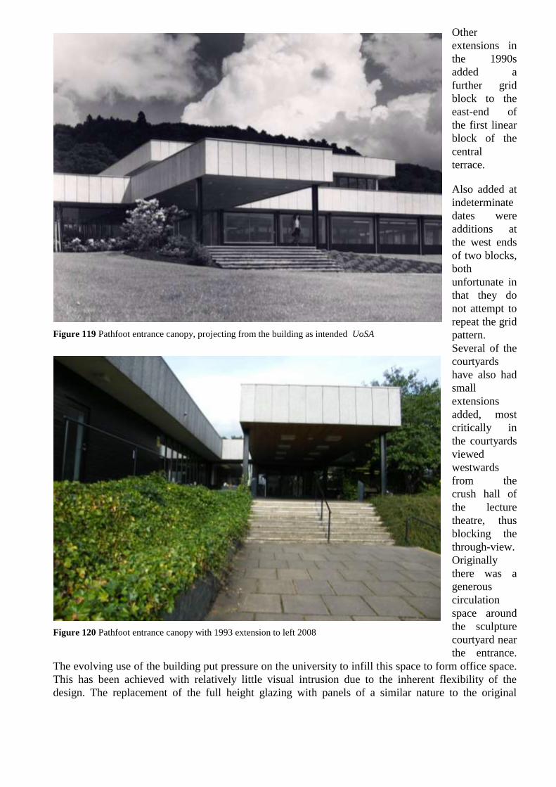
Other
extensions in
the 1990s
added a
further grid
block to the
east-end of
the first linear
block of the
central
terrace.
Also added at
indeterminate
dates were
additions at
the west ends
of two blocks,
both
unfortunate in
that they do
not attempt to
repeat the grid
pattern.
Several of the
courtyards
have also had
small
extensions
added, most
critically in
the courtyards
viewed
westwards
from the
crush hall of
the lecture
theatre, thus
blocking the
through-view.
Originally
there was a
generous
circulation
space around
the sculpture
courtyard near
the entrance.
The evolving use of the building put pressure on the university to infill this space to form office space.
This has been achieved with relatively little visual intrusion due to the inherent flexibility of the
design. The replacement of the full height glazing with panels of a similar nature to the original
Figure 119 Pathfoot entrance canopy, projecting from the building as intended UoSA
Figure 120 Pathfoot entrance canopy with 1993 extension to left 2008
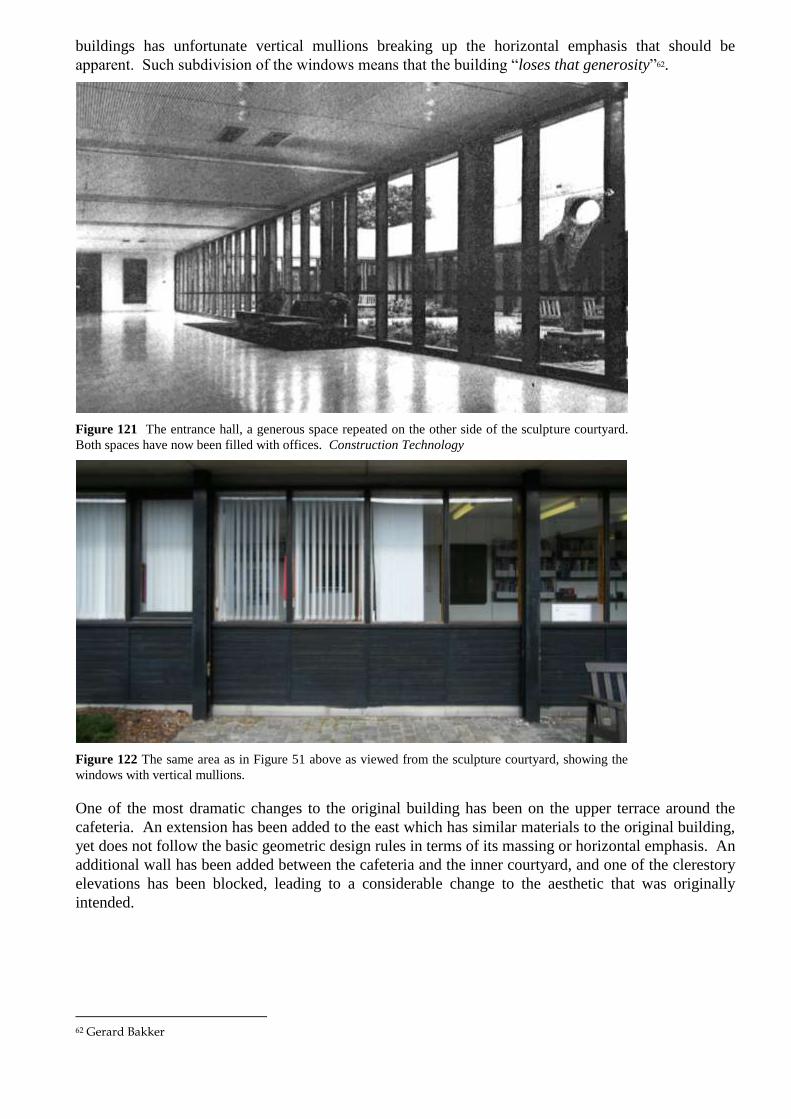
buildings has unfortunate vertical mullions breaking up the horizontal emphasis that should be
apparent. Such subdivision of the windows means that the building “loses that generosity”62.
Figure 121 The entrance hall, a generous space repeated on the other side of the sculpture courtyard.
Both spaces have now been filled with offices. Construction Technology
Figure 122 The same area as in Figure 51 above as viewed from the sculpture courtyard, showing the
windows with vertical mullions.
One of the most dramatic changes to the original building has been on the upper terrace around the
cafeteria. An extension has been added to the east which has similar materials to the original building,
yet does not follow the basic geometric design rules in terms of its massing or horizontal emphasis. An
additional wall has been added between the cafeteria and the inner courtyard, and one of the clerestory
elevations has been blocked, leading to a considerable change to the aesthetic that was originally
intended.
62 Gerard Bakker

Figure 123 The restaurant in 1968. Architects’ Journal
Figure 124 The restaurant in 2008.
Throughout the building doors have been replaced, presumably to upgrade their fire rating, though they
have been replaced using a less attractive pale wood, most commonly beech. Ceilings have also been
lowered in many placed, sometimes creating awkward junctions with door openings, and generally the
use of generic grid pattern ceiling tiles is inappropriate in comparison to the carefully selected original
ridged mineral-fibre tiles which are still visible in parts of the building. In the main concourse, the
ceiling has also been lowered in order to accommodate recessed picture lighting, changing the nature
of the corridor significantly. The simple rules of the building ensured that the ceilings in long corridors
were visually shortened with the placing of the lights across the full width of the corridor.

Figure 125 Main corridor of Pathfoot, showing original ceiling arrangement. UoSA
Aside from the awkward nature of the original entrance canopy alongside the southern extension, the
replacement entrance doors do not have the same presence as the original full-height doors. The
reception desk has also been treated with a green tiled wall with section of rubble wall.
v Critical Acclaim
In 1968, the significance of Pathfoot was recognised with a Civic Trust Award and a RIBA Award for
Scotland in the following year. The RIBA Jury reported that the building “is sympathetic to its site and
its surroundings. The plan has a simple and comprehensive organisation which can easily adapt to
future needs. The relation of internal routes to courtyards, and to view outside is clear and also
sensitive in scale and the use of materials and a straightforward structure fit well with the function of
the building.”63
Docomomo64 placed the Pathfoot building on their list of Sixty Key Monuments of the Modern
Movement in Scotland, compiled in 199365. The purpose of the list was to draw attention to importance
of the Modern Movement in Scotland, and promote the idea that the buildings on this list should be
considered as part of Scotland‟s heritage. The compilation of the list was partly a response to the
imminent threat to many of the buildings, and indeed the demolition of some key examples. It was
also an attempt to counter the negative popular perception of Modernism. The Pathfoot building is
described as a “microcosm of several key Modern values – scientific design, rapid prefabricated
construction, and flexibility in use – applied to one of the most characteristic modern building
projects: a new university, the first to be established in Scotland since 1583.”
Pathfoot is also recorded by Docomomo on their International Selection of Modern Architecture (see
Appendix X).
Prospect, the Scottish Architectural Journal, published a list of the top-100 modern buildings in
Scotland in 2005. The list was voted for by its readers. The University of Stirling campus buildings,
including Pathfoot, was placed at number 36, with RMJM‟s similar work at the Royal Commonwealth
Pool at number 19.
63 From an extract of the RIBA Jury‟s Report printed in “RIBA and Civic Awards for Stirling‟s Pathfoot Building”, Construction Technology, c1968, p33 64 Docomomo‟s full title: International Working Party for Documentation and Conservation of Buildings, Sites and Neighbourhoods of the Modern Movement. 65 Reproduced in M Glendinning, Rebuilding Scotland, 1997, pp153-182

The Pathfoot building was listed by Historic Scotland at Category „A‟ in May 2009.
4.1.3 Character Assessment
i Building Form
The building takes as its basic form the six original rectangular blocks set onto a south-facing slope.
The length of these blocks is their major physical feature. They are placed roughly according to
contours and the blocks step down the hillside in pairs. There has been significant landscaping work to
create terraces for these blocks to sit on.
These blocks contain classrooms, corridors and service accommodation. They are the dominant form
but there are three positions where the buildings depart from this basic arrangement. These points are
indicated by increased height. At the south east corner crossing the east end of the lowest pair of blocks
is a two storey block which formerly contained a library. At the centre of the plan, crossing the middle
blocks is a higher part containing a crush hall and lecture theatres. It is also used for exhibitions. At
the north east corner, spanning the east end of the northern blocks is the refectory. Crossing the gaps
between the blocks at regular intervals are link corridors, glazed on both sides, running north–south.
The main corridor, known as the main concourse, is much wider. It passes due north through the entire
original building from the main entrance near in the south block. It rises up flights of stairs on the lines
of each terrace or bank and passes the east end of the crush hall and lecture theatres.
This regular grid of east–west blocks and north–south circulation creates a group of open spaces –
courtyards or gardens running in east–west lines throughout the building. These gardens have been
treated in some cases as “outdoor rooms” and given formal planting. In other places the planting is
natural or just grass. The grid of blocks and gardens creates a very interesting and successful quality of
visual permeability throughout the building.
The building had its principal face to the south facing the entrance to the campus. The entrance is to
the eastern end of the south block and has a canopy extending about 10m south of the main door. The
canopy that marks the entrance is the only major plan form which has its rectangular long axis north–
south rather than east–west. It is elegantly designed, extending the concrete roof band out on four I-
beams.
An impression of the character of the original south front, before a further block was extended to the
south, can be gained from photographs. The original design is an exceptionally pure architecture made
of two bands – a band of vertical concrete panels at roof level, a band of windows between structural I-
beams, the window frames being stained black. Immediately in front of the block is a grass terrace
roughly the same width as the original south block. The effect of this terrace was that, in distant views,
the boarding along the foot of the window band is hidden and the architecture looks even simpler with
the windows appearing to extend down to the ground. The terraces are very much part of the
architecture and have an important part to play in achieving this purity. The landscape in front of the
building needs to be as level as the building itself.
If the new south block is extended then consideration should be given to completing the intended grid
including the glazed link corridors which pass north – south.
The south and east sides of the building and their landscape setting have greater aesthetic importance
than they the north and west sides. The building has been placed close to the western boundary of the
campus and there is a band of trees about 20m wide immediately inside of the boundary wall. To the
north west this band of trees is much wider than originally intended. This means that the west side of
the building is hidden from views. It has a service route along it and has been treated as the back of the
building. There are various buildings built of grey brick around the service road. The southern of these

independent buildings is unfortunate in that it acts as a view closer for the sequence of gardens
between the southern pair of the original blocks. This aquarium building is later than the original
Pathfoot building but was constructed very soon after the completion of the building.
The north front of the building has a similar very strong horizontal emphasis as the south block. The
block is set into a cutting in the landscape and there is a terrace some distance to the north which
coincides with the roof deck level. This terrace was used as a car park from the start. There are views
from this terrace over the roof of the Pathfoot Building towards the other university buildings and the
Wallace Monument beyond.
The north side is also less significant than the south or eastern aspect. It is not seen in conjunction with
the eastern aspect especially with increased woodland planting near the north east corner of the
building over the last ten years. The concrete roof band does not project to the same extent as it does
on the south side. This elevation is slightly marred by car parking along its full length. The access to
the main north end of the main concourse is not particularly emphasised. There is a gap in the
fenestration band and a tank projection immediately above it. At the eastern end the block terminates
with an additional storey originally intended as the clerestory of the refectory.
At the far western end of the north block is a detached boiler house with some service buildings. The
boiler house is clad with vertical sheeting and looks different to the rest of the building. This seems to
have been the original intention. Further to the west of the boiler house is a relatively recent aquarium
building with rendered walls and sheeted roof, and asymmetrical north gable.
The most impressive interior space is the main concourse. At the north end there is a gap in the north
block and the main porch into the building is on the north face of the fifth block. From here, the
corridor passes down a flight of stairs between the fifth and fourth block which is the same height as a
full storey. The interest of the corridor is in the way that it inter-relates to the bands of open space
between the blocks. They are alternately wild banks planted with evergreen shrubs and flat courtyards
or gardens. Between the third and fourth blocks is the crush hall. This space is in line with a band of
courtyard gardens and continues the architectural quality of the outside with panels under a clerestory
to the south, east and west. The view eastwards through a formal planted court then another glazed
corridor towards the grass and trees beyond is particularly successful. The view westwards has blocked
by offices extended on the side of a link corridor. Beyond this extension in the same band of gardens
is a rather unkempt courtyard space. The view westwards has been blocked by another extension next
to a link corridor.
The bank between the second and third of the original blocks survives for its full width. It is generally
planted with low lying evergreen shrubs. Some of these might be over mature, particularly to the west.
A full width view along this bank is blocked by sheeting next to the lift at the first corridor to the west
of the main corridor. This sheeting appears to be part of the original design and matches the sheeting
on the ends of the original blocks.
The space between the fifth block and the sixth, north, block is treated differently with fewer of the
north-south corridor links glazed in. The positions of the corridor links are indicated by the roof band
bridging over between the doors as a shelter.
To the south of the crush hall a further flight of stairs passes down to the south entrance level. The two
storey block to the south east was the original library but was not needed when the new library was
built and has been converted into offices and classrooms currently accommodating the institute of
education. Since a library building on another site was always part of the masterplan, this conversion of
the temporary library must have been anticipated by the designers originally. The successful
subdivision of the library demonstrates the flexibility inherent in the design of the building.

Towards the southern end of the main corridor there is an important view westwards between the
southern and second of the original blocks. At the far end, this view is blocked by an aquarium
building. The courtyard is particularly successfully landscaped here with fine modern sculptures.
Originally, the spaces to the north and south of this courtyard were open and formed the entrance hall.
The subsidiary corridors running east–west within the main blocks mainly retain their block work
finish and full height apertures containing doors with panels above. Some of the doors with vertical
glazed panels also survive.
The refectory has been extended and the original intention of being able to see to north, east and south
has been changed so that only a south view is available. The block originally was intended to have a
clerestory on all sides. This has also been altered.
The Pathfoot Building was designed and built with the expectation that it would be altered internally
and extended. There have been several additions. They have varied in quality but all have obscured the
simplicity and purity of the original design to some extent. The addition of a further block to the south
has been carefully designed with detailing derived from the original building. In many ways it matches
the original Pathfoot blocks and the differences are quite subtle. The concrete panels in the roof band
are face fixed but the fixings are only evident when the building is seen obliquely in sunlight.
The new building departs from the original design because it includes bay window projections which
fill the gap between the fenestration band and the roof band. This is an interesting departure from the
original arrangement. In the opinion of one of the original designers, Gerard Bakker, it is not how he
would have done it but it looks in keeping with the rest of the architecture of the building. Another
departure in the design of this block is its different relationship to the landscaping. Unlike the original
south block, this block does not face onto a level terrace. The ground slopes away to the west. A small
amount of plinth brickwork to the east becomes a full storey height to the west. As an individual piece
of architecture, this divergence between ground line and roofline is interesting and attractive but it is
different to the original architectural sensibility of horizontal blocks sitting on a terrace with terrace
being a third horizontal band of the original building. The disharmony of the sloping ground has
possibly been recognised in the planting of dense evergreen shrubs along the south front of this
building as if to disguise the change of level.
The south block is at its least in keeping with the original building at its eastern end where it stops
short of the original entrance canopy. The original entrance canopy no longer acts as a single projection
south from a long line of the front of the building.
The ends of the original block have sheeted ends where they have not been extended.
An extension at the eastern end of the third original block is a careful match to the original but has a
different end with dark painted vertical timber.
Two blocks built at the west ends of the original blocks are less successful. These buildings have been
constructed near to, but not attached to, the original end of the third and fifth blocks. In both cases
there has been a failure to understand, or afford, the original aesthetic and constructional system of the
building. These blocks are only superficially similar to the original building in that they have a
concrete roof band. Otherwise, the boarding is horizontal and the constructional system and windows
bears little resemblance to the original. The critical point about an extension westwards is that it should
maintain the north and south lines of each block and that the views along the gaps between the blocks
should be maintained, however long the blocks. With these later building being at the western edge,
the visual damage is relatively minimal.
The gap between the fifth and sixth blocks at the North West corner is a service yard and is full of
sheds.

The refectory has been extended to the east to form an additional kitchen and service accommodation.
Unfortunately, this building does not follow the rules either of unbroken east – west horizontal lines of
the concrete roof band or the constructional system and proportions of the fenestration band.
ii Material
The materials externally on the original building are vertical concrete panels forming a band around the
roof. Below this at regular intervals governed by the constructional grid are I-section columns. These
columns give depth to the fenestration band which, on the south-facing sides, is well behind (about
1m) of the front edge of the roof band and with the wall of the building a further 200mm or so behind
the back of the I column. The walls are formed with timber horizontal ship lapped boarding below
window panels. Typically a bay contains two windows, a broad fixed sheet of glass with a narrower
opening panel and thicker frame to one or other side.
On the south front of the original block, the ends of timber and the plinth are covered with metal
sheeting. There are also metal sheeted covers behind the I columns. The boarding, window frames and
I-beams with the fenestration band are all painted black although the metal facings across the heads of
the windows and behind the I columns are left self finished. These are not particularly noticeable
because they are in shadow. The north faces of the blocks do not have the 1m projection of the roof
band used on the south and east ends.
The ends of the original blocks are covered with vertical profiled sheeting. These sheeted ends are the
strongest physical expression of the potential of the building for extension.
Grey brick has been used for a storage and service building at the western end of the gap between the
first and second original blocks. The service buildings to the North West are generally constructed of
grey brick with sheeted walls and roofs.
Considerable care has been taken to repeat the use of these materials over the south and east
extensions. The south block repeats the materials but makes a variation by using grey brick at the
plinth level, rather than metal sheeting. The recesses behind the columns are also painted black on this
block and there is a smaller gap between the columns and the wall face.
The end of the eastern extension to the third block has been finished more elegantly than the original,
with black painted horizontal boarding and a recessed doorway at the centre.
Although the general palette of materials has been retained in the various western alterations and
extensions, and in the extension to the refectory, the steel frame has been omitted which means that the
building has not repeated the particular rhythm of its original design.
The extensions use grey brick as the plinth material, something which has been avoided in the original
blocks.
The condition of the materials seems generally fair considering that this building was constructed from
components at great speed. The buildings have been carefully maintained. At some places the soffit
below the roof is peeling away or has broken. This is also the case in the newer south block. In some
places there is a slight discontinuity in the roof band. This is notable particularly on the south face of
the third block where it projects eastwards beyond the north wall of the former library block. The
external joinery needs to be overhauled and repainted, including sills. The relatively lightweight
joinery of the glazed link corridors also needs to be repaired in places. The materials used on the link
corridors and on other parts of the building have not proven to be particularly long lasting. The
building was built remarkably quickly and according to tight financial controls. The university has had
to spend a significant amount in like for like replacement of fabric and, in some cases, the replacement

fabric is starting to decay due to poor detailing. On some blocks, the metal sheeting at the base of the
wall has been lost exposing stock brick behind.
On the north side, the roof band is disfigured by a single projecting sign. The tank projection over the
north main entrance is also clad in vertical sheeting which may not be the original material.
iii Character and Setting
The overall character of the Pathfoot area is of long predominantly black and white blocks sitting on
terraces within a natural landscape. Although the buildings are dominant within this area, the way that
the landscape has been allowed to pass through in between the main east-west block is an unusually
successful example of integration of a building with its landscape. The building is surrounded by trees
and the low height of the building allows views from the south and south east to include the rocky hill
to the north. From the north car park it is possible to see over the building towards the profile of
Stirling, Stirling Castle and the Wallace Monument.
The building is set fairly close to the northern boundary. At the northern boundary is a beautifully
constructed 19th century rubble wall with triangular copes. Beyond it is a heavily wooded steep hill
with an attractive 18th
century house, Blairlowan, sitting in its own garden at the foot.
The character to the west is also constrained by the short distance from it to the boundary of the
campus site. There are trees and a service road on this side but this is the least viewed part of the area.
The main aspects which give an attractive setting for the Pathfoot Building are to the east and south.
There are extensive areas of maintained grass with trees and with banks sloping down to the south and
east. To the east are bands of coniferous trees. To the south is the main entrance to the university which
is covered with tarmac and has a gatekeeper‟s booth. The access road up to the south entrance is as the
original designer imagined, including the car parking. A further car park has been created to the south
of the west part of the Pathfoot Building.
The setting contains a considerably greater amount of woodland and tree cover than had been intended
at the time the building was designed.
iv Views
Some of the best views from the site are obtained from the south part of the refectory. There has been a
significant amount of change in the refectory area but alterations have sought to maintain the main
view southwards. This was very much the intention when the building was designed with the refectory
in this position. From the refectory there are views of evergreen trees which rise to roughly the height
of the horizon behind them. The skyline behind is Abbey Craig which is surmounted by the spectacular
profile of the Wallace Monument. Closer views are towards sports pitches in the middle distance and
the grassy bank in the foreground. These views are similar but broader in the view from the south front,
particularly towards the east. In this view the horizon is formed by the Campsie Hills with the profile
of Stirling Castle rising to about the same sky line.
Views to the west are restricted and less designed. In the winter there are views through the branches of
deciduous trees towards the backs of Victorian and later villas. To the south west of the building is a
substantial car park. More distant views towards the Forth valley are blocked by the closely spaced
trunks of evergreen trees.
The most important views towards the building are generally from the south and south east. The view
towards the original building from the south west has been blocked by the newer south block
extension.

In the view from the south the porch has lost some of its prominence due to the construction of the
block to the south west but the arrangement of porch canopy against the long original block can still be
imagined. The building is approached from the south and south east. The views towards the building
from the south east are the least altered with the ends of the blocks staggered and set within an
informal and sloping landscape. There is a minimum of shrub and tree planting so that the blocks are
seen to sit directly onto their landscape terrace base.
In the views from the south east the band of trees on the hillside behind are not particularly prominent
but does form a backdrop for the northern blocks.
The views towards the western ends of the blocks are not significant.
The view towards the north side was probably not intended to be seen in pure elevation. The north side
of the building is most often viewed obliquely, where the very strong line of the roof band forms the
main feature. In the view from the north east the boiler house and boiler house chimney are visible,
possibly unfortunately, at the far end of this wall. The aquarium building beyond is slightly intrusive.
4.1.4 Assessment of Significance
It is clear that the building is significant both architecturally and historically. The history of the
building is as part of the new university provision within Britain. When the building was being
designed its relationship to other projects at other universities was understood and the designers were
aware of how the building fitted into both this type of building and departed from it.
The building is also significant as an example of 20th
century construction. Speed was an important
factor. It is a testament to the ability of the designers that the speed of building was turned into a very
elegant piece of modular construction.
Aesthetically, the building is significant. It is a variation on a particular theme which was being
explored in the RMJM office at the time. The detailing of the original blocks is particularly elegant. It
is well sited within its landscape although its proximity to the west and north boundaries of the campus
site mean that the south and east aspects are considerably more important than the north and west.
The building is cleverly planned with landscape filtering through the buildings on the east–west bands
of courtyards, gardens and banks. It is possibly this part of the design – the use of the use of the bands
of outside space between the blocks – that gives the building its individual character and continues to
make the building valued by students, staff and visitors.
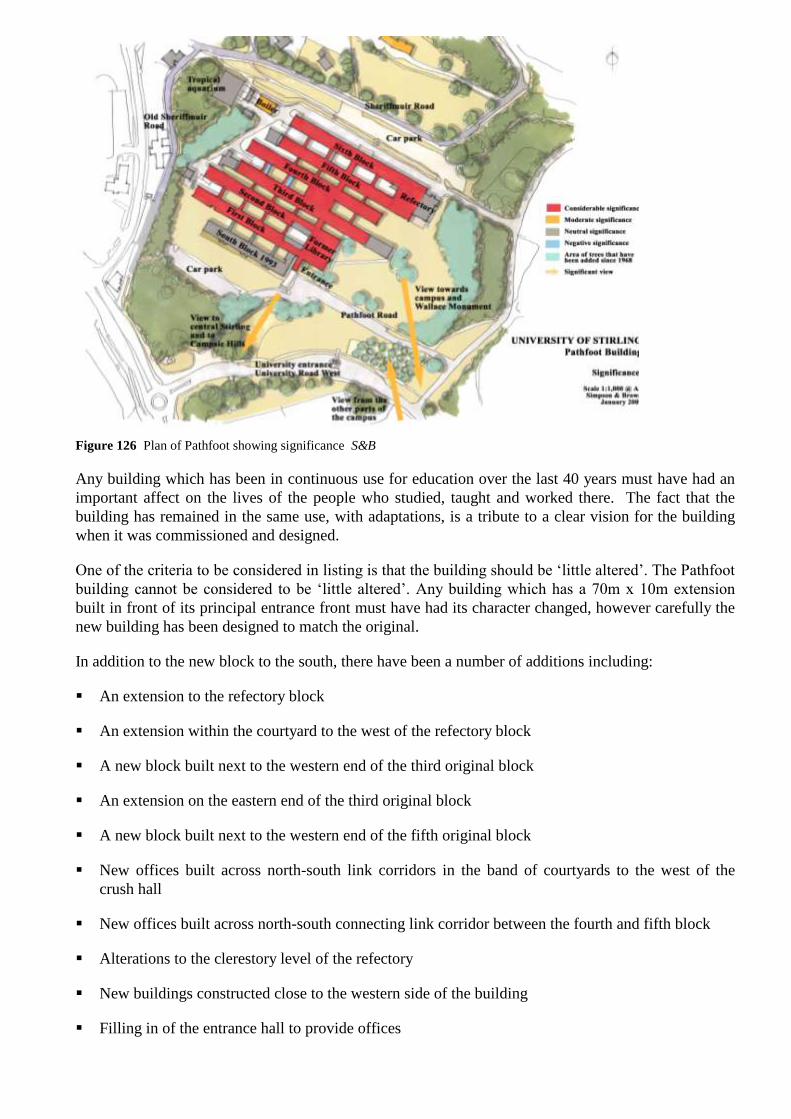
Figure 126 Plan of Pathfoot showing significance S&B
Any building which has been in continuous use for education over the last 40 years must have had an
important affect on the lives of the people who studied, taught and worked there. The fact that the
building has remained in the same use, with adaptations, is a tribute to a clear vision for the building
when it was commissioned and designed.
One of the criteria to be considered in listing is that the building should be „little altered‟. The Pathfoot
building cannot be considered to be „little altered‟. Any building which has a 70m x 10m extension
built in front of its principal entrance front must have had its character changed, however carefully the
new building has been designed to match the original.
In addition to the new block to the south, there have been a number of additions including:
An extension to the refectory block
An extension within the courtyard to the west of the refectory block
A new block built next to the western end of the third original block
An extension on the eastern end of the third original block
A new block built next to the western end of the fifth original block
New offices built across north-south link corridors in the band of courtyards to the west of the
crush hall
New offices built across north-south connecting link corridor between the fourth and fifth block
Alterations to the clerestory level of the refectory
New buildings constructed close to the western side of the building
Filling in of the entrance hall to provide offices

Conversion of the library to form offices and classrooms
In addition to these alterations there are a large number of minor changes to internal doors, circulation,
ceiling finishes and the entrance lobby.
Although part of the original design of the building, the boiler house was detailed as an ancillary and
utilitarian building. It did not form part of the arrangement of three pairs of blocks. The boiler house
should be considered to have less significance than the rest of the Pathfoot Building. It has no
aesthetic significance. What significance it does have is historical – as part of the original design and
construction.
4.1.5 Recommendations
The Pathfoot Building will continue to be a key part of the academic estate of the university. In this study it is assumed that some further extension and alteration is possible in conservation terms. Indeed, it is highly desirable that the building should continue in its existing use and so some pressure to adapt the building to suit changing needs in teaching and administration is inevitable. The building is unusual for a building considered to have heritage value, in two respects; the building was designed with the expectation that it would be altered and extended, and it has been possible to consult architects who were involved in the design and construction of the buildings.
The following recommendations are in the form of guidelines and parameters for the nature of future alterations and extensions.
i Physical Evidence and Recording
The building has a great deal of social significance for its continuing use as a University. A project to record the social history of the building is ongoing. The project does not form part of this report.
When a part of the building is to be altered it should be recorded in photographs before and during alteration.
ii Condition
The university buildings have been very carefully maintained and the condition of the Pathfoot Building is generally good. However there are areas which require repair work, including;
Some damage to soffit panels to be repaired
Some flaking of external paint finishes
Rotten timber at windows and sills, particularly at link corridors
iii Retention of Significance
The Pathfoot Building is recognised as having considerable significance. The boiler house and extensions have less significance. The overall significance of the site would be not be altered particularly if they were removed. The alterations which block the views along the east-west courtyard bands have negative significance.
The original parts of the Pathfoot Building should be retained in good repair. Alteration and extension is possible to the building without damaging its overall significance. This is justified by the original designer‟s intention that the buildings should be capable of alteration and extension.

Some of the extensions detract from the overall significance of the building. They were carried out during a time when pressure to expand was great but resources were limited. It is probably not practical to reverse the alterations and extensions but if further major proposals are made for any of these areas in the future then greater consideration should be given to the original aesthetic of the design.
Possibly the part of the design which is most individual to the original design, and most characteristic of the period that it was built, is the relationship between the main interior spaces and the bands of open space which pass through the building on the east–west axis. This is also the quality of the original design which is most vulnerable to loss through alteration.
Whilst it would be desirable to reverse some previous alterations, it is recognised that it is unlikely to be practical. The amount of building that has negative significance is small compared to the total area of the plan. The way that these negative elements affect the total significance of the building is also relatively minor. Future changes that would be similar to the parts of the building that have negative significance should be avoided.
There would be no benefit in terms of significance in removing partitions to recover the library space. The fact of the temporary library becoming classrooms and offices following the completion of the permanent library is an interesting fact in the history of the campus.
iv Conservation and Adaption for Continued Use
The main aim of the conservation work on the building should be to retain the parts of the building that we value. Despite the pressure to change and extend, the building has retained its fundamental interest and character and this is a tribute to the robust quality of the original design and its inbuilt flexibility.
Over time, the qualities that make the building special will become more accepted by the general public. The aesthetic qualities of the building are already more obvious that they are in many buildings from the late 1960s.
The significant surviving interiors of Pathfoot Building should be repaired. In the long term, it is desirable that the wall and ceiling treatment in the main concourse crush halls and the main corridor are restored.
Since the building will remain in its existing use for the foreseeable future, it is possibly less important for these works, where there is no active decay, to be undertaken in a short timescale than it would be for a building where a change of use or owner is imminent. The University should undertake to carry out works of conservation, such as the ceiling treatment of the main concourse, within its overall strategy for the building. It is the recommendation of this conservation plan that, when internal renewals become necessary in the main concourse and crush hall, the original design intention for the finishes should be reinstated as far as practically possible.
The repair and restoration of missing elements should be based on detailed examination of the relevant parts of the existing structure or feature. The specification of materials in building repair and conservation should match the existing in terms of quality, materials, colour, and finishes. Interventions should be carefully considered to be in sympathy with the existing structure or feature in their design and materials. An intervention or extension should generally replicate elements of the existing structure. The materials used in interventions should be of appropriate quality and as long lasting as the original. Generally, new materials should match existing materials.
In matching materials both for the interiors and exterior, it is the surface appearance that matters. The external concrete panels, for instance, should have the same colour, surface texture, height and width as the panels on the original blocks. There is no significance and no conservation benefit in matching the materials or fixing methods of parts that are unseen, such as fixing details or roof construction. Indeed, requirements for energy conservation and the wish to build sustainably mean

that an attempt to match a 1968 fixing method would be not practical besides being pointlessly expensive. Some requirements in planning, such as disabled access, have also developed, to considerable public benefit, over the 40 years since the building was built.
A quality which was not as successful in the original design was the selection of materials and detailing. This is a common problem with buildings built to a fast timescale on a limited budget and is not a criticism of the original design but it has caused the university a considerable cost in renewing materials over the lifespan of the building so far. The most expensive repairs have been to the rotten timbers at the glazed link corridors. The university has carried out significant repairs in these areas in the past and further work is required both to the original and replacement fabric. The main problem is that the original detail does not shed water sufficiently. It makes no sense to reinstate an exact detail where it has been demonstrated not to work and so modification to original detailing is recommended. The modification should involve the minimal visual alteration needed to achieve adequate protection of the timber from the excessive damp that will cause rot.
Within the main blocks the interior walls form classrooms, offices and secondary corridors. These parts of the interior were designed to be easily adapted to suit changing needs. The wall materials were kept simple so that they could be changed without altering the overall aesthetic quality of the building. This means that it is appropriate to continue to alter the office and classroom areas. The alterations should follow the pattern of the original with painted blockwork walls and door openings extending to the ceiling with a timber panel above the door.
v Landscape
The landscape around the buildings forms an important context. During the construction of the building, the area was laid out with terraces and access roads. Some access roads have been widened and car parks have been added during the life of the building.
The landscape is considered to be the main constraint in the possibilities for extending the building to the east and south.
The relationship between the buildings and the terraces is an important part of the design. Each block was intended to sit on a terrace. The departure from this principle in the design of the south extension is unfortunate. If a further extension of the 1993 south block is intended, then the opportunity should be taken to extend the landscape terrace across its base. The important design consideration is that the block should appear to be sitting on a terrace in middle distance views from the south west, for instance from the car park. It would be possible to include further accommodation – for instance service or storage – within the terrace.
The amount of trees around the buildings is now considerably more than intended when the building was designed. It would be desirable to remove some trees to improve views towards the building from the rest of the campus. To the west of the building, neither the trees planted since the construction of the building nor the line of the service road are significant and both could be altered without affecting the significance of the building.
vi Possible Development
In the opinion of one of the original architects, the building is capable of extension but extensions are more constrained by the landscape setting than they are by the building itself. Often, when considering development near to historic buildings, there is a virtue in building separate structures that are recognisably different from the original. In the unusual case of the Pathfoot Building, extensions which match the original are preferable to separate and distinct buildings. This is because the building was designed with the expectation of extension. It is possible to argue that the sensibility of the design is still „current‟ in a way that would not be the case to a designer asked to alter or extend a Medieval or Victorian building. It is still possible to copy the original materials and proportions.

Gerard Bakker has commented that the building can be extended as long as the „simple rules‟ of the original design conception are followed. The simple rules referred to are not written but they are an indication that the original design was considered to be simple and easy to copy. The continuation of the concrete band at roof level has been copied in the extensions as has the dark fenestration band. The „rules‟ of the design of the fenestration band are that the steel structure is exposed at regular centres which creates a series of regular rectangles with a particular proportion of height to width. The sill height, boarding pattern and proportions of the windows are according to a single system throughout the original blocks. They create an overall horizontal emphasis to the fenestration band. A difference between the successful integration of the 1993 south block and the extension to the refectory, which is less successful in visual terms, is that the concrete band looks best if the block is a simple rectangle in plan at roof level and does not advance and recede in line with a more complex plan form below.
The building has already received a considerable extension to the south side. However, the south and east aspects remain the most important sides of the building. It is considered that further extension to the south is possible particularly in the westwards extension of the 1993 south block. The view of the south elevation of the first original block has been lost so there can be no further damage to the character of the building if there is another extension in this area. The main drawback in the design of an extension to this block is that the ground slopes away to the south west. Although care has been taken to match the original design in the extension, it is clear that the original aesthetic was of long blocks sitting on terraces. A further extension of the south block should include some terracing so that the original aesthetic is maintained.
On the east side there has been one extension already. The fact that the original blocks were finished with profiled sheeting may be an indication that these blocks were thought capable of extension in the original design. The third block has been extended with a different but more permanent design using vertical boarding and a recessed door at the end of the corridor. Although not original, this is an appropriate termination to a block where the landscape prevents further extension. This existing extension forms a good precedent to be matched in the extension of the forth block.
The end of the fourth block is now the only one that is clad with vertical sheeting on the east side of the building. It could be considered to be the only „unfinished‟ end to a block on this side of the building. The refectory was located in order to make the best of the views towards the Wallace Monument and the centre of Stirling to the south and south east. It should not have a building blocking these views. This suggests that an extension to the fourth block should extend no further than the extension that has been built onto the end of the third block. The third and fourth block were originally conceived as the central pair of the six blocks and it would be appropriate for them to have their east ends in line as was the case when the building was first built. If this block is extended then consideration should be given to building the glazed link corridors.
The northern aspect of the building is different and less significant than the south or eastern aspect. It is not seen in conjunction with the eastern aspect. The constraints on a northwards extension of the building – a new north block in the same manner as the 1993 south block – would be the access road, the slope, the car parking and the views from the houses in Bridge of Allan to the north of the campus boundary.
All of the western ends of the original blocks have sheeted ends and may well have been intended for extension. In two cases, extensions have been constructed near to, but not attached to, the original end of the block. In both cases there has been a failure to understand, or afford, the original aesthetic and constructional system of the building. These buildings stand in the way of more meaningful extension. The tree planting to the North West was not intended when the building was first built and is not significant. It is understood that extensions to the west would have a lower priority for the university due to their remoteness from the central concourse and the ground conditions on this side of the building.
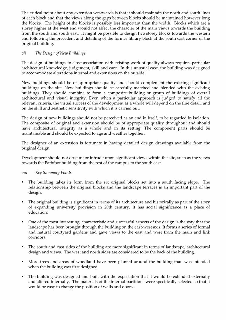
The critical point about any extension westwards is that it should maintain the north and south lines of each block and that the views along the gaps between blocks should be maintained however long the blocks. The height of the blocks is possibly less important than the width. Blocks which are a storey higher at the west end would not affect the character of the main views towards the building from the south and south east. It might be possible to design two storey blocks towards the western end following the precedent and detailing of the former library block at the south east corner of the original building.
vii The Design of New Buildings
The design of buildings in close association with existing work of quality always requires particular architectural knowledge, judgement, skill and care. In this unusual case, the building was designed to accommodate alterations internal and extensions on the outside.
New buildings should be of appropriate quality and should complement the existing significant buildings on the site. New buildings should be carefully matched and blended with the existing buildings. They should combine to form a composite building or group of buildings of overall architectural and visual integrity. Even when a particular approach is judged to satisfy all the relevant criteria, the visual success of the development as a whole will depend on the fine detail, and on the skill and aesthetic sensitivity with which it is carried out.
The design of new buildings should not be perceived as an end in itself, to be regarded in isolation. The composite of original and extension should be of appropriate quality throughout and should have architectural integrity as a whole and in its setting. The component parts should be maintainable and should be expected to age and weather together.
The designer of an extension is fortunate in having detailed design drawings available from the original design.
Development should not obscure or intrude upon significant views within the site, such as the views towards the Pathfoot building from the rest of the campus to the south east.
viii Key Summary Points
The building takes its form from the six original blocks set into a south facing slope. The relationship between the original blocks and the landscape terraces is an important part of the design.
The original building is significant in terms of its architecture and historically as part of the story of expanding university provision in 20th century. It has social significance as a place of education.
One of the most interesting, characteristic and successful aspects of the design is the way that the landscape has been brought through the building on the east-west axis. It forms a series of formal and natural courtyard gardens and gave views to the east and west from the main and link corridors.
The south and east sides of the building are more significant in terms of landscape, architectural design and views. The west and north sides are considered to be the back of the building.
More trees and areas of woodland have been planted around the building than was intended when the building was first designed.
The building was designed and built with the expectation that it would be extended externally and altered internally. The materials of the internal partitions were specifically selected so that it would be easy to change the position of walls and doors.

The building is in good condition generally but the specification of materials and some of the detailing has caused deterioration.
The building continues to be fully used for its original purpose.
Changes in the exact use of the building have led to internal alterations and extensions. It is inevitable that pressure to change and adapt to suit the needs of the university will continue.
There have been several alterations which have obscured the purity of the original design. The new block to the south and the eastwards extension of the third original block are the most successful of these extensions in terms of their aesthetic relationship to the original design.
The alterations which most damage the aesthetic appreciation of the building are where offices have been built against glazed link corridors blocking views along the bands of gardens.
Further external extensions and internal alterations are possible without detracting from the significance of the building.
The main constraint for south and east extensions is the landscape.
It would be possible to add an extension to the east end of the fourth block without detracting from the significance of the building.
It would be possible to add an extension to the south of the building without detracting from the significance of the building.
Westwards extensions could be higher but they should be aligned with the original blocks. They would be constrained by the form of the ground.
4.2 Character Area 2: Central Area
Figure 127 Character Area 2 site plan
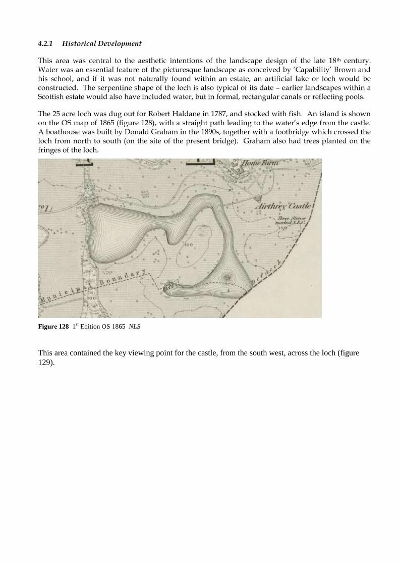
4.2.1 Historical Development
This area was central to the aesthetic intentions of the landscape design of the late 18th century. Water was an essential feature of the picturesque landscape as conceived by „Capability‟ Brown and his school, and if it was not naturally found within an estate, an artificial lake or loch would be constructed. The serpentine shape of the loch is also typical of its date – earlier landscapes within a Scottish estate would also have included water, but in formal, rectangular canals or reflecting pools.
The 25 acre loch was dug out for Robert Haldane in 1787, and stocked with fish. An island is shown on the OS map of 1865 (figure 128), with a straight path leading to the water‟s edge from the castle. A boathouse was built by Donald Graham in the 1890s, together with a footbridge which crossed the loch from north to south (on the site of the present bridge). Graham also had trees planted on the fringes of the loch.
Figure 128 1st Edition OS 1865 NLS
This area contained the key viewing point for the castle, from the south west, across the loch (figure
129).

Figure 129 View across the loch to Airthrey Castle 1904 StAU
In 1968 the loch was divided at its south eastern extremity to form a pond, allowing road access to the new buildings of the University.
Figure 130 Construction of new road, dividing pond from loch c1968 UoSA

Figure 131 Oblique aerial view from 2007 showing the central area buildings. RCAHMS
Figure 132 Oblique aerial view from 1970s showing the central area buildings RMJM
Figure 133 Oblique aerial view from 1970s showing the central area buildings. RMJM
i Cottrell Building, 1970-72

Figure 134 The north elevation of the first phase of the Cottrell Building nearing completion c1970.
Note the start of construction of one of the „rib‟ blocks in the background. UoSA
The largest of the building on the Airthrey campus was named after Tom Cottrell, the first Principal
and Vice-Chancellor of the University who died in 1973. The building was originally referred to as
„T70‟ in the development plans, a name methodically derived from the fact that it was the main
teaching block, to be completed in 1970.
The form of the building roughly
follows the contour of the site, with
ladder-plan of long parallel blocks
connected at regular intervals by
distinct linking „rib‟ blocks forming
generous internal courtyards. The
north block („A‟) was built first,
with the link buildings following on
after and the south block („B‟)
finished in time for the University
student population reaching 3,000.
The inspiration for the plan of the
Cottrell block can be clearly seen in
Denys Lasdun‟s iconic campus for
Figure 135 Model of Denys Lasdun‟s University of East
Anglia. Note the ladder plan of the teaching blocks (not
completed as shown).
the University of East Anglia (1962-8), where again the same model of expansion was suggested,
though not executed as planned (the north range was not built). Nevertheless the concept of a
continuous teaching block is one that rapidly gained momentum from the early 1960s and can be seen
at East Anglia and Leeds, and concurrently in developments in North America66.
66 Listing text for the University of East Anglia, English Heritage, http://www.heritagegateway.org.uk, accessed 30-Apr-2009

Fig
ure
s 1
36
M
od
el s
ho
win
g t
he
cen
tral
are
a b
uil
din
gs.
RM
JM
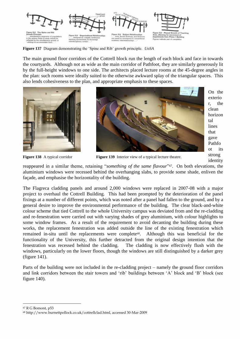
Figure 137 Diagram demonstrating the „Spine and Rib‟ growth principle. UoSA
The main ground floor corridors of the Cottrell block run the length of each block and face in towards
the courtyards. Although not as wide as the main corridor of Pathfoot, they are similarly generously lit
by the full-height windows to one side. The architects placed lecture rooms at the 45-degree angles in
the plan: such rooms were ideally suited to the otherwise awkward splay of the triangular spaces. This
also lends cohesiveness to the plan, and appropriate emphasis to these spaces.
On the
exterio
r, the
clean
horizon
tal
lines
that
gave
Pathfo
ot its
strong
identity
reappeared in a similar theme, retaining “something of the same flavour”67. On both elevations, the
aluminium windows were recessed behind the overhanging slabs, to provide some shade, enliven the
façade, and emphasise the horizontality of the building.
The Flagreca cladding panels and around 2,000 windows were replaced in 2007-08 with a major
project to overhaul the Cottrell Building. This had been prompted by the deterioration of the panel
fixings at a number of different points, which was noted after a panel had fallen to the ground, and by a
general desire to improve the environmental performance of the building. The clear black-and-white
colour scheme that tied Cottrell to the whole University campus was deviated from and the re-cladding
and re-fenestration were carried out with varying shades of grey aluminium, with colour highlights to
some window frames. As a result of the requirement to avoid decanting the building during these
works, the replacement fenestration was added outside the line of the existing fenestration which
remained in-situ until the replacements were complete68. Although this was beneficial for the
functionality of the University, this further detracted from the original design intention that the
fenestration was recessed behind the cladding. The cladding is now effectively flush with the
windows, particularly on the lower floors, though the windows are still distinguished by a darker grey
(figure 141).
Parts of the building were not included in the re-cladding project – namely the ground floor corridors
and link corridors between the stair towers and „rib‟ buildings between „A‟ block and „B‟ block (see
figure 140).
67 R G Bomont, p53 68 http://www.burnettpollock.co.uk/cottrellclad.html, accessed 30-Mar-2009
Figure 138 A typical corridor Figure 139 Interior view of a typical lecture theatre.

ii
Andrew
Miller
Building
, 1970-
73
Figure 142 Central area buildings, renamed Andrew Miller building shortly after completion. The
library and link bridge on the left, with the MacRobert Arts Centre on the right. UoSA
The Andrew Miller Building remains, as intended, the main student focal point for the university, and
includes the atrium space, Robbins Centre, Chaplaincy, shops and the University Library. It was
named after the former principal and vice chancellor of the University in a ceremony on the 1st October
2003.69
69 News Archive, www.stir.ac.uk, accessed 22-Apr-09
Figure 140 Original and replacement
cladding and fenestration
Figure 141 South elevation of Cottrell showing the replacement
cladding and fenestration

Figure 143 Concourse-level plan of Andrew Miller building as originally constructed. Note the
stepped-back plan of the library (with the upper level shown in dotted lines) which opens to an open
courtyard (now enclosed as the atrium) and the „Future Social Buildings‟ which were intended as part of
Phase 2, but were not built. Architectural Design
iii The University Library, 1970
Figure 144 2008 view of the University Library
Although both appearing as a distinct building from the exterior, and being structurally separate, the
University of Stirling Library was always designed to be closely interlinked with the other central area
buildings and largely indistinguishable from the user‟s point of view. Entered from the concourse level
of the Andrew Miller building, RMJM deliberately avoided the option of a grand separate entrance –
meaning teaching, research and recreation could all take place, in theory, without ever having to go out
of doors.
The library is arranged as an upside-down ziggurat over four storeys: the first floor projects out from
the basement and ground levels and is supported by concrete columns equally spaced around the
perimeter of the building. The second floor projects out further again. Gerrard Bakker, who worked
on the Library recalled being influenced by the design for the Royal Northern College of Music in
Manchester that he had worked on (compare figures 145 and 146). Overall the plan of the building is
arranged on a squared-grid of eight structural bays by five.
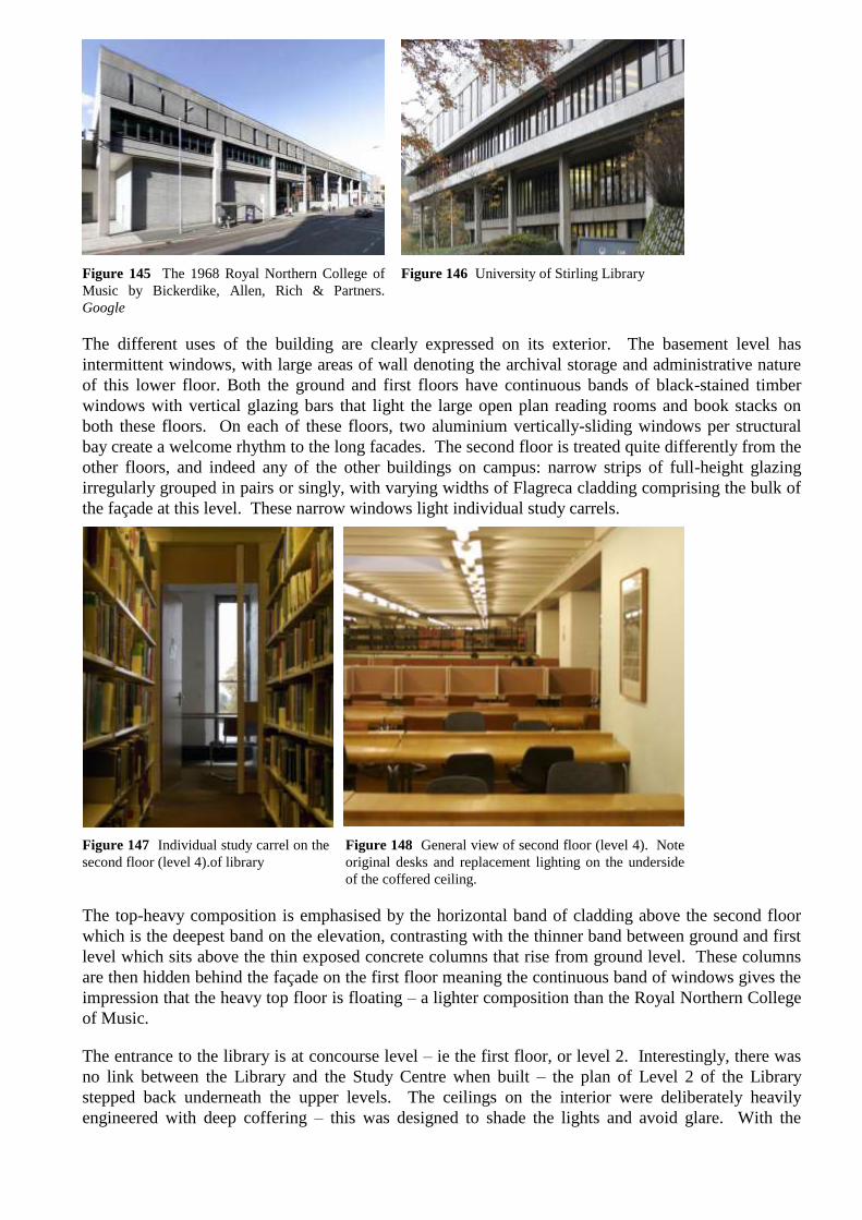
Figure 145 The 1968 Royal Northern College of
Music by Bickerdike, Allen, Rich & Partners.
Figure 146 University of Stirling Library
The different uses of the building are clearly expressed on its exterior. The basement level has
intermittent windows, with large areas of wall denoting the archival storage and administrative nature
of this lower floor. Both the ground and first floors have continuous bands of black-stained timber
windows with vertical glazing bars that light the large open plan reading rooms and book stacks on
both these floors. On each of these floors, two aluminium vertically-sliding windows per structural
bay create a welcome rhythm to the long facades. The second floor is treated quite differently from the
other floors, and indeed any of the other buildings on campus: narrow strips of full-height glazing
irregularly grouped in pairs or singly, with varying widths of Flagreca cladding comprising the bulk of
the façade at this level. These narrow windows light individual study carrels.
Figure 147 Individual study carrel on the
second floor (level 4).of library
Figure 148 General view of second floor (level 4). Note
original desks and replacement lighting on the underside
of the coffered ceiling.
The top-heavy composition is emphasised by the horizontal band of cladding above the second floor
which is the deepest band on the elevation, contrasting with the thinner band between ground and first
level which sits above the thin exposed concrete columns that rise from ground level. These columns
are then hidden behind the façade on the first floor meaning the continuous band of windows gives the
impression that the heavy top floor is floating – a lighter composition than the Royal Northern College
of Music.
The entrance to the library is at concourse level – ie the first floor, or level 2. Interestingly, there was
no link between the Library and the Study Centre when built – the plan of Level 2 of the Library
stepped back underneath the upper levels. The ceilings on the interior were deliberately heavily
engineered with deep coffering – this was designed to shade the lights and avoid glare. With the

improved anti-glare designs of modern lighting, this is no longer required, and indeed some
replacement lighting has been fixed to the surface of the ceiling (figure 148).
Figure 149 Sketch impression of new library entrance on Level 2. UoSA
The library is currently undergoing a major redevelopment project by the architects Lewis and Hickey.
The project will radically alter the interior of the building in particular with the insertion of a central
lightwell occupying one square of the building‟s grid which will bring daylight into the centre of all the
main floors. The main entrance will also be shifted north, to join with the north-west corner of the
atrium, cutting across the remnants of the open courtyard. The individual study carrels on the second-
floor will be removed.
iv MacRobert Arts Centre, 1971
The MacRobert Arts Centre was designed to be a prominent building at the heart of the university
campus – the fly tower of the theatre rises above all of the buildings in the immediate surroundings, yet
being without fenestration or other distinctive elements means that the Flagreca clad form of the fly
tower is less distracting than its otherwise bold form would suggest. It also neatly mimics the stair
towers of the library and Cottrell building. The oblique angle that the Centre sits at in provides
adequate distinction from the other central area buildings. The positioning allows for the awkward
shape of the auditorium to sit well in the overall composition – in the same way that the lecture rooms
of Cottrell sit at the angles of that building – and allows the restaurant space to fully take advantage of
the view over the MacRobert pond.
Figure 150 MacRobert Arts Centre with double-height dining space at the lower level and fly-tower
behind.

Figure 151 Main auditorium at the MacRobert after the 2002 refurbishment. Buro Happold
Figure 152 1973 plan, at concourse level, showing the MacRobert Arts Centre, Shops and Social
Building. Architectural Review
Like the Library, the MacRobert was built with main entrance being accessed directly from the
concourse, marked as „2‟ in figure 152. Steps sank down from this concourse level underneath the
rake of the theatre to the reception space with box office ticket booths, and led to foyer space on either
side („1‟). The foyer to the left of the ticket booths also led to a smaller rehearsal, or studio, theatre.
To the right, the larger foyer (overlooked from concourse level) led to the café and bar, and then from
there down to the restaurant.

Figure 153 The art gallery, underneath the
concourse. The large MacRobert foyer is on the
other side of the glazed partition. UoSA
Figure 154 The art gallery, now converted into
the main entrance and box office area. The stair
leading up to the concourse is on the right. UoSA
The Art Gallery was situated underneath the concourse, wrapping around the large foyer space – this
was later converted into the bar, and more recently, the main entrance and box office area.
The MacRobert, with its capacity of 500, was always deliberately intended to be the public face of the
University, fostering a positive „town and gown‟ relationship. Indeed, J M McKean is somewhat more
emphatic as to its purpose in his opinion piece in the Architectural Review of June 1973:
„Some universities plan to have a rough, cheap, adaptable workshop ‘theatre’ even if they
end up with one much more finished… [At Stirling] is the direct opposite; it is a superior
theatre – with superior architectural design and finish – intended to stimulate passive
student awareness rather than active participation. Surprised by such riches, students are
often both self-conscious about and suspicious of the ‘middle-class cultural indoctrination’
offered.‟70
When the MacRobert opened in the autumn of 1971, The Guardian stated that “The MacRobert Centre
is a marvellously impressive arts complex that aims to inject cultural lifeblood into Scotland’s newest
and most idyllic University campus at Stirling.”71
Figure 155 The foyer of the MacRobert, with the
concourse level on the left (now the atrium). The
ticket booths (centre) were under the rake of the
theatre above. The columns mark the line of the
wall shown on the right of figure 156.
Architectural Review
Figure 156 The same space after conversion
(photograph taken from the other end at the lower
level). The atrium is on the right, with borrowed
light for the exhibition space coming from the
glass bricks in the new wall. Buro Happold
70 J M McKean, „University of Stirling: Criticism‟, Architectural Review, June 1973, p361 71 Quote on p7, University of Stirling: A Survey – 1972

Figure 157 The larger MacRobert foyer in the
1970s. Note the half-stair to the reception area, up
to the main concourse beyond. Architectural
Design
Figure 158 The same area today. Note the
removal of the stair and the lowering of the floor
to the space at the back, now used as exhibition
space. Buro Happold
The MacRobert underwent extensive refurbishment before its reopening in October 2002. This work,
by the architects Appleton Partnership, included the refocusing of the MacRobert to its separate
entrance adjacent to the Andrew Miller building entrance at the ground level of Queen‟s Court. The
ticket booths were moved to the bar area, just inside the Queen‟s Court entrance. The original
reception area was separated from the atrium space, a wall built up, steps removed and the floor
lowered in order to create an exhibition space („arthouse‟). This deliberately separated the university
function and the more public function of the MacRobert – even though the integration of the two had
been a key design aspiration of RMJM and Tom Cottrell. Nevertheless, the accessibility of the
MacRobert was greatly improved. The main theatre („mainhouse‟) and the studio theatre were also
refurbished, with the smaller of the two was specifically redesigned for use as a children‟s theatre
(„playhouse‟).
Figure 159 The MacRobert Extension. Buro Happold
As well as the internal alterations, a large extension was
also built, providing a new workshop and rehearsal space
(„workhouse‟) and cinema („filmhouse‟). The new
extension is a rather complex four-storey building (see
figure 159) which despite being attractive in its own
Figure 160 The MacRobert
Extension adjacent to the link
bridge
right detracts from the simplicity of the original design concept. The way that the extension abuts the
link bridge was deliberately designed to maintain the original structural integrity of the bridge, but has
in the process created an unattractive void along two bays of the bridge (see figure 160), and an
awkward juxtaposition of materials.
The additions and alterations
to the entrance from Queen‟s
Court also have drawbacks.
Whilst enabling a higher
profile for the MacRobert, it
has achieved this only at the
expense of the entrance to
the Andrew Miller building.
Details such as the pitched-
roof form of the rooflight,
the mesh-panel sign, and the Figure 161 Architectural „clutter‟ created with the refurbishment
of the MacRobert Centre highlighted in blue.
multi-faceted arrangement are particularly out of keeping. In the words of Dr Douglas Robertson these
additions have „seriously compromised the original design concept‟72
v Robbins Centre, 1971
This is the home of the Stirling University Students‟ Association and was named after the first
Chancellor of the University, Lord Robbins. The building was designed as the first stage of what was
always intended to be a far more substantial building stretching out eastwards to the loch (see figure
143). Although intended as part of Phase 2, it was not completed.
As well as containing offices for the Students‟ Association, the Robbins Centre incorporates two bars,
the Studio and Long Bar. An external deck area was added in 2002.
vi Studies Building, 1973
This part of the Andrew
Miller building was the last
to be completed to the
original development plan.
Comprising of two tiered
storeys, it was built to
provide study space for the
students who lived off-
campus.
The roofline of the building
was kept deliberately in line
with the low level of the roof
of the shops – this kept the
entrance elevation from the
bridge low-key, with the
Figure 162 View showing the low-profile of the studies building,
with the library rising behind. UoSA
focal points remaining on the MacRobert fly tower and the library.
An oddity of the study centre was that it was not originally connected to the library, being separated at
concourse level by the courtyard space breaking out through towards the loch. The stepping back of
the plan of the library at level 2 created a gap between the two buildings – this gap was closed when a
narrow glazed link corridor was constructed. The somewhat awkward arrangement is to be further
rationalised with the redevelopment of the library, with student access to both buildings being provided
in the north-west corner of the atrium. The narrow corridor will revert to staff use.
72 Dr Douglas Robertson, Department of Applied Social Science, Speaking at a conference at the University of Stirling, 24-Nov-2007

vii Footbridge, 1970
Figure 163 View of the footbridge looking towards the students‟ residences.
Figure 164 View showing the simplicity of the structure of
the footbridge. UoSA
The footbridge over Airthrey Loch replaced an
earlier bridge at the same narrow point of the
loch. It was designed in order to facilitate the
large volume of pedestrian traffic between the
central area buildings and the students‟ residences
on the north banks of Airthrey Loch. The height
of the bridge above the water level of
Figure 165 Oblique aerial view of the
footbridge over Airthrey Loch.
RCAHMS
the loch reflects both the requirement to provide level access into the central area buildings, but was
the specific requirement that sailing boats on the loch should be able to pass underneath.
Constructed as a u-section reinforced concrete box, the deck comprised concrete slabs laid without a
mortar bed to facilitate drainage. This has been covered with red-coloured Tarmacadam at a later date,
with the pattern of the concrete slabs showing through.
The key attraction of the footbridge is its stark contrast, in material, colour and form, with the
picturesque and naturalistic forms of Airthrey Loch, lending the bridge a strong sculptural quality.
When viewed from due east or west, the ends of the bridge are hidden by vegetation, highlighting the
central section. For the many users of the bridge, the elevated views of the surrounding landscape
provided turn this otherwise functional structure into a dramatic keystone in the composition of the
campus.
The footbridge was listed by Historic Scotland at Category „C(S)‟ in May 2009.

viii Link Bridge, 1970
The link bridge connects the concourse level of the Andrew Miller building and the ground level of the
Cottrell building.
Figure 166 External view of the link bridge
The key purpose of the bridge was to allow uninterrupted communication between the teaching,
research, recreation and dining facilities of the University. A typical day in the life of a student or
member of staff could thus be contained completely indoors, without any inconvenience of dealing
with traffic or the weather. The bridge carries pedestrians over the inner loop road.
Although the interior has the same simplicity as the corridors of Cottrell (and formerly of the
concourse of the Andrew Miller building), the external structure of the bridge has an elegant structural
form. The bridge stands on forked structural piers that split from a single column to wrap around the
walkway to meet with the roof.
Figure 167 Internal view of the link bridge

ix Queen’s Court, 1972
Although completed at with the opening of the
Phase 2 buildings, the open courtyard area between
Cottrell, the Link Bridge and the Andrew Miller
building was named to commemorate the formal
opening of the University by The Queen in 1972.
The plaque acknowledging this was „cast and
generously donated by the Carron Company,
Falkirk‟ – a nice link to a company that was once
the biggest ironworks in Europe.
Queen‟s Court acts as the main vehicular hub of the
campus with a frequent bus service from Stirling
and beyond using the court as a terminus.
Figure 168 Oblique aerial view of Queen‟s Court. RCAHMS Figure 169 Plaque unveiled in
October 1972
x The Stirling Management Centre, 1988
Figure 170 The Stirling Management Centre
The Stirling Management Centre was opened in 1988 and is a predominately two-storey building
forming an open U-shape with single-storey projection to the west at intermediary level. It contrasts
with the main university buildings by being built in brick with a concrete tiled roof. It was extended
and refurbished in 1994, and again in 2008 in a £5.5m project by Burnett Pollock Associates.
xi The Atrium, 1998

Figure 171 1970s oblique aerial view showing
the open courtyard. RMJM
Figure 172 2007 Oblique aerial view from south-
east with covered atrium highlighted in blue.
RCAHMS edited by S&B
What is now referred to as the atrium was created in 1998
by Ian Burke Associates73, and involved the covering over of
what was originally designed as an open courtyard, with the
concourse running around the perimeter. A large glazed
tetrahedron roof provides light to this space which is used
for a variety of social purposes. A slim courtyard between
the atrium and the library building was retained, with access
to the open area adjacent to the loch maintained.
Figure 173 The atrium
xii University Court Building, 1998
Figure 174 University Court Figure 175 University Court from west 2009
The University Court building, an extension of the Cottrell building was completed in 1998. It was
designed by Alan Clyde of the Hurd Rolland Partnership74. Parts of the building, although modern,
have possibly been influenced by 1950s domestic style, somewhat incongruous against the 1970s
Cottrell. Since the re-cladding of Cottrell, the contrast has been exaggerated.
Although not regarded as being of the same architectural quality as other parts of the university75, the
prominent position of the University Court building at the main entrance to Queen‟s Court means in
many ways it acts at the public face of the University buildings and has successfully resolved the
73 Planning Application reference 97/00614/DET (1997), www.stirling.gov.uk 74 CV of Alan Clyde, http://www.hurdrolland.co.uk/, accessed 12-May-2009 75 Dr Douglas Robertson, Department of Applied Social Science, Speaking at a conference at the University of Stirling, 24-Nov-2007, described it as „a missed opportunity‟
previously awkward and abrupt end of Cottrell, providing a more welcoming reception to visitors.
Nevertheless it can be seen that the detailing of the building has led to premature ageing, in particular
with the staining of the façade under the projecting window surrounds.
xiii R G Bomont Building, 1998
Figure 176 R G Bomont building 2008
Like the University Court building, the Hurd Rolland Partnership-designed R G Bomont building
appears to have been designed in a deliberately anachronistic 1950s style. It is difficult to believe it is
little more than a decade old, not helped again by the premature ageing. The interaction of the building
and Cottrell is interesting – the R G Bomont building takes on the same massing and overall depth as
Cottrell but the loose connection (a narrow single-storey corridor at low level) and distance between
the two means that any sense of cohesion is difficult to find. This is further confirmed by the fact that
the main elevation has been turned to face the end of Cottrell. The building houses the Department of
Nursing and Midwifery.
xiv Iris Murdoch Building, 2002
Figure 177 Iris Murdoch building 2009

This building, designed by Burnett Pollock Associates, houses the Dementia Services Development
Centre. The plan of the building was deliberately set out to demonstrate good practice in
accommodating users with dementia in a public building by maximising clarity in order to aide
orientation and avoid confusion. Presentations demonstrating these aspects are regularly given at the
centre.
The overall plan of the building is designed as the end point of the teaching block – the L-plan is
enclosed by the garden wall that wraps around it in a parabolic curve.
As well as a mix of open-plan and cellular office space, seminar and meeting rooms, the building
includes residential accommodation for visiting academics. The garden, also designed to cater for
people with dementia, was by the landscape architect Annie Pollock.
Built at a cost of £1.5m it was completed in March 2002.
Figure 178 The Colin Bell and Iris Murdoch buildings.2009
xv Colin Bell Building, 2003
Designed by Burnett Pollock Architects the Colin Bell building was built to house the Department of
Applied Social Science. Being masterplanned at the same time as the adjacent Iris Murdoch building,
the architectural treatment is very similar with white render ground storey, aluminium-clad upper
storey, and a variety of sizing and placing of fenestration. The two buildings are, in plan, completely
separate yet are tied together visually by a simple screen across the entrance pend which leads to a
porch for both buildings.

Figure 179 The post-1997 extensions to Cottrell
This group of post-1997 buildings demonstrate an interesting academic and architectural move away
from flexible teaching space and a return to custom buildings for stand-alone departments. As a group
they act as an effective „full-stop‟ to Cottrell, providing the satisfying conclusion that was always
intended but not built for more than two decades. Whilst taking on a completely different format in
both layout and materiality, they remain closely connected to Cottrell in terms of their massing,
footprint and building line. The Colin Bell and Iris Murdoch buildings are particularly well liked –
even being referred to as „Pathfoot Mark II‟ by staff who work in them76.
xvi Proposed Central Area Expansion: Phase 3
The ladder-plan of Cottrell was designed to be easily extended, as shown in the development plans (see
3.10). Further extension was anticipated in Phase 3, both continuing T70 to the east, and with an
additional building T70 to the south. Whilst most diagrams suggested a similar block to Cottrell, a
model prepared to demonstrate Phase 3 growth (figure 180) suggests a quite different building –
reflecting the proposals in the development plans that Cottrell would be reserved for general teaching,
and the block to the south designed for specialist teaching.
It can be presumed that the link corridor shown on the proposed layout plans would have been a link
bridge similar to that between T70 and what is now referred to as the Andrew Miller building – a
model prepared by the architects to demonstrate Phase 3 growth shows a similar arrangement as on the
north side of Cottrell – ground floor entrance lobby (as built) with the bridge adjoining at first floor
level. As a result of the rise of the site, this bridge would have joined the Phase 3 buildings at ground
level, thus creating an extremely large area under continuous cover.
76 Dr Douglas Robertson, Department of Applied Social Science, Speaking at a conference at the University of Stirling, 24-Nov-2007

Figure 180 The Phase 3 model prepared by RMJM. Note the extended library projecting over the edge
of the loch, the distinct nature of the Phase 3 teaching block south of Cottrell, and the residences to the
east of Airthrey Loch, accessed via the extended social buildings and second bridge over the loch. RMJM
The Phase 3 growth was also intended to include an expansion of the library – the photograph of the
model shows the suggested doubling of the building with an additional five-by-eight bay block
connected with two-bay wide links with a large open courtyard. The north-west corner of the
additional block would have been cantilevered over the edge of the loch.
The model also shows the intended completion of the social buildings stretching out to the north-east
to meet the east portion of Airthrey Loch, as well as a further extension northwards, presumably for
further shops. A second bridge is shown providing access to the Phase 3 residential blocks.
5.7.3 Character Assessment
The Cottrell Building dominates this area. It is an irregular shape, generally in line with the contour
which curves form the south east round to the north. This building encloses the MacRobert Centre, the
Library and the Andrew Miller building to the north. The general quality of this area is dominated by
buildings and car parking. It has the character of the hub of the built part of the university and is far
busier with cars and people than the other character areas. The main part of the Cottrell Building is
three storeys high and clad with metal sheets. The cladding has disguised the original architectural
relationship with the Pathfoot building. Unlike the Pathfoot Building, there is no clear point of
entrance. The strongest route into the building is from the north on the axis of the bridge through the
Andrew Miller building. To some extent the west and south sides of the Cottrell building are the
back. Alterations to these sides would not particularly affect the character of the campus. Close to the
south west part of the Cottrell building is the Logie Lecture Theatre. This is a separate building faced
with high aggregate concrete blocks and built into the landscape to take advantage of a bank rising
upwards to the south west.

The Stirling Management Centre is raised on the highest part of this character area. The conference
centre is prominent in views from the car park but not in views from outside the university area
because it is screened by a bank and some trees. The building forms an open U plan with its open side
facing east. It is built of brown brick with concrete tiled roof. To the north east is a hall building with
a segmental sheeted roof. The southern arm has been extended eastwards in an imitation of the same
style. The area enclosed by the conference centre is surprisingly unkempt. There is an opportunity for
a garden here or further development. To the south the land rises to a belt of relatively young trees
with a field at the brow of the hill edged by more mature trees. There are some remnants of ornamental
ditches and paths within this woodland. The banks slope down to the chalets and form part of that
character area.
At the end of the car park to the east of the Management Centre between the Cottrell Building and the
RG Bomont Building is a view of Airthrey Castle in its landscape. The contrast between old building
and university building in this view is a strong and positive one. It is one of the few views in which the
tower on the north side of the castle makes an effective contribution to the landscape.
To the east of the south east corner of the Cottrell building are two further university buildings. They
are connected to the Cottrell Building by corridors along the northern edge. First is the RG Bomont
building. This building is clad with high aggregate concrete block, quite similar to the block used on
the Cottrell building. This is a relatively small building. Its length is about the same as the Cottrell
building and in line with it but it is quite narrow east to west. Beyond this, and with its architecture
forming a termination to the built development is a group formed by the Colin Bell building and the
Iris Murdoch building. The construction materials are the massing and detailing which is carefully
considered and together these buildings provide the best post 1970s architecture on the campus. The
rounded end of the Iris Murdoch building is like a prow of a ship. It contains an attractive garden.
This end suggests the limit of development in this direction. There are some mature trees further east.
The buildings are in good condition although the garden walls of the Iris Murdoch building are
disfigured by staining and some cracking under the copes. There is also some staining on the circular
entrance tower of the Iris Murdoch building.
The north east facing side of the Cottrell building is also clad. The architecture is more lively,
however, because the roofline has the ends of blocks which run across the building and also service
towers projecting about two storeys above the general roof line. The complex of buildings curves
around the MacRobert pond which is surrounded by trees. This pond is separate from the loch. The
particular part of the loch which is closest to this side of the building does not make a particularly
prominent impression but there are very good views across it towards Airthrey Castle and its entrance
tower. There are some sculptures on the grounds to the north of the pond. Around the loch is a
walkway with seats.
The buildings around the pond give the impression of being the backs of buildings. The east and south
face of the Andrew Miller block does have some reflection of the original palette of materials of high
aggregate concrete block and black frames to windows. The south eastern face of the MacRobert
Centre is also a strong architectural statement with a café facing the pond, a sculpture next to the pond
and the high fly tower faced with concrete block behind it. The newer block to the south of the fly
tower is rather more fussy in appearance.
The Cottrell building has been extended at the north west corner to provide offices.
The bridge between the library block and the Cottrell building is another strong statement from the
1970s and, again, uses the characteristic materials. Its strength as a statement is reduced to some extent
by the extension to the north west.
The library is a strong statement of the architecture of the 1970s university. It projects from the bank
towards the western part of the loch. At the north west corner it rises to about two storeys on concrete

columns before supporting the main two bands at the top of the building. At least from the north and
west, this building can be read as an independent structure from the adjoining buildings.
The single storey block to the north east of the library forms part of the architectural context on the
approach across the foot bridge from the students‟ residences. This approach which counts as the main
architectural entrance to the complex of buildings is kept very low key with planting and cherry trees
disguising most of the buildings. The library block rises to the west. To the east is the service wing of
the Robbins Block which does look like the back of a building with service sheds, parking, bins and
sheets of concrete. Some screening is certainly desirable in this area.
This low key entrance at the north end of the Andrew Miller building is an architectural set piece
which should be maintained.
Inside the library relatively little remains. The detailing around the carrels – the student study rooms
on the top floor – is of interest and the minimal shadow gap square handrail detailing on the stairs has
been carefully considered.
The most attractive quality about the Cottrell Building are the inward facing courtyards. In each case
they have a mix of formal and informal planting. The central courtyard has a paving design which
reflects the 45 degree diagonals of the
Cottrell building in a design of concrete
paving and bands of sets. The garden
between blocks X and Y is less formal.
The courtyard between Y and Z is a
service courtyard with parking. The
courtyard between blocks X and W and
between U and V is also informal with
tree planting but less intense and with a
greater area of gravel. The latter
courtyard has some beautiful trees.
Figure 181 Courtyard within Cottrell 2009
4.2.3 Assessment of Significance
The footbridge, Andrew Miller Building (including the Library and MacRobert), the link bridge and
the Logie Lecture Theatre are of considerable significance. The Cottrell building has been reclad and
is now of moderate significance. Elements of this Character Area are of neutral significance: Stirling
Management Centre, University Court building, RG Bomont building. The landscape setting of these
buildings is generally of considerable significance, including Airthrey Loch, which forms perhaps the
most important single landscape feature of the campus.
There are important views within this area, including perhaps the most important views of the campus
buildings. From the west shore of the loch the visitor sees a panorama of the university, taking in the
residences in Character Area 3, the footbridge, the Library and the western end of the Cotterell
building. The planting of brightly colourful azaleas and shrubs at the west of the loch is not in
accordance with the 18th
century landscape design, nor is it considered to be in the best visual interests
of the 20th
century buildings.

Figure 182 Character Area 2 showing significance BLA
From the south eastern shores of the loch (to the east of the pond) the view of Airthrey Castle in its
designed landscape setting of water, parkland and mature trees should be an expression of the
picturesque ideal, however this particular view is partly obscured by overgrown trees and inappropriate
shrubbery, reducing its significance.
Figure 183 Coniferous shrubs and small border of colourful azaleas on shores of loch 2009

Figure 184 Character Area 2 showing views
4.2.4 Recommendations
Maintenance
The buildings in this character area are generally well maintained.
Recording
The library building should be recorded in photographs prior to the planned redevelopment.
The library interior was carefully designed, including furniture, carpets and curtains. Surviving pieces of the original library furniture should be recognised and retained.
Development
The model for future development on this site should be the existing buildings. Development would be possible following the RMJM Phase 3 layout.
Landscape
This area contains two of the most significant viewing points within the campus, of the students‟ residences from the west shore of the loch, and of Airthrey Castle, also from the loch shore. Both sites should be improved:

Removal of colourful flowering shrubs on shores of loch
Thinning and progressive removal of saplings and small trees on shores of loch
A strategy should be drawn up for the future siting of sculpture within the landscape.
Commemorative trees should not be planted in this area, but instead in dedicated areas such as the Memorial Garden.
Figure 185 View towards Airthrey Castle from CA2, with shrubs and smaller trees 2009
Figure 186 Colourful plants at western shores of loch, with monochrome library beyond 2009

Figure 187 View of residences from south with mature parkland trees and self-seeded smaller trees and
shrubs which are obscuring views 2009
4.3 Character Area 3: Students Residences
Figure 188 Character Area 3 site plan

4.3.1 Historical Development
This area of landscape was parkland prior to the construction of the students‟ residences, and a relatively defined area within the picturesque design, as it is now. The principal approach from the west ran through this area, skirting the loch and then following the rising ground to the north east before curving round to the castle, giving typically picturesque views across water to the house. To the west a drive led north along a belt of trees to skirt a band of trees to the north, which disguised the boundary wall and the road to Logie Old Kirk. Across the open area between this and the loch were scattered parkland trees, with one clump of trees, which would have provided periodic interruptions to the view of the house from the approach, a typically picturesque feature.
Figure 189 1865 OS NLS
In the 1890s Donald Graham had a footbridge built across the loch, together with a pier, and further to the east a boathouse. It is marked on the 2nd Edition OS 1899 (figure 191) and survived until the mid 20th century. He is also reported as having planted trees along the lochside.
Figure 190 Undated mid 20th
century photograph of footbridge and Character Area 11 UoSA

Figure 191 1899 OS NLS
The area maintained its parkland character during the hospital period, and the principal approach to the castle continued to be from the West Lodges. In 1947 the West Avenue (as it was known – it was never lined with trees however) was lighted with electric street lights.
The construction of the students‟ residences involved a partial loss of the West Approach, but the majority was preserved as a footpath. The western end of this was planted as the George Forest Walk by the Airthrey Gardens Group, and contains a number of species introduced by the renowned plant collector.
Figure 192 Aerial photograph showing construction of students‟ residences UoSA
i RMJM’s Residences
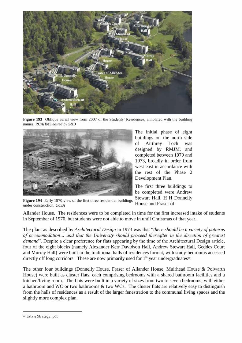
Figure 193 Oblique aerial view from 2007 of the Students‟ Residences, annotated with the building
names. RCAHMS edited by S&B
The initial phase of eight
buildings on the north side
of Airthrey Loch was
designed by RMJM, and
completed between 1970 and
1973, broadly in order from
west-east in accordance with
the rest of the Phase 2
Development Plan.
The first three buildings to
be completed were Andrew
Stewart Hall, H H Donnelly
House and Fraser of Figure 194 Early 1970 view of the first three residential buildings
under construction. UoSA
Allander House. The residences were to be completed in time for the first increased intake of students
in September of 1970, but students were not able to move in until Christmas of that year.
The plan, as described by Architectural Design in 1973 was that “there should be a variety of patterns
of accommodation… and that the University should proceed thereafter in the direction of greatest
demand”. Despite a clear preference for flats appearing by the time of the Architectural Design article,
four of the eight blocks (namely Alexander Kerr Davidson Hall, Andrew Stewart Hall, Geddes Court
and Murray Hall) were built in the traditional halls of residences format, with study-bedrooms accessed
directly off long corridors. These are now primarily used for 1st year undergraduates77.
The other four buildings (Donnelly House, Fraser of Allander House, Muirhead House & Polwarth
House) were built as cluster flats, each comprising bedrooms with a shared bathroom facilities and a
kitchen/living room. The flats were built in a variety of sizes from two to seven bedrooms, with either
a bathroom and WC or two bathrooms & two WCs. The cluster flats are relatively easy to distinguish
from the halls of residences as a result of the larger fenestration to the communal living spaces and the
slightly more complex plan.
77 Estate Strategy, p65

The
construction
of the student
residences at
Stirling was
completely
dependent on
external
funding. By
the late 1950s
the University
Grants
Committee
had decided
that it was not
its concern to
provide
monies, as a
general rule,
for accommodation, even on campus universities like Stirling. This was despite earlier recognition that
on-campus accommodation was of great importance to the success of the university. However, the
time of expansion of the tertiary education sector in the UK saw a rapid change in views on how to
provide accommodation for students – indeed, even “as early as 1966 it was asked why the university
should be dealing with student residences at all”78. In the end, the Appeals Committee raised generous
funding which when used in conjunction with commercial loans, enabled the University to build the
crucial residences.
The monies raised for the residences did not allow for generous architectural treatments, and the
finishes were even more pared back than at Cottrell which itself was heavily constrained by the
University Grants Committee. The competition between the glass-plate universities was such that if
one university achieved a new low in £/m2, this was then applied to other buildings projects. Although
this did not directly affect the residences at Stirling, other economical projects had shown what could
be achieved.
The concrete block work of the exterior is repeated
on the exterior – much to the chagrin of the
residents themselves. Many services are left
exposed – as can easily be seen on the underside of
the arcade ceilings. What is remarkable is that the
architects achieved such picturesque composition –
albeit using a very limited palate of much repeated
parts.
Although conceived as individual buildings,
covered walkways allow for sheltered
communication between most. These walkways
start as arcades beneath the blocks, stretching out to
connect at corner points where paths leading to
other parts of the campus lead off.
78 S Muthesius, p83
Figure 195 East elevation of A.K. Davidson Hall, looking towards the Wallace Monument.

Figure 196 Typical arcade, showing
exposed concrete blockwork and
services on the underside of the ceiling.
UoSA
Figure 197 General view of Geddes Court.
Figure 198 General view of Muirhead House, with the original fenestration.

Figure 199 Plans showing typical layout of a Halls of Residence and Cluster Flats, with a plan of a
typical flat. Note the slightly more complex footprint of the wings of the Cluster Flats – reflecting the
wider variety of spaces. Each of the buildings splays out towards the south, maximising the exposure to
sunlight. Architectural Review
Ongoing refurbishment of the Students Residences has had two main effects on the fabric of the
buildings – the replacement of the original single-glazed fenestration and the insertion of en-suite
facilities to cater for increased expectations of current students and vacation letting. The insertion of
en-suite facilities in general involves the conversion of alternate bedrooms into two bathrooms –

resulting in the loss of approximately one-third of the total number of bedrooms. Even the less
ambitious refurbishment projects have resulted in the loss of bedrooms as improved communal
facilities require more space.
Figure 200 General view of replacement fenestration – note the bold black frames and the top-hung
hinged opening.
The replacement of the windows has had a surprising effect on the elevations. The replacement
double-glazed top-hung windows in dark black-stained timber create a bolder colour scheme than the
original aluminium frames – something that is rather successful. Although efforts were made by the
university to source sliding windows, it was not possible to do so, and the new top-hung windows have
introduced a measure of „movement‟ to the elevations when compared to the sliding mechanism of the
original fenestration.
A summary of the accommodation provided at the University of Stirling is shown in Appendix II.
ii Pendriech Way Chalets
Figure 201 General view of chalets at Pendriech Way 2009
In 1981, additional student accommodation was supplied in the form of ten chalets at Pendriech Way.
The chalets are all single storey Scandinavian-style timber constructions of the type more normally
found in holiday parks, but are ideally suited to the woodland setting east of Pathfoot. They are
popular with the returning undergraduates who live in them and as holiday accommodation in vacation
periods. Each chalet accommodates five students, or up to six as a holiday-let.
iii Airthrey Park Medical Centre

Figure 202 Airthrey Park Medical Centre 2008
A small area of land immediately east of the students‟ residences is leased to the Airthrey Park Medical
Centre. The building is a fairly nondescript single-storey L-shape with matching later extension that
ties in with the colouring and materiality of the students‟ residences. This practice is aimed primarily
at staff and students at the University but is also open to patients from the local area.
iv Vacation letting
The University of Stirling, in line with many other universities, makes full use of the residential estate
in the weeks when students are not in residence. In fact, the University of Stirling was one of the first
Universities to fully develop this concept, no doubt in part to the need to service the loans taken out to
cover construction costs. The flatted accommodation has proven particularly popular for the group
travel market – whilst individual conference delegates require private facilities, those in groups often
prefer self-contained flats with shared facilities. The same is true of the chalets at Pendriech Way and
Spittal Hill, which are in any case a popular holiday-let accommodation type.
The University has stated that the Halls of Residences are best suited for conference use when
bedrooms have en-suite facilities – at the time of writing this report only Andrew Stewart Hall and
Muirhead provided such facilities. At the end of 2007/8, the total number of en-suite study bedrooms
was 20779 – far below the largest conference capacity of 460 (MacRobert Centre)80. There is therefore a
balance to be made between the pressure to refurbish further Halls to provide similar accommodation,
and yet maintain provision of adequate low-cost (ie non en-suite) accommodation for students who
require it. There is a further conflict in that when en-suite provision is added, there is a resulting loss
of capacity.
v Other accommodation off-campus
The University of Stirling also owns a
number of residential buildings off
campus. The first of these is Alangrange
in Bridge of Allan, a Victorian villa
previously used as a guest house, which
was purchased by the University for use as
a staff and student club from 1967 until
the main buildings were completed. It was
later converted to student accommodation,
and has since been extended significantly.
79 Estate Strategy, p57 80 http://www.external.stir.ac.uk/business/conferences/conf-lec.php, 10-Feb-2009

A further villa called Friarscroft, is located
just outside
Figure 203 Alangrange and extension
the campus boundary. John Forty‟s Court in Stirling is a large purpose-built apartment block that
opened in 1994.
Further buildings in Stirling are leased by the University for directly-managed student accommodation.
These are the Thistle Chambers on Murray Place in Stirling, built in 1978; Lyon Crescent in Bridge of
Allan completed in 1991; and Union Street in Stirling which was completed in 1993. Thistle
Chambers and Union Street are flats, predominantly for returning undergraduates, whilst Lyon
Crescent comprises houses with study bedrooms for postgraduate students.
5.11.3 Character Assessment
This area comprises of a series of blocks, generally with their long axis running north – south. They
are placed along the northern side of Airthrey Loch. The buildings are surrounded by a parkland
landscape with paths and ornamental planting. Many of the trees are well established and pre-date the
buildings. The buildings are built of aggregate faced concrete block with concrete bands at sill and,
continuously, at lintel level which probably corresponds with the floor levels. The architecture of these
buildings is clearly of a similar approach to both Pathfoot and the other original university buildings.
The windows are in bands with frameworks painted black. There is a distinction made between
corridors and bedrooms. The blocks climb up the hill to some extent. The whole area has the same
happy combination of modernist buildings and a 19th
century landscape setting as seen in the Airthrey
Castle Yards area although the scale of the buildings is obviously enormously greater. The concrete
still looks fairly good against the backdrop of trees and with the surrounding grass although the
concrete has not stained or weathered particularly well since there is no weathering course at the head
of the walls. Near the central north – south axis of this character area is the head of the bridge over
Airthrey Loch to the Cottrell building.
This bridge is an audacious piece of architecture and engineering. The elevated and level line running
through a natural landscape has been important to the designers, as has the intention to bring the two
pairs of supporting pillars directly into the loch. As exposed and unprotected concrete, the bridge is
now much more stained and covered with moss than originally intended. It would have looked very
white and fresh when it was first built. The inner faces of the parapets have been painted white.
An assessment of the condition of the students‟ residence building is too detailed to be part of the
scope of this report. Some points were falling off the concrete bands was noted, particularly at the
corners and this seems to be associated with rusting reinforcement.
Figure 204 View to west 2008 Figure 205 Footbridge from east 2008

Figure 206 View to west 2008 Figure 207 View east towards Principal‟s House
Possibly as a reaction to the slightly dispiriting nature of the concrete on such large buildings, some
climbing plants have been allowed to grown on the gables of these buildings but these have now been
cleared away. The common blind colour in some of these buildings does help add life and interest to
the elevations.
The original arrangement was black timbers with metal frame windows and then frosted sheets of glass
in between. This has survived more towards the eastern part of the halls of residence rather than the
west.
To the north east is the Medical Centre which has no particular architectural distinction and pays only
nominal regard to the architecture of the other buildings within the character area.
A building has been added into the courtyard of Geddes Court in a style which is oddly 80s post
modern and traditional compared to the elegant modern architecture which surrounds it.
At the northern edge of the character area is the estate wall at the foot of the main northern bank. This
appears to be in good condition although some rebedding of copes and some repointing is inevitable.
Views within this site are mainly towards the south and there are set piece views towards the Wallace
Monument, for instance between Murray Hall and Polwarth House. The most important view towards
the character area is from the south, over Airthrey Loch from the central area. This is one of the
signature views of Stirling University.
Towards the western end of the north side boundary, to the north of Andrew Stuart Hall, the wall has
been given large buttresses. These buttresses are now in poorer condition than the wall and it is
unclear if they are achieving very much. Some of the buttresses have quite large gaps between them
and the wall which shows that the wall is not depending on them for support. There is little point in
restoring or repairing the buttresses but this area of wall should be examined by a structural engineer to
establish why buttresses were felt to be needed in the first place and if any other structural tying is
needed at the moment.
To the north west is an area of chalets. These are more closely spaced than the chalets in Character
Area 8 and they make a better use of their woodland setting. The buildings are in fair condition. There
is a heavy build up of moss on the roofs but this is not unattractive and, since the gutters are all UPVC,
there is no problem about acidic run off from these surfaces.

Figure 208 Parkland trees at lochside Figure 209 Mature oak with residences behind
Figure 210 Mature and younger parkland trees Figure 211 Younger parkland trees 2009
The view across Character Area 11 is of modern rectilinear buildings against a backdrop of cliffs and
trees. In the foreground is the loch. There is a well planted and mature edge to the loch with trees
rising up higher than the students‟ residence buildings and breaking the mass of the buildings up with
trunks and foliage.
In views along the east – west axis of the loch, the bridge stands out as an audacious introduction of a
strong horizontal grey bar on an otherwise entirely romantic landscape. The bridge is a sculptural
introduction which could be said to emphasise the natural and romantic qualities of the landscape by
contrast.

Figure 212 CA3 site plan showing views
5.11.1 Assessment of Significance
This character area is of considerable architectural and social significance. The original architecture of the RMJM student residences remains explicit, largely as a result of its simplicity in form, materiality and functionality, however abrupt that may be. Later alterations and enhancements have not been to the detriment of the overall appreciation of these buildings within the Airthrey designed landscape, and have improved both the external appearance and functionality of the buildings.
The construction of these residences was crucial to the success of the University in its early days, and the provision of such accommodation on-campus is a key character of the plate-glass universities. The Medical Centre is a later addition and is of neutral significance.
Overall the landscape is of considerable significance as an 18th century picturesque design, with surviving mature parkland trees, however there are aspects which intrude onto the character area. These are: shrubs and flowering plants throughout, which distract from the „green‟ aesthetic of the designed landscape, (grass, and mature trees); excessive growth of self-seeded smaller trees and shrubs along the north shore of the loch, which block views to the south;
The George Forrest Walk is of some historical and social significance as the creation of the Airthrey Gardens Group, and contains specimen rhododendron plants, many of which are in poor condition. However, it largely follows the route of the 18th century western approach to Airthrey Castle, and historically was intended to give the approaching visitor picturesque views across the loch, and towards buildings. This function could be restored, with a gradual resiting of the remaining rhododendrons to areas identified in this report which do not have an adverse impact on the designed landscape. Plantations of colourful azaleas and rhododendrons in the east of this area, together with memorial trees, coniferous species and others which are alien to the concept of the designed landscape, are also of negative significance. The surviving parkland trees which were carefully preserved during the construction of the buildings remain of outstanding significance in the context of the campus.
Figure 213 CA3 site plan showing significance
4.3.4 Recommendations

Further alterations and extensions to the RMJM student residences should be continued in the same
manner as the enhancement projects already carried out in order to maintain uniformity of appearance.
New build projects in this character area should respect the massing and materiality of the RMJM
student residences. Outright duplication would be inappropriate, as well as possibly unpopular, but a
suitable harmony between the architecture of the existing buildings and any new build should be
sought – the high quality architecture of the Colin Bell and Iris Murdoch Buildings and the relationship
of these buildings to the Cottrell Building would be a suitable exemplar for development in this area.
Landscape
Improvements to the landscape of this area could be carried out by:
Management to remove self-seeded shrubs and small trees along shores of loch
Maintenance of stock of mature parkland trees
Progressive removal of colourful species to other parts of campus including walled garden,
arboretum and memorial garden
Removal of coniferous trees along shores of loch and elsewhere
4.4 Character Area 4: Sports Area
4.4.1 Historical Development
The Sports Area was part of the parkland of the estate, bounded to the west by the late 18th/early 19th century stone boundary wall.
Historic OS maps show woodland on the same site as the present trees.
The area was among the earliest to be
developed by the new university.
Figure 214 Character Area 4, site plan

Figure 215 Aerial view of the sports area c1967, prior to construction of central area UoSA
Figure 216 Aerial view of sports area 1972 UoSA
The sports facilities are promoted by the university. This identifies how important such facilities are in
attracting students. However the sports facilities are not merely for recreational purposes: sport is one
of the five key academic subject areas and „The Department of Sports Studies was ranked 1st in
Scotland and 5th in the UK in the 2008 Research Assessment Exercise with 85% of our research
outputs classed as of international standard’81. Stirling was also the first university in Scotland to
81 http://www.sports.stir.ac.uk, accessed 22-Apr-09

make its facilities available to the general public, further enhancing integration with the local area - in
2004, two-thirds of users were from the wider community82.
In 2008, the First Minister, Alex Salmond announced that „the University of Stirling will become
Scotland's University for Sporting Excellence [which] will act as the hub of a national network of
universities and colleges providing training and support for Scotland's best athletes.‟83
The University has produced an impressive list of competitors in a variety of sports: 85 junior and
senior internationalists and 35 national champions84.
i Gannochy Trust Pavilion, 1970
Figure 217 East elevation of Gannochy Trust Pavilion. Note the closed blinds on the upper level, the car
parking and the fenced off tennis courts in front.
This sports pavilion, named after the Gannochy Trust that donated £100,000 towards the University
Appeal, was designed by the architects Reiach and Hall. Alan Reiach was a close contemporary of
Robert Matthew, and although not quite so prolific, created a practice that was renowned for its
contribution to modernism in Scotland (see 3.11). The practice continues today. The pavilion was
opened in 1970, concurrent with the first of the student residences, central area and teaching block that
catered for the Phase 2 expansion.
The Pavilion as originally built provided
limited, but crucial, facilities – changing
rooms for outdoor sports on the lower level,
with a recreation and bar space above
opening out on to a terrace with panoramic
views of the playing fields.
The materials used on the building include
Flagreca cladding panels on the overhanging
roof slab and black-stained timber windows,
neatly tying the building into the rest of the
campus. A red brick was used for the lower
level which highlighted the prominence of
Figure 218 Cricket being played in front of
the pavilion UoSA
the elegant upper level. The changing rooms at the lower level were lit by a narrow band of clerestory
windows, with larger windows at either end which provided a pleasing balance to the composition of
the façade. The pavilion was an exceptionally well designed and well thought through building.
82 UoS Press Release, 19-Oct-2004 83 Speech to the Scottish Parliament, 14-May-2008, http://www.scotland.gov.uk, accessed 22-Apr-09 84 Sports Studies Factsheet, http://www.sports.stir.ac.uk, accessed 22-Apr-09

Further expansion was always expected once funds allowed, as shown in drawings of the anticipated
centre from 1968/69 (figure 220). However, the nature of this expansion was not clearly set out from
the start, with the further phases of the Sport Centre development undergoing a number of schematic
alternatives. Despite its smaller size, the pavilion was clearly intended to be the focal point for the
sports area: the various proposals for further expansion, and the buildings as built by Reiach and Hall,
were subservient to and clearly distinct from the pavilion.
Figure 219 Gannochy Trust Pavilion with phase 2 swimming pool behind, and separate squash courts
block on the right. Note the busy terrace of the pavilion. UoSA
The pavilion continues to be used for sporting use. However in 2006 the recreation and bar space on
the upper level was converted for use as a multi-purpose studio85. The area in front of the pavilion is
used for car parking and the outdoor tennis courts built in front of this have been fenced off with full-
height wire mesh, meaning the pavilion building is no longer related to the space it overlooks.
Coupled with the fact that the previously thriving terrace is no longer used, and the unfortunate
appearance of the closed blinds on the studio windows (presumably for privacy) the use of the pavilion
appears to be different from the original intention.
ii Gannochy Sports Centre, 1973-80
85 Stirling Minds, Issue 16, Autumn 2006, p3
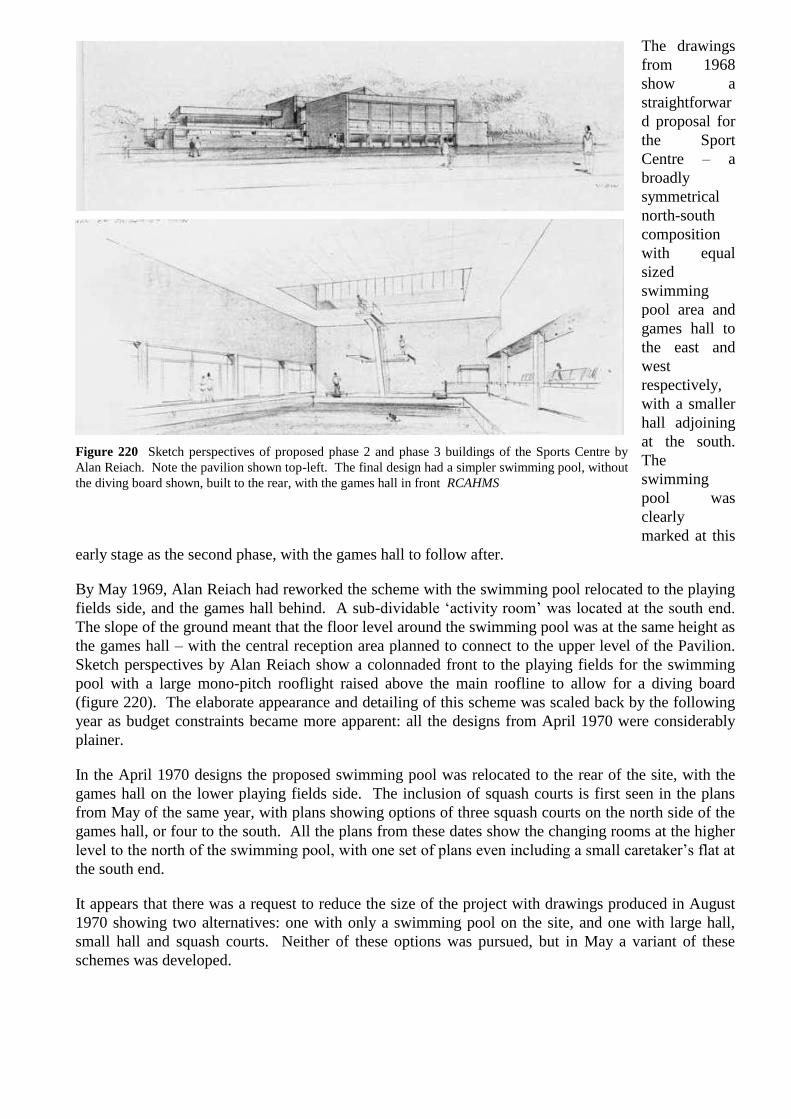
The drawings
from 1968
show a
straightforwar
d proposal for
the Sport
Centre – a
broadly
symmetrical
north-south
composition
with equal
sized
swimming
pool area and
games hall to
the east and
west
respectively,
with a smaller
hall adjoining
at the south.
The
swimming
pool was
clearly
marked at this
early stage as the second phase, with the games hall to follow after.
By May 1969, Alan Reiach had reworked the scheme with the swimming pool relocated to the playing
fields side, and the games hall behind. A sub-dividable „activity room‟ was located at the south end.
The slope of the ground meant that the floor level around the swimming pool was at the same height as
the games hall – with the central reception area planned to connect to the upper level of the Pavilion.
Sketch perspectives by Alan Reiach show a colonnaded front to the playing fields for the swimming
pool with a large mono-pitch rooflight raised above the main roofline to allow for a diving board
(figure 220). The elaborate appearance and detailing of this scheme was scaled back by the following
year as budget constraints became more apparent: all the designs from April 1970 were considerably
plainer.
In the April 1970 designs the proposed swimming pool was relocated to the rear of the site, with the
games hall on the lower playing fields side. The inclusion of squash courts is first seen in the plans
from May of the same year, with plans showing options of three squash courts on the north side of the
games hall, or four to the south. All the plans from these dates show the changing rooms at the higher
level to the north of the swimming pool, with one set of plans even including a small caretaker‟s flat at
the south end.
It appears that there was a request to reduce the size of the project with drawings produced in August
1970 showing two alternatives: one with only a swimming pool on the site, and one with large hall,
small hall and squash courts. Neither of these options was pursued, but in May a variant of these
schemes was developed.
Figure 220 Sketch perspectives of proposed phase 2 and phase 3 buildings of the Sports Centre by
Alan Reiach. Note the pavilion shown top-left. The final design had a simpler swimming pool, without
the diving board shown, built to the rear, with the games hall in front RCAHMS

These more detailed drawings clearly
delineate the phasing of the proposed
centre – the phase 1 Pavilion was by then
complete, phase 2 comprised the
administrative offices, reception and a
weights room on the lower (ground) level,
with changing rooms, small studio and the
swimming pool on the upper level. The 1st
floor walkway connecting to the Pavilion
was included in this phase. Also included
was the squash courts block containing
three courts. This phase was completed in
1973.
Figure 221 Gannochy Sports Centre swimming
pool, since converted for use as a fitness suite.
UoSA
Figure 222 Oblique aerial views showing the development of the Gannochy Sports Centre. The image
on the left is post-1973 showing the swimming pool and squash courts building. The image on the right,
post-1980, shows the addition of the games hall. UoSA
The subsequent phase with the large and small halls in front of the phase 2 buildings was not
completed until 1980. The planned incorporation of the squash courts into the main body of the
building by adding a further five courts and a connecting corridor at first floor level was not built, and
the three phase 2 squash courts remained separate.
iii Gannochy Tennis Centre, 1991
Figure 223 Gannochy Tennis Centre 2009
The Gannochy Tennis Centre was opened in 1991 by HRH, Princess of Wales. The building is a
straight-forward industrial-style building in two-tone brick with metal cladding and roof in dark green.
It houses four indoor tennis courts.
iv Robertson Trust Swimming Pool/National Swimming Academy, 2002
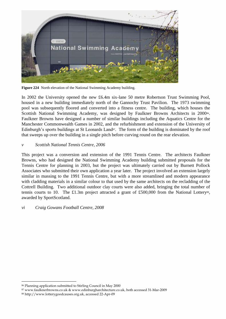
Figure 224 North elevation of the National Swimming Academy building.
In 2002 the University opened the new £6.4m six-lane 50 metre Robertson Trust Swimming Pool,
housed in a new building immediately north of the Gannochy Trust Pavilion. The 1973 swimming
pool was subsequently floored and converted into a fitness centre. The building, which houses the
Scottish National Swimming Academy, was designed by Faulkner Browns Architects in 200086.
Faulkner Browns have designed a number of similar buildings including the Aquatics Centre for the
Manchester Commonwealth Games in 2002, and the refurbishment and extension of the University of
Edinburgh‟s sports buildings at St Leonards Land87. The form of the building is dominated by the roof
that sweeps up over the building in a single pitch before curving round on the rear elevation.
v Scottish National Tennis Centre, 2006
This project was a conversion and extension of the 1991 Tennis Centre. The architects Faulkner
Browns, who had designed the National Swimming Academy building submitted proposals for the
Tennis Centre for planning in 2003, but the project was ultimately carried out by Burnett Pollock
Associates who submitted their own application a year later. The project involved an extension largely
similar in massing to the 1991 Tennis Centre, but with a more streamlined and modern appearance
with cladding materials in a similar colour to that used by the same architects on the recladding of the
Cottrell Building. Two additional outdoor clay courts were also added, bringing the total number of
tennis courts to 10. The £1.3m project attracted a grant of £500,000 from the National Lottery88,
awarded by SportScotland.
vi Craig Gowans Football Centre, 2008
86 Planning application submitted to Stirling Council in May 2000 87 www.faulknerbrowns.co.uk & www.edinburgharchitecture.co.uk, both accessed 31-Mar-2009 88 http://www.lotterygoodcauses.org.uk, accessed 22-Apr-09

Figure 225 Craig Gowans Football Centre with both Tennis Centre buildings behind 2009
Built on the site of the former outdoor tennis courts, the football centre is the training facility for
Falkirk Football Club. The £900,000 building was designed by McEachern and MacDuff as a two-
storey asymmetrical block immediately to the south of the indoor tennis centre extension of 2006. This
south block, white-rendered with a grey metal roof that matches that of the tennis centre and houses
offices, changing rooms, physiotherapy space and a players‟ lounge.
5.9.3 Character Assessment
This is a flat area to the south of the main entrance and the Pathfoot building. The pitches for football
and rugby are along the west side of the site with a running track at the south west corner. The sports
buildings are along the eastern edge of this area tucked in under a bank rising towards the car parks to
the west of the Cottrell Building. The first building on the site was the sports pavilion. This small
building was originally intended to be the first part of a three phase building but has been extended
massively beyond its original extent.
The buildings are grouped fairly tightly together to allow the maximum space for the outdoor pitches in
the western part. The original building is slightly to the north of the centre of this linear group. It is a
sports pavilion very much derived in style from the architecture of Pathfoot. The design of the
overhanging concrete band is very similar to Pathfoot and this is an interesting instance of the initial
Stirling University house style developed by RMJM at Pathfoot being interpreted by another architect
for other Stirling University buildings. The architecture is developed slightly from the Pathfoot
arrangement with curtain wall glazed corners to the south west and north west. The pavilion was
originally intended to have views surveying the whole area of the sports pitches. The original design of
this pavilion is very elegant with a symmetrical front facing east around the central door. The
symmetry was not exact. It was interrupted to form bays underneath the eastern two thirds of the north
side where the glazing has been brought out to just behind the plane of the concrete cornice band. The
curtain wall glazing is recessed at the north west corner so that the main face westwards towards the
sports pitch is also symmetrically arranged. The door and division of glazing is slightly irregular.
The condition of this building is not particularly good. There is timber decay in the structural
framework at first floor level and some cracks are visible in the joints at the cornice band. Various
repairs have been made in bitumen or by fixing on additional timber but these have been done in a
rather ad hoc manner. It seems that the earlier colour of the joinery at first floor level was black which
also fits in with the house style established for the Pathfoot building. Some glazed panels have now
been covered with board and other sheets of glass have been damaged and filled up behind with block
work. The brick parapets to the east and west have either been extended upwards or had to be rebuilt.

The concrete parapets to the stair near the north west corner are in quite poor condition with some
concrete spalling and moss at the head of the wall.
Figure 226 View north to Pathfoot from Character Area 4 2009
At the plinth level, the architecture is again at its most elegant facing west with a clerestory band
immediately under the band of concrete which imitates the style established at Pathfoot. The material
of the lower part is a light orange brickwork. At the north west corner is a concrete stair which was
probably intended to be freestanding and would be an elegant design, but its impact has been reduced
by the store which has been fitted beneath it. A service building to the north east also detracts from
the purity of the arrangement. Around the first floor pavilion level there is paving which might not be
the original paving and which is in fairly poor condition and is ponding in many places.
The subsequent phases of building were built to the south of the original pavilion. At least in the
entrance link block between the original pavilion and department of sports studies building, the
original architecture of concrete cornice bands was continued. The main building to the south has less
architectural distinction, even though the colour of brick and extended narrow clerestory bands have
been repeated. The eastern side of this building is screened by bank and trees. The main sports hall
block does have considerable architectural ambition with a long band of metal framed glazing
underneath a concrete cornice band. The western side of this original building has been extended
massively beyond its original footprint. In the later buildings function and cost has been more
important than appearance. Roughly the same colour of brick has been used but the block has been
designed with considerably less architectural ambition than the original pavilion.
There are further blocks containing squash and tennis courts to the west and to the south west. These
are functional sheds. The southernmost building is the football centre. This is a contemporary
building built with render with a sheeted front edge, apparently to refer to the larger sheeted shed to the
north which contains tennis courts.

Figure 227 Gannochy Pavilion and tennis courts 2009
The Scottish National Tennis Centre at the north of this western run of buildings is the least attractive
and least architecturally distinguished of any of the buildings in this character area. It presents a blank
face to the pitches with the token patterning in the brickwork and a sheeted band near the roof which
has a number of dents and bashes in it. Water is overflowing from the northern end of the western
gutter.
The relationship between the Alan Reiach Pavilion and the sports pitches has been reduced by clay
court, tennis courts and parking. To some extent this is an understandable and reasonable development
of the land around the original building but the hedge between the clay courts and the original pavilion
does work in the opposite way in landscape terms to the original intention of the pavilion.
To the north of the original Pavilion is the National Swimming Academy. This is a building of
considerably greater architectural ambition than the tennis and squash courts. The care taken with this
design is fortunate given the prominence of this building on the route from the main vehicular entrance
to the campus. The architecture is white painted render with grey around the windows and boarded
panels on the side facing westwards. To the east part is the pool area which is enclosed within an
elegant shape formed by a curving sheeted roof. The building is a skilful design in that it produces an
elegant shape which is very suitable for its function but uses inexpensive materials. The purity of this
design should be respected. It may be difficult to extend in a satisfactory manner to the north, south or
east. A westwards extension is possible but the designer should be careful to follow the original
architectural aesthetic of the building.
The character of this group of buildings is functional rather than aesthetic. In the area in general, the
wide flat area of sports pitches with beech hedges and bank of trees to east and west provides an
effective buffer between the campus buildings and the area beyond. The original intention was a much
more open area with most sports being outside. The original pavilion would have been a much more
prominent focus on the eastern side of the sports pitches but this context has largely been lost in
development, particularly to the south west. There is no point in trying or expecting to reclaim this lost
prominence for the original pavilion.
The National Swimming Academy is a good building and indicative of the university‟s commitment to
architectural quality.

The trees are important to this character area. There are mature trees to the western boundary and to
the southern half of the eastern boundary. To the south eastern part of the site is attractive woodland
which contains some remnants of estate paths.
Figure 228 Woodland and boundary wall to west
of CA4 2009 Figure 229 Woodland above CA4 2009
Views from the site are relatively restricted by these banks of trees. To the south, the villa which now
forms the Scottish Institute of Sport is visible through the trees and fences around the football pitches.
To the north are views of the Pathfoot building with fields and trees behind. Views towards Pathfoot
are restricted by the fences around the artificial football pitches and by some semi-mature trees.
However, the Pathfoot building does look well in its setting when seen from the centre of this character
area.
5.9.1 Assessment of Significance
The Alan Reiach Gannochy Trust Pavilion has significance aesthetically. The National Swimming
Academy is possibly too new to make a judgement on aesthetic and historical significance but could be
regarded to have moderate significance, not least a result of its prominence at the entrance to the
university campus. The other buildings are neutral in aesthetic terms although clearly very important
and practical education buildings, and therefore they have social significance.
The belt of planting to the west of this area and the boundary wall are both of considerable landscape significance and provide an attractive buffer between this area and the main public road. The woodland to the east of this area is also of considerable significance as surviving policy woodland.
Figure 230 Character Area 4, site plan showing
views Figure 231 Character Area 4, site plan showing
significance

4.4.4 Recommendations
Whilst it would be ideal if the fabric of the Gannochy Trust Pavilion could repaired it is recognised that there is pressure to redevelop this plot in order to further the University‟s role as a centre of sporting excellence. It is also recognised that the building has been altered and a suitable use has not been found - as a result the Estate Strategy has earmarked the building for demolition and replacement.
In designing a replacement building for this location, care should be taken to use the quality of Alan Reiach‟s design as a benchmark, and recognise the potential of the existing design to influence that of the replacement in its function as a high-quality „hub‟ at the heart of the sports area. Mitigative measures prior to the demolition of the building should include a full recording exercise of the building (photographic and measured survey). Contact with a member of the original design team might also be possible, which would assist in recording the original design intentions.
Further development in this character area would be best placed to the west of the 1991 tennis centre, allowing continued use of the playing fields to the north and the running track to the south. Development in this location would also disguise the inappropriately blank elevation of the tennis centre, and offer the potential to improve upon the currently limited, and architecturally detrimental, parking facilities.