Embed Size (px)
Citation preview
2017
0430
011
8 5M
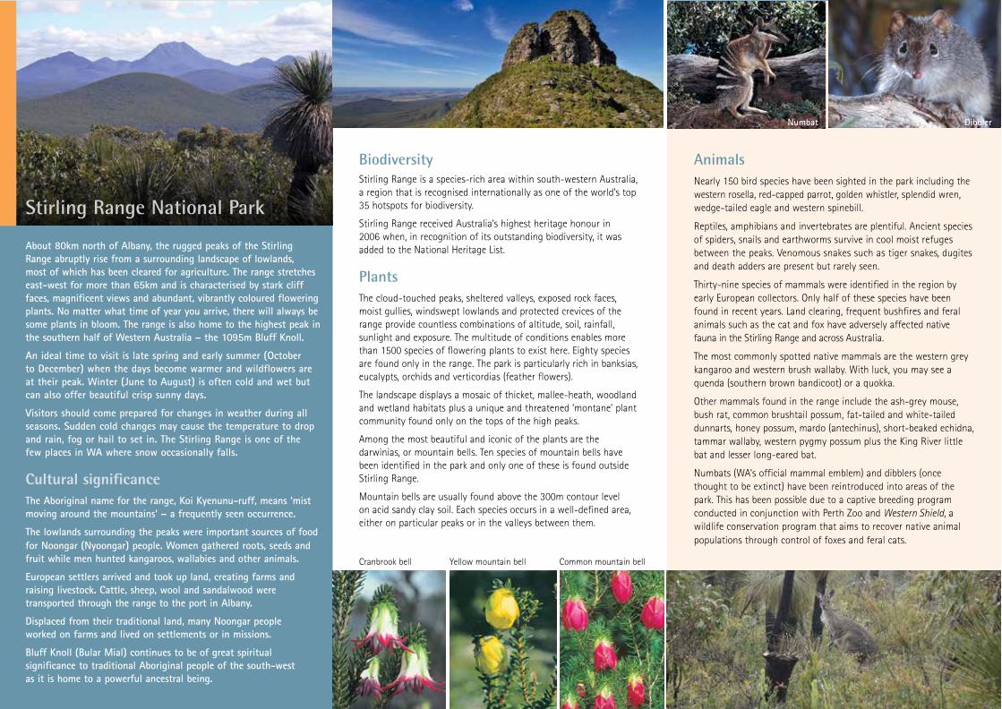
AnimalsNearly 150 bird species have been sighted in the park including the western rosella, red-capped parrot, golden whistler, splendid wren, wedge-tailed eagle and western spinebill.
Reptiles, amphibians and invertebrates are plentiful. Ancient species of spiders, snails and earthworms survive in cool moist refuges between the peaks. Venomous snakes such as tiger snakes, dugites and death adders are present but rarely seen.
Thirty-nine species of mammals were identified in the region by early European collectors. Only half of these species have been found in recent years. Land clearing, frequent bushfires and feral animals such as the cat and fox have adversely affected native fauna in the Stirling Range and across Australia.
The most commonly spotted native mammals are the western grey kangaroo and western brush wallaby. With luck, you may see a quenda (southern brown bandicoot) or a quokka.
Other mammals found in the range include the ash-grey mouse, bush rat, common brushtail possum, fat-tailed and white-tailed dunnarts, honey possum, mardo (antechinus), short-beaked echidna, tammar wallaby, western pygmy possum plus the King River little bat and lesser long-eared bat.
Numbats (WA’s official mammal emblem) and dibblers (once thought to be extinct) have been reintroduced into areas of the park. This has been possible due to a captive breeding program conducted in conjunction with Perth Zoo and Western Shield, a wildlife conservation program that aims to recover native animal populations through control of foxes and feral cats.
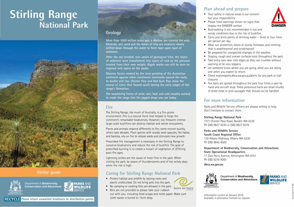
About 80km north of Albany, the rugged peaks of the Stirling Range abruptly rise from a surrounding landscape of lowlands, most of which has been cleared for agriculture. The range stretches east-west for more than 65km and is characterised by stark cliff faces, magnificent views and abundant, vibrantly coloured flowering plants. No matter what time of year you arrive, there will always be some plants in bloom. The range is also home to the highest peak in the southern half of Western Australia – the 1095m Bluff Knoll.
An ideal time to visit is late spring and early summer (October to December) when the days become warmer and wildflowers are at their peak. Winter (June to August) is often cold and wet but can also offer beautiful crisp sunny days.
Visitors should come prepared for changes in weather during all seasons. Sudden cold changes may cause the temperature to drop and rain, fog or hail to set in. The Stirling Range is one of the few places in WA where snow occasionally falls.
Cultural significanceThe Aboriginal name for the range, Koi Kyenunu-ruff, means ‘mist moving around the mountains’ – a frequently seen occurrence.
The lowlands surrounding the peaks were important sources of food for Noongar (Nyoongar) people. Women gathered roots, seeds and fruit while men hunted kangaroos, wallabies and other animals.
European settlers arrived and took up land, creating farms and raising livestock. Cattle, sheep, wool and sandalwood were transported through the range to the port in Albany.
Displaced from their traditional land, many Noongar people worked on farms and lived on settlements or in missions.
Bluff Knoll (Bular Mial) continues to be of great spiritual significance to traditional Aboriginal people of the south-west as it is home to a powerful ancestral being.
BiodiversityStirling Range is a species-rich area within south-western Australia, a region that is recognised internationally as one of the world’s top 35 hotspots for biodiversity.
Stirling Range received Australia’s highest heritage honour in 2006 when, in recognition of its outstanding biodiversity, it was added to the National Heritage List.
PlantsThe cloud-touched peaks, sheltered valleys, exposed rock faces, moist gullies, windswept lowlands and protected crevices of the range provide countless combinations of altitude, soil, rainfall, sunlight and exposure. The multitude of conditions enables more than 1500 species of flowering plants to exist here. Eighty species are found only in the range. The park is particularly rich in banksias, eucalypts, orchids and verticordias (feather flowers).
The landscape displays a mosaic of thicket, mallee-heath, woodland and wetland habitats plus a unique and threatened ‘montane’ plant community found only on the tops of the high peaks.
Among the most beautiful and iconic of the plants are the darwinias, or mountain bells. Ten species of mountain bells have been identified in the park and only one of these is found outside Stirling Range.
Mountain bells are usually found above the 300m contour level on acid sandy clay soil. Each species occurs in a well-defined area, either on particular peaks or in the valleys between them.
Plan ahead and prepare• Your safety in natural areas is our concern
but your responsibility.• Please heed warnings shown on signs that
display the DANGER symbol. • Bushwalking is not recommended in hot and
windy conditions due to the risk of bushfire. • Carry and drink plenty of drinking water – three to four litres
per person per day.• Wear sun protection, boots or sturdy footwear, and clothing
that is weatherproof and scratchproof.• Be prepared for unexpected changes in the weather.• Sloping, rough and uneven surfaces exist throughout the park.• Take extra care near rock edges as they can crumble without
warning or be very slippery.• Let someone know where you are going, what you are doing
and when you expect to return. • Check exploreparks.dbca.wa.gov.au/alerts for any park or trail
closures.• Fox baits are spread throughout the park four times a year by
hand and aircraft drop. These poisonous baits are small chunks of dried meat or pink sausages that should not be handled.
For more informationParks and Wildlife Service officers are always willing to help. Don’t hesitate to contact them.
Stirling Range National Park 7371 Chester Pass Road, Borden WA 6338 Ph (08) 9827 9230 or (08) 9827 9278
Parks and Wildlife Service South Coast Regional Office 120 Albany Highway, Albany WA 6330 Ph (08) 9842 4500
Department of Biodiversity, Conservation and Attractions State Operational Headquarters 17 Dick Perry Avenue, Kensington WA 6151 Ph (08) 9219 9000
dbca.wa.gov.au
Cranbrook bellYellow mountain bellCommon mountain bell
Numbat Dibbler
Stirling Range National Park
RECYCLE Please return unwanted brochures to distribution pointsInformation current at January 2018. Available in alternative formats on request.
GOVERNMENT OFWESTERN AUSTRALIA
Stirling Range National Park
FireThe Stirling Range, like much of Australia, is a fire-prone environment. Fire is a natural force that helped to forge the continent’s remarkable biodiversity. However, too frequent intense large-scale bushfires can destroy habitat and whole ecosystems.
Plants and animals respond differently to fire; some recover quickly, others take decades. Plant species with woody seed capsules, like hakea and banksia, rely on fire to release seeds and stimulate new growth.
Prescribed fire management is necessary in the Stirling Range to conserve biodiversity and reduce the risk of bushfire. The goal of prescribed burning is to create a mosaic of vegetation of differing post-fire ages.
Lightning strikes are the cause of most fires in the park. When visiting the park, be aware of thunderstorms and of hot windy days when fire risk is high.
Caring for Stirling Range National Park• Protect habitat and wildlife by leaving rocks and
plants undisturbed. Do not bring pets into the park.• No camping or cooking fires are allowed in the park.• Bins are not provided so please take your rubbish
out with you, including food scraps and toilet paper. Make sure toilet waste is buried to 15cm deep.
More than 1000 million years ago, a shallow sea covered the area. Minerals, soil, sand and the bones of tiny sea creatures slowly drifted down through the water to form layer upon layer of sediment.
After the sea receded, over aeons of geological time, the layers of sediment were transformed into layers of rock by the pressure created from their own weight. Ripple marks can still be seen on exposed rock layers on the peaks.
Massive forces created by the slow grinding of the Australian continent against other continents eventually caused the rocks to buckle and rise. Chester Pass and Red Gum Pass show the course of rivers that flowed south during the early stages of the range’s formation.
The weathering forces of wind, rain, heat and cold steadily worked to erode the range into the jagged shape you see today.
Geology
Visitor guide
20170430 0118 5M
AnimalsNearly 150 bird species have been sighted in the park including the western rosella, red-capped parrot, golden whistler, splendid wren, wedge-tailed eagle and western spinebill.
Reptiles, amphibians and invertebrates are plentiful. Ancient species of spiders, snails and earthworms survive in cool moist refuges between the peaks. Venomous snakes such as tiger snakes, dugites and death adders are present but rarely seen.
Thirty-nine species of mammals were identified in the region by early European collectors. Only half of these species have been found in recent years. Land clearing, frequent bushfires and feral animals such as the cat and fox have adversely affected native fauna in the Stirling Range and across Australia.
The most commonly spotted native mammals are the western grey kangaroo and western brush wallaby. With luck, you may see a quenda (southern brown bandicoot) or a quokka.
Other mammals found in the range include the ash-grey mouse, bush rat, common brushtail possum, fat-tailed and white-tailed dunnarts, honey possum, mardo (antechinus), short-beaked echidna, tammar wallaby, western pygmy possum plus the King River little bat and lesser long-eared bat.
Numbats (WA’s official mammal emblem) and dibblers (once thought to be extinct) have been reintroduced into areas of the park. This has been possible due to a captive breeding program conducted in conjunction with Perth Zoo and Western Shield, a wildlife conservation program that aims to recover native animal populations through control of foxes and feral cats.
About 80km north of Albany, the rugged peaks of the Stirling Range abruptly rise from a surrounding landscape of lowlands, most of which has been cleared for agriculture. The range stretches east-west for more than 65km and is characterised by stark cliff faces, magnificent views and abundant, vibrantly coloured flowering plants. No matter what time of year you arrive, there will always be some plants in bloom. The range is also home to the highest peak in the southern half of Western Australia – the 1095m Bluff Knoll.
An ideal time to visit is late spring and early summer (October to December) when the days become warmer and wildflowers are at their peak. Winter (June to August) is often cold and wet but can also offer beautiful crisp sunny days.
Visitors should come prepared for changes in weather during all seasons. Sudden cold changes may cause the temperature to drop and rain, fog or hail to set in. The Stirling Range is one of the few places in WA where snow occasionally falls.
Cultural significanceThe Aboriginal name for the range, Koi Kyenunu-ruff, means ‘mist moving around the mountains’ – a frequently seen occurrence.
The lowlands surrounding the peaks were important sources of food for Noongar (Nyoongar) people. Women gathered roots, seeds and fruit while men hunted kangaroos, wallabies and other animals.
European settlers arrived and took up land, creating farms and raising livestock. Cattle, sheep, wool and sandalwood were transported through the range to the port in Albany.
Displaced from their traditional land, many Noongar people worked on farms and lived on settlements or in missions.
Bluff Knoll (Bular Mial) continues to be of great spiritual significance to traditional Aboriginal people of the south-west as it is home to a powerful ancestral being.
BiodiversityStirling Range is a species-rich area within south-western Australia, a region that is recognised internationally as one of the world’s top 35 hotspots for biodiversity.
Stirling Range received Australia’s highest heritage honour in 2006 when, in recognition of its outstanding biodiversity, it was added to the National Heritage List.
PlantsThe cloud-touched peaks, sheltered valleys, exposed rock faces, moist gullies, windswept lowlands and protected crevices of the range provide countless combinations of altitude, soil, rainfall, sunlight and exposure. The multitude of conditions enables more than 1500 species of flowering plants to exist here. Eighty species are found only in the range. The park is particularly rich in banksias, eucalypts, orchids and verticordias (feather flowers).
The landscape displays a mosaic of thicket, mallee-heath, woodland and wetland habitats plus a unique and threatened ‘montane’ plant community found only on the tops of the high peaks.
Among the most beautiful and iconic of the plants are the darwinias, or mountain bells. Ten species of mountain bells have been identified in the park and only one of these is found outside Stirling Range.
Mountain bells are usually found above the 300m contour level on acid sandy clay soil. Each species occurs in a well-defined area, either on particular peaks or in the valleys between them.
Plan ahead and prepare• Your safety in natural areas is our concern
but your responsibility.• Please heed warnings shown on signs that
display the DANGER symbol. • Bushwalking is not recommended in hot and
windy conditions due to the risk of bushfire. • Carry and drink plenty of drinking water – three to four litres
per person per day.• Wear sun protection, boots or sturdy footwear, and clothing
that is weatherproof and scratchproof.• Be prepared for unexpected changes in the weather.• Sloping, rough and uneven surfaces exist throughout the park.• Take extra care near rock edges as they can crumble without
warning or be very slippery.• Let someone know where you are going, what you are doing
and when you expect to return. • Check exploreparks.dbca.wa.gov.au/alerts for any park or trail
closures.• Fox baits are spread throughout the park four times a year by
hand and aircraft drop. These poisonous baits are small chunks of dried meat or pink sausages that should not be handled.
For more informationParks and Wildlife Service officers are always willing to help. Don’t hesitate to contact them.
Stirling Range National Park 7371 Chester Pass Road, Borden WA 6338 Ph (08) 9827 9230 or (08) 9827 9278
Parks and Wildlife Service South Coast Regional Office 120 Albany Highway, Albany WA 6330 Ph (08) 9842 4500
Department of Biodiversity, Conservation and Attractions State Operational Headquarters 17 Dick Perry Avenue, Kensington WA 6151 Ph (08) 9219 9000
dbca.wa.gov.au
Cranbrook bell Yellow mountain bell Common mountain bell
Numbat Dibbler
Stirling Range National Park
RECYCLE Please return unwanted brochures to distribution pointsInformation current at January 2018. Available in alternative formats on request.
GOVERNMENT OFWESTERN AUSTRALIA
Stirling Range National Park
FireThe Stirling Range, like much of Australia, is a fire-prone environment. Fire is a natural force that helped to forge the continent’s remarkable biodiversity. However, too frequent intense large-scale bushfires can destroy habitat and whole ecosystems.
Plants and animals respond differently to fire; some recover quickly, others take decades. Plant species with woody seed capsules, like hakea and banksia, rely on fire to release seeds and stimulate new growth.
Prescribed fire management is necessary in the Stirling Range to conserve biodiversity and reduce the risk of bushfire. The goal of prescribed burning is to create a mosaic of vegetation of differing post-fire ages.
Lightning strikes are the cause of most fires in the park. When visiting the park, be aware of thunderstorms and of hot windy days when fire risk is high.
Caring for Stirling Range National Park• Protect habitat and wildlife by leaving rocks and
plants undisturbed. Do not bring pets into the park.• No camping or cooking fires are allowed in the park.• Bins are not provided so please take your rubbish
out with you, including food scraps and toilet paper. Make sure toilet waste is buried to 15cm deep.
More than 1000 million years ago, a shallow sea covered the area. Minerals, soil, sand and the bones of tiny sea creatures slowly drifted down through the water to form layer upon layer of sediment.
After the sea receded, over aeons of geological time, the layers of sediment were transformed into layers of rock by the pressure created from their own weight. Ripple marks can still be seen on exposed rock layers on the peaks.
Massive forces created by the slow grinding of the Australian continent against other continents eventually caused the rocks to buckle and rise. Chester Pass and Red Gum Pass show the course of rivers that flowed south during the early stages of the range’s formation.
The weathering forces of wind, rain, heat and cold steadily worked to erode the range into the jagged shape you see today.
Geology
Visitor guide
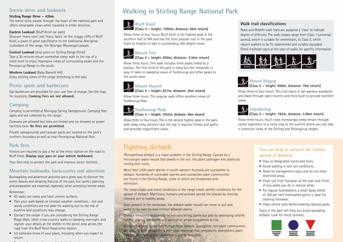
Bluff Knoll (Class 4 – height: 1095m, distance: 6km return)
Allow three to four hours. Bluff Knoll is the highest peak in the southern half of WA and has the most popular trail in the park. Scale its heights to take in outstanding 360-degree views.
Mount Trio (Class 4 – height: 856m, distance: 3.5km return)
Allow three hours. This walk includes three peaks linked by a plateau. The first third of the path is steep but the remainder is easy. It takes in sweeping views of Toolbrunup and other peaks to the south-west.
Mount Hassell (Class 4 – height: 827m, distance: 3km return)
Allow three hours. This popular walk offers excellent views of Toolbrunup Peak.
Toolbrunup Peak (Class 5 – height: 1052m, distance: 4km return)
Allow three to four hours. This is the second highest peak in the park, with steep rocky sections near the top. It requires fitness and agility and provides magnificent views.
Walk trail classificationsParks and Wildlife walk trails are assigned a ‘class’ to indicate degree of difficulty. The walk classes range from Class 1 (universal access), which is suitable for wheelchairs, to Class 5, which require walkers to be fit, experienced and suitably equipped. Check trailhead signs at the start of walks for specific information.
Walking in Stirling Range National Park
Mount Magog (Class 5 – height: 856m, distance: 7km return)
Allow three to four hours. This trail starts in tall wandoo woodland and leads through open country and thick bush to provide excellent views.
Talyuberlup (Class 5 – height: 783m, distance: 2.6km return)
Allow three hours. You’ll cross increasingly steep terrain through varied vegetation to a rocky crag at the summit where you can take in extensive views of the Stirling and Porongurup ranges.
You can help to prevent the further spread of dieback:• Stay on designated tracks and trails.• Avoid walking in wet soil conditions.• Abide by management signs and do not enter
restricted areas.• Clean soil from footwear at the start and finish
of any walks you do in natural areas.• For regular bushwalkers, a small spray bottle
of 100 per cent methylated spirits is ideal for cleaning footwear.
• Clean vehicle tyres before entering national parks.
Signs in the park will help you avoid spreading dieback. Look for these symbols.
Fighting diebackPhytophthora dieback is a major problem in the Stirling Range. Caused by a microscopic water mould that dwells in the soil, this plant pathogen kills plants by rotting their roots.
More than 2300 plant species in south-western Australia are susceptible to dieback. Hundreds of vulnerable species and susceptible plant communities are found in the Stirling Range, some of which are threatened with extinction.
The steep slopes and moist conditions in the range create perfect conditions for the spread of dieback. Machinery, humans and animals spread the disease by moving infested soil to healthy areas.
Once present in the landscape, the dieback water mould can move in soil and water or by root-to-root contact between plants.
Dieback threatens biodiversity by not only killing plants but also by destroying wildlife habitat, placing the health and survival of whole ecosystems at risk.
No cure has been found for Phytophthora dieback. Susceptible rare plant communities are sprayed with phosphite, a non-toxic chemical that temporarily strengthens plant defence. Respraying must occur every one to two years.
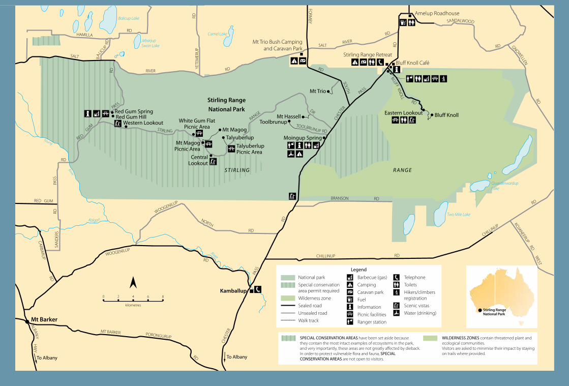
Scenic drive and lookoutsStirling Range Drive – 42kmThe scenic drive travels through the heart of the national park and offers remarkable views when travelled in either direction.
Eastern Lookout (Bluff Knoll car park)Discover ‘many eyes’ and ‘many faces’ on the craggy cliffs of Bluff Knoll, a place of great significance to the traditional Aboriginal custodians of the range, the Noongar (Nyoongar) people.
Central Lookout (mid-point on Stirling Range Drive)Take a 30-minute-return somewhat steep walk to the top of a small knoll to enjoy impressive views of surrounding peaks and the Porongurup Range to the south.
Western Lookout (Baby Barnett Hill)Enjoy striking views of the range stretching to the east.
Picnic spots and barbecuesGas barbecues are provided for your use free of charge. See the map for locations. Cooking fires are not allowed.
CampingCamping is permitted at Moingup Spring Campground. Camping fees apply and are collected by the ranger.
Caravans are allowed but sites are limited and no showers or power facilities exist. No fires are permitted.
Private campgrounds and caravan parks are located on the park’s northern boundary as well as near Porongurup National Park.
Park feesVisitors are required to pay a fee at the entry station on the road to Bluff Knoll. Display your pass on your vehicle dashboard.
Your fees help to protect the park and improve visitor facilities.
Mountain bushwalks, backcountry and adventureBushwalking and adventure activities are a great way to discover the scenic beauty and amazing features of the park, but careful planning and preparation are essential, especially when accessing remote areas.
Remember:• All walks are steep and have uneven surfaces. • Plan your walk based on forecast weather conditions - hot and
windy conditions are not ideal for walking due to the risk of bushfire and conditions may change.
• Contact the ranger if you are considering the Stirling Range Ridge Walk, other cross-country walks or camping overnight, and register your details at the shelter in the picnic area across the road from the Bluff Knoll Road entry station.
• Let someone know of your plans, including when you expect to return.
• Contact the ranger for more detailed information on appropriate sites for abseiling, rock climbing.
Bluff Knoll (Class 4 – height: 1095m, distance: 6km return)
Allow three to four hours. Bluff Knoll is the highest peak in the southern half of WA and has the most popular trail in the park. Scale its heights to take in outstanding 360-degree views.
Mount Trio (Class 4 – height: 856m, distance: 3.5km return)
Allow three hours. This walk includes three peaks linked by a plateau. The first third of the path is steep but the remainder is easy. It takes in sweeping views of Toolbrunup and other peaks to the south-west.
Mount Hassell (Class 4 – height: 827m, distance: 3km return)
Allow three hours. This popular walk offers excellent views of Toolbrunup Peak.
Toolbrunup Peak (Class 5 – height: 1052m, distance: 4km return)
Allow three to four hours. This is the second highest peak in the park, with steep rocky sections near the top. It requires fitness and agility and provides magnificent views.
Walk trail classificationsParks and Wildlife walk trails are assigned a ‘class’ to indicate degree of difficulty. The walk classes range from Class 1 (universal access), which is suitable for wheelchairs, to Class 5, which require walkers to be fit, experienced and suitably equipped. Check trailhead signs at the start of walks for specific information.
Walking in Stirling Range National Park
Mount Magog (Class 5 – height: 856m, distance: 7km return)
Allow three to four hours. This trail starts in tall wandoo woodland and leads through open country and thick bush to provide excellent views.
Talyuberlup (Class 5 – height: 783m, distance: 2.6km return)
Allow three hours. You’ll cross increasingly steep terrain through varied vegetation to a rocky crag at the summit where you can take in extensive views of the Stirling and Porongurup ranges.
You can help to prevent the further spread of dieback:• Stay on designated tracks and trails.• Avoid walking in wet soil conditions.• Abide by management signs and do not enter
restricted areas.• Clean soil from footwear at the start and finish
of any walks you do in natural areas.• For regular bushwalkers, a small spray bottle
of 100 per cent methylated spirits is ideal for cleaning footwear.
• Clean vehicle tyres before entering national parks.
Signs in the park will help you avoid spreading dieback. Look for these symbols.
Fighting diebackPhytophthora dieback is a major problem in the Stirling Range. Caused by a microscopic water mould that dwells in the soil, this plant pathogen kills plants by rotting their roots.
More than 2300 plant species in south-western Australia are susceptible to dieback. Hundreds of vulnerable species and susceptible plant communities are found in the Stirling Range, some of which are threatened with extinction.
The steep slopes and moist conditions in the range create perfect conditions for the spread of dieback. Machinery, humans and animals spread the disease by moving infested soil to healthy areas.
Once present in the landscape, the dieback water mould can move in soil and water or by root-to-root contact between plants.
Dieback threatens biodiversity by not only killing plants but also by destroying wildlife habitat, placing the health and survival of whole ecosystems at risk.
No cure has been found for Phytophthora dieback. Susceptible rare plant communities are sprayed with phosphite, a non-toxic chemical that temporarily strengthens plant defence. Respraying must occur every one to two years.
Scenic drive and lookoutsStirling Range Drive – 42kmThe scenic drive travels through the heart of the national park and offers remarkable views when travelled in either direction.
Eastern Lookout (Bluff Knoll car park)Discover ‘many eyes’ and ‘many faces’ on the craggy cliffs of Bluff Knoll, a place of great significance to the traditional Aboriginal custodians of the range, the Noongar (Nyoongar) people.
Central Lookout (mid-point on Stirling Range Drive)Take a 30-minute-return somewhat steep walk to the top of a small knoll to enjoy impressive views of surrounding peaks and the Porongurup Range to the south.
Western Lookout (Baby Barnett Hill)Enjoy striking views of the range stretching to the east.
Picnic spots and barbecuesGas barbecues are provided for your use free of charge. See the map for locations. Cooking fires are not allowed.
CampingCamping is permitted at Moingup Spring Campground. Camping fees apply and are collected by the ranger.
Caravans are allowed but sites are limited and no showers or power facilities exist. No fires are permitted.
Private campgrounds and caravan parks are located on the park’s northern boundary as well as near Porongurup National Park.
Park feesVisitors are required to pay a fee at the entry station on the road to Bluff Knoll. Display your pass on your vehicle dashboard.
Your fees help to protect the park and improve visitor facilities.
Mountain bushwalks, backcountry and adventureBushwalking and adventure activities are a great way to discover the scenic beauty and amazing features of the park, but careful planning and preparation are essential, especially when accessing remote areas.
Remember:• All walks are steep and have uneven surfaces. • Plan your walk based on forecast weather conditions - hot and
windy conditions are not ideal for walking due to the risk of bushfire and conditions may change.
• Contact the ranger if you are considering the Stirling Range Ridge Walk, other cross-country walks or camping overnight, and register your details at the shelter in the picnic area across the road from the Bluff Knoll Road entry station.
• Let someone know of your plans, including when you expect to return.
• Contact the ranger for more detailed information on appropriate sites for abseiling, rock climbing.