Embed Size (px)
Citation preview

August 1, 2019
Ms. Betty Tustin The Traffic Group, Inc. 104 Kenwood Court Berlin, Maryland 21811 Dear Ms. Tustin,
The Department has completed its review of the traffic impact study (TIS) for the proposed
Chase Oaks (formerly known as Charter Oak) residential development. The TIS was prepared by
The Traffic Group, Inc. (TTG), and is dated May 10, 2019. TTG prepared the report in a manner
generally consistent with DelDOT’s Development Coordination Manual.
The TIS evaluates the traffic impacts of the proposed development, proposed to be located on
both sides of Webbs Landing Road (Sussex Road 277B) and Robinsonville Road (Sussex Road
277), in Sussex County, Delaware.
The proposed development would consist of 249 single-family detached houses on an
approximately 139.13-acre assemblage of parcels (Tax Parcels 234-6.00-96.00, 97.00 & 98.00).
Three full access points are proposed: one along Robinsonville Road and two along Webbs
Landing Road opposite each other, creating one four-leg intersection with Webbs Landing Road.
Construction is anticipated to be complete in 2026.
The subject land is currently zoned AR-1(Agricultural Residential) in Sussex County, and the
developer, Charter Oak Investment, LLC, does not plan to rezone the land.
DelDOT currently has one active project within the study area for the proposed development.
DelDOT’s Hazard Elimination Program (HEP), formerly known as the Highway Safety
Improvement Program (HSIP), includes improvements at the intersections of Delaware Route 24
and Camp Arrowhead Road (Sussex Road 279) / Fairfield Road, and Delaware Route 24 and
Robinsonville Road / Angola Road (Sussex Road 277). This project would make operational
improvements to address safety deficiencies and to accommodate future traffic volumes at these
two intersections.

Ms. Betty Tustin, The Traffic Group, Inc.
August 1, 2019
Page 2 of 37
Specifically, the improvements associated with the Delaware Route 24 / Camp Arrowhead Road
/ Fairfield Road intersection will include extending the existing left-turn and right-turn lanes to
increase capacity and providing bicycle lanes and pedestrian facilities.
The improvements associated with the Delaware Route 24 and Robinsonville Road / Angola
Road will include the widening of the eastbound Robinsonville Road and westbound Angola
Road approaches to provide separate left-turn, through and right-turn lanes; the widening of the
northbound and southbound Delaware Route 24 approaches to provide separate left-turn, through
and right-turn lanes; and extending the existing left-turn and right-turn lanes on all approaches to
meet storage requirements.
The latest updates for this HEP project indicate that design is currently underway and right-of-
way acquisition is anticipated to be underway in the fall of 2019. Construction is anticipated to
be complete in the spring of 2021.
In addition to the above-mentioned HEP project, the developer of Burton’s Pond will be
realigning Sloan Road / Pinewater Road (Sussex Road 49) with the intersection of Delaware
Route 24 and Hollymount Road (Sussex Road 48) to create a four-leg intersection. This project
will also incorporate a separate left-turn lane, one through lane, and a right-turn lane along the
northbound and southbound Delaware Route 24 approaches. The eastbound Hollymount Road
and westbound Sloan Road / Pinewater Road approaches will include a separate left-turn, one
through lane and a right-turn lane.
It is noted that the proposed development is located within the boundary of the proposed
Henlopen Transportation Improvement District (TID). A TID is a planning concept that seeks to
proactively align transportation infrastructure spending and improvements with land use
projections and future development within the designated district. In this letter, DelDOT has
identified the locations in the study area where they have identified improvements to be done as
part of the TID. In some locations, the developer should be required to make or contribute
toward those improvements. If and when DelDOT and the County establish the TID, it may be
appropriate for the developer to contribute to the TID. The Henlopen TID is still under
development by DelDOT and Sussex County. DelDOT has completed the 2045 traffic analysis
for the TID and is finalizing concept plans and cost estimates for needed improvements.
DelDOT plans to discuss those plans and estimates and options for a Capital Transportation
Program for the TID (TID CTP) with the County this fall.
Ms. Betty Tustin, The Traffic Group, Inc.
August 1, 2019
Page 3 of 37
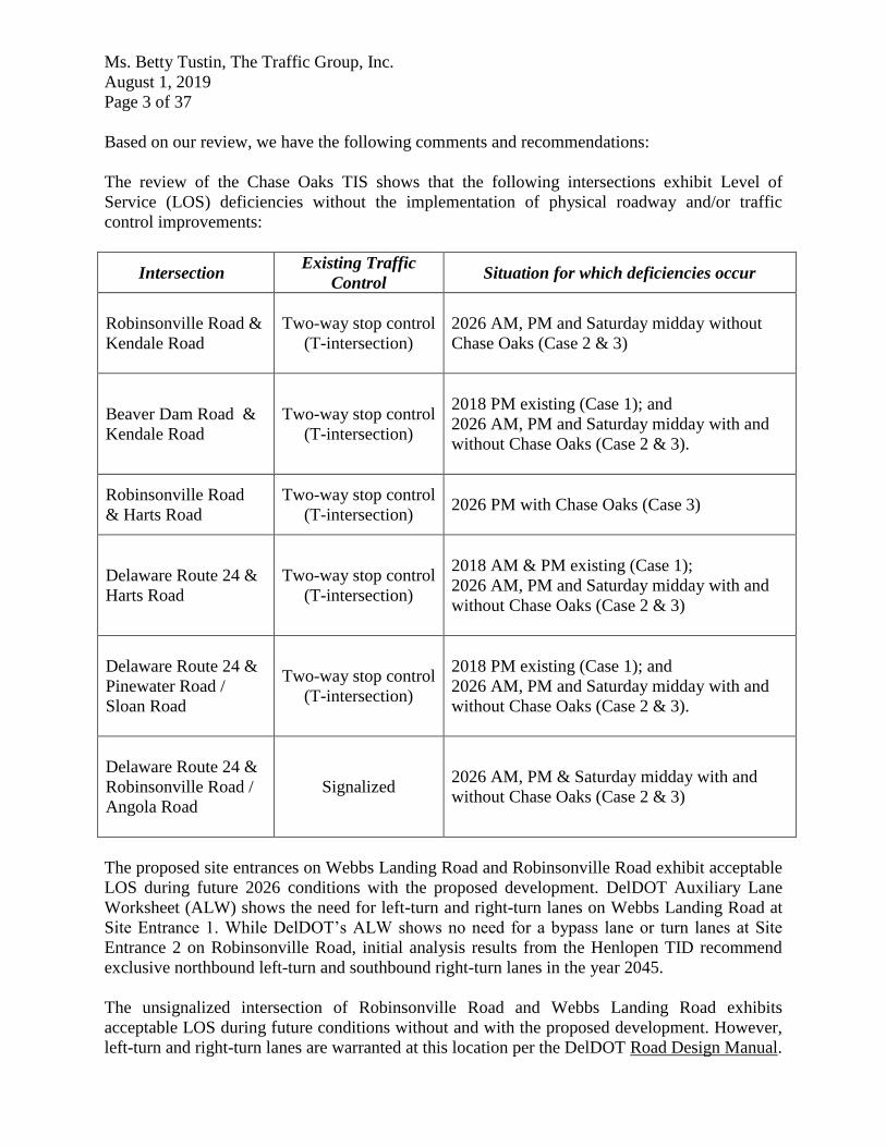
Based on our review, we have the following comments and recommendations:
The review of the Chase Oaks TIS shows that the following intersections exhibit Level of
Service (LOS) deficiencies without the implementation of physical roadway and/or traffic
control improvements:
Intersection Existing Traffic
Control Situation for which deficiencies occur
Robinsonville Road &
Kendale Road
Two-way stop control
(T-intersection)
2026 AM, PM and Saturday midday without
Chase Oaks (Case 2 & 3)
Beaver Dam Road &
Kendale Road
Two-way stop control
(T-intersection)
2018 PM existing (Case 1); and
2026 AM, PM and Saturday midday with and
without Chase Oaks (Case 2 & 3).
Robinsonville Road
& Harts Road
Two-way stop control
(T-intersection)
2026 PM with Chase Oaks (Case 3)
Delaware Route 24 &
Harts Road
Two-way stop control
(T-intersection)
2018 AM & PM existing (Case 1);
2026 AM, PM and Saturday midday with and
without Chase Oaks (Case 2 & 3)
Delaware Route 24 &
Pinewater Road /
Sloan Road
Two-way stop control
(T-intersection)
2018 PM existing (Case 1); and
2026 AM, PM and Saturday midday with and
without Chase Oaks (Case 2 & 3).
Delaware Route 24 &
Robinsonville Road /
Angola Road
Signalized 2026 AM, PM & Saturday midday with and
without Chase Oaks (Case 2 & 3)
The proposed site entrances on Webbs Landing Road and Robinsonville Road exhibit acceptable
LOS during future 2026 conditions with the proposed development. DelDOT Auxiliary Lane
Worksheet (ALW) shows the need for left-turn and right-turn lanes on Webbs Landing Road at
Site Entrance 1. While DelDOT’s ALW shows no need for a bypass lane or turn lanes at Site
Entrance 2 on Robinsonville Road, initial analysis results from the Henlopen TID recommend
exclusive northbound left-turn and southbound right-turn lanes in the year 2045.
The unsignalized intersection of Robinsonville Road and Webbs Landing Road exhibits
acceptable LOS during future conditions without and with the proposed development. However,
left-turn and right-turn lanes are warranted at this location per the DelDOT Road Design Manual.

Ms. Betty Tustin, The Traffic Group, Inc.
August 1, 2019
Page 4 of 37
The unsignalized intersection of Robinsonville Road and Kendale Road exhibits LOS
deficiencies during future conditions without and with the proposed development. With the
construction of Chase Oaks, the eastbound Kendale Road approach is expected to operate at LOS
F during the AM, PM and Saturday midday peak hours. The future AM, PM and Saturday
midday peak hour 95th percentile queue lengths would be approximately 23, 15 and 13 vehicles,
respectively. Although the Henlopen TID is still under development, a traffic signal has been
recommended for this intersection based on initial TID analysis results. A traffic signal would
mitigate all LOS deficiencies at this intersection during the future conditions without and with
the proposed Chase Oaks development.
The unsignalized intersection of Beaver Dam Road and Kendale Road exhibits LOS deficiencies
during existing AM peak hour and future conditions without and with the proposed development.
With the construction of Chase Oaks, the westbound Kendale Road approach is expected to
operate at LOS F during the AM, PM and Saturday midday peak hours. The future AM, PM and
Saturday midday peak hour 95th percentile queue lengths would be approximately 24, 42 and 26
vehicles, respectively. Although the Henlopen TID is still under development, a traffic signal has
been recommended for this intersection based on initial TID analysis results. A traffic signal
would mitigate the LOS deficiencies at this intersection for the future conditions without and
with the proposed Chase Oaks development. A traffic signal would be the most appropriate
mitigation measure for this intersection.
The unsignalized intersection of Robinsonville Road and Harts Road exhibits LOS deficiencies
during the PM peak hour in the future condition with the proposed development. With the
construction of Chase Oaks, the westbound Harts Road approach is expected to operate at LOS E
in the weekday PM peak hour. The future PM peak hour 95th percentile queue length would be
approximately 6 vehicles. The initial analysis for the Henlopen TID recommends that Harts Road
be closed at Delaware Route 24. With that closure, the TID recommends adding exclusive
northbound right-turn and southbound left-turn lanes at the intersection of Robinsonville Road
and Harts Road. Absent that closure, adding a westbound right-turn lane would solve the LOS
deficiencies at this intersection.
The unsignalized intersection of Delaware Route 24 and Harts Road exhibits LOS deficiencies
during the existing AM and PM peak hour and future conditions without and with the proposed
development. With the construction of Chase Oaks, the southbound Harts Road approach is
expected to operate at LOS F during the AM, PM and Saturday midday peak hours. The future
AM, PM, and Saturday midday peak hour 95th percentile queue lengths would be approximately
23, 19, and 16 vehicles, respectively. The queues are mainly associated with the southbound left-
turn movement. As mentioned above, the initial analysis for the Henlopen TID recommends that
Harts Road be closed at Delaware Route 24. To replace it, the analysis recommends extending
Jolyns Way, located just south of the subject intersection, to intersect Robinsonville Road
creating a one-lane roundabout and providing a traffic signal at the intersection of Delaware
Route 24 and Jolyns Way.
The unsignalized intersection of Delaware Route 24 and Pinewater Road / Sloan Road exhibits
LOS deficiencies during the existing PM peak hour and future conditions without and with the
proposed development. With the construction of Chase Oaks, the westbound Pinewater Road /
Sloan Road approach is expected to operate at LOS E in the existing weekday PM peak hour,

Ms. Betty Tustin, The Traffic Group, Inc.
August 1, 2019
Page 5 of 37
and at LOS F during the future AM, PM, and Saturday midday peak hours. As mentioned above,
there is a planned improvement by the developer of Burton’s Pond to realign Pinewater Road /
Sloan Road with the intersection of Delaware Route 24 and Hollymount Road. As part of the
realignment project, a traffic signal will be installed at the intersection to address those LOS
deficiencies.
Should the County choose to approve the proposed development, the following items should be
incorporated into the site design and reflected on the record plan by note or illustration. All
applicable agreements (i.e. letter agreements for off-site improvements and traffic signal
agreements) should be executed prior to entrance plan approval for the proposed development.
1. The developer should improve Robinsonville Road and Webbs Landing Road along the
site frontages in order to meet DelDOT’s local road standards. The standards include, but
are not limited to, eleven-foot travel lanes and five-foot shoulders. The developer should
provide a bituminous concrete overlay to the existing travel lanes, at DelDOT’s
discretion. DelDOT should analyze the existing lane’s pavement section and recommend
an overlay thickness to the developer’s engineer if necessary.
2. The developer should construct exclusive northbound right-turn and southbound left-turn
lanes at the intersection of Robinsonville Road and Webbs Landing Road. The proposed
configuration is shown on the table below.
Initial recommended minimum turn-lane lengths (excluding tapers) of the separate turn lanes are
listed below. The developer should coordinate with DelDOT’s Subdivision Section to determine
final turn-lane lengths.
* Proposed turn-lane length based on DelDOT’s Road Design Manual.
Approach Current Configuration Proposed Configuration
Northbound
Robinsonville Road
One shared through / right-turn
lane
One through lane and one right-
turn lane
Southbound
Robinsonville Road
One shared left-turn / through
lane
One left-turn lane and one
through lane
Eastbound
Webbs Landing Road Does not exist Does not exist
Westbound
Webbs Landing Road
One shared left-turn / right-turn
lane
One shared left-turn / right-turn
lane
Approach Left-Turn Lane(s) Right-Turn Lane
Northbound
Robinsonville Road N/A 100 feet*
Southbound
Robinsonville Road 100 feet* N/A
Eastbound
Webbs Landing Road N/A N/A
Westbound
Webbs Landing Road N/A N/A

Ms. Betty Tustin, The Traffic Group, Inc.
August 1, 2019
Page 6 of 37
3. The developer should enter into a traffic signal agreement with DelDOT for the design
and construction of a future traffic signal for the intersection of Robinsonville Road and
Kendale Road. The agreement should include pedestrian signals, crosswalks,
interconnection, and ITS equipment such as CCTV cameras at DelDOT’s discretion.
Entering into a Traffic Signal Revolving Fund (TSRF) agreement for this intersection is
one option for meeting this requirement.
4. The developer should enter into a traffic signal agreement with DelDOT for the design
and construction of a future traffic signal for the intersection of Beaver Dam Road and
Kendale Road. The agreement should include pedestrian signals, crosswalks,
interconnection, and ITS equipment such as CCTV cameras at DelDOT’s discretion.
Entering into a Traffic Signal Revolving Fund (TSRF) agreement for this intersection is
one option for meeting this requirement.
5. The developer should coordinate with DelDOT regarding an equitable share contribution
toward the potential improvements at the intersection of Robinsonville Road and Harts
Road proposed by the Henlopen TID. The improvements include adding exclusive
northbound right-turn and southbound left-turn lanes at the intersection. Otherwise, the
developer should enter into an agreement with DelDOT to construct an exclusive
westbound right-turn lane at the intersection of Robinsonville Road and Harts Road. The
length of the westbound right-turn lane should be a minimum of 50 feet, in addition to a
50-foot taper. The developer should coordinate with DelDOT’s Development
Coordination Section to determine the final design details of this improvement.
6. The developer should construct Site Access 1 on Webbs Landing Road. As the proposed
Chase Oaks would be located on both sides of Webbs Landing Road, Site Access 1 will
form a four-leg intersection with Webbs Landing Road. The proposed configuration is
shown on the table below.
Approach Current Configuration Proposed Configuration
Northbound
Site Entrance Does not exist
One shared left-turn / through /
right-turn lane
Southbound
Site Entrance Does not exist
One shared left-turn / through /
right-turn lane
Eastbound
Webbs Landing Road One through lane
One left-turn lane, one through
lane, and one right turn lane
Westbound
Webbs Landing Road One through lane
One shared left-turn / through /
right-turn lane

Ms. Betty Tustin, The Traffic Group, Inc.
August 1, 2019
Page 7 of 37
Initial recommended minimum turn-lane lengths (excluding tapers) of the separate turn lanes are
listed below. The developer should coordinate with DelDOT’s Subdivision Section to determine
final turn-lane lengths.
Approach Left-Turn Lane(s) Right-Turn Lane
Northbound
Site Entrance N/A N/A
Southbound
Site Entrance N/A N/A
Eastbound
Webbs Landing Road 85 feet* 70 feet*
Westbound
Webbs Landing Road N/A N/A
* Proposed turn-lane length based on DelDOT’s Auxiliary Lane Worksheet.
7. The developer should construct Site Access 2 on Robinsonville Road. The proposed
configuration is shown in the table below.
Approach Current Configuration Proposed Configuration*
Northbound
Robinsonville Road One through lane
One shared left-turn / through
lane
Southbound
Robinsonville Road One through lane
One shared through / right-turn
lane
Eastbound
Site Entrance Does not exist
One shared left-turn / right-turn
lane
*Per DelDOT’s Auxiliary Lane Worksheet, no turn lanes or bypass lanes are required at this
entrance.
8. The developer should coordinate with DelDOT regarding an equitable share contribution
toward the planned improvements by the developer of Burton’s Pond to realign Pinewater
Road / Sloan Road with the intersection of Delaware Route 24 and Hollymount Road.
The amount of the contribution should be determined through coordination with
DelDOT’s Development Coordination Section.
9. The developer should coordinate with DelDOT regarding an equitable share contribution
toward DelDOT’s HEP projects at the intersections of Delaware Route 24 and Camp
Arrowhead Road / Fairfield Road, and Delaware Route 24 and Robinsonville Road /
Angola Road. The amount of the contribution should be determined through coordination
with DelDOT’s Development Coordination Section.

Ms. Betty Tustin, The Traffic Group, Inc.
August 1, 2019
Page 8 of 37
10. The following bicycle, pedestrian, and transit improvements should be included:
a. A right-turn yield to bikes sign (MUTCD R4-4) should be added at the start of the
right-turn lane on eastbound Webbs Landing Road at the proposed site entrance along
that road.
b. Adjacent to the right-turn lane added to eastbound Webbs Landing Road at the site
entrance, a minimum of a five-foot bicycle lane should be dedicated and striped with
appropriate markings for bicyclists through the turn lane in order to facilitate safe and
unimpeded bicycle travel.
c. Appropriate bicycle symbols, directional arrows, striping (including stop bars), and
signing should be included along bicycle facilities and right-turn lanes within the
project limit.
d. Utility covers should be made flush with the pavement.
e. A minimum of fifteen-foot wide easement from the edge of the right-of-way should
be dedicated to DelDOT within the site frontage along Robinsonville Road and
Webbs Landing Road.
f. Within the easements along Robinsonville Road and Webbs Landing Road, a
minimum of a ten-foot wide Shared-Use Path (SUP) that meets current AASHTO and
ADA standards should be constructed along each site frontage. Each SUP should
connect to the shoulder improvements in accordance with DelDOT’s Shared Use
Path and/or Sidewalk Termination Policy dated June 19, 2014. The SUP should have
a minimum of a five-foot buffer from the roadway. The developer should coordinate
with DelDOT’s Development Coordination Section to determine exact locations and
details of the SUP connections at the property boundaries.
g. ADA compliant curb ramps and crosswalks should be provided at all pedestrian
crossings within the development, including all site entrances. Type 3 curb ramps are
discouraged.
h. DelDOT recommends the construction of internal sidewalks for pedestrian safety and
to promote walking as a viable transportation alternative within the development.
These sidewalks should each be a minimum of five feet wide (with a minimum of a
five-foot buffer from the roadway) and should meet current AASHTO and ADA
standards. These internal sidewalks should connect to the frontage shared-use paths.
i. Where internal sidewalks are located alongside of parking spaces, DelDOT
recommends that a buffer be added to eliminate vehicular overhang onto the
sidewalk. Improvements in this TIS may be considered “significant” under DelDOT’s Work Zone Safety and Mobility Procedures and Guidelines. These guidelines are available on DelDOT’s website at http://www.deldot.gov/information/pubs_forms/manuals/de_mutcd/index.shtml. For any additional information regarding the work zone impact and mitigation procedures during construction please contact Mr. Mark Buckalew of DelDOT’s Traffic Section. Mr. Buckalew can be reached at (302) 894-6353 or by email at [email protected]. Please note that this review generally focuses on capacity and level of service issues; additional safety and operational issues will be further addressed through DelDOT’s subdivision review process.

Ms. Betty Tustin, The Traffic Group, Inc.
August 1, 2019
Page 9 of 37
Additional details on our review of this TIS are attached. If you have any questions concerning
this review, please contact me at (302) 760-2109 or Mr. Claudy Joinville at (302) 760-2124. My
email is [email protected] and Mr. Joinville’s email is
Sincerely,
T. William Brockenbrough, Jr.
County Coordinator
TWB:cjm
Enclosures
cc with enclosures: Ms. Janelle Cornwell, Sussex County Planning & Zoning
Ms. Constance C. Holland, Office of State Planning Coordination
Mr. Brad Eaby, Deputy Attorney General
Ms. Shanté Hastings, Director, Transportation Solutions (DOTS)
Mr. Drew Boyce, Director, Planning
Mr. Mark Luszcz, Chief Traffic Engineer, Traffic, DOTS
Mr. Michael Simmons, Assistant Director, Project Development South,
DOTS
Mr. Alastair Probert, South District Engineer, DOTS
Mr. J. Marc Coté, Assistant Director, Development Coordination
Mr. Don Weber, Assistant Director, Traffic, DOTS
Mr. Peter Haag, Traffic Studies Manager, Traffic, DOTS
Mr. David Dooley, Service Development Planner, Delaware Transit
Corporation
Mr. Anthony Aglio, Planning Supervisor, Statewide & Regional Planning
Mr. Todd Sammons, Subdivision Engineer, Development Coordination
Ms. Susanne Laws, Sussex County Subdivision Coordinator, Development
Coordination
Mr. Mark Buckalew, Traffic Safety Engineer, DelDOT Traffic, DOTS
Mr. John Andrescavage, Subdivision Manager, Development
Coordination
Mr. Brian Yates, Subdivision Manager, Development Coordination
Mr. Troy Brestel, Project Engineer, Development Coordination
Mr. Claudy Joinville, Project Engineer, Development Coordination

Ms. Betty Tustin, The Traffic Group, Inc.
August 1, 2019
Page 10 of 37
General Information
Report date: May 10, 2019
Prepared by: The Traffic Group, Inc. (TTG)
Prepared for: Chase Oaks (f.k.a. Charter Oak)
Tax parcels: 234-6.00-96.00, 97.00 & 98.00
Generally consistent with DelDOT’s Development Coordination Manual: Yes
Project Description and Background
Description: The proposed Chase Oaks residential development would consist of 249 single-
family detached houses.
Location: proposed to be located on both sides of Webbs Landing Road (Sussex Road 277B)
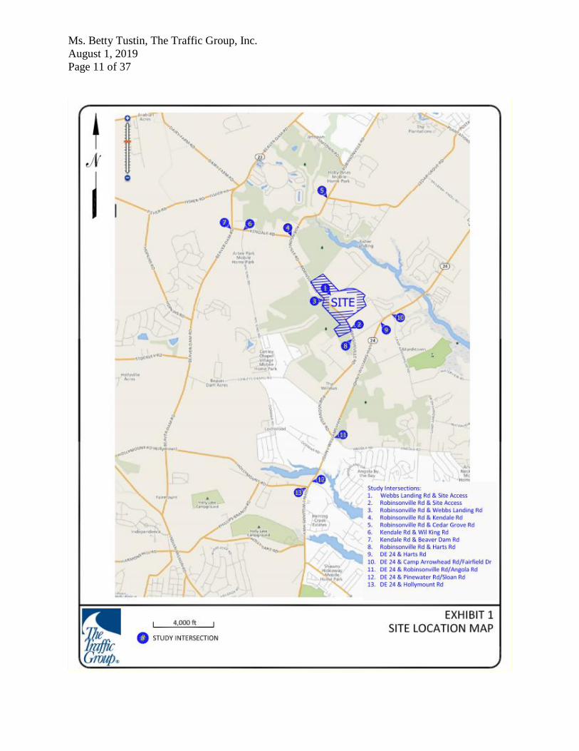
and Robinsonville Road (Sussex Road 277), in Sussex County, Delaware. A site location map is
included on Page 11.
Amount of land to be developed: approximately 139.13-acre assemble of parcels of land
Land use approval(s) needed: DelDOT Subdivision approval and Sussex County land use
approval. The subject land is currently zoned AR-1(Agricultural Residential) in the Sussex
County, and the developer, Charter Oak Investment, LLC, does not plan to rezone the land.
Proposed completion date: 2026
Proposed access location: Three full access points are proposed: one along Robinsonville Road
and two along Webbs Landing Road opposite each other, creating one four-leg intersection with
Webbs Landing Road.
Daily Traffic Volumes (per DelDOT Traffic Summary 2018):
2018 Average Annual Daily Traffic on Robinsonville Road 3,537 vpd
2018 Average Annual Daily Traffic on Webbs Landing Road: 423 vpd
Ms. Betty Tustin, The Traffic Group, Inc.
August 1, 2019
Page 11 of 37

Ms. Betty Tustin, The Traffic Group, Inc.
August 1, 2019
Page 12 of 37
2015 Delaware Strategies for State Policies and Spending
Location with respect to the Strategies for State Policies and Spending Map of Delaware:
The proposed Chase Oaks development is located within three investment level areas,
Investment Level 2, Level 3 and Level 4.
Investment Level 2
Investment Level 2 Areas are areas of the state that are the most active portion of Delaware’s
developed landscape. Investment Level 2 Areas consist of less developed areas within
municipalities, rapidly growing areas in the counties that have or will have public water or
wastewater services and utilities, areas that are generally adjacent to or near Investment Level 1
Areas, smaller towns and rural villages that should grow consistently with their historic
character, and suburban areas with public water, wastewater, and utility services. These areas
serve as a transition between Investment Level 1 Areas and the state’s more open, less populated
areas.
In Investment Level 2 Areas, like Investment Level 1 Areas, state investments and policies
should support and encourage a wide range of uses and densities, promote other transportation
options, foster efficient use of existing public and private investments, and enhance community
identity and integrity. In addition, investments should encourage a departure from the typical
single-family-dwelling developments and promote a broader mix of housing types and
commercial sites encouraging compact, mixed-use development where applicable.
Overall, it is the State’s intent to use its spending and management tools to promote well-
designed development in Investment Level 2 Areas.
Investment Level 3
Investment Level 3 Areas fall into two categories. The first category covers land that is in long-
term growth plans of counties and municipalities but where development is not necessary to
accommodate expected short-term population growth. The second category includes lands that
are adjacent to fast growing Investment Level 1 and Level 2 areas but are often impacted by
environmentally sensitive features, agricultural-preservation issues, or other infrastructure issues.
From a housing perspective, Investment Level 3 areas are characterized by low density and rural
homes.
Investment Level 4
Investment Level 4 Areas are predominantly rural or agricultural and contain much of
Delaware’s open space and natural areas. These areas are home to agribusiness activities, farm
complexes, and small settlements / unincorporated communities. Investment Level 4 Areas may
also have scattered single-family detached residential homes. Existing transportation facilities
and services will be maintained by the state while it continues to manage the transportation
system in a manner that will support the preservation of the natural environment and agricultural
business. Construction of new homes, and development unrelated to the areas’ needs is
discouraged; housing policies will focus on maintenance and rehabilitation of existing homes and
communities. In addition, the Department of Education does not support the construction of new

Ms. Betty Tustin, The Traffic Group, Inc.
August 1, 2019
Page 13 of 37
educational facilities in Investment Level 4 Areas. The educational needs of Investment Level 4
Areas would likely need to be met through facilities located in Investment Level 1, Level 2 and
Level 3 Areas.
In general, the state will limit its investments in public infrastructure systems. Investments
should address existing public health, safety, or environmental risks, preserve rural character and
natural resources, and discourage further development that is unrelated to the areas’ needs.
Proposed Development’s Compatibility with Strategies for State Policies and Spending:
The proposed Chase Oaks development is located within Investment Level 2, Level 3 and Level
4 Areas, and is to consist of a 249 single-family detached houses. This type of development is
consistent with the character of Investment Level 2, Level 3 and, to a lesser extent, Level 4 areas.
It is noted that only a small portion of the proposed development is within the Level 4 Area.
New housing developments are discouraged in Investment Level 4 areas and should meet
significant qualifications regarding timing, phasing, site characteristics, and agency programs in
Investment Level 2 and Level 3 areas. In general, the state would be responsible for providing
many public services to the residents of the proposed development, such as school construction
and transportation, police and fire / EMS services, and additional maintenance of the
transportation system.
However, given that only a small portion of the development is within Level 4, state policies
provide that some of the needs of developments located within Level 4 areas would need to be
met through facilities located in Level 1, Level 2 and Level 3 areas. It also noted that the
majority of the proposed development is located within Level 2 and Level 3 areas. While a
portion of the proposed development is located within Level 4, because the majority of the
development is located within Level 2 and Level 3 areas, the development appears to generally
comply with the policies stated in the 2015 Strategies for State Policies and Spending document.
Nonetheless, additional discussion may be required to address the portion of the development
located within the Level 4.
Comprehensive Plan
Sussex County Comprehensive Plan: (Source: Sussex County Comprehensive Plan Update, June 2008)
The Sussex County Comprehensive Plan Future Land Use Map indicates that the proposed
Chase Oaks development is located in Sussex County, within a “low-density area.” Low density
areas are categorized as rural areas. In these areas, Sussex County expects farming to co-exist
with certain types of residential uses. Similar to all other lands designated as low density areas in
Sussex County, the site of the proposed development is zoned AR-1 (Agricultural Residential).
This zoning designation allows for single-family detached homes at two homes per acre on lots
containing a minimum of ½ acre if the development connect to central sewers. Otherwise, single-
family detached homes are permitted on minimum ¾ acre lots. Two homes per acre are also
allowed where a cluster-style plan is used and 30% of the tract is preserved in permanent open
space.

Ms. Betty Tustin, The Traffic Group, Inc.
August 1, 2019
Page 14 of 37
Based on the Sussex County Comprehensive Plan, the following major guidelines should apply
to future growth in the low density areas.
Permitted Uses – The primary land uses within low-density areas should be agricultural activities
and single-family detached homes. Business or industrial uses should only be permitted to
support or address the needs for these two uses.
Densities – The minimum lot size should be ½ acre for lots with central sewer service and ¾ acre
for lots with on-site septic systems. A cluster-style plan should permit overall site densities of
two homes per acre, provided significant open space is preserved and the development connects
to a central sewer.
Infrastructure – Developments where lots are smaller than ¾ acre should require connection to a
central sewer.
Proposed Development’s Compatibility with Comprehensive Plan: The Chase Oaks
residential development would consist of 249 single-family detached houses on a 139.13-acre
assemblage of parcels. It appears that a cluster-style development is proposed, considerable open
space is preserved, and the tract connects to a central community sewer system. Therefore, the
comprehensive plan allows for a maximum overall site density of two homes per acre. The
construction of 249 single-family houses on 139.13 acres results in an overall site density of just
under two homes per acre.
The proposed site is currently zoned AR-1 within Sussex County, and no rezoning is proposed.
The purpose of the AR-1 zoning district is to protect agricultural lands and activities and other
valuable natural resources. Low-density housing is permitted along with churches, recreational
facilities, and accessory uses as may be necessary or is normally compatible with residential
surroundings. While there are issues relating to the use and size of the proposed development in
this rural area that require further discussion, based on the elements described above it appears
the proposed development may be compatible with the current version of the Sussex County
Comprehensive Plan.
Relevant Projects in the DelDOT Capital Transportation Program
DelDOT currently has one active project within the study area for the proposed development.
DelDOT’s Hazard Elimination Program (HEP), formerly known as the Highway Safety
Improvement Program (HSIP) includes improvements at the intersections of Delaware Route 24
and Camp Arrowhead Road (Sussex Road 279) / Fairfield Road, and Delaware Route 24 and
Robinsonville Road / Angola Road (Sussex Road 277). This project would make operational
improvements to address safety deficiencies and to accommodate future traffic volumes at these
intersections.
Specifically, the improvements associated with the Delaware Route 24 / Camp Arrowhead Road
intersection will include extending the existing left-turn and right-turn lanes to increase capacity
and providing bicycle lanes and pedestrian facilities.
The improvements associated with the Delaware Route 24 and Robinsonville Road / Angola
Road will include the widening of the eastbound Robinsonville Road and westbound Angola

Ms. Betty Tustin, The Traffic Group, Inc.
August 1, 2019
Page 15 of 37
Road approaches to provide separate left-turn, through and right-turn lanes; the widening of the
northbound and southbound Delaware Route 24 approaches to provide separate left-turn, through
and right-turn lanes; and extending the existing left-turn and right-turn lanes on all approaches to
meet storage requirements.
The latest updates for this HEP project indicate that design is currently underway and right-of-
way acquisition is anticipated to be underway in the fall of 2019. Construction is anticipated to
be complete in the spring of 2021.
In addition to the above-mentioned HEP project, the developer of Burton’s Pond will be
realigning Sloan Road / Pinewater Road (Sussex Road 49) with the intersection of Delaware
Route 24 and Hollymount Road (Sussex Road 48) to create a four-leg intersection. This project
will also incorporate a separate left-turn lane, one through lane, and a right-turn lane along the
northbound and southbound Delaware Route 24 approaches. The eastbound Hollymount Road
and westbound Sloan Road / Pinewater Road approaches will include a separate left-turn, one
through lane and a right-turn lane.
It is noted that the proposed development is located within the boundary of the Henlopen
Transportation Improvement District (TID). The TID is a planning concept that seeks to
proactively align transportation infrastructure spending and improvements with land use
projections and future development within the designated district. When intersection
improvements are identified as part of the Henlopen TID, contributions would be required from
the developer of Chase Oaks. Presently, DelDOT and the County are still working toward
establishing the TID but when and if that is done, it may be appropriate for the developer to
exchange some of the obligations addressed in this letter for an obligation to contribute to the
TID. The TID is still under development by DelDOT and Sussex County. DelDOT has
completed the 2045 traffic analysis for the TID and is finalizing concept plans and cost estimates
for needed improvements. DelDOT plans to discuss them and develop options for a Capital
Transportation Program for the TID (TID CTP) for review with the County this fall.
Trip Generation
Trip generation for the proposed development was computed using comparable land uses and
equations contained in the Trip Generation Manual, Tenth Edition, published by Institute of
Transportation Engineers (ITE). The following land use was utilized to estimate the amount of
new traffic generated for this development:
249 single-family detached houses (ITE Land Use Code 210)

Ms. Betty Tustin, The Traffic Group, Inc.
August 1, 2019
Page 16 of 37
Table 1
CHASE OAKS PEAK HOUR TRIP GENERATION
Land Use
249 Single-Family
Detached Houses
Weekday AM Peak Hour
Weekday PM Peak Hour
Saturday
Peak Hour
In Out Total In Out Total In Out Total
Site Entrance 1 41 125 166 140 82 222 112 95 207
Site Entrance 2 4 12 16 14 8 22 11 9 20
TOTAL TRIPS 45 137 182 154 90 244 123 104 227
Table 2
CHASE OAKS DAILY TRIP GENERATION
Overview of TIS
Intersections examined:
1) Webbs Landing Road (Sussex Road 277B) / Site Entrance 1
2) Robinsonville Road (Sussex Road 277) / Site Entrance 2
3) Robinsonville Road / Webbs Landing Road (Sussex Road 277B)
4) Robinsonville Road / Kendale Road (Sussex Road 287)
5) Robinsonville Road / Cedar Grove Road (Sussex Road 283)
6) Kendale Road / Wil King Road (Sussex Road 288)
7) Kendale Road / Beaver Dam Road (Sussex Road 285)
8) Robinsonville Road / Harts Road (Sussex Road 277A)
9) Delaware Route 24 / Harts Road
10) Delaware Route 24 / Camp Arrowhead Road (Sussex Road 279) / Fairfield Drive
11) Delaware Route 24 / Robinsonville Road / Angola Road (Sussex Road 277)
12) Delaware Route 24 / Pinewater Road / Sloan (Sussex Road 49)
13) Delaware Route 24 / Hollymount Road (Sussex Road 48)*
*Due to the proposed realignment of Pinewater Road / Sloan Road at the intersection of
Delaware Route 24 and Hollymount Road (Sussex Road 48), DelDOT required the
Consultant to conduct a traffic count at the intersection of Delaware Route 24 and
Hollymount Road as Cases 2 and 3 should assume the completion of the realignment
project.
Land Use
249 Single-Family
Detached Houses
Weekday ADT
Saturday
ADT
In Out Total In Out Total
Site Entrance 1 1,095 1,095 2,190 1,052 1053 2,105
Site Entrance 2 108 109 217 104 104 208
TOTAL TRIPS 1,203 1,204 2,407 1,156 1,157 2,313

Ms. Betty Tustin, The Traffic Group, Inc.
August 1, 2019
Page 17 of 37
Conditions examined:
1) 2018 existing conditions (Case 1)
2) 2026 without Chase Oaks (Case 2)
3) 2026 with Chase Oaks (Case 3)
Peak hours evaluated: Weekday morning, afternoon, and Saturday midday peak hours
Committed developments considered:
1) Tidewater Landing (213 single-family detached houses - 20 unbuilt)
2) Dellwood a.k.a. Ocean Meadows (100 single-family detached houses)
3) Acadia a.k.a. Insight at Lewes Point (238 single-family detached houses)
4) Coastal Club (412 single-family detached houses – 260 unbuilt, 280 residential
condominiums / townhouses – 163 unbuilt)
5) Anchors Run a.k.a. Insight at Lewes Run (263 single-family detached houses)
6) Kindleton (90 single-family detached houses)
7) Outer Banks (49 single-family detached houses)
8) The Woods at Burton Pond (165 single-family detached houses)
9) Pelican Landing (88,000 square-foot shopping center)
10) Marsh Island (152 single-family detached houses)
11) Marsh Farm Estates (104 single-family detached houses with 103 unbuilt units)
12) Saddle Ridge (f.k.a. Windswept) (81 single-family detached houses)
13) Rehoboth Point Yacht Club (f.k.a. Love Creek Marina) (188 condominiums and 5,000
square-foot quality restaurant)
14) Middle Creek Preserve (313 single-family detached houses)
15) Dorman Farm Property (200 single-family detached houses, 178 townhouses)
16) Headwater Cove (137 single-family detached houses)
17) Kielbasa (68 single-family detached houses)
18) Novosel Subdivision (160 single-family detached houses)
19) Street Property (173 single-family detached houses)
Intersection Descriptions
1) Webbs Landing Road / Site Entrance 1 Type of Control: no existing intersection; proposed two-way stop (four-leg intersection)
Northbound approach: (Proposed Site Entrance 1) proposed shared left-turn / through /
right-turn lane, stop-controlled
Southbound approach: (Proposed Site Entrance 1) proposed shared left-turn / through /
right-turn lane, stop-controlled
Eastbound approach: (Webbs Landing Road) one shared left / through / right-turn lane
Westbound approach: (Webbs Landing Road) one shared left / through / right-turn lane
Ms. Betty Tustin, The Traffic Group, Inc.
August 1, 2019
Page 18 of 37
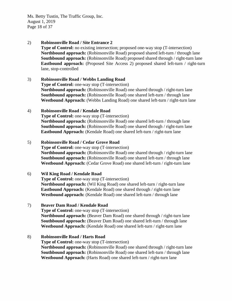
2) Robinsonville Road / Site Entrance 2 Type of Control: no existing intersection; proposed one-way stop (T-intersection)
Northbound approach: (Robinsonville Road) proposed shared left-turn / through lane
Southbound approach: (Robinsonville Road) proposed shared through / right-turn lane
Eastbound approach: (Proposed Site Access 2) proposed shared left-turn / right-turn
lane, stop-controlled
3) Robinsonville Road / Webbs Landing Road Type of Control: one-way stop (T-intersection)
Northbound approach: (Robinsonville Road) one shared through / right-turn lane
Southbound approach: (Robinsonville Road) one shared left-turn / through lane
Westbound Approach: (Webbs Landing Road) one shared left-turn / right-turn lane
4) Robinsonville Road / Kendale Road Type of Control: one-way stop (T-intersection)
Northbound approach: (Robinsonville Road) one shared left-turn / through lane
Southbound approach: (Robinsonville Road) one shared through / right-turn lane
Eastbound Approach: (Kendale Road) one shared left-turn / right-turn lane
5) Robinsonville Road / Cedar Grove Road Type of Control: one-way stop (T-intersection)
Northbound approach: (Robinsonville Road) one shared through / right-turn lane
Southbound approach: (Robinsonville Road) one shared left-turn / through lane
Westbound Approach: (Cedar Grove Road) one shared left-turn / right-turn lane
6) Wil King Road / Kendale Road Type of Control: one-way stop (T-intersection)
Northbound approach: (Wil King Road) one shared left-turn / right-turn lane
Eastbound Approach: (Kendale Road) one shared through / right-turn lane
Westbound approach: (Kendale Road) one shared left-turn / through lane
7) Beaver Dam Road / Kendale Road Type of Control: one-way stop (T-intersection)
Northbound approach: (Beaver Dam Road) one shared through / right-turn lane
Southbound approach: (Beaver Dam Road) one shared left-turn / through lane
Westbound Approach: (Kendale Road) one shared left-turn / right-turn lane
8) Robinsonville Road / Harts Road Type of Control: one-way stop (T-intersection)
Northbound approach: (Robinsonville Road) one shared through / right-turn lane
Southbound approach: (Robinsonville Road) one shared left-turn / through lane
Westbound Approach: (Harts Road) one shared left-turn / right-turn lane

Ms. Betty Tustin, The Traffic Group, Inc.
August 1, 2019
Page 19 of 37
9) Delaware Route 24 / Harts Road Type of Control: one-way stop (T-intersection)
Southbound approach: (Harts Road) one left-turn lane and one right-turn lane
Eastbound approach: (Delaware Route 24) one left-turn lane and one through lane
Westbound Approach: (Delaware Route 24) one through lane and one right-turn lane
10) Delaware Route 24 / Camp Arrowhead Road / Fairfield Drive Type of Control: four-way signalized intersection
Northbound approach: (Camp Arrowhead Road) one left-turn lane, one through lane,
and one right-turn lane
Southbound approach: (Fairfield Drive) one left-turn lane and one shared through /
right-turn lane
Eastbound approach: (Delaware Route 24) one left-turn lane, one through lane, and one
right-turn lane
Westbound Approach: (Delaware Route 24) one left-turn lane, one through lane, and
one right-turn lane
11) Delaware Route 24 / Robinsonville Road / Angola Road Type of Control: four-way signalized intersection
Northbound approach: (Delaware Route 24) one left-turn lane and one shared through /
right-turn lane
Southbound approach: (Delaware Route 24) one left-turn lane and one shared through /
right-turn lane
Eastbound approach: (Robinsonville Road) one shared left-turn / through lane and one
right-turn lane
Westbound Approach: (Angola Road) one shared left-turn / through lane and one right-
turn lane
12) Delaware Route 24 / Pinewater Road / Sloan Road Type of Control: one-way stop (T-intersection)
Northbound approach: (Delaware Route 24) one through lane and one right-turn lane
Southbound approach: (Delaware Route 24) one shared left-turn / through lane
Westbound Approach: (Pinewater Road/Sloan Road) one shared left-turn / right-turn
lane
13) Delaware Route 24 / Hollymount Road Type of Control: one-way stop (T-intersection)
Northbound approach: (Delaware Route 24) one shared left-turn / through lane
Southbound approach: (Delaware Route 24) one through lane and one right-turn lane
Eastbound Approach: (Hollymount Road) one shared left-turn / right-turn lane

Ms. Betty Tustin, The Traffic Group, Inc.
August 1, 2019
Page 20 of 37
Safety Evaluation
Crash Data: Per current DelDOT policy, a review of crash data is not included in this letter.
Sight Distance: The proposed access on Webbs Landing Road would be located on a relatively
straight section of roadway. However, the location of the proposed access appears to be in the
trough of a vertical curve, which could limit sight distance. In addition, east of the proposed site
entrance, there is a horizontal curve which has the potential to impact sight distance or create
safety concerns for left-turning vehicles in and out of the site entrance on Webbs Landing Road.
Due to the vertical and horizontal curves mentioned above, sight distance and safety should be
analyzed as part of the site plan review process to confirm that adequate sight distance will be
available for all proposed movements at the site entrance.
The proposed entrance on Robinsonville Road would be located on a slightly curved and
relatively flat section of roadway and appears to have adequate sight distance. The proposed
entrance on Robinsonville Road would be located on the inside of a horizontal curve and
approximately ½ mile north of another horizontal curve near the intersection of Robinsonville
Road and Fox Run Road. While there appears to be no immediate sight distance or safety
concerns to left-turning vehicles in and out of the site entrance on Robinsonville Road due to the
slight horizontal curve at the entrance location, sight distance should be analyzed as part of the
site plan review process to confirm that adequate sight distance will be available for all proposed
movements at the site entrance.
There appears to be a slight sight distance deficiency at the intersection of Robinsonville Road
and Kendale Road for vehicles turning left from Kendale Road, although it appears there is room
for left-turning vehicles to move up closer to Robinsonville Road to improve their sight distance.
While there are horizontal curves along Robinsonville Road, the study area generally consists of
straight and flat roadways and there are few potential visual obstructions. Sight distance appears
to be adequate throughout the study area, other than the issues described above. No problematic
sight distance deficiencies have been reported or indicated by crash data.
Transit, Pedestrian, and Bicycle Facilities
Existing transit service: The Traffic Group, Inc. contacted representatives of the Delaware
Transit Corporation (DTC) to determine existing and planned transit services near the proposed
development. DART currently operates Route 215 along Delaware Route 24. DTC currently has
no plans to extend service along Robinsonville Road.
Planned transit service: At the time of the Chase Oaks TIS, it was determined that there are no
plans to extend transit service along Robinsonville to serve the proposed development.

Ms. Betty Tustin, The Traffic Group, Inc.
August 1, 2019
Page 21 of 37
Existing bicycle and pedestrian facilities: According to DelDOT’s Sussex County Bicycle Map
(dated March 2018), Beaver Dam Road is classified a “high traffic connector bicycle route with
bikeway.” Delaware Route 24 is classified as a “high traffic regional bicycle route with
bikeway.” A portion of Robinsonville Road, from Delaware Route 24 to Conley Chapel Road, is
classified is classified as a “connector bicycle route without bikeway.”
There are few existing pedestrian facilities throughout the study area. There no marked
crosswalks or pedestrian signals at the study intersections. Only the intersection of Delaware
Route 24 and Camp Arrowhead Road / Fairfield Drive has curb ramps along the north side.
Planned bicycle and pedestrian facilities: The Traffic Group, Inc. contacted representatives of
the DelDOT’s Local Systems Planning Section to determine existing and planned bicycle and
pedestrian facilities for the proposed development. DelDOT’s Local Systems Planning Section
provided comments regarding planned or requested bicycle and pedestrian facilities in the study
area of this proposed development. The following comments were provided:
Install a ten-foot wide shared-use path along the site frontages on Robinsonville Road
and Webbs Landing Road.
Previous Comments
All comments from DelDOT’s Scoping Letter, Traffic Count Review, and Preliminary TIS (PTIS) Review were addressed in the Final TIS submission.
General HCS Analysis Comments
(See table footnotes on the following pages for specific comments)
1) The TIS used cycle lengths of 120 seconds, whereas DelDOT used cycle lengths of 150
seconds in the analyses of the signalized intersections of Delaware Route 24 and Camp
Arrowhead Road / Fairfield Road, and Delaware Route 24 and Robinsonville Road /
Angola Road.
2) Neither the TIS nor DelDOT included percent grade in their analyses.

Ms. Betty Tustin, The Traffic Group, Inc.
August 1, 2019
Page 22 of 37
Table 3
PEAK HOUR LEVELS OF SERVICE (LOS)
based on Traffic Impact Study for Chase Oaks
Report dated May 10, 2019
Prepared by The Traffic Group, Inc.
Unsignalized Intersection 1
Two-Way Stop Control (T-
intersection)
LOS per TIS
LOS per
DelDOT
Webbs Landing Road &
Site Entrance 1
Weekda
y
AM
Weekda
y
PM
Saturday
Midday
Weekda
y
AM
Weekda
y
PM
Saturda
y
Midday
2026 with Chase Oaks (Case 3)
Northbound Site Entrance A (9.9) B (10.4) B (10.3) A (9.9) B (10.3) B (10.2)
Southbound Site Entrance A (8.6) A (8.5) A (8.5) A (8.6) A (8.5) A (8.5)
Eastbound Webbs Landing Road - Left A (8.6) A (8.8) A (8.7) A (8.6) A (7.3) A (7.3)
Westbound Webbs Landing Road -
Left A (7.3) A (7.5) A (7.4) A (7.3) A (7.5) A (7.4)
1 For both unsignalized and signalized intersection analyses, the numbers in parentheses following levels of service
(LOS) are average delay per vehicle, measured in seconds. For signalized analyses, LOS analysis results are given
for only the overall intersection delay.

Ms. Betty Tustin, The Traffic Group, Inc.
August 1, 2019
Page 23 of 37
Table 4
PEAK HOUR LEVELS OF SERVICE (LOS)
based on Traffic Impact Study for Chase Oaks
Report dated May 10, 2019
Prepared by The Traffic Group, Inc.
Unsignalized Intersection 2
Two-Way Stop Control (T-
intersection)
LOS per TIS
LOS per
DelDOT
Robinsonville Road &
Site Entrance 2
Weekda
y
AM
Weekda
y
PM
Saturday
Midday
Weekda
y
AM
Weekda
y
PM
Saturda
y
Midday
2026 with Chase Oaks (Case 3)
Northbound Robinsonville Road - Left A (8.1) A (8.5) A (8.3) A (8.1) A (8.5) A (8.3)
Eastbound Site Entrance B (12.8) B (14.8) B (14.5) B (12.8) B (14.8) B (14.5)
2 For both unsignalized and signalized intersection analyses, the numbers in parentheses following levels of service
(LOS) are average delay per vehicle, measured in seconds. For signalized analyses, LOS analysis results are given
for only the overall intersection delay.

Ms. Betty Tustin, The Traffic Group, Inc.
August 1, 2019
Page 24 of 37
Table 5
PEAK HOUR LEVELS OF SERVICE (LOS)
based on Traffic Impact Study for Chase Oaks
Report dated May 10, 2019
Prepared by The Traffic Group, Inc.
Unsignalized Intersection 3
Two-Way Stop Control (T-
intersection)
LOS per TIS
LOS per
DelDOT
Robinsonville Road &
Webbs Landing Road
Weekda
y
AM
Weekda
y
PM
Saturday
Midday
Weekda
y
AM
Weekda
y
PM
Saturda
y
Midday
2018 Existing (Case 1)
Southbound Robinsonville Road - Left A (7.7) A (7.5) A (7.6) A (7.7) A (7.5) A (7.6)
Westbound Webbs Landing Road A (9.9) A (9.3) B (10.1) A (9.9) A (9.3) B (10.1)
2026 without Chase Oaks (Case 2)
Southbound Robinsonville Road - Left A (8.0) A (8.2) A (8.2) A (8.0) A (8.2) A (8.2)
Westbound Webbs Landing Road B (11.9) B (11.8) B (13.6) B (11.9) B (11.8) B (13.6)
2026 with Chase Oaks (Case 3)
Southbound Robinsonville Road - Left A (8.2) A (8.7) A (8.6) A (8.2) A (8.7) A (8.6)
Westbound Webbs Landing Road C (16.1) C (22.9) C (21.2) C (16.1) C (22.9) C (21.2)
3 For both unsignalized and signalized intersection analyses, the numbers in parentheses following levels of service
(LOS) are average delay per vehicle, measured in seconds. For signalized analyses, LOS analysis results are given
for only the overall intersection delay.

Ms. Betty Tustin, The Traffic Group, Inc.
August 1, 2019
Page 25 of 37
Table 6
PEAK HOUR LEVELS OF SERVICE (LOS)
based on Traffic Impact Study for Chase Oaks
Report dated May 10, 2019
Prepared by The Traffic Group, Inc.
Unsignalized Intersection 4
Two-Way Stop Control (T-
intersection)
LOS per TIS
LOS per
DelDOT
Robinsonville Road &
Kendale Road
Weekda
y
AM
Weekda
y
PM
Saturday
Midday
Weekda
y
AM
Weekda
y
PM
Saturda
y
Midday
2018 Existing (Case 1)
Northbound Robinsonville Road - Left A (7.6) A (8.2) A (8.0) A (7.6) A (8.2) A (8.0)
Eastbound Kendale Road C (16.3) B (10.9) B (12.9) C (17.7) B (14.1) B (13.7)
2026 without Chase Oaks (Case 2)
Northbound Robinsonville Road - Left A (8.3) A (9.2) A (9.2) A (8.3) A (9.2) A (9.2)
Eastbound Kendale Road F
(249.9) F (53.3) F (67.4)
F
(254.9)
F
(101.0) F (90.1)
2026 with Chase Oaks (Case 3)
Northbound Robinsonville Road - Left A (8.5) A (9.4) A (9.2) A (8.5) A (9.4) A (9.2)
Eastbound Kendale Road F
(420.6)
F
(136.2)
F
(149.7)
F
(424.9)
F
(190.8)
F
(176.1)
4 For both unsignalized and signalized intersection analyses, the numbers in parentheses following levels of service
(LOS) are average delay per vehicle, measured in seconds. For signalized analyses, LOS analysis results are given
for only the overall intersection delay.

Ms. Betty Tustin, The Traffic Group, Inc.
August 1, 2019
Page 26 of 37
Table 7
PEAK HOUR LEVELS OF SERVICE (LOS)
based on Traffic Impact Study for Chase Oaks
Report dated May 10, 2019
Prepared by The Traffic Group, Inc.
Signalized Intersection 5 LOS per TIS LOS per
DelDOT6
Robinsonville Road &
Kendale Road
Weekday
AM
Weekday
PM
Saturday
Midday
Weekda
y
AM
Weekda
y
PM
Saturday
Midday
2026 without Chase Oaks (Case 2) N/A N/A N/A B (19.9) B (18.9) B (17.8)
2026 with Chase Oaks (Case 3) N/A N/A N/A B (19.2) B (19.4) B (17.8)
5 For both unsignalized and signalized intersection analyses, the numbers in parentheses following levels of service
(LOS) are average delay per vehicle, measured in seconds. For signalized analyses, LOS analysis results are given
for only the overall intersection delay. 6 The improvements at this intersection are based on recommendation from the Henlopen TID. The improvements
entail a traffic signal and exclusive turn lanes on all three approaches.
Ms. Betty Tustin, The Traffic Group, Inc.
August 1, 2019
Page 27 of 37
Table 8
PEAK HOUR LEVELS OF SERVICE (LOS)
based on Traffic Impact Study for Chase Oaks
Report dated May 10, 2019
Prepared by The Traffic Group, Inc.
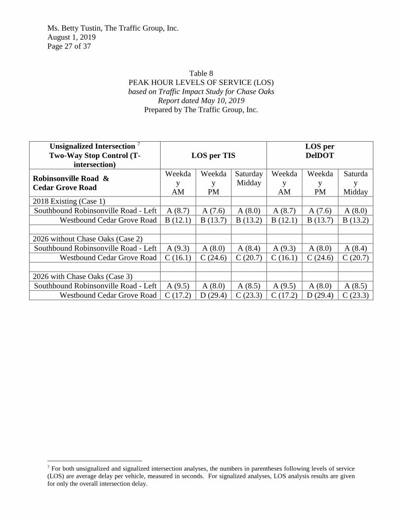
Unsignalized Intersection 7
Two-Way Stop Control (T-
intersection)
LOS per TIS
LOS per
DelDOT
Robinsonville Road &
Cedar Grove Road
Weekda
y
AM
Weekda
y
PM
Saturday
Midday
Weekda
y
AM
Weekda
y
PM
Saturda
y
Midday
2018 Existing (Case 1)
Southbound Robinsonville Road - Left A (8.7) A (7.6) A (8.0) A (8.7) A (7.6) A (8.0)
Westbound Cedar Grove Road B (12.1) B (13.7) B (13.2) B (12.1) B (13.7) B (13.2)
2026 without Chase Oaks (Case 2)
Southbound Robinsonville Road - Left A (9.3) A (8.0) A (8.4) A (9.3) A (8.0) A (8.4)
Westbound Cedar Grove Road C (16.1) C (24.6) C (20.7) C (16.1) C (24.6) C (20.7)
2026 with Chase Oaks (Case 3)
Southbound Robinsonville Road - Left A (9.5) A (8.0) A (8.5) A (9.5) A (8.0) A (8.5)
Westbound Cedar Grove Road C (17.2) D (29.4) C (23.3) C (17.2) D (29.4) C (23.3)
7 For both unsignalized and signalized intersection analyses, the numbers in parentheses following levels of service
(LOS) are average delay per vehicle, measured in seconds. For signalized analyses, LOS analysis results are given
for only the overall intersection delay.

Ms. Betty Tustin, The Traffic Group, Inc.
August 1, 2019
Page 28 of 37
Table 9
PEAK HOUR LEVELS OF SERVICE (LOS)
based on Traffic Impact Study for Chase Oaks
Report dated May 10, 2019
Prepared by The Traffic Group, Inc.
Unsignalized Intersection 8
Two-Way Stop Control (T-
intersection)
LOS per TIS
LOS per
DelDOT
Kendale Road &
Wil King Road
Weekda
y
AM
Weekda
y
PM
Saturday
Midday
Weekda
y
AM
Weekda
y
PM
Saturda
y
Midday
2018 Existing (Case 1)
Northbound Wil King Road B (11.5) B (11.5) B (10.3) B (11.5) B (11.5) B (10.3)
Westbound Kendale Road – Left A (7.8) A (7.7) A (7.6) A (7.8) A (7.7) A (7.6)
2026 without Chase Oaks (Case 2)
Northbound Wil King Road B (14.4) C (16.1) B (13.5) B (14.4) C (16.1) B (13.5)
Westbound Kendale Road – Left A (8.0) A (8.3) A (8.0) A (8.0) A (8.3) A (8.0)
2026 with Chase Oaks (Case 3)
Northbound Wil King Road C (15.1) C (17.3) B (14.3) C (15.1) C (17.3) B (14.3)
Westbound Kendale Road – Left A (8.0) A (8.4) A (8.1) A (8.0) A (8.4) A (8.1)
8 For both unsignalized and signalized intersection analyses, the numbers in parentheses following levels of service
(LOS) are average delay per vehicle, measured in seconds. For signalized analyses, LOS analysis results are given
for only the overall intersection delay.

Ms. Betty Tustin, The Traffic Group, Inc.
August 1, 2019
Page 29 of 37
Table 10
PEAK HOUR LEVELS OF SERVICE (LOS)
based on Traffic Impact Study for Chase Oaks
Report dated May 10, 2019
Prepared by The Traffic Group, Inc.
Unsignalized Intersection 9
Two-Way Stop Control (T-
intersection)
LOS per TIS
LOS per
DelDOT
Beaver Dam Road &
Kendale Road
Weekda
y
AM
Weekday
PM
Saturda
y
Midday
Weekda
y
AM
Weekday
PM
Saturday
Midday
2018 Existing (Case 1)
Southbound Beaver Dam Road - Left A (9.6) A (8.4) A (8.4) A (9.6) A (8.4) A (8.4)
Westbound Kendale Road C (22.3) F (50.0) C (18.3) C (22.3) F (50.0) C (18.4)
2026 without Chase Oaks (Case 2)
Southbound Beaver Dam Road - Left B (11.1) B (10.0) A (9.8) B (11.1) B (10.0) A (9.8)
Westbound Kendale Road F (242.4)
F
(1,448.9)
F
(324.4)
F
(242.4)
F
(1,448.9)
F
(327.2)
2026 with Chase Oaks (Case 3)
Southbound Beaver Dam Road - Left B (11.2) B (10.3) B (10.0) B (11.2) B (10.3) B (10.0)
Westbound Kendale Road F (298.7)
F
(1,952.6)
F
(434.6)
F
(298.7)
F
(1,952.6)
F
(438.0)
9 For both unsignalized and signalized intersection analyses, the numbers in parentheses following levels of service
(LOS) are average delay per vehicle, measured in seconds. For signalized analyses, LOS analysis results are given
for only the overall intersection delay.
Ms. Betty Tustin, The Traffic Group, Inc.
August 1, 2019
Page 30 of 37
Table 11
PEAK HOUR LEVELS OF SERVICE (LOS)
based on Traffic Impact Study for Chase Oaks
Report dated May 10, 2019
Prepared by The Traffic Group, Inc.
Signalized Intersection 10 LOS per TIS LOS per
DelDOT11
Beaver Dam Road &
Kendale Road
Weekday
AM
Weekday
PM
Saturday
Midday
Weekda
y
AM
Weekda
y
PM
Saturday
Midday
2026 without Chase Oaks (Case 2) N/A N/A N/A C (25.1) B (16.6) B (17.1)
2026 with Chase Oaks (Case 3) N/A N/A N/A D (38.8) B (18.4) B (18.9)
10 For both unsignalized and signalized intersection analyses, the numbers in parentheses following levels of service
(LOS) are average delay per vehicle, measured in seconds. For signalized analyses, LOS analysis results are given
for only the overall intersection delay. 11 The improvements at this intersection are based on recommendation from the Henlopen TID. The improvements
entail a traffic signal and exclusive turn lanes on all three approaches.

Ms. Betty Tustin, The Traffic Group, Inc.
August 1, 2019
Page 31 of 37
Table 12
PEAK HOUR LEVELS OF SERVICE (LOS)
based on Traffic Impact Study for Chase Oaks
Report dated May 10, 2019
Prepared by The Traffic Group, Inc.
Unsignalized Intersection 12
Two-Way Stop Control (T-
intersection)
LOS per TIS
LOS per
DelDOT
Robinsonville Road &
Harts Road
Weekda
y
AM
Weekda
y
PM
Saturday
Midday
Weekda
y
AM
Weekda
y
PM
Saturda
y
Midday
2018 Existing (Case 1)
Southbound Robinsonville Road - Left A (7.8) A (7.6) A (7.7) A (7.8) A (7.6) A (7.7)
Westbound Harts Road B (10.4) B (11.2) B (11.4) B (10.4) B (11.2) B (11.4)
2026 without Chase Oaks (Case 2)
Southbound Robinsonville Road - Left A (8.3) A (8.3) A (8.5) A (8.3) A (8.3) A (8.5)
Westbound Harts Road B (14.0) C (23.4) C (23.6) B (14.0) C (23.4) C (23.6)
2026 with Chase Oaks (Case 3)
Southbound Robinsonville Road - Left A (8.5) A (8.5) A (8.8) A (8.5) A (8.5) A (8.8)
Westbound Harts Road C (15.5) E (35.6) D (33.9) C (15.5) E (35.6) D (33.9)
2026 with Chase Oaks (Case 3) – with
addition of westbound right-turn lane
Southbound Robinsonville Road - Left N/A N/A N/A A (8.5) A (8.5) A (8.8)
Westbound Harts Road N/A N/A N/A B (13.7) C (19.2) C (20.1)
12 For both unsignalized and signalized intersection analyses, the numbers in parentheses following levels of service
(LOS) are average delay per vehicle, measured in seconds. For signalized analyses, LOS analysis results are given
for only the overall intersection delay.

Ms. Betty Tustin, The Traffic Group, Inc.
August 1, 2019
Page 32 of 37
Table 13
PEAK HOUR LEVELS OF SERVICE (LOS)
based on Traffic Impact Study for Chase Oaks
Report dated May 10, 2019
Prepared by The Traffic Group, Inc.
Unsignalized Intersection 13
Two-Way Stop Control (T-
intersection)
LOS per TIS
LOS per
DelDOT
Delaware Route 24 &
Harts Road
Weekday
AM
Weekday
PM
Saturday
Midday Weekday
AM
Weekday
PM
Saturda
y
Midday
2018 Existing (Case 1)
Northbound Delaware Route 24 - Left A (8.4) B (11.2) A (8.5) A (8.4) B (11.2) A (8.5)
Eastbound Harts Road F (61.3) F (75.1) D (26.6) F (61.0) F (75.3) D (26.7)
2026 without Chase Oaks (Case 2)
Northbound Delaware Route 24 - Left A (9.0) B (13.9) A (9.9) A (9.0) B (13.9) A (9.9)
Eastbound Harts Road F (833.7)
F
(1,279.1)
F
(434.7) F (831.3)
F
(1,282.1)
F
(436.8)
2026 with Chase Oaks (Case 3)
Northbound Delaware Route 24 - Left A (9.1) B (14.2) B (10.0) A (9.1) B (14.2) B (10.0)
Eastbound Harts Road F
(1,061.0)
F
(1,522.9)
F
(553.4)
F
(1,058.2)
F
(1,526.4)
F
(555.8)
13 For both unsignalized and signalized intersection analyses, the numbers in parentheses following levels of service
(LOS) are average delay per vehicle, measured in seconds. For signalized analyses, LOS analysis results are given
for only the overall intersection delay.

Ms. Betty Tustin, The Traffic Group, Inc.
August 1, 2019
Page 33 of 37
Table 14
PEAK HOUR LEVELS OF SERVICE (LOS)
based on Traffic Impact Study for Chase Oaks
Report dated May 10, 2019
Prepared by The Traffic Group, Inc.
Signalized Intersection 14 LOS per TIS LOS per
DelDOT
Delaware Route 24 &
Camp Arrowhead Road
Weekday
AM
Weekday
PM
Saturday
Midday
Weekda
y
AM
Weekda
y
PM
Saturday
Midday
2018 Existing (Case 1) B (11.3) B (10.5) C (24.2) A (7.4) A (6.5) B (14.2)
2026 without Chase Oaks (Case 2) B (14.3) D (43.7) D (43.9) C (20.9) B (15.2) C (34.8)
2026 without Chase Oaks (Case 2) –
with HEP improvements N/A N/A N/A C (20.9) B (15.2) C (31.3)
2026 with Chase Oaks (Case 3) B (14.2) D (50.9) D (44.2) C (26.2) B (17.5) D (32.2)
2026 with Chase Oaks (Case 3) – with
HEP Improvements N/A N/A N/A C (26.2) B (17.5) D (32.2)
14 For both unsignalized and signalized intersection analyses, the numbers in parentheses following levels of service
(LOS) are average delay per vehicle, measured in seconds. For signalized analyses, LOS analysis results are given
for only the overall intersection delay.

Ms. Betty Tustin, The Traffic Group, Inc.
August 1, 2019
Page 34 of 37
Table 15
PEAK HOUR LEVELS OF SERVICE (LOS)
based on Traffic Impact Study for Chase Oaks
Report dated May 10, 2019
Prepared by The Traffic Group, Inc.
Signalized Intersection 15 LOS per TIS LOS per
DelDOT
Delaware Route 24 &
Robinsonville Road / Angola Road
Weekday
AM
Weekday
PM
Saturday
Midday
Weekda
y
AM
Weekda
y
PM
Saturday
Midday
2018 Existing (Case 1) D (38.3) D (35.8) C (44.2) B (16.6) B (15.1) C (21.1)
2026 without Chase Oaks (Case 2) F (159.3) F (212.2)
F
(210.7) E (76.7)
F
(116.1)
F
(118.7)
2026 without Chase Oaks (Case 2) –
with HEP improvements N/A N/A N/A E (68.1) E (68.0) D (38.7)
2026 with Chase Oaks (Case 3) F (158.5) F (224.7)
F
(219.4) E (76.2)
F
(135.6)
F
(123.3)
2026 with Chase Oaks (Case 3) – with
HEP improvements N/A N/A N/A D (35.6) E (73.8) D (39.2)
15 For both unsignalized and signalized intersection analyses, the numbers in parentheses following levels of service
(LOS) are average delay per vehicle, measured in seconds. For signalized analyses, LOS analysis results are given
for only the overall intersection delay.

Ms. Betty Tustin, The Traffic Group, Inc.
August 1, 2019
Page 35 of 37
Table 16
PEAK HOUR LEVELS OF SERVICE (LOS)
based on Traffic Impact Study for Chase Oaks
Report dated May 10, 2019
Prepared by The Traffic Group, Inc.
Unsignalized Intersection 16
Two-Way Stop Control (T-
intersection)
LOS per TIS
LOS per
DelDOT
Delaware Route 24 &
Pinewater Road / Sloan Road
Weekda
y
AM
Weekday
PM
Saturday
Midday
Weekda
y
AM
Weekda
y
PM
Saturday
Midday
2018 Existing (Case 1)
Southbound Delaware Route 24 - Left B (11.0) A (9.8) B (10.1) B (10.9) A (9.8) B (10.1)
Westbound Pinewater Road / Sloan
Road D (32.9) E (43.5) D (33.0) D (32.9) E (43.5) D (33.0)
2026 without Chase Oaks (Case 2)
Southbound Delaware Route 24 - Left B (12.3) B (12.5) B (12.5) B (12.2) B (12.5) B (12.5)
Westbound Pinewater Road / Sloan
Road F (89.4) F (185.1)
F
(119.3) F (89.3)
F
(185.1)
F
(119.3)
2026 with Chase Oaks (Case 3)
Southbound Delaware Route 24 - Left B (12.4) B (12.9) B (12.8) B (12.3) B (12.8) B (12.8)
Westbound Pinewater Road / Sloan
Road F (101.2) F (218.1)
F
(137.5)
F
(101.1)
F
(218.1)
F
(137.5)
16 For both unsignalized and signalized intersection analyses, the numbers in parentheses following levels of service
(LOS) are average delay per vehicle, measured in seconds. For signalized analyses, LOS analysis results are given
for only the overall intersection delay.

Ms. Betty Tustin, The Traffic Group, Inc.
August 1, 2019
Page 36 of 37
Table 17
PEAK HOUR LEVELS OF SERVICE (LOS)
based on Traffic Impact Study for Chase Oaks
Report dated May 10, 2019
Prepared by The Traffic Group, Inc.
Unsignalized Intersection 17
Two-Way Stop Control (T-
intersection)
LOS per TIS
LOS per
DelDOT
Delaware Route 24 &
Hollymount Road
Weekday
AM
Weekday
PM
Saturday
Midday
Weekda
y
AM
Weekday
PM
Saturday
Midday
2018 Existing (Case 1)
Northbound Delaware Route 24 - Left A (8.8) B (11.4) A (9.3) A (8.8) B (11.3) A (9.3)
Eastbound Hollymount Road F (99.0) F (167.2) F (87.0)
F
(100.4) F (173.7) F (90.3)
2026 without Chase Oaks (Case 2)
Northbound Delaware Route 24 - Left B (10.7) B (13.8) B (11.1) B (10.7) B (13.8) B (11.1)
Eastbound Hollymount Road F (832.2)
F
(2,401.5)
F
(1,707.4)
F
(834.2)
F
(2,404.8)
F
(1,704.7)
2026 with Chase Oaks (Case 3)
Northbound Delaware Route 24 - Left B (10.9) B (14.0) B (11.3) B (10.9) B (13.9) B (11.3)
Eastbound Hollymount Road F (962.2)
F
(2,779.1)
F
(1,991.7)
F
(964.3)
F
(2,782.0)
F
(1,988.6)
17 For both unsignalized and signalized intersection analyses, the numbers in parentheses following levels of service
(LOS) are average delay per vehicle, measured in seconds. For signalized analyses, LOS analysis results are given
for only the overall intersection delay.

Ms. Betty Tustin, The Traffic Group, Inc.
August 1, 2019
Page 37 of 37
Table 18
PEAK HOUR LEVELS OF SERVICE (LOS)
based on Traffic Impact Study for Chase Oaks
Report dated May 10, 2019
Prepared by The Traffic Group, Inc.
Signalized Intersection 18 LOS per TIS LOS per
DelDOT
Delaware Route 24 &
Hollymount Road / Sloan Road19
Weekday
AM
Weekday
PM
Saturday
Midday
Weekda
y
AM
Weekda
y
PM
Saturday
Midday
2026 with Chase Oaks (Case 3) –
realigned, four-leg, intersection N/A N/A N/A B (13.2) D (38.7) D (52.6)
18 For both unsignalized and signalized intersection analyses, the numbers in parentheses following levels of service
(LOS) are average delay per vehicle, measured in seconds. For signalized analyses, LOS analysis results are given
for only the overall intersection delay. 19 The proposed realignment of Hollymount Road and Sloan Road / Pinewater Road will include a traffic signal to
mitigate the intersection with acceptable level of service during the 2026 build-out condition.