Embed Size (px)
Citation preview
STATE GEOLOGICAL AND NATURAL HISTORY SURVEY OF CONNECTICUT
DEPARTMENT OF ENVIRONMENTAL PROTECOON
The Surficial Geology
of the
Haddam Quadrangle
WITH MAP
RICHARD FOSTER FLINT .Late of Yale University
1978
QUADRANGLE REPORT NO. 36
------------· --~--
-- -----------------------------
STATE GEOLOGICAL AND NATURAL HISTORY SURVEY OF CONNECTICUT
DEPARTMENT OF ENVIRONMENTAL PROTECTION
Honorable Ella T. Grasso, Governor of Connecticut
Stanley J. Pac, Commissioner of the Department of Environmental Protection
STATE GEOLOGIST DIRECTOR, NATURAL RESOURCES CENTER
Hugo F. Thomas, Ph.D. Hartford, Connecticut
EDITOR Lou Williams Page, Ph.D.
ii
FOREWORD
Richard Foster Flint, the author of this report, died on June 6, 1976, soon after this map and manuscript had been prepared. It is appropriate at this time to pay tribute to the major contributions he has made to Connecticut geology. For years he has been a world authority on the Quaternary era, conducting field work and lecturing in South America, Europe, Asia, and Africa. His first major work on glacial geology came soon after he joined the Yale Faculty when the Connecticut Geological and Natural History Survey asked him .to study the glacial geology of Connecticut. The field work and report were done in the summers of 1927, 1928, and 1929, and the report, The Glacial Geology of Connecticut, Connecticut Geological and Natural History Survey Bulletin 47 ( 294 pages, 1 large map), was published in 1930. He had already published shorter papers in scientific journals and had given lectures before scientific societies which had aroused great interest in his ideas of downwasting and stagnation as opposed to the conventional "normal retreat" in the last stages of Continental glaciation. Bulletin 47, with the map of the glacial deposits on the scale of 1: 125,000, described the glacial deposits in considerable detail and gave the evidence he saw for stagnation and downwasting. For years geologists debated "stagnation" as opposed to "normal retreat" and many field trips gave opport:unity for discussion. Moreover, his map of the glacial deposits even at the scale of 1:125,000 was a valuable tool in the hands of highway engineers and planners, and those in search of usable sand, gravel, and clay deposits.
Though Flint continued to publish papers on Connecticut geology in professional journals and was one of the editors of the glacial map of North America, the next period of direct activity with the Geological and Natural History Survey came after 1950 when the State had been remapped with larger scale ( I: 24,000) modem topographic maps. The State Survey had already started detailed bedrock maps on a quadrangle basis. Dr. Flint took part in discussions which led to the decision to make quadrangle maps showing the surficial deposits. He advised on personnel, critically reviewed manuscripts of other authors, and in addition, he himself mapped the surficial geology of 10 quadrangles published in 6 quadrangle reports. These are in addition to the two (Haddam and-Naugatuck) now being issued.
The new larger scale maps are very timely with the increasing interest in land use. Dr. Flint has made major contributions to geology and to the State, and its citizens have benefited greatly both from his published work and from other work he and his students did in Connecticut.
As· a Commissioner and later Director of the Connecticut Geological and Natural History Survey from 1947 to 1971, I found it a great privilege to work with such a distinguished geologist as Richard Foster Flint.
Joe Webb Peoples
iii
TABLE OF CONTENTS
Abstract
Introduction
Bedrock geology
Topography
Drainage
Preglacial weathering
Glacial-erosional features
Temporary glacial-stream channels
Glacial sediments .
Till General character
Stratigraphy and correlation
Erratic boulders
Stratified drift
Types of stratified drift .
Distribution and character
Conditions of origin
Postglacial sediments
Wind-blown sand and silt Alluvium and colluvium
Alluvium in the Connecticut River trench Alluvium in lesser valleys .
Swamp and marsh sediments
Beach sand and gravel
Artificial fill
Weathering and soils
Glacial and postglacial history
Economic geology
Sand and gravel
Landfill . . ...
Swamp and marsh deposits
Ground water
References
iv
Page
1
3
4
5
6
7
8
9
9
9
9
12
12
13
13
14
15
19
19 19 20
' "' 20
21
22
22
''"' 22
23
25
25
" "" 26
''"""'"'""""' 26
26
"""""""'" 27
ILLUSTRATIONS
Page
Plate I. Map of the surlicial geology of the Haddam quadrangle . . . . (in pocket)
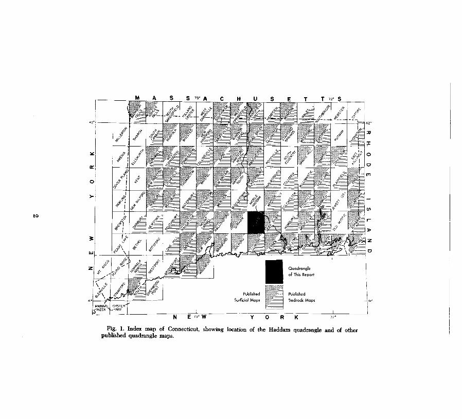
Figure I. Index map of Connecticut showing location of the Haddam quad- 2 rangle and of other published quadrangle maps . . . . . . . . . . . .. . 2
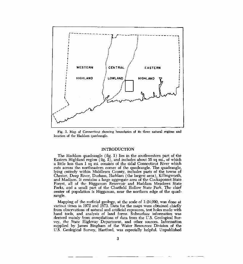
2. Map of Connecticut showing boundaries of its three natural regions and location of the Haddam quadrangle . . . . . . . . . . . . . . . . . . . . . . . . . . . . . . . . . . . . 3
3. Sketch map of principal streams, divides, and places where meltwater streams crossed divides 6
4. Perspective sketch showing conditions during deglaciation 15
5. Cross section through Connecticut River trench . 18
TABLES
Table I. Comparison of altitudes of bodies of stratified drift and related escape routes of meltwater across divides . 17
2. Genetic classification of swamps and marshes in the Haddam quadrangle 21
v
The Surficial Geology of the
Haddam Quadrangle by
Richard Foster Flint
ABSTRACT
The Haddam quadrangle lies in the southwestern part of the Eastern Highland of Connecticut. Features made by glacial erosion include striations, grooves, and streamline hills. Till covers much of the area, although over many hills and ridges it is thin or absent. Its thickness varies greatly, ranging from a foot or two up to more than 100 ft. The glacial features are believed to have resulted from .the passage of a thick ice sheet southeastward across the area.
During deglaciation, stratified drift was deposited in the· larger valleys. Its character indicates that the southern margin of the ice wasted away irregularly, leaving irregular residual masses of ice in the valleys. The margin of the wasting glacier ponded meltwater against major divides. The ponds overflowed across the divides, cutting channels through bedrock. Today the channels carry no water but form notches in the divides.
After the quadrangle was deglaciated, but while the glacier still covered much of the state, meltwater flowing down the Connecticut River 'trench built up a body of outwash sand and gravel as much as 1 mi. wide and up to 200 ft thick. The central part of this body was subsequently washed away by the Connecticut River, leaving discontinuous terraces of sand and gravel along the sides of the trench.
While stratified drift was being deposited, winds removed material from its swface and dropped it as a thin covering of sand and silt over adjacent areas. In postglacial time the drift was dissected by streams that deposited thin layers of alluvium · on valley floors. Mucky swamp deposits, black with organic matter, accumulated in shallow basins in bedrock and glacial drift.
Substances of actual or potential economic value that occur in the quadrangle include ground water, sand and gravel, till, and humus. At sites such as highways, parking areas, and large buildings the terrain has been altered conspicuously by artificial filling.
I
---------------------------------------·-
~
s S 73" A T 12° S
42°
I
J J J >I I *~ ~v I
"'" I !----------+
3: z
"' z.
¥ ,7
I , I <l
41° ~--·- [" - j ... b?____JL_ _ _JL_~~~~7.N~PE~1=3°~W..-~~~~~y-;--~O~~R;--~K-;--~~----:1=2°~~~
of This Report
Surflciol Mops Bedrock Mops
Fig. 1. Index map of Connecticut, showing location of the Haddam quadrangle and of other published quadrangle maps.
, .. <" ' ' \
I I I I I I I
l '
.......
r--------------: -iJr-- -----y- ----- -- ---- --, ' ' I f : : I
J : I I I / { I I I ,,' I f I I : I l I I ,I I I / I I : / I I t /' I
: I I
\ CENTRAL ,i EASTERN I ' I : ,J I I I ,' ' I
( LOWLAN.li'D' HIGHLAND j f : \ ,,' I
:, ,,'' _,..•
WESTERN
HIGHLAND
>
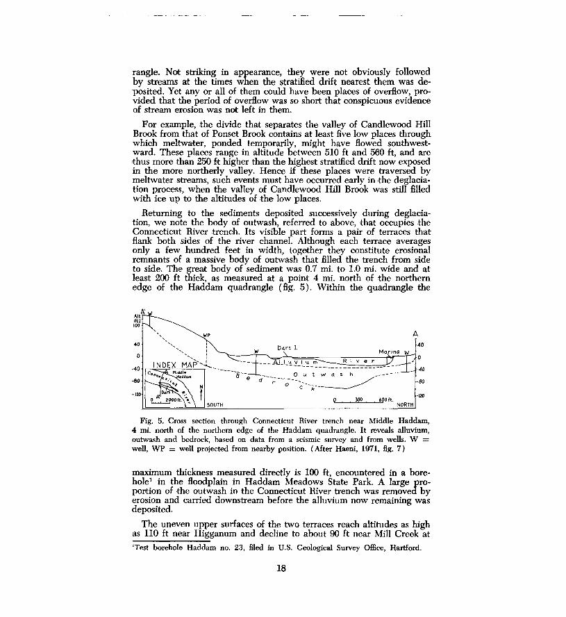
Fig. 2. Map of Connecticut showing boundaries of its three natural regions and location of the Haddam quadrangle.
INTRODUCTION
The Haddam quadrangle (fig. 1) lies in the southwestern part of the Eastern Highland region (fig. 2), and includes about 55 sq mi., of which a little less than 1 sq mi. consists of the tidal Connecticut River which cuts across the northeastern comer of the quadrangle. The quadrangle, lying entirely within Middlesex County, includes parts of the towns of Chester, Deep River, Durham, Haddam (the largest area), Killingworth, and Madison. It contains a large aggregate area of the Cockaponset State Forest, all of the Higganum Reservoir and Haddam Meadows State Parks, and a small part of the Chatfield Hollow State Park. The chief center of population is Higganum, near the northern edge of the quadrangle.
Mapping of the surficial geology, at the scale of 1:24,000, was done at various times in 1972 and 1973. Data for the maps were obtained chiefly from observations of natural and artificial exposures, test holes made with hand tools, and analysis of land forms. Subsurface information was derived mainly from compilations of data from the U.S. Geological Survey, the State Highway Department, and other sources. Information supplied by James Bingham of the Water Resources Division of the U.S. Geological Survey, Hartford, was especially helpful. Unpublished
3
information on the bedrock geology of the quadrangle, furnished by Lawrence Lundgren, Jr., is gratefully acknowledged. Criticism of map and text by Fred Pessl, Jr., and Dennis O'Leary is also acknowledged with thanks.
In Connecticut the surficial materials or regolith (the unconsolidated materials that overlie the bedrock) are chiefly of glacial origin; here surficial geology and glacial geology are nearly synonymous. That Connecticut had been overrun by glacier ice was firmly established in the 19th Century by J. D. Dana. General discussion of the glacial features of Connecticut, although without speciaPreference to the Haddam district, can be found in publications by Rice and Gregory ( 1906, p. 227-259) and Flint ( 1930, 1934).
BEDROCK GEOLOGY
The detailed bedrock geology of the Haddam quadrangle has not been published. The quadrangle is underlain by very old metamorphic rocks (chiefly gneisses) and in a few places by granite and pegmatite. These rocks were folded under very high pressure, well down within the Earth's crust. That process, which ended some 250 million years ago, was followed by prolonged erosion, which removed from the region a layer of rock material probably at least 10-12 mi. thick. If that thickness is approximat.ely correct, the average rate of removal was about l/4 in. every hundred years. Whatever its rate, erosion lowered the surface of southern Connecticut to its present position, exposing .to view the formerly deepseated rocks. Their old, folded structures form, on the surface, a pattern that delineates a broad structural dome (Lundgren, 1963, fig. 2). As indicated in a later section, some of these structural elements in the bedrock are reflected in the trends and forms of hills and valleys, caused mainly by the varying erodibility of different types of rock. The more erodible ones generally underlie valleys and lowlands; the least erodible rocks underlie the higher groups of hills.
The metamorphic rocks are cut by a younger body of igneous rock consisting of a thin dike of diabase of Triassic age. Inconspicuous and generally hidden beneath glacial deposits, the trace of the dike trends SW-NE across .the quadrangle from near the intersection of County Road with Emmanuel Church Road in Killingworth to the Connecticut River at Higganum.
The physical and chemical characteristics of the various sorts of bedrock and the pattern in which they crop out at the surface influence to some extent the surficial geology of the Haddam area. The presence in the glacial drift of rock fragments whose places of origin in bedrock can be identified helps to determine the directions of How of former glacier ice in southern Connecticut.
Because glacial drift is thin over most of the quadrangle, bedrock is exposed at the surface in many places and is close beneath the surface rather generally. In upland areas of moderate to low relief, the covering of glacial drift is nearly continuous and bedrock exposures are small. The thickness of drift varies considerably in these areas and the bedrock
4
outcrop map unit (pl. 1) is less accurate and is more interpretative. In many hill areas, however-particularly the sides and southern slopes of hills-the drift is so thin and discontinuous that exposures of underlying bedrock are numerous and closely spaced. The bedrock outcrop map unit (pl. 1) is more accurate in these areas.
TOPOGRAPHY
The surface of the Haddam area is irregular. The altitudes of the tops of hills and ridges, reflecting the general seaward slope of this part of Connecticut, increase from 400-450 ft near the southeastern corner of the quadrangle to 650-730 ft near the northwestern corner, a general rise of about 20 ft/mi. The rise, however, is masked in places by abrupt local variations in the height and trend of topographic elements, brought about by the effects of erosion on bedrock of different kinds and by changes in bedrock structure.
Another influence on local topography is the thickness and distribution of the mantle of till ·that overlies the bedrock. This is discussed in the description of the till. We may note here, however, that upland areas of smooth topography generally expose till in roadcuts and other artificial excavations, whereas hills marked by very irregular topography more commonly expose bedrock, with abundant boulders scattered over the surface. Although this difference reflects varying thicknesses of the mantle of till, it probably antedates the till at least in part. A smooth bedrock topography before glaciation is likely to have led to the deposition of an unbroken sheet of till. In contrast, knobby bedrock topography was conducive to. discontinuous deposition of till and to glacial quarrying from the lee slopes of rock hills, creating numerous boulders. The contrast is visible when one compares the northern and southern slopes of many of the hills in the Haddam quadrangle. Till covers the former, and bedrock appears commonly in the latter.
The relief of the bedrock surface is greater than it appears, because the bedrock floor of the Connecticut River valley lies well below present sea level. At Middle Haddam, 4 mi. upstream from the northern edge of the Haddam quadrangle, the floor lies generally at -100 ft and at one point, in a deep well, is lower than -155 ft. South of the Connecticut Turnpike bridge in Old Lyme, 15 mi. downstream from Haddam, the floor lies at -200 ft (Haeni, 1971; Upson and Spencer, 1964, p. M8-M10). Although the valley and some of its tributaries may have been deepened to some extent by glacial erosion, probably their depths are mainly the result of rise in the level of the sea relative to the land.
The valleys of the region have been filled to various depths with glacial drift, reducing the relief. Few details are known because the records of borings, on which such knowledge depends, are few. In most local valleys, however, the sedimentary fills are believed to be rather thin. If this is so, the relief of the Haddam district is attributable mainly to the irregular surface of the bedrock, the broader features of which were fashioned well before glaciation occurred.
5
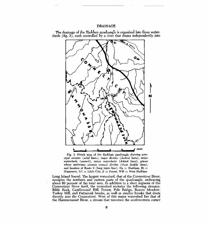
DRAINAGE
The drainage ol the Haclclam quadrangle l.s organlzed ~nto three watersheds (fig. 3), each controlled by a river that drains independently into
• f I t 1 f/'fN.l.S
Fig. 3. Sketch map of the Haddam quadrangle showing principal streams (solid lines), major divides (dashed lines), major watersheds (named), minor watersheds (dotted lines), places where meltwater streams crossed divides (short double lines), and location of Route 9 (long triple line). Ha = Haddam, Hi = Higganum, LC= Little City, P = Ponset, WH =West Haddam.
Long Island Sound. The largest watershed, that of the Connecticut River, occupies the northern and eastern parts of the quadrangle, embracing about 60 percent of the total area. In addition to a short segment of the Connecticut River itself, the watershed includes the following streams: Bible Rock, Candlewood Hill, Ponset, Pole Bridge, Beaver Meadow, Turkey Hill, and Pattaconk brooks, as well as smaller brooks that drain directly into the Connecticut. West of this major watershed lies that of the Hammonasset River, a stream that traverses the southwestern comer
6
of the quadrangle and is fed by several long tributaries, among which Bunker Hill and Pond Meadow brooks are conspicuous. In the southern part of the map area, between the two watersheds already named, is the basin of the Menunketesuck River with its principal tributary, Heft Brook.
The Connecticut River, where it passes through the quadrangle, is tidal; indeed tidewater affects the river as far inland as Hartford, nearly 20 mi. upstream from Higganum. The presence of tidewater is a result of submergence of the coast, mentioned in the preceding section. The mouths of tributaries within the Haddam quadrangle are, of course, affected by tides.
The general pattern formed by the streams within the quadrangle has existed for many millions of years, long before glaciation of the region, but the precise controls under which the pattern took shape are not known. Some stream segments follow belts of comparatively erodible rock or are parallel with foliation or other structures in the bedrock. Nevertheless, other segments cut across major bedrock structures, and therefore must have been localized by factors other than those structures.
Glaciation seems to have altered the pre-existing drainage pattern very little. The courses of the smaller streams are interrupted in places by swamps, particularly in headwater areas. Some of the swamps occupy shallow basins created by the irregular deposition of glacial drift or by the collapse of drift during melting of masses of glacier ice that were buried beneath it. Three examples are:
1. Two swamps about 1,600 ft south of the intersection of McTish Road with Johnson Road in the southwestern part of the Town of Haddam.
2. A swamp along the course of Ponset Brook, about 2,000 ft east of the Little City Cemetery.
3. A swamp along Pond Meadow Brook in the Town of Killingworth, about 1,200 ft upstream from the head of Kroopa Pond. Such basins remain because of the recency of glaciation; the time since that event has been too short to permit the re-establishment of stream How uninterrupted by basins of glacial origin.
The lakes and ponds, both named and unnamed, within the quadrangle include water-supply reservoirs, present or former millponds, recreational ponds, and basins that are former pits dug for sand and gravel. All or nearly all were created or at least deepened by artificial dams.
PREGLACIAL WEATHERING
In the region southwest of Connecticut, beyond the southern limit of the ice sheet that formerly overran all of New England, the bedrock in most natural and artificial exposures displays to a varying .extent the effect of long-continued weathering, chiefly by chemical decomposition. The weathered rock occupies a shallow zone within which decomposition is most intense close to the surface and fades out downward into
7
fresh rock at depths ranging from a few feet to tens of feet. In contrast, within the glaciated region exposed bedrock is generally undecomposed. This implies that in most places the overriding ice sheet rubbed away the loose, weathered rock at the surface and bit down into fresh, unaltered rock beneath. Exposed bedrock in the Haddam quadrangle offers no exception to ·this general rule. At only one place was bedrock seen to be affected by weathering of probable preglacial age. This is in a cut, several hundred feet long by 30 ft deep, on the western side of the southbound roadway of Route 9, about 1 mi. south of Interchange 7. Here many joints in the gneiss ( Monson Gneiss?) are oxidized to rusty brown. Oxidation of the faces of joints probably represents only the lowest part of the zone of weathering before glaciation. We may speculate that the ice sheet removed an overlying, more completely weathered part but failed to destroy the deeper traces of oxidation. A more complete record of preglacial weathering is preserved farther south along Route 9 (Flint, 1975).
GLACIAL-EROSIONAL FEATURES
Striations and grooves, ranging in length from a few inches to a few feet, etched into the surface of bedrock by particles of rock embedded in the base of flowing glacier ice are found throughout Connecticut. Their occurrence in any area depends on the types of bedrock that are present; their visibility depends to a considerable extent on the number of artificial excavations in surficial loose material that reveal the bedrock beneath. Most natural exposures, being far older than artificial ones, rarely retain striations, which are very shallow and become obliterated either by weathering, which roughens and granulates the rock, or by abrasion in stream water.
Glacial grooves were observed at only two places in the Haddam quadrangle, and no striations were observed. These meager results can be attributed to widespread occurrence of coarse-grained granitic rocks, which do not accept glacial markings with ease and readily lose those which are accepted, and to the very slight extent of industrialization in the area. The two localities at which grooves are exposed are shown on the map (pl. 1 ) . One is on the southern side of Ponset Road about 1,000 ft east of Ponset. Here enough till has been removed from an abandoned borrow pit to expose a nearly horizontal surface of granitic rock beneath it, displaying a shallow groove that cuts the grain of the rock, trending S 2° E. The other locality, also an artificial excavation, is in the Beechwood Trailer Camp east of Route 81 and close to the southern edge of the quadrangle. There grooves trend obliquely up a NE-sloping surface of bedrock, in a direction S 12° W. At both localities the trends are compatible with the range of trends measured at 14 localities in the Essex and Old Lyme quadrangles adjacent on the south (Flint, 1975). In those and other nearby quadrangles, however, the preponderant trend of grooves and other indicators of direction of flow of the former ice sheet is east of south rather than west of south.
Glacial erosion is involved in the creation, not only of striations and grooves but also of local streamline hills. Smooth, oval in plan, and in some cases remarkably symmetrical, such hills are believed to reflect a
8
-- ---- -------------------------
process of glacial molding that is the work of both erosion and deposition. Streamline hills within the quadrangle average about 35 ft in height, and may consist almost entirely of bedrock or of glacial sediment (commonly till), or of any proportion of the two. In the Haddam quadrangle at least 21 such hills can be distinguished by their form alone from the contours shown on plate 1. Conspicuous among them are Candlewood Hill, 2 mi. north of Little City ( 800 ft long; 80 ft high; trend N-S), the unnamed hill l mi. west southwest of Scovill Reservoir ( 1,200 ft long; 50 ft high; trend NW-SE), and the hill 0.5 mi. west of the northern part of Cedar Lake ( 2,300 ft long; 60 ft high; trend NW-SE). Of the 21 streamline hills, at least eight expose bedrock on some part of their surfaces. Sixteen trend NW-SE, one trends N-S, and four trend NE-SW. Because those in the first two categories parallel the regional trend of glacial striations and grooves, and only in places parallel the major structure of the bedrock units (Lundgren, 1963, fig. 2), we infer that their trends were determined primarily by the flowing ice sheet. Nine hills expose bedrock in some part or parts of their surfaces; of these, three trend SW while the other six trend SE. Probably the trends of at least some of the hills with SW alignment were determined by alignments of structures in the bedrock before glaciation occurred, and were later smoothed, at least in part, by glacial processes.
TEMPORARY GLACIAL-STREAM CHANNELS
At a number of places within the quadrangle are gaps and channels that cross divides separating the watersheds of existing streams. Some of these bear evidence of scour by former streams, whereas others are floored with organic muck that conceals their detailed character. Some of these features are so related to bodies of stratified drift that they are believed to have carried glacial meltwater for short periods during the deglaciation of the quadrangle. They are discussed hereafter, in connection with the conditions of origin of stratified drift.
GLACIAL SEDIMENTS
Sediments of glacial origin, collectively known as glacial drifr, are of two general kinds: till, deposited directly from glacier ice, and stratified drifr, deposited in streams or lakes created by the melting of glacier ice. Both are present in the Haddam quadrangle, where they are patchy and discontinuous in distribution and extremely variable in thickness. Specific measured thicknesses are given in the descriptions that follow.
Till
GENERAL CHARACTER
Till consists of a mixture of rock particles of many sizes, ranging from large boulders to tiny particles of clay; at any one locality not all these sizes are necessarily present. Till forms a discontinuous mantle over the area. It covers much of the bedrock surface on hills and smaller valleys alike, and thereby shows that the bedrock had been sculptured, by weathering and by runoff of rainwater, essentially to its _present surface form before glaciation. Because the major valleys are partly filled with
9
sediment younger than the till, the till itself is exposed in them only rarely. However, borings made in the Boors of valleys show that till generally underlies the younger sediment and in turn is underlain by bedrock. For example, test hole no. 20 (Haddam quadrangle) bored in the Boor of the valley of Ponset Brook 1,000 ft southwest of Haddam Junior High School, passed throuEh 62 ft of stratified drift, and then 4 ft of till, before encountering bedrock (unpublished data on file at U.S. Geological Survey, Hartford, Connecticut).
It is evident on plate 1 that in the majority of the areas where bedrock is at or close to the surface, the slopes of hills are steeper than elsewhere. The presence of steep slopes, in turn, depends to a considerable degree on minerals and struotures, particularly foliation and jointing, in the bedrock. In places, vertical or very steeply dipping foliation and joints could have been quarried by the ice that Bowed over the rock. Large and small pieces of rock would have been split away from a hill and carried southeastward, leaving behind a steep clifflike slope. As long as it remained steep, no amount of quarrying would change the angle of the slope created in this way by the ice that Bowed past it. For such cliffs to form, the structures need not have been at right angles to the direction of ice movement. Their trend needed only a component transverse to the "downstream" direction. An analogy is a carpenter's plane passing across the end of a board. Even if the plane meets the trailing edge of the board obliquely, bits of the wood will be chipped and split off.
In the Haddam quadrangle the areas where bedrock is mapped (pl. 1) as being at or close to the surface commonly display exposures of bedrock, many of them clifflike. Such areas also have many boulders at the surface, most of them consisting of the local bedrock and having joint-controlled faces.
In contrast, most slopes that faced the oncoming ice are sufficiently mantled with till to conceal the bedrock. Records of wells that penetrate both till and underlying bedrock are too few to permit general appraisal of the thickness of till on north-facing slopes. However, the map area, affords one measurement of thickness. The log of a well at altitude 570 ft, on the northwestern slope of the hill immediately south of Hidden Lake, shows 88 ft of till, underlain by bedrock at a depth more than 50 ft below the altitude of the base of the hill. Yet near the southeastern base of the hill, at altitude 500 ft, bedrock is believed to be close to the surface.
Evidently many slopes that face "upstream" caused the Bowing ice to deposit till over them. Similarly the broad tops of many interHuves received a mantle of till sufficiently thick to conceal the bedrock except for a few exposures. The till mantle has smoothed topographic detail by filling small valleys and pockets in the bedrock surface, particularly on hillsides. Roadcuts, stream banks, and other surface exposures rarely show more than a few feet of till. However, most of the logs of borings, made principally for water wells, within the map area, show greater thicknesses. In the 47 such logs that are filed in the U.S. Geological Survey, Hartford, in which till more than 4 ft thick is recorded, the average thickness of till is 38 ft. But because few of the borings are in areas where bedrock is at or apparently close to the surface, this average is
10
not representative of the quadrangle as a whole, and should probably be reduced substantially. The 47 logs include a range of thickness from 5 ft to 118 ft.
The surface of the till in the quadrangle is smooth. It has little relief that results from local variations in its own thickness, independent of the relief of the underlying bedrock surface. The glacier appears to have smeared till over the bedrock in a blanketlike manner.
Till includes a coarse fraction consisting of pebbles, cobbles, and boulders and a fine fraction consisting of sand, silt, and clay. As is general throughout much of Connecticut, the coarse fraction is conspicuous in surface exposures but, when measured, is found in most samples not to exceed 20 percent of the total. In some samples it amounts to less than 5 percent. In the till within the map area, sand and silt are abundant relative to clay; hence the till is commonly rather friable. It is less so in areas underlain by micaceous, schistose rocks than in areas of gniesses and granitic rocks rich in quartz, where the fine fraction of till includes larger amounts of sand.
The pebbles, cobbles, and boulders in till are generally subangular in shape, reflecting the joints and foliation surfaces in the bedrock from which they were derived. Most of them show some degree of smoothing and abrasion, acquired during their travel in the glacier. Comers and edges between facets are rounded, and the surfaces of a few (generally fewer than 5 percent) are scored with striations. A very few are well rounded; very likely these had been transported in streams before being last picked up by the glacier. The sand-size particles are mainly very angular, implying crushing while in glacial transport.
In some exposures the shapes of many particles (including big boulders ) in the coarse fraction reflect the fact that their surfaces are ragged fracture planes with little or no evidence of modification by glacial abrasion. These fragments may have been tom from bedrock by the glacier and transported without coming into frequent contact with other pieces of rock, or they may have resulted from crushing.
In composition the till commonly resembles the bedrock that immediately underlies it or that occurs within a short distance northward. Composition is reflected in the color of the sediment, which, when dried, ranges from yellows (hue 5Y) to yellowish grays and yellowish browns (hue IOYR) of the Munsell system (Goddard and others, 1948).
The characteristics of the till exposed in the Haddam quadrangle can be seen conveniently in two places. One is a cut on the northern side of Hubbard Road in Haddam, 0.4 mi. west of the Route 9 overpass. Pieces of sedimentary rock of Triassic age, described in the second paragraph followin~, are present in the till at that place. The other locality is a cut on the northern side of West Main Street, Chester, close to its intersection with Sypher Road.
Whereas most of the till within the map area was derived from gneissic, schistose, and granitic rocks, a small and variable proportion of it cam'e from reddish and brownish sedimentary rocks and from basalt and diabase, all of Triassic age. The sedimentary rocks and the basalt
11
do not occur within the area; however, they do occur widely northwest of a NE-SW line that passes within a distance of less than 1 mi. measured in the direction of regional glacier flow, from the northwestern corner of the Haddam quadrangle. The diabase occurs within the map area itself, in the form of the dike mentioned in the section on bedrock geology. For these reasons it is not surprising that Triassic elements are present in the till of this map area, most abundantly in its northwestern part. They are also present in stratified drift, as described in a later section.
Although most till is not stratified, at a few places within the area it possesses distinct fissility. This structure consists of closely spaced subparallel partings that in most exposures are also approximately parallel with the ground surface. The origin of the structure is not known; it might have originated in at least two ways. Some fissility may have resulted from the plastering by moving ice of successive layers of wet, plastic sediment onto the ground. In places it may have been formed by repeated wetting and drying, or other physical changes, after deposition and even after deglaciation.
STRATIGRAPHY AND CORRELATION
All the till exposed in the Haddam area appears to be part of a single layer, deposited during a single glaciation. In the Mount Carmel quadrangle, 18 mi. west of our map area, two distinct layers of till are present and seem to be related to two distinct sets of striations (Flint, 1961). Elsewhere in Connecticut two different facies of till have been identified. The two facies have been regarded by some geologists as having been deposited, respectively, beneath a flowing ice sheet, and on top of an ice sheet, near its margin, during the process of deglaciation. Others regard. the two facies as the deposits made by separate glaciations, or at least as the result of significant change in the local direction of flow during a single glaciation. These differences of opinion are summarized by Pessl ( 1972). Probably the till in the Haddam quadrangle is equivalent to one or the other of those tills, but information is insufficient to support a determination, which must await wider study. In any case, our till probably was deposited during the Wisconsin Glacial Age of geologic time.
Erratic boulders
Erratic boulders, consisting by definition of boulders of a rock type different from the bedrock upon or above which they lie, are numerous in the map area. Some lie free on the surf ace of till or bedrock; others are partly embedded in drift. Many of the boulders exceed 5 ft in longest diameter but only those with a diameter of 10 ft or more were plotted on the map (pl. 1). Twenty-six were observed, and probably many others· were missed in densely forested terrain. The largest of those plotted, a glacially worn boulder of pegmatitic rock on the southeastern side of Candlewood Hill Road in Haddam, 1,000 ft east of Upper Pond, is partly embedded in till. The dimensions of the exposed part are about 25 x 17 x 15 ft. Another boulder, nearly as large ( 21 x 18 x 11 ft) and also consisting of pegmatitic rock set in till, lies on the northwestern side of Nason Road in Haddam, 1,600 ft south of Upper Pond.
12
Spacing of joints and foliation planes in the parent bedrock is the chief factor that determines the diameter of a boulder. The sizes of both of these boulders seem to have been controlled by joints.
In the Haddam quadrangle erratic boulders, both large and small, are distributed very irregularly. Of the 26 large boulders plotted on plate l, seven form a group scattered along the high, steep southeastern side of the valley of Candlewood Hill Brook in Haddam. We may speculate that these were "stranded" as the glacier in which they were carried flowed southeastward, up and over this obstacle, which demanded a lift of more than 300 ft. Apart from this group, the factors that determined the place of deposition of each boulder have not been determined. We can say only that most of them occupy areas of uncommonly great local relief and steep slopes, where interference with smooth flow of the glacier was probably rather large.
In composition the 26 large erratics include nine gneiss, seven pegmatite, two each of granitic rock, amphibolite, and diabase, and four unidentified. None of them had to be carried far to reach their present positions. The two erratics of diabase occur, respectively, only 1,600 ft and about 3 mi. southeast of the diabase dike, measured in the direction of flow of the former ice sheet.
Stratified drift
TYPES OF STRATIFIED DfilFT
The sorted sediments, mostly stratified, that are deposited in streams and lakes derived from melting glaciers, are collectively known as stratified drift. Some of this material was derived directly from rock particles in glacier ice, and some consists of reworked and redeposited till. Most of the stratified drift in the Haddam area was deposited by streams. In it can be discerned two facies, each with distinctive characteristics and each an end member of a gradational series. One facies is the drift deposited in contact with melting ice near the margin of the glacier. The other end member is the drift deposited by streams that flowed away from the glacier, miles or tens of miles from the glacier in which it originated. The sediments of both facies are much the same, although, like all stream-deposited sediments, they become finer grained and better sorted in the downstream direction. But as long as ice, residual from the glacier, is present beside or beneath accumulating stratified drift, that drift will have lasting characteristics that betray its peculiar place of deposition, and constitutes a facies labeled ice-contact stratified drift. Downstream the stratified . drift changes its character as residual ice beside or beneath it gradually becomes less abundant. Where the direct influence of ice ceases to be evident, the sediment constitutes a facies labeled outwash, although it is essentially the same body of sediment.
We define ice-contact stratified drift, then, as sediment deposited in streams and other bodies of water against, upon, beneath, or otherwise in immediate contact with melting glacier ice. Such sediment includes sand, gravel, silt, and clay, and commonly possesses one or more of these characteristics: great internal variability, poor sorting, large and abrupt changes in grain size both vertically and horizontally, inclusion
13
of small bodies of till, erratic boulders, or flowtill (,till-like sediment deposited by landsliding off adjacent ice), and deformation of sedimentary layers by subsidence or other displacement activated by melting of underlying or adjacent glacier ice. Rounding of individual particles, although highly variable, is commonly slight or only partial.
In addition, ice-contaot stratified drift is characterized, in places at least, by constructional topography that includes basins (known as kettles), partial basins, irregular, knoll-like mounds ( kames), and kame terraces gradually built up between the sides of a glacier and the sides of the valley it occupies. These features reflect the presence of irregular bodies of melting ice during accumulation of the drift.
In the map area virtually all the stratified drift ranges in color from grayish and dark yellowish orange (hue lOYR) to dusky yellow (hue SY) on the Munsell scale (Goddard and others, 1948), reflecting the color of comminuted, oxidized bedrock. However, like the till mentioned earlier, a small portion of the stratified drift, in the form of scattered pebbles, and lenses of sand and silt, is derived from reddish sedimentary rock and dark-colored igneous rock of Triassic age. The significance of this fact is mentioned in a later section.
In contrast with ice-contaot sediment, outwash is defined as stratified drift deposited by streams beyond a glacier and free of any influence of buried ice. It is commonly characterized by lenticular beds, each consisting of parallel laminae that are inclined in the downstream direction. Range of grain size is relatively small (most outwash consists of sand- and pebble sizes), and stratification is more regular and systematic than it is in ice-contact sediment.
DISTRIBUTION AND CHARAcrER
Bodies of stratified drift of both types described are present in the Haddam quadrangle, generally in valleys, and in some places along the sideslopes of valleys (pl. I ) . In an earlier section it was noted that the quadrangle includes parts of three watersheds (fig. 3). The aggregate area of stratified drift in the Connecticut River watershed (which occupies the northeastern part of the quadrangle) is greater than that in the other two watersheds (which we shall call the southern watersheds ) combined. Furthermore, except for two strips along the main river itself, the Connecticut River watershed contains no outwash, whereas in the southern watersheds both ice-contact stratified drift and outwash are present.
In the southern watersheds stratified drift is comparatively thin, is distributed along valleys in a patchy manner, and slopes down the valleys at gradients not greatly different from those of today's streams in the same valley. In the Connecticut River watershed, however, the drift is generally thicker and less patchy, cont&ins a larger proportion of sand to coarser particles (in places more than 85 percent), and slopes downstream at gradients that vary conspicuously from part to part of each valley.
Also in some valleys (notably those of Candlewood Hill Brook downstream from Black Shop Pond and Ponset Brook northeast of Ponset)
14
there are indications that the drift was deposited in ponded water. In the former area there is exposed laminated silt with a little clay, in which are embedded random cobbles and pebbles having glaciated shapes. These dropstones were certainly dropped to the bottom of a lake from some kind of rafts floating on the lake surface; probably the rafts consisted of floating ice. This lake facies of ice-contact stratified drift is shown separately on the map (pl. 1), labeled with the symbol icl.
This collection of features suggests that the stratified drift in the valleys of the Connecticut River watershed, deposited partly by streams and partly in ponds, and mostly upon and beside tongues and separate masses of glacier ice, accumulated successively at different altitudes as the glacier shrank back toward what is now the channel of the Connecticut River. It suggests also that during this process some of the deposited drift was reworked and eroded again and again.
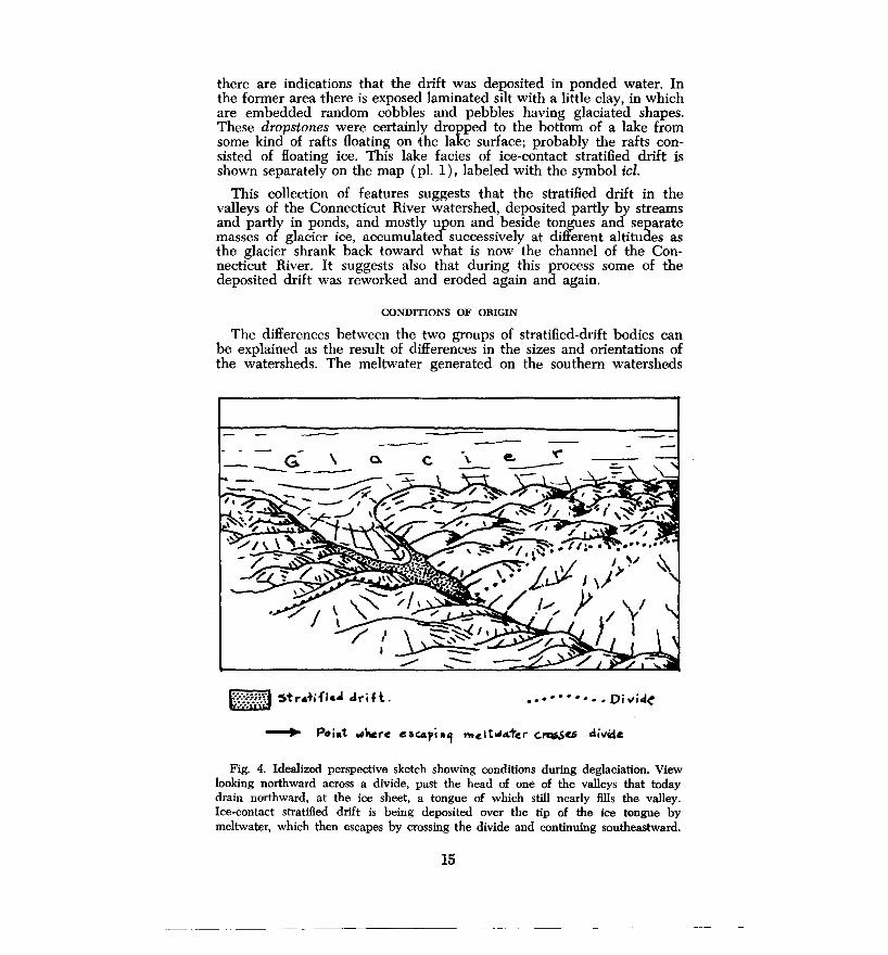
CONDmONS OF ORIGIN
The differences between the two groups of stratified-drift bodies can be explained as the result of differences in the sizes and orientations of the watersheds. The meltwater generated on the southern watersheds
-_-_ -- G" ' a. ----
,. I
~ ~tra+ifi&.,i driH. ~
'('
• • • • • • • • •• Di 'tlic:f~
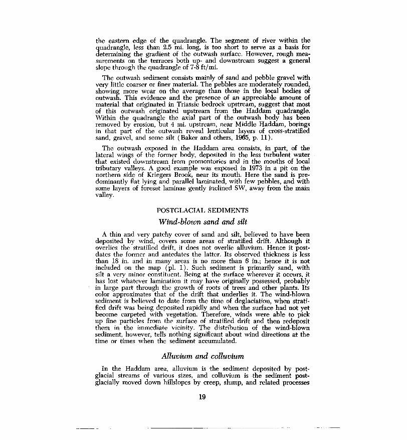
Fig. 4. Idealized perspective sketch showing conditions during deglaciation. View looking northward across a divide, past the head of one of the valleys that today drain northward, at the ice sheet, a tongue of which still nearly fills the valley. Ice-contact stratified drift is being deposited over the tip of the ice tongue by meltwater, which then escapes by crossing the divide and continuing southeastward.
15
-----------------·------------- -------
could How southward out of the quadrangle with no impediment save possibly thin residual masses of ice left behind on valley floors during deglaciation. Thus the water could have exported a large part of the total sediment released locally from the glacier. But that total was not large, because the area of the southern watersheds that lies within the quadrangle is comparatively small. Thus the stratified drift is comparatively scanty and includes bodies of outwash.
In contrast, the stratified drift in the Connecticut River watershed evidently accumulated in a different: way. During deglaciation, the marginal part of the ice sheet there lay upon a surface whose valleys sloped toward the ice. At first, therefore, meltwater could escape only toward the south and southeast, either across the main divide into other watersheds or across a local divide into the next valley in the Connecticut River watershed itself. In places water would have been ponded between the divide and the edge of the glacier itself. Probably any ponds present were soon filled with sand and other sediment. Thus, at the head of any valley, the features might have looked as suggested in the rough sketch, figure 4.
A closer look at the bodies of stratified drift in the Connecticut River watershed shows that at or just beyond the up-valley ends of most of them there are low places in the divide that confines them. In some of the low places are short channels that lead into the headwaters of other valleys. The most conspicuous of these low places are at the headwaters of Turkey Hill, Beaver Meadow, Salrtpeter, and Ponset brooks. Channels of this kind are best displayed along Jericho Road in Haddam. Altitudes of the channel floors, determined from the contours on plate 1, are mostly within 10 ft of the maximum altitudes of the ice-contact bodies adjacent to ·the north.
It can be inferred that in such places, as soon as melting ice uncovered the divide, meltwater deposited stratified drift against it and escaped across it. The process could continue only as long as the drift remained at least as high as the channel floor that acted as a base level for the meltwater. As the glacier continued to melt and the drift that overlay it progressively collapsed, waiter became ponded and ceased to How across the divide. Much of the drift seems to have been laid down by streams rather than in lakes, indicating that this change must have occurred rapidly-rapidly enough to permit the meltwater to overflow at other, lower, points, where localized deposition of drift, followed by collapse, could be repeated, as the drift near the earlier, higher place of overflow was eroded.
An example is seen on the watershed of Saltpeter Brook. During deposition of the stratified drift there, water escaped first across the divide (altitude 560 fit) at the head of that valley, into the valley of Pattaconk Brook. Intermediate routes at intermediate altitudes ( 530, 500, and 450 ft), marked only weakly, may have been occupied across the divide to the east, emptying into the valley of Beaver Meadow Brook. Thereafter, deglaciation opened a lower route, strongly marked by a channel at 340 ft, 0.4 mi. southeast of Ponset, through which the combined meltwater of Saltpeter and Ponset brooks drained into the valley of Pole Bridge Brook.
16
Events in other valleys probably were analogous, although in some valleys they are not clearly marked. In the valley of Candlewood Hill Brook, the pond represented by the lake facies of the ice-contact stratified drift may have discharged eastward into the area now occupied by the Higganum Reservoir. At that time the reservoir area was probably still filled with a short lobe of the ice sheet, as indicated by the absence of stratified drift in it. Thereafter, with ice lobes having evacuated the mouths of all the local valleys, the trench now occupied by the Connecticut River became filled with outwash as rthe lobe of ice remaining in that trench progressively disappeared.
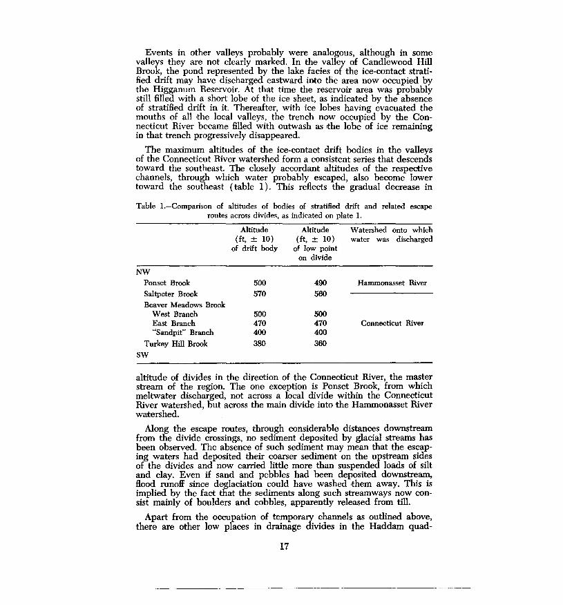
The maximum altitudes of the ice-contact drift bodies in the valleys of the Connecticut River watershed form a consistent series that descends toward the southeast. The closely accordant altitudes of the respective channels, through which water probably escaped, also become lower toward the southeast (table 1). This reflects the gradual decrease in
Table !.-Comparison of altitudes of bodies of stratified drift and related escape routes across divides, as indicated on plate 1.
NW Ponset Brook
Saltpeter Brook
Beaver Meadows Brook West Branch East Branch "Sandpit" Branch
Turkey Hill Brook
SW
Altitude (ft, ± 10)
of drift body
500 570
500 470 400 380
Altitude (ft, ± 10)
of low point on divide
490 560
500 470 400 360
Watershed onto which water was discharged
Hammonasset River
Connecticut River
altitude of divides in the direction of the Connecticut River, the master stream of the region. The one exception is Ponset Brook, from which meltwater discharged, nort across a local divide within the Connecticut River watershed, but across the main divide into the Hammonasset River watershed.
Along the escape routes, through considerable distances downstream from the divide crossings, no sediment deposited by glacial streams has been observed. The absence of such sediment may mean that the escaping waters had deposited their coarser sediment on the upstream sides of the divides and now carried little more than suspended loads of silt and clay. Even if sand and pebbles had been deposited downstream, flood runoff since deglaciation could have washed them away. This is implied by the fact that the sediments along such streamways now consist mainly of boulders and cobbles, apparently released from till.
Apart from the occupation of temporary channels as outlined above, there are other low places in drainage divides in the Haddam quad-
17
---------------------------- -···-··---
rangle. Not striking in appearance, they were not obviously followed by streams at the times when the stratified drift nearest them was de·posited. Yet any or all of them could have been places of overflow, provided that the period of overflow was so short that conspicuous evidence of stream erosion was not left in them.
For example, the divide that separates the valley of Candlewood Hill Brook from that of Ponset Brook contains at least five low places through which meltwater, ponded temporarily, might have flowed southwestward. These places range in altitude between 510 ft and 560 ft, and are thus more than 250 £t: higher than the highest stratified drift now exposed in the more northerly valley. Hence if these places were traversed by meltwater streams, such events must have occurred early in the deglaciation process, when the valley of Candlewood Hill Brook was still filled with ice up to the altitudes of the low places.
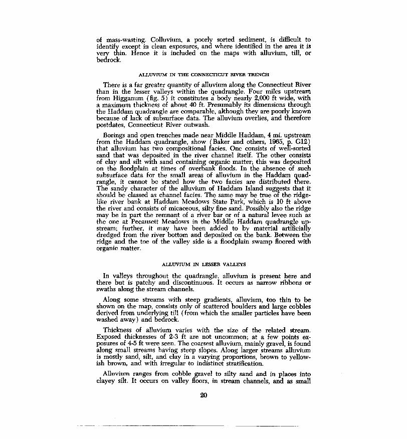
Returning to the sediments deposited successively during deglaciation, we note the body of outwash, referred to above, that occupies the Connecticut River trench. Its visible part forms a pair of terraces that flank both sides of the river channel. Although each terrace averages only a few hundred feet in width, together they constitute erosional remnants of a massive body of outwash that filled the trench from side to side. The great body of sediment was 0.7 mi. to 1.0 mi. wide and at least 200 ft thick, as measured at a point 4 mi. north of the northern edge of the Haddam quadrangle (fig. 5). Within the quadrangle the
40
0
-40
-80 N
-120 f
WP
SOUTH
A
Dut I. 40 Marina
~::::--~-......~~~=:::::------cR~i~v-;--;;-e~r--i~-j1o
-l20 0~ __ 300 __ ~690/t. NORTH
Fig. 5. Cross section through Connecticut River trench near Middle Haddam, 4 mi. north of the northern edge of the Haddam quadrangle. It reveals alluvium, outwash and bedrock, based on data from a seismic survey and from wells. W well, WP = well projected from nearby position. (After Haeni, 1971, fig. 7)
maximum thickness measured directly is 100 ft, encountered in a borehole1 in the floodplain in Haddam Meadows State Park. A large propol'l:ion of the outwash in the Connecticut River trench was removed by erosion and carried downstream before the alluvium now remaining was deposited.
The uneven upper surfaces of the two terraces reach altitudes as high as 110 ft near Higganum and decline to about 90 ft near Mill Creek at 1Test borehole Haddam no. 23, filed in U.S. Geological Survey Office, Hartford.
18
the eastern edge of the quadrangle. The segment of river within the quadrangle, less than 2.5 mi. long, is too short to serve as a basis for determining the gradient of the outwash surface. However, rough measurements on the terraces both up- and downstream suggest a general slope through the quadrangle of 7-8 ft/mi.
The outwash sediment consists mainly of sand and pebble gravel with very little coarser or finer material. The pebbles are moderately rounded, showing more wear on the average than those in the local bodies of outwash. This evidence and the presence of an appreciable amount of material that originated in Triassic bedrock upstream, suggest that most of this outwash originated upstream from the Haddam quadrangle. Within the quadrangle the axial part of the outwash body has been removed by erosion, but 4 mi. upstream, near Middle Haddam, borings in that part of the outwash reveal lenticular layers of cross-stratified sand, gravel, and some silt (Baker and others, 1965, p. 11).
The outwash exposed in the Haddam area consists, in part, of the lateral wings of the former body, deposited in the less turbulent water that existed downstream from promontories and in the mouths of local tributary valleys. A good example was exposed in 1973 in a pit on the northern side of Kriegers Brook, near its mouth. Here the sand is predominantly flat lying and parallel laminated, with few pebbles, and with some layers of foreset laminae gently inclined SW, away from the main valley.
POSTGLACIAL SEDIMENTS
Wind-blown sand and silt
A thin and very patchy cover of sand and silt, believed to have been deposited by wind, covers some areas of stratified drift. Although it overlies the stratified drift, it does not overlie alluvium. Hence it postdates the former and antedates the latter. Its observed thickness is less than 18 in. and in many areas is no more than 6 in.; hence it is not included on the map (pl. 1 ) . Such sediment is primarily sand, with silt a very minor constituent. Being at the surface wherever it occurs, it has lost whatever lamination it may have originally possessed, probably in large part through the growth of roots of trees and other plants. Its color approximates that of the drift that underlies it. The wind-blown sediment is believed to date from the time of deglaciation, when stratified drift was being deposited rapidly and when the surface had not yet become carpeted with vegetation. Therefore, winds were able to pick up fine particles from the surface of stratified drift and then redeposit them in the immediate vicinity. The distribution of the wind-blown sediment, however, tells nothing significant about wind directions at the time or times when the sediment accumulated.
Alluvium and colluvium
In the Haddam area, alluvium is the sediment deposited by postglacial streams of various sizes, and colluvium is the sediment postglacially moved down hillslopes by creep, slump, and related processes
19
of mass-wasting. Colluvium, a poorly sorted sediment, is difficult to identify except in clean exposures, and where identified in the area it is very thin. Hence it is included on the maps with alluvium, till, or bedrock.
ALLUVIUM IN THE CONNECTICUT RIVER TRENCH
There is a far greater quantity of alluvium along the Connecticut River than in the lesser valleys within the quadrangle. Four miles upstream from Higganum (fig. 5) it constitutes a body nearly 2,000 ft wide, with a maximum thickness of about 40 ft. Presumably its dimensions through the Haddam quadrangle are comparable, although they are poorly known because of lack of subsurface data. The alluvium overlies, and therefore postdates, Connecticut River outwash.
Borings and open .trenches made near Middle Haddam, 4 mi. upstream from the Haddam quadrangle, show (Baker and others, 1965, p. Gl2) that alluvium has two compositional facies. One consists of well-sorted sand that was deposited in the river channel itself. The other consists of clay and silt with sand containing organic matter; this was deposited on the floodplain at times of overbank floods. In the absence of such subsurface data for the small areas of alluvium in the Haddam quadrangle, it cannot be stated how the two facies are distributed there. The sandy character of the alluvium of Haddam Island suggests that it should be classed as channel facies. The same may be true of the ridgelike river bank at Haddam Meadows State Park, which is 10 ft above the river and consists of micaceous, silty fine sand. Possibly also the ridge may be in part the remnant of a river bar or of a natural levee such as the one at Pecausett Meadows in the Middle Haddam quadrangle upstream; further, it may have been added to by material artificially dredged from the river bottom and deposited on the bank. Between the ridge and the toe of the valley side is a floodplain swamp floored with organic matter.
ALLUVIUM IN LESSER VALLEYS
In valleys throughout the quadrangle, alluvium is present here and there but is patchy and discontinuous. It occurs as narrow ribbons or swaiths along the stream channels.
Along some streams with steep gradients, alluvium, too thin to be shown on the map, consists only of scattered boulders and large cobbles derived from underlying till (from which the smaller particles have been washed away) and bedrock.
Thickness of alluvium varies with the size of the related stream. Exposed thicknesses of 2-3 ft are not uncommon; at a few points exposures of 4-5 ft were seen. The coarsest alluvium, mainly gravel, is found along small streams having steep slopes. Along larger streams alluvium is mostly sand, silt, and clay in a varying proportions, brown to yellowish brown, and with irregular to indistinct stratification.
Alluvium ranges from cobble gravel to silty sand and in places into clayey silt. It occurs on valley floors, in stream channels, and as small
20
alluvial fans. Nearly all the sediment mapped as alluvium lies at the surf aces of floodplains, most of which are no more than 5 ft above the streams at low water but which are inundated at times of high water.
At one place in the quadrangle, where Abner Road in Killingworth crosses Chatfield Hollow Brook, a steep-gradient tributary stream has built up coarse alluvium to form a fan with a radius of at least 1,000 ft, forcing the brook to make a detour. The fan is dissected by channels as much as 10 ft deep, testifying to a former change from upbuilding to erosion. In the absence of evidence of date of the change, we may speculate that the fan was built soon after deglaciation, when the climate was still cold and before the watershed had become clothed with a protective cover of vegetation. At such a time coarse debris could move in abundance down the local hillslopes to provide material for fan building. Later, with a warmer climate and a cover of vegetation, debris would have diminished, and stream flow at times of flood should have been able to cut channels in the fan.
Swamp and marsh sediments Swamps (wooded) and marshes ( nonwooded), as described in table
2, occur in various parts of the Haddam quadrangle. Their sediments,
Table 2. Genetic classification of swamps and marshes in the Haddam quadrangle.
Origin
Basin in till
Basin created by dam of stratified drift
Kettle; basin in collapsed drift
Valley floor without definite basin'
Floodplain swale
Example
Swamp NW of Jericho Road, 0.9 mi. southwest of Interchange 7, Route 9.
Narrow swamp 2.5 mi. northeast of Ponset crossroads
Swamp along Ponset Brook, 1.2 mi. east of Little City
Swamp between Bethke Road and Route 81 in Killingworth
Elongate swamp in Haddam Meadows State Park, Connecticut River floodplain
1 Such swamps and marshes occur where drainage is impeded by variations In permeability of
the floor materials, some of which include plant matter.
which underlie the living vegetation, consist mainly of muck, an olivegray to dark-gray or brownish mixture of silt, clay, and fine sand, with a high percentage of comminuted decayed plant matter. They also include peat, which is almost pure organic matter. In small swamps such deposits are seldom more than 10 ft and in many are less than 5 ft thick, but some of the thicker swamp deposits preserve a fossil record of changes in vegetation and climate since the time when the ice sheet melted off the area. Swamps and marshes in the Haddam area have not been studied from this point of view, but a marsh in New Haven ( Deevey, 1943, p. 726) yielded a core 28 ft long, containing a record of fossil pollen that shows the types of trees and other plants that lived in the vicinity during approximately the last 15,000 years. The succession of vegetation shows, in general, progressive wanning of the climate, with intermediate fluch1ation.
21

Beach sand and gravel
The surface of the Connecticut River fluctuates, not only with the tides but also with seasonal floods that cause variation of 10 ft or more. As the water surface falls slowly following a flood, small wind-generated waves make cuts in alluvium along the river banks, sort the bank material, and create miniature beaches of well-sorted sand or small pebbles. Too small 'to be shown on the map, and ephemeral in duration, such beaches are nevertheless evident, and may last until the next flood, which submerges and destroys them. Good examples can often be seen around the mouth of Higganum Creek at the northern edge of the quadrangle.
Artificial fill
Artificial fill consists of deposits made by human activity; these include roads, railroads, shore-protection and building-construction fills, and the large accumulations of trash called "dumps." Although much of the fill material mapped was obtained from sources close to the fill bodies, part of it was brought from more distant sources, some of which are the borrow pits shown on the maps. The largest body of fill in this area is along Route 9.
In a town center such as Higganum much of the surface material that underlies streets, driveways, and lawns consists of fill. However, fill is mapped only where it is known or judged to be at least 5 ft thick and where it is large enough in area to be shown at the scale of the map. Areas of conspicuous artificial cutting that are continuous with areas of fill are mapped as fill. Such areas include large sand and gravel pits.
WEATHERING AND SOILS
Where the contact between bedrock and overlying till is exposed, the surface of the bedrock is fresh and unweathered, just as it was left after glacial abrasion. However, in places where no till was deposited or where overlying till has been stripped away by erosion, the surface of the bedrock is slightly but noticeably weathered. Weathering takes the form of slight roughening, slight bleaching, or oxidation. Along joints such weathering changes extend downward well below the surface. This is the extent of local postglacial weathering in bedrock.
In glacial drifit and wind-blown sediments the most obvious effect of weathering is oxidation, which in till is generally limited to a depth of 2 or 3 ft but in stratified drift extends to greater depth. Oxidation imparts a yellowish or brownish hue to the fine-grained particles in the drift; it also forms rinds of limonite on the surfaces of stones and boulders of amphibolite and other rocks rich in iron-bearing minerals.
Within the thin zone of weathering, soils are developed. The Haddam area lies within the region of Brown Podzolic soils of northeastern United States. Brown Podzolic soils are imperfectly developed Podzols characterized, in forested areas, by a thin, gray, leached zone beneath a thin mat of partly decomposed organic matter. Such soils, having weakly developed profiles, are normally less than 30 in. thick. Within the map
22
area there are a number of soil types, some of which have been discussed by Morgan ( 1930). Because the area lies within a single zone of climate and vegetation, local differences among its soils result mainly from differences in parent material, relief, and drainage. Of these factors parent material is believed to be the most important.
Weathering that probably occurred before glaciation is represented in the area and is described in a foregoing section.
GLACIAL AND POSTGLACIAL HISTORY
Before glaciation of the region began, the principal valleys, ridges, and hills had already been shaped by long-continued erosion and, except in detail, were similar to those of today. The surface was mantled with regolith, a surface zone of loose material, perhaps thick, developed by weathering of the underlying bedrock.
Evidence from outside the map area indicates that during the last million years or more, Connecticut was overrun by sheets of glacier ice at least twice and possibly several times. In the Haddam area, however, evidence of only one glaciation has been found thus far. In that glaciation the ice sheet flowed across the area from NW to SE. Because evidence of glaciation is present on the highest hills as well as in the valleys, it is clear that when the glacier reached its maximum extent the area was completely buried beneath ice. The cumulative effect of this and any earlier glaciations was to smooth, round off, and generally shape the hills and ridges into streamline form, to smooth and widen some of the valleys, and to remove most of the pre-existing regolith.
In the Great Lakes region the combined evidence of till layers and radiocarbon dates indicates that a group of related glaciations occurred within the last 70,000 years or so and that the last major invasion by ice culminated around 18,000 years ago. It is thought that the part of the ice sheet that covered New England then reached its outer limit at or south of what is now Long Island, where it built ·the end moraines and outwash plains that are prominent features of the island. The outer margin of the ice sheet melted just rapidly enough so that with the ice continually renewed by flow from the north, its margin remained in about the same position. Later, melting increased while flow was reduced, and the margin retreated northward across what is now Long Island Sound. During the retreat the ice sheet became somewhat thinner. Probably about 15,000 years ago the margin of the glacier had melted back to the line of the present Connecticut coast.
There ensued a period of several hundred years or more, when increase of flow or increase of melting or both caused the margin of the glacier to halt and to shift position slowly, forward and backward. Small end moraines were built at that time along what is now the Connecticut coast, south of the Haddam quadrangle.
Thereafter, thinning affected an increasingly wide marginal belt of the ice sheet through which, accordingly, the higher hilltops began to appear. At the same time the glacier began to flow more slowly. Eventually the ice became so thin that its outer or marginal part virtually ceased to flow and became nearly inert. Thinning progressively exposed the hills, while
23
tongues and detached masses of ice remained in the larger valleys. Streams of meltwater flowed between the margins of such masses and the adjacent valley sides, and built up thick embankments of sand and gravel derived from the active ice farther upstream. In many places stratified drift completely buried residual masses of ice. In this way the ice-contact facies of the valley trains were built up, with the sand and gravel merging southward into outwash in the zone that had by then become free of ice. Thus during deglaciation there was an ice-free zone to the south, then a zone of separated bodies of residual ice in the valleys, and finally a continuous zone of thinning ice that extended far to the north.
The bodies of stratified drift in the southern part of the Haddam quadrangle were built up, followed by those in the northern part. In places fine sediment was blown from surfaces of stratified drift and deposited nearby.
When the last remnants of the ice sheet had melted from the quadrangle, flows of meltwater ceased in most of the valleys, whose supplies of water now depended solely on local rainfall. The single exception was the Connecticut River, with its headwaters far to the north. That river continued to carry meltwater and to build up outwash sediment until a later time. It is apparent in figure 5 that outwash extends down to about 100 ft below today's sea level. Probably this reflects the wellknown faot that during glaciation and deglaciation, world sea level was much lower than it is today, perhaps by as much as 300 ft. At that time the Connecticut, with its load of outwash sediment, was probably flowing on a profile lower than today's sea level, and gradually rose on its own thickening deposit until it attained an altitude, at Haddam, of about 100 ft measured from today's sea level, and filled the river's trench from side to side.
When the deposition of outwash ceased, the river, now fed mainly or wholly by rainfall rather than by glacial meltwater, began to cut a trench into its thick fill of outwash gravel and sand, and carried the debris away downstream. The trench became 130 ft deep in this area, as can be seen in figure 5. Then the general rise of sea level decreased the gradient of the river in the Haddam area, causing the stream to begin depositing sediment again. This sediment is alluvium, which has been built up to a maximum thickness, near Middle Haddam, of about 25 ft (fig. 5).
The trenching of outwash by the Connecticut triggered trenching of stratified drift by smaller streams tributary ·to the river, and spreading of thin swaths of alluvium along their courses. Another effect of trenching by the Connecticut was the creation of the falls or, rather, the long rapids of Higganum Creek, 1,200 ft northeast of the principal street interseotion in Higganum and about 40 ft above the river. The falls occur where the creek passes from till onto bedrock. This seems to indicate that when the Connecticut River outwash body had reached its full height, 60-70 ft of outwash filled the mouth of the creek, which flowed across the top of the fill into the Connecticut. When the main river trenched its outwash, the creek followed suit, cutting down until it uncovered a spur of bedrock that lay beneath its bed. Being unable to
24
trench the bedrock, the creek has fonned a rapids across the rock, before once more passing onto a deeper part of its valley, now filled with alluvium.
Much of the history of vegetation and climate in southern Connecticut since the peak of glaciation has been learned from the thick sediment in Rogers Lake, a deep natural lake in the Old Lyme quadrangle southeast of the Haddam area. Cores recovered from the sediment have been studied in detail. From the fossil pollen they contain, a continuous record of the local vegetation and climate during the last 14,000 years or so has been read (Davis, 1969), and has been dated by means of radiocarbon measurements. The record, confinned by studies of pollen in cores elsewhere in coastal Connecticut, shows ,that during the deglaciation of the Old Lyme area the vegetation consisted mainly of treeless, tundralike grassland; after deglaciation it changed to spruce forest and later to other conifers. Still later a warmer climate induced the gradual development of the deciduous forest we see today.
At the time of maximum extent of the ice sheets in North America and Europe, sea level, as noted earlier, was very low, possibly as low as -300 ft. As meltwater returned through the world's streams to the ocean, sea level gradually rose. By about 5,900 years ago it had risen, relative to the land, to about 26 ft below the present mean sea level, as shown by a series of radiocarbon dates on wood and peat from beneath estuarine mud at several places along the Connecticut coast (Bloom and Stuiver, 1963).
Throughout postglacial time the existing soils were forming beneath a cover largely of forest vegetation. The youngest soils are those on alluvium. The accumulation of postglacial peat in swamps and the return of forests have altered the landscape appreciably, but the work of man: deforestation, cultivation of the soil, and construction of roads and buildings are far more conspicuous changes. When settlement of coastal Connecticut by European people began in the 17th Century, all the land in the Haddam area, except for a few marshes and patches of bare rock, was clothed with forest. Today nearly 70 percent.of the state's land area consists of woodland. The Podzolic character of the local soils reflects the influence of the forest cover.
ECONOMIC GEOLOGY
Sand and gravel
The aggregate area of sand and gravel in the Haddam quadrangle is minor, as can be seen on plate 1. Pits from which these materials are taken are few and small, the largest being the Washburn Pit, on the western side of Route 81, 1 mi. north of West Haddam. The production of this pit has been mainly sand, which is sold without washing. Because the overall supply of reachable sand and gravel is dwindling, imports and substitutes are likely to find increasing favor.
The general distribution of sand and gravel in the. Haddam quad- . rangle, together with the locations of operating pits and estimates of the volumes of materials probably available, will be found in an undated report by Vitali.
25
-------------------~
Landfil,l
The material most. commonly used as artificial fill is till. It is comparatively abundant; also it contains a variety of grain sizes, including silt and clay, a characteristic that promotes compaction. Ordinarily, pits are begun as fill is needed, at localities close to the areas to be filled, and are abandoned as filling is completed. Although the supply of till is still extensive, the general thinness of the till mantle makes it difficult to find localities where till can be excavated in an efficient manner. Icecontact stratified drift is also used as fill for many purposes.
Swamp and marsh deposlts
The organic deposits in swamps and marshes within the map area are potential sources of garden humus. However, as most of the bodies are small in area and probably also in thickness, it is doubtful that their economic development is feasible.
Ground water
Various bodies of stratified drift within the area are potential sources of ground water for domestic use or for small industrial plants. However, because they consist of sand and gravel they are very permeable, and the water table is generally low (in many places 15 ft or more below the surface), as well as rather closely adjusted to the level of the nearest surface stream. In consequence, the developmnt of a reliable water supply from such material depends on thickness of the sediment in the zone below the water table. This is a matter for local investigation in each case.
Till is generally too thin and in some places too impermeable to be a source of water other than for shallow wells of low yield. Most users of water within the map area prefer to derive their supplies either from surf ace reservoirs or from wells drilled into bedrock.
Discussion of ground-water problems pertinent to the Haddam area will be found in a report by J. S. Brown ( 1928).
26
REFERENCES
Baker, J. A., Lang, S. M., and Thomas, M. P. 1965, Geology and hydrology of the Hartford Research Center, CANAL site, Middletown, Connecticut: U.S. Geol. Survey Bull. 1133-G, 42 p.
Bloom, A. L., and Stuiver, Minze, 1963, Submergence of the Connecticut coast: Science, v. 139, p. 332-334.
Brown, J. S., 1928, Ground water in the New Haven area, Connecticut: U.S. Geol. Survey Water-Supply Paper 540, 206 p.
Davis, M. B., 1969, Climatic changes in Connecticut recorded by pollen deposition at Rogers Lake: Ecology, v. 50, p. 409-422.
Deevey, E. S., 1943, Additional pollen analyses from southern New England: Am. Jour. Sci., v. 241, p. 717-752.
Flint, R. F., 1930, The glacial geology of Connecticut: Connecticut Geol. Nat. History Survey Bull. 47, 294 p.
-----, 1934, Late-glacial features of the Quinnipiac-Farrnington lowland in Connecticut: Am. Jour. Sci., v. 227, p. 81-91.
-----, 1961, Two tills in southern Connecticut: Geol. Soc. America Bull., v. 72, p. 1687-1692.
-----, 1975, The surficial geology of the Essex and Old Lyme quadrangles: Connecticut Geol. Nat. History Survey Quad. Rept. 31, 41 p.
Goddard, E. N., and others, 1948, Rock color chart: National Res~ch Council, Washington, D.C., 6 p. (Reprinted, 1961, Geol. Soc. America)
Haeni, F. P., 1971, Continuous seismic profiling on the lower Connecticut River: Unpub. M.A. thesis, Middletown, Conn., Wesleyan Univ., 62 p.
Lundgren, Lawrence Jr., 1963, The bedrock geology of the Deep River quadrangle: Connecticut Geol. Nat. History Survey Quad. Rept. 13; 39 p.
Morgan, M. F., 1930, The soils of Connecticut: Connecticut Agric. Expt. Station Bull. 320, p. 828-911.
Pessl, Fred, Jr., 1972, Till fabrics and till stratigraphy in western Connecticut in Goldthwait, R. P., ed., Till: a symposium: Ohio State Univ. Press, p. 92-105.
Rice, W. N., and Gregory, H. E., 1906, Manual of the geology of Connecticut: Connecticut Geol. Nat. History Survey Bull. 6, 273 p.
Upson, J. E., and Spencer, C. W., 1964, Bedrock valleys of the New England coast as related to fluctuations of sea level: U.S. Geol. Survey Prof. Paper 454, p. Ml-M44.
Vitali, Reno (undated), Construction aggregate availability study: Summ. Rept. Highway Dist. II, Connecticut Dept. Transportation, Bur. of Highways, Soils, and Foundations Div., 45 maps (folio).
27
------------------------------- ---~-------