Embed Size (px)
Citation preview

Geología Colombiana No. 25, Diciembre, 2000
The Stratigraphy of the W Side of the Cretaceous Colombian Basin in the Upper Magdalena Valley. Reevaluation of Selected Areas and Type Localities Including Aipe, Guaduas, Ortega, and Piedras.
JAVIER GUERRERO Departamento de Geociencias, Universidad Nacional de Colombia. Apartado Aéreo 14490, Bogotá, Colombia. E-mail: [email protected] GUSTAVO SARMIENTO Departamento de Geociencias, Universidad Nacional de Colombia. Apartado Aéreo 14490, Bogotá, Colombia. E-mail: [email protected] ROSA NAVARRETE Paleosedes Ltda. Apartado Aéreo 58686, Bogotá, Colombia. E-mail: [email protected]
GUERRERO J, SARMIENTO G, NAVARRETE R (2000) : The Stratigraphy 01 the W Side 01 the Cretaceous Colombian Basin in the Upper Magdalena Valley. Reevaluation 01 Selected Areas and Type Localities Including Aipe, Guaduas, Ortega, and Piedras. GEOLOGIA COLOMBIANA 25, Pgs. 45-110, 12 PI., 5 Figs., 6 Tabl. , 1 Microp. App.: 6 PI.
ABSTRAeT
Marine strata composed 01 mixtures 01 calcareous and terrigenous particles dominate the Cretaceous succession 01 the Upper Magdalena Valley (UMV). These include mainly biomicrites, biosparites, mudstones, sandstones and mixed calcareous/terrigenous rocks 01 a litharenitic affinity. Sedimentary rocks deposited in Iluvial environments, and including granule and pebble conglomerates, are present only in the lowermost and uppermost parts 01 the section .
The succession was deposited in a ramp, which had an inclination 01 about 0.06° toward the E and reached marine depths 01 200 to 250 m on the axis 01 the basin. The whole Cretaceous section 01 the UMV was sourced lrom the W by the ancestral Central Cordillera metamorphic / volcanic are, as indicated by the abundant content 01 metamorphic and volcanic rock Iragments.
The new term CRETACEOUS COLOMBIAN BASIN is proposed to make emphasis in a single elongated back-arc basin which opened N to the Caribbean and connected intermittently to the S with other back-arc and loreland basins E 01 the volcanic are, along Ecuador, Perú, Bolivia, Chile, and Argentina. The basin reached a width 01 400 to 500 km during times 01 high sea levels and had two sources 01 sediment, one W in the Central Cordillera and another E in the Guyana Shield. The strata in the W side 01 the basin have a calcareous/litharenitic nature, in contrast with the ones in the opposite E side that have a quartzarenitic nature, because the last ones were sourced mainly by the Precambrian and Paleozoic sedimentary rocks 01 the Guyana Shield.
Sedimentary environments in the UMV were control!ed mainly by eustatic sea level changes that affected the whole intracratonic basin , so that sea level pulses are synchronous in both , E and W sides 01 the basin. Since the sequence stratigraphy 01 sea level changes in the UMV is synchronous with the one in the Eastern Cordillera and Llanos Foothills, a Iramework 01 allostratigraphic units is lormally proposed lor the whole basin .
Type localities and selected areas lrom the UMV including Aipe, Guaduas, Ortega, and Piedras were sampled lor analyses 01 sedimentary petrography and micropaleontology 01 loraminilers and palynomorphs, allowing precise characterization 01 the units and appropriate dating. The oldest known ages 01 the Cretaceous sedimentary succession in this part 01 the basin are Aptian; however, the ancestral Central Cordillera also sourced older Cretaceous strata 01 known Berriasian to Barremian age in adjacent areas.
Key Words: Allostratigraphy, Back-Arc Basin, Colombia, Cretaceous, Foraminifers, Hydrocarbon Exploration, Lithostratigraphy, Paleogeography, Palynomorphs, Sedimentology, Sedimentary Petrography, Sequence Stratigraphy, and Upper Magdalena Valley.
45

Guerrero et al.: The Stratigraphy of the W Side of the Cretaceous Colombian Basin .
INTRODUCTION
RESUMEN
La sucesión Cretácica del Valle Superior del Magdalena (VSM) está dominada por estratos marinos, compuestos por una mezcla de partículas calcáreas y terrígenas. Estos incluyen principalmente biomicritas, bioesparitas, lodolitas, arenitas y rocas mixtas calcáreo/terrígenas de afinidad litoarenítica. Rocas sedimentarias depositadas en ambientes fluviátiles, incluyendo conglomerados de gránulos y guijos, solamente están presentes en la base y en el tope de la sección.
La sucesión se depositó en una rampa, que tuvo inclinación de alrededor de 0.06° hacia el E y alcanzó profundidades marinas de 200 a 250 m en el eje de la cuenca. La sección Cretácica del VSM tuvo como fuente de detritos una cadena montañosa localizada al W y correspondiente a la ancestral Cordillera Central , como lo indica el abundante contenido de fragmentos de roca metamórfica y volcánica.
Se propone el término CUENCA CRETÁCICA COLOMBIANA, para hacer énfasis en el concepto de un única cuenca de back-arc. Esta se abría al N hacia el Caribe y se conectaba al S de manera intermitente con otras cuencas de back- arc y de foreland al E del arco volcánico, a lo largo de Ecuador, Perú , Bolivia, Chile y Argentina. La cuenca alcanzó un ancho de 400 a 500 km durante intervalos de ascenso del nivel del mar y tuvo dos fuentes de detritos, una al W en la ancestral Cordillera Central y otra al E en el Escudo de Guyana. Los estratos en el lado W de la cuenca tienen afinidad calcáreo/litarenítica, en contraste con los del lado opuesto de la cuenca al E que tienen una afinidad cuarzoarenítica, debido a la proveniencia de detritos originados principalmente de la erosión de las rocas sedimentarias del Precámbrico y Paleozoico del Escudo de Guyana.
Los ambientes sedimentarios del VSM fueron controlados principalmente por cambios eustáticos del nivel del mar, que afectaron toda la cuenca intracratónica, de manera que los pulsos de ascenso y descenso del nivel del mar son sincrónicos en los dos lados E y W de la cuenca. Teniendo en cuenta que las secuencias estratigráficas del VSM son sincrónicas con las de la Cordillera Oriental y el Piedemonte Llanero, se propone un esquema formal de unidades aloestratigráficas para toda la cuenca.
Se tomaron muestras para análisis de petrografía sedimentaria y micropaleontología de foraminíferos y palinomorfos en varias localidades tipo y áreas seleccionadas, incluyendo Aipe, Guaduas, Ortega y Piedras, para lograr una caracterización litológica más precisa, así como dataciones adecuadas. Las edades más antiguas que se conocen para esta parte de la cuenca son del Aptiano, no obstante que la ancestral Cordillera Central sirvió también de area fuente a estratos del Berriasiano al Barremiano en áreas adyacentes.
Most of the names currently used in the stratigraphic
nomenclature of the Cretaceous of the UMV are derived
from Piedras and Ortega, two areas closely located to
each other, on the N si de of this part of the valley (Fig. 1).
The Caballos (CORRIGAN 1967) and the Tetu~n (ALLEN 1989;
BARRIo & COFFIELD 1992) units were first studied and named
in the area of Ortega. The Hondita, Lomagorda, Olini, and
La Tabla units (PORTA 1965, 1966) have their type locality
in the area of Piedras. The Buscavida (CORRIGAN 1967)
and Seca (PORTA 1965, 1966) units were also named from
areas nearby Piedras. Based on these early works, a strati
graphic nomenclature (Table 1) including all or so me of
those units has been extended to the S of the UMV for
several authors (e.g. BELTRÁN & GALLO 1968; BARRIo &
COFFIELD 1992; ETAYO & FLÓREZ 1994; VERGARA 1994, 1997;
VILLAMIL 1998).
UMV comes originally from the stratigraphy of the Girardot
Nariño Section of BÜRGL & DUMIT (1954) , the stratigraphy
of the Ortega area of BÜRGL (1961), and the stratigraphy
and geological map (Plate L9-Girardot) of ~AASVELDT et al. (1956) . This geological map covered the UMV ares from
a latitude around Ortega-Saldaña on the SW, to Piedras
Jerusalén on the NE.
The Cretaceous succession of the UMV was divided
by VERGARA (1994, 1997) in the Yaví, Caballos, Hondita,
and Lomagorda Formations, the Olini Group, the "nivel de
lutitas y arenas", and the La Tabla Formation. However, a
direct comparison with thE: lithology and biostratigraphy of
the type locality near Piedras was not performed by him,
due to the poor state of preservation and advanced wea
thering of the strata. Because of that, and although Vergara
established that most of the units could be identified in
the whole U~V, doubts arise regarding some of their
boundaries an~their correlation.
The subdivision of the Cretaceous succession of the
46

Since the lithology and biostratigraphy of the type locality are essential to properly correlate and identify the units in the UMV, we have oone an effort to obtain a better characterization of them . Several excellent sections (from creeks) exposed in the Piedras area have been reevaluated , including field measuring and description, additionally to sampling for laboratory analysis, mainly of sedimentary petrography and micropaleontology. AIthough emphasis is placed in the stratigraphy of the Piedras area, other sections from the Aipe, Guaduas, and Ortega areas where al so revised and sampled.
Due to the fact that most of the Cretaceous sedimentary record of the UMV is composed of a mixture of very fine grained calcareous and terrigenous particles (mud to very fine sand size), rocks are difficult to classify properly in the outcrops with a hand lens and common field techniques. Commonly, sandstones with carbonate cement and minor amounts of fossils are erroneously classified as "Iimestones", or true biomicrites of planktic foraminifers are classified as terrigenous mudstones.
Because of that, we believe that sedimentary petrography (Plates 1 to 11) of well exposed and non weathered sections (Plate 12) is essential to properly characterize these rocks. The procedure of careful field collection has been also applied to the samples for micropaleontological analysis, resulting in a much better recovery of well preserved specimens of palynomorphs (App. Plate 1) and foraminifers (App. Plates 11 to VI) , that in road and other weathered outcrop samples .
.{ With a better description and dating of the units
in their type locality, we hope to solve some of the confusion that has been a constant in the strati
graphy of the Cretaceous of Colombia, due to the lack of appropriate procedures according to international standards of stratigraphic codes and
guides. Units with similar lithology but very different stratigraphic position have been given the same
name, and there is also the contrary and most common case, that a single unit has been given diffe
re"t names in nearby localities. A mixture of formal and non-formal names is used in unpublished the
sis, field trips, and company reports, that makes
very difficult the communication for the purposes of characterization of the units, geological mapping
and exploration of resources.
The boundary between the Upper and Middle
Geología Colombiana No. 25 , Diciembre, 2000
Magdalena Valley is located near the town of Dorada. The upper course of the Magdalena River is characterized by a narrow valley in which the river has an alternative sedimentary and erosive nature over rock units as old as Paleozoic. To the S, in the area of Neiva and Tatacoa Desert, the valley ex poses mainly the Cretaceous and Tertiary strata that rest with angular unconformity
"
N "-
i
GIRARDOT
" -
PRAGA 2\ C;O Ion
} ' -
YAGUARA •
Fig, 1, Location of Cretaceous Sections from the. UMV, Córdoba (1), Honda (2), Guaduas (3), Piedras (4), El Cobre (5), Ortega (6), OIini (7), Ataco (8), Aipe (9), and Yaguará (10),
47

Guerrero et al.: The Stratigraphy 01 the W Side 01 the Cretaceous Colombian Basin .
on the Jurassic basement of the Saldaña Formation . Between Girardot, Piedras, and Dorada, the river is eroding Late Cretaceous and Middle Miocene strata. Due to the differential resistance of these strata, several rapids that make navigation difficult are found near Honda. The erosive nature of the Magdalena River in its upper course is due to the continued uplift of the valley along with the uplift of Central and Eastern Cordilleras. The climate is dry in the UMV, being in the rain shadow of the two cordilleras; the transition to more wet regimes is located in Dorada, were the valley becomes wider. From Dorada to the N, the Magdalena River develops a more permanent meandering to anastomosed pattern in a less confined va 11 ey, with sedimentation dominating over erosiono
The stratigraphy of the Cretaceous succession along the UMV, as far N as Dorada, is very comparable between different localities. Reverse faults that today control the valley (e.g. the Cambrás and the Bituima Fault systems), were sinsedimentary normal faults parallel to the cretaceous shoreline (see LUNOBERG et al. 1998; MARTINEZ &
VERGARA 1999). Notorious variations in thickness and lithology are found only in an E direction , toward the depocenter of a back arc basin. The E boundary of the UMV stratigraphy is located in the Bituima Fault; the opposite W boundary is located in the E foothills of the Central Cordillera.
METHOOS ANO CLASSIFICATIONS
For the procedures of naming, reevaluating and proposing stratigraphic units, we follow the North American Code of Stratigraphic Nomenclature (NORTH AMERICAN COMMISSION ON STRATIGRAPHIC NOMENCLATURE 1983) published by the American Association of Petroleum Geologists. The International Stratigraphic Guide (SALVADOR 1994), published by the International Union of Geological Sciences and the Geological Society of America, was also used. In those cases in which there are differences between the two publications, the specific norm is discussed.
Regarding the nomenclature to refer the thickness of strata, the ones of 1 cm or less are designated as laminae and those thicker as beds, according to INGRAM (1954). The laminae are subdivided in very thin (Iess than 0.3 mm), thin (0.3-1 .0 mm), medium (1-3 mm) and thick (3-10 mm) . The beds are subdivided in very thin (1-3 cm), thin (3-10 cm) , medium (10-30 cm) , thick (30-100 cm) and very thick (more than 1 m).
The compositional and textural classifications are those of FOLK (1959, 1962, 1974) for the terrigenous and calcareous rocks (and their mixtures) . Because in the terrig-
48
enous rocks it is very important the analysis of provenance (source area), a modification was introduced to place all the polycrystalline quartz among the rock fragments, including it in one of the three RF poles, metamorphic, sedimentary or volcanic. For the calcareous rocks, additionally to the textural and compositional classifications of FOLK (1959, 1962), the textural classification of DUNHAM (1962) was also used.
To express the texture and porosity of the rocks under the petrographic microscope, the results of counting 250 to 400 points (at 1 mm intervals, over lines perpendicular to stratification and spaced 3 mm) are indicated in percentages of framework, matrix, cement, and pores. In the matrix, were included the particles with an average diameter 1/10 smaller than the average size of the particles of the framework. In the fossiliferous muddy sandstones and impure sandy biomicrites (fine and very fine sandstone range), the muddy matrix is usually composed of a mixture of calcareous and terrigenous particles smaller than 8 ~ , covered with organic matter of marine origin that darkens them and makes difficult the identification of individual particles. The matrix appears as a paste of pale to dark brown color in the microscope and dark grey to black color on hand sample.
The relative percentages of particles of the framework, that can be more easily identified than those of the matrix, always determined if the rock had a more terrigenous or a more calcareous nature. The proportion of calcareous and terrigenous particles of the matrix in the clay and very fine silt size (Iess than 8~), is usually the same one of the larger particles of the framework. When doubts did arise in the petrographic microscope, other complementary laboratory methods, such as dissolving the sample in HCI to weight the remaining particles were used.
Following Folk's guidelines for classification of fine grained rocks composed of mixtures of terrigenous and calcareous particles, a fossiliferous mudstone is an impure terrigenous rock composed of a mixture of terrigenous and calcareous particles in the clay and silt size range. The matrix is composed of clay minerals and other terrigenous particles, mix'ed with minor amounts of calcareous particles. The composition of the framework particles above 8~ is predominantly terrigenous (Q, F, and RF), with lesser amounts of fossils and other calcareous particles (>10% and <50%) . If the percentage of the framework I,;alcareous particles is less than 10%, the rock is a (terrigenous) mudstone.
An impure biomicrite is an impure calcareous rock composed of a mixture of calcareous and terrigenous

~ CD
TABLE 1. HISTORICAL OEVELOPMENT OF THE SlHATlGRAPHIC CLASSIRCATION OF THE CflETACEOUS SUCCESSION FROM THE UMV,
INVAUO SYNONYMS ANO HOMONYMS, ALONG WITH MISUSEO OR INFORMAL NAMES ARE INOICATEO IN 'QUOTATlON MARKS',
RAASVEl.DT El AL, 19561 PORTA, 1965, 1966 CORR1GAN, 1967 BELlRÁN & GAlLO, 1966 1 BAAA10 & COFAB.D, 1'9921 ElAYO & FLÓREZ, 1994 1 VERGARA, 1994, 1997 VlLLAMIL, 1998
KO SECA FORMATION 'GUAOOAS FORMA TION' 'GlJAOlIAlAGROUP' 'GUAOOAS FORMA TION' SECA FORMAnON 'GlJAlJUAS FORMA TION'
K1 LA TABlA FORMA TION 'GlJAD.lJ..~ 'BUSCAVIDA FORMATI SHAlE FACIES"
'MONSERPA TE FORMA TION' 'MONSERPA TE FORMA TION LA TABlA FORMA nON 'GUAOAlUPE FORMA nON'
K2 'NIVEL DE LUTlTAS y ARENAS" 'MONSERPA TE I
'BUSCAVIDA SHAl.P ~IVEL DE LUTlTAS Y ARENAS" 'UNNAMED'
O
~ I 'UPPER CHERl'
O O K3 L L1D1TA SUPERIOR V 'UPPERCHERl' FORMATlON' L1DIT A SUPERIOR L L1DITA SUPERIOR L 'UPPER CHERl' I I I I
N L N N f-------I L I i 'Fl r.oRRF !;ANOSl' I I
K4 'NIVEL DE LUTITAS" E L 1 'AK:O SHAlE' 'NIVEL DE LUTITAS' 'MIDOLE SHAlE' G T L , G G
R A E R R O T O O
I U L1D1TA INFERIOR A
~ 1 L1DITA INFERIOR ~ I 'LOWER CHERl' K5 'LOWER CHER1' I 'LOWER CHERl' L101TA INFERIOR P
F i O i
K6 I LOMAGORDA FORMA TION I R I I 'VILLETA I R I M ' 'LA LUNA L1MESTONE' 1 LOMAGORDA FORMA TION A T
K7 HONOITA FORMA TION I I I FORMATION' I "fiAMBLCÁ SHALE" ' v 'UNNAMED UNIl' O L U
N 1 'HONDITA FORMA nON' E P T '
K8 'TETUÁN L1MESTONE' i A 'HILÓ FORMA TION'
UPPER K9 I 'UPPER MEfolBER' I 'CABALLOS FORMA TION' I 'CABALLOS FORMA TION' I ~ ~ I 'SEGMENT 5' I ~ ~ I 'UPPER CABALLOS"
MIDOLE K9 CABALLOS I A ~ I 'MIDOLE folEMSER' I "T1:TI11~ I IU~C::Tf'IN~ I 'EL OCAL FORMA TION' I ~ ~ I 'SEGMENT 4' I ~ ~ I
LOWER K9 FORMATlON I i ~ I 1 N EGMENTS 1-3' N 'LOWER CABALLOS"
'LOWER SANDSTONE' ¡ 'ALPUJARPA FORMA TlON' i KJ YAví FORMA noN
J3 1 PRE-CRETACEOIJS BASEMENT IPRE-CRET ACEOUS BASEfolEj PRE-CRET ACEOIJS BASEMENTI SALDAÑA FORMA TION SALDAÑA FORMATION
GUERRERO El AL, 200l
SECA FORMA TION
LA TABlA FORMATION
HONDITA FORMATION
G> ro
TETUÁN FORMA nON o o (Q ¡¡j-
I ~ ~ I UPPER SANOSTONE MEt.IlER V :::::::::::: j o o o 3 cr
I ~ ~ IM1UULt ~~4ÓtJ CIUMlvMfi!Ni!fl:OOM ¡¡j' :::J Ql
Z
" " LOWER SANDSTONE MEt.IlER 1\)
.tn
o ,,' YAvf FORMA nON ¡¡;'
3 cr .ro
PRE-CRETACEOUS BASEMENT - 1\) o o o

Guerrero et al.: The Stratigraphy 01 the W Side 01 the Cretaceous Colombia n Basin.
particles in the clay and silt size range. The matrix is composed 01 calcareous particles , mixed with minor amounts 01 clay minerals and other terrigenous particles. The composition 01 the Iramework particles aboye 8iJ is predominantly calcareous (Iossils) , with lesser amounts 01 terrigenous particles (> 10% and <50%). II the percentage 01 terrigenous particles is less than 10%, it is a biomicrite. II silt size calcareous Iramework particles predominate over matrix, it is a packstone biomicrite; il they are between 10% and 50%, is a wackestone biomicrite; il less than 10%, is a lossililerous micrite or a micrite il less than 1 %.
Marlstone is a lield term applied to rocks composed 01 a mixture 01 approximately equal parts 01 calcareous and terrigenous particles in the mud size range that can be better classilied in thin section either as lossililerous mudstones or as impure biomicrites. Lidita is also a lield term appl ied to strata Iractured orthogonally in square prism shapes 01 5-10 cm side, that can be better classilied as silicil ied , loss ililerous micrites and biomicrites 01 loraminilers.
The loraminilers and the palynomorphs were prepared with standard methods. The biostratigraphy 01 planktic loraminilers lollows CARON (1985).
LOCATION OF THE SECTIONS
The Chicuambe Anticline is located approximately 6 km NE 01 Ortega. The sections are in proximity 01 "Hacienda Las Brisas", near the upper courses 01 the Chicuambe and Calará Creeks. They are reached taking a deviation located approximately 7 km SW 01 the Cucuana River, on the road lrom Guamo to Ortega. This deviation takes an unpaved road beginning at the crossing 01 lile main road with the Chicuambe Creek and goes parallel to it, approximately 3 km toward the NW, to a small open pit mine 01 iron oxides near Las Brisas.
A good section 01 the uppermost part 01 the Caballos Formation and lower part 01 the Tetuán Formation is exposed in the main course 01 the Chicuambe Creek, near the axis 01 the Chicuambe Anticline (IGAC Plates 263-IVD and B; coordinates 878.800 E and 929.600 N to 878.500 E and 930.000 N). The other section is located in a laulted slice on the W, which exposes the uppermost part 01 the Caballos Formation and at least the lower 140 m 01 the Tetuán Formation. The lirst section is reached walking Irom the mine, lor about hall an hour toward the W, up to the westernmost branch 01 the Chicuambe Creek. The last section (IGAC Plates 263-IV-D and B; coordinates 879.000 E and 930.900 N to 878.700 E and 931 .000 N) is reached
50
on the road that continues Irom the mine toward the chosen location 01 an oil perforation, named "el pozo".
The Piedras - La Tabla section originally described by PORTA (1965) comes lrom the walkway (camino real) that goes Irom Piedras (Fig. 1) to La Tabla. The lirst one is a small town with about a thousand people and the last one used to be a small village (Caserío La Tabla) composed 01 only 10 to 20 larms. The walkway departs Irom Piedras (at an altitude 01 400 m) to the south, crosses a, bridge on the Opia River, and goes parallel to the river lor about a kilometre, toward a larm named "Hacienda Bolívar'. Then, very close to the confluence 01 the "Cardona" and "Hondita" Creeks, turns to the SE and takes the water divide 01 the two creeks, to climb the hills that end up in the La Tabla Ridge ("Cuchilla La Tabla"), which is about 800 m high. The walkway is still used lor the people 01 the area that take it in their horses. A walk journey Irom Piedras to the La Tabla Ridge would take approximately two hours; the La Tabla House is hall a km beyond La Tabla Ridge. With a lield vehicle it is possible to reach only the area close to the conlluence 01 the two mentioned creeks, close to the Bolívar Farm.
Since the rocks exposed in the Piedras - La Tabla walk way are weathered, we prelerred to measure our sections and take our samples 01 the Hondita, Lomagorda, and Lidita Inlerior Formations (Fig. 3) on the Hondita (IGAC Plate 245-II-A; coordinates 910.900 E and 991 .800 N to 912.000 E and 990.900 N) and Cardona Creeks. They border the N and S sides 01 the walk way in a short horizontal distance 01 no more than 300 m. The rest 01 the section up to the lower part 01 the Seca Formation was measured in the Talora Creek (Fig. 4) , 4 km NE 01 the walk way. The Talora Creek Section (IGAC Plate 245-II-A; coordinates 914.600 E and 993.300 N to 915.100 E and 993.200 N) can be easily reached taking the road lrom Piedras to Chicalá, "Hacienda La Palma", and Guataquicito. Approximately 2.5 km alter La Palma, there is a 1-km deviation to the W that ends near the lower part 01 the Talora Creek. In the dry season, a lield vehicle could be used up to this point, and the section reached in another 15 minutes walk toward the lirst exposures 01 the Seca Formation . From there, and climbing the Talora Creek, there are excellent exposures 01 the La Tabla, Buscavida, Lidita Superior, and El Cobre Formations.
The Guaduas Syncline was sampled in several areas. In the W flan k, the Córdoba Section goes parallel to the Negro River, between the Pitas Creek and El Neme Creek that can be reached walking Irom the Córdoba Railroad Station . The La Morena Creek section is reached in the road lrom Córdoba to Puerto Salgar. The lirst section

-f J ,r
r '
CALCAAEOUS: Md W k Pk Grll instone. Aud tes TERRIGENOUS C Md S t vfS f5 mS eS veS Gr Pebb
<> _9 @, ' c'
O
dh ph ' c'
O
~'?¡s rs (§
O ph .~ tSl
\:;."'
3-<3 . H
@¡
,:.0;" ph "". ph
~
'iJ!~
ph
d~b
iS d~ O
3-E F ~.
>lo ph
O _9 f1(P
3-D
d" ph
U,p
@.
Geología Colombiana No. 25. Diciembre. 2000
LEGEND
-S leified B omierite (Diagenet e Chert) -Impure (Clayish / S ty) Waekestone B om er te -Waekestone B om er te
Paekslone B om er te
Med um-gra n Biospar te
Impure (Sandy) Biospar te
Coarse-grain B osparite
~~ 'i79...t. 'á0~
Foraminifers
'- -'J Bvaves
lf=~ Ammontes
ph
Phosphat sed Part eles
-Phosphorte
[ ~ ~
B oturbat on
~---¡
----~ I
Reverse Fau t
-Shale / Mudslone
-Foss i l~erous Mudslone
'~"'~'~"l ¡:::::::::::::::::::@i Very Rne Foss i l~erous Sandstone
• • • • • • • • • • • a •••• • _ , . o •• · . . . . . . . . . . . •••• •• • • o •• · . . . . . . . . . . ~.~
F ne Sandslone
[.-. _ ... . 'j . . . . . . . · .. . . .. . . . ... . .
• • I ••• ••
Med um Sandstone
~:.:. : .:. : . : ' l.·.·.·.·.·.·.· .. Med um-gran Foss i l~erous Sandstone
~ ~~~ ..... · ..... . . . ---Coarse Sandstone
Very Coarse Foss i l~erous Sandstone
~.~.~~;j Conglomerate
3-A~ P ate and Sample Numbers
gl
Glaueon te Part eles
Benton rre
Caleareous Coneretions
VERTICAL SCALE IN METERS
Fig. 2. Composite Stratigraphic Section. Chicuambe Anticline, Ortega Area.
51

Guerrero el al.: The Stratigraphy 01 the W Side 01 the Cretaceous Colombia n Basin .
exposes the Lower Tertiary, and the Seca, La Tabla, and Buscavida Formations , along with part of the Lidita Superior and El Cobre Formations. The second section exposes most of the El Cobre Formation and the lower part of the Lidita Superior Formation .
On the E flank of the syncline, the Guaduas Section (Fig. 1) is located approximately 11 km S40E of Guaduas and 1 km SSW of the "Balastera" open pit mine. It is reached from the main road Guaduas - Bogotá, taking a deviation to the S from a small village named La Cabaña. This deviation goes in an unpaved road for about 7 km, up to the La Bolsa Creek, where excellent exposures of the Guaduas, La Tabla, Buscavida, Lidita Superior, El Cobre, Lidita Inferior, and Lomagorda Formations are found.
The El Cobre Creek is reached from Payandé. Its upper course is located approximately 3 km SW, taking an unpaved road to the Chicalá Creek, a tributary of the El Cobre. The other way to reach it is taking the road to Valle de San Juan, toward the S for approximately 8 km, up to a deviation to the NNW that goes for about 1.5 km to the confluence of the El Cobre Creek with the Luisa River. The section has very good exposures of the three members of the Caballos Formation .
The Aipe Section in the Palmarosa and Bambucá Creeks is reached on the W deviation to Praga, located N of the Aipe River, from the main road Bogotá - Neiva. The exposures located approximately 12 km from the main deviation are part of the W flank of the Media Luna Syncline. The Palmarosa Creek exposes the Yaví Formation and part of the Caballos Formation . The Bambucá Creek exposes the rest of the succession, up to the top of the La Tabla Formation .
STRATIGRAPHY
The Cretaceous Succession of the UMV (Table 1) is divided in the Yaví, Caballos, Tetuán , Hondita, Lomagorda, Lidita Inferior, El Cobre, Lidita Superior, Buscavida, La Tabla, and Seca Formations (Plates 1 - 12). Some of these units that were used for many years in an informal and imprecise way, are here formally defined and characterized. The new units include the Tetuán Formation , the El Cobre Formation, and the Buscavida Formation.
YAví FORMATION
The Yaví Formation (MOJICA & MACiA 1983) constitutes the basal unit of the cretaceous succession in some 10-calities of the UMV. It rests with angular unconformity on
52
older units, and has a variable thickness that reaches a maximum of approximately 300 m.
The Yaví Formation is recognized by the alternance of reddish and multicolored sandstones and mudstones in very thick beds; it includes in some localities a basal conglomeratic sandstone or a pebble and cobble conglomerate up to 35-40 m thick. Its type locality is the Yaví River, near Prado and Dolores. According to the data of MOJICA & MACiA (1983) , the sandstones include significant amounts of volcanic rock fragments, along with quartz and feldspars, that would classify them as lithic (volcanic) arenites.
The thickness of the Yaví Formation decreases as much as the thickness of the lower sandstone segment of the Caballos Formation increases, so that. the basal transgressive sandstone beds of the Cretaceous in the UMV include the Yaví Formation and the Lower Sandstone Member of the Caballos Formation . In those places where the basal cretaceous section does not include reddish and multicolored mudstones interlayered with the sandstones and conglomerates, it is considered that the Yaví Formation do es not exist, and the basal strata are included in the Lower Sandstone Member of the Caballos Formation.
A section of the Yaví Formation with a thickness of approximately 300 m was measured in the PalmarosaBambucá Creek (Aipe Section), where the lower contact with the Saldaña Formation is well exposed. The composition of the sandstones of the unit classifies them as lithic (volcanic) arenites (Plate 1).
PLATE 1. YAví FORMATION, Palmarosa Creek (Aipe Area). Thin section photographs of lithic (volcanic) arenites including quartz, feldspar, and abundant volcanic rock fragments with phenocrysts in a microcrystalline groundmass. Note calcareous (A, B) and ferruginous cement (G, H), the absence of fossils, and the alteration of feldspars and volcanic rock fragments (C, D, E, F).
A, B: Crossed nicols. Samples from 20 and 25 m aboye the base of the unit.
C, D: Crossed and parallel nicols. Sample from 40 m aboye the base of the unit.
E, F: Crossed and parallel nicols. Sample from 140 m aboye the base of the unit.
G, H: Crossed nicols. Sample from 210 m aboye the base of the unit. H is an enlargement (rotated 90° to the left) of the central portion of G.

G
E
e
A
E E
'" o
]l
Geología Colombiana No. 25, Diciembre, 2000
H
F
D
B
53

Guerrero el al.: The Stratigraphy 01 the W Side 01 the Cretaceous Colombian Basin.
Although the Yaví Formation and the Lower Sandstone Member of the Caballos Formation are composed predominantiy of sandstone, the accompanying finer grained lithology is very important to establish the boundary between the two units. The upper contact of the Yaví Formation is placed in the uppermost bed of reddish mudstone, considering the fact that at some point of the section the interbeded mudstones are of dark grey to black color and contain marine fossils. This contact is transitional in many localities, where an interval of a few meters could include interbeddings of reddish and black mudstones.
Palynomorphs of late Early Aptian age (VERGARA &
PROSSL 1994) were collected from a part of the section that could be interpreted either as the uppermost part of the Yaví Formation or lowermost part of the Caballos Formation in the Palmarosa-Bambucá section. These are the oldest dated fossils of the cretaceous succession of the UMV.
CABALLOS FORMATION
The type locality of the Caballos Formation (CORRIGAN 1967) is the one including the vicinities of Cerro Caballos near Ortega. The author originally proposed it to refer to the "basal sandstone unit of the Aptian-Albian, which is widespread in the Upper Magdalena Basin". According to Corrigan, the thickness of the formation ranges from 100 to 450 m; the lower contact is transgressive, with slight to strong unconformity over pre-Cretaceous rocks; its upper contact was placed "at the top of the first massive sandstone unit beneath the vi lleta shales". Later on , BELTRÁN &
GALLO (1968) divided the Caballos Formation in three
lithological units, including two sandstone segments separated by a finer grained segment that included black shales.
The proposal of FLÓREZ & CARRILLO (1994) to subdivide the Caballos Formation was discussed by VERGARA et al. (1995) , who indicated that the new names "alpujarra" and "el ocal" should be avoided because they were applied to strata of variable lithology and stratigraphic position . Be
cause of these variation in thickness, lithology and stratigraphic position of the three subdivisions from one to another locality, the upper contact of the "el ócal formation"
is in some areas with the "caballos formation" and in others with the "vi lleta formation" (FLÓREZ & CARRILLO, 1994: p.
11-16). Since the subdivision of the Caballos Formation
was not attempted in a single section and the proposed units do not have a clearly defined lithology and stratigraphic position , their boundaries are very confusing. We
believe that the originally published definition (Article 4 of
the NASC) of the Caballos Formation by CORRIGAN (1967) is clear enough, has priority (Article 7c of the NASC) over
54
other proposed names, and should be maintained. If new names for the three segments of the Caballos Formation introduced by BELTRÁN & GALLO are going to be proposed, it should be done at the type area of the Caballos Formation of CORRIGAN (1967) .
The Caballos Formation is mainly of marine nature, especially from the middle segment which includes ammonites (Ra/abaceras sp., Epiche/aniceras sp.) and foraminifers of Late Aptian age (VERGARA et a/., 1995). The formation is approximately 300 m thick in the Quebrada Palmarosa-Bambucá (Aipe Section) , according to VERGARA (1994). The minor interbeddings of mudstone contained in the Lower and Upper Sandstone Members are of black color, in contrast with the reddish and multicolored ones of the underlying Yaví Formation.
The lower contact of the Caballos Formation is conformable on top of the Yaví Formation or unconformable on pre-cretaceous units, in the areas where the Yaví Formation was not deposited.
In this study, the section of the El Cobre Creek NNE of Ortega, was measured and sampled (Fig. 1, Plate 2). The composition of the sandstones from the Caballos Formation classifies them in a range that goes from lithic arenites and sublitharenites of volcanic nature, to quartz arenites.
An small percentage of limestones and impure limestones that includes biosparite and sandy biosparite is al so present in several sections. The textural and compositional maturity of the sandstones increases toward the top of the formation , where some quartz sandstone is present.
PLATE 2. CABALLOS FORMATION. Thin section photographs of lithic -yolcanic- arenite (A, B), recrystallized biomicrite (C, O), fossiliferous quartz arenite (E, F), and fish-bone sandy biosparite (G, H).
A, B: Crossed and parallel nicols. Sample from 30 m aboye the base of the Lower Sandstone Member. El Cobre Creek (Ortega Area).
C, O: Crossed and parallel nicols. Sample from 5 m aboye the base of the Middle Mudstone/Biomicrite Member. El Cobre Creek (Ortega Area).
E, F: Crossed and parallel nicols. Sample from 20 m aboye the base of the Upper Sandstone Member. El Cobre Creek (Ortega Area).
G, H: Crossed and parallel nicols. Top of the Upper Sandstone Member. Bambucá Creek (Aipe Area).

Geología Colombiana No. 25 , Diciembre, 2000
G H
] ~ E F
]:
e o
] ~ A B
] ~
55

Guerrero el al.: The Stratigraphy 01 the W Side 01 the Cretaceous Colombia n Basin .
TETUÁN FORMATION (new unit)
VERGARA (1994, 1997) ineluded the strata below the Olini Group in the Hondita and Lomagorda Formations, following the original proposal of PORTA (1965, 1966). VERGARA (1994) dated the whole Cretaceous section with foraminifers for the first time, and extended the lower boundary of the Hondita Formation of PORTA to inelude the strata overlying the sandstones of the Caballos Formation. However, the lithology of the Hondita Formation in its type locality (fossiliferous terrigenous shales and very finegrained sandstones) , its age (essentially Cenomanian) , and stratigraphic position, do not correspond with the strata that rest on top of the Caballos Formation. These strata that inelude marlstones and biomicrites of late Early, Middle, and Late Albian age must be excluded from the lower part of the "hondita formation" of Vergara.
The name Tetuán Formation is formally proposed for the approximately 200 m of marlstones and biomicrites that rest on the sandstones of the Caballos Formation and underlie the coarsening-upward terrigenous mudstones, sandy mudstones, and sandstones of the Hondita Formation in the UMV. The age of such strata is late Early, Middle and Late Albian, according to VERGARA (1997) and VILLAMIL (1998). The name is apparentiy derived from the Tetuán River, so that we formally propose the type locality of the unit in the area of Ortega. Good sections are 10-cated on the Chicuambe Anticline, 6 km NE of Ortega and 10 km N of the Tetuán River. The Tetuán Formation ineludes the lower 150 to 200 m of the "villeta formation", that rest on the Caballos Formation at the Chicuambe Anticline Section of BARRIO & COFFIELD (1992: fig . 8).
The Tetuán Formation corresponds to the K8 unit of RAASVELDT et al. (1956) , who had already mapped and described it as clayish limestones, alternating with calcareous and bituminous black shales ("Calizas arcillosas alternando con esquistos negros calcáreos y bituminosos") .
The name "tetuán limestone" has been previously used in an imprecise and informal way to refer strata in different stratigraphic positions. BARRIO & COFFIELD (1992: fig . 2 and p. 126) used the name in an informal way to inelude strata underlying the Upper Sandstone Member of the Caballos Formation. They also indicated in their correlation chart (BARRIO & COFFIELD, 1992: fig . 2) that the name had been previously used to refer to strata aboye the Caballos Formation . ETAYO & FLÓREZ (1994) and ETAYO (1 994) used the name informally to refer to the strata overIying the Upper Sandstone Member of the Caballos Formation. PEÑA & ANNICCHARICO (1999) placed the unit aboye
56
the Caballos Formation and indicated that it attained a maximum thickness of 145 m in oil wells, and measured field sections up to 80 m thick in the lower part of the unit. According to them, the most common lithology is the one corresponding to sample APO-16, which in thin section (PEÑA & ANNICCHARICO, 1999: Anexo 2.1) is a biomicrite of foraminifers.
The Tetuán Formation is redefined here to inelude all the fine-grained calcareous strata aboye the Caballos Formation and below the Hondita Formation. The contact between the Caballos and Tetuán Formations is placed on top of the last massive, thick to very thick sandstone (or sandy biosparite) bed of the Caballos Formation, aboye which the predominant lithology is not any more of a sandy nature but of a marlstone or biomicrite nature (Fig. 2). The contact between the Tetuán and the Hondita Formatian is
PLATE 3. TETUÁN FORMATION. Thin section photographs of biomicrites and fossiliferous shales from the Aipe Area (A, B, e) and from the Ortega Area (O, E, F, G, H). Note partial recrystallization of framework (foraminifers) and calcareous mud matrix in the Aipe samples.
A: Parallel nicols. Sample from 5 m aboye the base of the unit. Packstone-texture biomicrite of foraminifers. Most of the framework fossils are recrystallized. Aipe Area.
B: Parallel nicols. Sample from 15 m aboye the base of the unit. Note silt size glauconite (green) particle and so me foraminifers partially recrystallized and pyritized, floating in a calcareous mud matrix. Aipe Area.
e: Parallel nicols. Sample from 80 m aboye the base of the unit. Foraminifers and matrix partially recrystallized and pyritized floating in a calcareous mud matrix. Aipe Area
O: Parallel nicols. Sample from 10m aboye the base of the unit. Fossiliferous mudstone with very thin siltstone lamina at the bottom. Ortega Area.
E, F: erossed and parallel nicols: Very fossiliferous shale. SiIt size terrigenous particles in the framework are slightly more abundant than foraminifers. Sample from 30 m aboye the base of the unit. Ortega Area.
G, H: erossed and parallel nicols. Wackestone-texture biomicrite of foraminifers from 90 m aboye the base of the unit. Ortega Area. Note the absence of terrigenous particles in the framework.

E
]:
e
]:
Geología Colombiana No. 25, Diciembre, 2000
F
] ~
E E
57

Guerrero el al.: The Stratigraphy 01 the W Side 01 the Cretaceous Colombian Basin .
placed on top of the last foraminiferal marlstone or biomicrite bed of the Tetuán Formation, where the strata change in nature to the predominantly terrigenous ones of the overlying Hondita Formation.
Good reference sections of the Tetuán Formation are the ones from Ataco (VERGARA , 1997) and from the Quebrada Olini (VILLAMIL, 1998). According to VERGARA (1997: p. 114 and fig. 4) , it would be composed of "black laminated marlstones interbeded with biomicrite beds and abundant carbonate concretions". According to VILLAMIL (1998: p. 210, and append. fig . 1) it would be composed of pelagic limestones and organic-rich calcareous shales.
Several authors (e.g. ETAYO, 1994; ETAYO & FLÓREZ, 1994; VILLAMIL, 1998) have also divided the strata that overlie the Caballos Formation and underlie the Olini Group in three lithostratigraphic units. We do agree with the presence of three well -defined units (Table 1), but we can not follow the usage of several formations and informal units that include a mixture of names from the Eastern Cordillera and the UMV.
ETAYO & FLÓREZ (1994) included the strata above the sandstones of the Caballos Formation and below the cherts of the Olini Group in the informal units "tetuán limestone", "bambucá shale" and "la luna limestone". ETAYO (1994: fig . 2) divided the "villeta group" in the informal units "tetuán limestone" and "la frontera limestone", without naming the intermediate shales and very fine-grained sandstones. Neither these names were formally proposed nor the lithology, thickness and boundaries clearly stated, so that they have significant differences between successive publications of these authors.
VILLAMIL (1998) proposed the subdivision of the "villeta group" of the UMV in the "hiló formation", the "unnamed unit" and the "la frontera formation". Villamil al so provided a biostratigraphic framework, based mainly in bivalves and ammonites, and recognized the presence of three well defined stratigraphic units between the Caballos Formation and the Olini Group. However, the "hiló formation" and the "la frontera formation" are improperly used in the UMV, because their lithology and stratigraphic position do not correspond with the characteristics of the units in their type localities on the Eastern Cordillera. The three units recognized by VILLAMIL (1998) correspond to the Tetuán Formation of this work and to the Hondita and Lomagorda Formations of PORTA (1965, 1966).
In conclusion, the units "vi lleta", "bambucá", "hiló", "la frontera", and "la luna", can not be recognized in the UMV, because they include non-valid homonyms and synonyms
58
of the units formally proposed by PORTA (1965, 1966). Several authors that studied the Vi lleta Group stratigraphy, paleogeography and correlations (e.g. HUBACH, 1957; JULlVERT, 1968; VERGARA 1994, 1997; VERGARA et al., 1995; GUERRERO & SARMIENTO, 1996; LUNDBERG et al., 1998; MARTINEZ & VERGARA, 1999) indicated that the use of the term Vi lleta Group is restricted to the Eastern Cordillera.
It is inadequate to include in the "vi lleta group" the strata between the Caballos Formation and the Olini Group in the UMV, because the Vi lleta Group in its type locality on the Eastern Cordillera is a unit of different lithology and stratigraphic position . The Villeta Group is composed of terrigenous mudstones and sandstones with a quartzarenite affinity and encompasses strata of Barremian to Santonian age. Includes the Fómeque, Une and Chipaque Formations above the Cáqueza Group on the E flank of the Eastern Cordillera, and the Trincheras, Socotá, Capotes, Hiló, Limolitas de Pacho, La Frontera and Conejo Formations above the La Naveta Formation on the W flan k of the Eastern Cordillera. The Villeta Group has a thickness of about 3.000 to 4.000 m, and different source area, mostly in the Guyana Shield on the E side of the basin . In contrast, the succession erroneously named "vi lleta group" in the UMV is mainly of calcareous and metamorphic/volcanic nature including biomicrites , biosparites and fossiliferous litharenites. It encompasses only strata of late Early Albian to Coniacian age, has a thickness of approximately 600 m, and has a different source area on the opposite, W side of the basin, on a metamorphic-volcanic ancestral Central Cordillera arc (see LUNDBERG et al, 1998).
Regarding the use of the term "villeta formation", CORRIGAN (1967: p. 232) stated: "an unfortunate term ... it is often used to designate little studied rocks that may encompass the entire Cretaceous, and locally may include pre-Cretaceous and even Tertiary sediments". We should add that still today the term is loosely and improperly used in the Magdalena Valley, Eastern Llanos, and Putumayo, to refer to almost any fine grained, dark-grey to black colored cretaceous strata.
HONDITA FORMATION
The Hondita Formation was the name given by PORTA (1965, 1966) to the lowermost unit of the Cretaceous type section from the area of Piedras. According to his description (PORTA, 1965: p. 12 and fig. 2; PORTA, 1966: p. 31 and plate 1), the unit has 90 m of thickness, and is composed mainly by "sandy limestones" in beds of a few cm to 1 m, that alternate with mudstones and shales.

Geología Colombiana No. 25, Diciembre, 2000
·1(.'.
CALCAREOUS Md Wk Pk Gr. nstones Rudltes Md Wk Pk Gr.instones Rud ltes TERRtGENOUS. e Md Slt vfS fS mS eS veS Gr Pebb e Md S il .,S IS mS eS veS G, Pebb
C-3Q '<=: 6-G. H
H-14 C-29
H-13 ,-, H-12
6-E, F C-28
5-8 H-ll O
H-l0
6-C, O H-27 6 -A, 8
i,.'\, H-9
S-H H-26
H-8 H-2S , S-G H-24
;o"
O S-A ,
H-7 S-F H-23
/. H-8
.-:........ 340 S-E
fl.ó Z -. .,. .'. O 5-0
I ~ : ........... .'J.
O
H-22 , d.
.\
LL :S--.
S-C H-21
.' . d"
... ~...:....... , f
';l.¿ « --~ O ¡lo
O a: .. 5 O ----4-G H (!)
~~ ~~f H-20
4-E, F H-S « , .. ~ gl
4-C, O H-4 O H-3 -l
H-19
...:....... -:........
~ lit. - H-18
¡,o~
¡; .'.
ri\ - H-1 7
---.. ----. gl - H-16
?i% ... 4-A, 8 H-2 .----. - H-1S
H-l .------ 8
Fig. 3. Late Cenomanian to Santonian Seetion, Hondita (H1-H27) and Cardona (C28-C30) Creeks, Piedras Area.
59

Guerrero el al.: The Stratigraphy 01 the W Side 01 the Cretaceous Colombia n Basin.
According to PORTA, the formation corresponds to the unit K7 of RAASVELDT et al. (1956) , that in the legend of the geological map indicates "calcareous-clayish shales, scarce beds of impure limestones". In Spanish: "esquistos calcáreo-arcillosos, escasos bancos de calizas impuras". This would suggest that the predominant lithology is the shale, contrary to Porta ' s descriptions and drawings of the sections that would suggest that the "sandy limestones" predominate.
Our field and laboratory results from the Piedras area indicate that the Hondita Formation has a thickness of at least 140 m, and in fact includes "sandy" lithologies. Very fine grained, clean and also muddy sandstones (Fig. 3, Plate 4) have been identified; they contain calcareous cement, abundant foraminifers, a few fish bones, and some glauconite. Although there is a fare amount of sandstone, terrigenous mudstones are also very common; they are frequently sandy (with minor amounts of very fine sand terrigenous particles) and fossiliferous . The terrigenous nature of the Hondita Formation has a very sharp contrast with the overlying foraminiferal biomicrites of the Lomagorda Formation.
The sandy mudstone has a soft aspect in the field, that is interrupted by the thin to medium (occasionally thick) beds of very fine sandstones, which are harder and more prominent than the mudstones. The internal stratification is mostly in lamina sets and thin .beds. The sandstones exhibit ripple and wavy bedding. Bioturbation is occasionally observed.
The terrigenous component of the sandstones classifies them as lithic arenites. The rock fragment (RF pole) component being mainly metamorphic and volcanic . Muscovitic quartzites are the most common metamorphic rock fragment, followed by more altered volcanic fragments composed of a mixture of microcrystalline quartz and feldspars with some phenocrysts, in the dacite to andesite compositional range. The monocrystalline quartz is frequently strained and clearly of nietamorphic origin; some quartz can al so be identified as of volcanic origino Some of the sandstones have important amounts of feldspars and are classified as feldspathic litharenites.
The terrigenous "impure limestone" or "sandy limestone" character of the Hondita Formation indicated by PORTA and RAASVELDT et al. is notorious enough to establish a lithological difference with the units below (the Tetuán Formation) and aboye (the Lomagorda Formation) , which are composed mainly of biomicrites. In the Piedras area, the lower boundary of the Hondita Formation is not observed due to a major reverse fault that rises the creta-
60
ceous block E of Piedras and places the unit in contact with the Middle Miocene Honda Group. Other minor reve rse faults repeat parts of the unit, so that ~easured thickness is approximate. The contact with the overlying Lomagorda Formation is a relatively sharp boundary placed where the terrigenous nature of the strata disappear, to change to the foraminiferal biomicrites of the Lomagorda Formation .
Other sections of the Hondita Formation
The "unnamed" Cenomanian strata in the Olini Creek near Chaparral (100 km to the SSW of Piedras) are here included in the Hondita Formation. According to VILLAMIL (1998: p. 205-206, p. 210-212, figs. 11, 27, 29, 30) they include claystones and siltstones in the lower part with fine grained sandstones toward the upper parí. In the Yaguará Section further S, the upper part of these strata would include 20 m of coarse grained sandstones in thick to very thick beds, interlayered with claystones (VILLAMIL 1998: p. 205-206, p. 210-212, fig. 26). The lower boundary of the Hondita Formation in the Olini Section would be an
PLATE 4. HONDITA FORMATION. Thin section photographs of fossiliferous mudstones and very fine grained Iithic (metamorphic I volcanic) arenites. Hondita Creek, Piedras Area.
A, B: Crossed and parallel nicols. Very fine grained sandstone sample from 129 m below the top of the unit. Note abundant feldspars (twinned), altered volcanic rock fragments, calcite cement, and calcareous fossil fragments.
C, O: Crossed and parallel nicols. Fossiliferous mudstone from 92 m below the top of the unit. Largest terrigenous particles have average diameters of 40-50 ~. The calcareous (in part pyritized) particles are fossils of foraminifers. Most of the framework (medium and coarse silt) and matrix (clay and very fine silt) particles are of terrigenous nature.
E, F: Crossed and parallel nicols. Laminae of matrixfree very fine grained sandstone (above) and sandy fossiliferous mudstone (below). Sample from 81 m below the top of the unit. Note foraminifers in the mudstone lamina. Glauconite in the center of photo.
G, H: Crossed and parallel nicols. Calcite-cemented, very fine grained, fossiliferous sandstone. Sample from 75 m below the top of the unit. Note irregular festooned shapes and corroded borders of terrigenous particles, because of partial replacement by calcite.

Geología Colombiana No. 25, Diciembre, 2000
H
F
D
B
61

Guerrero el al.: The Stratigraphy 01 the W Side 01 the Cretaceous Colombia n Basin .
abrupt one over the calcareous shales and pelagic limestones of the underlying ("hiló formation") uni!. The Hondita
Formation would be approximately 200 m thick in the Olini
Section (from m 260 to m 460 in fig. 27 and append. fig. 1
of VILLAMIL 1998).
The approximately 95 m of Cenomanian strata from
the Quebrada Calambé Section that ETAYO & FLÓREZ (1994)
included in the "bambucá shale" are also included here in the Hondita Formation . They documented the section as
severely faulted , with two repetitions of the unit, in which
included muddy-clay'sh shales, with minor thin beds of
micrite; toward the upper part, medium beds of fine grained sandstones with a mud matrix of terrigenous and calcare
ous particles.
Age
The Hondita Formation is essentially of Cenomanian
age, according to its foraminiferal content (Tables 2 , 3,
Appendix Plates 11 , 111) in its type section, in the area of
Piedras. The data of ETAYO & FLÓREZ (1994) and VILLAMIL
(1998) also indicate a Cenomanian age.
ETAYO & FLÓREZ reported the presence of several am
monite genera in the "bambucá shale" from the Calambé
Section, including Sharpeiceras, Schloenbachia, Acompsoceras, Mariella , Metoicoceras , Carthaginites , Neostlingoceras, and Stonohamites.
VILLAMIL (1998: p. 189) indicated that the resolution of
biostratigraphic correlation of the Cenomanian stage in
Colombia remains relatively low. He proposed several
zones of bivalves and ammonites, including in the ammo
nites the genera Parengonoceras, Metoicoceras, Desmoceras and Wrightoceras. The upper part of his "un
named unit" included the zone of the bivalve Exogyra squamata and the ammonite Wrightoceras munieri, indi
cating that the zone is gene rally represented by coarse
grained sandstones with thick Thalassinoides burrows and
shallow water bivalves. This sandstones correspond to the
uppermost part of the Hondita Formation of this work.
We do agree with a boundary between the Hondita
and Lomagorda Formations very close to the Cenomanian
Turonian boundary, but acknowledge that this lithological
boundary could be slightly diachronic between sections.
In the other hand, the diachronism might be created or
overemphasized as a result of different biostratigraphic
interpretations; for example, VILLAMIL (1998: p. 189) indi
cated that Wrightoceras munieri had been proposed as
an Early Turonian fossil by ZABORSKY (1990) , but in Colom
bia it occurs in Late Cenomanian strata.
62
Our ages from the upper part of the Hondita Forma
tion indicate clearly a Cenomanian. The uppermost part of the formation includes strata broadly dated in the tran
sitio n Late Cenomanian / Early Turonian. The planktic fora
minifers (Table 3) include Rotalipora brotzeni (Plate 11) and Praeglobotruncana delrioensis, two forms that according
to CARON (1985) have thei r last appearance in the Late
Cenomanian. They coexist with Whiteinella baltica that has its first appearance also during the Late Cenomanian.
Other planktic species present are Guembelitria cenomana and Helvetoglobotruncana praehelvetica, which
coexist in the latest Cenomanian - earliest Turonian. In
the other hand , there are abundant specimens of
Whiteinella archaeocretacea and inornata, that have their first appearance in the Early Turonian.
In contrast with the very scarce planktic recovery, the
benthic foraminifers (Table 3) are very abundant in the
Hondita Formation . Important forms are Gavelinella cenomanica, Praebulimina subcretacea, Praebulimina primitiva, Lenticulina gaultiana, and Pyramidina minima.
The palynological content (Appendix Plate 1) of the up
permost part of the Hondita Formation in the Piedras area
also indicates an age range of latest Cenomanian to ear
liest Turonian. Dichastopollenites sp. is a pollen known from
the Late Cenomanian of Egypt (IBRAHIM 1996). Classopollis sp. is a pollen known to have its last appearance in the
earliest Turonian of Senegal (JARDINE & MAGLOIRE 1965).
Appendicisporites auritus is a spore reported to have its
last appearance in the Turonian of California (JAMEOSSANAIE
& LINDSLEY-GRIFFIN 1993) . The marine dinoflagellate
Dinogymnium sp. has been reported as having his first
appearance in the Turonian of Venezuela (HELENES et al. 1998), but ROBASZINSKY et al. (1982) have reported it from
the latest Cenomanian of France.
LOMAGORDA FORMATION
According to PORTA (1966: p. 34), the Lomagorda For
mation has a thickness of 167 m; it is composed predomi
nantly by mudstones and shales, with large elliptical cal
careous concretions of up to 1 m of diameter, that alter
nate with minor proportions of sandstone beds and some
chert beds. The Lomagorda Formation overlies the Hondita
Formation and underlies the Olini Group.
The Lomagorda Formation corresponds to the K6 unit
of RAASVELDT et al. (1956) , that was described as "calcare
ous-clayish mudstones with beds of sandy limestone and
some "Iidita" toward the base. The same calcareous clay-

Geología Colombiana No. 25, Diciembre, 2000
TABLE 2. PLANKTIC FORAMINIFERS (IN NUMBER OF SPECIMENS) FROM THE HONDITA, LOMAGORDA, ANO LIDITA INFERIOR FORMATIONS. HONDIT A ANO CARDONA CREEKS, PIEDRAS AREA.
HONDITAFM LOMAGORDA FORMATION LlDITA INF FM LlTHOSTRATIGRAPHY
CENOMAN CIT TURONIAN CONIACIAN EARLY SANTONIAN SANTONIAN GEOCHRONOLOGY
I I I I I I I I I I :I: :I: I :I: :I: :I: I :I: I I I I :I: :I: I I I () () ()
~ N '" .". '" '" ..., O> '" o ~ - W ~ v. m ~ c;; ¡¡) N ~ N N N N N N N N '"
PLANKTiC FORAMINIFERS N ..., o N '" .". '" '"
..., O> '" o
c;, m ~ (JI o Hedbergella p/anispira
N N c;, (JI w o <O m ~ o ..., N <O W Hedbergella de/rioensis o rrr (JI
w w (JI w Hedbergella simp/ex
~ Praeg/obotruncana de/rioensis
o Heterohelix moremani
'" (JI G/obigerinelloides ultramicra
- Güembelitria cenomana
w Rotalipora brotzeni
N N (JI ::::; N ... ..., ... (JI <O m (JI Whiteinella ba/tica o o o o (JI (JI (JI
- Whiteinella paradubia
N He/vetog/obotruncana prahe/vetica w
'" N W o N N N (JI N w Whiteinella archaeocretacea (JI o ..., '" (JI
- N Dicarinella canalicu/ata
- w Dicarinella imbricata ... (JI N W o (JI ... N N ... Whiteinella inomata o (JI (JI o w
~ c;, N W N N (JI N '" N ;; ... ¡;; N W ;; c;, <D <D m (JI o (JI (JI gJ '" '" (JI o (JI
'" '" o ... o <O '" ..., m Heterohelix reussi (JI (JI N o o (JI o (JI
..., N :;: W c;, '" m w N <D W N Heterohelix lata o o N
c;, W - N o <O ... N N ... N o N al W Heterohelix pu/chra - '" '" w
... He/vetog/obotruncana he/vetica
m w - Marginotruncana renzi
w - Marginotruncana sigali
~ '" o al W c;, ¡;; W N N ... Heterohelix g/obocarinata
N - N Marginotruncana coronata
.... :;: ... w Güembe/itria sp.
c;, N '" W N N ... m ... Hedbergella flandrini o
N Dicarinella primitiva w c;, N ..., m ... ::::; N W '" c;, N ¡;; ;; Archaeog/obigerina creta cea '" '" w
'" N W
'" '" N Hedbergella ho/mde/ensis '" o N '" '" :;: g; N o '" ... N ;¡; c;, c;, ;; Archaeog/obigerina b/owi o '" ..., ...
o w w Archaeog/obigerina bosquensis
N - N N Hastigerinoides sp. (fragments)
o (JI w (JI N Heterohe/ix carinata
w m ... ... (JI Pseudogüembe/ina costu/ata
w ~ <O W ... Contusotruncana fomicata
63

Guerrero et al.: The Stratigraphy 01 the W Side 01 the Cretaceous Colombian Basin .
ish mudstones with large calcareous concretions in tlle middle part (wagon wheel horizon), and very finely laminated shales toward the topo In Spanish : "esquistos calcáreo-arcillosos con bancos de caliza silicosa y algunas liditas en la base ; los mismos esquistos con grandes concreciones -ruedas de carreta- en la parte media y esquistos pizarrosos muy delgados -hojosos- en la parte superior.
To B ÜRGL & DUMIT (1954: p. 32-33 and Plates 2-3), the lower K6b horizon is composed of sandy marlstones with "Iiditas" and limestones. The upper K6a horizon is composed of sandy marlstones with large calcareous concretions up to 2 m in diameter, and finely laminated calcareous shales (K6b: margas arenosas con liditas y calizas; K6a : margas arenosas con grandes concreciones calcáreas de hasta 2 m de diámetro y esquistos margosos hojosos.
AII the descriptions make emphasis in the large calcareous concretions present in the medium to upper part of the unit, and in the presence of "lid itas" or "cherts" toward the base of it. However, the predominant lithology is somewhat different to these authors. To R AASVELDT et al. (1956), it is calcareous-clayish mudstone; to P ORTA (1966), it is mudstone and shale; to B URGL & D UMIT (1954), it is "marlstone". It is certainly difficult to differentiate in the field between terrigenous mudstones with minor amount of fossils and impure biomicrites with minor amounts of terrigenous mud, especially if the samples are weathered. They are both very fine grained (clay and silt size partic les) and react to HCI; the only observable particles with a hand lens are probably the foraminifers, with the additional problem that some of them are diagenetically silicified and might appear like terrigenous quartz particles in weathered samples.
The non weathered exposures of the Hondita Creek and our petrographic analyses indicate that the predominant lithology of the Lomagorda Forination is laminated foraminiferal biomicrite of packstone texture. The rocks are almost entirely made of foraminifers and minor amounts of small bivalves, containing very minor amounts of terrigenous particles (up to coarse silt) around 1-2%. Some of them reach up to 15% of terrigenous particles and are classified as impure biomicrites. Minor loraminileral biomicrites 01 wackestone texture are also present (les8 than 20% 01 the lormation). The large calcareous concretions 01 up to 2 m 01 diameter are a very notorious leature in the upper part of the Lomagorda Formation. These calcareous concretions are the result 01 early cementation 01 the biomicrite beca use the strata surrounding are more compacted and bend around the concretions.
64
Close to the base of the Lomagorda Formation there are scarce occurrences of soft, very thin and thin beds of greenish-grey colo red bentonites that contrast very sharply with the dark grey and black colors 01 the predominant biomicrites. For a thickness of about 5 m, some of the biomicrite strata associated with the bentonite beds are Iractured horizontally and vertically to produce the cubic shapes 01 5-10 cm side, that are referred as "Iiditas". Neither sandstones nor sandy lithologies where detected in the unit.
PLATE 5. LOMAGORDA FORMATION. Thin section photographs of packstone biomicrites of foraminifers. So me of them (D, F) include small percentages (Iess than 10%) of terrigenous particles in the mud size fraction. Others, from the lower part of the unit (A and B), include 10% to 15% terrigenous particles and are classified as impure (muddy) biomicrites. Hondita Creek, Piedras Area.
A: Crossed nicols. Largest terrigenous particle is about 80 ~ (very fine sand), but most of them are
. smaller than 60 ~, in the clay to coarse silt range. Sample from 8 m aboye the base of the unit.
B: Crossed nicols. Large terrigenous particles are 20-30 ~, medium silt size. Note large silicified foraminifers (100 and 150 ~ long) in the lower part of photo. Sample from 42 m aboye the base of the unit.
C: Parallel nicols. Phosphatized fish spines in the lower right and upper lett. Sample from 72 m below the top of the unit.
D: Crossed nicols. Scarce terrigenous particles of coarse silt size. Sample from 51 m below the top of the unit.
E: Parallel nicols. Horizontal fractures filled with oil. Sample from 38 m below the top of the unit.
F: Crossed nicols. The isolated fine sand quartz particle (150 ~ long) in the center of photo is among the largest terrigenous particles observed in the unit, and constitutes an exception. Sample from 30 m below the top of the unit.
G: Parallel nicols. Subhorizontal fractures filled with oil. Sample from 15 m below the top of the unit.
H: Parallel nicols. Green 90 ~ glauconite in the upper lett, and so me phosphatized particles including fish spine in the lower right. Sample from 3 m below the top of the unit.

Geología Colombiana No. 25, Diciembre, 2000
H
F
e D
8
65

Guerrero el al.: The Stratigraphy 01 the W Side 01 the Crelaceous Colombian Basin .
The Lomagorda Formation measures 238 m in the Quebrada Hondita. Toward the lower part of the section, there are several minor folds and reverse faults that dip in the same direction of the beds (SE) , and repeat them. We believe that these faults have minor displacements of less than 10m, because there are no significant changes in lithology or biostratigraphic contents between the faulted blocks. Measurement of the Lomagorda Formation in non faulted sections of nearby locations, indicates an average thickness of 210m.
Other sections of t e Lomagorda Formation
VERGARA (1997: p. 116) designated the Ataco Section (110 km SSW of Piedras, and also very near to the Olini Creek) , as the reference section of the Lomagorda Formation . Over there, it would be a 121 m thick succession ... "with a basal 15 m set of fine chert-mudstone intercalations" ... and consists "predominantly of dark calcareous shales with carbonate banks tenths of meters thick. The carbonates are foraminiferal wackestones (biomicrites) containing up to 33% of planktic foraminifers".
The lithology of the Ataco Section awaits revision and petrographic characterization , because no shales are known in the type loca lit y of the unit nearby Piedras. In the fig. 5 of VERGARA (1997), the section is about 103 m thick (instead of the 121 given in his text) and "cherts" go up to about m 25 (instead of m 15). Most of the remaining of the section has the symbol of "black marls" (instead of "dark calcareous shales"). We believe that the "calcareous shales" or "black marls" of VERGARA could well be the biomicrites found in the type locality of the unit near Piedras. The only published photo of a thin section of the Lomagorda Formation in Ataco (VERGARA 1994: plate 8) indicates that lithology is very similar to the one at Piedras.
The strata from the Olini Creek that Villamil included in the "la frontera formation " are~here included in the Lomagorda Formation. According tO"vILLAMIL (1998: p. 212) , the unit is characterized by "rhythmically interbeded limestones and very dark, laminated shales". These "dark, laminated shales" appear to be calcareous shales, according with the symbol used in his stratigraphic section (append. fig . 1 of VILLAMIL 1998).
Age
As indicated by its very rich content of planktic foraminifers (Table 2), the Lomagorda Formation includes the Turonian , the Coniacian, and the earliest Santonian.
66
The most diverse assemblages with more abundant specimens are present in the lower part of the Lomagorda Formation. Toward the upper part of the unit, diversity and number of specimens decreases. Benthic foraminifers (Table 3) are scarce in the unit, in contrast with the very rich content of them in the underlying Hondita Formation.
The lower part of the formation contains abundant specimens of Whiteinella archaeocretacea and inornata, that according to CARON (1985), have their first appearance in the Early Turonian. Hedbergella delrioensis, a form not any younger than earliest Santonian is present trough the whole formation . These three species would narrow the age determination to a range no older than Early Turonian, and no younger than the earliest Santonian.
Other species that support the age range include the fi rst appearances of Archaeoglobigerina cretacea, blowi and bosquensis during the Coniacian . Pseudogüembelina costulata has its first appearance in the upper part of the formation , indicating the late Coniacian . Hedbergella flandrini , a relatively common species of the unit, has a range of Late Turonian to earliest Santonian . The first appearance of Contusotruncana fornicata indicates the late Coniacian to earliest Santonian.
In the Guaduas Section, on the E side of the Guaduas Syncline, the age range of the Lomagorda Formation includes also the Turonian, the Coniacian, and the earliest Santonian . The lower part of the unit includes Heterohelix moremani, Whiteinella archaeocretacea, and Heterohelix reussi. The upper part of the unit includes Marginotruncana sinuosa , Heterohelix reussi , Archaeoglobigerina bosquensis, and Archaeoglobigerina blowi.
OLlNI GROUP
The Olini Group (PORTA 1965, 1966) is composed of the Lidita Inferior, the "nivel de lutitas" and the Lidita Superior. The "lid itas" have been intervals of correlation since BURGL & DUMIT (1954) and PETTERS (1954), corresponding to strata in thin beds (5-10 cm) that are found generally fractured orthogonally in cubic shapes. However, its lithology has been little studied and there is very little petrographic documentation published. As stated by PORTA (1965: p.14 and 1966: p.37) , "the stratigraphic names ¡ef the units of the Olini Group, not always correspond with their petrography (Iithology)". The middle level of the Olini Group, or "nivel de lutitas" includes coarser grain size than any one of the lid itas aboye and below. In several localities it is constituted not by mudstones (Iutitas), but by sandstones that vary of very fine to medium grain size.

-1 > ti! rm ~ ti! m z -1 ::t (; "TI O J:J > 31: Z ;; m J:J CIl "TI J:J O 31: -1 ::t m ::t O z e ~ > z e rO 31: > C) O J:J e > "TI O J:J 31: > -1 o z !" :I: O z e ::¡ > o J:J m m ~ "U ¡;; e J:J > CIl > J:J m ~
HONDITAFM CENOMAN C/T
:I: :I: :I: :I: :I: :I:
~ N '" .. U1 O>
'" .... .... ....
'" ... '" '" .... ¡;; .... '" '" 00 '" '" .... '"
'" a>
o
'" 00
'" '" '" '" ::: N
'" '" '" N '" ~ lO
'" '" ;;. 00 ~
~ o '" 00 00 '" lO o N
o .: o ::: '" lO
00 '" ti>
o ~ '" lO o '" lO .... ::: '" - ....
'" ....
.... -lO .... ~ '" ~ '" ti>
'" o '" '" ~ '" 00 N '" '" '" '" o lO ....
'" .... ....
00
lO
'" o ;;.
'" :::
'"
TURONIAN
:I: :I: :I: :I: :I: :I:
.... 00 <l> o ~ N
'" '"
'" -'" .... '"
<O '" ....
-'" '"
'"
Geología Colombiana No. 25, Diciembre, 2000
LOMAGORDA FORMATION LlTHOSTRA TIGRAPHY CONIACIAN EARL y SANTONIAN GEOCHRONOLOGY
(J) :I: :I: :I: :I: :I: :I: :I: :I: :I: :I: :I: :I: :I: :I: }>
:;:: BENTHIC FORAMINIFERS ;;; .: ¡j, m ~ ~ <O N ~ '" '" '" '" '" '1l o '" '" .. U1 a> r
m
Gavelinella eenomanica
Praebulimina suberetaeea
PraebuliminaJ)rimitiva
Lentieulina gaultiana'
Neobulimina Spp .
'" Karreriella~
'" Buliminella~
Pyramidina minima
Saeeammina globosa
~erellaspp.
Arenobulimina el.J!!eslii
Bolivina alf. e~eetella
Gavelinella alf. eenomaniea
Gavelinella ex. gr .. berthelini
Ammobaeulites cf. agglutinans
Troehammina el. stf!Qhensoni
Pyramidina el. rudita
Trochammina spp.
Pseud'!.eQl.[mQ!.P..hina alf. eY1!}eri
Buliminella d 'orbjgfl11
Bolivina spp.
Haplophragmoides el. rugosus
Ammobaeulites el. eolombianus
HaploQhragmoides el. flgQeri
Haplophragmoides calcula
Ammobaeulites haplc!.e.h~moidaelormis
Amobaeulites cf. eCJjJfolithilormis
Haplophragmoides spp.
Ammobaeulites el. arena tus
Bolivina eretosa
T urritellella spp.
Anomalina redmondi
Viryulina~
'" Praebulimina alf. kiekapoensis ..... ..... o ..... Small Buliminid f~ments
- Ammobaeulites SjJQ.
'" - Haplophragmoides walteri
Praebulimina cf. earsE1}'!le
'" Praebulimina el. reussi
~ist~na~
Buliminella alf. eolonensis
Cassidulina (?)
Rotalid f~ments
'" Neobulimina alf. eanadensis
SilieosJ.Q.moilina ~
Haplophragmoi:ies el. zaratei
Haplophragmoides el. exeavata
Nodosarid f~ments
'" Recrystallised Buliminids
67

Guerrero el al.: The Stratigraphy of the W Side of the Cretaceous Colombia;"] 8asin.
LlDITA INFERIOR FORMATION
According to PORTA (1965, 1966), the unit is composed by 30-35 m of interlayering of "cherts" of yellowish white color, "Iiditas", mudstones and black shales. Several folds affect the section . The "cherts" in thin and sporadically medium beds prevail over the other lithologies. Petrographically, they would be "porcelanites and calcareous cherts".
In the Quebrada Hondita, the succession assigned to the Lidita Inferior Formation is composed predominantly by finely laminated wackestone biomicrites, in part silicified , that in some levels are fractured in orthogonal prisms of 5-10 cm of side. There are also minor laminae and very thin beds of muddy packstone biomicrites, with concentrations of phosphatic particles. The Lidita Inferior Formation corresponds to the K5 unit of RAASVEl OT et al. (1956).
The rocks of the Olini Group, that in field have been assigned traditionally to "cherts" or to "Iiditas", correspond in a more detailed examination in thin section, with very finely laminated wackestone biomicrites, exhibiting partial silicification in laminae and irregular lenses. The replacement for silica involves mostly the tests of the foraminifers that originally are made of calcite, and sometimes do involve sectors of the calcareous matrix. These biomicrites of wackestone texture have a relationship of calcareous mud matrix that is around 75% to 90%, and framework of planktic and benthic foraminifers around 10% to 25% of the total of the rock. Vertical microfractures in two perpendicular directions produce the known pattern of lithology in orthogonal prisms 5-10 cm of side.
In the micropaleontologic analysis, there have been reported some radiolarians in very small and negligible amounts of less than 1 %. The bioturbation in these rocks is almost totally absent and the foraminifers are as a rule smaller (diameters generally around 20 ~) than those of units above and below. They lay in a perfectly horizontal way that is made very notorious by the presence of specimens with relatively long tests. The partially silicified wackestone biomicrites constitute beds of diagenetic, but not biogenic or primary cherts.
The laminae and very thin beds of muddy packstone biomicrites, with concentrations of phosphatic particles, are present in very minor amounts and constitute less than 5% of the unit. The content of phosphatized particles is not enough to show up in the gamma ray logs, in contrast with the Lidita Superior Formation, that is very phosphatic.
68
Other sections of the Lidita Inferior Formation
According to BARRIO & COFFlEl O (1992: p. 132), the "Iower chert" includes lOto 20 m of "thin bedded, finely laminated brown siliceous shales" ... "A few beds of black lenticular and laminated chert are also present".
VERGARA (1997) measured 64.4 m of the Lidita Inferior Formation in the Ataco area. He indicated that "the .lithology consists of blocky, fractured , dark cherts that weather to a beige color, exhibit rhythmic bedded layers 1 to 15 cm thick and alternate with laminated shale".
PLATE 6. LlDITA INFERIOR FORMATION. Thin section photographs of fossiliferous micrites and wackestone biomicrites of foraminifers. The fossiliferous micrites are the most typical lithology of the formation, being composed of calcareous mud in the clay and fine silt size range, with less than 10% of larger (more than 16 J.I.) identifiable calcareous particles (fossils in this case). The wackestone biomicrites have percentages of i.cIentifiable fossil particles larger than fine silt, that never reach more than 15% of the samples. There is replacement of calcite by quartz, so that parts of the same sample, and some times of the same thin section, range from micrite, to partially silicified micrite, to diagenetic chert. Hondita and Cardona Creeks, Piedras Area.
A, B: Crossed and parallel nicols. Two silicified foraminifers (almost transparent in parallel nicols), in the lower center (160 J.I. long) and upper left (100 J.I. long). The other foraminifers retained their original calcite test, although some of them are recrystallized and lost their original texture. Sample from 7 m aboye the base of the unit.
C, D: Crossed and parallel nicols. Silicified foraminiter (200 J.I. long) in the center ot photo. Phosphatized fish spine in the lower left. Sample trom 10 m aboye the base of the unit.
E, F: Crossed and parallel nicols. Two silicified foraminiters (100 J.I. long) in the upper left and upper right. The shades of pale to dark brown colors show differential concentration ot organic matter in the calcareous mud matrix. Black spots are pyrite crystals. Sample trom 17 m aboye the base of the unit.
G, H: Crossed and parallel nicols. Large (120 J.I. long) toraminiter in the upper right retained its original calcite test. Most others are replaced by quartz. Black spots are pyrite crystals. Sample trom 27 m aboye the base of the unit.

Geología Colombiana No. 25 , Diciembre, 2000
H
F
e D
.... A B
69

Guerrero el al.: The Stratigraphy 01 the W Side 01 the Cretaceous Colombian Basin.
On the E flank of the Guaduas Syncline (Guaduas Section) , the Lidita Inferior Formation has 43 m of thickness. It is composed predominantly of thin beds of finely laminated wackestone biomicrites, in part silicified , that are usually fractured in orthogonal prisms of 5-10 cm of side. There are also some thin beds of muddy packstone biomicrites, with notorious concentrations of phosphatized particles.
Age
The Lidita Inferior Formation is of Santonian age, as indicated by its strat igraphic position between the Lomagorda Formation (which includes the earl iest Santonian) and the El Cobre Formation (which in some localities includes the latest Santonian) . The Lidita Inferior Formation represents only part of the approximately 3.5 Ma time span of the Santonian. The samples from the Hondita and Cardona Creeks (Table 4) include Heterohelix reussi, Hastigerinoides sp., Archaeoglobigerina cretacea, and A. blowi.
EL COBRE FORMATION (new unit)
According to PORTA (1965, 1966), the intermediate level of the Olini Group or "nivel de lutitas" (Ievel of mudstones) has 65 m of thickness, being composed predominantly of mudstones, locally sandy, with minor intercalations of some beds of sandstones. His section from the Piedras - La Tabla walkway is very generalized, and it is not indicated which type of sandstones they are, neither from the compositional nor textural point of view. The Plate 1 of PORTA (1966) has a grain size curve that assigns the term "fine detritics" to the sandstone interbeddings, suggesting that they would be fine or very fine grained sandstones.
BARRIO & COFFIELD (1992: fig. 2 and p. 133) designated the uppermost 20 m of the "unit between the two cherts" in an informal way as "El Cobre Sandstone". BARRIO & COFFIELD did not explain the origin of the "el cobre" name, but it could not have been taken from the Quebrada El
Cobre beca use over there the outcrops are from the Caballos Formation instead of the Olini Group. To these authors, the "unit between the two cherts" in the La Favorita
- La Manga section (10 km SSW of Payandé) is 380 m thick and composed of "brown micritic limestones and grey
to fine-grained light green calcareous sandstones with concretions, bivalves, and ammonites". In the Quebrada
El Loro (30 km SW of Payandé), the "section between the two cherts" is composed of "medium- to fine-grained green
sandstones with abundant lenticular and flaser bedding". In the Ortega area (40 km SSW of Payandé) , the "section
between the cherts consists of finely laminated black and
70
brown limestones with abundant microfauna. The top is dominated by laminated yellowish marls with thin coquina beds and thin beds of calcareous sandstones ... This section ranges in thickness from 90 to 120 m".
Most of the authors that have published sections of the Olini Group recognize the presence of sandstones in the unit between the Lidita Inferior and Lidita Superior Formations. However, they also recognize lithological differences between the sections and include along with the sandstones, other lithologies such as mudstones (PORTA 1965), micrites (BARRIO & COFFIELD 1992) or shales (VERGARA 1997). Unfortunately, most of the sections have little detail and no petrographic documentation, making it difficult to recognize how much sandstone do the unit contains and what would it be the accompanying lithology.
Although the unit between the Lidita Inferior and Lidita Superior Formations has not been formally named, the "El Cobre Sandstone" is a known term for oil geologists, that some times use it not only for the uppermost part of these strata, but for all of it. For these reason, we believe that. the El Cobre Formation is an appropriated name for the unit. We do not name it "El Cobre Sandstone Formation", because the unit is not entirely made of sandstone.
In all the sections known to us, sandstone is abundant. If mudstones or limestones are present, they are always sandy or at least have a notorious terrigenous component, a fact that contrasts very sharply with the Lidita Inferior and Lidita Superior Formations, that are composed of biomicrites of wackestone texture, almost entirely barren of terrigenous particles.
The El Cobre Formation is formally proposed to refer to the strata between the Lidita Inferior and Lidita Supe
rior Formations of the Olini Group. It replaces the informal
term "Ievel of mudstones" of PORTA (1965, 1966). The type locality of the El Cobre Formation is the same one of the other two formations of the Olini Group, in the area of Piedras.
Our th in sections and field observations from the Piedras - La Tabla walkway and Talora Creek, indicate that
the unit between the Lidita Inferior and the Lidita Superior Formations of the Olini Group has 140 m of thickness.
Glauconitic, fossiliferous sandstones of very fine grain size, with a lower proportion of sandy biosparites compose it.
The foraminifers are again the most common fossil type, along with phosphatic fish remains. Some of the sand
stones reach fine grain size. The El Cobre Formation corresponds in stratigraphic position to the K4 unit of RAASVELDT et al. (1956).

eALCAREOUS: Md W k Pk Gr. n.tones Rud tn TERRtGE NOUS: el Md Sil vfS fS mS eS veS Gr Pebb
T-12
~~.;
8-H T-ll
, 9 , 0 <.<0;) .
8-G T- l 0
d" "'" 8-E F T-9
8-C O T-8
8-A 8
&
"'" -'- - T-7 .,>"
9 ~~~
7-H
7-G
¡; 9 (¡~
),~~
¡; 9 7-F
¡; dJ~
ph .
d.A~
T-6
~?~ 7-E
.~ 1'5 7-0
ph T-4
- 7-C ¡; - T-3
.} ph
_'0 o"
~~¿ O 7-8
¡; O
7-A ,,9.:: T-2 " (?
O fJ~~ .. .. ...
~ .. T-l
Geología Colombiana No. 25, Diciembre, 2000
Md W k Pk Grain.tonn Rud tes e l Md Slt vf S fS mS eS veS Gr Pe bb
'!'br
- T-20
T-19
10-F JL
ro.~ lO_E"'"
T-16
.'. - '
O
10-C
(;)
10-A 8
- 9-H
9-F, G O
9- 0 E
T- 15
9-A , 8 , C - T-14
.'~
T-13
T-1 8
10-G. H
T-17
Fig. 4 , Latest Santonian to early Late Maastrichtian Section. Talora Creek, Piedras Area.
71

Guerrero el al.: The Stratigraphy 01 the W Side 01 the Cretaceous Colombia n Basin .
In the Talora Creek outcrops are excellent, being exposed the uppermost 123 m of the unit. A polygonal measured in the Piedras - La Tabla walk way indicates that the unit is 140 m thick. The contact with the underlying Lidita Inferior Formation is relatively sharp, with a transition of less than 5 m in which the finely laminated wackestone biomicrites of the Lidita Inferior Formation change to the bioturbated fossiliferous sandstones and sandy biosparites of the El Cobre Formation.
Three segments are distinguished in the unit. The lower segment (41 m thick) is composed of an alternan ce of medium to very thick beds of sandstones and limestones, that have a soft (friable) and hard expression in the field . The friable strata predominate, being bioturbated, very fine grained, fossiliferous sandstones in thick and very thick beds, with calcareous concretions 20-40 cm in diameter. The more resistant and prominent strata correspond to sandy biosparites in medium and thick beds, al so totally homogenized by bioturbation. Benthic foraminifers (very fine to medium sand size) are the most common fossil in both lithologies.
In the middle segment (49 m thick) predominate the clean, calcite cemented, glauconitic and fossiliferous, very fine grained sandstones. The segment is notorious for its stratification in laminae and very thin beds present in sets up to 30 cm thick that monotonously repeat. Bioturbation is notoriously absent and predominate the hydrodynamic over the biogenic structures, including very low angle wavy and lenticular strata. There are sporadic but notorious thin and medium phosphatic beds that have gamma ray values slightly aboye the ones of the rest of the unit. These horizons include phosphatic and terrigenous particles that
PLATE 7. EL COBRE FORMATION. Thin section photographs of matrix-free, calcite-cemented, fossiliferous, very fine to fine grained, lithic (metamorphic/volcanic) arenites, and biosparites of foraminifers and bivalves. AII of them with crossed nicols. Note irregular festooned shapes and corroded borders of terrigenous particles, beca use of partial replacement by calcite. Talora Cree k, Piedras Area.
A: Very fine grained, fossiliferous sandstone. Two twinned feldspars in the lower left and right corners. Large (120 ¡.t) foraminifer to the left of the feldspar on the lower right cornero Sample is composed of 57% framework particles and 43% calcite cemento The framework particles are divided in 57% terrigenous particles (41% monocrystalline quartz, 6% metamorphic rock fragments, 5% volcanic rock fragments, 4% feldspars, 1% glauconite) and 43% calcareous par-
72
ticles (benthic foraminifers). Sample from 110m below the top of the unit.
B: Fine grained, fossiliferous sandstone. Twinned feldspar in the center of photo. Abundant bivalve fragments. Sample is composed of 65% framework particles and 35% calcite cemento The framework is composed of 72% terrigenous particles and 28% calcareous particles. Sample from 97 m below the top of the unit.
C: Impure (sandy) biosparite of foraminifers. Abundant specimens of Buliminella sp. in the center and upper right side. Large specimen of Siphogenerinoides sp. in the lower part is 1.1 mm long. Largest terrigenous particles (center right) are around 100 ¡.t in diameter. Sample is composed of 61 % framework particles and 39% calcite cement: The framework is composed of 18% terrigenous particles and 82% calcareous particles. Note brownish colored, phosphatized tests of foraminifers. Sample from 65 m below the top of the unit.
o: Very fine grained, fossiliferous sandstone. Sample is composed of 62% framework particles and 38% calcite cemento The framework is composed of 76% terrigenous particles and 24% calcareous particles. Sample from 50 m below the top of the unit.
E: Very fine grained, fossiliferous sandstone, with very similar percentages to the sample on D. Large (200 ¡.t) twinned feldspar in the center is partially replaced by calcite, at the middle part and borders of the particle. Other terrigenous particles are very reduced in size and have angular, corroded, and festooned shapes due to extensive replacement by calcite. Sample from 45 m below the top of the unit.
F: Very fine grained, fossiliferous sandstone. Sample is composed of 63% framework particles and 37% calcite cement. The framework is composed of 53% terrigenous particles and 47% calcareous particles. Original 80 ¡.t size of twinned feldspar in the center has reduced to 40 ¡.t., due to partial replacement by calcite. Sample from 25 m below the top of the unit.
G: Very fine to fine grained, glauconitic, fossiliferous sandstone. Sample is composed of 65% framework particles and 35% cal cite cemento The framework is composed of 84% terrigenous particles and 16% calcareous particles (foraminifers and fish spines). Sample from 10 m below the top of the unit.
H: Very fine grained, glauconitic, fossiliferous sandstone, with very similar percentages to the sample on G. Green glauconite particle (300 ¡.t long) at the center, probably corresponds to a fecal pellet. Sample from 5 m below the top of the unit.

Geologia Colombiana No. 25 , Diciembre, 2000
G H
73

Guerrero el al.: The Slraligraphy of Ihe W Side of Ihe Crelaceous Colombian Basin .
reach coarse sand and granule size; some of them are friable due to the weathering of phosphates.
The upper segment (33 m thick) includes greenishgrey, very fine and fine , friable sandstones. They are also fossiliferous and calcite cemented, but very glauconitic. Stratified in laminae and very thin beds, that compose sets up to 3 m thick, alternating with very thick bioturbated beds of about the same thickness. The bioturbation is moderated, caused by small organisms that did not displaced vertically, so that original stratification can be partly appreciated. Grain size is slightly coarser than in the lower parts of the formation . Some beds are harder due to larger amounts of calcite cemen!.
Other sections of the El Cobre Formation
BERMUDEZ & MORCOTE (1995) studied several sections of the unit ("formación nivel de lutitas") in the vicinities of Payandé. According to them, it would be approximately 165 m thick, and composed of fossiliferous, glauconitic, bioturbated, calcite cemented, fine and very fine grained sandstones that toward the top of the unit change gradually to conglomeratic sandstones including granule size particles. They also reported calcite concretions in the
sandstones of the lower part of the uni!. The most common fossils include benthic foraminifers, bivalves and phosphatic fish bones. Along with the calcite cemented, very fine grained sandstones that constitute the most common lithology, they reported "calcareous sandstones" that probably are the sandy biosparites recognized in the type 10-cality nearby Piedras.
In the southern portion of the UMV, in the proximity of
Aipe (Quebrada Bambucá), VERGARA (1997: p. 118) indicated that the "unit between the two liditas" of the Olini Group consisted of 52 m of fine and very fine grained
sandstones. VERGARA also indicated that the most common lithology of the unit in the Ataco Section was shale, but over there the section is faulted (VER<;'ARA 1997: fig. 6) ,
not very well exposed, and his study did not include petro
graphic documentation .
Age
The El Cobre Formation is essentially of Early Campanian age. In its type locality near Piedras, the low
ermost part of the formation includes also the latest
Santonian, as indicated by Heterohe/ix reussi, a form that has its last appearance at the Santonian/Campanian
boundary. Planktic foraminifers are scarce in the unit, in
contrast with the very notorious presence of benthic foraminifers (Tables 4, 5) . Among the very abundant benthic
74
foraminifers, it is worth to mention Bu/iminella colonensis, Neobulimina canadensis, Praebu/imina reussi, Bolivina explicata , Siphogenerinoides reticulata , and Siphogenerinoides cretacea.
The planktic foraminifers Marginotruncana sinuosa, Globotruncanita elevata, Rugoglobigerina pilula, and Globotruncana lapparenti were recovered in the Córdoba sections on the W side of the Guaduas Syncline. They also indicate latest Santonian and Early Campanian. Marginotruncana sinuosa has its last appearance during the latest Santonian . Globotruncana lapparenti and Globotruncanita elevata have their first appearance in the latest Santonian, but the last one is essentially an Early Campanian form o R. pilula would be the only Rugoglobigerina known from the Santonian.
The dinoflagellates from the Córdoba sections include Trichodinium castanea , Dinogymnium digitus , and Dinogymnium westralium. AII of them are also present in the Llanos Piedmont section, but D. westra/ium is important because it has its last appearance in the middle part of the Early Campanian San Antonio Formation (SARMIENTO & GUERRERO 2000).
The planktic forms Heterohelix globulosa, Archaeoglobigerina blowi, Archaeoglobigerina cretacea, Globotruncana lapparenti, and Globotruncana ventricosa, are reported from the Guaduas Section on the E si de of the Guaduas Syncline. Heterohelix globulosa has its first appearance in the earliest Campanian. Globotruncana ventricosa has its first appearance in the late Early
Campanian.
LlDITA SUPERIOR FORMATION
According to PORTA (1965, 1966), in its type locality in
the Piedras - La Tabla area, the unit has 60 m of thickness and is composed of "cherts" of white and yellowish color and ''lid itas", with minor interbeddings of mudstones and
black shales (PORTA 1966: plate 1). In the Girardot-Nariño Section, according to BURGL & DUMIT (1954) it has a thick
ness of 105 m.
In a more detailed examination of the type locality, in
the Section of the Talora Creek, it is observed that the
Lidita Superior Formation has 58 m of thickness. It is composed in its lower segment (18 m) predominantly by fora
miniferal biomicrites of packstone texture, in thin to medium beds, finely laminated, with sporadic thin and me
dium beds of phosphorites that include bio -, pel - and intra - micrites of packstone texture.
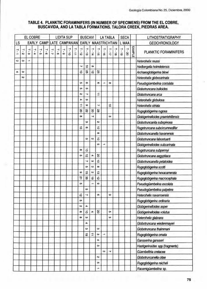
LS
-t -t
~ N
N c.>
~ c.>
N
Geología Colombiana No. 25 , Diciembre, 2000
TABLE 4. PLANKTIC FORAMINIFERS (IN NUMBER OF SPECIMENS) FROM THE EL COBRE, BUSCAVIDA, ANO LA TABLA FORMATIONS. TALORA CREEK, PIEDRAS AREA.
EL COBRE LlDITA SUP BUSCAVI LA TABLA SECA LlTHOSTRATIGRAPHY EARLY CAMP LATE CAMPANIAN EARL y MAASTRICHTIAN LMAA GEOCHRONOLOGY
en -t -t -t -t -t -t -t -t -t -t -t -t -t -t -t -t -t -t :l>
, . ~ PLANKTIC FORAMINIFERS c.> ~ 01 (J) ...¡ CD <O <5 ~
~ ¡;; ~ ¡;; ~ :::j 00 ID ~ " ~ O> r m
~ Heterohelix reussi ...¡ <5 O> Hedbergella hoImdelensis
<5 N ~ N Archaeoglobigerina blowi 01 01
Heterohelix gIobocarinata 01 O> O> ~ CD Ps~embelina costulata 01 01 Globotruncana bulloides N ...¡ ~
Globotruncana arca ~
~ c.> Heterohelix globulosa ~
<O ...¡ <5 Heterohelix striata ~
~ ~ ~ N Rugoglobigerina rugosa CD
CD ...¡ c.> GIobí~nel/oides J!taeriehillensis c.> N Globotruncanita subsJ!{nosa
<5 CD <5 Rugotruncana subcircumnodifer CD Globotruncanel/a havanensis
c.> N <5 Globotruncana fa/sostuarti 01 ~ GIobí~nelloides subcarinata
O> ~
Rugotruncana St¿~nyi o
01 ~ ~ N Globotruncana aegyptiaca o
...¡ c.> <5 Globotruncanella~taloidea
01 N CD Rwob~na scotti <O ¡;; N ¡;; RugogIobigerina hexacamerata ~ c.> ~
~ Rugoglobigerina macrocepha/a 01 <O
01 ~ <O P~~üembelina excolata 01 Pseudogüembelina paJ~
~ ...¡ O> <O Heterohelix navarroensis N
01 Rwobi~na ordinaria N ~ Globigerinelloides asper (J) <5 ~ ~ 01 Globigerinelloides vo/utus O> c.> c.> Heterohelix ~abrans
~ Globotruncana wiedenmayeri c.> c.> Globotruncana thalmmani
ID ~ c.> ~ Rwobi~na omata ~
~ Gansserina gansseri c.> Has~noides rur~
(o> ...¡ Güembelitria cretacea N Globotruncanella citae 01 Rugoglobigerina reicheli ~ Racemf9iJembelina ~
75

Guerrero el al.: The Stratigraphy 01 the W Side 01 the Cretaceous Colombia n Basin .
In the middle (16 m) segment, predominate the very finely laminated wackestone biomicrites, in part silicified , that give origin to diagenetic cherts. The vertical microfractures in two perpendicular directions produce the known standard lithology in orthogonal prisms of 5-10 cm of side that have been referred traditionally as "Iiditas". Calcareous concretions and len ses up to 30 cm thick, are a product of early diagenesis beca use the surrounding strata bend around them, to depart from the usual pattern of planar and parallel bedding. Phosphatic beds are negligible and present only in laminae that separate the thin beds of micrite and chert. These laminae of phosphates are recognized because of their soft nature and weathering to yellowish colors. Cherts are black, very brittle and are easily recognized in the field because of their conchoidal fracture ; their aspect is rugged in contrast with the rounded borders developed on the micrites.
The upper (24 m) segment is similar to the basal segment and again composed of foraminiferal biomicrites of packstone texture, in finely laminated thin to medium beds, with sporadic thin and medium beds of phosphorites that include bio -, pel - and intra - micrites of packstone texture. These phosphatic beds are present in hard and soft beds; the last ones probably correspond to the "mudstones and black shales" of PORTA (1966), from the Piedras - La Tabla walkway.
The highest gamma ray reading of the sucession (230 CPS), corresponds to the beds of phosphorites of the lower and upper segments and of the Lidita Superior Formation , in contrast with the chert beds of the middle segment, that have much lower readings of about 50 CPS.
The Lidita Superior Formation corresponds to the K3 unit of RAASVELDT et al. (1956).
Other sections of the Lidita Superior Formation
BARRIO & COFFIELD (1992: p. 133) indicated that the "upper chert" in the Ortega area ranged in thickness from 40
PLATE 8. LlDITA SUPERiOR FORMATION. Thin section photographs of fossiliferous micrites, wackestone biomicrites, and phosphatized packstone intrabiomicrites of foraminifers. The fossiliferous micrites are the most typical lithology of the middle part of the formation , being composed of calcareous mud in the clay and fine silt size range, with less than 10% of larger (more than 16 ~) identifiable calcareous particles (fossils in this case). The wackestone biomicrites have percentages of identifiable fossil particles larger
76
than fine silt, that rarely reach more than 15% of the samples. There is replacement of calcite by quartz, so that parts of the same sample range from micrite, to partially silicified micrite, to diagenetic chert. The packstone intra-biomicrites are present in scarce thin to medium beds that are thicker and more common in the lower and upper parts of the formation. Talora Creek, Piedras Area.
A, B: Crossed and parallel nicols. Silicified, fossiliferous micrite (diagenetic chert). Most foraminifers and matrix are replaced by quartz. Diagenetic cherts are recognized in thin section because almost all foraminifers are replaced by quartz. Although the mineralogical change is not as evident in the matrix because it is darkened by organic matter, the hand samples reveal the nature of these rocks, that do not react to HCI, are black colored, and have a brittle conchoidal fracture. Sample from 20 m aboye the base of the unit.
C: Parallel nicols. Wackestone biomicrite of foraminifers. Calcite-filled vertical fracture (typical of the "liditas") in the left. Glauconite (60 ~) in the center. Sample from 24 m aboye the base of the unit.
D: Parallel nicols. Medium lamina (2 mm thick) of packstone intra-biomicrite from the same thin section shown in C. Light brown colored particles are phosphatized foraminifers, intraclasts, and fish bones. Black spots are pyrite crystals. The test of foraminifer at the center is replaced by pyrite. The specimen between two phosphatized particles in the upper right corner is Buliminella colonensis. Very large specimens in the lower and upper part are Siphogenerinoides sp.
E, F: Crossed and parallel nicols. Partially silicified wackestone biomicrite of foraminifers. Large specimens (up to 300 ~ long) with their original calcite filling and test replaced by quartz (gray, black, and white speckled in crossed nicols, and almost transparent with parallel nicols). Note that some foraminifers retained their original calcite composition. Phosphatized particles (on the left), are black in crossed nicols and light brown in parallel nicols. Sample from 32 m aboye the base of the unit.
G: Parallel nicols. Phosphatized bio-intramicrite. Light brown colored intraclasts reach coarse sand size. Sample from 43 m aboye the base of the unit.
H: Parallel nicols. Wackestone biomicrite of foraminifers. Note dark brown, almost black colored calcareous mud matrix, due to large concentrations of organic matter. Most specimens are of Buliminella colonensis. Sample from 2 m below the top of the unit.

Geología Colombiana No. 25, Diciembre, 2000
H
] ~ E F
] ~
A B
]:
77

Guerrero el al.: The Stratigraphy 01 the W Side 01 the Cretaceous Colombian Basin.
to 90 m. According to them , the unit consists of "intercalated, finely laminated, siliceous yellow shales and massive grey chert with wavy bedding and phosphorite beds".
In the Ataco Section (VERGARA 1997: p. 18), the "Lidita Superior reaches 45 m and exhibits more phosphatic layers relative to the Lidita Inferior. These are preferentially concentrated in rhythmically occurring graded laminae normally on top of erosional surfaces".
On the E flank of the Guaduas Syneline (Guaduas Section) , the Lidita Superior Formation reaches a maximum thickness of 160 meters. It is composed predominantly of thin beds of partially silicified, finely laminated wackestone
textured biomicrites and fossiliferous micrites that are usually fractured in orthogonal prisms of 5-1 O cm of side. There are also some thin and medium beds of packstone textured bio- , pel- , and intra- micrites, with notorious concentrations of phosphatized particles. Calcareous concretions and lenses up to 40 cm thick are present through the unit.
The phosphatized horizons in the Guaduas Section constitute a minor percentage of the unit (no more than 10%) but are very notorious because of their high gamma ray signal and because they are relatively coarse grained and have sharp bases. The larger partieles in these beds include phosphatized benthic foraminifers, pellets, fish bones and biomicrite intraclasts up to 5 mm of diameter. These thin to medium beds weather more easily than the
surrounding wackestones and cherts if phosphatic partieles predominaté over the calcareous ones. In contrast, the biomicrites of packstone texture with little phosphatic fragments are harder and more resistant to weathering than any other lithology in the Lidita Superior Formation.
Age
The age of the Lidita Superior Formation is Late Campanian. The best recovery of age diagnostic foramini
fers and palynomorphs is from the Guaduas Syncline. In the type locality, at Piedras, the age is constrained by the recovery of abundant benthic foraminifers and by the strati
graphic position of the unit between the El Cobre Forma
tion (Early Campanian) and the Buscavida Formation (Early Maastrichtian).
Among the very abundant benthic foraminifers (Table
5) from the Piedras area are included Buliminella cOlonensis, Bolivinoides draco , Haplophragmoides perexplicatus, and Bolivinoides decora tus. The last two
forms were also considered as indicative of the Late Campanian from the E foothills of the Eastern Cordillera
78
by TCHEGLlAKOVA et al. (1997). H. perexplicatus has its last appearance in the Late Campanian and R. decoratus is known from the Late Campanian.
In the Guaduas Section on the E flan k of the Guaduas Syncline, were recovered the planktics Rugoglobigerina rugosa , Globotruncana ventricosa , Globotruncana lapparenti, and Globotruncana arca. Among the benthics are also present Buliminella colonensis, Haplophragmoides perexplicatus, and Bolivinoides decora tus. In the Córdoba sections on the W flan k of the Guaduas Syncline, were recovered Rugoglobigerina rugosa , Rugoglobigerina bulbosa, Globotruncanita elevata, Heterohelix globulosa, and the benlhic form Buliminella colonensis. According to CARON (1985) , Globotruncana ventrícosa has its first appearance in the late Early Campanian and Globotruncanita elevata has ils last appearance during the Late Campanian.
The palynomorphs from Lidita Superior Formation on the Córdoba sections include Andalusie/la mauthei, Trichodinium castanea , Dinogymnium digitus , and Alisogymnium euclaense, also present in the Late Camp.anian Aguacaliente Formation from the E foothills of the Eastern Cordillera (SARMIENTO & GUERRERO 2000).
BUSCAVIDA FORMATION (new unit)
The strala corresponding to the "nivel de lutitas y arenas" (PORTA 1965, 1966), that overlie the cherts of the Olini Group and underlie the sandstones of the La Tabla Formalion, have been designated in several informal ways in
Ihe UMV. Originally, the strata were characterized and mapped by RAASVELDT et al. (1956) , who included them in the informal K2 unit. These authors described it as composed of usually calcareous shaley claystones, and marl
stones ("Arcillas esquistosas, a menudo calcáreas, margas.").
PORTA designated the unit in its type locality (Piedras -La Tabla) as 75 m thick and composed of dark mudstones, with minor interbeddings of sandstone 1-2 m thick. Porta ' s
grain size log (PORTA 1966: lámina 1) oscillates between mudstones (Iutitas) and "fine detritics" (detríticos finos) ,
apparently indicating that sandstones are of very fine to
fine grain size.
Other authors have used several names for these strata. In a field trip guide, CORRIGAN (1967: p. 229) indi
cated in his correlation chart the name "buscavida shale facies" or "buscavida formation", to refer to the strata be
tween the "upper chert" and the "guaduas formation"; the name is attributed lo Intercol Geologists, but has never

Geología Colombiana No. 25, Diciembre, 2000
EL COBRE LlDITA SUP BUSCAVIDA ..L.A.I.ABLA ....SECA. l itill.G.BAEI:!' ILS 'ARl 'r.A ,jDAI IAI LA"-e. CJIMP EARLY M \ASl RICfmftJ LMAA LOGY.-
en :' -< :' -< -< -< :' -< -< :' :' :' :' :' :' :' :' :' :' :' > ;¡: BENTHIC FORAMINIFERS - N '" ... en en .... IX> ., <5 :: ~ ¡;; .: c;, ¡;; :::; <» ¡¡; N ." o ::;; en ... <5 '" <5 '" !:l g; Buliminella c%nensis en '" :: N en '" c;, Neobulimina canadensis ... N '" '" ... Praebulimina reussi o
N :: Anoma/ina redmoncfi en Bo/ivinoides m '" Buliminella vitrea QD Bulimina COOJDressa ~ Bo/Mna @Jl/icata
'" '" H : ruoosus en .... ~~moides calcula N ., IX> Praebulimina kickaooensis
'" IX> ... &ramidina rudita ., <5 <5 Praebulimina carsevae en - '" ~ '"
.... g; Bo/Mna incrassata o ., ce T rochammina SDD .
'" - IX> - Bath~ ... - .... - IX> N N c;, '" O> Gavelinella SDissocostata o o - '" '" c;, M~n~ decufS6COSlata '" N Siohooenerinoides re~cu/ata en '" N ¡;; ~ SI!!Lrobuliminella stainfol1hi '" ... '" N HaoIoohraamoides.l1nXDlicatus ~ N N ¡g .... ~ )8 ~ )8 "'-1<:< rinoides cretacea O ., Ammobaculites texana
'" ... :: :: t; '" Loxostoma clavatum en ... ., c;, N '" Loxostoma Dlaitum o en N
S~nerinoides uh/i ... N .... ... Len~cu/ina O/iOO$teoius '" <5 SI!!Lrobulimin~orata en
<5 ., c;, Praebulimina /addi
'" N N N )8 S~nerinoides revo/uta ... o
- ¡;; ... N U. Len~cu/ina münsteri ce Gavelinella velascoensis <5 BoIivina incrassata aioantea en N BoIivinoides draco <» en Gavelinella semicomolanata
'" <5 M~nulina curvi~ta .... '" ¡g N N Bo/ivinoides cJecoratus o o en ¡g N Loxostoma aemum en en ~ ~ )8 )8 Pseudouv~na cretacea .... c;, en <5 C;; Gavelinel/a erikdalensis :: :: .... N Anomalina nelsoni en N ~ .: '" Gavelinel/a nacatochensis en
~ '" '" '" G..r.roidinoides cretacea en .... g¡ Pseudouv~naJlLummerae o
~ N ~ N ... '" Gvroidinoides ~ressa o g; <5 N en '" ... ~ria cotdieriana o
g¡ en Karr9riel/a conversa '" '" ... - Dentalina cf. /omeiana
'" '" '" Cibicides beaumon~anus ~ ~ ¡;: '" Bifarina Dlummel8e ... g; ... <» Pl8ebulimina trihedl8 '" '" '"
N
'" '" Gaveline//a steohensoni o C;; S~noides bennudezi N ... S~no~/andesi '" N
'" - - . ISDD. ... - N Si!lm..omQ!DbLna $l1D.. N .... <5 S~noides dentata o N <5 ~ ·noides ovevi o
<5 '" N Si !J1M(a
'" Siohooenerinoides c/arki <5 '" Siohooenerinoides Dlummeri o
'" .,
S~noidesbl8m~~ '" N SaracenariB 500.
'" Rhabdatnmina SDD.. N N ~ Si/icos...klmllilina §I!!¿
<5 '" '" ~rella5OO. N '" Marssonella o~
79

Guerrero el al.: The Stratigraphy 01 the W Side 01 the Cretaceous Colombian Basin.
been formally defined or proposed. CORRIGAN used it as a facies change of the "guadalupe formation".
BELTRÁN & GALLO (1968) used the name "monserrate formation" assigning the origin of it to Hubach, and indicating that its type section would be the Monserrate Hill near Bogotá, to refer to the interval between the "villeta formation" and the "guaduala group". However, the "villeta formation" of these authors is different from the one of CORRIGAN, because this author included the "upper chert" in the "villeta formation". In contrast, BELTRÁN & GALLO excluded from the "villeta formation" the "basal sandstone" and the "upper chert", to include them in the "monserrate formation", along with other overlying units. BELTRÁN & GALLO were right in their correlations because their "basal sandstone" (El Cobre Formation) and the "upper chert" (Lidita Superior Formation) correlate with the lower and middle alloformations of the Guadalupe Group of the E si de of the Eastern Cordillera (see GUERRERO & SARMIENTO 1996). However, the nomenclature of BELTRÁN & GALLO can not be followed because includes non-valid synonyms of the nomenclature formally proposed by PORTA (1965) and because the lithology of the Guadalupe Group in the proximity of Monserrate is very different from the lithology of the contemporaneous units of the UMV.
RODRIGUEZ & ULLOA (1994), proposed the name "córdoba formation" to refer to the strata that overlie the Olini Group and underlie the Seca Formation; these correspond with the "nivel de lutitas y arenas" and with the La Tabla Formation of PORTA (1965) . These authors included in the "córdoba formation" dark grey to black calcareous siltstones in thicl< to very thick beds, with interbeddings of dark grey sandy limestone of fine to medium grain , with pyrite replaced fossils ... the upper part iS formed by calcareous cemented , clayish sandstone . In Spanish : "Iimolitas calcáreas, grises oscuras a negras, en capas gruesas a muy gruesas, con intercalaciones de caliza arenosa gris oscura, de grano fino a medio, con fragmentos de fósiles reemplazados en pirita .. . el techo está formado por arenisca con cemento calcáreo y matriz arcillosa". This description comes from the legend of the La Palma -189 Geological Map.
We reviewed the section aboye the Olini Group near Córdoba, along the Río Negro Between the Pitas and El Neme Creeks, and found that the La Tabla Formation can be clearly identified beneath the Seca Formation . The strata corresponding with the "nivel de lutitas y arenas" are predominantly impure biomicrites with percentages of terrigenous mud particles betweGn 10 and 20%. The "córdoba formation" clearly includes the "nivel de lutitas y arenas" and La Tabla Formation of PORTA (1995) and is an
80
invalid synonym of them.
The "nivel de lutitas y arenas" should receive a formal lithostratigraphic name of formation rank. From the three names ("buscavida", "monserrate", and "córdoba") that have beer. erroneously used to include it along with underlying and overlying units, the one most commonly used appears to be "bUsc&vida". For that reason, we formally
PLATE 9. BUSCAVIDA FORMATION. Thin section photographs of packstone-texture impure (muddy) biomicrites of foraminifers, bivalves, and fish spines. Talora Creek, Piedras Area.
A, B: Crossed and parallel nicols. Large horizontal fossil across the center of the photo is a bivalve shell. Larger terrigenous particles are in the coarse silt size range and reach about 30%. Black pyrite crystals in some foraminifers. Sample from 38 m aboye the base of the unit.
C: Parallel nicols. Other view of the same thin section of A and B. Large foraminifer (Siphogenerinoides cretacea) is approximately 1.7 mm long. Small planktic foraminifer to the lower left of it is Rugoglobigerina macrocephala.
D: Parallel nicols. Large phosphatized particles (including fecal pellets), in dark color. Sample from 47 m aboye the base of the unit.
E: Crossed nicols. Closer view of the same thin section of D. Terrigenous particles reach about 12% of the sample; the larger ones have a diameter of about 20-30 Il.
F: Parallel nicols. Note abundant phosphatized foraminifers in darker color. Among the smaller specimens that retain their original calcite composition there are several Buliminids. Sample from 52 m aboye the base of the unit.
G: Parallel nicols. Other view of the same thin section of F. Phosphatized fish spine across the lower part of photo.
H: Crossed nicols. Abundant (35%) terrigenous particles in the coarse silt range. Note 60 Il volcanic rock fragment in the center of photo. Most foraminifers are recrystallized. Sample from 62 m aboye the base of the unit.

Geología Colombiana No. 25, Diciembre, 2000
E
] ~
A B
]:
81

Guerrero el al.: The Stratigraphy 01 the W Side 01 the Cretaceous Colombian Basin .
propose the Buscavida Formation to refer to the strata above the Lidita Superior Formation of the Olini Group and below the La Tabla Formation. The unit is elearly differentiated from the underlying cherts of the Olini Group, and the overlying sandstones of the La Tabla Formation. The contact is transitional with both units; the lower contact is picked in the first appearance of impure biomicrite and the upper contact in the first appearance of medium beds of bioturbated sandstone of the La Tabla Formation.
This usage differs from the one originally proposed by CORRIGAN (1967) in that the Buscavida Formation is not in contact with the "guaduas formation" (Seca Formation) . Our definition excludes the sandstones and conglomerates above the Buscavida Formation, to inelude them in the La Tabla Formation . According to CORRIGAN, the name Buscavida comes from the area NW of Tocaima. This is very elose to the Piedras - La Tabla area, were we now designate the type locality of the Buscavida Formation. As well as with the underlying Olini Group and the overlying La Tabla Formation, the type locality of the Buscavida Formation ineludes the Piedras - La Tabla Section and the Talora Creek Section.
A detailed examination of the lithology in its type locality indicates that the Buscavida Formation is 90 m thick and that the most common lithology (Plate 9) is impure biomicrite, containing large amounts of foraminifers and lesser amounts of terrigenous mud particles. The average amount of terrigenous mud in these impure biomicrites increases in a gradual way toward the top of the unit, and some terrigenous mudstones are present.
Besides the very abundant foraminifer tests, there are horizons with abundant bivalves of small size (1-2 cm) and thin-walled shells. Bioturbation is very common throughout the whole formation . Scarce horizons, of up to medium bed thickness, include phosphatized partieles, made up of intraclasts, bivalve shells and planktic and benthic foraminifers.
In the lower part of the unit, impure biomicrite of packstone texture is a common lithology. In sample 9-A (Fig. 4, Plate 9) , the lithology is packstone with laminae of wackestone; the percentage of foraminifers in the framework fraction reaches 70%, leaving the remaining 30% to medium and coarse silt terrigenous particles. The matrix is darkened by the presence of organic matter, reaches 40% of the volume of the sample and is composed of a mixture of calcareous and terrigenous particles smaller than 8 ¡.t (elay and very fine silt size) . Glauconite of medium silt size is observed in the framework fraction .
82
Near level 9-D, the amount of terrigenous partieles almost disappears and rocks classify as packstone biomicrites of foraminifers. Sample 9-D (Fig . 4, Plate 9) is made of elosely packed foraminifers, with scarce glauconite, bivalve fragments, fish spines and pellets. Matrix reaches 30% of the volume of the sample. Terrigenous particles in the fine silt size range constitute about 12% of the framework fraction. Foraminifers are mainly in the size range of medium and coarse silt, but larger forms (very fine sand size) are also present.
Sample 9-F (Fig. 4, Plate 9) comes from a 40 cm conspicuous bed that is harder than the strata above and below; it has a sharp, erosive lower boundary and constitutes a minor deviation from the biomicrites of the unit because the amount of phosphatized foraminifers and intraclasts.
Other sections of the Buscavida Formation
The lower part of the "córdoba formation" (corresponding with the "nivel de lutitas y arenas") in the Córdoba Section is ineluded here in the Buscavida Formation. The original definition of the "córdoba formation" indicated a thickness of 661 m (RODRIGUEZ & ULLOA 1994: p. 31, fig 5) that did not take into account several reverse faults parallel to the Cambrás Fault. These faults repeat the section when they have the same trend (W) of the Cambrás Fault, or eliminate part of the same, when they are E trending back-thrusts. We studied again the section of the Río Negro near Córdoba, and found that the Buscavida Formation is very well exposed. It overlies the cherts of the Lidita Superior Formation of the Olini Group, and underlies the sandy mudstones and very fine sandstones of the lower part of the La Tabla Formation.
We propose the Córdoba Section along the Río Negro, between the Pitas and El Neme Creeks, as the main reference section of the Buscavida Formation . The strata exposed down river, beyond the El Neme Creek, are not ineluded in the measurement of the section because they correspond to extensively folded and faulted strata of the Buscavida and Lidita Superior Formations.
The Buscavida Formation on the Córdoba Section has a thickness of 120 m and is composed predominantly of wackestone and packstone biomicrites of foraminifers and bivalves, with variable minor amounts of terrigenous mud (many of them are impure biomicrites) . As a rule , the bioturbated strata are more notorious in the upper part of the unit. Toward the lower part, the lamination is elearer elose to the contact with the Lidita Superior Formation .

The Buscavida Formation in the E side of the Guaduas Syncline attains a maximum thickness of 160 170 meters. It has a very similar lithology to the one exposed in the Córdoba Section, on the W side of the Guaduas Syncline, except that toward the E there are even less terrigenous particles.
Age
The Buscavida Formation in its type locality includes the lower part of the Early Maastrichtian, as indicated by the very abundant planktic and benthic foraminifers (Tables 4, 5) . The age is also well constrained in the Guaduas Syncline, with foraminifers and palynomorphs.
In the Piedras area, the planktic foraminifers (Table 4) include several age diagnostic forms such as Heterohelix globulosa (Plate IV-E), Globigerinel/oides praeriehil/ensis (Plate V-J) , Globotruncanita subspinosa (Plate IV-I) , Rugotruncana subcircumnodifer, Globotruncana falsostuarti, Rugotruncana subpennyi, Globotruncana aegyptiaca, Globotruncanel/a petaloidea, Rugoglobigerina scotti, Rugoglobigerina hexacamerata, Rugoglobigerina macrocephala, Pseudogüembelina excolata, Pseudogüembelina palpebra , and Heterohelix navarroensis.
Based on the last appearance of H. globulosa and the first appearances of R. subpennyi, G. aegypt:aca, G. petaloidea, R. scotti, R. hexacamerata, R. macrocephala, P excolata, P palpebra, and H. navarroensis, the lower part of the Buscavida Formation is within the lower part of the zone of Globotruncana aegyptiaca. The upper part of the formation would be within the upper part of the Globotruncana aegyptiaca zone, as indicated by the disappearance of H. globulosa and the absence of Gansserina gansseri, which has its first appearance in the lower part of the overlying La Tabla Formation.
In tlle Guaduas Syncline , ¡he presence of Globotruncanel/a havanensis, Heterohelix globulosa, and Archaeoglobigerina cretacea in the lowermost part of the formation indicates the presence of the Globotruncanel/a havanensis zone, from the earliest Maastrichtian. The first appearance of G. havanensis in several sections indicates that the lower boundary of the Buscavida Formation is very close to the Campanian/Maastrichtian boundary.
Regarding the upper boundary of the unit, besides many of the mentioned forms from the Piedras area, the first appearance of Guembelitria cretacea in the upper 30 m of the Buscavida Formation in the Guaduas Syncline, supports also the presence of the uppermost part of the
Geología Colombiana No. 25, Diciembre, 2000
zone of G. aegyptiaca.
Among the palynomorphs from the Guaduas Syncline, it is worth to mention Andalusiel/a mauthei, Alisogymnium euc/aense, Dinogymnium acuminatun, and Andalusiel/a gabonensis. This last form is common in the Early Maastrichtian San Luis Formation from the E foothills of the Eastern Cordillera (SARMIENTO & GUERRERO 2000).
LA TABLA FORMATION
The La Tabla Formation (PORTA 1965, 1966) in its type loca!ity (Piedras - La Tabla) , includes the strata of relatively coarse grain, that overlie the Buscavida Formation. According to PORTA (1966: p. 47, lámina 1), the La Tabla Formation has a thickness of 85 to 90 m and is composed predominantly of sandstones . Toward the base has interlayering of mudstones and toward the top includes conglomerates of granule and gravel particles with a maximum 3 cm grain size (granule to medium pebbles).
The strata assigned to the La Tabla Formation were first characterize.d and mapped by RAASVELDT et al. (1956) , who included them in the informal K1 unit. These authors described it as composed of sandstones and fine conglomerates with quartz grains ("Areniscas y conglomerados finos. Granos de cuarzo.").
In the Piedras - La Tabla Section and the Talora Creek Section (Fig. 4, Plate 10), the unit is 90 m thick and composed of very fine grained sandstones to conglomerates of medium pebbles. The succession is coarsening upwards in a very gradual manner. Its lower contact is transitional with the impure biomicrites and fossiliferous mudstones of the upper part of the Buscavida Formation. Its upper contact is very sharp with the finer grained terrigenous mudstones and interlayered sandstones of the Seca Formation .
The sandstones of the La Tabla Formation are lithic arenites, with abundant rock fragments of metamorphic and volcanic nature, fossiliferous with 10% to 45% fossil fragments, including bivalves and foraminifers. Most of the sandstones are calcite cemented and free of mud matrix. On the lower part of the La Tabla Formation (Ievel 10-A) they are fine to very fine grained fossiliferous sandstones. Some of thern are also sandy biosparites (Ievel 10-C).
Associated with the interval between levels 10-0 and 10E there are fossiliferous, fine to medium grained sandstones and conglomeratic sandstones, along with minor interbeddings of laminae and very thin beds of conglom-
83

Guerrero et al. : The Stratigraphy 01 the W Side 01 the Cretaceous Colombian Basin .
erates. The conglomeratic component remains in the granule size. In some horizons, the amount of calcareous particles exceeds the one of terrigenous particles. Sample 10-E includes impure (sandy) biosparites with about 30% terrigenous particles and 70% calcareous particles. Here the calcareous particles are mainly fossils of bivalves. Sample is glauconitic and in the grain size range of fine to very fine sand.
Approximately 5 m below level 10-0, trough cross bedding is very striking (Plate 12-0), in beds up to 1 m thick indicating submari e dune movement toward SSw. On level 10-0 and a few meters below, calcareous concretions and lenticular calcareous beds 30-50 cm thick are harder than the surrounding strata, corresponding compositionaliy to impure biosparites. Thin to medium beds including concentrations of very well preserved ammonites and complete bivalves 6-8 cm in diameter with thick shelis, are a notorious feature of level T-16.
Conglomeratic sandstones and conglomerates of granules and very fine pebbles are present around level 10-F. They are again free of muddy matrix, contain about 35% of calcareous particles and 65% of terrigenous particles, and are calcite cemented. In sample 10-F, the sandstones are mainly of medium to coarse grain size; the conglomeratic component reaches granule size and exceptionaliy very fine pebble size. The most common calcareous particles are bivalves (Plate 12-E), that are among the largest particles of the sample and could reach a diameter of about 8 mm. Between levels 1 O-F and 1 O-G, the conglomerate fraction reaches medium pebble size (Plate 12-F).
Fossils and calcite cement disappear 1 m above level 10-G, where lithology is texturaliy and compositionally immature compared with the immediately underlying strata. Volcanic and metamorphic rock fragments are very abundant. Sandstone particles are angular and poorly sorted, mainly of fine grain size, but laminae of medium and very coarse sandstones are present, along with granule and very fine to medium pebble conglomerates (Plate 12-G). The largest terrigenous particles have approximately 6 cm
PLATE 10. LA TABLA FORMATION. Thin section photographs of matrix-free, calcite-cemented, fossiliferous, lithic (metamorphic/volcanic) arenites. So me sandy biosparites. Talora Creek, Piedras Area.
A, B: Crossed and parallel nicols. Very fine grained, fossiliferous, sandstone. Sample is composed of 75% framework particles and 25% calcite cemento The
84
framework is composed of 74% terrigenous particles (43% monocrystalline quartz, 13% metamorphic rock fragments, 8% volcanic rock fragments, 7% feldspars, 3% glauconite) and 26% calcareous particles (foraminifers). Sample from 5 m above the base of the unit.
C: Crossed nicols. Very fine grained, sandy biosparite. Sample is composed of 68% framework particles and 32% calcite cemento The framework is composed of 60% calcareous particles (foraminifers, bivalves, briozoans) and 40% terrigenous particles. Sample from 30 m above the base of the unit.
D: Crossed nicols. Fine grained, fossiliferous litharenite. Twinned feldspar in the lower right is 350 ~ long. Sample is composed of 60% framework particles and 40% calcite cement. The framework is composed of 94% terrigenous particles (48% monocrystalline quartz, 23% metamorphic rock fragments, 18% volcanic rock fragments, 5% feldspars) and 6% calcareous particles (bivalve fragments). Sample from 37 m below the top of the unit.
E: Crossed nicols. Fine grained, sandy biosparite. Sample is composed of 60% framework particles and 40% calcite cement. The framework is composed of 60% calcareous particles (bivalve fragments and complete bivalve shells up to 6 cm diameter) and 40% terrigenous particles. Note abundant volcanic rock fragments (gray speckled), and extensive replacement of terrigenous particles by calcite. The horizon includes also very well preserved specimens of ammonites. Sample from 29 m below the top of the unit.
F: Crossed nicols. Medium to very coarse grained, conglomeratic sandstone, and conglomerate of granules. Coarse sand particle in the center is a metamorphic (quartzite) rock fragmento Particle to the left is almost completely replaced by calcite. Either iron oxides or organic matter darkens microcrystalline (probably recrystallized) calcite cement. Large calcite crystals are bivalve fragments and partially replaced terrigenous particles. Sample from 22 m below the top of the unit.
G: Crossed nicols. Medium grained, fossiliferous sandstone. Abundant volcanic rock fragments. The one at the center includes a quartz phenocryst. Sample from 8 m below the top of the unit.
H: Crossed nicols. Other view of the same thin section of G. Abundant metamorphic and volcanic rock fragments. Note quartz (pale gray) particle with irregular festooned shapes and corroded borders, because of partial replacement by calcite.

Geología Colombiana No. 25, Diciembre, 2000
~-G H
F
e
] ~ A B
]:
85

Guerrero el al.: The Stratigraphy 01 the W Side 01 the Cretaceous Colombian Basin .
of diameter (coarse pebble size) , but they are very uncommon. Cement is ferruginous and chloritic. Sideritic and oxidized mud intraelasts of about 5 cm are common and could reach sizes of approximately 20 cm. There are also present some very small (in the mm range) coal fragments of wood and leaves. Cross bedding sets up to 1 m thick are a common feature. Cross bedding direction is toward the SSE.
A final 3.5 m interval around level T-18 includes a mixture of lithologies with abrupt lateral and vertical boundaries in thin to medium beds. These inelude medium to coarse grained conglomeratic sandstone, fine pebble conglomerate, sideritized mud intraclasts up to 20 cm of maximum diameter, wood fragments a few mm in diameter, coal laminae, and siderite beds.
The general coarsening upward trend of the unit is interrupted several times by scarce and isolated thin to medium beds of a lithology of relatively coarser grain size than the surrounding strata. Some of these beds do exhibit sharp and erosive lower boundaries. Another internal deviation of the general coarsening upward trend is found in the upper part of the section , from about level 10D to 1 OG, where there are some coarsening upward successions 2 m thick. They have sharp lower boundaries of fossiliferous fine to medium sandstone and end up in conglomeratic sandstones or conglomerates. The grain size of the top of each micro-succession is of coarser grain size than the ones underneath , so that the maximum grain size is attained toward the top of the formation.
Primary porosity could have reached about 30% of the sandstones and conglomerates of the La Tabla Formation , but calcite cement has obstructed most of it, to leave porosity percentages of only about 1-2%. Secondary porosity as a result of fracturing is a more important feature of these reservoir strata. Calcite cement is very abundant and could even reach 50% of some samples, due to partial to extensive replacement of terrigenous particles by calcite during diagenesis.
Other sections of the La Tabla Formation
Important sections of the La Tabla Formation are the ones outcropping in the Guaduas-Honda highway. Over there, outcrop several repetitions of the Buscavida, La Tabla and Seca Formations. Several authors, ineluding RAASVELDT & CARVAJAL (1957) and GÓMEZ & PEDRAZA (1994) have already documented these tectonic repetitions due to Wtrending reverse faults parallel to the Cambrás Fault. It is a tectonic situation similar to the one a few km N, on the Córdoba Section .
86
The "cimarrona formation" of PORTA (1965, 1966) on the Guaduas-Honda highway, on the W side of the Guaduas Syneline, includes two of these repetitions, which correspond to:
Porta (1965, 1966):
La Primavera Member: Zaragoza Member:
This work:
La Tabla Fm (E slice, 76 m) Buscavida Fm (E slice, 70 m)
............ Reverse Fault
Nivel Arenitas y Lutitas: Upper La Fría Member: Lower La Fría Member:
Seca Formation La Tabla Fm (W slice, 86 m) Buscavida Fm (W si ice, 72 m)
Although PORTA discussed the possibility of a fault repetition as indicated by RAASVELDT & CARVAJAL (1957), he discarded it, and correlated the "cimarrona formation" with part of the La Tabla Formation and part of the "umir formation" (PORTA 1966: p. 104). He also indicated (PORTA 1966: p. 54) that the strata underlying the "cimarrona formation" included "dark calcareous mudstones, thin banks of fine grained sandstones, and banks of grey marls" ... comparable to the "umir formation" ... "on the La Fría Creek, chert banks outcrop" ... "but the scarce exposures do not permit to assure that these cherts are part of the Lidita Superior". Regarding its upper limit, he stated (PORTA 1966: fig. 8 and p. 56) that the "cimarrona formation" underlies the Seca Formation.
In the same section, over the Guaduas-Honda highway, GÓMEZ & PEDRAZA (1994: p. 111-3 and fig 3) restricted the name "cimarrona formation" to the sandstones and conglomerates and used the name "umir formation" to refer to the underlying "calcareous mudstones". In this work, we include the sandstones and conglomerates in the La Tabla Formation, and the underlying marlstones and "calcareous mudstones" in the Buscavida Formation . The names "cimarrona formation" and "umir formation" should not be used to refer to these strata. The Umir Formation in its type locality has a different lithology and a different stratigraphic position from the strata in the GuaduasHonda highway.
Of the two repeated sections of PORTA in the GuaduasHonda highway, the W slice of the La Tabla Formation has a coarser grain size than the E slice. According with the information taken and reinterpreted from PORTA (1966: plate 3 and fig . 15), the W section has predominance of sandstones of very coarse grain and conglomerate of granules. In its top has conglomerates of very fine (4-8 mm) and fine pebbles (8-16 mm), with maximum particle sizes

of 4-9 cm and sporadically 13 cm. The E section is composed of sandstones of very coarse grain, with sporadic beds of conglomerate of granules; only reaches maximum particle sizes of 2-4 cm and sporadically 5 cm. The two sections are equivalent, but clearly of coarser grain toward the W.
The general characteristics and the coarsening-upward (prograding) trend of the sandstones and conglomerates from the type locality of the La Tabla Formation are very similar to the ones from the sections tectonically repeated on the Guaduas-Honda highway, especially to the ones of the E section. The coarsening-upward (prograding) trend is also present in the Córdoba Section and in the sections on the E side of the Guaduas Syncline (near the Alto del Trigo) , except that in those localities the unit is thinner (5-10m) and of relatively finer grain size. The thickness of the La Tabla Formation reduces toward the E, as much as the thickness of the Buscavida Formation increases. The added thickness of the two units (in non faulted sections) is always around 160-180 m.
The La Tabla Formation is the unit that constitutes the main reservoir of hydrocarbons of the Guaduas Syncline and other areas in the UMV, with secondary porosity by fractures . It has been described as composed of limestones in the Guaduas Syncline, but the evaluation of the petrography indicates that the lithology is predominantly terrigenous sandstone, with variable amounts of fossils. Occasionally, the percentage of allochemical particles is higher than the percentage of terrigenous particles, with rocks in the range from impure calcareous rocks (sandy biosparites) to totally calcareous ones (biosparites). In all the studied sections, the upper part of the La Tabla Formation includes coarse grained sediments, that do not have muddy matrix and that are cemented by calcite.
The gamma ray signal of the top of the La Tabla Formation includes very low values (10-50 API units) that contrast with those of the overlying Seca Formation around 150 API units and those of the underlying Buscavida Formation, around 100 API units.
Age
The La Tabla Formation is placed in the late Early Maastrichtian, as indicated by the presence of the lower part of the Gansserina gansseri zone.
Foraminifers are less abundant than in the underlying Buscavida Formation, but record the first appearance of important planktic forms (Table 4), including Gansserina gansseri, GlobotruncaneJla citae, and Rugoglobigerina
Geología Colombiana No. 25, Diciembre, 2000
reicheli. This first appearances occur very close to the base of the La Tabla Formation, and just above the uppermost samples belonging to the Early Maastrichtian G. aegyptiaca zone.
Since the Gansserina gansseri zone includes part of the Early Maastrichtian and part of the Late Maastrichtian, the lower part of the zone belongs to the Early Maastrichtian.
In the Guaduas Syncline, the assemblage is very much the same, but besides the mentioned forms , Abathomphalus intermedius has its first appearance toward the upper part of the formation . We believe that A. intermedius (instead of A. mayaroensis) should also be the form present in the sample studied by TCHEGlIAKOVA (1996) from the W flank of the Guaduas Syncline. We did not find evidence of the Abathomphalus mayaroensis zone in any of the approximately 100 samples studied from the Cretaceous section of the Guaduas Syncline.
Among the palynomorphs of the Guaduas Syncline, bes id es Dinogymnium acuminatum, and Andalusiella gabonensis, which are al so present in the underlying Buscavida Formation , Crussafontites grandiosus and Buttinia andreevi have their first appearance in the section.
SECA FORMATION
The type locality of the Seca Formation (PORTA, 1965, 1966) is the road Cambao - San Juan de Rio Seco, near the bridge over the Seca Creek. Porta used the name to refer to the strata above the La Tabla Formation ("cimarrona formation") and below the Hoyón Formation. As a reference section he designated the Guaduas-Honda highway. According to PORTA, the lower part of the unit is composed of an alternance of red and grey mudstones with medium to thick beds of sandstones. The mudstones would predominate over the sandstones. To the N of Tocaima, in a creek also named Seca (PORTA, 1965: p. 29), the grey mudstones of the lower part of the Seca Formation contain fossils of foraminifers. PORTA correlated the unit with the Guaduas Formation and also indicated the change of fully marine to continental environments of sedimentation within the Seca Formation.
We have reviewed several sections that ex pose de contact between the La Tabla and Seca Formations, and found that there is a sharp granulonletric contrast in the lower part of the Seca Formation , and that it is composed of grey mudstones with scarce interbeddings of sandstones. The sandstones are lithic arenites and in some
87

Guerrero el al.: The Stratigraphy 01 the W Side 01 the Cretaceous Colombian Basin.
localities predominate for a few meters over the grey mudstones. The lower boundary of the Seca Formation is very abrupt and easy to map; it is located on top of the last conglomeratic sandstone or conglomerate of medium pebbles of the La Tabla Formation. The angular unconformity indicated by PORTA (1965: p. 21 , 1966: p. 111) between the two units, was not observed in any of the studied localities.
In the Talora Creek, approximately 20 m of the unit are exposed. Over there, it is composed of very fine to fine grained muddy sandstones and sandy mudstones (Fig. 4, Plate 11), in laminae and very thin to thin beds. Compositionally, they are lithic (metamorphic-volcanic) arenites, with about 25% of ferruginous and calcite cemen!. Sample 28 (Fig. 4) from an interlayered sandy mudstone, contains very scarce benthic foraminifers. Sedimentary structures inelude horizontal parallel bedding , wave ripples, and planar cross bedding.
Other sections of the Seca Formation
In the section on the E side of the Guaduas Syneline, near the Alto del Trigo (Guaduas Section) , the lower part of the Seca Formation is composed of terrigenous mudstone and elaystone with very scarce fossils of foraminifers ; over there, approximately 30 m can be clearly observed. Very well exposed grey mudstone and elaystone constitute the dominant lithology. Minor thin beds of very fine to fine grained sandstone and muddy sandstone contain some fossils of foraminifers, fish scales, and echinoderms. A few meters aboye, coal beds are presen!.
In the Córdoba Section, approximately 50 m from the lower part of the unit are partiy exposed ; it is composed predominantly of grey mudstones wit minor interbeddings of coarsening upwards sandstones of very fine to fine grain size. Thin to very thin beds of sideritized mudstone are presen!. Sandstones are present in thin to medium beds; toward the lower part, they are glauconitic and have about 7% of calcareous partieles, including foraminifers and calcareous algae. Most of them are mud-free, with about 30% of calcareous and ferruginous cemen!. Fossils disappear toward the upper part of the section.
Age
The Seca Formation is of Late Maastrichtian age as indicated by its foraminiferal and palynological conten!. Foraminifers are relatively scarce in the formation, with a dominance of benthic forms. Distal sections, such as the one on the E flank of the Guaduas Syncline, contain a few planktic remains (Plate 11 : E, F) including Heterohelix sp.
88
In the Piedras area (Table 5) only two benthic forms were recovered , including Eggerella sp. and Marssonella oxycona.
In the Guaduas Syneline, several benthic foraminifers from field and well sections include Anomalinoides velascoensis , Bathysiphon cylindrica, Gavelinella erikdalensis, Haplophragmoides calcula, Hap!ophragmoides excavata , Haplophragmoides flagleri, Haplophragmoides walteri, Haplophragmoides zaratei, Miliammina lata , Rzehakina epigona, Silicosigmoilina californica, Silicosigmoilina perplexa, and Trochammina stephensoni. Also present are the genera Ammomarginulina, Ammobaculites, Anomalina, Lenticulína, Massilina, Planispirina, Praebulimina, Pseudosigmoilina, Quinqueloculina , Recurvoides, Rhabdamina, Rotalia, Saracenaria, and Spiroplectammina.
BÜRGL (1957) indicated that in the Dindal area, on the
PLATE 11. SECA FORMATION. Thin section photographs of mudstones, sandy mudstones, and fine to very fine grained muddy sandstones. Piedras and Guaduas areas.
A, B: Crossed and parallel nicols. Very fine to fine grained sandstone of sublitharenitic (metamorphicl volcanic) composition, with ferruginous (brown to black in parallel nicols) and calcareous cemento Framework particles reach 78% while cement reaches 22%. The framework is composed of 82% quartz, 12% volcanic rock fragments, 5% metamorphic rock fragments, and 1% feldspar. Sample from 5 m aboye the base of the unit. Talora Creek, Piedras Area.
C, D: Crossed and parallel nicols. Laminae of fossiliferous mudstone (upper darker side) and fine to medium grained siltstone (clearer lower part of photo). Sample from 22 m aboye the base of the unit. Guaduas Section, E si de of the Guaduas Syncline.
E, F: Crossed and parallel nicols. Sandy, fossiliferous mudstone. Pyritized foraminifer (Heterohelix sp.) in the center is 200 ¡.t long. Mud matrix is composed mainly of clay minerals and larger silt sized terrigenous particles. Sample from 24 m aboye the base of the unit. Guaduas Section, E side of the Guaduas Syncline.
G, H: Crossed and parallel nicols. Other view of the same thin section of E and F. Silicified and pyritized planktic foraminifer in the lower center. Volcanic rock fragment of 140 ¡.t in the center left, and other pyritized foraminifers in the upper center and right sides.
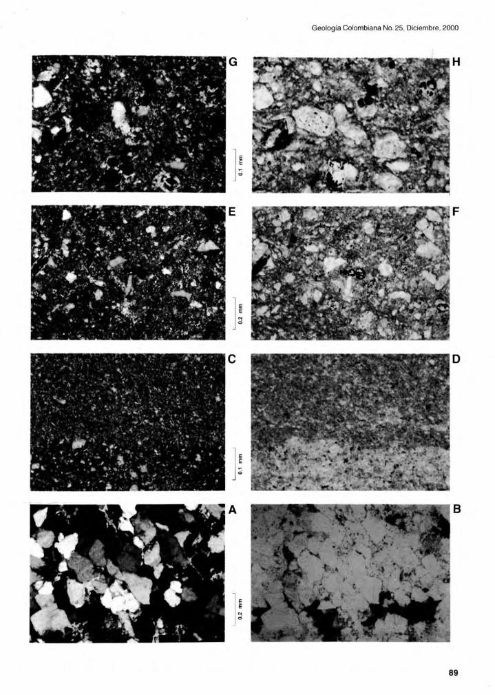
Geología Colombiana No. 25, Diciembre, 2000
G H
] ~ E F
]:
o
A 8
]:
89

Guerrero el al.: The Stratigraphy 01 the W Side 01 the Cretaceous Colombian Basin .
W flank of the Guaduas Syncline, the dark shales overlying the "cimarrona limestone" included Spirop/ectammina semicomp/anata, Massi/ina texanensis, and Eponides bolli. Based on the fossil content and probably in its stratigraphic position , BÜRGL also included these strata in the Late Maastrichtian.
Regarding the palynology of the Seca Formation from the Guaduas Syncline, several forms are reported from field and well sections. They include the dinoflagellates Anda/usiella gabonensis and Dinogymnium acuminatum, along with the pollen and spores Annutriporites iversenii, Buttimia andreevii, C/avatri/ete mutisi, C%mbipollis tropicalis , Crussafontites grandiosus , Echitriporites triangu/iformis , Proxapertites humbertoides, Psi/amonoco/pites ciscudae, Psi/amonoco/pites medius, Psi/atrico/pites rubini , Psi/atri/etes guaduensis , Retitrico/pites c%mbiae, Spinizonoco/pites bacu/atus, Spinizonoco/pites echinatus, Synco/porites margina tus, Tetradites umirensis, and U/moideipites kreempii. Similar palynological associations have been reported from the Late Maastrichtian of other localities, including Venezuela (MULLER et al. 1987), the Eastern Cordillera (SARMIENTO 1992), and the Llanos Foothills (SARMIENTO & GUERRERO 2000) .
SEDIMENTARY ENVIRONMENTS
The Cretaceous sedimentation of the area occupied today by the UMV began during the Early Aptian , and perhaps during the Barremian, as indicated by the 300 m thick succession of strata of the Yaví Formation underlying the oldest known Early Aptian date from the Aipe Section .
Deposition and preservation of sediments was only possible when a transgressive system established due to the initiation of tectonic subsidence, or due to high eustatic sea levels during the Barremian and Aptian , or perhaps due to a combination of both allocyclic variables. Prior to that, this area dominated by exposures of the Late Triassic to Early Jurassic volcaniclastic rocks of the Saldaña Formation, was subjected lo erosion and acted as source area of Early Cretaceous strata deposited on the E, toward the depocenter of the basin .
Sedimentation with an onlaping pattern toward the W was initiated in a continental environment of braided streams, in several alluvial fans fed by the Central Cordillera metamorphic/volcanic arc. The lowermost part of the Aipe Section is dominated by pebble and cobble conglomerates, which present an allocyclic large-scale fining-up-
90
ward retrogradational pattern toward conglomeratic sandstone and sandstones in the upper part of the unit, where also multicolored and reddish mudstone is interlayered. These fluvial deposits are considered to represent the transgressive transition from alluvial fans to braided and finally to meandering fluvial systems. The meandering river system from the upper part of the section includes the reddish and multicolored mudstones that differentiate the unit from the overlying Caballos Formation . These reddish mudstones are interlayered with sandstones in autocyclic fining-upward couplets up to 6 m thick (point bar deposits), which repeat several times in a total thickness of approximately 50 m in the uppermost part of the formation.
The thickness ratio of all the strata deposited in braided river systems versus the ones deposited by meander river systems might be variable between locations. However,
PLATE 12. Field photographs of stratigraphic sections. Cardona Creek (A) and Talora Creek (B-H). Piedras area.
A: Lomagorda Formation. Level of very large calcareous concretions. Approximately 10m below the top of the unit.
B: El Cobre Formation. Thin to medium bedded phosphatic, sandy biosparites. Level 7-C.
C: Lidita Superior Formation. Thin bedded biomicrites and cherts. Part of the interval between levels S-C and S-E.
D: La Tabla Formation. Cross-bedded, fine grained, fossiliferous sandstones. Approximately 5 m below level 10-D.
E: La Tabla Formation. Plan view of sandy biosparite with abundant bivalve shells up to 6 cm in diameter. Approximately 2 m below level 10-E.
F: La Tabla Formation. Plan view of medium to very coarse grained conglomeratic sandstone, and conglomerate of fine to medium pebbles. Level 10-F.
G: La Tabla Formation. Medium to very coarse grained conglomeratic sandstone, and conglomerate of fine to medium pebbles, including oxidized intraclasts. Approximately 1 m below the top of the unit.
H: Seca Formation. Interval of laminated and very thin bedded, fine grained, muddy sandstones and sandy mudstones. About S m aboye the base of the unit.

Geología Colombiana No. 25, Diciembre, 2000
G H
E F
e D
A 8
91

Guerrero et al.: The Stratigraphy 01 the W Side 01 the Cretaceous Colombian Basin.
the allocyclic large-scale fining-upward trend of the Yaví Formation (from a braided to a meandering system) is present in all the sections known to uso
The Lower Sandstone Member of the Caballos Formation includes coastal plain and shoreface environments, still representing a transgressive system that continued during the early Late Aptian . The predominantly lithic arenites of this member contain some fossil leaves and wood, benthic foraminifers, and marine molluscs. Coastal plain environments include interbeddings of sandstones and grey to black mudstones with fossil leaves, deposited by a channel - flood plain system of coastal low-energy meandering and anastomosed streams, along with a backshore dune complex ponds and lagoons. Stratification in the shoreface sandstones includes cross bedding, ripples, wavy lamination, and planar bedding, as a result of the fair-weather wave action. The upper part of the member exhibits a retrogradational pattern evidenced by a large-scale fining-upward facies succession that close to the top includes very fine and muddy sandstones.
The Midd le Mudstone/Biomicrite Member of the Caballos Formation was deposited in offshore marine environments at water depths of more than about 15 meters. Dark grey to black colored fine grained sediments were deposited below the direct influence of the fairweather wave action , so that bioturbated strata and planar bedding are the most common sedimentary structures. Planktic foraminifers are common, and the oldest ammonites of the section are present in this middle member. The transgressive system initiated at the base of the Yaví Formation reached its highest sea level within the middle member of the Caballos Formation , during the Late Aptian. These relatively high sea levels were maintained during so me time, depositing an early aggradational highstand system.
The Upper Sandstone Member of the Caballos Formation was deposited in shoreface and coastal plain environments, representing a relative sea level fal!. Stratification in the shoreface sandstones also includes cross bedding, ripples, wavy lamination , and planar bedding, as a result of the fair-weather wave action. Fossils of marine molluscs are common in several levels, so that fossiliferous sandstones, sandy biosparites and biosparites confirm the marine nature of this part of the section . The lower contact of the member is very abrupt in some localities, because of its erosive nature on the underlying mudstones and biomicrites. In the sections known to us, there is an early lowstand progradational pattern represented by a large-scale coarsening-upward facies succession, due to successively lower sea levels. Maximum grain size within
92
the sandstone range is reached in the upper part of the member, where a short interval of an aggradational lowstand pattern is present. The base of the member is considered as a sequence boundary, representing the highest velocity of sea level fall , at the inflection point of a sea level curve. This relatively abrupt sea level fall is considered to be synchronous in the whole basin, corre lates with the base of the Une Formation on the E border of the basin, and has an age very close to the Aptian/Albian boundary.
The dark grey to black biomicrites and marlstones of the 200 m thick Tetuán Formation were deposited in shallow offshore to deep ramp marine environments. Foraminifers and Ammonites are very common through the formation, which represents a succession of transgressive and highstand system tracts of late Early, Middle and Late Albian age. The base of this marine transgression is indicated by a sharp granulometric contrast including several beds of sideritized strata that weather to iron oxides with a deep red coloration. This siderite carbonates are present in an interval of 5 to 10m, which includes fossiliferous sandstones and sandy biosparites assigned to the top of the Caballos Formation, and fossiliferous mudstones, biomicrites, and glauconitic pelmicrites assigned to the lowermost part of the Tetuán Formation. The beds of this 10m thick interval are so enriched in iron, that are mined in localities such as the Chicuambe Anticline near Ortega. The lower part of the Tetuán Formation includes bioturbated strata, deposited at marine depths between 15 and 100 m, which supported the existence of abundant benthic organisms such as foraminifers and bivalves. As depth increased to about 200 m in the middle and upper parts of the formation , laminated bedding is a more common feature. Storm events are recorded by medium to thin beds of packstone bio-, pel- , and intra- micrites, that are thicker and more frequent in the lower part of the formation, in contrast with the less frequent and thinner beds toward the middle part of the formation deposited in deeper environments.
The Hondita Formation was deposited in offshore and shoreface environments. It represents a relative sea level fall , as indicated by a large-scale coarsening-upward progradational pattern , which ends in deposition of shoreface sandstones. The upper part of the formation includes an aggradational lowstand pattern indicated by the presence of an interval with a lithology composed predominantly by sandstone. The terrigenous mudstones of the lower part of the unit are interpreted as the result of sedimentation in shallow offshore environments, at depths of no more than about 100 meters. The change from the carbonate sedimentation of the underlying Tetuán Forma-

tion , to the predominantly terrigenous mudstones and sandstones 01 the Hondita Formation is interpreted as the result 01 an eustatic sea level lall , accompanied 01 an increase in the rate 01 sedimentation. Sea level lall is very gradual, probably because 01 attenuation due to continuous subsidence. The inflection point representing the highest velocity 01 sea level drop should coincide with the change in sedimentation rate that diminished the relative amount 01 calcareous particles in relation to terrigenous particles. This change in sedimentation pattern at the base 01 the Hondita Formation is considered as a sequence boundary 01 an age close to the Albian/Cenomanian boundary, synchronous with the base 01 the Upper Sandstone Member of the Une Formation in the E border 01 the basin.
The lower part of the Lomagorda Formation coincides with a transgressive system of Turonian age, exhibiting a retrogradational pattern due to increase 01 relative sea leve!. Sedimentation again returned to offshore marine environments, but this time in a shallow carbonate ramp, as indicated by the packstone biomicrites with an enormous amount of planktic and benthic foraminifers, along with abundant phosphatic lish remains, and the sporadic presence of coal micro-Iragments including leaves and other plant remains. Bivalves are abundant in parts of the section , where bioturbated strata are common. Depths probably reached no more than about 100 meters in highly productive marine environments. The greenish and palegrey colored bentonite beds in the lower part of the formation are the result of the relatively fast accumulation of volcanic ash produced during contemporaneous volcanism of the early Central Cordillera Volcanic Are. Apparently, the ash was enriched in silica, or at least had a geochemistry that favored the silicification of strata next to it. Because of that, in many areas there are "Iiditas" or silicified biomicrites in Turonian units, including the upper part of the La Frontera Formation in the W border of the Eastern Cordillera. During the Coniacian and earliest Santonian, sedimentary environments remained approximately the same, as indicated by the continuous predominance of packstone biomicrite. The only apparent difference in thfl upper part 01 the Lomagorda Formation is that the sedimentation of ash beds diminished almost completely.
The laminated foraminiferal biomicrites of wackestone texture of the Lidita Inferior Formation were deposited during the Santonian in relatively deep marine waters 01 a carbonate rampo Depths were of more than 100 m, but probably no more than 200-250 m. Benthic organisms were scarce, so that the absence of bioturbation allowed the preservation of a fine lamination. The interlayered lami-
Geología Colombiana No. 25, Diciembre, 2000
nae and very thin to medium beds of micrites with phosphatized foraminifers, fish remains, and intraclasts, are interpreted as the sedimentation of removed intrabasinal particles during sporadic storm events. Some of them exhibit graded bedding, but they are not interpreted as turbidite flows because 01 their sporadic nature in the section . Since there are very little cherts, and they are the result of d iagenetic replacement of biomicrite , paleoceanographic hypothesis of biogenic cherts invoking migration of South America to the NW into equatorial areas 01 upwelling (VILLAMIL et al. 1999), have little basis. As will be discussed below, the W side of the Cretaceous carbonate ramp had as continuous source area the ancestral Central Cordillera Volcanic Are, so that it is difficult to envision an open connection toward the W with the Pacific Ocean.
The fossiliferous arenites and sandy biosparites of the El Cobre Formation were deposited in a shorelace environment. They do represent a relative sea level lall , which started during the latest Santonian and had its maximum expression during the Early Campanian . The base 01 the El Cobre Formation is considered as a sequence boundary of an age very close to the Santonian/Campanian boundary, where a fastest velocity of sea level fall is placed, in the inflection point. The transition from the laminated biomicrites of the Lidita Inferior Formation to the matrixfree, very fine grain biosparites and sandstones of the El Cobre Formation is relatively last, as indicated by a thin interval of less than 5 m of fossiliferous mudstones and shales in some sections. The lowermost part 01 the lormation exhibits an early-Iowstand progradational pattern, while the upper part exhibits a late-Iowstand aggradational pattern.
The Lidita Superior Formation represents a succession 01 transgressive and highstand systems deposited during the Late Campanian. Lithology is again dominated by finely laminated foraminiferal biomicrites of wackestone texture, indicating sedimentary environments on a deep carbonate ramp, such as the ones exhibited by the Lidita Inferior Formation. The difference is that the Lidita Superior Formation represents a much longer period of deep marine sedimentation. The deepest environments of deposition are located in the middle of the unit, where neither bioturbation nor high-energy sedimentary events were present. These very finely laminated beds represent steady sedimentation below the storm wave and current action, probably at 200 to 250 m during times 01 maximum flooding. The lower and upper part of the unit include phosphatized beds which are thicker and of coarser grain toward the lowermost and uppermost parts of the formation, in a very symmetric manner. The thicker the phos-
93

Guerrero et al.: The Stratigraphy 01 the W Side 01 the Cretaceous Colombian Basin.
phatic beds are, the more proximity to shallower environments can be interpreted. Proximal storm beds will be thicker and of coarser grain size than the distal ones. Because of that, the unit is interpreted as containing a very clear transgressive pattern, a maximum flooding surface, an early-highstand aggradational pattern , and a latehighstand progradational pattern .
The Early Maastrichtian Buscavida and La Tabla Formations include a gradual succession of shallow ramp to shoreface marine environments. A sequence boundary is placed at the base of the Buscavida Formation, where the highest velocity in sea level is interpreted, at the inflection point oi a sea level curve. The succession of facies includes an early-Iowstand progradational pattern in the Buscavida and La Tabla Formations, and a thin interval with a late-Iowstand aggradational pattern toward the upper part of the La Tabla Formation . Sea levellowered in a gradual way, as indicated by the very gradual coarsening upwards, from very fine grained muddy biomicrites and fossiliferous mudstones, to very coarse grained matrixfree fossiliferous sandstones and sandy biosparites. The aggradational part of the succession in the upper part of the La Tabla Formation includes upper shoreface and backshore dune environments. The granule to pebble conglomerates and conglomeratic sandstones interbeded with sporadic coaly mudstones in the uppermost part of some sections of the La Tabla Formation , are interpreted as deposited in coastal plain and delta plain environments.
Marine shoreface conditions of deposition are interpreted to cease in the uppermost part of the La Tabla Formation, where strata are free of calcite cement and fossils of foraminifers and marine molluscs disappear. In this part of the section, abrupt lateral changes in lithology at the outcrop level indicate the interaction of several adjacent sedimentary environments capable to deposit a wide range in granulometries, from claystones to conglomerates.
The Late Maastrichtian grey colo red terrigenous mudstones, interbeded with coal beds and fossiliferous glauconitic sandstones of the Seca Formation are interpreted as the result of flooding over the previous coastal plain deposits. Sedimentary environments then evolved to lagoons, interdistributary bays, and shoreface to shallow offshore. Foraminifers appear again in the section, but in low numbers, so that the terrigenous particles clearly predominate over the calcareous ones. Coals were deposited in highly vegetated areas, with very little or no terrigenous input. Mudstones and siltstones correspond to lagoonal and flood plain environments. The fossiliferous cross-bedded glauconitic sandstones were deposited in a shoreface environment. Muddy sandstones associated in coarsening upward successions that end up in shoreface
94
sandstones were deposited in shallow offshore environ
ments. The Seca Formation in the W side of the basin includes a transgressive and an early-highstand aggradational pattern, which correlates with the lower part of the Guaduas Formation in the E side of the basin.
GEOMETRV OF THE BASIN, SOURCE AREA, ANO PALEOGEOGRAPHV
The diminishing of thickness toward the ESE of the coarse sediments of the La Tabla Formation and its approximately constant thickness in NNE direction indicates that the source area was located to the W, in the ancestral Central Cordillera. It also indicates that the coastline was approximately parallel to this mountain range. The hypothesis of the source area in a metamorphic-volcanic arc is confirmed by the regional distribution of coarser grain size to the W and by the abundance of metamorphic and volcanic rock fragments and feldspars along all the studied sections. AII the studied Aptian to Maastrichtian strata of the UMV, including the Vaví, Caballos, Tetuán, Horidita, Lomagorda, Lidita Inferior, El Cobre, Lidita Superior, Buscavida, and Seca Formations, have source area in a volcanic-metamorphic arc to the West. This regional distribution is better appreciated in the units of relatively coarser grain size. For example, the sections of the La Tabla Formation from the Guaduas-Honda highway, are clearly thicker and of coarser grain size than those of the E si de of the Guaduas Syncline.
The idea of a back-arc, or a northerly elongated basin for several intervals of the Cretaceous of Colombia has been formulated by several authors (e.g. BURGL 1961 ; ETAYO et al. 1976; COOPER et al. 1995; VILLAMIL 1998). Recently, LUNDBERG et al. (1998) discussed again the geometry of the basin, indicating that the quartzarenites of the E side had as source area the Guyana Shield , while the litharenites of the W side had as source area the ancestral Central Cordillera. The basin was controlled by normal faults of approximate direction N20E, that from the Late Paleocene were inverted by tectonic compression, to finally lift the Eastern Cordillera during the Middle and Late Miocene. The axis of the Cretaceous Basin seems to have
been located in the W flank of the Eastern Cordillera, E of the Bituima Fault.
According to LUNDBERG et al. (1998: p. 23), "since th~ earliest Cretaceous, the west border of northern South America in Colombia was a magmatic arc - the early Central Cordillera -, with a back-arc basin to the east and forearc basin on the west" ... "Cretaceous deposits onlap continentalcrust on both sides of a northerly elongated sea-

Geología Colombiana No. 25, Diciembre, 2000
NORTH CONNECTION WITH PROTo- CARIB8EAN
N
~ /
/ /
/
/
o 100 200 km
Fig. 5. Paleogeography of the Cretaceous Colombia n Basin. Shoreline migration toward the Guyana Shield on the E and the Central Cordillera on the W, during high sea levels (Berriasian and Valanginian, Barremian and Aptian, Middle and Late Albian, Turonian to Santonian, and Late Campanian). Shoreline migration toward the axis of the basin during low sea levels (Hauterivian, Early Albian, Cenomanian, Early Campanian, and Early Maastrichtian ).
95

Guerrero et al.: The Stratigraphy 01 the W Side 01 the Cretaceous Colombian Basin.
way. Thinning of the continental crust was accompanied by high angle normal faulting and subsidence. The depocenter of the basin had an axis parallel to the magmatic.arc, and was located along the present Eastern Cordillera" ... "drainage was directed from the east and west into the axis which finally connected north to the protoCaribbean".
The paleogeography and source area of the E side of the basin were documented by FABRE (1985), who indicated that the petrography of the Cretaceous succession was dominated by quartz arenites. Compositionally and texturally, the sandstones and conglomerates are mature to supermature as a result of several cycles of sedimentation . Monocrystalline quartz percentages of the sandstones are around 99%; feldspars, polycrystaJline metamorphic quartz, and other rock fragments, only reach 1 %. Detritus provenance was mainly from pre-Cambrian and Paleozoic sedimentary units located to the E, on the Guyana Shield . Fabre also indicated the thickening of coarse-grained units toward the E boundary of the basin and their tectonic control during sedimentation by normal faulting and thermal subsidence.
VILLAMIL (1999) and VILLAMIL et al. (1999) also indicated the existence of a northerly-elongated seaway during the Campanian and Maastrichtian, with source areas on the W (the Central Cordillera) and in the E (The Guyana Shield). VILLAMIL (1999) proposed that the axis of the basin migrated toward the E from the Campanian to the Miocene as a result of gradual uplift of the Central Cordillera, but we do not see any hard evidence of the migration of the axis during the Campanian and Maastrichtian. Instead, we view the evolution of the sedimentary environments of the entire Cretaceous, as evidence of eustatic sea level changes that produced onlap and downlap of shoreline deposited strata. When relative sea level rise occurred, the shoreline on the W side of the basin migrated toward the W. On the contrary situation during times of sea level fa 11 , the shoreline migrated toward the E, diminishing the width of the marine corridor.
Most of the studied Cretaceous section in the UMV was deposited in marine environments, except for the Yaví Formation and the uppermost part of the La Tabla Formation in proximal W locations. Sedimentary environments range from calcareous/terrigenous shoreface to offshore and deep rampo Neither turbidites nor slump deposits are present that could indicate the presence of a continental slope and a shelf break. Because of the low terrigenous input from the W (a narrow volcanic-metamorphic arc), calcareous detritus are present in shoreface environments, but dominate the section deposited in the oftshore and
96
deep ramp environments.
There are neither reefs nor calcareous mounds that could be documented in any of the sections, beca use there are no rocks that could be related to these environments. They would be the biolithites of FOLK (1959, 1962), the boundstones of DUNHAM (1962) , or the bafflestones, bindstones and framestones of EMBRY AND KLOVAN (1971).
We believe that the marine ramp had a gentle inclination of less than 0.1 ° toward the E, because of the distribution of grain size in this part of the basin. The top of the La Tabla Formation toward the W includes fluvial and coastal plain environments, which connect to the E with lower shoreface environments. With a ramp inclined 0.1 °, approximately 8 km would be the horizontal distance necessary from the shoreline, to reach a depth of 14 m in the transition from the lower shoreface sands to the offshore muds. It would be a gradient of about 1 in 570 m or 1 in 1000 m if inclination was about 0.057° and horizontal distance about 14 km. This is a very important consideration to evaluate the paleogeography of the area. When the upper part of the La Tabla Formation in the E side of the Guaduas Syncline was being deposited in a lower shoreface environment, the shoreline was located to the W, at a maximum distance of about 8-14 km. In other words, the sandstones deposited in shoreface environments, should have been no more than approximately 14 km in horizontal width.
The La Tabla Formation wedge extends approximately 14 km (after tectonic restoration) from the Cambrás Fault, where it has its maximum known thickness, to the Bituima Fault, where reaches a minimum thickness of about 5-10 meters. Then, it would be reasonable to believe that the shoreline was located near the Cambrás Fault, during the time of deposition of the uppermost part of the La Tabla Formation. During the approximately 2 Ma that too k the deposition of the 80 m of strata included in the La Tabla Formation , the shoreline was migrating from the W toward the Cambrás Fault, just before the deposition of the Seca Formation started. The same type of sedimentological , stratigraphic and paleogeographic analysis can be applied to the other lowstand sandstones of the W side of the basin, including the Upper Sandstone Member of the Caballos Formation, the Hondita Formation, and the El Cobre Formation. These units are of coarser grain size and greater thickness toward the W, and their progradational trends are the result of sea level falls and gradual migration of the shoreline toward the E.
Intermediate units such as the Middle Member of the Caballos Formation and the Tetuán, Lomagorda, Lidita
Inferior, and Lidita Superior Formations represent times of transgression and high sea levels, during which the shoreline migrated toward the west. When maximum marine depths in the basin reached 200 m, the distance from the shoreline to the depocenter was approximately 200 km, with a ramp inelination of 0.057°. Then, the whole width of the basin would have been 400 to 500 km at times when depths reached 200 to 250 m during the Santonian and Late Campanian.
The most important evidence to disregard the possible tectonic control on the migration of the axis of the basin during the Cretaceous, is the fact that sea level changes are synchronous in the entire basin (see GUERRERO & SARMIENTO 1996; VERGARA 1997; VILLAMIL 1998). Eustatic sea level falls that can be documented in Colombia left several sequence boundaries including the Aptian/Albian boundary (base of the Upper Sandstone Member of the Caballos Formation), the Albian/Cenomanian boundary (base of the Hondita Formation), the Santonian/ Campanian boundary (base of the El Cobre Formation), and the Campanian/Maastrichtian boundary (base of the Buscavida Formation).
A very important difference with previous interpretations that regarded the area of the present Central Cordillera as flooded during most of the Cretaceolls, is that in our interpretation the ancestral Central Cordillera is exposed during the entire Cretaceous, and was the permanent metamorphic-volcanic source area on the W side of a back-arc basin.
The new term CRETACEOUS COLOMBIAN BASIN is proposed to make emphasis in the concept of a single and elongated basin opening to the N, instead of the cur
rent artificial concept of several basins, like the "Upper Magdalena Basin", the "Middle Magdalena Basin", the "Llanos Basin", and so on. The different types of strata de
posited late rally adjacent, during a short span of time can be more easily correlated when a single basin is consid
ered, instead of several basins separated by imaginary barriers, with apparently different tectonic controls, that
have never been documented.
The Cretaceous Colombian Basin also connected S to other back-arc and foreland basins located E of the
early volcanic arc, in Ecuador, Peru, Bolivia, Chile, and
Argentina (see LUNDBERG et al. 1998).
SEQUENCE STRATIGRAPHY ANO ALLOSTRATIGRAPHIC UNITS
Geología Colombiana No. 25, Diciembre, 2000
An analysis of sequence stratigraphy useful in lithological correlation and with potential of prediction of lithologies and stratal geometries, must have a strong sedimentological and biostratigraphical support. The sedimentological analysis must sustain major abrupt changes as well as gradual changes of sea level. The biostratigraphy constitutes the essential support to demonstrate that the limiting surfaces of the systems (1 : The unconformity of the sequence boundary. 2: The first major transgressive surface and 3: The maximum flooding surface) are synchronous. It is also essential to prove that the systems (1: Lowstand Systems Tract, LST or Shelf Margin Systems Tract, SMST. 2: Transgressive Systems Tract, TST, and 3: Highstand Systems Tract, HST) have the same age in the whole basin, and potentially in the whole planet.
In such a way, the only form in which an operational framework of sequence stratigraphy is consolidated is in the extent that it is demonstrated that the same discontinuity surfaces are found in the whole basin , and that they have the same age. The sequence stratigraphy framework documented by GUERRERO & SARMIENTO (1996: fig . 9) for the Cretaceous of the Eastern Cordillera and correlations with the Catatumbo, Llanos Foothills, and Upper Magdalena Valley areas, has not been challenged. Subsequent papers (VERGARA & RODRIGUEZ 1997; VERGARA 1997; LUNOBERG et a/1998; VILLAMIL 1998) have in general agreed, in finding the same ages for the proposed sequences. These sequences are the SK5 (Cenomanian to Santonian), SK6 (Campanian) and SK7 (Maastrichtian) .
In the present study (Table 6) , we have found the upper part (TST and HST) of the SK3 Sequence which ineludes the Yaví Formation, the Lower Sandstone Member
and the Middle Mudstone/Biomicrite Member of the Caballos Formation. The SK4 Sequence includes the Upper Sandstone Member of the Caballos Formation and the Tetuán Formation. Tile SK5 Sequence ineludes the
Hondita, Lomagorda, and Lidita Inferior Formations) , the SK6 Sequence ineludes the El Cobre and Lidita Superior Formations, and the SK7 Sequence includes the
Buscavida, La Tabla, and lower part of the Seca Formations. The biostratigraphic correlation of the units demonstrates that the boundaries proposed by GUERRERO &
SARMIENTO (1996) are synchronous in both (E and W) sides of the basin. Especially, it is emphasized as of great value
the combined age definition obtained with foraminifers, palynomorphs, and ammonites.
The stratigraphy of the Cretaceous Colombian Basin is more easily understood with a scheme of
allostratigraphic units that laterally include several contemporaneous lithostratigraphic units. A division of the strati-
97

Guerrero et al.: The Stratigraphy 01 the W Side 01 the Cretaceous Colombian Basin .
graphy of a basin, based on allostratigraphic units vertically separated by discontinuities, has the advantage of providing a more precise correlation and predicts changes in lithology or geometry of strata. In such a way, the identification of the bounding discontinuities is more important than the identification of the vertical lithological boundaries, although in many cases they do coincide.
In order to provide a sequence stratigraphy framework for the whole basin, several allostratigraphic units are formally proposed (Table 6) in addition to the ones proposed by GUERRERO & SARMIENTO (1996). The new allostratigraphic units include the Fómeque Alloformation , the Une Alloformation (composed of the Lower, Middle, and Upper Une Allomembers) , the Chipaque Alloformation , and the Guaduas Alloformation . The type localities of these new units are the same ones of the corresponding lithostratigraphic units on the E side of the Eastern Cordillera, near Bogotá. Each one of these allostratigraphic units ineludes laterally several lithostratigraphic units as a result of the lateral changes of sedimentary environments toward the axis of the basin , and consequently correspond to system tracts.
The TST and HST of Sequence SK3 are ineluded in the Fómeque Alloformation, of Barremian and Aptian age. The base of the TST of Sequence SK3 has an age close to the Hauterivian/Barremian boundary, and ineludes very fine-grained sediments on the centre of the basin (Trincheras, Paja, and Fómeque Formations) and coarse grained sediments toward the borders of the basin. The Fómeque Alloformation ineludes on the W boundary of the basin the transgressive deposits of the Yaví Formation and the Lower and Middle Members of the Caballos Formation. The coarse grained proximal deposits on the E boundary of the basin have not been studied in detail , but they could be represented by the conglomerates of the upper part of the "río ele farmation".
The LST of Sequence SK4 is included in the Lower Une Allomember of latest Aptian to early Albian age. It ineludes the coarsening-upward sandstones of the Upper Sandstone Member of the Caballos Formation on the W side of the basin, the Socotá formation toward the axis of the basin, and the Lower Sandstone Member of th9 Une Formation on the E side of the basin.
The TST and HST of Sequence SK4 are ineluded in the Middle Une Allomember of late Early, Middle and Late Albian Age. This allostratigraphic unit ineludes the Tetuán Formation on the W border of the basin, the Capotes and Hiló Formations toward the axis of the basin , and the Middle Mudstone Member of the Une Formation on the E
98
border of the basin.
The LST of Sequence SK5 is ineluded in the Upper Une Allomember of Cenomanian Age. It includes the Hondita Formation on the W border of the basin , the Limolitas de Pacho, Arenitas de Chiquinquirá and Churuvita Formations toward the axis of the basin, and the Upper Sandstone Member of the Une Formation on the E border of the basin .
The TST and HST of Sequence SK5 are ineluded in the Chipaque Alloformation of Turonian to Santonian Age. It includes the Lomagorda and Lidita Inferior Formations on the W border of the basin, the La Frontera, Conejo, and La Luna Formations toward the axis and N side of the basin, and the Chipaque Formation on the E border of the basin.
The LST of Sequence SK6 is included in the Lower Guadalupe Alloformation of Early Campanian age. It includes the El Cobre Formation on the W side of the basin and the Dura and San Antonio Formations on the E side of the basin. The time equivalent deposits of finer grain size toward the axis of the basin have been almost completely eroded because of uplift of the Eastern Cordillera. Toward the N, they would be included in the lower part of the Colón Formation.
The TST and HST of Sequence SK6 are included in the Middle Guadalupe Alloformation of Late Campanian age. It includes the Lidita Superior Formation on the W and central side of the basin , and the Plaeners and Aguacaliente Formations on the E border of the basin . We believe that on the eroded axis of the basin, pelagic sedimentation took place. Toward the N, the upper part of the Colón Formation would be included.
The LST of Sequence SK7 is ineluded in the Upper Guadalupe Alloformation of Early Maastrichtian age. Ineludes the Buscavida and La Tabla Formations on the W border of the basin, and the Labor-Tierna and San Luis Formations on the E border of the basin. Again, the timeequivalent finer grained sediments deposited in the axis of the basin were eroded during uplift of the Eastern Cordillera. Toward the N, the finer grained deposits would be ineluded in the Mito Juan Formation.
Finally, the TST of Sequence SK7 is ineluded in the lower part of the Guaduas Alloformation , of Late Maastrichtian age. Includes the lower part of the Seca Formation on the W side of the basin and the lower part of the Guaduas Formation on the E side of the basin.

TABLE 6, SEQUENCE STRATIGRAPHY ALONG WlTH THE ALLOSTRATIGRAPHIC ANO UTHOSTRATIGRAPHIC CLASSIRCAnON OF THE CRETACEOUS SUCCESSION FROM THE UMV,
LITHOLOGY LITHOSTRATIGRAPHIC UNIT THICKNESS DESCRIPTION AGE ALLOSTRATIGRAPHIC UNIT SEQUENCEISYSTEMSTRACT
LOWER PART SECA FORMATION 300- 400 m OF GLAUCONITIC SANDSTONES ANO COALS TOWARD THE LOWER PART.
LATE MAASTRICHTIAN LOWER PART GUADUAS ALLOFORMATION SK7 TST
COARSENING-UPWARD FOSSILlF LlTHARENITES LA TABLA FORMATION 5-90m ANO SANDY BIOSPARITES. CONGL SANDST ANO
PEBBLE CONGLOMERATES TOWARD THE TOP EARL Y MAASTRICHTIAN UPPER GUADALUPE ALLOFORMATlON SK7 LST
BUSCAVIDA FORMATION 9O-170m COARSENING-UPWARD BIOMICRITES ANO IMPURE EARL y MAASTRICHTIAN UPPER GUADALUPE ALLOFORMATION SK7 LST (MUDDY) BIOMICRITES OF FORAMINIFERA.
O L I LlDITA SUPERIOR FORMATION I
50 - 160 m ISCARCE THIN TO MEOIUM BE OS OFI LATE CAMPANIAN MIOOLE GUAOALUPE ALLOFORMATION SK5 TST - HST
N I
50 - 160 m IARENITES ANO SANOY BIOSPARITES OF BENTHICI G I EL COBRE FORMATION EARL y CAMPANIAN LOWER GUAOALUPE ALLOFORMA TION SK5 LST R O ~ I LlOITA INFERIOR FORMATION 30- 70 m SCARCE THIN TO MEDIUM BEOS OF SANTONIAN CHIPAQUE ALLOFORMATION SK5 TST - HST
PHOSPHATIZEO BIO-ANO INTRA-MICRITES.
LOMAGORDA FORMATION 170 - 240 m BIOMICRITES ANO IMPURE ~MUOOYÁ BIOMICRITES OF FORAMINIFERA ANO SCA CE BIV LVES. TURONIAN ANO CONIACIAN CHIPAQUE ALLOFORMATION SK5 TST
I COARSENING-UPWARO MUOSTONES, SANOY
I (j) HONDITA FORMATION 200 - 250 m MUDSTONES. ANO FOSSILlFEROUS LlTHIC CENOMANIAN UPPER UNE ALLOMEMBER SK5 LST ro
o O"
<O
TETUÁN FORMATION I 150 - 20C m IFÓsSILI{ERO-US 'Muosfor:iES -ANO-iMPÚREI MIOOLE ANO LATE ALBIAN I MIODLE UNE ALLOMEMBER SK4 TST - HST 0;' () o O" 3
C F I UPPER SANOSTONE MEMBER 6O-15Om GLAÜCONiTlé v OÜÁ'i1'fz AREÑITES _. AND '-SANDY EAR L Y ALBIAN LOWER UNE ALLOMEMBER SK4 LST O' 0;'
A O BIOSPARITES OF BIVALVES. ::J
B R D> Z
A M FOSSILlFEROUS MUDSTONES, IMPURE ~MUDOY) LATE APTIAN FÓMEQUE ALLOFORMATION SK3 TST - HST 9 L A MIOOLE MUOSTIBIOMICR MEMBER 6O-15Om BIOMICRITES ANO BIOMICRITES OF FORAM NIFERS. 1\)
L T ~
01 LlTHIC, FOSSILlFERQUS AREN ITES WITH MINOR o ñ'
S O LOWER SANOSTONE MEMBER 50-150m INTERBEOOINGS OP FOSSILlFEROUS, GRAY EARL Y APTIAN FÓMEQUE ALLOFORMATION SK3 TST (iS' N MUOSTONES. 3
O' _ro
YAVi FORMATION MubsTONES. CONGLOMERATIC SANOST ANO EARL Y APTIAN FÓMEQUE ALLOFORMATION TST 1\) o
<O PEBBLE-COBBLE CONGLOM AT THE BASE. o <O o

Guerrero et al.: The Stratigraphy 01 the W Side 01 the Cretaceous Colombian Basin.
The easiest surface to identify in the field is the first major transgressive surface at the base of the TST. There is a very abrupt lithological change of the sediments deposited during the lowest sea levels (late -aggradationalLST), and the deeper marine sediments deposited during relative sea level rise (early TST). The second easiest surface to identity is the maximum flooding surface (top of the TST) and the associated overlying condensed section (early HST). The most disputed and difticult surface to identify in some parts of the basin is the sequence boundary. This is because the late HST and the early LST are both progradational (deposited during sea level fall) , so that the boundary between them is not always as evident as theory indicates it should be. Such sequence boundary is located in the inflection point of the sea level fall during highest velocities of sea level change, and should include the tastest change in sedimentary environments across sequences. It is the surface that would have the greatest possibility to be the result of erosion, and involve an unconformity.
It is very likely that the continuous and steady subsidence of the basin favored the development of notorious transgressive surfaces, transgressive system tracts, and early (aggradational) highstand system tracts, because of the additive eftect of subsidence on eustatic sea level rise. On the contrary situation, eustatic sea level fall would be attenuated by basin subsidence, with the consequence that relative sea level fall is slower and of smaller magnitude than relative sea level rise. In such an scenery, and leaving aside possible changes in the rate of sediment supply to the basin, the inflection point of the eustatic sea level fall would not be as evident as the inflection point during fastest eustatic sea level rise. Since the inflection point of the relative sea level fall is not easy to identify, some people would place a particular portion of a progradational (regressive) system in the late HST, and others in the early LST. For instance, some would erroneously include the sandstones of the Lower Guadalupe Alloformation in a HST, instead of placing them more reasonably in a LST. It should be considered the fact that they include (toward the top of the unit) the lowest sea levels reached, prior to the beginning of the Late Campanian TST. In the first case, the question to be asked is: How could the strata deposited during lowest sea level be included in a "highstand system tract" ?
It is very probable that those discussions are the result of a lack of detailed studies that could illustrate in a more clear way aggradational, progradational , and retrogradational patterns. With more information, the sequence boundaries will be more precisely located and the apparent age discrepancies between localities will be re-
100
duced. In such scenery, a lot of work remains to be done in our stratigraphy.
HYDROCARBON EXPLORATION
The two better known reservoirs in the UMV cretaceous succession include the Upper Sandstone Member of the Caballos Formation, and the La Tabla Formation. They do correspond with the units of coarser grain size in the sandstone to granule and pebble conglomerate range. Other sandstones such as the ones from the Hondita and El Cobre Formations have not been considered beca use of their very fine sandstone grain size, but could in some locations prove to be good reservoirs. Regarding source rocks, organic matter of marine origin is abundant as indicated by the enormous amount of foraminifers, especially in the Lomagorda, Lidita Inferior, Lidita Superior, and Buscavida Formations.
Primary porosity of coarse-grained units reached high values of about 30%, but calcite cementation during complex diagenesis has almost completely destroyed it. AIthough extensive carbonate and silica diagenesis has produced replacement of calcareous particles by quartz (Lidita Inferior and Lidita Superior Formations), more common is the replacement of terrigenous particles by calcite (Upper Caballos, Hondita, El Cobre, and La Tabla Formations). In such a way, porosities do not reach 2% in any of the samples studied. Present porosity is the result of fracturing of the rocks during late Andean orogeny. Because of that, the porosity of the reservoirs will present significant variations depending of their relative position to major faults and folds. Best porosities will be found in the matrix-free calcite-replaced rocks that have a more brittle behavior than the ones containing mixtures of calcareous and terrigenous mudo
Another important fact to consider is that grain size decreases toward the depocenter of the basin on the E, as a result of deeper marine environments of sedimentation. Because of that, the thickness of the coarse grainad units will also decrease toward the East. The best example of that would be the La Tabla Formation, that in the E side of the Guaduas Syncline reaches only 5-10 m of thickness, but in more proximal locations to the Early Maastrichtian shoreline on the W, it reaches 80-90 m of thickness. Wells drilled toward the E closer to the axis of the basin could eventually not find any reservoir.
Stratigraphic traps or traps with a combined structuralstratigraphic control would be more easily found toward the depocenter of the basin, in the direction of thinnlng of
coarse grained reservoir units. The La Tabla reservoir wedge in the E side of the Guaduas Syncline could be late rally sealed by minor faults that would place it against the mudstones of the lower part of the Seca Formation or the biomicrites of the Buscavida Formation.
The precise location of the axis of the basin is a very important piece of information, to predict changes in Ii
thology and in thickness of the units. Such axis has to be determined by considering provenance of sediments from the E (quartz arenite affinity) or from the W (Iithic and calcareous affinity) sides of the basin.
CONCLUSIONS
Detailed lithological characterization of strata from the UMV allowed the definition of the W border of the Cretaceous Colombian Basin. A permanent source of terrigenous detritus was placed to the W in an ancestral Central Cordillera metamorphic/volcanic arco
This Cretaceous intracratonic back-arc basin had an elongated shape parallel to the W border of the continent, opened N to the Proto- Caribbean, and connected intermittently to the S with other back-arc and foreland basins located E of the early volcanic arco The Cretaceous Colombian Basin had two main sources of detritus, one already documented in its E si de, on the Guyana Shield, and another in the W side, on the early Central Cordillera.
The terrigenous input from the W side of the basin was relatively low because it was located in a narrow mountain belt composed of a metamorphic/volcanic arco This paleogeographic situation favored the production and preservation of calcareous detritus, which mixed with the terrigenous ones in various proportions, depending on relative position to the shoreline and relative sea level on the basin. Consequently, the strata exposed today in the UMV have a mixed calcareous/litharenitic nature, including muddy/sandy biomicrites and biosparites of foraminifers and bivalves, along with very fossiliferous mudstones and sandstones. In contrast, the whole continental area of the Guyana Shield provided a much larger amount of terrigenous particles in the opposite E si de of the basin , so that limestones are scarce. The strata derived from Precambrian and Paleozoic sedimentary rocks of the Guyana Shield have a more mature composition. Quartz arenites and terrigenous mudstones dominate the succession 10-cated today in the E border of the Eastern Cordillera.
The Cretaceous Succession of the UMV is divided in the Yaví, Caballos, Tetuán, Hondita, Lomagorda, Lidita
Geología Colombiana No. 25, Diciembre, 2000
Inferior, El Cobre, Lidita Superior, Buscavida, La Tabla, and Seca Formations. These lithostratigraphic units reflect sea level changes and correspond to lowstand, transgressive and highstand systems, which in turn can be included in formal allostratigraphic units recognized in the entire basin.
In the W part of the basin, we have found the upper part (TST and HST) of the SK3 Sequence (F6meque Alloformation) which includes the Yaví Formation, the Lower Sandstone Member and the Middle Mudstone/ Biomicrite Member of the Caballos Formation. The SK4 Sequence (Lower and Middle Allomembers of the Une Alloformation) includes the Upper Sandstone Member of the Caballos Formation and the Tetuán Formation. The SK5 Sequence (Upper Une Allomember and Chipaque Alloformation) includes the Hondita, Lomagorda, and Lidita Inferior Formations. The SK6 Sequence (Lower and Middle Guadalupe Alloformations) includes the El Cobre and Lidita Superior Formations. The SK7 Sequence (Upper Guadalupe Alloformation and Lower Allomember of the Guaduas Alloformation) includes the Buscavida, La Tabla, and Seca Formations.
Sequence boundaries are placed where the fastest velocity of sea level fall can be documented with the most abrupt change of facies from deeper to shallower marine environments. These include the base of the Upper Sandstone Member of the Caballos Formation, the base of the Hondita Formation, the base of the El Cobre Formation, and the base of the Buscavida Formation.
The top of lowstand systems is placad in the top of progradational to aggradational coarsening-upward successions, just where the coarsest grained lithology is reached and maintained in a given interval, so that the lowest sea levels can be documented. Good examples are the top of the Uppcr Sandstone Member of the Caballos Formation, the top of the Hondita Formation, the top of the El Cobre Formation, and the top of the La Tabla Formation.
The base of transgressive systems is placed where abrupt changes in lithology indicate deepening of the basin; good examples are the lower parts of the Tetuán, Lomagorda, Lidita Superior, and Seca Formations.
The ages of these sequences are the same across the whole basin, reflecting eustatic sea level changes, or at least synchronous variations in the entire basin. The patterns of retrogradation, progradation and aggradation coincide in age, with only minimum displacements due to the interaction of the other variables, including differential
101

Guerrero et al.: The Stratigraphy 01 the W Side 01 the Cretaceous Colombian Basin.
subsidence and rate of production of detritus in the source areas.
Because of that, the hydrocarbon reservoir units have the same age in both, E and W borders of the basin . Coarse-grained units are thicker toward the borders of the basin and thinner toward its axis, which is located today in the W flank of the Eastern Cordillera. The axis of the basin apparently had a fixed position during the entire Cretaceous, so that lateral migration of the shoreline is attributed mainly to eustatic sea level changes.
ACKNOWLEDGMENTS
A large amount 01 inlormation and samples were obtained during the lield practices 01 the courses 01 Sedimentology and Stratigraphy, taught by JG at the Universidad Nacional de Colombia, during the second term 01 1999 and the two terms 01 2000. Special thanks go to those students who were very enthusiastic in the lield and in the Laboratory 01 Sedimentary Petrography at the Geoscience Departmen\.
Thin sections were prepared in the laboratories 01 the Department by Mr. Armando Sánchez and Mr. Miguel Angel Bernal. Photographs 01 thin sections were also taken at the Geoscience Departmen\. The photographs 01 loraminilers were taken using the Scanning Electron Microscope 01 the Physics Department, thanks to the authorization 01 Prolessor Alvaro Mariño and very kind and helplul assistance 01 Prolessor Germán Arenas.
Fossils 01 loraminilers were prepared in the Laboratories 01 Paleosedes Ltda. Palynomorphs and some thin sections were prepared in ¡he Laboratories 01 Geochron Ltda.
Special thanks go also to anonymous reviewers, who helped to improve the tex!. Dr. Richard Madden Irom Duke University in the United States kindly reviewed the linal manuscript.
REFERENCES
BARRIO CA, COFFIELD DQ (1992): Late Cretaceous Stratigraphy 01 the Upper Magdalena Basin ·in the Payandé-Chaparral Segment (Western Girardot Sub-Basin), Colombia. Journal 01 South Arr.'erican Earth Sciences 5(2): 123-139.
BELTRÁN N, GALLO J (1968) :The Geology 01 the Neiva Sub-Basin, Upper Magdalena Basin , Southern Portion . IX Annual Field Conlerence, Colombian Society 01 Petroleum Geologists and Geophysicists. Reprinted in p. 253-275: CSPGG Geological Field Trips Colombia, 1959-1978, Geotec, 1979, 545 p. , Bogotá.
BERMUDEZ H, MORCOTE A (1995) : Análisis estratigrálico del Grupo Olini , del Nivel de Lutitas y Arenas (S hale de Buscavida) y de la Formación Monserrate en los Alrededores del Valle de . San Juan y San Luis, Tolima. Unpublished B.S. Thesis in Geology, Departamento de Geociencias Universidad Nacional , Bogotá.
BURGL H, DUMITY (1954) : El Cretácico Superior en la Región de Girardo!. Bol. Geol. Instituto Geológico Nacional 11 (1): 23-48.
BURGL H (1957): Bioestratigrafía de la Sabana de Bogotá y sus
102
Alrededores. Bol. Geol. Servicio Geológico Nacional V/2: 117-147, Bogotá.
BURGL H (1961): Sedimentación Cíclica en el Geosinclinal Cretáceo de la Cordillera Oriental de Colombia. Bol. Geol. Servicio Geológico Nacional VII : 85-118, Bogotá.
CARON M (1985) : Cretaceous planktic loraminilera (p 17-86). In: Planktic Stratigraphy (Bolli H, Saunders JB, Perch-Nielsen K, -Eds-). Cambridge University Press.
COOPER M, ADDISON F, ALVAREZ R, CORAL M, GRAHAM R, HAYWARD A, HOWE S, MARTINEZ J, NAAR J, PEÑAS R, PULHAM A, TABORDA A (1995) : Basin Development and Tectonic History 01 the Llanos Basin, Eastern Cordillera, and Middle Magdalena Valley, Colombia. AAPG Bulletin 79(10): 1421 -1443.
CORRIGAN H (1967): The Geology 01 the Upper Magdalena Basin (Northern Portion). VIII Annual Field Conference, Colombian Society 01 Petroleum Geologists and Geophysicists. Reprinted in p. 221-251 : CSPGG Geological Field Trips Colombia, 1959-1978, Geotec, 1979, 545 p. , Bogotá.
DUNHAM RJ (1962) : Classification of carbonate rocks according to depositional texture. In: Classification of Carbonate Rocks (Ham WE -Ed-) . AAPG memoir 1: 108-121 .
EMBRY A, KLOVAN J (1971) A Late Devonian reef tract on r.ortheastern Banks Island. NorthwestTerritories. Bull. Canad. Petrol. Geol. 19: 730-781 .
ETAYO F, RENZONI G, BARRERO D (1976): Contornos Sucesivos del Mar Cretaceo en Colombia. En p. 217 -252 de: Memoria del Primer Congreso Colombiano de Geología, 438 p., Bogotá.
ETAYO F (1994): A Modo de Historia Geológica del Cretacico en el Valle Superior del Magdalena. En Capítulo XX: 1-6 (Etayo, F.) Estudios Geológicos del Valle Superior del Magdalena. Departamento de Geociencias, Universidad Nacional de Colombia, Bogotá.
ETAYO F, FLOREZ JM (1994): Estratigrafía y Estructura de la Quebrada Calambe y el Cerro El Azucar, Olaya Herrera, Tolima. En Capítulo XII : 1-23 (Etayo, F.) Estudios Geológicos del Valle Superior del Magdalena. Departamento de Geociencias, Universidad Nacional de Colombia, Bogotá.
FABRE A (1985) : Dinámica de la Sedimentación Cretácica en la Región de la Sierra Nevada del Cocuy (Cordillera Oriental de Colombia) . En Capítulo XIX: 1-20 (Etayo F, Laverde F) Proyecto Cretácico. Publicaciones Geológicas Especiales dellngeominas No. 16.
FLÓREZ M, CARRILLO G (1994) : Estratigrafía de la Sucesión Litológica Basal del Cretácico del Valle Superior del Magdalena. En Capítulo 11 : 1-26 (Etayo, F.) Estudios Geológicos del Valle Superior del Magdalena. Departamento de Geociencias, Universidad Nacional de Colombia, Bogotá.
FOLK R (1959) : Practical Petrographic Classification of Limestones. AAPG Bull . 43: 1-38.
FOLK R (1959) : Spectral Subdivision 01 Limestone Types . In: Classilication of Carbonate Rocks (ed. WE Ham) p. 62-84. AAPG Memoir 1.

FOLK R (1974) : Petrology of Sedimentary Rocks. Hemphill Publishing Company, 159 p, Texas.
GOMEZ E, PEDRAZA P (1994) : El Maastrichtiano de la Región Honda-Guaduas, Limite Norte del Valle Superior del Magdalena: Registro Sedimentario de un Delta Dominado por R íos Trenzados. En Capítulo 111: 1-19 (Etayo, F) Estudios Geológicos del Valle Superior del Magdalena. Departamento de Geociencias, Universidad Nacional de Colombia, Bogotá.
GUERRERO J, SARMIENTO G (1996): Estratigrafía física , Palinológica, Sedimentológica y Secuencial del Cretácico Superior y Paleoceno del Piedemonte Llanero. Implicaciones en Exploración Petrolera. Geología Colombiana 20: 3-66. Departamento de Geociencias, Universidad Nacional de Colombia.
HELENES J, DE GUERRA C, VASQUEZ J (1998) : Palynology and chronostratigraphy of the Upper Cretaceous in the subsurface of the Barinas Area, Western Venezuela. American Association of Petroleum Geologists Bulletin 82 (7) : 1308-1328, Tulsa.
HUBACH E (1957): Contribución a las Unidades Estratigráficas de Colombia. Informe 1212, Inst. Geol. Nal. , 166 p., Bogotá.
IBRAHIM MA (1996) : Aptian-Turonian palynology of the Ghazalat-1 Well (GTX- 1) Qattara Depression , Egypt . Review of Palaeobotany and Palynology 94: 137-168. Amsterdam.
INGRAM RL (1954) : Terminology for the thickness of stratification and parting units in sedimentary rocks. GSA Bulletin 65: 937-938.
JAMEOSSANAIE A, LlNDSLEY-GRIFFIN N (1992): Palynology and plates tectonics ' - A case study on Cretaceous terrestrial sediments in the eastern Klamath mountains of Northern California, U.SAPalynology 17: 11-45. Dalias.
JAMES NP, BOURQUE PA (1992): Reefs and Mounds (p. 323-347). In: Facies Models, Response to Sea Level Change (Eds. Walker RG, James NP). Geological Association of Canada, 409 p.
JARDINE S, MAGLOIRE L (1965): palynologie et stratigraphie du Crétacé des bassins du Sénegal et de Cote d' Ivoire. Memoir BRGM 32: 187-222. Paris.
JULlVERT M (1968): Léxico Estratigráfico Internacional , Vol. 5 América Latina, Fascículo 4a Colombia, Primera Parte. - Centre National de la Recherche Scientifique, 651 p., París.
LUNDBERG JG, MARSHALL LG, GUERRERO J, HORTON B, MALABARBA MC, WESSELlNGH F (1998) : The Stage far Neotropical Fish Diversification: A History of Tropical South American Rivers. In p. 13-48 (Malabarba LR, Reis RE, Vari ZM) Phylogeny and Classification of Neotropical Fishes. Lucena & CAS. Lucena, (eds) . Porto Alegre, Edipucrs, 603 p.
MARTINEZ JI , VERGARA LE (1999): La Sucesión Paleoambiental del Cretácico de la Región de Tequendama y Oeste de la Sabana de Bogotá, Cordillera Oriental Colombiana. Geología Colombiana 24: 107-147. Departamento de Geociencias, Universidad Nacional de Colombia, Bogotá.
MOJICA J, MACíA C (1983): Características Estratigráficas y Edad de la Formación Yaví, Mesozoico de la Región entre Prado y Dolores, Tolima, Colombia. Geología Colombiana 12: 7-32. Depto. de Geociencias, Universidad Nacional de Colombia, Bogotá.
Geología Colombiana No. 25, Diciembre, 2000
MULLER J, DI GIACOMO E, VAN ERVE AW (1987) : A palynological Zonation for the Cretaceous, Tertiary, and Quaternary of Northern South America. American Association of Stratigraphic Palynologists Foundation. Contribution Series 19: 7-76, Dalias.
NORTH AMERICAN COMISSION ON STRATIGRAPHIC NOMENCLATURE (1983) : North American Stratigraphic Codeo Am. Assoc. Peto Geol. Bullo 67: 841-875.
PEÑA J, ANNICCHARICO G (1999) : Evaluacion Regional de las Calizas de Tetuán como Potencial Reservorio de Hidrocarburos en la Sub-Cuenca de Neiva, Valle Superior del Magdalena. Unpublished B.S. Thesis in Geology, Departamento de Geociencias Universidad Nacional , Bogotá.
PETTERS V (1954) : Tertiary and Upper Cretaceous Foraminifera from Colombia, S.A. Contr.Cush.Found. Foram. Res. V/1: 37-41 .
PORTA J DE (1965): Estratigrafía del Cretácico Superior y Terciario en el extremo S del Valle Medio del Magdalena. Boletín Geológico de la UIS 19: 5-50, Bucaramanga.
PORTA J DE (1966) : La Geología del Extremo S del Valle Medio del Magdalena entre Honda y Guataquí (Colombia). Boletín Geológico de la UIS 22/23: 5-347, Bucaramanga.
RAASVELDT HC, BURGL H, VAN DER HAMMEN T (1956): Mapa Geológico de la Plancha L9 (Girardot) , Escala 1: 200.000. Servicio Geológico Nacional , Bogotá.
RAASVELDT HC, CARVAJAL JM (1957) : Mapa Geológico de la Plancha K9 (Armero) , Escala 1: 200.000. Servicio Geológico Nacional , Bogotá.
ROBASZYNSKI F, ALCAYDE G, AMEDRO F, BADILLET G, DAMOTTE R, FOUCHER JC, JARDINE S., LEGOUX O, MANIVIT H, MONCIARDINI C, SORNAY J (1982): Le Turonien de la région - type : Saumurois el Touraine . Stratigraphie , biozonations , sédimentologie . Bulletin des Centres de Recherches Exploration - Production Elf - Aquitaine 6 (1) 119-225, Pau.
RODRIGUEZ E, ULLOA C (1994) : Geología de la Plancha 189-La Palma. Memoria Resumida del Mapa Geol. de Ingeominas 1: 100.000.
SALVADOR A (1994): International Stratigraphic Guide.lnternational Union of Geological Scie!1ces (Trondheim, Norway) and Geological Society of America (Boulder, U.S.A.) , 214 p.
SARMIENTO G (1992) : Palinología de la Formación Guaduas (Estratigráfica y Sistemática). Bol. Geol. Ingeo. 32(2) : 45-126.
SARMIENTO G, GUERRERO J (2000) Palinología del Santoniano Tardío al Maastrichtiano del Piedemonte Llanero Colombiano. Correlación con el Paleocinturón Tropical. Geología Colombiana 25 : (este volumen). Departamento de Geociencias, Universidad Nacional de Colombia, Bogotá.
TCHEGLlAKOVA N (1996): Registro de la Biozonas de Foramin íferos Planctónicos Gansserina gansseri y Abathomphalus mayaroensis (Maastrichtiano Medio y Superior) en el Extremo Meridional del Valle Medio del Magdalena (Colombia, Sur América). Geología Colombiana 20: 67-80, Bogotá.
TCHEGLlAKOVA N, SARMIENTO G, GUERRERO J (1997): Bioestratigrafía y Paleoecología de los Foraminíferos Bentónicos de la Formación Chipaque y el Grupo Guadalupe. Turoniano -Maastrichtiano del Piedemonte Llanero de los Andes Colombianos. Geología Colombiana 22: 103-119, Bogotá.
103
Guerrero el al.: The Stratigraphy of the W Side of the Cretaceous Colombian Basin .
VERGARA L (1994): Stratigraphic, micropaleontologic and organic geochemical relations in the Cretaceous of the Upper Magdalena Valle, Colombia. Giessener Geologische Schriften 50, 179 p. Lens-Verlag , Giessen.
VERGARA L, PROSSL K.(1994): Dating the Yaví Formation (Aptian , Upper Magdalena Valley, Colombia) , Palynological Results. En Capítulo XVIII : 1-14 (Etayo, F.) Estudios Geológicos del Valle Superior del Magdalena. Departamento de Geociencias, Universidad Nacional de Colombia, Bogotá.
VERGARA L, GUERRERO J, PATARROYO P, SARMIENTO G (1995) : Comentarios acerca de la Nomenclatura Estratigráfica del Cretácico Inferior del Valle Superior del Magdalena. Geología Colombiana 19: 21-31 .
VERGARA L (1997): Stratigraphy, Foraminileral Assemblages and Paleoenvironments in the Late Cretaceous 01 the Upper Magadalena Valley, Colombia . (Part 1). Journal 01 South American Earth Sciences 10(2): 111 -132, Oxlord.
VERGARA L, RODRIGUEZ G (1997) : The Upper Cretaceous and Lower Paleocene 01 the Eastern Bogota Plateau and Llanos Thrustbelt, Colombia: ·Alternative Appraisal to the Nomenclature and Sequence Stratigraphy. Geología Colombiana 22: 51-79.
VILLAMIL T (1998) : Chronology, Relative Sea-Ievel History and a new Sequence Stratigraphic Model lor Basinal Cretaceous Facies of Colombia. SEPM Spec. Publ. 58: 161-216.
VILLAMIL T (1999) : Campanian - Miocene Tectonostratigraphy, Depocenter Evolution and Basin Development of Colombia and Western Venezuela. Palaeogeo. Palaeoclim. Palaeoecol. 153: 239-275.
VILLAMIL T, ARANGO C, HAY W (1999): Plate Tectonic Paleoceanographic Hypotesis lor Cretaceous Source Rocks and Cherts 01 Northern South America. GSA Esp. Paper 332: 191-202.
ZABORSKI P (1990) : The Cenomanian and Turonian (midCretaceous) ammonite biostratigraphy 01 north-eastern Nigeria. Bull. Brithish Mus. Nat. Hist. (Geology) 46: 1-18.
Manuscripl received, Seplember 2000.
APPENDIX OF MICROPALEONTOLOGY:
PLATES 1, 11, 111, IV, V, VI.
104

Geología Colombiana No. 25 , Diciembre, 2000
J
K
___ ~ __ ~ ____ F ---____ ---" G ____ •• __________ ~ H
D E
e
16 ~
B PLATE 1. Palynomorphs from the Hondita Formation. A: Appendicisporites auritus (Sample H-4). B: Oligosphaeridium sp. (Sample H-4). C: Appendicisporites auritus (Sample H-3). o: Classopollis sp. (Sample H-3). E: Dinogymnium sp. (Sample H-4). F: Appendicisporites auritus (Sample H-3). G: Raistrickia sp. (Sample H-4). H: Raistrickia sp. (Sample H-5). 1: Appendicisporites auritus (Sample H-4). J , K: Dichastopollenites sp. (Sample H-4).
105
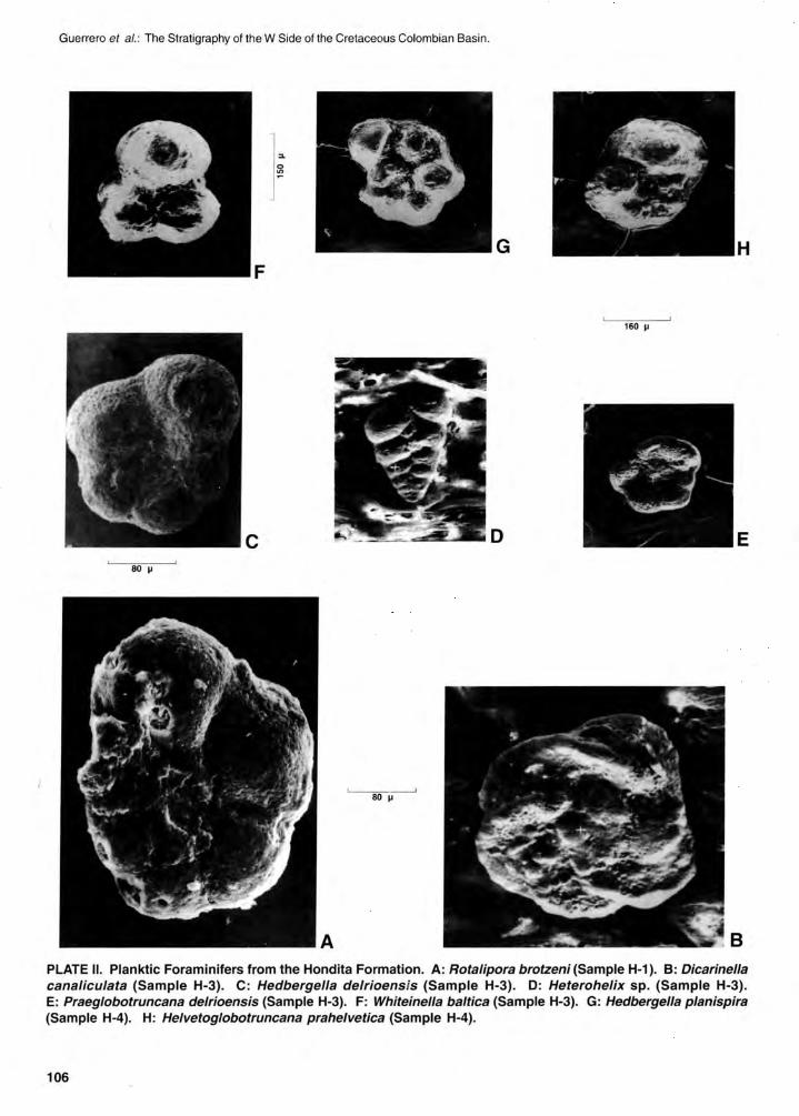
Guerrero et al.: The Stratigraphy 01 the W Side 01 the Cretaceous Colombian Basin.
G H F
160 ~
e D E 80 ~
PLATE 11. Planktic Foraminifers from the Hondita Formation. A: Rotalipora brotzeni (Sample H-1). 8: Dicarinella canaliculata (Sample H-3). C: Hedbergella delrioensis (Sample H-3). o: Heterohelix sp. (Sample H-3). E: Praeglobotruncana delrioensis (Sample H-3). F: Whiteinella baltica (Sample H-3). G: Hedbergella planispira (Sample H-4). H: Helvetoglobotruncana prahelvetica (Sample H-4).
106
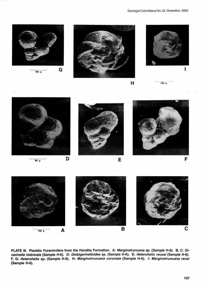
Geología Colombiana No. 25, Diciembre, 2000
160 l' G
H 160 l'
SOl' E F
B e
PLATE 111. Planktic Foraminifers from the Hondita Formation. A: Marginotruncana sp. (Sample H-6). e, C: Dicarinella imbricata (Sample H-6). D: Globigerinelloides sp. (Sample H-6). E: Heterohelix reussi (Sample H-6). F, G: Heterohelix sp. (Sample H-6). H: Marginotruncana coronata (Sample H-6). 1: Marginotruncana renzi (Sample H-6).
107

Guerrero el al. : The Stratigraphy 01 the W Side 01 the Cretaceous Colombian Basin .
H
160 ~
F 80 ~
,
80 ~ B e
PLATE IV. Planktic Foraminifers from the Hondita (A), Lomagorda (B-O) and Buscavida (E-I) Formations. A: Marginotruncana sigali (Sample H-6). B: Hedbergella simplex (Sample H-7). C: Hedbergella flandrini (Sample H-8). o: Heterohelix reussi (Sample H-8). E: Heterohelix globulosa (Sample T-12). F: Hedbergella holmdelensis (Sample T-13). G: Globotruncana wiedenmayeri (Sample T-13). H: Globotruncanella sp. (Samp!e T-13). 1: Globotruncanita subspinosa (Sample T-13).
108

Geología Colombiana No. 25, Diciembre, 2000
J
D 160 ~
A B
PLATE V. Planktic Foraminifers from the Buscavida (A, B, E) and La Tabla (C, D, F-J) Formations. A: Heterohelix navarroensis (Sample T-13). B: Pseudoguembelina palpebra (Sample T-13). C: Globotruncana arca (Sample T-15). D: Globotruncana falsostuarti (Sample T-15). E: Rugoglobigerina omata (Sample T-13). F: Globotruncana sp. (Sample T-15). G: Pseudoguembelina excolata (Sample T-15). H. Rugotruncana subcircumnodifer (Sample T-15). 1: Guembelitria cretacea (Sample T-16). J: Globigerinelloides prairiehillensis (Sample T-17).
109

Guerrero el al.: The Stratigraphy 01 the W Side 01 the Cretaceous Colombia n Basin .
160 ~
G
F
e
320 ~
A
PLATE VI. Benthic Foraminifers from the El Cobre (A), Lidita Superior (B-E), Buscavida (F) and La Tabla (G) Formations. A: Bolivinoides sp. (Sample T-3). B: Siphogenerinoides uhli (Sample T-7). C: Buliminella colonensis (Sample T-7). O: Sporobulimina perforata (Sample T-7). E: Neobulimina canadensis (Sample T-11). F: Siphogenerinoides parva (Sample T-13). G: Siphogenerinoides bramlettei (Sample T-15).
110