Embed Size (px)
Citation preview
39 Ind. C1. Comm. 383
BEFORE THE INDIAN CLAIMS COMMISSION
THE CREEK NATION, 1 )
P l a i n t i f f , 1 1
V. 1
THE UNTTJD STATES OF AMERICA, 1 1
Defendant. 1
Docket No. 169
Decided: Tebruary 1 7 , 1977
ADDITIONAL FINDINGS OF FACT
By t h e f indings of f a c t numbered 1 t o 33, inc lus ive , and t he opinion
and order entered he re in on December 14, 1970, 24 Ind. C1. Camn. 238, the
C m i s s i o n determined t h a t t h e defendant acted un fa i r ly and dishonorably
toward the Creek Nation i n re fus ing t o provide the Nation with copies of
the approved Creek r o l l s during the enrollment period, and i n not taking
reasonable precautions t o prevent erroneous enrollments (24 Ind. C1. Corn., a t
269). It was ordered t h a t t h i s case proceed t o a determination of damages,
i f any, suffered by the Creeks a s a r e s u l t of defendant 's fa i lure t o a c t
f a i r l y and honorably toward them.
On June 26 and 27, 1975, hearings were held before the Conanission,
during which p l a i n t i f f and defendant presented both documentary evidence
and exper t witness testimony on the value of the 142 separa te and non-
contiguous t r a c t s of land i n the former Creek domain i n Oklahoma, which
c o n s t i t u t e the subjec t matter of t h i s case.
The Commission makes t h e following f indings of f a c t which are supple-
mental t o those previously entered here in .
39 Ind. C1. Comm. 383 410
34. Erroneous Enrollments and Taking Date. The p a r t i e s s t ipu la ted
on June 26, 1975, tha t the lands which a r e the subject of t h i s case a r e
142 erroneous allotments of approximately 160 acres each t o t a l l i n g
22,737.21 acres and consist ing of some 212 separa te and non-contiguous
t r a c t s within the Creek Nation i n what is now east-central Oklahoma. The
pa r t i e s fu r the r s t ipu la ted t h a t the correc t valuation da te is March 4 ,
1907, the da te the Creek t r i b a l r o l l s were closed.
35. Counties and Townsites. The counties within which the subject
lands a r e located, a r e Creek, Hughes, McIntosh, Muskogee, Okfuskee,
Okmulgee, Rogers, Tulsa and Wagoner. A port ion of the subject lands a r e
located within the townsites of Broken Arrow and Sand Springs.
36. Land Classif icat ion. P r io r t o allotment, the Creek lands were
c lass i f i ed under the d i rec t ion of the Dawes Commission. (See 24 Ind. C1.
Comm. 238, Findings 12-14, a t 256-258, where the Commission described
the functions of t h e Dawes Commission.) Only the surface of the land was
examined and was graded i n 40-acre t r a c t s f o r i t s f e r t i l i t y , topography,
timber, e tc . The schedule f o r gradipg the land contained 10 c l a s s i f i c a t i o n s ,
within which were 8 fu r the r subclass i f ica t ions , beginning with the bes t
land and ending with the l e a s t desirable. Such c l a s s i f i c a t i o n was without
regard t o the land's locat ion, proximity t o markets or other factors af fec t ing
value. Class i f ica t ion began on December 1, 1900, and was completed about
April 15, 1901. In a l i t t l e over four months, 3,072,813.16 acres were
c lass i f i ed .
37. Method of Appraisal fo r Allotment Purposes. Appraisal of the
lands was made by a committee appointed by and under the d i rec t ion of the
Dawes Commi~sion. The committee worked from the c l a s s i f i c a t i o n s
39 Ind. C1. Com. 383
of t h e lands thus made without eramining the lands. The
s t a t u t o r y price of $6.50 per a c r e was appl ied t o the best
lands, and the lands the l e s se r c l ass i f i ca t ions were valued downward
from t h a t pr ice , the lowest c l a s s i f i c a t i o n being appraised at SO cents
per acre. Adjustments were made fo r proximity t o ce r t a in ra i l roads and
towns. IIowever, when these appra isa ls were made not a l l the ra i l roads
had been constructed through the Creek Nation, and not a l l the tuwns had
been established tha t were i n existence on the valuation date of March 4,
1907.
38. Minerals not Valued. Only the surface of the Creek lands were
valued. Minerals were not valued because the land would not have been
a l l o t t e d had i t been known t h a t there were minerals beneath the surfac,e.
It was,in theory, the policy of the Department of the In te r io r t o hold
mineral lands fo r the benef i t of a l l members of the t r ibe .
39. Surface Condition of the Land. Because these 142 allotments
were located within a broad area of the Creek Nation, there i s no one
charac te r i s t i c which can be applied to a l l of the t r ac t s . However, the
evidence indicates tha t the various t r a c t s were su i t ab le f o r several
d i f f e r e n t uses, those most prevalent being agr icul ture and grazing.
40. Early Use of Surface Land. The Creek Indians and ear ly s e t t l e r s
on Creek lands s e t t l e d along the streams and grew small patches of corn
and raised l ivestock, but depended mainly on hunting and f i sh ing for
subsistence.
41. Development of Surface Land. With a white population i n 1904
of 650,000 i n the Indian Terri tory, the removal of r e s t r i c t i o n s on lands
39 Ind. C1. Comm. 383
of the freedmen by the Act of April 21, 1904, 33 S ta t . 204, 205; and the
r i g h t t o l ease Creek lands under the regulat ions of the Department of the
In te r io r promulgated on July 10, 1903, ag r icu l tu ra l development of these
lands proceeded quickly. A s a general proposition, lands not subject t o
allotment were e i t h e r purchased o r leased i n 1904 by white s e t t l e r s .
42. Topography and Elevation. The Creek lands were within the
Sandstone H i l l s Region. They were generally l eve l t o undulating o r
r o l l i n g p r a i r i e lands, and were located i n the east-central port ion of
what is presently Oklahoma. The topography consisted of a l t e rna t ing
sandstone h i l l s and broad shale val leys. The tops of h i l l s were usually
f l a t and broad. The sandstone areas i n some places supported a th ick
growth of timber, and were used f o r the stock ra is ing. The shale areas
were used i n most instances f o r agr icul ture . The e levat ion of the lands
ranged generally from 430 t o 1100 f e e t above sea level .
43. Drainage. The Creek Nation was drained by the Cimarron,
Arkansas, Canadian, L i t t e , Verdigris and Grand (Neosho) r i v e r s and
numerous t r i b u t a r i e s and l e s s e r streams. The majority of t r a c t s i n t h i s
case were drained by the Cimarron River and i ts t r i b u t a r i e s .
44. Rainfall. The average annual r a i n f a l l i n the Creek Nation ranges
from 35.53 inches i n the western pa r t of the Creek Nation (Creek County),
t o 41.44 inches i n the eas tern port ion (McIntosh County). The r a i n f a l l is
39 Ind. C1. Comm. 383 413
grea tes t during the growing season. There was plenty of water for
domestic use, Wells found good water frcm 20 t o 60 fee t , and were d r i l l e d
a t l i t t l e expense. On the p r a i r i e , water was found i n sand or limestone,
and was f ree of a l k a l i . Ridge lands were generally supplied with water
from springs. The qual i ty of water i n general was excellent . Water fo r
stock was p len t i fu l and unfai l ing.
45. Climate. The climate was continental , with long and warm
sumners, tempered w i t h cool night breezes. The winters were moderate,
with l i t t l e snowfall. The average January temperature ranged from
36.2* F:to 40.6O F. The average July temperature ranged from 80.Z0 F.
t o 82.9' F.
46. Growing Season. The growing season was generally long, ranging
from 210 to 225 days. The l a t e s t k i l l i n g f r o s t was i n April, and the f i r s t
k i l l i n g f r o s t was around the end of October.
47. Soi ls . The s o i l s on these 142 t r a c t s varied. They
ranged from black loam with high f e r t i l i t y t o rocky and mountainous with
no f e r t i l i t y . An analysis of the evidence of surface condition a s pre-
sented by the p l a i n t i f f i n i t s expert 's r epor t , involving 1897 U. S.
Geological Survey maps, and the defendant's use of the Dawes Commission
survey, indica te t h a t approximately hal f the t o t a l acreage i n t h i s case
consisted of moderately f e r t i l e t o very f e r t i l e land and the other half
consisted of l e s s f e r t i l e s o i l s .
48. Native Vegetation. The majority of these t r a c t s were timbered
with a large var ie ty of d i f fe ren t type trees. There were a l s o numerous
types of nat ive grasses. The woodlands were used for c a t t l e grazing.
39 Ind. Cl. Comm. 383 414
The evidence does not show tha t there were eormarercial timber operations
nor that the grasslands were used f o r large-scale c a t t l e grazing.
49. Crops. Cropa com~lonly grown i n the Creek Nation were corn,
cotton, peanuts, grain and forage sorghums, oats , a l f a l f a , bermudagrass,
wheat, sweet and I r i s h potatoes, Timothy and Clover, Wild hay, ~ r o m
corn, k a f f i r corn, barley, cowpeas, f l ax , fye, f r u i t s and vegetables.
Corn and cotton were the principal cash crops.
50. Railroads. In 1907 there were 1 4 ra i l roads operating within
the Creek Nation Including the Sand Springs Interurban Railway,
predecessor i n t i t l e t o the Sand Springs Railway.
51. - Roads, Given the non-contiguous nature of thege t r qc t s , the
qual i ty of the road ayetem is of r e l a t i ve unimportance. It appears that
there was a substant ia l network of d i r t roads which traversed the Creek
Nation. A large number of the 142 t r a c t s had some kind of road crossing
them.
5 2 , Markets, Besides the loca l markets, other markets fo r
products of the area were Kansas City, S t . Louis, Chicago, Minneapolis,
Dallas, and points eas t .
53. P l a i n t i f f ' s Surface Appraisal. Samuel L. Stakes of Muskogee,
Oklahoma, was selected by the p l a in t i f f t o give h i s opinion of the
surface value of the 22,737.21 acres at issue. He determined tha t a
f a i r value fo r the surface of t h i s land a s of March 4, 1907, was
$2,500,000.00, which is approximately $110.00 per acre. Stokes valued
each t r a c t individually. H i s report f i r s t indicates the description
given the land i n an 1897 U.S. Geological Survey map of the area.
It then cites s o i l survey data which was prepared, i n almost
39 Ind. C1. Corn. 383 415
every instance,from for ty t o f i f t y years a f t e r the taking date. A showing
is then made of the condition of the s o i l and t e r r a i n based on the 1897
maps and the more current s o i l surveys. lhis work was done by George
Stokes, who i s a s o i l expert and agronomist. A judgment i s then made as t o
the highest and best use of the t r a c t s as of March 4, 1907, and as of March 4,
1975. Finally, a do l l a r value i s assigned for land which was su i t ab le for
crops i n 1907 and land which was not su i t ab le f o r crops a t t h a t time. M r .
Samuel stokes makes an a p l e r e c i t a t i o n t h a t the f a c t s on which he based h i s
conclusions evolved more from h i s general experience i n appraising lands
than they did from concrete evidence, which he indicates is not avai lable
i n t h i s case.
54. Defendant's Surface Appraisal. D r . William G . Murray of Ames, Iowa,
was selected by the defendant t o provide a complete appraisal i n t h i s
case. A sample of t h i r t y sa les within the Creek Nation covertng the
period from November 1906 t o September 11, 1907 was provided. These
were s a l e s which required the approval of the U.S. Department of the
In te r io r . These sa les indicated a p e r acre value of $18.42, which was
calculated by dividing the acreage sold (generally 80 t o 160 acre t r a c t s )
i n t o the s a l e price. Also provided were a group of th i r ty-nine appraisals
made by appraisers under the supervision of the U.S . Indian Agent a t
Muskogee. These appraisals did not extend beyond February 1906. However,
the thir ty-nine appraisals used consti tuted every known appraisal fromDecember
1905 t o February 1906. The per ac re value given these t r a c t s was $13.67.
The sale pr ice , the pr ice bid and the appra isa l of a fu r the r group
of tracts covering the period from March 29, 1906, t o November 20, 1906,were
39 Ind. C1. Comm. 383 416
a l s o submitted. This group of 50 s a l e s wi th b i d s and appra i sa l s i ~ d i c a t e d
an appra i sa l value average of $15.52 per a c r e and a s a l e p r i c e of $18.58
per acre.
I n 1910, t he f i r s t Federal Census ava i l ab le f o r t he Creek lands was
made. A pe r acre va lua t ion of farm r e a l e s t a t e was made on a county by
county b a ~ i s . Of the n ine counties involved i n t h i s case, t h e average
p r i ce per acre f o r such land was $23.00. On a state-wide bas i s , the
average p r i c e per ac re was $26.00. Using a weighted average based on
t h e loca t ion of t he t r a c t s within these nine count ies D r . Murray
ca lcula ted a per ac re value of $17.83. Using t h e information from t h e
1910 census he then assigned an average sur face value of $15.00 per ac re */ -
t o the 140 t r a c t s he valued.
D r . Murray'then provided a tract by t r a c t breakdown, but used a s
h i s s t a r t i n g point the $6.50 f igu re t h a t the Dawes Commission provided
f o r purposes of appra isa l . This breakdown included among o the r th ings a
topographical and s o i l desc r ip t ion f o r each tract. I n t h e survey made by
the Dawes Commission, t he surveyors only walked up two s i d e s of each
t r a c t , thereby rendering it impossible t o determine the condit ion of t he
i n t e r i o r of the t r a c t s . However, t h i s appra i sa l i s the c l o s e s t th ing
ava i l ab le t o the Commission i n providing some ind ica t ion as t o t h e
condit ion of t h e land a s of March 4 , 1907.
55 . Highest and Best Use. After analyzing and weighing a l l t h e
evidence, t h e Comission has determined t h a t t h e h ighes t and bes t use
of t he 22,737.21 ac res under considerat ion is a s follows: 14,681.27
*/ D r . Murray overlooked two t r a c t s . This is explained i n note 2, supra, - of our opinion.
39 Ind. C1. Comm. 383 417
acres were bes t su i ted f o r a g r i c u l t u r a l purposes; 7,095.94 ac res were
beet s u i t e d f o r noa-agricultural purposes, and 960 ac res were beat
su i t ed f o r townsites. The a g r i c u l t u r a l land was used f o r t h e plant ing
of crops. The non-agr i c u l t u r a l land was p r inc ipa l ly uncleared fo res t
land and s o i l not s u i t a b l e f o r the plant ing of crops but s u i t a b l e f o r
t h e grazing of cattle. The townsite lands were t r a c t s adjacent t o o r
i n known towns located within the Creek Nation.
56. Commission Valuation of the Surface Lands. The Commieeion has
reviewed a l l t h e evidence and weighed the r e l a t i v e merits of the p a r t i e s '
app ra i sa l repor ts . It i s the Commission's decis ion t h a t 14,681.27 acree
of a g r i c u l t u r a l land had a f a i r market value a s of March 4, 1907, of
$293,625.40; t h a t 7,095.94 acres of non-agricultural land had a fair
market value of $88,699.25, and the townsite land t o t a l l i n g 960 ac res
had a fair market value of $48,000.00. The aggregate value of these
22,737.21 a c r e s is $430,324.65, o r $18.92 per acre .
57. Location and History of Coal i n the Creek Nation. The region
of Pennsylvanian rocks south of t h e Arkansas River i n Indian Te r r i to ry
was d i s t i n c t l y marked of f from the northern area by t h e absence of
limestone, and the increased presence of sandstone and coal . These rocks
conta in a l l of t h e p r inc ipa l coa l beds i n the present S t a t e of Oklahoma.
This region covered a subs t an t i a l port ion of the Creek Nation. The f i r s t
record of t h e presence of coal i n what i s now eas t e rn Oklahoma wa8 made
by French explorers i n 1719. Coal was f i r s t mined on a commercial
s c a l e near Maester i n the Choctaw Nation i n 1872. Between 1872 and
1879, companies mining coal i n the Choctaw and Chickasaw Nations paid these
39 Ind. C1. Comm. 383 418
Indian governments over $1,200,000 i n roya l t i e s , and t o individual
Indians from whom the coal mines were leased over $800,000, o r a t o t a l
of over $2,000,000 i n royal t ies .
58. Creek Knowledge of Coal Deposits. The Creeks had known qu i t e
ea r ly of the existence of coal deposits within t h e i r nation. Ward Coach-
man, Principal Chief of the Creek Nation i n 1876, was f i r s t t o recommend
development of the lands a s a revenue measure, and under h i s Influence
a law was passed by the Creek Nation i n 1878 requiring c i t i z e n s t o pay
r o y a l t i e s on a l l coal offered f o r sa le . I n 1881, provision was made
fo r the admission of non-citizen developers i n the formation of mining
corporations. The most important mining laws were passed i n 1885 and
1887 through the influence of J. M. Perryman. Under these a c t s , leases
covering most of the Nation were given corporations formed by Creeks and
outside developers.
59. Background t o Mining Leases Under U. S. Department of the
In ter ior . The Creek Agreement, r a t i f i e d by Act of March 1, 1901, 31 S ta t .
681, contained no provision f o r leas ing lands i n the Creek Nation f o r
mineral purposes. However, p r io r t o the adoption of the Creek Agreement
the I n t e r i o r Department had granted temporary p e d s s i o n f o r several
p a r t i e s t o mine m d ship coal i n the Creek Nation. The Kansas and Texas
Coal Company, s ince September 1899, had mined coal on Creek land under
such temporary permission. In September 1901, this company made
applicat ion f o r a renewal of the temporary permit t o mine coal on land
of a Creek c i t i z e n who claimed the lands as an allotment. The department
39 Ind. C1. Com. 383 419
approved the appl ica t ion of t h i s company t o continue mining coal on t h i s
Creek land, under a cont rac t between the a l l o t t e e and the mining company,
the department construing the contract a s the consent of t h e a l l o t t e e .
The roya l ty derived from the coa l mined was d i rec ted t o be paid t o the
United S t a t e s Indian Agent f o r the Union Agency, Muskogee, Indian
Terr i tory , and placed t o t h e c r e d i t of t h e land, and held f o r the
a l l o t t e e u n t i l the f i n a l d i s t r i b u t i o n of t he Creek lands should be made.
60. Res t r i c t ion on Leasing by the United S ta t e s , No va l id mineral
l e a s e s could be secured i n the Creek Nation u n t i l Ju ly 19, 1903, when
the Secretary of t h e I n t e r i o r promulgated regulat ions governing the
l eas ing of minerals, Le., o i l , gas and coal . These regulat ions required
t h e lessees t o pay the l e s s o r s a royal ty of 8 cents f o r each ton of coa l
mined. I n 1904, 36 leases were approved by the I n t e r i o r Department under
t h e regula t ions authorizing twelve companies t o mine coa l i n the Creek
Nation. I n 1905, 51 such l eases were approved and i n 1906, 60 l e a s e s
were approved.
61. Development of Coal. The Ju ly 14, 1906 repor t of t he Indian
Agent f o r t he Union Agency a t Muskogee, s t a t ed :
Mention s h a l l a l so be made of the coa l depos i t s i n the Creek Nation, p a r t i c u l a r l y a t Henryetta, where there i s a considerable quant i ty of good coa l which is s u f f i c i e n t l y deep t o be mined by shaf t . Other small coal depos i t s a r e found a t d i f f e r e n t poin ts , but are near the surface and a re mined only by the ' s t r ipping ' process. (PI. Ex. 26, at 226)
Although coal continued t o be mined i n the Creek Nation a f t e r 1906, the
coa l business depended f o r i ts market on home consumption, r a i l r o a d s and
generat ing p lants . The development of o i l and gas i n the Creek Nation i n
39 Ind. C1. Comm. 383 420
the 1906-1907 period slowed fu r the r development of the coal industry
i n the Creek Nation,
62. Indicat ions of Coal Value. On June 5, 1905, 21 bids were
received f o r cash bonus payments on coal leases i n the contiguous
Choctaw and Chickasaw Nations. The highest bid was $16.91 per acre
and the lowest bid was $5.00 per acre. The average of the 21 b ids was
$7.75. A l l bids were rejected a s being too low. All of the 142
erroneous allotments involved i n t h i s case po ten t i a l ly had coal beneath
the surface t h a t was of d e f i n i t e commercial value a s of March 4, 1907.
The mine inspector f o r the Indian Terri tory estimated t h a t "4,000 tons
per acre is a f a i r average for the amount of coal t h a t can be secured,"
and a t the going r a t e of 10 cents per ton, the royalty value alone would
amount t o $400,00. In 1907, the average p r ice of coal i n t h e Indian
Terri tory was $3.00 t o $3.50 per ton. A prospective purchaser of these
142 t r a c t s would have known the above f a c t s r e l a t i v e t o the value of
these coal reserves a t t h a t time.
63. Determination of Coal Value. The defendant has contended t h a t
s ince there was no evidence introduced regarding the existence of coal on
these 142 t r a c t s , no value can be a t t r ibu ted t o the presence of coal i n
the subsurface of these lands. The p l a i n t i f f a s s e r t s tha t the evidence
supports a valuation of $7.50 per acre fo r coal. It is our opinion t h a t
a well-informed purchaser would have been justified i n concluding tha t
i t was very l i k e l y t h a t there were coal deposits i n the subsurface of
the subject t r a c t s . Upon consideration of a l l the evidence r e l a t i n g t o
the po ten t i a l presence of coal beneath the subject t r a c t s , we believe
39 Ind. C1. Comm. 383 421
that a reasonable increment of $110,000 should be added t o t h e f a i r
market value of these t r a c t s t o r e f l e c t the value of po ten t i a l and
proven coal deposi ts .
64. O i l Development i n the Creek Nation. As ea r ly as 1865, it
was comnon knowledge t h a t the Pennsylvanian formation, which subsequent
t o 1865 and before 1907, produced subs tan t i a l q u a n t i t i e s of o i l and gas
i n Kansas, also extended south i n t o Indian Terr i tory , and included the
Cherokee and Creek Nations. The Pennsylvanian format ion w a s coneidered
the most probable of a reas f o r the production of o i l and gas. In 1889,
o i l was discovered i n the Creek Nation i n what is now McIntosh County.
The next o i l development i n the Creek Nation came when Michael Cudahy
of Omaha, Nebraeka, secured a blanket l ea se f o r o i l and gas on more than
200,000 a c r e s i n the Creek Nation, and employed McBride and Bloom of
Independence, Kansas, t o d r i l l the wells. The f i r s t w e l l was d r i l l e d i n
1894 on what is now the townsite of Muskogee. Further o i l development
i n the Muskogee a rea was delayed u n t i l 1904 when i t became poss ib le t o
obta in good t i t l e t o t h e lands,
65. Federal At t i tude on O i l . Federal o f f i c i a l s and Indians a l ike
bel ieved t h a t there was o i l i n Oklahoma. The Muskogee Weekly Phoenix,
of November 2 , 1899, had s t a t ed t h a t there were great depos i t s of o i l
i n Indian Terr i tory . There were producing w e l l s a t Muekogee, Chelsea,
and B a r t l e t t s v i l l e , and vas t po ten t i a l o i l f i e l d s s t retched across the
Cherokee and Creek Nations.
39 Ind. C1. Comm. 383 422
66. Leasing i n 1899. I n 1899, three o i l companies made appl ica t ions
t o l ease some 183,000 ac res of land i n the Creek and Cherokee Nations.
However, the In te r io r Department decided t h a t it would not permit the
wholesale leas ing of the Indian land i n the manner attempted, but would
r e s t r i c t each company t o a t r a c t improved by i t , and would grant l eases
f o r such t r a c t s only. On May 22, 1899, the Department re jec ted another
applicat ion f o r such a lease. The o i l companies were thus unable t o
eecure o i l l eases f o r fu r the r development i n these lands a t t h a t time.
67. Action by the O i l Companies. I n defiance of the Department of
the In te r io r , the o i l companies resumed d r i l l i n g i n May 1901, i n the
Creek Nation. This ac t ion was regarded by the Department "as a brazen,
presumptuous and unwarranted proceeding." In June 1901, a producing
well was d r i l l e d a t Red Fork, j u s t west of Tulsa, i n the Creek Nation,
i n what is now Tulsa County. The 1901 Report of the Commission t o the
Five Civil ized Tribes, s ta ted:
Unusual a c t i v i t i e s i n the matter of se lec t ing allotments was (s ic) displayed during the month of June, when the discovery of petroleum was made near the town of Red Fork, i n the Creek Nation. For the most par t , these appl ica t ions f o r allotments i n the v i c i n i t y were stimulated by the ac t ion of speculators, who desired t o secure l eases from the Cit izens who might secure the lands i n tha t v i c i n i t y i n allotment. The Commission exercised all possible care t o see t h a t the best i n t e r e s t s of the Creek c i t i z e n s were subserved. (PI. Ex. 26, a t 31)
The Red Fork development was during the allotment period i n the
Creek Nation. Under the provisions of the Creek Agreement, the lands
of the individual Creek a l l o t t e e s were r e s t r i c t e d agains t a l ienat ion,
and the I n t e r i o r Department was required t o supervise the leas ing of
these lands,
39 Ind. C1. Comm. 383 423
68. Number of Leases. The Department of the I n t e r i o r , on J d y 10,
1903, promulgated regula t ions f o r mining l eases covering lands i n the
creek Nation. In h i s repor t f o r the f i s c a l year ended June 30, 1904,
dated October 17, 1904, t he Commissioner of Indian Affa i rs s t a t ed t h a t
a t o t a l of 53 o i l and gas l eases of lands i n the Creek Nation had been
approved by the department.
69. Removal of Res t r ic t ions . A s a r e s u l t of the Act of Apr i l 21,
1904, 33 S ta t . 189, t h e r e s t r i c t i o n s on the s a l e of lands were removed.
One r e s u l t of t h i s ac t ion was t h a t a grea t many freedmen of the Five
Civi l ized Tribes gave up t h e i r lands f o r of t en inadequate consideration.
70. Continuation of Leasinq. The I n t e r i o r Department continued t o
approve o i l and gas l eases of lands i n the Creek Nation subject t o
r e s t r i c t i o n s on leasing. I n h i s 1905 repor t , the Commissioner of Indian
A f f a i r s s t a t e d that 94 o i l and gas l eases of Creek lands had been approved
by t h e department. In h i s 1906 repor t , the Commissioner s t a t e d t h a t the
department had approved 126 o i l and gas l eases on Creek lands. Under
approved leases , o i l development i n the Creek Nation progressed rapidly.
In h i s r epor t of Ju ly 14, 1906, t o the Commissioner of Indian Affa i rs ,
t h e United S t a t e s Agent f o r the Union Agency a t Muskogee, s ta ted :
In the rapid development of the resources of the Indian Terr i tory , the r i c h o i l depos i t s have a t t r a c t e d , from every p a r t of the United S ta t e s , those in t e re s t ed i n the oil industry. This development has been e spec ia l ly a c t i v e i n the Creek and Cherokee nat ions, and these o i l f i e l d s , i n connection with those adjacent i n Kansas and Oldakoma comprise what is known as the 'mid-continent f i e l d , ' and i t has made most remarkable s t r i d e s i n t h e pas t year. The l a rge r percentage of t h e l eases have
39 Ind. C1. Corn. 383 424
been taken and the g rea tes t development has been i n the Cherokee Nation, but of l a t e t h e f i e l d s have wved southward i n the Creek Nation very rapidly. (PI. Ex. 26, a t 225-26)
In 1904, fu r the r development of o i l and gas wells was begun i n the
MUshgee area, i n the eas tern portion of the Creek Nation. A t t h i s time
there were 35 o r more producing wel ls i n t h i s area and 50 a t Red Fork.
Operators from a l l over the mid-continent region flocked t o the new
development a t Muskogee, and many l a rge companies were represented.
The oilmen believed the new development was a forerunner of the opening
of another l a rge f i e l d i n the Creek Nation.
71. Glenn Pool St r ike . In November 1904, the f i r s t o i l w e l l was
completed about 14 miles south of Tulsa, i n the western port ion of the
Creek Nation, i n what is now Creek County. On November 22, 1904, when
t h i s 800-barrel w e l l was developed, " th i s was the s ignal f o r tremendous
excitement and from tha t moment there was one of the g rea tes t s t ruggles
fo r o i l leases i n the v i c i n i t y ever known i n the h i s to ry of the o i l
business." This discovery opened up the Glenn Pool which yielded sub-
s t a n t i a l production and which was "the greates t s t r i k e up t o t h a t time
i n Oklah~ma.~' Glenn Pool a t t r a c t e d oilmen from all over the United Sta tes .
Its depth was reasonably shallow, the cost of d r i l l i n g moderate, the o i l
output was by gas pressure, and the qua l i ty of o i l was excellent .
72. Quality of Glenn Pool. The O i l ~ n v e s t o r ' s Journal, August 3,
1906, s t a ted with respect t o increased o i l production i n the Mid-Continent
region :
39 Ind. C1. Comm. 383 425
. . . This l a rge augmentation i n the gross output is due t o the pushlng of productive t e r r i t o r y s t ead i ly southward i n t o Indian Terri tory where the sands a r e more p r o l i f i c than i n Kansas. The far ther south operations move the greater becomes the capacity of wells. The Glenn Pool, about f i f t e e n miles southeast of Tulsa, I.T., i n the f r o n t i e r development, is the most remarkable pool yet dis- covered i n the Mid-Continent region. Development is trending t o the south and southeast and operators a r e looking f o r pools a l l the way t o Texas. . .
. . . The showing of the Glenn Pool has convinced operators t o a g rea te r degree than ever before of the p o s s i b i l i t i e s of ul t imate extension of proven t e r r i t o r y t o Texas* ( D e f . Ex. V-12, a t 12)
73. Bonus Payments. Large bonuses were paid f o r o i l and gas
l eases i n the Glenn Pool area. The O i l Investors' Journal, August
1906, reported:
. . . Leases have brought from a few do l l a r s t o $16,000 a t r a c t . One company ea r ly i n the game paid $12,000 f o r a 160-acre farm and fee. It is f i n e land f o r farming purposes i f i t had no o i l , but with the present showing i t would probably be appraised a t p r e t t y near $300,000. (Def. Ex. V-12, a t 14)
The Commissioner of Indian Affa i rs i n 1907 reported:
Many Indians who have allotments i n the productive f i e l d s receive each month roya l t i e s i n very l a rge amounts, many from $300 t o $400 per month, severa l more than $2,000 and one more than $3,000 per month. In addit ion t o the roya l t i e s , l e s sees o f f e r la rge bonuses f o r leases on t r a c t s within the developed o i l f i e l d s , the l a r g e s t cash bonus being $43,000, paid for a lease on 20 acres within what is known a s the Glenn Pool; a bonus of $25,000, i n addit ion t o a royalty of 12 1 / 2 percent, was paid fo r a 160-acre l ease on the allotment, a l s o i n the Glenn Pool, of Ernest Clayton, a deceased Creek Indian. (Pl. Ex. 26, a t 99)

39 Ind. C1. Conmr. 383 426
74. Potent ia l Productivity. The Pennsylvanian formation i n the
Creek Nation had been proven t o be a p ro I i f i c producer of o i l and gas.
In the Hay 19, 1907 issue of the O i l ~nves tors ' Journa1, i t is stated:
Professor Charles N. Gould, the geologist at the s t a t e universi ty of Oklahoma, Norman, Oklahoma, gives it a s h i s opinion tha t a t the present time not one-third of the future o i l f i e l d of Oklahoma has been prospected, and not one-tenth of it has been fu l l y developed. H e bases h i s conclusion on the geological s t ructure of the rocks and the conditions under which o i l and gas have been found i n other par t s of the country. Professor Gould has spent several years studying conditions i n the o i l regions, and has come t o the conclusion t ha t the center of future development lies i n the region south of the Canadian r iver . The southern par t of the Cherokee and much of the Creek Nations w i l l a l so probably develop i n to good te r r i to ry . There is a l so a region i n west cen t ra l Arkansas tha t should prdve pro l i f i c , according t o Prof essor Gould . ' 1f these predictions a r e correct, ' Professor Gould s ta tes . 'it seems probable that the Mid-Continent f i e l d is s t i l l i n i ts infancy, and that it w i l l shor t ly become the most important f i e ld i n the continent.' ( D e f . Ex. V-12, a t 3)
75. Morris Pool Development. The next development i n the Creek
Nation was a t the town of Morris, i n what is now Okmulgee County, located
i n the center of the Creek Nation. The O i l Investors' Journal of June 19,
1907, reported :
There is r i ch o i l t e r r i t o ry north of the big pool-- and south of i t . The Glenn f i e ld may come and go a s a flowing proposition, but there w i l l s t i l l be a world of o i l awaiting the d r i l l . The f i r s t par t of t h i s month a big w e l l was brought i n a t Morris, f o r t y m i l e s south of Tulsa, giving evidence of the presence of another pool, those dimensions, however, a r e yet t o be defined. F i f t y miles southeast of Tulsa, a t Muskogee, a w e l l is flowing 250 barre ls of high grade o i l . Another year may see a half dozen new f i e l d s developed i n Indian Territory. (Def. Ex. V-12, a t 12)
39 Ind. C1. Comm. 383 427
The W r r i s pool was near t h e town of Olanulgee. The O i l investorsi
Journal of July 5, 1907, reported:
. . . All agree on one point: an o i l f i e l d was never opened i n a p r e t t i e r country than t h a t i n which b r r i s is si tuated. It is a high, gently r o l l i n g p r a i r i e , with a number of knobs t o the south l i k e those a t the south end of the G l e ~ f i e ld . The s o i l is r i ch , and most of i t is i n cul t iva t ion, there being many f i e l d s of corn, cotton and o a t s i n the neighborhood. The roads are good and i t w i l l be easy t o move f re igh t from Morris out t o the f i e l d . . . (Def. Ex. V-12, a t 3)
76. Lease Bonuses. A t a s a l e on May 11, 1907, bonuses were paid
f o r o i l and gas leases i n the Morris f i e l d on Creek minor lands f o r
e ight 40-acre tracts a s follows: $4.500; $3,375; $9,100; $2,700; $2,525;
$3.025; $2,500; and $2,000; o r t o t a l bonuses f o r 320 acres of $23,225 o r
$72.50 an acre. I n July 1907, o i l and gas l eases on two 80-acre t r a c t s
were purchased i n the Morris f i e l d , one fo r $20,000 and the other f o r
$2,500 cash and pa r t of the o i l .
77. Opinion of the Commissioner. In h i s 1907 repor t t o the
Secretary of the I n t e r i o r , the Commissioner of Indian Affa i rs , s ta ted:
. . . The experience s ince the opening of t h i s t e r r i t o r y to white settlement shows most c l e a r l y t h a t it is not s a f e t o remove a l l r e s t r i c t i o n s . The dealings of the white man i n the Indian Terri tory, i n the acquis i t ion of valuable agri- cu l tu re and o i l lands, have shown too many instance8 of unconscionable greed and dishonesty. The agri- c u l t u r a l lands i n the Indian Terr i tory are wonder- f u l l y f e r t i l e , having increased many-fold i n v a l i e during the past ten years. But, i n addit ion t o th i s , the discovery of the deposits of o i l and coal had made c e r t a i n sec t ions of the country very much more valuable and has tremendously increased the des i re of white men t o obtain control of those sectione. Thus f a r these o i l and coal lands have been handled under a system of leasing control led by the I n t e r i o r Department, (PI. Ex. 27, at 23-24)
39 Ind. C1. Com. 383 428
With many Indians t h e r e a f t e r ab le t o l e a s e o r sell t h e i r lands with-
out r e s t r i c t i o n s , o i l development continued t o progress r ap id ly i n t h e
Creek Nation.
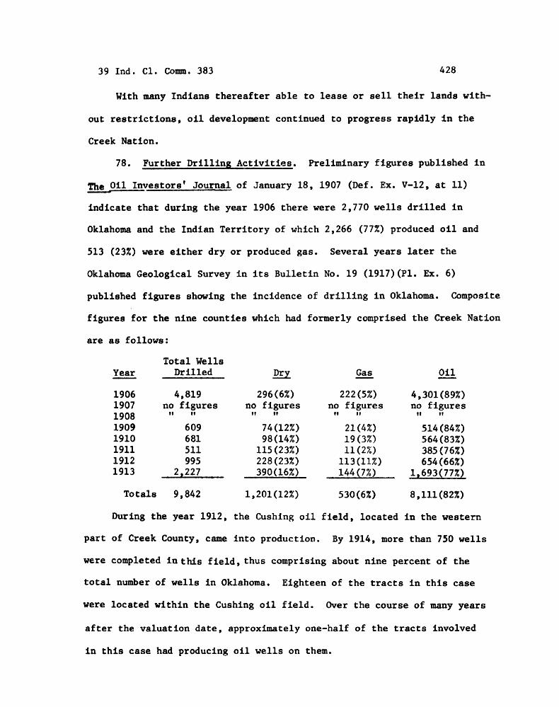
78. Further D r i l l i n g Ac t iv i t i e s . Preliminary f i g u r e s published i n
O i l ~ n v e s t o r s ' Journal of January 18, 1907 (Def. Ex. V-12, a t 11)
ind ica t e t h a t during the year 1906 the re were 2,770 w e l l s d r i l l e d i n
Oklahoma and t h e Indian Te r r i to ry of which 2,266 (77%) produced o i l and
513 (23%) were e i t h e r d ry o r produced gas. Several years l a t e r t h e
Oklahoma Geological Survey i n i ts Bu l l e t in No. 19 (1917) (PI. Ex. 6)
published f igu res showing t h e incidence of d r i l l i n g i n Oklahoma. Composite
f igu res f o r t h e nine count ies which had formerly comprised t h e Creek Nation
a r e a s follows:
Total Wells Year - Dri l led
4,819 no f i g u r e s
11 11
Tota ls 9,842
Dry
296 (6%) no f igu res
1 11
Gas - 222 (5%)
no f i g u r e s 11 11
O i l - 4,301(89%) no f igu res
11 11
During the year 1912, the Cushing o i l f i e l d , located i n the western
p a r t of Creek County, came i n t o production. By 1914, more than 750 w e l l s
were completed i n this f i e l d , t h u s comprising about nine percent of t h e
t o t a l number of w e l l s i n Oklahoma. Eighteen of t h e t r a c t s i n t h i s case
were located wi th in t h e Cushing o i l f i e l d . Over t h e course of many years
a f t e r t he va lua t ion da te , approximately one-half of t h e t r a c t s involved
i n t h i s case had producing o i l w e l l s on them.
39 Ind. C1. Comm. 383 429
79. O i l Leases on the Subject Tracts. I n t e r e s t i n o i l explorat ion
w a s so high i n Oklahoma during t h e e a r l y years of the twentieth century
t h a t i t was common p r a c t i c e f o r owners of t r a c t s t o l e a s e t h e o i l
explora t ion r igh t s . O f t he 142 t r a c t s involved i n t h i s case, t e n had
l eases on them by the year 1907; thirty-one more were leased between
1908 and i910; and sixty-one o the r s were leased by the year 1915. The
amounts for which t h e t r a c t s were leased is not known but evidence i n
the record ind ica t e t h a t $25.00 per ac re was considered t o be a f a i r
es t imate of t h e value of an o i l l ea se i n t h e a r e a of t h e subject t r a c t s
a t approximately the d a t e of taking (PI. Ex. 23, a t 27).
80. Mineral Values. After analyzing and weighing a l l the evidence,
the Commission has determined t h a t a separa te value should be given t o
the subsurface area of these 142 t r a c t s based upon o i l and gas development.
The evidence ind ica t e s tha t o i l development i n the Indian Te r r i to ry and
the Creek Nation began s u b s t a n t i a l l y before the va lua t ion d a t e i n t h i s
case. Furthermore, t h i s development was so widespread t h a t a reasonable
purchaser having access t o a l l t h e information then cu r ren t ly ava i l ab le
could reasonably conclude t h a t the opportunity of f inding o i l and gas
with in these 142 t r a c t s was more than speculat ive.
81. p l a i n t i f f ' s O i l and Gas Appraisal. Josef Faust and John J.
Hassler of Oklahoma City, Oklahoma, were se lec ted by the p l a i n t i f f t o
determine the mineral value of these 142 t r a c t s . D r . Faust valued the
o i l i n these t r a c t s i n th ree ways. The f i r s t was the "true value", t h e
second was t he "discounted value" a s of 1907 and t h e third was the
39 Ind. C1. Comm. 383
"present worth" as of January 1, 1975. I n reaching each of these values,
a l e a s e bonus and r e n t a l was es tab l i shed based on a f ixed va lue of $10.00
per acre. This f i g u r e was the same f o r each of t he valuat ions. The
second f a c t o r w a s the roya l ty value, and t h i s was f ixed a t $25.00 per
acre and was a l s o the same f o r each of the th ree valuat ions. The t h i r d
f a c t o r wae t h e only varying one, and t h i s was based on production value.
The "true value" production value was based on ac tua l production, while
the "discounted value" and "present worth" values were made by using
computer values based on a c t u a l yearly production and government bond
i n t e r e s t r a t e s .
On t he b a s i s of t h e i r research, Faust and Hassler determined t h a t a
f i g u r e of $10,00 per a c r e was a f a i r l e a s e bonus and r e n t a l . They l ike-
wise concluded t h a t $25.00 was a f a i r f i g u r e t o determine roya l ty value.
These f igu res were based on t h e i r determination of f a i r average value of
these lands with regard t o each type of va lua t ion being determined. The
roya l ty f i g u r e of $25.00 per ac re takes i n t o considerat ion those t r a c t s
which had a d ry hole d r i l l e d , on which no we l l s had been d r i l l e d o r on
which we l l s had been d r i l l e d but production had ceased. This f i g u r e is
predicated on t h e i r eva lua t ion of the evidence and t h e i r experience i n t h e
o i l business over t h e years .
The Commission f i n d s t h a t l e a s e bonuses and r e n t a l s , w i th a poss ib le
r a r e exception, were based on l e a s e s made a f t e r March 4, 1907. The
Commission makes the same determination with regard t o roya l ty payments,
which a r e based on production and the production va lue be i t contempo-
raneous o r i n the fu ture . I n a l l ins tances p l a i n t i f f ' s experts ' values
a r e based on events occurred a f t e r t he tak ing d a t e of March 4, 1907.
39 Ind. C1. Comm. 383 431
82. ~efendant's Oil and Gas Appraisal. Defendant's appraiser,
Dr. Murray, determined that the average per acre value of the lands was
$15.00 not including any special value attached to specific tracts
based on mineral presence. His f i n a l average per acre value for all
tracts was $21.95. Although not stated, it follows that he determined
that the per acre enhancement for all rnfnerals was $6.95 per acre.
In his tract-by-tract valuation, he valued three tracts at more
than $50.00 per acre because these tracts had oil and gas production
very near the taking date. All other tracts were valued a few dollars
above or below the $15.00 per acre average. Presumably, valuations
above $15.00 reflect enhancement for minerals, although the objective
basis for such enhancement is not explained.
83. Valuation of the Oil. The Commission has reviewed all the
evidence and weighed the relative merits of the parties' appraisal
reports. The Commission finds that the evidence in this case
establishes that in 1907 it was common knowledge that oil was present
under a significant portion of the Creek Nation but that, at that tine,
the exact location of the oil was impossible to determine. A knowledge-
able purchaser, having full access to the information then available,
would have been willing to pay a substantial incremental amount for
lands within the Creek Nation based upon the known and potential
presence of oil. Based upon the evidence of record we find that a
reasonable increment to the value of the subject tracts to reflect the
known and potential presence of oil and gas is $550,000.
39 Ind. C1. Colmn. 383 432
84. Equalization Money Paid to Erroneous Enrollees. Equalization
money was that money paid to enrollees when they were allotted lands
and the value of the allotments (as determined by the Oawes Commission
valuation procedures) did not reach $1,040.00. These sums were invariably
very small amounts. The defendant paid equalization of allotment money
from Creek tribal funds to persons erroneously placed upon the tribal
rolls of the Creek Nation. The total amount so paid by the defendant
was $25,381.55.
85. Total Surface and Mineral Value. The Commission finds that
the total fair market value as of March 4, 1907, of the 142 tracts in
this case is $1,090,324.65.
CONCLUSIONS OF LAW
Based upon the foregoing findings of fact, the Commission concludes
as a matter of law that:
1. The agricultural, grazing and townsite lands, totalling
22,737.21 acres, had a fair market value as of March 4, 1907, of
$430,324.65.
2. Known and potential coal deposits under these lands increased
the fair market value thereof by the amount of $llO,OOO.OO.
3. Known and potential oil and gas deposits under these lands
increased the fair market value thereof bv the amount of $550,000.00.
4. The amount of Creek Tribal funds paid to erroneous allottees
was $25,381.55.
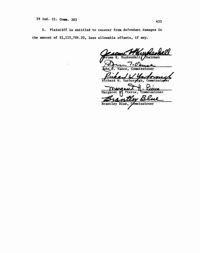
5 . Plaintiff is entitled to recover from defendant damages in
the amount of $1,115,706.20, less allowable offsets, if any.
-- - s. Vance , Commissioner
u u- Brantley Blue