Embed Size (px)
Citation preview
THE SEA FLOOR

Geological processes shapethe Earth
• How do they influence the Marine Habitat
a. Sculpt the shorelines
b. Determine water depth,
c. Control the bottom sediment
d. Create new islands
e. Create underwater mountains for organisms to colonize
d. Determine the nature of marine habitat.

Earth- Water planet• Ocean covers 71% of the earth• Oceans regulate the climate and atmosphere
• Land forms cover 2/3 of the earth

Northern Hemisphere• 61% ocean 2/3 land coverage

Southern Hemisphere• 80% Ocean 1/3 land

Oceans- 4 large Basins• Pacific Ocean – largest and deepest• Atlantic – second largest• Indian – close to the size of the Atlantic • Arctic – smallest and shallowest

Continents and Oceans of the World
• A

Seven Continents

Seas • A saline body of water with a connection to the ocean. “sea” syn. For ocean

Land closed Seas• Great Salt Lake• Great Lakes• Caspian Sea• Sea of Galileo

Great Salt Lake
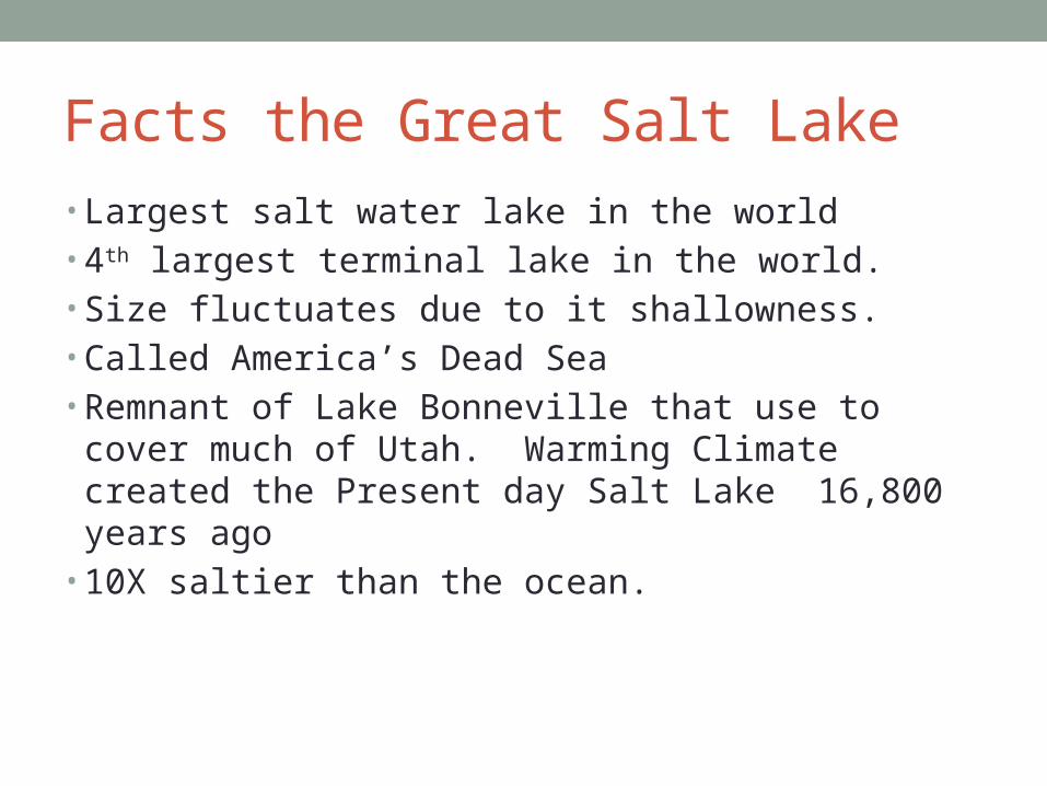
Facts the Great Salt Lake• Largest salt water lake in the world• 4th largest terminal lake in the world.• Size fluctuates due to it shallowness.• Called America’s Dead Sea• Remnant of Lake Bonneville that use to cover much of
Utah. Warming Climate created the Present day Salt Lake 16,800 years ago
• 10X saltier than the ocean.

Great Lakes

Great Lakes Facts• 21% of the freshwater on earth• Connected to the Atlantic ocean through the Saint
Lawrence seaway and Great Lakes Water way.• Carved out by retreating Glaciers 10,000 years ago. • Filled with melted water of the glaciers.
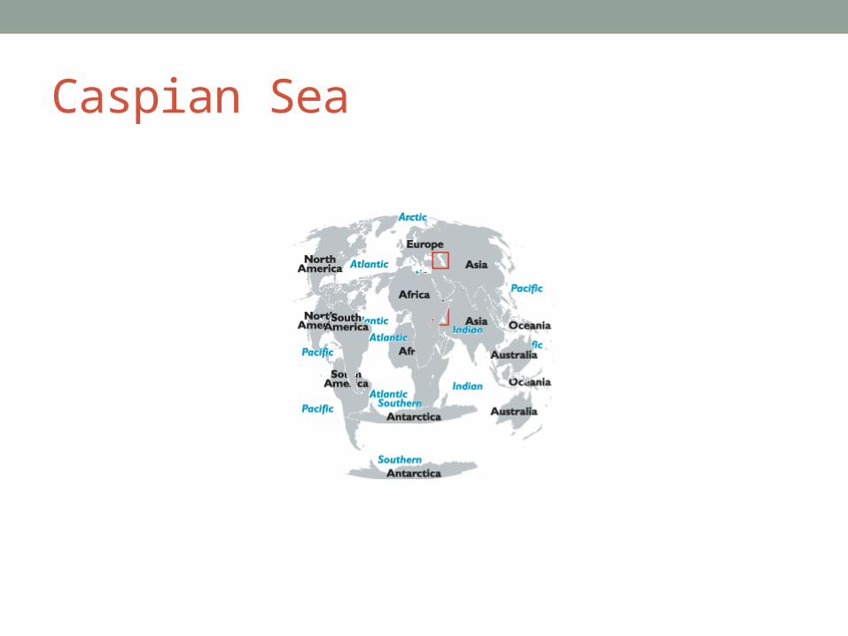
Caspian Sea
Caspian Sea facts• Once part of the Tethy’s Ocean• Landlocked due to plate tectonics• No natural outflow except for evaporation• Volga and Ural Rivers discharge into it.• Levels of the sea controlled by the atmospheric conditions
of the North Atlantic ocean. Studies of the global climate changes are invaluable.
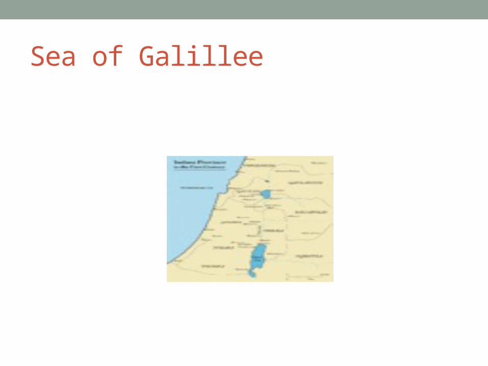
Sea of Galillee

Sea of Galilee facts• Located in Northeast Israel in Jordan Rift Valley• This Rift valley is caused by the separation of the African
and Arabian Plates.• Out flows the Jordan River and evaporation.• It has salt water springs under the lake, the weight of the
freshwater hold it in check on top of them.

World Ocean• All bodies of water are interconnected.• Southern Ocean – continuous body of water around
Antarctica

Structure of the Earth• Internal Structures of the earth.
Inner Core – solid iron
Temperature 4000 C
Liquid outer core
The movement of the outer core over the inner core is thought to produce the magnetic field

Structure of the Earth

• Mantle – layer outside the core, composed of
molten material.
Crust – outmost layer, differs greatly between ocean and crust.
Planet molten. Heat was generated Material settled according to their density.

Density• D = Mass/volume• Mass = grams (g) or milligrams (mg)• Volume = milliliter (ml), liter (L) , cm3• Densest material flow to the center of the planet. Lightest
material cooled to a tin crust (on top) • Atmosphere and ocean began to form.• Density intensive property depend on the composition of a
substance, not the size.


Continental and Oceanic Crust• Ocean Crust – basalt• Only 5 km (3miles) thick• Geological young, dark in color, rich in iron and
magnesium

Continental Crust - Granite• 20 to 40 km thick ( 12 to 30 miles)• Less Dense than basalt • Present during all geological eras.
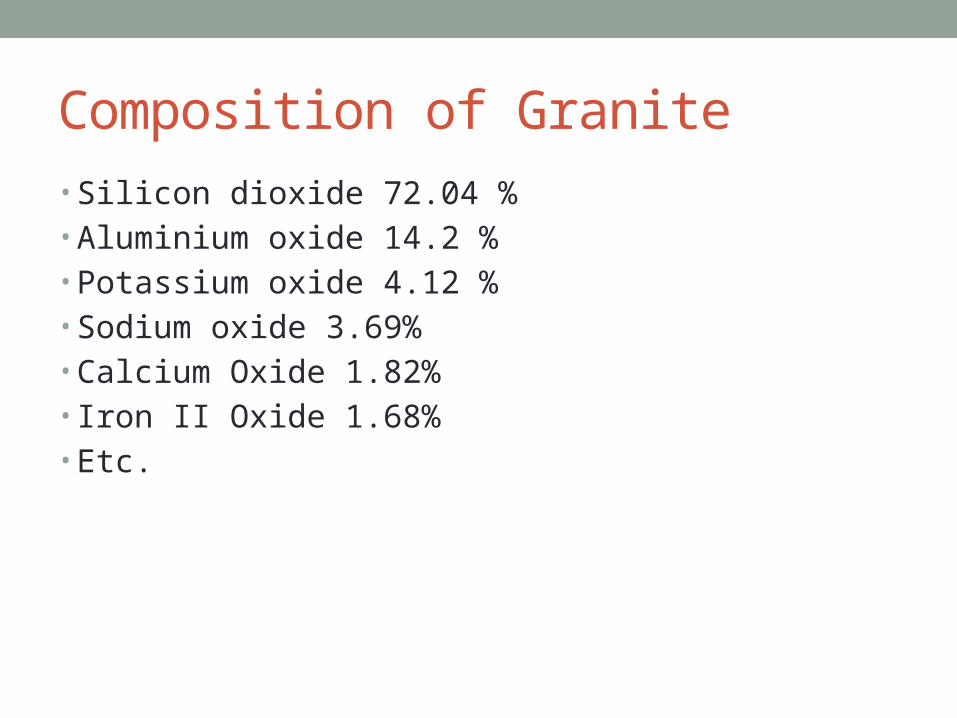
Composition of Granite• Silicon dioxide 72.04 %• Aluminium oxide 14.2 %• Potassium oxide 4.12 %• Sodium oxide 3.69%• Calcium Oxide 1.82%• Iron II Oxide 1.68%• Etc.

Why are continents higher than the sea floor?
• Continental Crust is of lower density. It rises above.• Mixture – density varies because the composition varies. • Density of a substance tends to decrease with/an
increase in temperature.• Rocks – continental rocks can be up to 3.8 billion years
old.

Big Bang Theory• Cosmic explosion occurred 13.7 billion years ago.• Dust particles collide and build larger particles such as
earth and other planets• Solar system formed 4.5 billion years ago from clouds of
dust.

Sir Francis Bacon• Studied the coastlines• Found the coastlines of the continents tend to fit like a
jigsaw puzzle.

Matching coastlines

Continents fitting together

Fossils and animal tend to be similiar

Alfred Wegner• Developed the continental drifting theory.• Continents at one time were joined together as a super
continent. Pangea
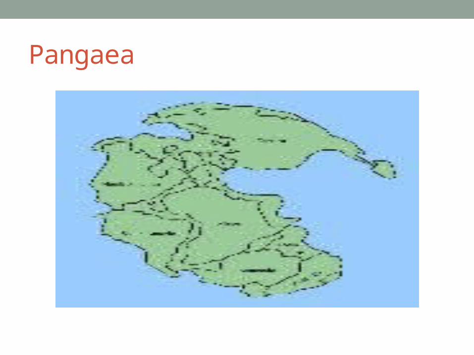
Pangaea

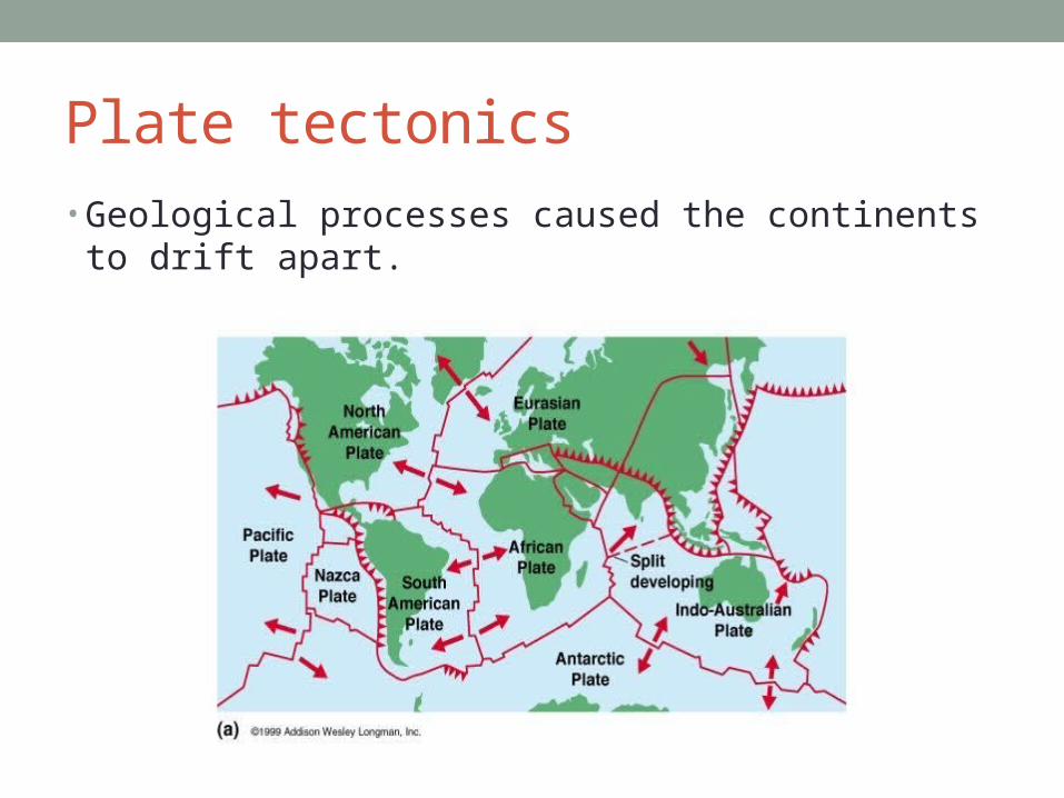
Plate tectonics• Geological processes caused the continents to drift apart.

Mid Ocean Ridge • Detected by sonar• Continuous chain of submarine volcanic mountains.• Largest geological feature on earth• Transform faults break up the ridge

East Pacific Rise
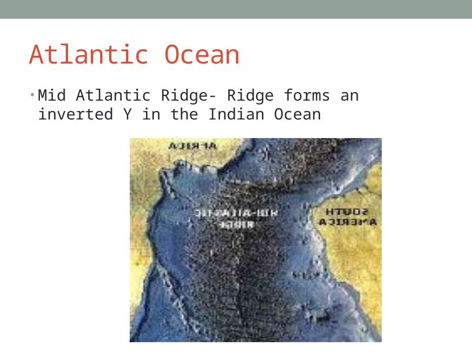
Atlantic Ocean• Mid Atlantic Ridge- Ridge forms an inverted Y in the
Indian Ocean

Trenches• Deep depressions in the sea floor.• Most are concentrated in the Pacific Ocean• Geological activity concentrated at the ridge• Rocks are very young at the ridge, there is very little
sediment.

Puerto Rico Trench

Magnetic Anomalies• Magnetic bands seen on the ocean floor .• They tend to run parallel to the ridge.• Zone represent alternating and reverse magnetization
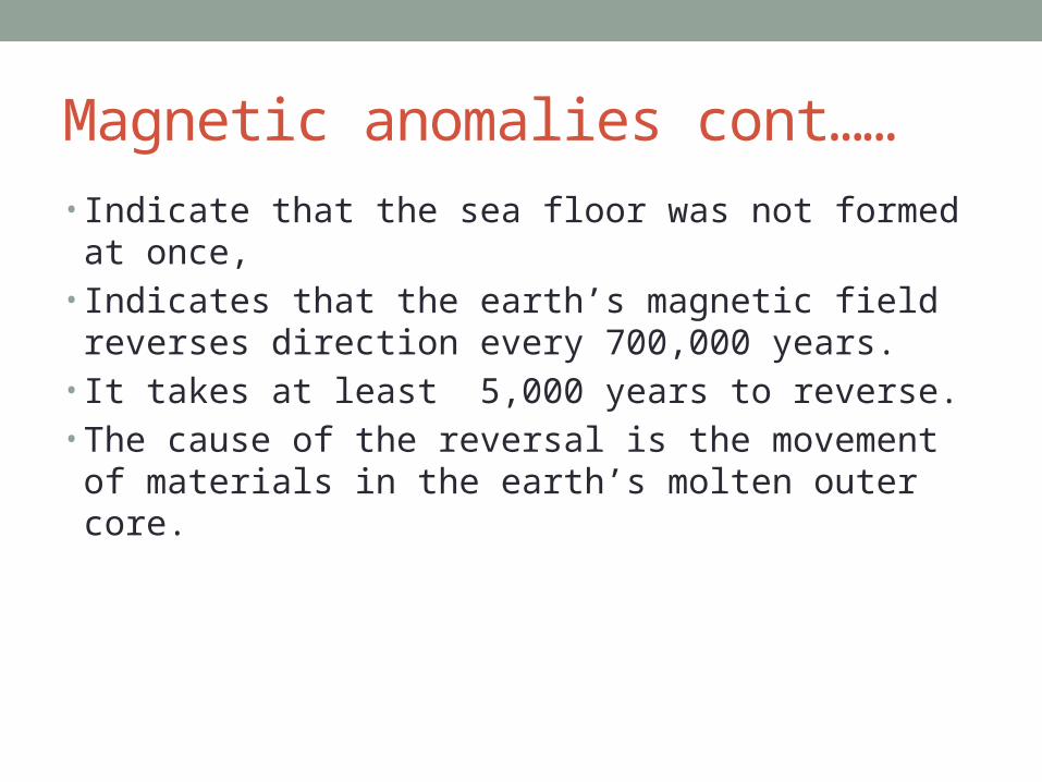
Magnetic anomalies cont……• Indicate that the sea floor was not formed at once,• Indicates that the earth’s magnetic field reverses direction
every 700,000 years.• It takes at least 5,000 years to reverse.• The cause of the reversal is the movement of materials in
the earth’s molten outer core.


Sea floor Spreading• Located at the top of the ridges.• Ocean crust separated allowing the mantle materials to
melt and rise up.• It cools forming new oceanic crust.• Sea floors moves away.• It freezes the magnetic field . The stripe direction
preserves the magnetization at the time.


Earth Surface• Compose of granite , the upper part of the mantle.• Lithosphere – Rock Sphere – 100 km thick(60 miles)• Lithosphere Plates – Break off the lithosphere that can
contain continental crust, ocean crust or both.• Floats on the asthenosphere.

Earth’s Plates

Mid Ocean Ridge • Forms the edges of the plates.• Plates spread 2 to 18 cm per year. • Lithosphere destoried at the trenches.

Subduction Zone• Trenches form when two plates collide and one plate dips
below the other and sinks back into the mantle.• Produces earthquakes and volcanos

Plates collisions• Oceanic/Continental

• Oceanic / Oceanic (develops volcanic island chains along trenches
• Island arcs Ex. Aleutian and Mariana Island

• Continental/ Continental – Forms mountain ranges. Ex Himalayan Mountains
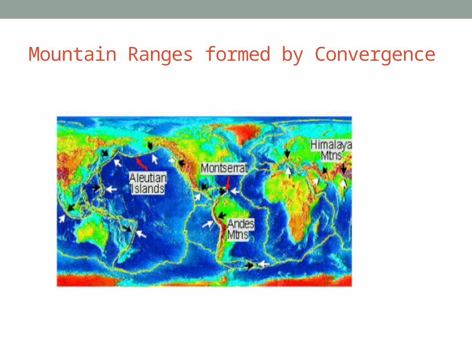
Mountain Ranges formed by Convergence

Shear Boundary• 2 boundary plates slide pass each other.• Lock and stress builds up.• Plates break free• They slip all at once- earthquake • EX. San Andreas fault.


San Andreas fault and the land it forms

Plate Movement• “Slab Pull” – Lithosphere is pulled and melted into the
mantle forming a trench and pulls the rest of the plates with it

Vast Oceans Surrounded Pangea• Panthalassa (Pacific Ocean)• Tethy Sea – Separates Eurasia from Africa
( (Medterranean Sea) • Sinus Boreales – Arctic Ocean

Ancient oceans formation

Separation of Pangaea
• Pangaea splits into Laurasia and Gondwana• Gondwana splits from Indian Ocean• South America/Africa Rift – South Atlantic is formed


Sediments two types• Lithogenous sediments- Sediments that are from the
breakdown of rocks.• Most common is red clay

• Biogeneous sediments- Consists of skeleton and shells of marine animals.
• Some are referred to as microfossils• Calcium carbonate (calcareous ooze)

• Silica ( Siliceous ooze)
Past Climates• Determined by chemical composition of microfossils.
Carbon dating is used to date microfossils.• Temperature – Study the ratio of magnesium to Calcium
isotopes or different oxygen isotopes. Strontium to Calcium in coral skeletons

Ice Cores• Taken in Greenland and Antarctica contains bubbles of
ancient atmosphere in it.

Ice Ages• They are cold periods that we find at the Ocean levels
dropped. Glaciers built up.
Interglacial Periods• Warming Period.• The last ice age was 18,000 years ago.• Green House Effect has prolonged the interglacial period.

Sea Ice Meltng

Sea Floor - 2 major Parts
• Continential Margin- edge of the continents
• Deep sea floor.

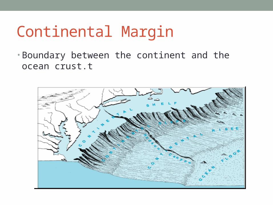
Continental Margin• Boundary between the continent and the ocean crust.t

Continental Shelf• Gentle slope • Shallowest part of the marine environment• Makes up 8% of the ocean surface.• Biologically the richest• Glaciers have eroded deep canyons and have become
submerge (submarine canyons) • Width is less than .6 miles to 470 miles to the end of the
shelf break.

Continental Slope

Continental Slope• Steep slope going down• Exact edge of the continent descends to the sea floor. • Submarine canyons channel sediment down by the
submarine canyons to the seep sea floor.

Active Margins• Usually have narrow shelves• Steep slopes and little of no continental rise.• Why? Lots of geologically activity. Ex. West Coast

Active Margins
Passive Margins• Wide shelves and relative gentle slopes and well
developed rises• No geological activity to remove the sediment • ex. East Coast ( flat coastal Plain)


Deep Ocean Basins• Lie at the depth of 3000 to 5000 meters.• Referred to as the Abyssal Plain • Rises very gentle slope of less that 1 degree.• It contains low abyssal hills, submarine
volcanos( seamounts), flat topped Sea Mounts (guyots), islands that are submerged


Trenches • Deepest part of the ocean.• Marianna Trench in the Western Pacific• 36,165 ft deep,,

Hydrothermal Vents• Central Rift Valley• Located in the center of the mid Atlantic Ridge• Water drips down in the cracks, heated water reenters the
ocean through the vents .• Temperature of the water is between 50F to 660 F • Black smoke is due to the sulfides that are released.• Minerals and sulfides harden to the outside to give in the
black color.
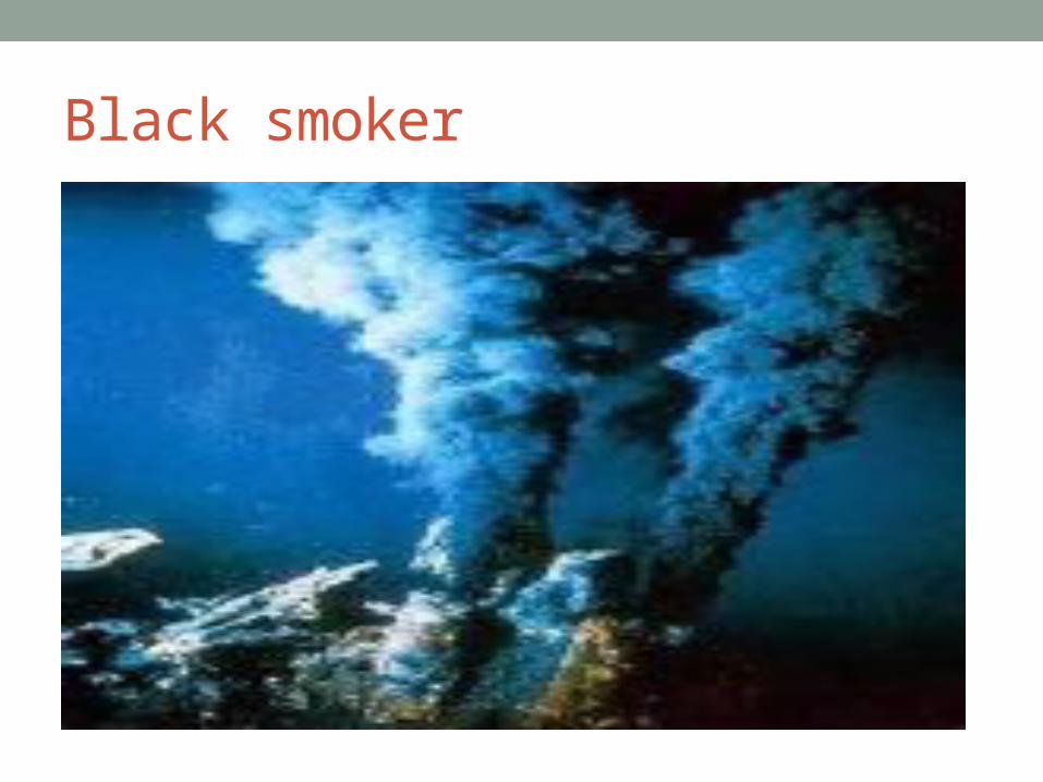
Black smoker