Embed Size (px)
Citation preview

Special Points of
Interest:
Learn more about our student volunteer!
What category of drought is affecting my area?
How much does a cloud weigh?
Interesting note about crickets and temperature.
What is the average date of the first measurable snow?
Product Highlight: U.S. Drought Monitor
2
What is the Fall Equinox?
3
Student Volunteer Spotlight
3
Employee Spotlight
4
A Fall Maze
5
October Weather Brings Changes
6
Fall Climate Outlook
7
Fall 2014
Volume 4, Issue 3
The Quarterly Hail
National Weather Service - Hastings, Nebraska
Notes From the Meteorologist In Charge It’s been busy here at the office all summer. It was very active weather-wise through June, then in July, someone seemed to flip the “Summer” switch and it dried out and warmed up in the matter of a few days it seems. Other than the weather, the office has been very busy too. We have been out teaching hydrology to school kids, visiting our many partners and attending a multitude of meetings with partners. We hired an Electronic Technician who reported in August. Electronic Technicians are the people who repair the radar, computers, weather sensing equipment, etc. These folks are very important to the operations of the office. Without them the equipment would not work or would be “out of tune” and thereby feeding the forecasters inaccurate data. This electronic technician position had been left unfilled for two and a half years due to the government shutdowns and meager budgets of the last few years. There are also a few employees with major life changes that have occurred this summer or will be very soon. We have one family expecting their first baby and a pair of forecasters that are getting married! That’s just a few of the highlights of the busy summer we have had here. I hope yours was productive and blessed too. Now, looking ahead, the Climate Prediction Center thinks there is a high chance of an El Niño event this winter. El Niño events are very forecastable for the coasts, but not so much here in the plains. Since the national media focuses on where the majority of people live, there will likely be a lot of talk about El Niño this fall and winter. Moderate to strong El Niños normally produce a warm and drier Northwest US and a cooler and wetter Southeast US. In the middle, it’s a coin toss, so don’t get drawn into the hype. An El Niño doesn’t promise we will be in an active weather pattern over our area. We have had droughts in El Niño years. What I can promise you is that the staff will be prepared for all types of weather, so we are as prepared as we can be for whatever nature throws at us. We hope you are preparing for any and all types of weather too. Thanks for all you do. It is truly a pleasure to serve you!
Steve Eddy Meteorologist In Charge, National Weather Service Hastings, Nebraska [email protected] 402-462-2127 x642
Inside this issue:

Page 2 Volume 4, Issue 3 www.weather.gov/hastings
Product Highlight - United States Drought Monitor
Remember that there are other daily products outside of the normal 7 day forecast provided by the National Weather Service! In fact, we offer a variety of products each day that can help you make your weather driven decisions. We will try to highlight a different product, tell you what it can do for you and where to find it.
What: United States Drought Monitor
How to find it: There are a couple different ways to find this product. You can find it directly on the U.S. Drought
Monitor website at http://droughtmonitor.unl.edu/. You can also find it on our website at www.weather.gov/hastings. Scroll about halfway down the page until you see the words “Enhanced Hazardous Weather Outlook”. Below the Enhanced Hazardous Weather Outlook you will see a drop down menu labeled “Preparedness”, click on that and choose “Drought”. The drought monitor will be located in the upper left hand corner.
Background: The U.S. Drought Monitor, established in 1999, is a weekly map of drought conditions that is produced
jointly by the National Oceanic and Atmospheric Administration, the U.S. Department of Agriculture, and the National Drought Mitigation Center (NDMC) at the University of Nebraska-Lincoln. The U.S. Drought Monitor website is hosted and maintained by the NDMC. U.S. Drought Monitor maps come out every Thursday morning at 8:30 eastern time, based on data through 7 a.m. the preceding Tuesday. The map is based on measurements of climatic, hydrologic and soil conditions as well as reported impacts and observations from more than 350 contributors around the country. Eleven climatologists from the partner organizations take turns serving as the lead author each week. The authors examine all the data and use their best judgment to reconcile any differences in what different sources are saying.
Page 3 Volume 4, Issue 3 www.weather.gov/hastings
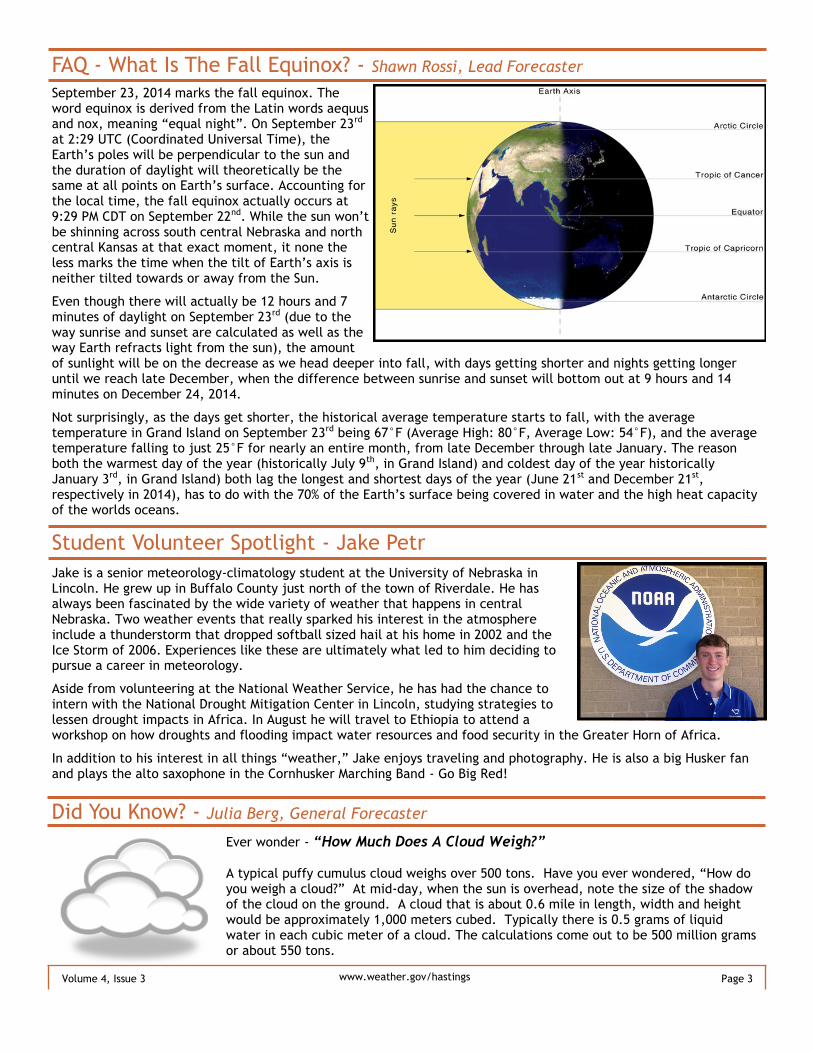
FAQ - What Is The Fall Equinox? - Shawn Rossi, Lead Forecaster
September 23, 2014 marks the fall equinox. The word equinox is derived from the Latin words aequus and nox, meaning “equal night”. On September 23rd at 2:29 UTC (Coordinated Universal Time), the Earth’s poles will be perpendicular to the sun and the duration of daylight will theoretically be the same at all points on Earth’s surface. Accounting for the local time, the fall equinox actually occurs at 9:29 PM CDT on September 22nd. While the sun won’t be shinning across south central Nebraska and north central Kansas at that exact moment, it none the less marks the time when the tilt of Earth’s axis is neither tilted towards or away from the Sun.
Even though there will actually be 12 hours and 7 minutes of daylight on September 23rd (due to the way sunrise and sunset are calculated as well as the way Earth refracts light from the sun), the amount of sunlight will be on the decrease as we head deeper into fall, with days getting shorter and nights getting longer until we reach late December, when the difference between sunrise and sunset will bottom out at 9 hours and 14 minutes on December 24, 2014.
Not surprisingly, as the days get shorter, the historical average temperature starts to fall, with the average temperature in Grand Island on September 23rd being 67°F (Average High: 80°F, Average Low: 54°F), and the average temperature falling to just 25°F for nearly an entire month, from late December through late January. The reason both the warmest day of the year (historically July 9th, in Grand Island) and coldest day of the year historically January 3rd, in Grand Island) both lag the longest and shortest days of the year (June 21st and December 21st, respectively in 2014), has to do with the 70% of the Earth’s surface being covered in water and the high heat capacity of the worlds oceans.
Did You Know? - Julia Berg, General Forecaster
Ever wonder - “How Much Does A Cloud Weigh?”
A typical puffy cumulus cloud weighs over 500 tons. Have you ever wondered, “How do you weigh a cloud?” At mid-day, when the sun is overhead, note the size of the shadow of the cloud on the ground. A cloud that is about 0.6 mile in length, width and height would be approximately 1,000 meters cubed. Typically there is 0.5 grams of liquid water in each cubic meter of a cloud. The calculations come out to be 500 million grams or about 550 tons.
Student Volunteer Spotlight - Jake Petr
Jake is a senior meteorology-climatology student at the University of Nebraska in Lincoln. He grew up in Buffalo County just north of the town of Riverdale. He has always been fascinated by the wide variety of weather that happens in central Nebraska. Two weather events that really sparked his interest in the atmosphere include a thunderstorm that dropped softball sized hail at his home in 2002 and the Ice Storm of 2006. Experiences like these are ultimately what led to him deciding to pursue a career in meteorology.
Aside from volunteering at the National Weather Service, he has had the chance to intern with the National Drought Mitigation Center in Lincoln, studying strategies to lessen drought impacts in Africa. In August he will travel to Ethiopia to attend a workshop on how droughts and flooding impact water resources and food security in the Greater Horn of Africa.
In addition to his interest in all things “weather,” Jake enjoys traveling and photography. He is also a big Husker fan and plays the alto saxophone in the Cornhusker Marching Band - Go Big Red!

Page 4 Volume 4, Issue 3 www.weather.gov/hastings
Employee Spotlight - Marla Doxey, Data Acquisition Program Manager
Once upon a time, in a state far away, ok, maybe not so far away. I grew up on a farm in southern South Dakota, along with 1 sister and 3 brothers. Following graduation I joined the Air Force and spent 6 enjoyable years serving our country. The first 4 years were spent as a diesel mechanic, during which I had many adventures going TDY (temporary duty assignment) as I was assigned to the 3rd Combat Communications Group at Tinker AFB, OK. I was part of the first group of women allowed to be deployed out in the field where we set up what was called a Bare Base. We were self-sustaining, living in tents, providing our own electricity with diesel generators, eating C-rations (yuck) and testing communications and radar equipment. The fun part was driving the big trucks and fork lifts. As much as I enjoyed the people and the work, I knew it wasn’t what I wanted to do with the rest of my life, even though it did provide me with the skill to work on my own car, which I really enjoyed up until these newer models where you open the hood and are lucky to be able to find the engine. I applied for cross-training in which you select 3 career fields you would like to work in. Weather observer was actually my 3rd choice, only because I had to choose something. At the time I had no clue what a weather observer did. Wouldn’t you know, that is what fate chose for me. Following weather school at Chanute AFB, IL, I was stationed at Wright-Patterson AFB, OH. During this time I got married and eventually left the Air Force in July of 1980, when my husband did not get his transfer to Dayton. Shortly after my discharge from the Air Force, I convinced the Area Manager at the Cleveland, OH office that he really needed to hire me at the Youngstown, OH weather office where there were 2 vacancies. I have been with the National Weather Service since September 1980 and have had a very rewarding career, thanks to all the wonderful people I have worked with along the way and the challenges that changing weather and technology can bring. Fate did a wonderful job!! In May of 1981 we were blessed with twin boys, Jeremiah and Matthew. I felt extremely lucky as I had wanted 2 boys, just hadn’t planned on having them at the same time! I can tell you that working rotating shifts and having a family does have its challenges, especially when I became a single parent. But life itself is ever changing. Every day is different. All 3 of us managed to survive the challenges of moving and especially the teenage years, wow, I keep telling them they are lucky I even talk to them!! Just kidding, kinda J. They did grow up and now work at Alliance Steel in Oklahoma City, along with my granddaughter, Brooklynn. Who knew being a grandmother could be so much fun!! While my NWS career started in Youngstown, I spent a couple of years at the North Omaha, NE office followed by a return to the Youngstown office when they needed someone familiar with the area and could immediately go to work with no additional training. A few years later I was selected for the Official-in-Charge position at the NWS office in Mansfield, OH. This office was only open from 5:30 AM to 6 PM, except during severe weather, so it made for a better family life. Unfortunately, it wasn’t long before they started talking about closing offices due to modernization. My next adventure brought me to the newly opened office in Hastings, NE as the Data Acquisition Program Manager, which was one of the new positions created. This was probably my most challenging position as no one really knew what it was supposed to entail. However, this gave me the opportunity to make it my own. The part of my job that I have enjoyed the most is the Cooperative Observer Program. What a great bunch of people who dedicate a part of each and every day to recording/reporting the weather for their area. They are so fascinating and have many stories of their own. Outside of work, I enjoy spending time with Gary, my better half. After always riding on the back of motorcycles, he convinced me to get my own. I think he was just tired of carting me around. So now I ride a motorcycle, take care of my house and yard, and spend time with my furry family, Sable (dog), Ryder and Goldberg, both cats. Thanks to Gary I have vacationed in Panama, Italy, most of the eastern United States and part of the southwest, amazing places. We are working our way through our bucket list. While I may retire in a couple years, it might force me to figure out what I want to do when I grow up. That is a scary thought.
Page 5 Volume 4, Issue 3 www.weather.gov/hastings
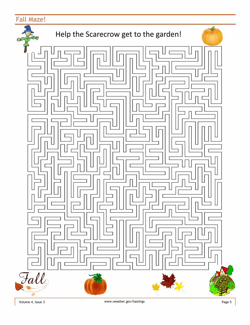
Fall Maze!
Help the Scarecrow get to the garden!

Page 6 Volume 4, Issue 3 www.weather.gov/hastings
October Brings Weather Changes - Julia Berg, General Forecaster
The month of October is generally the month of change from summer to winter. Although Autumn is officially here in September, the lag in seasons makes October the month of the most change. High temperatures at the beginning of the month are generally in the lower to mid 70s and by the end of the month upper 50s to lower 60s are common. Low temperatures are in the 40s at the beginning of the month and in the 30s by the end. Much of the area experiences their first frost or freeze during the month of October. Monthly precipitation is around 2 inches on average through the month. Although snow has been reported in September a few times through the years, the first snowfall of the year is more typically in October. Normal snowfall for the month is up to an inch. There is a wide variety of weather across the area during the month of October. Tornadoes and severe weather is still possible and on October 9, 1913, a pair of tor-nadoes near the Kansas and Nebraska border destroyed several barns and a dozen homes were destroyed. Three people were killed and 14 injured; eight horses and hundreds of baby chicks were also killed. On October 29, 1956, there was F3 damage done to farms near Wilsonville and Elwood in Nebraska. With this storm there were a few people injured. On the other hand, there have been a few snow storms that have been notable as well. October 25, 1997, brought wind driven snow. Two to three inches of rain fell before changing to snow. The heaviest snow was in north central Kansas with up to 15 inches of snow. October 27, 1980, snow of 6.6 inches was reported in Grand Island, with 10 inches in Greeley, Nebraska.
A Student’s Perspective - Becoming A Meteorologist - Jake Petr, Student Volunteer
Meteorology is a fascinating field of study that continues to evolve with improving weather models and computer technology. Today, the most common way to become a meteorologist is to pursue an undergraduate degree in Meteorology or Atmospheric Science. The program is rather rigorous and is definitely not for everyone. Along with a passion for studying and observing the weather, it helps to have a strong interest in math and science. Students are required to take courses such as atmospheric dynamics, thermodynamics, and synoptic and they also have to take multiple semesters of calculus, physics, and computer programming. While in college, students often have the opportunity to participate in weather related clubs such as a local chapter of the American Meteorological Society and many of them also have their own organized storm chase teams. These provide them with leadership opportunities and avenues to network with other meteorologists in the field. As a student begins to get settled into the program they can begin to explore which career path they would like to pursue. Broadcasting, research, teaching, and weather forecasting are some of the most common options. Seeking out an internship, both paid and unpaid, is often the best way to find out which area of meteorology fits your interests. Each option has its own set of guidelines to follow that will improve your chances of getting a job. For example, in broadcasting it is best to have experience in front of a green screen and take additional communication courses. As for research and teaching it is essentially a good idea to go to graduate school for a Master’s Degree in Atmospheric Science and ultimately get a Doctorate. For weather forecasting jobs, such as at the National Weather Service, having a Master’s Degree is becoming more common. It also helps to have experience forecasting while still in school, either from a class or taking part in forecasting competitions such as the WxChallenge. This is only a quick glimpse of some of the things students in meteorology need to do in order to become meteorologists. It may be a difficult journey but if you love the weather becoming a meteorologist can be a very rewarding career.
Field crickets are called the poor man's thermometer because temperature directly
affects their rate of activity. Count the number of chirps per 15 seconds and add 40 to
get the temperature in Fahrenheit.
Weird Fact!

Fall Climate Outlook Detailed Below...
This Table Reflects Various Historical Fall Extremes For The Local Area...
Page 7 Volume 4, Issue 3
Precipitation Outlook for Fall 2014
(September-November)
Temperature Outlook for Fall 2014
(September-November)
To view these and other Climate Prediction Center
outlooks visit http://www.cpc.ncep.noaa.gov/
Warmest
Fall Seasonal
Average Temp
(Sep-Nov)
Coolest
Fall Seasonal
Average Temp
(Sep-Nov)
Average Date
of First
Measurable Snow
(0.1” or more)
Earliest First
Measurable Snow
On Record
(0.1” or more)
Latest First Fall
Hard Freeze
(28°or colder)
Grand Island 59.0˚ / Fall 1931 46.6˚ / Fall 1896 Nov. 10 Sep. 20, 1995 Nov. 12, 1927
Hastings 58.1˚ / Fall 1933 47.2˚ / Fall 1985 Nov. 13 Sep. 29, 1985 Nov. 14, 1915
Kearney 57.2˚ / Fall 1963 47.1˚ / Fall 1976 Nov. 16 Sep. 29, 1985 Nov. 10, 1998
Greeley 57.6˚ / Fall 1963 45.3˚ / Fall 1996 Nov. 16 Oct. 10, 2009 Nov. 1, 1963
Hebron 58.9˚ / Fall 1963 48.8˚ / Fall 1993 Nov. 17 Sep. 30, 1985 Nov. 14, 1978
Alton, KS 61.5˚ / Fall 1931 49.8˚ / Fall 1985 Nov. 29 Oct. 24, 1957 Nov. 12, 1915
Plainville, KS 60.8˚ / Fall 1963 50.2˚ / Fall 1993 Nov. 24 Oct. 6, 2012 Nov. 21, 2008
www.weather.gov/hastings
The latest Fall Outlook from the Climate Prediction Center slightly favors below normal temperatures across most of the South Central Nebraska and North Central Kansas area. Time Frame: The NWS considers the “fall” season to be all of September, October and November. Although this differs somewhat from the astronomical fall season that runs from September 22-December 21, using these three full calendar months is convenient for calculating meteorological data. Temperature: The top outlook on the right reflects a forecast for the 3-month period as a whole. We tend to view temperatures in the context of a daily high/low or monthly average, but the 3-month outlook accounts for the entire season. Red/orange colors represent “warmer” than normal and Blue colors represent “cooler” than normal. The white area labeled “EC” designates regions with equal chances of having above, near or below normal temperatures. This means there is no clear trend in the forecast analysis to support one of these outcomes over another. According to the image, nearly the entire local area is very slightly favored (33-40% chance) to observe below normal temperatures this fall. However, this still means there is a 33% chance of observing near normal reading and a 27-33% chance of having above normal temperatures. In other words, this is not necessarily a very high confidence forecast for below normal fall temperatures.
Precipitation: Similar to temperatures, the precipitation outlook on the bottom depicts the total precipitation trend for the entire 3-month period, and is independent of short term day-to-day events. Green colors represent “wetter” than normal and Orange/brown colors represent “drier” than normal. The white area labeled “EC” designates regions with equal chances of having above, near or below normal precipitation. As depicted, Nebraska portions of the area are at least very slightly favored (33-40%) to observe above normal precipitation this fall. Slightly higher confidence for above normal totals resides over North Central Kansas, where a 40-50% chance is indicated. However, even in that area, there still exists a 33% chance of observing near normal precipitation and a 17-27% chance of precipitation falling short of normal. As is the case with the temperature outlook, the precipitation outlook does not forecast how much above or below normal precipitation might be.

Weather Forecast Office 6365 Osborne Drive West Hastings, NE 68901
National Weather Service
Phone: 402-462-2127 Website: www.weather.gov/hastings E-mail: [email protected] Facebook: US National Weather Service Hastings Twitter: @NWS Hastings
Meteorologist-In-Charge
Steve Eddy
Warning Coordination Meteorologist
Mike Moritz
Science and Operations Officer
Rick Ewald
Data Acquisition Program Manager
Marla Doxey
Electronic Systems Analyst
Mark Fairchild
Information Technology Officer
Carol Cartier
Administrative Assistant
Victor Schoenhals
Electronics Technician
Mike Bergmann
Meteorological Intern / Hydrometeorological Technicians
Briona Saltzman ● Joe Guerrero / Mike Reed ● Phil Beda
Meet the Rest of the Staff at WFO Hastings
Lead Forecasters
Merl Heinlein ● Jeremy Wesely ● Cindy Fay
Shawn Rossi ● Scott Bryant
General Forecasters
Julia Berg ● Angela Pfannkuch
Ryan Pfannkuch ● Jeff Halblaub


![Temperate deciduous forest [Meteorologist] Ariana](https://img.pdfslide.us/doc/110x75/56649dab5503460f94a9a551/temperate-deciduous-forest-meteorologist-ariana.jpg)