Embed Size (px)
Citation preview

the power of nature2
The power of natural thinkingHydropower has shaped Tasmania’s development for the last century. In recent years, we have also learned to harness the benefits of wind. The energy generated by this combination of water and wind powers Tasmanian households and businesses and is also sold into the national grid, making the State the nation’s renewable energy powerhouse and Hydro Tasmania Australia’s largest renewable energy generator and water manager.
The Power of Nature tells the story of how renewable energy is created from wind and water. It has been updated from the first edition put together by a dedicated team of Hydro Tasmania staff almost 15 years ago. And while the business has seen significant changes in that time, the story of renewable energy, how it is made and the benefits it can bring, has remained a constant. The only real difference that has occurred in the intervening years is the increased recognition and demand for renewable energy in a world slowly coming to grips with the challenges of climate change.
The story begins with a brief history lesson, as the development of hydropower in particular has been an integral part of Tasmania’s progress over the past 100 years. What started in 1914 as the Hydro-Electric Department was later known as the Hydro-Electric Commission, the Hydro-Electric Corporation and from 1998 as Hydro Tasmania. But it has been known and claimed by Tasmanians for generations simply as ‘the Hydro’.
For a century, the Hydro and the renewable energy it has generated have shaped Tasmania’s industries, economy, landscape and community. Its legacy is not only its engineering and construction feats, but also its lasting impact on the State’s population and culture over the past 100 years to the present day and well into the future.
It’s a great story that we hope you enjoy.
Hydro Tasmania
Gordon Dam
3the power of nature
Contents
Hydro Tasmania - a brief history 4
The beginnings 4
The pioneers 4
The post-war boom 4
End of an era 5
The changed organisation 5
Understanding energy 6
How energy is generated 6
Tasmania’s renewable energy sources 6
Power from water 8
Hydropower 8
Storing the water 8
Getting water to the power station 10
Generating power 11
Types of water turbines 12
Hydropower and sustainable thinking 12
Hydro Tasmania’s hydropower developments 14
Our catchment areas 14
Great Lake – South Esk catchment 14
Derwent catchment 16
Mersey – Forth catchment 18
Gordon – Pedder catchment 19
Pieman catchment 20
King catchment 21
Yolande catchment 21
Power from wind 22
Converting wind to electricity 22
Planning a wind farm 23
Constructing and operating a wind farm 24
Hydro Tasmania wind developments 25
Huxley Hill Wind Farm 25
Joint-venture wind farms 25
Remote area power supply 27
King Island Advanced Hybrid Power Station 27
Sharing our renewable energy and expertise 28
Basslink 28
The National Electricity Market 28
Financial markets 28
Momentum Energy 29
Entura 29
Hydro-Electric CorporationSeptember 2014ABN 48 072 377 158
4 the power of nature
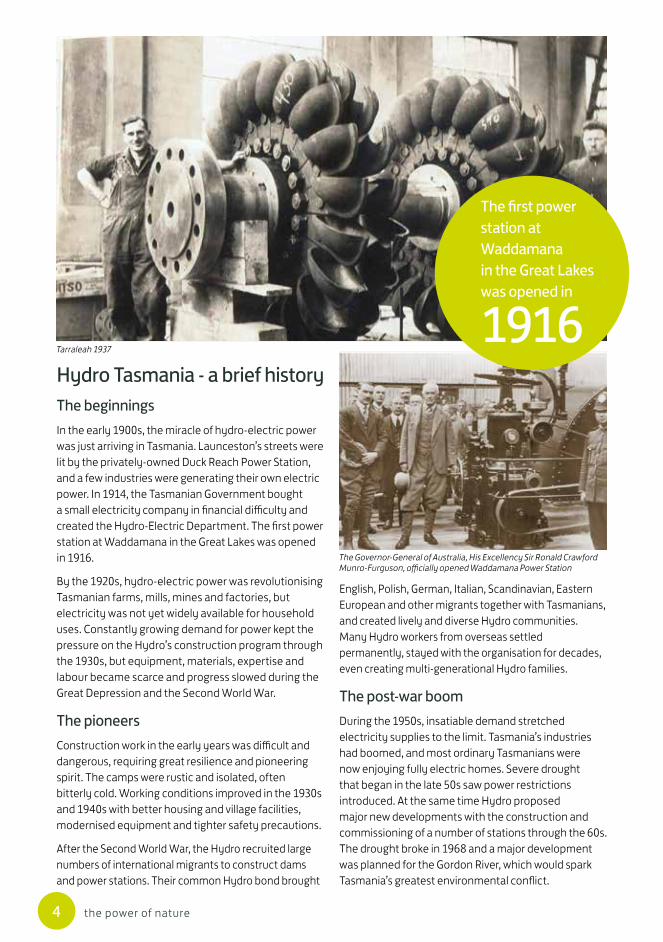
Hydro Tasmania - a brief historyThe beginningsIn the early 1900s, the miracle of hydro-electric power was just arriving in Tasmania. Launceston’s streets were lit by the privately-owned Duck Reach Power Station, and a few industries were generating their own electric power. In 1914, the Tasmanian Government bought a small electricity company in financial difficulty and created the Hydro-Electric Department. The first power station at Waddamana in the Great Lakes was opened in 1916.
By the 1920s, hydro-electric power was revolutionising Tasmanian farms, mills, mines and factories, but electricity was not yet widely available for household uses. Constantly growing demand for power kept the pressure on the Hydro’s construction program through the 1930s, but equipment, materials, expertise and labour became scarce and progress slowed during the Great Depression and the Second World War.
The pioneersConstruction work in the early years was difficult and dangerous, requiring great resilience and pioneering spirit. The camps were rustic and isolated, often bitterly cold. Working conditions improved in the 1930s and 1940s with better housing and village facilities, modernised equipment and tighter safety precautions.
After the Second World War, the Hydro recruited large numbers of international migrants to construct dams and power stations. Their common Hydro bond brought
English, Polish, German, Italian, Scandinavian, Eastern European and other migrants together with Tasmanians, and created lively and diverse Hydro communities. Many Hydro workers from overseas settled permanently, stayed with the organisation for decades, even creating multi-generational Hydro families.
The post-war boomDuring the 1950s, insatiable demand stretched electricity supplies to the limit. Tasmania’s industries had boomed, and most ordinary Tasmanians were now enjoying fully electric homes. Severe drought that began in the late 50s saw power restrictions introduced. At the same time Hydro proposed major new developments with the construction and commissioning of a number of stations through the 60s. The drought broke in 1968 and a major development was planned for the Gordon River, which would spark Tasmania’s greatest environmental conflict.
The first power station at Waddamana in the Great Lakes was opened in
1916Tarraleah 1937
The Governor-General of Australia, His Excellency Sir Ronald Crawford Munro-Furguson, officially opened Waddamana Power Station
5the power of nature
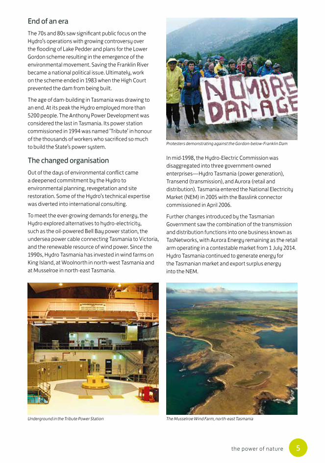
End of an eraThe 70s and 80s saw significant public focus on the Hydro’s operations with growing controversy over the flooding of Lake Pedder and plans for the Lower Gordon scheme resulting in the emergence of the environmental movement. Saving the Franklin River became a national political issue. Ultimately, work on the scheme ended in 1983 when the High Court prevented the dam from being built.
The age of dam-building in Tasmania was drawing to an end. At its peak the Hydro employed more than 5200 people. The Anthony Power Development was considered the last in Tasmania. Its power station commissioned in 1994 was named ‘Tribute’ in honour of the thousands of workers who sacrificed so much to build the State’s power system.
The changed organisationOut of the days of environmental conflict came a deepened commitment by the Hydro to environmental planning, revegetation and site restoration. Some of the Hydro’s technical expertise was diverted into international consulting.
To meet the ever-growing demands for energy, the Hydro explored alternatives to hydro-electricity, such as the oil-powered Bell Bay power station, the undersea power cable connecting Tasmania to Victoria, and the renewable resource of wind power. Since the 1990s, Hydro Tasmania has invested in wind farms on King Island, at Woolnorth in north-west Tasmania and at Musselroe in north-east Tasmania.
In mid-1998, the Hydro-Electric Commission was disaggregated into three government-owned enterprises—Hydro Tasmania (power generation), Transend (transmission), and Aurora (retail and distribution). Tasmania entered the National Electricity Market (NEM) in 2005 with the Basslink connector commissioned in April 2006.
Further changes introduced by the Tasmanian Government saw the combination of the transmission and distribution functions into one business known as TasNetworks, with Aurora Energy remaining as the retail arm operating in a contestable market from 1 July 2014. Hydro Tasmania continued to generate energy for the Tasmanian market and export surplus energy into the NEM.
Protesters demonstrating against the Gordon-below-Franklin Dam
Underground in the Tribute Power Station The Musselroe Wind Farm, north-east Tasmania

6 the power of nature
Understanding energyHow energy is generatedEverything on Earth is made of tiny building blocks called atoms. Inside atoms are smaller electrically-charged moving particles called electrons. It is the movement of these electrons that creates electricity.
Some substances have electrons that can flow freely from one atom to another. The flow of electrons from one atom to another is known as an electric current. Metals such as copper and aluminium are particularly good at allowing the free flow of electrons and are known as conductors. These two metals are the ones most commonly used in electrical wiring. An electric current can be produced by either chemical or mechanical action.
Chemical action
In 1800 an Italian count, Alessandro Volta, used pieces of copper and zinc, brought into contact in a salt solution, to produce a flow of electrons. He had made the first electric battery. The chemical production of electricity in batteries is very important to modern society but is too expensive and at too small a scale to meet most of our electricity requirements.
Mechanical action
In 1831, British scientist Michael Faraday discovered a different way of producing electricity. He found that moving a magnet inside a coil of wire produced an electric current. The movement of the magnet caused the electrons in the wire to move. The huge generators in modern power stations work on the same principle. They consist of large and powerful magnets that spin very fast inside huge coils of conductor.
Tasmania’s renewable energy sources With its high rainfall, mountainous terrain and location in the path of prevailing westerly winds, Tasmania has some of the best renewable energy resources in the world. The renewable sources that we use – water and wind – are naturally replenished. They can be used again and again.
Water
Hydro Tasmania taps into the natural water cycle to provide the water we use to generate hydropower.
The average rainfall on Tasmania varies considerably, from 3200 mm on the west-coast to 500 mm in the midland area. Some of it falls on low-lying or coastal areas, some soaks into the ground, some is returned to the atmosphere by evaporation or transpiration. But most precipitation (rain, hail and snow) falls in the
Precipitation
Condensation
EvaporationWater flow
WATER CYCLE
Average annual rainfall in Tasmania Diagram courtesy of the Bureau of Meteorology
The coils of conductor in the outer section of the generators at Gordon Power Station
The water cycle
500600700800
10001200140016002000
28002400
3200
Annual rain in millimetres

7the power of nature
high areas of central and western Tasmania, then runs off into mountain streams, lakes and rivers. It is this great amount of water that provides the potential energy available for the generation of hydropower. Tasmania’s dams and power stations have been built in high rainfall areas or on rivers running from these highland regions.
The Hydro-Electric Department began surveying Tasmania’s water resources in 1916. Today Hydro Tasmania continues to measure rainfall and run-off around the State. These hydrological studies are needed to ensure effective planning for short- and longer-term water use. This allows maximum energy value to be obtained from water entering Hydro Tasmania’s water storages.
Wind
As the Earth turns, the sun heats up some parts of the land and sea more than others. The hot air above these areas rises. In other areas cool air sinks because it is heavier than the surrounding air. The interaction between rising hot air and sinking cooler air creates wind.
Wind and water: a perfect synergyTasmania is in a unique position, able to rely on renewable energy as the primary source of energy for the State, with world-class resources in both wind and hydropower. Wind is not a constant source of power. When the wind doesn’t blow, we can almost instantly increase our use of hydropower.
We can harness power from wind when it blows and from high rainfall in our run-of-river power stations. When both rainfall and wind are low, water can be released from lake storages for generating power. This is the synergy of the combination of wind and water power.
Hydro Tasmania continually monitors generation at each power station, whether its source is wind or water, and can control generation to provide the supply of electricity that is required by the Australian Energy Market Operator.
Tasmania has a world-class wind energy resource. Our island lies directly in the path of the Roaring Forties, strong westerly winds found generally between the latitudes of 40 and 50 degrees south. This band has some of the strongest sustained winds on the planet. The strong west-to-east air currents are caused by the combination of air being displaced from the Equator towards the South Pole and the Earth’s rotation, and there are few landmasses to serve as windbreaks. When these winds reach the west coast of Tasmania, they have blown across the cooling Southern Ocean for thousands of kilometres, gathering momentum and speed.
Tasmania has some of the best renewable energy resources in the
world
Tasmania lies directly in the path of the Roaring Forties where strong westerly winds circle the earth
0º Equator
20º Latitude
40º Latitude

8 the power of nature
Power from waterHydropowerHydropower uses the potential energy of water stored in lakes and running in rivers. Potential (stored) energy becomes kinetic (moving) energy when gravity causes the water to flow downhill through pipes and canals. Water under pressure enters a power station and is directed onto a turbine. The kinetic energy of the moving water is turned into mechanical energy as it makes the turbine spin around. The turbine is connected by a shaft to magnets which spin rapidly inside coils of copper wire (conductor). Now the mechanical energy becomes electrical energy, ready for distribution and use.
The amount of energy available from a hydro-electric power station depends on two major factors: water pressure and flow.
Water pressure
The water pressure acting on a turbine depends on the height through which the water has to fall to reach the turbine. The greater the height (we call it ‘head height’) of the water above the turbine, the greater its pressure. For example, water falling through 100 metres can produce twice as much power as the same volume falling only 50 metres.
Flow of water
The greater the quantity of water available, the greater the number (or size) of the turbines that can be spun and the greater the power output of the generators. Twice the flow of water produces twice the amount of power.
Power station
ElectricityGenerator
Turbine
Waterstorage
Dam
Waterflow
Storing the waterDams are the most recognisable features of hydropower schemes. They are constructed to create water storages (lakes) that provide a continuous supply of water to spin the turbines. The lake acts like a battery that stores power.
The type of dam to be built depends on a range of physical and resource factors. The available flow of water and its head, shape, size and geology of the valley will be considered, as will the availability of labour and machinery and the quality and cost of construction materials.
The ability of the dam to withstand the pressure of water built up behind it depends on its weight and shape. The dam also needs to be made of (or contain) material that prevents water flowing through it.
Dams can be grouped into two major categories on the basis of their construction materials – embankment dams (rockfill and earthfill) and concrete dams.
Embankment dams
Embankment dams rely on a large mass of rock, gravel, earth or clay to hold back water. Concrete, bitumen or clay is used to waterproof the face of the dam.
Concrete-faced rockfill dams
Hydro Tasmania specialised in the construction of these types of dams. Locally available, good quality rock material is transported and compacted using heavy machinery. The dam is waterproofed using a thin layer of concrete on the upstream face.
The largest concrete-faced rockfill dam in Tasmania is the Reece Dam, which is 122m high and contains more than 2.6 million cubic metres of fill
A simplified cross-section of a hydropower station
An aerial view of Lake Gordon

9the power of nature
Concrete dams
The weight of concrete and the shape of the dam provide the strength to hold back the water. Concrete is a relatively expensive material and the construction of concrete dams is usually more labour intensive than building embankment dams.
Spillways
Dams must be designed to cope with floods. Spillways provide a path for floodwater to flow over or around the dam. On concrete dams, spillways are usually constructed to allow water to flow over the top.
Spillways on embankment dams take the water around the side of the dam and away from the downstream face because of the damage that floodwater would cause to loose rock on the downstream side.
Rowallan Dam is an earth-cored rockfill dam 43m high, built in the 1960s
The Liapootah Dam is a concrete gravity dam 40m high
The spectacular Gordon Dam is a concrete arch dam 140m high
Clay- or earth-cored rockfill dams
These differ from concrete-faced dams in their method of waterproofing. They have a central core of clay or other fine-grained material. The water penetrates the upstream side of the dam but is prevented from flowing through by the clay core.
Concrete gravity dams
Concrete gravity dams rely on their own weight to hold back water. A number of the dams built to contain relatively small storages are of this type. Hydro Tasmania used a number of techniques to reduce the amount of concrete, which in turn reduced costs.
Concrete arch dams
The upstream curve of the arch shape provides the strength to withstand the pressure of the water built up behind the dam. Concrete arch dams are normally constructed in deep gorges and the geological foundations need to be strong. Their shape requires only about ten per cent of the concrete of an equivalent gravity dam, making them more cost effective than other types of dams.
Devils Gate Dam spilling
10 the power of nature
Getting water to the power stationWhere water storages are situated some distance from the power station, channels need to be constructed to carry the water overland.
If the topography is relatively flat, open channels are used. There are two types — canals and flumes. Canals are shallow excavations. They are lined with concrete if water leakage would otherwise be a problem. Flumes are rectangular open channels with floors and walls of reinforced concrete. They are built where a channel needs to be taken around the sides of a steeper slope and where canal excavation presents too many problems.
In some rugged topography it is cheaper to channel the water through tunnels and pipelines. Various combinations of canals, flumes, tunnels and wooden or steel pipelines are features of many of Hydro Tasmania’s power schemes.
Above a power station, overland channels feed water into vertical shafts, power tunnels or high-pressure steel pipes called penstocks. Large towers called surge towers are often built near the top of these structures. They are designed to prevent any damage resulting from pressure build-up when water is suddenly shut off at the power station.
Power tunnels are often lined with concrete or steel to prevent leakage of high pressure water into the surrounding rock. A typical intake is fitted with a trash rack and control gates. The steel mesh trash rack prevents debris such as logs being carried down into the turbines. Replacing the Lake Margaret
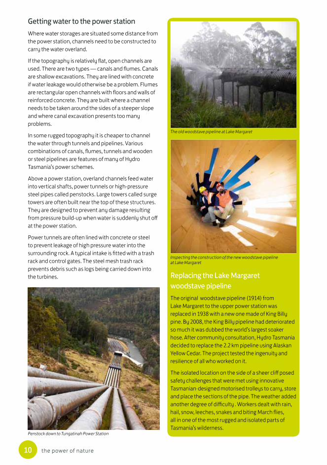
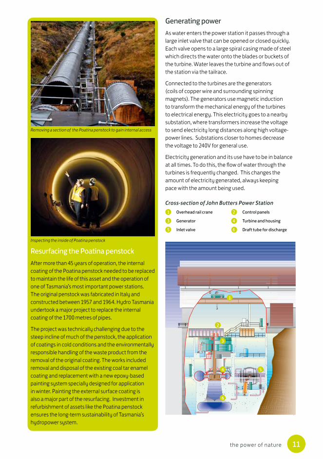
woodstave pipelineThe original woodstave pipeline (1914) from Lake Margaret to the upper power station was replaced in 1938 with a new one made of King Billy pine. By 2008, the King Billy pipeline had deteriorated so much it was dubbed the world’s largest soaker hose. After community consultation, Hydro Tasmania decided to replace the 2.2 km pipeline using Alaskan Yellow Cedar. The project tested the ingenuity and resilience of all who worked on it.
The isolated location on the side of a sheer cliff posed safety challenges that were met using innovative Tasmanian-designed motorised trolleys to carry, store and place the sections of the pipe. The weather added another degree of difficulty . Workers dealt with rain, hail, snow, leeches, snakes and biting March flies, all in one of the most rugged and isolated parts of Tasmania’s wilderness.
The old woodstave pipeline at Lake Margaret
Inspecting the construction of the new woodstave pipeline at Lake Margaret
Penstock down to Tungatinah Power Station
11the power of nature
Resurfacing the Poatina penstockAfter more than 45 years of operation, the internal coating of the Poatina penstock needed to be replaced to maintain the life of this asset and the operation of one of Tasmania’s most important power stations. The original penstock was fabricated in Italy and constructed between 1957 and 1964. Hydro Tasmania undertook a major project to replace the internal coating of the 1700 metres of pipes.
The project was technically challenging due to the steep incline of much of the penstock, the application of coatings in cold conditions and the environmentally responsible handling of the waste product from the removal of the original coating. The works included removal and disposal of the existing coal tar enamel coating and replacement with a new epoxy-based painting system specially designed for application in winter. Painting the external surface coating is also a major part of the resurfacing. Investment in refurbishment of assets like the Poatina penstock ensures the long-term sustainability of Tasmania’s hydropower system.
Generating powerAs water enters the power station it passes through a large inlet valve that can be opened or closed quickly. Each valve opens to a large spiral casing made of steel which directs the water onto the blades or buckets of the turbine. Water leaves the turbine and flows out of the station via the tailrace.
Connected to the turbines are the generators (coils of copper wire and surrounding spinning magnets). The generators use magnetic induction to transform the mechanical energy of the turbines to electrical energy. This electricity goes to a nearby substation, where transformers increase the voltage to send electricity long distances along high voltage-power lines. Substations closer to homes decrease the voltage to 240V for general use.
Electricity generation and its use have to be in balance at all times. To do this, the flow of water through the turbines is frequently changed. This changes the amount of electricity generated, always keeping pace with the amount being used.
Cross-section of John Butters Power Station1 Overhead rail crane 2 Control panels
3 Generator 4 Turbine and housing
5 Inlet valve 6 Draft tube for discharge
1
2
3
4
6
5
Removing a section of the Poatina penstock to gain internal access
Inspecting the inside of Poatina penstock

12 the power of nature
Types of water turbinesPeople have used the energy of moving water since ancient times. During the nineteenth century, a variety of small, high-speed waterwheels were invented. They are called turbines.
Hydro Tasmania uses different types of turbines in our power stations:
Pelton turbines operate when one or more jets of water under extremely high pressure are squirted from nozzles onto buckets on the edge of a circular wheel.
Turgo turbines are a modification of the Pelton turbine, designed for medium-pressure flows.
Francis turbines consist of a series of vertically arranged curved metal blades. Water under very high to moderately high pressure flows down through the blades and makes the turbine spin.
Kaplan turbines are like propellers with adjustable blades that allow the turbine to operate efficiently under relatively low water pressures.
Hydropower and sustainable thinkingHydro Tasmania aspires for its power generation system to provide clear benefits for its shareholders, the people of Tasmania, for many decades into the future. Achieving this requires not only sound maintenance of the assets themselves, but an awareness of the many types of interrelationships with community and environmental values.
Dams, power stations and other hydropower infrastructures have a life span that can be prolonged indefinitely with careful, regular maintenance and periodic refurbishments. Comprehensive monitoring of all generating assets identifies potential problems early. The main aim of refurbishment is to improve the condition and performance of existing assets. Simultaneously, modern technology can be applied to improve operational efficiency and effectiveness.
Sustainable thinking recognises the interrelationships of our assets and operations with environmental and community values. More than 14 000 gigalitres of water flows through our power stations making Hydro Tasmania Australia’s largest water manager. Our hydropower operations affect more than 50 of Tasmania’s lakes and the flow in at least 1200 km of waterways that have important ecological processes and community uses.
Our use of water is managed under a water licence granted by the Tasmanian Government. Over the past 100 years we have developed processes for managing water for hydropower that take into account a variety of other needs including irrigation, town water supply, aquaculture, recreational use, angling, aesthetics and habitat for in-stream biota.
Our water management protocols establish long-term storage targets, set storage operating rules, manage storage risks, recognise environmental values and set out protocols for communication with local communities and stakeholders.
Hydro Tasmania is proud of its demonstrated leadership in corporate and project sustainability both locally and internationally. Sustainability for Hydro Tasmania involves the transparent and balanced application of economic, environmental and social considerations to business decisions and activities, embedded through its Sustainability Code and award-winning annual reports. Hydro Tasmania has been a leader in development of the International Hydropower Association’s Sustainability Guidelines and Hydropower Sustainability Assessment Protocol. Through its consulting arm, Entura, the business works
Pelton turbines
Francis turbines
Kaplan turbines
13the power of nature
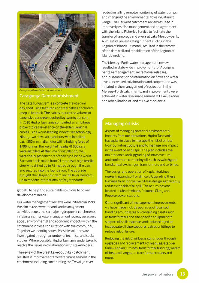
Catagunya Dam refurbishmentThe Catagunya Dam is a concrete gravity dam designed using high-tension steel cables anchored deep in bedrock. The cables reduce the volume of expensive concrete required by twenty per cent. In 2010 Hydro Tasmania completed an ambitious project to cease reliance on the elderly original cables using world-leading innovative technology. Ninety-two new cable anchors were installed, each 350 mm in diameter with a holding force of 1700 tonnes, the weight of nearly 70 000 cars were installed. At the time of installation, they were the largest anchors of their type in the world. Each anchor is made from 91 strands of high tensile steel wire drilled up to 75 metres through the dam and secured into the foundation. The upgrade brought the 50-year-old dam on the River Derwent up to modern international safety standards.
Managing oil risksAs part of managing potential environmental impacts from our operations, Hydro Tasmania has a plan in place to manage the risk of oil less from our infrastructure and to manage any impact in the event of an oil spill. The plan includes the maintenance and upgrading of infrastructure and equipment containing oil, such as switchyard bunds, heat exchanges, transformers and turbines.
The design and operation of Kaplan turbines makes trapping spilt oil difficult. Upgrading these turbines to an innovative oil-less design significantly reduces the risk of oil spill. These turbines are located at Meadowbank, Paloona, Cluny and Repulse power stations.
Other significant oil management improvements we have made include upgrades of localised bunding around large oil-containing assets such as transformers and site-specific equipment to support oil spill response, and replaced aged or inadequate oil pipe supports, valves or fittings to reduce risk of failure.
Reducing the risk of oil loss is continuous through upgrades and replacements of many assets over time – Kaplan turbines, transformer bunding, water/oil heat exchanges on transformer coolers and more.
ladder, installing remote monitoring of water pumps, and changing the environmental flows in Cataract Gorge. The Derwent catchment review resulted in improved pest fish management and an agreement with the Inland Fisheries Service to facilitate the transfer of lampreys and elvers at Lake Meadowbank. A PhD study investigating nutrient cycling in the Lagoon of Islands ultimately resulted in the removal of the dam wall and rehabilitation of the Lagoon of Islands wetland.
The Mersey–Forth water management review resulted in state-wide improvements for Aboriginal heritage management, recreational releases, and dissemination of information on flows and water levels. Increased collaboration and cooperation was initiated in the management of recreation in the Mersey–Forth catchments, and improvements were achieved in water level management at Lake Gairdner and rehabilitation of land at Lake Mackenzie.
globally to help find sustainable solutions to power development needs.
Our water management reviews were initiated in 1999. We aim to review water and land management activities across the six major hydropower catchments in Tasmania. In a water management review, we assess social, environmental and economic impacts within the catchment in close consultation with the community. Together we identify issues. Possible solutions are investigated through a number of technical and social studies. Where possible, Hydro Tasmania undertakes to resolve the issues in collaboration with stakeholders.
The review of the Great Lake-South Esk catchment resulted in improvements to water management in the catchment including constructing the Trevallyn elver
Catagunya Dam during refurbishment

14 the power of nature
Hydro Tasmania’s hydropower developmentsHydro Tasmania’s hydropower developments date back to 1914.
In Tasmania we own, operate and maintain a complex hydropower system including 30 hydropower stations, 55 major dams and 45 major lakes.
Our system contains two large permanent water storages (Great Lake and Lake Gordon). These are supported by several seasonal water storages, and run-of-river systems which use seasonal flows.
Our catchment areasHydro Tasmania’s hydropower stations have been built in seven high-rainfall water catchments formed from natural river systems in Tasmania’s rugged landscape: Great Lake–South Esk, Derwent, Mersey–Forth, Gordon–Pedder, Pieman, King and Yolande.
The water systems and power stations are interlinked through natural and man-made water channels.
GREAT LAKE
Tamar River
LAKE TREVALLYN
ARTHURS LAKE
WOODS LAKE
LAKE AUGUSTA
Great Western Tiers
Lake River
Macquarie River
Midland Highwayto Campbell Town
South Esk River
Meander River
North Esk River
Cataract Gorge
Launceston
Perth
LongfordCressy
Poatina
POATINA POWER STATION(underground)
ARTHURS LAKEPUMP STATION
TODS CORNERPOWER STATION
accesstunnel tail race
tunnel
TREVALLYNPOWER STATION
TREVALLYN DAM
MIENA DAMLiawenee
Canal
ARTHURS LAKE DAM
ARTHURS LEVEE
WOODS LAKE DAM
tunnel
tunnel
penstock
Great Lake – South Esk catchment
Great Lake is Australia’s second largest freshwater lake (Lake Pedder is the largest), 1030 metres above sea level. The lake has an area of 114 km².
The South Esk catchment covers approximately 12 per cent of Tasmania, from the eastern slopes of Ben Lomond and incorporating Great Lake, Meander and Tamar Rivers on the way to the Tamar Estuary at Launceston.
There are three power stations operating in this catchment.
Power stationDate(s) commissioned Turbines
Capacity (MW)
Trevallyn 1955 4 Francis 95.80
Poatina 1966, 1977 6 Pelton 300.00
Tods Corner 1966 1 Francis 1.70
Poatina Power Station
Poatina Power Station was Tasmania’s first underground power station. It is a huge excavation as wide as a city street and as high as a seven-storey building. It is the State’s second largest power station, harnessing the fall of 830 metres down the face of the Great Western Tiers.
Tods Corner Power Station
Arthurs Lake was created in the 1920s to increase the water available at Great Lake. Water is pumped up 140 metres from Arthurs Lake to a 5 km flume. The automated Tods Corner Power Station recovers part of the energy used in pumping the water. The rest, and more, is recovered when the water is used at Poatina.
15the power of nature
Trevallyn Power Station
Trevallyn Power Station in the South Esk catchment was the first power station built by the Hydro outside of the Central Highlands. It replaced the Duck Reach Power Station, one of the earliest in Australia. Duck Reach was commissioned in 1895, destroyed by floods in 1929, was rebuilt and continued to operate until 1955. The Trevallyn Power Station is 5 km from the centre of Launceston in the north of Tasmania. It is powered by the daily flow down the South Esk River from Lake Trevallyn.
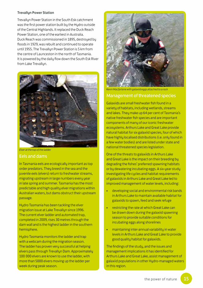
Management of threatened speciesGalaxiids are small freshwater fish found in a variety of habitats, including wetlands, streams and lakes. They make up 64 per cent of Tasmania’s native freshwater fish species and are important components of many of our iconic freshwater ecosystems. Arthurs Lake and Great Lake provide natural habitat for six galaxiid species, four of which have highly localised distributions (i.e. only found in a few water bodies) and are listed under state and national threatened species legislation.
One of the threats to galaxiids in Arthurs Lake and Great Lake is the impact on their breeding by degrading the fishes’ preferred spawning habitats or by dewatering incubating eggs. A six-year study investigating life cycles and habitat requirements of galaxiids in Arthurs Lake and Great Lake led to improved management of water levels, including:
• developing social and environmental risk bands in Arthurs Lake to maintain available habitat for galaxiids to spawn, feed and seek refuge
• restricting the rate at which Great Lake can be drawn down during the galaxiid spawning season to provide suitable conditions for incubating eggs along shorelines
• maintaining inter-annual variability in water levels in Arthurs Lake and Great Lake to provide good quality habitat for galaxiids.
The findings of the study, and the issues and management implications it has identified for Arthurs Lake and Great Lake, assist management of galaxiid populations in other Hydro-managed waters in this region.
Eels and dams In Tasmania eels are ecologically important as top order predators. They breed in the sea and the juvenile eels (elvers) return to freshwater streams, migrating upstream in large numbers every year in late spring and summer. Tasmania has the most predictable and high quality elver migrations within Australian waters, but dams obstruct their upstream passage.
Hydro Tasmania has been tackling the elver migration issue at Lake Trevallyn since 1996. The current elver ladder and automated trap, completed in 2009, rises 30 metres through the dam wall and is the highest ladder in the southern hemisphere.
Hydro Tasmania monitors the ladder and trap with a webcam during the migration season. The ladder has proven very successful at helping elvers pass through Trevallyn Dam. Approximately 100 000 elvers are known to use the ladder, with more than 5000 elvers moving up the ladder per week during peak season.
Elver at the top of the ladder
Kevin Macfarlane with galaxiid eggs attached to a rock
16 the power of nature
Derwent catchment
penstockspenstocks
tunnel
tunnel
LAKE ECHOLAKE ECHODAM
LAKE KING WILLIAM
LAKE ST CLAIR
LAKE CATAGUNYAMEADOWBANK LAKE
LAKEBINNEYTUNGATINAH
LAGOON
LAKEREPULSE
BRADYSLAKE
DEE DAM DEE LAGOON
WAYATINAH LAGOON
CLUNYLAGOON
LAUGHING JACK LAGOON BRONTELAGOON CLARK DAM
PINE TIER DAM
LIAPOOTAH DAM
CATAGUNYA DAM& POWER STATION
REPULSE DAM& POWER STATION
CLUNY DAM& POWER STATION
LAKE ECHOPOWER STATION
TUNGATINAHPOWER STATION
TARRALEAHPOWER STATION
BUTLERS GORGEPOWER STATION
pumping stationNo.1 canal
No.2 canalCLARENCE WEIR
LIAPOOTAHPOWER STATION
MEADOWBANK DAM& POWER STATION
Florentine River
Clarence River Nive RiverPine River
River Ouse Nive River
River Derwent
River Derwent
River Derwent River Dee
River Dee Clyde River
Lyell Highway
TARRALEAH
WAYATINAH
OUSE
HAMILTON
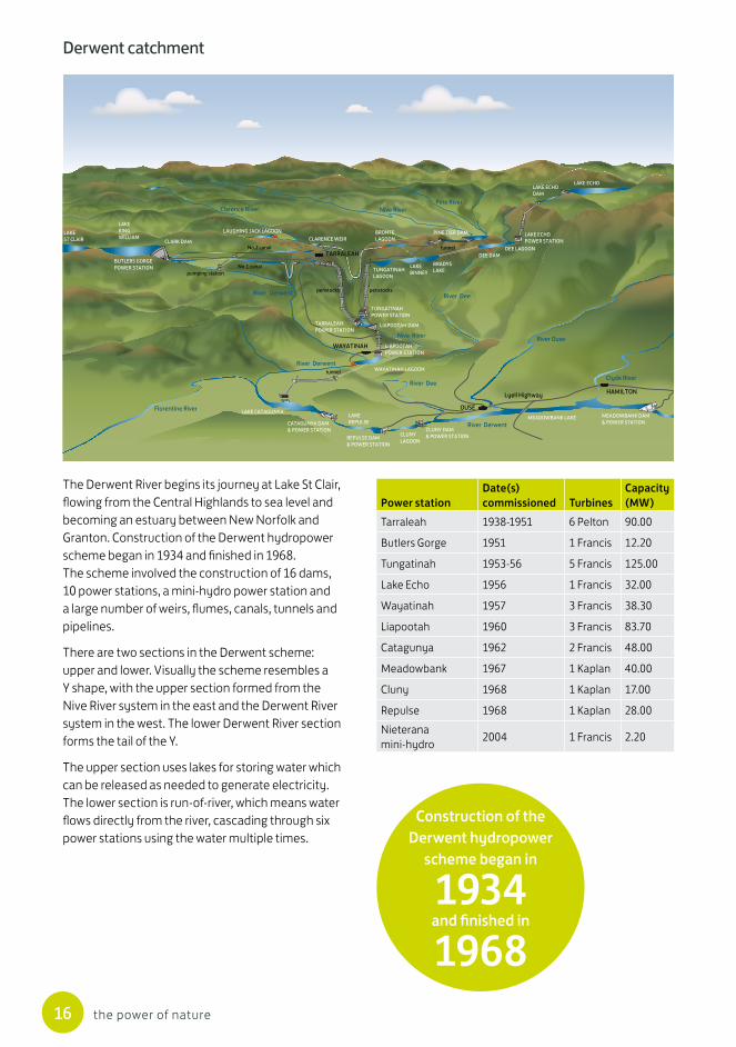
The Derwent River begins its journey at Lake St Clair, flowing from the Central Highlands to sea level and becoming an estuary between New Norfolk and Granton. Construction of the Derwent hydropower scheme began in 1934 and finished in 1968. The scheme involved the construction of 16 dams, 10 power stations, a mini-hydro power station and a large number of weirs, flumes, canals, tunnels and pipelines.
There are two sections in the Derwent scheme: upper and lower. Visually the scheme resembles a Y shape, with the upper section formed from the Nive River system in the east and the Derwent River system in the west. The lower Derwent River section forms the tail of the Y.
The upper section uses lakes for storing water which can be released as needed to generate electricity. The lower section is run-of-river, which means water flows directly from the river, cascading through six power stations using the water multiple times.
Power stationDate(s) commissioned Turbines
Capacity (MW)
Tarraleah 1938-1951 6 Pelton 90.00
Butlers Gorge 1951 1 Francis 12.20
Tungatinah 1953-56 5 Francis 125.00
Lake Echo 1956 1 Francis 32.00
Wayatinah 1957 3 Francis 38.30
Liapootah 1960 3 Francis 83.70
Catagunya 1962 2 Francis 48.00
Meadowbank 1967 1 Kaplan 40.00
Cluny 1968 1 Kaplan 17.00
Repulse 1968 1 Kaplan 28.00Nieterana mini-hydro 2004 1 Francis 2.20
Construction of the Derwent hydropower
scheme began in
1934 and finished in
1968

17the power of nature
Lagoon of Islands restorationOriginally a unique ecosystem characterised by floating islands of vegetation, Lagoon of Islands was flooded in 1964 to provide water to downstream irrigators along the Ouse River. Insufficient water was available during the drought in the 1970s and in 1984 Ripple Canal was constructed to divert more water into the lagoon. Ultimately this development proved to be unsustainable, with significant and ongoing water quality problems.
Hydro Tasmania explored and implemented a number of remedial actions to improve water quality and ecosystem health over 10 years but none provided a long-term solution. With irrigation needs now met from Great Lake, Lagoon of Islands had not been used for its intended purpose for a number of years. In response to the continually deteriorating ecosystem, Hydro Tasmania established an ambitious project to decommission the dam and rehabilitate the lagoon to a natural, healthy and self-sustaining wetland.
In April 2013, the 320-metre long, six-metre high earth wall dam and associated infrastructure were removed and the area replanted with native vegetation. Comprehensive monitoring of water
quality, vegetation, invertebrates, weeds and algae is tracking the progress of the lagoon’s recovery. A similar wetland in the central highlands of Tasmania, Companion Lagoon, is the control site to guide rehabilitation targets for the vegetation community.
WADDAMANA POWER STATION MUSEUM
WADDAMANA CANALS
PENSTOCKLAGOON
SHANNON LAGOON
GREAT LAKE
ARTHURSLAKE
LAKE ECHO
MIENA DAM
LIAWENEECANAL
Site of the old SHANNONPOWER STATION
Shannon River River Ouse
Lake Highway
Poatina Road
WADDAMANA
MIENA
LIAWENEE
From old to newIn 1916 power generation began at the Waddamana A Power Station. Between 1939 and 1949 Waddamana B was built to meet the increasing demand of electricity in Tasmania.
The Shannon Power Station was built to use the water from Great Lake before it flowed into Penstock Lagoon and on to Waddamana. Waddamana A and Shannon power stations continued to operate until 1964. Waddamana B was decommissioned in 1994. The water stored in Great Lake is now used at Poatina Power Station located to the north. The large drop down the Great Western Tiers makes Poatina a more efficient power station.
You can visit Waddamana A power station today in its new life as a museum. The Waddamana Power Station Museum has been welcoming tourists since it was converted in 1988.
Carolyn Maxwell researching the remnant woody islands at Lagoon of Islands
Inside the Waddamana Power Station Museum
18 the power of nature
Mersey–Forth catchment
Devonport
Ulverstone
SpreytonLatrobe
She�eld
Mole Creek
Railton LAKE PALOONA
LAKE PARANGANA
LAKE CETHANA
LAKE GAIRDNER
LAKE ROWALLAN
Bass Strait
Central Plateau
Great Western Tiers
LAKE MACKENZIE
LAKE BARRINGTON
ROWALLAN DAM& POWER STATION
MACKENZIE DAM
FISHERPOWER STATION
LEMONTHYMEPOWER STATION
PARANGANA DAM& MINI HYDROPOWER STATION
DEVILS GATE DAM& POWER STATION
PALOONA DAM& POWER STATION
WILMOT DAM
WILMOTPOWER STATION
CETHANA DAM& POWER STATION
(underground)
pumping station
tunnel
tunnel
tunnel
tunnel
tunnel
River Forth
Wilmot River
Mersey River
Mersey River
Don RiverRiver Forth
Bass Highway
WesternBlu�
Barn Blu�
Mt OssaCradle
Mountain
Mount Beecroft
Black Blu�
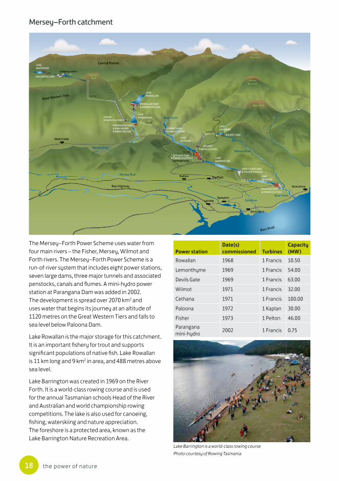
The Mersey–Forth Power Scheme uses water from four main rivers – the Fisher, Mersey, Wilmot and Forth rivers. The Mersey–Forth Power Scheme is a run-of-river system that includes eight power stations, seven large dams, three major tunnels and associated penstocks, canals and flumes. A mini-hydro power station at Parangana Dam was added in 2002. The development is spread over 2070 km2 and uses water that begins its journey at an altitude of 1120 metres on the Great Western Tiers and falls to sea level below Paloona Dam.
Lake Rowallan is the major storage for this catchment. It is an important fishery for trout and supports significant populations of native fish. Lake Rowallan is 11 km long and 9 km2 in area, and 488 metres above sea level.
Lake Barrington was created in 1969 on the River Forth. It is a world-class rowing course and is used for the annual Tasmanian schools Head of the River and Australian and world championship rowing competitions. The lake is also used for canoeing, fishing, waterskiing and nature appreciation. The foreshore is a protected area, known as the Lake Barrington Nature Recreation Area.
Power stationDate(s) commissioned Turbines
Capacity (MW)
Rowallan 1968 1 Francis 10.50
Lemonthyme 1969 1 Francis 54.00
Devils Gate 1969 1 Francis 63.00
Wilmot 1971 1 Francis 32.00
Cethana 1971 1 Francis 100.00
Paloona 1972 1 Kaplan 30.00
Fisher 1973 1 Pelton 46.00Parangana mini-hydro 2002 1 Francis 0.75
Lake Barrington is a world-class rowing coursePhoto courtesy of Rowing Tasmania
19the power of nature
Gordon–Pedder catchment
Power stationDate(s) commissioned Turbines
Capacity (MW)
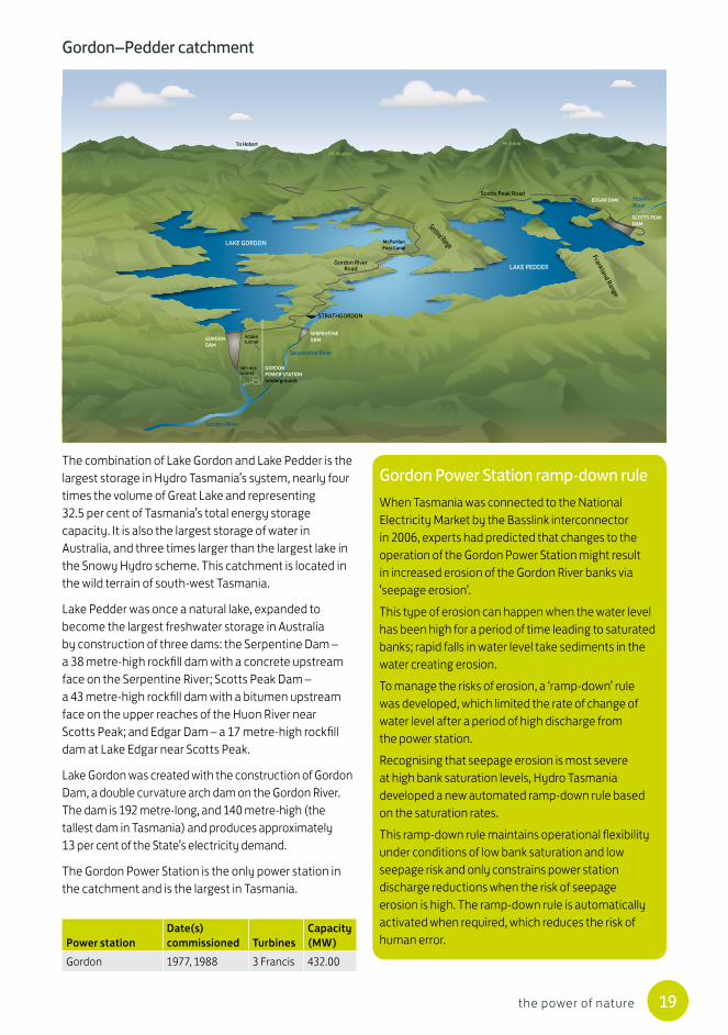
Gordon 1977, 1988 3 Francis 432.00
LAKE GORDON
LAKE PEDDER
GORDON DAM
SERPENTINE DAM
SCOTTS PEAKDAM
EDGAR DAM
GORDONPOWER STATION (underground)
Gordon River
Serpentine River
Huon River
Frankland Range
Sentinel Range
Gordon RiverRoad
Scotts Peak Road
McPartlanPass Canal
To Hobart
intaketunnel
tail racetunnel
Mt Mueller
Mt Anne
STRATHGORDON
The combination of Lake Gordon and Lake Pedder is the largest storage in Hydro Tasmania’s system, nearly four times the volume of Great Lake and representing 32.5 per cent of Tasmania’s total energy storage capacity. It is also the largest storage of water in Australia, and three times larger than the largest lake in the Snowy Hydro scheme. This catchment is located in the wild terrain of south-west Tasmania.
Lake Pedder was once a natural lake, expanded to become the largest freshwater storage in Australia by construction of three dams: the Serpentine Dam – a 38 metre-high rockfill dam with a concrete upstream face on the Serpentine River; Scotts Peak Dam – a 43 metre-high rockfill dam with a bitumen upstream face on the upper reaches of the Huon River near Scotts Peak; and Edgar Dam – a 17 metre-high rockfill dam at Lake Edgar near Scotts Peak.
Lake Gordon was created with the construction of Gordon Dam, a double curvature arch dam on the Gordon River. The dam is 192 metre-long, and 140 metre-high (the tallest dam in Tasmania) and produces approximately 13 per cent of the State’s electricity demand.
The Gordon Power Station is the only power station in the catchment and is the largest in Tasmania.
Gordon Power Station ramp-down rule When Tasmania was connected to the National Electricity Market by the Basslink interconnector in 2006, experts had predicted that changes to the operation of the Gordon Power Station might result in increased erosion of the Gordon River banks via ‘seepage erosion’. This type of erosion can happen when the water level has been high for a period of time leading to saturated banks; rapid falls in water level take sediments in the water creating erosion. To manage the risks of erosion, a ‘ramp-down’ rule was developed, which limited the rate of change of water level after a period of high discharge from the power station. Recognising that seepage erosion is most severe at high bank saturation levels, Hydro Tasmania developed a new automated ramp-down rule based on the saturation rates. This ramp-down rule maintains operational flexibility under conditions of low bank saturation and low seepage risk and only constrains power station discharge reductions when the risk of seepage erosion is high. The ramp-down rule is automatically activated when required, which reduces the risk of human error.
20 the power of nature
Pieman catchment
LAKE MACKINTOSH
LAKE ROSEBERY
LAKE PIEMAN
LAKE MURCHISON
LAKE PLIMSOLLANTHONY DAM
TRIBUTEPOWER STATION
(underground)
LAKE NEWTON & DAM
WHITE SPUR LAKE& DAM
HENTY LAKE& DAM
BASTYAN DAM& POWER STATION
REECE DAM& POWER STATION
MACKINTOSH DAM& POWER STATION
MURCHISON DAM
TULLABARDINE DAM
Little Henty River
Pieman River
Zeehan HighwayMurchison Highway
Anthony Main Road
tunnel
tunnel
Mt Murchison
Victoria Peak
Mt Romulus
Mt Read
Mt Dundas
Mt Black
Southern Ocean
Zeehan
Rosebery
Tullah
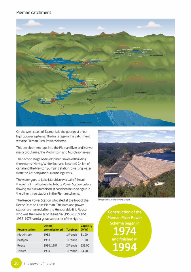
On the west coast of Tasmania is the youngest of our hydropower systems. The first stage in this catchment was the Pieman River Power Scheme.
This development taps into the Pieman River and its two major tributaries, the Mackintosh and Murchison rivers.
The second stage of development involved building three dams (Henty, White Spur and Newton) 7.4 km of canal and the Newton pumping station, diverting water from the Anthony and surrounding rivers.
The water goes to Lake Murchison via Lake Plimsoll through 7 km of tunnels to Tribute Power Station before flowing to Lake Murchison. It can then be used again in the other three stations in the Pieman scheme.
The Reece Power Station is located at the foot of the Reece Dam on Lake Pieman. The dam and power station are named after the Honourable Eric Reece who was the Premier of Tasmania (1958–1969 and 1972–1975) and a great supporter of the Hydro.
Power stationDate(s) commissioned Turbines
Capacity (MW)
Mackintosh 1982 1 Francis 81.00
Bastyan 1983 1 Francis 81.00
Reece 1986, 1987 2 Francis 238.00
Tribute 1994 1 Francis 84.00
Construction of the Pieman River Power
Scheme began in
1974 and finished in
1994
Reece Dam and power station
21the power of nature
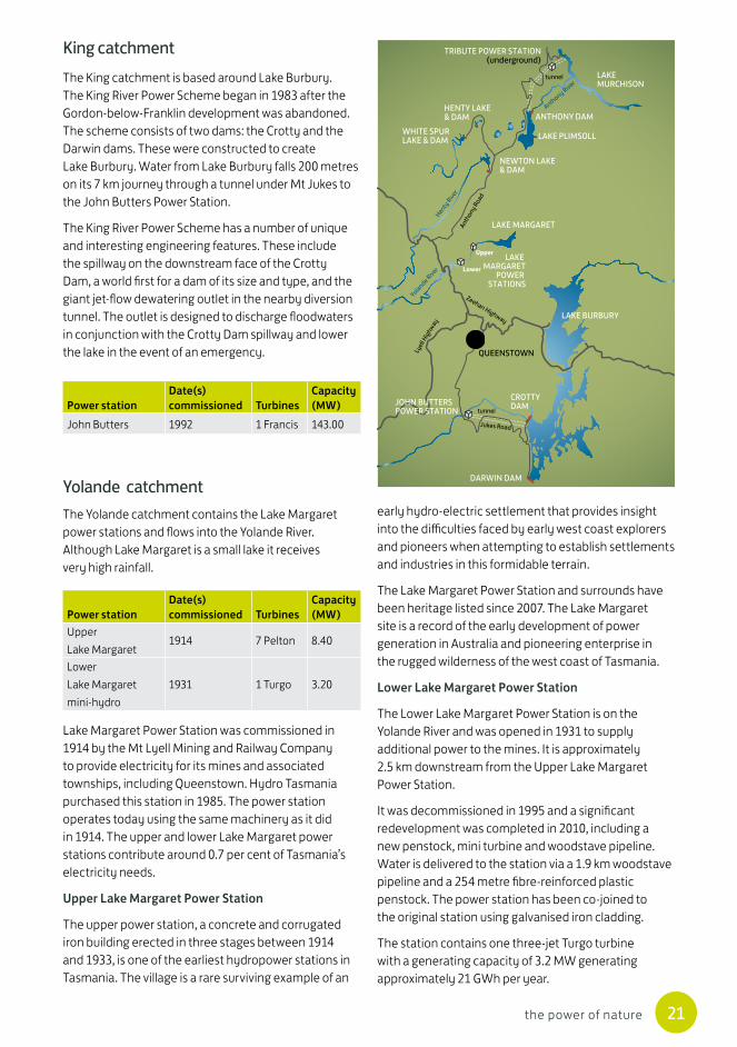
King catchment
Yolande catchmentThe Yolande catchment contains the Lake Margaret power stations and flows into the Yolande River. Although Lake Margaret is a small lake it receives very high rainfall.
Power stationDate(s) commissioned Turbines
Capacity (MW)
Upper Lake Margaret
1914 7 Pelton 8.40
Lower Lake Margaret mini-hydro
1931 1 Turgo 3.20
Power stationDate(s) commissioned Turbines
Capacity (MW)
John Butters 1992 1 Francis 143.00
LAKEMURCHISON
LAKE PLIMSOLL
LAKE MARGARET
LAKE MARGARET
POWER STATIONS
LAKE BURBURY
CROTTYDAM
DARWIN DAM
ANTHONY DAM
NEWTON LAKE& DAM
HENTY LAKE& DAM
WHITE SPURLAKE & DAM
TRIBUTE POWER STATION(underground)
QUEENSTOWN
Anthony River
Henty Rive
r
Yolande River
Anthony Road
Jukes Road
Lyell
High
way
Zeehan Highway
Upper
Lower
tunnel
tunnelJOHN BUTTERSPOWER STATION
The King catchment is based around Lake Burbury. The King River Power Scheme began in 1983 after the Gordon-below-Franklin development was abandoned. The scheme consists of two dams: the Crotty and the Darwin dams. These were constructed to create Lake Burbury. Water from Lake Burbury falls 200 metres on its 7 km journey through a tunnel under Mt Jukes to the John Butters Power Station.
The King River Power Scheme has a number of unique and interesting engineering features. These include the spillway on the downstream face of the Crotty Dam, a world first for a dam of its size and type, and the giant jet-flow dewatering outlet in the nearby diversion tunnel. The outlet is designed to discharge floodwaters in conjunction with the Crotty Dam spillway and lower the lake in the event of an emergency.
Lake Margaret Power Station was commissioned in 1914 by the Mt Lyell Mining and Railway Company to provide electricity for its mines and associated townships, including Queenstown. Hydro Tasmania purchased this station in 1985. The power station operates today using the same machinery as it did in 1914. The upper and lower Lake Margaret power stations contribute around 0.7 per cent of Tasmania’s electricity needs.
Upper Lake Margaret Power Station
The upper power station, a concrete and corrugated iron building erected in three stages between 1914 and 1933, is one of the earliest hydropower stations in Tasmania. The village is a rare surviving example of an
early hydro-electric settlement that provides insight into the difficulties faced by early west coast explorers and pioneers when attempting to establish settlements and industries in this formidable terrain.
The Lake Margaret Power Station and surrounds have been heritage listed since 2007. The Lake Margaret site is a record of the early development of power generation in Australia and pioneering enterprise in the rugged wilderness of the west coast of Tasmania.
Lower Lake Margaret Power Station
The Lower Lake Margaret Power Station is on the Yolande River and was opened in 1931 to supply additional power to the mines. It is approximately 2.5 km downstream from the Upper Lake Margaret Power Station.
It was decommissioned in 1995 and a significant redevelopment was completed in 2010, including a new penstock, mini turbine and woodstave pipeline. Water is delivered to the station via a 1.9 km woodstave pipeline and a 254 metre fibre-reinforced plastic penstock. The power station has been co-joined to the original station using galvanised iron cladding.
The station contains one three-jet Turgo turbine with a generating capacity of 3.2 MW generating approximately 21 GWh per year.

22 the power of nature
Power from wind
Converting wind to electricityWind has been used for thousands of years to sail ships, pump water and drive machinery, but it took until the 1890s to first convert the power of the wind (kinetic energy) into electricity. These early wind turbines have evolved into the high-technology turbines we see today, generating clean electricity across Australia from the renewable energy of wind.
Parts of a wind turbine
Electricity from wind is generated in a similar way to hydropower. Wind spins the blades of a turbine, which in turn spin a magnet inside a coil of conductor (called a generator). Each wind turbine has an underground foundation to ensure the structure is stable and sits on top of a tall steel tower made up of three sections. The generator, gearbox and brakes are housed in a steel-framed, fibreglass-covered ‘box’ called the nacelle, which sits on top of the tower. A cone-shaped hub, supporting the turbine (or rotor) blades, is attached to the nacelle at one end. Most modern turbines have three aerodynamic, tapered blades made from fibreglass or reinforced plastics.
Wind turbines are controlled automatically by computer to take best advantage of wind conditions, and to operate safely and efficiently. An ultrasonic anemometer on the nacelle measures wind direction and speed. When the wind changes direction, the nacelle rotates horizontally, allowing the blades to face into the wind. The blades can also tilt to capture the wind most efficiently, and pivot to slow and stop the turbine if the wind becomes too strong.
Shaft
Generator
Ladder
Power cable
Nacelle
Underground cable is connected to a sub-station
Anemometer
Gearbox
Blades
The Bluff Point Wind Farm, north-west Tasmania
Parts of a wind turbine
23the power of nature
Modern wind turbines are very tall structures, increasing in size and efficiency as time passes. Taller towers and longer blades enable greater productivity by capturing wind higher up where it is stronger and less turbulent. Longer blades also ‘sweep’ a bigger circle than shorter blades, capturing more wind energy and creating more electricity from each turbine.
Getting wind power from a turbine to you
A collection of wind turbines is known as a wind farm. Wind turbines are connected by underground cables to a substation, where low-voltage electricity produced by the turbines is converted into high-voltage electricity for efficient transport over long distances. Substations near homes decrease the voltage again for general use.
Total wind farm infrastructure (turbines, foundations, cables, roads and substations) uses only a small proportion of the wind farm site, leaving the rest available for other use, such as farming.
Planning a wind farmYears of work go into planning a new wind farm. Detailed investigations are needed to ensure that the wind farm will be technically and economically feasible, as well as socially and environmentally acceptable.
Finding the ideal wind farm location
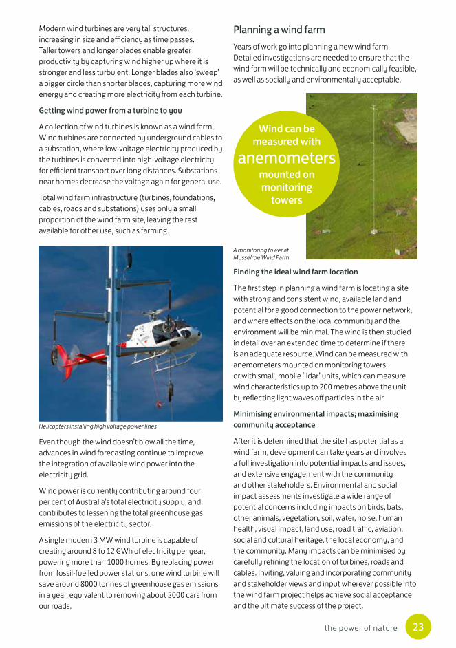
The first step in planning a wind farm is locating a site with strong and consistent wind, available land and potential for a good connection to the power network, and where effects on the local community and the environment will be minimal. The wind is then studied in detail over an extended time to determine if there is an adequate resource. Wind can be measured with anemometers mounted on monitoring towers, or with small, mobile ‘lidar’ units, which can measure wind characteristics up to 200 metres above the unit by reflecting light waves off particles in the air.
Minimising environmental impacts; maximising community acceptance
After it is determined that the site has potential as a wind farm, development can take years and involves a full investigation into potential impacts and issues, and extensive engagement with the community and other stakeholders. Environmental and social impact assessments investigate a wide range of potential concerns including impacts on birds, bats, other animals, vegetation, soil, water, noise, human health, visual impact, land use, road traffic, aviation, social and cultural heritage, the local economy, and the community. Many impacts can be minimised by carefully refining the location of turbines, roads and cables. Inviting, valuing and incorporating community and stakeholder views and input wherever possible into the wind farm project helps achieve social acceptance and the ultimate success of the project.
Even though the wind doesn’t blow all the time, advances in wind forecasting continue to improve the integration of available wind power into the electricity grid.
Wind power is currently contributing around four per cent of Australia’s total electricity supply, and contributes to lessening the total greenhouse gas emissions of the electricity sector.
A single modern 3 MW wind turbine is capable of creating around 8 to 12 GWh of electricity per year, powering more than 1000 homes. By replacing power from fossil-fuelled power stations, one wind turbine will save around 8000 tonnes of greenhouse gas emissions in a year, equivalent to removing about 2000 cars from our roads.
Wind can be measured with
anemometers mounted on monitoring
towers
A monitoring tower at Musselroe Wind Farm
Helicopters installing high voltage power lines
24 the power of nature
Once the planning is complete the documents are assessed by the relevant regulatory authorities. Depending on the condition and issues at the specific site, this may involve the local council and state and commonwealth regulators. The regulators determine if the wind farm project should be approved and any conditions to be attached to the permit. These conditions, which may include various types of monitoring for impacts, must be complied with.
Constructing and operating a wind farmConstruction of a wind farm is a major logistical challenge. While some components may be manufactured locally, many turbine components need to be shipped to Australia and transported by truck to the wind farm site. Giant cranes are used to assemble the towers and place the turbines. A large amount of concrete (1200 tonnes) is needed for the foundation of each turbine.
Depending on the issues at the specific site, potential impacts to the environment (such as flora and fauna) and cultural heritage are carefully managed, minimising impacts.
Once the wind farm is constructed and has complied with all the permit requirements of construction, the wind farm can commence operation. There may be requirements for monitoring various environmental impacts during the operation of the wind farm. The type and extent of these depends on the issues and the relevant regulators.
Analyses have shown that most wind farms repay all their greenhouse gas emissions and the total amount of energy used in their manufacture and construction in less than six months of operation. The expected life of a wind turbine is around 20 years, but can be extended by replacing parts.
If the wind farm is decommissioned, the land can be returned to its original state by dismantling and removing the turbines and covering the foundations with topsoil and grass, leaving almost no lasting ‘footprint’.
Pouring a concrete foundation at Musselroe Wind Farm
Transporting a 45 metre turbine blade
Constructing towers at Musselroe Wind Farm
An aerial view of Musselroe Wind Farm

25the power of nature
Hydro Tasmania wind developments
Hydro Tasmania has invested in four wind power developments. The Huxley Hill Wind Farm on King Island is owned and operated by Hydro Tasmania.
The Musselroe, Bluff Point and Studland Bay wind farms are operated under a joint venture between Shenhua Clean Energy and Hydro Tasmania, an entity known as Woolnorth Wind Farm Holding Pty Ltd; Shenhua Clean Energy owns a 75 per cent share and Hydro Tasmania retains 25 per cent.
Huxley Hill Wind FarmIn 1998 Hydro Tasmania built its first wind farm, Huxley Hill on King Island in Bass Strait. It was the second commercial wind farm in Australia. In 2003 two more turbines (Vestas V52 850 kw) were added to the original three turbines (Nordex N29 250 kw), raising Huxley Hill Wind Farm’s capacity to 2.45 MW. This wind farm is part of Hydro Tasmania’s King Island Renewable Energy Integration Project (KIREIP) which uses a range of renewable and conventional technologies to provide King Island’s power.
Location Capacity Composition Land area Land usage
Bluff Point Wind Farm (north-west Tasmania)
65 MW 37 V66 Vestas turbines (blades 33 m, tower height 60 m)
1524 ha 40 per cent of the land is used for grazing and cropping; the rest is remnant vegetation protected from any human activities including cattle grazing
Studland Bay Wind Farm (north-west Tasmania)
75 MW 25 V90 Vestas turbines (blades 45 m, tower height 80 m)
1410 ha 60 per cent of the land is used for grazing and cropping; the rest is remnant vegetation protected from any human activities including cattle grazing
Musselroe Wind Farm (north-east Tasmania)
168 MW 56 V90 Vestas turbines (blades 45 m, tower height 80 m)
5500 ha Approximately 40 per cent of the land is protected in reserves and restricted areas. The remainder is used for cattle grazing
Joint-venture wind farms
Studland Bay Wind Farm, north-west Tasmania

26 the power of nature
Musselroe Wind Farm: engaging with cultural heritageThe site of the Musselroe Wind Farm is historically, spiritually and culturally significant to Tasmanian Aboriginal people. At the early stages of the project, some members of the local Aboriginal community had concerns about plans for a wind farm in this area. Right from the earliest detailed investigations of how to preserve the extensive cultural heritage of the site, Hydro Tasmania worked closely with Aboriginal community members to understand their concerns and help build their confidence in and connection with the project.
Forming strong relationships helped the project succeed and acknowledged the significance of cultural heritage. Members of the project team increased their cultural awareness through training in the field, several ‘Walks in Country’ with Aboriginal elders during construction and followed Aboriginal heritage officers’ guidance on the fine-scale location of turbines.
The melythina tiakana warrana (Heart of Country) Aboriginal Corporation held an on-site ceremony to honour the Ancestors, collaborated with Hydro Tasmania to tell their story of past and present at the Tebrakunna Visitor Centre, and supported the official opening of the wind farm with a spectacular demonstration of traditional music and dance.
Hydro Tasmania placed the utmost value on an extensive, integrated and constructive approach to community engagement across the full range of community sectors affected by the Musselroe project, and this was recognised nationally with an industry excellence award for community engagement from the Clean Energy Council of Australia.
Birds, bats and wind farms: what we have learnt Our investigations of bird and bat behaviour have led to some unique findings – many are Australasian-firsts, and some are world-firsts; for example:
• approximately 20 per cent of the species of birds that are found at the Bluff Point and Studland Bay wind farms are involved in turbine collisions, and these species have specific characteristics or ‘lifestyles’. To be involved in a collision, a bird or bat has to be present in the rotor swept area of the turbine. It is only some species whose ’lifestyle’ places them in this situation
• all species display an ‘avoidance’ capacity; that is, they actively avoid objects if they see them in time.
We have measured the avoidance behaviour of two species of eagles for the first time at these sites and found the avoidance rate is varied; for example:
• there was a lower avoidance rate when the turbines were standing soon after construction and before they were fully operational
• once the wind farm was fully operating avoidance rates were higher when a turbine was turning compared to when it was stationary
• Wedge-tailed eagles avoided turbines more in poor weather.
These findings suggest that eagles are aware of turbines and respond to changes in the risk posed by the turbines. However, sometimes this avoidance behaviour fails. We continue to investigate why this occasionally occurs.
Our studies to date have found no evidence of the wind farms causing disturbance to eagles breeding on site, or changes in the other birds present on site. We are continuing our studies and learning more all the time.
Various trials of innovative strategies to minimise impacts to birds and bats continue. While some of these have not been successful (such as various ways to alert eagles to the presence of turbines) we continue to try new ideas. We believe it is only through trial and error that new, effective strategies will be developed. Details of these trials are published in our annual environment reports for the wind farms.
Aboriginal Heritage Officer, Colin Hughes, showing construction crew members how to identify stone artefacts
27the power of nature
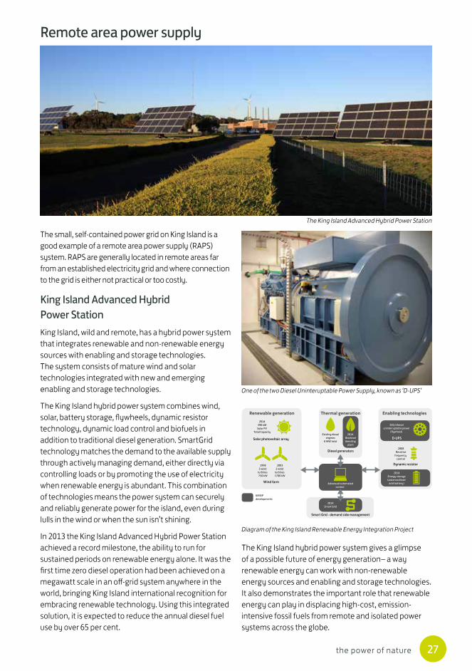
The small, self-contained power grid on King Island is a good example of a remote area power supply (RAPS) system. RAPS are generally located in remote areas far from an established electricity grid and where connection to the grid is either not practical or too costly.
King Island Advanced Hybrid Power StationKing Island, wild and remote, has a hybrid power system that integrates renewable and non-renewable energy sources with enabling and storage technologies. The system consists of mature wind and solar technologies integrated with new and emerging enabling and storage technologies.
The King Island hybrid power system combines wind, solar, battery storage, flywheels, dynamic resistor technology, dynamic load control and biofuels in addition to traditional diesel generation. SmartGrid technology matches the demand to the available supply through actively managing demand, either directly via controlling loads or by promoting the use of electricity when renewable energy is abundant. This combination of technologies means the power system can securely and reliably generate power for the island, even during lulls in the wind or when the sun isn’t shining.
In 2013 the King Island Advanced Hybrid Power Station achieved a record milestone, the ability to run for sustained periods on renewable energy alone. It was the first time zero diesel operation had been achieved on a megawatt scale in an off-grid system anywhere in the world, bringing King Island international recognition for embracing renewable technology. Using this integrated solution, it is expected to reduce the annual diesel fuel use by over 65 per cent.
Remote area power supply
The King Island hybrid power system gives a glimpse of a possible future of energy generation– a way renewable energy can work with non-renewable energy sources and enabling and storage technologies. It also demonstrates the important role that renewable energy can play in displacing high-cost, emission-intensive fossil fuels from remote and isolated power systems across the globe.
The King Island Advanced Hybrid Power Station
One of the two Diesel Uninteruptable Power Supply, known as ‘D-UPS’
Diagram of the King Island Renewable Energy Integration Project
Renewable generation
Wind farm
KIREIPdevelopments
Solar photovoltaic array
19983 wind
turbines750 kW
2003 2 wind
turbines1700 kW
Enabling technologies
D-UPS
Dynamic resistor
2012 Diesel uninterruptable power
(flywheel)
2008 Resistive
frequency control
2014Energy storage(advanced lead
acid battery)
Thermal generation
Diesel generators
Existing dieselengines
6 MW total
2014 Biodiesel blending
plant
2014Smart Grid
Advanced automatedcontrol
Smart Grid - demand side management
2014390 kWSolar PV
Total Capacity
28 the power of nature
Sharing our renewable energy and expertiseBasslinkIn 2006 the energy market in Tasmania changed. One of the world’s longest undersea cables, Basslink, went into operation and linked Tasmania to the National Electricity Market (NEM).
Basslink is owned and operated by Basslink Pty Ltd which is owned by CitySpring Infrastructure Trust.
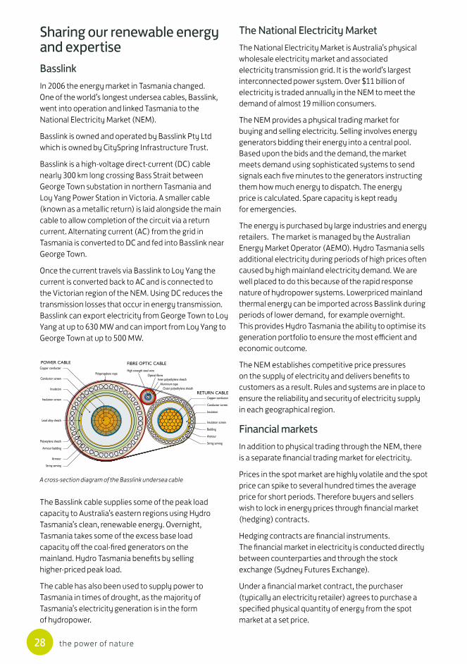
Basslink is a high-voltage direct-current (DC) cable nearly 300 km long crossing Bass Strait between George Town substation in northern Tasmania and Loy Yang Power Station in Victoria. A smaller cable (known as a metallic return) is laid alongside the main cable to allow completion of the circuit via a return current. Alternating current (AC) from the grid in Tasmania is converted to DC and fed into Basslink near George Town.
Once the current travels via Basslink to Loy Yang the current is converted back to AC and is connected to the Victorian region of the NEM. Using DC reduces the transmission losses that occur in energy transmission. Basslink can export electricity from George Town to Loy Yang at up to 630 MW and can import from Loy Yang to George Town at up to 500 MW.
The Basslink cable supplies some of the peak load capacity to Australia’s eastern regions using Hydro Tasmania’s clean, renewable energy. Overnight, Tasmania takes some of the excess base load capacity off the coal-fired generators on the mainland. Hydro Tasmania benefits by selling higher-priced peak load.
The cable has also been used to supply power to Tasmania in times of drought, as the majority of Tasmania’s electricity generation is in the form of hydropower.
The National Electricity MarketThe National Electricity Market is Australia’s physical wholesale electricity market and associated electricity transmission grid. It is the world’s largest interconnected power system. Over $11 billion of electricity is traded annually in the NEM to meet the demand of almost 19 million consumers.
The NEM provides a physical trading market for buying and selling electricity. Selling involves energy generators bidding their energy into a central pool. Based upon the bids and the demand, the market meets demand using sophisticated systems to send signals each five minutes to the generators instructing them how much energy to dispatch. The energy price is calculated. Spare capacity is kept ready for emergencies.
The energy is purchased by large industries and energy retailers. The market is managed by the Australian Energy Market Operator (AEMO). Hydro Tasmania sells additional electricity during periods of high prices often caused by high mainland electricity demand. We are well placed to do this because of the rapid response nature of hydropower systems. Lowerpriced mainland thermal energy can be imported across Basslink during periods of lower demand, for example overnight. This provides Hydro Tasmania the ability to optimise its generation portfolio to ensure the most efficient and economic outcome.
The NEM establishes competitive price pressures on the supply of electricity and delivers benefits to customers as a result. Rules and systems are in place to ensure the reliability and security of electricity supply in each geographical region.
Financial marketsIn addition to physical trading through the NEM, there is a separate financial trading market for electricity.
Prices in the spot market are highly volatile and the spot price can spike to several hundred times the average price for short periods. Therefore buyers and sellers wish to lock in energy prices through financial market (hedging) contracts.
Hedging contracts are financial instruments. The financial market in electricity is conducted directly between counterparties and through the stock exchange (Sydney Futures Exchange).
Under a financial market contract, the purchaser (typically an electricity retailer) agrees to purchase a specified physical quantity of energy from the spot market at a set price.
Copper conductor
Conductor screen
Insulation
Insulation screen
Lead alloy sheath
Polyetylene sheath
Armour bedding
Armour
String serving
Copper conductor
Conductor screen
Insulation
Insulation screen
Bedding
Armour
String serving
High strength steel wireOptical fibres
Inner polyethylene sheathAluminium tape
Outer polyethylene sheath
Polypropylene rope
POWER CABLE FIBRE OPTIC CABLE
RETURN CABLE
A cross-section diagram of the Basslink undersea cable
29the power of nature
For example, if the actual price paid in the spot market by the purchaser is higher than the set price, the counterparty to the contract (typically an electricity generator or a financial institution) pays the difference in cost.
There are numerous variations on the standard financial market contract available in the market, often containing complicated financial arrangements.
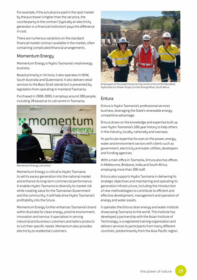
Momentum EnergyMomentum Energy is Hydro Tasmania’s retail energy business.
Based primarily in Victoria, it also operates in NSW, South Australia and Queensland. It also delivers retail services to the Bass Strait islands but is prevented by legislation from operating in mainland Tasmania.
Purchased in 2008-2009, it employs around 280 people, including 28 based at its call centre in Tasmania. Entura
Entura is Hydro Tasmania’s professional services business, leveraging the State’s renewable energy competitive advantage.
Entura draws on the knowledge and expertise built up over Hydro Tasmania’s 100 year history to help others in the industry, locally, nationally and overseas.
Its particular expertise focuses on the power, energy, water and environment sectors with clients such as government, electricity and water utilities, developers and funding agencies.
With a main office in Tasmania, Entura also has offices in Melbourne, Brisbane, India and South Africa, employing more than 200 staff.
Entura also supports Hydro Tasmania in delivering its strategic objectives and maintaining and operating its generation infrastructure, including the introduction of new methodologies to contribute to efficient and effective development, management and operation of energy and water assets.
It operates the Entura clean energy and water institute showcasing Tasmania to the world. The institute has developed a partnership with the Asian Institute of Technology, is a registered training organisation and delivers services to participants from many different countries, predominantly from the Asia-Pacific region.
Momentum Energy is critical to Hydro Tasmania to sell its excess generation into the national market and enhance its long-term commercial performance. It enables Hydro Tasmania to diversify its market risk while creating value for the Tasmanian Government and the community. It will help drive Hydro Tasmania’s profitability into the future.
Momentum Energy further enhances Tasmania’s brand within Australia for clean energy, pristine environment, innovation and service. It specialises in serving industrial and business customers and tailors products to suit their specific needs. Momentum also provides electricity to residential customers.
Momentum Energy call centre
Employees at the powerhouse during construction of the Neusberg Hydro Electric Power Project on the Orange River, South Africa
River
PiemanR i verK i n g
R ive r
Gordon
R i v e rH u o n
Derwent
River
Macquarie
R ive r
Nive
R i v e r
R iver
E s k
South
RiverTam
ar
A r t h u rR i v e r
Lake Sorell
Woods Lake
Lagoon of Islands
Lake Crescent
Arthurs Lake
Lake Leake
Lake Tiberias
Great Lake
Lake Augusta
Lake Mackenzie
Lake St. Clair
LakeEcho
Lake King William
Lake Rowallan
Lake Gordon
Lake Pedder
Meadowbank Lake
Lake Repulse
Wayatinah Lagoon
ClunyLagoon
Lake Catagunya
Lake Plimsoll
Lake Burbury
Lake NewtonWhite Spur Lake
Lake HentyLake Pieman Lake Murchison
Lake Mackintosh
Lake Rosebery
Lake Parangana
Lake Cethana
Lake Gairdner
Lake Barrington
Lake Paloona
Lake Trevallyn
FISHER
LEMONTHYME
PALOONA
WILMOTCETHANA
TREVALLYN
REECE
TRIBUTE
MACKINTOSH
JOHNBUTTERS
DEVILS GATE
POATINA
ROWALLAN
GORDON
TODS CORNER
WADDAMANA
LAKE ECHO
MEADOWBANK
REPULSE
BUTLERS GORGETARRALEAH
LIAPOOTAH
CLUNYWAYATINAH CATAGUNYA
TUNGATINAH
Arthurs Lake
STUDLAND BAY
BLUFF POINT
Kermandie
New Norfolk
Knights Rd
Electrona
Sorell
RokebyHOBART
DerwentBridge
Norwood
Avoca
St Marys
DerbyScottsdale
MUSSELROE
George Town
LAUNCESTONRailton
Queenstown
Savage River
Que
SmithtonPort Latta
Hampshire
BurnieEmu Bay
WesleyVale
DevonportUlverstone
Triabunna
Boyer
LindisfarneMornington
Kingston
Chapel StreetCreek Road Risdon
Palmerston
She�eld
BASTYAN
Farrell
Rosebery
NewtonLAKE MARGARET
Temco
Bridgewater
Hadspen
Comalco
StarwoodGeorge Townconverter station
Basslink
North Hobart
MowbraySt Leonards
Waratah Tee
Huon River
Castle Forbes Bay
King
Island
Flinders
Island
Cape BarrenIsland
Furneaux
Group
Bass Strait
Tasm
an Se
aSouthern Ocean
HYDROPOWER STATION
WIND FARM
GAS
SUBSTATION (Indicative location only)
220 kV TRANSMISSION ROUTE
110 kV TRANSMISSION ROUTE
400 kV DC TRANSMISSION ROUTE
SCALE 0 20 40
Kilometers
LEGEND
QLD
SA
VIC
TAS
NSW
The National Electricity Market links five regions
Roaring 40s winds
Roaring 40s winds
Roaring 40s winds
Roaring 40s winds
WHITEMARK(diesel/wind)
CURRIE(King Island Advanced Hybrid Power Station –
solar/wind/diesel)
TAMAR VALLEYPOWER STATION
(gas)
Tasmania’s electricity system
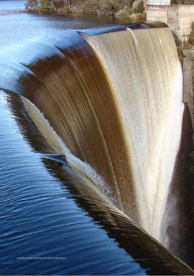
Lake Barrington spilling over Devils Gate Dam

hydro.com.au
1310
28