Embed Size (px)
Citation preview
PDP The Planning & Design Partnership Planning.. Architecture.. Interiors.. Landscape
The Chicory Barn Studio, The Old Brickyards, Moor Lane, Stamford Bridge
York, The East Riding Of Yorkshire, YO41 1HU.
Telephone 01759 373656 Fax 01759 371810 e-mail: [email protected]
DESIGN & ACCESS STATEMENT
OUTLINE PLANNING APPLICATION FOR PROPOSED
RESIDENTIAL DEVELOPMENT OF 40 DWELLINGS ON
LAND TO THE SOUTH OF RACECOURSE ROAD, EAST
AYTON, SCARBOROUGH YO13 9HP
December 2015
VIEW FROM RACECOURSE LOOKING NORTH EAST WITH APPLICATION
SITE TO THE RIGHT OF THE HIGHWAY BEYOND TREE
2
CONTENTS
1 INTRODUCTION
2 THE PROPOSALS
3 PLANNING POLICY CONTEXT
4 HIGHWAYS
5 DRAINAGE
6 DAYLIGHT, SUNLIGHT AND PRIVACY
7 FLOOD RISK ASSESSMENT
8 SUSTAINABILITY
9 DESIGNING OUT CRIME
10 CONCLUSIONS
3
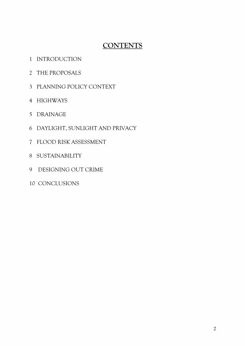
VIEW FROM RACECOURSE LOOKING SOUTH WEST WITH APPLICATION
SITE TO THE LEFT OF THE HIGHWAY
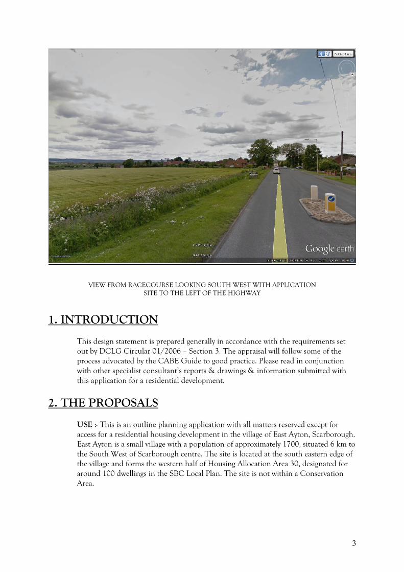
1. INTRODUCTION
This design statement is prepared generally in accordance with the requirements set
out by DCLG Circular 01/2006 – Section 3. The appraisal will follow some of the
process advocated by the CABE Guide to good practice. Please read in conjunction
with other specialist consultant’s reports & drawings & information submitted with
this application for a residential development.
2. THE PROPOSALS
USE :- This is an outline planning application with all matters reserved except for
access for a residential housing development in the village of East Ayton, Scarborough.
East Ayton is a small village with a population of approximately 1700, situated 6 km to
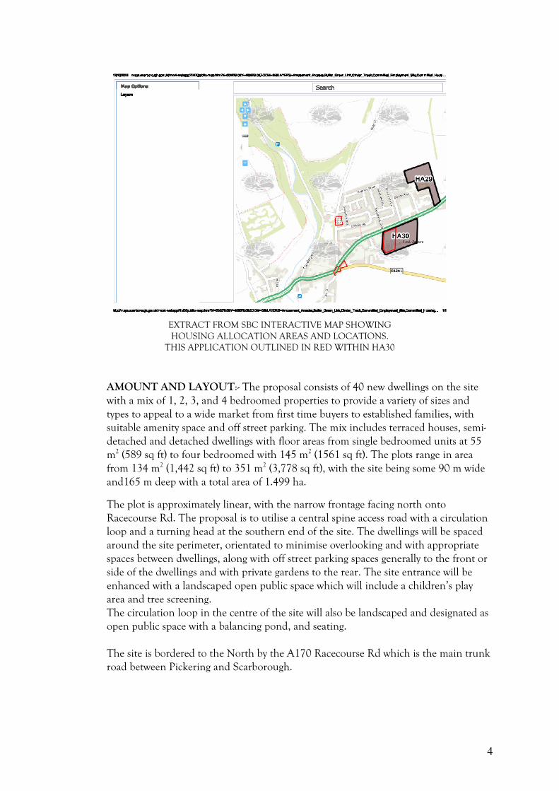
the South West of Scarborough centre. The site is located at the south eastern edge of
the village and forms the western half of Housing Allocation Area 30, designated for
around 100 dwellings in the SBC Local Plan. The site is not within a Conservation
Area.
4
EXTRACT FROM SBC INTERACTIVE MAP SHOWING
HOUSING ALLOCATION AREAS AND LOCATIONS.
THIS APPLICATION OUTLINED IN RED WITHIN HA30
AMOUNT AND LAYOUT:- The proposal consists of 40 new dwellings on the site
with a mix of 1, 2, 3, and 4 bedroomed properties to provide a variety of sizes and
types to appeal to a wide market from first time buyers to established families, with
suitable amenity space and off street parking. The mix includes terraced houses, semi-
detached and detached dwellings with floor areas from single bedroomed units at 55
m2 (589 sq ft) to four bedroomed with 145 m2 (1561 sq ft). The plots range in area
from 134 m2 (1,442 sq ft) to 351 m2 (3,778 sq ft), with the site being some 90 m wide
and165 m deep with a total area of 1.499 ha.
The plot is approximately linear, with the narrow frontage facing north onto
Racecourse Rd. The proposal is to utilise a central spine access road with a circulation
loop and a turning head at the southern end of the site. The dwellings will be spaced
around the site perimeter, orientated to minimise overlooking and with appropriate
spaces between dwellings, along with off street parking spaces generally to the front or
side of the dwellings and with private gardens to the rear. The site entrance will be
enhanced with a landscaped open public space which will include a children’s play
area and tree screening.
The circulation loop in the centre of the site will also be landscaped and designated as
open public space with a balancing pond, and seating.
The site is bordered to the North by the A170 Racecourse Rd which is the main trunk
road between Pickering and Scarborough.
5
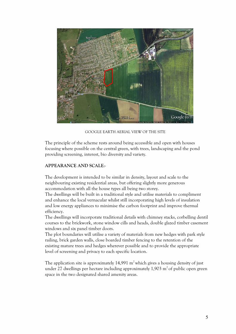
GOOGLE EARTH AERIAL VIEW OF THE SITE
The principle of the scheme rests around being accessible and open with houses
focusing where possible on the central green, with trees, landscaping and the pond
providing screening, interest, bio diversity and variety.
APPEARANCE AND SCALE:-
The development is intended to be similar in density, layout and scale to the
neighbouring existing residential areas, but offering slightly more generous
accommodation with all the house types all being two storey.
The dwellings will be built in a traditional style and utilise materials to compliment
and enhance the local vernacular whilst still incorporating high levels of insulation
and low energy appliances to minimise the carbon footprint and improve thermal
efficiency.
The dwellings will incorporate traditional details with chimney stacks, corbelling dentil
courses to the brickwork, stone window cills and heads, double glazed timber casement
windows and six panel timber doors.
The plot boundaries will utilise a variety of materials from new hedges with park style
railing, brick garden walls, close boarded timber fencing to the retention of the
existing mature trees and hedges wherever possible and to provide the appropriate
level of screening and privacy to each specific location.
The application site is approximately 14,991 m2 which gives a housing density of just
under 27 dwellings per hectare including approximately 1,903 m2 of public open green
space in the two designated shared amenity areas.
6
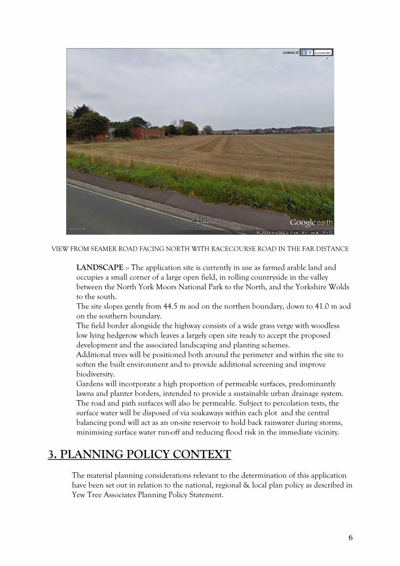
VIEW FROM SEAMER ROAD FACING NORTH WITH RACECOURSE ROAD IN THE FAR DISTANCE
LANDSCAPE :- The application site is currently in use as farmed arable land and
occupies a small corner of a large open field, in rolling countryside in the valley
between the North York Moors National Park to the North, and the Yorkshire Wolds
to the south.
The site slopes gently from 44.5 m aod on the northen boundary, down to 41.0 m aod
on the southern boundary.
The field border alongside the highway consists of a wide grass verge with woodless
low lying hedgerow which leaves a largely open site ready to accept the proposed
development and the associated landscaping and planting schemes.
Additional trees will be positioned both around the perimeter and within the site to
soften the built environment and to provide additional screening and improve
biodiversity.
Gardens will incorporate a high proportion of permeable surfaces, predominantly
lawns and planter borders, intended to provide a sustainable urban drainage system.
The road and path surfaces will also be permeable. Subject to percolation tests, the
surface water will be disposed of via soakaways within each plot and the central
balancing pond will act as an on-site reservoir to hold back rainwater during storms,
minimising surface water run-off and reducing flood risk in the immediate vicinity.
3. PLANNING POLICY CONTEXT
The material planning considerations relevant to the determination of this application
have been set out in relation to the national, regional & local plan policy as described in
Yew Tree Associates Planning Policy Statement.
7
4. HIGHWAYS
The vehicular access to the site will be from Racecourse Road which is straight and
wide, with good visibility in both directions, currently with a 40 mph speed limit.
Adequate visibility splays are achievable, however the exact requirements will be
guided by NYCC highways requirements for all aspects of road widths, footpaths,
materials and detailed design as appropriate.
The smaller house types with one or two bedrooms include designated off-street
parking spaces, the mid–range units have either integrated or attached garages, and the
largest plots have detached single or double garages.
5. DRAINAGE
Separate foul and surface water drainage systems are proposed, with foul connecting
into the public sewer. The surface water system will be designed accordingly using the
balancing pond before connection to a watercourse. All systems will be suitably
attenuated and will all be subject to the design guidance and exact requirements of
Yorkshire Water, the Environment Agency and the Internal Drainage Board.
6. DAYLIGHT, SUNLIGHT AND PRIVACY
National guidance on assessing new development proposals is set out in the Building
Research Establishment Report “Site Layout Planning for Daylight & Sunlight: A
Guide to Good Practice” by P J Littlefair (1991). Local plan policies generally protect
residential amenity and ensure that adjacent development does not result in
unreasonable loss of light, overlooking or overshadowing. Good design ensures
buildings which in their layout, form and positioning are compatible with the
character of the surroundings, and not result in an unreasonable loss of privacy,
deprive neighbouring properties of natural light or be detrimental to local amenity.
Dual aspect units also improve the quality of daylight and sunlight which is the case in
this instance. The north - south and east - west aspects of the houses on the site
provide variety and the proposed landscaping and distances between dwellings helps to
mitigate any significant overshadowing.
Site planning should ensure that there is sufficient area of sky visible to give a good
level of natural interior lighting with windows of a reasonable size, and is determined
by distances and angles between the proposed face to face or face to rear relationship
of the buildings using the 25 degree and 45 degree approaches. The layout complies
with these recommendations in the current form.
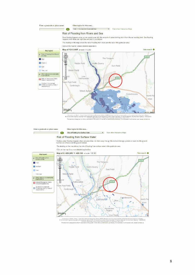
7. FLOOD RISK
The site is in an area of low risk from flooding as shown on maps as below from the
Environment Agency for Surface Water and from Rivers.
8
9
8. SUSTAINABILITY
The dwellings will comply with current building regulations and be efficient in terms
of thermal insulation and energy consumption which assists in minimising the carbon
footprint. Construction materials and components wherever possible will be selected
with regard to life cycle costing impact, the amount of energy embodied within and
with a view to recyclability. Reclaimed and recycled materials will also be used, sourced
locally wherever possible to benefit the local economy and community. The scheme
design aims to create a living environment, which will enhance the health and well-
being of both its residents and the surrounding community.
The houses will benefit from thermally efficient heating systems and it is intended to
supplement the domestic hot water with solar panels included within the design. NB
these have not been indicated on the accompanying drawings as they will be sized and
designed by specialist installer. They will be located on the south facing roof pitches
wherever possible. The use of these zero carbon technologies is intended to reduce the
demand on fossil fuels.
The village is served by a regular bus service between Scarborough and Pickering.
The national Rail network is available at Scarborough or York, and the A64 trunk
road connects to the motorway network.
The facilities in East Ayton include a Parish Church, a Public House, Restaurant,
Petrol Station, a Hotel and Country House and a Primary School.
9. DESIGNING OUT CRIME
The proposed dwellings are arranged to provide close supervision of the shared access
road, the parking spaces, the public areas and the private gardens. The provision of
distinct borders with well-defined public and private spaces discourage antisocial
behaviour and reduces the risk of crime. The development is intended to encourage a
community feel and promote a ‘crime-watch’ conscious neighbourhood. The scheme
at detailed stage would be considered in conjunction with the police architectural
liaison officer.
10. CONCLUSIONS
The site currently consists of open arable farmland set on the eastern edge of the
village, with few features other than the existing hedges to the boundary along the
western perimeter.
The existing adjoining properties consist of a housing estate to the north beyond
Racecourse Road, which is a mixture of dwelling types but predominantly bungalows,
and a similar site to the west with mainly corporation style two storey dwellings.
10
The proposed new dwellings are intended to sit sympathetically and unobtrusively in
this part of the village and provide much sought after residential accommodation in
this rural village location.
The additional new residents, by increasing the village population, will help to
improve the viability of the village community and with use of the local facilities, will
promote the sustainability of the village.
We believe this design statement has set out a well-considered scheme and how it has
evolved to provide a good mix of types to meet the local housing need.
The material planning considerations relevant to the determination of this application
have been set out in relation to the national, regional and local plan policy as
described in the Planning Supporting Statement by Yew Tree Associates.
We hope to have demonstrated that the broad principle of development on this site
complies with these policies on many levels.
The applicant hopes that Scarborough Borough Council is able to support this
planning application for the development of a range of high quality dwellings to be
constructed on the site.

![1. Welcome [horndeanmatters.files.wordpress.com]...Certificate FS 29637 Planning Master Planning & Urban Design Architecture Landscape Planning & Design Environmental Planning Graphic](https://img.pdfslide.us/doc/110x75/5f05c0ca7e708231d414884d/1-welcome-certificate-fs-29637-planning-master-planning-urban-design.jpg)