Embed Size (px)
Citation preview
fROM THEARIZONA BUREAU
Of MINES
Vo!. 6 Nos. 3-4 Earth Sciences and Mineral Resources in Arizona December, 1976
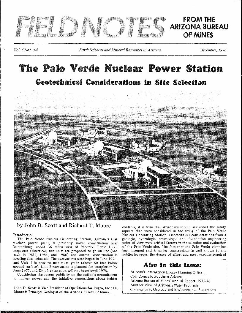
The Palo erde uelear POlVer StationGeotechnical Considerations in Site Selection
by John D. Scott and Richard T. Moore
IntroductionThe Palo Verde Nuclear Generating Station, Arizona's first
nuclear power plant, is presently under construction nearWintersburg, about 36 miles west of Phoenix. Three 1,270megawatt (electrical) net units are proposed to go on line (oneeach in 1982, 1984, and 1986), and current construction ismeeting that schedule. The excavations were begun in June 1976,and Unit 1 is now to maximum grade (about 60 feet belowground surface). Unit 2 excavation is planned for completion byJune 1977, and Unit 3 excavation will not begin until 1978.
Considering the recent publicity on the nation's commitmentto nuclear power and the initiative propositions about tighter
John D. Scott is Vice President of Op.eiations for Fugro, Inc.; Dr.Moore is Principal Geologist of the Arizona Bureau of Mines.
controls, it is wise that Arizonans should ask about the safetyaspects that were considered in the siting of the Palo VerdeNuclear Generating Station. Geotechnical considerations from ageologic, hydrologic, seismologic and foundation engineeringpoint of view were critical factors in the selection and evaluationof the Palo Verde site. The fact that the Palo Verde plant hasbeen licensed and is under construction is well known to thepublic; however, the degree of effort and great expense required
Also in this issue:Arizona's Interagency Energy Planning OfficeCoal Comes to Southern ArizonaArizona Bureau of Mines' Annual Report, 1975-76Another View of Arizona's Water ProblemsCommentary: Geology and Environmental Statements
~--",---,
Page 2 ARIZONA BUREAU OF MINES December, 1976
to confirm Palo Verde as a viable site is not widely known. It isthe purpose of this paper to generally describe the geotechnicalcriteria for siting nuclear power facilities, the methods used toevaluate the Palo Verde site and its region, the geotechnicalconditions encountered at the site, and the continuinginvestigation during the construction phases.
BackgroundThe siting, licensing, construction and operating of nuclear
power plants in the United States is controlled by the NuclearRegulatory Commission (NRC) which was formerly a part of theAtomic Energy Commission. In addition to this agency, the Stateof Arizona exercises its authority through the Arizona PowerPlant and Transmission Line Siting Committee, which acts andreviews the environmental aspects of the site and transmissionline independently. The Arizona Bureau of Mines, GeologicalSurvey Branch, has been working with the NRC on the evaluationof the geologic aspects of the site. In addition, local zoningrequirements are followed.
To assist in its review, the NRC has set up a set of rigid criteriawhich are designed to cover all factors related to the safety of theplant and site. Basically, the NRC requires the utility to supportits application for a construction permit by filing anEnvironmental Report containing sufficient information aboutthe facility, site, and environs to permit the NRC to assess theenvironmental impact. The NRC also requires that theEnvironmental Report include evaluations of various sitealternatives and justifications made by the utility including therationale for selection of the prime site. The guidelines requirethat the selection of the preferred site from among viablealternatives be documented.
The Environmental Report is followed by a Preliminary SafetyAnalysis Report (PSAR), which is a comprehensive study on allsite conditions related to safe design, construction, and operationof the plant. Both of these documents become public records atthe time of submittal. To give some idea of the comprehensivenature of these reports, the PSAR for the Palo Verde NuclearGenerating Station consists of 17 volumes, each volume twice the
oo
oo
37'
d32' NORTH
0 50 100M
MILES
'"
10S 0109'
,.'EXPLANATION
0 It! < 4,0
0 4.0:5 M < 5.0
30' 0 5.0::S M < 6.0
0 0 6.0 S M < 7.0
07.0';MEplelllltr locollons from ESSA,1927-1973....
I \41< Quaternary Fault Troe..
1/
000 0 33'
0
110'
SONORA----"(j)ra8718 )
APPROX. LOCATION
o
200 Mile Radius
111°
\
0
00 0000
00
00
0'!
113"
0100 Mile Radius
00
50 Mil(l Radius00
~\0 0 0 "
Si~:j ~"-
• PHOENIX
\0'\0
\\0 \.
o \ 11\ \ ): \ I ~ • TUCSON
/
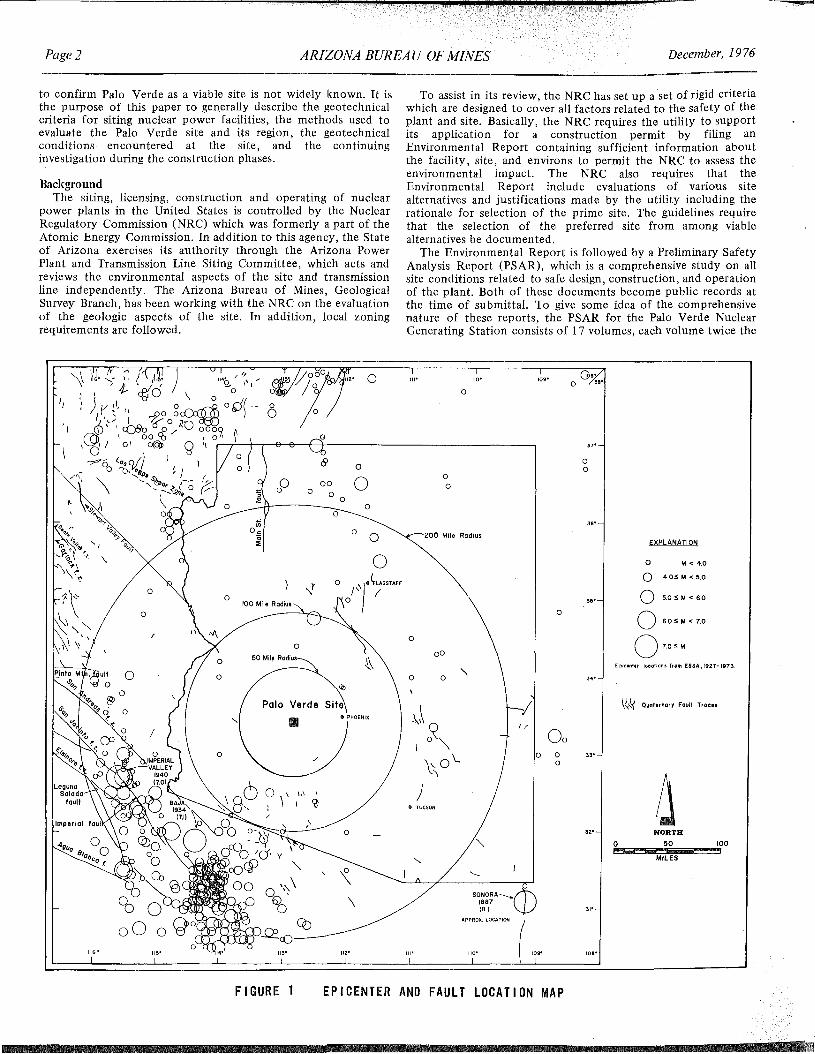
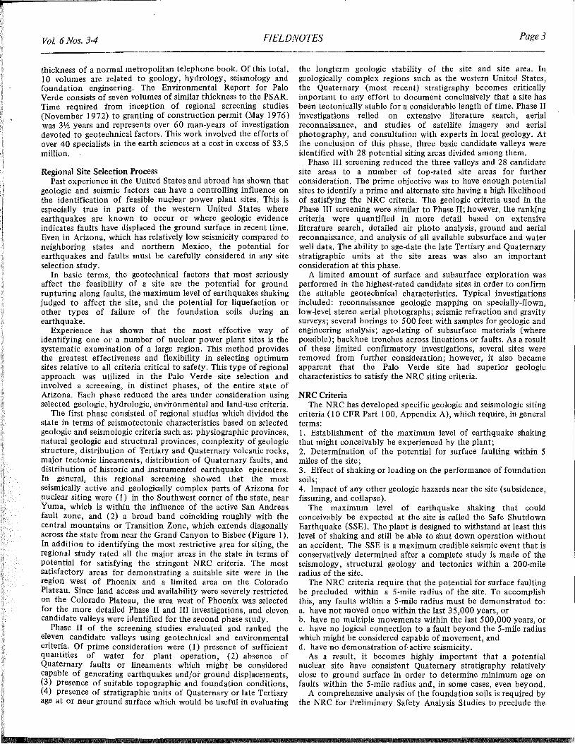
0
FIGURE 1 EPICENTER AND FAULT LOCATION MAP
Vol. 6 Nos. 3-4 FIELDNOTES Page 3
thickness of a normal metropolitan telephone book. Of this total,10 volumes are related to geology, hydrology, seismology andfoundation engineering. The Environmental Report for PaloVerde consists of seven volumes of similar thickness to the PSAR.Time required from inception of regional screening studies(November 1972) to granting of construction permit (May 1976)was 3Y:z years and represents over 60 man-years of investigationdevoted to geotechnical factors. This work involved the efforts ofover 40 specialists in the earth sciences at a cost in excess of $3.5million.
Regional Site Selection ProcessPast experience in the United States and abroad has shown that
geologic and seismic factors can have a controlling influence onthe identification of feasible nuclear power plant sites. This isespecially true in parts of the western United States whereearthquakes are known to occur or where geologic evidenceindicates faults have displaced the ground surface in recent time.Even in Arizona, which has relatively low seismicity compared toneighboring states and northern Mexico, the potential forearthquakes and faults must be carefully considered in any siteselection study.
In basic terms, the geotechnical factors that most seriouslyaffect the feasibility of a site are the potential for groundrupturing along faults, the maximum level of earthquakes shakingjudged to affect the site, and the potential for liquefaction orother types of failure of the foundation soils during anearthquake.
Experience has shown that the most effective way ofidentifying one or a number of nuclear power plant sites is thesystematic examination of a large region. This method providesthe greatest effectiveness and flexibility in selecting optimumsites relative to all criteria critical to safety. This type of regionalapproach was utilized in the Palo Verde site selection andinvolved a screening, in distinct phases, of the entire state ofArizona. Each phase reduced the area under consideration usingselected geologic, hydrologic, environmental and land-use criteria.
The first phase consisted of regional studies which divided thestate in terms of seismotectonic characteristics based on selectedgeologic and seismologic criteria such as: physiographic provinces,natural geologic and structural provinces, complexity of geologicstructure, distribution of Tertiary and Quaternary volcanic rocks,major tectonic lineaments, distribution of Quaternary faults, anddistribution of historic and instrumented earthquake epicenters.In general, this regional screening showed that the mostseismically active and geologically complex parts of Arizona fornuclear siting were (l) in the Southwest corner of the state, nearYuma, which is within the influence of the active San Andreasfault zone, and (2) a broad band coinciding roughly with thecentral mountains or Transition Zone, which extends diagonallyacross the state from near the Grand Canyon to Bisbee (Figure 1).In addition to identifying the most restrictive area for siting, theregional study rated all the major areas in the state in terms ofpotential for satisfying the stringent NRC criteria. The mostsatisfactory areas for demonstrating a suitable site were in theregion west of Phoenix and a limited area on the ColoradoPlateau. Since land access and availability were severely restrictedon the Colorado Plateau, the area west of Phoenix was selectedfor the more detailed Phase II and III investigations, and elevencandidate valleys were identified for the second phase study.
Phase II of the screening studies evaluated and ranked theeleven candidate valleys using geotechnical and environmentalcriteria. Of prime consideration were (l) presence of sufficientquantities of water for plant operation, (2) absence ofQuaternary faults or lineaments which might be consideredcapable of generating earthquakes and/or ground displacements,(3) presence of suitable topographic and foundation conditions,(4) presence of stratigraphic units of Quaternary or late Tertiaryage at or near ground surface which would be useful in evaluating
the longterm geologic stability of the site and site area. In.geologically complex regions such as the western United States,the Quaternary (most recent) stratigraphy becomes criticallyimportant to any effort to document conclusively that a site hasbeen tectonically stable for a considerable length of time. Phase IIinvestigations relied on extensive literature search, aerialreconnaissance, and studies of satellite imagery and aerialphotography, and consultation with experts in local geology. Atthe conclusion of this phase, three basic candidate valleys wereidentified with 28 potential siting areas divided among them.
Phase III screening reduced the three valleys and 28 candidatesite areas to a number of top-rated site areas for furtherconsideration. The prime objective was to have enough potentialsites to identify a prime and alternate site having a high likelihoodof satisfying the NRC criteria. The geologic criteria used in thePhase III screening were similar to Phase II; however, the rankingcriteria were quantified in more detail based on extensiveliterature search, detailed air photo analysis, ground and aerialreconnaissance, and analysis of all available subsurface and waterwell data. The ability to age-date the late Tertiary and Quaternarystratigraphic units at the site areas was also an importantconsideration at this phase.
A limited amount of surface and subsurface exploration wasperformed in the highest-rated candidate sites in order to confirmthe suitable geotechnical characteristics. Typical investigationsincluded: reconnaissance geologic mapping on specially-flown,low-level stereo aerial photographs; seismic refraction and gravitysurveys; several borings to 500 feet with samples for geologic andengineering analysis; age-dating of SUbsurface materials (wherepossible); backhoe trenches across lineations or faults. As a resultof these limited confirmatory investigations, several sites wereremoved from further consideration; however, it also becameapparent that the Palo Verde site had superior geologiccharacteristics to satisfy the NRC siting criteria.
NRC CriteriaThe NRC has developed specific geologic and seismologic siting
criteria (I 0 CFR Part 100, Appendix A), which require, in generalterms:1. Establishment of the maximum level of earthquake shakingthat might conceivably be experienced by the plant;2. Determination of the potential for surface faulting within 5miles of the site;3. Effect of shaking or loading on the performance of foundationsoils;4. Impact of any other geologic hazards near the site (subsidence,fissuring, and collapse).
The maximum level of earthquake shaking that couldconceivably be expected at the site is called the Safe ShutdownEarthquake (SSE). The plant is designed to withstand at least thislevel of shaking and still be able to shut down operation withoutan accident. The SSE is a maximum credible seismic event that isconservatively determined after a complete study is made of theseismology, structural geology and tectonics within a 200-mileradius of the site.
The NRC criteria require that the potential for surface faultingbe precluded within a 5-mile radius of the site. To accomplishthis, any faults within a 5-mile radius must be demonstrated to:a. have not moved once within the last 35,000 years, orb. have no multiple movements within the last 500,000 years, orc. have no logical connection to a fault beyond the 5-mile radiuswhich might be considered capable of movement, andd. have no demonstration of active seismicity.
As a result, it becomes highly important that a potentialnuclear site have consistent Quaternary stratigraphy relativelyclose to ground surface in order to determine minimum age onfaults within the 5-mile radius and, in some cases, even beyond.
A comprehensive analysis of the foundation soils is required bythe NRC for Preliminary Safety Analysis Studies to preclude the
Page 4
Bedrock High atBoring PV-23extending throughPalo Verde Clay----
Bedrock High atBoring PV-23--- _
Note: Boundaries of Clay Shownon these Diagrams IndicatesLimits of Drilling Data, NotActual Edge of Cloy.
Vertical E'xaggeration: 5X
ARIZONA BUREAU OF MINES December, 1976
PRESENTGROUND SURFACE
~-- Surface of clay whereoutlined by borings
TOP OFPALO VERDE CLAY
bedrock whereby borings
BEDROCK SURFACE
FIGURE 2 ISOMETRIC BLOCK DIAGRAM OF SURFACE AND SUBSURFACE CONTOURS AT PALO VERDE NUCLEAR GENERATING STATION SITE
possibility of differential settlements, excessive consolidation,liquefaction during the Safe Shutdown Earthquake, or any otherfoundation phenomena that might endanger the integrity of theplant. The foundation studies also include such considerations assubsidence due to decreases in ground-water level, collapse ofsoils, and the effects of man-made hazards such as mining orwithdrawal of oil. Besides immediate impacts of such conditions,all of these investigations must also consider possible long-termchanges over the projected 40-year life of the plant.
Geotechnical Investigation of Palo VerdeAs a result of Phase III, the Palo Verde site was confirmed as
feasible. However, a detailed site-specific geotechnical investigation was required in order to determine final designconsiderations and to prepare the PSAR. This detailedinvestigation required about one year to complete and includedthe following activities:- reconnaissance and detailed geologic mapping of an areaencompassed within a 25-mile radius and 5-mile radius of the site;- Over 9 miles of seismic refraction geophysical surveys;- reconnaissance and detailed gravity and magnetic geophysicalsurveys covering an area within a 10-mile radius of the site;- 2000 feet of exploratory backhoe trenches;- drilling of more than 200 exploratory borings to depthsranging from 50 to 721 feet (in total about 10 miles of boringswere drilled for geologic and foundation engineering analysis);
- high-resolution downhole geophysical logging of nearly allexploratory borings for stratigraphic correlation;- potassium-argon-age dating of 34 rock samples;- analysis of approximately 550 samples of basin sediments forpaleomagnetic polarity;
static and dynamic engineering tests on core and drive samples;- detailed ground-water analysis;- complete research of all pertinent geologic, seismologic, andhydrologic data.
In addition, there were seven specialists from the University ofArizona and Arizona State University who were consulted onspecific aspects of the project, such as geohydrology,stratigraphy, structural geology, petrology, clay mineralogy,palynology and geophysics.
Geology of the Palo Verde SiteThe Palo Verde Nuclear Generating Station site is within the
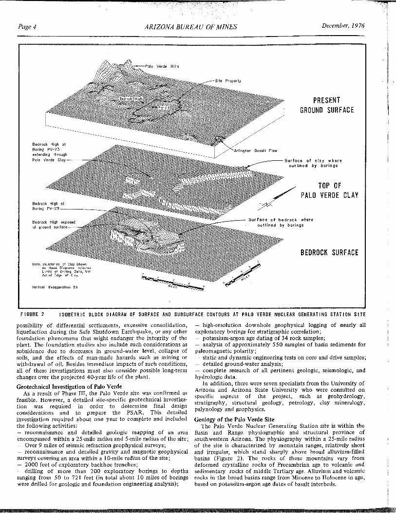
Basin and Range physiographic and structural province ofsouthwestern Arizona. The physiography within a 25-mile radiusof the site is characterized by mountain ranges, relatively shortand irregular, which stand sharply above broad alluvium-filledbasins (Figure 2). The rocks of these mountains vary fromdeformed crystalline rocks of Precambrian age to volcanic andsedimentary rocks of middle Tertiary age. Alluvium and volcanicrocks in the broad basins range from Miocene to Holocene in age,based on potassium-argon age dates of basalt interbeds.
Vol. 6 Nos. 34 FlELDNOTES Page 5
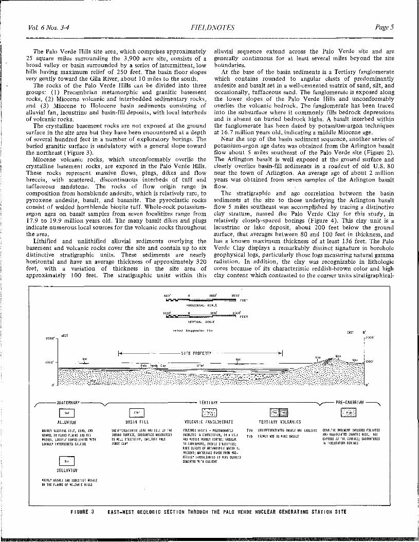
The Palo Verde Hills site area, which comprises approximately25 square miles surrounding the 3,900 acre site, consists of abroad valley or basin surrounded by a series of intermittent, lowhills having maximum relief of 250 feet. The basin floor slopesvery gently toward the Gila River, about 10 miles to the south.
The rocks of the Palo Verde Hills can be divided into threegroups: (l) Precambrian metamorphic and granitic basementrocks, (2) Miocene volcanic and interbedded sedimentary rocks,and (3) Miocene to Holocene basin sediments consisting ofalluvial fan, lacustrine and basin-fill deposits, with local interbedsof volcanic rocks.
The crystalline basement rocks are not exposed at the groundsurface in the site area but they have been encountered at a depthof several hundred feet in a number of exploratory borings. Theburied granitic surface is undulatory with a general slope towardthe northeast (Figure 3).
Miocene volcanic rocks, which unconformably overlie thecrystalline basement rocks, are exposed in the Palo Verde Hills.These rocks represent massive flows, plugs, dikes and flowbreccia, with scattered, discontinuous interbeds of tuff andtuffaceous sandstone. The rocks of flow origin range incomposition from hornblende andesite, which is relatively rare, topyroxene andesite, basalt, and basanite. The pyroclastic rocksconsist of welded hornblende biotite tuff. Whole-rock potassiumargon ages on basalt samples from seven localitites range from17.9 to 19.9 million years old. The many basalt dikes and plugsindicate numerous local sources for the volcanic rocks throughoutthe area.
Lithified and unlithified alluvial sediments overlying thebasement and volcanic rocks cover the site and contain up to sixdistinctive stratigraphic units. These sediments are nearlyhorizontal and have an average thickness of approximately 320feet, with a variation of thickness in the site area ofapproximately 100 feet. The stratigraphic units within this
alluvial sequence extend across the Palo Verde site and aregenerally continuous for at least several miles beyond the siteboundaries.
At the base of the basin sediments is a Tertiary fanglomeratewhich contains rounded to angular clasts of predominantlyandesite and basalt set in a well-cemented matrix of sand, silt, andoccasionally, tuffaceous sand. The fanglomerate is exposed alongthe lower slopes of the Palo Verde Hills and unconformablyoverlies the volcanic bedrock. The fanglomerate has been tracedinto the subsurface where it commonly fills bedrock depressionsand is absent on buried bedrock highs. A basalt interbed withinthe fanglomerate has been dated by potassium-argon techniquesat 16.7 million years old, indicating a middle Miocene age.
Near the top of the basin sediment sequence, another series ofpotassium-argon age dates was obtained from the Arlington basaltflow about 5 miles southeast of the Palo Verde site (Figure 2).The Arlington basalt is well exposed at the ground surface andclearly overlies basin-fill sediments in a roadcut of old U.S. 80near the town of Arlington. An average age of about 2 millionyears was obtained from seven samples of the Arlington basaltflow.
The stratigraphic and age correlation between the basinsediments at the site to those underlying the Arlington basaltflow 5 miles southeast was accomplished by tracing a distinctiveclay stratum, named the Palo Verde Clay for this study, inrelatively closely-spaced borings (Figure 4). This clay unit is alacustrine or lake deposit, about 200 feet below the groundsurface, that averages between 80 and lOO feet in thickness, andhas a known maximum thickness of at least 136 feet. The PaloVerde Clay displays a remarkably distinct signature in boreholegeophysical logs, particularly those logs measuring natural gammaradiation. In addition, the clay was recognizable in lithologiccores because of its characteristic reddish-brown color and highclay content which contrasted to the coarser units stratigraphical-
1500'IijjIi
1500' 3000'
FEET
HORIZONTAL scALE
1000' 1000' 2.000'iillijjli~OI""""""i;;;;;;;OiiiiOiiii~""'''''''''~ FEET
VERTICAL SCALE
2000'WEST
Vertical EXQooeratlon<. 1·5)(EAST S'
2000'
I~ SITE PROPERTY ~ I Q"
'"00, 'W{;K~f~;~~~~rEijR~mi;}it~w"MJ«!mW;ilir;0;~~;!f~E~~~~i,%iN~tnJt\';JljiBlj;~&ii~fu;B~~I;f, :00
TERT IARY VOLCAN I CSVOLCANIC FANGLOMERATEBAS INFl LL
~QUATERNARY----..V"-------------- TERTIARY ---------------~ PRE-CAMBRIAN~
o G ~ ((:~r:R,(:~1ALLUV I UM
MAINLY ALLUYI AL SILT, SAHD, ANDGRAVEl IN FLOOD PLAINS AHD DRYWASNES, LOOSELY CONSOLIDATED WlTNLOCALLY INTERBEDDED CALICNE
UNDIFFERENTIATED SAND AND SiLT AT TNEGROUND SURFACE, SUBSURFACE MODERATELYTO WELL STRATIFIED, INCLUDES PALOYEROECLAY
YOLCANIC GRAVEl - PREDONINANTlY Tvu UNDIFFERENTIATED BASALT AHD AHDESITEBASALTIC IN CONPOSITION, IN A SiLT Tvb BASALT AND OLIYINE BASALTAND MATRIX POORLY SORTED; ANGULARTO SUBROUNOEO, POORLY STRATIFIED;RARE CLASTS OF METANORPN IC NATER I ALPRESENT; NATERIALS RANGE FRON MOD-ERATElY CONSOLIDATED TO VERY DENSELYCEMENTED WITN CALICNE
GRANITIC BASEMENT INCLUDES FOLIATEDAND NONFDLlATEO GRANTIC ROCK. NOTEXPOSED AT TNE SURFACE; ENCOUNTEREDIN EXPLORATORY BORlHGS
COLLUVI UM
MAINLY BASALT AND ANOESITIC RUBBLEON TNE FLANKS OF YOLCANIC NILlS
FIGURE 3 EAST-WEST GEOLOGIC SECTION THROUGH THE PALO VERDE NUCLEAR GENERATING STATION SITE
q
Page 6 ARIZONA BUREAU OF MINES December, 1976
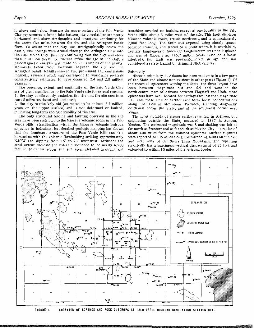
ly above and below. Because the upper surface of the Palo VerdeClay represented a broad lake bottom, the correlations are nearlyhorizontal and show stratigraphic and structural continuity forthe entire five miles between the site and the Arlington basaltflow. To assure that the clay was stratigraphically below thebasalt, two borings were drilled through the Arlington flow intothe Palo Verde Clay, thereby confirming that the clay was olderthan 2 million years. To further refine the age of the clay, apaleomagnetic analysis was made on 550 samples of the alluvialsediments taken from locations between the site and theArlington basalt. Results showed two prominent and continuousmagnetic reversals which may correspond to worldwide reversalsconservatively estimated to have occurred 2.4 and 2.8 millionyears ago.
The presence, extent, and continuity of the Palo Verde Clayare of great significance to the Palo Verde site for several reasons:1. the clay continuously underlies the site and the site area to atleast 5 miles southeast and northeast;2. the clay is relatively old (estimated to be at least 2.7 millionyears on the upper surface) and is not deformed or faulted,indicating long-term geologic stability of the area.
The only structural folding and faulting observed in the sitearea have been restricted to the Miocene volcanic rocks in the PaloVerde Hills. Stratification within the Miocene volcanic bedrocksequence is indistinct, but detailed geologic mapping has shownthat the dominant structure of the Palo Verde Hills area is ahomocline with the volcanic flowbedding striking approximatelyN40"w and dipping from 15° to 23° southwest. Attitudes andareal extent indicate the volcanic sequence to be nearly 6,500feet in thickness across the site area. Detailed mapping and
trenching revealed no faulting except at one locality in the PaloVerde Hills, about 3 miles west of the site. This fault displacesMiocene volcanic rocks, trends northwest, and is approximately2,000 feet long. The fault was exposed using closely spacedbackhoe trenches, and traced to a point where it is overlain byTertiary fanglomerate. Since the fanglomerate was not displacedand was of Miocene age (16.7 million years based on a basaltinterbed), the fault was pre-fanglomerate in age and notconsidered a safety hazard by stringent NRC criteria.
SeismicityHistoric seismicity in Arizona has been moderate in a few parts
of the State and almost non-existent in other parts (Figure 1). Ofthe recorded epicenters withing the State, the three largest havebeen between magnitude 5.0 and 5.9 and were in thenorth-central part of Arizona between Flagstaff and Utah. Moreepicenters have been located for earthquakes less than magnitude5.0, and these smaller earthquakes form loose concentrationsalong the Central Mountains Province, trending diagonallynorthwest across the State, and at the southwest corner nearYuma.
The most notable of strong earthquakes felt in Arizona, butoriginating outside the State, occurred in 1887 in Sonora,Mexico. The estimated magnitude was 8 and shaking was felt asfar north as Prescott and as far south as Mexico City - a radius ofabout 400 miles from the assumed epicenter. Surface ruptureswere reported for 35 miles along north-trending faults on the eastand west sides of the Sierra Teras Mountains. The rupturingreportedly has a maximum vertical displacement of 26 feet andextended to within 10 miles of the Arizona border.
+
I
+-----r + + + +
"'MILES
EXPLANAT 1ON
NORTH
PV-I" BOR INO Locm ON
Q 'XPOSEOBEOROCK
ttl ARLINGTON BASILT FLOW
.......... APPROXIMATE LOCATION OF BURIED CONTACT
.PI/-162
PV-4:r_+_-',,,PV-48 PV-49
•
LOCATION OF BORINGS AND ROCK OUTCROPS AT PALO VERDE NUCLEAR GENERATING STATION SITE
~ v-, .PV-57 PV-·
1
PV-20 j/V.,. ..PV-21 -lPV-U PV-"t?+PI/-1S6. P~-42 .PV-43 .PV 44.PV_47
PV-7 PV-l PV~24 I32 Gp -18 [3 PV-23 • . • .PV-5
PV- 45 PV-46 PI/-2SeP -5 ••
----\-....+-*-+--\+\--f-+--+ PV-27 .V-28 P -29 't----PI/-IS PV-!5~
PV-2•
FIGURE 4
.PV-161
;----+----+ ..PV-133+-----r----t-----~"----1
I .PV-J}2rpV-.8+-=----t-'·F+)~~--4~":p...,.L-____."d..!CA.;----+------1r-t''-'Jh'"-""1-----+ +
::1+ + + + L-__~'-'::"_..::~;_,..__:!~.._--",+/."~V--:15=-------'====r-r====:r:====t==
epV-IO I PRg~~TY pV-6ol .P~-36 epV-62 LV-53,
• PV-II I I .PV-51 1 e PV-3.
____+--_-_-_-_-._,.'._._~.~~~~~-+----~~~~~P~V.~13"....+------L-+;I..L--------------~-~~.~P-V--,.5.-ce-...~.:-R;;-;'~W"~-~..,-P-~-3=7-.-,---.,-"-.,",.,.,.••-.,",'.",_.•__~
conlcusion of grading and will be submitted to the NRC as a partof the Final Safety Analysis Report, which becomes a publicdocument.
~d Canyon Publications Updated
ConclusionThe process by which the Palo Verde Nuclear Generating
Station site was selected represents a state-of-the-art systematicapproach to a complex problem. All the primary safetyconsiderations, geotechnical and environmental, were input on astatewide scale to identify the most promising areas for furtherstudy. This was a long, rigorous, and expensive investigation, buthas been rewarded by the establishment of the Palo VerdeNuclear Generating Station site and the identification of someviable alternative sites, which also seem to have all the necessarycharacteristics to demonstrate their suitability. The public shouldbe aware of the difficulty, expense, and time required to identifyand license viable nuclear sites in the western United States. Thestringent safety criteria for siting are so restrictive that ademonstrably viable nuclear site is an important and rare firldthat cannot be randomly or capriciously relocated. As a result,viable nuclear sites should be regarded as a form of naturalresource to be wisely used for the power needs of this and futuregenerations.
Page 7
efforts by the Museum, the GCNHA,Western Washington State at Bellingham,the University of Wyomirlg, and theUniversity of Liecester in England.
Mail orders will be accepted, andshould be addressed to the Grand CanyonNatural History Association, c/o Museumof Northern Arizona, Route 4, Box 720,Flagstaff, AZ 86001. The book costs$5.00 plus 50¢ for postage, and the map,rolled in a mailirlg tube, costs $3.95 plus$1.00 for postage.
Bibliography
Aguilera, J.G., 1920, The Sonora earthquake of 1887: Bull Seis. Soc. Am.,V. 10, No.1, p. 31-44 (a translation for A.C. Lawson).
Bonilla, M.G., 1967, Historic Surface Faulting in Continental United Statesand Adjacent Parts of Mexico: U.S. Geological Survey (AEC).
Coffman, J.L., and von Hake, C.A., 1973, Earthquake history of theUnited States: U.S. Dept. Commerce Pub. 41-1 Revised Edition(through 1970), U.S. Gov't. printing office, Washington, D.C., 208p.
Cooley, M.E., 1973, Map showing distribution and estimated thickness ofalluvial deposits in the Phoenix area, Arizona: U.S. Geo!. Survey MapI-845-C.
Environmental Science Services Administration, 1927-1973, Seismicity ofArizona and nearby areas: U.S. Dept. of Commerce, continuingtabulation of data.
Fugro, Inc., 1974-1975, Preliminary Safety Analysis Report of Palo VerdeNuclear Generating Station, for Arizona Nuclear Power Project, Vo!.II and III.
Garfunkel, Z., 1974, Model for the late Cenoxoic tectonic history of theMojave Desert, California, and for its relation to adjacent regions:Geol. Soc. America Bull., V. 85, No. 12.
Gilluly, J., 1967, Chronology of tectonic movements in the western UnitedStates: Am. Jour. Sci., V. 265, p. 306-331.
Hunt, C.B., 1963, Tectonic framework of southwestern United States andpossible continental rifting in Backbone of the Americas: AAPGMemoir 3, p. 130-139.
Longwell, C.R., 1950, Tectonic theory viewed from the Basin Ranges:Geo!. Soc. America Bull., V. 61, p. 413-433, illus. maps.
Mindling, A., 1971, A summary of data relating to land subsidence in LasVegas Valley: Desert Research Institute, University of NevadaSystem, Reno.
NUS Corporation, Evaluation of Potential 1981-1983 Nuclear Power PlantSites in the State of Arizona, Executive Summary, 1973.
F1ELDNOTES
Geology of the Grand Canyon, secondedition, contairls articles covering theCanyon's geological history from Precambrian to Cenozoic times.
The map was compiled under thedirection of Bill Breed, Curator ofGeology at the Museum of NorthernArizona, and is the result of combirled
f"the Safe Shutdown Earthquake, the maximum level(}ishaking was postulated using the 1887 Sonora
(magnitude 8), relocated to a distance of 72 milesloiVerde site. This conservative estimation was basedthetical relocation of the epicenter from Sonora,~goint about 250 miles n~r~hwest along m.ajor faultitt systems in the TransltlOn Zone provmce. The
bach of mapped Quaternary faults to the site is in the()ne about 72 miles east of the site. This relocatedis larger than any Arizona historical event and is a
~iepresentation of the maximum level of shaking thatiiht experience within its design life.
ologie ActivitiesH6rts are developed at Palo Verde, detailed geologicfe<being made of all exposures for any type of(liIlg utility trenches. These trenches and other11rL an extensive network of exposures that are
eplogic analysis. At least one wall of all pertinentphotographed as a permanent record, and geologic
lithologic descriptions, are logged at scales of teneli'For Category 1 excavations (Category 1 includes
rtartt facilities irl terms of safety), detailed geologicat scales of 10 feet and 5 feet to the inch and a'c map is constructed at a scale of 10 feet to theose .of such detailed inspection and logging is to
(}igeology irl as much detail as possible to:he subsurface conditions at the site;at design considerations made durirlg earlierill are appropriate for the site conditions.investigations the geologists are constantly alertof warpirlg, shearing, faulting, cracking, or other
gic instability that might affect plant design. To$ been no indication of any such features and,
ology exposed in the excavations shows positiverig-term geologic stability. One of the bestof this is provided by the detailed logs which
ise locations of geologic strata throughout theJ3ecause the excavations are relatively shallow, allry .> within the basin sediments, which contain!atively continuous, and nearly horizontal strata of
dclay. By carefully tracing a number of these layersxcavation and establishing their location with surveystrata can be documented to be irl place and
. Occasionally one or more of these strata will pinchfinger with another sedimentary unit. These areas arepected and other strata are traced across any" pinch-al sedimentary structure to confirm continuity and
sence of any disturbance. Periodically, representativesC, U.S. Geological Survey, and Arizona Bureau ofed inspections of these excavations and check therts of the detailed logging. Once such inspection was
irt September, 1976. All the logs and other pertinentwill be assembled irlto a final report at the
geologic map of the Grand.nd a companion book have been
by the Museum of Northernarid the Grand Canyon Naturalssociation.eological Map of the Grandat a scale of 1:48,000, replacesf..I>rint map by John Maxson.
Page 8 ARIZONA BUREAU OF MINES December, 1976
&LtZI
Energy Program Coordination in Arizona
The Interagencyby Brent W. Brown
11II
an In ce
IntroductionTraditionally, energy-related activities in Arizona have been
uncoordinated and fragmented. Energy programs have beendispersed among some twenty agencies of state government. Sucha fragmented structure was not designed to cope with theoverwhelming energy crisis which first generated widespreadpublic concern in the 1970s and which is expected to continuefor several decades. While some coordination of energy programsundoubtedly did occur among the various agencies, the existingstructure did little to encourage it.
In August of 1975, Governor Castro responded to thisproblem, and established the Interagency Energy Planning Office(IEPO) .by executive order. Twenty state agencies areparticipating members of IEPO, and agency representatives arefrom the top policy-making levels.
IEPO - Structure and Function
In terms of structure, IEPO has four working subcommittees.An Energy Sources subcommittee, chaired by Jim Warnock of theSolar Energy Research Commission, considers problems of supplyand demand. Tom Clark of the Water Commission chairs asubcommittee concerned with the interrelationships betweenEnergy and the Environment. A subcommittee on EnergyConservation and Public Information is chaired by Oscar Lyon ofthe Department of Transportation, and I chair the subcommitteeon Governmental Policy and Administration.
The primary function of IEPO is to provide for the coordination of energy programs and activities among state agencies thateither have a primary energy responsibility or, at least, an indirectrelationship to energy programs or problems. Another importantfunction is to serve as a major point of contact between state andfederal energy agencies. In order for Arizona to competesuccessfully for its fair share of federal energy expenditures, it isvital that coordination exist at the state level.
Effective and efficient energy decision-making requires manyingredients. One basic requirement is a central repository for thecollection of energy data; another is the capability for analyzingenergy trends and assessing their socio-environmental impacts.Essential components of a state energy policy must include thedevelopment of contingency plans to cope with possible energyshortages and the creation of an energy resources conservationprogram. Without a legislative mandate to buttress the Governor'sexecutive order which established IEPO, it has not been possibleto effectively accomplish such tasks. Nevertheless, IEPO has beenable to get the processes started.
IEPO Activity Since its Creation
Typical energy-related problems and opportunities requireconcerted action by state agencies. For example, attracting a 10megawatt solar electric generating plant to Arizona involves suchentities as the Corporation Commission, the Arizona Power
Dr. Brown is Executive Director of the Governor's Office ofEconomic Planning and Development, Acting Director of theArizona Solar Energy Research Commission, and Chairman ofthe Interagency Energy Planning Office.
Authority, and the Solar Energy Research Commission. IEPO hasprovided a valuable mechanism for exposing the commonalities ofenergy interests, expertise, and experience that exist within themember agencies, and has provided a useful vehicle for unitingthem for a common purpose.
From its inception, IEPO meetings have been coordinated withthose of the Citizens Energy Task Force which also wasestablished by Governor Castro in August, 1975. The purpose ofthe task force is to advise the Governor on matters relating toArizona's energy problems and opportunities. The President ProTem of the Senate and the Speaker of the House are members,and the membership of the task force includes a broad spectrumof interests and perspectives.
IEPO has met monthly since its formation and has considereda number of energy policy issues. Information exchange andprogram coordination among member agencies has been stressed.
s on Arizona
development of nuclear and solar energy, sections of the plan dealwith coal development in the Western states and water usedemands. IEPO members are able to assess energy related impactsfrom the perspective of their agencies. By pooling their perspectives, a relatively comprehensive statewide vision emerges.
s
Page 9
at the economics of that plan, the CAPdoesn't look bad at all.
One of the arguments against the CAPis that there isn't enough water in theColorado River to supply all the needs ofthe Colorado River Basin. It's true that in1922 when they broke the flow down,there were 7l1z million acre feet on anaverage per year for the upper basin and7l1z million for the lower basin, whichadds up to 15 million. In 1948, somesmart Texas senator convinced thegovernment to give Texas the 1liz millionacre feet of Rio Grande water that wasgoing to Mexico. In exchange, Mexicoreceived an equal amount of ColoradoRiver water that was being used in theUnited States. How the guys in theColorado River Basin could sit aroundand let that get by is hard to understand.
Now they're talking about anothermillion acre feet of water needed in theColorado River Basin for energy development - oil shale and coal gassification.Where's this going to come from?
ater Proble
The twenty member agencies of IEPO are: Arizona SolarEnergy Research Commission, Arizona Power Authority, Attorney General's Office, Arizona Resources Information System,Arizona Water Commission, Arizona A tomic Energy Commission,Arizona Corporation Commission, Division of Emergency Services, Department of Transportation, State Land Department,Oil and Gas Conservation Commission, Department of MineralResources, Department of Administration, Arizona Bureau ofMines, Arizona Board of Regents, Department of Health Services,Department of Economic Security, Department of Education,Department of Revenue, and the Office of Economic Planningand Development.
The Immediate Future
The Interagency Energy Planning Office will continue tocoordinate energy programs among state agencies for the foreseeable future. Federal/state energy conservation guidelines are onthe immediate agenda for IEPO members. Nevertheless, in a largersense the need still exists for a more permanent, legislativelysanctioned energy agency to effectively and adequately meet thestate's future energy problems and needs. The consolidation ofvarious energy activities into a single administrative unit wouldenable Arizona to accomplish its vital energy functions moreefficiently and effectively. Pending the creation of such anagency, IEPO will continue to play an important role in energymatters by coordinating relevant state agency activities.
FJELDNOTES
pumping very intensively for irrigatedagriculture) the ground water levels aredropping as much as 20 feet per year.We're using waters that were laid down along time ago - we're depleting ourground water reserves.
What do we do? We're dealing with alimited water supply that will run outwith time. Of course, you can importwater. The CAP (Central Arizona Project)would do exactly that with the ColoradoRiver waters. People have argued that theCAP is a wild scheme, but if you look atsome of the schemes that are beingproposed under the Reclamation Act of1903, CAP isn't wild at all. For example,cotton is grown up on the high plains ofTexas and New Mexico where the growersknew there was a very limited groundwater supply at the time they startedirrigating. They're running out of water.What do they want the U.S. governmentto do but bring water from the MississippiRiver, lift it 4,000 feet, pump it 700miles ... to grow cotton! When you look
Vie
ins that I think are there: the water supply; theonservation, or the morewater; and the need fornCourage water conservais not required at the
the Director of the Waterarch Center at the Univera, and a Professor of
Water Resources. Theerits were excerpted fromSeptember 23, 1976 at aiiith Sciences Researchthe UA campus.
y, we know we have athroughout the state.
r levels are dropping - 3the Tucson area, andthe Phoenix area. In
earld~1fw (where they're
ts and strategies in the solar energy area havecsof discussion for IEPO members. The Solar
hCommission, which was created by Governorof 1975, has taken numerous initiatives in thea/heating/cooling feasibility study for state and
,iheating/cooling demonstration programs, solarn programs, a solar climatological inventory,
rrtping, and an on-going effort to establish an~rlergy Research Institute. The Commission also
the first memorandum of understanding with therch Development Administration (ERDA) in
qlsagreement should lead to significant contractse.state of Arizona in the area of solar energy.salso examined the proposal to reverse the flow
a.tural gas line that crosses northern Arizona andthe transport of crude oil from the Alaskan north.IEPO deliberations led to a policy decision to<ls8/S0HIO project. The crude oil pipeline, whentransport 500,000 barrels of crude oil daily
,V/hich raises the possibility for construction of~~finery. SOHIO's president has indicated to~\Villingness to provide a supply of crude oil tory,when and if one is built.s/have been involved in the development of a
servation plan. The overall goal is to accomplish al.lction in the total amount of energy consumed in1Q80. Most recently, IEPO participants have
RDA plan, "Creating Energy Choices for thesubsequent revision. Besides dealing with the
iscussions" among the IEPO participants havetopics as the Palo Verde nuclear plant, the
tric generating plant, the Alaskan natural gas andprnents, and the Montezuma pump storage
Page 10
O.K. There's 150 million acre feet ofColumbia River water flowing into thePacific every year. Senator Jackson put a10-year moratorium on even looking atthat water as far as using it for anotherarea. When we're developing petroleumproducts, but Jackson says we're notgoing to get any water, I think we oughtto tell him he's not going to get any oil orgasoline. If that's the way they want us toplay the game, fine, but I don't think it'sgoing to happen.
I think the government's going to haveto worry about that million acre feet forenergy development; they're going tohave to worry about the 1Y2 million forMexico; they're going to have to dosomething like go to the Columbia River.
Other things are also happening thatthe people arguing against the CAP areprobably not aware of. For example, itlooks as though cloud seeding might workin certain places, in certain times. Luckyfor us, it looks like one of these places (in ,the winter season) is the western slopearea of the Rocky Mountains. About 95percent of the flow of the Colorado Rivercomes from that area. If they couldincrease snow pack by about 15 percent,which they think is possible, they'retalking about probably Ph million acrefeet of water. This is more than we'retalking about for the CAP.
Further, 20 years ago a plan wasproposed to bring icebergs from theAntartica. Everyone laughed. Nowthey're not laughing any more. It looks asthough we could take 10 icebergs, eachabout 1 mile long, 1 mile wide, and 900.feet thick, rope them together, put apropeller on the head iceberg (whichbecomes the "locomotive"), run anatomic-powered ship alongside this locomotive, and send extra energy over to thepropeller. The ship would guide theicebergs into the ocean currents. Theseicebergs could be parked 10 miles off thecoast of Los Angeles. Chop them intopieces, run a line along the bottom of theocean to the city, and the chunks of icewould melt by the time they arrived inLos Angeles. When ice freezes, brineseparates from the ice, so you wind upwith ice-cold, pure water - at a cost ofabout $30 per acre foot.
Right now we're paying $50-60 peracre foot for Colorado River water,which, as you know, is high in salts.Surely, if Southern California could getpure water for $30 per acre foot, they'renot going to opt for Colorado Riverwater. A chain of ten icebergs isestimated to contain 9 million acre feetof pure water - about 75 percent of theflow of the Colorado River, which is nowestimated to be 13Y2 million acre feet peryear. If San Diego and California weresatisfied with the icebergs, perhaps theycould free their share of the Colorado
ARIZONA BUREAU OF MINES
River for the CAP to extend as far asTucson. Admittedly, it would take thefederal government to bring the icebergsto the California coast.
Another alternative being offered isdesalting water (which is expensive; rightnow $1.25 per thousand gallons at thelocation of the water).
Conservation
Eighty-nine percent of the water usedin this state is used by irrigatedagriculture - about 7 million acre feet ofwater per year. The farmers are operatingat 50 percent efficiency. However, youcan go to Israel, where they use dripirrigation (especially with a crop likecitrus) and the most efficient methodsthey can find - they're up to a90 percent efficiency in water use! Youcan do it - if you want to.
Harvesting water. In a desert area, lessthan 3 percent of the water, on theaverage, runs off. The other 97 percentsoaks in - but not very far. The suncomes out, the water returns to thesurface, and you've lost it by evaporationand transpiration. Of the waters that dorun off, that do reach the river channels,about 75 percent finally reach theground water tables and replenish them.
In water harvesting, you attain asmuch as 85 percent runoff instead of 3percent. You cover the ground withplastic, then the plastic with a protectivecover of gravel, and lead the water intolined tanks to prevent seepage. You canalso cover the tanks with floating rafts toprevent evaporation. You've got enoughwater, even in a year of the poorestrainfall, for 100 head (one unit) of cattleby using only one-half acre of ground.
The city of Williams, Arizona, haulstheir water by tanker at a cost of $2,000per acre foot - poor quality water, bythe time they receive it. A system wasdesigned for them using 200 acres ofplastic covered with gravel. The waterwould run into a tank that would be linedand not covered, so the residents coulduse it for water recreation. The waterwould be treated, and there could be thewater supply for the city of Williams.
Water harvesting has a tremendouspotential.
Water can be reused. Tucson, which isscreaming about conserving water, isputting 37,000 acre feet per year into theriver below the Roger Road sewagetreatment plant. They're taking credit forthis - they say it's recharged. About 90percent is recharged - along with a lot ofnutrient matter. I don't think it's thekind of water a city like Tucson shouldbe dropping in the river and taking creditfor. It's good water for some purposes,th'ough.
Some University of Arizona people
December, 1976
came up with the scheme to use gravityto get this water to Avra Valley (anagricultural area west of Tucson). Thewaters are full of nitrates and phosphatesand must have $7-8 of nutrient value peracre foot. It's too rich to use continually,but it can be cut half and half. Trade twoacre feet of Avra Valley water for four wecould pump to the farmers; bring it toTucson through the existing pipeline; useit and put it through the treatment plantagain; then by gravity, it can go back toAvra Valley.
Urban hydrology. When you urbanizea desert region, you increase the quantityof runoff about six-fold. You alsodecrease the quality of the water - itpicks up a large amount of bacteria. Amulti-disciplinary study of this situationcame up with a method of using thisrunoff for irrigation and maintenance ofgreenbelts and parks.
When Tucson built Randolph Park, awash went right through the park.Someone decided to divert the washaround the park. 2,000 years beforeChrist, people were diverting water fromwashes and watering lands alongside thewashes. It's not new! If the wash werenot diverted away from Randolph Park,the park could be irrigated essentiallywith storm runoff during the summer.
Water Laws
We are practically the only state in theUnion without any water laws.
In New Mexico, if a farmer is irrigatinginefficiently, Steve Reynolds, the StateEngineer, can tap him on the shoulderand say, "You've got six months to get anefficient irrigation system or I shut yourwater off." If six months goes by and hehasn't put in an efficient system, Steveturns his water off. Even if the farmertakes him to court, Steve Reynolds winsevery time because he has laws to backhim up.
If Wes Steiner (of the Arizona WaterCommission) went to Sandy Mesa, wherethey're using 12 acre feet of water peracre every year to grow citrus (ascompared to Isreal where with the sameclimate and soil the use is 2Y2 acre feet),and told the farmer to become moreefficient or else - they'll tell Wes Steinerto get lost if they're feeling good thatday! There are no laws! You get intoridiculous situations, like the followingexample.
The water that is inefficiently irrigatedon the Sandy Mesa goes down into thevalley below; the ground water in thevalley comes to the surface in a hurry.The residents of the valley run to thefederal government for help, and thefederal government takes our money,puts in a l4-million dollar concrete-lined
Continued on page 16
=
Bureau
F1ELDNOTES
southern Arizona. A total ofapproximately 40 samples was sent to theU.S. Geological Survey laboratories fortesting for composition and trace elementcontent. The results of the study will bereleased as an Arizona Bureau of Minescircular early in 1977.
In July 1975, the U.S. GeologicalSurvey funded a two-year project, whichis under the direction of R.T. Moore, todefine and delineate geologic hazardsoccurring in an area of approximately1,240 square miles situated north ofTucson and extending to the latitude ofPicacho. A map showing slope stability inthe area has been completed and will bepublished by the U.S.G.S. A second map,showing erosional hazards, is beingcompleted and considerable informationhas been obtained on the engineeringproperties of the soils in the area. Thesedata should become available for reviewin mid-l 977. Assistant field geologistBruce Murphy, a graduate geologicalengineer from the College of Mines,University of Arizona, has been employedfulltime on the project.
During the fiscal year, Robert Vargaheld the Bureau appointment as GraduateResearch Assistant. His project involvedthe mapping of a portion of the westernHarquahala Mountains and a study of thegeologic structure of the area. A copy ofhis thesis, "Stratigraphy and superposeddeformation of a Paleozoic and Mesozoicsedimentary sequence in the HarquahalaMountains, Arizona," is on file in theBureau's library.
In addition to the scientific studiesbeing undertaken, members of theGeological Survey Branch represent theBureau at meetings of the Governor'sInteragency Engery Planning Office, andprepare the Bureau's response to StateClearinghouse Documents on mining,geological, and environmental issues. Atthe request of the Nuclear RegulatoryCommission, Bureau geologists wereinvolved in the review of the geologicanalysis that was an important part of thesafety analysis made of the Palo VerdeNuclear Power site, and they are involvedon a continuing basis in the ongoingmonitoring of geologic conditions asexposed in the various excavations beingmade for the complex.
All members of the professional staffwere called upon to respond to the mapyinquiries received from industry andmembers of the public, and individual
Page 11
1975-76Mines,ofa 10-month appointment. During fiscal1975-76, four additional geologists wereemployed on temporary status to assiston specific projects supported bynon-state funds. Support personnelconsist of three laboratory techniciansone secretary, and one part-time clericalassistant.
During the year, five research projectswere underway, two of which weresupported with State funds and threeunder federal grants.
Geologist Stanton Keith has continuedhis state-funded project of preparing aseries of bulletins that index historic andpresent mining operations on a countybasis. These bulletins contain valuableinformation that is useful in land-useplanning and mineral potentialevaluation. During fiscal 1975-76 thethird book in this series, "Index ofMining Properties in Santa Cruz County,"(bulletin 191) was released and Mr. Keithbegan working on the manuscript forYuma County.
John Vuich, Assistant Geologist,completed a field study of the geology,mineral resources, and geologic hazards ofthe South Tucson Mountain area. Theresults of this study are scheduled to bepublished in fiscal 76-77 as a bulletinentitled "Geology and Land-UsePlanning." This project also was fundedwith state monies.
A field and laboratory study ofuranium occurrences of the MogollonRim and Slope region of Central Arizona,which was funded by a grant from theU.S. Geological Survey, was completedby Geologist H. Wesley Peirce. Fieldgeologists Nile Jones and Ralph Rogersassisted Dr. Peirce, who was PrincipalInvestigator on this project, during thefirst part of fiscal 1975-76. The finalreport was released into open file inFebruary, 1976, and will be publishedduring the present fiscal year as a Bureaucircular.
An eighteen-month coal samplingproject, funded by the U.S. GeologicalSurvey, was begun during fiscal year1975-76, with Principal GeologistRichard T. Moore the chief investigatorand Charles Kiven the assistant fieldgeologist. During the course of theproject, samples were taken from theactive faces at both of the mines operatedby Peabody Coal Company on BlackMesa (which are leased from the Navajoand Hopi Tribes), and from selected sitesin the inactive Deer Creek coal field in
AL REPORT:
ey Branchis charged with the
of acquiring, disseminating,basic geologic data that areo (a) enhance our
of Arizona's general9.I')T/in order to assist inth.e short and long-rangeayhave on human activitye merits of alternative land
assist in developing anfthe controls influencingof both metallic andineral resources and
Arizona.year, the Bureau
long-standing goal withtion of the Survey's
support staff into aoffices and laboratories.75, the University of'lable to the Survey new
at 845 North Parkest edge of the campus.
new offices, whichOf the sale of Bureau
more accessible to the,illy, our library facilities
more convenient tobe verified by the great
Visitor traffic has alsolly.f ··consists of fourgeologists and one
a.ssistant who serves on
objectives of the Arizonaf Mines, as set forth by law, aret and make available to thef the State information on therid mineral resources of Arizona,
vestigate various metallurgicalg processes in order tothose most effective for the
of Arizona ore deposits.eau was created in 1915 by aneState legislature and placedauthority of the Arizona Boardnts. Under the enabling,ithe Bureau actively engages indprovides service in the fields,metallurgy, and mining inBoth public inquiries and the
of other State agencies. Inout these diverse functions,
isions have been established1m: the Geological Survey
the Mineral Technology

Page 12
staff members were involved in severaldiverse activities. Dr. Peirce authored andco-authored several papers that appearedin various technical journals; Mooreserved as Collaborator in Seismology forthe National Oceanic and AtmosphericAdministration; Dr. Dresher, the Directorof the Arizona Bureau of Mines,represented the Association of AmericanState Geologists (AASG) at hearingsbefore the Department of the InteriorTask Force on Mineral Lands Availabilityin Salt Lake City, and before the NationalCommission on Supplies and Shortages inWashington, D.C.; and Dresher and Moorerepresented the Bureau at the AnnualMeeting of the AASG. Individual staffmembers were also available for lecturesrequested by civic and serviceorganizations and a number of publicschools and community colleges.
During fiscal 1975-76, steps were takento expand the geologic publicationprogram of the Bureau and cooperativeagreements were made to publish selectedmaterials authored by faculty members atArizona State University, Tempe. It isplanned that this program will beexpanded to include other state agenciesand universities which are in a position tocontribute to the knowledge of Arizona'sgeologic environment.
Mineral Technology BranchThis division of the Bureau has a staff
consisting of one mineralogist, twometallurgists, and a mining engineer.Research assistants and laboratorytechnicians are employed on ,a temporarybasis, when needed.
As with the Geologic.al Survey Branch,the mission of this unit is two-fold,including both research and service. Thebranch conducts research and investigations into, and provides informationabout, the development of Arizona'smineral resources, including the mining,metallurgical processing, and utilizationof metallic and nonmetallic mineraldeposits. These activities are directedtoward the efficient recovery of Arizona'smineral resources as well as insuring thatthe recovery methods will be compatiblewith the environmental aspects of thestate.
During fiscal year 1975-76, AssistantMetallurgist Walter Fisher completedresearch to determine the feasibility ofusing secondary-treated sewage effluentin copper sulfide milling operations. Theresults of the study were published asBureau Circular 17. Sam Rudy, AssistantMetallurgist, assisted Dr. Fisher with hisresearch and co-authored the circular.
The objectives of this investigationwere to (l) determine what effects mightbe encountered if sewage effluent weresubstituted for the normal water supply
ARIZONA BUREAU OF MINES
in a copper sulfide milling operation, and(2) examine conventional water treatment techniques for improving waterquality. Sewage effluent was found to bedetrimental to froth flotation recovery ofcopper and molybdenum sulfides, causinga severe foaming problem and a significant loss of copper and molybdenum.Various conventional water treatmenttechniques were found to improve thequality of sewage effluent to an acceptable level for flotation recovery. Additional research is being performed by theBureau to isolate and identify theconstituents of sewage effluent detri.mental to copper flotation.
The Bureau sponsored graduateresearch on the alkaline, cyanide leachingof copper minerals. The purpose of thisstudy was to obtain fundamental data oncyanide leaching of chalcocite, animportant copper sulfide mineral, thatcould be used as the basis for a leachingprocess that could replace smelting as thecopper recovery and refining techniquefor chalcocite ores. This work resulted ina Ph.D. dissertation in the Dept. ofMetallurgical Engineering at the University of Arizona.
Services performed during fiscal1975-76 were as follows: Analyses wereperformed by Associate MineralogistRobert O'Haire on 1,262 samples ofrocks and minerals which were submittedby members of the public foridentification. Simple sampleidentifications, including spectroscopicanalyses, were done at no charge forsamples originating in Arizona. Smallcharges were made for samples originatingout of state, or when x-ray diffractionanalyses were required.
December, 1976
and in the formulation of workablemining plans for the development of theirore deposits.
Rabb also served in an advisorycapacity to several state agencies inthe conduct of their responsibilitieswhich interface with mining in the State,and presented talks at numerous colleges,schools, and professional and civicorganizations on mining in Arizona. Healso taught a course at the University onthe practical aspects of mining. '
Page 13
Other servicesThe Arizona Bureau of Mines
distributed 5,562 technical bulletins,4,970 maps, and 24,100 copies ofFIELDNOTES. Almost 3,000 individualsvisited the Bureau's offices, requestinginformation pertaining to geology,minerals, metallurgy, and mining. 56mineral and rock kits were distributedfree to public schools for educationalpurposes. Several out-of-print bulletinsand maps were reprinted because ofcontinued public demand. Several staffmembers gave talks to schools onearth-science-related subjects.
Continued on page 16
FlELDNOTES
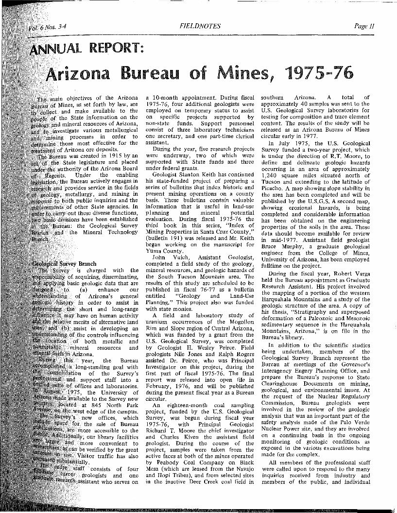
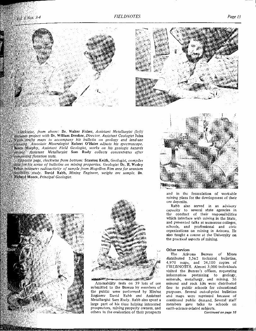
Amenability tests on 39 lots of oresubmitted to the Bureau by members ofthe public were performed by MiningEngineer David Rabb and AssistantMetallurgist Sam Rudy. Rabb also spent alarge part of his time helping interestedprospectors, mining property owners, andothers in the evaluation of their prospects
from above: Dr. Walter Fisher, Assistant Metallurgist (left)with Dr. William Dresher, Director. Assistant Geologist John
to accompany his bulletin on geology and land-useMineralogist Robert O'Haire adjusts his spectroscope.
Assistant Field Geologist, works on his geologic hazardsMetallurgist Sam Rudy collects concentrates after
flotation tests.clockwise from bottom: Stanton Keith, Geologist, compilesof bulletins on mining properties. Geologist Dr. H. Wesley
radioactivity of sample from Mogollon Rim area for uraniumDavid Rabb, Mining Engineer, weighs ore sample. Dr.
Pr;in~';n'11 Geologist.
Page 14 ARIZONA BUREAU OF MINES December, 1976
aal ames to aut ernII
rlzana
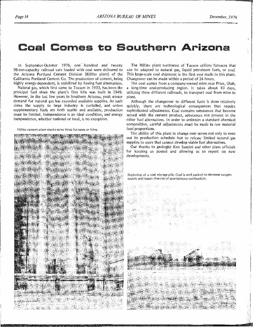
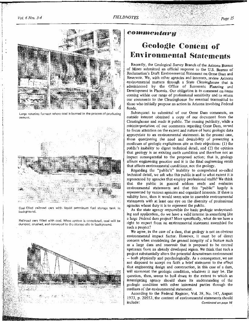
In September-October 1976, one' hundred and twenty98-ton-capacity railroad cars loaded with coal were delivered tothe Arizona Portland Cement Division (Rillito plant) of theCalifornia Portland Cement Co. The production of cement, beinghighly energy-dependent, is stabilized by having fuel alternatives.
Natural gas, which first came to Tucson in 1933, has been theprincipal fuel since the plant's first kiln was built in 1949.However, in the last few years in Southern Arizona, peak winterdemand for natural gas has exceeded available supplies. At suchtimes the supply to large industry is curtailed, and unlesssupplementary fuels are both usable and available, productionmust be limited. Independence is an ideal condition, and energyindependence, whether national or local, is no exception.
Rillito cement plant stacks serve three furnaces or kilns.
The Rillito plant northwest of Tucson utilizes furnaces thatcan be adapted to natural gas, liquid petroleum fuels, or coal.This large-scale coal shipment is the first ever made to this plant.Changeover can be made within a period of 24 hours.
The coal comes from a company-owned mine near Price, Utah,a long-time coal-producing region. It takes about 10 days,utilizing three different railroads, to transport coal from mine toplant.
Although the changeover to different fuels is done relativelyquickly, there are technological consequences that requiresophisticated adjustments. Coal contains substances that becomemixed with the cement product, substances not present in theother fuel alternatives. In order to amintain a standard chemicalcomposition, careful adjustments must be made in raw materialfeed proportions.
The ability of this plant to change over serves not only to evenout its production schedule but to release limited natural gassupplies to users that cannot develop viable fuel alternatives.
Our thanks to geologist Ken Santini and other plant officialsfor keeping us posted and allowing us to report on newdevelopments.
Beginning of a coal storage pile. Coal is well packed to decrease oxygensupply and lessen chances of spontaneous combustion.
FIELDNOTESVol. 6 Nos. 3-4
Large rotating furnace where coal is burned in the process of producingcement.
Coal-filled railroad cars with liquid petroleum fuel storage tank inbackground.
Railroad cars filled with coal. When system is completed, coal will bedumped, crushed, and conveyed to the storage silo in background.
15
Geolo~ie Content ofEnlTililonm(Antal Stat(Alll(AntsRecently, the Geological Survey Branch of the Arizona Bureau
of Mines submitted an official response to the U.S. Bureau ofReclamation's Draft Environmental Statement on Orme Dam andReservoir. We, with other agencies and interests, review Arizonaenvironmental matters through a State Clearinghouse that isadministered by the Office of Economic Planning andDevelopment in Phoenix. Our obligation is to comment on itemscoming within our range of professional sensitivity and to returnour comments to the Clearinghouse for eventual transmittal tothose who initially propose an action in Arizona involving Federalfunds.
Subsequent to submittal of our Orme Dam comments, anoutside interest obtained a copy of our document from theClearinghouse and made it public. The ensuing publicity, while amisinterpretation of our comments regarding Orme Dam, servedto focus attention on the extent and nature of basic geologic dataappropriate to an environmental statement. In the present case,those questioning the need and desirability of presenting amodicum of geologic explicitness cite as their objections: (1) thepublic's inability to digest technical detail, and (2) the opinionthat geology is an existing earth condition and therefore not animpact consequential to the proposed action; that is, geologyaffects engineering practice and it is the final engineering resultthat affects environmental conditions, not the geology.
Regarding the "pUblic's" inability to comprehend so-calledtechnical detail, we ask who this public is and to what extent it isrepresented by agencies that employ professional staffs? We thinkthat the public in general seldom reads and evaluatesenvironmental statements and that this "public" largely isrepresented by various agencies and organized interests. If there isvalidity here, then it would seem wise to assemble environmentalstatements with at least one eye on the diversity of professionalagencies whose duty it is to represent the public.
As the state agency responsible for basic geologic understanding and application, do we have a valid interest in something likea large Federal dam project? More specifically, what do we have aright to expect from an environmental statement assembled forsuch a project?
We agree, in the case of a dam, that geology is not an obviousenvironmental impact factor. However, it must be of directconcern when considering the general integrity of a feature suchas a large dam and reservoir that is proposed to be erectedupstream from an already developed region. We think that such aproject substantially alters the potential downstream environment- both physically and psychologically. As a consequence, we arenot disposed to accept on faith a brief statement to the effectthat engineering design and construction, in this case of a dam,will surmount the geologic condition, whatever it may be. Thequestion, then, seems to boil down to the extent to which aninvestigating agency should share its understanding of thegeologic condition with other interested parties through themedium of the environmental statement.
According to the Federal Register, Vol. 38, No. 147, August1973, p. 20553, the content of environmental statements shouldinclude: Continued on page 16
Page 16 ARIZONA BUREAU OF MINES December, 1976
Commentary continued"A description of the proposed action, a statement of its
purposes, and a description of the environment affected,including information, summary technical data, and maps anddiagrams where relevant, adequate to permit an assessment ofpotential environmental impact by commenting agencies and thepublic..."
Concerning the Orme Dam, from our position we read this toencompass " potential environmental impact" downstream froma dam that will be 195 feet high, over one mile long, and that willback up water for at least 10 miles. We think, therefore, that theenvironmental statement should contain information, summarytechnical data, and maps and diagrams adequate to permit anoverview and assessment of the downstream environment by thiscommenting agency.
There seems to be a tendency to avoid inclusion of geologicdata that might be misconstrued and/or misused by nongeologists. We are sensitive to this because in our opinion our ownClearinghouse document was misused and misrepresented, though
perhaps unintentionally. However, this problem should belessened by knowing ahead of time that a document will bescrutinized by non-geologically trained persons, and this shouldbe viewed as an opportunity to educate. Perhaps it is better in thelong run to err on the side of profuseness rather than brevitywhen dealing with potentially hazardous matters.
The argument easily is made that none can know more thanthe investigating agency. Yet there is always the question ofwhether, in a given circumstance, simply knowing more isenough.
In our opinion, it does not require an excessively lengthy ortechnical statement to communicate geologic sensitivity, basicinvestigatory techniques utilized, drill hole patterns and depths,and conclusions regarding those recognized geologic circumstances that require mitigation.
Of course, the extent and nature of geologic coverage varieswith each project. However, where appropriate, it is our intentand purpose to encourage both geologic awareness in the unawareand more complete geologic revelation by the aware.
172,773
$ 84,597
$251,743
6,6053,423
41,154
Total income $302,925
FIELDNOTES
Volume 6, Nos. 3-4 Dec. 1976State of Arizona
Governor. . ..... Hon. Raul CastroUniversity of Arizona
President. . . . . . . John P. SchaeferArizona Bureau of Mines
Director . .William H. DresherEditor Judi Goodpaster
ARIZONA BUREAU OF MINESTHE UNIVERSITY OF ARIZONA
TUCSON, ARIZONA
ABM annual report continued
1975-76 Expenditures by CategoryTechnical and advisory ser-
vices to members of thepublic
Mineral resource and geologic studies (includingprinting costs)
Administration and clericalexpenses 45,555
Total expenditures $302,925Sources of Income, 1975-76Operating budget from
StateService charges to members
of the publicPublication salesGrants from federal agen
cies
Some views on water continued
ditch, and pumps to keep the water levelsdown in the valley. Since the valley wasonce an inland sea, with a lot of saltdeposits, the water they're pumping isbrackish. The government then deliversthis brackish water to Mexico. Mexicostarts screaming. The solution? A desaltingplant, using reverse osmosis. So, we pay$400 per acre foot to deliver this water tocotton fields in Mexico, which use 2 acrefeet per acre (inefficiently) to growcotton. The 2 acre feet costs us $800 to grow maybe $300 worth of cotton inMexico. What other country in the worldcould afford to do this?
State water plan. Fortunately, we dohave a state Water Commission, they dohave good people, and they've come upwith a State Water Plan. It's a three-phaseplan. The first phase has beencompleted (ed. note: see FIELD NOTES,June, 1976). It's a look at all the waterbasins in the state. The second phase isdue January 1 next year; the third is dueJanuary 1 the following year. When theproject is completed, the Water Commission will be able to begin to lobby forwater legislation.
New ARMCircular
Circular 17, "Utilization of MunicipalWaste Water for Froth Flotation ofCopper and Molybdenum Sulfides ," isnow available from the Arizona Bureau ofMines.
This report, written by Bureau metallurgists Walter W. Fisher and SamuelRudy, describes a laboratory investigationto determine the feasibility of utilizingsewage effluent in place of fresh water ina copper flotation mill.
The detrimental effects of sewageeffluent on the flotation process aredescribed along with techniques tomodify both the sewage effluent and theflotation process so that waste water is anacceptable replacement for fresh water.
Utilization of municipal waste water inthis manner is an important waterconservation method that can result in asignificant reduction in the consumptionof high-quality water.
Circular 17 costs 75¢ per copy. Formail orders, please add 10% of the totalorder (25¢ minimum) for postage andhandling.
ARIZONA BUREAU OF MINESTHE UNIVERSITY OF ARIZONA
845 NORTH PARK AVE.TUCSON, ARIZONA 85719
NON·PROFIT ORG.
u.s. POSTAGE;<i'!' PAID
PERMIT NO. '190TUCSON, ARIZONA
1852