Embed Size (px)
Citation preview
The Newsletter of the International Coastal Atlas Network
ICAN Technicalities 2
Overview of the
Caribbean Marine
Atlas
5
The Marine Irish
Digital Atlas
7
How to become a
member of ICAN
7
Maryland’s Coastal
Atlas
8
Coastal and Marine
Information System
of Andalusia
10
North Carolina
Coastal Hazards
Decision Portal
12
Digital Climatic At-
las of Mexico
13
COINAtlantic News 15
Florida Water Atlas 16
From the Editor’s
Keyboard
16
A Message from the
ICAN Co-Chairs
17
Volume One Number 1
March 2012
http://icoastalatlas.net
Front and back page image is a north-south stretched image of Isla del Giglio, Italy.
Original image courtesy Esri
UNESCO Intergovernmental Oceanographic Commission pro-
visionally accepts ICAN as an official IODE Project
The International Coastal Atlas Network (ICAN) has been accepted provi-
sionally by the UNESCO Intergovernmental Oceanographic Commission
(IOC) as an official IODE (International Oceanographic Data and Informa-
tion Exchange) Project, at the recent IODE Officers Meeting, held between
30 January and 2 February 2012. An official announcement will follow,
from IOC IODE, as soon as the formal paperwork has been completed.
ICAN already supports two major regional coastal or marine atlas projects
of IOC, the African Marine Atlas and the Caribbean Marine Atlas projects.
CONTENTS
ICAN 6
The sixth international workshop for the International Coastal At-
las Network will be held in conjunction with CoastGIS 2013 in
June 2013 on the campus of the University of Victoria in Victoria
British Columbia, Canada. Stay tuned for details.
Dawn Wright receives AAG Award.
ICAN co-chair and Esri chief scientist Dawn J.
Wright, has received the Association of American
Geographers (AAG) Presidential Achievement
Award. Presented at the AAG annual meeting on
February 28, 2012. The award recognizes Wright's
outstanding work as a scientist, researcher, author,
and advocate for marine conservation and for her
contributions to geographic science.
"Dawn Wright is a researcher of exceptional
achievement whose work highlights the remark-
able breadth and diversity of contemporary geog-
raphy," said AAG president Audrey L. Kobayashi.
"Wright's work to build geospatial technology
standards for ocean mapping has enabled the sci-
entific community to share information and col-
laborate on research projects. She has championed
geographic information systems for marine re-
search that are laying the groundwork for more
sustainable ocean resources policies. The AAG
Presidential Achievement Award affirms the bene-
fit her efforts have brought to geographic science."
Dawn is a founding member and Co-chair of the
International Coastal Atlas Network. As chief sci-
entist, Wright leads Esri's natural sciences efforts
and drives the company's ocean and science initia-
tives. She is also a professor of geography and
oceanography at
Oregon State Uni-
versity, a fellow of
the American Asso-
ciation for the Ad-
vancement of Sci-
ence, and a fellow of
Stanford University's
Aldo Leopold Lead-
ership Program in
science communica-
tion.
"Dr. Wright's strong background in geographic
information science and expertise in GIS
[geographic information systems] have enabled
her to bring greater perspective to scientists
throughout the world who map and analyze ter-
rains, ecosystems, and habitats," said Jack Danger-
mond, Esri president, “The AAG has been a force
in promoting technology for geographic science.
By honoring a capable scientist who is also skilled
in geospatial systems affirms the association‟s
commitment to a community that is expanding its
approaches to research and analysis.”
Congratulations Dawn! The members of ICAN
always knew you were special.
Volume One Number 1 March 2012 Page 2
ICAN Technicalities
Activities of the ICAN Technical Team
Roy Lowry ([email protected]) and Adam Leadbetter
([email protected]), BODC, Liverpool, UK, Declan Dunne
([email protected]) and Yassine Lassoued ([email protected]) ,
CMRC, Cork, Ireland, Tanya Haddad
([email protected]), Oregon Coastal Atlas Project, USA,
Liz O’Dea ([email protected]) State of Washington Department
of Ecology, USA
The development of ICAN semantics began with the assem-
bly of a Coastal Erosion ontology to support semantically-
enabled atlas layer discovery following the workshop at Cor-
vallis in 2007. Semantically-enabled, or „smart‟, discovery is
where terms supplied by the search client are used to locate
metadata that has been marked up using different but seman-
tically related terms. A much quoted example is a search that
returns datasets tagged „rainfall‟ for a search term of
„precipitation‟.
This work was based on strategies and technologies provided
by the Marine Metadata Interoperability (MMI) initiative.
The strategy adopted was to take local vocabularies and on-
tologies, convert them into Web Ontology Language(OWL)
classes using tools like Protégé or TopBraid Composer and
then map them to a global ontology, again comprising OWL
classes, using the MMI VINE tool.
Some initial work, the conversion of local vocabularies from
the Irish MIDA and Oregon coastal atlases into OWL, was
completed but very little mapping work was done subse-
quently. The possibility was mooted that the OWL-based
approach, particularly some of the tools, created a techno-
logical barrier that people were unwilling to surmount. Con-
sequently, in the NETMAR project (see below) an approach
was taken where tools such as Microsoft Excel were used to
assemble the local vocabularies and the mappings as a series
of spreadsheets. These were then imported into an Oracle
database and exported by a Java software layer (the NERC
Vocabulary Server or NVS) as a thesaurus conforming to the
W3C Simple Knowledge Organisation System (SKOS) stan-
dard.
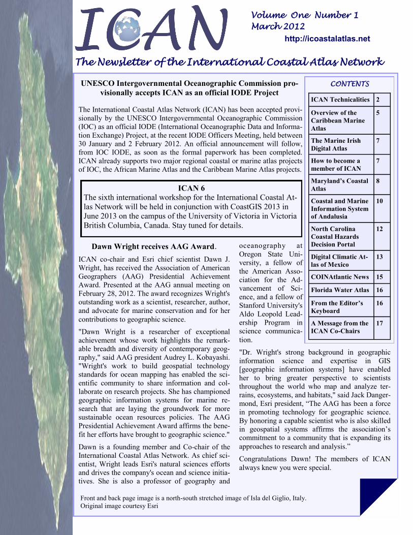
As a part of this work, the mapping between the Oregon
Coastal Atlas and the ICAN Coastal Erosion Global Atlas
was completed as shown in Figure 1. The resulting thesaurus
is available as a SKOS document from the NVS at the URL
http://vocab.nerc.ac.uk/scheme/ICANCOERO. The response
returned by the vocabulary server is a SKOS document en-
coded in RDF-XML. However, a stylesheet has been in-
cluded to facilitate human browsing of the resource. Hard-
Figure 1. ICAN Coastal Erosion Mapping
International Coastal Atlas Network Newsletter Page 3
core XML addicts can get their fix through „View Source‟.
Further work to incorporate the MIDA vocabulary and some
terms from the Wisconsin Coastal Atlas are planned for late
spring and early summer of 2012. If anybody has other
coastal erosion semantic resources they would like to be
mapped in please contact either of the authors at BODC.
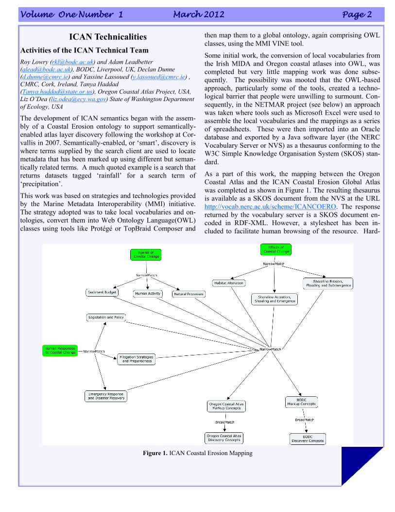
Following requests from the ICAN community at the ICAN
5 workshop, a draft ICAN Water Quality Global Thesaurus
has been developed as shown in Figure 2.
Figure 2. ICAN Water Quality Global Thesaurus
We would like to develop this into a full semantic discovery
resource. However, we need local water quality vocabularies
or ontologies for us to map. If anybody has these available,
please get in touch with BODC. We would also like to hear
from anybody interested in working with us to develop se-
mantic resources for Marine Spatial Planning or Climate
Risks.
ICAN Cookbooks
Following the ICAN workshop in Copenhagen in 2008, it was
decided to provide technical training for costal web atlas de-
velopers in the form of cookbooks, especially for people who
are starting a new atlas. While the “Coastal Informatics: Web
Atlas Design and Implementation” handbook published by
IGI-Global in 2011 covers the more theoretical aspects of
costal web atlas development, the cookbooks are targeted to
contain more practical step-by-step instructions. Conse-
quently, the NETMAR project has produced cookbooks to
contribute to this technical training material.
These are:
Understanding Semantics.
This cookbook provides a tutorial for those who wish to fur-
ther investigate and make use of semantic web technologies.
For data to be fully understood in a distributed system, they
must be labelled (or “marked up”) accordingly. Either the la-
bel used throughout the system must use a common set of
phrases, or there must be a means of translating between the
phrases used at different points of the system. The aim of the
cookbook is to provide consistent phrases and to define the
relationships in a formal manner, resulting in what is often
called a “knowledge organization system”.
In 1999 Tim Berners-Lee wrote “If HTML and the [World
Wide] Web made all the online documents look like one huge
book, [semantics] will make all the data in the world look like
one huge database." The ICAN Understanding Semantics
cookbook now provides a tutorial for those who wish to in-
vestigate and make use of these technologies, aimed specifi-
cally at members of the ICAN community.
Understanding Metadata.
This cookbook provides a tutorial for those who wish to better
understand metadata. Geospatial metadata is “data about
data”. It contains information that documents the basic char-
acteristics of a geospatial data resource. It can also document
basic characteristics of geospatial applications or services.
Metadata falls into broad categories where it answers the
“what, why, when, who, where and how” questions about the
resource.
Volume One Number 1 March 2012 Page 4
Establishing a CSW metadata catalogue with GeoNet-
work opensource.
This cookbook provides a tutorial for those who wish to bet-
ter understand CSW (Catalog Services for the Web) metadata
catalogues. It also contains initial pointers to establishing a
CSW server using GeoNetwork opensource. A metadata
catalogue stores and publishes collections or sets of metadata
records describing data, services, and related information
resources. Standards are required to enable interoperable
searching of distributed metadata catalogues between organi-
sations. This is achieved using the CSW standard.
Connecting your Atlas.
This cookbook provides a step-by-step guide explaining how
to connect a local atlas as a node in the ICAN Prototype and
NETMAR Demonstrator. It is a prototype atlas mediator
which provides a common interface for accessing distributed
local atlases, such as MIDA (Marine Irish Digital Atlas),
OCA (Oregon Coastal Atlas), and Washington Coastal Atlas
(WCA). It uses a knowledge organization system (KOS) to
improve data discovery by exploiting the semantics of key-
words and allowing users to search data by “meaning” rather
than by “mere keywords.”
The four cookbooks are available in a single PDF file that is
currently located at http://netmar.nersc.no/sites/
n e t m a r . n e r s c . n o / f i l e s /
NETMAR_D7.9.1_ICAN_Semantic_Cookbooks.pdf. The
NETMAR team plan to update these cookbooks by June
2012. Please get in touch with CMRC if you wish to give us
feedback.
ICAN Prototype and NETMAR Demonstrator
The ICAN Prototype and NETMAR Demonstrator provides a
graphical user interface which aims to allow users to search
data by meaning rather than by mere keywords. Using the
ICAN semantic resources it will enable distributed search
across local atlases, such as MIDA (Marine Irish Digital At-
las), OCA (Oregon Coastal Atlas), and Washington Coastal
Atlas (WCA). The smart search and discovery client cur-
rently supports three features: ontology browsing, dataset
smart search, and metadata visualisation. Data visualisation
and data download are planned.
The search and discovery client helps the user find relevant
datasets by allowing him to browse the ontology terms to
find suitable search criteria. The ontology browser lists the
defined themes, and by clicking on any one of them, their
definition is shown along with related terms. From here, the
user can inspect any of the related terms by clicking on them,
or move on to searching by entering a keyword in the search
field. For example, entering “temperature” will search the
ontology for any semantically related terms, and display
these with definitions inside the browser. When a user has
found a suitable search term, he can enter it in the search
field at the top of the Ontology Browser window. This will
start the dataset smart search application. The search client
will present a summary of all datasets matching the criteria,
and the user can then click on any of the found datasets to get
a full metadata listing for it.
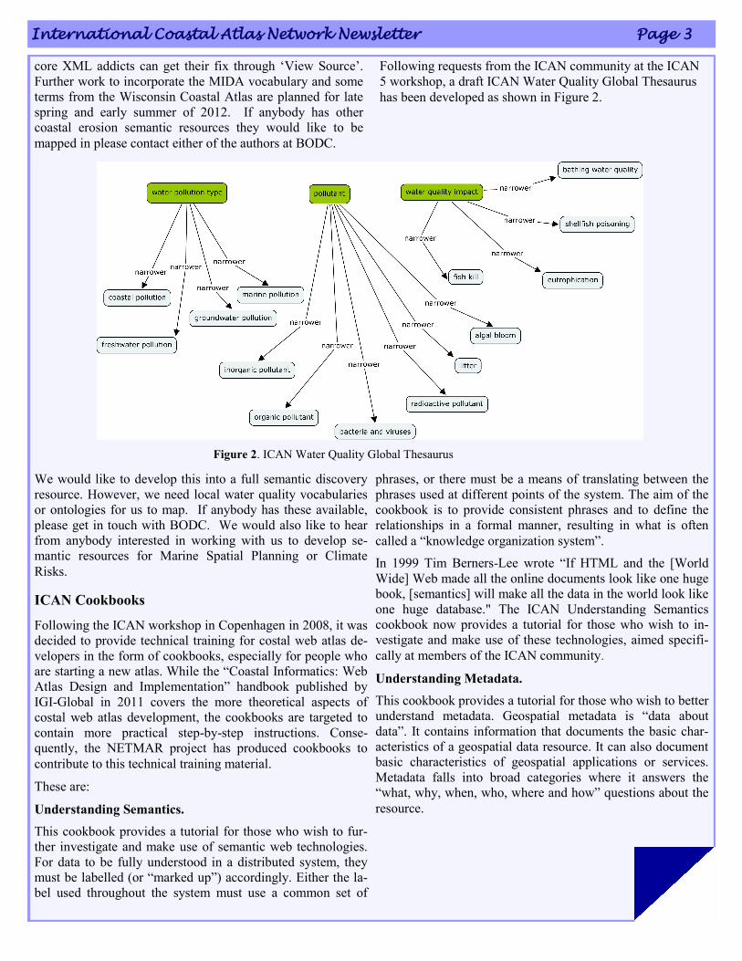
The smart search and discovery client relies on two services:
a semantic web service (SWS) and a CSW (Catalogue Ser-
vice for the Web) mediator (CSWM), as shown in Figure 3.
The semantic web service (SWS) provides a high-level inter-
face for retrieving knowledge from the NETMAR ontologies.
On top of the
catalogue
services, a
CSW Media-
tor is respon-
sible for han-
dling meta-
data seman-
tics and al-
lows data
discovery
based on se-
mantics.
A test ver-
sion of the
NETMAR
Demonstrator
is currently
located at
http://
net-
mar.ucc.ie/
discovery/.
Please get in
touch with
CMRC if you wish to connect your atlas to the demonstrator
or give feedback.
NETMAR
The Open Service NETwork for MARine Environmental
Data is a 3-year project funded by the European Union under
its FP7 programme that started in February 2010. The objec-
tive is prototype portal development using Liferay technol-
ogy incorporating tools such as a viewer, semantic resource
browser, CSW semantically-mediated search and WPS chain
editor as portlets. ICAN was one of four demonstration pi-
lots selected for the project. The work described above
would not have been possible without the NETMAR funding.
Figure 3. Smart search client components and
services
International Coastal Atlas Network Newsletter Page 5
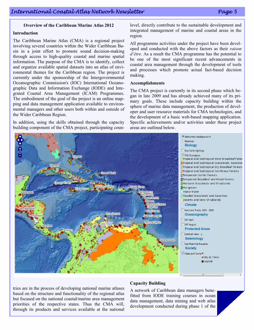
Overview of the Caribbean Marine Atlas 2012
Introduction
The Caribbean Marine Atlas (CMA) is a regional project
involving several countries within the Wider Caribbean Ba-
sin in a joint effort to promote sound decision-making
through access to high-quality coastal and marine spatial
information. The purpose of the CMA is to identify, collect
and organize available spatial datasets into an atlas of envi-
ronmental themes for the Caribbean region. The project is
currently under the sponsorship of the Intergovernmental
Oceanographic Commission's (IOC) International Oceano-
graphic Data and Information Exchange (IODE) and Inte-
grated Coastal Area Management (ICAM) Programmes.
The embodiment of the goal of the project is an online map-
ping and data management application available to environ-
mental managers and other users both within and outside of
the Wider Caribbean Region.
In addition, using the skills obtained through the capacity
building component of the CMA project, participating coun-
tries are in the process of developing national marine atlases
based on the structure and functionality of the regional atlas
but focused on the national coastal/marine area management
priorities of the respective states. Thus the CMA will,
through its products and services available at the national
level, directly contribute to the sustainable development and
integrated management of marine and coastal areas in the
region.
All programme activities under the project have been devel-
oped and conducted with the above factors as their raison
d’être. As a result the CMA programme has the potential to
be one of the most significant recent advancements in
coastal area management through the development of tools
and processes which promote actual fact-based decision
making.
Accomplishments
The CMA project is currently in its second phase which be-
gan in late 2009 and has already achieved many of its pri-
mary goals. These include capacity building within the
sphere of marine data management, the production of devel-
oper and user resource materials for CMA technologies, and
the development of a basic web-based mapping application.
Specific achievements and/or activities under these project
areas are outlined below.
Capacity Building
A network of Caribbean data managers bene-
fitted from IODE training courses in ocean
data management, data mining and web atlas
development conducted during phase 1 of the
Volume One Number 1 March 2012 Page 6
CMA.
Specific training was given for atlas developers via the
CMA Training Course on PostgreSQL, PostGIS and
OpenLayers for Web-Based Atlas Development in Bridge-
town, Barbados in April of 2011.
The development of web-based mapping applications has
resulted in the exposure to and growing familiarity with sev-
eral coding languages (Javascript, PHP, HTML, XML) and
software platforms (GeoServer, GeoNetwork).
Development of Resource Materials
The main CMA website www.caribbeanmarineatlas.net is
host to information on all of the training courses, planning
meetings and national stakeholder meetings conducted as
part of the CMA project
A user manual for the mapping application has been devel-
oped and is also available on the main site
Resource materials directly related to national atlas develop-
ment efforts and other developer-specific materials are
available in a section of the main website not open to the
general public.
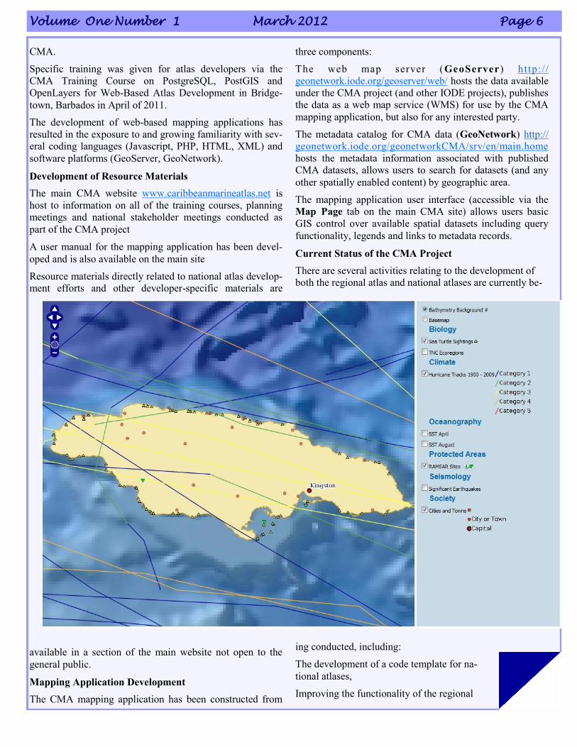
Mapping Application Development
The CMA mapping application has been constructed from
three components:
The web map server (GeoServer) http:/ /
geonetwork.iode.org/geoserver/web/ hosts the data available
under the CMA project (and other IODE projects), publishes
the data as a web map service (WMS) for use by the CMA
mapping application, but also for any interested party.
The metadata catalog for CMA data (GeoNetwork) http://
geonetwork.iode.org/geonetworkCMA/srv/en/main.home
hosts the metadata information associated with published
CMA datasets, allows users to search for datasets (and any
other spatially enabled content) by geographic area.
The mapping application user interface (accessible via the
Map Page tab on the main CMA site) allows users basic
GIS control over available spatial datasets including query
functionality, legends and links to metadata records.
Current Status of the CMA Project
There are several activities relating to the development of
both the regional atlas and national atlases are currently be-
ing conducted, including:
The development of a code template for na-
tional atlases,
Improving the functionality of the regional
International Coastal Atlas Network Newsletter Page 7
atlas,
Formatting and uploading additional datasets, and
Data gathering for national atlas development projects.
Future of the project
Between 2012 and 2013, several activities are expected to be
completed to fulfill the goals of the CMA project, these in-
clude:
The rollout of several national coastal/marine atlases based
on the CMA,
Additional national stakeholder meetings,
The improvement of functionality for both national and re-
gional atlases,
Atlas user and developer training,
National-level atlas promotion, and
The development of an atlas sustainability strategy.
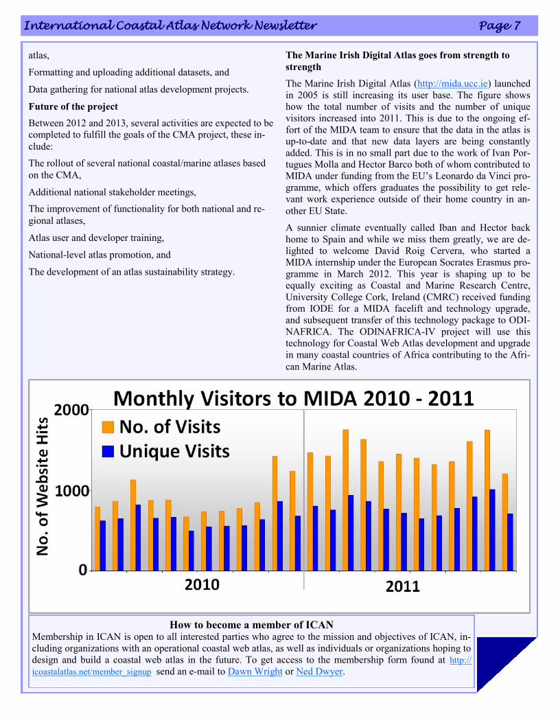
The Marine Irish Digital Atlas goes from strength to
strength
The Marine Irish Digital Atlas (http://mida.ucc.ie) launched
in 2005 is still increasing its user base. The figure shows
how the total number of visits and the number of unique
visitors increased into 2011. This is due to the ongoing ef-
fort of the MIDA team to ensure that the data in the atlas is
up-to-date and that new data layers are being constantly
added. This is in no small part due to the work of Ivan Por-
tugues Molla and Hector Barco both of whom contributed to
MIDA under funding from the EU‟s Leonardo da Vinci pro-
gramme, which offers graduates the possibility to get rele-
vant work experience outside of their home country in an-
other EU State.
A sunnier climate eventually called Iban and Hector back
home to Spain and while we miss them greatly, we are de-
lighted to welcome David Roig Cervera, who started a
MIDA internship under the European Socrates Erasmus pro-
gramme in March 2012. This year is shaping up to be
equally exciting as Coastal and Marine Research Centre,
University College Cork, Ireland (CMRC) received funding
from IODE for a MIDA facelift and technology upgrade,
and subsequent transfer of this technology package to ODI-
NAFRICA. The ODINAFRICA-IV project will use this
technology for Coastal Web Atlas development and upgrade
in many coastal countries of Africa contributing to the Afri-
can Marine Atlas.
How to become a member of ICAN Membership in ICAN is open to all interested parties who agree to the mission and objectives of ICAN, in-
cluding organizations with an operational coastal web atlas, as well as individuals or organizations hoping to
design and build a coastal web atlas in the future. To get access to the membership form found at http://
icoastalatlas.net/member_signup send an e-mail to Dawn Wright or Ned Dwyer.
Volume One Number 1 March 2012 Page 8
Maryland’s Coastal Atlas Undergoes Face-lift and
Rolls Out New Tools for Informing Coastal Plan-
ning and Decision-Making
Maryland‟s Chesapeake & Coastal Service (CCS) is improv-
ing the State‟s ability to access coastal data and tools that
will help inform decision-making about coastal management
with Maryland‟s Coastal Atlas. This online mapping and
planning tool, developed to allow users to visually analyze
and explore data for coastal and ocean planning activities,
has recently undergone a number of exciting updates and
enhancements that are slated for launch in March 2012.
Originally launched in June of 2008, the Coastal Atlas rep-
resented a significant overhaul from the Maryland Shoreline
Online mapping portal supported by the Department of
Natural Resources‟ Chesapeake & Coastal Service (CCS).
Sparked by Governor O‟Malley‟s enthusiasm for GIS tech-
nology as a tool for improved transparency, accountability,
and communication, the Coastal Atlas was developed
shortly after the roll out of Maryland iMap – a centralized
collection of the most commonly used Maryland data layers,
tools and services hosted in an ESRI ArcGIS Server envi-
ronment. Maryland iMap makes these layers, representing
the best data available to the public for free, accessible as
web services so state and local governments don‟t have to
store or host data while ensuring the layers look the same
across all state mapping applications. Following the lead of
the earliest Maryland iMap applications (like GreenPrint,
AgPrint and StateStat), the Coastal Atlas was developed
using ArcGIS Server and Adobe Flex technology allowing
state and local officials to access the data/web services they
want to display.
From October 2010 through March 2012, through funding
from Maryland‟s Coastal Zone Management grant and with
the help of developers/programmers at Towson University‟s
Center for GIS and Maryland Environmental Service, CCS
staff has worked to enhance the functionality and utility of
the Coastal Atlas. A major overhaul to the Atlas‟s three
mapping applications (Ocean, Shorelines, and Estuaries) has
allowed the addition of new tools that enhance the user ex-
perience and allow for easier modification to include future
enhancements.
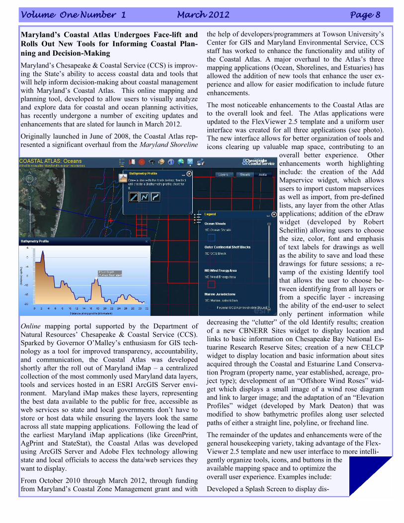
The most noticeable enhancements to the Coastal Atlas are
to the overall look and feel. The Atlas applications were
updated to the FlexViewer 2.5 template and a uniform user
interface was created for all three applications (see photo).
The new interface allows for better organization of tools and
icons clearing up valuable map space, contributing to an
overall better experience. Other
enhancements worth highlighting
include: the creation of the Add
Mapservice widget, which allows
users to import custom mapservices
as well as import, from pre-defined
lists, any layer from the other Atlas
applications; addition of the eDraw
widget (developed by Robert
Scheitlin) allowing users to choose
the size, color, font and emphasis
of text labels for drawings as well
as the ability to save and load these
drawings for future sessions; a re-
vamp of the existing Identify tool
that allows the user to choose be-
tween identifying from all layers or
from a specific layer - increasing
the ability of the end-user to select
only pertinent information while
decreasing the “clutter” of the old Identify results; creation
of a new CBNERR Sites widget to display location and
links to basic information on Chesapeake Bay National Es-
tuarine Research Reserve Sites; creation of a new CELCP
widget to display location and basic information about sites
acquired through the Coastal and Estuarine Land Conserva-
tion Program (property name, year established, acreage, pro-
ject type); development of an “Offshore Wind Roses” wid-
get which displays a small image of a wind rose diagram
and link to larger image; and the adaptation of an “Elevation
Profiles” widget (developed by Mark Deaton) that was
modified to show bathymetric profiles along user selected
paths of either a straight line, polyline, or freehand line.
The remainder of the updates and enhancements were of the
general housekeeping variety, taking advantage of the Flex-
Viewer 2.5 template and new user interface to more intelli-
gently organize tools, icons, and buttons in the
available mapping space and to optimize the
overall user experience. Examples include:
Developed a Splash Screen to display dis-
International Coastal Atlas Network Newsletter Page 9
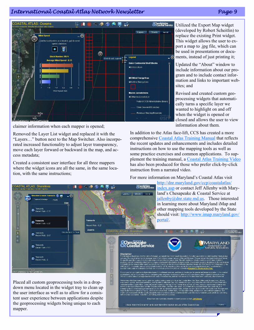
claimer information when each mapper is opened;
Removed the Layer List widget and replaced it with the
“Layers…” button next to the Map Switcher. Also incorpo-
rated increased functionality to adjust layer transparency,
move each layer forward or backward in the map, and ac-
cess metadata;
Created a consistent user interface for all three mappers
where the widget icons are all the same, in the same loca-
tion, with the same instructions;
Placed all custom geoprocessing tools in a drop-
down menu located in the widget tray to clean up
the user interface as well as to allow for a consis-
tent user experience between applications despite
the geoprocessing widgets being unique to each
mapper.
Utilized the Export Map widget
(developed by Robert Scheitlin) to
replace the existing Print widget.
This widget allows the user to ex-
port a map to .jpg file, which can
be used in presentations or docu-
ments, instead of just printing it;
Updated the “About” window to
include information about our pro-
gram and to include contact infor-
mation and links to important web-
sites; and
Revised and created custom geo-
processing widgets that automati-
cally turns a specific layer we
wanted to highlight on and off
when the widget is opened or
closed and allows the user to view
information about them.
In addition to the Atlas face-lift, CCS has created a more
comprehensive Coastal Atlas Training Manual that reflects
the recent updates and enhancements and includes detailed
instructions on how to use the mapping tools as well as
some practice exercises and common applications. To sup-
plement the training manual, a Coastal Atlas Training Video
has also been produced for those who prefer click-by-click
instruction from a narrated video.
For more information on Maryland‟s Coastal Atlas visit
http://dnr.maryland.gov/ccp/coastalatlas/
index.asp or contact Jeff Allenby with Mary-
land‟s Chesapeake & Coastal Service at
[email protected]. Those interested
in learning more about Maryland iMap and
other mapping tools developed by the State
should visit: http://www.imap.maryland.gov/
portal/.
Volume One Number 1 March 2012 Page 10
Coastal and Marine Information System of
Andalusia (Spain)
Environmental Information Network of Andalusia
Preparing a new atlas interface to be online soon!
The Environmental Information Network of Andalusia
(REDIAM) will publish during 2012 a new coastal and ma-
rine atlas in Spanish and English with new functionalities
and new contents. The new atlas interface will make easier
all kind of search by citizens and technician using the
Coastal and Marine Information System of Andalusia in
their daily work.
Looking for new projects with our Portuguese col-
leagues!
The Portuguese Geographical Institute and the Environ-
mental Information Network of Andalusia (Spain) together
with other partners from the Mediterranean have applied to
the European Neighborhood Policy Instrument Call with
the AgoraMedGIS Project to promote the sustainable and
integrated planning and management of marine and coastal
zones in the Mediterranean Basin, making available univer-
sal access to data and geographic information and improve
knowledge, the sharing of information and articulation be-
tween stakeholders.
AgoraMedGIS - Marine and Coastal Mediterranean Basin
Information System, is based on the "Ágora" concept, sym-
bol of ancient Greece direct democracy. "Ágora" was the
place where the citizens use to meet and share and discuss
ideas and issues that were important to all. In this sense, the
tool that will be developed by the partners allows the search-
ing for multidisciplinary information that exists about a cer-
tain place, enabling the user to filter it accordingly to his
own interest or focus, or selecting data by project type, ac-
tivity or thematic area and related to the Mediterranean Ba-
sin in general or to specific zones. AgoraMedGIS will trans-
form the entire Mediterranean basin in a small village in the
domain of data.
Erosion rates 1956 – 2007 in our sandy beaches!
The erosion rates constitute a very valuable indicator for
understanding coastal dynamics and its effects produced by
river regulations (mainly by damming them) and the con-
struction of coastal infrastructures.
In this sense, negative erosion rates (regressive coast)
show more vulnerability; and positive erosion rates
(progressive coast) show less vulnerability. After calculating
the erosion rates for the entire Andalusian coast
during the periods 1956-1979 and 1979-2007,
some stretches have been chosen and validated
as being of special interest due to the intensity
in coastal dynamics: the coast of Huelva, the
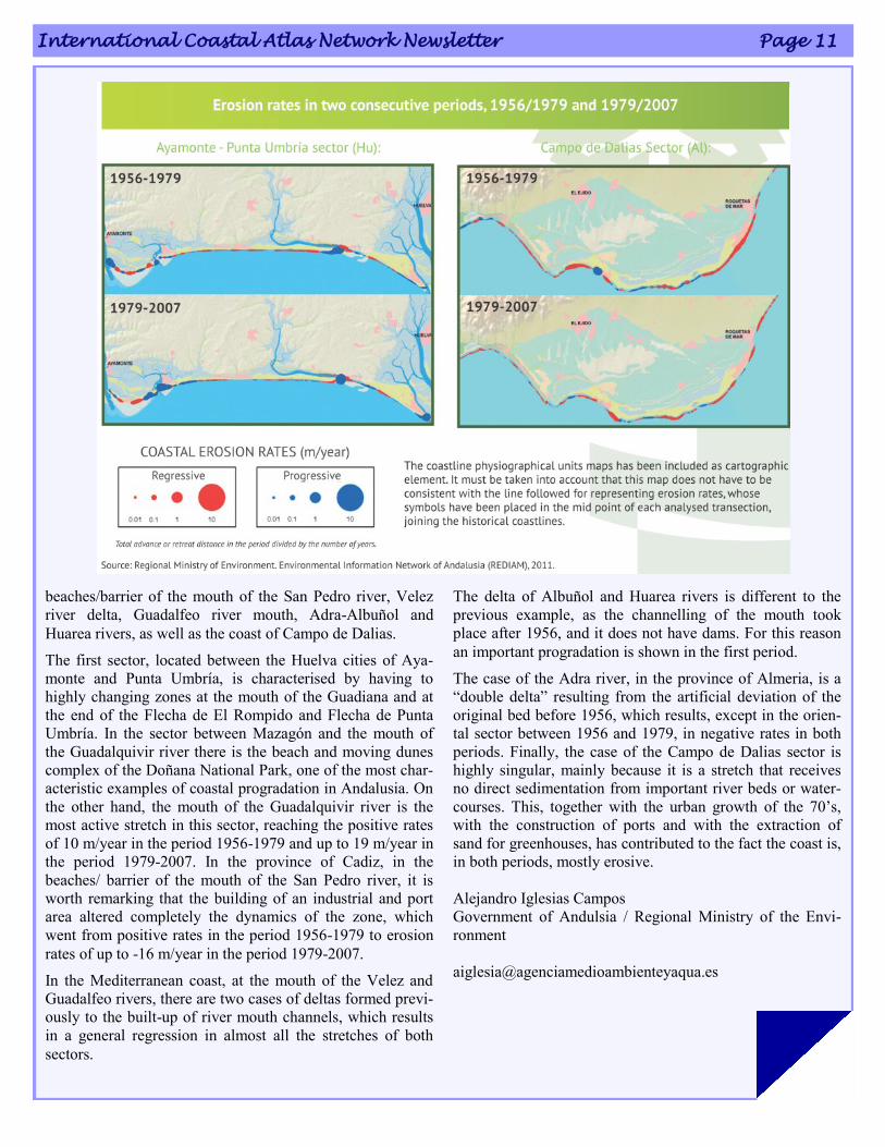
International Coastal Atlas Network Newsletter Page 11
beaches/barrier of the mouth of the San Pedro river, Velez
river delta, Guadalfeo river mouth, Adra-Albuñol and
Huarea rivers, as well as the coast of Campo de Dalias.
The first sector, located between the Huelva cities of Aya-
monte and Punta Umbría, is characterised by having to
highly changing zones at the mouth of the Guadiana and at
the end of the Flecha de El Rompido and Flecha de Punta
Umbría. In the sector between Mazagón and the mouth of
the Guadalquivir river there is the beach and moving dunes
complex of the Doñana National Park, one of the most char-
acteristic examples of coastal progradation in Andalusia. On
the other hand, the mouth of the Guadalquivir river is the
most active stretch in this sector, reaching the positive rates
of 10 m/year in the period 1956-1979 and up to 19 m/year in
the period 1979-2007. In the province of Cadiz, in the
beaches/ barrier of the mouth of the San Pedro river, it is
worth remarking that the building of an industrial and port
area altered completely the dynamics of the zone, which
went from positive rates in the period 1956-1979 to erosion
rates of up to -16 m/year in the period 1979-2007.
In the Mediterranean coast, at the mouth of the Velez and
Guadalfeo rivers, there are two cases of deltas formed previ-
ously to the built-up of river mouth channels, which results
in a general regression in almost all the stretches of both
sectors.
The delta of Albuñol and Huarea rivers is different to the
previous example, as the channelling of the mouth took
place after 1956, and it does not have dams. For this reason
an important progradation is shown in the first period.
The case of the Adra river, in the province of Almeria, is a
“double delta” resulting from the artificial deviation of the
original bed before 1956, which results, except in the orien-
tal sector between 1956 and 1979, in negative rates in both
periods. Finally, the case of the Campo de Dalias sector is
highly singular, mainly because it is a stretch that receives
no direct sedimentation from important river beds or water-
courses. This, together with the urban growth of the 70‟s,
with the construction of ports and with the extraction of
sand for greenhouses, has contributed to the fact the coast is,
in both periods, mostly erosive.
Alejandro Iglesias Campos
Government of Andulsia / Regional Ministry of the Envi-
ronment
Volume One Number 1 March 2012 Page 12
The NC COHAZ Decision Portal
Conveys Critical Data
and Useful Mapping Products
The coast of North Carolina is at risk to a diversity of haz-
ards (e.g., storm surge, sea-level rise), and these hazards
potentially can have major consequences (financial and oth-
erwise) for people who live, work, and recreate in impacted
areas. There has been much research conducted on coastal
hazards affecting North Carolina and their ramification, but
information is scattered and often hard to track down. Also,
it is typically not in a form suitable for public consumption.
To improve on these issues, a team of researchers from the
departments of Geological Sciences and Geography at East
Carolina University (ECU) has worked with others at ECU
and around the state to develop a web-based information
site on coastal hazards and related research; it is called the
North Carolina COastal HAZards (NC COHAZ) Decision
Portal. At the site (http://www.coastal.geology.ecu.edu/
NCCOHAZ/), a variety of information on coastal hazards in
the state (particularly the northeastern portion) has been
coalesced.
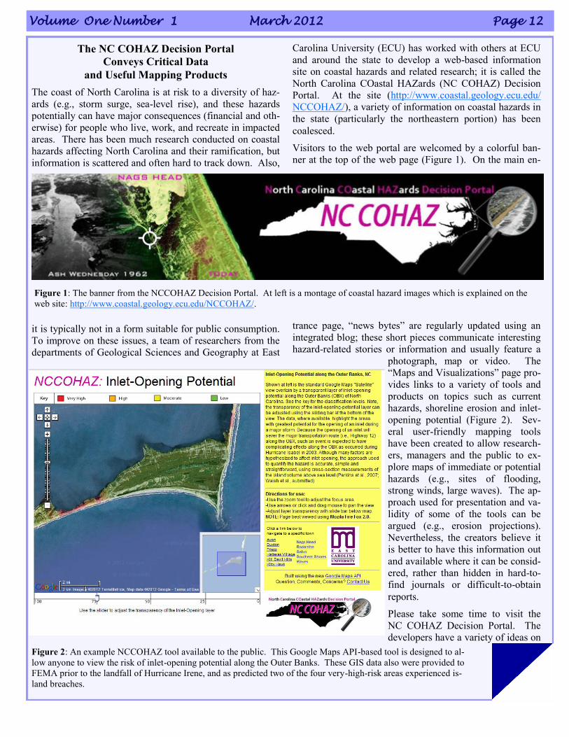
Visitors to the web portal are welcomed by a colorful ban-
ner at the top of the web page (Figure 1). On the main en-
trance page, “news bytes” are regularly updated using an
integrated blog; these short pieces communicate interesting
hazard-related stories or information and usually feature a
photograph, map or video. The
“Maps and Visualizations” page pro-
vides links to a variety of tools and
products on topics such as current
hazards, shoreline erosion and inlet-
opening potential (Figure 2). Sev-
eral user-friendly mapping tools
have been created to allow research-
ers, managers and the public to ex-
plore maps of immediate or potential
hazards (e.g., sites of flooding,
strong winds, large waves). The ap-
proach used for presentation and va-
lidity of some of the tools can be
argued (e.g., erosion projections).
Nevertheless, the creators believe it
is better to have this information out
and available where it can be consid-
ered, rather than hidden in hard-to-
find journals or difficult-to-obtain
reports.
Please take some time to visit the
NC COHAZ Decision Portal. The
developers have a variety of ideas on
Figure 1: The banner from the NCCOHAZ Decision Portal. At left is a montage of coastal hazard images which is explained on the
web site: http://www.coastal.geology.ecu.edu/NCCOHAZ/.
Figure 2: An example NCCOHAZ tool available to the public. This Google Maps API-based tool is designed to al-
low anyone to view the risk of inlet-opening potential along the Outer Banks. These GIS data also were provided to
FEMA prior to the landfall of Hurricane Irene, and as predicted two of the four very-high-risk areas experienced is-
land breaches.
International Coastal Atlas Network Newsletter Page 13
how to expand the site, such as plans for a more formal ma-
rine atlas. But, if you have any suggestions or thoughts on
information contained on the site or data you would like to
see added, etc., do not hesitate to contact J.P. Walsh,
[email protected], (252) 328-5431. Feedback of any kind is
appreciated. Hopefully, this site will improve communica-
tion and information on coastal data exchange around the
state and beyond. Ultimately, the goal of NC COHAZ is to
help mitigate the effects of coastal hazards on the citizens of
North Carolina, and this can only be accomplished through
better sharing of knowledge, data and ideas.
J.P. Walsh1,2, Reide Corbett1,2 and Tom Allen1 1East Carolina Univesity 2UNC Coastal Studies Institute
Meteorological drought in the Digital Climatic Atlas
of Mexico
The new version of the Digital Climatic Atlas of Mexico
(DCAM) includes the meteorological drought thematic
using advanced technological tools and new methodolo-
gies for the cartographic processes that include the
quality control of the data and the display of interactive
maps in the Internet.
With the aim of generate and integrate in version 2.0 of the
DCAM the cartographic displays of continental basic cli-
matic variables (temperature and precipitation), bioclimatic
parameters, extreme climatology and meteorological
drought periods in Mexico, the data of over 5,200 meteoro-
logical stations were proc-
essed from the daily climate
databases (1902-2011) of the
Mexican Weather Service
(abbreviated to SMN in
Spanish) of the National
Commission of Water
(CONAGUA). This was
done as part of a joint project
between the SMN and the
Informatics Unit for Atmos-
pheric and Environmental
Sciences (UNIATMOS) of
the Center for Atmospheric
Sciences (CCA) of the Na-
tional Autonomous Univer-
sity of Mexico (UNAM).
The drought in Mexico
The meteorological drought
is an atmospheric phenome-
non that occurs when the pre-
cipitation in a region, and
during a determined period, is
lower than the reference average established from measure-
ments in a typical 30-year period. If the decrease of the pre-
cipitation is severe and goes on for extended periods, then
the type of drought that impacts agriculture and hydrology is
generated, which is characterized by the negative effects on
the economic sector of the region or directly to people in the
affected communities. The drought in Mexico is one of the
natural phenomena that more severely affects the economy,
since large cultivated areas and livestock are lost when it
happens.
The main cause of the drought is the lack of rain; however,
there are factors that contribute to generate it such as
changes of the general circulation of the ocean-atmosphere
system related to alterations in the sea surface temperature,
to changes in the atmospheric pressure and to increases in
the carbon dioxide concentrations, among others. The
Drought Fascicle by García F., Fuentes O. y Matías L. G.,
(2002), published by the National Center for Disaster Pre-
vention (CENAPRED) of the Mexican Government, incor-
porates a historic review of the droughts that occurred in
Mexico, including the months and places where it happened.
The drought periods which are registered and documented in
this publication are: 1998-2000, 1993-1996, 1970-1978,
1960-1964 and 1948-1954.
From the daily climatic data base of the SMN, that includes
information for the period 1902-2011, and according to the
methodology described in the DCAM documents (http://
atlasclimatico.unam.mx/atlas/uniatmos.html) on the process-
ing of climatic surface maps, and the quality control of the
continental climatic information and its validation, the
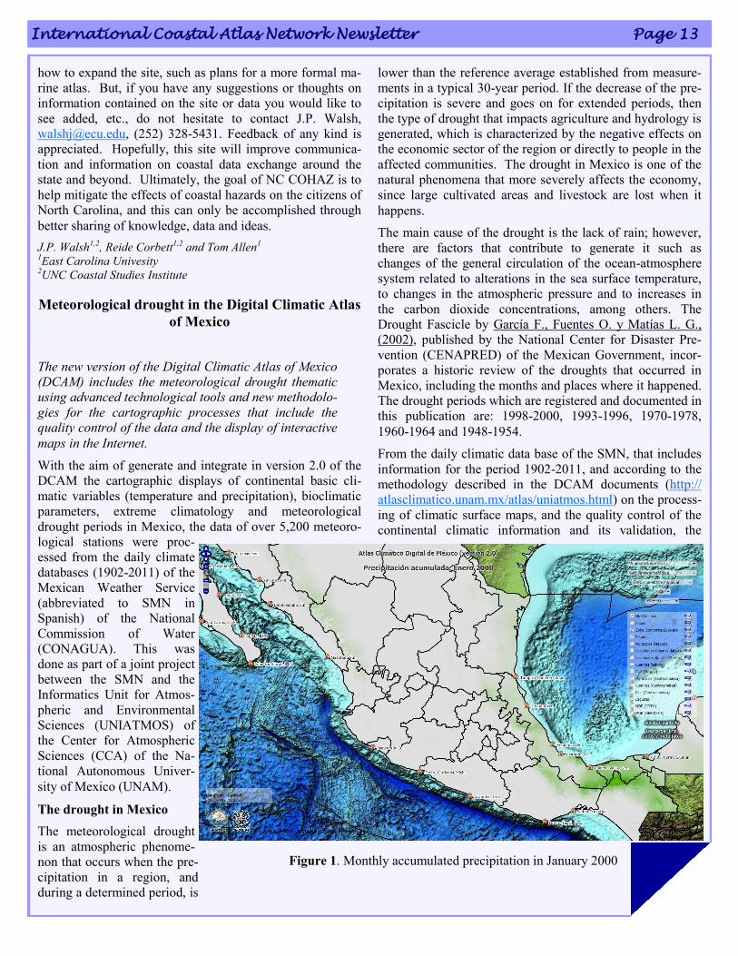
Figure 1. Monthly accumulated precipitation in January 2000
Volume One Number 1 March 2012 Page 14
monthly accumulated precipitation (see figure 1) was calcu-
lated for the Mexican Republic corresponding to the months
impacted by drought that are reported in the above men-
tioned publication, as well as its respective anomaly, which
is the difference between the accumulated precipitation dur-
ing a given month, for example, January 2000, and the aver-
age accumulated precipitation of all the Januaries of the
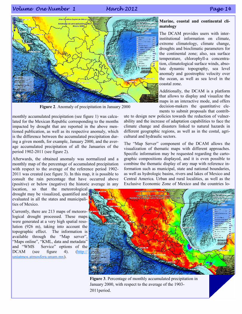
period 1902-2011 (see figure 2).
Afterwards, the obtained anomaly was normalized and a
monthly map of the percentage of accumulated precipitation
with respect to the average of the reference period 1902-
2011 was created (see figure 3). In this map, it is possible to
consult the rain percentage that have occurred above
(positive) or below (negative) the historic average in any
location, so that the meteorological
drought may be visualized, quantified and
evaluated in all the states and municipali-
ties of Mexico.
Currently, there are 213 maps of meteoro-
logical drought processed. These maps
were generated at a very high spatial reso-
lution (926 m), taking into account the
topographic effect. The information is
available through the “Map server”,
“Maps online”, “KML, data and metadata”
and “WMS Service” options of the
DCAM (see figure 4). (http://
uniatmos.atmosfera.unam.mx).
Marine, coastal and continental cli-
matology
The DCAM provides users with inter-
institutional information on climate,
extreme climatology, climate change,
droughts and bioclimatic parameters for
the continental zone; also, sea surface
temperature, chlorophyll-a concentra-
tion, climatological surface winds, abso-
lute dynamic topography, sea level
anomaly and geostrophic velocity over
the ocean, as well as sea level in the
coastal zone.
Additionally, the DCAM is a platform
that allows to display and visualize the
maps in an interactive mode, and offers
decision-makers the quantitative ele-
ments to submit proposals that contrib-
ute to design new policies towards the reduction of vulner-
ability and the increase of adaptation capabilities to face the
climate change and disasters linked to natural hazards in
different geographic regions, as well as in the costal, agri-
cultural and hydraulic sectors.
The “Map Server” component of the DCAM allows the
visualization of thematic maps with different approaches.
Specific information may be requested regarding the carto-
graphic compositions displayed, and it is even possible to
combine the thematic display of any map with reference in-
formation such as municipal, state and national boundaries,
as well as hydrologic basins, rivers and lakes of Mexico and
Central America. Urban and rural localities, as well as the
Exclusive Economic Zone of Mexico and the countries lo-
Figure 2. Anomaly of precipitation in January 2000
Figure 3. Percentage of monthly accumulated precipitation in
January 2000, with respect to the average of the 1903-
2011period.
International Coastal Atlas Network Newsletter Page 15
cated in the geographic area covered by the Atlas may also
be incorporated. The Digital Elevation Models Shuttle Radar
Topography Mission (SRTM) and General Bathymetric
Chart of the Oceans (GEBCO) serve as topographic and
bathymetric base for the above process.
The “Maps online” option allows a faster visualization of
integrated maps and also to obtaining climatic information in
any geographic location, to compare thematic layers in a
clear and quick way, and to do transparencies of the thematic
layers with the topography, which, in this case, comes from
data of the Advanced Spaceborne Thermal Emission and
Reflection Radiometer (ASTER).
The maps of the DCAM may be consulted in KML (Keyhole
Markup Language) format, to be displayed and comple-
mented with all facilities of the Google Earth system. Also,
the data and metadata of the thematic maps may be
downloaded freely and at no cost. Finally, the maps can also
be accessed through the “WMS Service” (Web Map Ser-
vice).
Agustín Fernández Eguiarte*
Rosario Romero Centeno*
Jorge Zavala Hidalgo*
*Centro de Ciencias de la Atmósfera
Universidad Nacional Autónoma de México
COINAtlantic Training held in Atlantic Canada
The Atlantic [Canada] Coastal Zone Information Steering
Committee in collaboration with the Southern Gulf of St.
Lawrence Coalition on Sustainability is holding day long
COINAtlantic Training Sessions called “Mapping Made
Easy” that introduces basic GIS concepts, the principles of
the Coastal and Ocean Information Network (COIN) Atlantic
Chain of Information Access and hands on exercises with the
two web-based COINAtlantic tools, the GeoContent Genera-
tor and the Search Utility. Two sessions have already been
held in Truro, Nova Scotia and Fredericton, New Brunswick.
Additional sessions are planned in the spring
in St. John‟s, Newfoundland and Labrador,
Rimouski, Quebec and Shipiggan, New Bruns-
wick. For more information visit
www.coinatlantic.ca
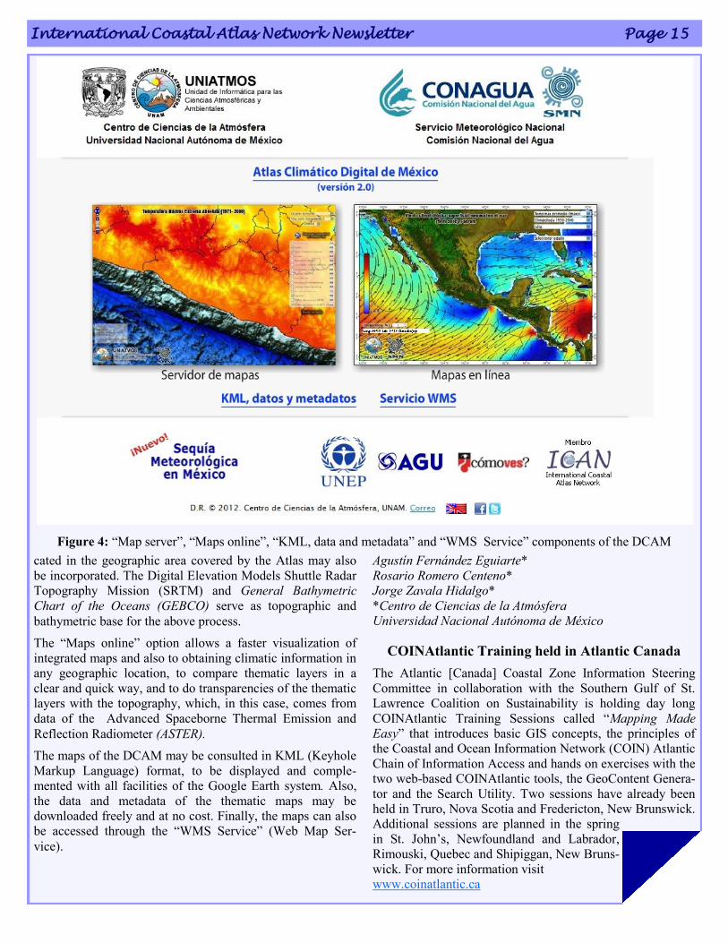
Figure 4: “Map server”, “Maps online”, “KML, data and metadata” and “WMS Service” components of the DCAM
Volume One Number 1 March 2012 Page 16
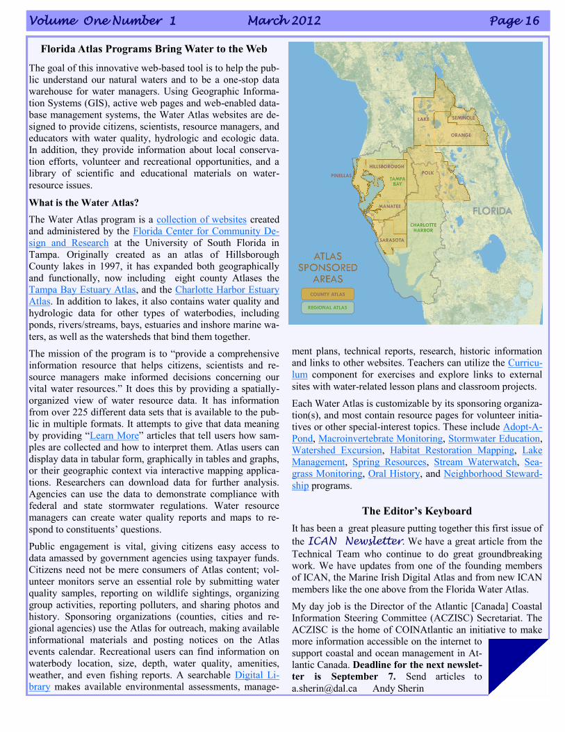
Florida Atlas Programs Bring Water to the Web
The goal of this innovative web-based tool is to help the pub-
lic understand our natural waters and to be a one-stop data
warehouse for water managers. Using Geographic Informa-
tion Systems (GIS), active web pages and web-enabled data-
base management systems, the Water Atlas websites are de-
signed to provide citizens, scientists, resource managers, and
educators with water quality, hydrologic and ecologic data.
In addition, they provide information about local conserva-
tion efforts, volunteer and recreational opportunities, and a
library of scientific and educational materials on water-
resource issues.
What is the Water Atlas?
The Water Atlas program is a collection of websites created
and administered by the Florida Center for Community De-
sign and Research at the University of South Florida in
Tampa. Originally created as an atlas of Hillsborough
County lakes in 1997, it has expanded both geographically
and functionally, now including eight county Atlases the
Tampa Bay Estuary Atlas, and the Charlotte Harbor Estuary
Atlas. In addition to lakes, it also contains water quality and
hydrologic data for other types of waterbodies, including
ponds, rivers/streams, bays, estuaries and inshore marine wa-
ters, as well as the watersheds that bind them together.
The mission of the program is to “provide a comprehensive
information resource that helps citizens, scientists and re-
source managers make informed decisions concerning our
vital water resources.” It does this by providing a spatially-
organized view of water resource data. It has information
from over 225 different data sets that is available to the pub-
lic in multiple formats. It attempts to give that data meaning
by providing “Learn More” articles that tell users how sam-
ples are collected and how to interpret them. Atlas users can
display data in tabular form, graphically in tables and graphs,
or their geographic context via interactive mapping applica-
tions. Researchers can download data for further analysis.
Agencies can use the data to demonstrate compliance with
federal and state stormwater regulations. Water resource
managers can create water quality reports and maps to re-
spond to constituents‟ questions.
Public engagement is vital, giving citizens easy access to
data amassed by government agencies using taxpayer funds.
Citizens need not be mere consumers of Atlas content; vol-
unteer monitors serve an essential role by submitting water
quality samples, reporting on wildlife sightings, organizing
group activities, reporting polluters, and sharing photos and
history. Sponsoring organizations (counties, cities and re-
gional agencies) use the Atlas for outreach, making available
informational materials and posting notices on the Atlas
events calendar. Recreational users can find information on
waterbody location, size, depth, water quality, amenities,
weather, and even fishing reports. A searchable Digital Li-
brary makes available environmental assessments, manage-
ment plans, technical reports, research, historic information
and links to other websites. Teachers can utilize the Curricu-
lum component for exercises and explore links to external
sites with water-related lesson plans and classroom projects.
Each Water Atlas is customizable by its sponsoring organiza-
tion(s), and most contain resource pages for volunteer initia-
tives or other special-interest topics. These include Adopt-A-
Pond, Macroinvertebrate Monitoring, Stormwater Education,
Watershed Excursion, Habitat Restoration Mapping, Lake
Management, Spring Resources, Stream Waterwatch, Sea-
grass Monitoring, Oral History, and Neighborhood Steward-
ship programs.
The Editor’s Keyboard
It has been a great pleasure putting together this first issue of
the ICAN Newsletter. We have a great article from the
Technical Team who continue to do great groundbreaking
work. We have updates from one of the founding members
of ICAN, the Marine Irish Digital Atlas and from new ICAN
members like the one above from the Florida Water Atlas.
My day job is the Director of the Atlantic [Canada] Coastal
Information Steering Committee (ACZISC) Secretariat. The
ACZISC is the home of COINAtlantic an initiative to make
more information accessible on the internet to
support coastal and ocean management in At-
lantic Canada. Deadline for the next newslet-
ter is September 7. Send articles to
[email protected] Andy Sherin
ABOUT THE NETWORK
ICAN is an informal group of organizations who have been meeting
since the first ICAN workshop held in Cork Ireland in 2006 to scope
and implement data interoperability approaches to coastal web atlases
(CWAs). The mission/strategic aim of ICAN is to share experiences
and to find common solutions to CWA development while ensuring
maximum relevance and added value for the end users. Operational
interoperability at the global-level is the long term vision. ICAN
strives to increase awareness among strategic users like policy makers
and resource managers of the opportunities that exist for increased
coastal and marine data sharing. ICAN seeks forge international col-
laborations of value, optimizing regional governance in coastal zone management. A major goal is to help
build a functioning digital atlas of the worldwide coast based on the principle of shared distributed infor-
mation based on interoperable locally-maintained CWAs as the premier source of spatial information
about coastal zones throughout the world. CWAs provide a basis for rationally-informed discussion, de-
bate and negotiation of sustainable management policies for our societies, nations and people throughout
the world. CWAs have tremendous potential to be relevant globally and contribute to global spatial data
infrastructures, marine spatial planning and related projects.
A Message from the ICAN Co-Chairs: A New Era for ICAN
This first newsletter is being published just as ICAN starts a new and exciting chapter in its development.
ICAN has applied to the International Oceanographic Commission (IOC) to become a project within the
International Oceanographic Data and Information Exchange (IODE) programme, and has been provi-
sionally accepted. IODE has been a great advocate for ICAN and an active member of the Network over
recent years. This new relationship will give ICAN a higher international profile than it has had and there
is potential for enhanced global reach. Moreover, being represented by an International entity allows
ICAN to join with other organisations and networks, compete for funding and become a full project part-
ner. There is also the potential for funding for certain activities from within IODE itself.
As an IODE project ICAN can share its knowledge and aid capacity building among IOC members in re-
lation to approaches for the exchange of coastal and marine data and information. Moreover it can assist
with promoting the implementation of International data standards with regard to coastal and marine data
management and exchange. ICAN can enhance networking among members to spread best practise, in the
first instance within the African Marine Atlas (AMA) and the Caribbean Marine atlas (CMA), but in the
future to other IODE related initiatives.
The most recent ICAN workshop was hosted at the IODE headquarters in Oostende, Belgium in Septem-
ber 2011. It was attended by over 40 participants and we were pleased to see a number of new faces as
well as those who have become familiar to us over the last six years. There were great presentations on
recent atlas developments, lively discussions on how coastal web atlases can support marine spatial plan-
ning, the launch of the new Belgian coastal atlas and a celebration of the publication of the Coastal Atlas
Handbook. A full workshop report will be available soon.
Over the coming weeks and months the current ICAN working groups will be reconstituted as a steering
group within the IODE ICAN project and will devise an updated work plan. ICAN has come a long way
since the first workshop on transatlantic atlases held in Cork in 2006. We look forward to further expan-
sion of the Network and consolidation of its relevance to coastal web atlas developers and users.
We would like to thank Andy Sherin, as one of our newest members, for offering to compile and edit this
ICAN newsletter. We believe it is a great way for you to inform the community of the latest developments
with your coastal atlas and likewise find out what is going on in other CWA communities around the
world.
Ned Dwyer, Dawn Wright
Coastal & Marine Research Centre Environmental Systems Research Institute &
University College Cork Oregon State University, USA
Ireland