Embed Size (px)
Citation preview

THE NATIONAL REPORT EL REPORTE NACIONAL
Western Atlantic Turtle Symposium Simposio de Tortugas del Atlantico Occidental
17-22 July / Julio 1983
San José, Costa Rica Puerto Rico National Report, WATS I Vol 3, pages 349- 363
FOR THE COUNTRY OF POR EL PAIS DE
PUERTO RICO
NATIONAL REPRESENTATIVE / REPRESENTANTE NACIONAL
GILBERT CINTRON MOLERO

Puerto Rico National Report, WATS I Vol 3, pages 349- 363
WESTERN ATLANTIC TURTLE SYMPOSIUM San José, Costa Rica, July 1983
NATIONAL REPORT FOR THE COUNTRY OF
PUERTO RICO
NATIONAL REPORT PRESENTED BY
Gilbert Cintron The National Representative
Address:
Depto. de Recursos Naturales Box 5887, Pta. de Tierra Station
San Juan, P.R. 00906
NATIONAL REPORT PREPARED BY
Juan G. Gonzalez, Ph.D. Department of Marine Sciences
University of Puerto Rico Mayagüez, Puerto Rico 00708
DATE SUBMITTED: 11 July 1983
Please submit this NATIONAL REPORT no later than 1 December 1982 to:
IOC Assistant Secretary for IOCARIBE ℅ UNDP, Apartado 4540
San José, Costa Rica

Puerto Rico National Report, WATS I Vol 3, pages 349- 363
With a grant from the U.S. National Marine Fisheries Service, WIDECAST has digitized the data-bases and proceedings of the Western Atlantic Turtle Symposium (WATS) with the hope that the revitalized documents might provide a useful historical context for contemporary sea turtle management and conservation efforts in the Western Atlantic Region. With the stated objective of serving “as a starting point for the identification of critical areas where it will be necessary to concentrate all efforts in the future”, the first Western Atlantic Turtle Sym-posium convened in Costa Rica (17-22 July 1983), and the second in Puerto Rico four years later (12-16 October 1987). WATS I featured National Reports from 43 political jurisdictions; 37 pre-sented at WATS II. WATS I opened with these words: “The talks which we started today have the multiple purpose of bringing our knowledge up to date about the biological peculiarities of the marine turtle popula-tions of the western Atlantic; to know and analyse the scope of the National Reports prepared by the scientific and technical personnel of more than thirty nations of the region; to consider options for the orderly management of marine turtle populations; and in general to provide an adequate forum for the exchange of experiences among scientists, administrators, and individuals inter-ested in making contributions for the preservation of this important natural resource.” A quarter-century has passed, and the results of these historic meetings have been lost to sci-ence and to a new generation of managers and conservationists. Their unique importance in providing baseline data remains unrecognized, and their potential as a “starting point” is neither known nor appreciated. The proceedings document what was known at the time concerning the status and distribution of nesting and foraging habitat, population size and trend, mortality factors, official statistics on exploitation and trade, estimated incidental catch, employment dependent on turtles, mariculture operations, public and private institutions concerned with conservation and use, legal aspects (e.g. regulations, enforcement, protected areas), and active research projects. In most cases it was the first time a national sea turtle assessment had been conducted. Despite the potential value of this information to agencies responsible for conducting stock assessments, monitoring recovery trends, and safeguarding critical habitat in the 21st century, the hand-written National Reports, largely illegible in the published proceedings, have slipped into obscurity. To help ensure the legacy of these symposia, we have digitized the entire proceedings, including the National Reports, plenary presentations and panels, and annotated bibliographies of both meetings, and posted them online at http://www.widecast.org/What/RegionalPrograms.html. Each article has been scanned from the original document. Errors in the scan have been cor-rected; however, to be true to the original content (as closely as we can discern it), potential errors of content have not been corrected. This article should be cited: Gonzales, J.G. 1984. National Report for Puerto Rico, pp.349-363. In: Bacon, P., F. Berry, K. Bjorndal, H. Hirth, L. Ogren and M. Weber (Editors), Proceedings of the First Western Atlantic Turtle Symposium, 17-22 July 1983, San José, Costa Rica. Volume III: The National Reports. RSMAS Printing, Miami.
Karen L. Eckert WIDECAST Executive Director
June 2009

Puerto Rico National Report, WATS I Vol 3, pages 349- 363
COUNTRY: PUERTO RICO
TABLE 1. GEOGRAPHIC INVENTORY Length of Coastline* (Total included adjacent islands)
914 Km
Length of Coastline Segments Main Island North coast 229 Km South coast 308 Km East coast 96 Km West coast 88 Km Subtotal 721 Km Adjacent Islands Vieques 110 Km Mona 53 Km Culebra 30 Km Subtotal 196 Km Insular shelf area (includes Puerto Rico and Virgin Islands)
7,203 Km2
Insular shelf area (Puerto Rico only)
5,282 Km2
Km2 of Continental Shelf Area Seward Extent of Jurisdictions: Territorial Sea 16.7 Km Extended Economic Zone 322 Km Fisheries Jurisdiction 322 Km Other (Describe) * Coastline length is the measurement of the national seaward boundary of a country; i.e., the distance from border to border for a coastal country and the distance around an island country.

Puerto Rico National Report, WATS I Vol 3, pages 349- 363
TABLE 2. COASTAL HABITAT INVENTORY OF MARINE SHORELINE Km of Shoreline
Marine Shoreline Characteristics* Undeveloped Developed** Total 1. Sand Beach (Total) 244.5 A. High Energy B. Low Energy 2. Reef (exposed) 3. Rocks 120.7 4. Cliffs 5. Vegetation (Total) *** 355.38 A. Vines 3.3 B. Grasses 28.5 C. Mangroves 147.5 D. Coconut Trees 36.1 E. Other Trees or Shrubs 128.14 F. Marshes 11.8 6. Mouths of Lagoons, Rivers, Canals 4.0 7. Total Shoreline **** 727.5 * Refer to SEA TURTLE MANUAL (Aerial Survey) ** Human development or use (See MANUAL) *** Editor’s note (2009): Vegetation total does not equal the sum of the constituent types. **** Editor’s note (2009): Shoreline total does not equal sum of the constituent components.
Figure 1. Reported turtle nesting beaches on the mail island of Puerto Rico.1
1 Editor’s note (2009): Maps and figures are reprinted exactly as they appear in the original WATS I Proceedings (Bacon et al. 1984); we regret the poor quality exhibited in some cases.

Puerto Rico National Report, WATS I Vol 3, pages 349- 363
TABLE 3.1. NESTING BEACH INVENTORY List beaches in geographic sequence. Provide additional information on following page. Name of Beach Length
in Km Species Nesting
(use abbreviations)* Months of Recorded
Nesting 1. Beach of Punta Arenas,
Vieques 0.50 D? May 2. Green Beach, Vieques 0.50 3 E? May 3. Yellow Beach, Vieques 1.00 Cm; D 2? May 4. Turtle Beaches, Vieques 0.33 D 2; ? 3 May 5. 2nd Beach S.E. of Punta
Salinas, Vieques 0.25 ? May
2nd Beach west of Punta Icacos, Vieques
0.25 D? May
7. Purple Beach, Vieques 1.25 D? May 8. Playa Brava, Culebra 1.50 C ?; D~20 May-June 9. Playa Resaca, Culebra 1.00 D~8 May-June
Species * Abbreviation Caretta caretta Cc Chelonia mydas Cm Dermochelys coriacea D Eretmochelys imbricata E Lepidochelys kempi Lk Lepidochelys olivacea Lo
TABLE 3.2. NESTING BEACH INVENTORY List beaches in geographic sequence. Provide additional information on following page. Name of Beach Length
in Km Species Nesting
(use abbreviations) * Months of Recorded
Nesting 1. Playa Mujeres (Carita) de Isla
Mona 1.40 D April
2. Playa Mujeres (Carita) de Isla Mona
D April
3. Playa Sardinera de Isla Mona 1.00 E April 4. Playa Sardinera de Isla Mona E April 5. Playa Punta Arena ** 1.00 E *** October **** 6. Tablonal de Aguada ** 1.00 E *** January **** 7. Playa Jobos de Isabela 2.50 D April 8. Playa Jobos de Isabela ** 2.50 E ? April 9. Piñones** 8.00 E September or October **** 10. Playa Larga N.E. of Punta Tuna 4 D April
Species * Abbreviation Caretta caretta Cc Chelonia mydas Cm Dermochelys coriacea D Eretmochelys imbricata E Lepidochelys kempi Lk Lepidochelys olivacea Lo

Puerto Rico National Report, WATS I Vol 3, pages 349- 363
TABLE 3.2. NESTING BEACH INVENTORY List beaches in geographic sequence. Provide additional information on following page. ** Information from outside sources *** Inferred from nesting season **** Inferred from date of hatching
TABLE 3.3. NESTING BEACH INVENTORY List beaches in geographic sequence. Provide additional information on following page. Name of Beach Length
in Km Species Nesting
(use abbreviations) * Months of Recorded
Nesting 1. Mona Island 8.00 E 10 ** 2. Culebra Island D 3. Vieques Island Cm; D; E 1 4. Playa Resaca, Culebra Island E 1 5. Playa Brava, Culebra Island E 1 6. Playa Larga, Culebra Island E 1 7. West Beach of Isla Culebrita,
Culebrita Island E 1
8. North Beach, Culebrita E 1 9. Playa Resaca, Culebrita E 11 10. Playa Brava, Culebra Island E 11
Species * Abbreviation Caretta caretta Cc Chelonia mydas Cm Dermochelys coriacea D Eretmochelys imbricata E Lepidochelys kempi Lk Lepidochelys olivacea Lo ** Editor’s note (2009): Information on “Months of Recorded Nesting” appeared in original National Report as listed in this table. It is unclear if the number (e.g. 10) refers to the number of the calendar month (October) or the total number of months of recorded data (10 months).

Puerto Rico National Report, WATS I Vol 3, pages 349- 363
TABLE 3.4. NESTING BEACH INVENTORY List beaches in geographic sequence. Provide additional information on following page. Name of Beach Length
in Km Species Nesting
(use abbreviations) * Months of Recorded
Nesting 1. West Beaches of Culebrita Isl. E 11** 2. North Beach, Culebrita Island E 11 3. South Beach, Culebrita Island E 11 4. Northwest Beach, Culebrita Isl. E 11 5. South Beach, Cayo Norte,
Culebra Island E 11
Species * Abbreviation
Caretta caretta Cc Chelonia mydas Cm Dermochelys coriacea D Eretmochelys imbricata E Lepidochelys kempi Lk Lepidochelys olivacea Lo ** Editor’s note (2009): Information on “Months of Recorded Nesting” appeared in original document as listed in this table. It is unclear if the number (e.g. 11) refers to the number of the calendar month (October) or the total number of months of recorded data (11 months).
Figure 2. KEY ● Beaches where turtle tracks or hatchlings have been encountered since October 1982. Research effort was not equal for all areas. • Only false crawls found.

Puerto Rico National Report, WATS I Vol 3, pages 349- 363
TABLE 3A. SANDY BEACH INVENTORY BY QUADRANGLE *
Quadrangle Meters** Quadrangle Meters** Aguadillo 12,180 Pta. Tuna 2,100 Isabella 19,820 Guayama 2,760 Quebradillas 8,240 Central Aguirre 720 Camuy --?-- Salinas 440 Arecibo --?-- Santa Isabel 180 Barceloneta --?-- Playa de Ponce -- Manati 5,980 Pta Cuchara 700 Veca Baia 18,200 Yauco -- Bayamon 3,00 Pta. Berraco 2,560 San Juan 10,220 Guanica 2,460 Carolina 12,880 La Paguera -- Rio Grande --?-- Cabo Rojo 4,200 Fajardo --?-- Puerto Real 6,400 Icacos -- Mayaguez 2,540 Pta. Puerca 10,060 Rincon 12,440 Naguabo 6,400 Humacao 4,520 Guayanes 9,240
TOTAL 208,500 meters
* Editor’s note (2009): This table was not numbered in the original National Report; the Editor assigned a number (TABLE 3A) to facilitate referencing. ** Editor’s note (2009): The values entered in these columns were difficult to read in all cases from the original National Report; “ --?-- ” indicates an indecipherable value.

Puerto Rico National Report, WATS I Vol 3, pages 349- 363
TABLE 3A-1. NESTING BEACH INVENTORY (supplementary page) Please give additional information about each nesting beach identified in Table 3. Include information
on color of sand, particle size, beach profile, backbeach vegetation, artificial lighting, etc. 1. Beach E. of Punta Arenas, Vieques
The beach is about 10 m wide and fairly flat. The sand is fine and gray. The beach is bordered by mangroves, vines and palms. There were many cattle tracks on the beach. An old 3 m wide pit was found close to the high tide line.
2. Green Beach, Vieques
The beach is 8-13 m wide and fairly flat. The sand is light and of medium grain. The backbeach area has scattered 1/3 meter high rocks and then a 3 m hill that only has vegetation on top. This consists of grasses, and sea grapes. The water has some underexposed beach rock. The three tracks found were only 35.5 cm wide and did not have nest pits.
3. Yellow Beach, Vieques The beach is 20-30 m wide and has two 1/2 m berms with flat beach between them. Sand is fine
and gray. Vegetation consists of grasses, vines, sea grapes acacia, giant milkweed, and some mangrove. One track was fresh from that night, but had been erased by concerned locals. It could still be measured and was about 104 cm. The locals seemed to know about tracks, and volunteered that they were parallel and made by a green turtle. No evidence of a pit remained, and there probable wasn’t one to start out with. The other three pits were older, and at least one was a Dermochelys, and one was poached.
4. Turtle Beach, Vieques This beach was checked by boat. There were 5 old pits and at least two were big enough to be
Dermochelys. 5. 2nd beach S.E. of Punta Salinas, Vieques One old pit seen on this beach by boat. 6. 2nd beach West of Punta Icacos, Vieques Saw one fresh track and nest by boat, from that night. 7. Purple Beach, Vieques The beach is about 15 m wide with a 30º slope up to the low berm then a relatively flat backbeach
area. The sand is light and of medium grain. The vegetation consists of giant milkweed, vines, grasses, sea grapes, acacia, and some coco palms. A fair amount of Syringodium was washed up on the beach. Two pits were found, both poached and one was large enough to be Dermochelys. Saw some men on horseback with a dog.
8. Playa Brava, Culebra
The beach is about 25 m wide with a 30º slope up to the small berm, and then slopes gently to a second berm 1-1 1/2 m high at the vegetation line. The sand is light, of medium grain and very soft. The vegetation consists of vines, grasses, sea grapes, giant milkweed, acacia, and half of the beach has palms 100 m behind.
This beach was covered with old tracks and pits and it was impossible to tell how many had been
made since the aerial survey of 16 May 1983. Only pits with tracks still visible were counted to get the figure 20, since these were probably made within the last 18 days. The smallest set of tracks was 142 cm and was listed as a possible Chelonia mydas. The pit was farther into the vegetation than most and the track was one of the few that crossed itself for any distance. Broken eggshells of yolkless eggs were found at 4 pits, signifying that these had been poached (unless the turtle had dropped these after covering). However, there were other signs of poaching activity and at least several others showed these signs to varying degrees.

Puerto Rico National Report, WATS I Vol 3, pages 349- 363
9. Playa Resaca, Culebra The beach is about 25 m wide and has 2 berms. The first berm is steep in some places, and the
second gently slopes up 1 m with fairly flat beach between them. The sand is light, of medium grain, and soft. Eight tracks were still visible on the beach, but the wind was rapidly erasing them. Eggshells were found at three pits, but many more looked undisturbed.
TABLE 3A-2. NESTING BEACH INVENTORY (supplementary page)
Please give additional information about each nesting beach identified in Table 3. Include information on color of sand, particle size, beach profile, backbeach vegetation, artificial lighting, etc. 1. Playa Mujeres (Carite) de Mona
The beach is about 40 m wide with a 30º slope from the water up to a 0.3 m* (1 foot) berm, and then has a fairly flat backshore area, bordered by Australian pines. The soft carbonate sand is white and coarse. There are no buildings here, but a diurnally used landing strip is nearby.
2. Playa Sardinera
The beach is about 7 m wide with a 40-50º slope, and with soft carbonate sand. The backbeach vegetation consists mainly of bay cedar averaging 1 m high, and 150 m behind this are Australian pines. There are no buildings where the turtles cam up, but there are many only 1/2 km away. Immediately offshore are exposed reefs.
3. Playa Punta Arena The beach is about 7-8 m wide with a slight slope. The sand is light and of medium grain. There
is a 5 storey condominium and many houses and lights on the beach. The vegetation consists mainly of coco palms.
4. Tablonal de Aguada
This beach is about 8 m wide and fairly flat. The sand is light, of medium grain, and there is beach rock offshore. There are many 3 m high rocks in the backbeach area, with mainly coco palms and West Indian almond trees behind them. There are scattered houses in the area.
5. Playa Jobos de Isabela The beach is about 10 m wide with a 20º slope up to the duneline. The sand is light and of
medium grain. The dunes are fairly high in some places and the vegetation is mainly sea grapes. The Dermochelys laid very close to a street light, in an area where there are many houses on the dunes.
6. Piñones The beach is 10 m wide and the slope varies from 0-30º, with a 1 m berm in some places. The
sand is white and semi-coarse. The vegetation is mainly coco palm and Australian pines. The road is close to the beach and there are scattered houses.
7. Playa Larga N.E. of Punta Tuna
The beach is about 20 m wide with a 30º slope coming out of the water and then a gradual slope to the vegetation. The sand is light and of medium grain. The vegetation is mainly coco palms and sea grapes.
Puerto Rico National Report, WATS I Vol 3, pages 349- 363
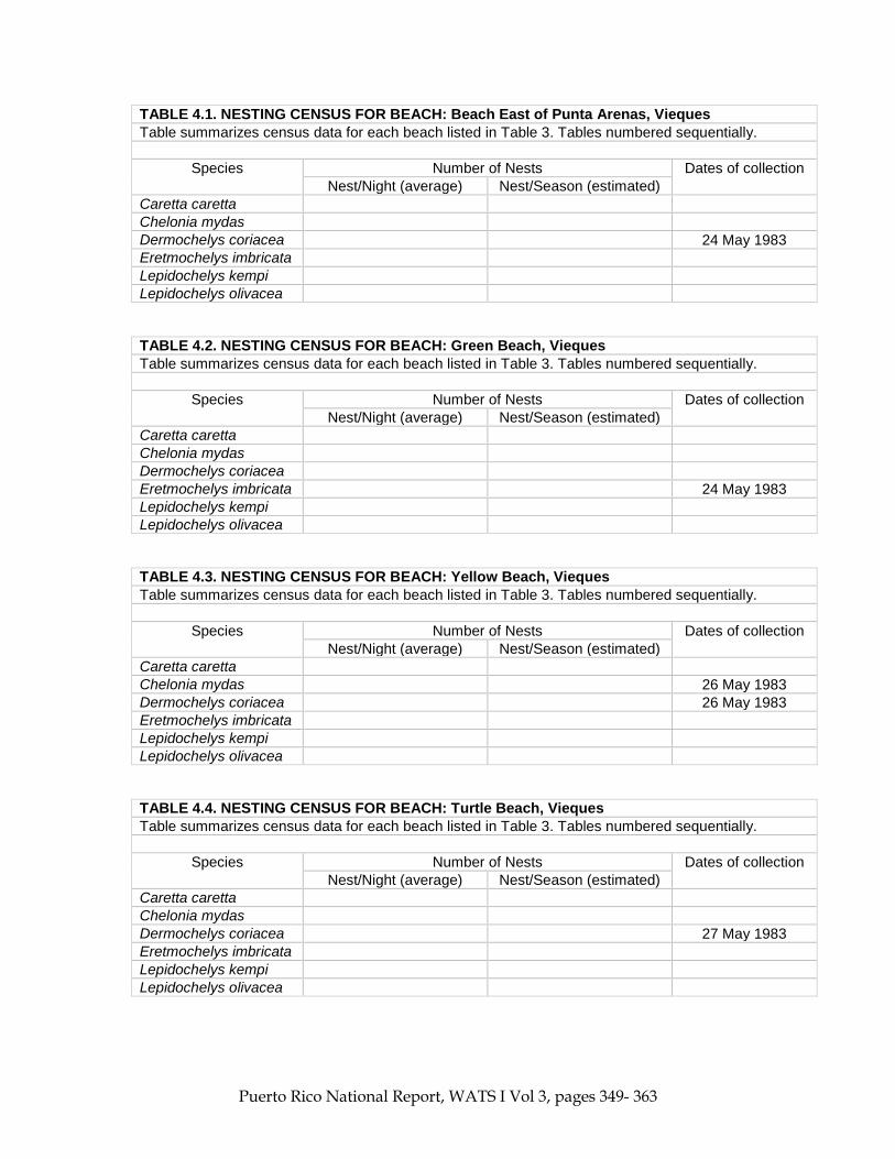
TABLE 4.1. NESTING CENSUS FOR BEACH: Beach East of Punta Arenas, Vieques Table summarizes census data for each beach listed in Table 3. Tables numbered sequentially.
Species Number of Nests Dates of collection Nest/Night (average) Nest/Season (estimated)
Caretta caretta Chelonia mydas Dermochelys coriacea 24 May 1983 Eretmochelys imbricata Lepidochelys kempi Lepidochelys olivacea
TABLE 4.2. NESTING CENSUS FOR BEACH: Green Beach, Vieques Table summarizes census data for each beach listed in Table 3. Tables numbered sequentially.
Species Number of Nests Dates of collection Nest/Night (average) Nest/Season (estimated)
Caretta caretta Chelonia mydas Dermochelys coriacea Eretmochelys imbricata 24 May 1983 Lepidochelys kempi Lepidochelys olivacea
TABLE 4.3. NESTING CENSUS FOR BEACH: Yellow Beach, Vieques Table summarizes census data for each beach listed in Table 3. Tables numbered sequentially.
Species Number of Nests Dates of collection Nest/Night (average) Nest/Season (estimated)
Caretta caretta Chelonia mydas 26 May 1983 Dermochelys coriacea 26 May 1983 Eretmochelys imbricata Lepidochelys kempi Lepidochelys olivacea
TABLE 4.4. NESTING CENSUS FOR BEACH: Turtle Beach, Vieques Table summarizes census data for each beach listed in Table 3. Tables numbered sequentially.
Species Number of Nests Dates of collection Nest/Night (average) Nest/Season (estimated)
Caretta caretta Chelonia mydas Dermochelys coriacea 27 May 1983 Eretmochelys imbricata Lepidochelys kempi Lepidochelys olivacea

Puerto Rico National Report, WATS I Vol 3, pages 349- 363
TABLE 4.5. NESTING CENSUS FOR BEACH: 2nd Beach S.E. of Punta Salinas, Vieques Table summarizes census data for each beach listed in Table 3. Tables numbered sequentially.
Species Number of Nests Dates of collection Nest/Night (average) Nest/Season (estimated)
Caretta caretta Chelonia mydas Dermochelys coriacea 27 May 1983 Eretmochelys imbricata Lepidochelys kempi Lepidochelys olivacea
TABLE 4.6. NESTING CENSUS FOR BEACH: 2nd Beach to west of Punta Icacos, Vieques Table summarizes census data for each beach listed in Table 3. Tables numbered sequentially.
Species Number of Nests Dates of collection Nest/Night (average) Nest/Season (estimated)
Caretta caretta Chelonia mydas Dermochelys coriacea 27 May 1983 Eretmochelys imbricata Lepidochelys kempi Lepidochelys olivacea
TABLE 4.7. NESTING CENSUS FOR BEACH: Purple Beach, Vieques Table summarizes census data for each beach listed in Table 3. Tables numbered sequentially.
Species Number of Nests Dates of collection Nest/Night (average) Nest/Season (estimated)
Caretta caretta Chelonia mydas Dermochelys coriacea 26 May 1983 Eretmochelys imbricata Lepidochelys kempi Lepidochelys olivacea
TABLE 4.8. NESTING CENSUS FOR BEACH: Playa Brava, Culebra Table summarizes census data for each beach listed in Table 3. Tables numbered sequentially.
Species Number of Nests Dates of collection Nest/Night (average) Nest/Season (estimated)
Caretta caretta Chelonia mydas 03 June 1983 Dermochelys coriacea 1-2 ? 03 June 1983 Eretmochelys imbricata Lepidochelys kempi Lepidochelys olivacea

Puerto Rico National Report, WATS I Vol 3, pages 349- 363
TABLE 4.9. NESTING CENSUS FOR BEACH: Playa Resaca, Culebra Table summarizes census data for each beach listed in Table 3. Tables numbered sequentially.
Species Number of Nests Dates of collection Nest/Night (average) Nest/Season (estimated)
Caretta caretta Chelonia mydas Dermochelys coriacea 1 ? 04 June 1983 Eretmochelys imbricata Lepidochelys kempi Lepidochelys olivacea
TABLE 4.10 *. NESTING CENSUS FOR BEACH: Playa Mujeres de Isla Mona Table summarizes census data for each beach listed in Table 3. Tables numbered sequentially.
Species Number of Nests Dates of collection Nest/Night (average) Nest/Season (estimated)
Caretta caretta Chelonia mydas Dermochelys coriacea 12, 17 April 1983 Eretmochelys imbricata Lepidochelys kempi Lepidochelys olivacea * Editor’s note (2009): This Table (4.10) was labeled TABLE 4-1, 2 in the original National Report. The Editor changed table number to maintain consistency within this report.
TABLE 4.11 *. NESTING CENSUS FOR BEACH: Playa Sardinera de Isla Mona Table summarizes census data for each beach listed in Table 3. Tables numbered sequentially.
Species Number of Nests Dates of collection Nest/Night (average) Nest/Season (estimated)
Caretta caretta Chelonia mydas Dermochelys coriacea 15 April 1983 Eretmochelys imbricata Lepidochelys kempi Lepidochelys olivacea * Editor’s note (2009): This Table (4.11) was labeled TABLE 4-3, 4 in the original National Report. The Editor changed table number to maintain consistency within this report.
TABLE 4.12 *. NESTING CENSUS FOR BEACH: Playa Punta Arena Table summarizes census data for each beach listed in Table 3. Tables numbered sequentially.
Species Number of Nests Dates of collection Nest/Night (average) Nest/Season (estimated)
Caretta caretta Chelonia mydas Dermochelys coriacea

Puerto Rico National Report, WATS I Vol 3, pages 349- 363
Eretmochelys imbricata
06 January 1983 (hatched)
Lepidochelys kempi Lepidochelys olivacea * Editor’s note (2009): This Table (4.12) was labeled TABLE 4-9 in the original National Report. The Editor changed table number to maintain consistency within this report.
TABLE 4.13 *. NESTING CENSUS FOR BEACH: Tablonal de Aguada Table summarizes census data for each beach listed in Table 3. Tables numbered sequentially.
Species Number of Nests Dates of collection Nest/Night (average) Nest/Season (estimated)
Caretta caretta Chelonia mydas Dermochelys coriacea Eretmochelys imbricata
09 March 1983 (hatched)
Lepidochelys kempi Lepidochelys olivacea * Editor’s note (2009): This Table (4.13) was labeled TABLE 4-6 in the original National Report. The Editor changed table number to maintain consistency within this report.
TABLE 4.14 *. NESTING CENSUS FOR BEACH: Playa Jobos de Isabela Table summarizes census data for each beach listed in Table 3. Tables numbered sequentially.
Species Number of Nests Dates of collection Nest/Night (average) Nest/Season (estimated)
Caretta caretta Chelonia mydas Dermochelys coriacea 10 April 1983 Eretmochelys imbricata 15 April 1983 Lepidochelys kempi Lepidochelys olivacea * Editor’s note (2009): This Table (4.14) was labeled TABLE 4-7, 8 in the original National Report. Editor changed table number to maintain consistency within this report.
TABLE 4.15*. NESTING CENSUS FOR BEACH: Piñones Table summarizes census data for each beach listed in Table 3. Tables numbered sequentially.
Species Number of Nests Dates of collection Nest/Night (average) Nest/Season (estimated)
Caretta caretta Chelonia mydas Dermochelys coriacea Eretmochelys imbricata
26 November 1983
(hatched) Lepidochelys kempi

Puerto Rico National Report, WATS I Vol 3, pages 349- 363
Lepidochelys olivacea * Editor’s note (2009): This Table (4.15) was labeled TABLE 4-9 in the original National Report. The Editor changed table number to maintain consistency within this report.
TABLE 4.16 *. NESTING CENSUS FOR BEACH: Playa Larga, N.E. of Punta Tuna Table summarizes census data for each beach listed in Table 3. Tables numbered sequentially.
Species Number of Nests Dates of collection Nest/Night (average) Nest/Season (estimated)
Caretta caretta Chelonia mydas Dermochelys coriacea 01 May 1983 Eretmochelys imbricata Lepidochelys kempi Lepidochelys olivacea * Editor’s note (2009): This Table (4.16) was labeled TABLE 4-10 in the original National Report. The Editor changed table number to maintain consistency within this report.
TABLE 4.17 *. NESTING CENSUS FOR BEACH: Playa Sardinera (P.S.), UveroCarabinero (UC), Playa Brava (P.B.), Playa Pájaros (P.P.) Table summarizes census data for each beach listed in Table 3. Tables numbered sequentially.
Species Number of Nests Dates of collection Nest/Night (average) Nest/Season (estimated)
Caretta caretta Chelonia mydas 3 1974 (nesting
season) Dermochelys coriacea Eretmochelys imbricata 13 P.S.; 8 P.B.; 1 U.C. May-October 1982 Lepidochelys kempi Lepidochelys olivacea * Editor’s note (2009): This Table (4.17) was labeled TABLE 4-1 in the original National Report. The Editor changed table number to maintain consistency within this report.
TABLE 4.18 *. NESTING CENSUS FOR BEACH: Culebra Island Table summarizes census data for each beach listed in Table 3. Tables numbered sequentially.
Species Number of Nests Dates of collection Nest/Night (average) Nest/Season (estimated)
Caretta caretta Chelonia mydas Dermochelys coriacea 4 1974 Eretmochelys imbricata Lepidochelys kempi Lepidochelys olivacea * Editor’s note (2009): This Table (4.18) was labeled TABLE 4-2 in the original National Report. The Editor changed table number to maintain consistency within this report.

Puerto Rico National Report, WATS I Vol 3, pages 349- 363
TABLE 4.19 *. NESTING CENSUS FOR BEACH: Playa Sardinera (P.S.), UveroCarabinero (UC), Playa Brava (P.B.), Playa Pájaros (P.P.) Table summarizes census data for each beach listed in Table 3. Tables numbered sequentially.
Species Number of Nests Dates of collection Nest/Night (average)
Nest/Season (estimated)
Caretta caretta Chelonia mydas 3 May 1974 - February 1975 Dermochelys coriacea 3 P.S.
105 U.C. 6 P.P. 12 P.B.
November 1973 November 1973 November 1973 November 1973
Eretmochelys imbricata 20 P.S. 33 U.C. 31 P.B.
60 others
June 1974-January 1975 June 1974-January 1975 June 1974-January 1975 June 1974-January 1975
Lepidochelys kempi Lepidochelys olivacea * Editor’s note (2009): This Table (4.19) was labeled TABLE 4-1B in the original National Report. Editor changed table number to maintain consistency within this report.
TABLE 4.20 *. NESTING CENSUS FOR BEACH: Vieques Island Table summarizes census data for each beach listed in Table 3. Tables numbered sequentially.
Species Number of Nests Dates of collection Nest/Night (average)
Nest/Season (estimated)
Caretta caretta Chelonia mydas 4 May-September 1981 Dermochelys coriacea
9 26
May 6-June 6, 1978 April-October 1981
Eretmochelys imbricata
2 23
May 6-June 6, 1978 December 1980-October 1981
Lepidochelys kempi Lepidochelys olivacea
* Editor’s note (2009): This Table (4.20) was labeled TABLE 4-3B in the original National Report. Editor changed table number to maintain consistency within this report.
TABLE 4.21*. NESTING CENSUS FOR BEACH: Playa Resaca, Culebra Island Table summarizes census data for each beach listed in Table 3. Tables numbered sequentially.
Species Number of Nests Dates of collection Nest/Night (average)
Nest/Season (estimated)
Caretta caretta Chelonia mydas 1 May-June 1977 Dermochelys coriacea 2 May-June 1977 Eretmochelys imbricata
4 3
June 1975 July 1976-June 1977

Puerto Rico National Report, WATS I Vol 3, pages 349- 363
Lepidochelys kempi Lepidochelys olivacea * Editor’s note (2009): This Table (4.21) was labeled TABLE 4-4B in the original National Report. The Editor changed table number to maintain consistency within this report.
TABLE 4.22*. NESTING CENSUS FOR BEACH: Playa Brava, Culebra Island Table summarizes census data for each beach listed in Table 3. Tables numbered sequentially.
Species Number of Nests Dates of collection Nest/Night (average)
Nest/Season (estimated)
Caretta caretta 3 May-June 1977 Chelonia mydas 3 May 6-June 10, 1977 Dermochelys coriacea
4 1
June 1975 July 1976-June 1977
Eretmochelys imbricata Lepidochelys kempi Lepidochelys olivacea * Editor’s note (2009): This Table (4.22) was labeled TABLE 4-5B in the original National Report. Editor changed table number to maintain consistency within this report. TABLE 4.23*. NESTING CENSUS FOR BEACH: Playa Larga, Culebra Island Table summarizes census data for each beach listed in Table 3. Tables numbered sequentially.
Species Number of Nests Dates of collection Nest/Night (average)
Nest/Season (estimated)
Caretta caretta Chelonia mydas Dermochelys coriacea Eretmochelys imbricata
3 0
June 1975 July 1976, June 1977
Lepidochelys kempi Lepidochelys olivacea * Editor’s note (2009): This Table (4.23) was labeled TABLE 4-6B in the original National Report. Editor changed table number to maintain consistency within this report.

Puerto Rico National Report, WATS I Vol 3, pages 349- 363
TABLE 4.24*. NESTING CENSUS FOR BEACH: West Beach of Isla Culebrita Table summarizes census data for each beach listed in Table 3. Tables numbered sequentially.
Species Number of Nests Dates of collection Nest/Night (average)
Nest/Season (estimated)
Caretta caretta Chelonia mydas Dermochelys coriacea Eretmochelys imbricata
3 15
June 1975 July 1976-June 1977
Lepidochelys kempi Lepidochelys olivacea * Editor’s note (2009): This Table (4.24) was labeled TABLE 4-7B in the original National Report. The Editor changed table number to maintain consistency within this report.
TABLE 4.25. NESTING CENSUS FOR BEACH: North Beach (NB), South Beach (SB), Northwest Beach (NWB), South Beach, Cayo Norte (S.B., C.N.) Table summarizes census data for each beach listed in Table 3. Tables numbered sequentially.
Species Number of Nests Dates of collection Nest/Night (average)
Nest/Season (estimated)
Caretta caretta Chelonia mydas Dermochelys coriacea Eretmochelys imbricata
3,1 from NB 0,2 from SB
0,6 from NWB 0,7 from SB, C.W.
June 1975 July 1976-June 1977 July 1976-June 1977 July 1976-June 1977
Lepidochelys kempi Lepidochelys olivacea * Editor’s note (2009): This Table (4.25) was labeled TABLE 4-8B + 2A in the original National Report. The Editor changed table number to maintain consistency within this report. TABLE 5*. AERIAL BEACH SURVEY SUMMARY Give any additional information available from aerial surveys. Information should include ground truth observation if conducted
Date Beaches Surveyed Numbers of Nesting Tracks Cc Cm D E Lk Lo No.
ID 11 April 1983 Most of the northern beaches
between Playa Jobos and Las Colinas (didn't cover well between Playa Uvero & Luquillo)
22 April 1983 Most of the beaches from Rincón north to San Juan
22 April 1983 Playa Isabela 1 22 April 1983 Playa Tortuguero 1
Puerto Rico National Report, WATS I Vol 3, pages 349- 363
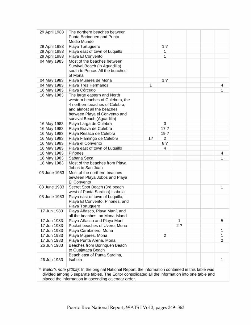
29 April 1983 The northern beaches between Punta Borinquen and Punta Medio Mundo
29 April 1983 Playa Tortuguero 1 ? 29 April 1983 Playa east of town of Luquillo 1 29 April 1983 Playa El Convento 1 04 May 1983 Most of the beaches between
Survival Beach (in Aguadilla) south to Ponce. All the beaches of Mona
04 May 1983 Playa Mujeres de Mona 1 ? 04 May 1983 Playa Tres Hermanos 1 4 16 May 1983 Playa Córcego 1 16 May 1983 The large eastern and North
western beaches of Culebrita, the 4 northern beaches of Culebra, and almost all the beaches between Playa el Convento and survival Beach (Aguadilla)
16 May 1983 Playa Larga de Culebra 3 16 May 1983 Playa Brava de Culebra 17 ? 16 May 1983 Playa Resaca de Culebra 19 ? 16 May 1983 Playa Flamingo de Culebra 1? 2 16 May 1983 Playa el Convento 8 ? 16 May 1983 Playa east of town of Luquillo 4 16 May 1983 Piñones 4 18 May 1983 Sabana Seca 1 18 May 1983 Most of the beaches from Playa
Jobos to San Juan 03 June 1983 Most of the northern beaches
bewteen Playa Jobos and Playa El Convento
03 June 1983 Secret Spot Beach (3rd beach west of Punta Sardina) Isabela
1
08 June 1983 Playa east of town of Luquillo, Playa El Convento, Piñones, and Playa Tortuguero
17 Jun 1983 Playa Añasco, Playa Maní, and all the beaches on Mona Island
17 Jun 1983 Playa Añasco and Playa Maní 1 5 17 Jun 1983 Pocket beaches of Uvero, Mona 2 ? 17 Jun 1983 Playa Carabinero, Mona 1 17 Jun 1983 Playa Mujeres, Mona 2 1 17 Jun 1983 Playa Punta Arena, Mona 2 26 Jun 1983 Beaches from Borinquen Beach
to Guajataca Beach
26 Jun 1983 Beach east of Punta Sardina, Isabela 1
* Editor’s note (2009): In the original National Report, the information contained in this table was divided among 5 separate tables. The Editor consolidated all the information into one table and placed the information in ascending calendar order.

Puerto Rico National Report, WATS I Vol 3, pages 349- 363
TABLE 5A. AERIAL BEACH SURVEY SUMMARY * (supplementary page) Give any additional information available from aerial surveys. Information should include ground truth
observation if conducted. The aerial surveys were conducted with one observer/recorder in an 8-seater Sikorsky helicopter that belonged to the U.S. Coast guard. The observations were usually made from the seat next to the large opening on the side of the helicopter, and as close to the beach as possible. Flying altitude was between 61-91.4 m ** (200-300 feet) and speed varied from 95-110 knots. Flights were made at all hours of the day. 4/11/83 The only observation was of a pit of the turtle that laid at Playa Jobos on 4/10/83. 4/22/83 A ground truth was made at playa Isabela. The beach is about 2 km long and 20 m wide, starts
out float, and then slopes 30º up to sand dunes. The sand is light and of medium grain. The dunes are covered with grasses and about about 100 m behind are some coco palms. It was raining lightly, but the track seemed fairly fresh, probably from last night. There were footprints in the area and a broken eggshell was found, implying the nest had been poached. Afterwards two men were seen trying to dig the nest again.
4/22/83 The beach at Playa Tortuguero is about 2 km long and 13-26 m wide. The western end is very
sloped and has a large amount of beach rock. The eastern end is fairly flat with very soft white sand. The vegetation consists of coco palms and sea grapes. The road is close to the beach and there are few buildings on the eastern end. The track was fairly large and the turtle probably didn’t lay, since a pit was not visible.
4/29/83 The playas east of the town of Luquillo, and Playa El Convento are really one large stretch of
beach about 7 km long and over 30 m wide. The beach is fairly flat and the sand is orange colored. There are sand dunes, and the vegetation is mainly sea grapes and coco palms. Although the beach has no buildings or roads behind it, it is frequented by many off-road vehicles.
5/4/83 A ground truth was made at Playa Tres Hermanos. The beach is about 2 km long but is
continuous with Playa Añasco which is several kilometers longer. It is about 12 m wide and has a slight slope. The sand is light and of medium grain, and has much debris, such as bamboo washed up on it from heavy rains a few weeks earlier. The vegetation consists of grasses, vines, coco palms and West Indian almond trees. There is a housing area to the north, and the public beach of Añasco to the south. Five old pits were found on the beach and only one still had identifiable tracks. This nest also had footprints and fresh sand dug up in the center. Many people frequent this beach.
5/4/83 The beach at Playa Córcega is about 2 km long and varies from 7-20 m wide. The sand is gray and of medium grain, and in some areas there is a 1 m berm. The vegetation consists of vines, coco palms and West Indian almond trees. There are no houses here, but there is a public beach, and there are many buildings to the north and south.
_________________ Editor’s notes (2009): * The original National Report started this supplemental table with entry of 6/3/83 on page 3-359 and
began the entry of 4/11/83 on page 3-361. Editor rearranged the placement of the entries to reflect a continued sequence of observations, starting with the earliest date (4/11/83) and ending with the latest entry (6/26/83).
** Editor added the metric linear distance to the British units of “feet” in the original National Report.
Puerto Rico National Report, WATS I Vol 3, pages 349- 363
TABLE 5A. AERIAL BEACH SURVEY SUMMARY * (supplementary page, Continued)
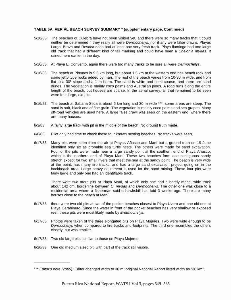
5/16/83 The beaches of Culebra have not been visited yet, and there were so many tracks that it could neither be determined if they really all were Dermochelys, nor if any were false crawls. Playas Larga, Brava and Resaca each had at least one very fresh track. Playa flamingo had one large old track that had a different kind of tail marking and could have been a Chelonia mydas. It rained here earlier in the day.
5/16/83 At Playa El Convento, again there were too many tracks to be sure all were Dermochelys. 5/16/83 The beach at Pinones is 9.5 km long, but about 1.5 km at the western end has beach rock and
some jetty-type rocks added by man. The rest of the beach varies from 10-30 m wide, and from flat to a 30º slope and a 1 m berm. The sand is white and semi-coarse, and there are sand dunes. The vegetation is mainly coco palms and Australian pines. A road runs along the entire length of the beach, but houses are sparse. In the aerial survey, all that remained to be seen were four large, old pits.
5/16/83 The beach at Sabana Seca is about 6 km long and 30 m wide ***, some areas are steep. The
sand is soft, black and of fine grain. The vegetation is mainly coco palms and sea grapes. Many off-road vehicles are used here. A large false crawl was seen on the eastern end, where there are many houses.
6/3/83 A fairly large track with pit in the middle of the beach. No ground truth made. 6/8/83 Pilot only had time to check these four known nesting beaches. No tracks were seen. 6/17/83 Many pits were seen from the air at Playas Añasco and Maní but a ground truth on 19 June
identified only six as probable sea turtle nests. The others were made for sand excavation. Four of the pits were made near a large sandy point at the southern end of Playa Añasco, which is the northern end of Playa Maní. These two beaches form one contiguous sandy stretch except for two small rivers that meet the sea at the sandy point. The beach is very wide at the point, has many tire tracks, and has a large sand excavation project going on in the backbeach area. Large heavy equipment is used for the sand mining. These four pits were fairly large and only one had an identifiable track.
There were two more pits at Playa Maní, of which only one had a barely measurable track
about 142 cm, borderline between C. mydas and Dermochelys. The other one was close to a residential area where a fisherman said a hawksbill had laid 3 weeks ago. There are many houses close to the beach at Maní.
6/17/83 there were two old pits at two of the pocket beaches closest to Playa Uvero and one old one at
Playa Carabinero. Since the water in front of the pocket beaches has very shallow or exposed reef, these pits were most likely made by Eretmochelys.
6/17/83 Photos were taken of the three elongated pits on Playa Mujeres. Two were wide enough to be
Dermochelys when compared to tire tracks and footprints. The third one resembled the others closely, but was smaller.
6/17/83 Two old large pits, similar to those on Playa Mujeres. 6/26/83 One old medium sized pit, with part of the track still visible. _________________ *** Editor’s note (2009): Editor changed width to 30 m; original National Report listed width as “30 km”.

Puerto Rico National Report, WATS I Vol 3, pages 349- 363
TABLE 6. ESTIMATED POPULATION SIZE OF NESTING FEMALES Summarize the estimated number of nesting females for the years indicated and describe methods of estimation on the next page.
Species Year
1982 1981 1980 1979 1978 1977 Average Year
Estimates * Caretta caretta Chelonia mydas 4 4 Dermochelys coriacea 26 9 5 Eretmochelys imbricata 22 * 23 2 33 Lepidochelys kempi Lepidochelys olivacea * Only 3 days of survey from 27-29 October 1982
TABLE 6A. ESTIMATED POPULATION OF NESTING FEMALES (supplementary page)
Please give brief details on methods of estimation for Table 6. . Estimation of population of nesting females was done by adding results of Table 4 since these represent really individual tracks and not nests (which can be more than one per track). An over-estimation could result from the fact that two or more tracks could have been from the same turtle. TABLE 7. FORAGING AREAS INVENTORY
Name of Area (or give coordinates)
Approx. Area (Km2)
Species Foraging (use abbreviations &
approx. numbers)
Nature of Evidence (observation, fishery, incidental
catch) Bahía Playa Blanca, Vieques Island
Cm Observation of immature turtles
Culebra Island reefs Cc-1; Cm-131; D-1; E-58 Observation of mature and immature turtles
Monito Island E-10 Observation of 10 turtles in one day (29 October 1982)
Species Abbreviation
Caretta caretta Cc Chelonia mydas Cm Dermochelys coriacea D Eretmochelys imbricata E Lepidochelys kempi Lk Lepidochelys olivacea Lo

Puerto Rico National Report, WATS I Vol 3, pages 349- 363
TABLE 9. NON-FORAGING TURTLES AT SEA. Please provide any information available on the incidence of turtles in offshore areas.
Location
(Give Lat. & Long. Coordinates) Date Species and Est. Nos.
(Abbreviations) Comments
6.4-8 km * offshore west of Punta Salinas October
1967 Lo-1
Species Abbreviation Caretta caretta Cc Chelonia mydas Cm Dermochelys coriacea D Eretmochelys imbricata E Lepidochelys kempi Lk Lepidochelys olivacea Lo * Editor’s note (2009): The distance in the original National Report was noted as 4-5 miles. The Editor converted the distance to metric units. TABLE 10. NATURAL MORTALITY
Life Stage Unit Species (abbrev.) *
Causes Extent of Mortality (% of Unit)
Nests/eggs E Wild pigs and wild cats Hatchlings E Birds: Pearly-eyed thrasher, yellow-crowned
night heron; frigate birds; feral pigs
Juveniles Predators at sea Adults (in water) E Human predation Nesting females E Human predation
Species * Abbreviation Caretta caretta Cc Chelonia mydas Cm Dermochelys coriacea D Eretmochelys imbricata E Lepidochelys kempi Lk Lepidochelys olivacea Lo
TABLE 18. PUBLIC AND PRIVATE INSTITUTIONS CONCERNED WITH TURTLE CONSERVATION / MANAGEMENT / UTILIZATION
Institution or Organization Name And Address
No. of Active Members
Activities in Progress
Department of Natural Resources Box 5887 Puerta de Tierra Puerto Rico 00906
Caribbean Fishery Management and Council Suite 1108, Banco de Ponce Building Hato Rey Puerto Rico 00918

Puerto Rico National Report, WATS I Vol 3, pages 349- 363
U.S. Fish and Wildlife Service Box 3005 Marine Station Mayaguez Puerto Rico 00709
TABLE 20. REGULATORY AUTHORITY Indicate all entities with statutory responsibilities (e.g., Fisheries Departments and Ministries, Police, Coast Guard, etc.)
Name and Address of Organization
Budget Allocation to Turtles
No. of Staff Assigned to Turtles
Comments on Levels of Enforcement
Department of Natural Resources Commonwealth of Puerto Rico Box 5887 Puerta de Tierra Puerto Rico 00906 U.S. Fish and Wildlife Service Law Enforcement Division Room 418 Marine Sciences Geology and Physics Bldg. University of Puerto Rico Mayaguez Puerto Rico
REPORTS AND PUBLICATIONS *
The following is a list of the major reports and publications concerned with national turtle resources (list author, date, title, and publisher). 1. Caldwell, D.K. 1969. Pacific ridley sea turtle, Lepidochelys olivacea, in Puerto Rico. Bulletin Southern
California Academy of Sciences. 68(2):112.
2. Carr, A., A. Meylan **, J. Mortimer, K. Bjorndal and T. Carr. Surveys of sea turtles populations and habitats in the western Atlantic. NOAA.
3. Carr, T. 1974. Marine turtles at Culebra Island. Department of Natural Resources. 4. Carr, T. 1978. The marine turtles and terrestrial reptiles of Culebra Island. U.S. Fish and Wildlife. 5. Carr, Tt. 1978. A survey of marine turtles at Vieques Island. Department of Marine Sciences. 6. Cíntrón, C y J. Thurston. 1977. Las Tortugas marinas de Puerto Rico. Department of Natural
Resources. 7. Pritchard, P.C.H and T.H. Stubbs. 1981. Vieques Island Sea Turtle Study. 8. Thurston, J. 1975. Observations on the ecology of the hawksbill turtle Eretmochelys imbricata on
Mona Island, Puerto Rico. Department of Natural Resources.

Puerto Rico National Report, WATS I Vol 3, pages 349- 363
9. Thurston, J. 1975. The green turtle, Chelonia mydas, at Mona Island and the hatchling green turtle project. Department of Natural Resources.
10. Thurston, J. and T.A. Wiewandt. 1975. Management of sea turtles on Mona Island. Department of
Natural Resources. 11. Thurston, J. and W.E. Rainey. 1973. Concentrated nesting of the hawksbill sea turtle (Eretmochelys
imbricata) on Mona Island, West Indies. Department of Natural Resources. ___________________________________ Editor’s notes (2009): * The list of reports and publications in the original National Report did not appear in the ascending alphabetical order as presented here. Editor provided this order to maintain consistency among all
national reports. ** Editor changed the spelling from “Mayan” as it appeared in the original National Report to the correct
spelling.