Embed Size (px)
Citation preview
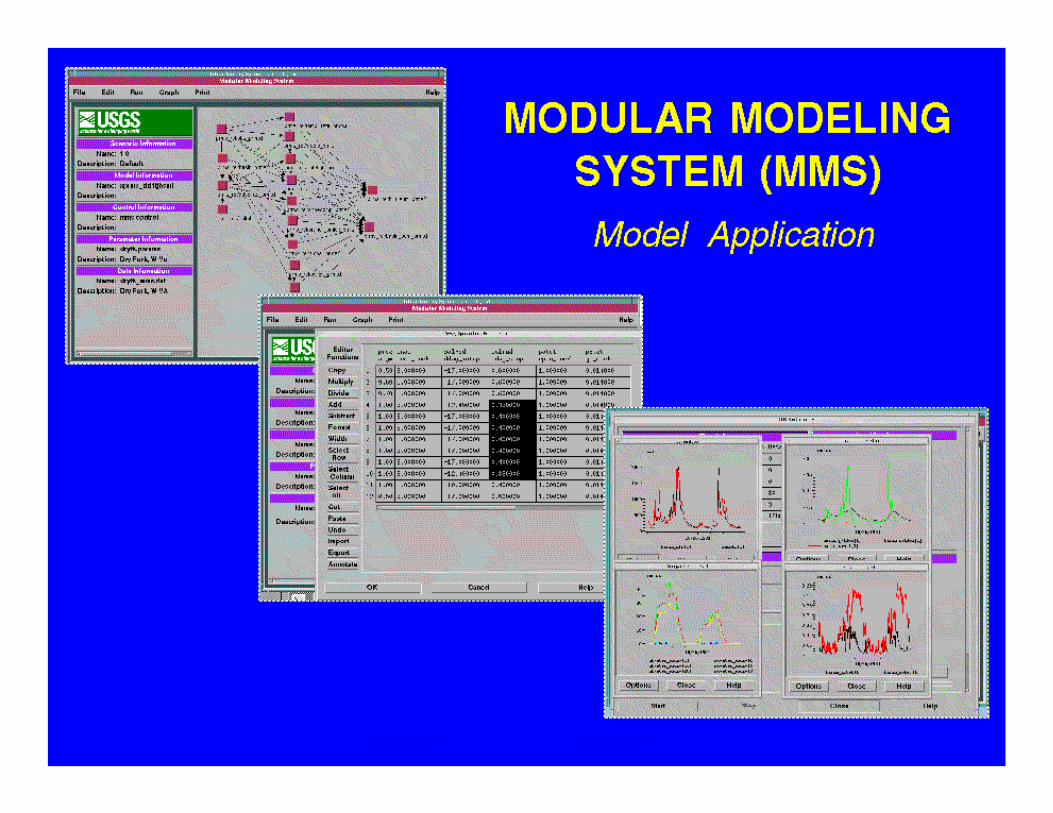
The Modular Modeling System The Modular Modeling System (MMS): A Toolbox for Water(MMS): A Toolbox for Water--and Environmentaland Environmental--Resources Resources
ManagementManagement
G.H. Leavesley, S.L. Markstrom, R.J. Viger, and L.E. Hay
U.S. Geological Survey, Denver, CO USA
STARTING POINTSSTARTING POINTS
There are no universal modelsThere are no universal modelsModels for different purposes require different Models for different purposes require different levels of detail and comprehensivenesslevels of detail and comprehensivenessAppropriate model process conceptualizations Appropriate model process conceptualizations are a function of problem objectives, data are a function of problem objectives, data constraints, and spatial and temporal scales of constraints, and spatial and temporal scales of applicationapplication
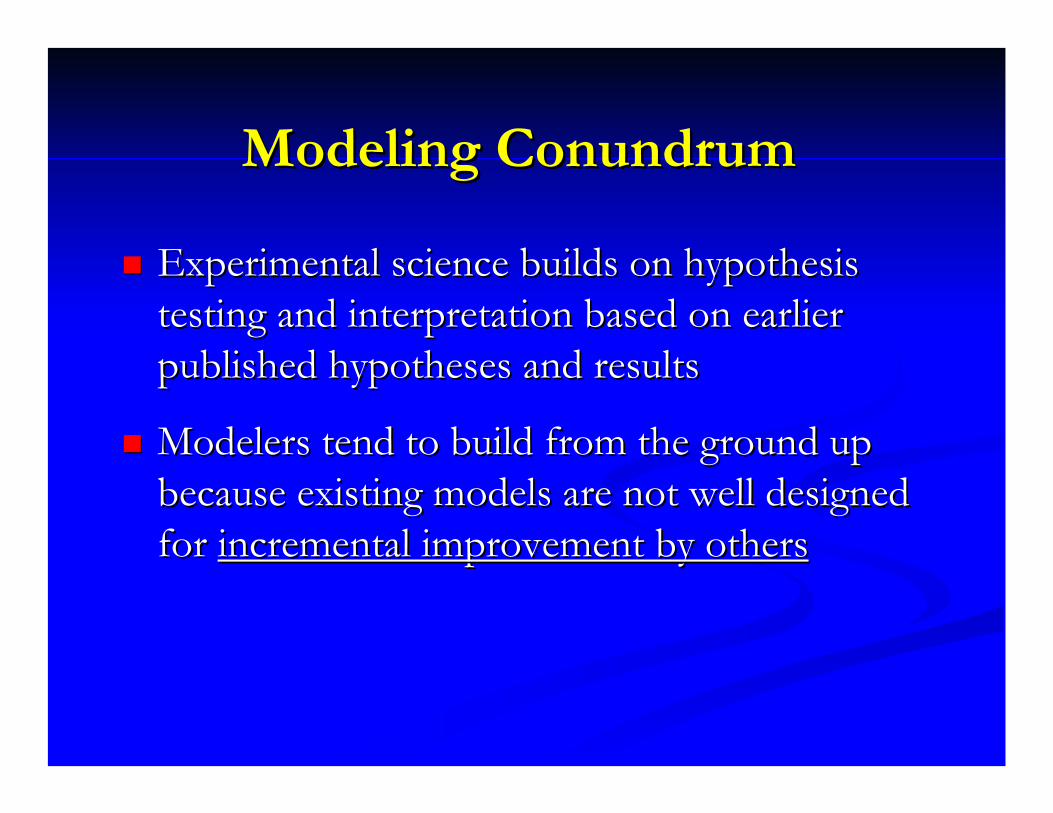
Modeling ConundrumModeling Conundrum
Experimental science builds on hypothesis Experimental science builds on hypothesis testing and interpretation based on earlier testing and interpretation based on earlier published hypotheses and resultspublished hypotheses and results
Modelers tend to build from the ground up Modelers tend to build from the ground up because existing models are not well designed because existing models are not well designed for for incremental improvement by othersincremental improvement by others

TOOL BOX MODELING TOOL BOX MODELING VIEWSVIEWS
Research Model Developer Research Model Developer Complex DetailComplex DetailApplication Model DeveloperApplication Model DeveloperModel UserModel UserResource ManagerResource ManagerPolicy Maker Policy Maker Condensed AnalysisCondensed Analysis
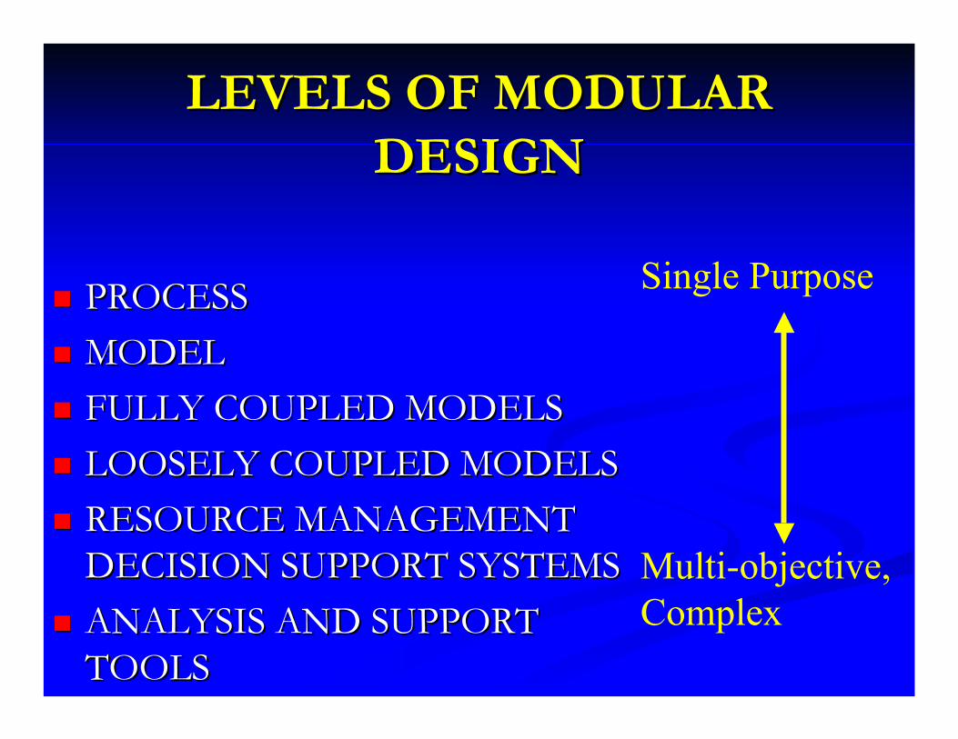
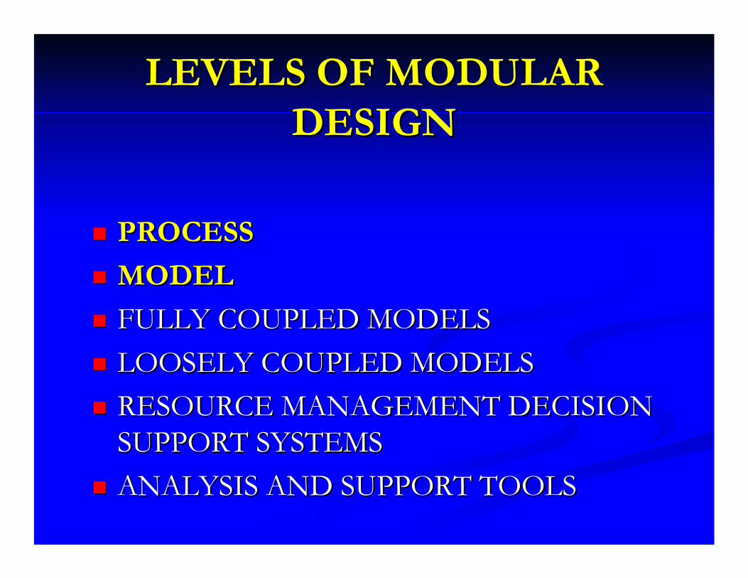
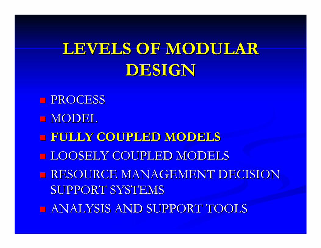
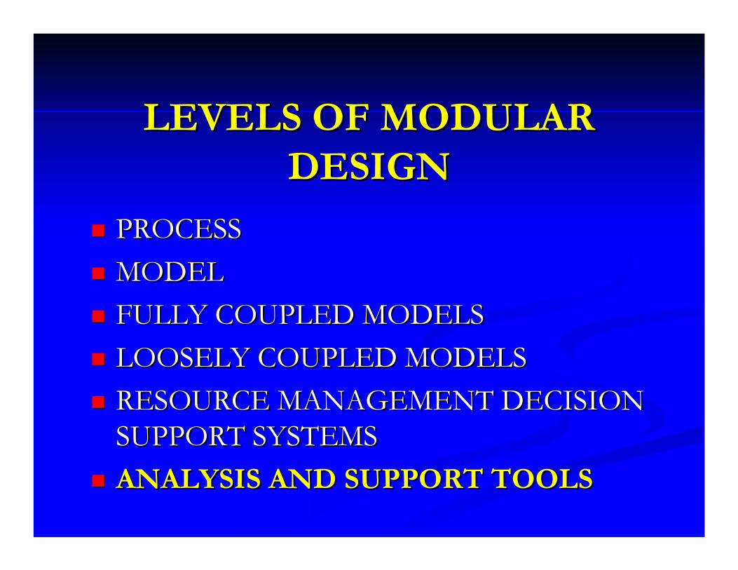
LEVELS OF MODULAR LEVELS OF MODULAR DESIGNDESIGN
PROCESSPROCESSMODELMODELFULLY COUPLED MODELSFULLY COUPLED MODELSLOOSELY COUPLED MODELSLOOSELY COUPLED MODELSRESOURCE MANAGEMENT RESOURCE MANAGEMENT DECISION SUPPORT SYSTEMSDECISION SUPPORT SYSTEMSANALYSIS AND SUPPORT ANALYSIS AND SUPPORT TOOLSTOOLS
Single Purpose
Multi-objective, Complex
LEVELS OF MODULAR LEVELS OF MODULAR DESIGNDESIGN
PROCESSPROCESSMODELMODELFULLY COUPLED MODELSFULLY COUPLED MODELSLOOSELY COUPLED MODELSLOOSELY COUPLED MODELSRESOURCE MANAGEMENT DECISION RESOURCE MANAGEMENT DECISION SUPPORT SYSTEMSSUPPORT SYSTEMSANALYSIS AND SUPPORT TOOLSANALYSIS AND SUPPORT TOOLS
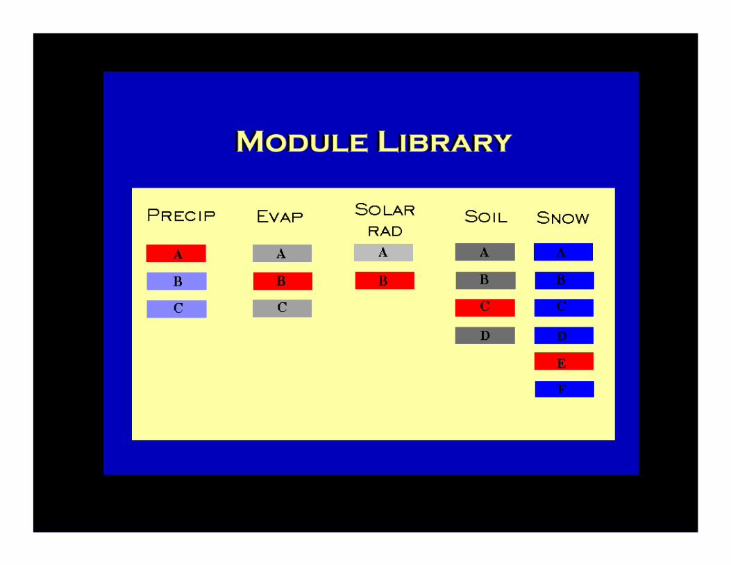
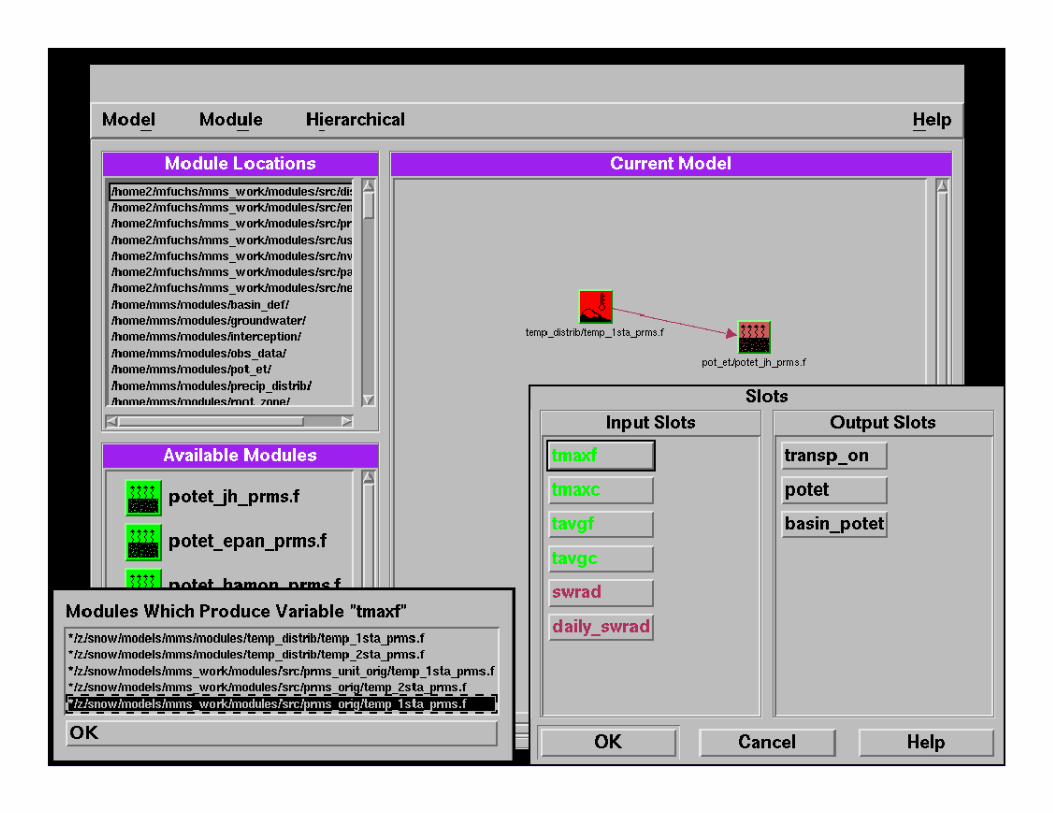
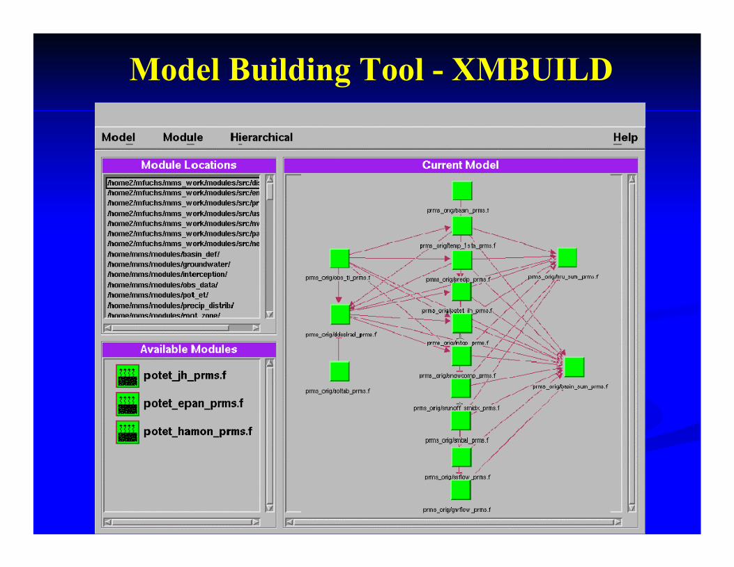
Model Building Tool - XMBUILD
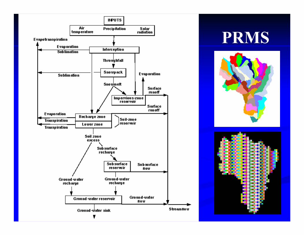
PRMS
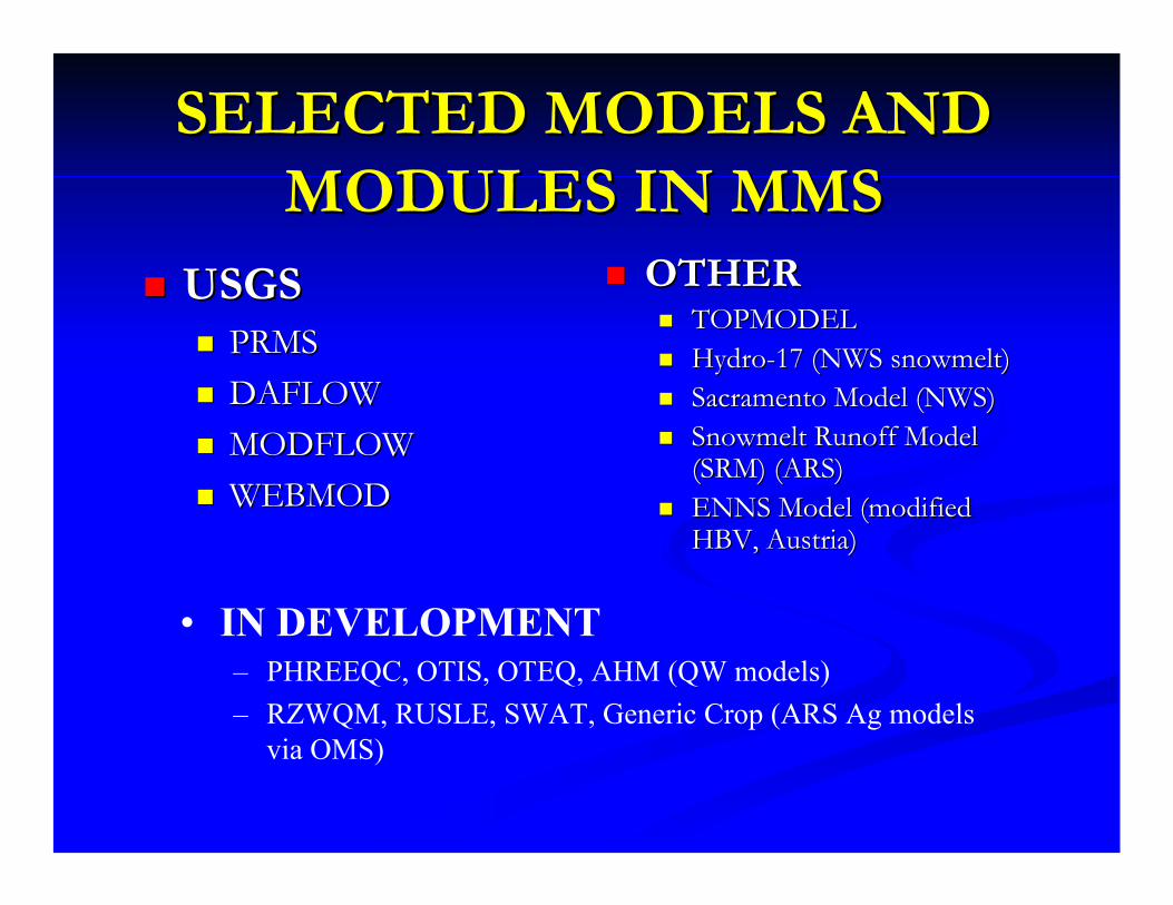
SELECTED MODELS AND SELECTED MODELS AND MODULES IN MMSMODULES IN MMS
USGSUSGSPRMSPRMSDAFLOWDAFLOWMODFLOWMODFLOWWEBMODWEBMOD
OTHEROTHERTOPMODELTOPMODELHydroHydro--17 (NWS snowmelt)17 (NWS snowmelt)Sacramento Model (NWS)Sacramento Model (NWS)Snowmelt Runoff Model Snowmelt Runoff Model (SRM) (ARS)(SRM) (ARS)ENNS Model (modified ENNS Model (modified HBV, Austria)HBV, Austria)
• IN DEVELOPMENT– PHREEQC, OTIS, OTEQ, AHM (QW models)– RZWQM, RUSLE, SWAT, Generic Crop (ARS Ag models
via OMS)
LEVELS OF MODULAR LEVELS OF MODULAR DESIGNDESIGN
PROCESSPROCESSMODELMODELFULLY COUPLED MODELSFULLY COUPLED MODELSLOOSELY COUPLED MODELSLOOSELY COUPLED MODELSRESOURCE MANAGEMENT DECISION RESOURCE MANAGEMENT DECISION SUPPORT SYSTEMSSUPPORT SYSTEMSANALYSIS AND SUPPORT TOOLSANALYSIS AND SUPPORT TOOLS
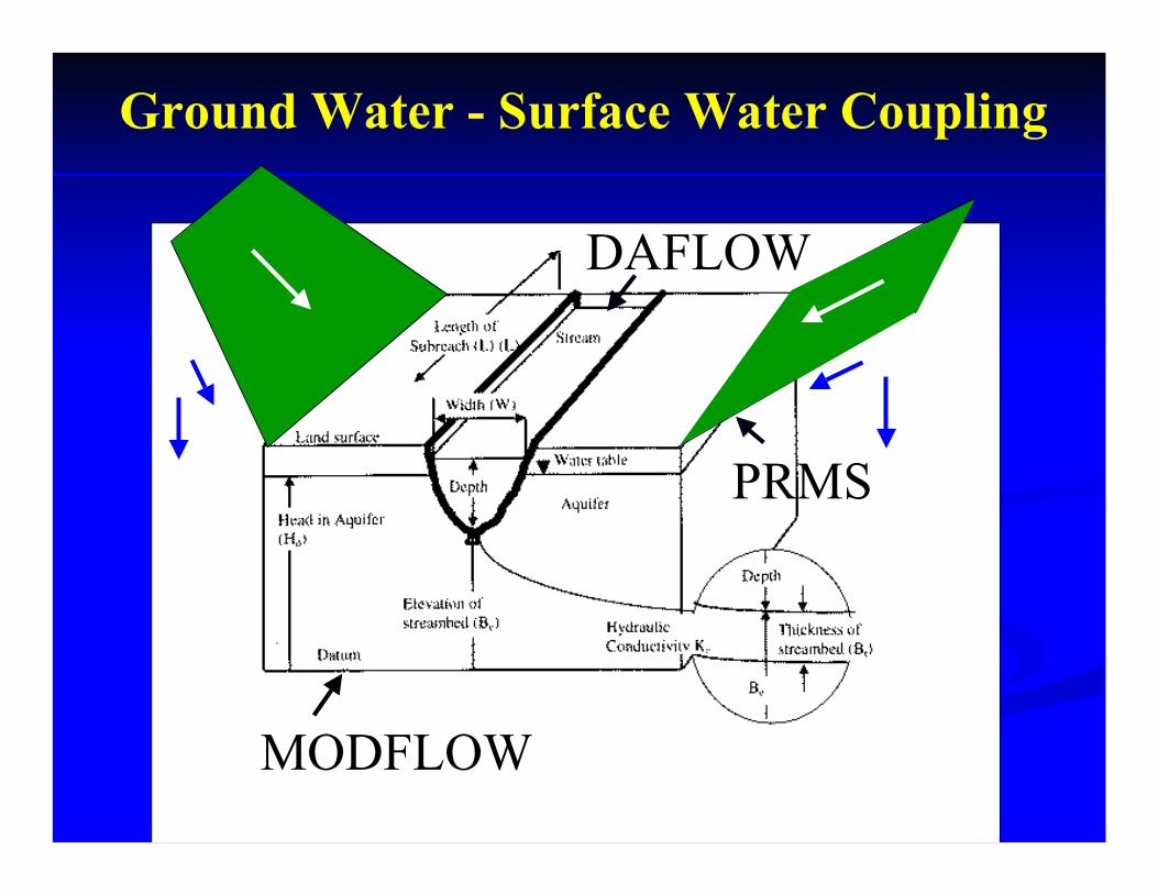
Ground Water - Surface Water Coupling
MODFLOW
PRMS
DAFLOW

LEVELS OF MODULAR LEVELS OF MODULAR DESIGNDESIGN
PROCESSPROCESSMODELMODELFULLY COUPLED MODELSFULLY COUPLED MODELSLOOSELY COUPLED MODELSLOOSELY COUPLED MODELSRESOURCE MANAGEMENT DECISION RESOURCE MANAGEMENT DECISION SUPPORT SYSTEMSSUPPORT SYSTEMSANALYSIS AND SUPPORT TOOLSANALYSIS AND SUPPORT TOOLS
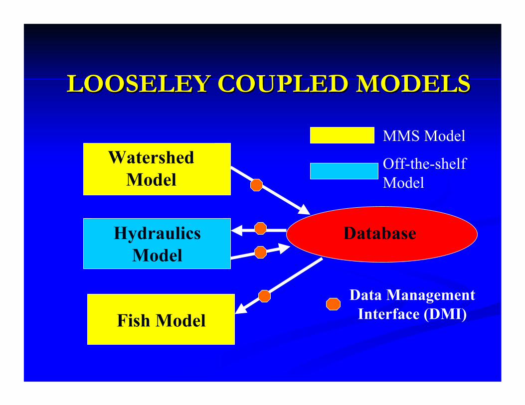
LOOSELEY COUPLED MODELSLOOSELEY COUPLED MODELS
Watershed Model
Hydraulics Model
Database
Fish ModelData Management
Interface (DMI)
MMS Model
Off-the-shelf Model

LOOSELEY COUPLED MODELSLOOSELEY COUPLED MODELS
Watershed Model
Hydraulics Model
Database
Fish ModelData Management
Interface (DMI)
MMS Model
Off-the-shelf Model
Model Management Interface (MMI) [XML]
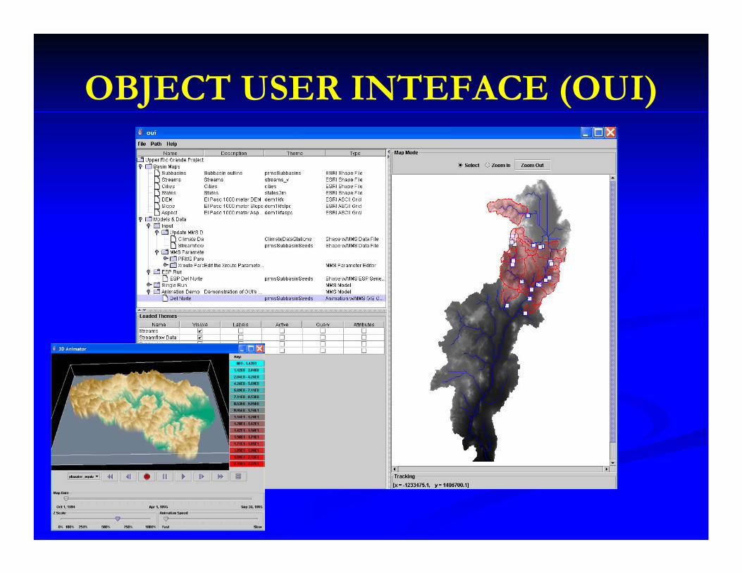
OBJECT USER INTEFACE (OUI)
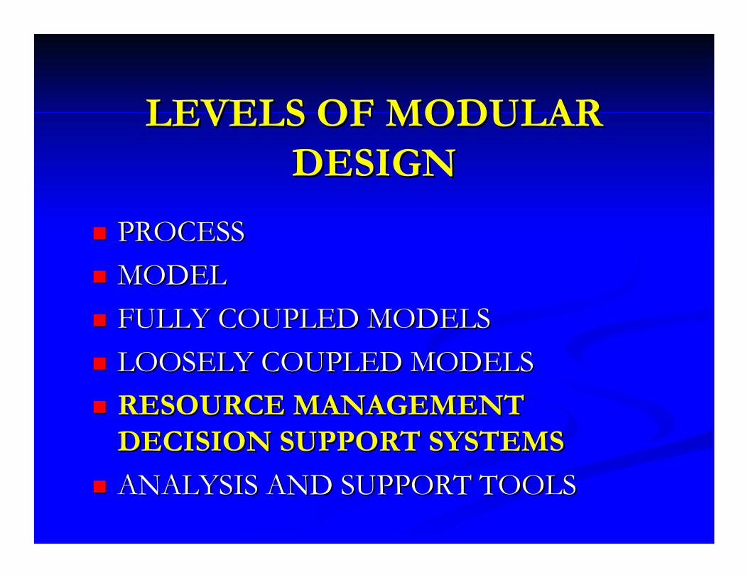
LEVELS OF MODULAR LEVELS OF MODULAR DESIGNDESIGN
PROCESSPROCESSMODELMODELFULLY COUPLED MODELSFULLY COUPLED MODELSLOOSELY COUPLED MODELSLOOSELY COUPLED MODELSRESOURCE MANAGEMENT RESOURCE MANAGEMENT DECISION SUPPORT SYSTEMSDECISION SUPPORT SYSTEMSANALYSIS AND SUPPORT TOOLSANALYSIS AND SUPPORT TOOLS

Watershed and River Systems Management
Program
Recreation
Municipal & Industrial
Riparian Habitat
Hydropower
Irrigation
Endangered Species
Research and development of decision support systems and their application to achieve an equitable balance among water resource issues.
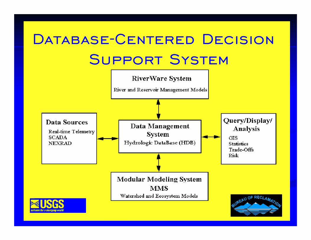
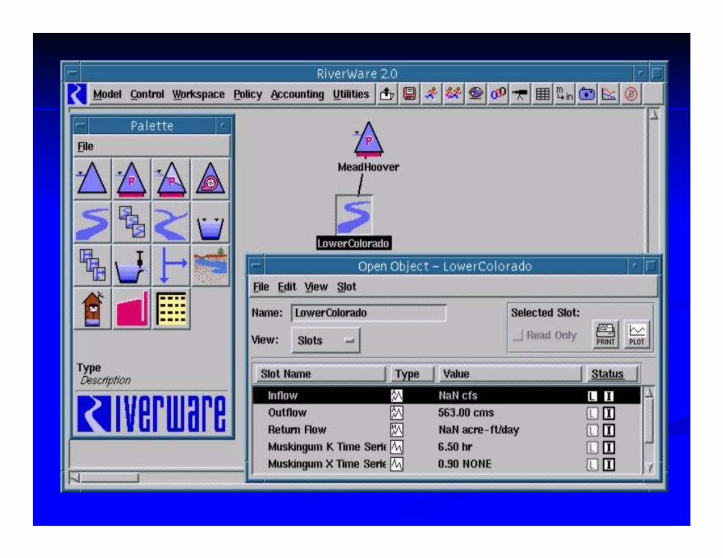
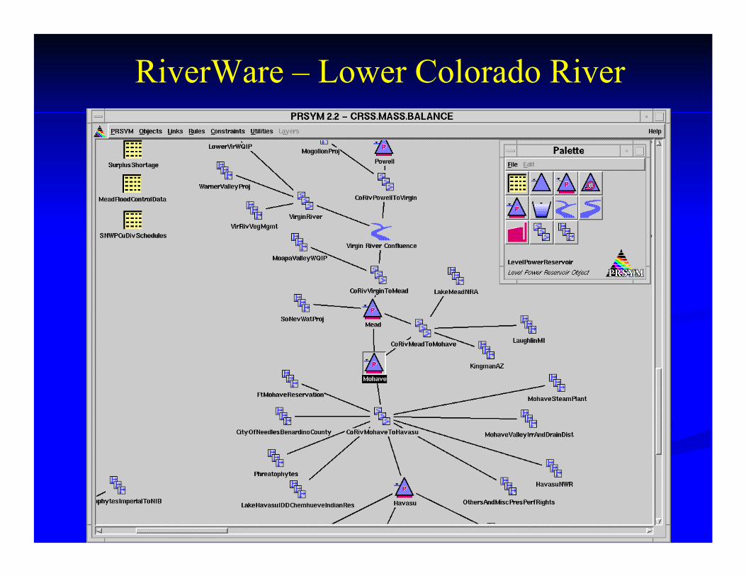
RiverWare – Lower Colorado River
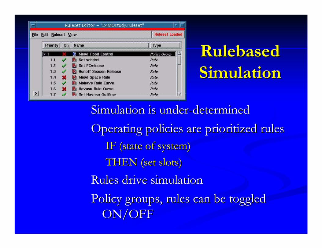
RulebasedRulebasedSimulationSimulation
Simulation is underSimulation is under--determineddeterminedOperating policies are prioritized rulesOperating policies are prioritized rules
IF (state of system)IF (state of system)THEN (set slots)THEN (set slots)
Rules drive simulationRules drive simulationPolicy groups, rules can be toggled Policy groups, rules can be toggled
ON/OFFON/OFF
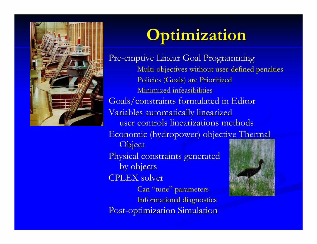
OptimizationOptimizationPrePre--emptive Linear Goal Programmingemptive Linear Goal Programming
MultiMulti--objectives without userobjectives without user--defined penaltiesdefined penaltiesPolicies (Goals) are PrioritizedPolicies (Goals) are PrioritizedMinimized infeasibilitiesMinimized infeasibilities
Goals/constraints formulated in EditorGoals/constraints formulated in EditorVariables automatically Variables automatically linearizedlinearized
user controls user controls linearizationslinearizations methodsmethodsEconomic (hydropower) objective Thermal Economic (hydropower) objective Thermal
ObjectObjectPhysical constraints generatedPhysical constraints generated
by objectsby objectsCPLEX solverCPLEX solver
Can “tune” parametersCan “tune” parametersInformational diagnosticsInformational diagnostics
PostPost--optimization Simulationoptimization Simulation
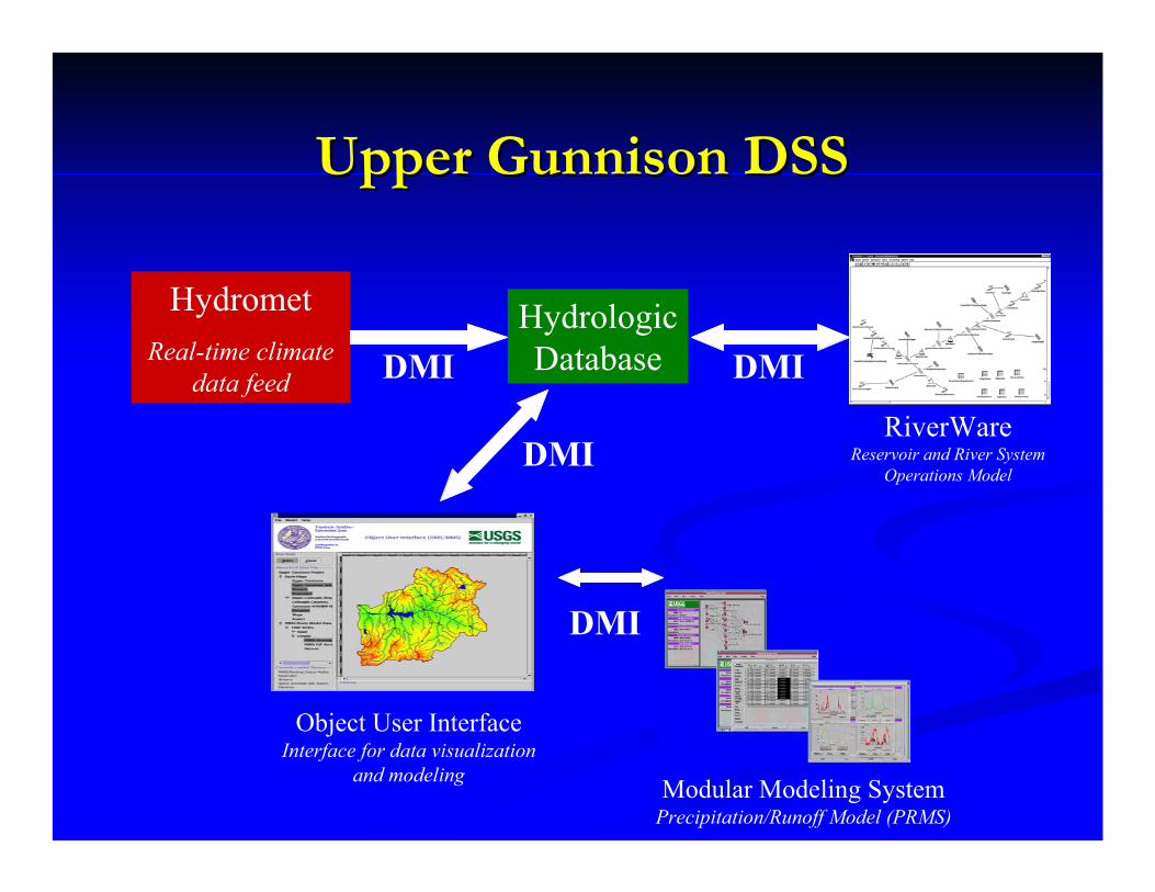
Upper Gunnison DSSUpper Gunnison DSS
HydrologicDatabase
HydrometReal-time climate
data feed
RiverWareReservoir and River System
Operations Model
DMI
DMI
DMI
Object User InterfaceInterface for data visualization
and modeling Modular Modeling SystemPrecipitation/Runoff Model (PRMS)
DMI

Generic DSS Framework for a Wide Generic DSS Framework for a Wide Range of Management IssuesRange of Management Issues
AnyDatabase
Climate Data Source
Object User InterfaceInterface for data visualization
and modeling
Modular Modeling SystemPhysical Process Models
DMI
DMI
DMI
MMI
Any Resource Management
Model
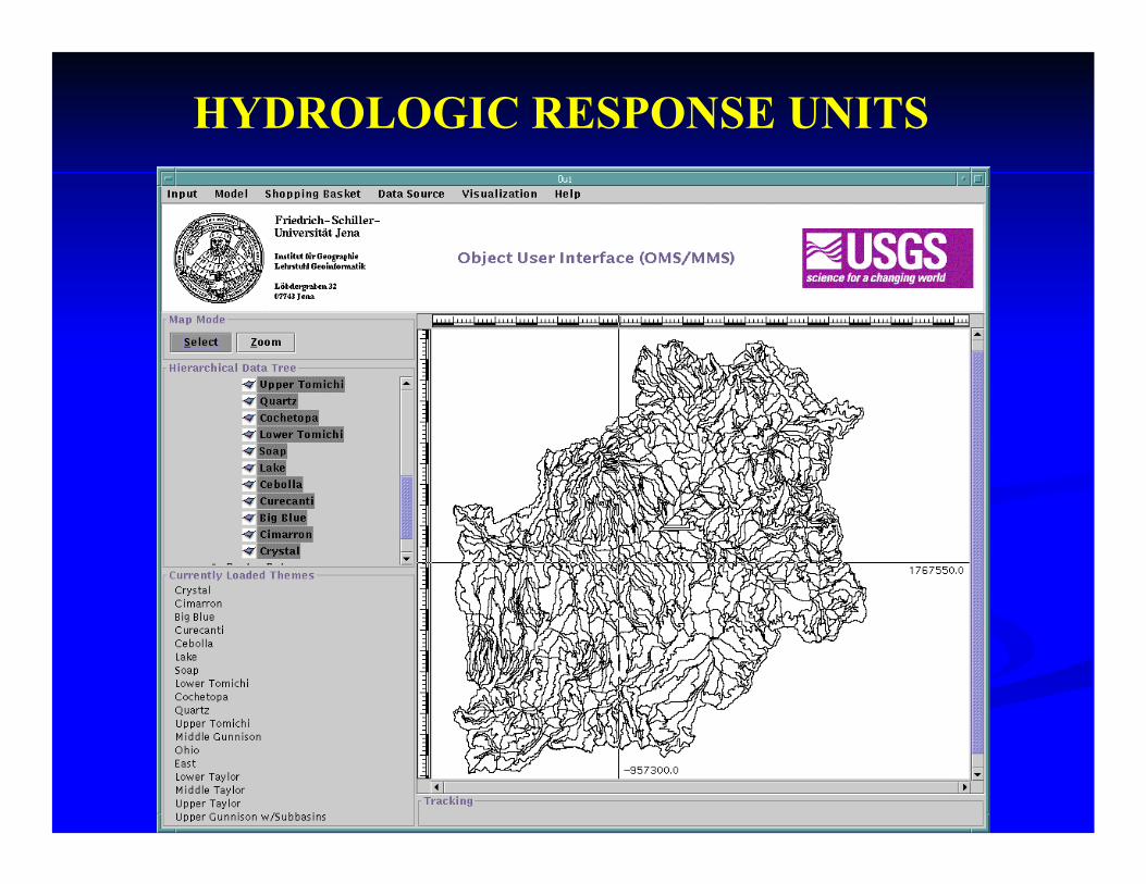
HYDROLOGIC RESPONSE UNITS
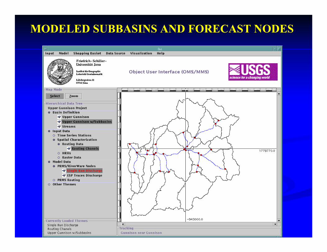
MODELED SUBBASINS AND FORECAST NODES
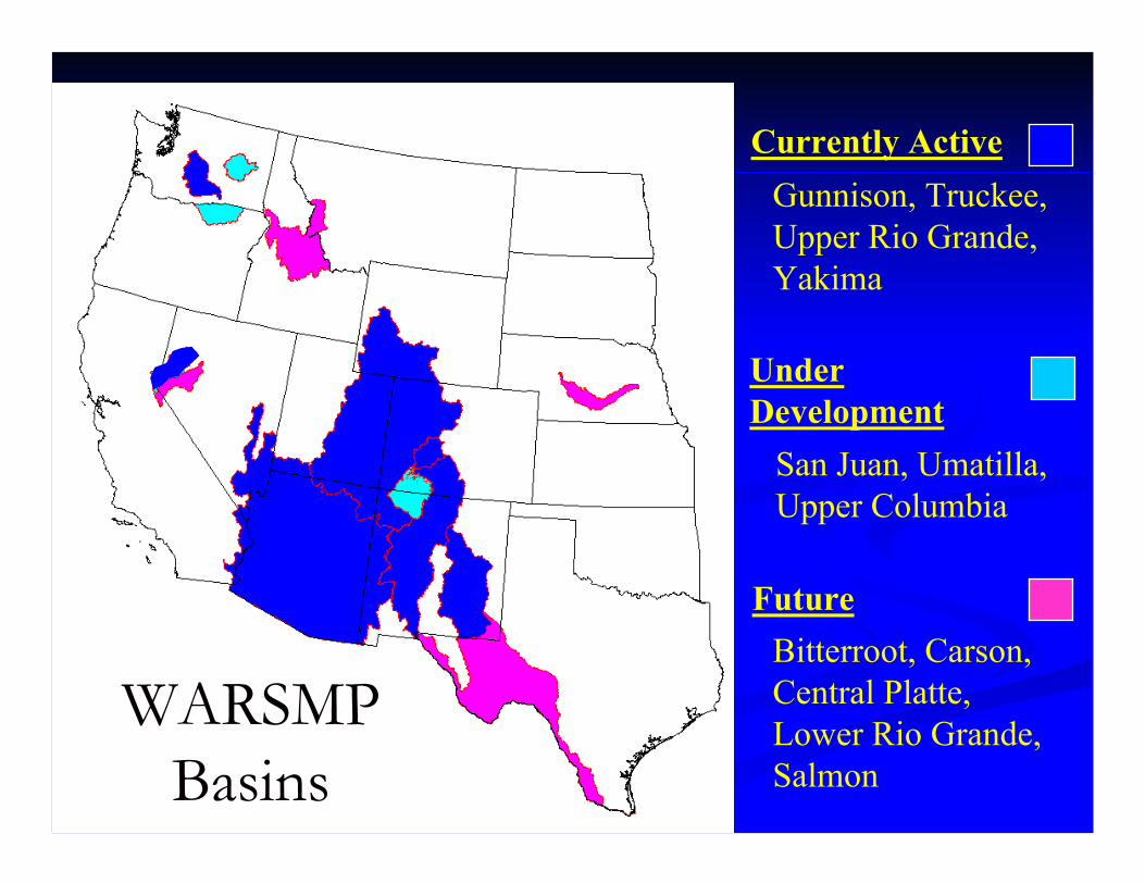
WARSMP WARSMP BasinsBasins
Currently Active
Under Development
Gunnison, Truckee, Upper Rio Grande, Yakima
San Juan, Umatilla, Upper Columbia
FutureBitterroot, Carson, Central Platte, Lower Rio Grande, Salmon
LEVELS OF MODULAR LEVELS OF MODULAR DESIGNDESIGN
PROCESSPROCESSMODEL MODEL FULLY COUPLED MODELSFULLY COUPLED MODELSLOOSELY COUPLED MODELSLOOSELY COUPLED MODELSRESOURCE MANAGEMENT DECISION RESOURCE MANAGEMENT DECISION SUPPORT SYSTEMSSUPPORT SYSTEMSANALYSIS AND SUPPORT TOOLSANALYSIS AND SUPPORT TOOLS
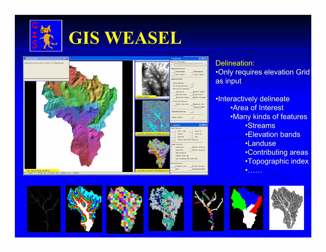
GIS WEASELDelineation:•Only requires elevation Grid as input
•Interactively delineate •Area of Interest•Many kinds of features
•Streams•Elevation bands•Landuse•Contributing areas•Topographic index•……
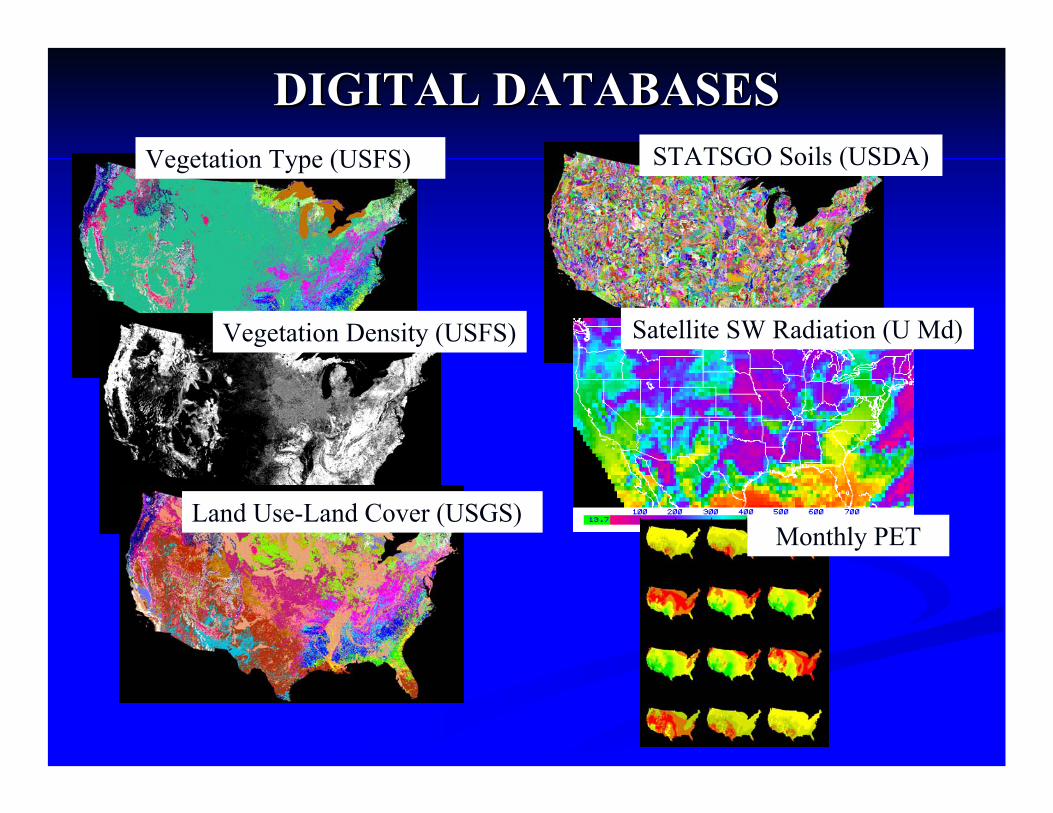
Vegetation Type (USFS)
Vegetation Density (USFS)
Land Use-Land Cover (USGS)
DIGITAL DATABASESDIGITAL DATABASESSTATSGO Soils (USDA)
Satellite SW Radiation (U Md)
Monthly PET
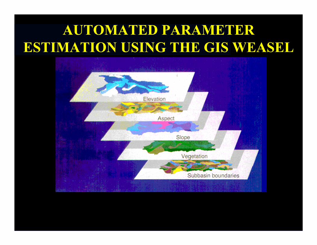
AUTOMATED PARAMETER ESTIMATION USING THE GIS WEASEL
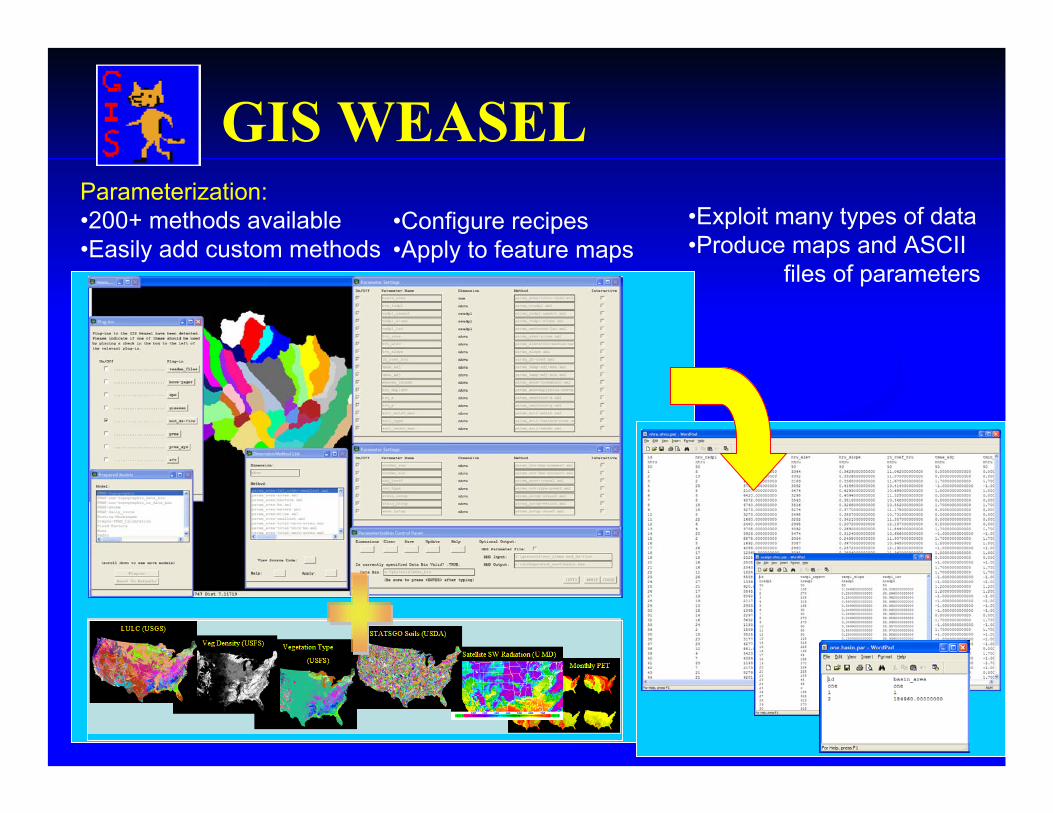
GIS WEASELParameterization:•200+ methods available•Easily add custom methods
•Configure recipes•Apply to feature maps
•Exploit many types of data•Produce maps and ASCII
files of parameters
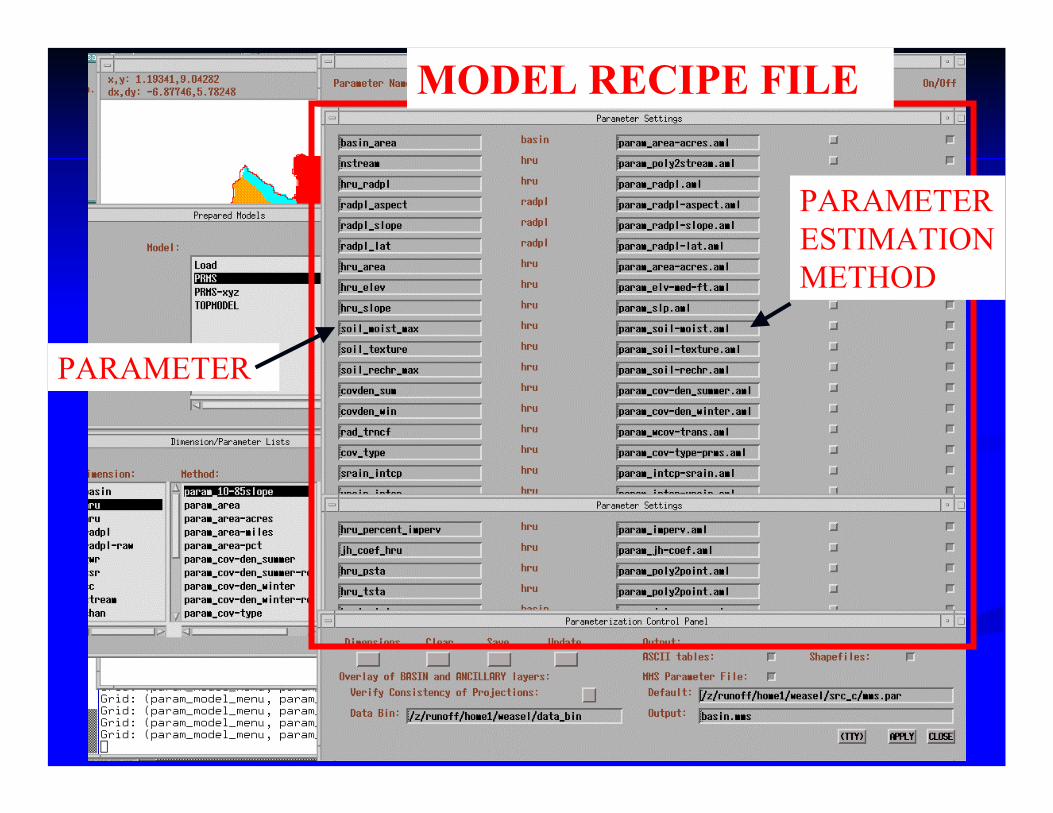
PARAMETER
PARAMETER ESTIMATION METHOD
MODEL RECIPE FILE
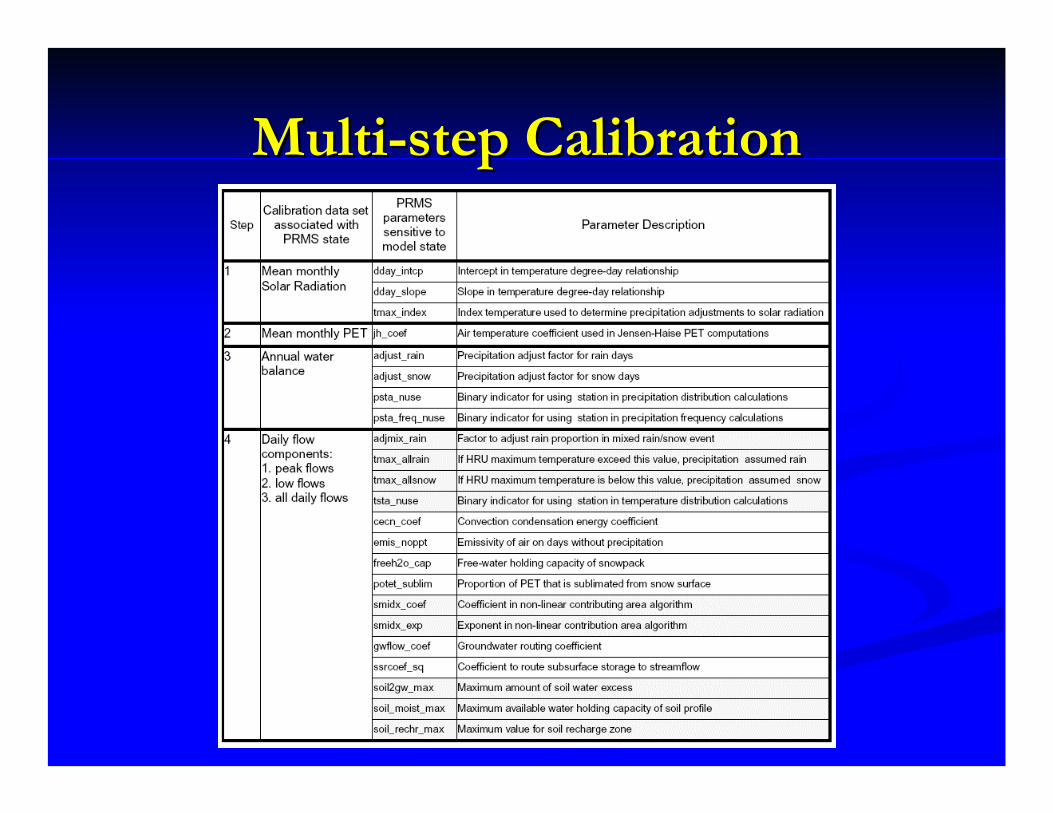
MultiMulti--step Calibrationstep Calibration
24
68
1012
200300400500600700anm
as, So
lar Ra
diation
Month
Solar Radiation
OBSca
l
SIMcal
SIMver
24
68
1012
20406080100140
anmas,
PET
Month
PET
OBSca
l
SIMcal
SIMver
1988
1990
1992
1994
1996
1998
60080010001200
anmas,
Water
Balanc
e
Water
Year
Annual WB
1988
1990
1992
1994
1996
1998
0.50.60.70.80.9
anmas,
Nash−
Sutcliff
e Good
ness o
f Fit
Nash
Sutcli
ffe
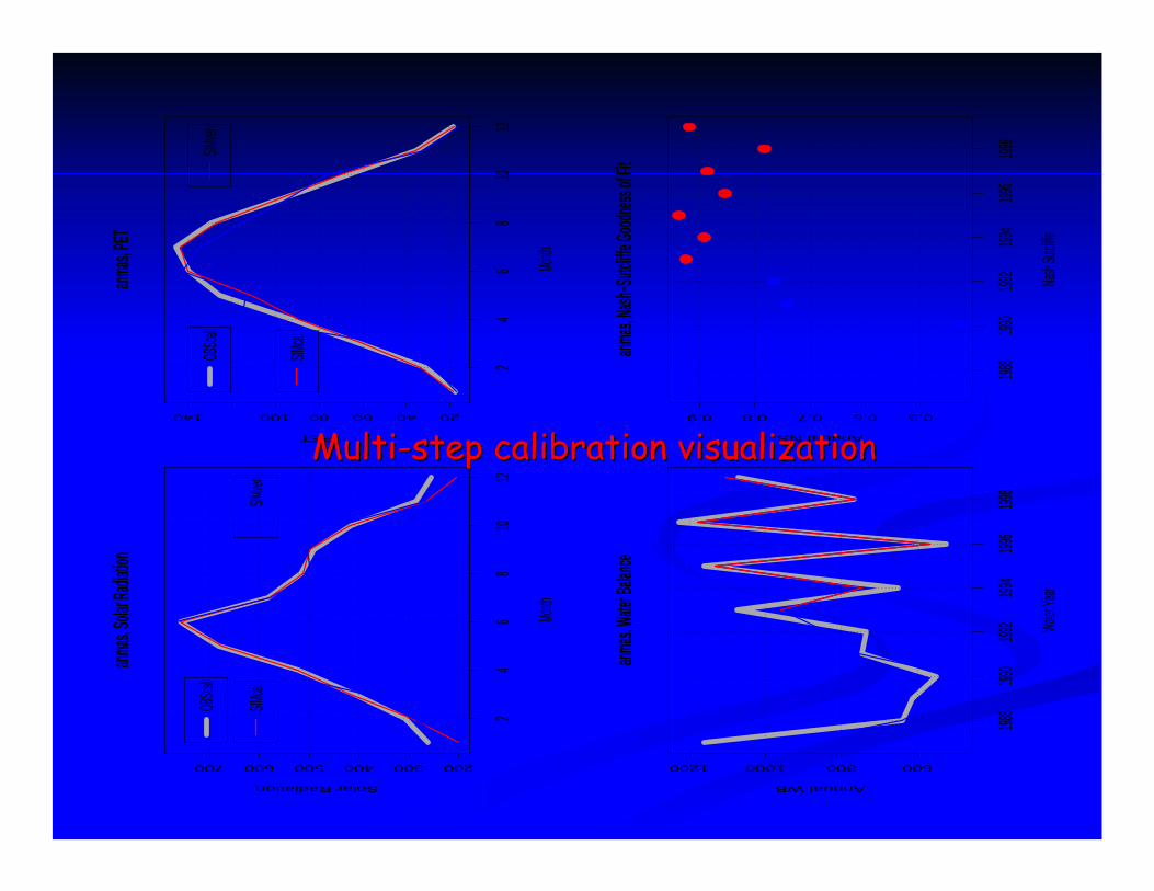
Annual NSMultiMulti--step calibration visualizationstep calibration visualization
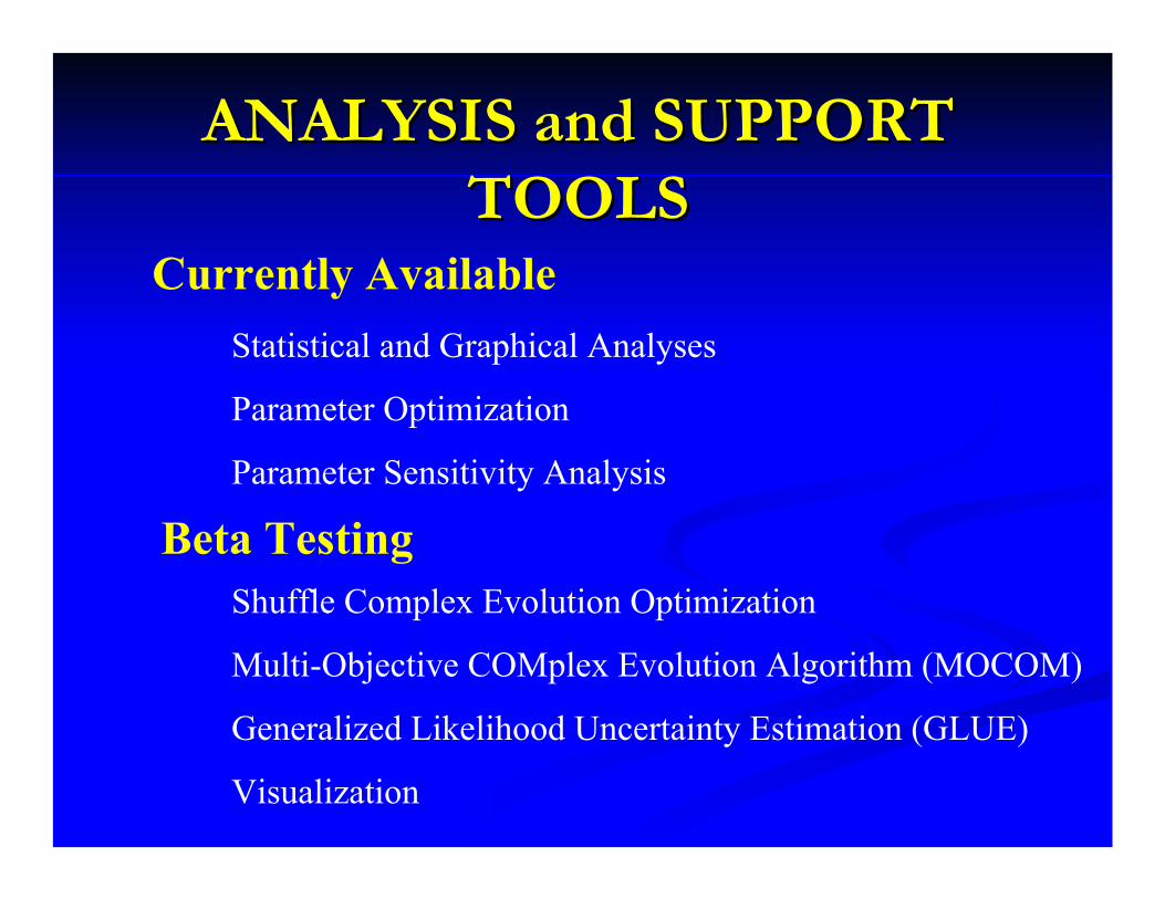
ANALYSIS and SUPPORT ANALYSIS and SUPPORT TOOLSTOOLS
Currently AvailableStatistical and Graphical Analyses
Parameter Optimization
Parameter Sensitivity Analysis
Beta TestingShuffle Complex Evolution Optimization
Multi-Objective COMplex Evolution Algorithm (MOCOM)
Generalized Likelihood Uncertainty Estimation (GLUE)
Visualization
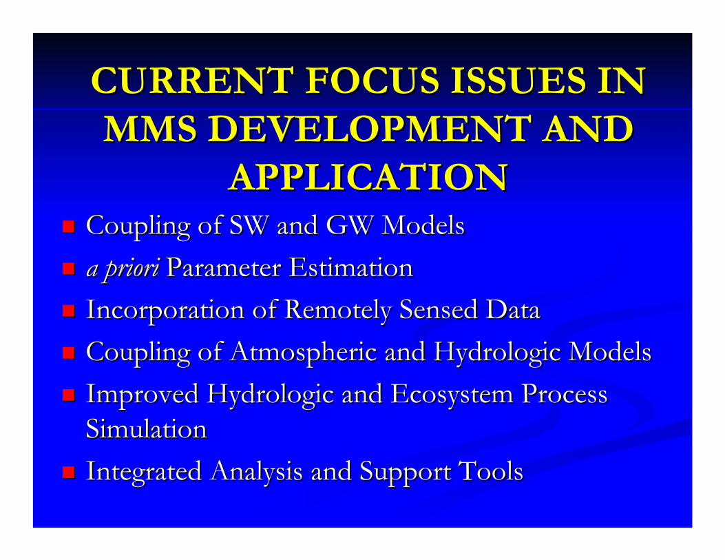
CURRENT FOCUS ISSUES IN CURRENT FOCUS ISSUES IN MMS DEVELOPMENT AND MMS DEVELOPMENT AND
APPLICATIONAPPLICATIONCoupling of SW and GW ModelsCoupling of SW and GW Modelsa prioria priori Parameter EstimationParameter EstimationIncorporation of Remotely Sensed Data Incorporation of Remotely Sensed Data Coupling of Atmospheric and Hydrologic ModelsCoupling of Atmospheric and Hydrologic ModelsImproved Hydrologic and Ecosystem Process Improved Hydrologic and Ecosystem Process SimulationSimulationIntegrated Analysis and Support ToolsIntegrated Analysis and Support Tools
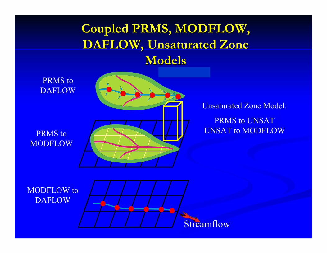
Coupled PRMS, MODFLOW, Coupled PRMS, MODFLOW, DAFLOW, Unsaturated Zone DAFLOW, Unsaturated Zone
ModelsModels
Streamflow
Unsaturated Zone Model:
PRMS to UNSAT UNSAT to MODFLOW
PRMS to DAFLOW
PRMS to MODFLOW
MODFLOW to DAFLOW
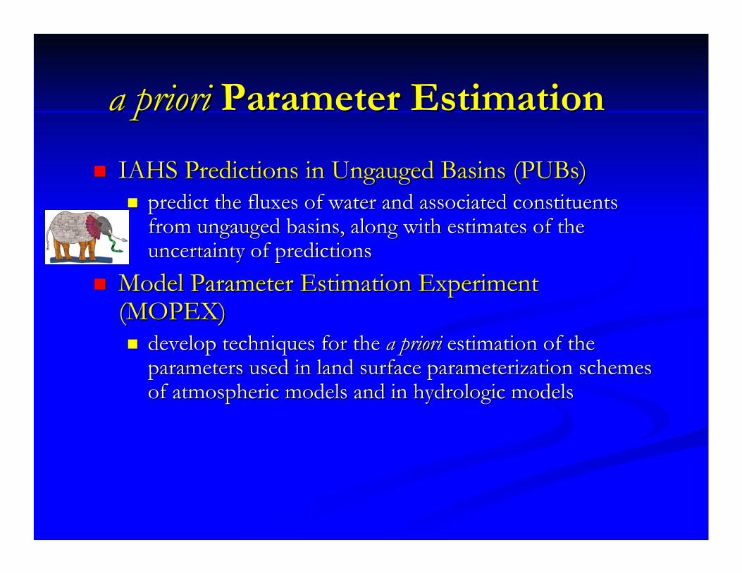
a prioria priori Parameter EstimationParameter EstimationIAHS Predictions in Ungauged Basins (IAHS Predictions in Ungauged Basins (PUBsPUBs))
predict the fluxes of water and associated constituents predict the fluxes of water and associated constituents from ungauged basins, along with estimates of the from ungauged basins, along with estimates of the uncertainty of predictionsuncertainty of predictions
Model Parameter Estimation Experiment Model Parameter Estimation Experiment (MOPEX)(MOPEX)
develop techniques for the develop techniques for the a prioria priori estimation of the estimation of the parameters used in land surface parameterization schemes parameters used in land surface parameterization schemes of atmospheric models and in hydrologic modelsof atmospheric models and in hydrologic models
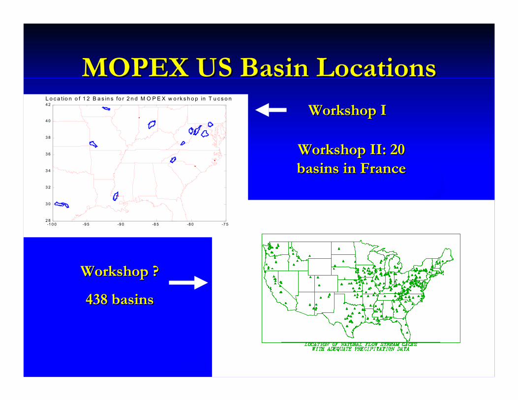
MOPEX US Basin LocationsMOPEX US Basin Locations
-1 0 0 -9 5 -9 0 -8 5 -8 0 -7 52 8
3 0
3 2
3 4
3 6
3 8
4 0
4 2L o c a tio n o f 1 2 B a s in s fo r 2 n d M O P E X w o rk s h o p in T u c s o n
Workshop IWorkshop I
Workshop II: 20 Workshop II: 20 basins in Francebasins in France
Workshop ?Workshop ?
438 basins438 basins
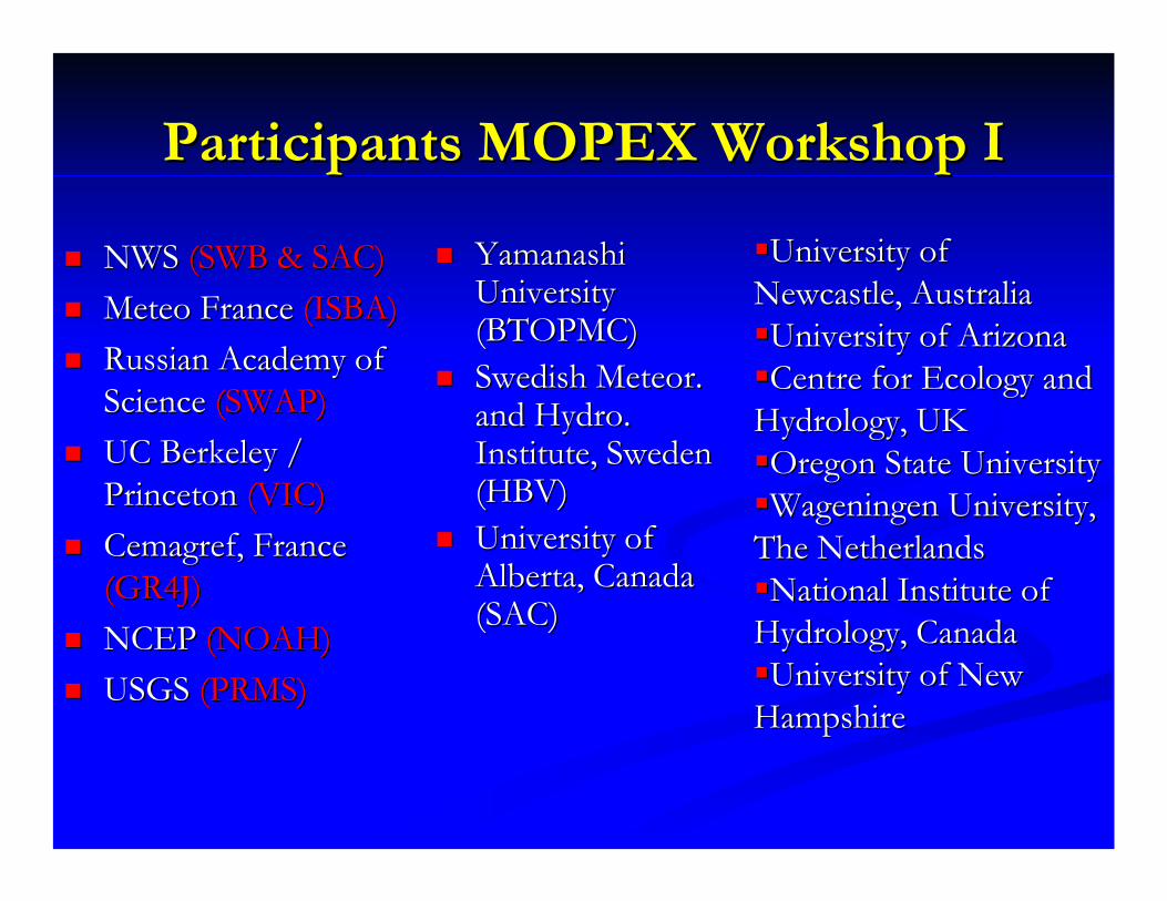
Participants MOPEX Workshop IParticipants MOPEX Workshop I
NWS NWS (SWB & SAC)(SWB & SAC)MeteoMeteo France France (ISBA)(ISBA)Russian Academy of Russian Academy of Science Science (SWAP)(SWAP)UC Berkeley / UC Berkeley / Princeton Princeton (VIC)(VIC)CemagrefCemagref, France , France (GR4J)(GR4J)NCEP NCEP (NOAH)(NOAH)USGS USGS (PRMS)(PRMS)
Yamanashi Yamanashi University University (BTOPMC)(BTOPMC)Swedish Meteor. Swedish Meteor. and Hydro. and Hydro. Institute, Sweden Institute, Sweden (HBV)(HBV)University of University of Alberta, Canada Alberta, Canada (SAC)(SAC)
University of University of Newcastle, AustraliaNewcastle, AustraliaUniversity of ArizonaUniversity of ArizonaCentre for Ecology and Centre for Ecology and
Hydrology, UKHydrology, UKOregon State UniversityOregon State UniversityWageningenWageningen University, University,
The NetherlandsThe NetherlandsNational Institute of National Institute of
Hydrology, CanadaHydrology, CanadaUniversity of New University of New
HampshireHampshire
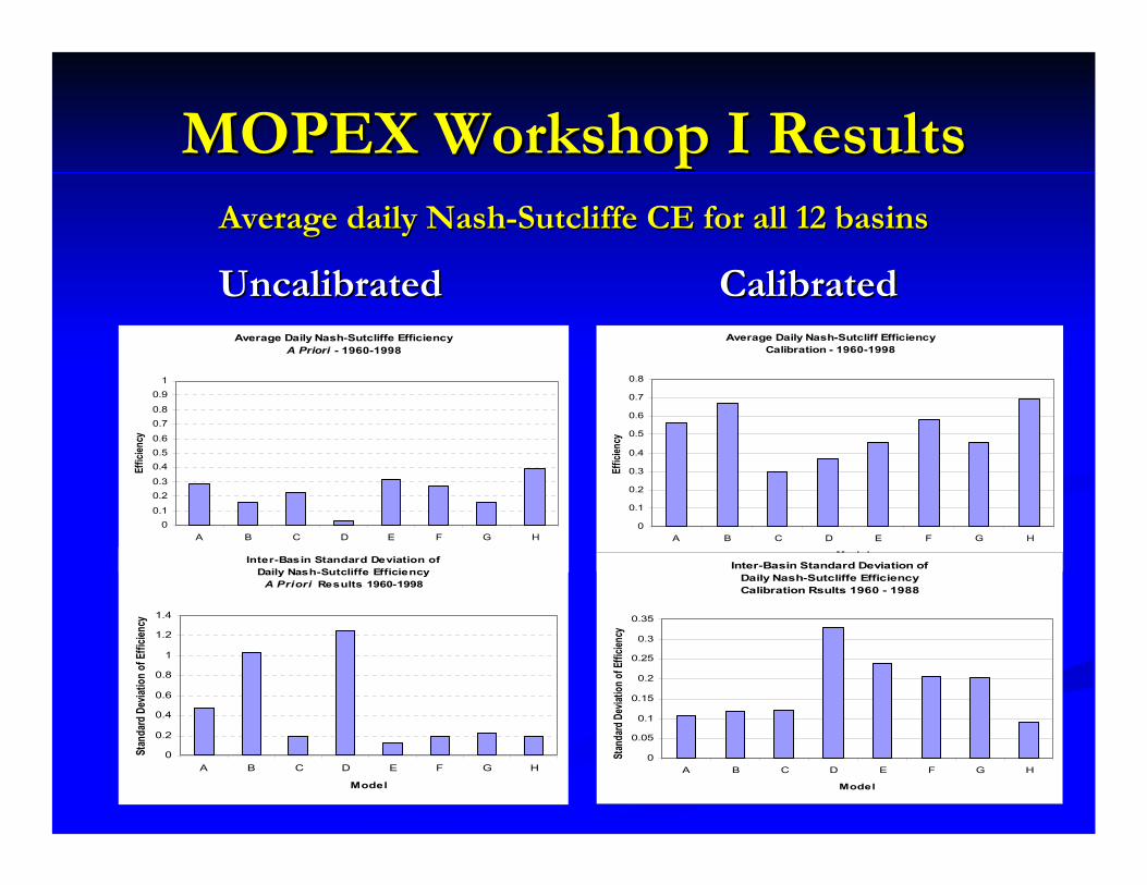
MOPEX Workshop I ResultsMOPEX Workshop I Results
Average Daily Nash-Sutcliffe EfficiencyA Priori - 1960-1998
00.1
0.20.3
0.40.50.6
0.70.8
0.91
A B C D E F G H
Model
Effic
iency
Inter-Basin Standard Deviation of Daily Nash-Sutcliffe Efficiency
A Priori Results 1960-1998
0
0.2
0.4
0.6
0.8
1
1.2
1.4
A B C D E F G H
Model
Stan
dard
Dev
iation
of Ef
ficien
cy
Average Daily Nash-Sutcliff EfficiencyCalibration - 1960-1998
0
0.1
0.2
0.3
0.4
0.5
0.6
0.7
0.8
A B C D E F G H
Model
Effic
iency
Inter-Basin Standard Deviation of Daily Nash-Sutcliffe EfficiencyCalibration Rsults 1960 - 1988
0
0.05
0.1
0.15
0.2
0.25
0.3
0.35
A B C D E F G H
Model
Stan
dard
Dev
iation
of Ef
ficien
cy
UncalibratedUncalibrated CalibratedCalibratedAverage daily NashAverage daily Nash--Sutcliffe CE for all 12 basinsSutcliffe CE for all 12 basins
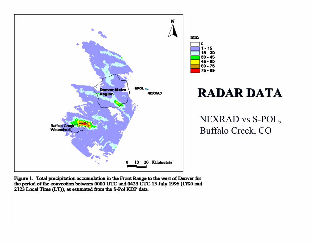
RADAR DATARADAR DATA
NEXRAD vs S-POL, Buffalo Creek, CO
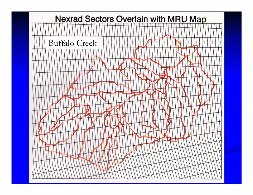
Buffalo Creek

Estimated Peak
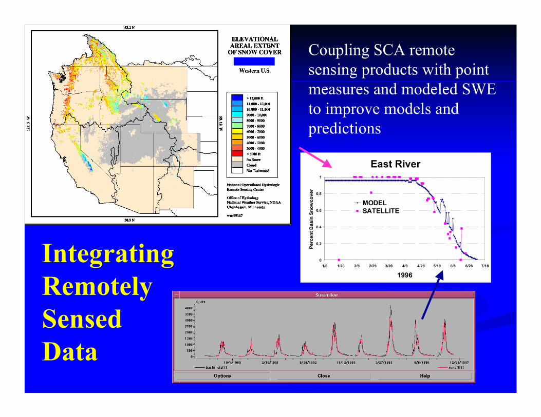
Coupling SCA remote sensing products with point measures and modeled SWE to improve models and predictions
East River
0
0.2
0.4
0.6
0.8
1
1/0 1/20 2/9 2/29 3/20 4/9 4/29 5/19 6/8 6/28 7/18
1996
Perc
ent B
asin
Sno
wco
ver
MODELSATELLITE
Integrating Remotely Sensed Data
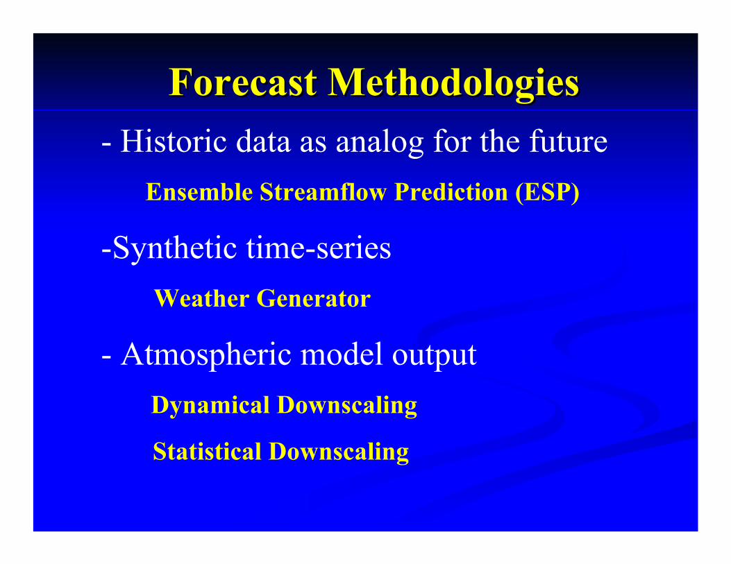
Forecast MethodologiesForecast Methodologies- Historic data as analog for the future
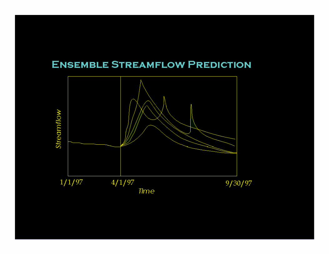
Ensemble Streamflow Prediction (ESP)
-Synthetic time-series Weather Generator
- Atmospheric model outputDynamical Downscaling
Statistical Downscaling
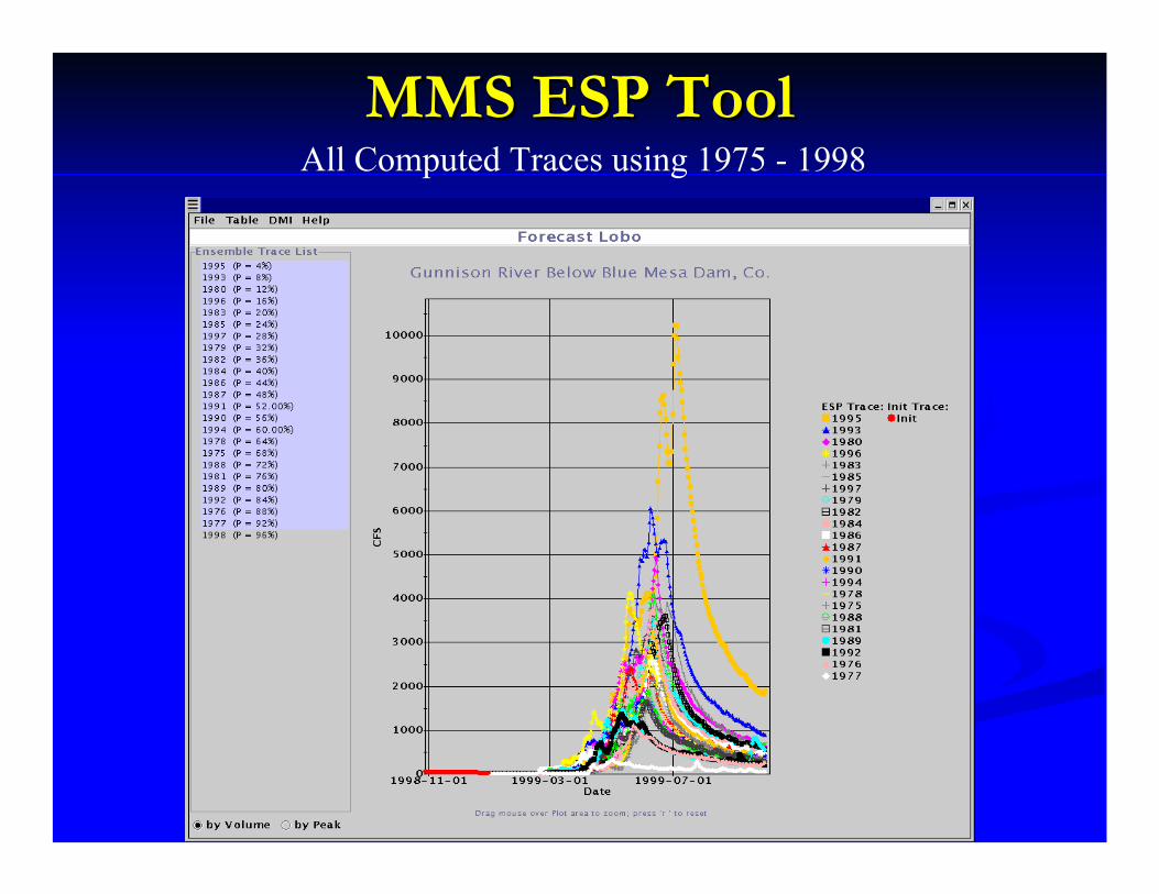
MMS ESP ToolMMS ESP ToolAll Computed Traces using 1975 - 1998
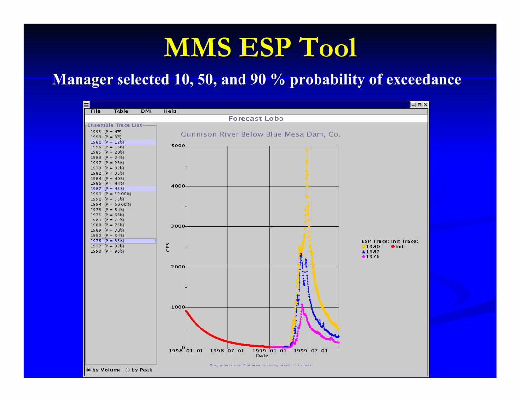
MMS ESP ToolMMS ESP ToolManager selected 10, 50, and 90 % probability of exceedance

Weather Generator
Develop synthetic timeDevelop synthetic time--series of precipitation series of precipitation and temperatureand temperature
LongLong--term planning or policy analysisterm planning or policy analysisClimate change scenariosClimate change scenarios
Collaboratively with Dr. Balaji Rajagopalan, University of Colorado, Boulder
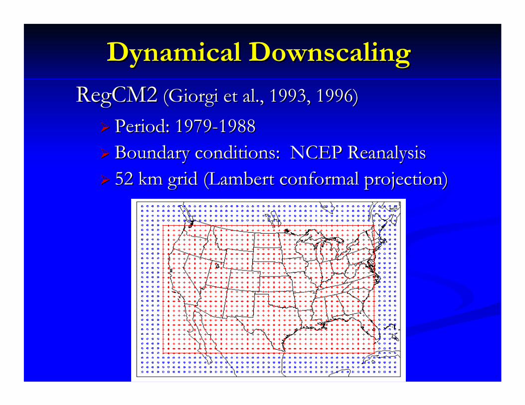
Dynamical DownscalingDynamical DownscalingRegCM2RegCM2 ((GiorgiGiorgi et al., 1993, 1996) et al., 1993, 1996)
Period: 1979Period: 1979--19881988Boundary conditions: NCEP ReanalysisBoundary conditions: NCEP Reanalysis52 km grid (Lambert conformal projection)52 km grid (Lambert conformal projection)

Nested Domains for MM5
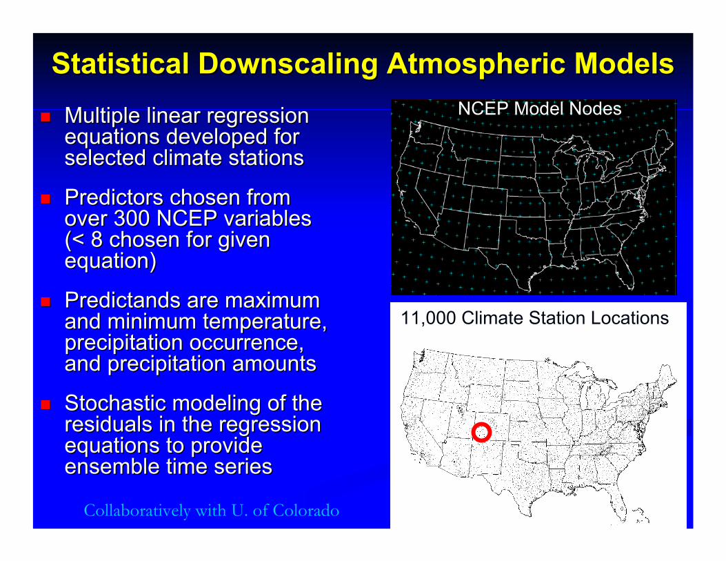
Statistical Downscaling AtmosphericStatistical Downscaling Atmospheric ModelsModelsMultiple linear regression Multiple linear regression equations developed for equations developed for selected climate stations selected climate stations
Predictors chosen from Predictors chosen from over 300 NCEP variables over 300 NCEP variables (< 8 chosen for given (< 8 chosen for given equation) equation)
PredictandsPredictands are maximum are maximum and minimum temperature, and minimum temperature, precipitation occurrence, precipitation occurrence, and precipitation amountsand precipitation amounts
Stochastic modeling of the Stochastic modeling of the residuals in the regression residuals in the regression equations to provide equations to provide ensemble time seriesensemble time series
11,000 Climate Station Locations
NCEP Model Nodes
Collaboratively with U. of Colorado
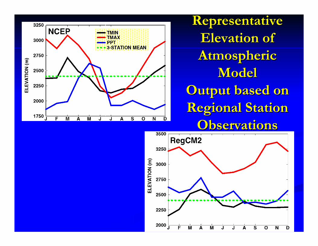
Representative Representative Elevation of Elevation of Atmospheric Atmospheric
ModelModelOutput based on Output based on Regional StationRegional Station
ObservationsObservations
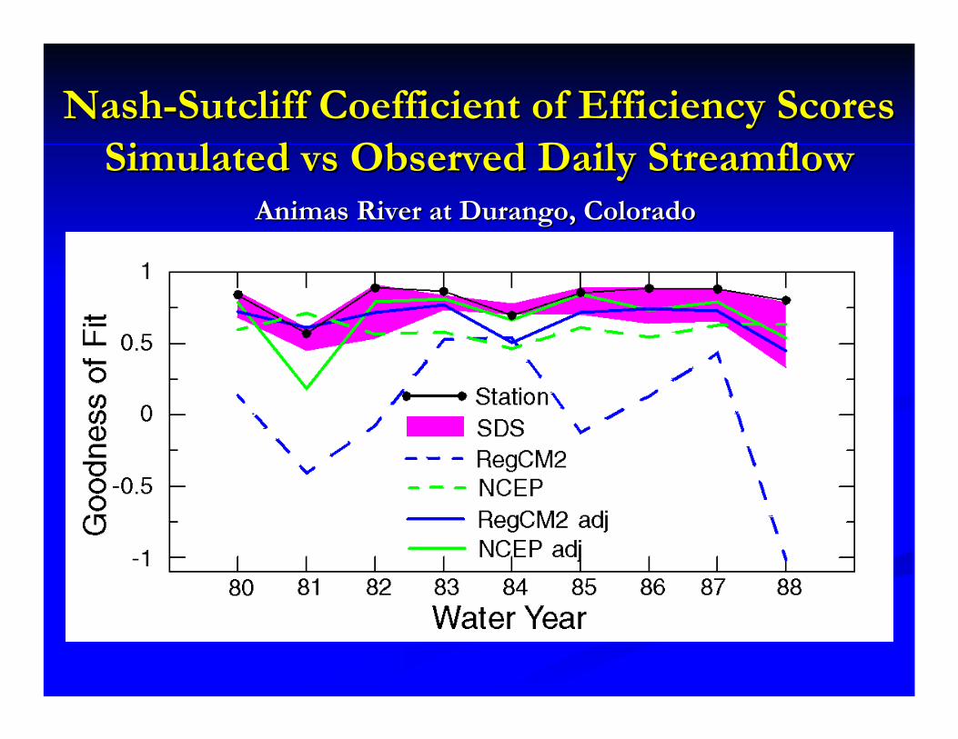
NashNash--Sutcliff Coefficient of Efficiency Scores Sutcliff Coefficient of Efficiency Scores Simulated Simulated vsvs Observed Daily StreamflowObserved Daily Streamflow
Animas River at Durango, ColoradoAnimas River at Durango, Colorado
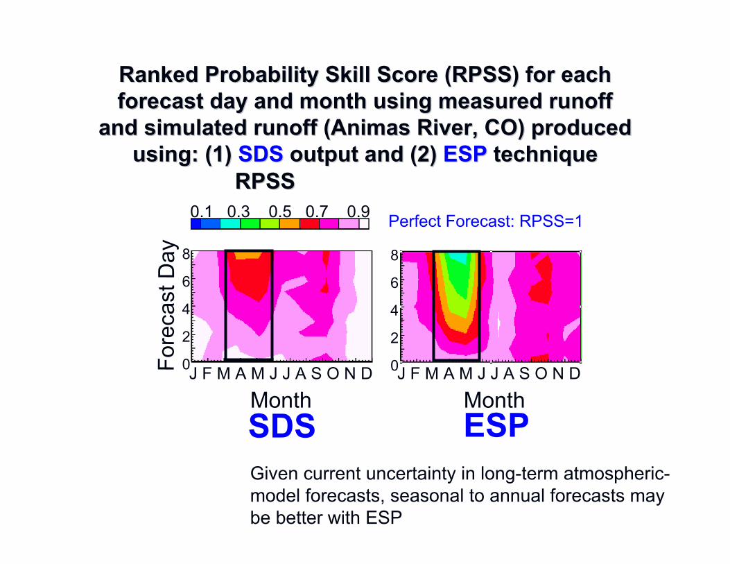
Ranked Probability Skill Score (RPSS) for each Ranked Probability Skill Score (RPSS) for each forecast day and month using measured runoff forecast day and month using measured runoff
and simulated runoff (Animas River, CO) produced and simulated runoff (Animas River, CO) produced using: (1)using: (1) SDSSDS output and (2)output and (2) ESPESP techniquetechnique
Fore
c as t
Day
Month MonthJ F M A M J J A S O N D J F M A M J J A S O N D
8
6
4
2
0
8
6
4
2
0
0.1 0.3 0.5 0.7 0.9RPSSRPSS
ESPSDS
Perfect Forecast: RPSS=1
Given current uncertainty in long-term atmospheric-model forecasts, seasonal to annual forecasts may be better with ESP
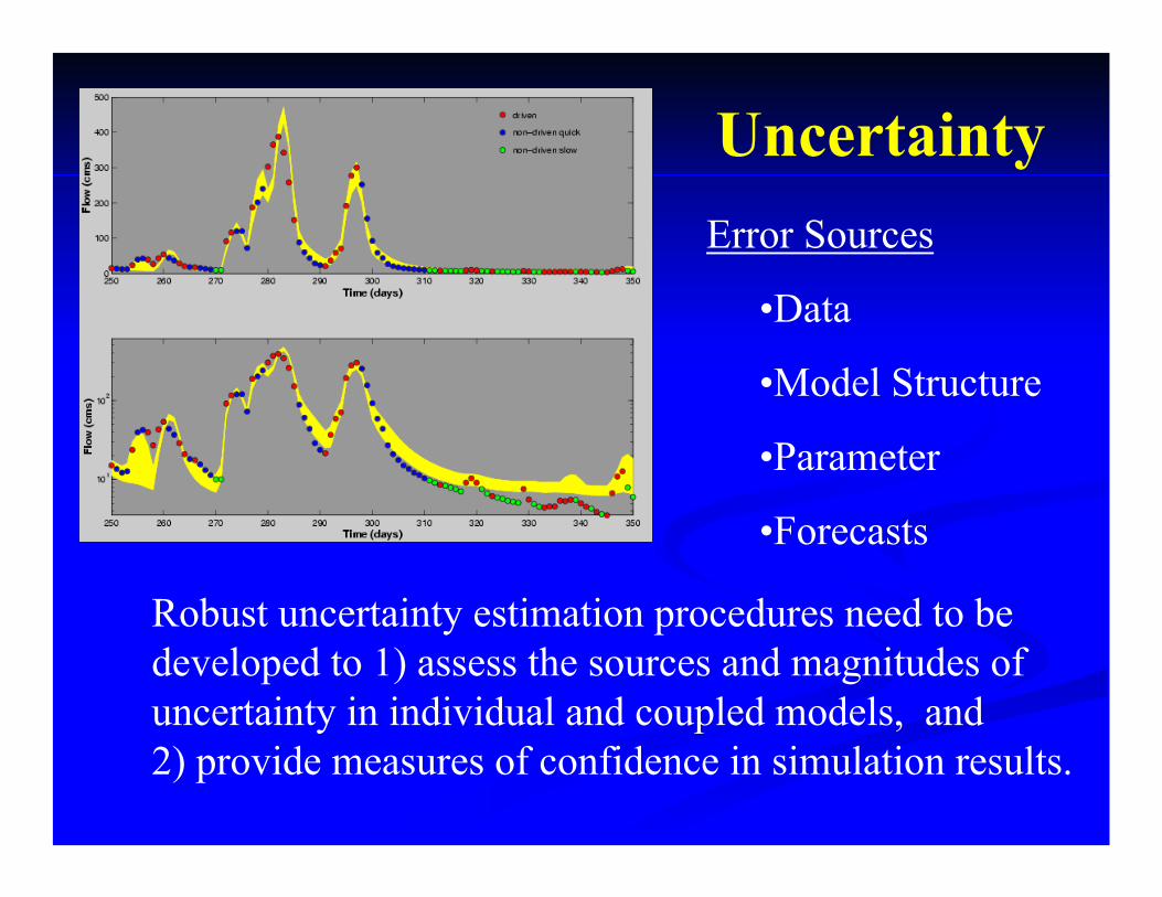
UncertaintyError Sources
•Data
•Model Structure
•Parameter
•Forecasts
Robust uncertainty estimation procedures need to be developed to 1) assess the sources and magnitudes of uncertainty in individual and coupled models, and 2) provide measures of confidence in simulation results.
Integrated ModelsIntegrated Models
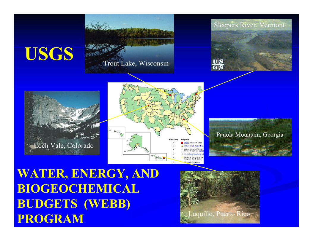
Sleepers River, Vermont
Trout Lake, Wisconsin
Panola Mountain, Georgia
Luquillo, Puerto Rico
Loch Vale, Colorado
WATER, ENERGY, AND BIOGEOCHEMICAL BUDGETS (WEBB) PROGRAM
USGS
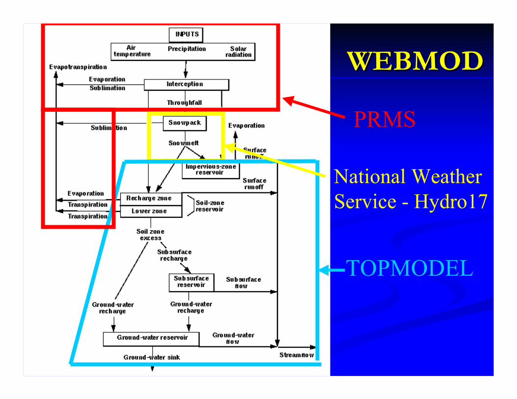
WEBMODWEBMOD
PRMS
National Weather Service - Hydro17
TOPMODEL
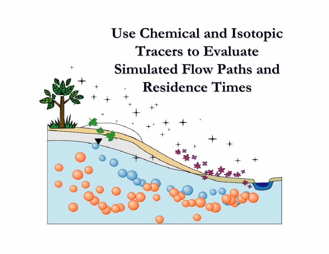
Next step: Use tracers to constrain the hydrologic solutions
Use Chemical and Isotopic Use Chemical and Isotopic Tracers to Evaluate Tracers to Evaluate
Simulated Flow Paths and Simulated Flow Paths and Residence TimesResidence Times
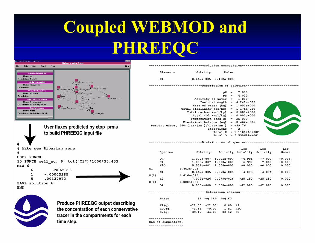
Coupled WEBMOD and PHREEQC
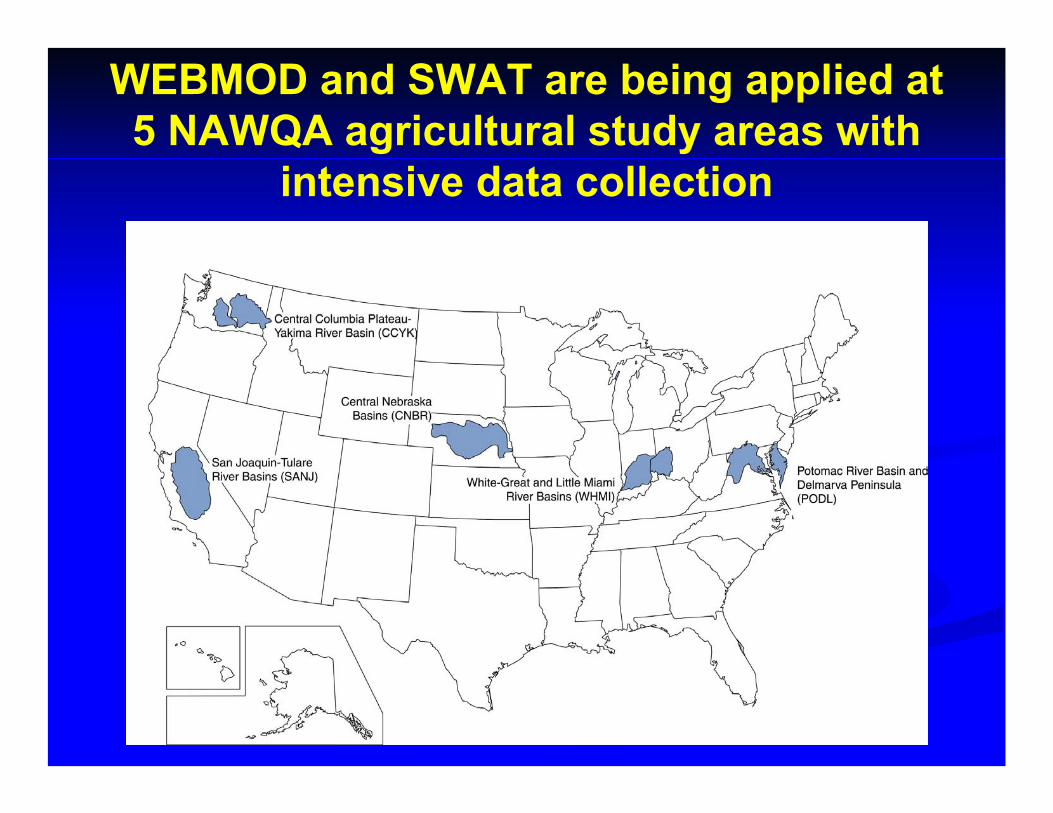
WEBMOD and SWAT are being applied at 5 NAWQA agricultural study areas with
intensive data collection
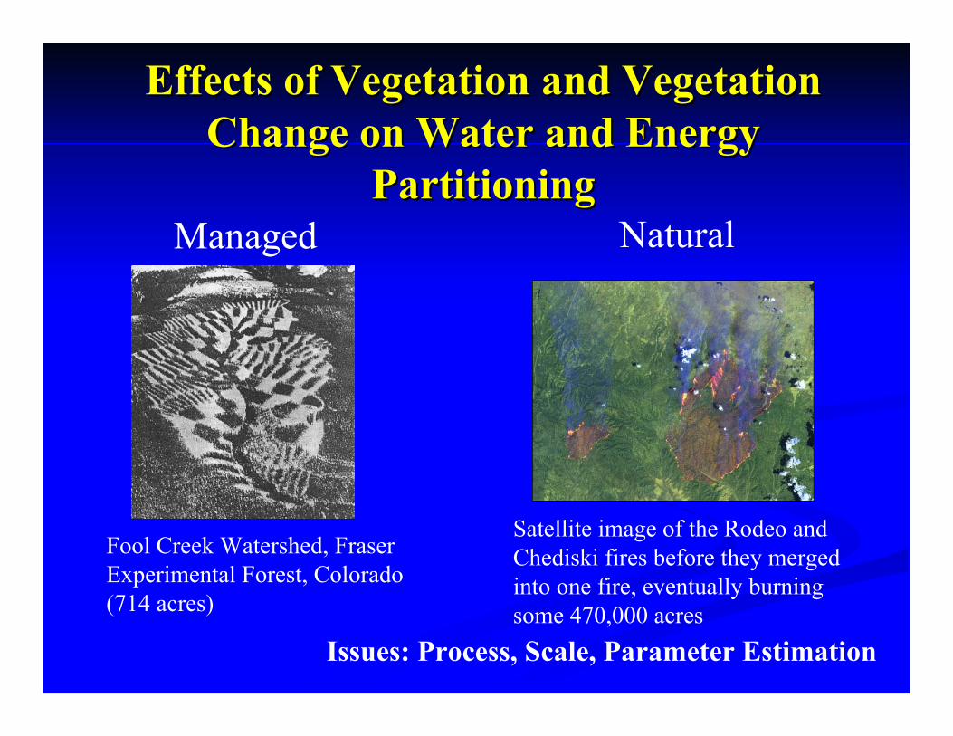
Satellite image of the Rodeo and Chediski fires before they merged into one fire, eventually burning some 470,000 acres
Effects of Vegetation and Vegetation Effects of Vegetation and Vegetation Change on Water and Energy Change on Water and Energy
PartitioningPartitioning
Fool Creek Watershed, Fraser Experimental Forest, Colorado (714 acres)
Managed Natural
Issues: Process, Scale, Parameter Estimation

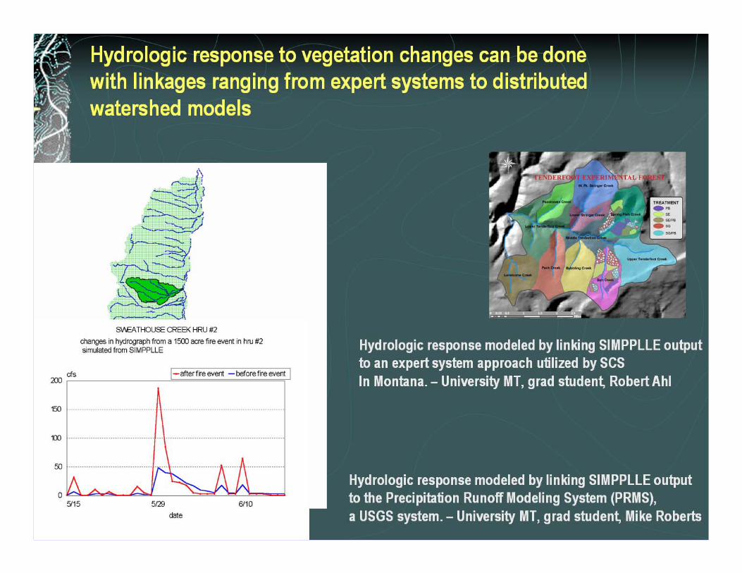
Vegetation Management ModelUS Forest Service, Missoula, Mt
•Simulates vegetation patterns and processes emphasizing the dynamics of landscape level change.
•Produces ensemble output
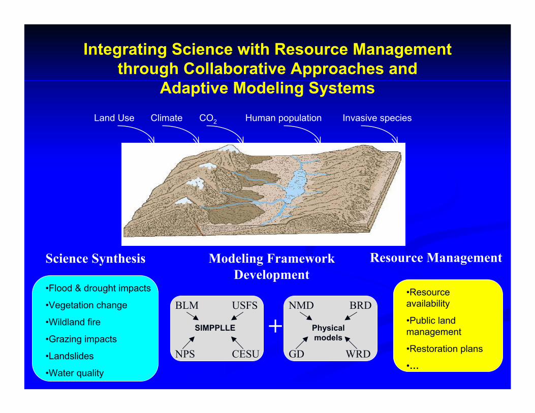
Integrating Science with Resource Management through Collaborative Approaches and
Adaptive Modeling SystemsLand Use Climate CO2 Human population Invasive species
GD WRD
BRDNMD
Physicalmodels
•Resource availability
•Public landmanagement
•Restoration plans
•…
•Flood & drought impacts
•Vegetation change
•Wildland fire
•Grazing impacts
•Landslides
•Water quality
Science Synthesis Modeling Framework Development
NPS CESU
USFSBLM
SIMPPLLE +
Resource Management
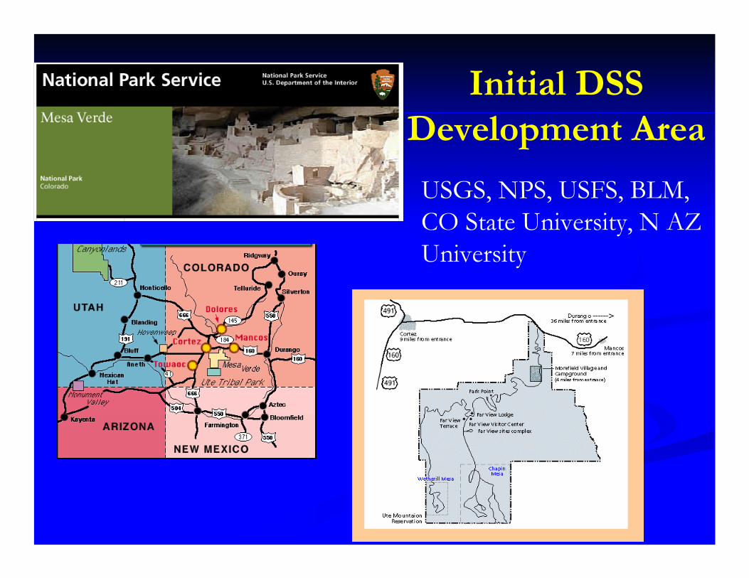
Initial DSS Development Area
USGS, NPS, USFS, BLM, CO State University, N AZ University
Integrating WaterIntegrating Water--Resource Resource and Socioand Socio--Economic ModelsEconomic Models
Population and Demand ForecastsPopulation and Demand ForecastsWater MarketsWater Markets
(change in ownership in perpetuity)(change in ownership in perpetuity)Water BankingWater Banking
(lease options over some period of time)(lease options over some period of time)
Issue: The better the prediction of the spatial and temporal distribution of water, the better the markets can perform.
This requires the full integration of physical-process and socio-economic models to optimize economic and institutional analyses.
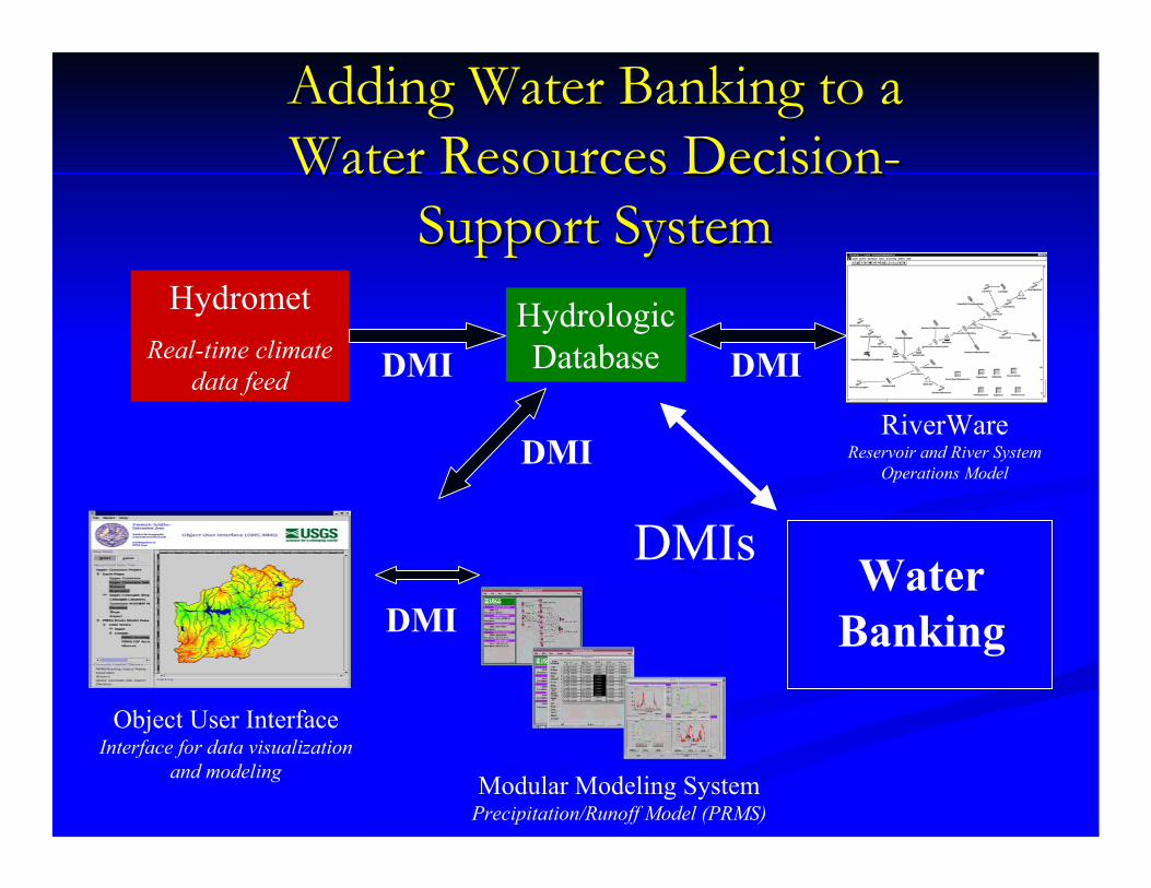
Adding Water Banking to a Adding Water Banking to a Water Resources DecisionWater Resources Decision--
Support SystemSupport SystemHydrologicDatabase
HydrometReal-time climate
data feed
RiverWareReservoir and River System
Operations Model
Object User InterfaceInterface for data visualization
and modeling Modular Modeling SystemPrecipitation/Runoff Model (PRMS)
DMI
DMI
DMI
DMIWater
Banking
DMIs

Integrated Framework DevelopmentIntegrated Framework DevelopmentCollaborative effort to integrate the Object Collaborative effort to integrate the Object
Modeling System (OMS) and the Modular Modeling System (OMS) and the Modular Modeling System (MMS)Modeling System (MMS)
OMS PlatformM
odel
Core
Mod
elBu
ilder
RZW
QM
PRM
S
Dat
abas
e
Netbeans IDE, Sun Forte,…
Java
Com
pile
r
XML
Test
ing
C++
Oth
er…
- ARS - USGS - NRCS
-Friedrich Schiller University, Germany
Branding

U.S. MULTIU.S. MULTI--AGENCY AGENCY MEMORANDUM OF MEMORANDUM OF UNDERSTANDINGUNDERSTANDING
Nuclear Regulatory Nuclear Regulatory Commission (NRC)Commission (NRC)Army Corp of Engineers Army Corp of Engineers (COE)(COE)US Geological Survey US Geological Survey (USGS)(USGS)NOAANOAADepartment of Department of Homeland SecurityHomeland Security
Facilitates cooperation in R&D of multi-media environmental models, frameworks, and databases for use
in human and environmental health risk assessment
Environmental Protection Agency (EPA)
Department of Energy (DOE)
US Agricultural Research Service (ARS)
Natural Resources Conservation Service (NRCS)
Bureau of Reclamation
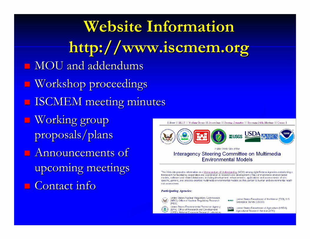
Website Information Website Information http://http://www.iscmem.orgwww.iscmem.org
MOU and addendumsMOU and addendumsWorkshop proceedingsWorkshop proceedingsISCMEM meeting minutesISCMEM meeting minutesWorking group Working group proposals/plansproposals/plansAnnouncements of Announcements of upcoming meetingsupcoming meetingsContact infoContact info
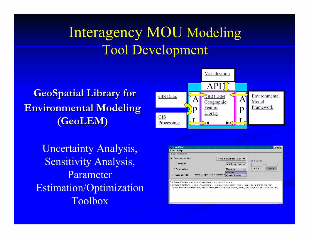
GeoSpatialGeoSpatial Library for Library for Environmental Modeling Environmental Modeling
((GeoLEMGeoLEM))
GIS Data:
GIS Processing:
GEOLEM Geographic Feature Library
API
API
Environmental Model Framework
APIVisualization
Uncertainty Analysis, Sensitivity Analysis,
Parameter Estimation/Optimization
Toolbox
Interagency MOU Modeling Tool Development
MMS Development is MMS Development is Accomplished Through Accomplished Through
Collaborative MultiCollaborative Multi--disciplinary disciplinary EffortsEfforts
MMS UNIVERSITY MMS UNIVERSITY COLLABORATIONCOLLABORATION
University of ArizonaUniversity of ArizonaNSF fundedNSF funded ---- Sustainability of semiSustainability of semi--Arid Hydrology and Arid Hydrology and Riparian Areas (SAHRA)Riparian Areas (SAHRA)
University of ColoradoUniversity of ColoradoNOAA fundedNOAA funded ---- Coupling of hydrologic and Coupling of hydrologic and atmospheric models to provide shortatmospheric models to provide short-- to longto long--term term forecastsforecasts
University of Nevada RenoUniversity of Nevada RenoDesert Research Institute fundedDesert Research Institute funded –– Watershed modeling Watershed modeling and coupled SW/GW modelingand coupled SW/GW modeling
Colorado State UniversityColorado State UniversityInteragency MOU funded Interagency MOU funded –– GeoLEMGeoLEM and Parameter and Parameter estimation, optimization, and sensitivity analysis toolsestimation, optimization, and sensitivity analysis tools
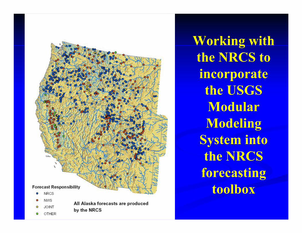
Working with the NRCS to incorporate the USGS Modular Modeling
System into the NRCS forecasting
toolbox
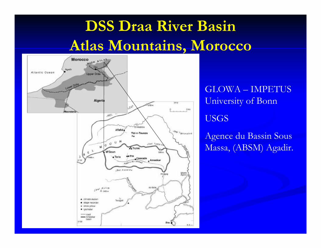
DSS Draa River Basin Atlas Mountains, Morocco
GLOWA – IMPETUS University of Bonn
USGS
Agence du Bassin SousMassa, (ABSM) Agadir.
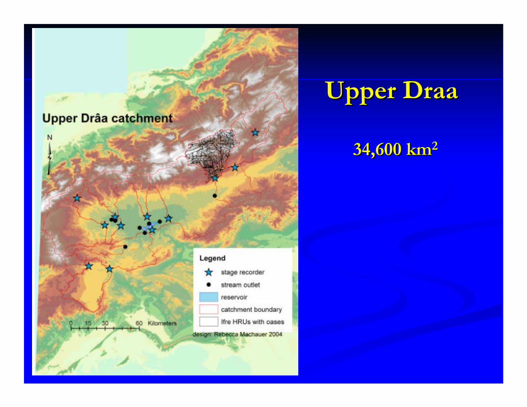
Upper Upper DraaDraa
34,600 km34,600 km2
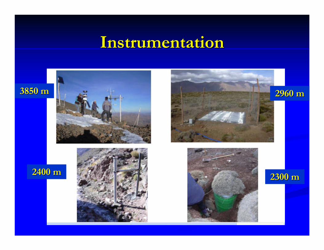
InstrumentationInstrumentation
3850 m3850 m 2960 m2960 m
2400 m2400 m 2300 m2300 m
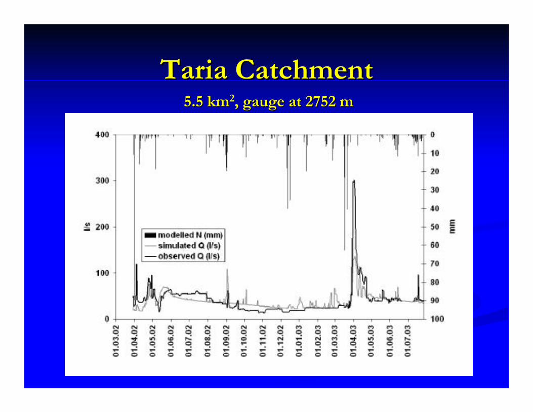
TariaTaria CatchmentCatchment5.5 km5.5 km2, gauge at 2752 m , gauge at 2752 m
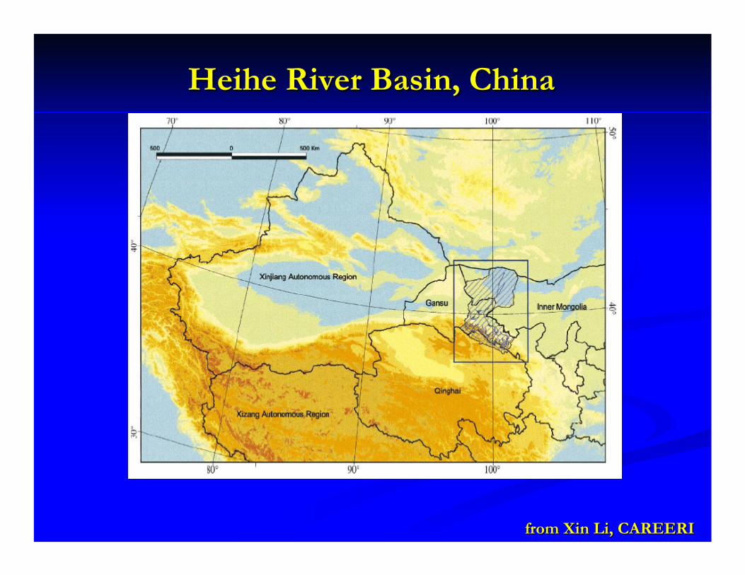
HeiheHeihe River Basin, ChinaRiver Basin, China
from from XinXin Li, CAREERILi, CAREERI
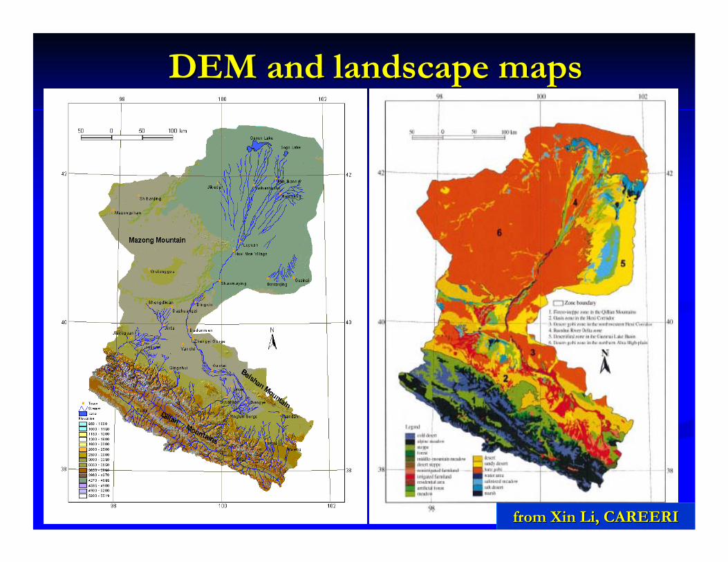
DEM and landscape mapsDEM and landscape maps
from from XinXin Li, CAREERILi, CAREERI
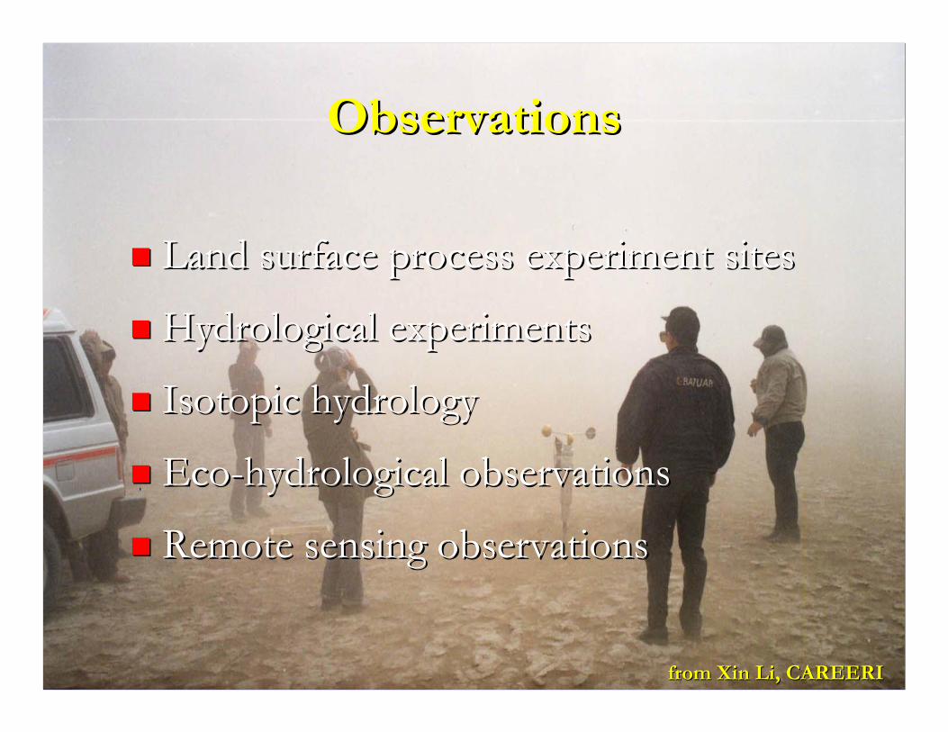
ObservationsObservations
Land surface process experiment sitesLand surface process experiment sites
Hydrological experimentsHydrological experiments
Isotopic hydrologyIsotopic hydrology
EcoEco--hydrological observationshydrological observations
Remote sensing observationsRemote sensing observations
from from XinXin Li, CAREERILi, CAREERI
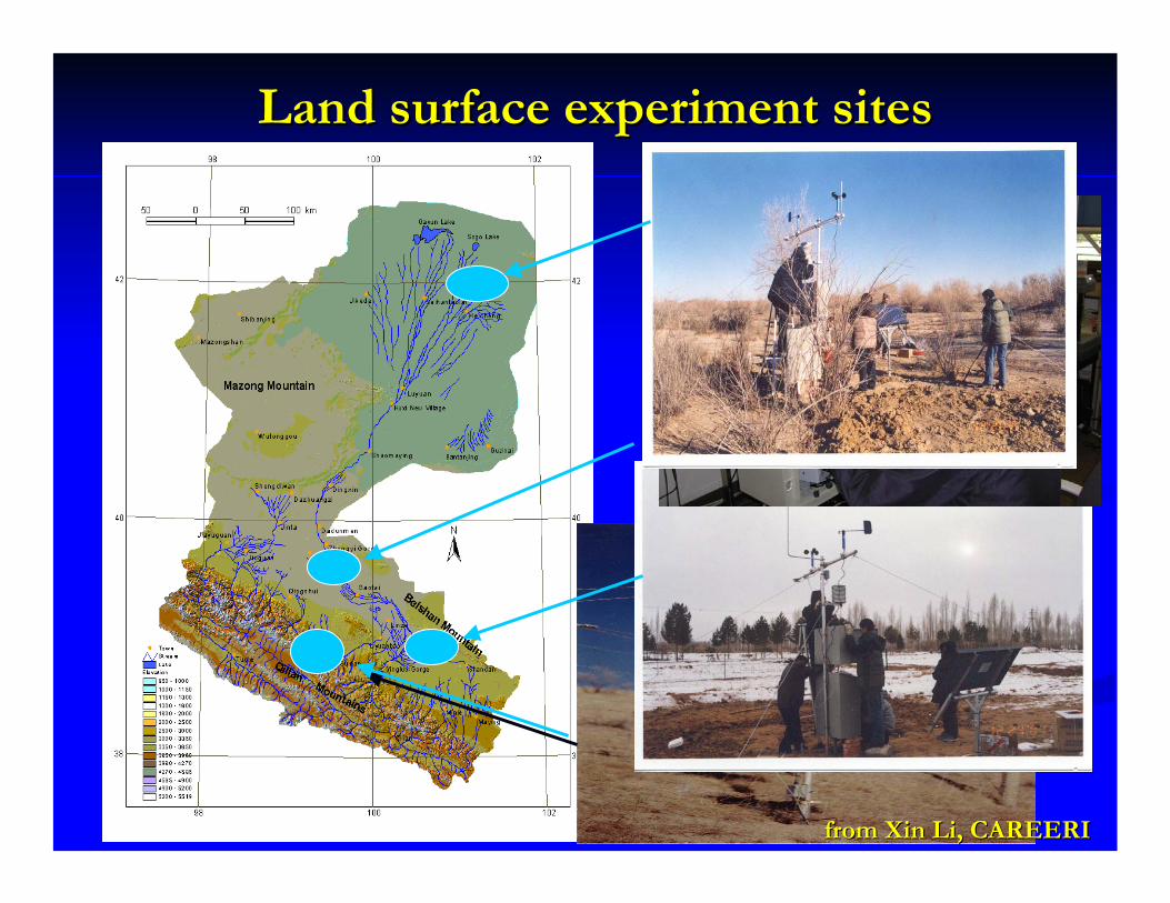
Land surface experiment sitesLand surface experiment sites
from from XinXin Li, CAREERILi, CAREERI

Modeling activitiesModeling activities
Land surface modelingLand surface modelingDistributed hydrological modelingDistributed hydrological modelingBasinBasin--scale climate modeling scale climate modeling Towards a decision support system Towards a decision support system
from from XinXin Li, CAREERILi, CAREERI

Remote sensingRemote sensing
Hydrological modelingHydrological modeling
Visual / Infrared MODIS TM ASTER AVHRR
Visual / Infrared MODIS TM ASTER AVHRR
Passive MicrowaveSSM/I AMSR
AMSR-E
Passive MicrowaveSSM/I AMSR
AMSR-E
SARASAR PALSAR
Vegetation index, LAI, fpar, NPP
Vegetation index, LAI, fpar, NPP
Surface temperature &
fluxes
Surface temperature &
fluxesSnowSnow Soil moistureSoil moisture Volume water
content
Land surface scheme
Land surface scheme
Distributed runoff model
Distributed runoff model
Ground water dynamics
Ground water dynamics
Integrated watershed model(new generation LSS)
Integrated watershed model(new generation LSS)
Meso-scale coupled model
Land surface data assimilation
system
Land surface Land surface data assimilation data assimilation
systemsystem
Mixel problem &data fusion
Ecological condition
Ecological conditionRe-analysis Dataset
Hydrological condition
Hydrological condition
Impacts on water resources
in basin scale
Impacts on water resources
in basin scale
Model integration, the strategy
from from XinXin Li, CAREERILi, CAREERI
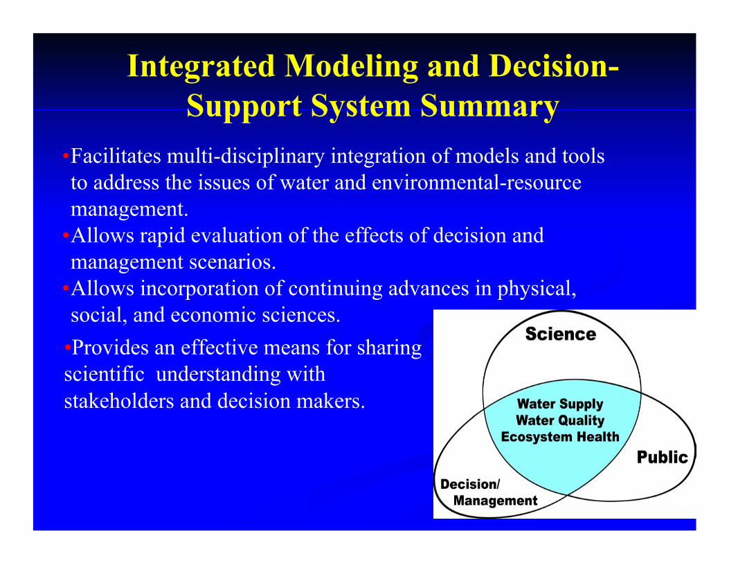
Integrated Modeling and Decision-Support System Summary
•Facilitates multi-disciplinary integration of models and tools to address the issues of water and environmental-resource management.
•Allows rapid evaluation of the effects of decision and management scenarios.
•Allows incorporation of continuing advances in physical, social, and economic sciences.
•Provides an effective means for sharing scientific understanding with stakeholders and decision makers.
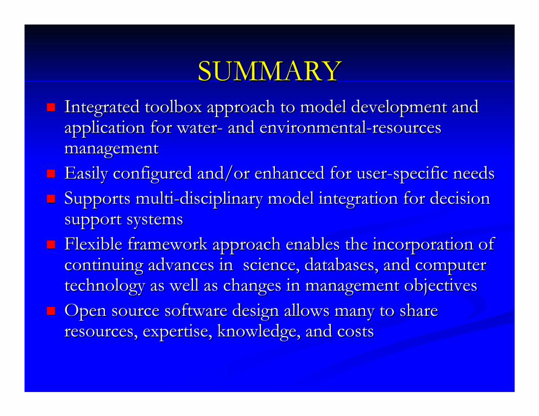
SUMMARYSUMMARYIntegrated toolbox approach to model development and Integrated toolbox approach to model development and application for waterapplication for water-- and environmentaland environmental--resources resources managementmanagementEasily configured and/or enhanced for userEasily configured and/or enhanced for user--specific needsspecific needsSupports multiSupports multi--disciplinary model integration for decision disciplinary model integration for decision support systemssupport systemsFlexible framework approach enables the incorporation of Flexible framework approach enables the incorporation of continuing advances in science, databases, and computer continuing advances in science, databases, and computer technology as well as changes in management objectivestechnology as well as changes in management objectivesOpen source software design allows many to share Open source software design allows many to share resources, expertise, knowledge, and costsresources, expertise, knowledge, and costs
Chicken Soup for the Modeling SoulChicken Soup for the Modeling Soul
“A fool with a tool is still a fool.”
System Development magazine
POINTPOINT
MORE INFORMATIONMORE INFORMATIONhttp://http://wwwbrr.cr.usgs.govwwwbrr.cr.usgs.gov/mms/mms
http://http://wwwbrr.cr.usgs.govwwwbrr.cr.usgs.gov/weasel/weasel
http://http://wwwbrr.cr.usgs.gov/warsmpwwwbrr.cr.usgs.gov/warsmp
http://http://oms.ars.usda.govoms.ars.usda.gov
http://http://www.iscmem.orgwww.iscmem.org
http://http://wwwbrr.cr.usgs.gov/projectswwwbrr.cr.usgs.gov/projects//SW_precip_runoff/papersSW_precip_runoff/papers