Embed Size (px)
Citation preview

1
The Mendip Way
Route Directions and Maps –Wells to Frome
Website: www.mendiphillsaonb.org.uk
Email: [email protected]
Facebook & Twitter: @MendipHillsAONB
Phone: 01761462338

2
Wells to Shepton Mallet – 6.1 miles
1. Leaving the museum behind you pass the cathedral on your left and head for the
small archway straight ahead. Go through the arch into the market place and then
turn immediately left through the large archway to the Bishops palace. Turn right and
follow the path with the moat to your left. Follow the moat all the way around to the
left until you reach the road.
2. Cross over the road and enter the woodland on Tor Hill to the right. Follow the wall
on the left then go up the steps on the right. Bear left where the path forks heading
uphill to the gate. Continue straight across the field and enter the woods opposite
and continue on the path. Leave the woods and cross a small paddock. As the
paddock widens follow the fence round to the right and through a narrow section then
left across the field to the stile.
3. Turn left on the track and follow the track for 1km as it passes the golf course and
enters a woodland. At the far end of the woodland the track goes through a gate then
bears left up a hill. At the top of the hill turn right and follow the path straight across a
field to the woods beyond. Keep to the left of the clearing where the path splits and
exit the woods through the gate and continue straight across the next field keeping to
the left hand side. Exit by the gate at the end and walk along the lane.
4. A short way along take the bridleway on your right and cross the field first to the left
then diagonally across to the far right hand corner. As the corner narrows take the
path through the gate and across the dip to the gate onto the lane. Turn left along the
lane and continue straight on past the solar farm.
5. Further along the lane take the path on the right through a narrow field and into a
larger field. Keep straight across the field to a stile on the far side. Cross over the
lane and into the next field heading for the far left hand corner. Turn left onto the road
for a short distance before taking the path on your right. Cross over diagonally left
keeping the metal barn on your right until you come to a stile. Cross the next field to
the far left hand corner. Continue straight across the next two fields to the double
gates. Cross this field keeping the wood to your right until you come to the kissing
gate on the corner of the wood. Follow the path down through the wood to the stream
at the bottom. Go over the stream and turn right up a steep bank and follow the path
through the quarry keeping the cliffs to your right. At the end of the cliffs go up the
stone steps and turn sharp right. Turn immediately right again up the wooden steps.
At the top of the steps turn left through the gate and follow the boundary of the field
all the way around to the gate on the far side.
6. Turn right on the road then immediately left onto the narrow track on the left. Halfway
down the track take the path off to the left through the gate and take the path past the
equestrian centre. At the end of the path turn right on the farm track then immediately
left on the road. A short way along the road turn right up the track then immediately
right through the kissing gate and head diagonally left towards the hedge sticking out.
At the end of the field go straight on through a gate and keep following the hedge on
the left bearing left at the end to a stile. Cross the field diagonally right to the gate

3
and go left then diagonally right down the steps. Go through the gate at the bottom
down the steps and left down the steep lane to a road. Cross the road and go slightly
right into an alley between two houses. Go up the alley to emerge on another road
beside the gates to a cemetery.
7. Again cross slightly to the right and take the footpath up some steps. At the top of
the hill bear right on a path to follow the right hand hedge until you come to a building
at the bottom right of the field. Turn left up the field to come to a pair of kissing gates
on your right. Go through the gates and follow the path between the wall and fence.
Continue along this path until the metal fence ends, keep ahead until you come to a
metal stile on your right. Ignoring this stile head left to a bridge under the disused
railway. Through this bridge the path goes right and leads down some steps to the
A37.
① ②
③ ④ ⑤
© Crown copyright and database right 2017. All rights
reserved. Ordnance Survey License number 100052600

4
⑤
⑥
⑦
⑧
© Crown copyright and database right 2017. All rights
reserved. Ordnance Survey License number 100052600

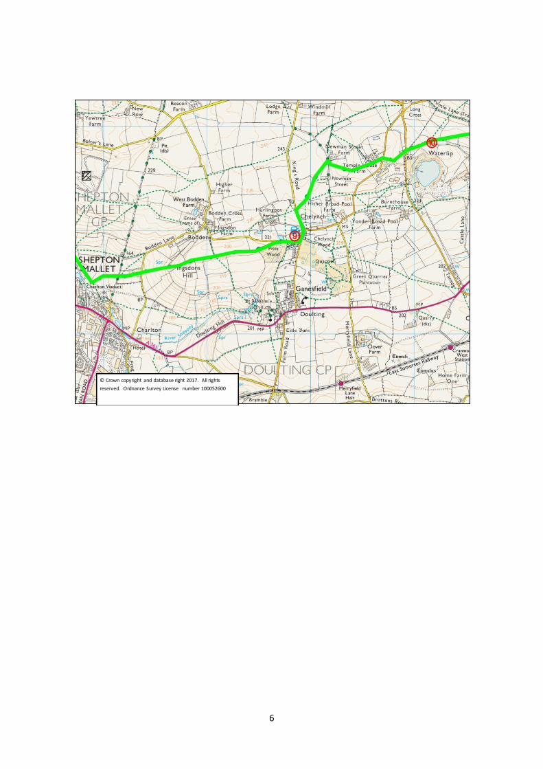
5
Shepton Mallet to Waterlip – 2.6 miles
8. Go left up the A37 to the end of the pavement, then cross over to Ivy House Farm
and go down the track. Go through a gate into a field and bear right to a double stile
at the corner of the wall on your right. Cross this stile and continue down the field to
a gate on your left. Go through the gate and continue down the hill, keeping the
Somerset and Dorset railway viaduct on your right, to come to a metal post stile.
Over the stile keep ahead until another metal post stile appears on your left. Turn left
past this stile and climb the hill diagonally to reach a stile in the hedge opposite.
Cross this stile onto a track, this track is the Foss Way, the Roman road from Exeter
to Lincoln, cross the track to some steps leading to a stile. Over the stile go up the
field towards a wood close to the end of the field bear left onto a small path through
the top of the woods and follow this through the wood to come to a kissing gate onto
a lane. Cross the lane, through the kissing gate and continue straight ahead up the
hill. When you reach a small clump of trees on your right, look for a kissing gate on
the right and go through to continue up the hill in front. When you reach the top look
back at the views extending to Glastonbury Tor and beyond. This is Igsdons Hill.
Continue ahead into a field as the route becomes a track. Where the track turns
sharp left continue ahead through a kissing gate and follow the right hand hedge to
come to a stile. Over the stile, continue to follow the right hand hedge towards a
wood on the right and a kissing gate onto a lane.
9. Turn right on the lane and walk down passing a pond on the left and climb the slope,
ignoring a crossing path, to come to Chelynch. Turn left and walk straight past the
Poachers Pocket on your left, continuing straight ahead out of the village. Look out
for some stone steps on your right and climb them to cross a stone stile into a field.
Go half left across this field to come to a gap in the hedge with a stone stile in the top
right of the field, go through and ignoring a path to the right follow the right hand
hedge to come to a kissing gate - if there are crops in the field you may need to walk
around the field boundary on the right rather than follow the right of way across the
field. Continue across the field to another kissing gate leading onto a lane. Turn
right on the lane and walk for about fifty meters to a field gate on the left. Through
this gate head up the field, slightly to the right, to come to a pair of kissing gates at
the top. Through the gates continue straight across the field, with a wind turbine on
your left, to come to another Kissing gate. Continue across the next field to come to
a stone stile onto a road. Turn left on the road for a few meters and take the lane on
the right opposite Temple House Farm. Follow this lane until you come to a road.
6
⑨
⑩
© Crown copyright and database right 2017. All rights
reserved. Ordnance Survey License number 100052600

7
Waterlip to Great Elm – 7.5 miles
10. Cross the Stoke St Michael road to the path opposite, to a 2 step stile with a wooden
sign post. Further up the grassy track turn right through what appears to be a garden
and go up the slope bearing left to reach a kissing gate. Go through the gate and
cross to the field gate opposite, go through this gate and follow the path to the right,
to a gate in the right hand corner. Go through this gate head right across the field,
passing a corner in the hedge to come to a kissing gate in the far hedge. Go through
into the woods turning left to come to another kissing gate, and go through onto
Funtle Lane. Turn right through the gateway and follow the track past the house to
come to a bridle gate, go through and continue straight across the field ahead.
Keeping the woods to the right cross over two more stiles and continue to a gate in
the corner. Looking to your left you can see the top of Cranmore Tower. Go through
the gate turn right onto a track going downhill, after about 80 meters look out for a
kissing gate on the left, where the path goes left and right. Turn back through this
gate and climb diagonally up the hill to a kissing gate in the far right corner. Go
through this gate, turn left and go over a stile into the woods around Cranmore
Tower. Keep ahead following the left hand hedge, passing the tower on your right, to
continue downhill. Follow the fence on the left downhill until you see a track crossing
through a gate on the left and heading off to the right around a left hand turn.
11. Ignore the track and turn sharp right and continue following the signs on posts, to
follow a level but narrow path across the hill. Follow this path, ignoring larger tracks
to left and right until you see a kissing gate at the edge of the wood. A large tree has
fallen here and appears to block the way, but go through and walk to the right and go
through a kissing gate ahead and slightly the right. Follow the right hand hedge
down the field. The OS map shows the path in the field to the right but this is
incorrect. The path continues through a kissing gate with the hedge on the right.
Cross a stile in an electric fence and continue to follow the right hand hedge. Go
through a kissing gate on the right onto a track, and follow the track down to another
kissing gate on the left and go through into the woods. At the end of the woods, go
through another kissing gate and cross the fields ahead. Go through a kissing gate
onto a lane. Go right on the lane then left onto a road. Follow this road for about 200
meters then take the minor road on the right.
12. When the road goes sharp right go ahead on a drive labelled Little Manor, Private
Drive. Where the drive goes to the left, take the kissing gate on the right, signpost
Frome Asham Woods. Follow the path between the hedge and a post and rail fence
until a kissing gate that leads to Asham Woods. Follow the track through the woods
until you come to a sign pointing to a small path to the left. Follow this path, with
care as the 4x4s have created big ruts, passing an old stile, until you come to a
stream. Cross the stream and bear left up the hill to another marker. Take the right
hand path and follow as it undulates through the trees, to come eventually up a hill to
turn right onto a track out of the woods. As the path bends left and uphill in the
woods it splits and you take the left hand path straight ahead to find the track out of

8
the woods. At the edge of Asham Woods follow the sign onto a track and out of the
woods. The OS map is incorrect, the track is the correct path. Follow the track and
go through a gate onto a road. Go through two more gates to dip under the main
road and carry on through a gate ahead. At the road junction go left along the road
and at the next junction turn right until you come to a footpath sign on your left. Go
through the gate, cross the field to the kissing gate in the opposite hedge, go through
and bear left to a kissing gate in the next hedge. Go through the gate and turn right
onto a track. Follow this track as it goes left and right until you come to a road. The
road to the left was cut when Whatley quarry was expanded.
13. Cross the road into the woods by the signpost and through the kissing gate. Follow
the quarry fence on the left and keep ahead when the fence disappears. Keep
following the path as it meanders beside a stream, until you can cross to a kissing
gate. Go through and across the field to a wall by a road. Turn left before the wall
and cross the stream and field to another kissing gate onto a track. Turn left along
the track. When you come to a fork take the left lower track, and follow the stream
on the left. When you see the quarry buildings on the left, the path goes right up a
long flight of steep steps. When you get to the top of the second flight go left and
keep left at the path junction, passing an old steel water tank to come down to a
road.
14. Turn right up the road for about 10 meters and cross to take the path up the bank.
Go through the kissing gate into a field and follow the hedge to the left. Look to the
right and you will see the spire of Whatley Church. Keep on through 3 kissing gates
to come onto a track. Go right on the track until you come to a bridle gate on the
right. Ignore this and go left to follow the hedge to come to a gate onto a road.
Cross the road and go left to reach a path into the woods on the right via a kissing
gate. Follow the path through the woods to a junction and take the left down the hill.
Follow the path across a stream and across the railway ahead. Go right to a crossing
path with steps to your left; turn right to come to the stream again. Cross the bridge
and follow the path to come to a kissing gate that leads onto a road by a bridge. This
is Great Elm.

9
⑫
⑬
© Crown copyright and database right 2017. All rights
reserved. Ordnance Survey License number 100052600
⑩
⑪
⑫
© Crown copyright and database right 2017. All rights
reserved. Ordnance Survey License number 100052600

10
⑬
⑭
⑮
© Crown copyright and database right 2017. All rights
reserved. Ordnance Survey License number 100052600

11
Great Elm to Frome – 2.6 miles
15. Cross the road and follow the permissive path beside the Mells Stream. Follow this
path, keeping the river to your left as it goes round a long curve to the right and going
under a rail bridge. Where you see a bridge to your left, do not cross, but keep the
stream on your left. You are now back on a public footpath. Follow this path where it
passes under a bridge through a gate. Ignore the signs to the left and cross the
bridge ahead to now keep the stream on your right taking the right hand fork just after
the bridge.. On the left are some partially restored lime kilns. Ignore the first bridge
on the right but cross the second. Continue to follow the path by the stream until you
come to a sign post on the left.
16. Take this path which climbs steeply to a stile into a field. Cross the field to a stile
opposite onto a road go straight across to a track leading up through a field. Where
the track bears left keep going straight on up the hill on the path to a gate. Go
through the gate and straight ahead up the hill, past houses on the right, and
eventually come to a road.
17. You are now on the outskirts of Frome. Cross the road on the left in front of the mini
roundabout turn right then left down Whatcombe Road. Cross over to take Upper
Whatcombe on the right. When you come to the bottom of some steps on your right,
turn right onto a footpath which curves up to the left. Follow this footpath into a lane
between houses, passing a sign showing it unsuitable for vehicles, to come to
Goulds Ground behind Trinity Church. Follow on to Trinity Row, and continue along
York Street to reach Selwood Road. Go left onto Selwood Road then right into
Trinity Street. Take the second right into Castle Street and look for a set of steps on
your left. Go down the steps and walk ahead to Catherine Street.
18. Turn left into Catherine Street and follow down the hill until it becomes Catherine Hill,
where the cobbles start. Go down Catherine Hill and then left into Stony Street to
arrive at Frome Market Place. Go left into Cork Street, cross the crossing and go
right around the National Westminster Bank to pass the George and continue along
past the shops to come to the Bridge over the river Frome. This bridge is almost
unique in having houses built on it. Cross the bridge and take the first left towards
the Market Yard Car Park. Go into the car park and head for the Cheese and Grain
hall to the right.
19. This is the end of the Mendip way, and you can enjoy a well-earned drink in the
Cheese and Grain café.

12
⑮
⑯
⑰
⑱
⑲
© Crown copyright and database right 2017. All rights
reserved. Ordnance Survey License number 100052600