Embed Size (px)
Citation preview
Somerset County Council Regulation Committee – 12th April 2018 Report by Service Manager – Planning Control Enforcement & Compliance: Philip Higginbottom
Application Number: Date Registered: Parishes: District: Member Division: Local Member: Case Officer: Contact Details: Description of Application:
Grid Reference: Applicant: Location:
2016/0665/CNT 16/03/2016 Stoke St Michael, Doulting and Cranmore Mendip Mendip Central and East Philip Ham Ben Gilpin 01823 359738 [email protected] Construction of three Replacement Tips at the Moons Hill Quarry Complex at Stoke St. Michael, Shepton Mallet, BA3 5JU E: 365930 N: 145973 John Wainwright and Company Ltd Moons Hill Quarry Complex, Mendip Road, Stoke St Michael, Somerset, BA3 5JU
1. Summary of Key Issues and Recommendation 1.1 The key issues for Members to consider are: - Principle of Development - Highways - Amenity (residential and users) – noise / dust / light - Visual and Landscape Character Impact - Ecology - Water Management (subterranean / surface water) - Archaeology - Land Stability - Other Matters - Planning Balance It is recommended that planning permission be granted subject to the imposition of the conditions in section 10 of this report and that authority to undertake any minor non-material editing, which may be necessary to the wording of those conditions be delegated to the Service Manager, Planning Control Enforcement & Compliance.
2. Site Description 2.1 The site comprises 3 separate sites, on which it is proposed to tip overburden from the consented quarry operations. The three sites (tips) are referred to as Tip A, Tip B (Tip B West and Tip B East), and Tip D in this report. The three tips (Tip A, Tip B and Tip D) are located at the periphery of the existing quarry. 2.2 The nearest residential properties (built form) to the proposed tips not in the control of the applicant are, to the west (Tip A), Upper Three Ashes Farm / Box Tree Cottage – circa 190 metres; to the south (Tip B), Long Cross Cottage – circa 85 metres; and to the south east (Tip D), Long Cross Farm – circa 85 metres. 2.3 The site has no statutory designation constraints. The nearest heritage asset (Box Tree Cottage – Grade II Listed Building) is circa 150 metres to the west of the boundary of Tip A. The distance of 150 metres relates to the curtilage (garden) of the Listed Building and not the Listed Building itself (the garden being circa 40 metres in length from east to west). 2.4 Across the north western part of the proposed tipping site (Tip A) runs the ‘SM18/10’ Public Right of Way (PRoW), and is detailed as a ‘Footpath’. This PRoW would be directly affected and it is proposed to be diverted. 2.5 The site is within the Silurian Andesite Safeguarded Area as defined in the Somerset Minerals Plan (2015). The Somerset Minerals Plan (SMP) states that Silurian Andesite is used for road surfacing, and Moons Hill Quarry is identified in the Somerset Minerals Plan as the only active Silurian Andesite quarry in the county. 2.6 There has been an operational quarry at this site for over 100 years. The main mineral quarried is Andesite, which is a high value mineral (compared for example to limestone aggregate) due to its high ‘Polished Stone Value’, which makes it suitable for use in road surfacing. The mineral is supplied to customers beyond Somerset since the nearest available alternative sources are in South Wales and Ireland, making this a regionally and nationally important mineral. 2.7 The Moons Hill Quarry complex consists of two quarry sites and is located approximately 600m south of the village of Stoke St Michael and 5 km northeast of the town of Shepton Mallet. The operation has two quarry sites, Moons Hill Quarry to the east and Stoke Quarry to the west straddle the public highway ‘Long Cross Bottom’. Mineral is processed and stored within both sites. 2.8 The existing access to both quarries is off the minor road ‘Long Cross Bottom’. 2.9 The quarry complex is located immediately to the north of a gently sloping ridge which runs east-west. It lies within a rural area used predominantly for agricultural grazing. The area is not within the Mendip Hills AONB, the nearest part of which lies 8.3 km to the west. 2.10 Tip A is to be 13.95 hectares is area. Tip B (West) is to be 5.35 hectares in area. Tip B (East) is to be 5.42 hectares in area. Tip D is to be 16.62 hectares in area.
2.11 Part of the quarry complex overlaps the Moons Hill Site of Scientific Interest (SSSI) which is designated due to its geological interest. None of Tip A, Tip B or Tip D would abut or overlap the SSSI. 3. Site History 3.1 The relevant planning history of the site is as follows:
- PL\2207\12 (2011/1264/cond.18): Increase height of Moons Hill South Mineral Tip, and Phase 3 of Mill Marsh Mineral Tip, and link the two through tipping of Mineral Waste from Moons Hill Quarry - details to satisfy condition 18 (Stability) – refused (22.08.2012).
- 2011/1264: Increase height of Moons Hill South Mineral Tip, and Phase 3 of Mill Marsh Mineral Tip, and link the two through tipping of Mineral Waste from Moons Hill Quarry – conditionally permitted (07.11.2011) 4. The Proposal 4.1 This full planning application seeks planning permission for the construction of three replacement tips at the Moons Hill Quarry complex at Stoke St. Michael, Shepton Mallet. Tip Volumes / End Heights 4.2 The three tips identified are needed to accommodate 1.63 million cubic metres of over burden. For clarity, Tip A and Tip B (East and West) have included 10% contingency capacity (as reflected in the figures below). The design of Tip D does not include 10% contingency capacity. 4.3 Tip A is proposed to accommodate 1.141 million cubic metres of over burden. The final height of Tip A would be 269 metres Above Ordnance Datum (AOD). The existing ground level at ‘Tip A’ is 249 metres AOD. 4.4 Tip B (East and West) are proposed to accommodate 0.745 million cubic metres of over burden. The final height of Tip B (West) would be 284.5 metres AOD. The final height of Tip B (East) would be 266 metres AOD. The existing ground level at ‘Tip B’ is 257.2 metres AOD. 4.5 Tip D is proposed to accommodate 0.91 million cubic metres of over burden. The final height of Tip D would be 288.5 metres AOD. The existing ground level at ‘Tip D’ is 270.5 metres AOD. 4.6 The resulting design of the three tips has been stated as sufficient to hold all of the remaining over burden that would be generated from the permitted mineral reserves at Moons Hill Quarry.
Tip Slope Profiles 4.7 The outer slope profiles of each tip are designed to be no greater that 1 in 5 (20 degree slopes) Tip Operations – Time for Completion / Hours of Working 4.8 Tip A would take 5-6 years to complete commencement, with working on the site between 08.00 hours and 18.00 hours, Monday to Friday, with no working on Saturdays, Sundays, Public or Bank Holidays. 4.9 Tip B would take 6 years to complete from commencement, with working on the site between 08.00 hours and 19.00 hours, Monday to Friday, with no working on Saturdays, Sundays, Public or Bank Holidays. 4.10 Tip B would take 8-11 years to complete from commencement, with working on the site between 08.00 hours and 19.00 hours, Monday to Friday, with no working on Saturdays, Sundays, Public or Bank Holidays. Direction of Tipping / Working 4.11 Each Tip would be worked from the furthest point from over burden source, back towards the quarry, with visual and acoustic bunding being created from tipped over burden as part of the first phase of each tip. 5. THE APPLICATION 5.1 Documents submitted with the original planning application are: Plans / LVIA PHOTO 594A-10-11 Tips A B & D_VP15&16 594A-10-10 Tips A B & D_VP14_E view 594A-10-09 Tips A B & D_VP13&14 594A-10-08 Tips A B & D_VP11&12 594A-10-07 Tips A B & D_VP9&10 594A-10-06 Tips A B & D_VP7&8 594A-10-05 Tips A B & D_VP5&6 594A-10-04 Tips A B & D_VP3&4 594A-10-03 Tips A B & D_VP1&2 594A-10-02 Tips A B & D_Context and VP's 3 – 14 594A-10-01 Tips A B & D_Context and VP's 1, 2, 15 & 16 594A-01-29_New Post Rest PRoW 594A-01-28_PRoW Diversions 594A-01-27Rev.A_Tip D_ Restoration Scheme 594A-01-26Rev.A_Tip B_ Restoration Scheme 594A-01-25Rev A_Tip A_ Restoration Scheme 594A-01-24Rev.A_Tip D Section B-B' Phases 6 to 9 594A-01-22Rev.A_Tip D Section A-A' Phases 5 to 8 594A-01-23Rev.A_Tip D Section B-B' Phases 1 to 5
594A-01-21Rev.A_Tip D Section A-A' Phases 1 to 4 594A-01-20Rev.A_Tip D - Concept working scheme 594A-01-19Rev.A_Tip B Section C-C' Phases 1 to8 594A-01-18Rev.A_Tip B Section B-B' Phases 11 to18 594A-01-17Rev.A_Tip B Section A-A' Phases 7 to 16 594A-01-15Rev.A_Tip B - Concept working scheme 594A-01-16Rev.A_Tip B Section A-A' Phases 1 to 6 594A-01-13Rev.A_Tip A Section B-B' 594A-01-14Rev.A_Tip A Section C-C' 594A-01-11Rev.A_Tip A Section A-A' Phases 5 to 9 594A-01-12Rev.A_Tip A Section A-A' Phases 10 to 14 594A-01-10Rev.A_Tip A Section A-A' Phases 1 to 4 594A-01-09Rev.A_Tip A - Concept working scheme 594A-01-07Rev.A_Tip B - Final landform 594A-01-08Rev.A_Tip D - Final landform 594A-01-06Rev.A_Tip A - Final landform 594A-01-05_Tip D_Topo Survey 594A-01-04_Tip B_Topo Survey 594A-01-03_Tip A_Topo Survey 594A-01-01Rev.A_Site Location Plan 594A-01-02Rev.A_Site Plan MAP - Theoretical Visibility Forms / Reports Hollands Pond GtCNewt Survey MH AD Ecology PL12 Landscape Design Strategy v3 APPLICATION FORM Moons Hill Planning Application Contents Page Replacement Planning Statement v1 Certificates v1 Environmental Statement: APPDX 5 Low Productivity Grassland Scheme APPDX 3 Dust Management Scheme v2 APPDX 4 Woodland & Hedgerow Scheme APPDX 2 Soil & Grass Seeding Procedures APPDX 1 Tip A B and D stability assessment 160107 v03 Non -Technical Summary v1 ENV STATMNT CONTENTS Front Page v1 ENV STATMNT Ch10 Landscape Visual Impact Ch 10 - LVIA v1 ENV STATMNT Ch10B Landscape Visual Impact Appendix 10B Methodology ENV STATMNT Ch10 Appendix 10A References ENV STATMNT Ch9 - Noise v1 ENV STATMNT Ch9 Noise Appendices 9A to 9C ENV STATMNT Chapter 8 Appendices ENV STATMNT Chapter 8 -Hydrology and Hydrogeology (including Flood Risk) v1 ENV STATMNT Chapter 7 - Traffic & Highways v1 ENV STATMNT Chapter 6 - Ecology v1
ENV STATMNT Ch6 ECOLOGY Appendices 6A to 6G ENV STATNT Chapter 5 - Community Social Effects v1 ENV STATMNT Chapter 4 Cultural Heritage v2 ENV STATMNT Ch4 Appendix 4C Archaeological Trial Trench Evaluation ENV STATMNT Ch4 Appendix 4B Geophysical Survey (Magnetic) ENV STATMNT Ch4 Appendix 4A Archaeological Desk Based Assessment ENV STATMNT Ch4 TIP B Trial Trenches 594A-04-03 ENV STATMNT Ch4 TIP B Geophysical Survey 594A-04-02 ENV STATMNT Ch4 Heritage Assets 594A-04-01 ENV STATMNT Chapter 3 - Cumulative v1 ENV STATMNT Chapter 2 - Alternatives v1 ENV STATMNT Chapter 1 Introduction v1 Email concerning the Scoping Opinion Email concerning the Scoping Opinion (2 ES Front Cover, Contents & Acknowledgments v2 5.2 Following initial consultation additional information was formally requested under Regulation 22 of the Town and Country Planning (Environmental Impact Assessment) Regulations 2011 (the EIA Regs), and subsequently advertised as required. The submitted Regulation 22 documents submitted are listed below (with the prefix ‘REG22’): REG22 Chapter 9 Appendices v2 REG22 Chapter 9 - Noise v2 REG22 Chapter 6 - Ecology v2 REG22 Appendices 6A to 6H - Ecology v2 REG22 NEs Scoping Opinion REG22 SCC Scoping Opinion REG22 NEW INFO Chap1 Intro v2 REG221 PLN 594B-01-62 PRoW Diversions REG22 PLN594B-01-23 Tip A SectCC' Midway Ph1A-3A REG22 PLN 594B-01-66 Tip D Restoration Scheme REG22 PLN 594B-01-65 Tip B Restoration Scheme REG22 PLN 594B-01-63 Post-Rest PRoW Plan REG22 PLN 594B-01-64 Tip A Restoration Scheme REG22 PLN 594B-01-61 Tip A Sections Through Attenuation Features REG22 PLN 594B-01-60 Tip D SectBB' MM FARM Ph3B-5A REG22 PLN 594B-01-59 Tip D SectBB' MM FARM Ph1A-3A REG22 PLN 594B-01-58 Tip D SectAA' LC FARM Ph3B-5A REG22 PLN 594B-01-57 Tip D SectAA' LC FARM Ph1A-3A REG22 PLN 594B-01-56 Tip D Ph5 REG22 PLN 594B-01-55 Tip D Ph4B REG22 PLN 594B-01-54 Tip D Ph4A REG22 PLN 594B-01-53 Tip D Ph3B REG22 PLN 594B-01-52 Tip D Ph3A REG22 PLN 594B-01-51 Tip D Ph2B REG22 PLN 594B-01-49 Tip D Ph1B REG22 PLN 594B-01-50 Tip D Ph2A REG22 PLN 594B-01-48 Tip D Ph1A REG22 PLN 594B-01-47 Tip B SectCC' LC Farm Ph6A-6C

REG22 PLN 594B-01-46 Tip B SectCC' LC Farm Ph4B-5B REG22 PLN 594B-01-45 Tip B SectCC' LC Farm Ph3A-4A REG22 PLN 594B-01-44 Tip B SectCC' LC Farm Ph1A-2B REG22 PLN 594B-01-43 Tip B SectBB' LC Cottage Ph6A-6C REG22 PLN 594B-01-42 Tip B SectBB' LC Cottage Ph4A-5B REG22 PLN 594B-01-41 Tip B SectAA' Knapps Fm Ph5B-6C REG22 PLN 594B-01-40 Tip B SectAA' Knapps Fm Ph3B-5A REG22 PLN 594B-01-39 Tip B SectAA' Knapps Fm Ph1A-3A REG22 PLN 594B-01-38 Tip B Ph6C REG22 PLN 594B-01-37 Tip B Ph6B REG22 PLN 594B-01-36 Tip B Ph6A REG22 PLN 594B-01-35 Tip B Ph5B REG22 PLN 594B-01-34 Tip B Ph5A REG22 PLN 594B-01-33 Tip B Ph4B REG22 PLN 594B-01-32 Tip B Ph4A REG22 PLN 594B-01-31 Tip B Ph3C REG22 PLN 594B-01-30 Tip B Ph3B REG22 PLN 594B-01-29 Tip B Ph3A REG22 PLN 594B-01-28 Tip B Ph2B REG22 PLN 594B-01-27 Tip B Ph2A REG22 PLN 594B-01-26 Tip B Ph1B REG22 PLN 594B-01-25 Tip B Ph1A REG22 PLN 594B-01-24 Tip A SectCC' Midway Ph3B-5B REG22 PLN 594B-01-22 Tip A SectBB' Knapps Ph3B-5B REG22 PLN 594B-01-21 Tip A SectBB' Knapps Ph1A-3A REG22 PLN 594B-01-20 Tip A SectAA' 3Ashes Ph3B-5B REG22 PLAN594A-01-03 Tip A Topo Survey REG22 PLAN 594B-01-19 Tip A SectAA' 3Ashes Ph1A-3A REG22 PLAN 594B-01-18 Tip A Ph5B REG22 PLAN 594B-01-17 Tip A Ph5A REG22 PLAN 594B-01-16 Tip A Ph4B REG22 PLAN 594B-01-15 Tip A Ph4A REG22 PLAN 594B-01-14 Tip A Ph3B REG22 PLAN 594B-01-13 Tip A Ph3A REG22 PLAN 594B-01-12 Tip A Ph2B REG22 PLAN 594B-01-11 Tip A Ph2A REG22 PLAN 594B-01-10 Tip A Ph1B REG22 PLAN 594B-01-09 Tip A Ph1A REG22 PLAN 594B-01-08 Tip D Final Landform REG22 PLAN 594B-01-07 Tip B Final Landform REG22 PLAN 594B-01-06 Tip A Final Landform REG22 PLAN 594A-01-05 Tip D Topo Survey REG22 PLAN 594A-01-04 Tip B Topo Survey REG22 PLAN 594A-01-02 Rev.A Site Plan REG22 PLAN 594A-01-01 Rev.A Site Location REG22 NEW INFO Reg22 Apx G Chpt10 Add Info v1 REG22 NEW INFO Reg22 Apx G Chpt10 Add Info PM REG22 NEW INFO Reg22 Apx E Draft Tip A UU REG22 NEW INFO Reg22 Appx B GWP Ltr Rpt REG22 NEW INFO Reg 22 Request- Appx A
REG22 NEW INFO Reg 22 Apx H Tip D Noise Table REG22 NEW INFO Reg 22 Apx I Bridleway Access Statement REG22 NEW INFO Reg 22 Apx H Tip A Noise Table REG22 NEW INFO Reg 22 Apx H Tip B Noise Table REG22 NEW INFO Reg 22 Apx F Draft Tips B & D UU REG22 NEW INFO Reg 22 AppxD BCL Ltr Rept REG22 NEW INFO Reg 22 AppxC Stability Assmnt REG22 NEW INFO Response to 2016 Reg22 Request v1 REG22 NEW INFO PLAN Post-Rest PRoW 6. Environmental Impact Assessment (EIA) 6.1 The applicant screened the proposal and acknowledged the proposed development would be deemed EIA development. 6.2 The applicant made a formal ‘Scoping Opinion’ request to Somerset County Council (SCC). The formal ‘Scoping Opinion’ (SCC reference PL/2778/14SCOPE) was issued to the agent of the current planning application on 22nd September 2015. 6.3 The EIA Scoping Opinion, as listed above, and published on line / on file, identified all elements that would need consideration as part of the formal Environmental Statement (ES) that would be required to accompany and support the planning application. Such a statement is to contain and conclude on the Environmental Impact Assessment findings from the proposed development. 6.4 The ES and the subsequent Regulation 22 submissions have been considered and commented upon by interested parties and Statutory Consultees. 7. Consultation Responses Received Mendip District Council: NO OBJECTION No objections are raised subject to the Minerals and Waste Planning Authority (SCC) being satisfied that the proposals would not have an adverse impact upon flood risk, local ecology, the landscape, the amenity of local residents, the setting of heritage assets, public right of way and highway safety. Stoke St Michael Parish Council: OBJECTION Generally there were grave concerns expressed which centred on the scale of the proposals and the impact on the environs of the village. It is the view of the Parish Council that the size and complexity of the proposal is such that it will permanently alter the entire landscape to the south of Stoke St Michael. In light of the size and complexity the Parish Council has concluded it would be more appropriate to sub-divide the application into three or more parts to enable more effective and
transparent decision making and more control over the future management of each subsequent part based on the experience gained in constructing earlier ones. Of particular note is the impact of the proposed tips on the topography of the area. The height of Tip A as an example has been quoted by the Wainwright representatives on 31 August as 18 metres but they would not give any guarantees that this height will not be exceeded. The representative’s comments on this point were restricted to the intention to generally mirror the profile of the hills in the area which is a telling statement of the scale. In addition, the quarry footprint will be significantly increased with the boundary being pushed out in a number of different directions. The construction of the bunds on land which is consistently waterlogged must be approached with extreme caution. Some residents have drawn a parallel with the Aberfan disaster where coal tips were undermined by water and subsequently slipped into the valley below with appalling loss of life. These residents are seeking guarantees that such a disaster could not happen with this application. The proximity of Tip A to dwellings at Three Ashes remains a significant issue. This will encroach to within 140 metres of the dwellings. It is these dwellings which will suffer the maximum imposition of noise and dust nuisance. Every effort must be made to mitigate these issues through conditions attached to any consent considered or granted. A similar approach should be taken in respect of Long Cross and those dwellings at the southern end of Mendip Road. The case for recycling or resale of the overburden has not been fully explored in the proposals presented to the public. Other industries are having to be pro-active and innovative in dealing with their waste arisings. In the application there appear to be only general comments that there is no market for the overburden. This is not acceptable given the scale of the impact of this application. Further there should be exploration of the view that a slower rate of construction of the tips would produce overburden of more manageable and useable proportions. This in turn would reduce the need for such a major plan. There were serious concerns expressed about the noise from machinery generated both in the construction of the bunds and the subsequent backfilling. These should be controlled by a specific condition in any consent. The hours of operation should be specifically controlled and applied to all the tips. A limit of working hours between 08.00 and 18.00 should be imposed as a condition of any consent. In addition a condition relating to the days of operation should be imposed limiting any activity to Monday to Friday, no Saturdays or Sundays and no Bank Holidays. The question of water management over the whole site has been consistently raised. The hydrology of the area on the West of Tip A is very complex and the explanations of the proposed drainage system appear incredibly simple and appear ultimately to
rely on field ditches to disperse the water. Further there does not appear to be any strategic plans on the management and control of contaminated water. The loss of species rich hedgerows is a major concern. Whilst there are long-term plans to replace these hedgerows there will be a loss in the short to medium term. There should be an assessment of the impact in the short term and issues relating to the recovery period. The aftercare and future management of the site either by Wainwright and Co. or others in the future should be comprehensively detailed in the conditions attached to any consent. Conclusion: In considering its response to this planning application the Parish Council has had the benefit of hearing the views of its members who attended the public consultation arranged by Wainwright & Co. and the views expressed by the members of the public who also attended and made further comment at the Parish Council meeting. There are common themes running through the views expressed. In summary they are: Scale and Impact of the proposals on the topography; Hydrology issues; Proximity to dwellings; Stability of the bunds; Noise and dust generated; Loss of Hedgerows; The aftercare and future management of the site. This list of matters is fundamental to the Parish Council’s consideration of the proposals. [1] Stoke St Michael Parish Council notes that the report by PBA has been withdrawn from the Somerset County Council website without explanation. In its absence Stoke St Michael Parish Council urges Somerset County Council to engage its own independent, professional and qualified advisors to examine and report on the detailed proposals and supporting documentation in the planning application; [2] The report referred to in [1] above be made public upon receipt; [3] Following publication as above sufficient time is allowed for consultees and other interested parties to consider and report their views on the content prior to further consideration of the planning application. Until such time as the total impact of the proposals are known then Stoke St Michael Parish Council objects to the granting of planning consent.
Doulting Parish Council: COMMENTS RECEIVED Doulting Parish Council considered the amended application 2016/0665/CNT from Wainwrights regarding three replacement tips at Moons Hill Quarry and, by a majority, agreed to support the application. Cranmore Parish Council: COMMENTS RECEIVED Cranmore Parish Council has considered the abovementioned application and agreed that the Parish Council should leave the decision to Somerset County Council planning officer but would like to highlight the following concerns: 1. The water course 2. The residents objections 3. The scale of the schemes 4. The noise and hydrology 5. The scope and why it couldn’t be incremental SCC Highways: NO OBJECTION Having reviewed the submitted information including the Environmental Statement ( February 2016) – Traffic and Highways Chapter 7, it would appear that any proposed vehicle movements associated with the development will remain on the site removing the need for dump trucks to cross the highway. Consequently, the scheme will have no adverse impact on the local highway network. Therefore, there is no highway objection to the proposed scheme SCC Planning Policy: NO OBJECTION With reference to the applicant’s request for a scoping opinion on this planning application, in 2015, the planning policy team requested that particular attention be given to: mineral safeguarding; biodiversity and geodiversity; restoration and aftercare; protecting local amenity; and management of solid mineral wastes. Following the receipt of this application and the consideration of the Environmental Statement, further information was required in order to determine whether the proposal was sustainable and aligned with the policy objectives of the Somerset Minerals Plan. The proposed application clearly lies within a Mineral Safeguarding Area (MSA), which allows the MPA to assess the potential impacts of development on or in close

proximity to a mineral resource, to ensure the ongoing viability of exploiting that resource (Somerset Minerals Plan, adopted 2015, Policy SMP9: Safeguarding). The minerals safeguarded within this planning application area are Carboniferous Limestone and Silurian Andesite. This application therefore needs to be supported by information and evidence demonstrating that the proposed tips would not jeopardise any potential resource on land not currently quarried, but within the MSA. Following the receipt of further information, as a result of the Reg 22 request, we are now satisfied that the location of the proposed tips should not lead to the sterilisation of reserves and have been provided with clearer information regarding the process of considering alternatives. Based on the information provided, the planning policy team have no objections to make to this application. Particular attention will need to be given to the potential impacts on the distinctive character and features of the Somerset countryside, to ensure alignment with policies SMP8, DM2, DM6, DM7, DM8 and DM11. Natural England: NO OBJECTION (COMMENT) International and national designated sites – no objection Chapter 6 (of the ES) – Ecology (dated 5th June 2017) includes an assessment of potential effects on Mells Valley Special Area of Conservation (SAC), partly informed by bat roost dusk emergence surveys undertaken during June and July 2014, and three paired bat activity transect surveys undertaken on 11th June 2015, 16th July 2015 and 23rd September 2014. No greater horseshoe bats were recorded, but we agree with the County Ecologist that due to their age, lack of automated detectors and limited seasonal coverage, the bat surveys undertaken for the application site are not sufficient to demonstrate proof of absence for this species. The habitat calculations were therefore revised, based on an assumption that greater horseshoe bats are present and both commuting and hunting on application site and in accordance with the North Somerset & Mendip Bat SAC Guidance (and draft Mells Valley Bat SAC Guidance). This exercise indicated an overall loss in habitat value for greater horseshoe bats is unlikely to result from the proposed development, but it may reduce the level of enhancement that would be provided. We note that further clarification about the phasing of the scheme is required in order to carry out a ‘test of likely significant effect’ (TOLSE) under the Habitats Regulations. We would be pleased to consider the TOLSE in due course. The TOLSE was completed by SCC and issued to NE for their opinion. They stated that: Thank you for consulting Natural England regarding the above proposal.
We have reviewed the TOLSE and agree with the Council’s conclusion that “although there is likely to be some effect on greater horseshoe bats if present, it is unlikely to be significant provided that a Landscape and Ecology Management Plan for the duration of and subsequent to the proposed development”. We also support the recommendation for the LEMP “that this is comprehensive by also covering the remaining Moons Hill Quarry holding replacing any existing management plan.” Environment Agency: NO OBJECTION SUBJECT TO PLANNING CONDITIONS The Environment Agency has no in principle objection to this proposal providing that the Surface Water Drainage Scheme and associated mitigation measures (Section 8.5.9) is first agreed as a condition to the Planning Permission ahead of any development. The scheme in addition to details already supplied should also make a provision for management of surface and groundwater quality. There should be no deterioration of the visible or chemical quality from the yet to be agreed baselines. The surface water and groundwater quality baselines will need to be established through monthly monitoring of both surface and groundwater at the surface and groundwater discharge points as reported in the Environmental Statement Chapter 8, for a minimum of 12 months and or until a baseline can be agreed with the Environmental Agency. We also agree with the report recommendation (Sections 8.5.7) for a further mitigation measure “that a survey is conducted to assess the need for any additional drainage following the stripping of soils” for all proposed tips. The applicant should consider whether the activity requires an Environmental Permit under the Environmental Permitting (England and Wales) regulations 2010. Further guidance is available in the Environment Agency’s regulatory position statement PS019. SCC Flood Risk Management (FRM): NO OBJECTION The LLFA has no objection to the application as submitted. SCC Public Rights of Way: COMMENTS / APPLICANT ADVISORY The proposed development affects several public footpaths, namely SM 7/90, SM 18/21 & SM 18/10 (plan of paths attached). Whilst familiar with some of the site I have not had the opportunity to look at the proposed Rights of Way changes on the ground and therefore the following comments will be subject to anything further that comes to light from a site visit.
In the event that consent is granted then the applicant will need to apply to divert the affected footpaths. The applicant has also offered dedication of routes, which is to be welcomed in terms of the gain that is being offered to local walkers, horse riders and cyclists. However, the process by which all this is achieved requires careful consideration. Diversions It would appear the applicant is proposing to use s261 TCPA 1990 for the temporary diversion of the affected footpaths. This section would be inappropriate with s257 being the appropriate section. Using s257 will result in a permanent diversion of the paths. We have yet to receive the applications, and would need to look carefully at the potential alternative routes for such diversions to ensure they are fit for purpose and agree surface treatments. In particular the alternative for Tip D is largely beside the road and given the suggestion of upgrading the path to a bridleway there would need to be an acceptable margin between the route and the road. An informative note should be added to any consent given to the effect of; ‘Development, insofar as it affects the rights of way should not be started, and the rights of way should be kept open for public use until the necessary (stopping up/diversion) Order has come into effect. Failure to comply with this request may result in the developer being prosecuted if the path is built on or otherwise interfered with.’ Dedications / Permissive Assuming the correct section (above) is used, the provision of footpaths over the crests of Tips A & D connecting into the public rights of way network would be required by other means. It is assumed that they would be a positive addition to the network for users allowing for improved views of the local area. Should consent be given, it is suggested that the provision of these is conditioned on a permissive basis for the lifetime of the quarry with a requirement to finalise permanent dedication of the paths prior to disposal of the site. The timing of such provision should be linked to a suitable timeframe following completion of each tip so that they are each available as soon as it is safe to do so. As part of the permissive agreement the applicant would be liable for the maintenance and public liability aspects of the paths. Any defects would need to be suitably rectified prior to dedication with the Authority reserving the right to review the alignment of the routes to be dedicated. As part of this we would need to abandon the dedication of the spur path in relation to planning permission for application 2011/1264 (condition 22). The proposed bridleway dedication will need further consideration. It would create 4 new junctions with the existing public vehicular highways which would need to be safety assessed, as well as the consideration of the dual use in terms of width of the route and the surface treatment. Therefore I propose a condition that subject to Local Authority approval a permissive bridleway for the lifetime of the quarry is to be provided within 2 years of the development commencing. If it is provided with Local Authority approval there would be a requirement to finalise permanent dedication of the bridleway prior to disposal of the site. As part of the permissive agreement the applicant would be liable for the maintenance and public liability aspects of the paths. Any defects would need to be suitably rectified prior to dedication with the Authority reserving the right to review the alignment of the routes to be dedicated.
In the event that approval isn’t granted the applicant could agree bridleway routes with a 3rd party, provided that the impact on the definitive public rights of way is managed appropriately. Generic comments The health and safety of the public must be taken into consideration during works to carry out the proposed development. Somerset County Council (SCC) has maintenance responsibilities for the surface of the rights of way, but only to a standard suitable for the public use. SCC will not be responsible for putting right any damage occurring to the surface of the ways resulting from vehicular use during or after works to carry out the proposal. It should be noted that it is an offence to drive a vehicle along a public footpath or public bridleway unless the driver has lawful authority (private rights) to do so. In addition, if it is considered that the development would result in any of the outcomes listed below, then authorisation for these works must be sought from Rights of Way Service. - A PROW being made less convenient for continued public use. - New furniture being needed along a PROW. - Changes to the surface of a PROW being needed. - Changes to the existing drainage arrangements associated with the PROW. If the work involved in carrying out this proposed development would - make a PROW less convenient for continued public use (or) - create a hazard to users of a PROW then a temporary closure order will be necessary and a suitable alternative route must be provided. SCC Acoustics Advisor: NO OBJECTION I have considered the revised Environmental Statement for this proposal that has been updated to address the Regulation 22 request of SCC for further information. I understand that these proposals may subsequently change due to concerns arising from land stability. The revised submission provides greater phased construction detailing of each tip and now provides sectional detailing with viewpoints from the first floor position of closest noise sensitive dwellings to the crest point of boundary bunding. This more clearly demonstrates the visual screening and associated acoustic benefits derived by the revised phasing and the more long-term periods of infilling. Looking at the new construction information in the Environmental Statement (ES) - Chapter 1 Introduction (v2 8/6/17) it appears Tip D has been redesigned to increase the standoff distance from 30m to 90m from Long Cross Farmhouse (Quarry owned 1.3.12) and this will have a noticeable acoustic benefit. The reduction in tip capacity
is indicated to remove the initial 10% over-capacity originally incorporated into the initial design. While not clearly explained this new design of tip D is described to have a 910,000m3 capacity and this would appear to be about a 4% (33,000 m3) greater reduction than the 10% allowance [based on the initial 1,408,000m3 design capacity less the material used to complete South Tip (360,000m3)]. This point is however not significant to noise consideration. I note in 1.3.39 (of the ES) that during periods of heavy rainfall, excess water is to be held within the sumps of tip areas and water may need to be pumped into the quarry voids. It is not clear under these circumstances where the location of pumps will be and what night-time noise impact might arise from these pumps. The water management scheme may therefore need to consider this noise impact and any necessary mitigation to prevent night-time disturbance. The ES indicates the applicant has restricted tip activities to weekdays and reduced the working hours associated with Tip A development to 08:00-18:00 compared with the 07:00-19:00 of Tip B and Tip D and this will be helpful in reducing the risk of noise disturbance. The revised development also proposes to only strip areas as required for a particular phase development and this will also distribute and reduce the extent of acoustic and visual impacts over the development. It is estimated that Tip A will require 5-6years to complete with Tip B taking a further 6 years and Tip D up to 11 years. While the application indicates sequential construction of Tip A and Tip B it would also suggest that work on Tip D may take place within the life of Tip A and as such, it is not clear if the total duration of tipping activities will be the sum of their individual indicated lifespans. The noise report indicates that initial screening bunds will be created with up to 2 bulldozers with the material delivery rates increased from the original estimate of 6 per hour to 20 per hour. I note that operating duty of all machines considered in bund construction calculations have now also been increased to 100% and this will provide more realistic prediction of noise during bund construction phases. I note that geometric distance losses have only taken account of additional soft ground absorption losses when it would seem there was a near grazing propagation path to a considered location. The calculations of noise impact in my view would therefore appear realistic. Worst case bund construction noise to a non-quarry-owned property would be that predicted at Three Ashes during initial Tip A works as detailed in 9.4.10 (of the ES). The predicted levels of 58dB(A) would, if limited to 8 weeks, be acceptable for temporary works under PPGN advice. Noise impacts during the first phase of Tip A operation would then fall to 40dB(A) and be unlikely to give rise to disturbance. It is also worth noting that worst-case predicted noise levels would only arise during neutral or more unusual easterly wind conditions and in practise I would therefore expect the prevailing winds to further reduce noise at the separation distances of more than 200m. The effects of wind gradient reduction would be more significant at other separation distances of 400m or more.
In conclusion the amended tip construction and phasing would appear to minimise noise effectively and impacts would remain within permitted limits defined under present NPPF guidance SCC Archaeology: NO OBJECTION An archaeological assessment of this proposal indicated that there are no significant archaeological assets affected by this proposal. As far as we are aware there are limited or no archaeological implications to this proposal and we therefore have no objections on archaeological grounds. SCC Ecology: NO OBJECTION SUBJECT TO PLANNING CONDITIONS Following completion of the TOLSE, it was determined by SCC Ecology that the effects of the proposed development on ecology / biodiversity were satisfactory, subject to planning conditions (including the provision of a LEMP; Bat Mitigation Strategy; Badger Sett Survey; Brown Hare & Hedgehog Survey; Birds Nest Survey; GCN surveys / working methods).. The full details / comments from SCC Ecology can be read in Appendix A of this report. National Planning Casework Unit: NO COMMENTS RECEIVED SCC Air Quality Advisor: NO OBJECTION SUBJECT TO PLANNING CONDITION Prior to the commencement of the development hereby permitted, a detailed dust assessment in accordance with guidance provided in Institute of Air Quality management (IAQM) document ‘Guidance on the Assessment of Mineral Dust Impacts for Planning, May 2016’, shall be submitted to, and approved in writing by, the Minerals Planning Authority. The assessment should also include management and mitigation measures in accordance with guidance in the IAQM document. Reason: In the interests of neighbouring amenity.
Consultations (Non-Statutory Consultees): Council for the Protection of Rural England (CPRE): OBJECTION CPRE Somerset wishes to OBJECT to this application. Whilst we appreciate that Moons Hill and Stoke quarries are treated uniquely in the Somerset Mineral Plan 2015 because they produce andesite, a nationally important material and because they have no output limit, we feel very strongly that there should be proper consideration of the local environment and the impact on local communities that would be caused by this proposal. Policies in the Minerals Plan and Waste Topic Paper are effectively silent on the subject of quarry tipping. There is no detailed guidance on the size and positioning of tips, constraints or consideration of the effect they have on local amenity and residents, therefore there are currently no adequate policies against which to test this application. We would like to point out the following flaws in this application: Lack of Adequate Consultation: CPRE Somerset has been contacted by members of the local community who are distressed that they were not given adequate advanced warning of this plan. A village meeting was not well advertised, delivery of neighbour letters was incomplete and late and the applicant has not made proper efforts to engage the whole community, including those living nearest to the proposed sites - ** They made contact with the Parish Council and its Quarry Liaison Group but this is not robust community consultation in our opinion. The impact on the local community of the building of such large-scale tips, over an extended period of time, is cumulative and has not been appropriately acknowledged. Their lives, and the tranquillity of this area of countryside, will be blighted by noise, dust and visual disturbance by lorry/tipper movements for the next eleven years. Landscape Impact: First and foremost we would like to question the accuracy of the baseline data and measurements used to prepare the drawings submitted as part of this application. We understand that the applicants are now, at this late stage, commissioning a new set of drawings based on more accurate land measurements. If this is so, then we assert that the application should be withdrawn and resubmitted at a later date using the new, more accurate drawings and measurements and giving interested parties the opportunity to comment on the new drawings which, hopefully, more accurately reflect the real situation. We believe that the application is contrary to National Policy Para 120 as it would reconfigure this part of the Mendip countryside forever, damaging the landscape and impacting the local community. CPRE is deeply concerned about the scale of this development in open countryside and we feel it is incompatible with the Minerals Plan Vision which speaks of a future which will ‘. . . ensure the steady and adequate
supply of minerals . . . whilst protecting the quality of life for local communities in Somerset and protecting and enhancing the county’s distinctive natural and historic environments.’ The proposed mineral waste tips would add up to 35 meters or 114 feet in height to current ground lines over an area of 43.6 hectares or 107 acres. This height increase over the tipped fields would radically alter the scale of existing contours. The existing gently undulating countryside will become closely rolling; the quality of the area will be changed for all time. It is impossible to imagine how the resulting landscape could, in any way, look natural, even after the restoration of hedgerows. You simply cannot hide these sorts of man-made and unnatural contours on this scale on a flat-topped ridge by planting a few hedges! It is also unrealistic to suggest that the mature trees in the existing hedges will be able to be transplanted successfully so it is likely to take several decades before a similar network of trees and mature hedges will be in place again on this hillside. CPRE Somerset therefore believes that this application contravenes Somerset Minerals Policy DM1 LANDSCAPE AND VISUAL AMENITY - ‘Planning permission for mineral development will be granted subject to the application demonstrating that: the proposed development will not generate unacceptable adverse impacts on landscape and visual amenity;’ We also feel this scheme contravenes Policy SMP 8 RECLAMATION/RESTORATION which states: ‘The restoration, aftercare and after-use of former mineral working sites will be determined in relation to: b) the surrounding environmental character and land use(s)’. This proposal will change the ‘the surrounding environmental character’ by introducing four alien tips and change the land use so that only around fifty percent of it is productive agricultural land, the rest being “species rich grassland”. We also believe that this scheme contravenes Minerals Policy DM7 RECLAMATION – LONG TERM ASPECTS. Referring to Reclamation Checklist Table 7: Proposals for all minerals sites must: Point 6. ‘Minimise the overall amenity and visual impacts of mineral development on the surrounding environment and communities’. The visual impact of this proposal would be particularly intrusive for residents of Three Ashes as many houses would have a direct view of the tip. In our opinion, this scheme contravenes Minerals Policy DM11 SOLID MINERAL WASTES which states: ‘Planning permission for the disposal of solid mineral wastes will be granted subject to the application demonstrating that: a) It is not practicable to re-use the material; and b) The proposal will not have significant adverse impact on the distinctive character and features of the Somerset countryside’. The applicant asserts that the overburden ‘has no value’ and that transporting it to fill, an adjacent disused quarry ‘would be uneconomic’. There is no evidence to corroborate these statements and we believe that this alternative course of action should be investigated thoroughly. As already mentioned, CPRE Somerset believes that this scheme will have a significant adverse impact on our countryside and is clearly in contravention of point b) Impact on Local Amenity & Tranquillity: Minerals
Policy DM8: MINERAL OPERATIONS AND THE PROTECTION OF LOCAL AMENITY states that the applicant must demonstrate: ‘a) that the proposed development will not generate unacceptable adverse impacts on local amenity: . . . Of particular significance is: iii) Noise and c) how the applicant intends to engage with local communities during the operational life of the site.’ Noise: The applicant’s “Environmental Statement Chapter 9 – Noise” shows that the quietest of the five areas selected for base-line background and ambient noise testing is at Three Ashes next to Tip A. The levels were: Ambient 50dBA and Background 39 dBA. The result of the tests in Appendix 9B 9.1 state: ‘no measurable control of ambient noise and background noise by traffic noise’. The loudest recorded sounds were ‘some leaf rustle and bird noise’ and “intermittent noise from the steam engine restoration works”. If this is the noise baseline level, how much more intrusive will be the noise of bulldozers and up to six dumper movements an hour (80 dBA (av) and 109 dBA respectively) for five and half days a week (Saturdays until 13.30) for five years?!! The difference between the ‘before’ and ‘after’ noise levels is alarming and should not be dismissed lightly. Amenity: Four footpaths and two bridle paths would be diverted for a period of five to eleven years as part of this proposal. Walkers and horse riders will find themselves passing through a lunar landscape with huge Lorries tipping waste onto fields that were previously pastures for grazing animals. Specifically, Footpath 07/09 will run directly beside the Old Frome Road which carries much heavy and fast traffic and it will therefore lose its formerly rural appeal. Bridle path 18/42 will pass directly to the north of Tip A immediately beside the tip making it unacceptable as a bridle path. Horses are frightened by loud noises and large machinery. For the (estimated) five years of tipping this section of bridle path will be effectively useless for all but the very calmest horses. Longer term impacts on restoration of Moons Hill and Stoke Quarry: The Minerals Plan 2015 highlights the necessity and importance of the restoration of quarries at the end of production. Moons Hill is currently being worked 80 AOD and will be deepened. Stoke, by the end of its life, will be a ‘hole in the ground’ of similar scale. The questions must be addressed as to how these holes will be filled? Where will sufficient local material come from for the restoration of these very large voids? It seems ridiculous and short-sighted to squander the quarry waste material by allowing it to be spread on nearby farmland on this scale creating an artificial landscape only to then face the prospect of either just leaving two deep, cold, dangerous water-filled holes or having to import material to fill these holes, causing further damage and disruption to local roads and communities. ** - references made by the CPRE refer to consultation with them / the public by the applicant.
Somerset Wildlife Trust: NO OBJECTION Context – our understanding of the application Wainwrights’ propose to create three new tips to accommodate overburden from the existing consented quarry. Proposed tip A will be an extension to the existing Stoke North Tip whilst proposed tip D will be extensions to the existing Moons Hill Tip South. Proposed Tip B is not an extension to an existing tip. The three tips will cover an area of 24.28 ha within an application site area of 43.31 ha. The three tips will raise the land by up to a maximum of 20m during their use over the next 10 years (completion data 2027). Post-development will be restoration to species-rich grassland for management as hay-meadow, ‘agricultural grassland for grazing’, naturally regenerated grassland, hedgerows, woodland and ponds (attenuation ponds). Landscape context Moon’s Hill quarry lies in an area dominated by land that is used for agriculture – predominantly as pasture. Much is improved pasture and perennial ley but there are small fragmented areas of species-rich grassland and areas of poor semi-improved neutral grassland mapped on the Somerset habitat map produced by Somerset Wildlife Trust in association with SERC. There are woodlands of considerable size to the south-east of the quarry and some smaller fragments of wooded land within and around the quarry, with a reasonably good network of hedgerows. Wetland is restricted to the quarry pools, although there are some stands of wet grassland. None of the land within the application site has a UK or international designation as a site of nature conservation importance although the Mells Valley Special Area of Conservation (SAC) designated for its greater horseshoe bat breeding population lies within 1-km of the site, and there are a number of SSSIs (biological and geological) and Local Wildlife sites in the surrounding area – these are listed in the Ecology chapter of the ES. Ecological Networks The National Planning Policy Framework (NPPF) specifies ‘ecological networks’ as a feature of the natural environment that should be conserved and enhanced by the planning system. This stems from a requirement under the Habitats Directive 1992. Somerset Wildlife Trust has worked in partnership with Somerset County Council to map the ecological networks in the county. The Somerset Minerals Plan Vision and Plan Objectives, Objective D is ‘To ensure that operational mineral sites are restored to high environmental standards at the earliest possible opportunity, thereby achieving environmental, social and economic gains from mineral development and strengthening local ecological networks’ [our emboldening]. Further, Section 10.8 (Site Reclamation) states ‘The delivery of planning policy on restoration regarding aggregate quarries should be informed by Maps 7a and 7b, which have been created by Somerset Wildlife Trust’s Living Landscape team in conjunction with Somerset County Council’.

Maps 7a and 7b in the Somerset Minerals Plan show Somerset’s broadleaved woodland and grassland ecological networks, respectively, in relation to active quarries in the Mendip Hills. The map of Somerset’s ecological network shows species-rich grassland networks within and around Moons Hill quarry but these show small fragments of core habitat with limited dispersal areas (Map 1 attached). Woodland ecological networks are restricted to small stepping stones within the quarry landholding – the only larger woodland networks lying outside the boundary to the south-east. The date of habitat data used for the mapped networks is 2011 but not all of this originated from field survey as access was not gained for all sites. I have looked into the likely quality and condition of these habitats further and have based my interpretation on the most recent data available. The most recent survey data appears to come from the Phase 1 survey conducted for the Ecology Chapter of the Environmental Statement (ES) by AD Ecology on behalf of Wainwrights’ presented for this application. Proposed tip A Both the ecological network map and the Phase 1 survey show that the habitat within the boundary of proposed tip A is species-poor grassland or ley. However, the northern boundary of tip A abuts a linear section of Three Ashes lanes and Fields Local Wildlife Site – selected for marshy and unimproved grassland. The linear section comprises a green lane that is also a public right of way. Green lanes provide wildlife corridors and often improve the connectivity of habitat patches. Restoration proposed for tip A includes species-rich grassland (hay-meadow) creation, creation of pasture, a natural regeneration area (grassland), hedgerows with trees, and an attenuation pond. Some hedgerow boundary habitat will be retained but approximately 1190m of hedgerow, some of which is species-rich, will be removed as part of the proposed works. Proposed tip B Land within proposed tip B was mapped as lowland meadow in 2011 and included as core habitat within a small, fragmented grassland ecological network that extends north from tip B as far as tip A. The recent Phase 1 survey for the ES describes small areas only of good semi-improved grassland within field B1 and B2 (refer to Appendix 6A in the ES) with species such as eyebright, common spotted orchid, southern marsh orchid, tormentil, ragged robin, meadow vetchling, bird’s-foot trefoil, black knapweed, yellow rattle and pignut. Each of these is a wildflower indicator species of Section 41 (Nerc Act 2006)/UK BAP priority grassland habitat (lowland meadow), although their abundance across the whole area is given as either rare or occasional, which would mean that the field as a whole does not meet the criteria.

Whether the previous lowland meadow habitat has been degraded or partially destroyed since 2011 or whether it was always limited in distribution is unclear. The condition of the rest of the ‘core’ grassland habitat of this network to the north, outside the boundary of tip B cannot be ascertained. All hedgerow boundary habitats will be retained. Restoration proposed for tip B includes species-rich grassland (hay-meadow) creation, creation of pasture, replacement of hedgerows with trees, small blocks of new woodland (some woodland will be retained), and two attenuation ponds. Proposed tip D Much of the area of the proposed land of tip D is mapped as exposed rock (the quarry face) but fields D1 and D4 are mapped as core habitat and dispersal areas (respectively) for a very small species-rich grassland ecological network. The Phase 1 report by AD Ecology describes a grassland that has some positive wildflower indicator species of S41/UK BAP priority habitat lowland meadow (black knapweed, bird’s-foot trefoil, cuckooflower, oxeye daisy, pignut, sheep’s sorrel), but again restricted in distribution and frequency. It is clear that there is at least some species-rich lowland meadow habitat in this area but the extent of it is unclear. Restoration proposed for tip D includes species-rich grassland (hay-meadow) creation in the fields where existing grassland is located, creation of pasture, hedgerows with trees, larger block of new woodland that encircles the northern part of the site, and three attenuation ponds. Some hedgerow boundary habitat will be retained but approximately 790m of hedgerow, some of which is species-rich, will be removed as part of the proposed works. Potential loss of species The Ecological Appraisal identified a number of protected species that either are, or have reasonable likelihood of, using the proposed application site for shelter, foraging, navigation or breeding and therefore likely to suffer habitat loss. It is not our intention to repeat those findings here but we support the recommendations of the Ecology Chapter of the ES of: • a pre-works survey followed by appropriate mitigation if the badger sett on the site is found to be active; • undertaking removal of hedgerow habitat only outside bird nesting season (March to August); and • appropriate precautionary measures as outlined and mitigation for newts (particularly great crested newts). With regard to bat species using the site, and the potential use of the application site by greater horseshoe bats associated with the Mells Valleys SAC, we defer to
Somerset County Council as the ‘competent authority’ under the Habitats Regulations for the potential impacts on bat species and a Test of Likely Significant effects on the greater horseshoe bats. Conclusions Our thoughts on the impacts of the proposed tips and merits of the proposed restoration are as follows: • Development of the proposed tips will result in the temporary (up to 10 years) loss of grassland habitat, some of which may be good semi-improved lowland meadow habitat supporting wildflower meadow species but unlikely to be unimproved lowland meadow. Whether the stands of grassland qualify as UK BAP/S41 (Nerc Act) habitat cannot be ascertained. However, the loss of these areas of grassland will result in further fragmentation, albeit temporarily, of the grassland ecological network in the vicinity of the quarry – a network that is already weak. This should be considered in the restoration plans and also in providing mitigation and possibly compensatory habitat during the period of working the tips. • Whilst efforts have been made to retain hedgerow boundary habitat to maintain links to habitat outside, the loss of hedgerow habitat is still extensive (1190 m including 1580m of species-rich hedgerow). This is a significant loss for species using this habitat for shelter, nesting, foraging, navigation etc. We commend the proposal to attempt to translocate sections of hedgerow and other flora where possible although the success of such activities is never guaranteed. • The proposed restoration of some areas to species-rich grassland and the provision of hedgerows with trees and newly planted woodland is to be commended. The resulting habitats would result in net gains to biodiversity if carried out appropriately. However, the timescale involved (10 years hence) will inevitably result in habitat loss for species associated with the habitat in the short- to medium-term. • We strongly recommend the use of native species of local provenance for all restoration activities, and the use where possible of green hay from neighbouring species-rich sites rather than commercially available seed. The varying geology (limestone and basalt) of the land at Wainwrights’ should be reflected in the restoration proposed: areas with underlying limestone should be restored to calcareous grassland, whilst basalt is more likely to support more neutral swards. • We are supportive of the proposal that the proposed tips are not worked at the same time to limit the loss of habitat at any one time, and we would be very supportive of restoration plans that aimed for a phased restoration during the lifetime of the application so that habitats are restored at the earliest opportunity. • We would be keen to see a more detailed management plan of how restoration would be carried out and the timescales for each element.

In conclusion Somerset Wildlife Trust is pleased to see the proposals for semi-natural habitat in the restoration plans and the provision of habitat that is appropriate to the area – our concerns mainly relate to the loss of habitat during the period of working the proposed tips. We are always keen to work with landowners to help to minimise habitat loss and achieve net biodiversity gain and would be happy to work with Wainwrights’ to achieve this. Mendip Society (Minerals): NO COMMENTS RECEIVED Public Comment: 31 members of the public have objected, citing:
- Ecological Impact; - Amenity (Noise / Dust / Light Pollution); - Impact on the Mendip Hills Area of Outstanding Natural Beauty (AONB) / Special
Landscape Area (SLA); - Loss of Countryside / Hedgerows; - Cumulative Impact (simultaneous development / operations); - Change in Character (excessive scale); - Highway Safety; - Impact on Telecommunications; - Loss of Human Rights; - Land Instability; - Blasting; - No alternative use for Overburden detailed; - Hydrological Impact (surface and groundwater); - Impacts on Public Rights of Way (PRoW); - No compensation; - Impact on existing Rural Businesses (Farms) / Loss of Agricultural Land;
- Tip Site ‘C’ (in that why is there no ‘Tip C’)
4 members of the public have stated support, citing:
- Economic Benefit / Employment Opportunities; - Social Benefit (Earth Science Centre)
6 members of the public have made general comments, suggesting.
- Each Tip proposed could have been the subject of individual planning applications - Is the restoration plan appropriate?
8. Comments of the Service Manager: Matters for Consideration: In this case the following matters are material considerations:
- Principle of Development - Highways - Amenity (residential and users) – noise / dust / light - Visual and Landscape Character Impact - Ecology - Water Management (subterranean / surface water) - Archaeology - Land Stability - Other Matters - Planning Balance
8.1 Principle of Development 8.1.1 The planning application seeks to secure permission for the life of the quarry in relation to permitted extraction – what is proposed will ensure all current permitted reserves can be extracted without the need for additional overburden tips. 8.1.2 The proposal identifies and details what would be a worst case scenario, stating that tipping space would be required for up to 1.63 million cubic metres of overburden. 8.1.3 The mineral mined at the site is Andesite and this mineral is of regional importance. 8.1.4 To establish the acceptability of the principle of development it needs to be identified as being in accordance with the Development Plan, and if not then, on balance, if the proposal would be acceptable bearing in mind material considerations (and whether negatives can be outweighed through the imposition of planning conditions). 8.2. Highways 8.2.1 The relevant Development Plan policies relating to highways are Policy DM9 of the Somerset Minerals Local Plan and Policy DP9 of the Mendip District Local Plan 8.2.2 Policy DM9 reads:
Mineral Transportation Planning permission for mineral development will be granted subject to the application demonstrating that the road network serving the proposed site is suitable or can be upgraded to a suitable standard to sustain the proposed volume and nature of traffic without having an unacceptable adverse impact on distinctive landscape features or the character of the countryside or settlements. Particular regard should be given to: a) highway safety; b) alignment; c) proximity to buildings;
d) air quality; e) the integrity of the road network including construction and any impacts on capacity; f) disruption to local communities. Proposals for mineral development that will generate significant transport movements must be supported by a Transport Assessment and Travel Plan. The Transport Assessment will need to demonstrate that appropriate consideration has been given to the alternatives to road transport, including rail, as a primary freight transport option. Alternatives to road transport should be pursued if they are demonstrated to be practicable and beneficial.
8.2.3 Policy DP9 reads:
Transport Impact of New Development 1. Where appropriate, development proposals must demonstrate how they will improve or maximise the use of sustainable forms of transport (particularly by means other than the private car), and shall include, where relevant, the submission of Travel Plans and/or Transport Assessments. 2. Development proposals will be supported where they: a) make safe and satisfactory provision for i. access by all means of travel (particularly by means other than the private car); ii. emergency vehicles; iii. servicing; and iv. parking of motor vehicles and cycles, addressing the needs of all including those with a disability. b) avoid causing traffic or environmental problems within the wider transport network or generating any requirement for transport improvements which would harm the character or locality; and c) avoid direct access on to a National Primary or County Route where the proposals are outside designated Development Limits, unless access via a National primary or County Route location is essential for the type of development proposed and mitigation on and off site is fully undertaken as part of the development to the satisfaction of the Highway Authority.
8.2.4 Chapter 7 of the formal Environmental Statement refers to, and considers the effects of the development on Traffic and Highways. 8.2.5 In this instance all overburden generated from the quarry of the regionally important mineral Andesite would be taken to the identified tips internally (within the areas of land in control of the applicant). It is stated that the tips can be constructed without the need to transport overburden on the public highway.
8.2.6 As the proposed creation of the 3 tips would not require vehicles used in their construction accessing or egressing to or from the public highway, impacts on highway safety would be no greater than that currently experienced. 8.2.7 It is noted that the removal of material off site by trucks to treatment / disposal sites via the public highway is a viable option financially and technically, but there would be a significant environmental impact due to the increased numbers of road trips to and from the site to remove the mineral waste. 8.2.8 Therefore, in relation to highways impacts from the development it is accepted that, based on the evidence provided, vehicle movements to and from the site for the purposes of tipping overburden material, using the public highway network, would be negligible (the public highway would not be used by associated vehicles as detailed above). 8.2.9 SCC Highways (statutory consultee) have raised no objection to the proposed development, subject to the inclusion of planning conditions as detailed in their comments. 8.2.10 Knowing that the proposed development is not considered one that would result in there being a ‘severe’ impact on the Highway Network the scheme would accord with the requirements of paragraph 32 of the NPPF, Policy DM9 of the Somerset Minerals Local Plan and Policy DP9 of the Mendip District Local Plan as the development would avoid causing traffic or environmental problems within the wider transport network and would not generate any requirement for transport improvements which would harm the character or locality. 8.3. Amenity (residential and users) – Noise / Dust / Light 8.3.1 The relevant policies relating to amenity (the issues detailed above) are Policy DM8 of the Somerset Minerals Plan and Policies DP7 and DP8 of the Mendip District Local Plan. 8.3.2 Policy DM8 reads:
Mineral operations and the protection of local amenity Planning permission will be granted for mineral development subject to the application demonstrating: a) that the proposed development will not generate unacceptable adverse impacts on local amenity; b) measures will be taken to mitigate to acceptable levels (and where necessary monitor) adverse impacts on local amenity due to: i) Vibration; ii) Dust and odour; iii) Noise; and iv) Lighting

c) how the applicant intends to engage with local communities during the operational life of the site.
8.3.3 Policies DP7 and DP8 read:
DP7: Design and Amenity of New Development The Local Planning Authority will support high quality design which results in usable, durable, adaptable, sustainable and attractive places. 1. Proposals for new development should demonstrate that they: a) are of a scale, mass, form and layout appropriate to the local context b) protect the amenity of users of neighbouring buildings and land uses and provide a satisfactory environment for current and future occupants c) optimise the potential of the site in a manner consistent with other requirements of this policy d) incorporate all practical measures to achieve energy efficiency through siting, layout and design e) maximise opportunities for: i. The use of sustainable construction techniques ii. The use of sustainable drainage systems iii. Renewable energy generation on site iv. The use of water efficiency measures, recycling and conservation v. New residents to minimise, re-use or recycle waste f) use locally sourced or recycled materials wherever practically possible g) meet the access needs of a wide range of users h) incorporate appropriate crime prevention measures i) undertake construction in a manner that makes efficient use of materials and minimises waste. 2. All allocations will be the subject of either an appropriately detailed Development Brief or Masterplan or other structured and agreed pre-application process prepared in conjunction with the relevant community. Where a Development Brief/Masterplan is prepared, it will, where appropriate, be adopted as a Supplementary Planning Document prior to the granting of planning permission. DP8: Environmental Protection All development proposals should minimise, and where possible reduce, all emissions and other forms of pollution. 1. Development (either cumulatively or individually) will be required to demonstrate that it does not give rise to unacceptable adverse environmental impacts on:
- ambient noise levels;
- air quality; - the quality of water resources, whether surface river or groundwater; - biodiversity; - light pollution; - land quality and ground stability; - residential amenity; and - public health and safety.
2. Development proposals must include an assessment appropriate to the type and extent of impact and any associated risks to the satisfaction of the relevant environmental body. Any proposed solutions or mitigation measures should comply with relevant EU and British Standards, Environment Agency guidance and national limits or guidelines and take account of any locally adopted standards and supplementary guidance. 3. Development proposals, particularly those in a rural setting and especially those in designated Areas of Outstanding Natural Beauty (AONBs), should make all reasonable efforts to minimise noise and light pollution impacts. 4. Development proposals which are on or adjacent to land which may have been subject to contamination or impact from existing sources of noise will need to demonstrate that measures can be taken effectively to mitigate the impacts on public health, environmental quality, the built environment and amenity. Proposals will only be permitted where the impact and risks are, or can be mitigated appropriately for the proposed use. Appropriate mitigation and remediation will be secured through planning conditions on the development. 5. Development will not be permitted within Sewage Treatment Works Consultation Zones unless it is demonstrated that the environment provided for future users will not be adversely affected.
8.3.4 A number of the objections received have stated the impact on amenity from noise, dust and light associated with the formation of the tips proposed. 8.3.5 With regards noise, it is considered that subject to the attachment of appropriate and reasonable planning condition(s) (being that the works are to be carried out in accordance with plans / hours as submitted), the proposed development would be acceptable on the grounds of noise and its impact on neighbouring amenity. This is an approach that would accord with the findings of the SCC Acoustics Advisor on such matters who has not raised an objection on the grounds of noise / impact on amenity. 8.3.6 With regards to dust and the management of dust, the statutory consultee (Somerset Scientific Services) has not raised an objection, subject to the inclusion of a planning condition (dust generated by the development is a possibility and the SCC Air Quality Advisor has stated that prior to the commencement of the development a detailed dust assessment (in accordance with the IAQM document (Guidance on the Assessment of Mineral Dust Impacts for Planning’) would be required for submission and approval by the Mineral Planning Authrority.
8.3.7 In relation to light pollution, the development proposed would be constructed between the hours of 08.00 hours to 18.00 hours (Monday to Friday (and not on weekends, Public or Bank Holidays) at Tip A, and 07.00 hours to 19.00 hours (Monday to Friday (and not on weekends, Public or Bank Holidays) at Tip B and Tip D, with no artificial lighting proposed. 8.3.8 In light of the above it is not considered reasonable to recommend refusal on the grounds of impact on amenity as the matters can be controlled by way of planning conditions and as such would accord with Policy DM8 of the Somerset Minerals Plan and Policies DP7 and DP8 of the Mendip District Local Plan as the development would seek to offset perceived effects on the residents nearest Tip A with limited working hours, and with reasonable working hours for Tip B and D so minimising effects from vehicle lights. In addition, the proposed development would also be carried out in accordance with submitted schemes as identified as appropriate to suppress dust and minimise noise emissions to acceptable levels, with no external artificial light to be used. 8.4. Visual Impact – Landscape 8.4.1 The relevant policies relating to visual impact are Policy DM1 of the Somerset Minerals Plan and Policy DP4 of the Mendip District Local Plan. 8.4.2 Policy DM1 reads:
Landscape and visual amenity Planning permission for mineral development will be granted subject to the application demonstrating that: a) the proposed development will not generate unacceptable adverse impacts on landscape and visual amenity; and b) measures will be taken to mitigate to acceptable levels adverse impacts on landscape and visual amenity. All mineral development proposals must be informed by and refer to the latest, relevant character assessments, nationally and locally. National Parks and Areas of Outstanding Natural Beauty have the highest status of protection in relation to landscape and scenic beauty. Proposals for mineral development within or adjacent to an Area of Outstanding Natural Beauty will need to take full account of the relevant AONB Management Plan; and proposals within or adjacent to Exmoor National Park will need to take full account of the Exmoor National Park Local Plan.
8.4.3 Policy DP4 reads:
Mendip’s Landscapes
Mendip district is defined by its landscapes. Proposals for development that would, individually or cumulatively, significantly degrade the quality of the local landscape will not be supported. Any decision-making will take into account efforts made by applicants to avoid, minimise and/or mitigate negative impacts and the need for the proposal to take place in that location. The following criteria will be applied in relation to particular landscape designations present in the district: 1. Within the nationally designated Areas of Outstanding Natural Beauty (AONBs) shown on the Policies Map the conservation and enhancement of the natural beauty, wildlife and cultural heritage will be the primary consideration in the determination of development proposals. New developments will be supported where:
- they foster the social or economic well-being of the communities within the designated area or promote the understanding and enjoyment of the special qualities of the AONB - provided that such development is compatible with the wider purpose for which the area was designated, and
- the site concerned, having regard to alternative options, offers the most appropriate means to limit or mitigate against any negative visual impact on the immediate locality and longer distance panoramic views, and
- the design and appearance of the proposal is responsive to its context and where visible within the wider landscape makes a positive contribution that reinforces the character of the AONB. Proposals in areas adjacent to the AONB will, depending upon their prominence in the wider landscape, be expected to demonstrate that their location and form do not compromise the setting of the designated area. 2. Proposals for development which lie within or which would affect the setting of Special Landscape Features (as defined on the Policies Map) will be determined with regard to their impacts upon their specific qualities as described in the 2012 “Assessment of Special Landscape Features.” 3. Outside of designated landscape areas, proposals should demonstrate that their siting and design are compatible with the pattern of natural and man-made features of the Landscape Character Areas, including cultural and historical associations, as detailed in the “Landscape Assessment of Mendip District.” 4. Proposals affecting Regionally Important Geological and Geomorphological Sites (RIGS) should seek to ensure that the integrity of the area designated is not compromised.
8.4.4 It is accepted that development by its very nature often results in change of scale in one form or another. What needs to be considered is whether that scale or change is commensurate to the location, and if that is acceptable on planning balance.

8.4.5 In this case a number of objections raised have cited the increase in land levels and the visual impact this would have. 8.4.6 To enable pragmatic assessment to be made, the nature of the mineral resource and nature of extraction to access the mineral resource needs to be understood. 8.4.7 The submitted information states that:
The waste overburden comprises primarily weathered andesite rock interbedded with mudstones and ash rock materials. The degree of weathering generally decreases with depth from the original ground surface, however there are pockets of completely weathered rock which locally extend to a depth of 12m below original ground level. Conversely, there have been areas where there is only slightly weathered andesite rock present within 1-3m of original ground surface. The completely weathered materials have broken down to sandy clays with gravels and occasional boulders. The more weathered andesite and tuff materials largely comprise boulder, cobble and gravel sized blocks of material. When the more weathered andesite materials are excavated, and when space and time allows, they are either stockpiled to allow for further weathering to occur and then processed, or directly processed to recover as much saleable stone as possible. Lack of stockpiling room means that the majority of andesite materials are now (and will continue to be) directly processed. Where the overburden comprises mostly mudstones and or ash rock materials then these materials go directly to tip as no consistent quality saleable product can be made. It is not unusual for all materials from the upper benches to go to tip due to the variable nature and disposition of material present and the potential variable quality of the processed end product.
8.4.8 By the nature of the geology on site it is clear that there would be a considerable volume of overburden that needs to be managed whilst extraction is on-going. 8.4.9 Comments received have suggested the over burden material could be used to back fill areas extracted. 8.4.10 It is understood that the target mineral at Moons Hill Quarry is andesite which has a high “polished stone value” (PSV) and is prized as a road stone in the wearing surface due to its skid resistance. The extraction of this andesite requires the removal of the overburden described by GWP above (to a depth of 12m below ground level). Although the overburden contains a percentage of andesite it is, a weaker weathered rock, in comparison to the underlying un-weathered high PSV andesite. 8.4.11 Current product specifications limit the potential use of much of the overburden, although the applicant remains open minded to technological advances
as it is clearly within their interest to reduce this costly waste stream to negate the process of moving them to tip. As a result, it is understood that the applicant is continually looking for opportunities to drive these materials up the value chain and to make its operations more sustainable. As an example, the applicant is working with a soil stabilisation specialist to minimise disposal of overburden products. 8.4.12 Nevertheless, much of the overburden must be placed in quarry waste tips due to very limited market opportunities. This is a common practice to all hard rock quarry operations. Furthermore, given the large volumes of overburden found above the target mineral at Moons Hill Quarry, the majority of these materials must be placed in tips in campaigns to ensure the continued operations at the quarry. 8.4.13 In this case it is understood two options for over burden management are available. The first option, and one that has been discounted, is to use one location for the deposit of all over burden. 8.4.14 With the known volumes (based on a worst case scenario), this could result in the creation of a very sizeable tip, with steep sides and a high finish height. The alternative is the creation of separate tip areas that would have shallower sides and reduced finish height. 8.4.15 Contrary to some comments that have been received, the site is not in a location designated for its natural beauty (i.e., it is not in the Mendip Hills AONB). In addition, the NPPF states that, in paragraph 144, that:
“When determining planning applications, local planning authorities should: ● give great weight to the benefits of the mineral extraction”
8.4.16 Knowing the above, any concerns (and the associated weight that could be apportioned) relating to visual impact from the development is tempered by the great weight that applies to the delivery of minerals, especially when the site area is not protected by a landscape designation (such as being in a National Park or in an AONB). 8.4.17 However, visual impact is still relevant to consideration. 8.4.18 In this case, the scale of the original and revised tip designs is important. 8.4.19 For Tip A, to the north west of the site, the redesign of the slopes on the western side of Tip A has sought to reflect the lines and gradients of comparative slopes nearby (to a gradient of 1:5). 8.4.20 It is accepted that the deposition of material in the Tip A location would alter the character of the current fields, but with proposed development phasing as identified in the application the extent of visual disruption would be limited, with the creation of a bund, with backfilling to the east. Subsequent increases in the height of the tip would take place further away from the properties to the west as phased tipping continues with mineral extraction. It is accepted the development would result in visual change but with the proposed restoration and phasing (as detailed in the
application) it would be acceptable as the development would be progressively restored as tipping proceeds (so minimising visual impact). 8.4.21 The deposition of over burden at Tip B (West and East) would, as best as possible, replicate the gradients of the local topography (it seeks to have comparable slope gradients and end uses). The highest point of the Tip B (West) would be 284.5 metres AOD – a slight increase from the current highest point in the field to the west of the Tip B (West) boundary – 279 metres AOD. Tip B (West) would also benefit from the screening provided by semi-mature trees alongside Old Frome Road. 8.4.22 The deposition of over burden at Tip B (East) would be more visible from the public highway and its users, with the necessity of vehicles to slow towards the junction of Long Cross Bottom / Old Frome Road. The site would again be partially screened and this, together with the initial bund construction (both west and east), then backfilling (followed by grassland restoration of both West and East), would help mitigate visual impacts. It is accepted the development would result in visual change but with the proposed restoration and phasing, together with the progressive restoration / landscaping it is considered long term visual impacts would be mitigated. 8.4.23 The extension of the tipping operation at Tip D, as revised (being pulled back from Long Cross Farm than that originally proposed (from circa 85 metres to circa 195 metres distant)), would seek to create a shallow (less than 1:5 gradient) incline from south to north. In this location, the character is one dominated by the existing Moons Hill South Tip and the continuation of this tip would not appear alien, having been well established and identified as being in the context of the wider Moons Hill Quarry operation. 8.4.24 Visual impacts from the development are accepted, but it is not considered that the long term visual impact would be so negative as to warrant a recommendation of refusal on visual impacts grounds. As such, subject to full extraction and restoration in accordance with the plans as submitted, it is not considered reasonable to recommend refusal on the grounds of visual impact. 8.4.25 On balance, with the proposed mitigation and the delivery of minerals (NOTE - the NPPF stresses that the delivery of minerals by Mineral Planning Authorities must be given ‘Great Weight’ when determining such planning applications), it is considered the delivery of minerals that are defined as being of regional importance is acceptable from a visual perspective and with planning conditions the proposed development would accord with Policies DP4 of the Mendip District Local Plan and DM1 of the Somerset Minerals Plan, as the development would not generate unacceptable adverse impacts, and that as the site is outside of designated landscape areas, it is considered the siting and design are sufficiently compatible with the pattern of the agricultural landscape. 8.5. Ecology 8.5.1 The relevant Development Plan policies relating to ecology are Policies DM2 and DM7 of the Somerset Minerals Plan and Policy DP5 of the Mendip District Local Plan.
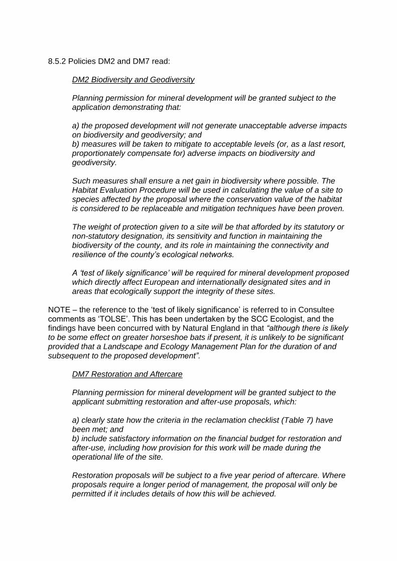
8.5.2 Policies DM2 and DM7 read:
DM2 Biodiversity and Geodiversity Planning permission for mineral development will be granted subject to the application demonstrating that: a) the proposed development will not generate unacceptable adverse impacts on biodiversity and geodiversity; and b) measures will be taken to mitigate to acceptable levels (or, as a last resort, proportionately compensate for) adverse impacts on biodiversity and geodiversity. Such measures shall ensure a net gain in biodiversity where possible. The Habitat Evaluation Procedure will be used in calculating the value of a site to species affected by the proposal where the conservation value of the habitat is considered to be replaceable and mitigation techniques have been proven. The weight of protection given to a site will be that afforded by its statutory or non-statutory designation, its sensitivity and function in maintaining the biodiversity of the county, and its role in maintaining the connectivity and resilience of the county’s ecological networks. A ‘test of likely significance’ will be required for mineral development proposed which directly affect European and internationally designated sites and in areas that ecologically support the integrity of these sites.
NOTE – the reference to the ‘test of likely significance’ is referred to in Consultee comments as ‘TOLSE’. This has been undertaken by the SCC Ecologist, and the findings have been concurred with by Natural England in that “although there is likely to be some effect on greater horseshoe bats if present, it is unlikely to be significant provided that a Landscape and Ecology Management Plan for the duration of and subsequent to the proposed development”.
DM7 Restoration and Aftercare Planning permission for mineral development will be granted subject to the applicant submitting restoration and after-use proposals, which: a) clearly state how the criteria in the reclamation checklist (Table 7) have been met; and b) include satisfactory information on the financial budget for restoration and after-use, including how provision for this work will be made during the operational life of the site. Restoration proposals will be subject to a five year period of aftercare. Where proposals require a longer period of management, the proposal will only be permitted if it includes details of how this will be achieved.

8.5.3 Policy DP5 reads: Biodiversity and Ecological Networks The Council will use the local planning process to protect, enhance and restore Somerset’s Ecological Network within Mendip. 1. All development proposals must ensure the protection, conservation and, where possible, enhancement of internationally, nationally or locally designated natural habitat areas and species. 2. Proposals with the potential to cause adverse impacts on protected and/or priority sites, species or habitats are unlikely to be sustainable and will be resisted. Exceptions will only be made where: a) the impacts cannot be reasonably avoided, b) offsetting / compensation for the impacts can be secured, c) other considerations of public interest clearly outweigh the impacts, in line with relevant legislation. Offsets as mitigation or compensation required under criterion b) will be calculated using Somerset County Council’s Biodiversity Offsetting methodology. 8.5.4 Planning Authorities have a statutory duty to ensure that the impact of development on wildlife is fully considered during the determination of a planning application under the Wildlife and Countryside Act 1981 (as amended), Natural Environment and Rural Communities Act 2006, The Conservation of Habitats and Species Regulations 2010 (Habitats Regulations 2010). 8.5.5 In this instance the site doesn’t have a statutory designation constraint relating to ecology. In addition the site is not identified as a Local Wildlife Site (LWS) or County Wildlife Sites (CWS). 8.5.6 Concerns (as opposed to objections) relating to the loss of grassland habitat during the construction of the tips has been made. In terms of the interim loss of habitat it is acknowledged that tipping and the restoration of tips will be phased, with completed areas of tipped overburden being re-seeded / planted as tipping progresses. 8.5.6 The submitted Environmental Statement (ES) identifies in Chapter 6 the presence on site of protected species / protected species habitats (notably Badgers; Bats and Great Crested Newts (GCN)). The ES also proposes various courses of mitigation for those protected species identified. 8.5.7 With regards habitat lost and habitat restored, the following table provides a numerical comparison that details the overall increase, long term, of suitable habitat:
Habitats Lost Habitats Restored
Area (ha) Habitat Units Area (ha) Habitat Units
Grassland 23.13 175.5 25.48 427.1
Hedgerow 1.52 7562.6 2.69 10113
Greater horseshoe bats 24.65 122.3 28.17 276.2
Lesser horseshoe bats 24.65 53.8 28.17 84.0
Great crested newt 5.65 23.0 9.86 35.4
8.5.8 In relation to Badgers, as a protected species, any works where a sett needs to be shut would require, and be carried out in accordance with a licence from Natural England. In this case, there is one main (active in June 2016) badger sett within the existing operational quarry to the east of Area A, while an outlier sett and artificial sett located to the west of Area B were disused in 2013. It is expected that the active main sett will be protected with a minimum 20m buffer as part of the implementation of Tip A. However, there is a low potential that the sett could be adversely affected (removed / damaged / disturbed) as part of the proposed Tip Area A work. Other disused setts would remain unaffected. 8.5.9 Knowing that there would be no complete loss at any one time during tipping operations of identified habitat, and that the final restoration of the scheme should result in biodiversity enhancement and percentage gain (comparable to that currently in situ) it is considered that, subject to planning conditions, the scheme would accord with Policies DM2 and DM7 of the Somerset Minerals Plan, Policy DP5 of the Mendip District Local Plan, the NPPF and Circular 06/2005. The reasoning for this position is that the ‘TOLSE’ as produced by SCC has stated that, with the provision of a Landscape and Ecology Management Plan (which would include appropriate restoration and aftercare), impacts on protected species would be minimised, and compensation for impacts can be secured. 8.6. Water Management (subterranean / surface water) 8.6.1 The relevant Development Plan policies relating to water management are Policy DM4 of the Somerset Minerals Plan and Policies DP7, DP8 and DP23 of the Mendip District Local Plan. 8.6.2 Policy DM4 reads:
Water Resources and Flood Risk Planning permission for mineral development will be granted subject to the application demonstrating that the proposed development will not have an unacceptable adverse impact on: a) the future use of the water resource, including:
i. the integrity and function of the land drainage and water level management systems; ii. the quality of any ground or surface water resource, where the risk of pollution and/or adverse impact on the resource would be unacceptable; b) the environmental value and visual amenity of the water resource; and c) drainage and flood risk to people, property or business
With regards to water flows, both subterranean and surface water, the consultees have not objected to the proposals on the impacts on effects on water bodies or water flows (the Lead Flood Authority raising no objection, and the Environment Agency not raising an objection, subject to the inclusion of planning conditions). 8.6.2 Policies DP7, DP8 and DP23 read:
DP7: Design and Amenity of New Development The Local Planning Authority will support high quality design which results in usable, durable, adaptable, sustainable and attractive places. 1. Proposals for new development should demonstrate that they: a) are of a scale, mass, form and layout appropriate to the local context b) protect the amenity of users of neighbouring buildings and land uses and provide a satisfactory environment for current and future occupants c) optimise the potential of the site in a manner consistent with other requirements of this policy d) incorporate all practical measures to achieve energy efficiency through siting, layout and design e) maximise opportunities for: i. The use of sustainable construction techniques; ii. The use of sustainable drainage systems; iii. Renewable energy generation on site; iv. The use of water efficiency measures, recycling and conservation; v. New residents to minimise, re-use or recycle waste f) use locally sourced or recycled materials wherever practically possible g) meet the access needs of a wide range of users h) incorporate appropriate crime prevention measures i) undertake construction in a manner that makes efficient use of materials and minimises waste. 2. All allocations will be the subject of either an appropriately detailed Development Brief or Masterplan or other structured and agreed pre-application process prepared in conjunction with the relevant community. Where a Development Brief/Masterplan is prepared, it will, where appropriate, be adopted as a Supplementary Planning Document prior to the granting of planning permission.

DP8: Environmental Protection All development proposals should minimise, and where possible reduce, all emissions and other forms of pollution. 1. Development (either cumulatively or individually) will be required to demonstrate that it does not give rise to unacceptable adverse environmental impacts on:
- ambient noise levels; - air quality; - the quality of water resources, whether surface river or groundwater; - biodiversity;
- light pollution; - land quality and ground stability; - residential amenity; and
- public health and safety. 2. Development proposals must include an assessment appropriate to the type and extent of impact and any associated risks to the satisfaction of the relevant environmental body. Any proposed solutions or mitigation measures should comply with relevant EU and British Standards, Environment Agency guidance and national limits or guidelines and take account of any locally adopted standards and supplementary guidance. 3. Development proposals, particularly those in a rural setting and especially those in designated Areas of Outstanding Natural Beauty (AONBs), should make all reasonable efforts to minimise noise and light pollution impacts. 4. Development proposals which are on or adjacent to land which may have been subject to contamination or impact from existing sources of noise will need to demonstrate that measures can be taken effectively to mitigate the impacts on public health, environmental quality, the built environment and amenity. Proposals will only be permitted where the impact and risks are, or can be mitigated appropriately for the proposed use. Appropriate mitigation and remediation will be secured through planning conditions on the development. 5. Development will not be permitted within Sewage Treatment Works Consultation Zones unless it is demonstrated that the environment provided for future users will not be adversely affected. DP23: Managing Flood Risk 1. Development will follow a sequential approach to flood risk management, giving priority to the development of sites with the lowest risk of flooding. The development of sites with a sequentially greater risk of flooding will only be considered where essential for regeneration or where necessary to meet specific local requirements.
2. Development in areas at risk of flooding will be expected to: a) be resilient to flooding through design and layout; and b) incorporate sensitively designed mitigation measures, which may take the form of on-site flood defence works and/or a contribution towards, or a commitment to undertake, such off-site measures as may be necessary, in order to ensure that the development remains safe from flooding over its lifetime, taking into account the predicted impact of climate change. 3. All development will also be expected to incorporate appropriate water management measures to reduce surface water run-off and ensure that it does not increase flood risks elsewhere. This should include the use of sustainable urban drainage systems (SUDS).
8.6.3 A number of objections have cited subterranean water flows and the effect this could have on the stability of the proposed tips. Land Stability has been considered in this report. 8.6.4 With regards to water flows and the proposed Tips, both subterranean and surface water, the Statutory Consultees have not objected to the proposals on the impacts on effects on water bodies or water flows (the Lead Flood Authority raising no objection, and the Environment Agency not raising an objection, subject to the inclusion of planning conditions). Furthermore, the only element to be protected is the known spring on Tip A site. This water flow is to be channelled and is to be covered with an impermeable membrane for the length of the drain only, ensuring appropriate contact between the tip material and the sub-base of the Tips. The membrane will ensure the drain does not become clogged with sediment ensuring the continuous flow of spring water, safely from the site. Such protection should ensure ground is not saturated beneath the tips from the flow of spring water. 8.6.5 In this instance it is considered the proposed development accords with Policies DP7, DP8 and DP23 of the Mendip District Local Plan and Policy DM4 of the Somerset Minerals Local Plan and as such, subject to the development being carried out in accordance with the submitted details and planning conditions, it is not considered the scheme would be to the detriment of surface or ground water flows and would not impact on water quality as the material is sourced ‘on site’ (from the Moons Hill Quarry complex), and is not considered to be a material that would result in negative impacts on water quality (being the same material as that currently in place at the Tip sites). Furthermore, rates of water flow from the sides of tipped over burden would be reduced with water being retained / slowed with the use of vegetation on the slopes (the slopes being progressively restored). 8.7. Archaeology 8.7.1 The relevant Development Plan policies relating to archaeology are Policy DM3 of the Somerset Minerals Plan and Policy DP3 of the Mendip District Local Plan. 8.7.2 Policy DM3 reads:
Historic Environment
Planning permission for mineral development will be granted subject to the application demonstrating that: a) the proposed development will not generate unacceptable adverse impacts on the historic environment or where an adverse impact or impacts have been identified, these can be adequately mitigated; and b) for proposals that impact on the integrity, character or setting of a heritage asset, impacts have been adequately considered by desk-based assessment and field evaluation and with reference to the Somerset Historic Environment Record and the records of designated heritage assets held by English Heritage; and c) adequate provision will be made for the preservation in-situ or excavation of the asset as appropriate, in discussion with the county archaeologist, and the recording of relevant information to advance understanding of the asset. The weight of protection afforded to a heritage asset will reflect the significance of the asset including, but not limited to, its statutory designation(s).
8.7.3 Policy DP3 reads:
Heritage Conservation Proposals and initiatives will be supported which preserve and, where appropriate, enhance the significance and setting of the district’s Heritage Assets, whether statutorily or locally identified, especially those elements which contribute to the distinct identity of Mendip. 1. Proposals affecting a Heritage Asset in Mendip will be required to: a) Demonstrate an understanding of the significance of the Heritage Asset and/or its setting by describing it in sufficient detail to determine its historic, archaeological, architectural or artistic interest to a level proportionate with its importance. b) Justify any harm to a Heritage Asset and demonstrate the overriding public benefits which would outweigh the damage to that Asset or its setting. The greater the harm to the significance of the Heritage Asset, the greater justification and public benefit that will be required before the application could gain support. 2. Opportunities to mitigate or adapt to climate change and secure sustainable development through the re-use or adaptation of Heritage Assets to minimise the consumption of building materials and energy and the generation of construction waste should be identified. However, mitigation and adaptation will only be considered where there is no harm to the significance of a Heritage Asset. 3. Proposals for enabling development necessary to secure the future of a Heritage Asset which would otherwise be contrary to the policies of this plan

or national policy will be carefully assessed against the policy statement produced by English Heritage “Enabling Development and the Conservation of Significant Places” (2008).
8.7.4 The three Tip sites detailed in the planning application do not have statutory heritage asset designation constraints. Consultees on heritage matters have not raised objections relating to the proposed mineral extraction (Mendip DC and SCC Archaeology Officer), suggesting that there wouldn’t be any impact (harm) from the proposed development. 8.7.5 Knowing the above it is considered the scheme accords with the requirements of Policy DM3 of the Somerset Minerals Local Plan and Policy DP3 of the Mendip District Local Plan as the development would not result in loss of, or harm to unidentified heritage assets on or near the site. 8.7.6 In relation to identified heritage assets (principally Listed Buildings) to the west of Tip A, the development is considered suitably distant from them as to ensure that any perceived harm to the setting is minimised. This would be further reduced once the landscaping detailed for the Tips has been completed. 8.8. Land Stability: 8.8.1 The consideration of land stability of the future tips is material in this case, as prescribed by the NPPG. 8.8.2 It states at paragraph 001 that:
The effects of land instability may result in landslides, subsidence or ground heave. Failing to deal with this issue could cause harm to human health, local property and associated infrastructure, and the wider environment. They occur in different circumstances for different reasons and vary in their predictability and in their effect on development. The planning system has an important role in considering land stability by:
- minimising the risk and effects of land stability on property, infrastructure and the public;
- helping ensure that various types of development should not be placed in unstable locations without various precautions; and
- to bring unstable land, wherever possible, back into productive use. The NPPG goes on to state at paragraph 002 that:
When dealing with land that may be unstable, the planning system works alongside a number of other regimes, including:
- a general duty on the site operator to ensure the safety of quarry excavations and tips; and that once abandoned the quarry is left in a safe condition, as required under the Quarries Regulations 1999.
8.8.3 In addition, paragraphs 120 and 121 of the NPPF need to be considered, where they read:
120. To prevent unacceptable risks from pollution and land instability, planning policies and decisions should ensure that new development is appropriate for its location. The effects (including cumulative effects) of pollution on health, the natural environment or general amenity, and the potential sensitivity of the area or proposed development to adverse effects from pollution, should be taken into account. Where a site is affected by contamination or land stability issues, responsibility for securing a safe development rests with the developer and/or landowner. 121. Planning policies and decisions should also ensure that: ● the site is suitable for its new use taking account of ground conditions and land instability, including from natural hazards or former activities such as mining, pollution arising from previous uses and any proposals for mitigation including land remediation or impacts on the natural environment arising from that remediation;
8.8.4 Furthermore, consideration needs to be given to Policy DM10 of the Somerset Minerals Plan, and the sub-text contained in paragraph 21.6. They read as follows:
DM10: Land Stability Proposals for mineral development will need to demonstrate, via the submission of a stability assessment prepared by a competent person, that: a) the proposal will not have an adverse impact on the stability of neighbouring land or properties; and b) the proposal will not result in watercourse channel instability either during the working phase of a minerals development or at any time after the cessation of mineral extraction operations. 21.6 In considering tip and quarry slope stability linked with new applications, relevant technical information should be provided by a competent person as part of the planning application. A competent person is one with a recognised relevant qualification, sufficient experience in dealing with land stability and current membership of a relevant professional organisation (see NPPF glossary).
As well as current policy, the jurisdiction of different controlling regimes needs to be understood – in this case the Quarry regulations 1999 (enforced by the Health and Safety Executive (HSE)) and the Planning System. This is explained best by the now-defunct Minerals Planning Guidance note 5, where it stated in paragraph 13:

Surface mineral working and tipping operations constitute development and therefore require permission under the Town and Country Planning Acts. As indicated in PPG 14, stability is a material planning consideration in so far as it affects land use but the planning system should not seek to duplicate controls that are the statutory responsibility of other bodies. The risks to health and safety of people are thus properly considered under health and safety legislation. However, where any instability may threaten land outside of the boundaries of the mineral working or tip, it may not necessarily threaten the health and safety of people though it could affect neighbouring land use. The MPA then has a duty to consider the potential effects on land use in the public interest and where necessary to consult adjoining landowners and other third-party interests.
8.8.5 A number of the objections received have stated the potential impact of land stability on neighbours as a reason for refusal of the scheme. The Parish Council (Stoke St Michael) have also cited the Aberfan disaster as justification for this stance. 8.8.6 The applicants have submitted a ‘Stability Assessment for Proposed Tips A, B and D’; produced by GWP Consultants LLP (dated June 2017). 8.8.7 The author of the GWP LLP report is a Chartered Geologist and a Fellow of the Institute of Quarrying. In addition, the counter-signatory is a Member of the Institute of Materials, Minerals and Mining, as well as a Fellow of the Geological Society. Both are Doctors in their field of expertise (Civil Engineering and Geotechnical Engineering respectively). Between them they have circa 65 years of experience in the field of geology and mining. 8.8.8 With regards the competence of GWP LLP, in relation to Policy and sub-text (paragraph 21.6 of the Somerset Minerals Plan), it is considered that they are suitably qualified, experienced and are members of the appropriate professional body to be able to produce reliable evidence on matters of land [in] stability. 8.8.9 The professional opinion detailed in the report submitted (GWP LLP Report ‘Stability Assessment for Proposed Tips A, B and D’ (dated June 2017)) states that: Stability analyses have been undertaken for the proposed tip geometries using a conservative shear strength envelope determined from the testing of materials recovered from on site. The analyses show that the proposed and existing tip slopes are adequately secure in the long term even when adopting a fully saturated slope and a lower bound shear strength envelope for tipped waste materials. Given an adequate Factor of Safety is achieved using the lower bound shear strength envelope it has not been necessary to analyse the proposed slopes using the derived average shear strength parameters for which a higher Factor of Safety would obtain. The proposed temporary inner screening bund slopes progressively formed during tip construction will be secure for the life of the structure assuming the foundations are stripped of all weak materials prior to construction.
The final tip designs consider the stability guidelines, visual impact and end use and ensure the proposed structures are secure in the long term. The foundations of all new tips will need to be inspected when the soils are removed to assess the need to install additional underdrainage measures. Where flows are encountered then a buried French drain, comprising a geotextile wrapped gravel filled trench, will be designed and installed to control any underflows, with direct connection to a peripheral drainage ditch. The lower western slopes of the Moons Hill South Tip are currently fully restored and the soils are grassed and are stable. The raising of the Moons Hill South Tip into the final Tip D proposed landform will have negligible impact in respect of stability on the existing critical lower western slopes of the tip, and the structure will be stable in the long term. 8.8.10 In this instance the submitted report appears comprehensive and the findings have been produced by an applicant appointed specialist who has to accord with their professional code. In summary they have stated that the design of the tips is one that would be suitably secure and would remain stable for their lifetime and that the design is considered one that would accord with adopted policy of the Development Plan and the NPPF. 8.8.11 However, points raised regarding the appropriate use of retrospective drainage measures have been made by the SCC Geotechnical Advisor in their comments, particularly relating to Tip A and Tip B, and that without details on a future ‘underdrainage’ scheme the claim that water flows could be suitably managed and stability of the tips maintained has been questioned. 8.8.12 In this instance, as it is a duty of the Mineral Planning Authority (MPA) to ‘minimise the risk and effects of land stability on property, infrastructure and the public’ (Planning Practice Guidance note (PPGn)), as the presence of ‘underflows’ has been identified as a possible result of the operation, the provision and installation of an appropriate and adequate ‘underdrainage systems’ is deemed reasonable (and has been stated in Chapter 8 of the formal Environmental Statement as infrastructure that would be provided ‘as a minimum’, and referred to above in this recommendations), with the objective of minimising risk. 8.8.13 Such a scheme can be secured by way of planning condition. 8.8.14 In relation to Tip D, the submission states that there should be ‘continued monitoring of groundwater levels below the steep western slope [of Tip D]’. In this instance it is considered reasonable and appropriate to secure such monitoring (and actions to mitigate) by way of planning condition. This should ensure accordance with the duties of the MPA regarding the PPGn. 8.8.15 In addition, and separate to the Development Plan and the NPPF, the stability of the tips as proposed would also be subject to controls as prescribed in the Quarry regulations 1999, with monitoring of such elements carried out by the Health and Safety Executive. The element that falls to the MPA is that where the stability of
perimeter slopes could impact on those land uses beyond the tip boundary, following the cessation of tipping activity. 8.8.16 In this case there is a duty to consider the potential effects on land use in the public interest. From the details and designs submitted the scheme has been considered and approved by suitably qualified individuals and the potential long term impacts on adjacent land uses (such as public rights of way) can be controlled by planning condition (where they require the final landforms to be retained and maintained in their final form in perpetuity). 8.8.17 In this instance it is considered that, subject to appropriate and reasonable planning conditions (principally working in accordance with plans (phasing and profiles), matters concerning land stability can be suitably managed ensuring the safety of the wider general public. 8.8.18 In summary it is considered the tips would accord with Policy DM10 and paragraph 21.6 as it has been stated by a competent person (persons in this case) that the scheme would not have an adverse impact on the stability of neighbouring land / users and the proposal would not result in watercourse channel instability. Furthermore, it is noted that ultimately the responsibility for securing a safe development rests with the developer and/or landowner (as prescribed by the NPPF). 8.8.19 The gradient and management of the finished slopes, as detailed on the plans submitted, are deemed to result in profiles that would be suitably stable as to ensure no impact on neighbouring land uses beyond the site as identified in the long term (either during or post cessation of tipping of overburden material). 8.8.20 ** The County Council acknowledges that the reference made to Aberfan within its geotechnical consultants advice, whilst highlighting the concern of potential land instability and risk to land beyond the application site, may have been unintentially emotive. As a result the advice was withdrawn, refined and resubmitted. 8.9. Other Matters 8.9.1 Public Rights of Way (PRoW) 8.9.1.1 The relevant Development Plan policy in this instance are Policy DP1 of the Mendip Local Plan and Policy DM6 of the Somerset Minerals Plan, which reads:
DP1 Local Identity and Distinctiveness 1. All development proposals should contribute positively to the maintenance and enhancement of local identity and distinctiveness across the district. 2. Proposals should be formulated with an appreciation of the built and natural context of their locality recognising that distinctive street scenes, townscapes, views, scenery, boundary walls or hedges, trees, rights of way and other
features collectively generate a distinct sense of place and local identity. Such features may not always be designated or otherwise formally recognised. 3. Where a development proposal would adversely affect or result in the loss of features or scenes recognised as being distinctive, the Council will balance up the significance of the feature or scene to the locality, the degree of impact the proposal would have upon it, and the wider benefits which would arise from the proposal if it were approved. Any decisions will also take into account efforts made by the applicant to viably preserve the feature, avoid, minimise and/or mitigate negative effects and the need for the proposal to take place in that location.
DM6
Proposals for mineral development that have the potential to impact on the rights of way network in Somerset will need to demonstrate how the affected part of the network or any alternative route will be managed and maintained. Where proposals are likely to have an unacceptable adverse impact on the rights of way network, the applicant must provide a satisfactory, authorised replacement route (either temporary or permanent). Authorised diversion routes must meet the relevant criteria, be fit for purpose and easily accessible, without causing significant disturbance to wildlife. If temporary, the original right of way shall be reinstated as soon as is practicable. If permanent diversion is required this shall seek to improve on and enhance the original public right of way.
8.9.1.2 The site proposed for the three tips would affect an existing PRoW (footpath). In this instance the relevant Statutory Consultee has not objected to the proposed development on the grounds of potential impacts to the PRoW or the users’ amenity of the PRoW. 8.9.1.3 What the response has identified is the obligation on the land owner to ensure the affected PRoW are diverted in accordance with the requirements of the Town and Country Planning Act 1990 (as amended). 8.9.1.4 In this instance, alternative routes and enhancements to the PRoW are proposed (the formality of changes are to be secured via an Order subject to section 257 of the Town and Country Planning Act 1990 (as amended). 8.9.1.5 Knowing the above, and that the diversion of the identified PRoW would fall under the remit of a different legislative regime it is considered acceptable to support the proposal in relation to PRoW, as impacts on amenity would be temporary (for the period of development) and subsequent amenity enhanced (with delivery of alternative routes being the subject of planting / landscaping). For these reasons it is considered the scheme would accord with Policy DM6 of the Somerset Minerals Plan and Policy DP1 of the Mendip District Local Plan as the proposal would seek to minimise any negative effect from the loss of the PRoW with its (the PRoW) diversion.
8.9.1.6 In this instance the consultee has recommended that as work involved in this proposal would require the stopping up and moving of a PRoW, then a temporary closure order would be necessary and that a suitable alternative route be required. 8.9.2 Agricultural Land Classification (ALC) / Loss of Agricultural Land: 8.9.2.1 The application’s supporting documentation suggests the ALC is Grade 5. However, from available records (www.magic.gov.uk and SCC records) the land is identified as Grade 3 (Tips A and D) and Grade 4 (Tip B). 8.9.2.2 In this instance the guidance detailed in paragraph 112 of the NPPF needs to be considered. 8.9.2.3 Paragraph 112 reads: Local planning authorities should take into account the economic and other benefits of the best and most versatile agricultural land. Where significant development of agricultural land is demonstrated to be necessary, local planning authorities should seek to use areas of poorer quality land in preference to that of a higher quality. 8.9.2.4 In this instance, with the delivery of minerals being given ‘great weight’ in deliberations (as prescribed in paragraph 144 of the NPPF) it is considered that the loss of Grade 3 and Grade 4 Agricultural Land is considered acceptable as the delivery of minerals (and their associated benefits) would carry more weight in planning deliberations and balance than the retention of lower grade agricultural land. 8.9.2.5 Therefore it is considered the proposed development is acceptable in terms of the benefit gained from the delivery of minerals over the loss of this relatively low grade quality agricultural land, and as such the planning application can be supported from this perspective as it would accord with paragraphs 112 and 143 of the NPPF (in that poorer quality agricultural land would be used, and that the use of the Tips would be returned to agricultural use once tipping is complete). 8.9.3 Impact on Rural Businesses (Farming): 8.9.3.1 It is accepted the development proposed would by its nature result in the loss of Grade 3 and Grade 4 agricultural land, for the period of time needed to complete the tips as identified. 8.9.3.2 It is also noted that the land identified as being lost is in the ownership of the applicant and as such the rights of use of that land by those wishing to farm the fields is also within the control of the applicant. 8.9.3.3 Although the use of the fields could result in a degree of disruption to business operations, the land would in general be returned to agricultural use so long term would not be construed as a loss of agricultural land. Such an impact would need to be considered as part of the planning balance for and against the proposal.

8.9.3.4 As the land is in the ownership of the applicant, the land identified would be rented and any financial loss over the time period of tipping is considered in this instance would be a civil matter between the land owner and the tenant farmer. 8.9.4 Tip Site ‘C’: 8.9.4.1 Reference has been made to ‘Tip Site ‘C’’. In the planning application the proposal seeks consent for Tips A, B and D. There is no Tip C. As such, consideration of something that does not form part of a proposal cannot be done and as such this can have no material weight in deliberations. 9. Planning Balance 9.1 In relation to the delivery of minerals, the NPPF states in paragraph 144 that: … Local Planning Authorities should … give great weight to the benefits of the mineral extraction, including to the economy. 9.2 As the site has no statutory designation constraints directly applicable, that water management / land stability / ecology / PRoW / Highways / Visual and Landscape Character Impact / temporary loss of agricultural land would be acceptable, that there would be benefits from the mineral extraction (which would also result in the retention of existing staff levels and the associated economic and social benefits that entails), as well as there being final biodiversity enhancement to the area, it is considered that the scheme would be acceptable on balance and should be supported. 10. Recommendation: It is recommended that planning permission be granted subject to the imposition of the conditions in section 10 of this report and that authority to undertake any minor non-material editing, which may be necessary to the wording of those conditions be delegated to the Service Manager, Planning Control Enforcement & Compliance. 1. Duration of Development and Implementation of Permission The development hereby permitted shall be completed, and the site restored and aftercare completed in accordance with the approved plans and schemes within 20 years from the date of the implementation of this permission. The Mineral Planning Authority shall be formally notified in writing that the planning permission has been implemented within 14 days of that implementation date. Reason: To ensure that the site reverts to a satisfactory after-use within a reasonable period of time. 2. Completion in accordance with the approved details The development hereby permitted shall be completed in strict accordance with the approved plans and specifications as set out below:
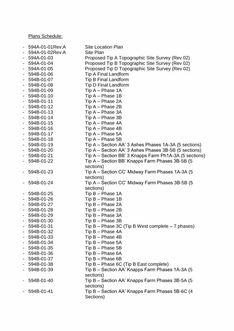
Plans Schedule:
- 594A-01-01Rev.A Site Location Plan - 594A-01-02Rev.A Site Plan - 594A-01-03 Proposed Tip A Topographic Site Survey (Rev 02) - 594A-01-04 Proposed Tip B Topographic Site Survey (Rev 02) - 594A-01-05 Proposed Tip D Topographic Site Survey (Rev 02) - 594B-01-06 Tip A Final Landform - 594B-01-07 Tip B Final Landform - 594B-01-08 Tip D Final Landform - 594B-01-09 Tip A – Phase 1A - 594B-01-10 Tip A – Phase 1B - 594B-01-11 Tip A – Phase 2A - 594B-01-12 Tip A – Phase 2B - 594B-01-13 Tip A – Phase 3A - 594B-01-14 Tip A – Phase 3B - 594B-01-15 Tip A – Phase 4A - 594B-01-16 Tip A – Phase 4B - 594B-01-17 Tip A – Phase 5A - 594B-01-18 Tip A – Phase 5B - 594B-01-19 Tip A – Section AA’ 3 Ashes Phases 1A-3A (5 sections) - 594B-01-20 Tip A – Section AA’ 3 Ashes Phases 3B-5B (5 sections) - 594B-01-21 Tip A – Section BB’ 3 Knapps Farm Ph1A-3A (5 sections) - 594B-01-22 Tip A – Section BB’ Knapps Farm Phases 3B-5B (5 sections) - 594B-01-23 Tip A – Section CC’ Midway Farm Phases 1A-3A (5
sections) - 594B-01-24 Tip A – Section CC’ Midway Farm Phases 3B-5B (5
sections) - 594B-01-25 Tip B – Phase 1A - 594B-01-26 Tip B – Phase 1B - 594B-01-27 Tip B – Phase 2A - 594B-01-28 Tip B – Phase 2B - 594B-01-29 Tip B – Phase 3A - 594B-01-30 Tip B – Phase 3B - 594B-01-31 Tip B – Phase 3C (Tip B West complete – 7 phases) - 594B-01-32 Tip B – Phase 4A - 594B-01-33 Tip B – Phase 4B - 594B-01-34 Tip B – Phase 5A - 594B-01-35 Tip B – Phase 5B - 594B-01-36 Tip B – Phase 6A - 594B-01-37 Tip B – Phase 6B - 594B-01-38 Tip B – Phase 6C (Tip B East complete) - 594B-01-39 Tip B – Section AA’ Knapps Farm Phases 1A-3A (5
sections) - 594B-01-40 Tip B – Section AA’ Knapps Farm Phases 3B-5A (5
sections) - 594B-01-41 Tip B – Section AA’ Knapps Farm Phases 5B-6C (4
Sections)

- 594B-01-42 Tip B (E) – Section BB’ Long Cross Cottage Phases 4A- 5B (4 sections)
- 594B-01-43 Tip B (E) – Section BB’ Long Cross Cottage Phases 6A- 6C (3 sections)
- 594B-01-44 Tip B – Section CC’ Long Cross Farm Phases 1A-2B (4 sections)
- 594B-01-45 Tip B – Section CC’ Long Cross Farm Phases 3A-4A (4 sections)
- 594B-01-46 Tip B – Section CC’ Long Cross Farm Phases 4B-5B (3 sections)
- 594B-01-47 Tip B – Section CC’ Long Cross Farm Phases 6A-6C (3 sections)
- 594B-01-48 Tip D – Phase 1A - 594B-01-49 Tip D – Phase 1B - 594B-01-50 Tip D – Phase 2A - 594B-01-51 Tip D – Phase 2B - 594B-01-52 Tip D – Phase 3A - 594B-01-53 Tip D – Phase 3B - 594B-01-54 Tip D – Phase 4A - 594B-01-55 Tip D – Phase 4B - 594B-01-56 Tip D – Phase 5 - 594B-01-57 Tip D – Section AA’ Long Cross Farm Phase 1A-3A (5
sections) - 594B-01-58 Tip D – Section AA’ Long Cross Farm Phase 3B- 5 (4
sections)
- 594B-01-59 Tip D – Section AA’ Mill Marsh Farm Phase 1A-3A (5 sections)
- 594B-01-60 Tip D – Section AA’ Mill Marsh Farm Phase 3B-5 (4 sections)
- 594B-01-61 Tip A Sections through Attenuation Features - 594B-01-62 Public Rights of Way Diversion Plan - 594B-01-63 Proposed (Post Restoration) Public Rights of Way Plan - 594B-01-64 Tip A Restoration Scheme - 594B-01-65 Tip B Restoration Scheme - 594B-01-66 Tip D Restoration Scheme
Reports APPDX 5 Low Productivity Grassland Scheme APPDX 3 Dust Management Scheme v2 APPDX 4 Woodland & Hedgerow Scheme APPDX 2 Soil & Grass Seeding Procedures APPDX 1 Tip A B and D stability assessment 160107 v03 Dust Scheme ND/v2. 1 26/01/2016 and with any scheme, working programme or other details submitted to and approved in writing by the Mineral Planning Authority in pursuance of any condition attached to this permission.

Reason: To enable the Minerals Planning Authority to deal promptly with any development not in accordance with the approved plans. 3. Bat Impact Mitigation Strategy Prior to the removal of any trees a Bat Impact Mitigation Strategy shall be submitted to and approved in writing by the Minerals Planning Authority. The Strategy shall be based on up to date survey information of potential roost sites. Reason: This is a pre-commencement condition in the interests of the strict protection afforded European protected species. 4. Landscape and Ecological Management Plan (LEMP) A Landscape and Ecological Management Plan (LEMP) shall be submitted to, and be approved in writing by, the Minerals Planning Authority within 6 months from the date of the implementation of this planning permission. The content of the LEMP shall include the following. a) Description and evaluation of features to be managed. b) Ecological trends and constraints on site that might influence management. c) Aims and objectives of management. d) Appropriate management options for achieving aims and objectives. e) Prescriptions for management actions. f) Preparation of a work schedule (including an annual work plan capable of being rolled forward over five-year periods). g) Details of the body or organization responsible for implementation of the plan. h) On-going monitoring and remedial measures. The LEMP shall also include details of the legal and funding mechanism(s) by which the long-term implementation of the plan will be secured by the developer with the management body (bodies) responsible for its delivery. The plan shall also set out how contingencies and/or remedial action will be identified, agreed and implemented so that the development still delivers the fully functioning biodiversity objectives of the originally approved scheme. The approved plan shall be implemented in full in accordance with the approved details, for the duration of the development hereby permitted. Reason: In the interests of mitigating impact on visual amenity 5. Survey of Badger Setts Within 6 months prior to the commencement of the development hereby permitted a survey of / for badger setts within the site area will be carried out by a suitably qualified ecologist. Thereafter, subject to the identification of badger setts in the Survey for Badger Setts, all measures for badgers / sett maintenance / actions shall be carried out in accordance with the details contained in paragraphs 6.6.10 to 6.6,19 of Chapter 6 of the Environmental Statement (AD Ecology Ltd, Ecological Impact Assessment version 2 dated 5th June 2017) as already submitted with the planning application and agreed in principle with the Minerals Planning Authority. As
the approved development is to proceed in a series of phases over 12 years from the commencement of tipping in either of Tips A or B and 12 years from the commencement of tipping in Tip D, further supplementary ecological surveys for badgers shall be undertaken to inform the preparation and implementation of corresponding phases of ecological measures required as per paragraph 6.7.2 of Chapter 6. Findings shall be submitted to and approved by the Minerals Planning Authority. Reason: This is a pre-commencement condition in the interests of a protected species 6. Brown Hare and Hedgehog Survey Prior to commencement of each phase of the development hereby permitted, surveys for Brown Hare and Hedgehog according to methods detailed in Mammal Society Guidance (Cresswell et al, 2012) shall be undertaken and a report of the findings, along with any impact mitigation required, shall be submitted to, and approved in writing by, the Minerals Planning Authority for approval. All such mitigation identified as required shall be fully implemented and maintained where necessary. Reason: This is a pre-commencement condition in the interests of the conservation of priority species 7. Bird Nest Survey (of Trees / Hedgerows prior to removal) No removal of hedgerows, trees or shrubs shall take place between 1st March and 31st August inclusive, unless a competent ecologist has undertaken a careful, detailed check of vegetation for active birds’ nests immediately before the vegetation is cleared and provided written confirmation that no birds will be harmed and/or that there are appropriate measures in place to protect nesting bird interest on site. Any such written confirmation shall be submitted to the Minerals Planning Authority within 14 days from the completion of such Bird Nest surveys. Reason: In the interest of nesting wild birds 8. Great Crested Newt: Tip D Vegetation Removal Methodology Any vegetation including hedgerow, grasses and tall herbs within Tip Area D shall initially be reduced to a height of 10 centimetres above ground level by hand beginning from the centre of the field moving slowly outwards to give any protected species present within the grassland areas time to disperse away from the clearance team and to avoid being isolated from ecological corridors that will provide a means of escape. Clearance can occur at a maximum rate of 2 hectares per day. Brashings and cuttings should be removed and the cut area left for a minimum period of 48 hours of warm but humid or wet weather with temperatures of 10°C or above before further work to minimise the risk of harming/killing any amphibians that may be present and to encourage their movement onto adjoining land in the active period. This work may only be undertaken between April and October. The vegetation height

shall be maintained below 10cm thereafter in the tip area for the duration of the creation of the Tip. Reason: in the interests of the Favourable Conservation Status of the population of a European protected species 9. Great Crested Newt: Hedgerow Removal Methodology Any hedgerow habitat (including ground flora) within Tip D must be cleared during temperatures of 10°C or above before clearing using an excavator. This will be undertaken only during April to October, inclusive. Reason: in the interests of the Favourable Conservation Status of the population of a European protected species 10. Great Crested Newt: Discovery If newts are found during the careful clearance of the habitat or at any other time then all work shall cease and a suitably qualified ecologist shall be consulted, with recommencement of operations only after agreement in writing with such appointed qualified ecologist. Reason: in the interests of the Favourable Conservation Status of the population of a European protected species. 11. Hours of Operation The overburden material from permitted quarrying operations at the Moons Hill Quarry Complex (as identified in this application) shall only be tipped / worked / profiled between the hours of: 08.00 to 18.00 Mondays to Fridays at Tip A; 07.00 to 19.00 Mondays to Friday at Tips B and D There shall be no such working on Saturdays, Sundays or Public / Bank Holidays at Tip A, Tip B or Tip D. Reason: In the interests of neighbouring amenity. 13. Water Conservation and Management Prior to the commencement of tipping at Tip A, Tip B or Tip D hereby permitted, a written scheme for the corresponding Tip to be commenced shall be submitted to, and approved in writing by, the Minerals Planning Authority that makes provision for the maintenance and management of surface and groundwater flow and quality from Consented area as detailed in approved drawing number ‘594A-01-02 Rev A’ (in the case of Tip A and Tip B, a single scheme covering both tips would be required, due to both tips draining into the same water course). There shall be no materially deleterious changes to the volumes of flow or to the visible or chemical water quality from the yet to be agreed baselines. The water flow and quality baselines will need

to be established through monthly monitoring at the surface and groundwater discharge points as reported in the Environmental Statement Chapter 8, for a minimum of 12 months and or until a baseline can be agreed with the Environmental Agency. The scheme shall comprise: a) A Baseline flow and quality Monitoring Plan including monitoring locations and
frequency, Monitoring methods, analytical parameters, sampling and testing protocols and methods and limits of detection;
b) A minimum 12 month baseline monitoring period, unless otherwise agreed with the EA and particulars of the assessment and reporting that will be undertaken on completion;
c) Full particulars of a surface water (and if necessary groundwater) drainage scheme and provision for its review and amendment (as necessary) on completion of the baseline monitoring and at other key stages of the works;
d) Full particulars of a surface water (and if necessary groundwater) management scheme and provision for its review and amendment (as necessary) on completion of the baseline monitoring and at other key stages of the works;
e) Protocols for review of the Baseline Monitoring Plan and the submission of a long term monitoring plan including where appropriate flow and quality trigger and control action values (compliance limits), details of contingency action that will be undertaken in respect of non-compliance, periodic reviews and reports for submission to Environment Agency and MPA;
f) Long term monitoring required under the scheme shall be maintained strictly in accordance the approved details.
Reason: In the interests of maintaining surface and groundwater flow and water quality and for the protection of sensitive environmental sites downgradient of the site. 14. Land Stability Prior to the commencement of tipping of overburden at Tip A and Tip B (Tip B West and Tip B East), full details of the underdrainage system and water management system for Tip A and Tip B (Tip B West and Tip B East) shall be submitted to, and approved in writing by, the Mineral Planning Authority. Once approved the development shall be carried out in accordance with those details for the duration of the development hereby permitted. Reason: In the interests of minimising risk, risk management and land stability in accordance with Planning Practice Guidance. 15. Environmental Management and Amenity Prior to the commencement of the development hereby permitted, a Construction Environmental Management Plan (CEMP) / Construction Method Statement (CMS) for Tip A and Tip B shall be submitted to, and approved in writing by, the Mineral Planning Authority. The submitted CEMP shall cover the whole of the permitted development area for Tips A and B subject of this consent as shown on Drawing No

‘594A-01-02 Rev A’ and the content of CEMP / CMS shall include the details as to the following:
- Employer’s Environmental Policies, training awareness and competencies, environmental objectives and targets, communications, records and management review, incident reporting;
- Pollution control measures especially storage and use of fuels and lubricants, vehicle refuelling and maintenance and any process chemicals used;
- Procedures for dealing with spillages on land and into water bodies; - Noise control and monitoring measures; - Confirmation that the CEMP / CMS shall be implemented for the duration of the
development hereby permitted. Reason: In the interests of protecting the environment and maintaining the amenity of nearby residents and land users. 16. Landscaping Within 6 months from the date of the implementation of this permission details of all soft landscape works shall be submitted to, and approved in writing by, the Mineral Planning Authority. The details to be provided shall include a programme for implementation during the phasing of the construction works and long-term management through the life of the tips and following the completion of tip activities. Reason: In the interests of protecting the environment and maintaining the amenity of nearby residents and land users. 17. Soil Stripping All subsoil and topsoil stripped from Tip A, Tip B and Tip D shall be managed and maintained for the duration of works, in accordance with the scheme detailed in Appendix 2 of the ES as submitted with this planning application. Reason: In the interests of protecting the environment and maintaining suitable volumes of material for restoration and on site use. 18. Post Quarrying Land Stability Subject to the planning permission having been implemented, in all circumstances where the Quarry Regulations 1999, subsequent versions, or similar replacement legislation does not apply, Geotechnical Stability Assessments shall be undertaken to assess and establish land / slope stability (within 6 months of the date of the date of implementation of this decision or within 6 months of the date of identification that the Quarry Regulations do not apply to any part of the permitted development site), and thereafter at intervals not exceeding 2 years. The reports on initial geotechnical stability assessments shall be submitted to the Mineral Planning Authority (MPA) for written approval.

For the avoidance of doubt such “circumstances” shall include any spatial areas or zones of the permitted development subject of this consent that may be outside the operational quarry area defined for the purposes of the Quarry Regulations, and any areas or zones of the permitted development that fall outside the Quarry Regulations by virtue of completion of restoration, landscaping or abandonment. The scope and content of the Geotechnical Stability Assessments required under this Condition shall be as set out and defined in the Quarry Regulations 1999 and its Schedules, subsequent versions or similar replacement legislation, and HSE Document L118 (second edition) 2013, Quarry Regulations 1999 Approved Code of Practice. The Geotechnical Stability Assessments so defined shall include all soil or rock slopes within the permitted development site boundary, whether temporary faces, slopes under restoration, restored final slopes, or temporary stockpile or spoil heap slopes, and whether inward or outward facing. A full stability review of the preceding geotechnical stability assessments and any other pertinent information shall be undertaken by a geotechnical specialist and submitted to the MPA every 6 years from the date of the report on the initial stability assessment. The review shall summarise the outcome of the geotechnical assessments, comment on any instability observed, and review whether any changes to final restored slope design and restoration proposals are needed with a commitment to undertaking them and a timescale for doing so. The final stability review shall be undertaken and submitted to the Minerals Planning Authority 6 months before the end of the aftercare period. Reason: To ensure long term post quarrying stability of slopes in the public interest. Relevant Development Plan Policies 1. The following is a summary of the reasons for the County Council’s decision
to grant planning permission. 2. In accordance with Section 38(6) of the Planning and Compulsory Purchase
Act 2004 the decision on this application should be taken in accordance with the development plan unless material considerations indicate otherwise. The decision has been taken having regard to the policies and proposals in:
- Mendip Local Plan, adopted in December 2014; and - Somerset Minerals Plan, adopted in February 2015. The policies in those Plans particularly relevant to the proposed development are: Mendip Local Plan Policy DP1 (Local Identity and Distinctiveness): The development would minimise and mitigate negative effects (such as dust, land stability) that could be experienced, to acceptable levels.
Policy DP3 (Heritage Conservation): The development would have minimal effect or harm on the setting of identified heritage assets and would leave unidentified heritage assets is situ so ensuring they remain preserved. Policy DP4 (Mendip’s Landscapes): The development would be progressively restored and landscaped and would have a limited long term effect on the wider landscape of the area. Policy DP5 (Biodiversity and Ecological Networks): Subject to adherence to the detailed planning conditions the development would not have a long term effect on the sites’ biodiversity. Policy DP7 (Design and Amenity of New Development): The development would be acceptable in terms of amenity on surrounding users, subject to adherence to the proposed planning conditions. Policy DP8 (Environmental Protection): The development would manage material on site, and would not result in unacceptable levels of pollution on or off site (in terms of dust; light; land stability or water quality). Policy DP9 (Transport Impact of New Development): The development would process material generated from Moons Hill Quarry, and have sufficient capacity to manage over burden from permitted reserves and would not directly result in any increase in traffic movements to and from the site or on the wider highway network, and would actually prevent potentially significant traffic movements on the highway removing the overburden off-site to be used / recycled elsewhere. Policy DP23 (Managing Flood Risk): The development as conditioned, would include appropriate mitigation to manage surface water flows, and subject to planning conditions proposed, would also manage subterranean water flows. Somerset Minerals Plan Policy DM1 (Landscape and visual amenity): The development would be acceptable in terms of the wider landscape effect and visual amenity, subject to the progressive restoration being undertaken and proposed levels of hedgerow replanting / trans locating.

Policy DM2 (Biodiversity and geodiversity): Subject to adherence to the detailed planning conditions the development would not have a long term effect on the sites’ biodiversity. Policy DM3 (Historic Environment): The development would have acceptable effects / benign levels of harm on the setting of identified heritage assets and would leave unidentified heritage assets is situ. Policy DM4 (Water Resources and Flood Risk): The development as conditioned would include appropriate mitigation to manage surface water flows, and subject to planning conditions proposed, would also manage adequately subterranean water flows. The development would manage material on site, and would not result in unacceptable levels of pollution on or off site (in terms of water quality). Policy DM6 (Public Rights of Way): The proposed development as conditioned would seek suitable diversion / alternative PRoW provision. Policy DM7 (Restoration and Aftercare): The proposed tips would be restored and returned to productive agricultural use, as well as replanted with hedgerows. Policy DM8 (Mineral operations and the protection of local amenity): The development would be acceptable in terms of amenity on surrounding users, subject to adherence to the proposed planning conditions. Policy DM9 (Minerals transportation): The development would process material generated from Moons Hill Quarry, and have sufficient capacity to manage over burden from permitted reserves and would not directly result in any increase in traffic movements to and from the site or on the wider highway network. Policy DM10 (Land Stability): The development would manage material on site, and subject to the implementation of land stability management measures as conditioned, would not result in land stability problems. 3. The County Council has also had regard to all other material considerations.

4. Statement of Compliance with Article 31 of the Town and Country Development Management Procedure Order 2012.
In dealing with this planning application the Minerals Planning Authority has adopted a positive and proactive manner. The Council offers a pre-application advice service for minor and major applications, and applicants are encouraged to take up this service. This proposal has been assessed against the National Planning Policy Framework and Local Plan policies, which have been subject to proactive publicity and consultation prior to their adoption and are referred to in the reason for approval or reason(s) for refusal. The Planning Authority has sought solutions to problems arising by considering the representations received, and liaising with consultees and the applicant/agent as necessary. Where appropriate, changes to the proposal were sought when the statutory determination timescale allowed.
Appendix A: SCC Ecology – Comments in full (No objection) It is proposed to develop replacement tips on three parcels of land (Area A, Area B and Area D) located to the south and west of the existing Moons Hill Quarry. The application site area totals 43.31 hectares [ha] (Tip A: 13.95ha; Tip B: 10.77ha; & Tip D: 18.59ha). The three sites will be used to raise the land by a maximum of approximately 20 metres through the disposal of mineral waste over approximately 11 years, with Tips A and B servicing Stoke Quarry, and Tip D servicing Moon’s Hill Quarry. Post-development the tips will be restored to a mix of agricultural and nature conservation land. The proposed tips will cover ten agricultural (pasture) fields in part or in their entirety, as well as some existing quarry, amenity grassland and boundary habitat includes hedgerow and plantation/tree-lines. The submitted version 2 of the ecological impact assessment was produced by AD Ecology Ltd to address Regulation 22 requirements. Surveys to inform the assessment took place over the period 2014 to 2016. Designated Sites: There is one nationally designated nature conservation site located 800-1,400 metres from the northern boundary of Area A. This is the St Dunstan’s Well Site of Special Scientific interest (SSSI) which is also a component site of the Mells Valley Special Area of Conservation (SAC). This site is of species-rich unimproved calcareous grassland, while greater horseshoe, lesser horseshoe and Natterer’s bats hibernate in the cave system. The proposed quarry tips will be above ground and contained within the study areas, and site working practices/design will ensure local environmental/abiotic conditions (i.e. water quantity/quality, air quality etc.) both during- and post construction will not be significantly altered. It is considered the site would be unaffected by the proposed development. The application site is also potentially within range of the Greater Horseshoe bat feature of the Mells Valley SAC. As advised by Natural England I will need to carry out a ‘test of likely significant’ (TOLSE) as the competent authority under the Habitats Regulations 2010 for potential effects on the SAC features. Bat-transect surveys were carried out in June, July and September 2014 recorded five species of bat foraging or commuting on-site. I note that Greater Horseshoe bats were not recorded during the transect surveys but would not regard this as proof of absence. These surveys (which may be considered out of date) did not make use of automated detectors. In comparison with transect surveys automated detectors are more efficient in picking up horseshoe bats. In addition Greater Horseshoe bats also use different foraging patches through the active period to exploit seasonally available prey species. Given that we cannot be sure of the extent to which the site is exploited by Greater Horseshoe bats I would have to assume that they are present and both commuting and hunting on site. A calculation for habitat replacement for Greater Horseshoe bats is included using the methodology from a draft version of the North Somerset and Mendip Bats SAC, which would equally apply to the Mells Valley SAC feature (which is included in similar guidance for the Mendip District bat

SACs currently being reviewed by Natural England) which showed that the final restoration scheme would result in an enhancement for the species. However, I would need to redo the calculation based on the published guidance which takes into account whether bats are absent or present in surveys and whether they are just commuting or then both commuting and feeding. However, I do not predict there to be a net loss in habitat value although there will be a reduction in the value of the enhancement. However, one issue is whether the restoration scheme is purely restoration or then phased which would move it towards being mitigation. AD Ecology state in paragraph that the restoration of hedgerows and calcareous grassland will be phased in during the period of tipping in paragraph 6.6.35 of their report but this is not shown on the submitted Phasing drawings. I need to have this clarified by the applicant in order to carry out the TOLSE. Habitats: There are four grassland fields within Area A, the remainder of the site comprising active quarry. These are predominantly species-poor improved pasture supporting common and widespread grasses and forbs of restricted diversity, with very small areas of wetter poor semi-improved grassland along the eastern boundary. There are two fields within Area B. These are predominantly species-poor improved/poor semi-improved pasture supporting common and widespread grasses and forbs of restricted diversity. However, there is a small area of moderate-good semi-improved grassland associated with the south-east corner of Field B2, which is wetter. This area is heavily poached by cattle and has been grazed extensively. The field is subject to fertilisation with manure. Within the southern part of Field B2 there is a small copse and the northern half of Field B2 is dominated by tall ruderal vegetation. There are four fields within Area D, with the remainder of the site comprising active quarry. These are predominantly species-poor improved/poor semi-improved pasture supporting common and widespread grasses and forbs of restricted diversity, with smaller areas of moderate semi-improved grassland associated with the northern boundary of Field D1. All hedgerows in Area A are species-rich, in accordance with UKBAP guidance, and five are ‘important’, under the Hedgerow Regulations 1997. In Area B four hedgerows are species-rich, one is important and one is species-poor. In Area D six hedgerows are species-rich, three are important and two are species-poor. Across the whole study area there are 5640m of hedgerow (2690m in Area A, 1430m in Area B and 1520m in Area D) with 4130m of species-rich/important hedgerow, 910m of species-rich hedgerow and 600m of species-poor hedgerow. Along the north-west boundary of Area B is a linear plantation and at the western end of Area D along the southern boundary is another small plantation. No trees within or bordering the proposed tip areas can be classed as ancient/veteran, however there are four trees that are described as being relatively old. Nine hedgerows on the application site will be removed as a result of the tipping, which includes 1065m in Area A and 835m in Area D. The nine affected hedgerows
total 1900m (34% of the total hedgerow within the study area) and include 1580m (31%) of species-rich hedge. The removal of hedgerows will be phased as the scheme progresses. AD Ecology conclude that ‘This immediate impact cannot be totally removed through mitigation, but an appropriate programme of hedgerow and hedge ground flora translocation at the project outset, combined with post-scheme planting of replacement hedgerows will adequately off-set this impact in the long-term.’ Dust may affect the remaining hedgerows, suppressing both flora and invertebrate fauna (and the species that depend on them, e.g. bats) including those on the boundaries of the application site and beyond. The applicant has submitted a Dust Control scheme was originally produced and approved for Condition 14 of Planning Permission Ref: 2011/1264 dated 7th November 2011. This condition should also be applied to this application. There is one small, permanent agricultural pond located to the immediate south of Area A. All other small agricultural ponds within or immediately adjacent to the three study areas were found to be ephemeral and completely dry in April-May 2015. The proposed quarry tips will retain ponds located adjacent to Area A and Area D, which will be protected with an appropriate buffer zone up to 100m wide. Holland’s Copse Pond is located ca. 100m north-east of Area D, and abuts the existing quarry. It is intended that the post-scheme land restoration will create additional areas of open water providing benefits in the long-term. AD Ecology describes the proposed restoration of habitats (comprising woodland; calcareous grassland; rough grassland managed for hay: and ponds) in paragraphs 6.6.38 to 6.6.43 of the ecological impact assessment report. These and their management will be secured through a Landscape and Ecological Management Plan (LEMP) [see the section on bats below] Somerset Strategic Ecological Network Within Somerset’s mapped Ecological Networks the grassland, especially those in Areas B and D are identified as important ‘stepping stones’ and connecting ‘matrix habitat’ in the local landscape. However looking at the GIS layers it look like they are isolated core areas surrounded by matrix habitat. No further mention is made of the effects of the proposed development on the ecological network is considered in the ecological impact assessment. There is likely to be loss of grassland core area and matrix habitat for a number of years although some may be restored during the phasing of the tipping operation in that period. However, from the description given of grassland habitat above it would appear that the fields are not priority habitat. Somerset Wildlife Trust has done extensive habitat surveys in the Mendips. However, the classification may derive from an interpretive aerial photographic habitat survey of Mendip District was carried out in 2010 by Somerset Environmental Records Centre. From whichever source the GIS layer they appear to have been classified as ‘Somerset lowland meadow with calcareous indicators’ in Area B and part of A, and ‘Lowland Meadow’ priority habitat in Area D. Nonetheless the status of

these habitats needs to be determined in order that ecological network can be confirmed or not. Bats (other than Greater Horseshoe) Across the site there are ten trees classed as having ‘good potential’ for roosting bats. Five of the trees are in boundary hedgerow that will be retained, and therefore have not been subject to emergence surveys. The other five trees in Areas A and B were subject to dusk bat emergence survey during June and July 2014 and were found not to support roosting bats. However, I would now consider these surveys to be out-of-date and that the trees need to be re-surveyed prior to any works commencing. Even if the trees are retained roosting bats can be disturbed by works in proximity to the roost (up to 200m away with regard to highway construction works). All species of bats and their resting places are afforded strict protection under the Habitats Regulations 2010 and individuals from reckless and intentional disturbance under the Wildlife and Countryside Act (WCA) 1981 (as amended). I would therefore recommend that the following is conditioned given that there is likely to be scope for mitigating measures: • Prior to the commencement of any works a Bat Mitigation Strategy shall be submitted to and approved in writing by the County Planning Authority. The Strategy shall be based on up to date survey information of potential roost sites. Reason: This is a pre-commencement condition in the interests of the strict protection afforded European protected species. I am aware of recent legislation which requires the applicant to agree to pre-commencement condition. However, without it in place I cannot be confident that no harm would come to roosting bats. The Habitats Regulations requires a system of “strict protection” for European protected species including through the planning system effectively preventing harm occurring to such protected wild animals. Bat-transect surveys were carried out in June, July and September 2014 recorded five species of bat foraging or commuting on-site. Bat species recorded in 2014 included Common Pipistrelle bats were observed foraging along the hedgerows in low numbers in all three proposed tip areas with incidental records of foraging along hedgerows connecting Areas A and B; Soprano Pipistrelle rarely recorded; Natterer’s were recorded near hedgerows where numerous mature trees present foraging opportunities; the high flying Noctule were recorded infrequently commuting over all three areas; and a single recording of a Lesser Horseshoe bat along hedgerow in the north west corner of Area B. Brown Long-eared bats were also recorded according to the figures in the Appendices. As the ‘competent authority’ under the Habitats Regulations we are obliged to assess the Favourable Conservation Status (FCS) of populations of European protected species affected by development as one of ‘three tests’. [The other two are consideration of alternatives and over-riding public interest.
In my consideration it is likely that other possible sites will probably (but not certainly) support a similar suite of bat species, Also see Country Contracts’ surveys carried out in 2007 and 2008 for Pl. App. 2011/1264) and understand that the type of mineral quarried is unique to Moons Hill in the Mendips] An amount of habitat available would be lost due to the proposed development and would particularly affect Common Pipistrelle bats, which recorded using hedgerows on all three sites. This may cause some displacement in seeking other resources and cause interspecific and intraspecific competition for prey resources outside the proposed development site. However, ED Ecology consider that ‘Low numbers of four common species of bat forage and/or commute along boundary hedgerow/ plantation habitat within the study areas, while another one species of bat was recorded commuting over the study areas. Just over one third of the hedgerows bordering or within the proposed tip areas will be removed. However, for Areas A and D some hedgerow boundary habitat will be retained and protected, while all boundary habitat in Area B will be retained and protected. This will retain foraging and commuting habitat that maintains links to habitat outside and surrounding each tip area. Existing environmental conditions along these retained hedgerows, for example light-levels, will also remain largely unaffected during the construction phase (i.e. normal working hours)’. Nonetheless, over 90% of prey caught by bats along hedgerows originates in the adjacent habitat (Bat Conservation Trust, 2003). Common pipistrelle bats were observed by AD Ecology ‘foraging along the hedgerows in low numbers in all three tip areas (and connecting hedgerows). Most encounters were with single bats, but up to 3 bats were observed in sheltered field corners’. It is not clear whether ‘foraging’ actually means commuting or whether individual ‘beats’ were identified – more detailed mapping or data would have been useful. The main prey of Common Pipistrelle during mid-summer are small flies, gnats and yellow dung flies, the latter present where cattle are grazed but less abundant where avermectins are used. Fields in Area B are noted to be used as pasture. The field habitats are to be progressively lost on all fields, in phases over the 11 years period with the habitat restoration following on from completion. Parts of the fields and some hedgerow will remain. Common Pipistrelle often use regular flight paths and ‘beats’, or small hunting patches, a number of which would be established within an individual’s home range of up to 50ha. (Jones & Racey, 2008; Boye & Dietz, 2005). These are likely to be disrupted due to a fall in prey abundance over the years. As some field habitat will remain it is likely that this will become unmanaged allowing long grasses and herbaceous flora to develop and benefit invertebrates that are preyed upon by bats. In addition AD Ecology state in paragraph that the restoration of hedgerows and calcareous grassland will be phased in during the period of tipping in paragraph 6.6.35 of their report (although this is not shown on the submitted Phasing drawings). Therefore on balance and providing that there is a phased restoration scheme (if the applicant can confirm that this is the case) it is likely that FCS will be maintained for all bat species with some enhancement following restoration dependent on the future management of such habitats. I am aware that an Ecological Management Plan was approved by Condition 47 of Planning Permission Ref: M25/1/76; a Woodland Management Plan approved by Condition 44 of Planning Permission Ref: M25/1/76; and a Hedgerow Management Plan approved by Condition 44 of Planning
Permission Ref: M25/1/76 (details of which are not on the County’s planning website although Condition 44 is stated Condition 47 is not). However, I consider that these should be brought together in an integrated plan for this application site which identifies the phased restoration scheme stated by AD Ecology and includes management of remaining habitats during the tipping period (see also great crested newt comments below). I would recommend that the following be conditioned: • A Landscape and Ecological Management Plan (LEMP) shall be submitted to, and be approved in writing by, the County planning authority prior to the commencement of the development [or specified phase of development]. The content of the LEMP shall include the following. a) Description and evaluation of features to be managed. b) Ecological trends and constraints on site that might influence management. c) Aims and objectives of management. d) Appropriate management options for achieving aims and objectives. e) Prescriptions for management actions. f) Preparation of a work schedule (including an annual work plan capable of being rolled forward over five-year periods). g) Details of the body or organization responsible for implementation of the plan. h) On-going monitoring and remedial measures. The LEMP shall also include details of the legal and funding mechanism(s) by which the long-term implementation of the plan will be secured by the developer with the management body(ies) responsible for its delivery. The plan shall also set out how contingencies and/or remedial action will be identified, agreed and implemented so that the development still delivers the fully functioning biodiversity objectives of the originally approved scheme. The approved plan will be implemented in accordance with the approved details. As I am uncertain, given the limited number of activity surveys and no use of automated detectors, of Lesser Horseshoe bat presence beyond the one recorded the proposed use of bat boxes (paragraph 6.6.64 of the AD Ecology report) would potentially favour Common Pipistrelle, which use boxes and hunt the same prey species. The proposed use of bat boxes would be included in the LEMP or not depending on updated bat activity surveys. Hazel Dormice A survey carried out between June and November 2014 (County Contracts) found no evidence of dormouse presence. Furthermore, Somerset Environmental Records Centre (SERC) holds no records of dormice within 2km of the study area. I am satisfied that no further measures need to be taken for this species. Badgers A badger survey was conducted in 2013 (County Contracts), which recorded a large established sett in an earth bund around the existing quarry site and adjacent to the
eastern boundary of Area A. This was found to be active in June 2016. A disused small (probably outlier) sett was found in the western boundary of Area B. An artificial sett has been constructed beyond the north-western corner of Area B, but there was no evidence of badger occupation. No other badger setts were found during site visits between 2014 and 2016, although signs of badger foraging are present across the entire study area. As badgers are dynamic and new setts can be formed in a short space of time I would recommend that pre-commencement survey be undertaken. This needs to be conditioned: • Immediately prior to works commencing a survey of badger setts will be carried out by a suitably qualified ecologist. Thereafter all measures for badgers shall be carried out in accordance with the details contained in paragraphs 6.6.10 to 6.6,19 of Chapter 6 of the Environmental Statement (AD Ecology Ltd, Ecological Impact Assessment version 2 dated 5th June 2017) as already submitted with the planning application and agreed in principle with the local planning authority prior to determination. As the approved development is to proceed in a series of phases over 11 years, further supplementary ecological surveys for badgers shall be undertaken to inform the preparation and implementation of corresponding phases of ecological measures required as per paragraph 6.7.2 of Chapter 6. Findings shall be submitted to and approved by the County planning authority. Reason: This is a pre-commencement condition in the interests of a protected species Other Mammals AD Ecology considered that there was potential for Brown Hares and / or Hedgehog to present on the site. Both these species are listed on s41 of the Natural Environment and Rural Communities (NERC) Act 2006 by which the local authority must have regard for their conservation in carrying out its duties including its role as a planning body. If present the proposed tips are likely to result in the temporary loss of habitat for Brown Hare for a period of at least eleven years. It is considered that Brown Hare are likely to disperse with the arrival of machinery and/or operatives except there may be a risk to mothers with dependent leverets which are likely to stay put (Wheeler et al, 2012). Lacking survey evidence I would use the same measures as for great crested newts below could be extended to all fields to discourage the use of habitats on site for breeding unless surveys are undertaken to prove presence / absence. Similarly hedgehogs will need to be considered across all hedgerows on the application site unless presence /absence surveys are undertaken. However, I would recommend that pre commencement surveys are undertaken: • Prior to commencement surveys for Brown Hare and Hedgehog according to methods detailed in Mammal Society Guidance(Cresswell et al, 2012) will be undertaken and a report of the findings, along with any mitigation required, be submitted to the County planning authority for approval.
Reason: This is a pre-commencement condition in the interests of the conservation of priority species Birds Birds observed across the whole study area (Areas A, B and D) during the breeding bird surveys in April and June 2015 and during subsequent visits included twenty-eight species, most of which are common lowland farmland or hedgerow/woodland species. Twenty one species were observed to be breeding including Song Thrush which is listed on s41 of the NERC act. All wild birds and their nests and eggs are protected whilst breeding under the WCA, I would therefore recommend that the following be conditioned: • No removal of hedgerows, trees or shrubs shall take place between 1st March and 31st August inclusive, unless a competent ecologist has undertaken a careful, detailed check of vegetation for active birds’ nests immediately before the vegetation is cleared and provided written confirmation that no birds will be harmed and/or that there are appropriate measures in place to protect nesting bird interest on site. Any such written confirmation should be submitted to the County planning authority. Reason: In the interest of nesting wild birds Reptiles The reptile survey, which set and checked 40 refugia tiles on seven occasions, as well as looking for basking reptiles or reptiles moving off during the survey visits and other Phase 2 survey visits, found no evidence of reptiles. It is therefore concluded that reptiles are absent for the study area. Great Crested Newts and other Amphibians The nearest records of Great Crested Newt (GCN) are approximately 2km north and 1.5km south of the study area. Surveys carried out in 2015 found no evidence of GCN was found in the pond, and as such this species is not present within the study area or local landscape of Tip A. AD Ecology considered that ‘The majority of the proposed Tip Area A provides limited habitat for amphibians in their terrestrial phase being intensively managed pasture that provides no refugia and restricted foraging opportunity. The key terrestrial habitat is the boundary hedgerows’. The majority of the proposed Tip Area D was considered to have limited habitat for amphibians in their terrestrial phase being intensively managed pasture and open/leggy hedgerows that provides no/very limited refugia and restricted foraging opportunity. GCN surveys of the Holland’s Copse pond, located ca. 100m north-east of Area D, and abutting the existing quarry, were conducted over four visits in April 2016 to determine presence/absence of GCN. A maximum of 10 great crested newts (7 male and 3 female) were found in the pond. This indicates that there is a small population present of up to 200 individuals.
AD Ecology states that ‘English Nature research (Cresswell and Whitworth, 2004) notes that ‘although a maximum routine migratory range has been determined as approximately 250m from a breeding pond, Jehle (2000) determined ‘a terrestrial zone of 63m, within which 95% of summer refuges were located’. Furthermore, Jehle and Arntzen (2000) recorded 64% of newts with 20m of the breeding pond edge. The Holland’s Copse pond will remain unaffected by the proposals and will be protected by a buffer zone’. These distances of course depend on the quality of suitable habitat around the pond but in this case, examining aerial photographs, would tend to agree with the distances from this research. Nonetheless, there is a low potential for GCN to occupy the grassland/hedgerow habitat within Area D with a subsequent low risk that individuals or very low numbers of GCN will be adversely affected. To ensure the protection of individual GCN (as well as smooth and palmate newts) that may be migrating and/or foraging within the proposed Tip Area D, mitigation actions are described by AD Ecology although I disagree with them on points of detail regarding the use of chemicals and hedgerow clearance timing. GCN are likely to be hibernating in nooks and crannies at the base of hedgerows in the stated times. However, I concur that these measures can be carried out through non-licensed reasonable avoidance measures which should be conditioned as follows: • Any vegetation including grasses and tall herbs within Tip Area D should initially be reduced to a height of 10 centimetres above ground level by hand beginning from the centre of the field moving slowly outwards to give any protected species present within the grassland areas time to disperse away from the clearance team and to avoid being isolated from ecological corridors that will provide a means of escape. Clearance can occur at a maximum rate of 2 hectares per day. Brashings and cuttings should be removed and the cut area left for a minimum period of 48 hours of warm but humid or wet weather with temperatures of 10°C or above before further work to minimise the risk of harming/killing any amphibians that may be present and to encourage their movement onto adjoining land in the active period. This work may only be undertaken between April and October. The vegetation height will be maintained below 10cm thereafter in the tip area for the duration of the operation. Reason: in the interests of the Favourable Conservation Status of the population of a European protected species • Any hedgerow habitat (including ground flora) that needs to be removed will first be carefully cut to a height of 10 centimetres above ground level using hand held equipment under the supervision of an appropriately licensed ecologist, brashings and cuttings removed and left for a minimum period of 48 hours of warm but humid or wet weather with temperatures of 10°C or above before clearing using an excavator. This will be undertaken only during April to October, inclusive. Reason: in the interests of the Favourable Conservation Status of the population of a European protected species • If newts are found during the careful clearance of the habitat or at any other time then all work will cease and a suitably qualified ecologist will be consulted.
Reason: in the interests of the Favourable Conservation Status of the population of a European protected species AD Ecology state that ‘Furthermore, phased removal/planting of hedgerows and phased removal/creation of species-rich limestone grasslands when combined with surrounding farmland of a similar nature (particularly to the east and west of Tip D) and management of areas adjacent to Tip A, Tip B and Tip D via existing ecological management plans secured by planning will maintain connectivity throughout the tipping operations for great crested newts and other amphibians present within and adjacent to the sites. This will allow amphibians to continue to commute to and from breeding ponds whilst providing optimal foraging habitat for newts in their terrestrial phase. Consideration has also been given to creating hibernacula. These measures would be covered by the LEMP that I have recommended for a condition of the permission as above. • Dust will be managed in accordance with the Dust Control Scheme dated 7th November 2011 approved for Condition 14 of Planning Permission Ref: 2011/1264. Reason: in the interests of wider amenity To summarise clarifications: Phased restoration is stated by AD Ecology in the Ecology Chapter of the ES, but is not shown on the Phasing Drawings – which is correct? Once this information is obtained I shall be able to carry out the TOLSE. The presence of core habitats of the grassland ecological network within the application site - I am checking with Somerset Wildlife Trust the evidence they have for the presence of priority habitat. Clarification was provided to SCC Ecology and the TOLSE was completed and issued to NE for their comment / opinion.