Embed Size (px)
Citation preview
Volume 1978 Article 19
1978
The Mariposa Site: A Late Prehistoric Site on the Rio Grande Plain The Mariposa Site: A Late Prehistoric Site on the Rio Grande Plain
of Texas of Texas
John L. Montgomery Center for Archaeological Research
Follow this and additional works at: https://scholarworks.sfasu.edu/ita
Part of the American Material Culture Commons, Archaeological Anthropology Commons,
Environmental Studies Commons, Other American Studies Commons, Other Arts and Humanities
Commons, Other History of Art, Architecture, and Archaeology Commons, and the United States History
Commons
Tell us how this article helped you.
Cite this Record Cite this Record Montgomery, John L. (1978) "The Mariposa Site: A Late Prehistoric Site on the Rio Grande Plain of Texas," Index of Texas Archaeology: Open Access Gray Literature from the Lone Star State: Vol. 1978, Article 19. https://doi.org/10.21112/ita.1978.1.19 ISSN: 2475-9333 Available at: https://scholarworks.sfasu.edu/ita/vol1978/iss1/19
This Article is brought to you for free and open access by the Center for Regional Heritage Research at SFA ScholarWorks. It has been accepted for inclusion in Index of Texas Archaeology: Open Access Gray Literature from the Lone Star State by an authorized editor of SFA ScholarWorks. For more information, please contact [email protected].
The Mariposa Site: A Late Prehistoric Site on the Rio Grande Plain of Texas The Mariposa Site: A Late Prehistoric Site on the Rio Grande Plain of Texas
Creative Commons License Creative Commons License
This work is licensed under a Creative Commons Attribution-Noncommercial 4.0 License
This article is available in Index of Texas Archaeology: Open Access Gray Literature from the Lone Star State: https://scholarworks.sfasu.edu/ita/vol1978/iss1/19
"I t
"l
THE MARIPOSA SITE: A LATE PREHISTORIC SITE
ON THE RIO GRANDE PLAIN OF TEXAS
John L. Montgomery
Center for Archaeological Research The University of Texas at San Antonio
Special Report, No. 6
1978
Volume 2. Studies in the Archaeology of Chaparrosa Ranch Thomas R. Hester, Series Editor
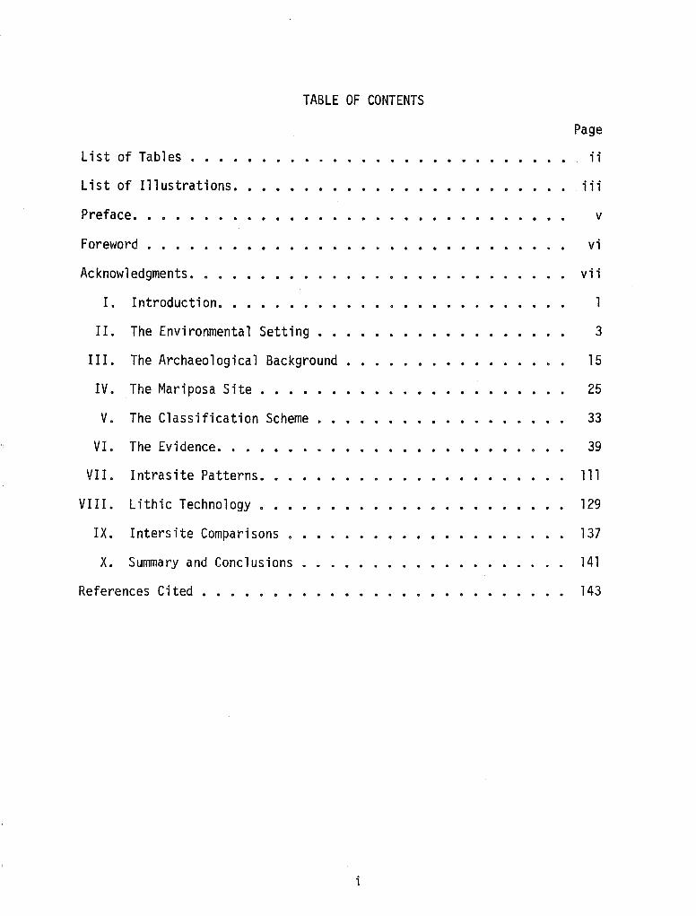
TABLE OF CONTENTS
List of Tables ..••
List of Illustrations.
Preface ••
Foreword . • ••.
Acknowledgments.
I. Introduction ••
. . . . . . . .
II. The Environmental Setting •••••.
III. The Archaeological Background .
IV. The Mariposa Site ••••••
V. The Classification Scheme
VI. The Evidence •••••
VII. Intrasite Patterns.
VIII. Lithic Technology.
IX. Intersite Comparisons .
X. Summary and Conclusions
References Cited ••••••.
i
. . . . . . . . . .
Page
ii
. iii
v
vi
vii
l
3
15
25
33
39
111
129
137
141
143
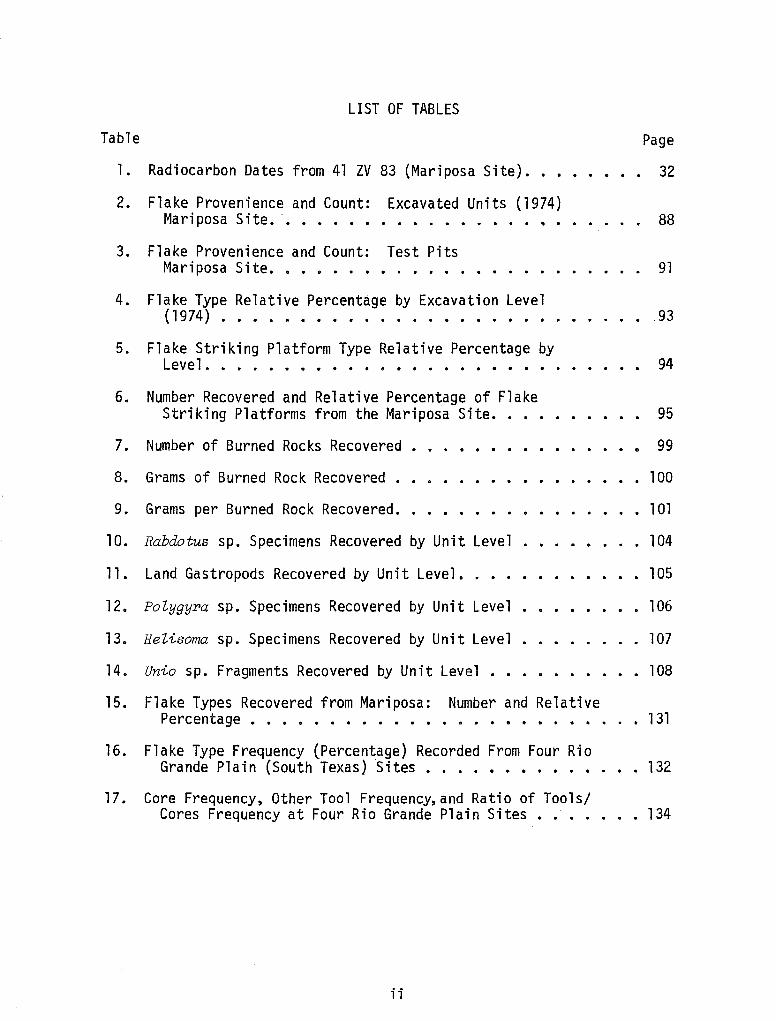
LIST OF TABLES
Table Page
1. Radiocarbon Dates from 41 ZV 83 (Mariposa Site) ••• 32
2. Flake Provenience and Count: Excavated Units (1974) Mariposa Site ••••••• . . . . . . . . . . . 88
3.
4.
5.
6.
Flake Provenience and Count: Test Pits Mariposa Site ••••••••
Flake Type Relative Percentage by Excavation Level (1974) ......•............•..
Flake Striking Platform Type Relative Percentage by Level . . . . • . • . . . . . . . . . . . • • . •
Number Recovered and Relative Percentage of Flake Striking Platforms from the Mariposa Site.
91
93
94
95
7. Number of Burned Rocks Recovered • . . . . • 99
8. Grams of Burned Rock Recovered ••.
9. Grams per Burned Rock Recovered.
10. Rabdotus sp. Specimens Recovered by Unit Level .
11. Land Gastropods Recovered by Unit Level.
12. PoZygyra sp. Specimens Recovered by Unit Level •
13. HeZisoma sp. Specimens Recovered by Unit Level •
• l 00
. l 01
. 104
. •. 105
. 106
. . l 07
14. Unio sp. Fragments Recovered by Unit Level •••••••••• 108
15. Flake Types Recovered from Mariposa: Number and Relative Percentage • • • • • • • • • • • • • • • • • • • 131
16. Flake Type Frequency (Percentage) Recorded From Four Rio Grande Plain (South Texas) Sites • • . . • • • • • • • 132
17. Core Frequency, Other Tool Frequency, and Ratio of Tools/ Cores Frequency at Four Rio Grande Plain Sites • . . • 134
ii
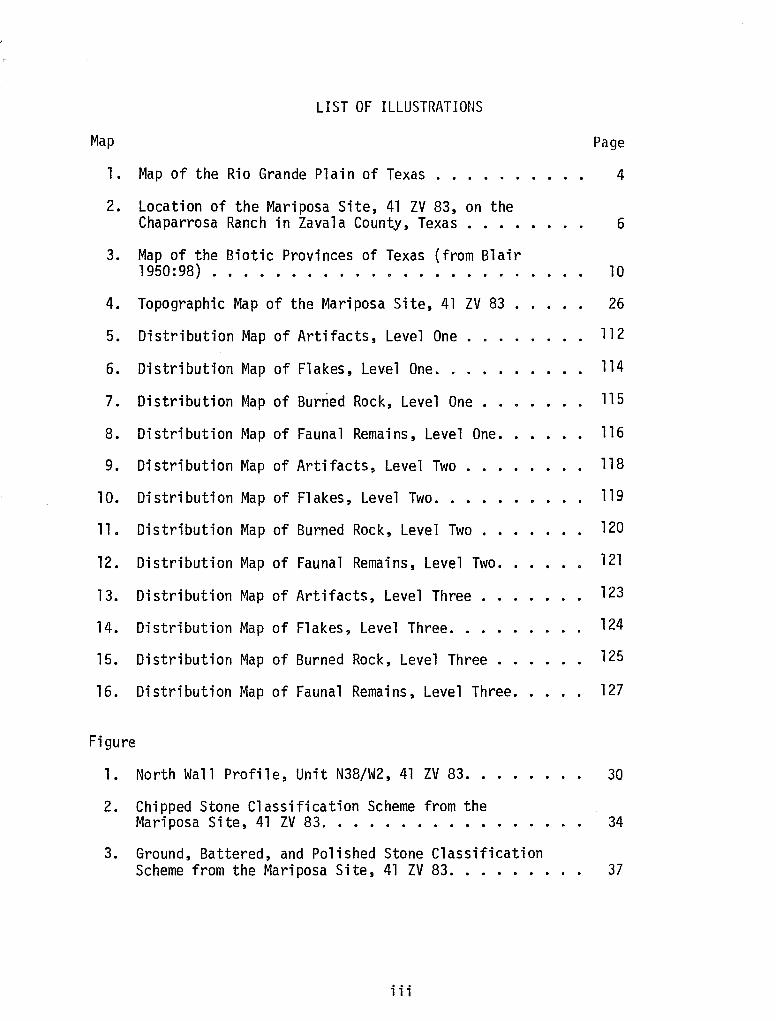
LIST OF ILLUSTRATIONS
Map
l. Map of the Rio Grande Plain of Texas ..... .
2. Location of the Mariposa Site, 41 ZV 83, on the Chaparrosa Ranch in Zavala County, Texas •..•
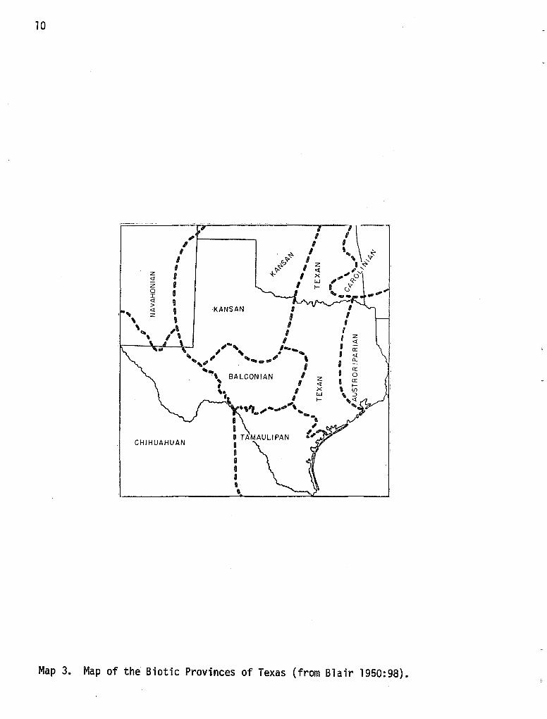
3. Map of the Biotic Provinces of Texas (from Blair 1950:98) ............... .
4. Topographic Map of the Mariposa Site, 41 ZV 83 .
5. Distribution Map of Artifacts, Level One .
6. Distribution Map of Flakes, Level One ••
7. Distribution Map of Burned Rock, Level One •
8. Distribution Map of Faunal Remains, Level One •.
9. Distribution Map of Artifacts, Level Two •
10.
11.
12.
Distribution Map of Flakes, Level Two ..
Distribution Map of Burned Rock, Level Two •
Distribution Map of Faunal Remains, Level Two.
13. Distribution Map of Artifacts, Level Three .
14. Distribution Map of Flakes, Level Three .•.
15. Distribution Map of Burned Rock, Level Three .
16. Distribution Map of Faunal Remains, Level Three.
Figure
1. North Wall Profile, Unit N38/W2, 41 ZV 83 ..
2. Chipped Stone Classification Scheme from the Mariposa Site, 41 ZV 83 .•••....•.•
3. Ground, Battered, and Polished Stone Classification
Page
4
6
10
26
112
114
115
116
118
119
120
121
123
124
125
127
30
34
Scheme from the Mariposa Site, 41 ZV 83. . . . • . • 37
iii
4.
5.
Plate
Burinated Biface, A-109 ....... .
Core Reduction Sequence at the Mariposa Site, 41 zv 83 • • . • • • . • • • • • . . .
1. Utilized Flakes, Trimmed Flakes and Scrapers.
2. Unifaces and Cores
Page
62
64
44
54
3. Cores and Projectile Points . 66
4. Projectile Points, Battered Stone and Ground Stone. . 73
5. Ground Stone . . . . . . . . . . . . . . . . . . . . 82
iv
PREFACE
In Volume I of the Chaparrosa Ranch Series, a series of brief papers outlined the nature and scope of archaeological research conducted at the ranch since 1970. It was noted that in 1974, extensive excavations were conducted at site 41 ZV 83 (Chaparrosa 28). The field work was done, under my direction, by the students of the first archaeological field school to be offered by the Division of Social Sciences, The University of Texas at San Antonio (UTSA).
In 1975, John Montgomery, then a graduate student at Texas Tech University, was one of the participants in the 1975 UTSA Field Course in Archaeology, also carried out at the ranch. Montgomery became interested in the past year's work at 41 ZV 83, and in his spare time (i.e., in the hottest part of the day when the rest of us had repaired to the shade of the field camp), he and two other students dug a test unit in a part of the site that had been previously unexcavated. Their discoveries further increased Montgomery's interest in the site.
After the conclusion of the field school, Montgomery and I discussed the possibility of using the 41 ZV 83 materials in the preparation of his Master's Thesis. This was agreed upon by other members of his thesis committee.
Thus, in this second volume in the Chaparrosa Ranch series, the results of Montgomery's extensive analysis are presented. Some minor revisions have been made, and I am grateful to Elizabeth Branch for her careful editing of the draft manuscript. I am particularly proud of John Montgomery's continued efforts and careful research in producing this piece of work. It is the first fully-detailed report of a major archaeological excavation in southern Texas. It is valuable in that regard, and will serve as a basic reference for south Texas archaeologists for many years. In addition, it is an excellent summary of Late Prehistoric cultural remains in southern Texas. The Late Prehistoric, we are now learning, was a time of substantial--and very intriguing--cultural change in southern Texas. Montgomery's data, and those obtained in other parts of south Texas since he completed his research, present a multitude of problems to be resolved and challenges to be faced by archaeologists working in this region.
Thomas R. Hester Director, Center for Archaeological
Research June 1978
v
FOREWORD
This study of the results of archaeological survey and excavation at the Mariposa site is a contribution to three levels of the discipline. As a pioneering report of detailed excavation data from south Texas, it is a contribution by way of a substantial start on filling in a 11 gap 11 which has existed in regional cultural history. While this is an elementary contribution, it is just the sort of fundamental effort which we are discovering must yet be done in many geographic areas of the United States. The fundamental, detailed examination of the archaeological record in North America is far from complete. Happily, with public support, via legislation, the threatened segments of the archaeological record are now receiving much more serious and systematic attention than ever before. We can confidently look forward to a period of massive recovery and interpretation of large segments of the unexplored record of the past.
The second contribution of this study is in the form of a sophisticated attempt to further our understanding or interpretation of evidence from the prehistoric past. The definition, comparison and testing of a lithic technology model (or theory) has moved our understanding of this general aspect of prehistoric people forward, perceptibly.
Thirdly, by using the concepts of 11 objective11 and 11 operation 11 explicitly as means of organizing the writing of this study, Montgomery has taken a significant step into the future of explicitly 11 operational 11 archaeology. Although of limited application here, these concepts have had in important guiding function in his report preparation and the all-important final step of the research process--communication.
I am pleased to note, finally, that this field and laboratory-library project was from start to finish a joint effort, linking individuals at both Texas Tech University and The University of Texas at San Antonio in the common effort to explore and learn about Texas prehistory.
vi
~~i 11 i am J. Mayer-Oakes June 1978
ACKNOWLEDGMENTS
I am greatly indebted to my committee members, Dr. William J. Mayer-Oakes, thesis chairman, Dr. P. Hickerson, and Dr. Thomas R. Hester, for their continued suggestions, criticisms and support during the preparation of this thesis. Philip Bandy assisted with many of the technical aspects of this thesis and Richard Alvey prepared several artifact drawings. Many faculty members and graduate students of the Department of Anthropology, Texas Tech University, must be thanked for their useful ideas and comments. The support of the Department of Anthropology, Texas Tech University, and the Center for Archaeological Research, The University of Texas at San Antonio, with facilities and supplies is appreciated. Mr. B. K. Johnson of the Chaparrosa Ranch allowed this research to occur on his ranch and permitted the author to move the artifacts to Lubbock for analysis. Jeannette Shaver typed the initial and final drafts of this thesis, and Sharon Crawford printed the plates. The support and encouragement of my parents made this thesis possible. Words cannot express the thanks due to Cori Montgomery. My wife washed, labeled, and cataloged artifacts, typed and edited many portions of the thesis and contributed needed encouragement during this project. Any errors or omissions are the author's responsibility.
vii
I. INTRODUCTION
It has frequently been asserted that there is a dearth of information concerning the culture history and the lithic and ceramic technologies of south Texas (cf. Hester and Hill 1975b). This study presents archaeological data from the excavation of a Late Prehistoric occupational locality, the Mariposa Site (41 ZV 83), on the Rio Grande Plain of Texas. It is hoped that this report will contribute to the understanding of Late Prehistoric lifeways and material culture, and will constitute a step toward bridging gaps which presently exist in the archaeological record.
Analysis of the materials excavated at Mariposa utilizes three general operations to achieve three corresponding, yet interrelated, archaeological objectives. The first objective to be considered here is description and compilation of the recovered archaeological data. To insure that future archaeological research can proceed from data recovery (in its most general sense) into realms of processual questions (e.g., settlement patterns, ecological adaptation, etc.), a solid information base as well as initial interpretations must exist. Since this objective has been only partially fulfilled for most areas in the Rio Grande Plain, it was considered to be an important objective to achieve in this thesis. To generate such data, a general site report format was chosen to act as an "outline" within which the operation of material description and analysis would be applied. A brief section on the environmental characteristics of the Mariposa site, along with a summary of the associated archaeological research previously reported, forms a background for the description of the excavated materials. An effort is made to elaborate on the significance of the horizontal and vertical distribution of artifacts and other cultural material (burned rock, snail and mussel shells, bone fragments). This aspect of the thesis results in statements concerning intrasite patterning and the possible location of functionally specific activity a re as within the site. A 11 of this inf orrna t ion wi 11 be derived from the surface collections, test pits and excavation units executed at the Mariposa site.
Interpretation of the lithic technology utilized by the Late Prehistoric inhabitants of Mariposa, the second thesis objective, will be much more limited in scope than the previous objective. Here, the operations to be considered rest upon a test of a generalized lithic technology model previously presented by Hester (1975b). A basically technological artifact description combined with a flake attribute analysis forms the bulk of the operations to be initiated. Tabulation of specific artifactual items mentioned by the model (cf. Hester 1975b) should, when combined with the other two operations mentioned above, spell out the overall validity of the lithic technology model.
Finally, results from the first two objectives form the basis of the third objective: a brief integration of the archaeological evidence excavated from Mariposa into the context of the regional archaeology. Operations necessary to resolve this final objective consist primarily of extracting the pertinent literature for comparison with the archaeological information excavated from Mariposa. Types of data considered most important include the results of the flake analysis, faunal analysis, feature descriptions, intra- and intersite

2
patterning of artifacts and/or features, and descriptions of basic lithic assemblage. Data prepared for this report will be compared and contrasted with related materials from other published Late Prehistoric sites within the Rio Grande Plain.
3
II. THE ENVIRONMENTAL SETTING
For an adequate understanding of the prehistory of any area, a description of the natural resources and the physical setting is necessary. The Rio Grande Plain of southern Texas has many characteristics which directly relate to its utilization by humans in the past and present. The following section presents a physiographic definition of the Rio Grande Plain region, its boundaries, geology, topography and natural features, climate, soils, and biota.
Definition of the Rio Grande Plain
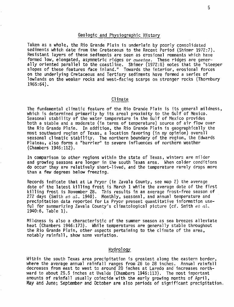
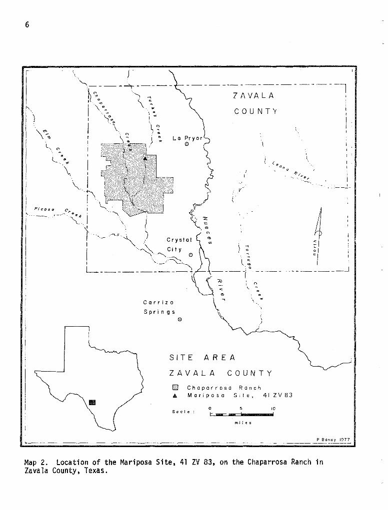
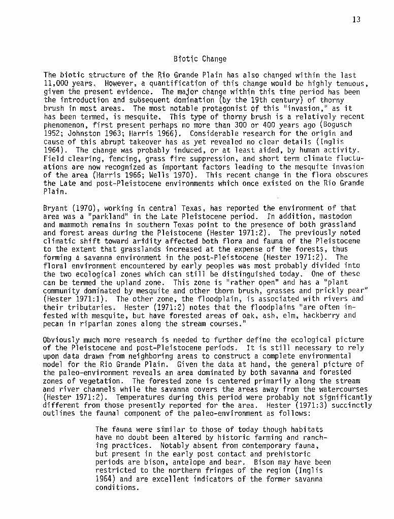
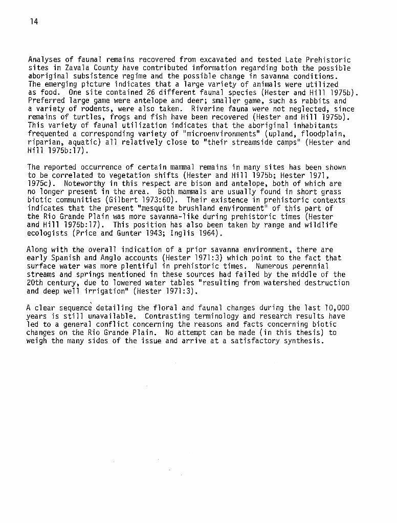
The Rio Grande Plain is that area of southern Texas whose western boundary is the Rio Grande, whose eastern and southern boundary is the Gulf of Mexico, and whose northern boundary lies just below the Balcones Escarpment of the Edwards Plateau. Thus, the Rio Grande Plain encompasses most of the region of southern Texas between San Antonio and Brownsville (see map 1). Counties within this area are Maverick, Zavala, Dinmit, Frio, LaSalle, Atascosa, McMullen, Live Oak, Jim Wells, Duval, Jim Hogg, Starr, Brooks, Hidalgo, Zapata and Webb. The region covers approximately 26,350 square miles (Chambers 1946:111). Field research for this thesis was centered within the Chaparrosa Ranch, located in northwestern Zavala County.
As a physiographic unit, the Rio Grande Plain lies within the West Coastal Plain of Fenneman (1938) and Thornbury (1965). It is also considered part of the Coastal Plain by Hunt (l972). Johnson (1931) treats the region as a unique one, which he terms the South Texas Plains. To retain terminological consistency established by Inglis (1964) and Hester (1971), this thesis uses the regional term Rio Grande Plain to describe the area in question. Elevation of the plain varies from 1,000 feet in the interior of the region to sea level in the coastal zone. In general, the region is a semi-arid lowland character-· ized by a mild climate and a long growing season of approximately 260 days (Johnson 1931:133).
Physiography and Topography
The Rio Grande Plain exhibits a varied topography. Overall it is a lowland which reaches a maximum elevation of 1,000 feet to 1,100 feet at the base of the Edwards Plateau (Chambers 1946:112). Sub-areas within the Rio Grande Plain, though, reveal different types of topography. The central and most of the northern areas are rolling plains while the southeastern area is a level section which parallels the Gulf coastline. A more rugged topography is seen in the western and southwestern areas where the land slopes down toward the Rio Grande. This rugged (or dissected) topography is due to the action of short, rapid streams flowing into the Rio Grande (Chambers 1946:112).

4
• N
LLANO
ESTACADO
EDWARDS TRANS
PLATEAU PECOS
Sc a I e
0 50 100 I - - I I
P Bandy 77
Map 1. Map of the Rio Grande Plain of Texas.
5
Geologic and Physiographic Hi'story
Taken as a whole, th.e Rio Grande Plain is underlain by poorly consolidated sediments which date from the Cretaceous to the Recent Period (Shimer 1972:7). Resistant layers of these sediments are seen as erosional remnants which have formed low, elongated, asymmetric ridges or auestas. These ridges are generally oriented parallel to the coastline. Shimer (1972:8) notes that the 11 steeper slopes of these features face inland. 11 Towards the interior, erosional forces on the underlytng Cretaceous and Tertiary sediments have formed a series of lowlands on the weaker rocks and west-facing scarps on stronger rocks (Thornbury 1965: 64}.
Climate
The fundamental climatic feature of the Rio Grande Plain is its general mildness, which is determined primarily by its areal proximity to the Gulf of Mexico. Seasonal stability of the water temperature in the Gulf of Mexico provides both a stable and a moderate (in terms of temperature) source of air flow over the Rfo Grande Plain. In addition, the Rio Grande Plain is geographically the most southward region of Texas, a location favoring (in my opinion) overall seasonal climatic stability. The northern boundary of the region, the Edwards Plateau, also forms a "barrier" to severe influences of northern weather (Chambers 1946:112).
In comparison to other regions within the state of Texas, winters are milder and growing seasons are longer in the south Texas area. When colder conditions do occur they are relatively short-lived, and the temperature rarely drops more than a few degrees below freezing.
Records indicate that at La Pryor (in Zavala County, see map 2) the average date of the latest killing frost is March 1 while the average date of the first killing frost is November 28. This results in an average frost-free season of 272 days (Smith et aZ. 1940). Monthly, seasonal, and annual temperature and precipitation data reported for La Pryor present quantitative information useful for summarizing Zavala County's climatological picture (cf. Smith et aZ. 1940:6, Table 1).
Mildness is also a characteristic of the sunmer season as sea breezes alleviate heat (Chambers 1946:173). While temperatures are generally stable throughout the Rio Grande Plain, other aspects pertaining to the climate of the area, notably rainfall, show some variation.
Hydrology
Within the south Texas area precipitation is greatest along the eastern border, where the average annual rainfall ranges from 26 to 28 inches. Annual rainfall decreases from east to west to around 20 inches at Laredo and increases northward to about 25.5 inches at Uvalde (Chambers 1946:113). The most important amounts of rainfall usually coincide with the early growing months of April, May and June; September and October are also periods of significant precipitation.
6
. '·
f'--.
I\~-. L\ "
·. -l_ ....
·.' -'JC
II
Picosa
""··-._.'_....-..
."-..._ : :.~" ---~----- -----------------!
ZAVALA I " "'I -I I o \ .. c
··\""o_ -- " ._.
."-,o"' ·."
' .. I"'
.\ v~ • (') : Clo
\ : ) ':,. La Pryor 0
)
\ {':: I ( ~ r ··-,~.·~J.~ ) Crystal I~ I '-- . tn
I ··.~ City
\··~ 0 · ... ~
COUNTY
I I
I _, I o . ~
(." . . o/J tJ
0
c:
I '·-. -·"·°") L_ __________ _ •. Q _________ __J
Carrizo
Springs 0
SITE AREA
: C'>
\. -"' ..
\ ..,
ZAVALA COUNTY
D Chaparrosa Ranch A Mariposa Site, 41 ZV83
Sc a I e : 0 5
I - ..... I
m 11 es
10 I
Map 2. Location of the Mariposa Site, 41 ZV 83, on the Chaparrosa Ranch in Zavala County, Texas.
7
Chambers (1946:113) has noted that the Rio Grande Plain is regarded as a subhumid region. Despite this classification, irregular rainfall also characterizes the general climatic pattern, causing frequent droughts. This fact makes irrig.ation an' important necessity for the present ag"ricultural economy of the area.
Considerations concerning the rainfall patterns of an area do not, of course, describe the whole hydrological picture. In addition to rainfall pools and runoff, there are two main water sources in the Rio Grande Plain: year-round rivers and streams.
Permanent flowing rivers are fairly numerous in the region. Major river systems (and their tributaries) are the Nueces, the Western Nueces, Frio, Sabinal, and Medina (the last four are not illustrated). These are the 11 principal spring-fed streams 11 within the area (Chambers 1946:115}. The largest river in the area, the Rio Grande, also forms the western boundary of the region. These river systems cut across the belted geological strata (described above} and form broad, shallow valleys filled with alluvial deposits (Johnson 1931:134}.
When considering only Zavala County, the principal streams are the Nueces and Leona Rivers and Turkey and Chacon Creeks (Chacon not illustrated}. These streams 11 occupy broad shallow valleys, and most of the upland slopes rise smoothly and gently away from the floodplains, 11 due to the original geology and topography of the area (Smith et aZ. 1940:2}.
Soils
The diverse topography present within the Rio Grande Plain gives rise, in part, to a corresponding variation in soil types in the area. Soil types characteristic of the region range from red and reddish-brown loam to light, sandy soil. The sandy soil actually forms dunes when proper wind conditions are present (Chambers 1946:112). Alluvial soils near streams are very fertile and are cultivated today.
Surface deposits and soils within the region consist mainly of marly deposits along the coast and sandy, silty clay deposits associated with the poorly consolidated formations of the Rio Grande Plain interior (Hunt 1972:87}. Another large group of soils, the Zonal and Intrazonal soils, are found in most other areas where the underlying bedrock formations are more consolidated. In warm, semi-arid regions, dominated by a mixed shrub and grass vegetation (like that of the Rio Grande Plain}, both reddish-brown and reddish-chestnut zonals are frequently present, along with the darker Rendzina soils of the Intrazonal group. Local climati~ conditions and vegetation patterns can be correlated for the most part to the type of soil group likely to be present (Hunt 1972:87}. 11 Since soil characteristics and their area distribution may be regarded as a summation of natural forces and conditions" (Johnson 1931:66), it would be advantageous to describe the basic soil characteristics of the Rio Grande Plain region. Soils within the region are very similar to other areas of Texas, especially those of East Texas. But, while the soils commonly found in East
8
Texas C1re leached of thetr minerC1ls· and nutrients? those found on the Rio Grande PlC1tn are not leached to a stgnificant degree, This lack of l~aching ts prtnctpallf due to relatively lesser amounts of annual ratnfall (about 20 tnches). Thus the sotls of the region exhibit a continual accumulatfon of miner~l nutrients, most notably calcium carbonate,
Accounts concerning the various soih which have developed in the Rio Grande Plain are available. One source describes 23 soils grouped under six divisions, based on dtsttnctive soil features, topography and vegetation (Carter 1931:91-94). Stnce these divisi-0ns are used to characterize sotls found in the 22,000,000 acres making up the Rio Grande Plain, it ts reasonable to scale down the scope of i'nqui'ry for deta i1 ed soil descripti'ons.
Li'ght-brown soils are predominant in the northwestern portion of the Rio Grande Plain (Carter 1931:101). Further, this porti'on of the Rio Grande Plain encompasses the area of i'n1111edtate concern. Briefly stated, the soil characteristics of this area are: (1) development from calcareous parent-materials, mainly limestone, marl, or alluvial deposits of calcareous soil materials; (2) lack of heavy grass coverage; and (3) subsurface build-up of calcium carbonate layers. Native vegetation associated with the light-brown soils are ''short grasses and scattered shrubs'' (Carter 1931:101). Carter (1931:101) divides the light-brown soils into the following series·: Maveri'ck, Zapata, Ector and Uvalde.
Withi'n the Chaparrosa Ranch in Zavala County (map 2), the soil complex can be more completely defined. Inspection of the soil survey report dealing with Zavala County reveals considerable soil type variation. For Zavala County alone, 32 soils have been described; these are also considerd representative of the northwestern part of the Rio Grande Plain (Smith et al. 1940:13). Descriptions of all these and the remaining 27 soil groups are available in detail which cannot be approached here. One should consult Smith et al. (1940) for further detai"led information.
The Chaparrosa area has been described as a gently sloping upland with some areas being nearly level (Arriaga 1974). The dominant soil type, Uvalde silty clay loam, is considered a member of the finely-silted, mixed, hyperthermic family of Aridic Calciustolls (Arriaga 1974). When profiled, this soil type is generally dark greyish brown, calcareous, silty clay loam from 10 to 20 inches in depth (the Al horizon). The next horizon (B2), from 20 to 42 inches, is characterized by silty clay loam of a greyish brown to brown color. This horizon has a higher CaCo content and is also considered more 11 clayey 11
(Arriaga 1974). From 42 ~o 64 inches, the soil color becomes a paler brown. Associated with this horizon, the Cl, is a general increase in alkaline conditions and clayish soi'l. Highest CaC03 content (alkalinity) and clayish conditions are found in the last soil divisional profile, the C2. The Cea horizon extends from 64 to 80 inches in depth. Beds of limestone and chert gravel underlie the soil hortzons just described.
The Uvalde soil series described above found on the Chaparrosa Ranch extend from the alluvial fans which flank the Edwards Plateau. They are found on
9
the terraces of streams which drain the Edwards Plateau within Texas. Associated slope gradients are usually less than 1 percent but can range up to 3 percent (Arriaga 1974). Since the soil is formed in alluvium from limestone, there is an associated high percentage of alkalinity within the soil, usually in the form of calcium carbonate (CaC03). Ranges in alkalinity vary from 11 5 to 25 percent in the A horizon up to 40 to 75 in the C horizon 11 (Arriaga 1974). There is usually a rise in calcium carbonate content with increasing soil depth.
Johnson (1931:66) has noted the soils, topography and climate are interrelated features within the total environment of any area. Each one determines (to some degree) the characteristics of the other features, and together they form the environmental setting. However, biota must be included as another aspect of the environment which exerts influence upon and which is influenced by the other three environmental factors.
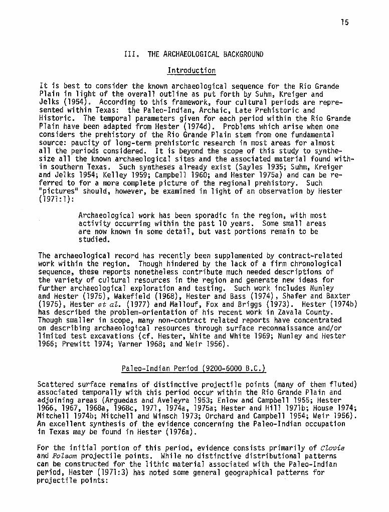
Biota
Blair 1s (1950:102-105) Tamaulipan biotic province encompasses most of the Rio Grande Plain area, and his data can be drawn on for a description of the flora and fauna characteristic of the region (see map 3). The dominant vegetation of the Tamaulipan province of Texas is thorny brush. Blair (1950:103) notes that this vegetation pattern begins just below the Balcones fault line and continues to the south across the Rio Grande into Mexico. When viewed from east to west, the brushland tends to thin out as available moisture declines. Plant species presently found in the Tamaulipan province include mesquite (PZ'osopis jutifZora), certain species of Aaaaia and Mimosa, granjeno (Ceitis paZZida), 1i$num vitae (PorZiera augustifoZia). cenizo (Leuaoph~ZZum texanum), white brush {Aloysia texana), prickly pear (Opuntia Zindheimeri}, tasajillo (Opuntia ZeptoavZis), Conda.Zia and CasteZa (Blair 1950:103).
Describing floral components associated with the Uvalde silty clay loam soil series, Smith et al. (1940:14) indicate that the soil supports a
••• grassland, on which a more or less thick growth of small trees and shrubs characteristic of a semiarid climate, has encroached. The grass cover is fairly thick in places and consists of curly mesquite, buffalo grass, certain species of grama, and some tobresa grass. There is a growth of scattered mesquite trees and of such shrubs as guajillo, soapbrush, false-mesquite, persimmon, lotebush and others.
Large trees such as live oak, pecan, elm, cottonwood and cypress presently pop-ulate river floodp,lains· and stream courses. Many of the smaller stream valleys are characterized by stands of mesquite trees. Grama, buffalo grass, mesquite grasses--to name only a few--are found in the upland areas among the
10
"i--------, , I
I I
' • • • ' ' .,,, I \
CHIHUAHUAN
KANSAN
• • II TAMAULIPAN
• • • • • ' '
Map 3. Map of the Biotic Provinces of Texas (from Blair 1950:98).
11
scattered growth of small trees and shrubs. Mesquite is the most widespread small tree here. Shrubs characteristically found in the upland areas include blackbrush, huisache, guajillo, black persimmon, false-mesquite {lambrush), catclaw, soapbrush or guayacan, lotebush, whitebrush, yucca, sangre de drago, prickly pear and other catci, and jointfir. This brush assemblage is commonly termed chaparral (Smith et al. 1940). Cenizo, creosotebush, saladillo, and alkali weed are present where local conditions are suitable.
Tamaulipan biota are well adapted to the semiarid and megathermal climate of the area (Thornwaite 1948). In quantitative terms, a moisture deficiency index ranging from -20 to -40 percent is regarded as characteristic of a semiarid and megathermal climate. Climatically, the south Texas plain is unique, as it is the only megathermal climate area in Texas and one of three located in the United States.*
According to Blair (1950:103-104), the vertebrate fauna within the Tamaulipan biotic province are characterized by a large number of 11 Neotropical 11 species and a group of grassland species which range to the neighboring Texan and Kansan provinces (see map 3). A few species from the Austroriparian province are also present. A total of 61 mammal species have been recorded in the Tamaulipan biotic province. In addition to the mammals, 36 species of snakes, 19 species of lizards, 9 of anurans, 3 of urodeles, and 2 species of land tortoises have been reported.
Blair ( 1950':'T'04i) describes in deta i 1 the di stri buti on of Neotropi ca 1 mamma 1 species and other fauna within the Tamaulipan province (see also Blair 1952). Previous statements concerning regional flora and fauna are extended further by Holdsworth (1972). In "A Study of Modern Flora and Fauna in the Vicinity of the Holdsworth Site (41 ZV 14)," Holdsworth (1972) presents a summary of plant and animal species now living within the local site area. This indepth view provides the best approximation of the ecological situation faced by the inhabitants of this site, and the possible ramifications of this study should be explored.
The vegetation patterns presently observed on the south Texas plain have not, however, been constant since the first human occupation of the area (Inglis 1964; Hester 1971). Prior vegetational shifts will be included as part of the paleo-environmental presentation.
*Southern Florida and the arid portions of southern California and southwestern Arizona are the other megathermal areas of the United States.
12
Paleo-Environment
Introduction
There is evidence of human occupation of the Rio Grande and the surrounding area for approximately the last ll,000 years (Hester l975a, l976a). Over this period of time, man has lived in environments quite unlike that of the present. It is therefore important to examine the available evidence for previous environments of the Rio Grande Plain. This review provides the background of climatic and concomitant biotic changes to which man has adapted.
Climate Change
Significant climate shifts have occurred in the general southwestern United States region since the end of the Pleistocene, considered to have occurred at about 10,000 B.P. (Butzer 1971:41). Ecological conditions present today have developed since the end of the Pleistocene. Climate, a significant part of the ecology, has fluctuated through time, probably in response to small changes of other variables (Bryson 1974). While intensive investigations concerning the paleo-environment of the Rio Grande Plain have not been conducted, neighboring areas, most notably the Trans-Pecos region of Texas, have produced useful environmental data directly pertaining to previous climates.
Based on the palynological data, Bryant and Larson (1968) have constructed a paleo-climatic model of the post-Pleistocene environment for the Trans-Pecos region of Texas. A more recent investigation in this area by Alexander (1970: 7) provides the following interpretation:
In brief, pollen data collected from a number of localities in southwest Texas, but principally from three canyon and floodplain sites indicate a gradually increasing aridity from post glacial times (ca. 10,000 B.P.) to present. A pinyon-juniper (and perhaps oak?) parkland-savanna dominates the uplands until about 4000 B.P. when more xeric vegetation dominates the pollen spectra. A brief return to mesic conditions is seen at 2500 B.P., but dramatic shifts in climate are not in evidence.
It is most probable that this general climatic pattern occurred in the Rio Grande Plain as well. To the north, in central Texas, Bryant (in Valastro, Davis and Rightmire 1970:625) has outlined a climatic picture generally equivalent to Alexander's. Mammalian cave populations in Kinney County, Texas (south-central Texas), reinforce this pattern of general aridity being interrupted 11 at least once by a period of increased moisture" (Semken 1967:10). Studies of Late Pleistocene and Holocene faunal assemblages in central Texas also point to climate conditions of increasing aridity in the last 10,000 years (Lundelius 1967). As can be expected, climate shifts will necessarily cause some corresponding changes in the biotic community of the area.
13
Bi'otic Change
The biotic structure of the Ri.o Grande Plai'n has also chan~ed within the last 11,000 years. However, a quantification of this change would be highly tenuous, given the present evidence. Th.e major chan~e within this time period has been the introduction and subsequent domination (.by the 19th century) of thorny brush i.n most areas. The most notable protagonist of this "invasion," as it has been termed, is mesquite. Thi.s type of thorny brush is a relatively recent phenomenon, first present perhaps no more than 300 or 400 years ago (Bogusch 1952; Johnston 1963; Harris 1966). Considerable research for the origin and cause of this abrupt takeover has as yet revealed no clear details (Inglis 1964). The change was probably induced, or at least aided, by human activity. Field clearing, fencing, grass fire suppression, and short term climate fluctuations are now recognized as important factors leading to the mesquite invasion of the area (Harris 1966; Wells 1970). This recent change in the flora obscures the Late and post-Pleistocene environments which once existed on the Rio Grande Plain.
Bryant (1970), working in central Texas, has reported the environment of that area was a "parkland" in the Late Pleistocene period. rn addition, mastodon and mammoth remains in southern Texas· point to the presence of both grassland and forest areas during the Pleistocene (Hester 1971:2). The previously noted climatic shift toward aridity affected both flora and fauna of the Pleistocene to the extent that grasslands increased at the expense of the forests, thus forming a savanna environment in the post-Pleistocene (Hester 1971:2). The floral environment encountered by early peoples was most probably divided into the two ecological zones which can still be distinguished today. One of these can be termed the upland zone. This zone is "rather open" and has a "plant community dominated by mesquite and other thorn brush, grasses and prickly pear" (Hester 1971:1). The other zone, the floodplain, is associated with rivers and their tributaries. Hester (1971:2) notes that the floodplains "are often infested with mesquite, but have forested areas of oak, ash, elm, hackberry and pecan in riparian zones along the stream courses."
Obviously much more research is needed to further define the ecological picture of the Pleistocene and post-Pleistocene periods. It is still necessary to rely upon data drawn from neighboring areas to construct a complete environmental model for the Rio Grande Plain. Given the data at hand, the general picture of the paleo-environment reveals an area dominated by both savanna and forested zones of vegetation. The forested zone is centered primarily along the stream and river channels while the savanna covers the areas away from the watercourses (Hester 1971:2). Temperatures during this period were probably not significantly different from those presently reported for the area. Hester (1971:3) succinctly outlines the faunal component of the paleo-environment as follows:
The fauna were similar to those of today though habitats have no doubt been altered by historic farming and ranching practices. Notably absent from contemporary fauna, but present in the early post contact and prehistoric periods are bison, antelope and bear. Bison may have been restricted to the northern fringes of the region (Inglis 1964) and are excellent indicators of the former savanna conditions.
14
Analyses of faunal remains recovered from excavated and tested Late Prehistoric sites in Zavala County have contributed information regarding both the possible aboriginal subsistence regime and the possible change in savanna conditions. The emerging picture indicates that a large variety of animals were utilized as food. One site contained 26 different faunal species (Hester and Hill 1975b). Preferred large game were antelope and deer; smaller game, such as rabbits and a variety of rodents, were also taken. Riverine fauna were not neglected, since remains of turtles, frogs and fish have been recovered (Hester and Hill l975b). This variety of faunal utilization indicates that the aboriginal inhabitants frequented a corresponding variety of 11 microenvironments 11 (upland, floodplain, riparian, aquatic) all relatively close to "their streamside camps 11 (Hester and Hill l975b:l7).
The reported occurrence of certain mammal remains in many sites has been shown to be correlated to vegetation shifts (Hester and Hill l975b; Hester 1971, l975c). Noteworthy in this respect are bison and antelope, both of which are no longer present in the area. Both mammals are usually found in short grass biotic communities (Gilbert 1973:60). Their existence in prehistoric contexts indicates that the present 11 mesquite brushland environment" of this part of the Rio Grande Plain was more savanna-like during prehistoric times (Hester and Hill 1975b:l7). This position has also been taken by range and wildlife ecologists (Price and Gunter 1943; Inglis 1964).
Along with the overall indication of a prior savanna environment, there are early Spanish and Anglo accounts (Hester 1971:3) which point to the fact that surface water was more plentiful in prehistoric times. Numerous perennial streams and springs mentioned in these sources had failed by the middle of the 20th century, due to lowered water tables "resulting from watershed destruction and deep well irrigation 11 (Hester 1971 :3) •
. A clear sequence detailing the floral and faunal changes during the last 10,000 years is still unavailable. Contrasting terminology and research results have led to a general conflict concerning the reasons and facts concerning biotic changes on the Rio Grande Plain. No attempt can be made (in this thesis) to weigh the many sides of the issue and arrive at a satisfactory synthesis.
15
III. THE ARCHAEOLOGICAL BACKGROUND
Introduction
It is best to consider the known archaeological sequence for the Rio Grande Plain in li~ht of the overall outline as put forth by Suhm, Kreiger and Jelks (1954). According to this framework, four cultural periods are represented within Texas: the Paleo-Indian, Archaic, Late Prehistoric and Historic. The temporal parameters given for each period within the Rio Grande Plain have been adapted from Hester (1974d). Problems which arise when one considers the prehistory of the Rio Grande Plain stem from one fundamental source: paucity of long-term prehistoric research in most areas for almost all the periods considered. It is beyond the scope of this study to synthesize all the known archaeological site~ and the associated material found within southern Texas. Such syntheses already exist (Sayles 1935; Suhm, Kreiger and Jelks 1954; Kelley 1959; Campbell 1960; and Hester 1975a) and can be referred to for a more complete picture of the regional prehistory. Such "pictures" should, however, be examined in light of an observation by Hester (1971: 1):
Archaeological work has been sporadic in the region, with most activity occurring within the past 10 years. Some small areas are now known in some detail, but vast portions remain to be studied.
The archaeological record has recently been supplemented by contract-related work within the region. Though hindered by the lack of a firm chronological sequence, these reports nonetheless contribute much needed descriptions of the variety of cultural resources in the region and generate new ideas for further archaeological exploration and testing. Such work includes Nunley and Hester (1975), Wakefield (1968), Hester and Bass (1974), Shajer and Baxter (1975), Hester et al. (1977) and Mallouf, Fox and Briggs (1973). Hester (1974b) has described the problem-orientation of his recent work in Zavala County. Though smaller in scope, many non-contract related reports have concentrated on describing archaeological resources through surface reconnaissance and/or limited test excavations (cf. Hester, White and White 1969; Nunley and Hester 1966; Prewitt 1974; Varner 1968; and Weir 1956).
Paleo-Indian Period (9200-6000 B.C.)
Scattered surface remains of distinctive projectile points (many of them fluted) associated temporally with this period occur within the Rio Grande Plain and adjoining areas (Arguedas and Aveleyra 1953; Enlow and Campbell 1955; Hester 1966, 1967, l968a, 1968c, 1971, 1974a, 1975a; Hester and Hill 197lb; House 1974; Mitchell 1974b; Mitchell and Winsch 1973; Orchard and Campbell 1954; Weir 1956). An excellent synthesis of the evidence concerning the Paleo-Indian occupation in Texas may be found in Hester (1976a).
For the initial portion of this period, evidence consists primarily of Clovis and Folsom projectile points. While no distinctive distributional patterns can be constructed for the lithic material associated with the Paleo-Indian period, Hester (1971:3) has noted some general geographical patterns for projectile points:
16
The greatest concentration of ciovis points are found in the northern part of the Rio Grande Plain. FoZsom specimens ... are present in the south.
Since sea levels were lower in the Late Pleistocene period, Hester (1971:3) believes that much of the evidence for early human occupations may now actually lie below water on the continental shelf. However, there ts some additional evidence (beyond scattered projectile point finds) which can be assigned to this period.
For example, near the Texas coast on the Berclair terrace, Sellards 1 (1940) excavations revealed early point styles in apparent association with a variety of extinct fauna. In addition, evidence of association between mammoth remains and human artifacts has been reported for the Falcon Reservoir located on the lower portion of the Rio Grande (Hester 1971:3). Hester (1971:3) reports a site near Corpus Christi, on Oso Creek, in which a large mineralized bone point (suggestive of those characteristic of the Llano Complex kill-sites) was loosely associated with extinct elephant remains (cf. Haynes 1966).
Until very recently, no Paleo-Indian occupation sites had been reported within south Texas. However, excavations conducted at the St. Mary 1 s Hall site (41 BX 229) have exposed occupational material assigned to the Paleo-Indian period (Hester 1975a, 1978). Underlying a compressed Archaic deposit, FoZsom and PZainview artifacts have been excavated in association with 11 bone tools, faunal remains (mainly deer-sized mammals), lithic debris, and fragmentary preforms 11 (Hester 1975a:3). Percussion flakes, pressure flakes, and bifacial thinning flakes have been recorded from the same geological stratum as the Paleo-Indian artifacts (an alluvial deposit of small gravels in a reddish brown clay matrix labeled as Stratum III; Hester 1975a).
ciovis points, associated in certain sites with mammoth remains, have been assigned a temporal position between 9500 and 9000 B.C. Other fossil faunal species from this time span (and also now extinct) include the camel, horse, and bison (Haynes 1966:107). With the subsequent disappearance of species'of mammoth, camel and horse, a now extinct species of bison became the focus of human hunting activities. From a general time period between 8500 and 7000 B.C., FoZsom points dominate the tool kit used to kill bison. After this period new varieties of projectile points came into use. Lanceolate points and stemmed dart points such as PZainview, PZainview goZondrina, Angostura, Meserve, MiZnesand, Lerma and ScottsbZuff are common varieties which have been reported from the Rio Grande Plain (Hester 1971). Recovery of such projectile points indicates more extensive a9original occupation in the area during the latter part of the Paleo-Indian period. As Hester (1971) points out, the lack of clearly stratified Paleo-Indian sites in the Texas Rio Grande Plain necessarily dictates comparison with points forms and associated tools excavated under tighter chronological control from neighboring areas of Texas and Mexico. For Texas, both Alexander (1963) and Sorrow, Shafer and Ross (1967) provide comparative evidence from central Texas. MacNeish 1 s (1958) investigation in the Sierra de Tamaulipas furnishes dated Paleo-Indian materials from northeastern Mexico for comparison and chronological correlation. Additional comparative information concerning the Paleo-Indian period from other regions of Texas close to the Rio Grande Plain includes Bonfire shelter, a kill-site in Val Verde County (Dibble and
17
Lorrain 1968). Monte11 Rockshelter in Uvalde County (Sellards 1952; Suhm, Kreiger and Jelks 1954), Kincaid Rockshe1ter in Uvalde County (Se11ards 1952; Suhm, Kreiger and Jelks 1954), Baker Cave in Val Verde County (Word and Douglas 197Q, Hester 1978)., the Johnston-Heller site in Victoria County (Bfrmingbam.and Hester 1976), and Devil 1 s ·Mouth· in Val Verde County (Johnson 1964;·Sorrow 1968).
Other areas within Mexico have also generated valuable data in this context. Epstein's (1969, 1972)' work in Neuvo Leon has brought to light Paleo-Indian materials which have crystallized some reinterpretation of Paleo-Indian subsistence and technology (cf. Hester 1976a).
After describing the d.i.stribution of Paleo-Indian artifacts within the Rio Grande Plain, little can be conclusively said, due to the lack of clear evidence concerning the hunting of Pleistocene megafauna. According to Hester (1971) and Newton (1968), small, nomadic groups of non-specialized hunters and _ gatherers constituted the human population in the Paleo-Indian period on the Rio Grande Plain.
The question of whether or not this general type of subsistence regime lasted throughout the 3000~year period designated as Paleo-Indian cannot currently be answered. Broad theoretical pictures concerning the technology and subsistence pattern have been formulated for other areas during the later stages of this period (Late Paleo-Indian) (Mason 1962; Sollberger and Hester 1972). Citing the archaeological evidence for the Eastern United States, Mason (1962: 246) constructs an image of 11 involution 11 during the Late Paleo-Indian period. This involution is"characterized by a 11 regionalization 11 of the Paleo-Indian artifact types which is probably due to a greater dependence and subsequent "adaptation to local food resources. 11
· -.
In an area closer to southern Texas, a somewhat similar statement has been forwarded by Sollberger and Hester (1972). With the loss of the megafaunal component in the environment, dependence shifted to vegetable materials to supplant small game kills. This adaptation can be seen in the archaeological record, especially at the Strohacker site of central Texas. Careful surface collection of this site adds to a growing body of data which demonstrates the presence of corner-notched and stemmed dart points in 11 both Paleo-Indian and pre-Archaic contexts in Texas" (Sollberger and Hester 1972:335). The evi-dence reviewed for Texas has now tentatively defined a pre-Archaic transitional phase (Sollberger and Hester 1972:335-337). Over a period of approximately 2500 years, between 6000 and 3500 B.C., new projectile points appear along with Cate Paleo-Indian styles. There are three types: (1) corner-notched, expanaing stem dart points, similar to the Martindale type; (2) stemmed dart points with concave bases (Gower type); and (3) corner-notched dart points similar to the UVaZde typ~,~ This sequence, as defined by Sollberger and Hester, still lacks specification in terms of associated lithic material. Clear evidence for the corresponding transition into the Archaic period in southern Texas has yet to appear.
18
Archaic Period (6QOO a,c,-A,D. 1200}
As a di,sttnct pertod, the Archatc has only been nebulously defi.ned for the Rio Grande Platn. Thts situation arises from the lack of stratified sites as·sociated wi·tn thts period in time. tn general, the Archaic is· chara,cterized by the appearance of dart potnts, whtch are belteved to be technologically and morphologtcally, separate from the preceding points as·sociated with the PaleoIndian pertod. Point types commonly recovered from this period are Tortugas, AbasoZo, Refugio, Langt'l'y, Sliwnla and Almagre, with Tortugas being the type most frequently encountered. Projecti·l e point types usually associated with the Paleo-Indian period are also known to be present in eroded Archaic sites (PZainvi·ew, Angostura and Scottsbluff) but most investigators believe these to be either mixed via eros·ion or pi'cked up by later aboriginals (Suhm, Kreiger and Jelks 1954:139; Hester 1968c:159). Other chipped stone artifacts known to occur in Archaic contexts are triangular and leaf-shaped knives, and side, oval and end scrapers. Ground stone tools such as manos and metates are recognized as part of the Archaic technology. As Suhm, Kreiger and Jelks (1954:140-141) note, based on tool types, the Archaic period of the Rio Grande Plain exhibits ties with almost all the neighboring areas of Texas and Mexico within the same time period. Descriptions of this period have, until recently, consisted of two foci, the Falcon and Mier. Nei'ther of these complexes was ever clearly isolated and defined and Hester (1971) recommends dropping tnese terms, since they seem to only confuse what Httle is known archaeologically about the Archaic period in this area.
Evidence for the occupation of the Rio Grande Plain during the Archaic period is scattered and in many cases, incomplete. Up until the late 1960s, few field studies had been initiated dealing specifically with the Archaic. Within the last decade, however, attention has been drawn to the need for clearer archaeological definition of the Archaic period. At Falcon Reservoir, a living floor dated to this period was described by Hartle and Stephenson (1951). This floor revealed triangular and subtriangular dart points with various unifacial and bifacial tools, including Clear> Fork gouges (Hester 1971). A radiocarbon analysis from organic material recovered on the floor indicated a date of 2700 B.C. (Krieger 1954:565). In Mexico, MacNeish (1958) has outlined the Archaic sequence for the northern Tamaulipas area. The archaeological data from his survey and excavation research resemble much of the scattered evidence recorded on the Rio Grande Plain and his divisions of the Archaic period can only be broadly applied to southern Texas. These divisions, the Nogales, Repelo, Abasolo and Catan Complexes, however, do little to describe human adaptations thoughout the Archaic. Instead, the picture of an overall continuum of similar artifacts which are not significantly changed permeates the period (Hester 1971). As an example, Hester (1971) refers to a unique artifact tool type, the Clear For>k gouge, which is actually present in contexts associated from the PaleoIndian period up to the Late Prehistoric period, a length of time which roughly approximates 10,400 years (from 9200 B.C. to A.O. 1200).
Integration of data from surrounding areas has changed the picture of Archaic subsistence and technology on the Rio Grande Plain (Hester 1976b). Throughout the period, dart points such as Tortugas, Langtry, Shumla, Abasolo, Refugio
and Atmag:r:iet show rel~ttons·hips: to the Pecos River focus to the west, while the presence of' ,4Jma:e-:r~. points indtcates contact to the south 1 n Tam~ul 1 pas (Suhm, Kretger and Jelks 1954L According to Suhm, Kretger and Jelks (1954), the above menti.oned dart poi'nts are ~ssociated with the Falcon Focus, which they place chronologically between ·5000 B.C. to A,D. 500 or lOPP. The introduction of smaller yet morphologi'cally s.imthr points· such as Matamoros and
19
Catan a~.d ~lie much smaller arrow p~tnts of th~. J!!l.1esr:o and PeP~iz variety '!larks the begrnnrng of the next focus, Mrer. The s1mrlar1ty of artifact types rn thes·e two foci makes· them hard to di'sttnguish, Suhm, Krieger and Jelks (1954: 142) regard the Mier Pocus as· being "transitional between Palcon Pocus and the historic hortzon. It might als·o be regarded as a .late phase of Falcon focus."
Investigators in the area, most notably Hester, have produced evidence for a clearer deftnitton of the Archaic period. Again using projectile points as time-space markers, triangular and stemless Tortugas points are taken to indicate 11Middl e Archaku occupations, foll owed temporally by the appearance of "smaller, notched forms't (Ensor, Frio} in the 11 late Archaic" (Hester 1974a:8). Associated rad toca rbon dates· for Late Archaic forms from the Za va 1 a County area appear to cluster around A.D. 580 (Hester 1975a:8). A smaller, dart-like point with stde notchi'ng, typed as ZavaZ.a, is also interpreted as indicating Late Archaic occupation. Unfortunately, artifactual evidence for other tools associated with Middle and Late Archaic point types has not yet been specified.
Although the nature of the Archaic occupations on the Rio Grande Plain is obscured by the lack of stratified contents and absolute dates, investigations are now underway to improve matters. A summar~ of the Archaic period in southern Texas (including the Rio Grande Plain) is now available (Hester 1976a). Studies concerning the aboriginal settlement patterning during this period have appeared for various areas and/or river drainages (Hester 1974b, 1975a, 1976b; Nunley and Hester 1966, 1975; Shafer and Baxter 1975; Shiner 1969). Archaic subsistence strategies (Hester 1975b; Hester and Hill 1971a, 1976b) and technological strategies (Hester 1975b; Hester and Hill 1971a; Nunley and Hester 1975; Hester, Gilbow and Albee 1973; Shafer and Hester 1971; Shiner 1969) are also being reconstructed. Additional information concerning some or all of the abovementioned aspects of the Archaic lifeway is being contained in site reports (Hester and Hill 1972; Hill and Hester 1971; Mitchell 1974c; Schuetz 1966) and survey reports (Newton 1968; Nunley and Hester 1966; 1975; Weir 1956}.
Late Prehistoric Period (A.O. 1200-A.D. 1528)
By contrast to the confusion associated with the Archaic period, evidence for the Late Prehfstoric period occupations on the Rio Grande Plain is readily available. Suhm, Kretger and Jelks (1954) indicated an apparent absence of a Late Prehistoric occupation in the area. However, since 1954 a significant number of single and multi-component sites for this period have been tested and/or excavated and subsequently reported. Zavala County stands out as a center of research dealing with Late Prehistoric subsistence settlement pattern
20
and technology. Hester and Hill (1975b) have comptled an important synthesis of the Late Prehistoric data in this area.
For Texas, the beginning of the Late Prehi srtrori c is marked by the occurrence of new items in the cultural inventory. These new traits include arrow points, ceramics, and agriculture (Hester and Hill 1975b). Lack of research in the area of south Texas led to the erroneous conclusion that the Late Prehistoric period, as defined above, did not exist in the area (Suhm, Kreiger and Jelks 1954). This earlier view held
... that the peoples of this area, ancestors of historic Coahuiltecan groups, survived in an Archaic-style, hunting and gathering lifeway until historic contact. There was some indication from surface sites (in the form of arrow points of the Perdiz, ScaZZorn and Fresno types) that the bow and arrow had been used in the area. However, there was no substantial evidence for the presence of ceramics, alterations in settlement patterns, different subsistence activities, or other Archaic patterns (Hester and Hill 1975b:l).
With the description of a bone-tempered plainware ceramic tradition in a Late Prehistoric time span, related to the already known Leon Plain ware of central Texas, initial archaeological definitions for the south Texas area during the Late Prehistoric have been attempted (Hester 1975c; Hester and Hill 1971a, 1975b). Intensive excavations and survey work in Zavala and Dimmit Counties form the interpretative basis for this new definition (Hester 1970a, 1974c; Hester and Hill 1972; Hill and Hester 1973).
The archaeological evidence for Late Prehistoric sites from areas geographically proximal to the Rio Grande Plain remains fragmentary, especially when compared to the known information available for the lower Rio Grande (Hester 1975c:109-125). Data from one nearby region, termed the Chihauhuan desert area, has been summarized elsewhere (Hester 1975c:109-111), and there are
... similarities between the late prehistoric remains from the lower Pecos and the southeastern Trans-Pecos and the materials in southern Texas. Unfortunately, so little is known about the late prehistoric that we cannot go much beyond this generalization (Hester 1975c:l21).
No cultural 11 complex 11 presently exists for the Rio Grande Plain, except near the coast. Two complexes which represent Late Prehistoric occupations have been defined for this coastal area. The Brownsville Complex, described by MacNeish (1947, 1958), is represented by a shell industry, triangular arrow points and possible ceramic artifacts and is generally in the Rio Grande delta (Hester 1971). On the central Texas coast, the Rockport Complex (Campbell 1960), with its various types of arrow points and an asphalt painted, sandy paste pottery, existed during the same time (Hester 1971:4). Corbin (1974) has recently summarized evidence for the Rockport Complex, noting that some re-evaluation in interpretation is necessary.
21
No similar Late Prehistoric complex has been defined for the south Texas interior (Hester 1971:4). Artifacts assumed to date from this period include a variety of arrow points, with Perdiz, Scallor>n and Fresno the most frequently occurring types. Zavala points, which appear to be morphologically and technologically intermediate between arrow points and dart points, are often recovered in association with Late Prehistoric artifacts. It is believed that the Zavala type (which is very similar to Johnson's Figueroa of Trans-Pecos and Trinity of East Texas) functioned as arrow points (Hill and Hester 1971).
The Late Prehistoric lithic inventory also contains blades exhibiting lateral retouch, end scrapers (made from flakes), and perforators (Hester 1971), in addition to an occasional occurrence of plain bone-tempered ceramics (Hester 1968b; Hester and Hill 1971a). Hester and Hill (1975b) and Hester (1975c) describe items of lithic, ceramic and bone which are commonly found in the Late Prehistoric context. Most radiocarbon dates from these sites indicate a span of only 250 years (A.O. 1400 to A.O. 1650) (Hester 1975a; Hester and Hill 1975b). Tortuga Flat and 41 ZV 155 appear to have been inhabited into early historic times or about A.O. 1760 (Hester and Hill 1975b; Hill and Hester 1973). Despite the fact that this date seems to place Tortuga Flat outside Late Pre~istoric temporal parameters, there is no evidence of historic contact (Hill and Hester 1973; Hester 1975c).
Because recent investigations have dealt with more (numerically) Late Prehistoric sites as compared with earlier sites, the information concerning settlement patterns, general subsistence, and technology is more readily available and more detailed (cf. Hester 1975c; Hester and Hill 1975b). This archaeological evidence indicates that environmental zones which closely flank stream channels were considered prime occupation areas by the aboriginal inhabitants. Large sites (~pproximately 3600 meters} with rich middens have been located and excavated in such areas. Midden material generally consists of large quantities of lithic tools, animal bone, land snail shells, charcoal, hearths and burned (fire-cracked) rock (Hester 1975a, 1975c).
Terraces located some distance from the streams supported two activities: workshop and occupation. Since these terraces frequently contain outcrops of chert and other knappable material, it is only natural that chipping stations and workshops should be located there. Most of the workshop sites were utilized for brief periods of time and were abandoned when the desired lithic materials had been obtained. Such sites contain "large amounts of flake refuse, partially worked cores, and broken preforms" (Hester 1971:66). Sporadically occupied, short-term campsites also are found in the terrace areas. These sites may represent overnight 11 stations 11 for extended hunting and/or gathering activities originating from the floodplain sites (Hester 1971:6). Occupation sites are also encountered in upland areas, above the terraces, and at considerable distances from water sources. Again, temporary or short-term habitation is indicated for these sites.
There are detailed statements concerning settlements and subsistence of the northwestern part of Zavala County (Hester 1975c; Hester and Hill 1975b). Most Late Prehistoric occupation sites occur on the floodplains of the Nueces River
22
and its tributaries. At least 12 major single and multi•component sites, including Mariposa, have been described and mapped for this area (Hester 1975a; Hester and Hill 1975b). Holdsworth (Hester and Hill 1972) and Tortuga Flat (Hill and Hester 1973) stand out as important published Late Prehistoric sites located in close proximity to Mariposa. Away from the Nueces River drainage, yet still within the Rio Grande Plain area, Oulline (41 LS 3) (Hester, White and White 1969), 41 ZV 153 (Hester et aZ. 1975), Stewart (Hester and Hill 1972) and Berclair (Hester and Parker 1970) sites also have provided published material concerning Late Prehistoric occupation of southern Texas.
Subsistence strategies have also been a focus of attention in the Zavala County area. Large land snails (Rabdotus sp.) and river mussels (Unio sp.) are found in great numbers and frequently clustered. Such patterning may indicate that snails were collected and extracted, perhaps by boiling (Hester and Hill 1975a, 1975b).
Along with invertebrate remains, vertebrate remains are also present at many Late Prehistoric sites. Diversity of species seems to be typical, for as many as "twenty-two different species of mammals and reptiles" were recovered from a "bone pile" at 41 ZV 155 (Hester and Hill 1975b; Hester et aZ. 1975). The Holdsworth site, in one locality, contained 21 species.
While the archaeological record indicates that many types of animals were being utilized, it is also evident that patterns of "preferred" food sources had been established. Among the larger mammals, deer and antelope were sought instead of bison (Hester and Hill 1975b:17), although bison was utilized. Rabbits and rodents constitute the major components in the small mammal category (Hester et aZ. 1975). Turtle, snake and frog were favorite reptilian species obtained by the aboriginal population, with the box turtle (Terrepene ornata) the most commonly occurring species (Hester and Hill 1975b).
The natural deterioration of evidence through time inhibits statements concerning the gathering activities of the Late Prehistoric populations. Two sites have produced data which can shed some light on the matter. It appears that acorns and spiny hackberry (granjeno) seeds were obtained by the inhabitants of Holdsworth and 41 ZV 10, respectively. Both samples have been burned (Hester and Hill 1975b).
Riverine areas close to the occupation sites probably provided the majority of animal food resources (Hester and Hill 1975b). Upland areas were utilized when larger mammals (deer, bison, antelope) were being sought.
Historic Period (After A.D. 1528)
Cabeze de Vaca•s journey across Texas marks the beginning of the Historic period. His entrance is generally thought to have occurred around A.O. 1528. Spanish influence in southern Texas gradually culminated in the local Indians being either killed, missionized, or assimilated into Spanish-Mexican groups. Not to be overlooked, though, is the large number of ethnohistorical accounts which also resulted from the Spanish and Anglo occupation.
23
Only a few· qrch.aeologi.cal si:te~· exist whi:ch can be attri.buted to the Historic period, as:·i.de from Indi.an occupations at the s.everal Spanish Colonial missions i.n s·outhern TexaS.· (Hester 1975a J, Hi.stori cal material rem" ins from those s:i tes external to the mts·sions are scattered and "i.ncl ude glass trade beads and meta 1 projectile poi'nt~· 11: (Hester 1975a:ll; see als.o Hester 1970b and Mi.tchell 1974a), The cultural assemblage as:s·octated with the mis·sion Indians has been described by Schuetz (1969}.
The aboriginal populations living away from the Spanish missions have been described primarily· from ethnohtstortca l accounts r-ather than from archaeol ogi ca 1 excavations. Whether or not s·uch informati'on is- adequate for cultural des·criptions of the native peoples· i's a questi"on whi'ch cannot be s·atisfactorily resolved at pres·ent. Dis·eas·e and expansionist pres·sures from the south doubtlessly altered the s·tructure, technology, and subsi·s·tence patterns of these populations prtor to actual Spanish settlement of south Texas (Campbell 1975).
Newcomb (1961:29) has included the Rio Grande Plain of southern Texas within the Western Gulf culture area. Semi-nomadic hunting and gathering groups, labeled as 11 Coahuiltecan, 11 occupied the interior region of southern and southwestern Texas. Coahuiltecan, a loosely applied linguistic term which encompasses many smaller distinct groups of both southern Texas and northeastern Mexico, was first used by J. W. Powe 11 in the 1800s (Troike 1962: 57).
Until recently, the description of Coahuiltecan culture has generally included all the vari'ous subgroups in one larger category. Such a classification obscures spectalized adaptation to limited microenvironments. Studies concentrating on the smaller, local groups are now appearing (cf. Campbell 1975).
Briefly, the small bands of Coahuiltecan speakers were semi-nomadic, probably moving wi'th the changing seasons. Large and small mammals, fish, reptiles, and plant materials (especially mesquite and cacti) were obtained when and where available. Other important cultural aspects have been published elsewhere (Newcomb 1956, 1958, 1961; Ruecking 1953, 1954, 1955a, 1955b; Skeels 1972; Troike 1962); these sources should be consulted for more detailed descriptions of these groups. To complicate matters, Nunley (1971) feels that cur-rent interpretations of the historic Coahuiltecans are over-generalized, causing erroneous conclusions. Attempts have also been made to reconstruct prehistoric subsistence patterns from contemporary situations (Hill, Holdsworth and Hester 1972).
25
IV. THE MARIPOSA SITE
Physical Dimensions and Definitions
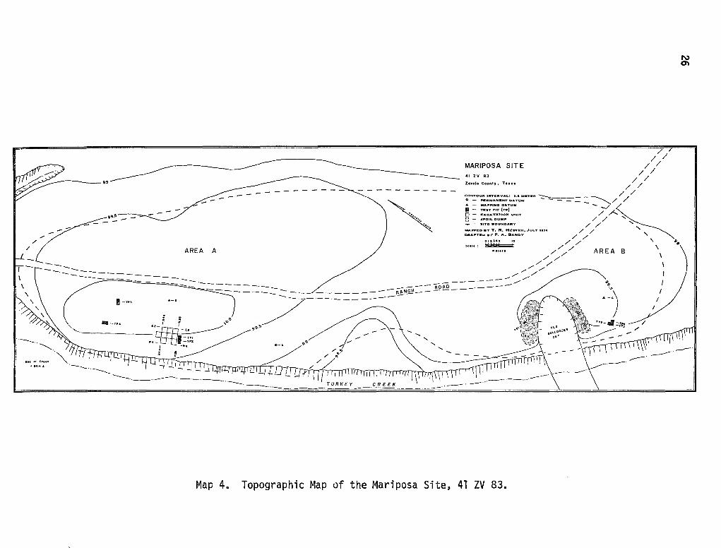
The Mariposa site (41 ZV 83) parallels the east bank of Turkey Creek on the Chaparrosa Ranch in northwestern Zavala County, Texas (maps 2 and 4). Turkey Creek is a tributary of the Nueces River, one of the major streams draining the Rio Grande Plain. Since Mariposa is located adjacent to a stream channel, it is termed a floodplain site (Hester 1971). In contrast, terrace sites within the same region are situated some distance away from a stream channel and are usually located at a somewhat higher elevation.
Horizontally, Mariposa encompasses over 200 meters which parallel Turkey Creek in a general north/south line. The site extends eastward away from the creek bank about 30 meters. Overall the horizontal area of Mariposa contains approximately 6,000 square meters.
Taken as a whole, the site is almost level except near the present creek bank along the western edge of the site. Mariposa is located on a long knoll and has two clear areas where sheet erosion and gullying (in the southern part of
·the site) have exposed cultural debris and artifacts. There is a thick brush area along Turkey Creek and to the east of the site on the floodplain. Vegetation present on the site includes guayacan, granjeno, white brush, allthorns, catclaws, Texas persimmon and guajuillo. Woody vegetation, mostly oak and white ash, is prominent on the creek bank. The creek area supports the densest vegetation near Mariposa (Hester n.d.).
Outline of Previous Investigations
Three separate investigations of Mariposa have been made in the span of five years. In 1970, preliminary site testing directed by Hester was achieved by excavating two test pits. Test Pit 1 measured 1 x 1 meter and Test Pit 2 measured 1 x 2 meters--both were located in the west central portion of the site (map 4). Each test pit was shovel excavated by 20 cm levels and all material was screened by passing dirt through 1/4-inch hardware screen. All lithic material (flakes and artifacts), most of the complete snail shell specimens, all mussel shell, all retrievable charcoal, and some burned rock samples were collected and bagged for each unit level. Profiles, along with soil and pollen samples, were obtained from the north wall of Test 2. The 1970 investigations determined that Mariposa contained substantial archaeological debris (burned rock, land snail shells, chert flakes) buried in alluvium to a depth of one meter. Only faint traces of definable stratigraphy were noted. Attempts to analyze the collected pollen samples were not successful, but three radiocarbon dates were secured.
The second investigation at Mariposa (a University of Texas archaeological field course directed by Hester) occurred during the summer of 1974, and initial results of this excavation have been published (Hester l974c). Nine two-meter squares were opened near the center of the site and carefully excavated in fivecentimeter levels. One major objective was to achieve a view of the horizontal
-·· ,~ .. ~
AREA A //{
,_ ------------====~------------=-==-====-=
--··
1-TP:S
llill-TP4
·--··--..
; : "~-' ~,o"
••- 1-TPJ -n•r: ~ -w ..
;
Map 4.
~ . .
MARIPOSA SITE
// //
/// 41 z v 83
Zavala County, T•aaa / / / /
CDNTOUft INTERVAL: 0.11 MKTll:R -::::--_ / / : = :~R .. ~;;.:E::Tr:t:UM - - --~/ / II - T .. T POT (TP) - -..../ ~ 0 - EXCAVATION UNIT / A ~ - ,j;f"QILDUMP / / '
- - SITr:t BOUNDARY / '
MAP'f"ll:D DY T. R. Hll!STKR, JULY .. ,. / / '
DRAP'TED D\" P. A. BANDY / '
OIZl45 10 // / / ' ~
""'" // / AREA B \ ~ / / \
/ / ,,,.,,,. // I
,,,. / I ----------.,.,.,,.,.,.,,,....
/-- -=========~~=-~~------- ~) I .. _,
~ 13'3·!.i
----I
/
·--··--
Topographic Map of the Mariposa Site, 41 ZV 83.
N en
27
d1str1but1on of cultural remains within the site (adjacent to the earlier Tests l and 2). With this in mind, excavation proceeded for the most part with trowel and brush, with all artifacts being mapped prior to removal and bagging. The recorded materials obtained from this investigation form the bulk of the analyzed data of this thesis. One test pit in Area A (TP3) and four test pits in Area B (TP1-TP4) were also completed along with the excavation.
The third and final investigation at Mariposa occurred in July of 1975. The writer, assisted by Charles Moffat and Irma Richie, returned to test another area of the site, TP4. A 1 x 2 meter test pit in Area 4 was excavated to a depth of 60 cm, in 15-cm levels. While there was only sparse evidence of lithic materials, a substantial hearth was revealed at the deepest level of the test (60 cm below the surface). Preliminary analyses of this test pit excavation have been prepared (Montgomery, Moffat and Richie 1975).
Excavation Methodology
Hester (1974c) has presented a statement concerning the excavation methodologies utilized at the Mariposa site. Initial testing in 1970 provided only a brief indication of the archaeological materials present, along with an estimate of the age and cultural affiliation of the site. The 1974 excavations were initiated with two objectives in mind. One objective was the recording and subsequent definition of intrasite artifact patterning. Variability in the archaeological record of spatial patterning could only be recorded by a horizontal excavation orientation. To this end, nine two-meter squares were excavated, each by five centimeter levels. Such a technique would 11 obtain a view of the horizontal distribution of cultural remains in one portion of the site 11 (Hester 1974c:l9). Each excavation unit retained ten centimeter balks and the southeast corner stake (relative to grid north) was considered the datum for the associated unit. As each five centimeter level was excavated, all materials were left in situ and mapped. Small objects (such as small chert chips, fragmentary snail shells, etc.) were bagged and labeled from the appropriate unit level quadrant. This excavation and recording process resulted in a series of "distribution maps 11
(Hester 1974c) which reflect the spatial relationship among artifacts. Further discussion of these relationships will be presented in 11 Intrasite Patterns. 11
A metal pipe (Datum A) was established as a permanent datum point in the middle of the site on the first field day of the 1974 excavations. Datum B, in Area A (see map 4), served as the reference point in constructing a site grid for accurate provenience control. Subsequent to the Datum A placement, the site was cleared of vegetation and a contour map was prepared using a telescopic alidade and plane table.
Vertical provenience was recorded in relation to a datum plane with an assumed elevation of 100 feet. This datum was established at Datum B. Accurate vertical provenience facilitated completion of the excavation's second major objective: projectile point sequence. Hester (1974c) has documented the general results of Mariposa's projectile point sequence.
28
After field work was completed, the bagged artifacts and materials were stored in San Antonio. This material was then turned over to the author, who cleaned, labeled and cataloged that portion of the site's material which had not been processed. Cataloging and labeling the excavated material followed these procedures:
1. Each quadrant within a level of every separate excavation unit was assigned a unique lot number.
2. All similar materials within one lot (burned rock, gastropod shells, flakes) were grouped together and bagged.
3. Materials within a lot 11 bag 11 were labeled with the site number (41 ZV 83), lot number, provenience information, excavation date and material description.
4. All worked artifacts were individually labeled with permanent ink in the following manner:
41 zv 83 Lot # A #
A separate artifact sheet was maintained for these items, listing all metric attributes, qualitative description, and provenience information. Projectile points were similarly labeled, with a P number instead of an A number. A projectile point sheet was also maintained which recorded pertinent quantitative and qualitative data.
These procedures produced catalog sheets describing all materials recorded for each lot provenience and associated data on all artifacts prior to analysis.
Site Morphology
Two profiles are available from Mariposa for use in this study. In Test 2 (dug in 1970), a profile of the northern wall was prepared. Examination of this profile indicates that four strata can be distinguished. The first 45 cm below the surface, designated Stratum 1, is composed of fine (alluvial) grey-brown, clay-loam soil. Scattered burned rock, flint flakes, mussel shell fragments, gastropod shells, and scattered charcoal occur in this level. Cultural material is densest in the first 20 cm, with two projectile points (Scallorn and Frio) and one projectile point fragment being recorded (Hester n.d.). From 45 cm to 80 cm below the surface, an increasingly granular and browner clay-loam soil constitutes Stratum 2. Cultural debris such as burned rock and flake fragments increases in comparison to the lower portion of 1. A large charcoal concentration was encountered and a projectile point basal fragment (Kinney) was recovered. Indicators of occupation are strongest in the upper part of this stratum. The division between Strata 2 and 3 is ill-defined, with 3 lying generally 80
29
centt~eters to 100 centimeters deep, Lower portions of Stratum 3 exhibit increasing clay·content, The depth of Stratum 3 slopes for 90 cm at the western extreme of the profile to 110 cm at the eastern edge. Burned rock, charcoal and scattered flakes occur in this brown granular clay-loc~m soil stratum .. Stratum 4 underlies- Stratum 3 and has be.en recorded to a depth of 140 cm in the eastern half of Test 2. Compos-ed of compact and nard tan clay, this stratum contains: a few burned rods and is considered to be culturally sterile.
Excavations in 1974 produced tne other profile from Mariposa, Using the north wall of N38/W2, a slightly di'fferent profile picture was obtained (see fig.1). Here the initial five centi"meters were termed Stratum r. This layer of reworked colluvium was laminated at the stratum bottom, wi'th olocky to wind-blown dust occurring above the laminated bottom up to the present surface. Color is light brown to tan when wet and brown-grey when dry. Lying beneath Stratum I to a depth of 50 cm is Stratum rr. Stratum rr is a layer of silty clay-loam filled with alluvial deposits and organic material. The greatest amount of cultural material in the excavation occurs in this stratum. Stratum II is characteristically grey to grey-brown i"n color. Prom 50 cm to 135 cm below the surface, a yellow to tan clay layer is observed. This layer, termed Stratum III, is marked by an increasing clay content with increasing depth and a corresponding decrease in cultural materials. The Stratum ff-III boundary is very ill-defined.
The two profiles from Mariposa depict somewhat different conditions concerning the depth of cultural deposits. Test 2 (1970) produced more material at a greater depth than the 1974 profile, as well as more varied stratigraphic relationships (four instead of three strata). However, considering the somewhat obscure boundary between Strata 2 and 3 in the 1970 profile, there is probably no great difference between the profiles.
Diagnostic materials encountered in both profiles indicate both Archaic and Late Prehistoric occupations for Mariposa. The first 30 cm below the surface in the 1974 excavations revealed Perdiz, ScaZZoPn and ZavaZa points. Both Archaic (Frio point) and Late Prehistoric (ScaUoPn point) materials occur in the initial 20 cm of deposit in the Test Pit 2 profile and a possible Kinney point fragment (Archaic) was recovered 40 to 60 cm below the surface. Indicators of Archaic occupation at Mariposa are especially strong in Area B, where several Archaic projectile points were recovered from eroded contexts.
As will be stated in the following section, projectile points in south Texas are not concrete time markers. Such being the case, more work at Mariposa will necessarily have to be done before statements can be generated concerning possible Archaic occupation(s) at Mariposa. However, within Stratum 1 of the 1970 profile and Strata I and II of the 1974 profile, a definite Late Prehistoric occupation, concentrated in the upper 30 cm of the deposit, has been demonstrated (Hester 1974c).
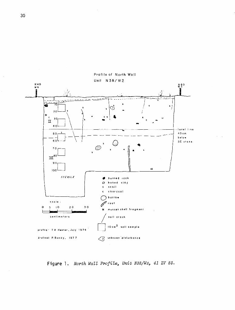
30
Profile of North Woll
Unit N38/W2 ::o ~~o ,!/
I
0
-t----------1---+---------------------------5 0 s \ VIL-1
-6;-L_J \ ----------
0 •
STERILE • burn ad rock
0 baked c I a y
• n a i I
charcoal
0 burrow
~root s ca I e
0 5 10 2 0 30 M musnal shell fragment
centimeters /soil crock
profile: TR Hester, July 19 74 D 10 cm 3 soil sample
drafted: P. Bandy, 197 7 (] unknown ·disturbance
Figure l. North WaZZ Profile, Unit N38/W2, 41 ZV 83.
-level line
43cm
be Io w
SE slake
31
Radiocarbon Analysis
Typological (relative) and chronometric (absolute) dating are the techniques most commonly used for dating sites in south Texas. In the majority of cases, typological comparisons rested upon already established projectile point sequences in central Texas (Hester and Hill 1975b:18). However, recent excavations in southern Texas have cast doubt on cross-dating south Texas projectile points (see Hester and Hill 1975b:18) with similar central Texas projectile points, making necessary the use of other dating methods for more accurate results.
Fortunately, radiocarbon dates are becoming available at many sites in southern Texas. This allows definition of the temporal parameters of many sites, including Mariposa. Hester and Hill (1975b:19) have previously reported the results of radiocarbon dating at Mariposa (41 ZV 83). Level 3 of the site has been dated at A.O. 1430 (sample Tx-1526) and a hearth at the same level was dated to ca. A.O. 1650 (sample UCLA 18210). Still deeper, at level 4, a date of A.O. 620 (UCLA-1821E) was obtained. These three radiocarbon determinations form the known time limits of the Mariposa occupation(s).
It must be pointed out that the levels used for the radiocarbon dates are not the same levels used in the 1974 excavations. Each level of Test Pit 2 (1"9'70) was 20 cm, while the 1974 excavations proceeded by 5 cm. Implications for this will be explored further in this section.
The earliest occupation of the site can be documented at around A.D. 620 and the latest occupation took place sometime near A.O. 1650 or later. Radiocarbon dates and sample descriptions from the Mariposa site are presented in Table 1.
Recognizing that Mariposa was possibly occupied for approximately 1,000 years (A.O. 620-A.D. 1650) poses some immediate problems. First, the earliest possible occupation of Mariposa falls in the Archaic Period (6000 B.C.-A.D. 1200). Second, the Late Prehistoric dates recovered from Mariposa are stratigraphically deep (40-60 cm below the present surface) and the 1974 excavations did not extensively sample to this depth. The majority of the 1974 excavation units penetrated only 25 cm below the surface. While no estimate of elapsed time has been prepared for the soil deposition between the dated soil level and the excavated, it is possible that the documented occupation of Mariposa may be quite close to historic times. Evidence for European contact, however, was not produced from site excavations.
Data necessary for solving the first problem are not yet available and will not be until excavations penetrate deeper into the site. This necessarily depends on whether or not future excavations are initiated at Mariposa. Resolution of the second problem also cannot be achieved without absolute dates associated with the upper 30 cm in Stratum I and II (1974). Thus, the excavated material from the Mariposa site must be considered to date past A.D. 1430 at this stage of the investigation.
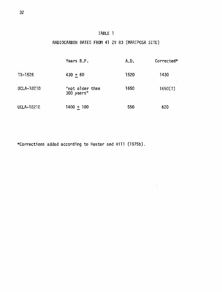
32
TX-1526
UCLA-18210
UCLA-1821E
TABLE l
RADIOCARBON DATES FROM 41 ZV 83 (MARIPOSA SITE)
Years B.P.
430 + 60
11 not older than 300 years"
1400 + 100
A.O.
1520
1650
550
Corrected*
1430
1650(?)
620
*Corrections added according to Hester and Hill (1975b).
V. THE CLASSIFICATION SCHEME
Before turning to the material excavated from Mariposa, a brief review of the classification scheme will be presented. All lithic and metal materials
33
(except burned rock) which had been altered by human activity (artifacts) were divided into three classes, based on the technological processes which produced them. Artifacts produced by the chipping (flaking) of siliceous materials are classed under chipped stone. This flaking or chipping is a process which results by removing material from the "objective piece by pressure, percussion, indirect percussion or the combination of pressure and percussion" (Crabtree 1972:65).
The second class of materials is also lithic, but these artifacts have been modified by processes of grinding, battering or polishing. Battering is produced by a specific use of the percussion technique, where "overlapping superimposed cones" are sought to shape the material (Crabtree 1972:80). Rubbing an object with abrasive material will, over time, produce either a smoothed or polished surface. If a glossy surface results, the process may be termed polishing. This occurs on only one artifact from Mariposa. Ground stone artifacts are also produced by abrasive action, but the smoothed surfaces of these artifacts do not exhibit gloss or sheen.
The third major class of materials was produced by a metal technology and therefore is probably not aboriginal. Only one such artifact was recovered from Mariposa.
Two of the three material classes of artifacts from Mariposa are divided into artifact groups which fall in each class. Only brief descriptions and reasons for division will be presented here. A more detailed examination of the artifacts is contained in the following chapter. All illustrated artifacts are drawn and photographed on a 1:1 scale. Artifacts were smoked with ammonium chloride before being photographed.
Chipped Stone
A morpho-technological division of these materials is presented graphically in Fig. 2. The first division is technological, separating chipped stone products from chipped stone by-products and from cores.
By-Products
Chipped stone by-products result from the reduction of lithic material to finished tools. The smaller (usually) debris caused by the chipping reduction is called by-products, or flakes and flake fragments. By-products may be altered or unaltered, another technological distinction. Unaltered by-products are composed of identifiable flake forms and flake fragments. Flakes which exhibited typical characteristics (bulb of force, compression rings, etc.) are further classified and subjected to analysis later in this chapter and thesis. Flake fragments were only counted, since they held no identifiable flake characteristics.
CHIPPED STONE
Products Cores I
I I Unifaces Formal Bifaces Altered
I Scrapers Fragments
r--- --- ----------,-- ----1 Projectile Flake Non-Flake
Points Bi faces Bi faces
By-Products
I -- I
Flakes
Unaltered
Flake Fragments
Figure 2. Chipped Stone Classification Boheme from the Mariposa Site, 41 ZV 83.
w +»
35
Two forms of alteration may be applied to by-products: utilization and trimming. Each of these technological processes was exhibited on secondary cortex flakes. Descriptions of these lithic processes are given in the following chapter; they do form a definite technological division for altered by-products.
Products
Products are the desired end-result, or artifacts, manufactured by a systematic reduction process. Products may be divided into two large groups: unifaces and formal bifaces. Unifaces are flaked on one face only while formal bifaces are flaked on two faces.
Unifaces may be complete or fragmentary. Fragmentary unifaces were further classified by the amount of cortex remaining on the tool fragment (division not shown in Fig. 2). Complete unifacial products all retained steep edge angles and were labeled scrapers for convenience (not by assumed function). There are four classes of scrapers (not shown in Fig. 2), depending on the location of the artifact's worked edges.
Formal bifaces were first classified by the presence or absence of hafting modification. Those artifacts which did retain some form of hafting modification were termed projectile points. Types of projectile points were assigned following the morphological and technological guidelines set forth in Suhm and Jelks (1962) and Hill and Hester (1971). Metric distinctions such as projectile point neck width, weight, maximum width and thickness (cf. Corliss 1972; Fenenga 1953; Jelinek 1967) between dart points and arrow points were informally recognized but not rigorously utilized. Projectile point fragments were classified as distal, medial or basal depending on whether the fragment was the point tip, the middle section or the portion closest to the haft (respectively).
The remainder of the bifaces were classified as flake bifaces or non-flake bifaces. Flake bifaces retained some evidence of being manufactured from a flake. Distal and proximal fragments (not shown in Fig. 2), as well as complete specimens, were recognized.
Non-flake bifaces retain no evidence of being manufactured from a flake. These artifacts were subdivided according to their existing condition (complete or fragmentary). Complete non-flake bifaces were also divided into five morphological and technological categories (not shown in Fig. 2). Fragmentary nonflake bifaces were subdivided into two categories, proximal and distal. Distal fragments were worked to a point or tip. Proximal fragments lacked this feature.
Cores
Cores result from the reduction of parent material by a flaking process. In this study, cores are classed as a separate category from products and byproducts, since cores are not prepared to be shaped implements. Cores retain the numerous flake scars caused from by-product removal. No macroscopic edge
36
wear is present on cores. The direction of flake (by-product) removal and the number and nature of flake platforms were among the attributes used to classify seven groups of cores (not illustrated in Fig. 2). A special core specimen, a core overshot flake, was recognized (see the following section).
Ground, Battered or Polished Stone
Ground stone was divided into morphological and technological classes, as well as artifact material. Both hematite and sandstone were ground. The abrasive grinding action took the form of localized scratching and grooving. General grinding of sandstone slabs produced smoothed sandstone slabs and smoothed hematite. Limestone was shaped into manos by general grinding action. Mano fragments were also recognized. Polishing was present on only one quartzite pebble. Hammerstones retained evidence of battering at one or more areas along their surfaces. The division of ground, battered or polished stone is presented in Fig. 3.
NON-CHIPPED LITHIC ARTIFACTS
Grinding
G·eneral Smoothing
I r· -----1--------, Sandstone Smoothed Limestone
Slabs Hematite Manos and Fragments
Localized Abrasion
I
Battering
Harrmerstone
S lh. -- G 1.
crate ing roov1ng
Hematite Sandstone Hematite
Polishing
Polished Quartzite
Sandstone
Figure 3. Ground, Battered and Polished Stone Classification Scheme from the Mariposa Site, 41 ZV BJ. w -...J
39
VI. THE EVIDENCE
Lithic Material
The basis for describing the chipped and ground stone recovered from archaeological contexts at Mariposa has been drawn from many sources. Hester (l975b}, Crabtree (1972), Shafer (1969) and Hester and Hill (1972) were considered important publications explaining terminology. Terms needing definition for greater understanding of the lithic descriptions follow:
Beveled Edge: "An edge which has been manufactured to produce the desired edge angle or exposure for the removal of a desired flake or flake series" (Crabtree 1972:38).
Biface: 11Artifact bearing flake scars on both faces" (Crabtree 1972:38).
Bulb of Force: "The bulbar part on the ventral side at the proximal end of a flake. The remnant of a cone part, the result of the application of either pressure or percussion force" (Crabtree 1972:48).
Com ression Rin s: "Ripple rings radiating from the point of force. Can be at pos1t1ve an negative--positive on the flake and blade; and negative on
the core ••• compression rings are generally more prominent with percussion than with pressure" (Crabtree 1972:52).
Denticulation: "Prominence resembling teeth similar to those on a saw. Toothlike serrating on margins of artifacts" (Crabtree 1972:58).
Dorsal: "Outer surface. Keeled part of blade or flake. For instance, the dorsal side of a blade is the face of the core prior to detachment" (Crabtree 1972: 59).
End View: "Perpendicular view of either proximal or distal end 11 (Crabtree 1972:60).
Exhausted: "Used up. Consumed, either from function wear or by the fl int knapper. Adjective applied most often to cores. Exhaustion may occur for the following reasons: steps and hinges, reduction of platform size or angle, lack of material, too small" (Crabtree 1972:62).
Face: 11 The dorsal or ventral surface of the artifact 11 (Crabtree 1972:62).
Flake: 11 Any piece of stone removed from a larger mass by application of force •.. A portion of isotropic material having a platform and bulb of force at the proximal end 11 (Crabtree 1972:64).
Hinge Fractures: 11 A fracture at the di sta 1 end of a flake or blade which prevents detachment of the flake at its proposed terminal point. A hinge fracture terminates the flake at ri9ht angles to the longitudinal axis and the break is usually rounded or blunt" (Crabtree 1972:68).
Lateral Margins: "Margins of flakes, blades and other stone tools on either or both sides of the longitudinal axis" (Crabtree 1972:72).
40
.!::.:!.£.: 11 ( 1) Projection found on core or artifact which results from the bul bar
scar. A concavity causing an overhang usually found on the leading edge. (2) Projection found on the proximal ventral surface of some flakes, believed to be associated with soft hammer percussion or pressure 11 (Crabtree 1972:74).
Longitudinal Lateral Section: 11 The area of the artifact bounded by the proximal and distal ends and both lateral margins 11 (Crabtree 1972:74).
Longitudinal Transverse Section: 11 The thickness of the artifact between the dorsal and ventral side and bounded by the proximal and distal ends 11 (Crabtree 1972: 74).
Percussion Flaking: 11 A method of striking with a percussor to detach flakes or blades from a core or mass 11 (Crabtree 1972:80).
Pl a no-Convex: 11 Fl at on ventral s ide--curved on dorsal surface. Common to unifaci a 1 artifacts" (Crabtree 1972:82).
Platform: 11 The table or surface area receiving the force necessary to detach a flake or blade. Can be either natural or prepared 11 (Crabtree 1972:84).
Pot Lid: 11 A plano-convex flake leaving a concave scar. Pot lids are the result of differential expansion and contraction of isotropic material but are minus the compression rings of force lines usually associated with these conditions. Generally they are a natural occurrence rather than intentional results of man-made flakes 11 (Crabtree 1972:84-85).
Pressure Flakinr 11 Process of forming and sharpening stone by removing surplus materia --in the form of flakes--from the artifact by a pressing force rather than by percussion 11 (Crabtree 1972:85).
Primar.x_ Retouch: 11 Removal of irregularities on the artifact by the pressure technique to make the piece ready for the second retouch" (Crabtree 1972:85).
Retouching: 11 A technique used to thin, straighten, sharpen, smooth and make the artifact more regular in form. Generally involves the use of pressure in one or more stages. Retouching usually follows percussion preforming. Before precision pressure work may be accomplished, one must first remove all irregularities on the objective piece by a primary retouch and then do a secondary retouch" (Crabtree 1972:89).
Serrating: 11 Indenting the edges by alternating the removal of flakes" (Crabtree 1972:90).
Side View: 11 The lateral edge or margin of the artifact when it is held horizonta 1 to the vi ewer 11 (Crabtree 1972: 90).
Sinuous: 11 Snake-like; alternating or wavy. Margins of artifacts are made sinuous by removing flakes alternately from the lateral edge 11 (Crabtree 1972:92).
Ste~ fr~cture: "A flake or flake scar that terminates abruptly in a right ang e break at the poi.nt of truncati.on. Caused by a dissipati.on of force or the collapse of the flak.e 11 (_Crabtree 1972:93).
Thermal Treatment: "Method of altering siliceous materials by exposure to controlled heat. Thfs treatment makes the stone more vitreous'' (Crabtree 1972:94).
Thinning Plakes·: 11 Flakes removed from a preform either by pressure or percussfon to thin the pi'ece for arttfact manufacture. Thinning flakes are also removed to thi'n a biface or uniface. Us·ually shows special platform preparation" (Crabtree 1972: 94).
Transverse: 11 Crosswise 11 (Crabtree 1972:95).
Transverse Section: "The area bounded by and between the lateral margins" (Crabtree 1972:95).
Uni face: "Artifact flaked on one surface only" (Crabtree 1972:97).
Ventral: 11 Plano side or inner surface of flake or blade. The under surface" (Crabtree 1972:97).
Vitreous: "Having the near luster and texture of glass" (Crabtree 1972:98).
Core: 11 A nodule from which flakes have been removed" (Shafer 1969:3).
Flake: 11 A chip or spall removed from a nodule (the parent stone) by force" (Shafer 1969:4).
Heavy Percussion Flakes: "Flakes with a rather prominent bulb of (force). They are relatively thick at the bulbar end, and frequently possess cortex somewhere on the dorsal surface or on the striking platform. The dorsal surface may or may not be faceted 11 (Sha fer 1969: 4).
41
Cortex Striking Platform: 11 The cortex {patinated) surface of a core used without modification as the striking platform" (Shafer 1969:4).
Sin le Faceted Strikin Platform: "The striking platform prepared by a single facet removing one flake 11 Sha fer 1969: 4).
Multiple Faceted Striking Platform: 11 A striking platform with two or more facets" (Sha fer 1969: 4).
Primary Cortex Flake: Flakes which 11 have the dorsal surfaces covered with cortex; they represent the initial decortication of a core" (Hester and Hill 1972:46).
Secondary Cortex Flakes: Flakes which "retain some cortex on the dorsal surface, representing further shaping of a core 11 (Hester and Hill 1972:46).
42
Intertor Flakes:: Pl a,kes reta i nin9 "no cortex on the qorsa l surface, i ndi cat i ng their removal from the interior of a core'' (Hester and Hill 1972:46).
Convergent Platform: ''Striking platform formed by convergent planes" (Hester 1971:106; Hester and Hill 1972:46).
Crushed (Shattered) Platforms: Flakes which have had their striking platform obliterated during flake removal.
Distal: Parthest from point of attachment for a projectile point. The portion of a biface which morphologically is· a point or tip.
Proximal: The base of a projectile point, or the area chipped (modified) for hafting.
Longitudinal: Running lengthwise.
Transverse: Crossing from side to side; crosswise.
Using these terms, a descriptton of the artifacts recorded at Mariposa will be more easily understood.
Artifacts were divided into three major divisions: chipped stone, ground and polished stone, and historic materials. No ceramics or bone tools were collected from testing and excavation activities conducted at Mariposa. Lithic objects culturally modified by chipping activities (Epstein 1962) were placed under the rubric of "chipped stone. 11 Modification may be bifacial or unifacial and the classification presented here was considerd most appropriate for the lithic assemblage at Mariposa.
Chipped Stone
Utilized Flakes
Thirty-four flakes are included under this category. Utilization should be distinctly separated from retouch or trimming, another tool category altogether. Mallouf, Fox and Briggs (1973:67) provide an excellent contrast between 11 utilization11 and 11 retouch 11
:
The term "utilization" is used when referring to random flake edges which exhibit irregular minute scarring. Use of this term is based on the observation that flakes freshly removed from a core often possess unidentified edges suitable for scraping or cutting purposes. Subsequent utilization of such an edge in working non-lithic materials such as antler or wood can, in time, produce a jagged, irregular edge outline.
"Retouch" . . . refers to a process whereby a flake edge is intentionally subjected to modification through the removal of a uniform series of tiny flakes. Retouch may be used as a means of sharpening, shaping, dulling, or otherwise reestablishing a usable edge in place of one which is worn or improperly formed.
43
Distinguishing between utilization and retouch is not a clear-cut matter, however. A retouch edge can be produced by utilization methods upon unmodified flakes (Mallouf, Fox and Briggs 1973:67). Any separation of these two different lithic modification techniques, then, is always tenuous.
At Mariposa, two types of utilized flakes are recognized: secondary cortex utilized flakes and interior utilized flakes. Secondary flakes, which retain both cortex and flake scars from core preparation, were utilized, as were interior flakes. Interior flakes retain no cortex and are believed to have been struck from the interior of a core nucleus (Mallouf, Fox and Briggs 1973: 75).
Utilized Secondary Flakes (Plate l,a)
Fourteen utilized secondary flakes were recovered from the 1974 field season. About half of these still retain a bulb of force and platform. Two of the utilized secondary flakes appear to have been burned. Chert is the basic lithic material used to manufacture these tools. Area of utilization, in most cases, is limited in extent to between five and ten millimeters along a lateral edge. Limited utilization area may reflect the physical limits of the flakes manufactured, since many of the flakes are small. Intense utilization did not appear on any of the specimens, implying only limited use and discard. Irregular flake shapes comprise the majority of the artifacts and no selected pattern of flake shape is indicated.
Utilized Interior Flakes (Plate l,b)
Fifty-nine percent of the utilized flakes (20 of 34 specimens) were manufactured on interior flakes. Again, no particular type of flake shape appears to have been preferred for utilization processes. Only three flakes are burned (A-10, A-11 and A-38) and one flake shows intensive utilization (A-15). One-third of the utilized interior flakes still retained either the bulb of force or the platform (or both). Significantly, 11 of the 18 flakes (61%) were hinge fractured on one or both ends of the flake. Such hinging could have resulted from tool manufacturing "accidents" where bifacial or unifacial reduction blows had been too severe for the material to handle. If such were the case, pieces of rejected or broken tools were obtained for use in different (or similar) activities. Fine-grained quartzite was used as the lithic resource material for one utilized interior flake (A~98) while light tan and brownish chert was used for the remainder of this category.
Metric measurements and provenience data for both categories of utilized flakes are included below.
44
Plate 1. Utilized Flakes, Trimmed Flakes and Scrapers. a, secondary cortex utilized flake (A-94); b, interior utilized flake (A-1); c, secondary cortex trimmed flake (A-149); d, interior trimmed flake (A-93); e, side scraper, one edge (A-86); f, side scraper, two edges (A-117); g, end and side scraper (A-66).
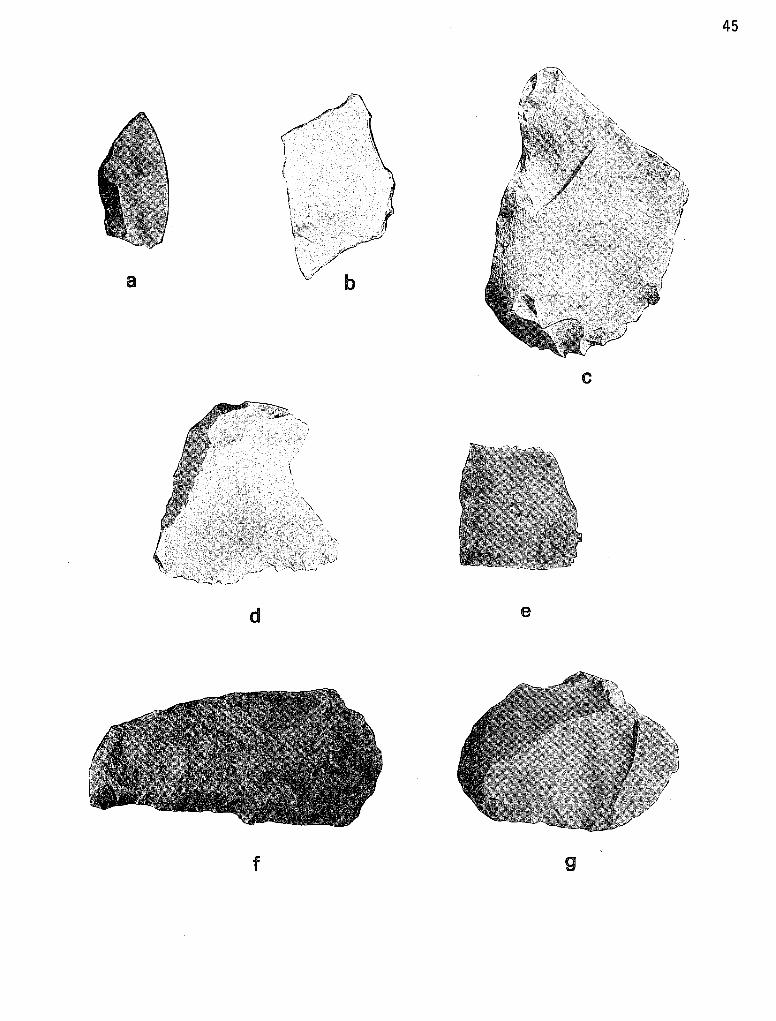
a
d
f
/ < l (
45
c
e
g
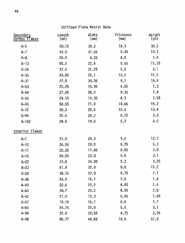
46
Utilized Flake Metric Data
Secondary Length Width Thickness Weight Cortex Flakes (mm) (mm) (mm) {gm)
A-5 50.15 39.2 18.3 30.5
A-7 42.0 31.55 8.35 13. 1
A-8 26.4 8.25 4.5 1.4
A-13 55.0 22.4 9.55 11.25
A-28 37.0 31.25 5.6 6. 1
A-30 43.85 25. 1 10.0 11. 5
A-31 27.5 30.35 9. 1 19.8
A-53 20.25 15.35 4.55 1.3
A-54 27.65 26.0 9.35 7.4
A-56 24.15 14.35 4.3 1.65
A-65 58.55 21.8 19.66 15.2
A-72 29.3 28.6 10.5 13. 4
A-94 35.0 28.2 6.15 3.5
A-162 24.6 19.6 5.2 4.0
Interior Flakes
A-1 51.0 29.3 9.6 12. l
A-10 26.55 28.0 6.35 5.3
A-11 25.25 17.65 6.65 3.0
A-15 26.55 22.0 5.6 3. l
A-22 23.8 24.05 5.3 3.25
A-23 61.9 35.0 8.8 11.2
A-29 38.15 27.0 9.75 7. 1
A-38 24.0 16. 1 2.8 1.4
A-43 22.6 20.2 6.45 2.6
A-60 30.7 29.2 4.55 2.8
A-62 21.0 12.3 5.55 1.65
A-67 18.15 15. 7 6.6 1. 7
A-80 24.75 22.0 5.5 3. 1 A-90 32.9 20.55 4.75 2.25
A-98 56. 77 46.66 18.0 51.5
47
Interior Flakes Length Width Thickness Weight (mm) (mm) (mm) {gm)
A-142 22.75 14. 20 13. 25 3.7 A-148 44.35 25.55 7 .15 7.4 A-151 35.65 24.6 11 .4 6.4 A-163 22.8 16.2 5.3 3.4
A-166 29.6 20.9 5.5 5.7
- - - - - - - - - - - - - - - - - - - - - - - - - - - - - - - - - - - - - -
Utilized Flake Provenience
Secondarl Cortex F-akes Level Unit Quadrant
A-5 2 (5-10 cm) N38/W2 NE
A-7 2 (5-10 cm) N38/W2 SW
A-8 2 (5-10 cm) N38/W2 SW
A-13 3 (10-15 cm) N38/W2 SE
A-28 1 (0-5 cm) N40 SW
A-30 2 (5-10 cm) N40 NW
A-31 2 (5-10 cm) N40 NW
A-53 3 (10-15 cm) N42 NE
A-54 3 (10-15 cm) N42 SW
A-56 4 (15-20 cm) N42 SW
A-65 2 (5-10 cm) N42/W2 SW
A-72 4 (15-20 cm) N42/W2 SW
A-94 2 (5-10 cm) N40/E2 SW
A-162 1 (0-20 cm) Area B Test 3
Interior Flakes
A-1 1 (0-5 cm) N38/W2 SW
A-10 3 (10-15 cm) N38/W2 NH
A-11 3 (10-15 cm) N38/W2 NW
A-15 4 (15-20 cm) N38/W2 NE
A-22 7 {30-35 cm) N38/W2 NW
A-23 7 (30-35 cm) N38/W2 NW
48
Interior Flakes Level Unit Quadrant
A-29 1 (0-5 cm) N40 SE A-38 1 (0-5 cm) N42 NE A-43 2 (5-10 cm) N42 NE A-60 1 (0-5 cm) N42/W2 NW A-62 l (0-5 cm) N42/W2 SW A-67 2 (5-10 cm) N42/W2 SE A-80 1 (0-5 cm) N42/E2 SE A-90 1 (0-5 cm) N40/E2 NE A-98 2 (5-10 cm) N40/E2 SE A-142 3 (30-45 cm) Test 5 Sl/2 A-148 3 (40-60 cm) Test 4 A-151 surface N42/W2 A-163 1 (0-5 cm) N42/E2 NW A-166 l (0-5 cm) N40/E2 SW
-------------------------------------------------------------------------Secondary cortex utilized flakes abundantly appear in levels 2 and 3, where 77% of these specimens were recorded. Of the nine excavation units, N38/W2, N40 and N49 contained most of the secondary cortex utilized flakes. Cultural processes which incorporated the use of secondary cortex utilized flakes may be concentrated in these excavated site areas. Utilized flakes with no cortex (interior flakes) were present in greatest quantities in the upper two levels of the site. N42/W2, N42/E2 and N38/W2 appear to be areas where the deposition of interior utilized flakes was preferred, although flakes in N38/W2 occur in deeper levels.
Combining the provenience data for all utilized flakes indicates that loci of utilization processes occurred in N38/W2, N40, N42/E2, N42 and N42/W2, containing almost one-third of the utilized flake specimens.
Trimmed Flakes (Plate l,c and d)
Marginally retouched flakes which exhibit no recognizable tool form or which seem to be primarily chipped in a random pattern with no visible intent toward tool manufacture were termed trimmed flakes. All of these artifacts were constructed on chert flakes and were trimmed (retouched) either unifacially or bifacially. Two subclasses of trimmed flakes are described (below) according to the type of flake used in the artifact preparation.
49
Secondary cortex trimmed flakes form the first subclass. Unifacial trimming is exhibited on eight of the nine artifacts in this subclass and is usually confined to one lateral edge. Three of these flakes still retain original striking platforms and bulb of force. Bifacial trimming on one edge characterizes the other secondary cortex trimmed flake. This artifact (A-64) was burned prior to flake removal.
Five artifacts comprise the second subclass of trimmed flakes: interior trimmed flakes. Artifact A-130 was manufactured from fine grained quartzite, while the other four were made from chert. All of the interior trimmed flakes are unifacially flaked on one lateral edge and irregular in outline. In contrast, most of the secondary cortex trimmed flakes retained a great deal of their original "fl ake 11 shape.
Trimmed flakes may represent two lithic stages. First, they may represent the rejected initial stages in a flake-tool manufacturing process. On the other hand, trimmed flakes could also represent easily and quickly manufactured cutting tools which may have been used for a relatively short duration (temporally) and discarded when the tool edge became ineffective. Conclusions concerning these two sequences are hindered by the small sample size encountered at 41 ZV 83.
Metric data and provenience information for the two subclasses of trimmed flakes follows.
Trimmed Flake Metric Measurements
Secondary Cortex Length Width Thickness Weight (mm) (mm) (mm) {gm)
A-19 46.2 34. l 18.5 26.2 A-58 31.35 28.35 10.6 6.35 A-64 40.0 28.35 13. 6 10.4 A-89 42.15 26.6 6.0 7.55 A-111 26.35 33.85 8.0 l 0. l A-149 76.0 45.2 17. 9 75.45 A-169 38.7 35.6 22.3 44.3 A-172 47.5 35.l 18.3 25.3 A-173 34.6 25.2 16. 1 15.6
Interior Flakes A-93 54.3 50.6 14.35 31.55 A-130 58.75 26.2 14.45 18. 35 A-154 23.15 19.3 -3.5 1.85 A-164 15.7 15. l 5.2 3.5 A-165 33.5 32.6 11.4 14.7
------- - - - - - - - - - - - - - - - - - - - - - - - -
50
Trimmed Flake Provenience
Secondar~ Cortex Level Unit Quadrant
A-19 5 (20-25 cm) N38/W2 NW A-58 4 (15-20 cm) N42 SE A-64 2 ( 5-10 cm) N42/W2 NE A-89 3 (10-15 cm) N42/E2 SE A-111 2 (5-10 cm) N38 NE A-149 3 (10-15 cm) N42 SE A-169 3 (10-15 cm) N42/E2 SW A-172 5 (20-25 cm) N42/W2 NE A-173 5 (20-25 cm) N42 SW
Interior Flakes A-93 2 (5-10 cm) N40/E2 SW A-130 l (0-20 cm) Area B Test 3 A-154 surface N42 A-164 3 (30-45 cm) Test 5 NE extension A-165 l (0-5 cm) N40/E2 SW
- - - - - - - - - ------- - - - - - ------ - - - -
Both trimmed flake types occur in levels one through five, although no clustering is readily discernible. Half of the trimmed flakes were recovered from levels two and three at Mariposa.
Unifacial Tools
Excavation and surface collecting at Mariposa produced 21 artifacts which exhibited primary and secondary flaking on one side or face. Classification within this category depended on the finished characteristics of the tool. Marginally flaked unifacial tools which exhibit completeness and a relatively long area of working edge were termed scrapers. Several types of scrapers are represented in the collection, including one-edge side scrapers, two-edge scrapers, end and side scrapers, and scraper fragments. Artifacts lacking distinctive tool finishing were classified as unifacial tool fragments.
Scrapers (Plate 1, e,f,g,). While recognizing that 11 scraper 11 as a functional description may not reflect the accurate function of this type of artifact, the term is retained due to its almost universal morphological and technological recognition. Stated another way, scrapers are those artifacts which frequently are made from flakes and are unifacially chipped (marginally or totally) to form steep edge angles. Steep edge angles are assumed to have
51
performed scraping functions; however, such conclusions cannot be definitely stated without microscopic edge wear analysis and replication experiments. No such studies were attempted, and the artifacts were classified after a macroscopic examination. Eight specimens were excavated during the field season and one specimen was collected from the surface of Area B during the same field season.
The nine specimens were grouped into four classes: side scrapers, one edge and two edge; end-side scrapers; and scraper fragments. According to Crabtree (1972:90), a side scraper is an "implement with beveling on one or more margins of a flake or blade to obtain a strong cutting edge. 11 Three complete scrapers and one scraper fragment can be classified as side scrapers. Two distinct classes of side scrapers can be produced--those with one edge worked and those with two edges worked.
Side Scrapers, One Edge (A-32, A-86, A-112, A-170)--Four examples of this class were excavated at Mariposa, one being a fragment. One specimen (Artifact #32) was manufactured from a large primary cortex flake. Hard-hammer percussion was the technique utilized to produce this flake. Distinct compression rings are seen on the ventral surface, a1ong with a prominent bulb of force. Platform preparation consisted of removing one flake. The bit of the scraper is convex and the tool outline is oval. Another of the one edge side scrapers is a fragment which still retains cortex on the dorsal surface except on that edge where retouching occurred. What exists of the bit appears to be straight. The third one-edged side scraper is irregular in tool outline and appears to have been made from a core. The retouched edges are quite steep. This specimen is made from fine-grained quartzite, whereas the previous two are made from the locally available chert.
Side Scraper, Two Edges (A-117)--0nly one specimen was classified in this category. Manufactured from a chert primary cortex flake, the artifact was retouched unifacially on one edge and bifacially on the other lateral edge. Cortex almost covers the dorsal face. The bifacial trimming on one edge may be evidence of either platform preparation for subsequent unifacial retouch or further modification of the edge into a bifacial working edge.
End and Side Scrapers (A-120, A-155, A-66)--Excavation revealed three scrapers classified as end-side scrapers. Bifacial retouch is seen on A-120, along with some edge wear. This specimen's end scraping edges are formed on the dorsal face. Cortex is also present on the dorsal face. The remaining two end-side scrapers (A-155, A-66) are thinner in comparison with A-120 and are generally more oval in outline. Both, like A-120, appear to have been manufactured from chert flakes. Artifact #155 has very steep flaking on the distal end and the overall flaking pattern of the end and two lateral edges is even and marginal. No cortex is present and the scraper retains a hinged fracture on the proximal end. This end exhibits neither retouch nor macroscopic edge wear.
Cortex is present on the proximal end of Artifact #66. As with A-155, pressure flaking has produced a fine working edge on this specimen. In longitudinal cross section, Artifacts #66 and 155 reveal lenticular outlines.
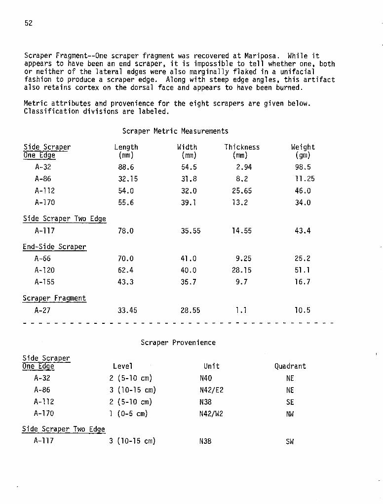
52
Scraper Fragment--One scraper fragment was recovered at Mariposa. While it appears to have been an end scraper, it is impossible to tell whether one, both or neither of the lateral edges were also marginally flaked in a unifacial fashion to produce a scraper edge. Along with steep edge angles, this artifact also retains cortex on the dorsal face and appears to have been burned.
Metric attributes and provenience for the eight scrapers are given below. Classification divisions are labeled.
Side Scraper One Edge
A-32 A-86 A-112 A-170
Side Scraper Two Edge A-117
End-Side Scraper A-66 A-120 A-155
Scraper Fragment
A-27
Side Scraper One Edge
A-32 A-86 A-112 A-170
Side Scraper Two Edge
Scraper Metric Measurements
Length Width (mm) (mm) 88.6 54.5 32.15 31.8 54.0 32.0 55.6 39. l
78.0 35.55
70.0 41.0 62.4 40.0 43.3 35.7
33.45 28.55
Scraper Provenience
Level 2 (5-10 cm) 3 (10-15 cm) 2 (5-10 cm) l (0-5 cm)
Unit N40 N42/E2 N38 N42/W2
Thickness (mm) 2.94 8.2
25.65 13.2
14.55
9.25 28.15 9.7
1.1
A-117 3 (10-15 cm) N38
Weight (gm) 98.5 11. 25 46.0 34.0
43.4
25.2 51. l 16. 7
l 0. 5
Quadrant NE NE SE NW
SW
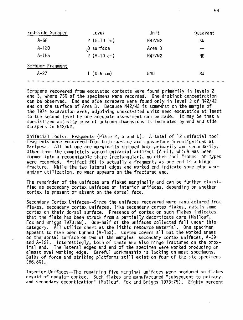
53
End-Side ScraEer Level Unit Quadrant A-66 2 (5-10 cm) N42/W2 SW A-120 ;.O surface Area B
(
A-155 2 (5-10 cm) N42/W2 NE
ScraEer Fragment A-27 l (0-5 cm) N40 NW
- - -· - ·- - - - - - ------- -------Scrapers recovered from excavated contexts were found primarily in levels 2 and 3, where 75% of the specimens were recorded. One distinct concentration can be observed. End and side scrapers were found only in level 2 of N42/W2 and on the surface of Area B. Because N42/W2 is somewhat on the margin of the 1974 excavation area, adjoining unexcavated units need excavation at least to the second level before adequate assessment can be made. It may be that a specialized activity area of unknown dimensions is indicated by end and side scrapers in N42/W2.
Unifacial Tools: Fragments (Plate 2, a and b). A total of 12 unifacial tool fragments were recovered from both surface and subsurface inveatigations at Mariposa. All but one are marginally chipped both primarily and secondarily. Other than the completely worked unifacial artifact (A-61), which has been formed into a recognizable shape (rectangular), no other tool "forms" or types were recorded. Artifact #61 is actually a fragment, as one end is a hinge fracture. While the two lateral edges and worked end indicate some edge wear and/or utilization, no wear appears on the fractured end.
The remainder of the unifaces are flaked marginally and can be further classified as secondary cortex unifaces or interior unifaces, depending on whether cortex is present or absent on the dorsal face.
Secondary Cortex Unifaces--Since the unifaces recovered were manufactured from flakes, secondary cortex unifaces, like secondary cortex flakes, retain some cortex on their dorsal surface. Presence of cortex on such flakes indicates that the flake has been struck from a partially decorticate core (Mallouf, Fox and Briggs 1973:68). One-half of the unifaces collected fall under this category. All utilize chert as the lithic resource material. One specimen appears to have been burned (A-152). Cortex covers all but the worked areas on the dorsal surface on two of the marginal secondary cortex unifaces, A-39 and A-121. Interestingly, both of these are also hinge fractured on the proximal end. The lateral edges and end of the specimen were worked producing an almost oval working edge. Careful workmanship is lacking on most specimens. Bulbs of force and striking platforms still exist on four of the six specimens (66.6%).
Interior Unifaces--The remaining five marginal unifaces were produced on flakes devoid of nodular cortex. Such flakes are manufactured "subsequent to primary and secondary decortication" (Mallouf, Fox and Briggs 1973:75). Eighty percent
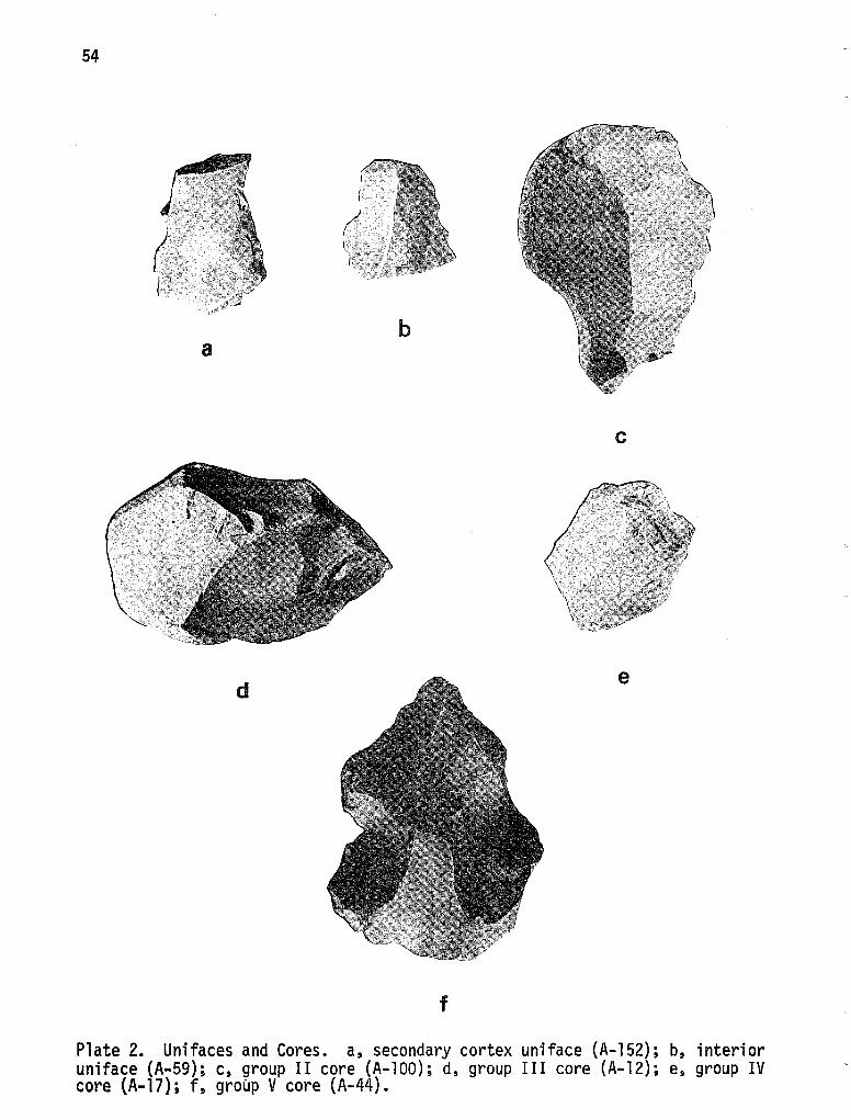
54
a
d
! I
( I .
~
b
c
e
f
Plate 2. Unifaces and Cores. a, secondary cortex uniface (A-152); b, interior uniface (A-59); c, group II core (A-100); d, group III core (A-12); e, group IV core (A-17); f, group V core (A-44).
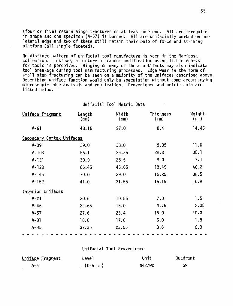
55
(four or five) retain hinge fractures on at least one end. All are irregular in shape and one specimen (A-57) is burned. All are unifacially worked on one lateral edge and two of these still retain their bulb of force and striking platform (all single faceted).
No distinct pattern of unifacial tool manufacture is seen in the Mariposa collection. Instead, a picture of random modification using lithic debris for tools is perceived. Hinging on many of these artifacts may also indicate tool breakage during tool manufacturing processes. Edge wear in the form of small step fracturing can be seen on a majority of the unifaces described above. Describing uniface function would only be speculation without some accompanying microscopic edge analysis and replication. Provenience and metric data are listed below.
Unifac ia l Tool Metric Data
Uniface Fragment Length (mm)
A-61 48.15
Secondar~ Cortex Unifaces A-39 A-103 A-121 A-128 A-145 A-152
Interior Unifaces A-21 A-45 A-57 A-81 A-85
- - - - - -------
Uniface Fragment A-61
39.0 55. l 30.0 66.45 70.0 41.0
30.6 22.65 27.6 18. 6 37.35
- - - - -
Unifacia 1 Tool
Level 1 (0-5 cm)
Width Thickness Weight (mm)
27.0
33.0 35.55 25.5 45.65 39.0 31.55
10.55 15. 0
23.4 17.0 23.55
- - - - -
Provenience
Unit N42/W2
(mm)
8.4
8.35 28.3 8.0
18.45 15. 25 15. 15
7.0
4.75 15. 0 5.0 8.6
(gm)
14.45
11 .0 35.1 7. l
46.2 38.5 16.9
1.5 2.05
10. 3 1.8 6.8
- - - - - - - - -
Quadrant SW
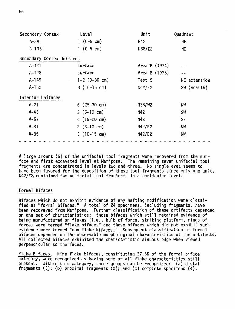
56
Secondary Cortex Level Unit Quadrant A-39 l (0-5 cm) N42 NE A-103 l (0-5 cm) N38/E2 NE
Secondar~ Cortex Unifaces A-121 surface Area B (1974) A-128 surface Area B (1975) A-145 1-2 (0-30 cm) Test 5 NE extension A-152 3 ( 10-15 cm) N42/E2 SW (hearth)
Interior Unifaces A-21 6 (25-30 cm) N38/W2 NW A-45 2 (5-10 cm) N42 SW A-57 4 (15-20 cm) N42 SE A-81 2 (5-10 cm) N42/E2 NW A-85 3 ( 10-15 cm) N42/E2 NW
- - - - - ------ - - - - - - - - - - - - - - - - - - - - - - - - - - -
A large amount (5) of the unifacial tool fragments were recovered from the surface and first excavated level at Mariposa. The remaining seven unifacial tool fragments are concentrated in levels two and three. No single area seems to have been favored for the deposition of these tool fragments since only one unit, N42/E2,contained two unifacial tool fragments in a particular level.
Formal Bifaces
Bifaces which do not exhibit evidence of any hafting modification were classified as "formal bifaces. 11 A total of 24 specimens, including fragments, have been recovered from Mariposa. Further classification of these artifacts depended on one set of characteristics: those bifaces which still retained evidence of being manufactured on flakes (i.e., bulb of force, striking platform, rings of force) were termed "flake bifaces 11 and those bifaces which did not exhibit such evidence were termed "non-flake bifaces. 11 Subsequent classification of formal bifaces depended on the observable morphological characteristics of the artifacts. All collected bifaces exhibited the characteristic sinuous edge when viewed perpendicular to the faces.
Flake Bifaces. Nine flake bifaces, constituting 37.5% of the formal biface category, were recognized as having some or all flake characteristics still present. Within this category, three groups can be recognized: (a) distal fragments (3); (b) proximal fragments (2); and (c) complete specimens (4).
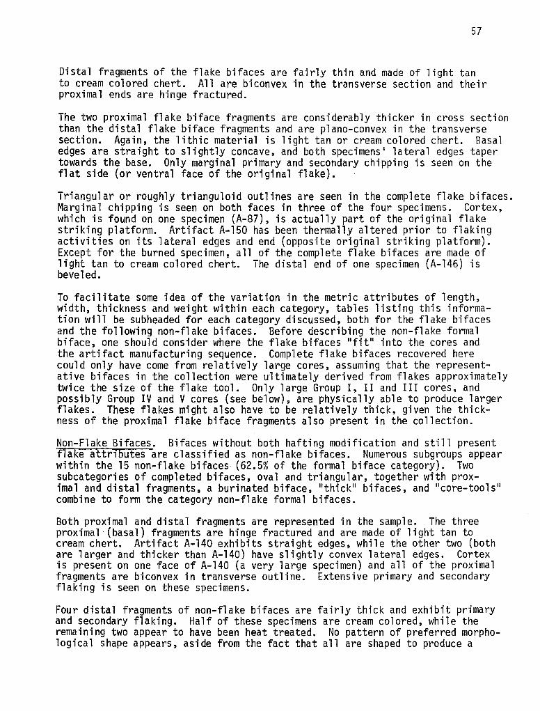
57
Distal fragments of the flake bifaces are fairly thin and made of light tan to cream colored chert. All are biconvex in the transverse section and their proximal ends are hinge fractured.
The two proximal flake biface fragments are considerably thicker in cross section than the distal flake biface fragments and are plano-convex in the transverse section. Again, the lithic material is light tan or cream colored chert. Basal edges are straight to slightly concave, and both specimens' lateral edges taper towards the base. Only marginal primary and secondary chipping is seen on the flat side (or ventral face of the original flake).
Triangular or roughly trianguloid outlines are seen in the complete flake bifaces. Marginal chipping is seen on both faces in three of the four specimens. Cortex, which is found on one specimen (A-87), is actually part of the original flake striking platform. Artifact A-150 has been thermally altered prior to flaking activities on its lateral edges and end (opposite original striking platform). Except for the burned specimen, all of the complete flake bifaces are made of light tan to cream colored chert. The distal end of one specimen (A-14q) is beveled.
To facilitate some idea of the variation in the metric attributes of length, width, thickness and weight within each category, tables listing this information will be subheaded for each category discussed, both for the flake bifaces and the following non-flake bifaces. Before describing the non-flake formal biface, one should consider where the flake bifaces 11 fit 11 into the cores and the artifact manufacturing sequence. Complete flake bifaces recovered here could only have come from relatively large cores, assuming that the representative bifaces in the collection were ultimately derived from flakes approximately twice the size of the flake tool. Only large Group I, II and III cores, and possibly Group IV and V cores (see below), are physically able to produce larger flakes. These flakes might also have to be relatively thick, given the thickness of the proximal flake biface fragments also present in the collection.
Non-Flake Bifaces. Bifaces without both hafting modification and still present flake attributes are classified as non-flake bifaces. Numerous subgroups appear within the 15 non-flake bifaces (62.5% of the formal biface category). Two subcategories of completed bifaces, oval and triangular, together with prox-imal and distal fragments, a burinated biface, 11 thick 11 bifaces, and 11 core-tools 11
combine to form the category non-flake formal bifaces.
Both proximal and distal fragments are represented in the sample. The three proximal (basal) fragments are hinge fractured and are made of light tan to cream chert. Artifact A-140 exhibits straight edges, while the other two (both are larger and thicker than A-140) have slightly convex lateral edges. Cortex is present on one face of A-140 (a very large specimen) and all of the proximal fragments are biconvex in transverse outline. Extensive primary and secondary flaking is seen on these specimens.
Four distal fragments of non-flake bifaces are fairly thick and exhibit primary and secondary flaking. Half of these specimens are cream colored, while the remaining two appear to have been heat treated. No pattern of preferred morphological shape appears, aside from the fact that all are shaped to produce a
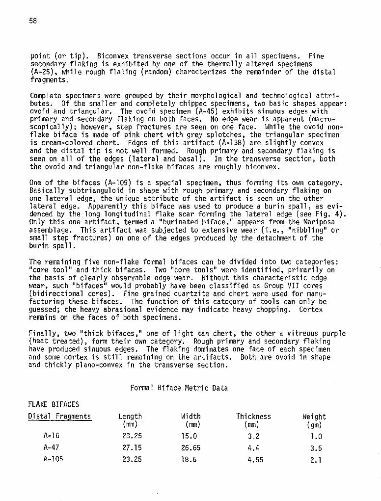
58
point (or tip). Biconvex transverse sections occur in all specimens. Fine secondary flaking is exhibited by one of the thermally altered specimens (A-25), while rough flaking (random) characterizes the remainder of the distal fragments.
Complete specimens were grouped by their morphological and technological attributes. Of the smaller and comp~etely chipped specimens, two basic shapes appear: ovoid and triangular. The ovoid specimen (A-45) exhibits sinuous edges with primary and secondary flaking on both faces. No edge wear is apparent (macroscopically); however, step fractures are seen on one face. While the ovoid nonflake biface is made of pink chert with grey splotches, the triangular specimen is cream-colored chert. Edges of this artifact (A-138) are slightly convex and the distal tip is not well formed. Rou9h primary and secondary flaking is seen on all of the edges (lateral and basal). In the transverse section, both the ovoid and triangular non-flake bifaces are roughly biconvex.
One of the bifaces (A-109) is a special specimen, thus forming its own category. Basically subtrianguloid in shape with rough primary and secondary flaking on one lateral edge, the unique attribute of the artifact is seen on the other lateral edge. Apparently this biface was used to produce a burin spall, as evidenced by the long longitudinal flake scar forming the lateral edge (see Fig. 4). Only this one artifact, termed a 11 burinated biface, 11 appears from the Mariposa assemblage. This artifact was subjected to extensive wear (i.e., 11 nibbling 11 or small step fractures) on one of the edges produced by the detachment of the burin spall.
The remaining five non-flake formal bifaces can be divided into two categories: 11 core tool 11 and thick bifaces. Two 11 core tools 11 were identified, primarily on the basis of clearly observable edge wear. Without this characteristic edge wear, such 11 bifaces 11 would probably have been classified as Group VII cores (bidirectional cores). Fine grained quartzite and chert were used for manufacturing these bifaces. The function of this category of tools can only be guessed; the heavy abrasional evidence may indicate heavy chopping. Cortex remains on the faces of both specimens.
Finally, two 11 thick bifaces, 11 one of light tan chert, the other a vitreous purple (heat treated), form their own category. Rough primary and secondary flaking have produced sinuous edges. The flaking dominates one face of each specimen and some cortex is still remaining on the artifacts. Both are ovoid in shape and thickly plano-convex in the transverse section.
Formal Biface Metric Data
FLAKE BIFACES Distal Fragments Length Width Thickness Weight
(mm) (mm) (mm) (gm) A-16 23.25 15.0 3.2 1.0 A-47 27.15 26.65 4.4 3.5 A-105 23.25 18.6 4.55 2. 1
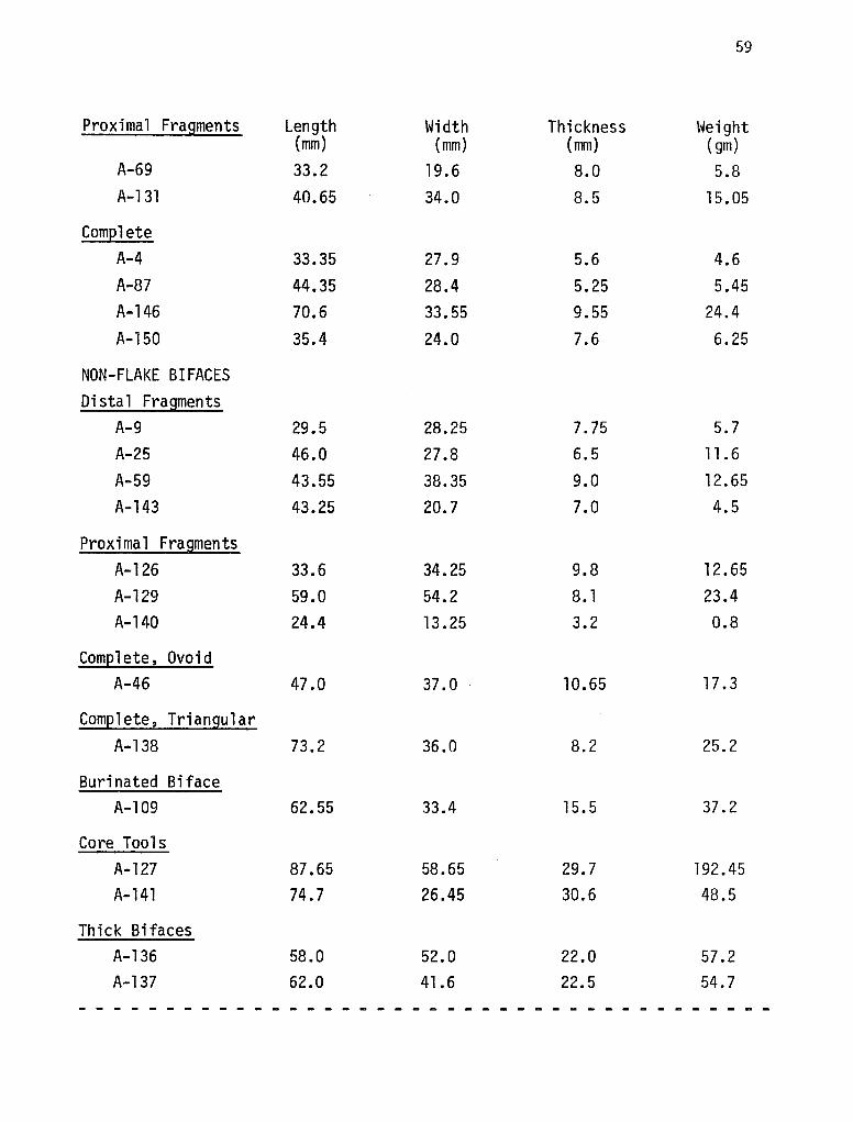
59
Proximal Fragments Length Width Thickness Weight (mm) (mm) (mm) (gm)
A-69 33.2 19.6 8.0 5.8 A-131 40.65 34.0 8.5 15.05
Complete A-4 33.35 27.9 5.6 4.6 A-87 44.35 28.4 5.25 5.45 A-146 70.6 33.55 9.55 24.4 A-150 35.4 24.0 7.6 6.25
NON-FLAKE BIFACES Distal Fragments
A-9 29.5 28.25 7.75 5.7 A-25 46.0 27.8 6.5 11.6
A-59 43.55 38.35 9.0 12.65 A-143 43.25 20.7 7.0 4.5
Proximal Fragments A-126 33.6 34.25 9.8 12. 65 A-129 59.0 54.2 8. 1 23.4 A-140 24.4 13.25 3.2 0.8
Complete, Ovoid A-46 47.0 37.0 10.65 17.3
Complete, Triangular A-138 73.2 36.0 8.2 25.2
Burinated Biface A-109 62.55 33.4 15.5 37.2
Core Tools A-127 87.65 58.65 29.7 192.45 A-141 74.7 26.45 30.6 48.5
Thick Bifaces A-136 58.0 52.0 22.0 57.2 A-137 62.0 41.6 22.5 54.7
- - - - - - - - - - - - - - - - - - - - - - - - - - - - - - - - - - - - - - - -
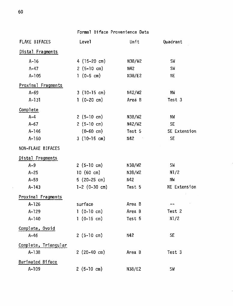
60
Formal Biface Provenience Data
FLAKE BIFACES Level Unit Quadrant
Distal Fragments
A-16 4 (15-20 cm) N38/W2 SW A-47 2 (5-10 cm) N42 SW A-105 1 (0-5 cm) N38/E2 NE
Proximal Fragments A-69 3 ( 10-15 cm) N42/W2 NW A-131 1 (0-20 cm) Area B Test 3
Complete A-4 2 (5-10 cm) N38/W2 NW A-67 2 (5-10 cm) N42/W2 SE A-146 (0-60 cm) Test 5 SE Extension A-150 3 (10-15 cm) N42 SE
NON-FLAKE BIFACES
Distal Fragments A-9 2 (5-10 cm) N38/W2 SW A-25 10 (60 cm) N38/W2 Nl/2 A-59 5 (20-25 cm) N42 NW A-143 1-2 (0-30 cm) Test 5 NE Extension
Proximal Fragments A-126 surf ace Area B A-129 1 (0-10 cm) Area B Test 2 A-140 l (0-15 cm) Test 5 Nl/2
ComElete, Ovoid A-46 2 (5-10 cm) N42 SE
Complete, Triangular A-138 2 (20-40 cm) Area B Test 3
Burinated Biface A-109 2 (5-10 cm) N38/E2 SW
61
Core Tools Level Unit Quadrant
A-127 surface Area B A-141 3 (30.-45 cm) Test 5 Nl/2.
Thick Bifaces A-136 1 (Q.-20 cm) Area B Test 3 A-137 1 (0-20 cm) Area B Test 3
---·-·-- - - - ..... -----.- - - .. - - - - - - - - -- - - - - - - - - -
Combining provenience information for the flake and non-flake bifaces, 16 of 23 (or 70%) of the specimens were recovered from Area A (all excavation units and test pits). Considering only flake bifaces, 89% (8 of 9) were found in Area A. On the other hand, only 57% (8 of 14) of the non-flake bifaces were located in Area A. Flake bifaces were found primarily in levels two and three, with some specimens much deeper. Four excavation units--N38/W2, N42, N38/E2 and N42/W2-and one test pit contained flake biface specimens in Area A. Non-flake bifaces excavated in Area A were evenly divided between lower contexts (greater than 15 cm below the surface) and upper contexts (0 to 15 cm below the surface). Level two exhibited more formal bifaces than any other single level, however. Three of the nine excavation units (N38/W2, N38/E2 and N42) and Test 5 were the Area A grid proveniences at Mariposa where non-flake bifaces were present. Half of the non-flake bi faces were found in Area A and ha 1 f were found in Area B at Mariposa. The majority (83%} from Area B were recorded on the surface to a depth of 20 cm.
Lack of flake bifaces in Area B at Mariposa is an important point to remember. The fact that projectile points recovered from Area B context typologically date to Archaic times (see section on projectile points) combined with the lack of flake bifaces may possibly indicate that different lithic technologies were occurring at different times at Mariposa. Much more research must be sustained, however, before this possibility can be verified.
Cores
The process of removing one or more flakes from a suitable cobble or nodule necessarily forms a core. Usually this reduction process is intended to produce either flakes destined to be further worked into flake tools or the process can be one of reducing the core itself into a tool (core-tool). These two processes can be divided into separate industries if the tool reduction process has not obliterated distinctions which exist in the initial stages of the two processes.
One objective of this study is to determine, if possible, which lithic process (flake-tool or core-tool) can be associated with those peoples who inhabited the Mariposa site. Great care, therefore, in distinguishing the different types of cores present is a necessary step in deciding which industry occurred. Previous work (Hester 1975b) makes this aspect appreciably easier.
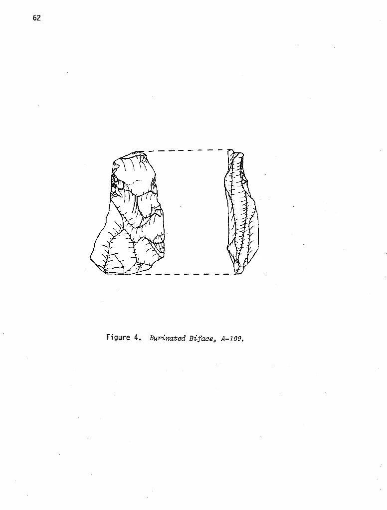
62
Figure 4. Burinated Bifaae, A-109.
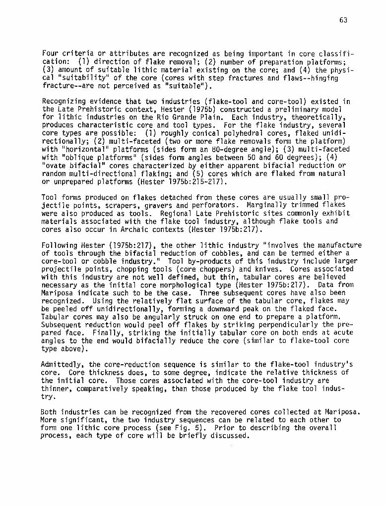
63
Four criteria or attributes are recognized as being important in core classification: (1) direction of flake removal; (2) number of preparation platforms; (3) amount of suitable lithic material existing on the core; and (4) the physical "suitability" of the core (cores with step fractures and flaws--hinging fracture--are not perceived as "suitable").
Recognizing evidence that two industries (flake-tool and core-tool) existed in the Late Prehistoric context, Hester (1975b) constructed a preliminary model for lithic industries on the Rio Grande Plain. Each industry, theoretically, produces characteristic core and tool types. For the flake industry, several core types are possible: (1) roughly conical polyhedral cores, flaked unidirectionally; (2) multi-faceted (two or more flake removals form the platform) with "horizontal" platforms (sides form an 80-degree angle); (3) multi-faceted with "oblique platforms" (sides form angles between 50 and 60 degrees); (4) "ovate bifacial 11 cores characterized by either apparent bifacial reduction or random multi-directional flaking; and (5) cores which are flaked from natural or unprepared platforms (Hester l975b:215-217).
Tool forms produced on flakes detached from these cores are usually small projectile points, scrapers, gravers and perforators. Marginally trimmed flakes were also produced as tools. Regional Late Prehistoric sites commonly exhibit materials associated with the flake tool industry, although flake tools and cores also occur in Archaic contexts (Hester 1975b:217).
Following Hester (1975b:217), the other lithic industry "involves the manufacture of tools through the bifacial reduction of cobbles, and can be termed either a core-tool or cobble industry." Tool by-products of this industry include larger projectile points, chopping tools (core choppers) and knives. Cores associated with this industry are not well defined, but thin, tabular cores are believed necessary as the initial core morphological type (Hester 1975b:217). Data from Mariposa indicate such to be the case. Three subsequent cores have also been recognized. Using the relatively flat surface of the tabular core, flakes may be peeled off unidirectionally, forming a downward peak on the flaked face. Tabular cores may also be angularly struck on one end to prepare a platform. Subsequent reduction would peel off flakes by striking perpendicularly the prepared face. Finally, striking the initially tabular core on both ends at acute angles to the end would bifacially reduce the core (similar to flake-tool core type above).
Admittedly, the core-reduction sequence is similar to the flake-tool industry's core. Core thickness does, to some degree, indicate the relative thickness of the initial core. Those cores associated with the core-tool industry are thinner, comparatively speaking, than those produced by the flake tool industry.
Both industries can be recognized from the recovered cores collected at Mariposa. More significant, the two industry sequences can be related to each other to form one lithic core process (see Fig. 5). Prior to describing the overall process, each type of core will be briefly discussed.
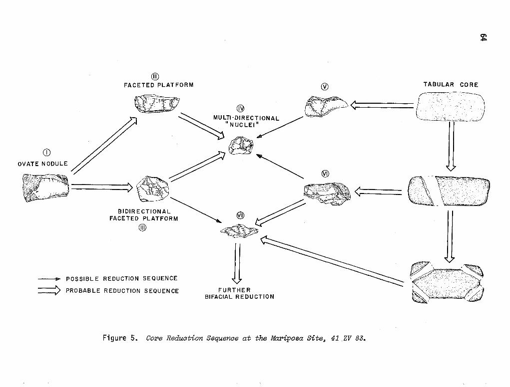
CD OVATE NODULE
® FACETED PLATFORM fj) TABULAR CORE
CJ\ .i::o
~ ~ (~ ..•..... ·~:-o·--~---:-, .
~ ® ~< ,. ' . . ···. ~ MULTl·DIREc:,10NAL~ · .. · L .·· • •,_ ... J
~"NUCLEI'/
@
~ @
'~ >~~· ··,~ ~ < (X~VE[['.:J
BIDIRECTIONAL~ .vm ~ FACETED PLATFORM ~ ~ ~
® ~
---11> POSSIBLE REDUCTION SEQUENCE
=::::!> PROBABLE REDUCTION SEQUENCE FURTHER BIFACIAL REDUCTION
Figure 5. Core Reduction Sequence at the Mariposa Site, 41 _ZV 83.
~' .. ,,,.,::· .·--~
~······•·•-.. -.·~
65
Group I Cores (one specimen, 3.2% of core sample)
This is a thickly ovate core with one flake detached indicating core testing or platform preparation. Since no further work on the core exists, it is probable that a· flaw in the material was detected, with the core being rejected. The flake produced could have been formed into a small tool. Group I cores are quite simi"lar to Hester's 5 (above).
Group II Cores (Plate 2,c. Ptve specimens, 16.1% of core sample)
Platforms are formed by the removal of one flake (s:ingle-faceted) and subsequent flakes are detached unidirectionally and perpendicular to the single-faceted pl at form. All are somewhat oval in outline and retain cortex on the face opposite the platform. These are morphologically similar to Hester's 2 (above).
Group III Cores (Plate 2,d. Two specimens, 6.5% of core sample)
These cores are faceted in two directions. Sinuous edges and denticulate outlines characterize the working edge. Cortex is present opposite the edge which was flaked. Both specimens exhibit roughly oval outlines.
Group IV Cores (Plate 2,e. 13 specimens, 41.9% of core sample)
Multi-faceting and multi-directional flake removal characterize Group IV cores. Many of the cores are faceted in four or more directions. Roughly angular outlines predominate. Artifact A-71 is a fine-grained quartzite, while the remaining five specimens are made of chert. Cortex is relatively absent.
Group V Cores (Plate 2,f. Three specimens, 9.7% of core sample)
Unidirectional flake removal on a natural (cortex) platform shapes these cores. Both utilize chert as the lithic resource material. A pyramid shape is indicated, with the peak being formed at the point where many flake scars converge. These cores lie flat on the cortex face, indicating a tabular shape prior to flake remova 1 .
Group VI Cores {Plate 3,a. Two specimens, 6.5% of core sample)
Platforms of Group VI cores are single-faceted subsequent to flake removal, oblique to perpendicular with respect to platform. Flake removal can proceed on either face or both. One specimen has been greatly reduced (A-104), and both are made of chert. Group VI cores are identical to Hester's 3 (above).
Group VII Cores {Plate 3,b. Two specimens, 16.1% of core sample)
The last category of cores is formed by bifacial reduction of tabular core material. Artifact #24 has been thermally altered. Bifacial reduction of these cores follows a multi-directional pattern which may be random or symmetrical at acute angles to the sides. This type of core is Hester's 4 (above).
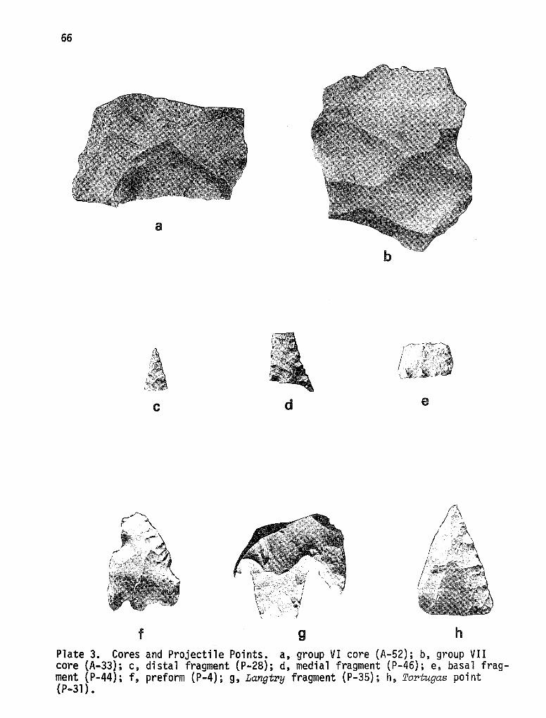
66
a
c d e
f~, ,, ~·
,,.,-/ !
f g h Plate 3. Cores and Projectile Points. a, group VI core (A-52); b, group VII core (A-33); c, distal fragment (P-28); d, medial fragment (P-46); e, basal fragment (P-44); f, preform (P-4); g, Langtry fragment (P-35); h, Tor-tugas point (P-31).
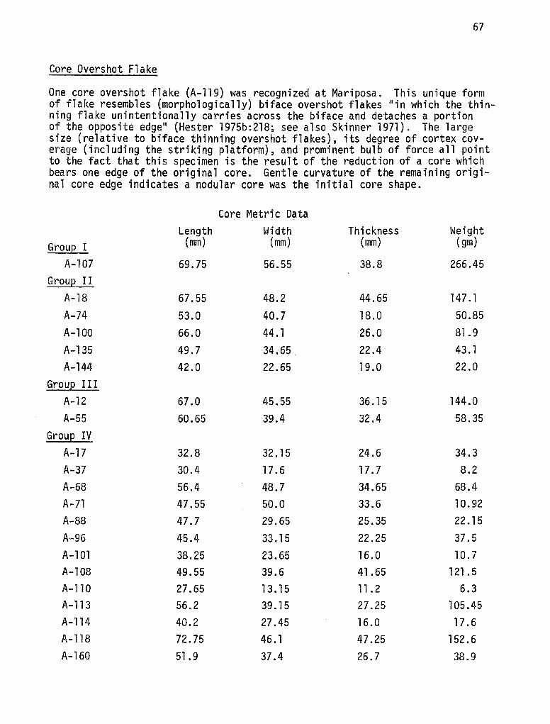
67
Core Overshot Flake
One core overshot flake (A-119) was recognized at Mariposa. This unique form of flake resembles (morphologically) biface overshot flakes 11 in which the thin-ning flake unintentionally carries across the biface and detaches a portion of the opposite edge11 (Hester 1975b:218; see also Skinner 1971). The large size (relative to biface thinning overshot flakes), its degree of cortex cov-erage (including the striking platform), and prominent bulb of force all point to the fact that this specimen is the result of the reduction of a core which bears one edge of the original core. Gentle curvature of the remaining origi-nal core edge indicates a nodular core was the initial core shape.
Core Metric Data Length Width Thickness Weight
Group I (mm) (mm) (mm) (gm)
A-107 69.75 56.55 38.8 266.45 Group II
A-18 67.55 48.2 44.65 147 .1 A-74 53.0 40.7 18.0 50.85 A-100 66.0 44.1 26.0 81. 9 A-135 49.7 34.65 22.4 43. l A-144 42.0 22.65 19.0 22.0
Group I II A-12 67.0 45.55 36. 15 144.0 A-55 60.65 39.4 32.4 58.35
Group IV A-17 32.8 32 .15 24.6 34.3 A-37 30.4 17. 6 17. 7 8.2 A-68 56.4 48.7 34.65 68.4 A-71 47.55 50.0 33.6 10.92 A-88 47.7 29.65 25.35 22 .15 A-96 45.4 33.15 22.25 37.5 A-101 38.25 23.65 16.0 10.7 A-108 49.55 39.6 41.65 121. 5 A-110 27.65 13. l 5 11.2 6.3 A-113 56.2 39. 15 27.25 105.45 A-114 40.2 27.45 16.0 17. 6 A-118 72.75 46.1 47.25 152.6 A-160 51. 9 37.4 26.7 38.9
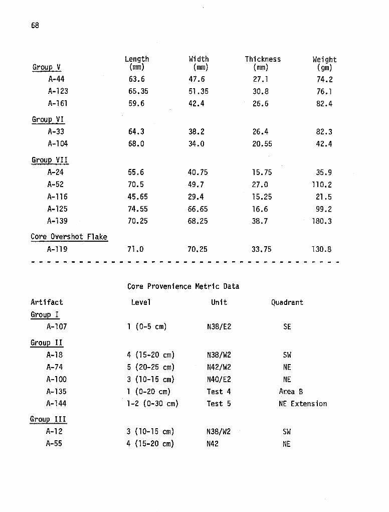
68
Length Width Thickness Weight Group V (mm) (mm) (mm) (gm)
A-44 63.6 47.6 27. 1 74.2 A-123 65.35 51.35 30.8 76. 1 A-161 59.6 42.4 26.6 82.4
Group VI A-33 64.3 38.2 26.4 82.3 A-104 68.0 34.0 20.55 42.4
Group VII A-24 55.6 40.75 15. 75 35.9 A-52 70.5 49.7 27.0 110.2 A-116 45.65 29.4 15.25 21.5 A-125 74.55 66.65 16.6 99.2 A-139 70.25 68.25 38.7 180.3
Core Overshot Flake A-119 71.0 70.25 33.75 130.8
- - - - - - - - - - - - - - - - - - - - - - - - - - - - - - - - - - - - - - -
Core Provenience Metric Data
Artifact Level Unit Quadrant Group I
A-107 l (0-5 cm) N38/E2 SE
Group II A-18 4 (15-20 cm) N38/W2 SW A-74 5 (20-25 cm) N42/W2 NE A-100 3 (10-15 cm) N40/E2 NE A-135 1 ( 0-20 cm) Test 4 Ar.ea B A-144 1-2 (0-30 cm) Test 5 NE Extension
Group III A-12 3 ( 10-15 cm) N38/W2 SW A-55 4 (15-20 cm) N42 NE
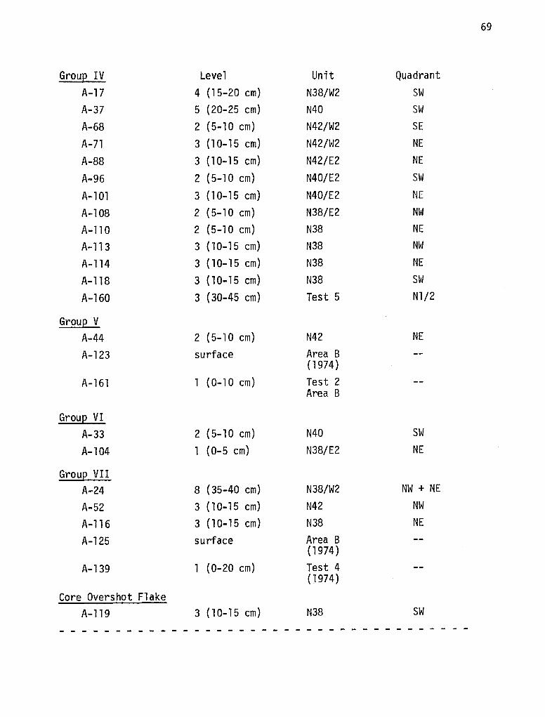
69
Group IV Level Unit Quadrant A-17 4 (15-20 cm) N38/W2 SW A-37 5 (20-25 cm) N40 SW
A-68 2 (5-10 cm) N42/W2 SE
A-71 3 (10-15 cm) N42/W2 NE
A-88 3 (10-15 cm) N42/E2 NE
A-96 2 (5-10 cm) N40/E2 SW
A-101 3 (10-15 cm) N40/E2 NE
A-108 2 (5-10 cm) N38/E2 NW
A-110 2 (5-10 cm) N38 NE
A-113 3 (10-15 cm) N38 NW
A-114 3 ( 10-15 cm) N38 NE
A-118 3 (10-15 cm) N38 SW
A-160 3 (30-45 cm) Test 5 Nl/2
Group V A-44 2 (5-10 cm) N42 NE
A-123 surface Area B (1974)
A-161 1 (0-10 cm) Test 2 Area B
Group VI A-33 2 (5-10 cm) N40 SW
A-104 1 (0-5 cm) N38/E2 NE
Group VII A-24 8 (35-40 cm) N38/W2 NW + NE
A-52 3 ( 10-15 cm) N42 NW
A-116 3 (10-15 cm) N38 NE
A-125 surface Area B (1974)
A-139 1 (0-20 cm) Test 4 ( 1974)
Core Overshot Flake A-119 3 ( 10-15 cm) N38 SW
- - - - - - - - - - - - - - - - - - - - - - - - - - - - - - - - - - - - -
70
Taken together, the cores, (Groups I-VII) exccwated at Mariposa are primarily from Area A and occur mos-t frequently in 1 eve ls two and three, where 55% of the s-pectmens we.re recovered. This trend i.s best tll ustrated tn the 13 Group IV core s-pecimens, all but two of which occur i.n levels two and three •. Group IV cores a 1 so repres·ent the most preva 1 ent core type recovered. Examination of core proveniences- indicates that most cores are equally distributed in seven of the nine excavation units at Mariposa. Possible clusters of Group IV cores may be in N42/W2 and N38, but the specimen sample size is presently not adequate for definite statements. The clustering in N38, however, is especially strong. This unit may have been a locus for the depositfon (discard} of exhausted Group IV core nuclei. These cores represent specimens which are physically not functional as core material (i.e., for the manufacture of appropriately sized flakes). Indirectly, since this unit seems to be a favored core discard area, a core preparation or use area may be located in the similar or adjacent areas.
All seven groups of cores can be technologically related in such a way as to describe the core reduction sequence practiced by the aboriginal inhabitants of Mariposa (see Fig. 4). The two different arrows indicate the (hypothetical) strength of association between core groups. This sequence has not been demonstrated to occur by replication; core group relationships are presented on the basis of inferred sequential core modifications. Two general morphological types of core resource material are available, nodular (or round) and tabular. Reduction of either type of core produced large flakes capable of use as tools (utilized, trimmed, uniface, biface, projectile point). Thus flakes were produced by the reduction of Group I (nodular) cores into either Group II and/or Group III cores and by the reduction of tabular resource material into Group V, VI and/or Group VII cores. Core overshot flakes, such as the one excavated, are also possible by-products.
Further reduction of Groups II, III, V, VI and VII cores would produce smaller cores as one end product, as well as flakes, though these flakes would be smaller than flakes initially produced. If large enough, generated flakes from this reduction could have possibly been trimmed into or utilized as tools. They also could have been finished into flake tools (unifaces and bifaces). Reduction of Group II and Group III cores would result in Group IV cores. Group VII cores will be produced from the continued reduction of Group VI cores, although they also could have been reduced into Group IV cores as well.
Certain cores (III, VII) could have easily been reduced into bifacial tools. It seems probable that most other cores were directed toward the manufacture of flakes and, ultimately, flake tools. Moving toward the center of Fig. 5 indicates that more and more smaller flakes are being removed from cores. The net result of this process is the generation of multi-directional core nuclei (Group IV cores). Physical conditions here also dictate that the smaller cores will produce smaller flakes, and the centrally located Group IV cores are the smallest core group based on their recorded metric attributes. Core nuclei were discarded when it became physically impossible to extract flakes large enough for tool production.
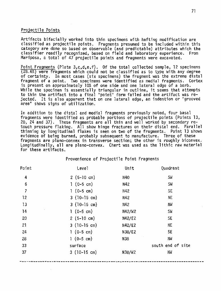
71
Projectile Points
Artifacts bifacially worked into thin specimens with hafting modification are classified as projectile points. Fragments presumed to be included within this category are done so based on observable (and predictable) attributes which the classifier readily recognized, based on field and laboratory experience. From Mariposa, a total of 47 projectile points and fragments were excavated.
Point Fragments (Plate 3,c,d,e,f). Of the total collected sample, 12 specimens (28.6%) were fragments which could not be classified as to type with any degree of certainty. In most cases (six specimens) the fragment was the extreme distal fragment of a point. Two specimens were identified as medial fragments. Cortex is present on approximately 10% of one side and one lateral edge of a barb. While the specimen is essentially triangular in outline, it seems that attempts to thin the artifact into a final "point" form failed and the artifact was rejected. It is also apparent that on one lateral edge, an indention or "grooved area" shows signs of utilization.
In addition to the distal and medial fragments previously noted, four basal fragments were identified as probable portions of projectile points (Points 13, 20, 24 and 37). These fragments are all thin and well worked by secondary retouch pressure flaking. All show hinge fractures on their distal end. Parallel thinning by longitudinal flakes is seen on two of the fragments. Point 13 shows evidence of being burned, probably subsequent to manufacture. Three of these fragments are plano-convex in transverse section; the other is roughly biconvex. Longitudinally, all are plano-convex. Chert was used as the lithic raw material for these artifacts.
Provenience of Projectile Point Fragments
Point Level Unit Quadrant
4 2 (5-10 cm) N40 SW 6 1 (0-5 cm) N42 SW 7 l (0-5 cm) N42 SE
12 3 (l0-15 cm) N42 NE 13 3 (10-15 cm) N42 NW 14 1 (0-5 cm) N42/W2 SW 20 2 (5-10 cm) N42/E2 SE 21 3 (10-15 cm) N42/E2 NE 24 1 ( 0-5 cm) N38/E2 SE 28 1 (0-5 cm) N38 NW 33 surface south end of site 37 3 (10-15 cm) N38/W2 NW
72
Dart Points (Plate 3, g,h. Plate 4,a). Of the recovered points, five specimens were readily identified as belonging to the general category of dart points. Temporally, these artifacts are usually associated with the Archaic Period, but can persist into later Neo-American occupations. All but two of the specimens were recovered from the surface near the gully cut in Area B of CH-28. Due to this unique spatial distribution, it is assumed that these three dart points have eroded from the lower level of the gully cut. Additionally, all three dart points recovered from this area are basal f~agments. Dart points are recognized to be morphologically distinct from arrow points (larger, heavier).
These three basal fragments are identified as specimens of the Langtry type (see Plate 3,g), as described by Suhm and Jelks (1962). The shoulders of the specimens are well defined, the stems contract slightly, and the bases are concave. All are made from chert which ranges in color from greyish-brown to pinkish-brown. Workmanship as a whole is not well refined and the distal hinge fracture on all of the fragments indicates that the points were broken during the latter stages of the manufacturing sequence and subsequently discarded.
Another dart point was excavated within the confines of the controlled test excavation number four at a depth of 20 to 40 cm below the present surface. This specimen is a complete Tortu.gas (see Plate 3,h) made of light tan chert with a rose strip along one lateral edge. As is characteristic of the Tortugas type (Suhm and Jelks 1962:249), this point is stemless with a triangular blade, straight to slightly convex edges, and a straight base. Alternate beveling combined with fine secondary retouch pressure flaking on the edges has produced a very 11 striking11 artifact. In cross section, this point exhibits a planoconvex outline and, due to the beveling, a triangular form is seen in the transverse section. The base has been thinned on only one face by removal of one longitudinal flake. Dimensions of the Tortugas point follow:
Length mm - 45.2 Width mm - 16.8 Thickness mm - 2.60 Weight gm - 1.3
According to Suhm and Jelks (1962:249), this type of dart point is 11 a major typ~ ••• of the Falcon Focus, continuing into the Mier Focus" and is "a minor type of the Aransas Focus, the Edwards Plateau Aspect and the Pecos River Focus. 11
While frequently occurring with Nee-American materials, the Tortugas dart point is usually associated with the Archaic and has been dated at 40oo·s.c. to A.O. 1000 (Suhm and Jelks 1962:249).
The remaining dart point is the smallest one in terms of overall size and weight and was recovered from the first level of Unit N38/E2 (NE quadrant) (Plate 4,a). This translucent grey point is a corner-notched, triangular point which has been fashioned from a flake. In the transverse section, the point exhibits a thick, roughly plano-convex outline, and longitudinally it shows asymmetric biconvexity. While not a 11 large point, 11 this specimen does have thick, wide edges which are slightly concave and a concave base. One face of this point is almost flat and on the other face both edges have been beveled.
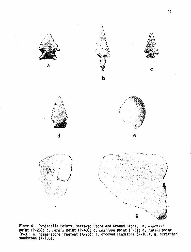
73
a
b
/
d e
. ··~ :----- ....
f
Plate 4. Projectile Points, Battered Stone and Ground Stone. a, Edgewood point (P-23); b, Perdiz point (P-40); c, ScaZZorn point (P-5); d, ZavaZa point (P-3); e, hammerstone fragment (A-26); f, grooved sandstone (A-102); g, scratched sandstone (A-106).
74
Both faces show extensive fla,ki.ng. Interestingly, one edge has been retouched wi'th pressure flaking whi.le the other edge reveals multi.ple step fractures occurring tn the same directton. Edge reworking (reshaping) may account for th ts·.
Morphologically, the described point could be an Ellis or Edgewood. Due to basal convexity, thi.s specimen was classified as· an Edgewood point (Suhm and Jelks 1962:183). Edgewood has been noted to occur in components of the East Texas Aspect, Archaic Stage, and less consistently, tn the Edwards Plateau Aspect. Edgewood types have been dated to the later stages of the Archaic period in Texas, around A.O. 1 (Suhm and Jelks 1962:183).
Metric data concerning this one point are:
Point
23
31
34
35
43 - ·- - - - -
Length mm - 27.0 Width mm - 17.0 Thickness mm - 50.0 Stem Width mm - 18.3 Stem Length mm - 7.4 Weight gm - 3.3
Provenience of Dart Points
Level Unit
1 (0-5 cm) N38/E2; NEl/4
2 (20-40 cm) Test 4
surface Area B, Gully
surface Area B, Gully
surface Area B - - - - - - - -· - - - - - - - - - -
Type
(Suhm and Jelks 1962) Edgewood
Tortugas
Langtry, Basal fragment
Langtry, Basal fragment
Langtry, Basal fragment - - - - - - - - - - - - - -
Arrow Points. Dominating the recovered projectile point category are arrow points. Generally, these projectile points appear in archaeological contexts after dart points and are indicators of the Late Prehistoric (temporal) period. Several types, most notably Perdiz, Scallorn and Zavala points, form the bulk of the arrow point category. Twenty-five specimens (59.5% of the total sample) were typed following descriptions published by Suhm and Jelks (1962) and Hester (1971). These will be described under the appropriate subheadings (types) and provenience data will follow the descriptions.
Perdiz Points (Plate 4,b)--Eight projectile points and fragments were classified according to the published criteria of Suhm and Jelks (1962) as Perdiz. One point appears to be resharpened, since it is very small. From CH-28, the Perdiz points have generally slender, triangular blades with straight concave edges.
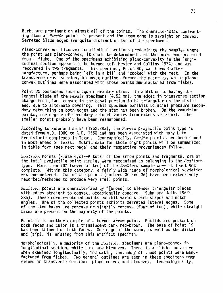
75
Barbs are prominent on almost all of the points. The characteristic contracting stem of Perdiz points is present and the stem edge is straight or convex. Serrated blade edges are quite distinct on two of the specimens.
Plano-convex and biconvex longitudinal sections predominate the sample; where the point was plano-convex, it could be determined that the point was prepared from a flake. One of the specimens exhibiting plano-convexity in the longitudinal section appears to be burned (cf. Hester and Collins 1974) and was recovered in two fragments. This specimen, Point 40, was burned after manufacture, perhaps being left in a kill and 11 cooked11 with the meat. In the transverse cross section, biconvex outlines formed the majority, while planoconvex outlines were associated with those points manufactured from flakes.
Point 32 possesses some unique characteristics. In addition to having the longest blade of the Perdiz specimens (4.52 mm), the edges in transverse section change from plano-convex in the basal portion to bi-triangular on the distal end, due to alternate beveling. This specimen exhibits bifacial pressure secondary retouching on both edges and the stem has been broken. On the remaining points, the degree of secondary retouch varies from extensive to nil. The smaller points probably have been resharpened.
According to Suhm and Jelks (1962:283), the Perdiz projectile point type is dated from A.D~ 1000 to A.O. 1560 and has been associated with many Late Prehistoric complexes in Texas. Geographically, Perdiz points have been found in most areas of Texas. Metric data for these eight points will be summarized in table form (see next page) and their respective proveniences follow.
ScaZZorn Points (Plate 4,c)--A total of ten arrow points and fragments, 21% of the total projectile point sample, were recognized as belonging to the ScaZZorn type. More than 70% (seven of ten) of the ScaZZorn sample were at least 90% complete. Within this category, a fairly wide range of morphological variation was encountered. Two of the points (numbers 30 and 36) have been extensively reworked/reshaped to produce very small points.
ScaZZorn points are characterized by "[broad] to slender triangular blades with edges straight to convex, occasionally concave 11 (Suhm and Jelks 1962: 285). These corner-notched points exhibit various barb shapes and notch angles. One of the collected points exhibits serrated lateral edges. Some of the stem bases are concave or slightly concave (four of ten), while straight bases are present on the majority of the points.
Point 19 is another example of a burned arrow point. Potlids are present on both faces and color is a translucent dark red-brown. The base of Point 19 has been thinned on both faces. One edge of the stem, as well as the distal end (tip), is missing from this artifact specimen.
Morphologically, a majority of the ScaZZorn specimens are plano-convex in longitudinal section, while some are biconvex. There is a slight curvature when examined longitudinally, indicating that many of these points were manufactured from flakes. Two general outlines are seen in these specimens when viewed in transverse section: plano-convex and biconvex. Technologically,
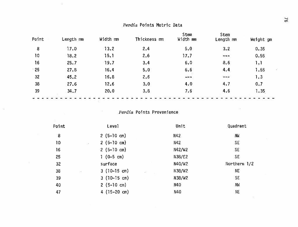
-...i O"I
Perdiz Points Metric Data
Stem Stem Point Length mm Width mm Thickness mm Width mm Length mm Weight gm
8 17.0 13. 2 2.4 5.0 3.2 0.35 10 18.2 15. 1 2.6 17. 7 --- 0.55 16 25.7 19. 7 3.4 6.0 8.6 1.1 25 27.8 16.4 5.0 6.6 4.4 1.55 32 45.2 16.8 2.6 --- --- 1. 3 38 27.6 12.6 3.0 4.0 4.7 0.7 39 34. 7 20.0 3.8 7.6 4.6 1.35
Perdiz Points Provenience
Point Level Unit Quadrant
8 2 (5-10 cm) N42 NW 10 2 (5-10 cm) N42 SE 16 2 (5-10 cm) N42/W2 SE 25 1 (0-5 cm) N38/E2 SE 32 surface N40/W2 Northern 1/2 38 3 (10-15 cm) N38/W2 NE 39 3 (10-15 cm) N38/W2 SE 40 2 (5-10 cm) N40 NW
47 4 (15-20 cm) N40 NE
77
Scallorn examples all present secondary retouch flaking. All but one of the points (number 17) show good workmanship, with controlled flaking on all faces.
Chert was utilized (in flake form) as the lithic material for all the artifacts examined. Color of the specimens varies from shades of light grey to pink with one dark red-brown specimen (the burned point mentioned above).
The Scallorn projectile point is a Late Prehistoric point which shows strong relationships (cultural?) to the Central Texas Aspect as well as Late Prehistoric foci of other Texas areas (Henrietta and Rockport Foci) (Suhm and Jelks 1962:285). Chronologically, Suhm and Jelks (1962:285) place the Scallorn before the occurrence of Perdiz points; they believe that the occurrence of Scallorn points in Texas spans 700 years, from A.D. 500 to A.O. 1200. Metric measurements and provenience data for the Scallorn points are included on the next page.
Zavala Points (Plate 4,d)--Relatively recent work in south Texas has revealed the presence in the Neo-American horizon of a sma 11 11 stubby 11 dart-1 i ke point (Hester and Hill l975b). A typological name, Zavala, has been given to this projectile point. It is still unclear whether the Zavala actually functioned as a dart point or an arrow point. Morphologically, this type seems to fall somewhere between dart points and arrow points. First, its length is generally smaller than dart points, but its thickness and rough flaking cast some doubt on whether it can be classified as an arrow point. Temporally, this point is found both in Neo-American and Late Archaic contexts. Zavala points, as a group, are manufactured on flakes and are side notched. Base edges range from slightly convex to straight and to slightly concave. Basal thinning has been noted for many specimens.
A very similar point from the Trans-Pecos area has been described by Johnson (1964:36). At Devil's Mouth, 61 Figueroa points were recovered whose dimensions are very similar to the Zavala type. Johnson's (1964:37) qualitative observations reveal other similarities:
The small size of these points may indicate that they were used as arrowheads, although they show the typical attributes of most dart points, viz., relative great thickness and crude percussion chipping.
Concerning the geographical and temporal boundaries, Johnson (1964:37) felt that his Figueroa was a major point type of the Late Archaic in a large portion of central and west-central Texas.
From the Mariposa site, seven specimens of the Zavaia type were excavated. Two of these points (Point 18 and Point 27) are burned. These points have all three types of bases, with one being basally notched (Point 22). As mentioned above, Zavala points are roughly trianguloid with straight to convex blade edges. Expanding stem types form the majority of the excavated sample. Three of the specimens are basally thinned, and all of the points show secondary retouch flake scars of the expanding variety. Seen in the longitudinal section, five specimens are roughly biconvex in outline and two are plano-convex. One of the Zavaia points exhibits a plano-trianguloid outline in the transverse section; the rest are biconvex to rough biconvex.
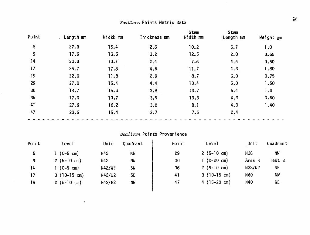
........
SaaZZo:r:>n Points Metric Data OJ
Stem Stem Point length mm Width mm Thickness mm Width mm Length mm Weight gm
5 27.0 15.4 2.6 10.2 5.7 1.0 9 17.6 13.6 3.2 12.5 2.0 0.65
14 20.0 13. 1 2.4 7.6 4.6 0.50 17 25.7 17 .8 4.6 11.7 4.3 1.80 19 22.0 11.8 2.9 8. 7 6.3 0.75 29 27.0 15.4 4.4 13.4 5.0 1.50 30 18.7 15.3 3.8 13. 7 5.4 1.0 36 17 .o 13. 7 3.5 13.3 4.3 0.60 41 27.6 16. 2 3.8 8. 1 4.3 1.40 47 23.6 15.4 3.7 7.6 2.4
- - - - - - - - - - - - - - - - - - - - - - - - - - - - - - - - - - - - - - - - - - - - - - - - - - - - -
SeaZZo:r:>n Points Provenience
Point Level Unit Quadrant Point Level Unit Quadrant
5 l (0-5 cm) N42 NW 29 2 (5-10 cm) N38 NW
9 2 (5-10 cm) N42 NW 30 1 (0-20 cm) Area B Test 3 14 l ( 0-5 cm) N42/W2 SW 36 2 (5-10 cm) N38/W2 SE 17 3 (10-15 cm) N42/W2 SE 41 3 (10-15 cm) N40 NW 19 2 {5-10 cm) N42/E2 NE 47 4 (15-20 cm) N40 NE
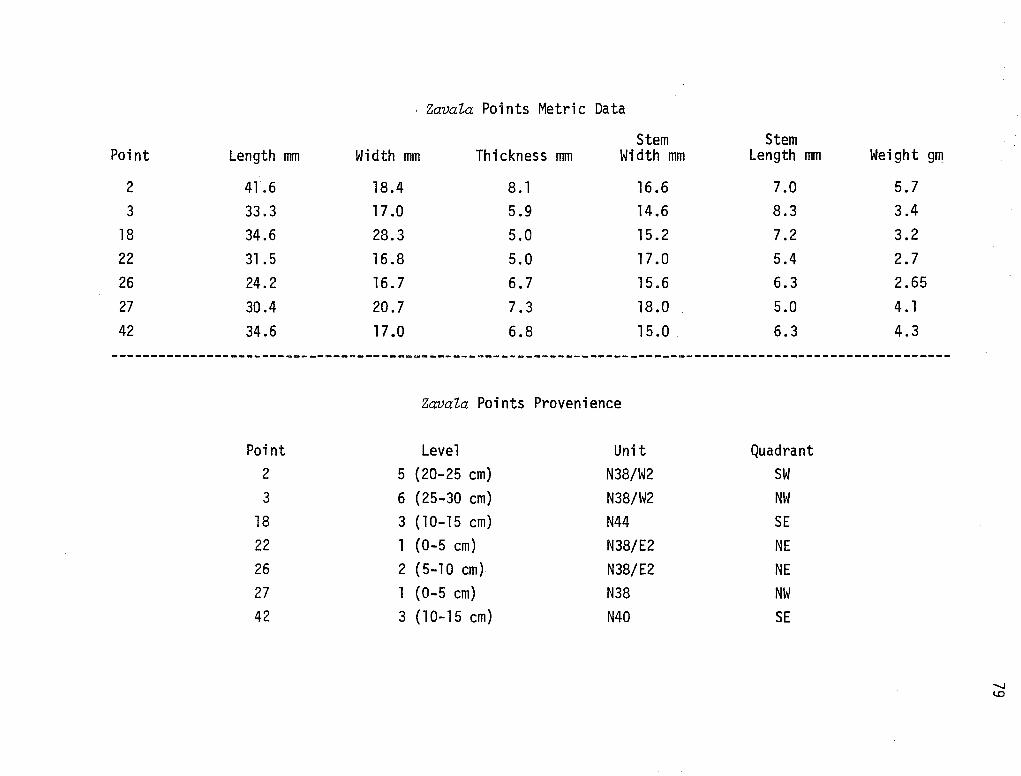
. Zavala Points Metric Data
Stem Point Length mm Width mm Thickness mm Width mm
2 41.6 18.4 8.1 16.6 3 33.3 17 .0 5.9 14 .6
18 34.6 28.3 5.0 15.2 22 31.5 16.8 5.0 17.0 26 24.2 16.7 6.7 15.6 27 30.4 20.7 7.3 18.0 42 34.6 17 .o 6.8 15 .0
Zavala Points Provenience
Point Level Unit 2 5 (20-25 cm) N38/W2 3 6 {25-30 cm) N38/W2
18 3 {10-15 cm) N44 22 1 {0-5 cm) N38/E2 26 2 (5-10 cm) N38/E2 27 1 (0-5 cm) N38 42 3 {10-15 cm) N40
Stem Length mm
7.0 8.3 7.2 5.4 6.3 5.0 6.3
Quadrant SW NW SE NE NE NW SE
Weight gm
5.7 3.4 3.2 2.7 2.65 4. 1 4.3
'-I c..o
80
As can be noted from the provenience table on page 86 zcwal.a points occur in almost all levels, with the smaller specimens occurring in the upper two levels. The preceding metric information indicates the variability present in the Zavala sample.
The majority of dart points recovered from Mariposa were confined to the surface of Area B and in deep levels of Area A. Only one example occurred in the upper level of an Area A excavation unit. On the other hand, only one (of 25) arrow point, a Scallorn occurred in Area B. It is immediately obvious that this dichotomy has important implications. Area B seems to be an Archaic locality, temporally distinct from Area A. The Mariposa site seems to have been a favored occupation area from at least Archaic times through the Late Prehistoric. Elaboration of the nature of the Archaic occupations at Mariposa cannot be presented until lower levels of the site are more completely revealed. Both the surface evidence in Area B and ·the deep hearth in Test 5 (Area A) indicate that Mariposa probably embodies an Archaic component in addition to the recorded Late Prehistoric component.
Perdiz points are present in great frequency in the upper three levels (and surface) of Mariposa, as 89% of the sample are recorded there. Six of the nine excavated units contained Perdiz points, with N42 and N38/W2 having more than one specimen in a level. As for Scallorn points, a similar 89% of these projec:ile points are situated in the upper three levels of the site. Of the six excavation units containing Perdiz points, four also contained Scallorn points. While the majority (71%) of Zavala points present at Mariposa occurred in levels one through three, two examples were recovered from much deeper contexts. However, since only two excavation units penetrated at least six levels, one cannot say that this pattern is useful for the entire site. Both examples from levels five and six occur in N38/W2. The fact that Zavala points occur in quite different excavation units than both Perdiz and Scallorn may be significant.
In summary, Perdiz and Scallorn projectile points occur with quite similar frequencies in the upper three levels of Mariposa. Zavala points, while occurring in similar archaeological contexts as both Perdiz and Scallorn, seem to appear before these types. This picture is quite in line with data from other Late Prehistoric sites in the vicinity of Mariposa (Hester and Hill 1975b). Due to the late C-14 determination for Mariposa, the temporal parameters for the existence of these point·types must be expanded, at least to A.O. 1650.
Ground, Battered, and Polished Stone
Analysis concerning this category of lithic artifacts offered surprising results. While most Late Prehistoric sites in this area contain numerous hammerstones (Hester and Hill 1975b:9), very few (two) were recovered from Mariposa, and one of these is a fragment (A-26; Plate 4,e}. Smoothed sandstone slabs, not usually reported from south Texas sites, were relatively frequent. Five specimens were excavated from Mariposa. One of these specimens, Artifact #41, consisted of three fragments, two of which fit together. All four of these fragments were located in level 1 (0-5 cm) of the southwestern quadrant of Unit N42. Well-worn corners are evident on the two fragments which
could ·be joined. One unidentified ground stone with rounded corners was recorded from the same provenience.
81
Artifact #106 is smoothed on both faces and one face exhibits a longitudinal scratch. The artifact is stained with a dark black substance (unknown origin).
Scratches and grooving occurred on four hematite specimens and six sandstone rocks. Taken together, these artifacts form the largest class of ground stone materials. Generally, such grooves and scratches (the majority of which are longitudinal) are associated with arrow shaft straightening activities (Hester and Hill 1975b:9); these implements may also have been used to grind and prepare platforms on artifacts for ease of manufacture (see Plate 4, f and g).
Four fragmentary manos and one complete mano were also found at Mariposa. All faces and edges are uniformly worn. Limestone was the favorite working material for these grinding implements, as all but one of the manos (a fragment) consisted of this material. Interestingly, the one mano fragment which was not limestone was made of quartzite and stained with hematite (see Plate 5).
Polished stone was rare, with only one quartzite fragment (polished on one face) being recovered (Artifact #97).
All of the artifacts described above were excavated during the 1974 field season. In 1975, testing at Mariposa revealed the presence of a large hearth located approximately 60 cm below the surface (Montgomery, Moffat and Richie 1975). A hearth at such a deep level is significant in itself but careful observations revealed additional information. Nine incised stones, all located in the central portion of the hearth and relatively close in proximity to each other, were recorded in the field and were removed for further examination.
All but one of the specimens are incised on one face only. Incising on the majority of the sandstone artifacts consisted of longitudinal lines running roughly parallel. As few as two and as many as five lines were present. In a few cases, the longitudinal lines were crossed by a perpendicular transverse line. On one specimen, Artifact #159-8, a longitudinal incision was crossed by four transverse lines. While most of the specimens had parallel longitudinal incised lines, no other recurring pattern persists in the sample. Approximately half of the sandstone artifacts are rectanguloid in outline, while the remainder of the sample are irregular. Some of the specimens are quite large (e.g., A-159-8) but a few are significantly smaller (e.g., A-159-1).
Problems associated in determining the function of incised stone are numerous (Hester and Hill 1975b:l3). Compounding these problems at Mariposa is the fact that sandstone rocks rather than limestone cobbles were used as raw material and that such incised rock appears in an oriented pattern within the deep hearth. Such circumstances as those at Mariposa have yet to be reported from other sites.
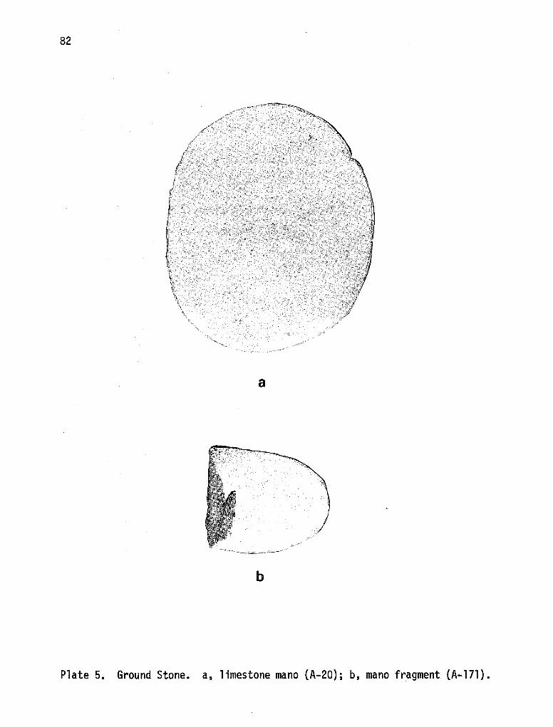
82
a
J
b
Plate 5. Ground Stone. a, 1 imestone mano (A-20); b, mano fragment (A-171).
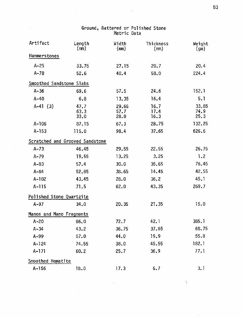
83
Ground, Battered or Polished Stone Metric Data
Artifact Length Width Thickness Weight (nm) (mm) (mm) (gm)
Hammers tones
A-25 33.75 27.15 20.7 20.4 A-78 52.6 40.4 58.0 224.4
Smoothed Sandstone Slabs A-36 69.6 57.5 24.6 152. l
A-40 6.8 13. 35 16.4 5. l
A-41 (3) 47.7 29.65 16.7 33.85 63.3 57.7 17. 4 74.9 33.0 28.0 16.3 25.3
A-106 87.15 67.3 28.75 132. 25 A-153 115. 0 98.4 37.65 626.6
Scratched and Grooved Sandstone
A-73 46.45 29.55 22.55 26.75
A-79 19. 55 13. 25 3.25 1.2
A-83 57.4 30.0 35.65 76.45
A-84 52.85 38.65 14.45 42.55
A-102 43.45 28.0 36.2 45. 1
A-115 71o5 62.0 43.35 269.7
Polished Stone Quartzite A-97 34.0 20.35 21. 35 15.0
Manos and Mano Fragments A-20 86.0 72. 7 42. 1 385. 1
A-34 43.2 36.75 37.85 68.75
A-99 57.0 44.0 19.9 55.8
A-124 74.55 38.0 45.55 182. 1 A-171 60.2 25.7 36.9 77. 1
Smoothed Hematite A-156 18.0 17. 3 6.7 3. 1
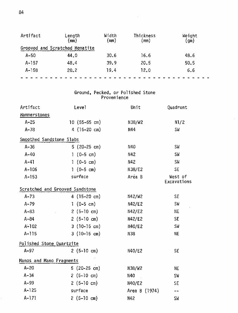
84
Artifact Length Width Thickness Weight (mm) (mm) (mm) (gm)
Grooved and Scratched Hematite A-50 44.0 30.6 16.6 48.6 A-157 48.4 39.9 20.5 50.5 A-158 20.2 19.4 12. 0 6.6
------ - - - - - - - - - - - - - - - - - - - - - - - - - - - - - - - - -
Ground, Pecked, or Polished Stone Provenience
Artifact Hammers tones
A-25 A-78
Level
10 (55-65 cm) 4 (15-20 cm)
Smoothed Sandstone Slabs A-36 5 (20-25 cm) A-40 A-41 A-106 A-153
(0-5 cm) 1 (0-5 cm) 1 (0-5 cm) surface
Scratched and Grooved Sandstone A-73 4 (15-20 cm) A-79 1 (0-5 cm) A-83 2 (5-10 cm) A-84 2 (5-10 cm} A;..102 3 ( 10-15 cm) A-115 3 ( 10-15 cm)
Polished Stone Quartzite A-97 2 (5-10 cm)
Manos and Mano Fragments A-20 5 (20-25 cm) A-34 2 (5-10 cm) A-99 2 (5-10 cm) A-125 surface A-171 2 (5-10 cm}
Unit
N38/W2 N44
N40 N42 N42 N38/E2 Area B
N42/W2 N42/E2 N42/E2 N42/E2 N40/E2 N38
N40/E2
N38/W2 N40 N40/E2 Area B (1974) N42
Quadrant
Nl/2 SW
SW SW SW SE
West of Excavations
SE SW NE SE SW NE
SE
NE SW SE
SW
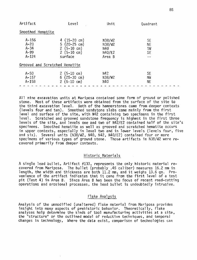
Artifact
Smoothed Hematite
A-156 A-20 A-34 A-99 A-124
Level
4 (15-20 cm) 5 (20-25 cm) 2 (5-10 cm) 2 (5-10 cm) surface
Grooved and Scratched Hematite
A-50 A-157 A-158
2 (5-10 cm) 6 (25-30 cm) 2 ( 5-10 cm)
Unit
N38/W2 N38/W2 N40 N40/E2 Area B
N42 N38/W2 N40
Quadrant
SE NE SW SE
SE NW NE
85
All nine excavation units at Mariposa contained some form of ground or polished stone. Most of these artifacts were obtained from the surface of the site to the third excavation level. Both of the hammerstones came from deeper contexts (levels four and ten). Smoothed sandstone slabs came mainly from the first level and surface of the site, with N42 containing two specimens in the first level. Scratched and grooved sandstone frequency is highest in the first three levels of the site, and levels one and two of N42/E2 contained half of the site's specimens. Smoothed hematite as well as grooved and scratched hematite occurs in upper contexts, especially in level two and in lower levels (levels four, five and six). Several units (N38/W2, N40, N42, N40/E2) contained four or more specimens of various types of ground stone. Those artifacts in N38/W2 were recovered primarily from deeper contexts.
Historic Materials
A single lead bullet, Artifact #133, represents the only historic material recovered from Mariposa. The bullet (probably .45 caliber) measures 16.2 mm in length, the width and thickness are both 11.2 mm, and it weighs 13.6 gm. Provenience of the artifact indicates that it came from the first level of a test pit (Test 4) in Area B. Since Area B has been the focus of recent road-cutting operations and erosional processes, the lead bullet is undoubtedly intrusive.
Flake Analysis
Analysis of the unmodified (unaltered) flake material from Mariposa provides insight into many aspects of prehistoric behavior. Theoretically, flake analyses help determine the kinds of tool manufacturing activities at a site, the "structure" or the outlined model of reduction techniques, and temporal changes in technology, Where the data exist, comparison of technologies can
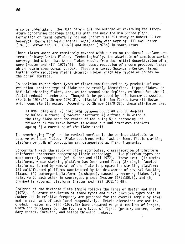
86
also be undertaken. The data herein are the outcome of reviewing the literature concerning debitage analysis with and near the Rio Grande Plain. Definition of terms generally follows Shafer 1 s (1969) study at Robert E. Lee Reservoir Basin (in west central Texas) along with work of Hill and Hester (1971), Hester and Hill (1972) and Hester (1975b) in south Texas.
Those flakes which are completely covered with cortex on the dorsal surface are termed Primary Cortex Flakes. Technologically, the attribute of complete cortex coverage indicates that these flakes result from the initial decortication of a core (Hester and Hill 1972:46). Subsequent reduction of a core produces flakes which retain some dorsal cortex. These are termed Secondary Cortex Flakes. Further core reduction yields Interior Flakes which are devoid of cortex on the dorsal surface.
In addition to the three types of flakes manufactured as by-products of core reduction, another type of flake can be readily identified. Lipped flakes, or bifacial thinning flakes, are, as the second name implies, evidence for the bifacial reduction technique. Thought to be produced by soft hammer percussion (Epstein 1964:64; Shiner 1970:31), bifacial thinning flakes have attributes which consistently occur. According to Shiner (1970:32), these attributes are:
1) Oval platform; 2) platforms between about 40 and 60 degrees to bulbar surface; 3) faceted platform; 4) diffuse bulb without the tiny flake near the center of the bulb; 5) a narrowing and thinning of the flake before it widens out and sometimes thickens again; 6) a curvature of the flake itself.
The overhanging 11 lip 11 on the ventral surface is the easiest attribute to observe on these flakes. Flake specimens which lack an identifiable striking platform or bulb of percussion are categorized as flake fragments.
Concomitant with the study of flake attributes, classification of platforms reinforces statements concerning lithic technology. Five platform types are most commonly recognized (cf. Hester and Hill 1972). These are: (1) cortex platforms, whose striking platform has been unmodified; (2) single faceted platforms, formed by removal of one flake to prepare the striking platform; (3) multifaceted platforms constructed by the detachment of several faceting flakes; (4) convergent platforms (A-shaped), caused by removing flakes lying relative to each other in convergent planes (Hester 1971:106,5), and (5) crushed (shattered) platforms (Hester and Hill 1972:46-48).
Analysis of the Mariposa flake sample follows the lines of Hester and Hill (1972). Separate tabulation of flake types and flake platform types both in number and in relative frequency are prepared for the overall sample by level and in each unit of each level respectively. Metric dimensions are not included. Hester and Hill (1972:48) have prepared range dimensions of length, width and thickness for the four main types of flakes (primary cortex, secondary cortex, interior, and biface thinning flakes).
87
Flake Types
As stated above, five flake types were recorded from materials excavated at Mariposa. These are presented, by unit and level provenience, in Table 2. Similar information, obtained from less exact methods (i.e., Test Pits), are provided in Table 3. This infonnation is summarized, by level, in Table 4 where relative percentage is the quantity recorded (this is only for 1974 excavations).
Centering on material excavated in 1974, an overall statement of the flake types represented at Mariposa can be formulated. Here, all levels and units are combined to show the following breakdown, by number and percent, of the five flake types:
Number Percentage of Recovered Flake Category
Primary Cortex Flakes 45 2.0 Secondary Cortex Flakes 319 13. 9 Interior Flakes 289 12.6 Biface Thinning Flakes 247 10.8 Flake Fragments 1,397 60.8
Total 2,297 100.0
If one removes the flake fragment category from the above information, the following numbers of specimens, and their relative frequency, by type, are generated:
Number Relative Recovered Percentage
Primary Cortex Flakes 40 4.4 Secondary Cortex Flakes 321 35.7 Interior Fl a kes 291 32.3 Biface Thinning Flakes 248 27.6
Total 900 l 00.0
Secondary cortex flakes, interior flakes, and biface thinning flakes contribute 95% of the identifiable flake types, with secondary cortex flakes being the most frequent. Interior flakes occur the second most frequently, followed by biface thinning flakes. Ramifications for these results are discussed in Chapter VIII (Lithic Technology).
The other attributes observed on flakes recovered from Mariposa may be grouped as flake striking platform types. Five categories here were also analyzed: single facet platforms, multi-facet platforms, crushed or shattered platforms, cortex platforms and convergent platforms. For the sake of brevity, all the data have been compiled in Table 5. Here each platform type is quantified by
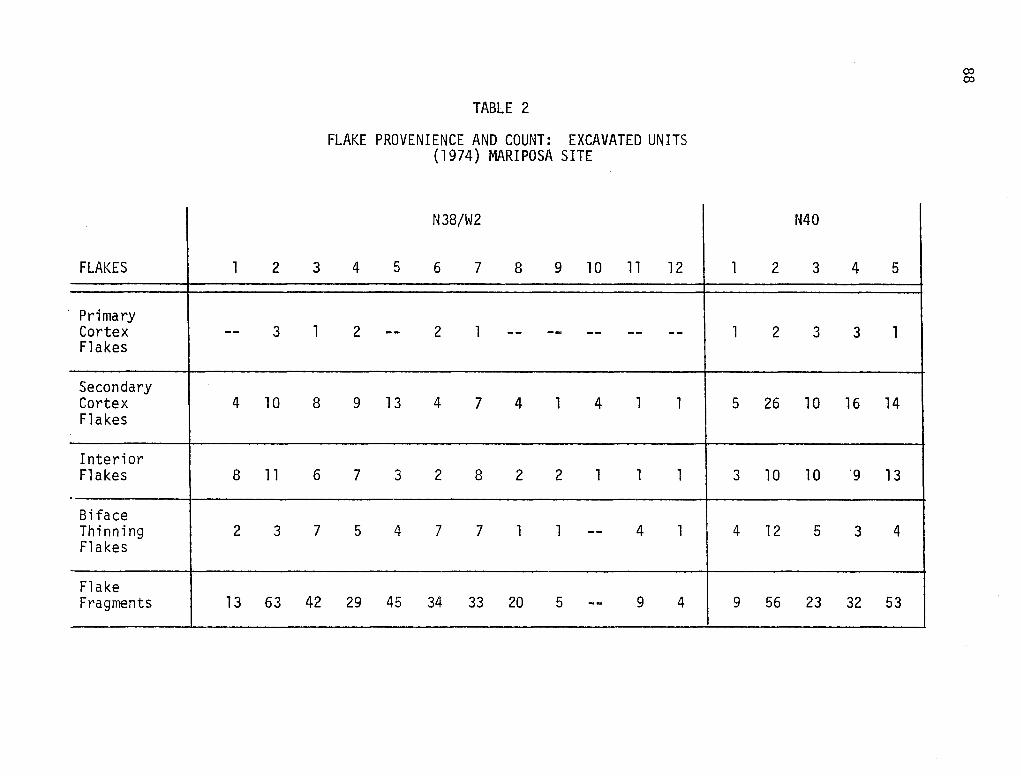
FLAKES 1 2 3
· Primary Cortex -- 3 1 Flakes
Secondary Cortex 4 10 8 Flakes
Interior Flakes 8 11 6
Bi face Thinning 2 3 7 Flakes
Flake Fragments 13 63 42
TABLE 2
FLAKE PROVENIENCE AND COUNT: EXCAVATED UNITS (1974) MARIPOSA SITE
N38/W2
4 5 6 7 8 9 10 11 12
2 -- 2 1 -- -- -- -- --
9 13 4 7 4 l 4 l l
7 3 2 8 2 2 l 1 1
5 4 7 7 l l -- 4 1
29 45 34 33 20 5 -- 9 4
N40
1 2 3
1 2 3
5 26 10
3 10 10
4 12 5
9 56 23
4
3
16
'9
3
32
5
l
14
13
4
53
co co
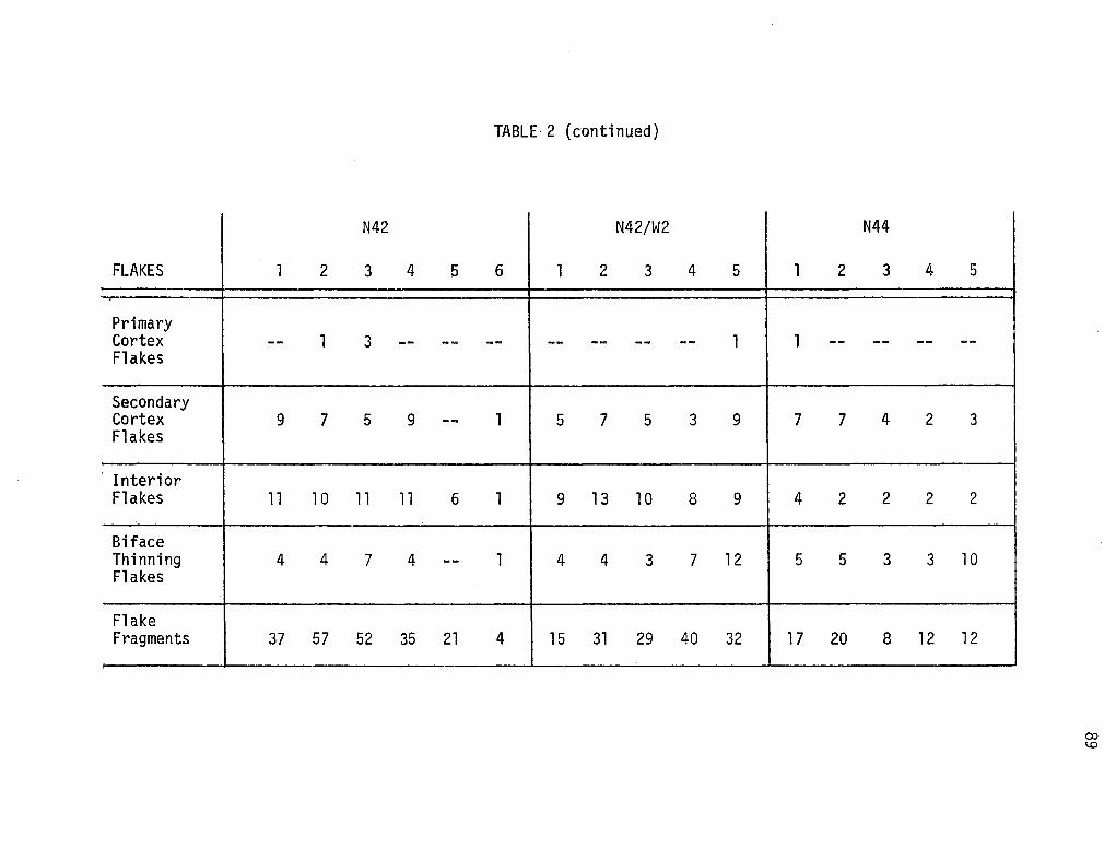
TABLE·2 (continued)
N42 N42/W2
FLAKES l 2 3 4 5 6 l 2 3
Primary Cortex -- l 3 -- -- -- -- -- --Flakes
Secondary Cortex 9 7 5 9 -- 1 5 7 5 Flakes
Interior Flakes 11 10 11 11 6 1 9 13 10
Bi face Thinning 4 4 7 4 -- l 4 4 3 Flakes
Flake Fragments 37 57 52 35 21 4 15 31 29
4 5 l 2
-- 1 1 --
3 9 7 7
8 9 4 2
7 12 5 5
40 32 17 20
N44
3 4
-- --
4 2
2 2
3 3
8 12
5
--
3
2
10
12
OJ l.O
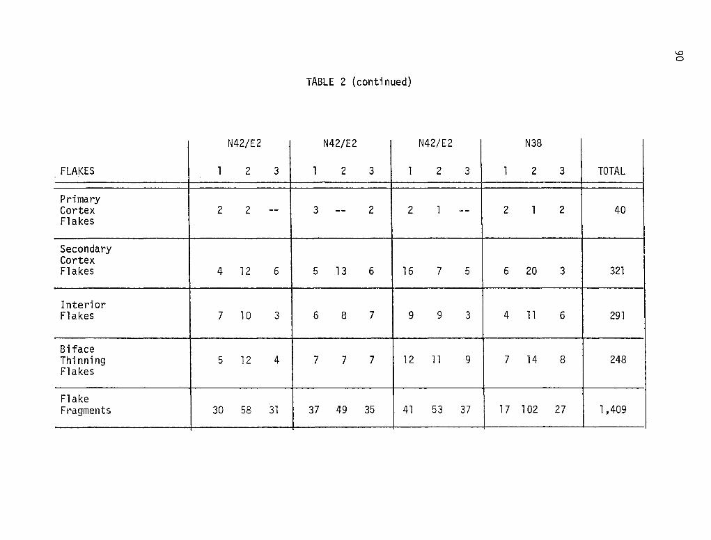
TABLE 2 (continued)
N42/E2 N42/E2
FLAKES l 2 3 l 2 3 l -
Primary Cortex 2 2 -- 3 -- 2 2 Flakes
Secondary Cortex Flakes 4 12 6 5 13 6 16
Interior Flakes 7 10 3 6 8 7 9
Bi face Thinning 5 12 4 7 7 7 12 Flakes
Flake Fragments 30 58 31 37 49 35 41
N42/E2
2 3 l
l -- 2
7 5 6
9 3 4
11 9 7
53 37 17
N38
2 3
l 2
20 3
11 6
14 8
l 02 27
TOTAL
40
321
291
248
1,409
l.O Cl
TABLE 3
FLAKE PROVENIENCE AND COUNT: TEST PITS MARIPOSA SITE
Test 1 1970 Test 2 Test 3 1974 1974
Area B Area B FLAKES l 2 3 4 5 6 7 1 2 3 l
Primary Cortex 2 -- -- -- l l 2 -- -- -- -- -- -- -- -- --Flakes
Secondary Cortex 3 5 3 2 2 18 12 5 4 5 l -- 4 l -- --Flakes
Interior Flakes 18 5 4 2 4 31 11 6 6 2 l -- -- -- 2 2
Biface Thinning 4 3 l l -- 6 3 3 l -- -- -- 5 2 l --Flakes
Flake Fragments 32 16 12 6 9 52 29 22 13 8 -- l 19 10 1 16
l.O __,
Test 4 Test l 1974 1974
Area B Area B
FLAKES 1 2 3
Primary Cortex -- -- -- --Flakes
Secondary Cortex -- -- 2 --Flakes
Interior Flakes 4 l l --
Bi face Thinning 5 2 3 --Flakes
Flake Fragments 33 3 3 l
TABLE 3 {continued}
Test 5 1975
Area A
l 2 3 4
2 -- -- --
-4 2 4 l
3 5 4 l
9 7 8 2
33 37 40 8
NE Ex ten-sion
1-2 3-4
l --
12 4
8 2
15 2
63 16
SE Ex ten-sion
1
--
l
2
--
1
TOTAL --
9
103
125
83
484
l.D N
Level l
Level 2 Level 3 Level 4
Level 5 Level 6 Level 7 Level 8 Level 9 Level 10 Level 11
Level 12
TABLE 4
FLAKE TYPE RELATIVE PERCENTAGE BY EXCAVATION LEVEL (1974)
Primary Secondary Interior Cortex Cortex Flakes Flakes Flakes
6 33.3 33.3 3.6 39.6 30.5 6.9 28.9 33.5 4.9 37.9 35.9 0 38.2 32.4
11. 1 27.8 16.7 4.3 30.4 34.8 0 66.7 33.3 0 33.3 66.7 0 66.7 16.7 0 16.7 16.7 0 33.3 33.3
93
Bi face Thinning Flakes
27.3 26.2 30.6 21.4 29.4 44.4 30.4 0 0
16. 7 66.7 33.3
l.O +=-
TABLE 5
FLAKE STRIKING PLATFORM TYPE RELATIVE PERCENTAGE BY LEVEL
Single Facet Multi-Facet Crushed/ Convergent Cortex Platform Platform Shattered
Level 1 44 31. 9 7.1 3.8 13.2
Level 2 51. 3 27.3 7.3 3 11.3
Level 3 46.4 35.5 6.6 0.6 10.8
Level 4 47.1 28.4 8.8 5.9 9.8
Level 5 47.4 31.6 8.4 2.1 10.5
Level 6 33.3 44.4 5.6 5.6 11. 1
Level 7 13 43.5 30.4 8.7 4.3
Level 8 66.7 0 16.7 0 16.7
Level 9 66.7 33.3 0 0 0
Level 10 50 16.7 16.7 0 16.7
Level 11 16.7 66.7 0 0 16.7
Level 12 50 50 0 0 0
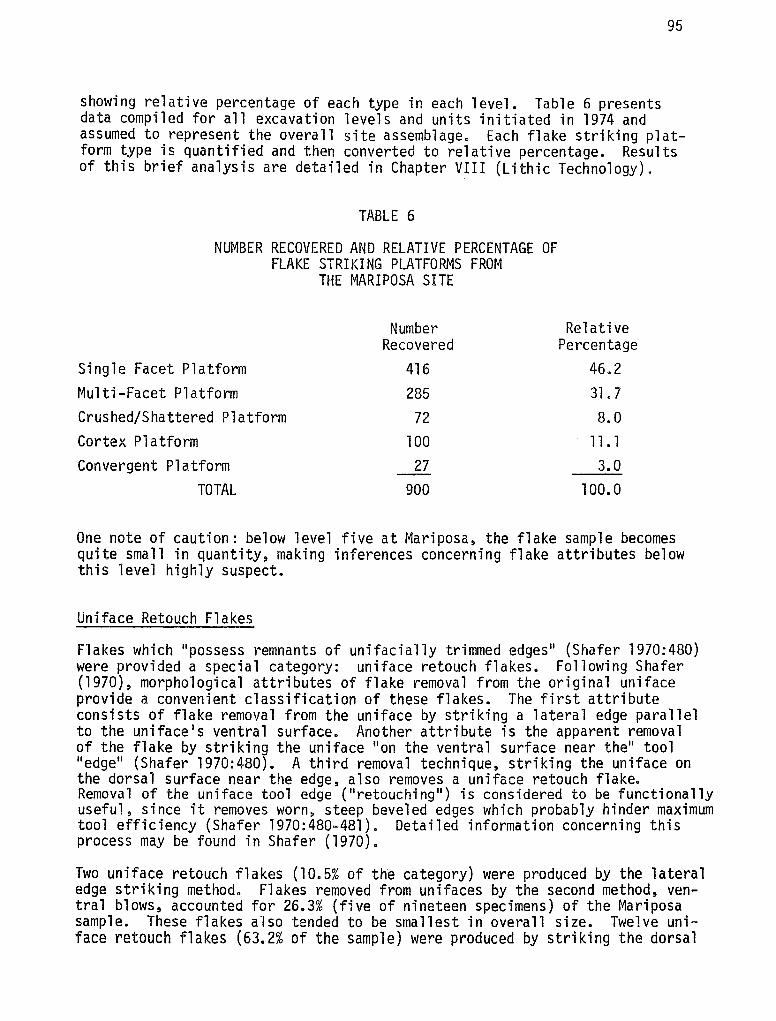
95
showing relative percentage of each type in each level. Table 6 presents data compiled for all excavation levels and units initiated in 1974 and assumed to represent the overall site assemblage. Each flake striking platform type is quantified and then converted to relative percentage. Results of this brief analysis are detailed in Chapter VIII (Lithic Technology).
TABLE 6
NUMBER RECOVERED AND RELATIVE PERCENTAGE OF FLAKE STRIKING PLATFORMS FROM
THE MARIPOSA SITE
Number Recovered
Single Facet Platform 416 Multi-Facet Platform 285 Crushed/Shattered Platform 72
Cortex Platform 100 Convergent Platform 27
TOTAL 900
Relative Percentage
46.2 31. 7 8.0
11. 1 3.0
100. 0
One note of caution: below level five at Mariposa, the flake sample becomes quite small in quantity, making inferences concerning flake attributes below this level highly suspect.
Uniface Retouch Flakes
Flakes which "possess remnants of unifacially trimmed edges" (Shafer 1970:480) were provided a special category: uniface retouch flakes. Following Shafer (1970), morphological attributes of flake removal from the original uniface provide a convenient classification of these flakes. The first attribute consists of flake removal from the uniface by striking a lateral edge parallel to the uniface 1 s ventral surface. Another attribute is the apparent removal of the flake by striking the uniface 11 on the ventral surface near the" tool 11 edge 11 (Shafer 1970:480). A third removal technique, striking the uniface on the dorsal surface near the edge, also removes a uniface retouch flake. Remova 1 of the uniface tool edge ( "retouchi ng 11
) is considered to be functionally useful, since it removes worn, steep beveled edges which probably hinder maximum tool efficiency (Shafer 1970:480-481). Detailed information concerning this process may be found in Shafer (1970).
Two uniface retouch flakes (10.5% of the category) were produced by the lateral edge striking method. Flakes removed from unifaces by the second method, ventral blows, accounted for 26.3% (five of nineteen specimens) of the Mariposa sample. These flakes also tended to be smallest in overall size. Twelve uniface retouch flakes (63.2% of the sample) were produced by striking the dorsal
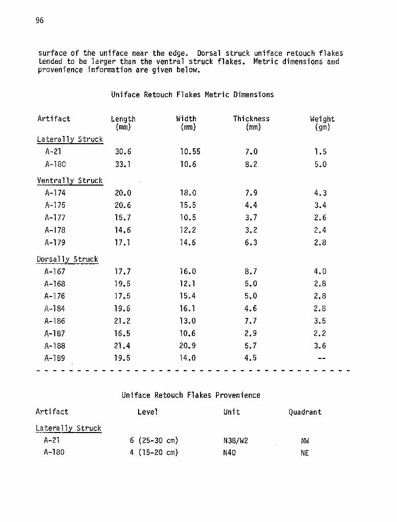
96
surface of the uniface near the edge. Dorsal struck uniface retouch flakes tended to be larger than the ventral struck flakes. Metric dimensions and provenience information are given below.
Uniface Retouch Flakes Metric Dimensions
Artifact Length Width Thickness Weight (mm) (mm) (mm) (gm)
Latera 11,l Struck A-21 30.6 10.55 7.0 1.5 A-180 33. 1 10.6 8.2 5.0
Ventrall,l Struck A-174 20.0 18.0 7.9 4.3 A-175 20.6 15.5 4.4 3.4 A-177 15. 7 10.5 3.7 2.6 A-178 14.6 12. 2 3.2 2.4 A-179 17. 1 14.6 6.3 2.8
Dorsallx Struck A-167 17. 7 16.0 8.7 4.0 A-168 19. 5 12. l 5.0 2.8 A-176 17 .5 15.4 5.0 2.8 A-184 19.6 16. l 4.6 2.8 A-186 21.2 13.0 7.7 3.5 A-187 16.5 10.6 2.9 2.2 A-188 21.4 20.9 5.7 3.6 A-189 19.5 14.0 4.5
~ - - ~ - - - - - - - - - - - - - - - - - - - - - - - - - - - - - - - - - - -
Uniface Retouch Flakes Provenience
Artifact Level Unit Quadrant
Latera llX Struck A-21 6 (25-30 cm) N38/W2 NW A-180 4 (15-20 cm) N40 NE
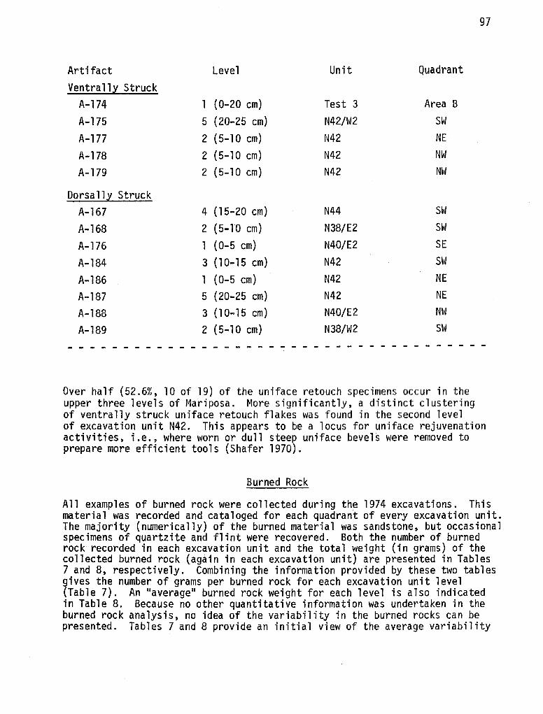
Artifact Level Unit Quadrant
Ventrall~ Struck A-174 1 (0-20 cm) Test 3 Area B
A-175 5 (20-25 cm) N42/W2 SW
A-177 2 (5-10 cm) N42 NE
A-178 2 (5-10 cm) N42 NW
A-179 2 (5-10 cm) N42 NW
Dorsa 11~ Struck A-167 4 (15-20 cm) N44 SW
A-168 2 (5-10 cm) N38/E2 SW
A-176 1 (0-5 cm) N40/E2 SE
A-184 3 (10-15 cm) N42 SW
A-186 l (0-5 cm) N42 NE
A-187 5 (20-25 cm) N42 NE
A-188 3 ( 10-15 cm) N40/E2 NW
A-189 2 (5-10 cm) N38/W2 SW
- - - - - - - - - - - - ------ - - - - - - - - - ------
Over half (52.6%, 10 of 19) of the uniface retouch specimens occur in the upper three levels of Mariposa. More significantly, a distinct clustering of ventrally struck uniface retouch flakes was found in the second level
97
of excavation unit N42. This appears to be a locus for uniface rejuvenation activities, i.e., where worn or dull steep uniface bevels were removed to prepare more efficient tools (Shafer 1970).
Burned Rock
All examples of burned rock were collected during the 1974 excavations. This material was recorded and cataloged for each quadrant of every excavation unit. The majority (numerically) of the burned material was sandstone, but occasional specimens of quartzite and flint were recovered. Both the number of burned rock recorded in each excavation unit and the total weight (in grams) of the collected burned rock (again in each excavation unit) are presented in Tables 7 and 8, respectively. Combining the information provided by these two tables gives the number of grams per burned rock for each excavation unit level (Table 7). An ''average" burned rock weight for each level is also indicated in Table 8. Because no other quantitative information was undertaken in the burned rock analysis, no idea of the variability in the burned rocks can be presented. Tables 7 and 8 provide an initial view of the average variability
98
between the first three excavated levels and present the variability of quantity and weight of recovered burned rocks per level between excavation units.
Examination of Table 7 shows that the number of burned rocks is highly variable both between excavation units in particular levels and between levels. Levels six through twelve are not discussed since less than five excavation units penetrated these levels. Levels two and five s·howed the highest number of burned rocks per level. The third level contained the lowest number of burned rocks. These data may indicate the levels (two and five) most heavily used or occupied at Mariposa, if one assumes that scattered burned rocks reflect intensity of occupation. Two separate occupations may have also occurred. Within the firs~t five excavated levels at Mariposa, some excavation units consistently provided either high or low burned rock counts. N44, through the initial five levels, contained uniformly low numbers of burned rocks. High burned rock counts are observed in excavation units N42 and N42/W2. This pattern is also seen in Table 8, where the data are weight rather than number of burned rocks. Again, N44 has low values through the first five levels, but here N38/W2 and N40 contained the highest weights (instead of N42 and N42/W2). Turning to Table 9, one gains an idea of the relative size (here measured as average grams per rock) of the burned rock recovered. Level three shows the largest values, with levels four and five (11.6 grams/rock and 12.0 grams/rock, respectively) also containing large values. Inspection of the individual excavation units indicates a different pattern from the previous tables. Low values, probably indicative of "smaller" burned rocks, are obtained consistently from two excavation units-N42 and N42/W2. Highest values are seen in N40 and N38/E2, while the overall level itself averaged the lowest values compared to the remaining upper four levels.
Conclusions from the above burned rock information must remain tenuous. While nine excavation units were cleared to three levels (15 cm below the surface), only five were excavated to five levels and two to level six. Excavation unit N38/W2 was the only unit which was excavated greater than six levels. Consequently, valid inferences concerning the significance of variability between levels and between excavation units within levels can only be proposed for those units excavated to five levels. If one assumes that number of burned rocks is an indicator of site usage, then this evidence from Mariposa points to maximum occupational activity at level two and level five. This same possibility arises when one considers the weight of burned rock recovered. While many areas revealed strong indicators of hearth activity, in one specific area-excavation unit N44--unusually low values were recorded from the first two tables. However, the significance of this focus of low activity is not clear. This uncertainty is compounded further when one considers the third table (Table 9). Here the low values of number of burned rocks and weight of burned rock are combined and indicate relatively fewer but larger burned rocks.
Overall, the recording of burned rock recovered from the 1974 excavations at Mariposa reflects that the density of burned rocks is greatest in two levels, when one considers the number and weight of burned rocks. One unit which recorded low amounts of number and wei,ght of burned rocks at the same time had relatively large pieces of burned rock within it.

TABLE 7
NUMBER OF BURNED ROCKS RECOVERED
N38/W2 N40 N42 N42/W2 N44 N42/E2 N40/E2
Level l 103 99 166 96 106 63 115 Level 2 237 156 193 172 82 186 167 Level 3 107 82 147 148 29 97 103 Level 4 121 184 203 248 39 --- ---Level 5 175 224 249 315 79 --- ---Level 6 161 --- 49 --- --- --- ---Level 7 145 --- --- --- --- --- ---Level 8 146 --- --- --- --- --- ---Level 9 20 --- --- --- --- --- ---Level 10 48 --- --- --- --- --- ---Level 11 161 --- --- --- --- --- ---Level 12 44 --- --- --- --- --- ---
TOTAL 1468 745 1007 979 335 346 385
N38/E2 N38
192 125 146 271
71 213
--- ------ ------ ------ ------ ------ ------ ------ ------ ---
409 609
Average
118 .3 178.9 110.8 159.0 208.4 105.0 145.0 146.0 20.0 48.0
161 .0 44.0
122.0
Total
1065 1610
997 795
1042 210 145 146
20 48
161 44
6283
~ ~
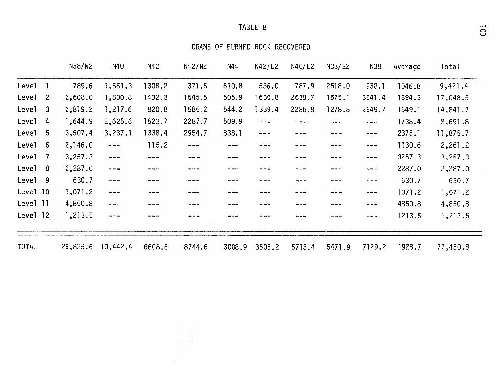
TABLE 8 __. 0 0
GRAMS OF BURNED ROCK RECOVERED
N38/W2 N40 N42 N42/W2 N44 N42/E2 N40/E2 N38/E2 N38 Average Total
Level 1 789.6 1,561.3 1308.2 371. 5 610.8 536.0 787.9 2518.0 938.1 1046 .8 9,421 .4 Level 2 2,608.0 1,800.8 1402.3 1545.5 505.9 1630.8 2638.7 1675. 1 3241.4 1894.3 17,048.5 Level 3 2,819.2 1,217.6 820.8 1585.2 544.2 1339.4 2286.8 1278.8 2949.7 1649. 1 14 ,841 . 7 Level 4 1,644.9 2,625.6 1623.7 2287.7 509.9 --- --- --- --- 1738. 4 8,691 .8 Level 5 3,507.4 3,237.1 1338. 4 2954.7 838. l --- --- --- --- 2375.1 11,875.7 Level 6 2,146.0 --- 115.2 --- --- --- --- --- --- 1130.6 2,261 .2 Level 7 3,257.3 --- --- --- --- --- --- --- --- 3257.3 3,257.3 Level 8 2,287.0 --- --- --- --- --- --- --- --- 2287.0 2,287.0 Level 9 630.7 --- --- --- --- --- --- --- --- 630.7 630.7 Level 10 1,071.2 --- --- --- --- --- --- --- --- 1071 . 2 l,071.2 Level 11 4,850.8 --- --- --- --- --- --- --- --- 4850.8 4,850.8 Level 12 1,213.5 --- --- --- --- --- --- --- --- 1213. 5 1,213.5
TOTAL 26,825.6 10,442.4 6608.6 8744.6 3008.9 3506.2 5713.4 5471 .9 7129.2 1928.7 77,450.8
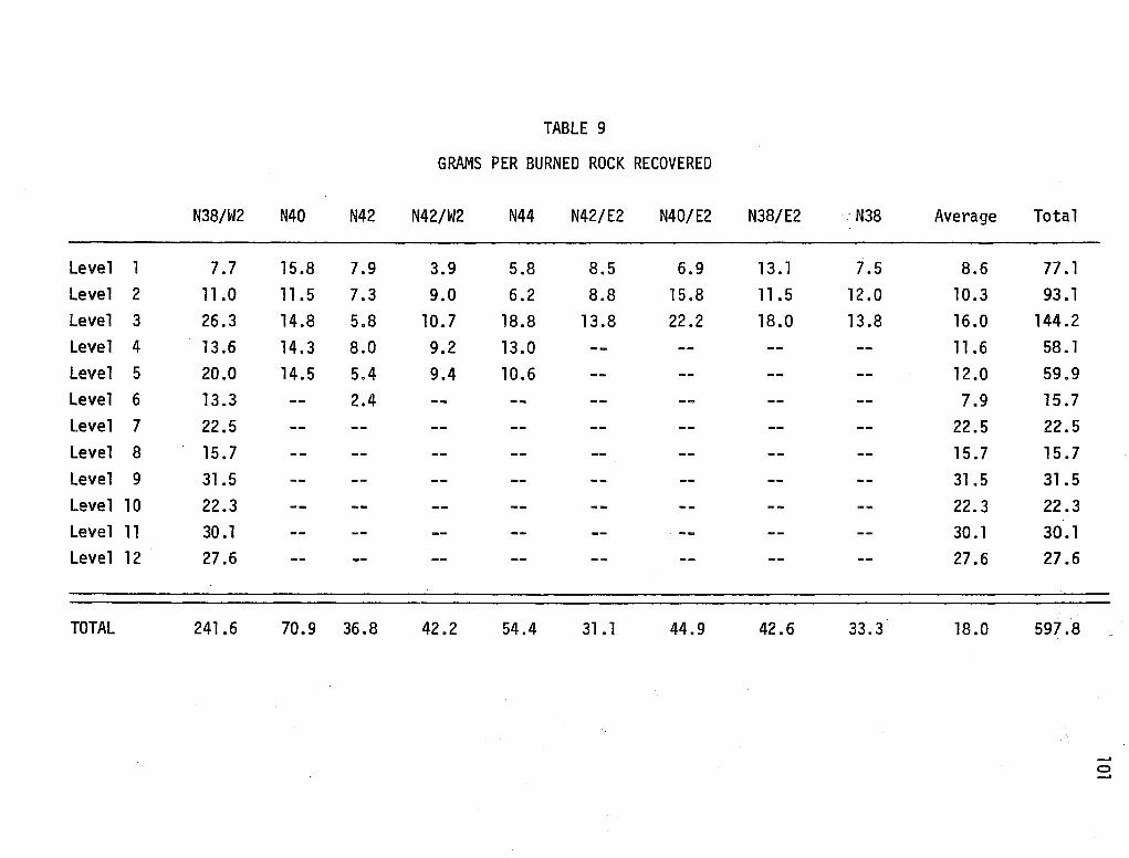
TABLE 9
GRAMS PER BURNED ROCK RECOVERED
N38/W2 N40 N42 N42/W2 N44 N42/E2 N40/E2 N38/E2 N38 Average Total
Level 1 7.7 15.8 7.9 3.9 5.8 8.5 6.9 13. l 7.5 8.6 77. 1 Level 2 11.0 11.5 7.3 9.0 6.2 8.8 15 .8 11.5 12.0 10.3 93 .1
Level 3 26.3 14.8 5.8 10. 7 18.8 13 .8 22.2 18.0 13 .8 16.0 144.2 Level 4 13.6 14.3 8.0 9.2 13.0 -- -- -- -- 11.6 58. l Level 5 20.0 14.5 5.4 9.4 10.6 -- -- -- -- 12 .0 59.9 Level 6 13.3 -- 2.4 -- -- -- -- -- -- 7.9 15. 7 Level 7 22.5 -- -- -- -- -- -- -- -- 22.5 22.5 Level 8 15.7 -- -- -- -- -- -- -- -- 15.7 15.7 Level 9 31.5 -- -- -- -- -- -- -- -- 31.5 31.5 Level 10 22.3 -- -- -- -- -- -- -- -- 22.3 22.3 Level 11 30 .1 -- -- -- -- -- -- -- -- 30. l 30. l Level 12 27.6 -- -- -- -- -- -- -- -- 27.6 27.6
TOTAL 241.6 70.9 36.8 42.2 54.4 31. l 44.9 42.6 33.3 18.0 597.8
__, 0 __,
102
Non-Lithic Material
Faunal Remains
Almost all levels and units excavated at Mariposa contained bone materials. The vast majority of these were unidentifiable fragments. Levels one and two retained the lowest amount of bone, while higher numbers were recovered in the remaining levels, especially level three. Faunal remains are conspicuously absent from the first three levels of N40, N42/W2 and N40/E2.
Identifiable remains are limited to a calcaneus first and second phalange of the white-tailed deer (OdocoiZeus virginianus). Four second phalanges and a third phalange (claw) attributed to a medium size mammal (coyote?) were all excavated from level five of N40, in the northwest quadrant. A possible human lower lateral incision was also recorded from this provenience.
Identification of the faunal remains was aided by Gilbert (1973) and Bass (1971). Further statements concerning the bone remains at Mariposa are hindered by a general lack of identifiable material, although several bone fragments were burned to charred.
Invertebrate Remains
Remains of both freshwater and land gastropods, along with freshwater mussels, were recovered from excavation at Mariposa. Land gastropods from the site include Rabdotus sp. and PoZygyra sp. HeZisoma sp. were the freshwater gastropods recovered from archaeological contexts at Mariposa, and Unio sp. represent the freshwater mussels present at the site. Statements concerning areal environments and possible aboriginal subsistence preferences are usually applied to the invertebrate fauna associated with archaeological sites (Suhm 1957; Clark 1973; Allen and Cheatum 1961; Hester 1975d; Hester and Hill 1975a, 1975b), although other applications have been suggested (cf. Allen and Cheatum 1961).
Preferred habitats of the land gastropods recovered from Mariposa reflect present environmental conditions. Rabdotus sp. gastropods are at home in semi-arid climates where brush exists and PoZygyra sp. gastropods are commonly found in either sparsely wooded areas or deep woodlands (Allen and Cheatum 1961:294-295). Permanent streams with vegetation, whose flow may be sluggish to rapid, are the preferred habitat of HeZisoma sp. All these conditions--semi-arid climate, brush, wood-lined creeks with pennanent water--occur today at Mariposa, and the presence of these gastropods in archaeological contexts strongly suggests that the present environmental conditions at Mariposa have not radically changed since Late Prehistoric occupations at the site. In addition to environmental statements, possible subsistence patterns have been postulated by various investigators to account for the large amounts of recovered gastropod material (Suhm 1957; Hester 1975d; Hester and Hill 1975a, 1975b).
Of the 5,182 gastropod specimens recovered from Mariposa, 4,983 were identified as Rabdotus sp. Rabdotus sp. accounts for 96% of the collected gastropods. Considering the large number of Rabdotus sp. specimens present and the fact that
103
many of these were large adult specimens, it is highly probable that these gastropods represent a food item exploited by the Late Prehistoric occupants. Stnce practically none of the Rabdotus sp. shells were burned, extraction after boi'l ing may have occurred (Hester and Hi 11 1975a). Ethnographic accounts referring to gastropod exploitatton by Indian groups in southern Texas strengthen arguments that thes·e invertebrates were an aboriginal food item in the past.
Examination of Table 10 points to the fact that maximum deposition of Rabdotus sp. occurred in levels two and three of Mariposa. Similar conclusions can be reached when considering all gastropod remains excavated at the site (see Table 11). Level one of Mariposa contains the lowest number of recovered gastropods. Some loci of intense Rabdotus sp. utilization appear to center in excavation units N42, N40/E2 and N38 of levels two and three. In levels two and three, relatively small numbers of Rabdotus sp. specimens occur in N40 and N42/E2. Areas of Mariposa appear to have been differentially utilized with respect to the deposition of Rabdotus sp. The relatively small number of excavated PoZygyra sp. and HeZisoma sp. specimens does not allow safe inferences concerning their depositional characteristics. More information concerning possible spatial patterning of gastropods will be discussed in a later section. Recorded quantity and provenience of Rabdotus sp., PoZygyra sp., and HeZisoma sp. gastropods are given in Tables 10, 12, and 13 respectively. Combined totals and associated provenience are presented in Table 11.
Freshwater mussels of the Unio sp. variety were also recorded at Mariposa. These bivalves represent a food source readily accessible in Turkey Creek. Unio sp. may have been extracted for food or as ornamental items (Hester and Hill 1975b) by aboriginal populations. Only Unio sp. fragments, most of them quite small, were recovered from archaeological contexts. Table 14 illustrates Unio sp. fragment quantity and associated provenience at Mariposa.
Of the 338 excavated fragments, 70% (235) were situated in levels two and three. Large numbers of fragments, possibly representative of Unio processing loci, are seen at N38/E2 in level one. Level two, which contained the largest level count, contained four excavation units exhibiting over 20 recovered fragments: N38/W2, N42/E2, N32/E2 and N38. Counts of 20 or more fragments in level three occur in N42/E3 and N40/E2. In level four, N38/W2 represents a loci of possible Unio sp. utilization. No excavation unit illustrated high counts through all excavated levels; N42/E2 and N38/E2 tended to have high numbers of fragments in levels two and three. The fragments of Unio sp. indicate that loci of possible processing are randomly scattered, temporally, with no preferred location being utilized during the aboriginal occupation(s). However, in level two, the Unio sp. fragments occur in greatest quantity in four contiguous excavation units forming the southern margin of the 1974 excavation area. Further excavations must be awaited before assessing the significance of this pattern.
Features
Four hearths and one burned rock concentration were recorded during the 1974 excavation and the 1975 testing of Mariposa. The burned rock concentration
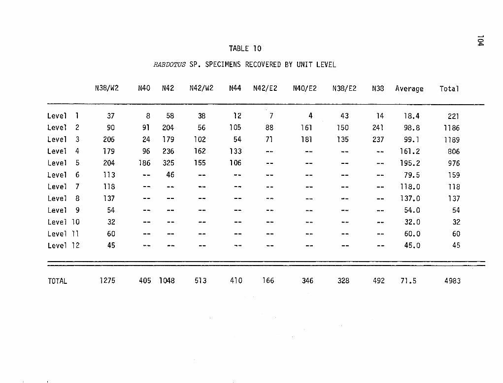
...... 0
TABLE 10 ~
RABDOTUS SP. SPECIMENS RECOVERED BY UNIT LEVEL
N38/W2 N40 N42 N42/W2 N44 N42/E2 N40/E2 N38/E2 N38 Average Total
Level 1 37 8 58 38 12 7 4 43 14 18.4 221 Level 2 90 91 204 56 105 88 161 150 241 98.8 1186 Level 3 206 24 179 102 54 71 181 135 237 99. 1 1189 Level 4 179 96 236 162 133 -- -- -- -- 161. 2 806 Level 5 204 186 325 155 106 -- -- -- -- 195.2 976 Level 6 113 -- 46 -- -- -- -- -- -- 79.5 159 Level 7 118 -- -- -- -- -- -- -- -- 118.0 118 Level 8 137 -- -- -- -- -- -- -- -- 137. 0 137 Level 9 54 -- -- -- -- -- -- -- -- 54.0 54 Level 10 32 -- -- -- -- -- -- -- -- 32.0 32 Level 11 60 -- -- -- -- -- -- -- -- 60.0 60 Level 12 45 -- -- -- -- -- -- -- -- 45.0 45
TOTAL 1275 405 1048 513 410 166 346 328 492 71.5 4983
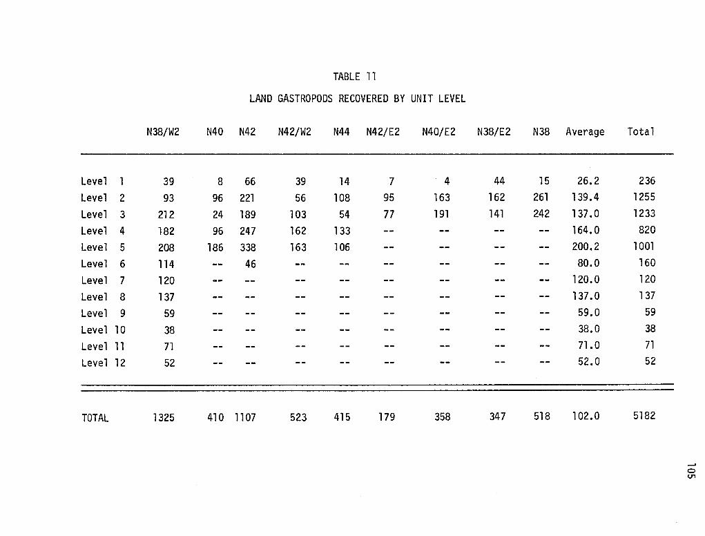
TABLE 11
LAND GASTROPODS RECOVERED BY UNIT LEVEL
N38/W2 N40 N42 N42/W2 N44 N42/E2 N40/E2
Level l 39 8 66 39 14 7 4 Level 2 93 96 221 56 108 95 163 Level 3 212 24 189 103 54 77 191 Level 4 182 96 247 162 133 -- --Level 5 208 186 338 163 106 -- --Level 6 114 -- 46 -- -- -- --Level 7 120 -- -- -- -- -- --Level 8 137 -- -- -- -- -- --Level 9 59 -- -- -- -- -- --Level 10 38 -- -- -- -- -- --Level 11 71 -- -- -- -- -- --Level 12 52 -- -- -- -- -- --
TOTAL 1325 410 1107 523 415 179 358
N38/E2 N38 Average
44 15 26.2 162 261 139.4 141 242 137. 0
-- -- 164.0
-- -- 200.2
-- -- 80.0
-- -- 120.0
-- -- 137 .o -- -- 59.0
-- -- 38.0
-- -- 71.0
-- -- 52.0
347 518 l 02.0
Total
236 1255 1233 820
l 001 160 120 137
59 38 71 52
5182
__, 0 (J"1
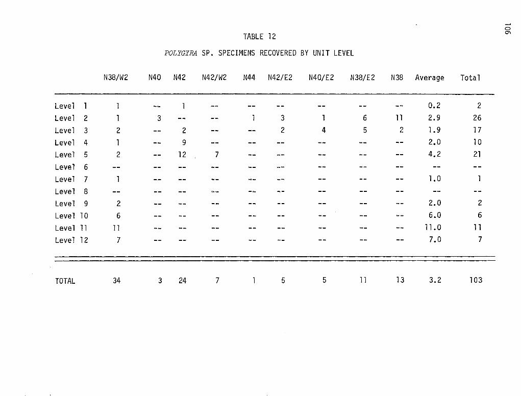
__, 0
TABLE 12 O"l
POLYGYRA SP. SPECIMENS RECOVERED BY UNIT LEVEL
N38/W2 N40 N42 N42/W2 N44 N42/E2 N40/E2 N38/E2 N38 Average Total
-Level l 1 -- 1 -- -- -- -- -- -- 0.2 2 Level 2 1 3 -- -- 1 3 1 6 11 2.9 26 Level 3 2 -- 2 -- -- 2 4 5 2 1.9 17 Level 4 1 -- 9 -- -- -- -- -- -- 2.0 10 Level 5 2 -- 12 7 -- -- -- -- -- 4.2 21
Level 6 Level 7 1 -- -- -- -- -- -- -- -- 1.0 1
Level 8 Level 9 2 -- -- -- -- -- -- -- -- 2.0 2
Level 10 6 -- -- -- -- -- -- -- -- 6.0 6
Level 11 11 -- -- -- -- -- -- -- -- 11.0 11
Level 12 7 -- -- -- -- -- -- -- -- 7.0 7
TOTAL 34 3 24 7 5 5 11 13 3.2 103
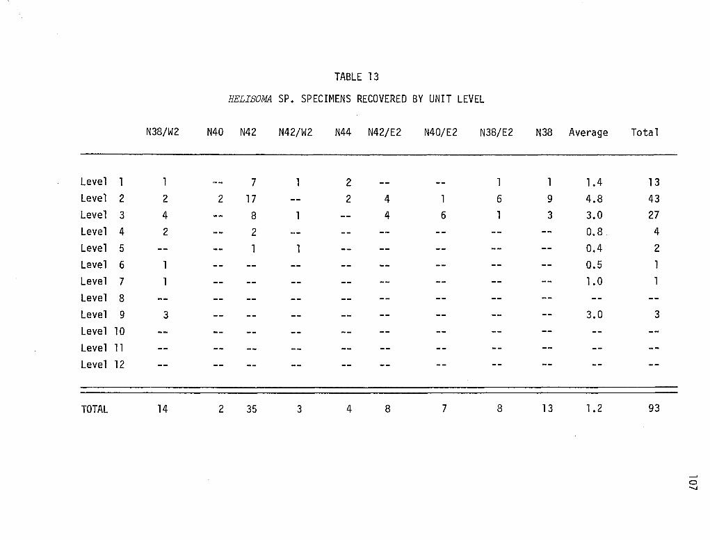
TABLE 13
HELISOMA SP. SPECIMENS RECOVERED BY UNIT LEVEL
N38/W2 N40 N42 N42/W2 N44 N42/E2 N40/E2 N38/E2
Level 1 l -- 7 l 2 -·- -- l Level 2 2 2 17 -- 2 4 l 6
Level 3 4 -- 8 l -- 4 6 1
Level 4 2 -- 2 -- -- -- -- --Level 5 -- -- l l -- -- -- --Level 6 1 -- -- -- -- -- -- --Level 7 l -- -- -- -- -- -- --Level 8 Level 9 3 -- -- -- -- -- -- --Level l 0 Level 11 Level 12
TOTAL 14 2 35 3 4 8 7 8
N38 Average
1 1.4 9 4.8 3 3.0
-- 0.8 -- 0.4 -- 0.5 -- l.O
-- 3.0
13 1 • 2
Total
13 43 27 4 2 l l
3
93
0 -.....!
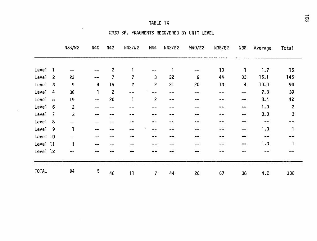
TABLE 14
UNIO SP. FRAGMENTS RECOVERED BY UNIT LEVEL
N38/W2 N40 N42 N42/W2 N44 N42/E2 N40/E2
Level 1 -- -- 2 l -- 1 --Level 2 23 -- 7 7 3 22 6 Level 3 9 4 15 2 2 21 20 Level 4 36 1 2 -- -- -- --Level 5 19 -- 20 1 2 -- --Level 6 2 -- -- -- -- -- --Level 7 3 -- -- -- -- -- --Level 8 Level 9 1 -- -- -- -- -- --Level 10 Level 11 1 -- -- -- -- -- --Level 12
TOTAL 94 5 46 11 7 44 26
N38/E2 N38 Average
10 1 1. 7 44 33 16. 1 13 4 1 o.o -- -- 7.8
-- -- 8.4
-- -- 1. 0
-- -- 3.0
-- -- 1.0
-- -- 1.0
67 38 4.2
Total
15 145
90 39
42 2 3
1
1
338
__, 0 O:>
was excavated from the first level (0-5 cm below the surface) of unit N42. Lying in the southeast quadrant of the excavati'on unit, this. small concentration of burned rock contained four snails associ'ated with a few flakes and a baked clay lump. No ass-ociated charcoal was recorded (see Montgomery, Moffat and Richie 1975).
109
Level two (5-10 cm below the. surface) contained two hearths in two excavation units. In N38/E2, a sma 11 ovate hearth with burned spa 11 fragments in situ was observed in the southwest quadrant of the unit (Plate 3). A more substantial hearth containing significant quantities of charcoal was recorded in the southwest quadrant of N42/E2, also in level two.
Test 4 in the 1974 investigations at Mariposa encountered a probable hearth situated 50.5 cm beneath the present ground surface. A charcoal sample was collected from this hearth, and a sketch map prepared. Three large hearth stones (burned) were situated in a roughly 25 x 35 cm concentration of charcoal. A Tortugas point (Plate 3) was recovered from the overlying level of Test 4.
In 1975, Test 5 at Mariposa revealed a large hearth 60 cm deep. Charcoal, burned rock, gastropod shells, flint flakes and nine incised burned rocks were obtained once the hearth was cleared. Information gathered from this hearth and test has been prepared (Montgomery, Moffat and Richie 1975).
The features recorded above are distinct locations of prehistoric hearth activity, which are separate from the scattered burned rocks found in every excavation unit at the site. While the scattered burned rocks recovered from Mariposa are indicators of past occupational activities, the features allow one to make more concrete statements concerning the nature of such activities. At Mariposa, the features recorded in the upper two levels of the site are small, tightly clustered hearth foci. Charcoal was recovered from one of these loci. An ovate outline is also seen in one of the hearths. In contrast, the two deepest features, assumed to be earlier (temporally) quite large concentrations of burned rock and charcoal, were recorded. Based on the significantly higher concentration of charcoal in one of these hearths and the higher density of burned rock seen in the second hearth, possible differences in function/usage of the features may be postulated.
The earlier features may represent hearths which were possibly maintained for long periods of time, while the smaller hearths from the upper levels may indicate overnight camps and/or hearths maintained only a few times (maybe only once). Without further information, the above proposition cannot be verified. This should, however, be tested at other south Texas sites.
111
VII. INTRASITE PATTERNS
Introduction
Careful field recording of artifacts, flint flakes, burned rocks, and faunal remains (snail shell concentrations, mussel shell concentrations, and faunal bone fragments) allows one to prepare horizontal 11 distribution 11 maps for each excavated level at Mariposa. Such maps, it was hoped, would generate significant cultural patterns as expressed by the depositional provenience of the archaeological specimens mentioned previously. During the 1974 field season, nine excavation units were opened to at least three levels. While several units were excavated much deeper, the upper three levels were chosen for analysis here. This was done to achieve the most reliable results, since patterns will probably be most evident in those levels containing the greatest amount of horizontally cleared spatial areas. It would not be logical to attempt analyses of artifact depositional patterns in a two-meter-square area as compared to a horizontal area encompassing 18 square meters.
The analysis attempted here must also rely on the recorded field data only. While a number of artifacts and faunal remains were recovered on the 1/4-inch screen during excavations (or retriev~d during the subsequent cataloging process). th~ir exact horizontal provenience ca~not be reconstructed, except to a 2 x 2 meter square, five centimeters deep. Those artifacts and faunal materials located in situ were recorded on grid paper in a field notebook for each unit and level. All unit maps within a level were connected into a larger grid map which utilized all excavation units. These maps formed the basis for the maps presented as Maps 5 through 16. In order to express the data most clearly, maps of four categories--artifacts, flakes, burned rock, and faunal material--were individually p~epared for each of the first three levels. Thus we have 12 maps to consider for analysis.
Visual interpretation of the distribution maps will be employed. Time did not permit more quantitative spatial analyses employing rigorous statistical tests of asssociation. Such analyses, which include nearest neighbor analysis, spatial analysis of variance, trend analysis, and others, should be employed in future and more specialized archaeological studies in the area (see Whallon 1973, 1974; Dacey 1973; Feder 1976). No attempt will be made to defenq the visual interpretation when compared to the other types of spatial analyses. Such being the case, conclusions reached from this analysis must remain tentative until other methods are used on this kind of data.
The following analysis will proceed by individual levels. Within each level, distribution maps of artifacts, flakes, burned rock, and faunal material will be described. An overall statement of the level will provide a brief summary and possible correlations in depositional characteristics between the four types of data.
Level One
(0-5 centimeters below the surface)
Artifacts (Map 5)
Of the 12 artifacts recorded in the field, most are scattered somewhat evenly over the nine excavation units. Two concentrations of artifacts were
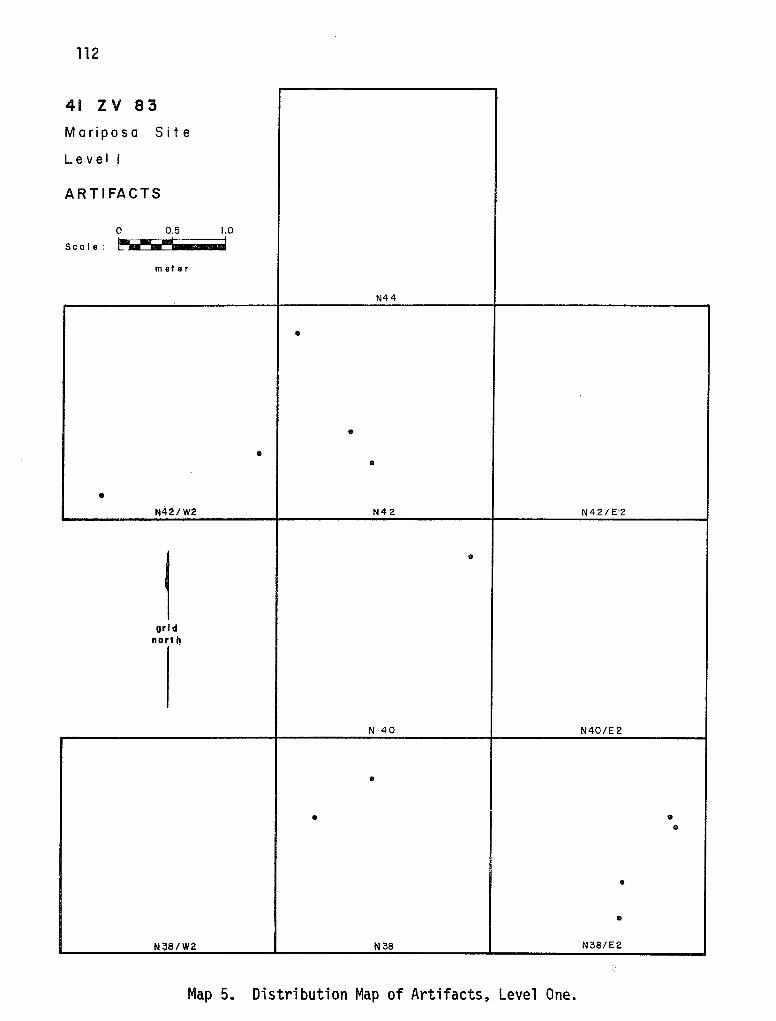
112
41 zv 83
Mariposa Site
Lev el I
ARTIFACTS
0 0.5 1.0
Sc a I e : l!"M-111 .... I
meter
N44
•
• • •
• N42/W2 N42 N42/E 2
~ •
grid north
N 40 N40/E 2
•
• • •
•
• N~8/W2 N38 N38/E2
Map 5. Distribution Map of Artifacts, Level One.
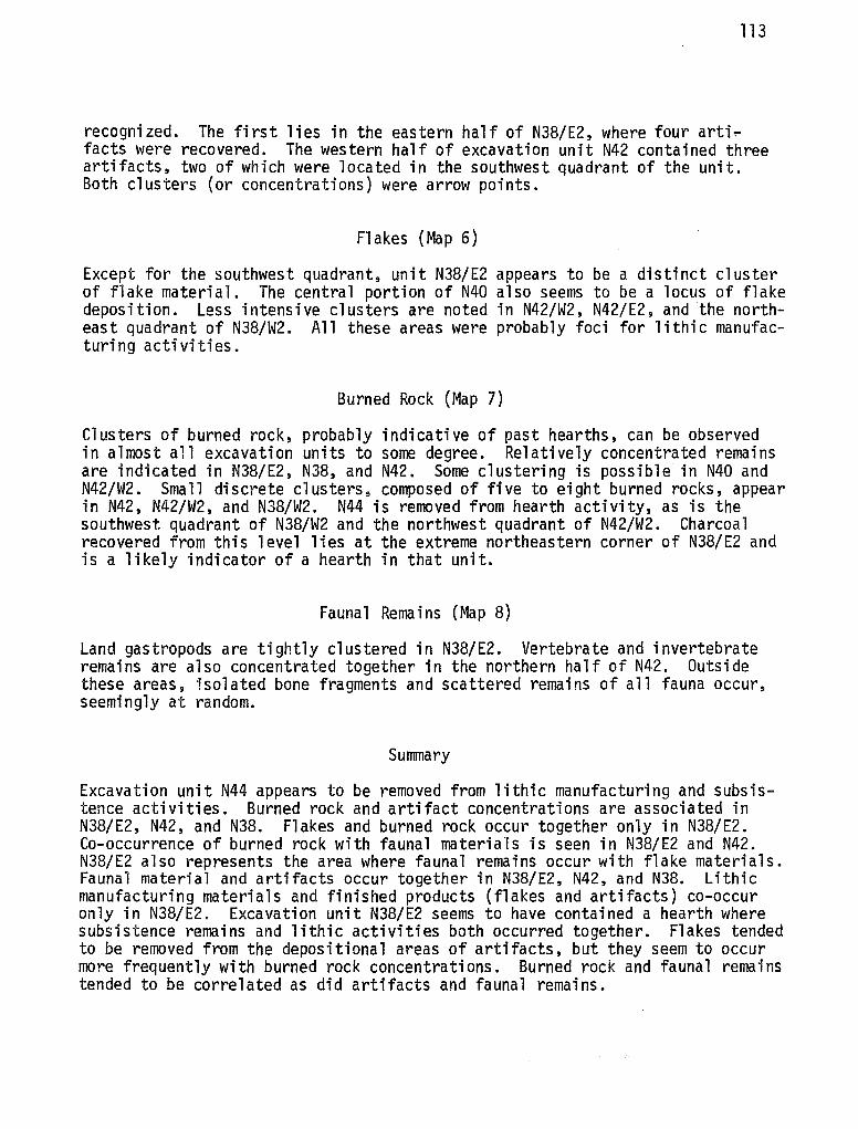
113
recognized. The first lies in the eastern half of N38/E2, where four arti~ facts were recovered. The western half of excavation unit N42 contained three artifacts, two of which were located in the southwest quadrant of the unit. Both clusters (or concentrations) were arrow points.
Flakes (Map 6)
Except for the southwest quadrant, unit N38/E2 appears to be a distinct cluster of flake material. The central portion of N40 also seems to be a locus of flake deposition. Less intensive clusters are noted in N42/W2, N42/E2, and the northeast quadrant of N38/W2. All these areas were probably foci for lithic manufacturing activities.
Burned Rock (Map 7)
Clusters of burned rock, probably indicative of past hearths, can be observed in almost all excavation units to some degree. Relatively concentrated remains are indicated in N38/E2, N38, and N42. Some clustering is possible in N40 and N42/W2. Small discrete clusters, composed of five to eight burned rocks, appear in N42, N42/W2, and N38/W2. N44 is removed from hearth activity, as is the southwest quadrant of N38/W2 and the northwest quadrant of N42/W2. Charcoal recovered from this level lies at the extreme northeastern corner of N38/E2 and is a likely indicator of a hearth in that unit.
Faunal Remains (Map 8)
Land gastropods are tightly clustered in N38/E2. Vertebrate and invertebrate remains are also concentrated together in the northern half of N42. Outside these areas, isolated bone fragments and scattered remains of all fauna occur, seemingly at random.
Summary
Excavation unit N44 appears to be removed from lithic manufacturing and subsistence activities. Burned rock and artifact concentrations are associated in N38/E2, N42, and N38. Flakes and burned rock occur together only in N38/E2. Co-occurrence of burned rock with faunal materials is seen in N38/E2 and N42. N38/E2 also represents the area where faunal remains occur with flake materials. Faunal material and artifacts occur together in N38/E2, N42, and N38. Lithic manufacturing materials and finished products (flakes and artifacts) co-occur only in N38/E2. Excavation unit N38/E2 seems to have contained a hearth where subsistence remains and lithic activities both occurred together. Flakes tended to be removed from the depositional areas of artifacts, but they seem to occur more frequently with burned rock concentrations. Burned rock and faunal remains tended to be correlated as did artifacts and faunal remains.
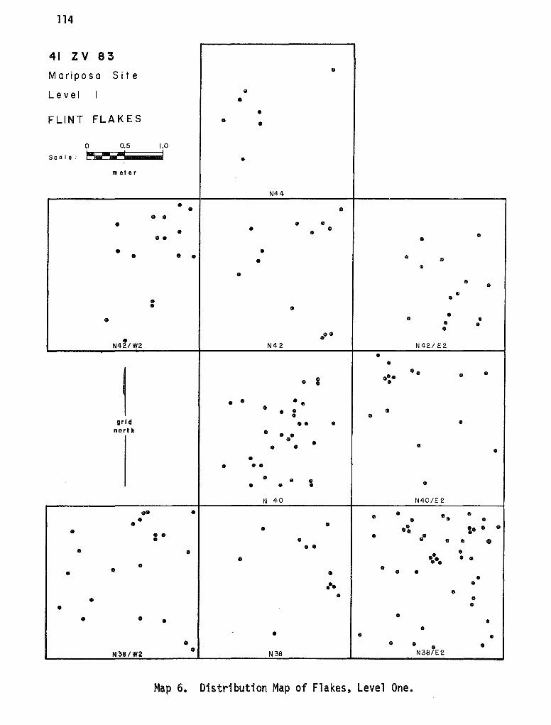
114
41 zv 83
Mariposa Site •
Lev el I • •
• FLINT FLAKES • •
0 0.5 1.0
Sc a I e : ~--I
• meter
N44
• • • • • • • • • • • • •• • •
• • • • • • • • • • • • • • • • •
• • • • • • • • •• •
N421'.V2 N42 N42/E2
• •
1
••• •• • • • I •
• • •• • • • • • • grid •• • • north • • •• • • • • • • • ••
• • • • • • • N 40 N40/E2
•• • • • • • • •• • • • •4:. • • • i· • • • • • • • • • • • • •• • • • •• • • • • •• • • • • • • •
••• • • • • • • •
• • • • • • • • • • • • • • • N38/W2 N38 N38/E2
Map 6. Distribution Map of Flakes, Level One.
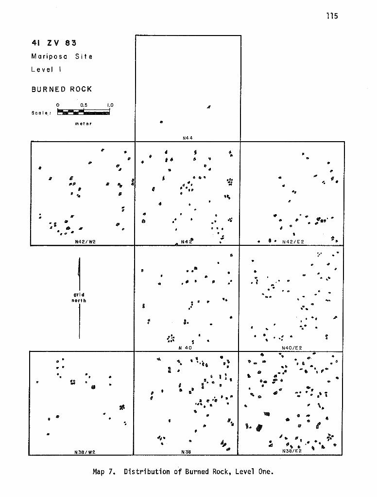
115
41 zv 83
Mariposa Site
Lev el I
BURNED ROCK
0 0.5 1.0
" Sc a I e. 1 ~---I
meter .. N44
q • 4 • ,. • -. Ill
Ill . " ,. " .. ,. • ..
q "' ,,
I 111 " ,. II I " 6 • II .. ,.. •. ,, •••
""• ... ... 11111 " "'
.. •• .. , ' , .. ,
•• ,, ~ IP • .. \ .. • II
• "' • ,,
• /If 41 • • "'
. .. .,. fl. ... • • • ·~ • ,,
Iii • •• .. .. ~i " • • - "' II • • • • ,,
II
" • . " • "' ... N4,
..,, • • ". N42/W2 . • • N 42/ E 2
:·· . II .
1 • • • .,,
' • • • • • • ,. ' ,. . ... .. . ....
• d • Ill • ' . • .. " • I ... • • . . • grid .. ... • .... .
north • •• .. ..... • IP
: • .. .. .. .. .. Ill . .. ' ,,,.
41 Ill ' • ... .. • • .. . .. ... .. .. ~. a • Ill I .. IP
' • .. • ••• ~ ..
N 40 N40/E 2
• ... • ' ~ . II 't • • • • .... .. .~ . .. ... • • • • ••• • a .. . • • .... .. .. .. Ill • . ,, .. .. • . .• • II
t I ' ~ • • • " A I .. ,, u • . · ... •• :-. .. 1111
0 I • • Ill •" • • ~- :'• II • ... ' . .... ..
I . ,. Ill a • • II ' • . . ,, - '"'& • • .. ,, '· • .. ' -• ,,. • I/II
• • • '· • 4 . 111
I . ,, .. i .. , ,, , .. ~ .. "'• .,,. ,, . ~· • ,, • . " ., ' tiJ/J -..
.. .. '
.. N38/W2 N38 "" N38/E2
Map 7. Distribution of Burned Rock, Level One.
116
41 zv 83
Mariposa Site •
Lev el I • • • LEGEND
FAUNAL REMAINS • BONE • • A MUSSEL SHELL
0 0.5 1.0 • SNAIL SHELL ~ ... J • Sc a I e :
meter • • • e N44
A • • •• • • • • • 0 • • A
.. A
• .. . • •
• " •
• • • • N42/W2 8 N42 • N42/E2
1 •
• grl d
north
le • • •
N 40 N40/E 2
• •
0 • • • • • • •• • A
• N 38/W2
/ N38 • N 38/ E 2
Map 8. Distribution Map of Faunal Remains, Level One.
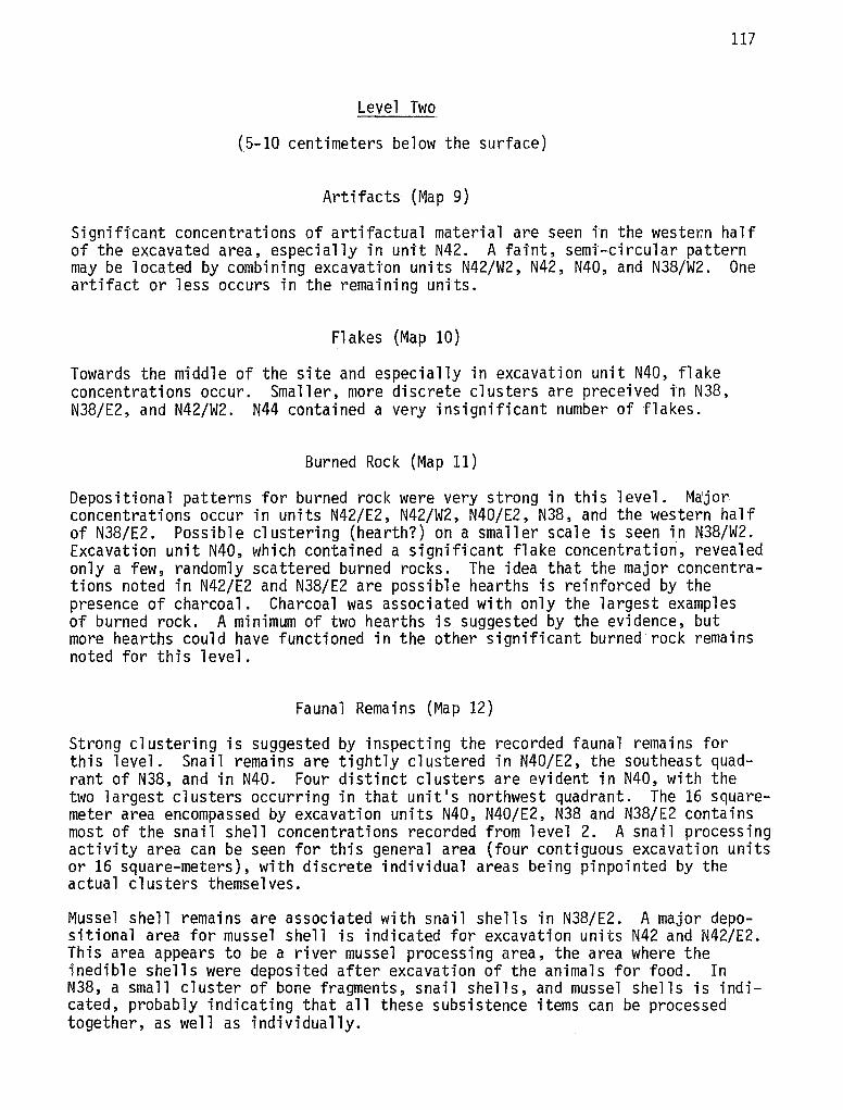
117
Level Two
(5-10 centimeters below the surface)
Artifacts (Map 9)
Significant concentrations of artifactual material are seen in the weste~n half of the excavated area, especially in unit N42. A fai'nt, semi-circular pattern may be located by combining excavati'on units N42/W2, N42, N40, and N38/W2. One artifact or less occurs in the remaining units.
Flakes (Map 10)
Towards the middle of the site and especially in excavation unit N40, flake concentrations occur. Smaller, more discrete clusters are preceived in N38, N38/E2, and N42/W2. N44 contained a very insignificant number of flakes.
Burned Rock (Map 11)
Depositional patterns for burned rock were very strong in this level. Ma'jor concentrations occur in units N42/E2, N42/W2, N40/E2, N38, and the western half of N38/E2. Possible clustering (hearth?) on a smaller scale is seen in N38/W2. Excavation unit N40, which contained a significant flake concentratiori, revealed only a few, randomly scattered burned rocks. The idea that the major concentrations noted in N42/E2 and N38/E2 are possible hearths is reinforced by the presence of charcoal. Charcoal was associated with only the largest examples of burned rock. A minimum of two hearths is suggested by the evidence, but more hearths could have functioned in the other significant burned rock remains noted for this level.
Faunal Remains (Map 12)
Strong clustering is suggested by inspecting the recorded faunal remains for this level. Snail remains are tightly clustered in N40/E2, the southeast quadrant of N38, and in N40. Four distinct clusters are evident in N40, with the two largest clusters occurring in that unit's northwest quadrant. The 16 squaremeter area encompassed by excavation units N40, N40/E2, N38 and N38/E2 contains most of the snail shell concentrations recorded from level 2. A snail processing activity area can be seen for this general area (four contiguous excavation units or 16 square-meters), with discrete individual areas being pinpointed by the actual clusters themselves.
Mussel shell remains are associated with snail shells in N38/E2. A major depositional area for mussel shell is indicated for excavation units N42 and N42/E2. This area appears to be a river mussel processing area, the area where the inedible shells were deposited after excavation of the animals for food. In N38, a small cluster of bone fragments, snail shells, and mussel shells is indicated, probably indicating that all these subsistence items can be processed together, as well as individually.
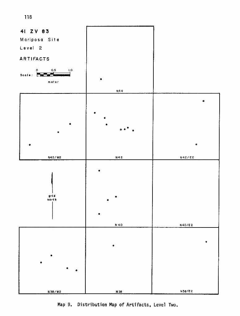
118
41 zv 83
Mariposa Site
Lev el 2
ARTI FAC.TS
0 0.5 1.0
Sc a I e : ~2""' I
• meter
N44
•
• •
• • II 0 o
• •
• •
N42/W2 N42 N42/E2
•
1 orl d • north •
• N 40 N40/E 2
• •
• •
• •
N38/W2 N38 N38/E2
Map 9. Distribution Map of Artifacts, Level Two.

119
41 zv 83 • Mariposa Site
• Lev el 2
FLINT FLAKES • ••
0 0.5 1.0
Sc a I e : ~? I • • meter •
N44
• • • .. • • • • • • • • •
• • • • • • • • • • •• • • •
' • • • • • •• •• • • :• • • ..
I • • • • • • • Ill • • • • • • • • • • • • • • • • \ • • • • • • N42/W2 N42 • N42/E2
• • • • • •
1
, , • • • • • • • ... • • • • .. • • • • • • • ..
•• •• • • • • • .. grid • • • north • • .. • •• • • • Ill • • Ill • • • • • • • • • • • •
• • • • • • • • .,
• • • N 40 • N40/E 2 A Ill
• • • • • • • • • • • • Ill • Ill Ill • • • • • •• • • • • • • • • • • • •••• • .. Ill • • • • Ill : . • • • • • • • ,. \ • •
• Ill • • •• • • • •• • •• • • • • • • •• • • • • •• • •
N381/2 • • •• • • N38 •• Ill N38/E2
Map 10. Distribution Map of Flakes, Level Two.
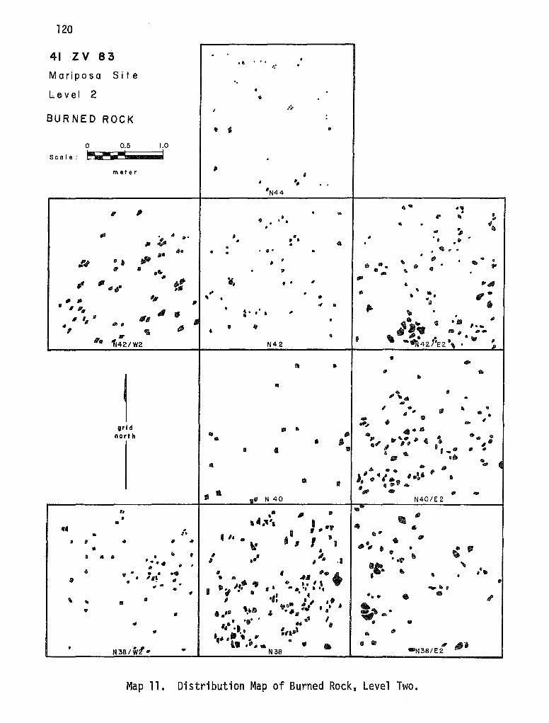
120
41 zv 83 . •• ... .
-: . Mariposa Site .. Le.vel 2 • •
, ..;.
BURNED ROCK :
• ' • 0 0.5 1.0
Sea I e: ~----- I . meter
, ' • ... . .
'N44
..... . .. "
, . .. • • • • fl' ill .. . . . .. . "• • ~ .,, ,,, l- • ... II • " . .
II • • • 41. . ' .• • ... . ... .. • • • • • . I*
,,. • -.f# fl • • ' . • .. • " . "· • .
"' ~ • .... . " • ... ' • . .. ~" ¥,
,,. ~ ".,,_. •• " " ,, "' ,.,,
' •• • .. ... ,, . ""
.. • • "' -,. •• • ,, 4 .. fl. • I 14' di • : . ' . ... . - a ,,. ,, '11 .
II 11 ' • i•.. .. •• " " "' , ~ • " I•,. , 418 • •t• .. , ,,..,. ,, " • 11111' ,,.
~42/W2 • ' -~\2i°l-E2\ , N42 . JI>
• • .. • " •
l ..
II
""· • .. ""' , • ,, .. Ill "' ., • • - • • , ... , -grl d 1111 .. .. ..
north Ill - • \ . .. ... • • ' "' llr ,. ~ 4.
"t/I II I IP •"I II• . ' .. • .. .,
• IB 1111. •• Ill • " . ... 4 . ... . , J' .. , ,. •• • • II ' " ., . • 41 .....
• ,,, . lliJ ... • 1111' N 40 N40/E 2 ,, .• If .. -
JI Ill II ...... ,, , ... , -• .. •• .. ' .. ~· ' ,, •'1 I ...
"' .. • I • • II • II
\- I .. ., • • • •
' " .. ill • • • • • •• .. t # ... .1 .. ' ~ , •• •t- . ·~
" II , "' " ,•.,. • • • • • •• II If
411 "'• • .. • '•~ 9 • • • IP • ti
Iii. J•f> "' 4' h It • ., - . II I -·· • -...... • • .., . ., .. : • 4.
"• " • .. ' • ' )/ . .. ' " ... II , .. ta•• ' . • "' . ,,•• "
. .,. . .. • ';ti' • Ill II II ... .- . ..,. - ... I ,, Ill ,,. ·• • ,, ,, .. ~ta•l • I>
• ,. # t .... . • ., ll .-,, • " • , ,. .. • N38/Wl .. .. N38 •N38/E2
Map 11. Distribution Map of Burned Rock, Level Two.
121 41 zv 83
Mariposa Site
Level 2 LEGEND
r:ALJNAL REMAINS • BONE
.A MUSSEL SHELL
0 0.5 1.0
~--I • SNAIL SHELL
Sc a I e : - • meter •
N44 .. • • .A
• A
• .A • • A • • • • • • A A
.A .A • A A
A • A
" A
• • • N42/W2 N42 • N42/ E2
• • • ,. • •
~ • ... ,,
• • • •• . -:.\•
• -r:·· grl d
north I
41\ • A •••
< .. • •
N840 N40/E2
A
• • • • • A • A • •• .. • A
• •
• . .. A
• • .. • .. .A
• ·' • N38/W2A N38 N38,.E2
Map 12. Distribution Map of Faunal Remains, Level Two.
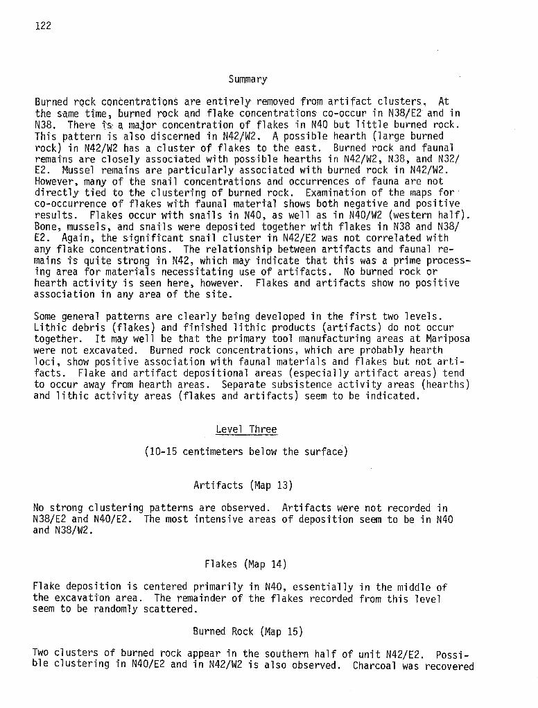
122
Summary
Burned rock concentrattons are entirely removed from artifact clusters, At the s-ame ti.'me 2 burned rock and flake concentrati'ons co-occur in N38/E2 and in N38, There ts a major concentration of flakes in N40 but little burned rock. This pattern is also discerned in N42/W2. A possible hearth (large burned rock} in N42/W2 has a cluster of flakes to the east. Burned rock and faunal remains are closely associated with possible hearths in N42/W2, N38, and N32/ E2. Mussel remains are particularly associated with burned rock in N42/W2. However, many of the snail concentrations and occurrences of fauna are not directly tied to the clustering of burned rock. Examination of the maps for co-occurrence of flakes with faunal matertal shows both negative and positive results. Plakes occur wtth snails in N40, as well as in N40/W2 (western half). Bone, mussels, and snails were deposited together with flakes in N38 and N38/ E2. Again, the significant snail cluster in N42/E2 was not correlated with any flake concentrations. The relationship between artifacts and faunal remains is quite strong in N42, which may indicate that this was a prime process; ng area for mateda ls necessitati'ng use of artifacts. No burned rock or hearth activity is s~en here, however. Flakes and artifacts show no positive association in any area of the site.
Some general patterns are clearly being developed in the first two levels. Lithic debris (flakes) and finished lithic products (artifacts) do not occur together. It may well be that the primary tool manufacturing areas at Mariposa were not excavated. Burned rock concentrations, which are probably hearth loci, show positive association with faunal materials and flakes but not artifacts. Flake and artifact depositional areas (especially artifact areas) tend to occur away from hearth areas. Separate subsistence activity areas (hearths) and lithic activity areas (flakes and artifacts) seem to be indicated.
Level Three
(10-15 centimeters below the surface)
Artifacts (Map 13)
No strong clustering patterns are observed. Artifacts were not recorded in N38/E2 and N40/E2. The most intensive areas of deposition seem to be in N40 and N38/W2.
Flakes (Map 14)
Flake deposition is centered primarily in N40, essentially in the middle of the excavati'on area. The remainder of the flakes recorded from this level seem to be randomly scattered.
Burned Rock (Map 15)
Two clusters of burned rock appear in the southern half of unit N42/E2. Possible clustering in N40/E2 and in N42/W2 is also observed. Charcoal was recovered
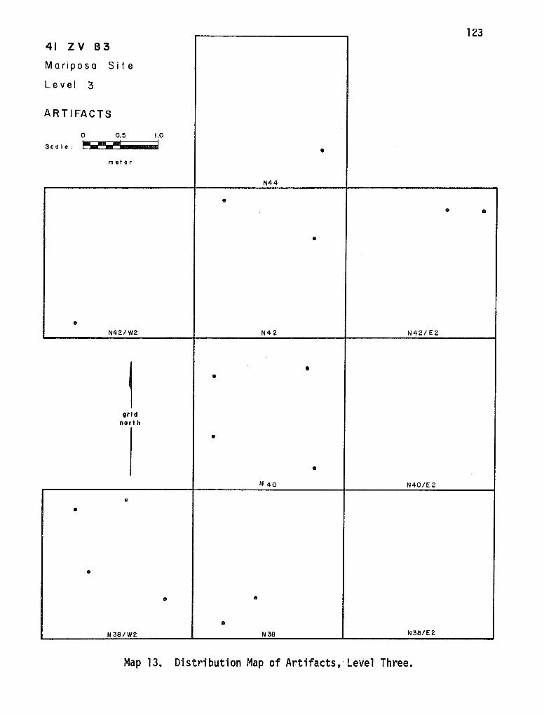
123 41 zv 83
Mariposa Site
Lev el 3
ARTIFACTS
0 0.5 1.0
Sc a I e : ~- ~ I - - • meter
N44
• • •
•
• N42/W2 N42 N42/ E2
1
• •
grid nart h
•
• N 40 N40/E 2
• •
•
• •
• N38/W2 N38 N38/E2
Map 13. Distribution Map of Artifacts, Level Three.
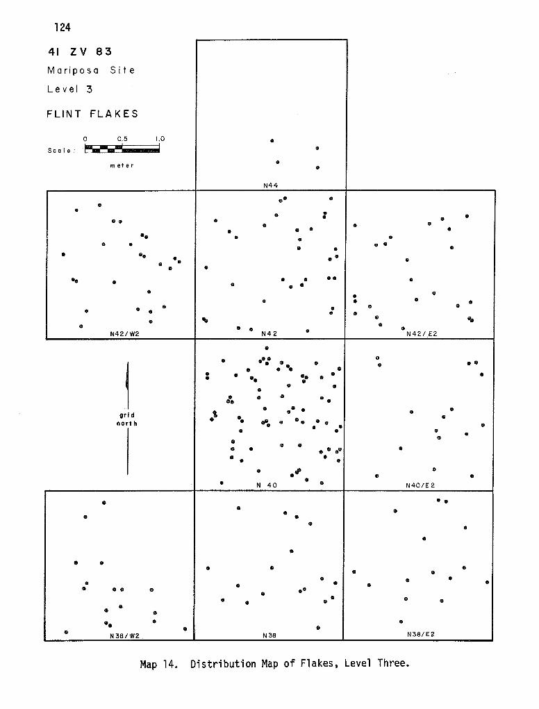
124
41 zv 83
Mariposa Site
Lev el 3
FLINT FLAKES
0 0.5 1.0 • Sc a I e : ·~ - ..... I • ....
meter • • N44
•• • • • • • •• • • • •
• • • • • • Ill
•• • • • • • • • • • • • •• • • • •• • • •
•• • • • • • • • • • • • • • • • • • • • • • • • • •
• "' • ' • • • • • • N42/W2 N42 N42/.E2
• • ... •
1
• •• •• • • •• • • • • •• • • • •• • • • • • • • • •• •• • • • grl d ·' • • • •• • north ... • •• • • • • • • • • •
• • • .. .. .. •••• ..
• • • • • ·"' • • • • • • N 40 N40/E 2
• •• • • • • • • • •
• • • • • • • •
• • • • • • • • • • • • •• • • • • • • • • • • •• • •
• • • N38/W2 N3B N38/E2
Map 14. Distribution Map of Flakes, Level Three.
41 z v 8 3
Mariposa Site
Level 3
BURNED ROCK
0 0.5
Sea I e: ~J""'
meter
...
grid north
"' . ,, •
1.0 I
fl
ill
"' • .. •• .... ,.
fl • 11111
"'
..
• Ill
,,
• •
"' •, I 11 a ,,
' "' di • • N 3~/W2
II
"
II
•
, '
II
" I
•
Glllll N44
• 6 • 'II
'
•• •
• • •
ti
' •
' N42
•
'
,,
8 N 40
,,
I
. . "' ... ..
•
II ,
• .. • ..
fl
• II • ,,
•• •
• • '
• • I
.... •
•' . • • •• ••
' .. • •• • . ".
• Ill • Ill
•• ' : •
'II " . . ' II
I
•
1
'Ill .. ,.
• '
. ..
•
.. . .... -.. • . ' ... "' ~ .. 'It IH2/ E2
-: .. "'" • •• • . . .
II
. ' •
• , • I
•
,,
"
,,. ., . ..
, . • • "' ··
"' ... .,, .. "
- "' 1~4C/E 2
.. , • ..
... N 38/ E 2
Map 15. Distribution Map of Burned Rock, Level Three.
125
•
"
" . .. .,.
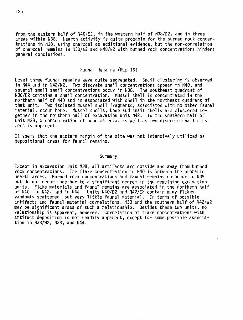
126
from the eastern half of N40/E2, in the western half of N38/E2, and in three areas within N38. Hearth activity is quite probable for the burned rock concentrations in N38, ustng charcoal as additional evidence, but the non~correlation of charcoal remains in N38/E2 and N40/E2 with burned rock concentrations hinders general conclusions.
Faunal Remains (Map 16)
Level three faunal remains were quite segregated. Snail clustertng is observed in N44 and in N42/W2. Two discrete snail concentrations appear in N40, and several small snail concentrations occur in N38. The southeast quadrant of N38/E2 contains a snail concentration. Mussel shell is concentrated in the northern half of N40 and is associated with shell in the northeast quadrant of that unit. Two isolated mussel shell fragments, associated with no other faunal material, occur here. Mussel shells, bone and snail shells are clustered together in the northern half of excavation unit N42. In the southern half of unit N38, a concentration of bone material as well as two discrete snail clusters is apparent.
It seems that the eastern margin of the site was not intensively utilized as depositional areas for faunal remains.
Summary
Except in excavation unit N38, all artifacts are outside and away from burned rock concentrations. The flake concentration in N40 is between the probable hearth areas. Burned rock concentrations and faunal remains co-occur in N38 but do not occur together to a significant degree in the remaining excavation units. Flake materials and faunal remains are associated in the northern half of N40, in N42, and in N44. Units N40/E2 and N42/E2 contain many flakes, randomly scattered, but very little faunal material. In terms of possible artifacts and faunal material correlations, N38 and the southern half of N42/W2 may be significant areas of such a relationship. Besides these two units, no relationship is apparent, however. Correlation of flake concentrations with artifact deposition is not readily apparent, except for some possible association in N38/W2, N38, and N44.
127 41 zv 83
Mariposa Site LEGEND
Lev el 3 • BONE
FAUNAL REMAINS A MUSSEL SHELL
• • • • SNAIL SHELL
0 0.5 1.0 • "' Sc a I e : ~? I
•• • • • • meter •
• N44
• .. • • A A
A A
•• • Ae
• • ' • .. •• •"' • ..
N42/W2 • N42 A • N42/ E2
\ N • A •
I A ..
• • •
• grid
north •• •I
• A
• N 40 • N40/E 2
\I .. .. • • .. ..
• A ..
A .. • • A •• •
N38/W2 N38 • I\ N38/E2
Map 16. Distribution Map of Faunal Remains, Level Three.
129
VIII. LITHIC TECHNOLOGY
The accepted durability of lithic artifacts has generated a world-wide interest regarding the analysis of making prehistoric stone tools--lithic technology. In a general sense, the subject of lithic technology encompasses the methods and processes involved in producing stone tools. When the manufacture or function of an artifact is not known, experimental replication may be employed to elucidate these problems (cf. Ascher 1961; Coles 1968; Hester, Heizer and Graham 1975:228-232; Wilmsen 1970, 1974). Other avenues of investigation are possible: a spectrum of investigations, ranging from the physical processes within the lithic material (cf. Speth 1974) to the recognition of individual chipping styles (Gunn 1975). Swanson (1975) has compiled recent views concerning the relationships between lithic technology and taxonolTlY, experimental lithic analyses, and the use of lithic technology in archaeological situations.
A brief review of the extensive literature concerning the topic of lithic technology indicates another avenue of interest, the lithic manufacturing process. Introduction of a diachronic view can illustrate the changes in tool types and manufacture, as shown by Bordes (1968). Classification of the products and byproducts introduced into the archaeological record by making lithic artifacts can be retraced as steps in the manufacturing process. This special area of investigation is, perhaps, the most directly useful for this thesis, since Hester (1975b) has already presented a testable model of lithic reduction for the study area.
Analysis of the stone tools and their manufacturing by-products is a way to infer cultural activities which produced them (Collins 1975). The manufacturing process has been described as an 11etic 11 or generalized model composed of five steps:
(1) acquisition of raw materials, (2) core preparation and initial reduction, (3) optional primary trimming, (4) optional secondary trimming and shaping, and (5) optional maintenance modification (Collins.1975:17).
Hester (1975b) has incorporated portions of this etic model for describing the activity processes ( 11 fabrication phases 11
) involved in producing chipped stone industries on the Rio Grande Plain of Texas. Archaeological contexts here indicate that three 11 phases 11 of Collins' etic model can be recognized (Hester 1975b:214). Phase I, defined as the 11 procurement of raw (lithic) materials, 11
(Hester 1975b:214) is identical to Collins' Step 1 (above). Since suitable lithic resources for flintknapping are found only in terrace outcrops overlooking major stream channels of the Rio Grande Plain, terrace sites functioned as Phase I activity areas (Hester 1975b). These terrace sites are located away from the primary occupational sites of the area, which rest 11 on the floodplains, particularly on natural levees paralleling stream channels'' (Hester 1975b:214). Terrace sites are uniquely situated with respect to chipped stone resources, so that only Phase I and the subsequent Phase II lithic activities occur here.
Phase II activities are concentrated to produce the "initial working and shaping of the raw material (using hammerstone percussion techniques)" (Hester 1975b: 214), or core preparation and initial reduction (Collins• Step 2, above). Two
130
distinct avenues of activity can be followed during this stage. Terrace cobbles could have been prepared (reduced) as cores for future flake removal. Flakes produced by this activity are thought to be "used as blanks for tool manufacture" (Hester 1975b:214). This flake-tool sequence is contrasted by a core-tool sequence in which cores are reduced into "preforms" (roughly-shaped bifaces) to be further reduced and made into tools (Hester 1975b:214). Analyses of materials encountered at the two types of sites (terrace workshop and floodplain occupation) have indicated that flakes removed by the flake-tool sequence were made at the terrace locations while core preforms produced by the core-tool sequence were carried to floodplain occupation sites for further modification. Several varieties of cores have been identified from archaeological sites on the Rio Grande Plain (cf. Hester 1975b and core model presented earlier), and these cores are considered to be an integral part of Phase II activities. While a core-blade industry has been postulated for this area and nearby regions of Texas (Hester 1975b:417-418; Hester and Shafer 1975), no evidence of this lithic industry was recovered from the Mariposa site.
Shaping, trimming and completion of lithic tools are considered to be Phase III activities (Hester l975b:218). Phase III, as presented above, incorporated Collins' Steps 3, 4 and 5. These activities occur at floodplain occupation sites, "using flake blanks obtained from cores or preforms brought down from the terrace workshops" (Hester 1975b:218). Specific activities linked to this phase include bifacial thinning and final trimming (of both flake blanks and preforms) into completed tools (such as projectile points, knives, perforators, etc.). Flake blanks do not necessarily have to be bifacially thinned; unifacial chipping and trimming could produce scrapers, notches and gravers (Hester 1975b).
Lithic debris resulting from each phase is quite distinctive and reflects the different activities associated with Phases I, II and III. Hester (1975b:218) has commented on this fact:
The workshops (used in Phase I and II) are dominated by decortication flakes. Interior flakes, those removed from a shaped core, and thinning flakes are rare. At occupation sites (where Phase III took place), decortication flakes are almost entirely absent. Instead, there are much higher percentages of interior flakes, some of which are large and represent blanks for tool manufacture; others are quite small, probably representing core trimming activities. There are also numerous thinning flakes •.• Most are apparently the result of bi~ facial reduction.
Bifacial "overshot flakes" and unifacial retouch flakes also result from Phase III activities at occupation sites (Hester 1975b:218-219).
Analysis of lithic artifacts and debitage (cf. Chapter V) was oriented towards a technological description, allowing for a test of the Collins-Hester model. If the model as presented above is accurate, then the artifact assemblage at Mariposa should contain some distinctive items. Mariposa's physical location, on a floodplain and near a stream channel, indicates that it most likely functioned as an occupation site rather than a workshop site. This being so, according to the model., only Phase III activity by-products (and products) are
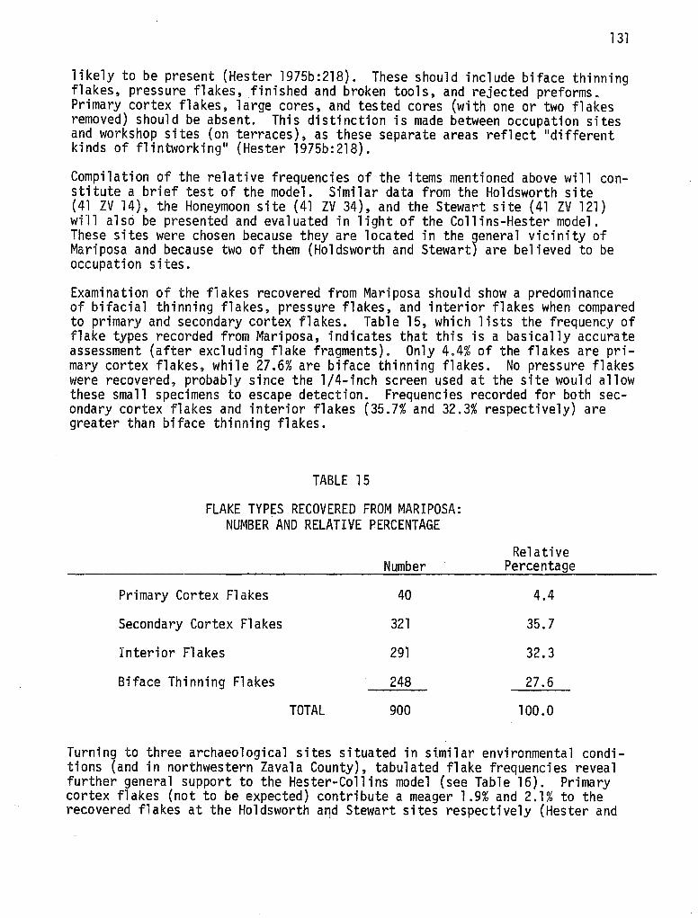
131
likely to be present (Hester 1975b:218). These should include biface thinning flakes, pressure flakes, finished and broken tools, and rejected preforms. Primary cortex flakes, large cores, and tested cores (with one or two flakes removed) should be absent. This distinction is made between occupation sites and workshop sites (on terraces), as these separate areas reflect 11 di fferent kinds of flintworking 11 (Hester 1975b:218).
Compilation of the relative frequencies of the items mentioned above will constitute a brief test of the model. Similar data from the Holdsworth site (41 ZV 14), the Honeymoon site (41 ZV 34), and the Stewart site (41 ZV 121) will also be presented and evaluated in light of the Collins-Hester model. These sites were chosen because they are located in the 9eneral vicinity of Mariposa and because two of them (Holdsworth and Stewart) are believed to be occupation sites.
Examination of the flakes recovered from Mariposa should show a predominance of bifacial thinning flakes, pressure flakes, and interior flakes when compared to primary and secondary cortex flakes. Table 15, which lists the frequency of flake types recorded from Mariposa, indicates that this is a basically accurate assessment (after excluding flake fragments). Only 4.4% of the flakes are primary cortex flakes, while 27.6% are biface thinning flakes. No pressure flakes were recovered, probably since the 1/4-inch screen used at the site would allow these small specimens to escape detection. Frequencies recorded for both secondary cortex flakes and interior flakes (35.7% and 32.3% respectively) are greater than biface thinning flakes.
TABLE 15
FLAKE TYPES RECOVERED FROM MARIPOSA: NUMBER AND RELATIVE PERCENTAGE
Primary Cortex Flakes
Secondary Cortex Flakes
Interior Flakes
Biface Thinning Flakes
TOTAL
Number
40
321
291
248
900
Relative Percentage
4.4
35.7
32.3
27.6
100.0
Turning to three archaeological sites situated in similar environmental conditions (and in northwestern Zavala County), tabulated flake frequencies reveal further general support to the Hester-Collins model (see Table 16). Primary cortex flakes (not to be expected) contribute a meager 1.9% and 2.1% to the recovered flakes at the Holdsworth and Stewart sites respectively (Hester and
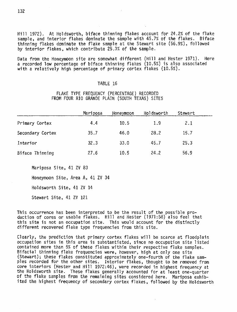
132
Hill 1972). At Holdsworth, biface thinning flakes account for 24.2% of the flake sample, and interior flakes dominate the sample with 45.7% of the flakes. Biface thinning flakes dominate the flake sample at the Stewart site (56.9%), followed by interior flakes, which contribute 25.3% of the sample.
Data from the Honeymoon site are somewhat different (Hi 11 and Hester 1971). Here a recorded low percentage of btface thinning flakes (10.5%) is also associated with a relatively high percentage of primary cortex flakes (10.5%).
TABLE 16
FLAKE TYPE FREQUENCY (PERCENTAGE) RECORDED FROM FOUR RIO GRANDE PLAIN (SOUTH TEXAS) SITES
Mariposa
Primary Cortex 4.4
Secondary Cortex 35.7
Interior 32.3
Biface Thinning 27.6
Mariposa Site, 41 ZV 83
Honeymoon Site) Area A, 41 ZV 34
Holdsworth Site, 41 ZV 14
Stewart Site, 41 ZV 121
Honeymoon Holdsworth
10.5 1.9
46.0 28.2
33.0 45.7
10.5 24.2
Stewart
2.1
15.7
25.3
56.9
This occurrence has been interpreted to be the result of the possible production of cores or usable flakes. Hill and Hester (1971:58) also feel that this site is not an occupation site. This would account for the distinctly different recovered flake type frequencies from this site.
Clearly, the prediction that primary cortex flakes will be scarce at floodplain occupation sites in this area is substantiated, since no occupation site listed contained more than 5% of these flakes within their respective flake samples. Bifacial thinning flake frequencies were, however, high at only one site (Stewart); these flakes constituted approximately one-fourth of the flake samples recorded for the other sites. Interior flakes, thought to be removed from core interiors (Hester and Hill 1972:46), were recorded in highest frequency at the Holdsworth site. These flakes generally accounted for at least one-quarter of the flake samples from the remaining sites considered here. Mariposa exhibited the highest frequency of secondary cortex flakes, followed by the Holdsworth
133
site. These flakes, which occur subsequent to the primary cortex flakes in a core reduction sequence (HestBr and Hill 1972:46), represent a reduction activity from Phase II (Hester 1975b). The high (35.7%) frequency of this flake type at Mariposa does not easily correspond to the Collins-Hester model.
Finished and broken tools, as well as rejected preforms, are also Phase III activity by-products and should be represented at floodplain occupation sites such as Mariposa (and Holdsworth and Stewart). At the same time, large cores and 11 tested 11 cores should contribute only a small part, if any, to the tool assemblage. If one computes the ratio of finished tools, broken tools, and preforms recovered at a site (i.e., all tool categories except cores) to large cores and tested cores, one can predict a large value if the model is accurate. Conversely, small ratio values would tend to make the model incorrect or at least insufficient in this area.
According to the stated model, only preforms and flake blanks destined to become either finished tools or broken (during manufacture or use) tools should be present at occupation sites. It is assumed that very few, if any, cores should be present at these sites; cores should instead be located at terrace sites close to the lithic resources of the region. For the purposes of this limited study, cores are thought not to occur at occupation sites for two reasons: (1) Quantification of 11 large 11 cores is not readily apparent--when is a core small? (2) Qther references used in this study do not distinguish between large and small cores, and therefore their results can be more easily compared to the results of this study. However, the author does wish to point out that core nuclei, or cores that are physically non-usable because all possible flakes from them have been removed, are likely to occur in limited numbers at occupation sites.
Table 17 summarizes the necessary information considered here. Data were drawn from the analysis of the lithic materials recovered at the Mariposa site, the Holdsworth and Stewart sites (Hester and Hill 1972), and the Oulline site (41 LS 3) (Hester, White and White 1969).
Two of the sites analyzed (Mariposa and Stewart) had relatively low ratio figures while the remaining two sites (Holdsworth and Oulline) had comparatively greater ratio values. This conflict casts some doubt on the validity of the Collins-Hester model. The fact that the ratio of tool frequency to core frequency is low at two sites indicates that core reduction activities (Phase II) are occurring at occupation sites. This is reinforced by the fact that secondar¥ cortex flake frequency is also relatively high at Mariposa (see Table 15}. Since three of the four sites examined here were either surface collected or tested (by test pits), the recovered data may be affected by sampling bias. It may well be that future excavation at these sites would record more cores and secondary cortex flakes in relation to the total lithic assemblage. In any case, it is clear that the excavated material from the Mariposa site indicates that Phase II activities can occur at occupation sites. Tested cores considered suitable for further reduction into tools or flakes may have been transported from terrace areas into the floodplain. At Mariposa Phase II by-products were recovered in sufficient quantity to suggest that this transportation of cores may have occurred.
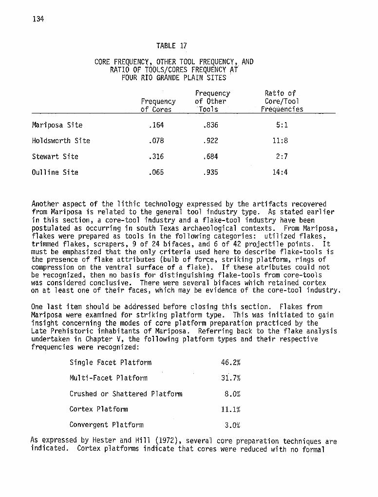
134
Mariposa Site
Holdsworth Site
Stewart Site
Oull i ne Site
TABLE 17
CORE FREQUENCY, OTHER TOOL FREQUENCY, AND RATIO OF TOOLS/CORES FREQUENCY AT
POUR RIO GRANDE PLAIN SITES .
Frequency Frequency of Other of Cores ·Tools
.164 .836
.078 .922
.316 .684
.065 .935
Rati:o of Core/Tool
Freguenti es
5:1
11:8
2:7
14:4
Another aspect of the lithic technology expressed by the artifacts recovered from Mariposa is related to the general tool industry type. As stated earlier in this section, a core-tool industry and a flake-tool industry have been postulated as occurring in south Texas archaeological contexts. From Mariposa, flakes were prepared as tools in the following categories: utilized flakes, trimmed flakes, scrapers, 9 of 24 bifaces, and 6 of 42 projectile points. It must be emphasized that the only criteria used here to describe flake-tools is the presence of flake attributes (bulb of force, striking platform, rings of compression on the ventral surface of a flake). If these atributes could not be recognized, then no basis for distinguishing flake-tools from core-tools was considered conclusive. There were several bifaces which retained cortex on at least one of their faces, which may be evidence of the core-tool industry.
One last item should be addressed before closing this section. Flakes from Mariposa were examined for striking platform type. This was initiated to gain insight concerning the modes of core platform preparation practiced by the Late Prehistoric inhabitants of Mariposa. Referring back to the flake analysis undertaken in Chapter V, the following platform types and their respective frequencies were recognized:
Single Facet Platform
Multi-Facet Platform
Crushed or Shattered Platform
Cortex Platform
Convergent Platform
46.2%
31.7%
8.0%
11.1%
3.0%
As expressed by Hester and Hill (1972), several core preparation techniques are indicated. Cortex platforms indicate that cores were reduced with no formal
135
preparation. Cores· undergoing preparation by removing one flake and using the new fracture surface for a striktng platform produce flakes with single facet platforms. These flakes. were the most· frequently occurring type and may suggest a preferred core reducti'on procedure. More extensive faceUng (flake removal} for preparing more core striki'ng platforms wtll result in flakes with multi-faceted platforms. A unique platform type caused by stri'king flakes on previous flake scar ridges (convergent planes; cf. Hester 1971) are convergent flake platforms. This flake platform type occurred least frequently in the Mariposa sample. Finally, crushed or shattered platforms, where only platform remnants are evident, also were observed. Ultimately, these flake platform types will be integrated into the core reduction sequence previously presented (see Chapter V). Time did not allow for such a detailed study to be presented here.
137
IX. INTERSITE COMPARISONS
Once materials from archaeological sites have been analyzed and interpretations prepared, comparisons with (temporally and culturally) related regional sites can qualify (and perhaps quantify) apparent similarities and differences. Evaluation of such results will often lead to a crystallization of ideas concerning such topics as settlement patterns, subsistence techniques, lithic assemblages, specialized environmental adaptations and lithic resource utilization. Only initial steps can be pursued in this direction for Late Prehistoric sites near Mariposa. This situation arises since so little published results are available from this region, and the majority of these have appeared only in the last six years or so.
Tested sites to be considered here include the Holdsworth (41 ZV 14) and Stewart (41 ZV 121) sites (Hester and Hill 1972), 41 ZV 152 (Hester et aZ. 1975), Tortuga Flat {Hill and Hester 1973), the Oulline site, 41 LS 3 (Hester, White and White 1969), and some of the sites surveyed and described by Hester and Hill {1975b:3-6). The unpublished results of major excavations at 41 ZV 10 (also on the Chaparrosa Ranch) will soon provide comparative information. Upper levels of this site contained evidence of Late Prehistoric occupation (T. R. Hester, personal communication).
At least 16 "major'' Late Prehistoric sites have been recorded from a limited study area of southern Texas (Hester and Hill 1975b:3-6). The Holdsworth, Tortuga Flat and Mariposa sites are included in this figure. Only the sites mentioned in the previous paragraph will be compared to Mariposa, since they contain the most detailed published information.
Some comparative statements concerning general site function and location have been already prepared. Hester and Hill (1975b:7) have ascertained that "all of the presently documented Late Prehistoric sites are occupation loci, generally with concentrated midden deposits 10 to 30 cm thick." These middens characteristically contain lithic debris, land gastropods (especially Rahdot;us sp.), river mussel shells (Unio sp.), other faunal materials, scattered burned rock (sandstone and chert), baked clay and charcoal (Hester and Hill 1975b; Hester 1975c). It is most often the case that these sites are situated adjacent to creek banks in riparian microenvironments (Hester and Hill 1975b:7; Hester 1975c).
When compared to other Late Prehistoric sites of the region, Mariposa exhibits some unique characteristics. The extensive faunal remains from test pits and feature excavations at most tested Late Prehistoric sites, particularly the "Bone Pile" at Tortuga Flat {41 ZV 155; Hill and Hester 1973), the 11 faunal species recognized at 41 ZV 152 (Hester et aZ. 1975), and the recovered bone from Holdsworth (Hester and Hill 1972) are conspicuously lacking at Mariposa. It appears likely that, at least for the areas excavated, land snails played a more important role as a subsistence item at Mariposa. Utilization of fauna (bone, snail shells and mussel shells) was concentrated into distinct patterns or foci, where snail extraction may have been an important activity.
The recorded features at Mariposa are consistent with those from similar sites. Hearth areas, with associated charcoal, ash, clay lumps and some lithic debris
138
are found at Mariposa as well as most other regional Late Prehistoric sites (Hester and Hill 1975b). Specialized lithic activity areas, such as a bifacial reduction area at Tortuga Flat (Hester and Hill 1975b:7), are contained within Mariposa (i.e., a uniface retouch area in level 2 of 42). Surface clusters of ceramics, reported to occur at Tortuga Flat (Hill and Hester 1973), are nonexistent at Mariposa. In fact, while many Late Prehistoric sites do contain some pottery, none was found at Mariposa. Flake and artifact distribution maps are presented from Mariposa, but there are none currently available from nearby sites. These maps also indicated preferred lithic activity areas. Diachronically, the distribution maps from Mariposa indicate that at Mariposa, as well as at many other Late Prehistoirc sites, the occupation levels can best be recognized as zones 11 with numerous, often overlapping, discrete occupational episodes 11 (Hester and Hill 1975b:20).
Specialized (unique) cultural features have been reported from areal Late Prehistoric contexts. A buried (female) with associated burial goods in situ was recovered from 41 ZV 152 {Hester et aZ.. 1975). Fifteen bone beads (tubular and barrel-shaped) were interred with the burial. A Tortugas dart point and a suite of faunal remains were also documented at this site (Hester et aZ. 1975). Another cultural feature recorded at Holdsworth may possibly represent a ''partially-burned brush hut structure11 {Hester and Hill 1975b:8).
Lithic assemblages characteristic of Late Prehistoric archaeological context are consistent for most sites, including Mariposa. Characteristic ScaZZorn and Perdiz projectile points, along with triangular varieties, compose the arrow point component. These have also been recovered from Tortuga Flat, Oulline and the Holdsworth sites. ZavaZa points, which retain both arrow point and dart point attributes, were recovered from Mariposa in associated contexts with Perdiz and ScaZZorn points. ZavaZa points, though not associated with sites compared here, have been hypothesized to be "coeval with arrow point forms and were part of the late prehistoric cultural inventory" (Hester and Hill 1975b:8, see also Hill and Hester 1971). This has been substantiated by excavations at Mariposa, although it should be noted also that ZavaZa points are well represented (compared to Perdiz and Scallorn specimens) in the lower (earlier) contexts of the site.
Other bifacial tools occurring in Late Prehistoric sites include ovate and triangular forms, drills and perforators. Drills and perforators were not present at Mariposa. Unifacial tools such as end scrapers and side scrapers are well represented at Mariposa, as well as the other Late Prehistoric sites considered here. Hammerstones, considered to be common items in the Late Prehistoric material inventory (Hester and Hill 1975b:9), are sadly lacking at Mariposa. Manos and grinding slabs, seen to occur infrequently in most Late Prehistoric sites (Hester and Hill l975b:9), are quite frequent at Mariposa. Scratched and grooved sandstone is another common artifact type at Mariposa. Lithic debitage analyses have been published from a few Late Prehistoric sites (Hill and Hester 1971; Hester and Hill 1972; Hester l975b) and comparison of Mariposa 1 s debitage analysis with· these studies was done earlier. Results of this comparison will not be repeated in detail here; suffice it to say that the lithic debitage from Mariposa is quite distinct in some aspects from many sites and similar (in other aspects) to many sites. Causes for this situation must await a more thorough examination, but the limited study in Chapter VIII indicates that Phase II reduction sequences are occurring at the Mariposa site.
139
Integrating radiocarbon dates into the above framework should establish the temporal parameters we are dealing with. For the sites being compared, Mariposa, Holdsworth and Tortuga Flat have all produced radiocarbon dates. Occupations of Holdsworth and Tortuga Flat begin about A.O. 1440 and end close to·A.D. 1760. Dates from the Mariposa site are· listed in Table l; the Late Prehistoric occupations here span a period of time from A.D. 1430 to A.D. 1650. All three sites were occupied into the early Historic period, yet none of them contain evidence for European contact. Returning to projectile points, it is apparent that for three Late Prehistoric sites on the Rio Grande Plain, SaaZZorn and Perdiz points were still being used into protohistoric times. This statement, initially forwarded by Hill and Hester (1973}, is further reinforced by pertinent data from the Mariposa site (see also Hester 1975c).
141
X. SUMMARY AND CONCLUSIONS
The testing and excavation of the Mariposa site, 41 ZV 83 in Zavala County, Texas, has produced a significant amount of archaeological information concerning the Late Prehistoric period on the Rio Grande Plain. Examination of the present environment indicates that ample and varied flora and fauna are available to man within a very favorable climatic setting. This particular setting has not been constant through time, however, since grassland-savannas existing at the end of the Pleistocene have now been replaced by a thorny brush environment.
Earliest evidence for man in the region also occurs near the end of the Pleistocene. The archaeological record documents man's existence from this initial entry (ca. 11,000 years ago) until historic (European) contact. Unfortunately, the archaeological evidence is in many ways meager. Much more work is necessary before adequately detailed information can be synthesized into a realistic "processual" picture of the regional archaeology. Perhaps the best evidence has been produced for the Late Prehistoric period, since problems specifically concerned with technology, subsistence and settlement patterns, microenvironmental zone utilization, and site functionality have been addressed, at least in a preliminary fashion. The report produced here will contribute to and consequently expand on those ideas which have previously been put forth by Hester (1971, 1974b, 1974c, 1975a, 1975c) and Hester and Hill (1975b).
Extending approximately 6000 square meters horizontally, Mariposa contains abundant cultural debris from the surface to a depth of nearly 90 cm. Cultural material was concentrated in the uppermost 20 cm. Radiocarbon dates from this upper level of the site average around A.D. 1500, while a date of A.D. 620 exists for a deeper level. This lower level may be associated with probable occupation(s) of Mariposa during the Archaic period.
Material remains excavated from Mariposa yielded an assemblage generally resembling those from similar Late Prehistoric sites in the region. Faunal materials such as land gastropods (Rabdotus sp.), river mussels (Unio sp.), and mammal bone fragments were recovered in an area marked by scattered burned rock and hearth activity loci. Hearths were represented by the deposition of large specimens of burned rock, charcoal and fofrequent pieces of baked clay. Lithic flakes and artifacts were encountered throughout the site. Primary cortex flakes, secondary cortex flakes, interior flakes and biface thinning flakes occurred in a ration of 1:9:8:7. Artifacts recovered from Mariposa include several types of cores, various bifaces and unifaces such as end scrapers, side scrapers, and end and side scrapers. Flakes were utilized as tools directly after manufacture and without modification ("utilized flakes") and they were also "retouched" to function as tools. Distinctive projectile point "types" include the Seal.Zorn and Perdiz varieties. These appear to be coeval throughout the Late Prehistoric occupation(s) at Mariposa. ZavaZa points appear in quantity in earlier (deeper) contexts and continue to be used along with the SaaZZorn and Perdiz points.
Within the site itself, horizontal patterning was manifested by the separation of specific cultural activities into discrete "activity areas." This is best illustrated by the patterning of faunal remains, where discrete snail shell loci were observed. Bone fragments, mussel shell remains and snail shells were often clustered together, indicating areas associated with subsistence activities.
142
Hearths, another area of distinct activity, were evidenced by the concentration or clustering of large specimens of burned rock, usually associated with charcoal. Many times hearths were also accompanied by clusters of artifacts, flakes, and faunal remains. It was often the case that lithic activity, as well as the deposition of fauna 1 remains, was established away from (or between) hearth loci. Flake debris and artifacts were only rarely associated in the same areas; at the same time, clustered faunal remains were readily encountered with concentrations of flakes and/or artifacts.
Analysis of lithic materials occurring at Mariposa was oriented toward evaluating a preliminary model of the lithic industries observed from sites on the Rio Grande Plain. Detailed study of the lithic material from Mariposa indicated that tools were manufactured by either core-reduction or flake production and modification, since both processes can be shown to occur through examination of the cores recovered from the site. In light of the Collins-Hester model (Hester 1975b), it is apparent that Phase II activities ·can occur at occupation sites such as Mariposa, given the fact that relatively large amounts of cores and secondary cortex flakes occurred at Mariposa.
The majority of information recovered at the Mariposa site is quite comparable to other Late Prehistoric sites nearby. However, the high frequency of ground sandstone slabs at Mariposa may indicate an unusually intensive reliance upon processing vegetal materials. At the same time, the low frequency of hammerstones at Mariposa is unique among Late Prehistoric sites so far investigated. The variety of faunal remains, especially vertebrate, which is characteristic of most Late Prehistoric sites, was not encountered at the site. The differences, which are few in comparison to the many si"milarities, must be viewed with some caution. Mariposa, which was tested twice and excavated for one season, remains the only Late Prehistoric site extensively excavated. Comparative information from other Late Prehistoric· contexts rests primarily on surface collections and/or test pits. It is quite apparent that this disparity of sampling could be responsible for the observed differences. It is also quite apparent that archaeological research in this region of Texas is far from complete and much work needs to be done.
143
REFERENCES CITED
Alexander, H. L., Jr.
1963 The Levi Site: A Paleo-Indian Campsite in Central Texas. American Antiquity 28(4):510-528.
Alexander, R. K.
1970 Archeological Excavations at Parida Cave, Val Verde County, Texas. Papers of the Texas ArcheologicaZ Salvage Project 19.
Allen, D. C. and E. P. Cheatum
1961 Ecological Implications of Fresh-water and Land Gastropods in Texas Archeological Studies. Bulletin of the Texas Archeological Society 31:291-316.
Arguedas, R. de la Borbolla and L. Aveleyra Arroya de Anda
1953 A Plainview Point from Northern Tamaulipas. American Antiquity 18(4):392-393.
Arriaga, D.
1974 Soil Description of Archeological Site (41 ZV 83). Report from Soil Conservation Service, Uvalde, Texas.
Ascher, R.
1961 Analogy in Archaeological Interpretation. Southwestern Journal of Anthropology 17:317-325.
Bass, W. B.
1971 Human Osteology: A Laboratory and Field ManuaZ. Columbia, Missouri.
Birmingham, W. W. and T. R. Hester
1976 Late PJeistocene Archaeological Remains from the Johnston-Heller Site, Texas Coastal Plain. In: Papers on Paleo-Indian Archae~ ology in Texas, I. Center for Aroha.eologioal Research, The University of Texas at San Antonio, SpeoiaZ Report 3:15-33.
Blair, W. F.
1950 The Biotic Provinces of Texas. Texas Journal of Science 2(1):93-115.
1952 Mammals of the Tamaulipan Biotic Province in Texas. Texas Journal of Science 4(2):230-250.
144
Bogusch, E. R.
1952 Brush Invasion in the Rio Grande Plain of Texas. Texas JoUPnal of Science 4(1):85-91.
Bordes, F.
1968 The Old Stone Age. McGraw-Hill Book Company, New York.
Bryant, M., Jr.
1970 General Comment. Radiocar>bon 12(2):625.
Bryant, M., Jr. and D. A. Larson
1968 Pollen Analysis of the Devil's Mouth Site. In: The Devil's Mouth Site, the third session, 1967, by William M. Sorrow. Papers of the Texas Archeological Salvage Project 14:57-70.
Bryson, R. A.
1974 A Perspective on Climatic Change. Science 184(4138):753-760.
Butzer, K. W.
1971 Envirorunent and Archeology: An Ecological Approach to Prehistory. Aldine-Atherton, Inc., Chicago.
Campbell, T. N.
1960 Archeology of the Central and Southern Sections of the Texas Coast. Bulletin of the Texas Archeologicai Society 29:145-176.
1975 The Payaya Indians of Southern Texas. Southern Texas Archaeological Association, Special Publication 1.
Carter, W. T.
1931 The Soils of Texas. Texas Agricultural Experiment Station Bulletin 9.
Chambers, W. T.
1946 The Geography of Texas. The Steck Vaughn Company, Austin.
Clark, J. W., Jr.
1973 The Problem of the Land Snail Genus Rabdotus in Texas Archaeological Sites. The Nautilus 87(1):24.

Coles, J. M.
1968 Experimental Archaeology. Proceedings of the Society of Antiquaries of Scotland 99:1-21.
Collins, M. B.
1975 Lithic Technology as a Means of Processual Inference. In:
Corbin, J. E.
Lithia Technology: Making and Using Stone Tools (E. H. Swanson, ed.):15-34. Aldine, Chicago.
1974 A Model for Cultural Succession for the Coastal Bend Area of Texas. Bulletin of the Texas Aroheologioal Society 45:29-54.
Corliss, D. W.
145
1972 Neckwidth of Projectile Points: An Index of Cultural Continuity and Change. Occasional Papers of the Ida.ho State University Museum 29.
Crabtree, D. E.
1972 An Introduction to Flintworking. Occasional Papers of the Ida.ho State University Museum 28.
Dacey, M. F.
1973 Statistical Tests of Spatial Association in the Locations of Tool Types. American Antiquity 38(3):320-328.
Dibble, D. S. and D. Lorrain
1968 Bonfire Shelter: A Stratified Bison Kill Site, Val Verde County, Texas. Miscellaneous Papers of the Texa.s Memorial Museum l.
Enlow, D. H. and T. N. Campbell
1955 Some Paleo-Indian Projectile Points from the Southeastern Periphery of the Great Plains. Panhandle-Plains Historical Review 28:29-37.
Epstein, J. F.
1962 Centipede and Damp Caves, Excavations in Val Verde County, Texas. Bulletin of the Texas Aroheologioal Society 33:1-129.
1969 The San Isidro Site, An Early Man Campsite in Nuevo Leon, Mexico. Department of Anthropology, The University of Texas at Austin, Anthropology Series 7.
146
1972 Some Implications of Recent Excavations and Surveys in Nuevo Leon and Coahuila. The Te::cas Journal of Science 24(1):45-56.
Feder, N.
1976 The Use of Trend Surface Analysis in Examining Activity Patterns at Anangula, Aleutians. Paper presented at the 75th annual meeting of the American Anthropological Association, Washington, D.C.
Fenenga, F.
1953 The Weights of Chipped Stone Points: A Clue to Their Functions. SouthJ.vestern Journal of Anthropology 9:309-323.
Fenneman, N. M.
1938 Physiography of the Eastern United States. McGraw-Hill, New York.
Gilbert, B. M.
1973 Mammalian Osteo-Arehaeology: North America. University of Missouri, Columbia.
Gunn, J.
1975 Idiosyncratic Behavior in Chipping Style: Some Hypotheses and Preliminary Analysis. In: Lithia Technology, edited by E. Swanson, 35-61. Mouton, The Hague.
Harris, D. R.
1966 Recent Plant Invasions in the Arid and Semiarid Southwest of the United States. Annals of the Association of American Geographers 56:408-422.
Hartle, D. D. and R. L. Stephenson
1951 Archaeological Investigations at the Falcon Reservoir, Starr County, Texas. Department of Anthropology, The University of Texas at Austin, River Basin Survey, mimeographed manuscript.
Haynes, C. V.
1966 Elephant Hunting in North America. Scientific American 214(6):104-112.
Hester, T. R.
1966 A Clovis Point from Southwest Texas. Newsbulletin of the Southern Plains AreheoZogicaZ Society 12:2-3.
147
1967 Notes on the Distribution of the Plainview Type in Southwest Texas. NewsbuZZetin of the Southern PZains AraheoZogiaaZ Soaiety 14:3-8.
l968a Folsom Points from Southwest Texas. PZains AnthropoZogist 13( 40): 117.
l968b Notes on Pottery Bearing Sites in Southern Texas. BuZZroarer 3(2):9-11.
1968c
1970a
1970b
1971
1974a
1974b
l974c
l974d
1975a
1975b
1975c
1975d
1976a
Paleo-Indian Artifacts from Sites Along San Miguel Creek: Atascosa, Frio and McMullen Counties, Texas. BuZZetin of the Texas AraheoZogiaaZ Soaiety 39:147-161.
An Interim Statement on Archaeological Research at Chaparrosa Ranch, Texas. Report submitted to the State Archeologist's Office, Austin.
Metal Projectile Points from Southern Texas. The Reaord 29:9-11.
Hunters and Gatherers of the Rio Grande Plain and the Lower Coast of Texas. Paper presented at the annual meeting of the Texas Academy of Science, Nacogdoches.
On Fluted Points and South Texas Archeology. Texas AroheoZogy 18(2): 11-14.
Prehistoric Subsistence and S~ttlement Systems on the Rio Grande Plain, Southern Texas. Yearbook of the American PhiZosophicaZ Society 1973:594-596.
Some Observations on Archaeology at Chaparrosa Ranch, 1974. La Tierra 1(3):19-22.
A Bibliographic Guide to the Archaeology of Southern Texas. La Tierra 1(4):18-36.
A Chronological Overview of Prehistoric Southern and SouthCentral Texas. Paper presented at the 1975 Conference, "The Prehistory of Northeastern Mexico and Texas, 11 Monterrey, Mexico.
Chipped Stone Industries on the Rio Grande Plain, Texas: Some Preliminary Observations. Texas JournaZ of Science 26(1-2): 213-222.
Late Prehistoric Cultural Patterns Along the Lower Rio Grande of Texas. Bulletin of the Texas Archeological Society 46:107-125.
The Natural Introduction of Mollusca in Archaeological Sites: An Example from Southern Texas. Journal of Field Archa.eology 2:273-275.
Late Pleistocene Aboriginal Adaptations in Texas. In: Papers on Paleo-Indian Archaeology in Texas. Center for Archa.eological Research, The University of Texas at San Antonio, Special Report 3:1-14.
148
1976b
1978
n~d.
The Archaic of Southern Texas. In: The Texas Archaic: A Symposium, edited by T. R. Hester. Center for Archaeological Research, The University of Texas at San Antonio, Special Report 2:83-90.
Early Human Occupations in South Central and Southwestern Texas: Preliminary Papers on the Baker Cave and St. Mary's Hall Sites. Center for Archaeological Research, The University of Texas at San Antonio.
Unpublished field notes from excavations at the Mariposa Site, 41 ZV 83. On file, Center for Archaeological Research, The University of Texas at San Antonio.
Hester, T. R. and F. A. Bass, Jr.
1974 An Archaeological Survey of Portions of the Chiltipin-San Fernando Creek Watershed, Jim Wells County, Texas. Center for Arc"haeological Research, The University of Texas at San Antonio, Arc"haeological Survey Report 4.
Hester, T. R., F. A. Bass, Jr., A. A. Fox, E. S. Harris and T. Kelly
1977 Archaeological Research at the Hinojosa Site (41 JW 8), Jim Wells County, Southern Texas. Center for Archaeological Research, The University of Texas at San Antonio, Archaeological Survey Report 42.
Hester, T. R. and M. B. Collins
1974 Evidence for Heat Treating of Southern Texas Projectile Points. Bulletin of the Texas Archeological Society 45:219-224.
Hester, T. R., D. Gilbow and A. D. Albee
1973 A Functional Analysis of Clear Fork Artifacts from the Rio Grande Plain of Texas. American Antiquity 38(1):90-96.
Hester, T. R., R. F. Heizer and J. A. Graham
1975 Field Methods in Archaeology. Mayfield, Palo Alto.
Hester, T. R. and T. C. Hill, Jr.
1971a
1971b
1972
An Initial Study of a Prehistoric Ceramic Tradition in Southern Texas. Plains Anthropologist 16:195-203.
Notes on Scottsbluff Points from the Texas Coastal Plain. Southwestern Lore 37(1):27-33.
Prehistoric Occupation at the Holdsworth and Stewart Sites on the Rio Grande Plain of Texas. Bulletin of the Texas Arc"haeological Society 42:33-74.
l975a Eating Land Snails in Prehistoric Southern Texas: Ethnohistoric and Experimental Data. The NautiZus 89(2):37-38.
149
1975b Some Aspects of Late Prehistoric and Protohistoric Archaeology in Southern Texas. Center for Archaeological Research, The University of Texas at San Antonio, Special Report 1.
Hester, T. R., T. C. Hill, Jr., D. Gifford and S. Holbrook
1975 Archaeological Salvage of Site 41 ZV 152, Rio Grande Plain of Texas. Texas Journal of Science 26(1-2):223-228.
Hester, T. R. and R. C. Parker
1970 The Berclair Site: A Late Prehistoric Component of Goliad County, Southern Texas. Bulletin of the Texas Archeologioal Society 41:1-23.
Hester, T. R. and H. J. Shafer
1975 An Initial Study of Blade Technology on the Central and Southern Texas Coast. Plains Anthropologist 20(69):175-185.
Hester, T. R., L. D. White and J. White
1969 Archaeological Materials from the Oulline Site and Other Sites in LaSalle County, Texas. Texas Journal of Science 21:130-165.
Hill, T. C., Jr. and T. R. Hester
1971 Isolated Late Prehistoric and Archaic Components at the Honeymoon Site (41 ZV 34), Southern Texas. Plains Anthropologist 15(54):52-57.
1973 A Preliminary Report on the Tortuga Flat Site: A Protohistoric Campsite in Southern Texas. Texas Archeology 17(2):10-14.
Hill, T. C., Jr., J. B. Holdsworth and T. R. Hester
1972 Yucca Exploitation: A Contemporary Account from the Rio Grande Plain. In: Archaeological Papers Presented to J. W. House (assembled by T. R. Hester):l0-11.
Holdsworth, J.
1972 A Study of Modern Flora and Fauna in the Vicinity of the Holdsworth Site (41 ZV 14). Bulletin of th.e Texas ArcheoZogical Society 43:65-73.
House, K.
1974 A Paleo-Indian Fluted Point from Live Oak County, Texas. Texas ArcheoZogy 18(1):17-19.
150
Hunt, C. B.
1972 Physiography of the United States. McGraw-Hill, New York.
Inglis, J. M.
1964 A History of Vegetation on the Rio Grande Plain. 1'exas Parks and WiZdlife Department BuZletin 45.
Jelinek, N. A.
1967 A Prehistoric Sequence in the Middle Pecos Valley, New Mexico.
Johnson, E. H.
University of Michigan Museum of Anthropology, AnthropoZogicaZ Papers 31.
1931 The Natural Regions of Texas. The University of Texas BuZZetin 3113. Bureau of Business Research Monograph 8.
Johnson, L., Jr.
1964 The Devil 1 s Mouth Site: A Stratified Campsite at Amistad Reservoir, Val Verde County, Texas. Department of AnthropoZogy, The University of Texas at Austin, ArchaeoZogy Series 6.
Johnston, M. C.
1963 Past and Present Grasslands of Southern Texas and Northeastern Mexico. EcoZogy 44(3):456-466.
Kelley, J. C.
1959 The Desert Cultures and the Balcones Phase: Archaic Manifestations in the Southwest and Texas. American Antiquity 24(3):276-388.
Krieger, A.
1954 A Radiocarbon Date on the Falcon Focus. BuZletin of the Texas ArciwologicaZ Society 25:565.
Lundelius, E. L., Jr.
1967 Late-Pleistocene and Holocene Faunal History of Central Texas. In: Pleistocene Extinctions: The Search for a Cause, P. S. Martin and H. E. Wright, Jr., eds: 287-320. Yale University Press, New Haven.
MacNeish, R. S.
1947 A Preliminary Report on Coastal Tamaulipas, Mexico. American Antiquity 13(1):1-15.
1958 Preliminary Archaeological Investigations in the Sierra Tamaulipas, Mexico. Transactions of the American PhiZosophicaZ Society 48(6).
151
Mallouf, R. J., D. E. Fox and A. K. Briggs
1973 An Assessment of the Cultural Resources of Palmetto Bend Reservoir, Jackson County, Texas. Texas Historical Corrunission and Texas Water Deveopment Board Archeological Survey Report 11.
Mason, R. J.
1962 The Paleo-Indian Tradition in Eastern North America. Current Anthropology 3(3):227-246.
Mitche 11, J. L.
l 974a
l974b
1974c
Additional Metal Points from Southern Texas. La Tierra 1:47-51.
An Unfluted Folsom-like Projectile Point from Webb County, Texas. La Tierra 1(2):9-11.
41 AT 18: An Archaeological Site in Atascosa County, Texas. La Tierra 1(1):32-36.
Mitchell, J. L. and J. Winsch
1973 A Paleo-Indian Point from South Texas. Ohio Archaeologist 23(2):9.
Montgomery, J. L., C. Moffat and I. Richie
1975 1975 Test Excavations, Chaparrosa 28. Center for Archaeological Research, The University of Texas at San Antonio, manuscript photocopied.
Newcomb, W. W., Jr.
1956 A Reappraisal of the "Cultural Sink" of Texas. Southwestern Journal of Anthropology 12(2):145-153.
1958 Indian Tribes of Texas. Bulletin of the Texas Araheological Society 29:1-34.
1961 The Indians of Texas. University of Texas Press, Austin.
Newton, M. B., Jr.
1968 The Distribution and Character of Sites, Arroyo Los Olmos, Starr County, Texas. Bulletin of the Texas Araheologiaal Society 38:18-34.
Nun 1 ey, J. P.
1971 Archaeological Interpretation and the Particularistic Model: The Coahuiltecan Case. Plains Anthropologist 16(54):302-310.
152
Nunley, J. P. and T. R. Hester
1966 Preliminary Archeological Investigations in Dimmit County, Texas. Texas Journal of Science 18(3):233-253.
1975 An Assessment of Archaeological Resources in Portions of Starr County, Texas. Center for Archaeological Research, The University of Texas at San Antonio, Archaeological Survey Report 7.
Orchard, C. D. and T. N. Campbell
1954 Evidence of Early Man from the Vicinity of San Antonio, Texas. Texas Journal of Science 6(4):454-465.
Prewitt, E. R.
1974 Preliminary Archeological Investigations in the Rio Grande Delta of Texas. Bulletin of the Texas Archeological Society 45:55-66.
Price, W. A. and G. Gunter
1943 Certain Recent Geological and Biological Changes in South Texas9 With Consideration of Probable Causes. Proceedings and Transactions of the Texas Academy of Science, 1942:138-156.
Ruecking, F., Jr.
1953
1954
l 955a
1955b
Sayles, E. B.
The Economic System of the Coahuiltecan Indians of Southern Texas and Northeastern Mexico. Texas Journal of Science 5(4):480-497.
Ceremonies of the Coahuiltecan Indians of Southern Texas and Northeastern Mexico. Texas Journal of Science 6(3):330-339.
The Coahuiltecan Indians of Southern Texas and Northeastern Mexico. Unpublished M.A. thesis, Department of Anthropology, University of Texas,. Austin.
The Social Organization of the Coahuiltecan Indians of Southern Texas and Northeastern Texas. Texas Journal of Science 7(4):357-388.
1935 An Archeological Survey of Texas. Meda.llion Papers XVII. Gila Pueblo, Arizona.
Schuetz, M. K.
1966 The Granberg Site: An Archaic Indian Habitation in Bexar County, Texas. Witte Musewrz Studies, 1.
1969 The History and Archeology of Mission San Juan Capistrano, San Antonio, Texas II: Description of the Artifacts and Ethnohistory of the Coahuiltecan Indians. State Building Corronission Archeological Program, Report 11.
Sellards, E. H.
1940 Pleistocene Artifacts and Associated Fossils from Bee County, Texas. BuZZetin of the GeoZogicaZ Society of America 51(11): 1627-1657.
153
1952 EarZy Man in America: A Study in Prehistory. University of Texas Press, Austin.
Semken, H. A.
1967 Mammal Remains from Rattlesnake Cave, Kinney County, Texas. The Pearce-SeZZards Series 7.
Shafer, H. J.
1969 Archeological Investigations in Robert Lee Reservoir Basin, West Central Texas. Papers of the Texas ArcheoZogicaZ SaZvage Project 17.
1970 Notes on Uniface Retouch Technology. American Antiquity 35(4): 480-487.
Shafer, H. J. and E. P. Baxter
1975 An Archeological Survey of the Lignite Project, Atascosa and McMullen Counties, Texas. Texas A&M University, AnthropoZogicai Laboratory Report 20.
Shimer, J. A.
1972 FieZd Guide to LandfoI'ms in the United States. The Macmillan Company, New York.
Shiner, J. L.
1969 Component Analysis for Archaic Sites. BuZZetin of the Texas ArcheoZogicaZ Society 40:215-229.
1970 Activity Analysis of a Prehistoric Site. BuZZetin of the Texas ArcheoZogicaZ Society 41:25-35.
Skeels, L. L. M.
1972 An-Ethnohistorical Survey of Texas Indians. Texas Historicai Survey Committee Report 22.
Skinner, S. A.
1971 Prehistoric Settlement of the De Cordova Bend Reservoir, Central Texas. BuZZetin of the Texas ArcheoZogicaZ Society 42:149-269.
154
Smith, H. M., M. H. Layton, J. T. Miller, T. W. Glassey and R. M. Marshall
1940 Soil Survey of Zavala County, Texas. United States Department of Agricultu:roe, Bu:roeau of Plant IndustPy SePies 1934, 21.
Sollberger, J. B. and T. R. Hester
1972 The Strohacker Site: A Review of Pre-Archaic Manifestations in Texas. Plains Anthr'opologist 17(58):326-344.
Sorrow, W. M.
1968 The Devil's Mouth Site: The Third Season - 1967. Papers of the Texas AraheologicaZ Salvage PY'oject 14.
Sorrow, W. M., H. J. Shafer and R. Ross
1967 Excavations at Stillhouse Hollow Reservoir. PapePs of the Texas APcheological Salvage PPoject 11.
Speth, J. D.
1974 Experimental Investigations of Hard Hammer Percussion Flaking. Tebiwa 17(1):7-36.
Suhm, D. A.
1957 Excavations at the Smith Rockshelter, Travis County, Texas. Texas Jou:ronal of Science 69(1):63-107.
Suhm, D. A. and E. B. Jelks
1962 Handbook of Texas Archeology: Type Descriptions. Texas Araheological Society Special PubZiaation l and Texas Memorial Museum Bulletin 4.
Suhm, D. A., A. D. Krieger and E. B. Jelks
1954 An Introductory Handbook of Texas Archeology. Bulletin of the Texas APcheological Society 25.
Swanson, E. (ed.)
1975 Lithia Technology. Mouton, The Hague.
Thornbury, W. D.
1965 Regional Geomorphology of the United States. John Wiley and Sons, Inc., New York.
Thornwaite, c. W.
1948 An Approach Toward a Rational Classification of Climate. Geographical Review 38:55-94.
Troike, R. C.
1962 Notes on Coahuiltecan Ethnography. Buiietin of the Texas ArcheoZogicaZ Society 32 (for 1961):57-63.
Valastro, S., Jr., E. M. Davis and C. T. Rightmire
155
1970 University of Texas at Austin Radiocarbon Dates VI. Radiocarbon 10(2):384-401.
Varner, D. M.
1968 The Nature of Non-buried Archaeological Data: Problems in Northeastern Mexico. BuZZetin of the Texas ArcheoZogicai Society 38:51-65.
Wakefield, W.
1968 Archeological Surveys of Palmetto Bend and Choke Canyon Reservoirs, Texas. Texas ArcheoZogicaZ SaZvage Project Survey Report 5.
Weir, F. A.
1956 Surface Artifacts from La Perdida, Starr County, Texas. BuZZetin of the Texas ArcheoZogicaZ Society 26{59-78.
Wells, P. V.
1970 Historical Factors Controlling Vegetation Patterns and Floristic Distributions in the Central Plains Region of North America. In: Pleistocene and Recent Environments of the Central Great Plains. University of Kansas SpeciaZ PubZication 3:211-221.
Whallon, R., Jr.
1973 Spatial Analysis of Occupation Floors I: Application of Dimensional Analysis of Variance. American Antiquity 38(3):266-278.
1974 Spatial Analysis of Occupation Floors II: The Application of Nearest Neighbor Analysis. American Antiquity 39(1):16-34.
Wilmsen, E. N.
1970 Lithic Analysis and Cultural Inference: A Paleo-Indian Case. AnthropoZogicaZ Papers of the University of Arizona 16.
1974 Lindenmeier: A PZeistocene Hunting Society. Harper and Row, New York.
Work, J. H. and C. L. Douglas
1970 Excavations at Baker Cave, Val Verde County, Texas. BuZZetin of the Texas MemoriaZ Museum 16.


![Mariposa Democrat (Mariposa, Calif.) 1857-07-30 [p ]...Mariposa Brewery.—Messrs. Hornneber & Lcsman,proprietors ofthe Mariposa Brew-ery,appreciating ourexertionsthishot weath-erinthe](https://img.pdfslide.us/doc/110x75/612d6a161ecc515869422c8c/mariposa-democrat-mariposa-calif-1857-07-30-p-mariposa-breweryamessrs.jpg)