Embed Size (px)
Citation preview
The James River Study Unit .................................................................................. 7.1 Description of the James River Study Unit ....................................................... 7.1
Physiography .................................................................................................. 7.1 Drainage .........................................................................................................7.6 Climate............................................................................................................7.6 Landforms and Soils.......................................................................................7.6 Flora and Fauna .............................................................................................7.6 Other Natural Resource Potential..................................................................7.7
Overview of Previous Archeological Work ....................................................... 7.8 Inventory Projects ......................................................................................... 7.8 Test Excavation Projects ............................................................................. 7.30 NRHP and NDSHSR ....................................................................................7.33 Major Excavation Projects ...........................................................................7.33 Other Work.................................................................................................. 7.36
Paleo-Indian Period ........................................................................................ 7.38 Paleo-Environmental Modeling.................................................................. 7.39 Cultural Chronology .................................................................................... 7.39 Settlement Behavior .................................................................................... 7.39 Native Subsistence Practices....................................................................... 7.39 Technologies................................................................................................ 7.40 Artifact Styles .............................................................................................. 7.40 Regional Interaction.................................................................................... 7.40 Historic Preservation Goals, Priorities, and Strategies .............................. 7.40
Plains Archaic Period.......................................................................................7.41 Paleo-Environment Modeling..................................................................... 7.44 Cultural Chronology .................................................................................... 7.44 Settlement Behavior .....................................................................................7.45 Native Subsistence Practices........................................................................7.45 Technologies.................................................................................................7.45 Artifact Styles .............................................................................................. 7.46 Regional Interaction.................................................................................... 7.46 Historic Preservation Goals, Priorities, and Strategies .............................. 7.46
Plains Woodland Period ..................................................................................7.47 Paleo-Environmental Modeling................................................................... 7.51 Cultural Chronology .....................................................................................7.52 Settlement Behavior .....................................................................................7.53 Native Subsistence Practices........................................................................7.53 Technologies.................................................................................................7.54 Artifact Styles ...............................................................................................7.54 Regional Interaction.....................................................................................7.55 Historic Preservation Goals, Priorities, and Strategies ...............................7.55
Plains Village Period ........................................................................................7.56 Paleo-Environmental Modeling...................................................................7.59 Cultural Chronology .....................................................................................7.59 Settlement Behavior ................................................................................... .7.60 Native Subsistence Practices....................................................................... 7.60 Technologies.................................................................................................7.61
Artifact Styles .............................................................................................. 7.62 Regional Interaction.................................................................................... 7.62 Historic Preservation Goals, Priorities, and Strategies .............................. 7.62
Equestrian/Fur Trade Period ......................................................................... 7.63 Paleo-Environmental Modeling.................................................................. 7.64 Cultural Chronology .................................................................................... 7.64 Settlement Behavior .................................................................................... 7.64 Native Subsistence Practices........................................................................7.65 Technologies.................................................................................................7.65 Artifact Styles ...............................................................................................7.65 Regional Interaction.....................................................................................7.65 Historic Preservation Goals, Priorities, and Strategies ...............................7.65
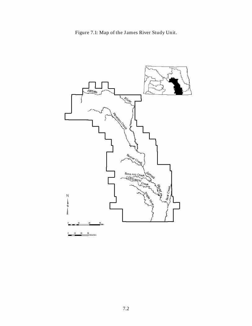
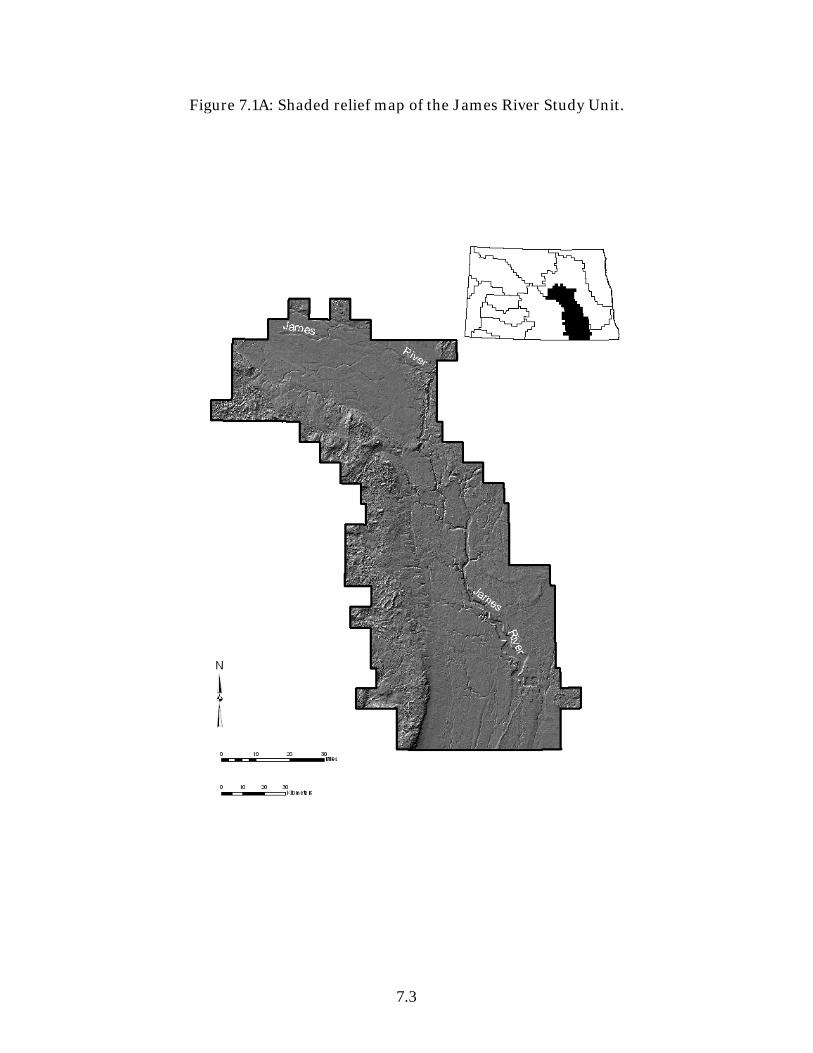
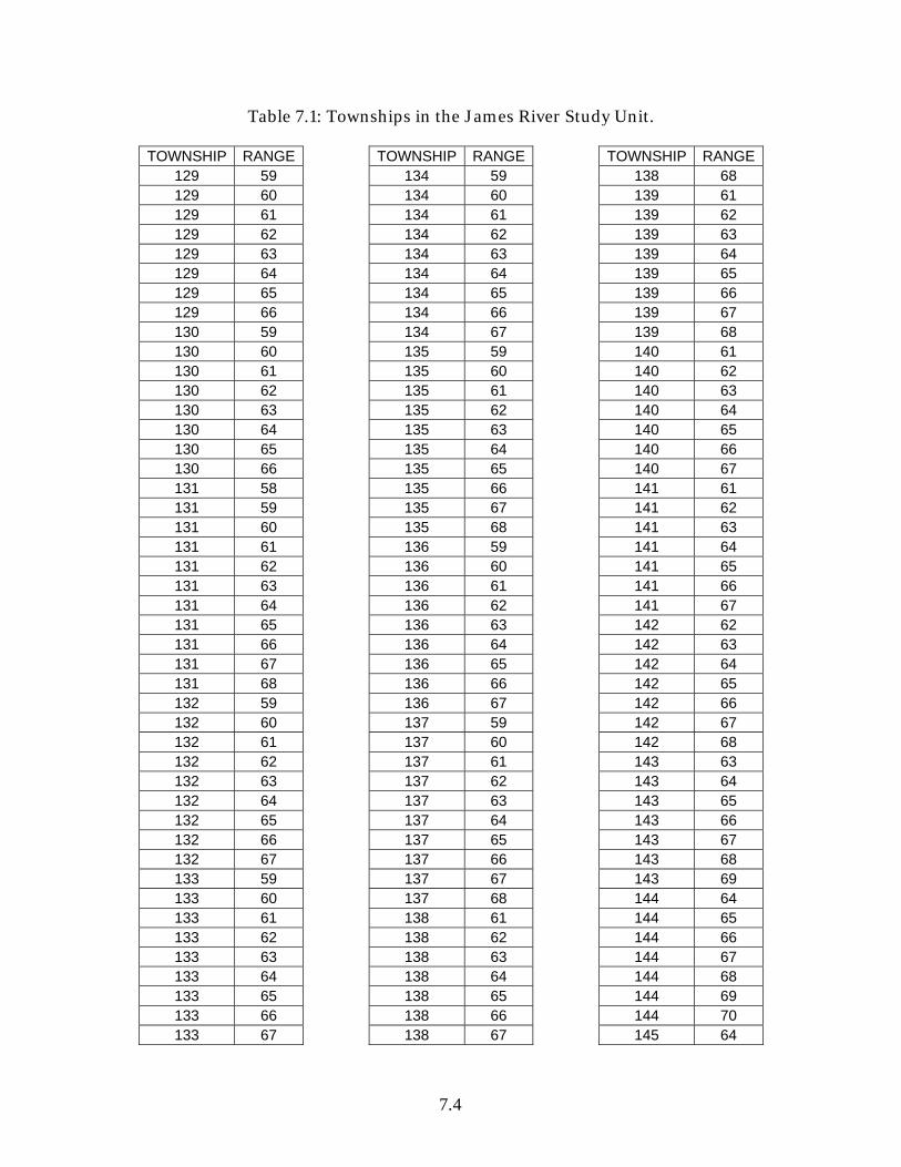
Figure 7.1: Map of the James River Study Unit. ...................................................7.2 Figure 7.1A: Shaded relief map of the James River Study Unit............................7.3 Table 7.1: Townships in the James River Study Unit............................................7.4 Table 7.2: Cultural/Temporal Affiliation of Archeological Resources in the James River Study Unit, 13-Sept-2007. ...........................................................................7.9 Table 7.3: Feature type by landform for archeological sites in the James River Study Unit, 13-Sept-2007. ...................................................................................7.10 Table 7.4: Inventory Projects in the James River Study Unit, 5-Sept-2007. ..... 7.11 Table 7.5: Test Excavation Projects in the James River Study Unit, 5-Sept-2007...............................................................................................................................7.33 Table 7.6: Major Excavation Projects in the James River Study Unit, 5-Sept-2007...............................................................................................................................7.35 Table 7.7: Other Work in the James River Study Unit, 5-Sept-2007. ................7.37
7.1
The James River Study Unit
Fern E. Swenson and Amy Bleier 2008
Description of the James River Study Unit The James River Study Unit (JRSU) covers 6,554 mi². The James River drains into the Missouri River and has its headwaters along the Missouri Escarpment in Wells County, North Dakota. Figures 7.1 and 7.1A outline the area and illustrate several principal tributaries. All or portions of Barnes, Dickey, Eddy, Foster, Kidder, LaMoure, Logan, McIntosh, Sargent, Sheridan, Stutsman, and Wells counties are within the JRSU. Table 7.1 lists townships in the JRSU. Much of the information presented here was compiled from archeological investigations conducted for the Bureau of Reclamation by the University of North Dakota (Gregg 1987; Gregg et al. 1985, 1986, 1987). Physiography The JRSU is in the Drift Prairie physiographic region. The surface features of the Drift Prairie resulted from the retreat of the glacial ice mass with occasional halts and minor readvances (Winters 1963:47). Uplands, valley wall side slopes, valley wall foot slopes, alluvial fans, river terraces, flood plains, and lake plains include the different landforms present in the study unit. The most common features in the uplands are ground moraines, end moraines, and valley trains. The Wisconsinan, Laurentide continental glacier was the last in a series of Pleistocene glaciers to cover the area. There was an advance around 20,000 BC, a recession about 12,000 BC, and the last advance around 9,000 BC. The ice mass reached as far south as the South Dakota-Nebraska border during the last advance (Flint 1955:Figure 27; Winters 1963). When the area was free of glacial ice, it was left with as much as 183 m (600 ft) of glacial till covering the Pierre shale bedrock (Gregg et al. 1987:7). Glacial lakes formed adjacent to the margin of the retreating ice mass and were a prominent aspect of the paleoecological landscape. Due to glacial lake formation, the physical geography of the valley in most of the study unit stands in contrast with that of the valley to the south in southern Dickey County and on into South Dakota. Glacial Lake Dakota formed to the south as the front of the last ice sheet melted back northward. The lake was dammed by the wasting glacial ice front on the north and the proximal side of an end moraine in Beadle County, South Dakota (Flint 1955:165; Gregg et al. 1987:7).
7.2
Figure 7.1: Map of the James River Study Unit.
7.3
Figure 7.1A: Shaded relief map of the James River Study Unit.
7.4
Table 7.1: Townships in the James River Study Unit.
TOWNSHIP RANGE 129 59 129 60 129 61 129 62 129 63 129 64 129 65 129 66 130 59 130 60 130 61 130 62 130 63 130 64 130 65 130 66 131 58 131 59 131 60 131 61 131 62 131 63 131 64 131 65 131 66 131 67 131 68 132 59 132 60 132 61 132 62 132 63 132 64 132 65 132 66 132 67 133 59 133 60 133 61 133 62 133 63 133 64 133 65 133 66 133 67
TOWNSHIP RANGE134 59 134 60 134 61 134 62 134 63 134 64 134 65 134 66 134 67 135 59 135 60 135 61 135 62 135 63 135 64 135 65 135 66 135 67 135 68 136 59 136 60 136 61 136 62 136 63 136 64 136 65 136 66 136 67 137 59 137 60 137 61 137 62 137 63 137 64 137 65 137 66 137 67 137 68 138 61 138 62 138 63 138 64 138 65 138 66 138 67
TOWNSHIP RANGE138 68 139 61 139 62 139 63 139 64 139 65 139 66 139 67 139 68 140 61 140 62 140 63 140 64 140 65 140 66 140 67 141 61 141 62 141 63 141 64 141 65 141 66 141 67 142 62 142 63 142 64 142 65 142 66 142 67 142 68 143 63 143 64 143 65 143 66 143 67 143 68 143 69 144 64 144 65 144 66 144 67 144 68 144 69 144 70 145 64

7.5
TOWNSHIP RANGE 145 65 145 66 145 67 145 68 145 69 145 70 145 71 145 72 145 73 145 74 146 64 146 65 146 66 146 67 146 68 146 69
TOWNSHIP RANGE146 70 146 71 146 72 146 73 147 64 147 65 147 66 147 67 147 68 147 69 147 70 147 71 147 72 147 73 148 63 148 64
TOWNSHIP RANGE148 65 148 66 148 67 148 68 148 69 148 70 148 71 148 72 148 73 149 67 149 68 149 69 149 70 149 71 150 68 150 70

7.6
Drainage About 18,648 km² are drained by the James River in North Dakota. The James River drains into the Missouri River and has its headwaters along the Missouri Escarpment in Wells County, North Dakota. The James River formed primarily after the recession of the last glaciation. Climate All of North Dakota is defined as having a subhumid continental climate characterized by wind and extreme temperatures. Winters are long and cold, while summers are short with warm to hot temperatures (Omodt et al. 1966:4-5). In LaMoure County, the average winter temperature is 12°F. In the summer, the average temperature is 81°F. The average annual precipitation is 18 inches. The average seasonal snowfall is approximately 23 inches (Thompson and Sweeney 1971:114-115). Landforms and Soils Uplands, valley wall side slopes, valley wall foot slopes, alluvial fans, river terraces, floodplains, and lake plains include the different landforms present in the study unit. Soils found on these landforms formed under a variety of pedogenic factors.
Natural Resources Conservation Service (NRCS) official soil survey resources are available on the internet (NRCS 2007a, b, c). The Web Soil Survey in particular may be useful as it has replaced the traditional county soil survey books. Electronic Field Office Technical Guide: http://www.nrcs.usda.gov/technical/efotg/ Soil Data Mart: http://soildatamart.nrcs.usda.gov Web Soil Survey: http://websoilsurvey.nrcs.usda.gov/app/ Flora and Fauna The vegetation that colonized the deglaciated terrain around the glacial lakes is thought to have been a kind of boreal forest containing spruce and deciduous trees with opening dominated by sagebrush (Ashworth and Cvancara 1983). The boreal forests had lower densities of big game animals than either deciduous forests or grasslands (Pettipas and Buchner 1983). The fluctuating prairie-boreal forest ecotone had shifted east of the Red River by the mid-Holocene (Grimm 1985:12) and prairie grasslands thereafter constituted the dominant vegetative environment of most parts of the Northeastern Plains. Natural and man-made prairie fires inhibited the return to
7.7
dominance of woodlands (cf. Grimm 1985). The moister climatic episodes of the late Holocene stimulated the entrenchment of woody vegetation along stream channels. The natural prairie of the study area was in the transition zone between the tall grass prairie of the Red River valley and the mixed grass prairie of western North Dakota. Wheatgrass, bluestem, and needlegrass constituted the predominant native vegetation in well-drained areas. Sedges, reeds, river grass, and prairie cordgrass were common in poorly drained locales (Gregg et al. 1987:12). Within the prairie environment, distinct ecological habitats emerged. Wetlands biotic communities, many of which still exist in the uplands of the Drift Prairie, provide food and cover for game in winter and are essential to waterfowl reproduction cycles. Wetlands habitats also exist within the main valley at numerous oxbow sloughs. Deciduous forest vegetation still can be found on the floodplain along portions of the river and in some drainages feeding it. Native trees of the gallery forest are willow, elm, ash, box elder, cottonwood, and bur oak (Bureau of Reclamation 1986:111-9). Woody shrubs, flowering plants, and other kinds of understory vegetation are also native to the gallery forest and intermittent drainages in the valley. Chokecherry, wild plum, wild rose, currant, raspberry, snowberry, Juneberry, and gooseberry, as well as the trees, provide shelter and forage for a diversity of wildlife (Gregg et al. 1987:12). The prairie, forest, and riverine environments are currently home to a variety of large and small mammals, birds, fish, reptiles, amphibians, and molluscs. Mammals include white-tailed deer, beaver, badger, raccoon, muskrat, fox, skunk, jack rabbit, cottontail rabbit, mink, weasel, and some insectivores. Avian species include geese, ducks, raptors, and song birds. Painted turtles, snapping turtles, bullheads, yellow perch, northern pike, and numerous species of aquatic molluscs are present in the river and some tributaries (Cvancara 1976, 1983; Gregg et al. 1987:12; Russell 1975). Other Natural Resource Potential The biotic diversity provided a wide array of resources for food, fuel, shelter, and water. Glacial erratics are abundant. Small boulders were abundant in many place and were readily easy to collect to hold tipi covers down, to build cairns, to cap caches and burials, to indicate animal drive line alignments, and many other purposes. Granitic raw materials were used to make ground and pecked stone artifacts. Rocks were also frequently used in stone boiling and sweat bathing. Knappable stones are found in the stream gravels including Tongue River silicified sediment (TRSS), Swan River chert, chalcedony, quartzite, and occasionally Knife River flint (KRF). Small pebbles of Yellowstone agate occur in trace amounts. Lithic procurement workshop locations within the Wilmart and Isan sites provide baseline data concerning the use of materials in the till (Gregg et al. 1987:491).
7.8
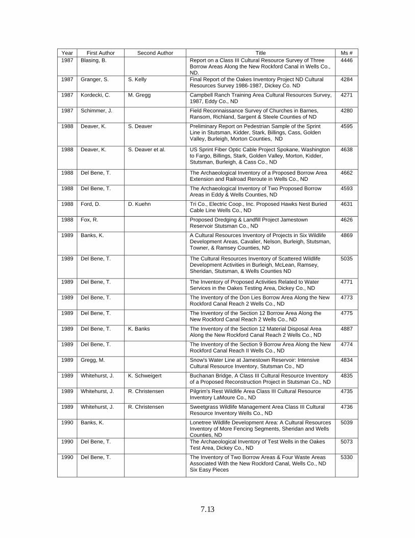
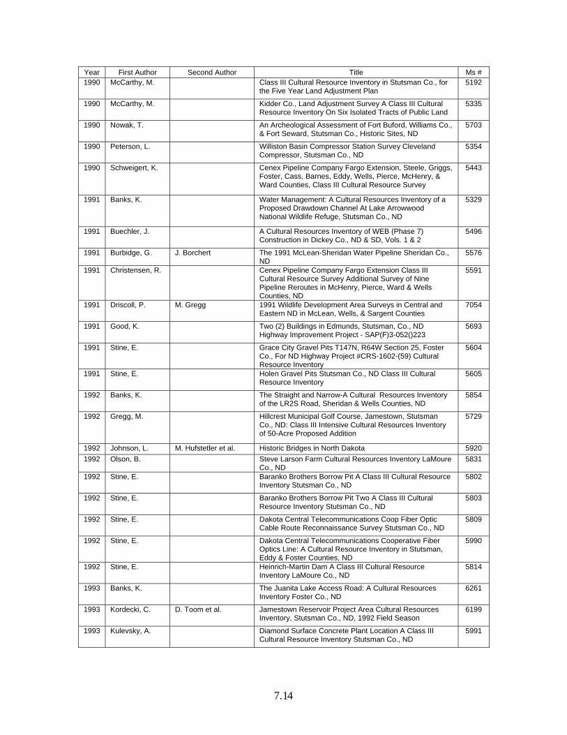
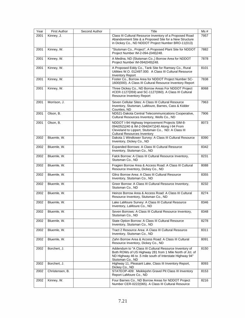
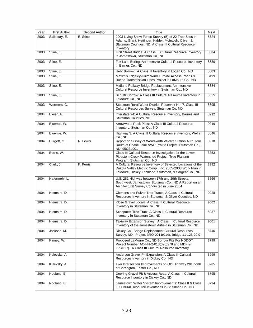
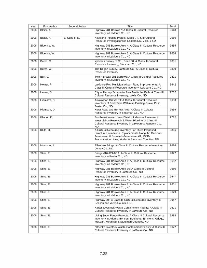
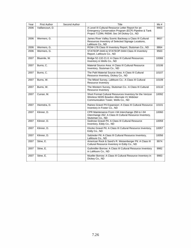
Overview of Previous Archeological Work Archeological work in this study unit has primarily been funded due to federal cultural resources legislation and regulations. The Bureau of Reclamation has administered much of the work in the James River Study Unit. However, other projects have resulted from proposed energy projects (pipeline and wind farms) and cellular tower locations. Inventory Projects As of 13 September 2007, there were 475 archeological sites and 417 archeological site leads and isolated finds in the state site file system for the JRSU. With its 6,554-mi² area, there is one site recorded for each 13.8 mi². The density of sites in the JRSU is a reflection of the relatively low amount of inventory work that has been conducted here in comparison with western North Dakota. However, site density is relatively high in surveyed areas. Tables 7.2 and 7.3 summarize data coded on the site forms for feature types by landform and cultural/temporal affiliations. Site totals vary in some cases because of incompletely coded data or uncoded data for some variables, and in other cases because multiple variables are recorded (e.g., a site might have multiple components or be situated on more than one landform). Other than cultural material scatters, mounds are well represented. A number of graves, other rock features, and stone circles have also been recorded. As in other study units, the majority of sites have not been identified as to cultural/temporal affiliation for the JRSU. An isolated KRF Hell Gap-type point was discovered on the edge of a plowed field near Kraft Slough in Sargent County (Toom et al. 1995). The Paleo-Indian point was recorded as a site lead. A number of Paleo-Indian spear points including Folsom, Agate Basin, Hell Gap, Cody Complex, and Scottsbluff have been reported in private collections (Gregg et al. 1985:5-7; 1987:20; Kordecki and Gregg 1986:31; Schneider 1982). Early Archaic to historic period sites have been recorded. Over half of the recorded sites in the JRSU are situated on hill-knoll-bluffs or terraces. A number of sites have also been recorded on floodplains and ridges. This is mainly a result of survey focus on the main valley for Bureau of Reclamation planning purposes. Table 7.4 lists all the inventory projects conducted wholly or partly within the JRSU for which there are manuscripts on file at the SHSND. Below is a brief description of some of those projects.
7.9
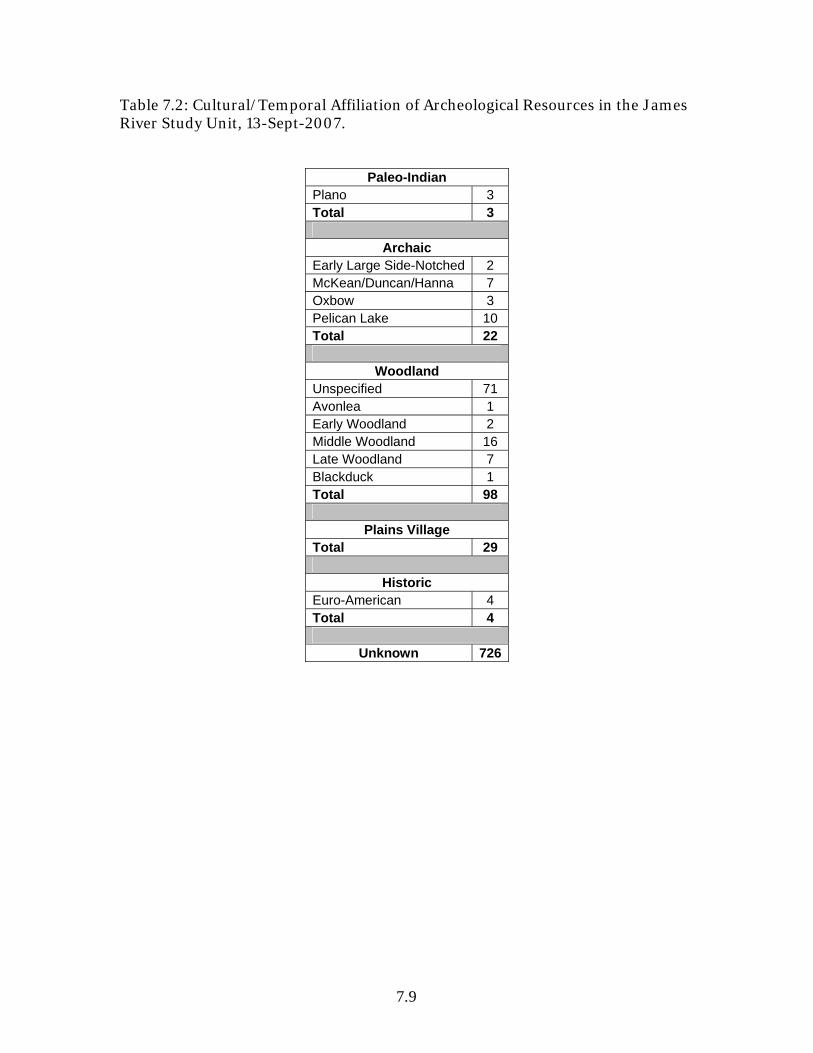
Table 7.2: Cultural/Temporal Affiliation of Archeological Resources in the James River Study Unit, 13-Sept-2007.
Paleo-Indian Plano 3 Total 3
Archaic Early Large Side-Notched 2 McKean/Duncan/Hanna 7 Oxbow 3 Pelican Lake 10 Total 22
Woodland Unspecified 71 Avonlea 1 Early Woodland 2 Middle Woodland 16 Late Woodland 7 Blackduck 1 Total 98
Plains Village Total 29
Historic Euro-American 4 Total 4
Unknown 726

7.10
Table 7.3: Feature type by landform for archeological sites in the James River Study Unit, 13-Sept-2007.
Cultural Material Scatter
Earthlodge Village
Earthworks Grave Hearth Mound Other Rock
Features Pit
Rock Shelter
Stone Circle
Misc. Total
Beachline (glacial)
1 1
Beach or riverbank
12 12
Draw 2 1 1 1 5
Upland plain
15 4 10 7 1 1 4 42
Floodplain 64 1 2 4 1 72
Hill - Knoll - Bluff
62 1 64 69 39 9 26 270
Ridge 16 1 1 10 11 1 10 1 51
Saddle 1 1
Spur 1 1
Swale 1 1
Terrace 80 1 4 13 2 59 9 3 14 185
Alluvial fan 1 1 1 3
Butte 1 1 1 3
Foot slope 10 2 1 4 2 19
Other 4 2 3 7 1 9 26
Total 269 2 11 86 8 156 74 16 1 68 1 692

7.11
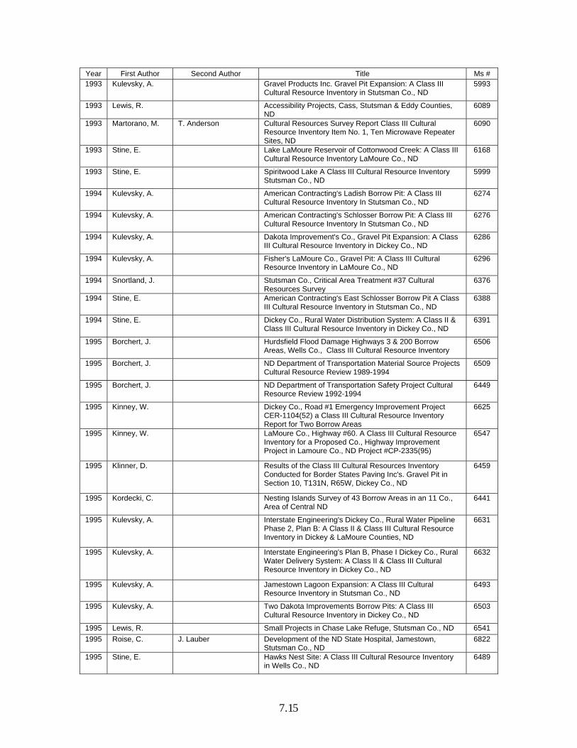
Table 7.4: Inventory Projects in the James River Study Unit, 5-Sept-2007. Year First Author Second Author Title Ms # 1890 Lewis, T. Northwest Archeological Survey, Richland, Barnes, Oliver,
McLean, Morton, Dickey, Ransom, LaMoure, Stutsman, Benson, Grand Forks, Walsh, & Pembina Co., ND
4184
1947 Bauxar, J. Preliminary Appraisal of the Archeological & Paleontological Resources of Jamestown Reservoir, ND., Stutsman Co., ND
71
1947 Cooper, P. Preliminary Appraisal of the Archeological & Paleontological Resources of Sheyenne Reservoir, ND
137
1953 Wheeler, R. Appraisal of the Archeological & Paleontological Resources of Jamestown Reservoir, ND: Supplement, Stutsman Co., ND
72
1964 Dill, C. Field Trip Report, July, 1964: Indian Mounds, Dickey, LaMoure, Ransom Co., ND
3954
1974 Carmichael, G. The Archaeological Survey Along the Proposed Route of Dome Pipeline in ND
93
1974 Schneider, F. Archaeological Investigations in the Proposed Lonetree Reservoir, Garrison Diversion Unit, ND: 1973 Season, Wells Co. & Sheridan Co., ND
52
1974 Schneider, F. R. Vehik Archaeological Surveys in the Garrison Diversion Unit, ND 107
1975 Franke, N. Report of the Archaeological and Historic Site Reconnaissance Survey of Project No. F-3-052 ( ) 198, US Highway 52, Carrington West, Foster Co. & Wells Co., ND
153
1975 Schneider, F. Archaeological Investigations in the Lincoln Valley Irrigation Project & In the LaMoure-Oakes Section, Garrison Diversion Project, ND, 1975, LaMoure Co., Stutsman Co., & Sargent Co., ND
105
1975 Schneider, F. Archaeological Investigations of Municipal and Industrial Water Supply Projects For Fessenden, Harvey, & Garrison, Wells Co., & McLean Co., ND
145
1976 Good, K. J. Dahlberg et al. Archaeology Investigations in the LaMoure-Oakes Project Area, Garrison Diversion, Sargent Co., LaMoure Co., & Stutsman Co., ND
102
1976 Schneider, F. Archaeological Investigations in the Proposed Lonetree Reservoir, Garrison Diversion Unit, ND: 1974 Investigations: Part 1, Wells Co., & Sheridan Co., ND
53
1977 Good, K. W. Kenney et al. Archaeological Investigations in the LaMoure-Oakes & Wild Rice River Project Areas, Sargent Co., LaMoure Co. & Stutsman Co., ND
103
1978 Schreiner, M. Cultural Resource Inventory of Proposed Construction Areas on a Waterfowl Production Area in the Kulm Wetland Management District, LaMoure Co., ND
405
1979 Franke, N. Preliminary Survey of Ponderosa Realty Development in the N½ of Section 35, T140N, R64W, in Jamestown, Stutsman Co., ND
3205
1979 Good, C. Cultural Resource Survey, Pipestem Reservoir, Stutsman Co., ND
947
1980 Gregg, M. Class III Intensive Inventory for All Cultural Resources at a Proposed Wastewater Treatment Facility Improvement, City of Jamestown, Stutsman Co., ND
1008
1980 Gregg, M. Class III Intensive Inventory for All Cultural Resources at a Proposed Wastewater Treatment Facility Improvement, Town of Edgeley, LaMoure Co., ND
1009
1980 Logan, J. K. Good et al. Results of a Literature Search and Class III Cultural Resource Inventory of the Two Proposed Sites for the Location of a Coal-Fired Power Plant Near Spiritwood, ND, Stutsman Co.
1695

7.12
Year First Author Second Author Title Ms # 1980 Snortland, J. Identification of Cultural Resources in the Ponderosa
Realty Development, Jamestown, Stutsman Co., ND, & the Salvage Excavation of Site 32SN22 (32SN208)
2491
1981 Fox, S. Cultural Resource Survey of the Proposed Sewage Lagoon Expansion Site at Ellendale, Dickey Co., ND
3020
1981 Gregg, M. Hillcrest Golf Course Renovation: Class III Intensive Cultural Resources Survey, Stutsman Co., ND
3009
1981 Schweigert, K. F. Vyzralek Cultural Resources Investigation of Portions of Jamestown, Stutsman Co., ND
2558
1981 Weston, L. An Intensive Inventory for all Cultural Resources in Preparation for the Proposed Montpelier Water Supply & Distribution Systems in Stutsman Co., ND
3010
1982 Brown, K. M. Brown et al. Prehistoric and Historic Resources Within the Jamestown Reservoir Project, Stutsman Co., ND
3112
1983 Schweigert, K. P. Jessen Architectural Recordation & Supplementary Recordation, LaMoure-Oakes Projects Areas, Garrison Diversion Unit, Dickey, Sargent, & LaMoure Co., ND
3474
1984 Gnabasik, V. Pipestem Burn Area-1984, Cultural Resources Survey, Pipestem Reservoir, Stutsman Co., ND
3475
1984 Kuehn, D. A Class III Intensive Inventory of the Buchanan Step I Facility, Buchanan, Stutsman Co., ND
3273
1985 Deaver, S. K. Schweigert A Class II Intensive Inventory of the Lincoln Valley Irrigation Area, and the Recordation of Historic Farmsteads in the Lonetree Reservoir Project Area, Garrison Diversion Unit, Sheridan and Wells Counties, ND, 2 Vols.
3838
1985 Gnabasik, V. Parkhurst Recreation Area Road ROW Request, Cultural Resources Survey, Stutsman Co., Pipestem Project, Stutsman Co., ND
3828
1985 Gregg, M. Cultural Resources Survey for a Bridge & County Road Relocation Project South of Montpelier, Stutsman Co., ND
3856
1985 Gregg, M. Kulm Survey Along Highway 13 in LaMoure Co., ND 3570
1985 Kordecki, C. M. Gregg Archeological Site Survey of the James River Banks from Jamestown to Grand Rapids, LaMoure & Stutsman Co., ND
4723
1985 MacDonald, L. Cultural Resource Survey of Three Road & Parking Areas Proposed for Development at Jamestown Reservoir, Stutsman Co., ND
3763
1986 Cultural Research & Management
An Architectural Survey of Jamestown, Stutsman Co., ND 4034
1986 Deaver, K. B. Coutant Cultural Resource Inventory of Portions of the New Rockford Irrigation Areas & the Sykeston Canal Route, Garrison Diversion Unit, Eddy and Wells Counties, Central ND
4183
1986 Kordecki, C. M. Gregg et al. James River Valley Archeological Site Survey, 1985, Dickey, LaMoure, Stutsman Co., ND
3902
1986 Kuehn, D. A Class III Cultural Resource Inventory & Shovel Probing at a Proposed Barrow Pit for the Kulm/Highway 13 Road Improvement Project, LaMoure Co., ND
4132
1986 Persinger, P. K. Good A Class III Cultural Resource Survey of Rural Electrical Lines Near Adrian and Ypsilanti, Stutsman & LaMoure Counties, ND
4118
1986 Sato, J. Archaeological Reconnaissance of the Western Area Power Administration's Jamestown to Grand Forks 115-kV Transmission Line Right-of-Way Located in Stutsman, Barnes, Griggs, Steele, & Grand Forks Counties, ND
4185
1987 Blasing, B. B. Coutant Class I and Class III Cultural Resource Surveys of Wildlife Mitigation Lands in Benson, Burleigh, Cavalier, Nelson, McLean, Ramsey, Sargent, Sheridan, Stutsman, Towner, & Wells Counties, ND
4549
7.13
Year First Author Second Author Title Ms # 1987 Blasing, B. Report on a Class III Cultural Resource Survey of Three
Borrow Areas Along the New Rockford Canal in Wells Co., ND.
4446
1987 Granger, S. S. Kelly Final Report of the Oakes Inventory Project ND Cultural Resources Survey 1986-1987, Dickey Co. ND
4284
1987 Kordecki, C. M. Gregg Campbell Ranch Training Area Cultural Resources Survey, 1987, Eddy Co., ND
4271
1987 Schimmer, J. Field Reconnaissance Survey of Churches in Barnes, Ransom, Richland, Sargent & Steele Counties of ND
4280
1988 Deaver, K. S. Deaver Preliminary Report on Pedestrian Sample of the Sprint Line in Stutsman, Kidder, Stark, Billings, Cass, Golden Valley, Burleigh, Morton Counties, ND
4595
1988 Deaver, K. S. Deaver et al. US Sprint Fiber Optic Cable Project Spokane, Washington to Fargo, Billings, Stark, Golden Valley, Morton, Kidder, Stutsman, Burleigh, & Cass Co., ND
4638
1988 Del Bene, T. The Archaeological Inventory of a Proposed Borrow Area Extension and Railroad Reroute in Wells Co., ND
4662
1988 Del Bene, T. The Archaeological Inventory of Two Proposed Borrow Areas in Eddy & Wells Counties, ND
4593
1988 Ford, D. D. Kuehn Tri Co., Electric Coop., Inc. Proposed Hawks Nest Buried Cable Line Wells Co., ND
4631
1988 Fox, R. Proposed Dredging & Landfill Project Jamestown Reservoir Stutsman Co., ND
4626
1989 Banks, K. A Cultural Resources Inventory of Projects in Six Wildlife Development Areas, Cavalier, Nelson, Burleigh, Stutsman, Towner, & Ramsey Counties, ND
4869
1989 Del Bene, T. The Cultural Resources Inventory of Scattered Wildlife Development Activities in Burleigh, McLean, Ramsey, Sheridan, Stutsman, & Wells Counties ND
5035
1989 Del Bene, T. The Inventory of Proposed Activities Related to Water Services in the Oakes Testing Area, Dickey Co., ND
4771
1989 Del Bene, T. The Inventory of the Don Lies Borrow Area Along the New Rockford Canal Reach 2 Wells Co., ND
4773
1989 Del Bene, T. The Inventory of the Section 12 Borrow Area Along the New Rockford Canal Reach 2 Wells Co., ND
4775
1989 Del Bene, T. K. Banks The Inventory of the Section 12 Material Disposal Area Along the New Rockford Canal Reach 2 Wells Co., ND
4887
1989 Del Bene, T. The Inventory of the Section 9 Borrow Area Along the New Rockford Canal Reach II Wells Co., ND
4774
1989 Gregg, M. Snow's Water Line at Jamestown Reservoir: Intensive Cultural Resource Inventory, Stutsman Co., ND
4834
1989 Whitehurst, J. K. Schweigert Buchanan Bridge, A Class III Cultural Resource Inventory of a Proposed Reconstruction Project in Stutsman Co., ND
4835
1989 Whitehurst, J. R. Christensen Pilgrim's Rest Wildlife Area Class III Cultural Resource Inventory LaMoure Co., ND
4735
1989 Whitehurst, J. R. Christensen Sweetgrass Wildlife Management Area Class III Cultural Resource Inventory Wells Co., ND
4736
1990 Banks, K. Lonetree Wildlife Development Area: A Cultural Resources Inventory of More Fencing Segments, Sheridan and Wells Counties, ND
5039
1990 Del Bene, T. The Archaeological Inventory of Test Wells in the Oakes Test Area, Dickey Co., ND
5073
1990 Del Bene, T. The Inventory of Two Borrow Areas & Four Waste Areas Associated With the New Rockford Canal, Wells Co., ND Six Easy Pieces
5330
7.14
Year First Author Second Author Title Ms # 1990 McCarthy, M. Class III Cultural Resource Inventory in Stutsman Co., for
the Five Year Land Adjustment Plan 5192
1990 McCarthy, M. Kidder Co., Land Adjustment Survey A Class III Cultural Resource Inventory On Six Isolated Tracts of Public Land
5335
1990 Nowak, T. An Archeological Assessment of Fort Buford, Williams Co., & Fort Seward, Stutsman Co., Historic Sites, ND
5703
1990 Peterson, L. Williston Basin Compressor Station Survey Cleveland Compressor, Stutsman Co., ND
5354
1990 Schweigert, K. Cenex Pipeline Company Fargo Extension, Steele, Griggs, Foster, Cass, Barnes, Eddy, Wells, Pierce, McHenry, & Ward Counties, Class III Cultural Resource Survey
5443
1991 Banks, K. Water Management: A Cultural Resources Inventory of a Proposed Drawdown Channel At Lake Arrowwood National Wildlife Refuge, Stutsman Co., ND
5329
1991 Buechler, J. A Cultural Resources Inventory of WEB (Phase 7) Construction in Dickey Co., ND & SD, Vols. 1 & 2
5496
1991 Burbidge, G. J. Borchert The 1991 McLean-Sheridan Water Pipeline Sheridan Co., ND
5576
1991 Christensen, R. Cenex Pipeline Company Fargo Extension Class III Cultural Resource Survey Additional Survey of Nine Pipeline Reroutes in McHenry, Pierce, Ward & Wells Counties, ND
5591
1991 Driscoll, P. M. Gregg 1991 Wildlife Development Area Surveys in Central and Eastern ND in McLean, Wells, & Sargent Counties
7054
1991 Good, K. Two (2) Buildings in Edmunds, Stutsman, Co., ND Highway Improvement Project - SAP(F)3-052()223
5693
1991 Stine, E. Grace City Gravel Pits T147N, R64W Section 25, Foster Co., For ND Highway Project #CRS-1602-(59) Cultural Resource Inventory
5604
1991 Stine, E. Holen Gravel Pits Stutsman Co., ND Class III Cultural Resource Inventory
5605
1992 Banks, K. The Straight and Narrow-A Cultural Resources Inventory of the LR2S Road, Sheridan & Wells Counties, ND
5854
1992 Gregg, M. Hillcrest Municipal Golf Course, Jamestown, Stutsman Co., ND: Class III Intensive Cultural Resources Inventory of 50-Acre Proposed Addition
5729
1992 Johnson, L. M. Hufstetler et al. Historic Bridges in North Dakota 5920
1992 Olson, B. Steve Larson Farm Cultural Resources Inventory LaMoure Co., ND
5831
1992 Stine, E. Baranko Brothers Borrow Pit A Class III Cultural Resource Inventory Stutsman Co., ND
5802
1992 Stine, E. Baranko Brothers Borrow Pit Two A Class III Cultural Resource Inventory Stutsman Co., ND
5803
1992 Stine, E. Dakota Central Telecommunications Coop Fiber Optic Cable Route Reconnaissance Survey Stutsman Co., ND
5809
1992 Stine, E. Dakota Central Telecommunications Cooperative Fiber Optics Line: A Cultural Resource Inventory in Stutsman, Eddy & Foster Counties, ND
5990
1992 Stine, E. Heinrich-Martin Dam A Class III Cultural Resource Inventory LaMoure Co., ND
5814
1993 Banks, K. The Juanita Lake Access Road: A Cultural Resources Inventory Foster Co., ND
6261
1993 Kordecki, C. D. Toom et al. Jamestown Reservoir Project Area Cultural Resources Inventory, Stutsman Co., ND, 1992 Field Season
6199
1993 Kulevsky, A. Diamond Surface Concrete Plant Location A Class III Cultural Resource Inventory Stutsman Co., ND
5991
7.15
Year First Author Second Author Title Ms # 1993 Kulevsky, A. Gravel Products Inc. Gravel Pit Expansion: A Class III
Cultural Resource Inventory in Stutsman Co., ND 5993
1993 Lewis, R. Accessibility Projects, Cass, Stutsman & Eddy Counties, ND
6089
1993 Martorano, M. T. Anderson Cultural Resources Survey Report Class III Cultural Resource Inventory Item No. 1, Ten Microwave Repeater Sites, ND
6090
1993 Stine, E. Lake LaMoure Reservoir of Cottonwood Creek: A Class III Cultural Resource Inventory LaMoure Co., ND
6168
1993 Stine, E. Spiritwood Lake A Class III Cultural Resource Inventory Stutsman Co., ND
5999
1994 Kulevsky, A. American Contracting's Ladish Borrow Pit: A Class III Cultural Resource Inventory In Stutsman Co., ND
6274
1994 Kulevsky, A. American Contracting's Schlosser Borrow Pit: A Class III Cultural Resource Inventory In Stutsman Co., ND
6276
1994 Kulevsky, A. Dakota Improvement's Co., Gravel Pit Expansion: A Class III Cultural Resource Inventory in Dickey Co., ND
6286
1994 Kulevsky, A. Fisher's LaMoure Co., Gravel Pit: A Class III Cultural Resource Inventory in LaMoure Co., ND
6296
1994 Snortland, J. Stutsman Co., Critical Area Treatment #37 Cultural Resources Survey
6376
1994 Stine, E. American Contracting's East Schlosser Borrow Pit A Class III Cultural Resource Inventory in Stutsman Co., ND
6388
1994 Stine, E. Dickey Co., Rural Water Distribution System: A Class II & Class III Cultural Resource Inventory in Dickey Co., ND
6391
1995 Borchert, J. Hurdsfield Flood Damage Highways 3 & 200 Borrow Areas, Wells Co., Class III Cultural Resource Inventory
6506
1995 Borchert, J. ND Department of Transportation Material Source Projects Cultural Resource Review 1989-1994
6509
1995 Borchert, J. ND Department of Transportation Safety Project Cultural Resource Review 1992-1994
6449
1995 Kinney, W. Dickey Co., Road #1 Emergency Improvement Project CER-1104(52) a Class III Cultural Resource Inventory Report for Two Borrow Areas
6625
1995 Kinney, W. LaMoure Co., Highway #60. A Class III Cultural Resource Inventory for a Proposed Co., Highway Improvement Project in Lamoure Co., ND Project #CP-2335(95)
6547
1995 Klinner, D. Results of the Class III Cultural Resources Inventory Conducted for Border States Paving Inc's. Gravel Pit in Section 10, T131N, R65W, Dickey Co., ND
6459
1995 Kordecki, C. Nesting Islands Survey of 43 Borrow Areas in an 11 Co., Area of Central ND
6441
1995 Kulevsky, A. Interstate Engineering's Dickey Co., Rural Water Pipeline Phase 2, Plan B: A Class II & Class III Cultural Resource Inventory in Dickey & LaMoure Counties, ND
6631
1995 Kulevsky, A. Interstate Engineering's Plan B, Phase I Dickey Co., Rural Water Delivery System: A Class II & Class III Cultural Resource Inventory in Dickey Co., ND
6632
1995 Kulevsky, A. Jamestown Lagoon Expansion: A Class III Cultural Resource Inventory in Stutsman Co., ND
6493
1995 Kulevsky, A. Two Dakota Improvements Borrow Pits: A Class III Cultural Resource Inventory in Dickey Co., ND
6503
1995 Lewis, R. Small Projects in Chase Lake Refuge, Stutsman Co., ND 6541
1995 Roise, C. J. Lauber Development of the ND State Hospital, Jamestown, Stutsman Co., ND
6822
1995 Stine, E. Hawks Nest Site: A Class III Cultural Resource Inventory in Wells Co., ND
6489

7.16
Year First Author Second Author Title Ms # 1995 Wermers, G. The Knudson Gravel Pit: Results of the Class III Cultural
Resources Inventory Conducted for Border States Paving Inc., Section 4, T131N, R59W, Dickey Co., ND
6458
1996 Borchert, J. K. Good Jamestown, Stutsman Co., 5th Street NW Historic Architectural Survey
6754
1996 Kordecki, C. D. Toom Drift Prairie Freshwater Lakes Sample Survey Project at Lake Jessie, Griggs Co., and Spiritwood Lake, Stutsman Co., ND, 1995 Field Season
6717
1996 Kordecki, C. Rusten Slough Wildlife Management Area Proposed Parking Lot Cultural Resources Inventory in Foster Co., ND
6715
1996 Kordecki, C. Wildlife Development Areas in McLean, Sheridan, & Wells Counties, ND, 1996 Cultural Resources Inventory
6869
1996 Kulevsky, A. Jamestown Cable Replacement, Northern Prairie Research Center: A Class III Cultural Resources Inventory in Stutsman Co., ND
6827
1996 Peterson, L. K. Vander Steen et al. Data Recovery at the Five Acre Western Tract of Site 32WE34 Wells Co., ND
6571
1996 Stine, E. Addendum to Interstate Engineering's Dickey Co., Rural Water Pipeline Phase 2, Plan B: A Class II & Class III Cultural Resource Inventory in Dickey & LaMoure Counties, ND
6817
1996 Stine, E. Gravel Products' Ashley Pit: A Class III Cultural Resource Inventory in Dickey Co., ND
6732
1996 Stine, E. Harris Borrow Pit: A Class III Cultural Resource Inventory, Barnes Co., ND
6741
1996 Toom, D. Northern Prairie Science Center Cultural Resources Survey of a Proposed New Building Location, Stutsman Co., ND
6833
1996 Wermers, G. D. Klinner Gravel Pit Cultural Resources Inventories Near Jamestown and Mandan, ND in Foster, Morton, & Stutsman Counties
6865
1997 Borchert, J. Safety Project Cultural Resource Review 1996 6880
1997 Fuller, T. New Rockford Gravel Pit: A Class III Cultural Resource Inventory, Eddy Co., ND
6910
1997 Kinney, W. Five Proposed Borrow Areas for NDDOT Project Number CER-4706(56). A Class III Cultural Resource Inventory in Stutsman Co., ND
6946
1997 Kinney, W. One Proposed Borrow Area for NDDOT Project Number Sea-2-036(006)069. A Class III Cultural Resource Inventory in Stutsman Co., ND
6955
1997 Kinney, W. The Jamestown Dam Filter Blanket Project. A Class III Cultural Resource Inventory of Two Proposed Borrow Areas, Stutsman Co., ND
7022
1997 Klinner, D. D. Porter Archeological Investigations in Foster & Wells Counties of ND for the Dakota Central Communications Cooperative ND521 Sykeston Exchange
7085
1997 Klinner, D. Dickey Co., Bridge 11-127-23.0 Replacement Project in Sections 28 and 33, T129N, R62W
7012
1997 Klinner, D. LaMoure Co., Bridge 23-126-09.0 Replacement Project in Sections 16 and 17, T135N, R62W
7013
1997 Kordecki, C. J. Bales Radio Tower Locations in a Multi-County, Area of Central and Southeastern ND: 1995 and 1996 Cultural Resources Inventory
6860
1997 Lewis, R. Spenningsby Brothers Wetland 97PLP323, Stutsman Co., ND
6932
1997 Olson, B. ND National Guard Leased Property in Eddy Co., ND: A Class III Cultural Resources Inventory
6928
1997 Penny, D. A Cultural Resource Inventory of the Hoffman Property, McIntosh and Dickey Counties, ND
7081
7.17
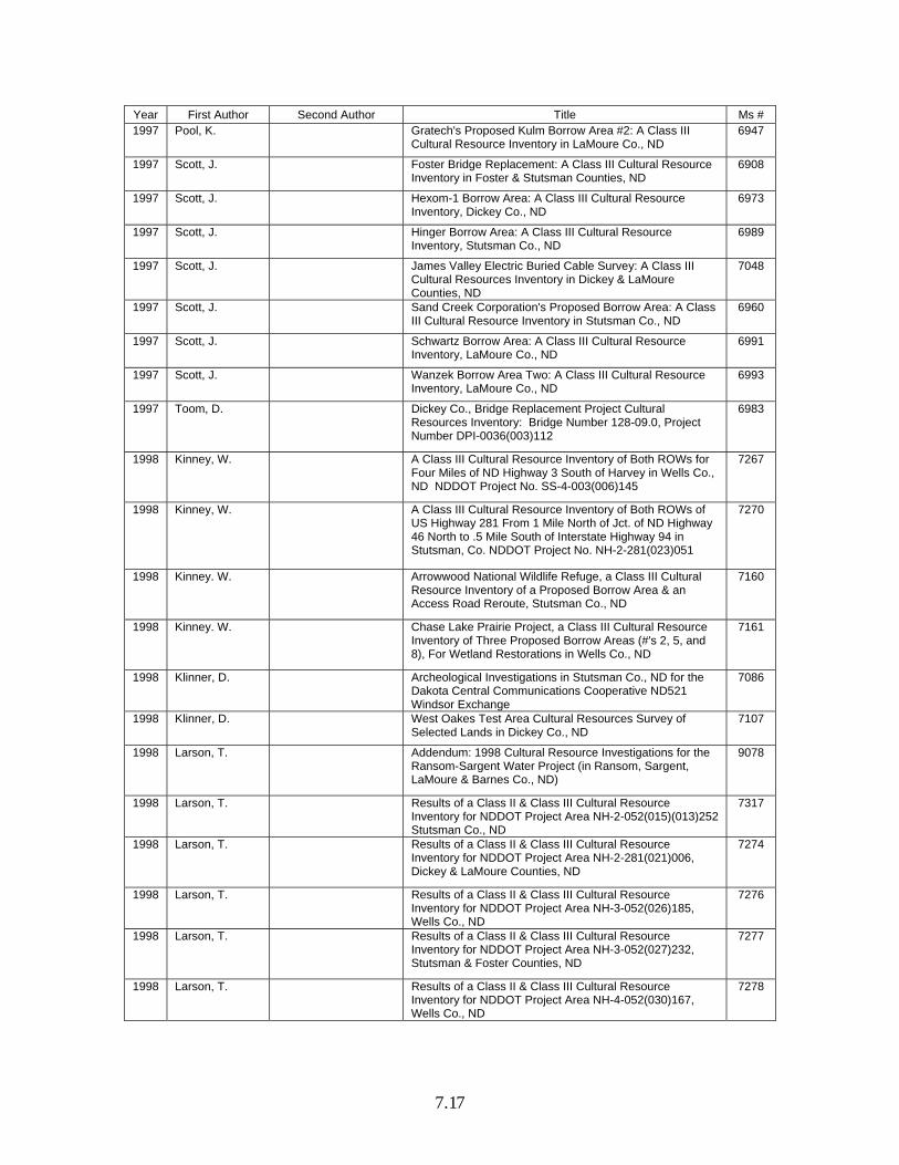
Year First Author Second Author Title Ms # 1997 Pool, K. Gratech's Proposed Kulm Borrow Area #2: A Class III
Cultural Resource Inventory in LaMoure Co., ND 6947
1997 Scott, J. Foster Bridge Replacement: A Class III Cultural Resource Inventory in Foster & Stutsman Counties, ND
6908
1997 Scott, J. Hexom-1 Borrow Area: A Class III Cultural Resource Inventory, Dickey Co., ND
6973
1997 Scott, J. Hinger Borrow Area: A Class III Cultural Resource Inventory, Stutsman Co., ND
6989
1997 Scott, J. James Valley Electric Buried Cable Survey: A Class III Cultural Resources Inventory in Dickey & LaMoure Counties, ND
7048
1997 Scott, J. Sand Creek Corporation's Proposed Borrow Area: A Class III Cultural Resource Inventory in Stutsman Co., ND
6960
1997 Scott, J. Schwartz Borrow Area: A Class III Cultural Resource Inventory, LaMoure Co., ND
6991
1997 Scott, J. Wanzek Borrow Area Two: A Class III Cultural Resource Inventory, LaMoure Co., ND
6993
1997 Toom, D. Dickey Co., Bridge Replacement Project Cultural Resources Inventory: Bridge Number 128-09.0, Project Number DPI-0036(003)112
6983
1998 Kinney, W. A Class III Cultural Resource Inventory of Both ROWs for Four Miles of ND Highway 3 South of Harvey in Wells Co., ND NDDOT Project No. SS-4-003(006)145
7267
1998 Kinney, W. A Class III Cultural Resource Inventory of Both ROWs of US Highway 281 From 1 Mile North of Jct. of ND Highway 46 North to .5 Mile South of Interstate Highway 94 in Stutsman, Co. NDDOT Project No. NH-2-281(023)051
7270
1998 Kinney. W. Arrowwood National Wildlife Refuge, a Class III Cultural Resource Inventory of a Proposed Borrow Area & an Access Road Reroute, Stutsman Co., ND
7160
1998 Kinney. W. Chase Lake Prairie Project, a Class III Cultural Resource Inventory of Three Proposed Borrow Areas (#'s 2, 5, and 8), For Wetland Restorations in Wells Co., ND
7161
1998 Klinner, D. Archeological Investigations in Stutsman Co., ND for the Dakota Central Communications Cooperative ND521 Windsor Exchange
7086
1998 Klinner, D. West Oakes Test Area Cultural Resources Survey of Selected Lands in Dickey Co., ND
7107
1998 Larson, T. Addendum: 1998 Cultural Resource Investigations for the Ransom-Sargent Water Project (in Ransom, Sargent, LaMoure & Barnes Co., ND)
9078
1998 Larson, T. Results of a Class II & Class III Cultural Resource Inventory for NDDOT Project Area NH-2-052(015)(013)252 Stutsman Co., ND
7317
1998 Larson, T. Results of a Class II & Class III Cultural Resource Inventory for NDDOT Project Area NH-2-281(021)006, Dickey & LaMoure Counties, ND
7274
1998 Larson, T. Results of a Class II & Class III Cultural Resource Inventory for NDDOT Project Area NH-3-052(026)185, Wells Co., ND
7276
1998 Larson, T. Results of a Class II & Class III Cultural Resource Inventory for NDDOT Project Area NH-3-052(027)232, Stutsman & Foster Counties, ND
7277
1998 Larson, T. Results of a Class II & Class III Cultural Resource Inventory for NDDOT Project Area NH-4-052(030)167, Wells Co., ND
7278

7.18
Year First Author Second Author Title Ms # 1998 Larson, T. D. Penny et al. Results of a Class II & III Cultural Resource Inventory for
Ransom-Sargent Water Users, Inc., Barnes, Cass, Dickey, LaMoure, Ransom & Sargent Co., ND, Vol. I & II
9093
1998 Scott, J. Addendum to Interstate Engineering Dickey Rural Water Delivery System (Phase 2, Plan C): A Class II & Class III Cultural Resource Inventory in Dickey, LaMoure & Logan Co., ND
9080
1998 Scott, J. Gowan Construction Gravel Pit Expansion: A Class III Cultural Resource Inventory, Stutsman Co., ND
7134
1998 Scott, J. Gratech Company, Ltd., Kulm Borrow Area #1: A Level III Cultural Resource Inventory, LaMoure Co., ND
7114
1998 Scott, J. Jamestown Solid Waste Transfer Station A Level III Cultural Resource Inventory Stutsman Co., ND
7115
1998 Scott, J. Kadrmas Lee & Jackson McIntosh Borrow: A Level III Cultural Resource Inventory, McIntosh Co., ND
7153
1998 Stine, E. D. Forsberg et al. A Class III Cultural Resource Inventory of the ND Segment of the Alliance Pipeline (Milepost 0 to 323.87)
7227
1999 Bluemle, W. J. Miller Gravel Pit: A Class III Cultural Resource Inventory, Foster Co., ND
7501
1999 Isern, T. K. Nesemeier Wrought Iron Cross Cemeteries in ND-Continuing Survey, 1998-99 (Public Report)
7725
1999 Kinney, W. A Class III Cultural Resource Inventory of Both ROWs of Interstate 94 Between Lippert & Jamestown in Stutsman Co., ND
7483
1999 Kinney, W. A Class III Cultural Resource Inventory of Both ROWs of ND Highway 1 from the Oaks Interchange to its Intersection with ND Highway 46 in Barnes Co., ND
7485
1999 Kinney, W. Dickey Co., ND Bridge Replacement Project #'s BRC-1124(54) and CP-1124(99). A Class III Cultural Resource Inventory Report
7332
1999 Kinney, W. Proposed Borrow Area for Stutsman Co., Highway Project #DPI-0036(004)471. A Class III Cultural Resource Inventory Report
7366
1999 Kinney, W. Stutsman Co., Emergency Borrow Area for NDDOT Project #CER-4717(56) Near Pingree, ND
7335
1999 Kinney, W. Stutsman Rural Water User's System Expansion, HE Project #1521.012. A Class III Cultural Resource Inventory of Two Locations in Stutsman Co., ND
7447
1999 Klinner, D. ND Department of Transportation Highway 52 By-Pass Project in Stutsman Co., ND: Cultural Resources Inventory Report
7345
1999 Klinner, D. Two Agriculture Waste System Projects in LaMoure Co., ND: The Daymond Syversens & Dave Syversen’s Locations
7417
1999 Kordecki, C. Jamestown Park Development Cultural Resources Inventory in Stutsman Co., ND
7411
1999 Kulevsky, A. M. Hannum A Class III Cultural Resource Inventory of the ND Segment of the Alliance Pipeline Addendum: Extra Workspaces, Pipe Make-Up Areas, & Route Variations in Pierce, Wells, Barnes, Cass & Richland Co., ND
7603
1999 Morrison, J. Krupsky Gravel Pit: A Class III Cultural Resource Inventory, Dickey Co., ND
7513
1999 Morrison, J. Pipestem Creek Bridge Replacement: A Class III Cultural Resource Inventory, Foster Co., ND
7517
1999 Ross, R. Erickson Borrow Area: A Class III Cultural Resource Inventory, Stutsman Co., ND
7521
1999 Ross, R. Madsen Borrow Area: A Class III Cultural Resource Inventory, Stutsman Co, ND
7531
7.19
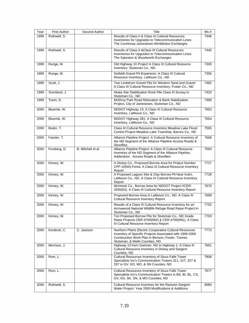
Year First Author Second Author Title Ms # 1999 Rothwell, S. Results of Class II & Class III Cultural Resources
Inventories for Upgrades to Telecommunication Lines: The Courtenay-Jamestown-Wimbledon Exchanges
7446
1999 Rothwell, S. Results of Class II &Class III Cultural Resources Inventories for Upgrades to Telecommunication Lines: The Sykeston & Woodworth Exchanges
7445
1999 Runge, M. Old Highway 10 Project A Class III Cultural Resource Inventory: Stutsman Co., ND
7300
1999 Runge, M. Seifeldt Gravel Pit Expansion: A Class III Cultural Resource Inventory, LaMoure Co., ND
7356
1999 Scott, J. Two Lindstrom Gravel Pits for Western Sand and Gravel: A Class III Cultural Resource Inventory, Foster Co., ND
7482
1999 Snortland, J. Akata Site Stabilization Rock Pile Class III Survey in Stutsman Co., ND
7423
1999 Toom, D. McElroy Park Road Relocation & Bank Stabilization Project, City of Jamestown, Stutsman Co., ND
7489
2000 Bluemle, W. NDDOT Highway 13: A Class III Cultural Resource Inventory, LaMoure Co., ND
7653
2000 Bluemle, W. NDDOT Highway 281: A Class III Cultural Resource Inventory, LaMoure Co., ND
7654
2000 Bodor, T. Class III Cultural Resource Inventory Meadow Lake Flood Control Project Meadow Lake Township, Barnes Co., ND
7565
2000 Fassler, T. Alliance Pipeline Project: A Cultural Resource Inventory of the ND Segment of the Alliance Pipeline Access Roads & Shooflies
7668
2000 Forsberg, D. B. Mitchell et al. Alliance Pipeline Project: A Class III Cultural Resource Inventory of the ND Segment of the Alliance Pipeline, Addendum: Access Roads & Shooflies
7563
2000 Kinney, W. A Dickey Co., Proposed Borrow Area for Project Number CPF-10(00)-Fema. A Class III Cultural Resource Inventory Report
7727
2000 Kinney, W. A Proposed Lagoon Site & Clay Borrow Pit Near Kulm, LaMoure Co., ND. A Class III Cultural Resource Inventory Report
7728
2000 Kinney, W. McIntosh Co., Borrow Area for NDDOT Project #CER-2635(63). A Class III Cultural Resource Inventory Report
7670
2000 Kinney, W. Proposed Borrow Area in LaMoure Co., ND. A Class III Cultural Resource Inventory Report
7699
2000 Kinney, W. Results of a Class III Cultural Resource Inventory for an Arrowwood National Wildlife Refuge Road Raise Project in Stutsman Co., ND
7702
2000 Kinney, W. Ten Proposed Borrow Pits for Stutsman Co., ND Grade Raise Projects CER-4700(992) & CER-4700(991). A Class III Cultural Resource Inventory Report
7703
2000 Kordecki, C. C. Jackson Northern Plains Electric Cooperative Cultural Resources Inventory of Specific Projects Associated with 1999-2000 Construction Work Plan in Benson, Foster, Towner, Stutsman, & Wells Counties, ND
7773
2000 Morrison, J. Highway 13 from Gwinner, ND to Highway 1: A Class III Cultural Resource Inventory in Dickey and Sargent Counties, ND
7651
2000 Rom, L. Cultural Resources Inventory of Sioux Falls Tower Specialists Inc's Communication Towers 311, 317, 327 & 337 in GV, KD, MO, & SN Counties, ND
7808
2000 Rom, L. Cultural Resources Inventory of Sioux Falls Tower Specialists Inc's Communication Towers in BA, BI, BL, CS, GV, KD, SK, SN, & MO Counties, ND
7677
2000 Rothwell, S. Cultural Resource Inventory for the Ransom-Sargent Water Project: Year 2000 Modifications & Additions
9084
7.20
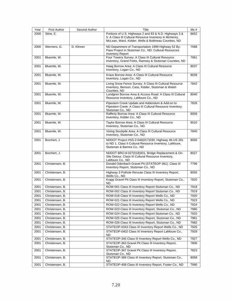
Year First Author Second Author Title Ms # 2000 Stine, E. Portions of U.S. Highways 2 and 83 & N.D. Highways 3 &
5: A Class III Cultural Resource Inventory in McHenry, McLean, Ward, Kidder, Wells & Bottineau Counties, ND
8652
2000 Wermers, G. D. Klinner ND Department of Transportation 1999 Highway 52 By-Pass Project in Stutsman Co., ND: Cultural Resources Inventory Report
7588
2001 Bluemle, W. Four Towers Survey: A Class III Cultural Resource Inventory, Grand Forks, Ramsey & Stutsman Counties, ND
7961
2001 Bluemle, W. Haag Borrow Area: A Class III Cultural Resource Inventory, Logan Co., ND
8037
2001 Bluemle, W. Kraus Borrow Area: A Class III Cultural Resource Inventory, Logan Co., ND
8039
2001 Bluemle, W. Living Snow Fence Survey: A Class III Cultural Resource Inventory, Benson, Cass, Kidder, Stutsman & Walsh Counties, ND
7842
2001 Bluemle, W. Lundgren Borrow Area & Access Road: A Class III Cultural Resource Inventory, LaMoure Co., ND
8040
2001 Bluemle, W. Pipestem Creek Update and Addendum & Add-on to Pipestem Creek: A Class III Cultural Resource Inventory, Stutsman Co., ND
7826
2001 Bluemle, W. Rafferty Borrow Area: A Class III Cultural Resource Inventory, Kidder Co., ND
8009
2001 Bluemle, W. Taylor Borrow Area: A Class III Cultural Resource Inventory, Stutsman Co., ND
8010
2001 Bluemle, W. Vining Stockpile Area: A Class III Cultural Resource Inventory, Stutsman Co., ND
7840
2001 Borchert, J NDDOT Project #SS-2-046(017)030, Highway 46-US 281 to ND 1, Class II Cultural Resource Inventory, LaMoure, Stutsman & Barnes Co., ND
8056
2001 Borchert, J. NDDOT BRO-8-027(018)001, Bridge Replacement & On-Site Detour, Class III Cultural Resource Inventory, LaMoure Co., ND
8027
2001 Christensen, B. Donald Odenbach Gravel Pit (STATEOP-361). Class III Inventory Report, Stutsman Co., ND
7796
2001 Christensen, B. Highway 3 Pothole Reroute Class III Inventory Report, Wells Co., ND
8055
2001 Christensen, B. Krapp Gravel Pit Class III Inventory Report, Stutsman Co., ND
7820
2001 Christensen, B. ROW-001 Class III Inventory Report Stutsman Co., ND 7918
2001 Christensen, B. ROW-002 Class III Inventory Report Stutsman Co., ND 7919
2001 Christensen, B. ROW-018 Class III Inventory Report Wells Co., ND 7920
2001 Christensen, B. ROW-021 Class III Inventory Report Wells Co., ND 7923
2001 Christensen, B. ROW-022 Class III Inventory Report Wells Co., ND 7924
2001 Christensen, B. ROW-023 Class III Inventory Report, Stutsman Co., ND 7980
2001 Christensen, B. ROW-024 Class III Inventory Report Stutsman Co., ND 7925
2001 Christensen, B. ROW-025 Class III Inventory Report, Stutsman Co., ND 7981
2001 Christensen, B. ROW-026 Class III Inventory Report, Stutsman Co., ND 7982
2001 Christensen, B. STATEOP-0343 Class III Inventory Report Wells Co., ND 7926
2001 Christensen, B. STATEOP-0402 Class III Inventory Report LaMoure Co., ND
7929
2001 Christensen, B. STATEOP-345 Class III Inventory Report Wells Co., ND 7927
2001 Christensen, B. STATEOP-363 Gravel Pit Class III Inventory Report, Stutsman Co., ND
7806
2001 Christensen, B. STATEOP-367 Gravel Pit Class III Inventory Report, Stutsman Co., ND
7823
2001 Christensen, B. STATEOP-389 Class III Inventory Report, Stutsman Co., ND
8058
2001 Christensen, B. STATEOP-408 Class III Inventory Report, Foster Co., ND 7990
7.21
Year First Author Second Author Title Ms # 2001 Kinney, J. Class III Cultural Resource Inventory of a Proposed Road
Abandonment Site & a Proposed Site for a New Structure in Dickey Co., ND NDDOT Project Number BRO-11(013)
7957
2001 Kinney, W. "Stutsman Co., Project", A Proposed Plant Site for NDDOT Project Number IM-2-094-(049)248.
7882
2001 Kinney, W. A Medina, ND (Stutsman Co.,) Borrow Area for NDDOT Project Number IM-094(049)248.
7878
2001 Kinney, W. A Proposed Eddy Co., Tank Site for Ramsey Co., Rural Utilities W.O. 012497.000. A Class III Cultural Resource Inventory Report
8101
2001 Kinney, W. Foster Co., Borrow Area for NDDOT Project Number SC-1600(000). A Class III Cultural Resource Inventory Report
7838
2001 Kinney, W. Three Dickey Co., ND Borrow Areas For NDDOT Project #CER-1127(059) and SC-1127(060). A Class III Cultural Resource Inventory Report
8068
2001 Morrison, J. Seven Cellular Sites: A Class III Cultural Resource Inventory, Stutsman, LaMoure, Barnes, Cass & Kidder Counties, ND
7963
2001 Olson, B. ND521-Dakota Central Telecommunications Cooperative, Cultural Resources Inventory, Wells Co., ND
7906
2001 Olson, B. NDDOT I-94 Highway Improvement Projects SIM-8-094(052)240 & IM-2-094(047)240 Along I-94 From Cleveland to Lippert, Stutsman Co., ND: A Class III Cultural Resources Inventory
8073
2002 Bluemle, W. Dakota 1 Windtower Survey: A Class III Cultural Resource Inventory, Dickey Co., ND
8390
2002 Bluemle, W. Expanded Borrows: A Class III Cultural Resource Inventory, Stutsman Co., ND
8342
2002 Bluemle, W. Falck Borrow: A Class III Cultural Resource Inventory, Stutsman Co., ND
8231
2002 Bluemle, W. Fragien Borrow Area & Access Road: A Class III Cultural Resource Inventory, Dickey Co., ND
8088
2002 Bluemle, W. Glinz Borrow Area: A Class III Cultural Resource Inventory, Stutsman Co., ND
8355
2002 Bluemle, W. Greer Borrow: A Class III Cultural Resource Inventory, Stutsman Co., ND
8232
2002 Bluemle, W. Heinze Borrow Area & Access Road: A Class III Cultural Resource Inventory, Stutsman Co., ND
8274
2002 Bluemle, W. Lake LaMoure Survey: A Class III Cultural Resource Inventory, LaMoure Co., ND
8346
2002 Bluemle, W. Seven Borrows: A Class III Cultural Resource Inventory, Stutsman Co., ND
8348
2002 Bluemle, W. State Option Borrow: A Class III Cultural Resource Inventory, Stutsman Co., ND
8278
2002 Bluemle, W. Tract 2 Resource Area: A Class III Cultural Resource Inventory, Stutsman Co., ND
8311
2002 Bluemle, W. Zahn Borrow Area & Access Road: A Class III Cultural Resource Inventory, Dickey Co., ND
8091
2002 Borchert, J. Addendum to "A Class III Cultural Resource Inventory of Both ROWs of US Highway 281 from 1 Mile North of Jct. of ND Highway 46 to .5 mile south of Interstate Highway 94" Stutsman Co., ND
8150
2002 Borchert, J. Highway 11, Pleasant Lake, Class III Inventory Report, Dickey Co., ND
8093
2002 Christensen, B. STATEOP-409: Meiklejohn Gravel Pit Class III Inventory Report LaMoure Co., ND
8153
2002 Kinney, W. Four Barnes Co., ND Borrow Areas for NDDOT Project Number CER-0222(065). A Class III Cultural Resource
8216

7.22
Year First Author Second Author Title Ms # Inventory Report
2002 Morrison, J. Heinze Gravel Pit: A Class III Cultural Resource Inventory, Stutsman Co., ND
8345
2002 Morrison, J. Living Snow Fence Survey of 28 Sites in Adams, Barnes, Bowman, Emmons, Golden Valley, Hettinger, Kidder, McIntosh, Mountrail, Oliver & Walsh Co., ND: A Class III Cultural Resource Inventory
8187
2002 Morrison, J. Perleberg Gravel Pit: A Class III Cultural Resource Inventory in Stutsman Co., ND
8237
2002 Morrison, J. Rocky Run Bridge Replacement: A Class III Cultural Resource Inventory, Wells Co., ND
8385
2002 Morrison, J. Schrader Borrow Area: A Class III Cultural Resource Inventory, LaMoure Co., ND
8284
2002 Morrison, J. Two Zahn Borrow Areas: A Class III Cultural Resource Inventory, Dickey Co., ND
8364
2002 Nienow, J. K. Breakey Class III Investigations IM-2-094(064)275 Eckelson to Oakes, Barnes Co., ND
8369
2002 Stine, E. Class III Cultural Resource Inventory, Highway 36 From Junction 3 to Pingree: Kidder & Stutsman Counties, ND
8350
2002 Wermers, G. Borrow Area, Federal Aid No. SIM-2-094(052)240, in Section 32, T140N, R66W, Stutsman Co., ND
8292
2002 Wermers, G. Kraft Slough 2002 Cultural Resources Inventory Project, Sargent Co., ND
9083
2003 Bluemle, W. Community Transportation Enhancement 2003 Project(s): A Class III Cultural Resource Inventory in Bottineau, Foster and Renville Counties, ND
8729
2003 Bluemle, W. Foster Co., Bridge: A Class III Cultural Resource Inventory, Foster Co., ND
8488
2003 Bluemle, W. Mitchell Borrow: A Class III Cultural Resource Inventory, Stutsman Co., ND
8645
2003 Bluemle, W. Resource Inventory in Addendum to: Midland Railway Bridge Replacement: An Intensive Cultural Resource Survey in Stutsman Co., ND
8616
2003 Burns, W. J. Clark Class III Cultural Resource Investigation for the Lower Pipestem Creek Watershed Project, Stutsman Co., ND
8532
2003 Kinney, W. Four Proposed Borrow Areas For NDDOT Project Number AC-NH-2-281(023)049 in Stutsman Co., ND
8538
2003 Kordecki, C. G. Wermers Arrowwood National Wildlife Refuge, Jim Lake Drawdown Channel Project, 2000-2002 Cultural Resources Investigations, Stutsman Co., ND
9007
2003 Kulevsky, A. Highway 13 Reconstruction/Storm Drain, Town of LaMoure, A Class III Cultural Resource Inventory in LaMoure Co., ND, NDDOT Project #NH-2-013(020)278
8667
2003 Kulevsky, A. T-Intersections on Highway 46: A Cultural Resources Inventory in Barnes, LaMoure, Ransom & Stutsman Counties, ND
8473
2003 Meyer, G. The Kulm Windfarm Project: An Intensive Cultural Resource Inventory of Proposed Wind Turbine Locations, Access Routes, & Transmission Line Rights-Of-Way, LaMoure Co., ND
8528
2003 Morrison, J. Flagg Borrow Area: A Class III Cultural Resource Inventory in Stutsman Co., ND
8588
2003 Morrison, J. Patzer Gravel Pit: A Class III Cultural Resource Inventory in Stutsman Co., ND
8522
2003 Morrison, J. Wilson Borrow Area: A Class III Cultural Resource Inventory in Stutsman Co., ND
8559
7.23
Year First Author Second Author Title Ms # 2003 Salisbury, E. E. Stine 2003 Living Snow Fence Survey (B) of 22 Tree Sites in
Adams, Grant, Hettinger, Kidder, McIntosh, Oliver, & Stutsman Counties, ND: A Class III Cultural Resource Inventory
8724
2003 Stine, E. First Street Bridge: A Class III Cultural Resource Inventory in Jamestown, Stutsman Co., ND
8684
2003 Stine, E. Fox Lake Boring: An Intensive Cultural Resource Inventory in Barnes Co., ND
8580
2003 Stine, E. Hehr Borrow: A Class III Inventory in Logan Co., ND 8603
2003 Stine, E. Maxim's Edgeley-Kulm Wind Turbine Access Roads & Buried Transmission Lines Project in LaMoure Co., ND
8499
2003 Stine, E. Midland Railway Bridge Replacement: An Intensive Cultural Resource Inventory in Stutsman Co., ND
8584
2003 Stine, E. Schultz Borrow: A Class III Cultural Resource Inventory in LaMoure Co., ND
8555
2003 Wermers, G. Stutsman Rural Water District, Reservoir No. 7, Class III Cultural Resources Survey, Stutsman Co, ND
8695
2004 Bleier, A. Interstate 94: A Cultural Resource Inventory, Barnes and Stutsman Counties, ND
8912
2004 Bluemle, W. Arrowwood Rock Piles: A Class III Cultural Resource Inventory, Stutsman Co., ND
9019
2004 Bluemle, W. Highway 3: A Class III Cultural Resource Inventory, Wells Co., ND
8846
2004 Burgett, G. R. Lewis Report on Survey of Woodworth Wildlife Station Auto Tour Route at Chase Lake NWR Prairie Project, Stutsman Co., ND 95CSL001
8978
2004 Burns, W. Class III Cultural Resource Investigation for the Lower Pipestem Creek Watershed Project: Tree Planting Program, Stutsman Co., ND
8853
2004 Clark, J. K. Ferris A Cultural Resource Inventory of Selected Locations of the Dakota Valley Electric Coop., Inc. 2005-2008 Work Plan in LaMoure, Dickey, Richland, Stutsman, & Sargent Co., ND
8982
2004 Hafermehl, L. U.S. 281 Highway between 17th and 29th Streets, Southwest, Jamestown, Stutsman Co., ND A Report on an Architectural Survey Conducted in June 2004
8866
2004 Hiemstra, D. Clemens and Pulver Tree Tracts: A Class III Cultural Resources Inventory in Stutsman & Oliver Counties, ND
9028
2004 Hiemstra, D. Klose Gravel Locale: A Class III Cultural Resource Inventory in Stutsman Co., ND
9002
2004 Hiemstra, D. Schepuetz Tree Tract: A Class III Cultural Resource Inventory in Stutsman Co., ND
8937
2004 Hiemstra, D. Taxiway Extension Survey: A Class III Cultural Resource Inventory of the Jamestown Airfield in Stutsman Co., ND
9001
2004 Jackson, M. Dickey Co., Bridge Replacement Cultural Resources Survey, ND: Project BRO-0011(014), Bridge 11-128-20.0
8746
2004 Kinney, W. Proposed LaMoure Co., ND Borrow Pits For NDDOT Project Number AC-NH-2-013(020)278 and MDF-2-999(017). A Class III Cultural Resource Inventory
8799
2004 Kulevsky, A. Anderson Gravel Pit Expansion: A Class III Cultural Resources Inventory in Dickey Co., ND
8999
2004 Kulevsky, A. Two Intersection Improvements on Old Highway 281 north of Carrington, Foster Co., ND
8785
2004 Nodland, B. Deering Gravel Pit & Access Road: A Class III Cultural Resource Inventory in Dickey Co., ND
8795
2004 Nodland, B. Jamestown Water System Improvements: Class II & Class III Cultural Resource Inventories in Stutsman Co., ND
8794

7.24
Year First Author Second Author Title Ms # 2004 Stine, E. Jamestown Water Tower: A Class III Cultural Resource
Inventory in Stutsman Co., ND 8973
2005 Bleier, A. 2005 Living Snow Fence Transportation Enhancement Program Sites in Adams, Dickey, Emmons, Stark & Stutsman Counties, ND: A Class III Cultural Resource Inventory
9296
2005 Bleier, A. 2005 State Wide Forest Land Enhancement Program Sites in Burleigh, Dunn, Emmons, Stark, Stutsman, & Walsh Counties, ND: A Class III Cultural Resource Inventory
9212
2005 Bleier, A. 2005 State Wide Tree Mitigation Sites in Burleigh, McLean, Pembina, Ransom, Stark, & Stutsman Counties, ND: A Class III Cultural Resource Inventory
9197
2005 Bleier, A. Lake Loop Road: A Class III Cultural Resource Inventory in Bottineau Co., ND
8588
2005 Bleier, A. ND05 Grace City Alt 1: A Class III Cultural Resource Inventory in Foster Co., ND
9391
2005 Bleier, A. Vculek Pit Expansion: A Class III Cultural Resource Inventory in LaMoure Co., ND
9452
2005 Bluemle, W. Airport Wetlands Mitigation Survey: A Class III Cultural Resources Inventory in Stutsman Co., ND
9303
2005 Boughton, J. S. Wagers A Class III Inventory of a 13.01-Mile Segment of Highway 281 in Eddy and Foster Counties, ND
9567
2005 Boughton, J. S. Wagers A Class III Inventory of a 2.94-Mile Segment of US Highway 281 in Eddy Co., ND
9581
2005 Burns, W. Class III Cultural Resource Investigation of a Gravel Pit, Southeast of Verona, LaMoure, Co., ND T133N R59W, in the NE¼ of Section 35 LaMoure Co., ND DOT Project Number: AC-SS-2-001(045)000 & SS-SNH-2-001(046)017
9444
2005 Heiner, P. D. Klinner Edgeley Municipal Airport: A Class III Cultural Resource Inventory, LaMoure Co., ND
9350
2005 Hiemstra, D. Ova Gravel Pit: A Class III Cultural Resource Survey in Stutsman Co., ND
9167
2005 Kinney, W. A Barnes Co., Borrow Pit for NDDOT Project Number IM-2-094(064)275. A Class III Cultural Resource Inventory Report
9359
2005 Klinner, D. LaMoure-Rott Municipal Airport: A Class III Cultural Resource Inventory, LaMoure Co., ND
9277
2005 Kluth, D. A Cultural Resource Inventory of a Proposed Borrow Location Near the Jamestown Substation, Stutsman Co., ND
9226
2005 Kordecki, C. Northern Plains Electric Cooperative 2004 Cultural Resources Inventory of Specific Projects in Benson, Foster, Kidder, Pierce, Rolette, Stutsman, Towner, & Wells Co., ND
9198
2005 Morrison, J. Nine Power Structures For Minnkota Power: A Class III Cultural Resource Inventory, A Class III Cultural Resource Inventory, Burleigh, Cass, and Stutsman Counties, ND
9333
2005 Salkin, P. An Archaeological Survey of a Proposed Communications Tower Site in the Township of Ellendale, Dickey Co., ND
9309
2005 Salkin, P. An Archaeological Survey of a Proposed Communications Tower Site Near the Town of Gackle, Logan Co., ND
9314
2005 Stine, E. Webster Borrow Areas: A Class III Cultural Resource Inventory in Dickey Co, ND
9220
2005 Wermers, G. STATEOP-0451 Class III Inventory Report, Stutsman Co., ND
9302
2006 Bleier, A. Highway 281 Borrow 3: A Class III Cultural Resource Inventory in LaMoure Co., ND
9646
7.25
Year First Author Second Author Title Ms # 2006 Bleier, A. Highway 281 Borrow 7: A Class III Cultural Resource
Inventory in LaMoure Co., ND 9648
2006 Bleier, A. E. Stine et al. Keystone Pipeline Project: Class I, II, & III Cultural Resource Investigations in Eastern ND, Vols. 1 & 2
9969
2006 Bluemle, W. Highway 281 Borrow Area 4: A Class III Cultural Resource Inventory in LaMoure Co., ND
9655
2006 Bluemle, W. Highway 281 Borrow Area 5: A Class III Cultural Resource Inventory in LaMoure Co., ND
9654
2006 Burns, C. Ypsilanti Survey of Co., Road 38: A Class III Cultural Resource Inventory, Stutsman Co., ND
9681
2006 Burns, W. The Regan Survey, LaMoure Co.: A Class III Cultural Resource Inventory
9839
2006 Burr, J. Two Highway 281 Borrows: A Class III Cultural Resource Inventory in LaMoure Co., ND
9821
2006 Heiner, P. LaMoure-Rott Municipal Airport Road Improvements: A Class III Cultural Resource Inventory, LaMoure Co., ND
9642
2006 Heiner, S. City of Harvey Schroeder Park Multi-Use Path: A Class III Cultural Resource Inventory, Wells Co., ND
9762
2006 Hiemstra, D. Arrowwood Gravel Pit: A Class III Cultural Resource Inventory of Rock Piles Within an Existing Gravel Pit in Foster Co., ND
9653
2006 Hiemstra, D. Kurtz Road and Borrow Area: A Class III Cultural Resource Inventory in Stutsman Co., ND
9659
2006 Klinner, D. Southeast Water Users District, LaMoure Reservoir to West Lisbon Reservoir & Water Pipeline: A Class III Cultural Resource Inventory in LaMoure & Ransom Co., ND
9782
2006 Kluth, D. A Cultural Resource Inventory For Three Proposed Structure Foundation Replacements Along the Garrison-Jamestown & Bismarck-Jamestown #1, 230Kv Transmission Lines, Kidder & Stutsman Counties, ND
9866
2006 Morrison, J. Ellendale Bridge: A Class III Cultural Resource Inventory, Dickey Co., ND
9686
2006 Stine, E. Bridge #16-124-05.1: A Class III Cultural Resource Inventory in Foster Co., ND
9827
2006 Stine, E. Highway 281 Borrow Area 1: A Class III Cultural Resource Inventory in LaMoure Co., ND
9652
2006 Stine, E. Highway 281 Borrow Area 10: A Class III Cultural Resource Inventory in LaMoure Co., ND
9650
2006 Stine, E. Highway 281 Borrow Area 6: A Class III Cultural Resource Inventory in LaMoure Co., ND
9647
2006 Stine, E. Highway 281 Borrow Area 8: A Class III Cultural Resource Inventory in LaMoure Co., ND
9651
2006 Stine, E. Highway 281 Borrow Area 9: A Class III Cultural Resource Inventory in LaMoure Co., ND
9649
2006 Stine, E. Highway 30: A Class III Cultural Resource Inventory in Benson and Wells Counties, ND
9947
2006 Stine, E. Kartes Livestock Waste Containment Facility: A Class III Cultural Resource Inventory in LaMoure Co., ND
9671
2006 Stine, E. Living Snow Fence Projects: A Class III Cultural Resource Inventory in Adams, Benson, Bottineau, Emmons, Griggs, McLean, Mountrail & Stutsman Counties, ND
9888
2006 Stine, E. Nitschke Livestock Waste Containment Facility: A Class III Cultural Resource Inventory in LaMoure Co., ND
9672
7.26
Year First Author Second Author Title Ms # 2006 Vaillancourt, D. A Level III Cultural Resource Letter Report for an
Emergency Conservation Program (ECP) Pipeline & Tank Project T129N; R65W; Sec 34 Dickey Co., ND
9903
2006 Wermers, G. James River Valley Scenic Backway a Class III Cultural Resources Inventory of Selected Signage Locations, LaMoure Co., ND
9657
2006 Wermers, G. ROW-178 Class III Inventory Report, Stutsman Co., ND 9864
2006 Wermers, G. STATEOP-0443 & STATEOP-0444 Class III Inventory Report, LaMoure Co., ND
9563
2007 Bluemle, W. Bridge 52-132-21.0: A Class III Cultural Resources Inventory in Wells Co., ND
10066
2007 Burns, C. Material Source Area: A Class III Cultural Resource Inventory, Stutsman Co., ND
10106
2007 Burns, C. The Pahl Material Source Area: A Class III Cultural Resource Inventory, Dickey Co., ND
10107
2007 Burns, W. The Mitzel Survey, LaMoure Co.: A Class III Cultural Resource Inventory
10109
2007 Burns, W. The Western Survey, Stutsman Co.: A Class III Cultural Resource Inventory
10110
2007 Curran, M. Short Format Cultural Resources Inventory for the Verizon Wireless ND05 Bowdon Alternate #1 Widicker Communication Tower, Wells Co., ND
10092
2007 Hiemstra, D. Raines Gravel Pit Expansion: A Class III Cultural Resource Inventory in Foster Co., ND
10101
2007 Klinner, D. CPR Maintenance From I-94 Interchange 258 to I-94 Interchange 262: A Class III Cultural Resource Inventory, Stutsman Co., ND
10060
2007 Klinner, D. Gedrose Gravel Pit: A Class III Cultural Resource Inventory, Eddy Co., ND
10059
2007 Klinner, D. Klocke Gravel Pit: A Class III Cultural Resource Inventory, Eddy Co., ND
10057
2007 Klinner, D. Salzieder Pit: A Class III Cultural Resource Inventory, LaMoure Co., ND
10056
2007 Stine, E. American Rock & Sand's R. Weisenberger Pit: A Class III Cultural Resource Inventory in Eddy Co., ND
9974
2007 Stine, E. Guthmiller Borrow: A Class III Cultural Resource Inventory in LaMoure Co., ND
9982
2007 Stine, E. Mueller Borrow: A Class III Cultural Resource Inventory in Dickey Co., ND
9983

7.27
Alfred J. Hill initiated and sponsored the recording of earthworks and burial mounds from 1881-1895. Hill contracted with T. H. Lewis to conduct the fieldwork which is known as the Northwestern Archaeological Survey (NWAS). Lewis recorded thousands of burial mounds and earthworks sites in 11 states in the north central United States and parts of Manitoba (Haury 1990:2; Lewis 1898:8). In North Dakota (Lewis 1886, 1891, 1893) over 200 earthworks, petroglyphs, and boulder formations were recorded in 12 counties (Haury 1990:2). Lewis mapped 152 mounds along the James River (Lewis 1890:1-2). Within the JRSU, 118 earthworks sites were recorded by Lewis. Lewis recorded 72 in Stutsman, 45 in LaMoure, and one in Dickey county. In 1989, a Historic Preservation Fund grant, “Documentation of Northwestern Archaeological Survey Sites Project,” was awarded to the University of North Dakota (UND) (Haury 1990). The primary purpose of the project was to relocate, verify, and record on current NDCRS site forms sites Lewis identified a hundred years earlier. In Stutsman County, 37 mound sites were relocated. Twenty-nine mound sites were relocated in LaMoure County. The enigmatic circular earthwork site in Dickey county was not part of this project which focused on the mound sites. During the 1989 survey, an effort was made to determine the reason (i.e., probably destroyed, possible legal location problems, or inconclusive) for not relocating the earthwork sites. In addition to site descriptions and maps, the report by Haury (1990) provides a summary of Lewis’ work in North Dakota, a discussion concerning the utility of the Northwestern Archaeological Survey (i.e., accuracy of the records and limitations of the records), and a summary of site types and design of prehistoric mound sites as indicated by the NWAS records. With the advent of the Inter-agency Archeological Salvage Program, archeological work occurred in a number of locations. This program was developed in response to the Bureau of Reclamation (Lehmer 1971:1). Under the direction of the National Park Service and a new department within the Smithsonian Institution, River Basin Surveys (SIRBS), archeologists attempted to locate and excavate sites prior to dam construction. At that time, the James River and Pipestem Creek valleys north of Jamestown were being considered for construction of the Jamestown and Pipestem Reservoirs (Bauxer 1947; Mallory 1966a, 1966b; Wheeler n.d., 1953, 1954). Work in the James Valley began in 1946 when Bauxer and Cooper surveyed the portion of the river north of Jamestown to be inundated by the construction of the Jamestown Reservoir (Bauxer and Wedel 1947). Seven sites, including five villages, one campsite, and one mound group, were identified during the five day survey. In 1952, Wheeler, Cain, and Woolworth completed inventory of 45 miles of riverbank between Jamestown and the Stutsman/Foster county line. In addition to the seven sites previously identified, three villages, three campsites, five boulder-lined depressions, 14 mound sites, and two burial sites were recorded. Of these, Hintz village (32SN3), five boulder-lined depressions (32SN30), Kropp Mound (32SN8), Mound 1 (32SN28), and one burial site (32SN31) were tested prior to dam construction (Wheeler 1953).
7.28
Other work in the drainage system by the SIRBS was directed toward obtaining a reconnaissance overview rather than completing intensive pedestrian surveys or testing sites. Although maps of the areas surveyed are not available, site records indicate that in 1965 Oscar Mallory and I. E. Johnson surveyed parts of the river in Wells and LaMoure counties, and in 1966 Glenn V. Dill Jr., an avocational archeologist, assisted by recording sites in Dickey and LaMoure counties. The sites included three small, fortified sites, two possible occupations, three mound groups, and a stratified site (Mallory 1966). Mallory also completed an inventory of the proposed Pipestem Reservoir, but failed to locate any sites in 900 acres of bottomland and 40 miles of shoreline (Mallory 1966). A three-year project for the Bureau of Reclamation was conducted by UND between 1974 and 1976. In 1974, an archeological inventory of the James River south of Jamestown was initiated. The project identified 94 archeological sites including nine stone circle sites, 20 rock cairns, 35 earthworks, 22 cultural material scatters, and eight historic sites (Schneider and Vehik 1976). Later in 1975, archeologists from UND returned to test seven sites along the James River to be affected by the proposed Oakes canal and bank stabilization projects (Good et al. 1976). The following year, investigations continued with a resurvey of the valley south of Jamestown to the Barnes County border and to test additional sites. The resurvey identified 18 additional sites (Good et al. 1977b:l). Dakota Interactive Services, Inc., conducted a cultural resources inventory and evaluation of cultural properties on lands within the Jamestown Reservoir management area for the Bureau of Reclamation in 1982 (Brown et al. 1982). The intensive pedestrian survey and shovel probing program along the shoreline of the Jamestown Reservoir recorded 18 new sites and three previously located sites. Eight of these sites were tested. In 1985 UND conducted additional cultural resources projects for the Bureau of Reclamation. A site survey was conducted along 127 km (79 miles) of James River banks from Jamestown in Stutsman County to Grand Rapids in LaMoure County. The river survey found 23 unknown prehistoric sites in eroding cutbank areas (Kordecki and Gregg 1985). Also, a site survey was undertaken of 4,923 hectares (12,161 acres) of irrigation development land in the valley and uplands in Stutsman, LaMoure, and Dickey counties. The area survey recorded 134 sites and isolate finds in floodplain, terrace, valley wall foot slope, alluvial fan, valley wall side slope, and upland areas (Kordecki and Gregg 1986). In 1992, UND conducted an intensive cultural resources survey of approximately 3,000 acres of public lands at the Jamestown Reservoir for the Bureau of Reclamation. Sixty-one sites were investigated (relocated, newly recorded, or determined to be inundated). Sites include artifact scatters, mounds, stone-lined depressions, rock cairns, stone circles, homestead, dump, and trail (Kordecki, Toom, and Jackson 1993).

7.29
Cultural resources were identified south of Spiritwood Lake in 1993. The size of the project area was approximately 200 m east-west by 150 m north-south (Stine 1993a:3). The project area extended from the shoreline south to the uplands. Recorded cultural resources include: (1) a small, disturbed mound with bone and lithics on its surface, (2) a concentration of unburned and burned bone fragments and fire-cracked rock, and (3) unburned and burned bone fragments, native ceramics, and lithic debitage eroding out of a gravel road (ibid.:6). Stine (ibid.:7) proposes that the artifact concentrations are part of site 32SN103, to the south. In 1994, archeologists conducted sample inventories, (re)visiting previously and newly recorded sites in the Lonetree Wildlife Management Area (Toom et al. 1998). The Lonetree project area crosses Sheridan and Wells counties and the JRSU, Sheyenne River Study Unit, and Souris River Study Unit. Nineteen archeological sites were recorded in 1994. The majority of the newly recorded sites were recorded on the eastern end of the project area on valley rim and upland landforms (ibid.:Table 4.2). In 1995, approximately 400 acres within the Drift Prairie region were intensively inventoried by UND (Kordecki and Toom 1996:1). “The project intended to produce information that would contribute toward our knowledge of the numbers and kinds of sites that are found adjacent to the larger Drift Prairie lakes” (ibid:iii). The project area was adjacent to Spiritwood Lake in Stutsman County. Spiritwood Lake is a freshwater body within glacial moraine terrain. Seven prehistoric cultural resources were recorded/updated during the intensive inventory. The feature types include three cultural material scatters, two mounds, and two cultural material scatter/mounds (ibid.:Table 4). The sites are situated on upland plains and hills, with both types of sites found on both types of landforms. The locations of these sites correlate to conclusions made by investigators. That is, the combinations of feature types and landforms reflect general trends throughout the region. Occupation sites (cultural material scatters) generally are located at relatively lower elevations and other site types generally at higher elevations (ibid.:79). Four linear segments were surveyed in Dickey and LaMoure counties for a proposed electric buried cable. The project corridor was 50 ft wide and totaled 6.3 miles (Scott 1997:8). The survey segments covered (1) flats and terraces overlooking the Maple River to the east, (2) a Maple River crossing with floodplains on either side, (3) uplands, valley edge, and toe slope of the James River valley, and (4) bottomlands and terraces up to the western toe slope of the James River valley and to the uplands (ibid.:6). Two prehistoric isolated finds, each containing one flake, were recorded in the fourth area described. Investigators recommended no further work. Several segments of the proposed Alliance pipeline access roads and shooflies crossed the JRSU. The Wells County segment was situated on a floodplain of the Big Slough (Kulevsky and Hannum 1999:6). The other segments
7.30
were located in flat to slightly rolling terrain in Foster County (Fassler 2000:6-9). In these areas, any shallow depressions were filled with water and previous disturbances included agricultural activities and construction of gravel roads. No new sites were observed. Two previously recorded sites (32FO21 and 32FO29) were avoided by rerouting the proposed pipeline facilities. In 2002, an intensive inventory was conducted for a proposed wind farm east of Kulm, North Dakota. The project area included 30 wind turbine locations, three substation locations, access routes, and a transmission line (Meyer 2003:1). The areal topography is characterized as flat to hummocky, dotted by sloughs and lakes. Virtually the entire project area has been cultivated. Two prehistoric sites, one prehistoric/historic site, and one prehistoric isolated find (a flake) were recorded during the survey (ibid.:20). Site 32LM202 is a sparse prehistoric cultural material scatter atop a hill (ibid.:30). Located on a larger hill, 32LM119 is a moderately dense prehistoric and historic cultural material scatter (ibid.:26). Site 32LM203 is a stone circle site with “an anomalous linear feature” on a wide, raised area above slough (ibid.:32). During 2004 and 2005, an inventory, including shovel probes, was conducted by the NDDOT for the proposed James River Valley Scenic Backway. The proposed project locations avoided known cultural resources. Six of the 18 proposed locations for signage were intensively inventoried (Wermers 2004:1). One prehistoric isolated find (a Swan River chert flake) and one historic site were recorded (ibid.:7). The prehistoric artifact was recovered from a shovel probe place on an upland edge, east of the James River valley. Test Excavation Projects The Hintz village (32SN3), five boulder-lined depressions (32SN30), Kropp Mound (32SN8), Mound 1 (32SN28), and one burial site (32SN31) were tested prior to dam construction (Wheeler 1953). Wheeler’s excavations at the Hintz site (32SN3) revealed that an earthlodge village lifeway was ongoing here during late prehistoric or protohistoric times. Shoreline erosion of the Pipestem Reservoir exposed a burial site (32SN102) which was salvaged and analyzed by UND (Fox and Pearson 1978). In 1975, UND tested seven sites along the James River that were scheduled to be affected by the proposed Oakes canal and bank stabilization projects by the Bureau of Reclamation (Good et al. 1976). The tested sites were Kirschenmann II (32SN221), 32SN242, Martin (32LM239), Schmoker (32LM241), Chappel (32LM240), Quast (32LM234), and Beeber (32LM235). The following year the Naze site (32SN246), Kirschenmann III (32SN247), Hendrickson III (32LM403), and Martin II (32LM401) were tested by UND for the Bureau of Reclamation (Good et al. 1977).
7.31
In 1982, Dakota Interactive Services, Inc., conducted test excavation within the Jamestown Reservoir management area for the Bureau of Reclamation. Five lithic scatters (32SN71, 32SN82, 32SN74, 32SN81, 32SN83) were tested. Sites 32SN71 and 32SN82 were “determined not to potentially contain significant subsurface scientific or cultural data” (Brown et al. 1982:130). Further testing was recommended for the other three sites, as they were eroding due to wave action (ibid.:131). In 1984, archeological testing was conducted by UND (Gregg et al. 1985) for the Bureau of Reclamation at nine sites along the James in Stutsman and LaMoure counties, and one site in the vicinity of the proposed Taayer Reservoir in Sargent County. Investigations at 32SA205, 32SA206, 32SA208, Hendrickson III, Hendrickson II (32SN402), Naze, Kirschenmann II, Kirschenmann III, Martin, Chappel, Beeber, and Quast were conducted. Testing supplemented existing information concerning site significance and determined site limits. Test excavation and site evaluation work was performed at eight prehistoric sites in James River bank stabilization areas for the Bureau of Reclamation in 1985 by UND. The tested sites are 32SN216 (Wolf), 32SN215 (Gohner I), 32SN119 (Mayer), 32SN111 (Nelson), 32LM401 (Martin II), 32LM236 (Stroh), 32LM243 (McCleary), and 32LM244 (Chappell II). The test excavations identified the oldest and most deeply buried cultural deposits found to date in the study area (Gregg et al. 1986). In 1986, UND text excavated 15 prehistoric and protohistoric archeological sites for the Bureau of Reclamation situated in areas of anticipated bank stabilization construction in Stutsman and LaMoure counties. The tested sites are 32SN57 (Makacega), 32SN58 (Greenwood Village), 32SN59 (Olson), 32SN106 (Larson), 32SN107 (Wilmart), 32SN120 (Isan), 32SN121 (Akata), 32SN110 (Ituhu), 32SN113 (Tahuka), 32SN114 (Cokan), 32LM8 (Kazapa), 32LM9 (Wanitipi), 32LM29 (Walde), 32LM15 (Ptega), and 32LM22 (Peterson). Testing was conducted for the purpose of evaluating eligibility for listing in the National Register of Historic Places (NRHP). All 15 of the sites tested are evaluated as eligible for NRHP listing. Testing was conducted on five acres, within the site limits, of 32WE34 for the Western Area Power Administration (Deaver 1995). The site is located on Hawks Nest Hill, a high point in east-central North Dakota. The testing program involved survey, auger probes, and test unit excavation. A cultural material scatter, including lithic debitage and tools, butchered bone, native ceramics, and fire-cracked rock, and “10 possible earthen features (conical and linear mounds) around the edges of the hilltop” were documented (ibid.:5.1). Burial mounds are known to have been constructed in the area, and the investigator points out the similarity of the 32WE34 artifact assemblage to those of 32SN22 (Jamestown Mounds) and 32SN207 (ibid.:6.1).

7.32
In 1993, UND conducted archeological inventory and testing at the site of the proposed Kraft Slough National Wildlife Refuge in Sargent County. During the survey, an isolated KRF Hell Gap-type point was discovered on the edge of a plowed field and recorded as a site lead (Toom et al. 1995). The two tested sites, 32SA54 and 32SA55, are sparse, surficially expressed cultural material scatters. Based on the presence of Middle Plains Village period ceramics and a Plains Side-Notched point, 32SA54 has been dated to ca. AD1500-1600 (ibid.:72). Two body sherds, similar to those found at 32SA54, were recovered at 32SA55 (ibid.:89). Investigators speculate that the latter site is an outlying activity area related to 32SA54, a short-term field camp (ibid.). Testing was conducted at 37 sites along the proposed Alliance Pipeline occurred in 1997 (Stine et al. 1998a). Additional testing and site evaluations were undertaken in 1998 at 21 sites (Stine et al. 1998c). The pipeline enters North Dakota from Canada, beginning north of the community of Sherwood, running southeasterly, and exits Richland County near the intersection of the North Dakota, South Dakota, and Minnesota borders. Within the JRSU, 13 sites in Foster and Wells counties were tested. Investigators recommended three sites as significant and eligible for the NRHP (Stine et al. 1998a.:i-ii). Two of these sites originally were recorded as prehistoric buried cultural material scatters (32FO21 and 32FO25) and a prehistoric surficial cultural material scatter (32FO20). These three sites are along Kelly Creek, within a 4.5-mi segment of the proposed pipeline corridor with the highest site density (one site per 0.45 mi) on the route (ibid.:196). In 1998, 32FO31, a buried prehistoric cultural material scatter southwest within the high-density segment, was tested and recommended eligible for the NRHP by investigators (Stine et al. 1998c:130). From 2002 through 2004, test excavations were conducted at nine sites within the boundaries of Camp Grafton South (Jackson et al. 2006). The project area is within the Prairie Pothole Region between the Sheyenne and James rivers. One site, 32ED29, is within the JRSU; the other eight are within the Sheyenne River Study Unit. Site 32ED29 contains stone features and a cultural material scatter. It is located in uplands west of the drainage divide between Lake Coe and Cherry Lake (ibid.:7.1). Disturbances to the area include National Guard activities and a road that runs the length of the site. Seventy auger probes were place across the site (ibid.). Testing results indicate that the cultural material scatter is surficial and, with the presence of two native ceramic sherds, dates to some time with the range of 500 BC-AD 1800 (ibid.:7.9). Investigators speculate that the cultural items may have been deposited when the road was constructed (ibid.).
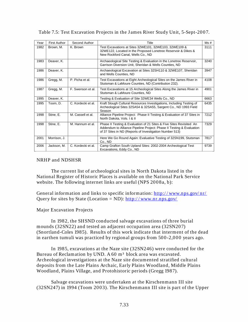
7.33
Table 7.5: Test Excavation Projects in the James River Study Unit, 5-Sept-2007. Year First Author Second Author Title Ms # 1982 Brown, M. K. Brown Test Excavations at Sites 32WE101, 32WE103, 32WE109 &
32WE122, Located in the Proposed Lonetree Reservoir & Dikes & New Rockford Canal, Wells Co., ND
3111
1983 Deaver, K. Archaeological Site Testing & Evaluation in the Lonetree Reservoir, Garrison Diversion Unit, Sheridan & Wells Counties, ND
3240
1986 Deaver, K. Archaeological Excavation at Sites 32SH110 & 32WE107, Sheridan and Wells Counties, ND
3947
1986 Gregg, M. P. Picha et al. Test Excavations at Eight Archeological Sites on the James River in Stutsman & LaMoure Counties, ND (Contribution 232).
4108
1987 Gregg, M. F. Swenson et al. Test Excavations at 15 Archeological Sites Along the James River in Stutsman & LaMoure Counties, ND
4901
1995 Deaver, K. Testing & Evaluation of Site 32WE34 Wells Co., ND 6663
1995 Toom, D. C. Kordecki et al. Kraft Slough Cultural Resources Investigations, Including Testing of Archeological Sites 32SA54 & 32SA55, Sargent Co., ND 1993 Field Season
6435
1998 Stine, E. M. Cassell et al. Alliance Pipeline Project: Phase II Testing & Evaluation of 37 Sites in North Dakota, Vols. I & II
7212
1998 Stine, E. M. Hannum et al. Phase II Testing & Evaluation of 21 Sites & Five Sites Revisited An Addendum to Alliance Pipeline Project: Phase II Testing & Evaluation of 37 Sites in ND (Reports of Investigation Number 513)
7329
2001 Morrison, J. Here We Go Round Again: Evaluative Testing of 32SN199, Stutsman Co., ND
7817
2006 Jackson, M. C. Kordecki et al. Camp Grafton South Upland Sites: 2002-2004 Archeological Test Excavations, Eddy Co., ND
9739
NRHP and NDSHSR The current list of archeological sites in North Dakota listed in the National Register of Historic Places is available on the National Park Service website. The following internet links are useful (NPS 2008a, b): General information and links to specific information: http://www.nps.gov/nr/ Query for sites by State (Location = ND): http://www.nr.nps.gov/ Major Excavation Projects In 1982, the SHSND conducted salvage excavations of three burial mounds (32SN22) and tested an adjacent occupation area (32SN207) (Snortland-Coles 1985). Results of this work indicate that interment of the dead in earthen tumuli was practiced by regional groups from 500-2,000 years ago. In 1985, excavations at the Naze site (32SN246) were conducted for the Bureau of Reclamation by UND. A 60 m³ block area was excavated. Archeological investigations at the Naze site documented stratified cultural deposits from the Late Plains Archaic, Early Plains Woodland, Middle Plains Woodland, Plains Village, and Protohistoric periods (Gregg 1987). Salvage excavations were undertaken at the Kirschenmann III site (32SN247) in 1994 (Toom 2003). The Kirschenmann III site is part of the Upper
7.34
James River Study Area (UJRSA) that extends from the Jamestown Reservoir south to the confluence of the James River and Bear Creek. The UJRSA also includes the Nelson, Naze, Ituhu, Akata, and Tahuka sites. Kirschenmann III is located east of the James River on a floodplain. Three components, dated by radiocarbon analysis, have been identified at the site, including: (1) Late Woodland-B (ca. AD 890); (2) Late Woodland-A (ca. AD 1110); and (3) Early Plains Village (ca. AD 1290) (ibid.:iii). Cultural deposits suggest that throughout prehistory the site functioned as a residential base camp of hunter-gatherers, with an emphasis on bison hunting during the Late Woodland period and a shift to a more sedentary lifeway during the Early Plains Village period (ibid.:15.1). The appearance of evidence for “low-intensity, maize-based horticulture” at the site indicate the transition (ibid.:15.1). In his Kirschenmann III summary Toom (ibid.:15.2) states, “There is every indication that maize-based horticulture was practiced locally, in the upper James River valley, by peoples of the Northeastern Plains Village complex…” Data recovery was conducted in 2000 at 32FO21 because of the route of the proposed Alliance pipeline (Murray 2000; also see Test Excavation Projects section above). The prehistoric multi-component site is located east of Kelly Creek on a sloping bench and flat terrace used for pasture (ibid.:i). Geophysical investigations were conducted at the site in 1999 in order to identify anomalies below ground surface (ibid.:ii). Later, 49.2 m³ of soil was excavated by shovel and auger testing and block unit excavation (ibid.). Intact paleosols and cultural deposits date the site to the late Paleo-Indian/Early Plains Archaic and Plains Woodland periods. The artifact assemblage included: chipped stone tools and debris (approximately 80% KRF), one possible hammerstone, bone and shell fragments, and possible fire-cracked rock (ibid.). Samples of stratified paleosols, both containing low amounts of cultural materials, returned radiocarbon dates of 6410±70 RCYBP and 4270±80 RCYBP (ibid.:iii). Murray (ibid.:iv) summarizes the results from 32FO21 and describes a common predicament on linear projects such as pipelines:
Archaeological data in the Alliance pipeline area was limited in quantity, quality, and spatial extent….Cultural material is discontinuously distributed in three small localities in the project area, and cultural deposits along the Alliance centerline trench and in the southern half of the project area possess poor integrity….The relatively meager results of data recovery work suggest that the project area lies along the fringe of a larger, possibly more substantial habitation site just beyond the project area. Based on the results of data recovery investigations in the current project area and earlier work at the site, it appears that 32FO21 offers the most research potential in the expansive lower terrace that continues north and west beyond the project area inside a loop of Kelly Creek. This area was minimally tested during

7.35
previous work. Since this area is not within the current Alliance project area, it was not a focus of data recovery.
Major excavation was undertaken at the Nelson site (32SN111) in 2000 in response to a proposed bank stabilization project (Toom and Jackson 2003). The Nelson site is part of the UJRSA (see discussion above). Specifically, the Nelson site is within a floodplain of the James River (ibid.:1.2). It was initially identified as a Late Plains Archaic site (Gregg 1985) based on two radiocarbon dates of 760-390 BC (corrected calendar date range) and recorded artifacts. In contrast, Toom suggests the site is Early Plains Woodland based on four radiocarbon samples dating to ca. 500 BC, 12 native ceramic body sherds (mean thickness of five sherds is 3.92 mm±0.25 mm, and two projectile points (Toom and Jackson 2003:11.1). Considering the radiocarbon curve during this period, the site is likely at the cusp of the terminal Late Archaic and initial Early Woodland periods. Table 7.6: Major Excavation Projects in the James River Study Unit, 5-Sept-2007. Year First Author Second Author Title Ms # 1952 Wheeler, R. Field Notes--32SN3--Hintz Site 73
1952 Woolworth, A. R. Wheeler Field Notes: 32SN28 & 32SN30 Photos & Specimen Catalogues 74
1953 Wheeler, R. Appraisal of the Archeological & Paleontological Resources of the Jamestown Reservoir, ND: Supplement
72
1953 Wheeler, R. Kropp Mound Site (32SN8) 129
1963 Wheeler, R. The Stutsman Focus: An Aboriginal Culture Complex in the Jamestown Reservoir Area, ND. River Basin Surveys Papers 30, Bureau of American Ethnology Bulletin 185, Smithsonian Institution, Washington, DC
--
1977 Good, K. J. Dahlberg et al. Archaeological Investigations of the Hendrickson III Site-32SN403, LaMoure-Oakes Project Area, Garrison Diversion Unit, ND
70
1978 Fox, R. J. Pearson Site 32SN102, Stutsman Co., ND: A Description & Analysis 588
1983 MacDonald, L. Archeological Investigations at Site 32WE103 Wells Co., ND 3218
1984 Snortland, J. G. Fox The Jamestown Mounds Project, Stutsman Co., ND 6200
1987 Gregg, M. Archeological Excavation at the Naze Site (32SN246) 4426
1995 Toom, D. James River Project Laboratory Report For Archeological Excavations at the Kirschenman-III (32SN247), Naze (32SN246), & Ituhu (32SN110) Sites, Stutsman Co., ND
6562
1995 Toom, D. James River Project Preliminary/Field Report on the 1995 Archeological Excavations at the Ituhu Site (32SN110), Stutsman Co., ND
6561
1998 Toom, D. C. Kordecki et al. Lonetree Wildlife Management Area 1994 Cultural Resources Investigations, Sheridan & Wells Counties, ND
9069
2000 Murray, M. Alliance Pipeline Project: Data Recovery at 32FO21, a Multicomponent Prairie Archaic Occupation on Kelly Creek in the James River Study Unit, Foster Co., ND, Vols. I & II
7765
2003 Toom, D. James River Archeological Projects 1994-2000 Background and General Research Design and Kirschenman-III Site (32SN247) 1994 Archeological Excavations Stutsman Co, ND James River Report, No. 1 & 2
8755
2003 Toom, D. M. Jackson Nelson Site (32SN111) 2000 Archeological Block Excavation Stutsman Co., ND James River Report Number 3
8802
7.36
Other Work The earliest archeological investigations, written observations, and reported digging focused on mounds and earthworks overlooking the James River valley (Gregg et al. 1987). In 1871, A. J. Comfort (Acting Assistant Surgeon in the US Army) produced an ethnographic report that included descriptions of Indian mounds along the James River in the vicinity of Fort Wadsworth, South Dakota, to the confluence of Bone Hill Creek and the James River in North Dakota (Comfort 1873:234). In 1872 Cyrus Thomas investigated Indian mounds under the auspices of the US Geological and Geographical Survey. Thomas recorded four sites on the western bank of the James River and apparently excavated part of the Jamestown Mounds site (32SN22). Only two of the four sites are described in his report and both are mound sites (Thomas 1894:160). George Beardsley, a land surveyor, laid out the township and section lines in the Beaver Creek and James River confluence area in 1875. Notations of earthen mounds and fortifications of an “early race” located on the bluff tops southwest of the confluence are included in his record (Beardsley 1875, cited in Gregg et al. 1987). In the Jamestown area in 1878, human burials were exposed in mounds by military personnel from Fort Seward, railroad workers, and others (Foster 1878, cited in Fox 1985). Potting or looting of mound sites was probably common along the James in the late 1800s and early 1900s. Such activities continued into the early 1980s until the state laws were changed, protecting unmarked prehistoric cemeteries. Most mound groups are scarred with potholes from vandals and some mounds have been obliterated. In 1993, Toom and Kordecki (1994) assessed the condition of flood prone sites across the state. Sixteen sites are within the JRSU. Seven sites were assessed as undamaged. The remaining nine sites were assessed as flood damaged and mitigation measures were recommended. These flood damaged sites, including several discussed in the present volume, are Ptega (32LM15), Martin (32LM239), Ituhu (32SN110), Nelson (32SN111), Tahuka (32SN113), Akata (32SN121), Kirschenmann II (32SN221), Naze (32SN246), and Kirschenmann III (32SN247) (ibid.). All of the sites are located along the James River. During the summer of 1998, archeological inventory, testing, and precision mapping were conducted at sites across Bureau of Reclamation-managed land surrounding the Jamestown Reservoir (Jackson 2000). Thirteen mound sites, two rock cairn sites, five stone-lined depression sites, two stone circle sites, and five cultural material scatters were updated/documented and evaluated (ibid.:Table 1.1). Fine-scale topographic mapping documents small or subtle anomalies on the ground surface that are important in site interpretation.

7.37
A profile of the high cutbank at site 32SN174, located on the Jamestown Reservoir, revealed at least six components (Jackson 2003:5). Thus far, one Plains Village and two Early Plains Archaic components have been identified from diagnostic artifacts and radiocarbon tests (ibid.). The site continues to be impacted by varying levels of the reservoir.
Table 7.7: Other Work in the James River Study Unit, 5-Sept-2007. Year First Author Second Author Title Ms # 1953 Howard, J. The Southern Cult in the Northern Plains, Wells Co., ND 4642
1965 Anonymous Historic Sites Under the Authority of the State Historical Society of North Dakota As Established by The Thirty-Ninth Legislative Assembly
2011
1966 Mallory, O. An Appraisal of the Archeological Resources of the Garrison Diversion Project, ND
96
1977 Schneider, F. Archaeological & Historical Investigations in the Garrison Diversion Unit, ND: Central and Southern Sections
99
1979 Starr, D. W. Reynolds Final Report of an Architectural and Historical Survey on Approximately 121,265 Acres in Central North Dakota, Dickey, Sargent, LaMoure, Stutsman, Eddy, Wells & Sheridan Counties
2477
1983 Schweigert, K. Evaluation of Twenty-Eight Farmsteads in the Lonetree Section, Garrison Diversion Unit, North Dakota, Wells & Sheridan Co., ND
3840
1985 Vyzralek, F. Report of an Architectural & Photographic Survey of Churches in Cavalier, Dickey, Cass, Traill, Grand Forks, Nelson, Ramsey, Walsh, & Pembina, Counties in Nine Eastern North Dakota Counties
5945
1985 Williams, J. The Jamestown Mounds Project Volume II Skeletal Biology, Stutsman Co., ND
5038
1989 Del Bene, T. K. Banks Discovery Situation (3 CFR Part 800.11) at New Rockford Canal, Reach 2, Wells Co., ND
4794
1989 Schweigert, K. Fort Buford/Fort Seward Survey Pre-Field Report, Williams and Stutsman Co., ND
4795
1990 Haury, C. In the Footsteps of T.H. Lewis: Retracing of the Northwestern Archaeological Survey in Oliver, Benson, Grand Forks, Pembina, Ransom, Richland, LaMoure, Morton, Stutsman, & Barnes Counties, ND
5322
1991 Driscoll, P. M. Gregg Wildlife Development Area Surveys in Nelson, Ramsey, Benson, Towner, McLean, Burleigh, Cavalier, Sheridan, Stutsman, & Wells Counties, ND
5303
1994 Banks, K. 40 Something: The River Basin Surveys -- 1994 Toom, D. C. Kordecki Flood Damage Assessment Survey of Twenty-Eight
Archeological Sites Along the Cannonball, Heart, James, Maple, Red & Sheyenne Rivers, North Dakota
6222
1994 Williams, J. Summary Report: Human Skeletal Remains from the Hawks Nest Site (32WE34), Wells Co., ND
6409
1996 Frison, G. R. Mainfort Archeological & Bioarcheological Resources of the Northern Plains
--
1997 Benchley, E. B. Nansel Archeology & Bioarcheology of the Northern Woodlands --
1998 Michlovic, M. F. Swenson Northeastern Plains Village Pottery --
1999 Hafermehl, L. Arrowwood National Wildlife Refuge & Civilian Conservation Corps Water Control Structures, Stutsman Co., ND
8957
2000 Jackson, M. Jamestown Dam Project Area, 1998 Archeological Investigations, Stutsman Co., ND
7611
2000 Mitchell, B. Standing Structures Investigation in the City of Jamestown, Stutsman Co., ND: 1st Avenue From 4th Street North (ND 20) to 10th Street South
8106
2002 Hafermehl, L. Crossing the Soo Line A Survey of NDDOT Structure No. 52-222.945 & Select Buildings in its Immediate Vicinity, Foster
8181
7.38
Year First Author Second Author Title Ms # Co., ND
2002 Hafermehl, L. River to Rails A Survey of Buildings Adjacent to ND Highway 13 through LaMoure, ND
8182
2003 Jackson, M. Jamestown Reservoir 2003 Archeological Profiling & Evaluation of the High Cutbank at Site 32SN174, Stutsman Co., ND
8754
2003 Stine, E. Edgeley-Kulm Wind Turbine Geotechnical Monitoring in LaMoure Co., ND
8500
2004 Brodnicki, E. Site Condition Assessment Pipestem Dam and Lake Stutsman Co., ND
8923
2005 Hufstetler, M. J. Goff Historic Bridges in North Dakota 2004 Revision 10128
2006 Hafermehl, L. North Dakota Highway Bridge Number 16-124.051: Photographic Documentation & a Brief Narrative History of the Structure, Foster Co., ND
9955
2006 Job, J. Sourisford Salamanders: Renewal Iconography of the Devils Lake-Sourisford Ceramic Complex, Stutsman Co., ND
10013
Paleo-Indian Period Paleo-Indian remains are rare in the JRSU. A patinated KRF blade tool, of the style commonly made late in the Paleo-Indian period, was found during surface survey of an upland ridge on the valley rim south of LaMoure (Kordecki and Gregg 1986:31; Schneider 1982). On the edge of the uplands overlooking the town of Dickey, a Scottsbluff point and a large KRF biface preform was found by a collector in a tilled field (Gregg et al. 1987:20). An isolated KRF Hell Gap-type point was discovered on the edge of a plowed field near Kraft Slough in Sargent County (Toom et al. 1995). Further south, an Agate Basin point was found along the valley rim in Brown County, South Dakota (Keller and Keller 1983:31). Gregg (et al. 1985:7) interprets the surface distribution as indication that big-game hunters were “in the study area and around the northwestern shore of Glacial Lake Dakota between 9000 BC and 6000 BC.” In addition to surface finds, a mammoth site west of the James valley in Stutsman County was partially excavated by UND geologists in 1969 (Smorada 1969). The site was in a context estimated to have formed after deglaciation around 10,000 BC. Associated artifacts were not found by the geologist who worked a few days at the site. No archeologist was involved with the project. A portion of the site remains intact for future study. This mammoth site as well as Paleo-Indian artifacts collected in the valley strongly indicates the Paleo-Indians were present in the Study Unit. The lack of identified sites may be attributed to the selection of survey areas and the depth of buried deposits. Thus far, surveys have been restricted to areas that either were under water during the early Holocene or have a high rate of soil deposition. Gregg (et al. 1987:20) suggests within the valley, sites of this period, as well as those of the subsequent Early Plains Archaic period, should be found on the surfaces of early Holocene James River terraces and also deeply buried within alluvial fans, valley wall foot slopes, and perhaps even the floodplain. Floodplain sites of this period are probably below the water table

7.39
(Picha and Gregg 1993). Paleo-Indian artifact finds will be most frequent in the uplands where extensive areas of land surface have witnessed minimal deposition of sediments or have been deflated over the past 8,000 years (Gregg et al. 1987:20). Paleo-Environmental Modeling What were the environmental conditions during the Paleo-Indian period in the Study Unit and what resources were available? Any well-dated early Holocene sedimentary contexts encountered should be sampled for pollen to aid in understanding Early Holocene environments. Excavations should employ techniques that enable pollen, plant microfossil, and other floral and faunal recovery to allow for climatic and environmental reconstruction. Cultural Chronology Recorded as a site lead, an isolated KRF Hell Gap-type point was found on the edge of a plowed field Sargent County (Toom et al. 1995). Folsom, Hell Gap, Agate Basin, Scottsbluff, and Cody complex spear points have been observed in private collections (Gregg et al. 1985:5-7; Gregg et al. 1987:20). This indicates the Folsom complex (9000-8000 BC), Hell Gap-Agate Basin complex (8500-7500 BC), and Cody complex (8000-6500 BC) are represented in this study unit. To what extent are these and other Paleo-Indian complexes represented in the JRSU? At 32FO21, intact paleosols and cultural deposits date to the late Paleo-Indian/Early Plains Archaic and Plains Woodland periods. Samples of stratified paleosols, containing low amounts of cultural materials, returned radiocarbon dates of 6410±70 RCYBP and 4270±80 RCYBP (Murray 2000:iii). Settlement Behavior What was the Paleo-Indian settlement pattern in the valley? An interdisciplinary team of geomorphologists, geologists, and archeologists could identify early Holocene landform evolution and human land use patterns. Excavation strategies should be geared toward determining settlement type. What is the range of variability that should be expected? What was the most favorable setting for residential base settlements in early Holocene times? What forms of natural or artificial structures were used for shelter? What were their mortuary practices? Native Subsistence Practices Direct evidence of Pleistocene megafauna in the JRSU has been reported. A mammoth was found in a playa setting in Stutsman County (Smorada 1969). The estimated date of the site is ca. 10,000 BC. Holocene megafauna bone deposits should be tested with an interdisciplinary research team.

7.40
What floral and faunal resources were available and how did the availability vary through the Paleo-Indian period? Were there regional differences in Paleo-Indian subsistence practices within the Northern Plains at different times during the Early Holocene as the result of small-scale environmental changes? Flotation recovery procedures should be applied to all sediments excavated from Paleo-Indian sites. How does their skeletal biology, relative health and nutrition, paleopathologies, and demographics compare with Paleo-Indian peoples in other ecological zones/contexts and with more recent groups? Technologies Most of the artifacts attributable to the Paleo-Indian period are spear points, although a blade tool and biface preform have also been reported (Gregg et al. 1987:20; Kordecki and Gregg 1986:31; Schneider 1982). Were Paleo-Indians involved in the same kind of raw materials procurement system as later peoples? Was their technology similar to other Paleo-Indian peoples? How do they compare to Archaic technologies? Research should address production and maintenance of lanceolate points, bone, antler, ivory, and shell technologies of Paleo-Indian peoples. Artifact Styles Folsom, Agate Basin, Hell Gap, Scottsbluff, and Cody complex points have been surface collected but there have been no intact deposits reported to date. How do the Paleo-Indian point type styles compare to those in other parts of North Dakota? A blade tool and biface preform also were surface collected. What other artifacts are represented and how do the styles compare to surrounding areas? Regional Interaction What evidence of regional interaction is represented? How does this compare with other study units? What is the range of lithic raw material types likely to occur in the JRSU? Are there other indicators for regional interaction besides patterns of lithic raw material use and artifact styles that can be identified in the archeological record for the Paleo-Indian period? Historic Preservation Goals, Priorities, and Strategies Because of the lack of information about Paleo-Indian tradition in the JRSU, any property with potential to yield information about this historic context would be eligible for nomination to the NRHP, regardless of integrity. A few historic preservation strategies that have been identified are listed below.
7.41
1. Conduct additional excavations at the mammoth site west of the James
River valley in Stutsman County using an interdisciplinary research team.
2. Consult a geomorphologist who could identify areas where early Holocene landform outcrops are exposed and conduct intensive archeological inventories of those areas.
3. Locate evidence of Paleo-Indian occupation of the valley by examining privately owned artifact collections in the area and locating the origins of any spear points in collections. Complete inventory forms for all identified properties.
4. Since little is known about the late Pleistocene and early Holocene,
testing/ excavation should be conducted to the extent necessary in determining settlement type using an interdisciplinary research team. Methods utilized should enable recovery of floral and faunal remains as well as artifacts. Field strategies should include techniques that will generate information about climate and vegetation during the terminal Pleistocene-Early Holocene.
Plains Archaic Period Early, Middle, and Late Plains Archaic periods are identified for this study unit. Characteristic dart points such as Simonsen, Oxbow, McKean, Duncan, Hanna, and Pelican Lake are hallmarks of this period. Archaic projectile points are relatively common in local collections. Evidence of Early Plains Archaic period occupations include Simonsen and Oxbow points from private collections. Oxbow points are the oldest points that occur commonly. Cultural affiliations with the Logan Creek (5500-3300 BC) and Oxbow (3300-2500 BC) complexes are indicated by the presence of Simonsen and Oxbow points (cf. Gregg 1985:101-107). Site 32FO21 is a multi-component located east of Kelly Creek on two terraces overlooking the Kelly Creek floodplain (Murray 2000:iii). Intact paleosols and cultural deposits date the site to the late Paleo-Indian/Early Plains Archaic and Middle Plains Archaic periods. Samples of stratified paleosols, both containing low amounts of cultural materials, returned radiocarbon dates of 6410±70 RCYBP and 4270±80 RCYBP (ibid.). One Oxbow point was collected from the surface of a multiple component occupation site, but dated features in that site were related to later components (32SN207). The only Oxbow projectile points recovered by an archeological excavation in the study area were found in Component I levels in the Jamestown Mounds (32SN22); however, Component I radiocarbon dates and diagnostic artifacts indicate that the points predate the mounds. It is suggested that either
7.42
the mounds were constructed on top of a sparse Oxbow cultural material scatter, or the points were introduced to the site along with mound fill borrowed from the area of an earlier site, such as 32SN207 (Snortland-Coles 1985:5.85). Sites of the Middle and Late Plains Archaic period are postulated to be buried in the floodplain, on the surfaces of terraces, near the surface of alluvial fans and valley wall foot slopes, and in the uplands (Gregg et al. 1987:21; Schneider 1982:129). At Hendrickson II (32SN402) a Duncan point was surface collected from the alluvial fan (Gregg et al. 1985:79). A Hanna point was surface collected on the alluvial fan and foot slope terrain at Greenwood Village (32SN58) (Gregg et al. 1987:85). Duncan and Hanna points have also been seen in private collections. These points indicate the presence of the Duncan complex (2000-1500 BC) and Hanna complex (1500-1000 BC). At the Mayer site (32SN119) a possible Middle Plains Archaic occupation surface was found 1.8 meters below ground surface (Gregg et al. 1986:113). Fire-cracked rock and a Swan River chert flake were found in a paleosol. An Archaic burial site (32SN102) was exposed in an eroding cutbank on the east side of the Pipestem Reservoir (Fox and Pearson 1978). Skeletal remains from the site include a 2-6 year old infant, an 18-21 year old female, a 19-25 year old female, and a 40-50 year old male. All of the individuals apparently were buried in a single shallow grave that subsequently was covered by slopewash and finally exposed by erosion. The only individual recovered in situ (the 19-25 year old female) was buried in an extended prone position. Artifacts were not recovered, but a radiocarbon date from a bone sample indicates that death occurred 1592 BC±70 (Fox and Pearson 1978:37). The earliest period commonly represented by sites in the valley bottom is from the Late Plains Archaic period. Pelican Lake points have been collected from several sites on terraces, valley wall foot slopes, and alluvial fans during surveys (Kordecki and Gregg 1986). Such points have frequently been noted in private collections. A Parkdale Eared point (cf. MacNeish 1958) was found on an alluvial fan at 32LM58 (Kordecki and Gregg 1986). This type of point suggests affiliation with the Late Archaic Larter focus of southern Manitoba. The Naze site produced a date of 3405±85 RCYBP (UGA-1399) on charcoal from a paleosol representing a previously stable floodplain surface now buried beneath 2.0-2.5 m of alluvium (Good, Kinney et al. 1977:83). The calibrated date range is 1778-1620 BC. A light density artifact deposit is associated with this buried soil in the area of the 1986 block excavation (Gregg 1987a). Testing at Akata (32SN121) also indicated two Late Plains Archaic settlement episodes (Gregg et al. 1987:226-257). Two bone samples per buried topsoil were dated to 2721±31 RCYBP (SMU-1988) and 2566±30 RCYBP (Picha and Gregg 1993:209). The calibrated date range for these samples are 984-828
7.43
BC and 820-659 BC, respectively. Flaking debris, fire-cracked rock, and exotic snail shell, bison and rabbit bone, and other burned, spirally fractured, and butchered bone fragments were recovered at 180-220 cm sd (Gregg et al. 1987:257). An aceramic component with small corner-notched points was encountered during test excavation at the Nelson site (32SN111) with charcoal dating 2380±70 RCYBP (Beta-13648) and bone dating 2923±40 RCYBP (SMU-1802) (Gregg et al. 1986:130-164). The calibrated date range for Beta-13648 is 755-698 BC and 537-392 BC. The calibrated date range for SMU-1802 is 1253-1245 BC and 1216-1044 BC. This sample was described as representing a Late Plains Archaic residential base or field camp with intact cultural deposits at 95 cm below ground surface. In addition to the points, a grooved clinker, abrader, two heavy duty cutting tools, two hammerstones, a KRF scraper, six KRF retouched flake tools, KRF punch/wedge/chisel, basalt mano and metate, flakes, bone tools, and fauna were recovered. The assemblage indicated hunting, stone tool maintenance, butchering and meat processing, bone processing, bone and antler working, and possibly plant food-processing activities (Gregg et al. 1987:163-164). Subsequent sampling of this component by Toom and Jackson (2003) recovered Early Woodland potsherds. The cultural affiliation of the component was revised to Early Woodland. At the Stroh site (32LM236) at 270-290 cm sd, there is an artifact deposit dating to the Late Plains Archaic period (Gregg et al. 1986:186). Bison bone was dated to 3080±70 RCYBP (Beta-13649) (Gregg et al. 1986:199). Although no temporally diagnostic artifacts were found during excavations, the zone did produce a KRF blade flake tool, burned and unburned bone, a few pieces of high quality chert flaking debris, and fire-cracked rock (Gregg et al. 1986:222). Corner-notched dart points indicative of Late Plains Archaic site use were recovered from the surface (Gregg et al. 1986:215). At the Walde site (32LM29) a large corner-notched dart point and a dart preform were surface collected on the alluvial fan. This suggests a Late Plains Archaic component (Gregg et al. 1987:410). At both Hendrickson II (32SN402) and Naze (32SN246), Late Plains Archaic components are indicated (Gregg 1987; Gregg et al. 1985:67). Undesignated Archaic components are reported at Martin II (32LM401) (Gregg et al. 1986). Based on stratigraphic superposition and association with buried topsoils, a posited Early Plains Woodland or Late Plains Archaic component is suggested at 170-190 cm sd at the Peterson site (32LM22). Also a Middle or Late Plains Archaic component is suggested for the buried surface at 190-220 cm sd (Gregg et al. 1987:477). Late Plains Archaic or Early Plains Woodland deposits are also posited for Ptega (32LM15) and Isan (32SN120) (Gregg et al. 1987). At 32SN120, the
7.44
suggested Late Plains Archaic/Early Plains Woodland is based on surface collected projectile points. At Ptega, the deposits were 160-180 cm sd. Paleo-Environment Modeling What were the environmental conditions during the Archaic tradition in the JRSU and what resources were available? During the pre- and post-Altithermal, is there a difference in Archaic adaptation lifeways? Environmental reconstruction of Holocene conditions in valley bottomlands, alluvial/colluvial fans, and glaciated plains (pond settings) should be undertaken. Cultural Chronology Early, Middle, and Late Archaic components have been identified in the JRSU. The presence of Simonsen and Oxbow points indicates cultural affiliations with the Logan Creek (5500-3300 BC) and Oxbow (3300-2500 BC) complexes (Gregg et al. 1985:101-107). At least six components have been identified in a cutbank profile at 32SN174, on the Jamestown Reservoir (Jackson 2003:5). Through radiocarbon analysis and recovery of diagnostic artifacts, two of the components have been dated to the Early Plains Archaic period (ibid.). Based on projectile point types, a Duncan complex (2000-1500 BC) component is present at Hendrickson II (32SN402) and a Hanna complex (1500-1000 BC) component is present at Greenwood Village (32SN58). Also an undesignated Middle Archaic component is posited at 32SN119. A possible Middle or Late Archaic burial was salvaged at 32SN102 which dated to 1592 BC±70. A number of sites that have been tested have posited Late Archaic components. In fact, several sites have been dated, including Akata (32SN121), Nelson (32SN111), Stroh (32LM236), and Naze (32SN246). But as evidenced at the Nelson site, some sampled components that test positive for Late Archaic may be from aceramic portions of Early Woodland artifact deposits. Late Plains Archaic or Early Plains Woodland components are suggested at sites 32LM22, 32LM15, 32SN59, and 32SN120. Additional work at Archaic and Woodland sites are needed in order to develop a database that will enhance our understanding of the differences and similarities between the time periods. Did the Archaic tradition evolve out of the Paleo-Indian tradition or did the Archaic peoples migrate into the area? How does the Archaic tradition relate to the Plains Woodland tradition? Were James River Archaic peoples physically different from James River Woodland peoples?
7.45
Settlement Behavior What were the Archaic settlement patterns in the JRSU? What types of structures were constructed and occupied by James River Archaic peoples? All excavation projects should attempt to identify the functional settlement types represented by remains from sampled components. Where should Archaic base camp deposits be anticipated, and what types of remains evince base camp activities? Attempts need to be made in correlating Archaic functional site types with landforms in order to begin modeling settlement behavior. Native Subsistence Practices The Nelson site (32SN111) provided the first evidence of subsistence practices represented by a component with a Late Archaic temporal affiliation in the JRSU. However, the subsequent discovery of potsherds in expanded excavations indicate an Early Woodland cultural affiliation. This component may date near the cultural and temporal boundaries between the Late Archaic and Early Woodland in the JRSU. The Nelson site component therefore has utility for modeling subsistence practices as well as other aspects of lifeways during both the Late Archaic and Early Woodland periods. Models are built to be revised and refined as new findings are made. Late Archaic subsistence practices were also evident at Akata (32SN121) where bison, large ungulate, and rabbit were recovered from test excavations. The elements indicated the bison or large ungulates were killed in the site vicinity and that complete or near complete carcasses were processed at the site (Gregg et al. 1987:254). What were the subsistence strategies of the Archaic peoples; what resources were exploited, what was available, and did it vary from early to late periods? Were there actually significant differences between Middle and Late Archaic subsistence practices? Systematic use of fine-screen recovery techniques will be necessary to see changes in Plains Archaic diet and subsistence. Standard flotation sampling of feature and nonfeature matrix during excavation should be practiced. Technologies How do Archaic technologies compare to earlier and later technologies? Stone, bone, shell, fiber, and other technologies can only be analyzed when discrete Archaic samples are recovered. What were Archaic mortuary practices? Were James River Archaic peoples physically different from James River Woodland peoples? What technologies were applied to build structures through the different Archaic periods and complexes? Structural remains are most likely to be best preserved in deeply buried alluvial and colluvial depositional contexts.
7.46
Artifact Styles Late Archaic sites are difficult to distinguish from Early or Middle Woodland sites because assemblages are similar and time periods overlap. Are there diagnostic attributes of core or flake morphology which can be used to identify particular Archaic periods or complexes in lieu of diagnostic points? Definitions should be formulated based on large samples from contexts with multiple unproblematic radiocarbon dates. Regional Interaction Nonlocal lithic materials are the most prevalent indicator of regional interaction. At Akata (32SN121) and Nelson (32SN111), the flaking debris samples were made up primarily of KRF with a low percentage of cortical specimens. Although KRF occurs naturally in glacial till, the quantity of KRF and low percentage of cortical frequency indicates acquisition was from the primary source area in western North Dakota (Gregg et al. 1987:244). At Akata (32SN121), a large snail shell was recovered from Late Archaic deposits dating 770 BC and 875 BC (Gregg et al. 1987:255). The large snail shell was identified as Lioplacodes nebrascensis, with the nearest source in the old Fort Union Formation sediments in Emmons County 90 miles to the west. A fossilized shell was also recovered at the Nelson site (32SN111). Gregg et al. (1986:162) state “Marine and fossil shells have been recorded in other late Archaic contexts in both the Northern Plains and the Eastern Woodlands (Brink and Baldwin 1985; Brose 1979; Winters 1968).” In other study units there is evidence of less interaction occurring during the Archaic period as compared to the Paleo-Indian and Woodland periods. Is this also the case of peoples living in the JRSU? Based on nonlocal material source areas, what is the evidence for changes in directionality of interaction through the Archaic periods? Sourcing of materials should be undertaken when samples (e.g., obsidian, copper, etc.) are recovered from discrete components of known age. Historic Preservation Goals, Priorities, and Strategies Thus far, the only feature types identified in the study area are isolated finds of projectile points, cultural material scatters, and one burial site. Anticipated feature types based upon inventories of other study areas include hearths, jump sites, rock cairns, rock alignments, stone circles, and pits (storage and refuse). Any property with the potential to yield data concerning this tradition would be eligible for nomination, given sufficient integrity.
7.47
The majority of work in the James River drainage system has been directed toward inventory of the river valley and adjacent terraces. Little area outside of the valley has been intensively surveyed. Although isolated Archaic projectile points are common, only recently have buried occupation sites been identified. These sites have only been identified using bank profiles and deep test units in the profiles (Gregg et al. 1987; Jackson 2003). Below is a list of a few historic preservation priorities/ strategies.
1. Consult a geomorphologist to identify Archaic tradition land surfaces throughout the study area. Paleoclimatic reconstruction and geomorphological studies of mid-Holocene contexts should be central to investigations of Archaic cultural deposits.
2. Conduct intensive inventories of uplands where Archaic surfaces are exposed.
3. Gregg’s (et al. 1985) and Schneider’s (1982) investigations of the James
River valley indicate that Archaic sites located on the floodplain are deeply buried. In order to locate sites in the river bottoms, conduct deep testing to find buried Archaic paleosols. Identification of Plains Archaic components in the study unit remains a top priority because so few are known. Establish cultural chronology based on chronometrically dated components. Single component deposits need to be identified and sampled to learn more about subsistence, technologies, and artifact styles.
4. Document private collections and locate additional Archaic sites based upon site leads from private collectors. Complete NDCRS site forms for all identified properties.
5. Buried components at several James River floodplain sites appear to
represent occupations that occurred during the Archaic-Woodland cultural-temporal transition in this region. This may be the sort of transition that Reeves (1983) hypothesized for the origins of the Besant complex somewhere east of the Missouri River in the eastern Dakotas. This is an important topic in Plains prehistory.
Plains Woodland Period Excavations at the Naze site (32SN246) provided the first evidence for an Early Plains Woodland occupation in the state (Gregg 1987). A burned structure, dating to the 550-410 BC time period, was uncovered 75-80 cm below ground surface. Pot sherds recovered indicate vessels were technologically and stylistically similar to Midwestern “Black Sand Tradition” ceramics. Projectile points are small corner-notched forms and a large Besant side-notched form. Two sizes of points are posited to represent the preferred use of lightweight fast darts for medium and long range shots and slower high impact darts for killing
7.48
big game at close range (Gregg 1987:265). Charred grape, chenopod, and possible marsh elder seeds were recovered inside the house. The marsh elder possibly indicates that indigenous seedy plants were tended or encouraged (incipient gardening). The Besant and Sonota complexes are proposed to have developed in Northeastern Plains from the sort of Early Plains Woodland cultural base represented at the Naze site, then spread westward to the northern parts of the Middle Missouri subarea and into the Northwestern Plains (Gregg 1987). ). The University of North Dakota conducted archeological investigations at the Naze site in 1994 and a report of their findings is forthcoming. Akata (32SN121) appears to be the second site in the study area to produce Early Plains Woodland ceramics from a buried artifact deposit. The deposits were present 60-150 cm below the present ground surface. Thick sherds with coarser temper from lower levels indicate an Early Plains Woodland component. There are no clear boundaries or bimodal distribution to enable clear separation of Early and Middle Woodland deposits at the tested location. Such separation might be found elsewhere at the site (Gregg et al. 1987:226-259). The University of North Dakota conducted archeological investigations at the Akata in 1996 and a report of their findings is forthcoming. Schneider (1982a:129) noted that an unexpectedly small number of Middle Plains Woodland sites were recorded along the upper James River as of the late 1970s. With mound building so well represented on the valley rim, more Middle Plains Woodland occupation sites were anticipated in nearby valley bottom settings. The apparent paucity of sites from this period is accounted for by their relatively deep burial. Middle Plains Woodland cultural zones were encountered from 60 to 100 cm sd at the Naze site, from 30 to 120 cm sd at the Beeber site, and from 60 to 90 cm sd at the Martin site. All three of these sites are in proximity to valley rim mound groups. Middle Plains Woodland settlements probably will be found in the bottoms near many valley rim conical mounds. Sites of this age are generally buried below the plow zone in most floodplain settings and can ordinarily be found only in river cutbanks or by subsurface probing or excavation. Middle Plains Woodland components were found in several multiple component occupation sites in the James River Study Unit. Besant projectile points found on the surface of 32SN207. The large side-notched projectile points indicate an affiliation with the Sonota complex. Also, at 32SN207, St. Croix Stamped pottery was identified indicating a possible association with the Arvilla complex (Snortland-Coles 1985). The Naze site (32SN246) has three radiocarbon dates firmly dating the Sonota component to 40 BC-AD 70. Based upon floral and faunal remains recovered from the Naze site, occupants of the sites exploited a diversity of species (Gregg 1987; Schneider 1982a:117). The third occupation site, Beeber (32LM235), is not dated but appears to be slightly later than 32SN207. The Beeber component was classified as Laurel (Schneider 1982). Middle Plains Woodland components have also been documented through testing at 32LM22, 32LM29, 32LM236, 32LM401, 32LM239, 32SN59, 32SN107, and 32SN120. The

7.49
excavated artifact samples at these sites were too small to allow specific cultural identification (Gregg et al. 1985, 1986, and 1987). Wheeler excavated Kropp Mound (32SN8) and Birks Mound (32SN28), two possible Middle Plains Woodland mound sites. The Kropp site is composed of a large conical mound with three linear mounds extending toward the southeast, southwest, and northwest. The latter two linear mounds terminate in small conical mounds. Excavation of the Great Mound resulted in the recovery of approximately 20 individual buried on at least three levels in the mound. Bundle burials were found on the original ground surface, mid-mound, and intrusive into the top of the mound. Apparently no artifacts were found with the lower level graves (Wheeler 1953). Wheeler suggested that they were constructed during the Late Plains Woodland period on the basis of a single radiocarbon date on an unprovenienced, unspecified sample (Neuman 1967:480). However, these mounds have multiple components including Middle Plains Woodland. The stratigraphy of Kropp Mound (32SN8) is described by Wheeler (1952:R58) as “One pit was dug into Stage I mound; and three pits were dug into the mound from the surface, i.e., after the completion of Strata II (or III).” Furthermore, a Hanna dart point dating to “the Early stage of the Middle Prehistoric period in the Northern Plains” (Wheeler n.d.:44) was recovered from the Great Mound of 32SN28. The projectile point is interpreted as being an “heirloom” piece that had been curated and deposited at a later date. A Middle Plains Woodland component is also probably represented at Birks Mound (32SN28). The Birks site consists of a complex of 21 conical mounds on a bluff bounded on one side by the James River and on another by an ephemeral drainage. Excavations in the center of Mound 1 yielded five bundle burials. One of the burials was found in association with scattered bison bones in a central sub-rectangular subfloor pit, and the others were scattered at four different depths below the top of the mound (Wheeler 1953:14-15). One of the burials in the mound fill was associated with five bison crania, articulated bison ribs, and boulders. In general, preservation was poor, and the only artifacts recovered were 10 flakes and one body sherd (Wheeler and Woolworth 1952). There was seldom any screening of hand excavated site matrix in those days. One can only imagine the artifact content of the feature matrix if it had been processed by fine-mesh water screening with sample flotation that became part of routine fieldwork methods in the 1970s. Feature 4 of 32SN28 is described as “The presence of bison skulls as well as other bison bones (including articulated ribs) in this mound, as well as in the Kropp Mound (32SN8) implies, I am certain, the existence of a bison cult of some kind” (Wheeler and Woolworth 1952:R13). From the description of bison remains, at least one component of the sites appears to relate to the Sonota complex. Middle Plains Woodland components were identified in three mounds in the Jamestown Mounds site (32SN22). Excavation revealed a circular to oval ossuary located below the floor in the center of each of the mounds. The ossuaries
7.50
were surrounded by small burial pits holding one to three primary, flexed interments. The features were constructed ca. AD 30-190 and later (ca. AD 380-670). Two of the ossuaries were reopened in order to add more interments (Snortland-Coles 1985:4.26). Each ossuary contained up to 28 individuals. Most were disarticulated primary interments, and some appeared to have been partially cremated. One ossuary was lined with a large mammal hide (probably bison) and all held charred fragments of oak logs. Artifacts included thick cord roughened ceramics; Besant projectile points; a copper cresent and tinkler; bison remains; ground stone; Anculosa, Marginella, and Columella shell beads, local mussel shell washer-shaped disks, trapezoidal pendants and gorgets; an antler tube; textile fragments, bifaces, and unifaces. The ossuaries and small burial pits were covered with a layer of mound fill (Snortland-Coles 1985). Late Woodland components in the James River valley have been identified at Akata(32SNl21), Naze (32SN246), Kirschenmann III (32SN247), Peterson (32LM22), Chappell (32LM240), Beeber (32LM235), and 32SN207. Ceramics recovered from the sites resemble St. Croix, Blackduck, Brainerd, and Sandy Lake wares. In addition to the characteristic Late Woodland materials, a vessel similar to Valley Cord Roughened (cf. Syms 1977:88) was found in association with Late Woodland projectile points. In Manitoba, this ware has been considered Middle Woodland due to associations with dart points, but Schneider groups the James River vessel with Late Woodland and indicates that this ware may have appeared later in North Dakota than in Manitoba (Schneider 1982a:119). The lithic assemblages from the sites are dominated by KRF and include side notched, corner notched and triangular projectile points. Based upon the floral and faunal record, it is interpreted that the inhabitants of these sites exploited a diversity of resources (Schneider 1982a:119). At Kirschenmann III, three components, dated by radiocarbon analysis, have been identified, including: (1) Late Woodland-B (ca. AD 890); (2) Late Woodland-A (ca. AD 1110); and (3) Early Plains Village (ca. AD 1290) (Toom 2003:iii). Some of the mounds on the James River may date to the Late Woodland period, but few have been tested. Only three mound sites in the drainage have been excavated by professional archeologists. Two of those sites, Kropp (32SN8) and Birks (32SN28), were discussed previously as possibly containing a Middle Woodland component; however, at least one unspecified component in the Great Mound of the Kropp site had a radiocarbon date of AD 1000±85 (Neuman 1967:480). The intrusive burials are associated with copper bangles, bison crania, and a serrated side-notched projectile point. Cord roughened sherds, simple stamped sherds, scrapers, flakes, worked and unworked mussel shell, and projectile points were recovered by screening mound fill (Wheeler 1953:11-13). Component III in the Jamestown Mounds (32SN22) contained small burial pits that intruded into lower mound levels and dated to ca. AD 800-990 (Snortland-Coles 1985:4.26-4.27). The majority of interments were secondary
7.51
and appeared to have been exposed on scaffolds or in trees prior to burial. Fewer exotic artifacts were found in Late Plains Woodland components of the mounds as compared to the earlier Middle Plains Woodland levels. A Sandy Lake mortuary vessel, bifaces, unifaces, an ochre-coated limestone slab, a beaver incisor, horn trapezoidal gorget, and columella tubes and beads comprised the artifact assemblage. In addition, a small side-notched projectile point was found interred in a sitting flexed position beside a 35-45 year old female who may have had tuberculosis (Snortland-Coles 1985:4.42 Williams 1985). Intrusive into Component III levels were three undated Component IV burial pits holding a primary infant and secondary adult interments. Artifacts were sparse in adult burial pits and included a bison rib and a uniface. The infant was buried with columella beads and tubes (Snortland-Coles 1985:4.19-4.56). Many of the mounds in the study area are linear in plan view. Linear mounds were apparently constructed in the Northeastern Plains and Middle Missouri subareas beginning as early as AD 500 or 600 (Chomko and Wood 1973:15). In the lower James River valley in South Dakota, mounds near Initial Middle Missouri village sites appear to have been used during the period AD 1000-1250 (Alex 1981). The continuity of mound burial mortuary ceremonialism, and in the case of Mound B at the Jamestown Mounds site, the repeated use of one mound during the Middle Plains Woodland, Late Plains Woodland, and Early Plains Village periods calls attention to potential for other aspects of cultural continuity during this thousand-year period. Paleo-Environmental Modeling The Scandic climatic episode of AD 400-750 is thought to have been generally arid. Windblown sediments should have capped Early and Middle Woodland sites in the bottomlands and on the south and east slopes of hills and ridges in the uplands. Attempts should be made to identify sedimentary units of this age capped or underlain by topsoils containing more recent or earlier Woodland cultural deposits. The climatic conditions of the Sub-Atlantic climatic episode of 1000 BC-AD 400 are thought to have been generally more mesic than the 1980s. Under such conditions, especially around 2,000 years ago, thick rich topsoils developed in many parts of the Northeastern Plains, and biomass should have increased. It is hypothesized that increased biomass and thus increased carrying capacity facilitated Middle Woodland population increase and cultural florescence. There was an early Middle Woodland and a later Village florescence in the Northern Plains just as there was in the Midwest. There is a need to specifically document the hypothesized mesic conditions of the Sub-Atlantic in the study area. The best prospects for this are at buried Middle Woodland sites associated with paleosols in alluvial and colluvial settings. It has been posited by M. Gregg that the Sonota cultural fluorescence was made possible by a protracted period of time within the Sub-Atlantic climatic
7.52
episode during which mesic conditions persisted throughout the Northern Plains, and overall biotic resource potential was maintained at an abnormally high level. This period of time is marked by a thick, well developed paleosol in floodplain stratigraphic sequences in the James River valley of eastern North Dakota (Gregg and Swenson 1987:68). What were the environmental conditions during the Woodland period in the JRSU and what resources were available? Are Sonota components often found contained with buried topsoils indicating mesic conditions and high biotic resource potential during Middle Woodland times? Cultural Chronology Early Plains Woodland components have been identified in the JRSU (Naze, Akata, and Nelson) but have not been assigned to any more specific named archeological unit. In all probability, some identified Middle Woodland or Late Archaic components may in fact be Early Woodland, as is the case with the Nelson site (32SN111) (Toom and Jackson 2003). Sites with Early Plains Woodland components have also been identified in the Sheyenne River Study Unit and also possibly along the lower Red River, north of Winnipeg. Several Middle Plains Woodland sites have been identified, most have been assigned to the Sonota complex. Ceramics similar to Laurel have been identified at the Beeber site (32LM235) (Schneider 1982) and Peterson site (32LM22) (Gregg et al. 1987:448-449). Terminal Middle Woodland St. Croix pottery has been recognized at 32SN22 (Snortland-Coles 1985). Late Woodland components have been recognized at a number of sites. Sandy Lake, Blackduck, Brainerd, and Arvilla ceramics have been identified. These same ceramics have been identified in the Sheyenne River and Red River study units. These ceramic wares are the most prominent artifact types of the larger artifact and feature complexes used to define named archaeological units such as complexes and phases. It remains to be determined if the Sandy Lake, Blackduck, Brainerd, and Arvilla complexes are represented at the sites where the ceramics have been identified. Alternatively, the presence of these ceramics may represent some form of exchange between cultural groups whose overall archaeological remains are attributable to different archaeological complexes. Did the Woodland tradition evolve out of the Archaic tradition or did the Woodland peoples migrate into the area? How does the Woodland tradition relate to the Archaic tradition? Were Woodland peoples ancestral to Archaic peoples or did the two traditions coexist for a time and represent two or more different cultures? Were James River Woodland peoples physically different from James River Archaic and Plains Village peoples?
7.53
Settlement Behavior Functional site types identified for this study unit are mortuary sites, field camps, and residential bases. Most of the mortuary sites are located in the uplands in mounds and are assigned to the Sonota complex. Based on the work at 32SN22, mounds are now recognized as being repeatedly used from the Middle Woodland to Plains Village period (Snortland 1985). Excavations at the Naze site (32SN246) documented the first solid evidence for an Early Plains Woodland occupation in the state (Gregg 1987a). There, a burned lodge dating to the 550-410 BC time period was unearthed. The Sonota complex has been identified in residential settlements and burial mounds. The range of Sonota and other Middle Woodland complex settlement types needs to be identified. The same is true for Early and Late Plains Woodland groups. Land surfaces that existed during the Woodland periods need to be identified throughout the study area. What were the Woodland settlement patterns? Residential bases, special purpose mortuary sites, and temporary campsites should be present near mound sites (cf. Gregg 1987c). Plains Woodland sites need to be inventoried and settlement types appraised. Native Subsistence Practices At the Naze site (32SN246) charred grape, chenopod, and marsh elder seeds were found together inside the Early Woodland house. They are interpreted as food remains with the marsh elder possibly indicating the indigenous seedy plants were tended or encouraged (incipient gardening). Middle Plains Woodland inhabitants of the Naze site were exploiting native wild resources, such as acorns, plums, and chokecherries (Gregg 1987). At 32SN121 wild rose was recovered from the Middle Plains Woodland component (Gregg et al. 1987). Cultural deposits at Kirschenmann III suggest that throughout prehistory the site functioned as a residential base camp of hunter-gatherers, with an emphasis on bison hunting during the Late Woodland period and a shift to a more sedentary lifeway during the Early Plains Village period (Toom 2003:15.1). The appearance of evidence for “low-intensity, maize-based horticulture” at the site indicate the transition (ibid.:15.1). In his Kirschenmann III summary, Toom (ibid.:15.2) states, “There is every indication that maize-based horticulture was practiced locally, in the upper James River valley, by peoples of the Northeastern Plains Village complex…” What were the subsistence strategies of the Woodland peoples; what resources were exploited? What was the flora and fauna resource potential of the JRSU during Early, Middle, and Late Woodland periods? What evidence is there for the intensified use of indigenous seedy plants and grasses for food during the Plains Woodland period? The full role of plant resources in the diet of these peoples remains to be demonstrated. When did corn and other domesticated

7.54
garden crops begin to be grown regularly in the JRSU? When Woodland components are excavated, it should be a top priority to attempt to identify floral remains from the deposits that may relate to subsistence practices. Fine-screen recovery to collect botanical remains provides direct evidence of Middle Plains Woodland subsistence in the study unit. Future analyses of organic residues recovered from ceramics will enhance our understanding of Plains Woodland dietary patterns. Were there significant differences in the roles of plant/vegetal foods in the diets of Woodland groups in the JRSU compared with the diet of Woodland groups in other study units? Technologies The earliest ceramic vessel production and use presently known in the Northern Plains occurred during the Early Plains Woodland period. The ceramic vessels found at Naze are technologically and stylistically akin to Midwestern “Black Sand Tradition” ceramics (Gregg 1987). Do the methods of constructing vessels change through time? Are there any similarities between the Plains Village and Late Woodland ceramics from JRSU sites to Hidatsa or Mandan ceramics? What technological attributes can be used to differentiate Woodland ceramics from Plains Village ceramics at high levels of probability? Michlovic and Swenson (1998) and Toom (2003) have addressed some of these questions. How do Woodland technologies compare to earlier and later technologies? What were Woodland mortuary practices? The occurrence of substantial quantities of fire-cracked rocks at a number of investigated Sonota sites suggests a long-term reliance of hot rocks for heat transfer. Stone boiling and baking with hot rocks were associated with food production at temporary camps and base camps. What evidence is there of this in the JRSU? The Middle Plains Woodland living surface at the Naze site was littered with large chunks of fire-cracked rock (Gregg 1987) and at campsites such as 32SN207. Artifact Styles Some Late Plains Woodland sites are difficult to distinguish from early Plains Village sites because both ceramics and lithic assemblages are similar and time periods overlap. What are distinguishing variables? What are the sources of stylistic influence seen in Woodland artifact assemblages? As with the Late Archaic-Early Woodland transition, the stratified floodplain sites in this study unit present the unusual opportunity to examine the Late Woodland-early Plains Village transition. Late Plains Woodland peoples are thought to have been the forebears of Plains Village culture in the region. Are there material traits or artifact styles distinctive to proto-Mandan and proto-Hidatsa groups in the study area?

7.55
Regional Interaction During the Middle Plains Woodland period (100 BC-AD 600) there is evidence of long distance regional interaction and exchange on the Northern Plains. Picha (1990) discusses evidence of the interregional Hopewell Interaction Sphere (HIS) along the James River valley. The paucity of HIS items in nonmortuary versus mortuary contexts is postulated as being related to excavation and recovery methods. Without fine screen recovery, many items and even classes of artifacts go undetected using one quarter-inch mesh (Picha 1990:6). At the Naze site (32SN246), the Middle Woodland component had obsidian from the Rocky Mountains, and copper from the Upper Lakes. At the Jamestown Mounds (32SN22), exotic items included copper and hematite from the Upper Lakes, snails from the Ohio Valley, and marine shell from the Gulf Coast. What evidence of regional interaction is there? Are obsidian artifacts more likely to represent Middle Plains Woodland occupations than occupations of any other cultural/temporal affiliation when they are found at campsites in the study unit? Historic Preservation Goals, Priorities, and Strategies Feature types identified in this study unit are cultural material scatters, earthworks, graves, hearths, mounds, rock cairns, and pits (storage and refuse). Additional anticipated property types based upon inventories of other study areas include jumps, lithic procurement areas, and stone circles. Any property with the potential to yield data concerning this tradition would be eligible for nomination, given sufficient integrity. Testing in the valley bottoms indicate Woodland sites are typically buried 50 cm to 2 m below present ground surface. The first Early Woodland component in North Dakota was identified at the Naze site after block excavations (Gregg 1987). A number of priorities concerning this study unit for the Woodland period have been identified. These are listed below.
1. Consult a geomorphologist to identify Woodland age landforms throughout the study area.
2. Conduct intensive inventories of uplands. Conduct intensive
inventories of all landforms adjacent to permanent water (e.g., James, Maple, Cottonwood, Bone Hill Creek, Beaver Creek, Pipestem).

7.56
3. Woodland sites located on the floodplain are deeply buried. In
order to locate sites in the riverbottoms, conduct deep testing to find buried Woodland age paleosols.
4. Document private collections and locate additional Woodland sites
based upon site leads from private collectors. Complete NDCRS site forms for all identified properties.
5. Map (using precision equipment) all existing earthworks that have
not previously been mapped within the last 10-20 years. Plains Village Period Several Plains village sites have been recorded in the JRSU. The origin of Plains Village has been a topic of much discussion. Early Plains Village origins in the Middle Missouri subarea have been postulated as a local development among indigenous peoples by some researchers and a migration of peoples from the east by others (Toom 1992). Lehmer (1971) and Wood (1967) suggest Plains Villagers entered North Dakota from the east. Toom (1992) presents a case for the migration of peoples from the east due to three interrelated factors (eastern demographic pressures, improved climate, and benefits of economic diversification). Others (Alex 1981; Ahler 1984, 2007; Gregg and Picha 1991; Fawcett 1983) postulate that some Plains Village groups were originally Woodland people who adopted a horticultural lifeway. Suggested places of origins for the Awaxawi and Hidatsa-proper subgroups include eastern North Dakota, such as the Devils Lake area. Alternatively, Ahler (1991:47-49) hypothesizes a more eastern origin in central and southern Wisconsin with sites in eastern North Dakota such as Sharbono and Hintz being way-stations for the Hidatsa subgroups migrating west. Part of the problem with investigating the origins of the tradition has been that most archeological investigations of Plains Village have been concentrated in the Missouri Trench while relatively little work has been done in the eastern part of the state. Based upon excavations in the Jamestown Reservoir area, Wheeler (1963) defined an eastern Plains Village complex on the James River called Stutsman focus. The 10 sites included in the focus by Wheeler (1963:Figure 26) are 32SN3, 32SN30, 32SN34, 32SN35, 32SN36, 32SN37, 32SN38, 32SN39, 32SN40, and 32SN41. The focus encompasses village sites, boulder lined depression sites, and burial sites. Distinguishing characteristics are small, circular earthlodges with four central posts surrounded by double rings of peripheral posts and long, covered, off-center entryways opening on the east or southeast. Villages and campsites were not fortified, were situated on alluvial terraces on the James River, and were semipermanent. Drying racks, sweat lodges, hearths, and subfloor cache pits were located inside the villages, and eagle traps were

7.57
constructed on nearby bluffs. Wheeler (1963:171) proposes that subsistence was based on hunting and gathering, as well as horticulture, although no evidence of cultivated crops was recovered in his excavations. Cultural materials associated with the focus are side-notched projectile points; a variety of chipped and ground stone tools; steatite, limestone, and catlinite pipes; scapula hoes and other bone tools; shell pendants; and ceramics similar to Hidatsa Painted Woods focus (Wheeler 1963:171-172). Using ceramic typology and associations with trade metal, the focus is dated circa AD 1750-1800 (Wheeler 1963:172). Schneider’s (1982a) analysis of sites excavated south of Jamestown resulted in separation of the Plains Village tradition into three cultural periods (Periods 3, 4, and 5). Period 3, the first and earliest, is represented by a component at the Quast site (32LM234) that contains the remains of charred corn. A hearth containing corn yielded a date of 705±70 RCYBP (UGA-1097) (Schneider 1982a:121). The calendar date range is AD 1261-1372 with 95% confidence (Stuiver and Pearson 1986). This was the earliest documented occurrence of corn east of the Missouri River in North Dakota. Ceramics associated with the corn are simple stamped vessels with straight to outflaring rims; vessel lips are decorated with notches. The site has been interpreted as a special meat processing camp where bone grease was produced (Vehik 1977:179). A second series of occupations (Period 4) during this cultural period is recognized in components in six multiple component sites (32SN246, 32SN247, 32LM235, 32LM240, 32SN221, and 32SN207) and one single component site (32LM241). Schneider (1982a:123) suggests these occupations dated between approximately AD 1300-1400. Ceramics from these sites are similar to Cambria ware. Cambria ceramics are usually found in southwestern Minnesota and appear to be related culturally to the Initial Variant of Middle Missouri Tradition (Anfinson 1979:51). Surface treatments on undecorated body sherds include cord roughened, simple stamped, check stamped, and brushed. Projectile points are side-notched and corner-notched, and a number of bone tools were recovered. The faunal assemblage shows an increase in deer, antelope and Canids but was dominated by bison. House structures were not observed (Schneider 1982a:122-123). Schneider’s Period 4 includes a component at the Beeber site (32LM235), the surface materials at Hendrickson II (32SN402) and 32SN207, the Rode site (32SN238), and Hendrickson III (32SN403), a fortified earthlodge village. The fortified Seefeldt Village site (32LM101) and lodge features at Greenwood Village (32SN58) may be of similar antiquity. The Beeber component is interpreted as a temporary camp occupied by a hunting party from the Missouri River based on the presence of an Extended Coalescent vessel (ibid.:125). The Hendrickson III village was small and had three circular lodges located inside the ditch and three or four outside. The weighted average of three radiocarbon dates from Hendrickson III indicates use circa AD 1317-1414. The lithic assemblage recovered from Hendrickson III shows a decrease in the frequency of KRF and an increase in jasper/chert and silicified sediment (Schneider 1982a:123). The

7.58
majority of projectile points are unnotched triangular and a minority are side-notched (ibid.:125). The ceramics show similarities to several of the Stutsman focus wares, Devils Lake/Sourisford pottery, and has a Coalescent cast to the materials (ibid.). Subsistence appears slightly different from Plains Village occupations on the Missouri River. The inhabitants of Hendrickson III evidently continued to utilize a variety of species of small game animals as well as bison and continued foraging for wild plants in addition to cultivating corn (Schneider 1982a). Period 5 is marked by the presence of Euro-American trade goods, however Schneider (ibid.:125) notes, “It may be that this occupation is associated with a portion of the ceramics assigned to Period 4 or Period 3 occupations.” Sites fitting into this temporal classification include Beeber, Biesterfeldt, and Hintz. The task of reconciling cultural dynamics within the Northeastern Plains continues. A new taxonomic unit, Northeastern Plains Village tradition, has been proposed (Toom 2004). Toom explains (ibid.:294),
The origins of the Northeastern Plains Village complex itself appear to lie in the Cambria complex of southwestern Minnesota, an early Plains Village manifestation. Cambria was previously considered to be part of the Initial variant of the Middle Missouri tradition (Henning 2001), but Henning and Toom (2003) now suggest that Cambria be removed from the Middle Missouri tradition and placed in a separate branch of Plains Village development: the Northeastern Plains Village tradition. Under such a scenario, and with reference to the Middle Missouri and Coalescent traditions, the Cambria complex would be the Initial variant of the Northeastern Plains Village and the Scattered Village complexes would be its Extended variant.
Clearly, the Plains Village period in eastern North Dakota was a time of great change. Several investigations have been undertaken and theories posited but more research is necessary. The Devils Lake/Sourisford complex is distinguished by exotic items such as incised miniature vessels, whelk shell gorgets, tubular pipes, columella shell beads, and incised stone tablets (Syms 1979:283). Burial mode is not addressed in Syms’ (1979a) article, probably since most of sites that have been associated with this complex have not been professionally excavated. Radiocarbon dates from three of the mounds and two occupation areas indicate a range from AD 900-1400 (Syms 1979). Geographically, the Devils/Lake Sourisford mounds are found in eastern and northern North Dakota, southern Manitoba, and southeastern Saskatchewan. Syms (1979:283, 303-304) suggested that Devils
7.59
Lake/Sourisford mortuary behavior was enacted by nomadic Siouan peoples, perhaps ancestral Assiniboin, Teton Dakota, Crow, Mandan, or Hidatsa. Miniature vessels indicative of the Devils Lake/Sourisford complex have been recovered from several sites in the JRSU (Swenson and Gregg 1988). The sites consist of two mound sites (32LM104 and “Montpelier Mound”) and a Plains Village earthlodge site (Hendrickson III, 32SN403) in the valley bottom. In addition, the surface treatments, decorative techniques, tempering, shapes, appendages, and wall thicknesses of the Devils Lake/Sourisford vessels are similar to those of full size jars from numerous Plains Village residential sites that were occupied between AD 1100 and 1400 along the upper James River. Based on these parallels Swenson and Gregg (1988) concluded that the resident Plains Villagers interred at least some of their deceased in burial mounds along the valley rim. Archeological finds from the James River indicate that this ritual was also practiced by semisedentary people, and their descendants may be the historic Hidatsa (Swenson and Gregg 1988). At Greenwood Village (32SN58) cord impressed rim sherds were recovered from the surface. The sherds, comprising part of one vessel, are reminiscent of cord-impressed rims recovered at Biesterfeldt (Wood 1971:30-31; Plate 10g,h,i). The Biesterfeldt site, located along the Sheyenne River, has been identified as a Cheyenne village occupied during the 1700s (Wood 1971:70). The presence of this vessel suggests two possibilities: (1) Greenwood village may have been occupied by a Cheyenne group or (2) occupants of Greenwood village were in contact with the Cheyenne and part of their relationship involved exchange of goods and/or intermarriage (Gregg et al. 1987). In addition to the specific sites listed above, Plains Village components are present at Makecega (32SN57), Larson (32SN106), Gohner I (32SN215), Mayer (32SN119), Isan (32SN120), Akata (32SN121), Ituhu (32SN110), Tahuka (32SN113), Kazapa (32LM8), Ptega (32LM15), Peterson (32LM22), Stroh (32LM236), McCleary (32LM243), and Chappell II (32LM244). Paleo-Environmental Modeling What were the environmental conditions during the Plains Village period in the JRSU and what resources were available? During the Neo-Atlantic episode climatic conditions are suggested to have improved which corresponds with the spread of Plains Village horticulture. Did the climate change have a significant impact in the adoption of corn agriculture by Plains Villagers in the study unit? Cultural Chronology The observations and model presented by Schneider (1982) for the Plains Village period continued to be supported by the data recovered from excavations in that area during the mid- and late-1980s.

7.60
As mentioned previously, the origin of Plains Villagers has been a topic of debate. Research indicates the study area was used by early villagers. A possible Hidatsa occupation is postulated at the Hintz site (32SN3). At Greenwood village (32SN58), some ceramics from the Protohistoric component are similar to the Biesterfeldt site (32RM1), a postulated Cheyenne village. At the time of the first historic accounts in the late 1700s, the area was the territory of the Middle Dakota. Did the Plains Village tradition evolve out of the Woodland tradition or did the Plains Village peoples migrate into the area? How does the Plains Village Tradition relate to the Plains Woodland tradition? Did the two traditions coexist for a time and represent two or more different cultures? Were James River Plains Village peoples physically different from James River Woodland peoples? What were Plains Village mortuary practices? How can they be distinguished from later and earlier burial sites? Is the hypothesis of in-place cultural continuity from Sonota through the early Late Woodland into Plains Village supported by continuity of mortuary ceremonialism at the Jamestown Mounds site? In testing and excavation programs techniques and/or specialists need to be employed that enable the separation of multiple components in order to establish a reliable database concerning lithic, ceramic, bone, and shell technologies. This needs to coincide with collecting samples that provide absolute dates. Settlement Behavior A fortified Plains Village site (Hendrickson III, 32SN403) is present in the Study Unit on the terrace of the James River. All of the presently recorded Plains Village residential sites recorded to date have been on flood plain and terrace terrains. Plains Villagers interred at least some of their dead in burial mounds. Most of the mounds are situated along the bluffs of the valley, although some have been recorded on terraces. At the Hintz site (32SN3) Plains Villagers resided in earthlodges identical to those of the Mandan, Hidatsa, and Arikara along the Missouri River. What other type of structures were constructed and occupied by the various Plains Villagers and Dakota people in the Study Unit? What were the Plains Village settlement patterns in the JRSU? Is there a greater density of Plains Village sites in the lower James River than the middle or upper parts? Native Subsistence Practices Evidence for Plains Village horticultural-hunter-gather lifeways exist for the Study Unit. Evidence of horticulture in the form of corn cobs or kernels is present at several sites including Akata (32SN121), Naze (32SN246), Larson (32SN106), Hendrickson III (32SN403), Quast (32LM234), and Kirschenmann III (32SN247). Gardening implements such as scapula hoes have been recovered
7.61
at Larson (32SN106) and Hendrickson III (32SN403). Evidence of hunting is primarily bison with minor amounts of game such as deer, Canids, fox, rabbit, bear, elk, and river mollusks. Recovery of wild plum pits, rose achenes, chokecherry, wild grapes, peavine, and sedge evince wild food gathering at numerous sites including Hendrickson III (32SN403), Beeber (32LM235), Kazapa (32LM8), Ituhu (32SN110), Naze (32SN246), and Quast (32LM234). Bone grease manufacture was the major activity represented at Quast (32LM234). What were the subsistence strategies of the Plains Villagers; what resources were exploited? How did Plains Village gardening practices change through time? Did adoption of any new species during the Plains Village period result in very great increases in storable food surpluses? How did the horticultural-hunter-gatherer lifeways of the Plains Villagers in the JRSU compare to other Plains Villagers in other study units? From the presently known information, bison hunting was central to the overall subsistence but to what extent was gardening practiced and how did dependence on wild plants vary through time and from place to place? It is imperative that fine mesh screening and flotation be implemented to sample for seeds and domesticated plant remains in cultural deposits. The testing programs conducted by UND for this study unit attests to the value of fine screen recovery and flotation, especially in regards to the recovery of floral materials. Technologies Similar technologies are present at Plains Village period sites in the JRSU and those in the Middle Missouri subarea. Bipolar core reduction is practiced. Shell pendants made from freshwater mussel shell are present as well as shell scrapers or spoons at Greenwood Village and Larson. Mussel shell fragments found in association with corn at Larson may indicate shell scrapers were used to process maize (Gregg et al. 1986:97-98; Gregg et al. 1987:488; Picha 1987). Bead making debris was present at Ituhu (32SN110) and Wanitipi (32LM9). Bison scapula hoes have been recovered. Schneider (1982) suggested that the use of KRF for chipped stone tools declined from the early Plains Village to late Plains Village. This has been supported from the flaking debris samples recovered from numerous tested sites in the Study Unit. Flaking debris samples dating to the late Plains Village show an increased use of locally available Swan River chert and TRSS (Gregg et al. 1987:491). Heat treatment of Swan River chert is evident. How do Plains Village technologies compare to earlier and later technologies? Collection of baseline information concerning lithic, ceramic, bone, and shell technology from well-dated sites needs to be continued.
7.62
Artifact Styles Ceramics from the Plains Village period along the James River generally are globular shaped jars with straight to outcurved rims. Tempering is generally grit but occasionally shell or combinations of grit and shell are used as plastic agents. Lips are most frequently rounded or flattened with opposing pairs of tabs. Exterior surfaces are usually smoothed or burnished but sometimes simple stamped or check stamped and rarely cord roughened. Decorations include trailed line and tool impressions on the neck to shoulder and upper body. “Ceramics of the Northeastern Plains Village complex are evidently a product of local stylistic preferences that were strongly influenced by Oneota and/or Cambria and Missouri Valley wares as well” (Michlovic and Swenson 1998:23). Michlovic and Swenson (1998:24) propose a revised taxonomy for Northeastern Plains Village ceramics, changes include: (1) creation of a Northeastern Plains Village ware group (Lisbon, Buchanan, and Owego Flared Rim wares); (2) move the Lisbon Tool Impressed type to the Sandy Lake ware category; (3) abandon the classification of Red River ware and place its types within the Lisbon and Buchanan Flared Rim wares; and (4) classify the remaining Stutsman focus wares as Missouri Valley pottery. Regional Interaction Marine shell, catlinite, copper, and obsidian artifacts have been recovered from Plains Village sites. Columella beads are made from whelk and conch from the Gulf or Atlantic coast. Catlinite from southeastern Minnesota was carved into tubular pipes or engraved tablets. Use of catlinite was common during the Plains Village period. Beads made from Lake Superior copper have been recovered. What are the mechanisms of trade for such items? Can trade routes be identified? What other evidence is there for regional exchange. Did the east-west, long distance routes of exchange between the Northeastern Plains and the Upper Midwest change from the Middle Woodland period to the Plains Village period? The presence of nonlocal raw materials in the chipped stone tool and flaking debris assemblages are evident in numerous Plains Village sites. Knife River flint is the most abundant material. Less amounts of Yellowstone Agate, Bijou Hill silicified sediment, plate chalcedony, porcellanite, smooth gray TRSS, obsidian, Rainy Buttes silicified wood have been documented. Historic Preservation Goals, Priorities, and Strategies Property types recorded in the study area are cultural material scatters, earthlodge villages, earthworks, fortifications, graves, hearths, mounds, pits, and lithic procurement areas. Any property with the potential to yield data concerning this tradition would be eligible for nomination, given sufficient integrity.
7.63
The majority of work in the James River drainage system has been directed toward inventory of the river valley and adjacent terraces. Little area outside of the valley has been intensively surveyed. More excavation and testing is needed of bottomland sites. A few suggested priorities are presented below.
1. Consult a geomorphologist to identify land surfaces which date to the Plains Village period throughout the study area.
2. Testing and excavation of sites using rigorous field techniques to maximize
artifact and ecofact recovery should be promoted. Use fine mesh screening and flotation in order to collect seeds and domesticated floral remains in cultural deposits.
3. Conduct intensive inventories of unsurveyed uplands terrace and
floodplain settings that have not been surveyed in the last 10 years.
4. Document private collections and locate additional Plains Village sites based upon site leads from private collectors and complete NDCRS site forms for all identified properties.
Equestrian/Fur Trade Period The Equestrian period (AD 1780-1880) spans the time subsequent to the introduction of the horse and the arrival of Euro-American trade goods to the region. Euro-American exploration and fur trade expansionism provided written records documenting cultural and environmental conditions. Traditional anthropological interpretation holds that after initial European contact in the late 17th and early 18th centuries, the Yankton and Yanktonai (or Middle bands of the Dakota) began a westward movement out of the upper Midwest towards what is now eastern North and South Dakota (Howard 1976:5). From then until the heavy European settlement of the mid-19th century, the James valley was part of the territory of the Yankton and Yanktonai. The earliest record of this Dakota occupation comes from the John K. Bear Winter count, a “calendrical history pertaining to the Lower Yanktonai Dakota” (Howard 1976:1). This account indicates that the Yanktonai had winter camps along the James River in 1725 (Howard 1976:28). Alfred W. Bowers, in his ethnohistory of the Hidatsa, also placed the Dakota on the James River prior to 1780 (Bowers 1965:215). By the time Lewis and Clark made their expedition up the Missouri River in 1804, the Yanktonai had established the James River as the central waterway of their territory (Thwaites 1969:95).

7.64
Paleo-Environmental Modeling Climatic conditions during late prehistoric and protohistoric times are thought to have been cooler and moister (referred to as the Neo-Boreal episode or Little Ice Age) than the present (cf. Grove 1988). Concordant with these moister conditions was a posited buildup in the regional biomass including the bison herds. Did the Little Ice Age end early in the Equestrian period? What were the environmental conditions in the JRSU? Cultural Chronology Tribes posited to have been in the territory during early historic times include Dakota (Yankton and Yanktonai), Cheyenne, Awaxawi Hidatsa, and Assiniboine. The Hintz site (32SN3) has been interpreted as possibly representing a Hidatsa village (Wheeler 1963:229; Wood 1980:67, 1986). Metal knife blades from the Hintz site were considered to document native utilization of materials supplied by direct or indirect Euroamerican trade during the Protohistoric period (Wheeler 1963:189). Archeological excavations at Naze (32SN246), Beeber (32LM235), Wanitipi (32LM9), and Peterson (32LM22) sites produced a gun flint, flintlock gun part, glass trade beads, and sheet brass scrap indicating Protohistoric occupations (Gregg 1987; Schneider 1982). Representative samples of trade materials collected using fine screen recovery during testing and major excavation will aid in developing a chronological scheme. Settlement Behavior How did protohistoric and historic Equestrian Nomadic settlement behavior differ from that of prehistoric nomadic hunter-gathers? In the JRSU, several ring sites have been recorded but most have not been identified as to cultural/temporal affiliation. In other study areas, most ring sites are suggested as being temporary camps occupied by prehistoric Woodland peoples (cf. Deaver and Deaver 1987). However, many were constructed by equestrian nomads and equestrian villagers. Techniques and strategies need to be utilized that will enable identification of cultural/temporal affiliation. What were the settlement patterns in the JRSU? What type of structures were constructed and occupied? What is the density of Protohistoric sites in this study area as compared to the Sheyenne River Study Unit? What were the mortuary practices? At the Peterson site (32LM22), manuports and FCR from a protohistoric occupation in a forested floodplain setting were visible on the surface when the leaf litter was removed. Like a tipi ring site in the uplands, a surface site on the
7.65
floodplain offers potential for determining the size of the settlement represented by the archaeological remains. Native Subsistence Practices Equestrian Nomadic subsistence practices involved hunting principally bison, plus deer and pronghorn, supplemented by foraging for wild plant foods such as prairie turnip (Psoralea esculenta) (cf. Denig 1961:10-13; Reid 1977). What differences should be expected in floral remains recovered from Equestrian Nomadic versus Plains Village winter residential bases? It is imperative that fine-mesh screening and flotation be implemented to sample for seeds of tobacco and other plant macrofossils in cultural deposits. Technologies During late prehistoric times, Plains Woodland and Plains Village societies experienced varying degrees of cultural change associated with shifts in settlement and subsistence practices. The introduction of the horse and fur trade expansionism brought material changes that impacted native technologies. What evidence of this is seen in the artifact assemblages? Artifact Styles In-depth study of various regional artifact styles provides useful clues for separating or combining the material culture of particular ethnic groups on the Northern Plains. Are there recognizable stylistic differences in archeological remains? Regional Interaction What evidence is there for regional interaction? Did interactions between the Plains Villagers and their non-Village neighbors change during this period? Historic Preservation Goals, Priorities, and Strategies Ethnohistoric research provides the necessary background information to generate information concerning prehistoric and protohistoric settlement and land use for the study unit. Virtually nothing is known about this period, and thus any property with the potential to yield data concerning this tradition would be eligible for nomination, given sufficient integrity. A few suggested priorities are presented below.
1. Conduct ethnohistoric research to provide background information (climate, environmental, cultural, etc.) and site lead information regarding this tradition.
7.66
2. Follow up #1 with surveys to identify and record properties.
3. Document private collections and locate additional sites based upon site leads from private collectors.
4. Testing and excavation of sites using rigorous field techniques is needed to
maximize recovery of ecofacts and artifacts. With recovery maximized, it is then necessary to proceed with a scientific methodology that includes detailed and accurate data collection to enable thorough descriptive analyses and hypothesis testing with a high degree of confidence.


![[PPT]Unit 2: River Valley Civilizations - levittownschools.comsites.levittownschools.com/ckind/Documents/Unit 2 River... · Web viewUnit 2: River Valley Civilizations Essential Questions:](https://img.pdfslide.us/doc/110x75/5ae431067f8b9a5b348e63bf/pptunit-2-river-valley-civilizations-2-riverweb-viewunit-2-river-valley.jpg)