Embed Size (px)
Citation preview

GENERAL GEOLOGY
Unit - I
External agencies
•Weathering
•Wind
•River
•Sea
•Landslide
Internal agencies
• Earthquakes
• Plate tectonics
• Groundwater

River

• Running water is the most important geologic agent ineroding, transporting and depositing sediment
• Nearly every landscape on Earth shows the results ofstream erosion or deposition
Running Water

Hydrologic Cycle
• Hydrologic cycle - the movement and
interchange of water between the sea, air, and
land
– Evaporation
• Solar radiation provides energy
– Precipitation
• Rain or snow
– Transpiration
• Evaporation from plants
– Runoff
• Water flowing over land surface
– Infiltration
• Water soaking into the ground
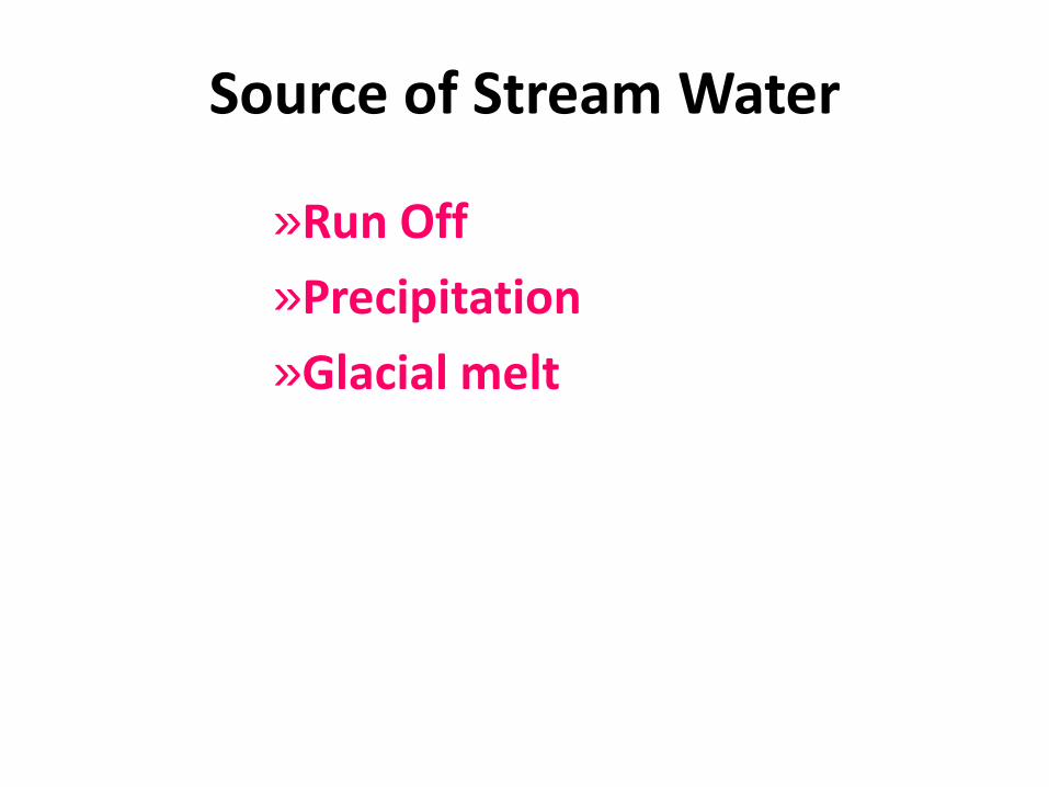
Source of Stream Water
»Run Off
»Precipitation
»Glacial melt

Streams and Stream Systems
• Stream orders
– Small streams join larger ones
– Relationship called streamorders
– First order versus second andthird order
– Smaller numbers in streamorder are more frequent
– Larger numbers are longer inlength and watershed order
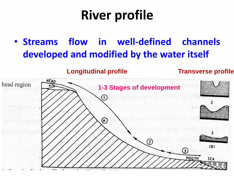
River profile
• Streams flow in well-defined channelsdeveloped and modified by the water itself
1-3 Stages of development
Longitudinal profile Transverse profile

Old stage
LIFE HISTORY OF RIVERS
Youthful stage
Matured stage

Geological work of River
• The water flowing from head to mouth the streams aregreatly modifying the topography of the region throughwhich they are flowing.
• This is three type
I. Erosion
II. Sediment Transport
III. Deposition

I. River Erosion
1. Methods of River erosion
2. Rate of River Erosion
3. Features / landforms of River Erosion
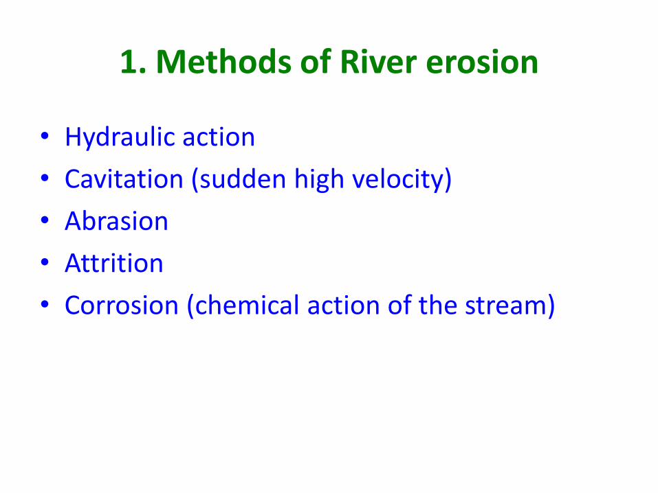
1. Methods of River erosion
• Hydraulic action
• Cavitation (sudden high velocity)
• Abrasion
• Attrition
• Corrosion (chemical action of the stream)

2. Rate of River Erosion
• Depends upon the
• Velocity of stream
• Lithology
• Load (volume of sediments)
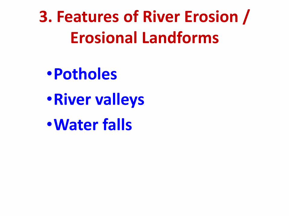
3. Features of River Erosion /Erosional Landforms
•Potholes
•River valleys
•Water falls

Potholes
• Depression of soft rock is pot holes
• It is done by hydraulic action
• Ranges from few cm to many meters indecent

• Potholes are erodedinto streambed by theabrasive action of thesediment load in thestream

River valleysdepressions formed by streams
a) Origin of valleys
(Gullies) (Ravines)(Valleys)
Start with gullies pass to ravines and end with valleys

b) Valley deepening
• It is achieved by all theerosional processes such ashydraulic action, abrasionand chemical action
(Example: Gorges and canyons)
• Base level of erosion:
– The lowest level up to which a river can erode its channel.

c) Valley Lengthening
L1 = initial length
L2 = Length after tributary capture
• stream receives a Number of tributary extendingthe valley length known as lengthening

River capture / piracy
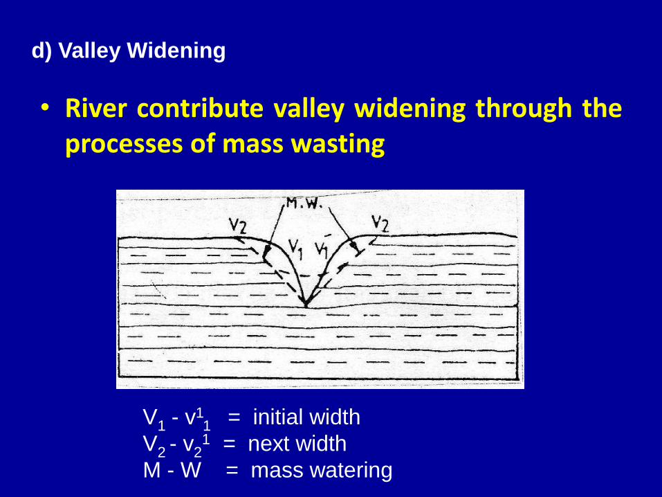
d) Valley Widening
V1 - v11 = initial width
V2 - v21 = next width
M - W = mass watering
• River contribute valley widening through theprocesses of mass wasting

Valley profile
• Transverse profile
• Longitudinal profile
P1= present P1-P5= imaginary

• Escarpment
• Dip slope
• Cuesta
• Hogback
• Mesa and Butte

Step like Escarpment(Iguassu Falls, Brazil)

WATER FALLS (Niagara Falls, Ontario, Canada)
Water falls

Sediment transport by River
1. Types of Load
2. Grading of Streams

1. Types of Load
• Suspended load - sediment that issmall/light enough to remain abovethe stream bottom
• Bed load - large or heavy particlesthat travel on the streambed– It consist of heavier particles of sand
pebbles gravel & cobbles
• Dissolved load - dissolved ionsproduced by chemical weatheringof soluble minerals
Bed load
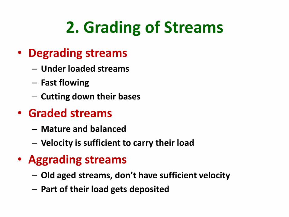
2. Grading of Streams
• Degrading streams– Under loaded streams
– Fast flowing
– Cutting down their bases
• Graded streams– Mature and balanced
– Velocity is sufficient to carry their load
• Aggrading streams– Old aged streams, don’t have sufficient velocity
– Part of their load gets deposited

Degrading streams

Graded streams

Aggrading streams

Deposition by Rivers
• The process:
– Dropping down of its load by any moving naturalagent is technically called deposition

Type of Fluvial deposits
• The deposits that are laid down by runningwater are called alluvial or fluvial or fluviatiledeposits
• Alluvial fans & cones
• Flood plain
• Deltas
• Channel Deposits
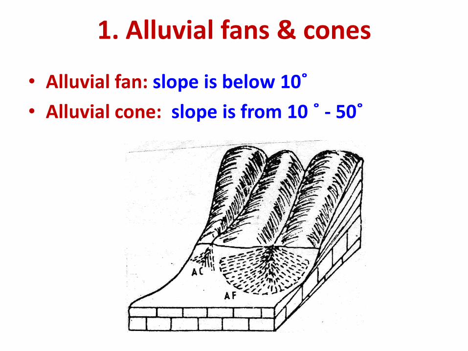
1. Alluvial fans & cones
• Alluvial fan: slope is below 10˚
• Alluvial cone: slope is from 10 ˚ - 50˚

ALLUVIAL FAN
IRS 1D – IRAN

Alluvial Fan

2. Flood plains• There may come periods of high-water level in a
stream during which it over flow on banks andspreads over vast area on its sides
• Such a process get repeated year after year
• The low lying areas surrounding major rivers aremade up of the layer of mud deposit laid after anumber of floods - called flood plains
Convex F.P Flat F.P

when the river floods it’s plays the loose sediments on either
banks called Flood plains.
It will have loose un consolidated sediments
Retain more moisture
Accumulate better Ground water
Better recharge zone from river
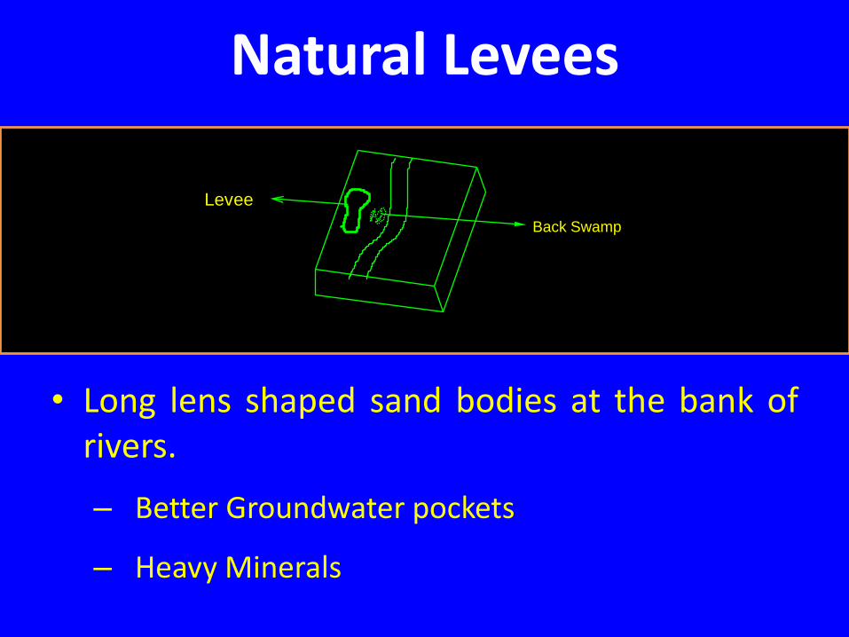
Natural Levees
• Long lens shaped sand bodies at the bank ofrivers.
– Better Groundwater pockets
– Heavy Minerals
Back Swamp
Levee

Levee
Unpaired
Flood Plain
Back Swamp

3. Channel Deposits• Many streams are forced by some natural causes to
deposit some of their load along their riverbeds.
• Great of economic use:
– Source of sand and gravels : suitable for constructionmaterials.
• Sandbars:
– Narrow ridge sand deposits in the riverbed
– Temporary in nature
Lensoid sand bodies within the river
Due to loss of bed load
Nearing of coastal zone
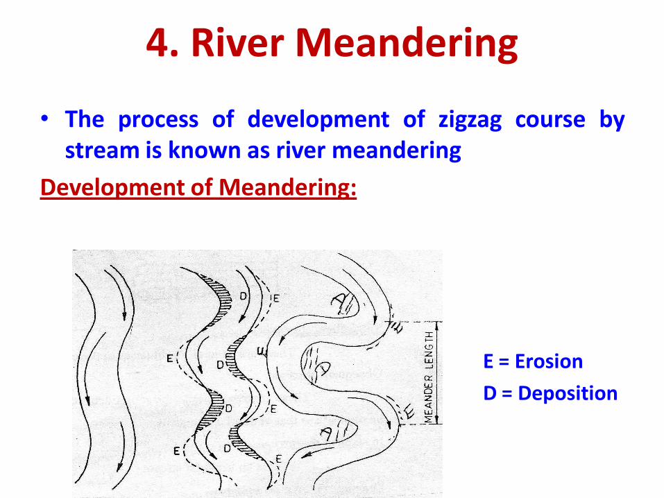
4. River Meandering
• The process of development of zigzag course bystream is known as river meandering
Development of Meandering:
E = Erosion
D = Deposition

Oxbow Lakes
The advanced stages of a meandering
Having loops or completely detached
The isolated area often contains waterfrom the same river are called OXBOWLAKES

5. Deltas • Deltas are defined as
alluvial deposit of roughlytriangular shape that aredeposited by the rivers atthe paints where theyenter into the sea
• The bottom set
– It is formed at the base ofthe delta by a gentle seaward inclination
• The foreset
– shows very steepinclination towards sea andmade up of thick layers ofsand & clay
• The topset
– It is a thin layer with gentleslope

LOBATE DELTA

CONTENENTAL DELTA - VAIGAI

Bay of Bengal
The Ganges and Brahmaputra
Rivers combined have formed
one of the largest deltas in
the world, comprising
approximately 105 640 km2.

THE CYCLE OF EROSION
• Depends on
– Humid environment
– Arid environment

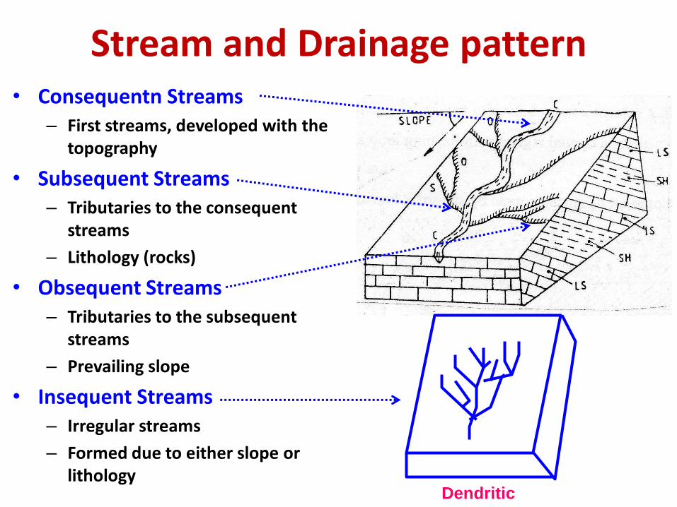
Stream and Drainage pattern• Consequentn Streams
– First streams, developed with the topography
• Subsequent Streams– Tributaries to the consequent
streams
– Lithology (rocks)
• Obsequent Streams– Tributaries to the subsequent
streams
– Prevailing slope
• Insequent Streams– Irregular streams
– Formed due to either slope or lithology
Dendritic

DRAINAGE PATTERNS
Pattern Origin Characteristics Geology
Dendritic Insequent Random,Acute-angle junctions
Homogeneous,Horizontal beds
Trellis Subsequent Parallel streams,High-angle junctions
Heterogeneous,Tilted beds
Rectangular / angular
Subsequent High-angle junctions,High-angle bends inTributaries
Jointed rocks
Annular Subsequent Circular patterns Heterogeneous,Breached domes
Radial Consequent Streams flowing in alldirections fromCentral high area
Volcanic or intrusivedomes


Dendritic Drainage
• Tree with branches
• Homogeneous lithology
• Granitic terrain

Softer
lithology
Trellis Drainage

Rectangular drainage
Zones of mutually
Perpendicular Joints

Annular Drainage
• Anomalous annularity in drainages
• Indicates surficial and subsurface domes and basins

Radial Drainage
(a) Radial centrifugal domes
(b) Radial centripetal basin
Domes and
basins

Superimposed Drainage
• The drainages of that are retaining their original character ofthe formation in which they were formed but misfit orsuper imposed over other formation.

Antecedent Drainage
• Gradual uplift of the crustal blocks
Present
course
Old course
Drainage
drainages got deflected due to later tectonic activities, doming,
arching subsidence etc.

Floods • Different Interval times
– Dry stage, half-full stage and bank-full stage
• Causes – Topography
– Lithology
– Vegetation
• Magnitude and Frequency– Hydrograph (Time Vs Discharge)
• Flood control– Afforestation
– Check dams
– Deepening of channel
– Diversion of channels
– Flood zonation mapping


Stage Landscape Processes
youthful steep hillsides,drainage divides predominant
V-shaped valleys
headward erosion,stream downcutting
mature rounded hills, valley walls predominant
graded streamsbroad floodplains
lateral erosion, streams adjust to discharge/load
old age “peneplane,”close to base level
very low relief,sluggish stream flow,
poor drainage
• The Cycle of Erosion

WHY TO STUDY FLUVIAL LANDFORMS ?
1. To understand the ongoing erosional and
depositional dynamics of the river systems
2. To fabricate the past fluvial activites of the various geological basins so as to understand the basin
dynamics and resources.
3. To fabricate the palaeo flood cycle.
4. To understand seismicity status.
5. To understand the areas prone for erosion and reservoir siltation.
6. To locate placer deposits.

7. To detect Groundwater locales
8. To identify Zones of natural and artificial recharge.
9. To identify vulnerable areas for pollution.
10. To select suitable sites for dams , reservoirs and
bridges.
11. To locate deltas and palaeo shores.

11. To locate deltas and palaeo shores.
12. To locate interdependent forces between marine & fluvial
forces.
13. To locate locales of hydrocarbon.
14. To draw Plans for Command area development
15. Inter linking of Rivers

![[PPT]Unit 2: River Valley Civilizations - levittownschools.comsites.levittownschools.com/ckind/Documents/Unit 2 River... · Web viewUnit 2: River Valley Civilizations Essential Questions:](https://img.pdfslide.us/doc/110x75/5ae431067f8b9a5b348e63bf/pptunit-2-river-valley-civilizations-2-riverweb-viewunit-2-river-valley.jpg)