Embed Size (px)
Citation preview
THE IN-SITU PROPERTIES OF CLAY SOIL IN PEKAN USING CONE
PENETRATION TEST
NUR ZAKI BIN ARBAIN
A thesis submitted in partial fulfillment of the
requirements for the award of the degree of
Bachelor of Civil Engineering
FACULTY OF CIVIL ENGINEERING & EARTH RESOURCES
UNIVERSITI MALAYSIA PAHANG
NOVEMBER, 2010
ABSTRACT
Construction project for civil structures always experience big challenges in
order to ensure no conflict to the foundation. As we know, foundation is an important
initial work in a construction of civil structure. if a foundation is not designed
according to its requirement and properly, collapse to the building might be occurred.
The construction of foundation needs to take account for the strength (bearing
capacity) of the site area. Here, site investigation plays an important role. Through
the results of site investigation, the choosing for suitable type of foundation can be
accomplished. This study had covered important aspects towards the choosing of
foundation for a building construction. The objectives of this study is to determine
the parameters of soil at site study and to determine the soil profile for site study
using the method of Piezocone's Cone Penetration Test. This method had been
chosen as it is the most reliable method to obtain dynamic pore pressure parameter at
site study among all site investigation method. Through this method, data obtained
had been tabulated and graphs had been plotted. The conclusions obtained from these
data are for the parameters; cone resistance is 12.07 MPa, sleeve friction is 0.06 MPa
and dynamic pore pressure is 0.65 MPa. The site study (Pekan) also had been
concluded to be classified in clays type of soil with clays-clayey to silty clay. From
above data, further analysis and calculation to obtain the suitable foundation for clay
type of soil can be proceed.
V
ABSTRAK
Projek pembinaan bagi struktur awam sering menghadapi cabaran besar
dalam memastikan tiada masalah terhadap asas tapak. Seperti yang kita ketahui, asas
tapak merupakan permulaan yang paling penting dalam pembinaan sesebuah
bangunan. Jika asas tapak bangunan tidak direkabentuk mengikut standard dan
dengan baik, keruntuhan bangunan berkemungkinan besar akan berlaku. Pembinaan
asas tapak haruslah melihat kepada kekuatan tanah di kawasan pembinaan. Di
sini,aspek penyiasatan tapak amatlah penting. Melalui dapatan keputusan
penyiasatan tapak terhadap kawasan kerja, pemilihan jenis asas tapak yang sesuai
mengikut jenis pembinaan bangunan dapat dilaksanakan. Kajian mi telah
merangkumi aspek-aspek penting dalam menuju kepada pemilihan asas tapak yang
sesuai untuk pemilihan sesebuah pembinaan bangunan. Objektif kajian mi ialah
mengetahui parameter-parameter tanah di tapak kajian dan mengetahui jenis profil
tanah di tapak kajian melalui kaedah Piezocone's Cone Penetration Test. Prosedur
kaedah penyiasatan telah dipilih befdasarkan kemampuan kaedah tersebut untuk
mencari parameter bagi tekanan hang dinamik (dynamic pore pressure) tapak kajian
berbanding kaedah penyiasatan tapak yang lain. Melalui kaedah penyiasatan di atas,
data-data telah dijadualkan dan graf telah diplotkan. Rumusan telah mendapati
bahawa, nilai parameter bagi cone resistance ialah 12.07 MPa, sleeve friction ialah
0.06 MPa dan dynamic pore pressure ialah 0.65 MPa. Kawasan tapak kajian (Pekan)
juga telah didapati tergolong dalam jenis tanah hat. Melalui dapatan data-data
tersebut, dapatlah dilakukan anahisis pengiraan selanjutnya bagi mendapatkan jenis
asas tapak yang sesuai bagi kawasan jenis tanah hat.
vi
TABLE OF CONTENTS
CHAPTER TITLE PAGE
DECLARATION
DEDICATION
ACKNOWLEDGEMENT iv
ABSTRACT v
ABSTRAK vi
TABLE OF CONTENTS vii
LIST OF TABLES xi
LIST OF FIGURES xii
LIST OF SYMBOLS xiv
LIST OF APPENDICES xv
CHAPTER 1 INTRODUCTION
1.1 Introduction 1
1.2 Problem statement 3
1.3 Objective 4
1.4 Scope of study 4
1.5 Significant of study 5
vi'
vi"
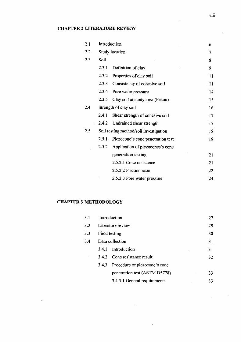
CHAPTER 2 LITERATURE REVIEW
2.1 Introduction 6
2.2 Study location 7
2.3 Soil 8
2.3.1 Definition of clay 9
2.3.2 Properties of clay soil 11
2.3.3 Consistency of cohesive soil 11
2.3.4 Pore water pressure 14
2.3.5 Clay soil at study area (Pekan) 15
2.4 Strength of clay soil 16
2.4.1 Shear strength of cohesive soil 17
2.4.2 Undrained shear strength 17
2.5 Soil testing method/soil investigation 18
2.5.1. Piezocone's cone penetration test 19
2.5.2 Application of piezocones's cone
penetration testing 21
2.5.2.1 Cone resistance 21
2.5.2.2 Friction ratio 22
2.5.2.3 Pore water pressure 24
CHAPTER 3 METHODOLOGY
3.1 Introduction 27
3.2 Literature review 29
3.3 Field testing 30
3.4 Data collection 31
3.4.1 Introduction . 31
3.4.2 Cone resistance result 32
3.4.3 Procedure of piezocone's cone
penetration test (ASTM D5778) 33
3.4.3.1 General requirements 33
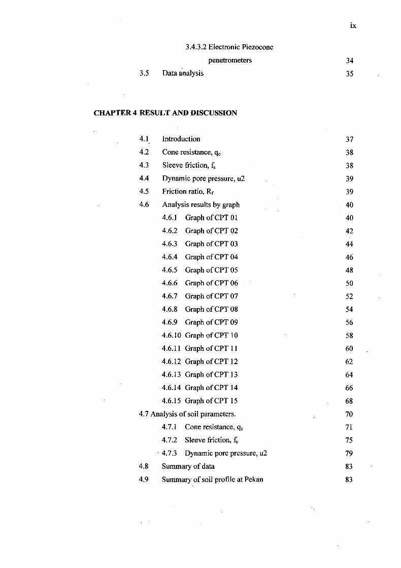
Ix
3.4.3.2 Electronic Piezocone
penetrometers 34
3.5 Data analysis 35
CHAPTER 4 RESULT AND DISCUSSION
4.1 Introduction 37
4.2 Cone resistance, qc 38
4.3 Sleeve friction, f 38
4.4 Dynamic pore pressure, u2 39
4.5 Friction ratio, Rf 39
4.6 Analysis results by graph 40
4.6.1 Graph of CPT O1 40
4.6.2 Graph of CPT 02 42
4.6.3 Graph of CPT 03 44
4.6.4 Graph of CPT 04 46
4.6.5 Graph of CPT 05 48
4.6.6 Graph of CPT O6 50
4.6.7 Graph of CPT 07 52
4.6.8 Graph of CPT O8 54
4.6.9 Graph of CPT 09 56
4.6.10 Graph of CPT lO 58
4.6.11 Graph of CPT 11 60
4.6.12 Graph of CPT 12 62
4.6.13 Graph of CPT l3 64
4.6.14 Graph of CPT l4 66
4.6.15 Graph of CPT 15 68
4.7 Analysis of soil parameters. 70
4.7.1 Cone resistance, q 71
4.7.2 Sleeve friction, f 75
4.7.3 Dynamic pore pressure, u2 79
4.8 Summary of data 83
4.9 Summary of soil profile at Pekan 83
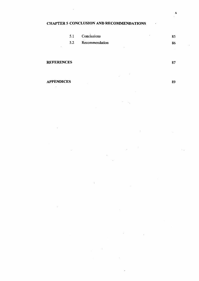
CHAPTER 5 CONCLUSION AND RECOMMENDATIONS
5.1 Conclusions 85
5.2 Recommendation 86
REFERENCES
87
APPENDICES 89
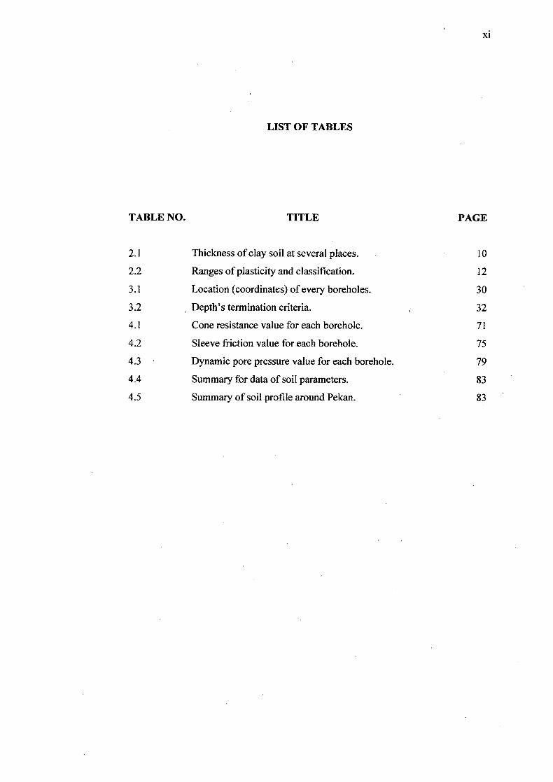
LIST OF TABLES
TABLE NO. TITLE PAGE
2.1 Thickness of clay soil at several places. 10
2.2 Ranges of plasticity and classification. 12
3.1 Location (coordinates) of every boreholes. 30
3.2 Depth's termination criteria. 32
4.1 Cone resistance value for each borehole. 71
4.2 Sleeve friction value for each borehole. 75
4.3 Dynamic pore pressure value for each borehole. 79
4.4 Summary for data of soil parameters. 83
4.5 Summary of soil profile around Pekan. 83
xi
LIST OF FIGURES
FIGURE NO. TITLE PAGE
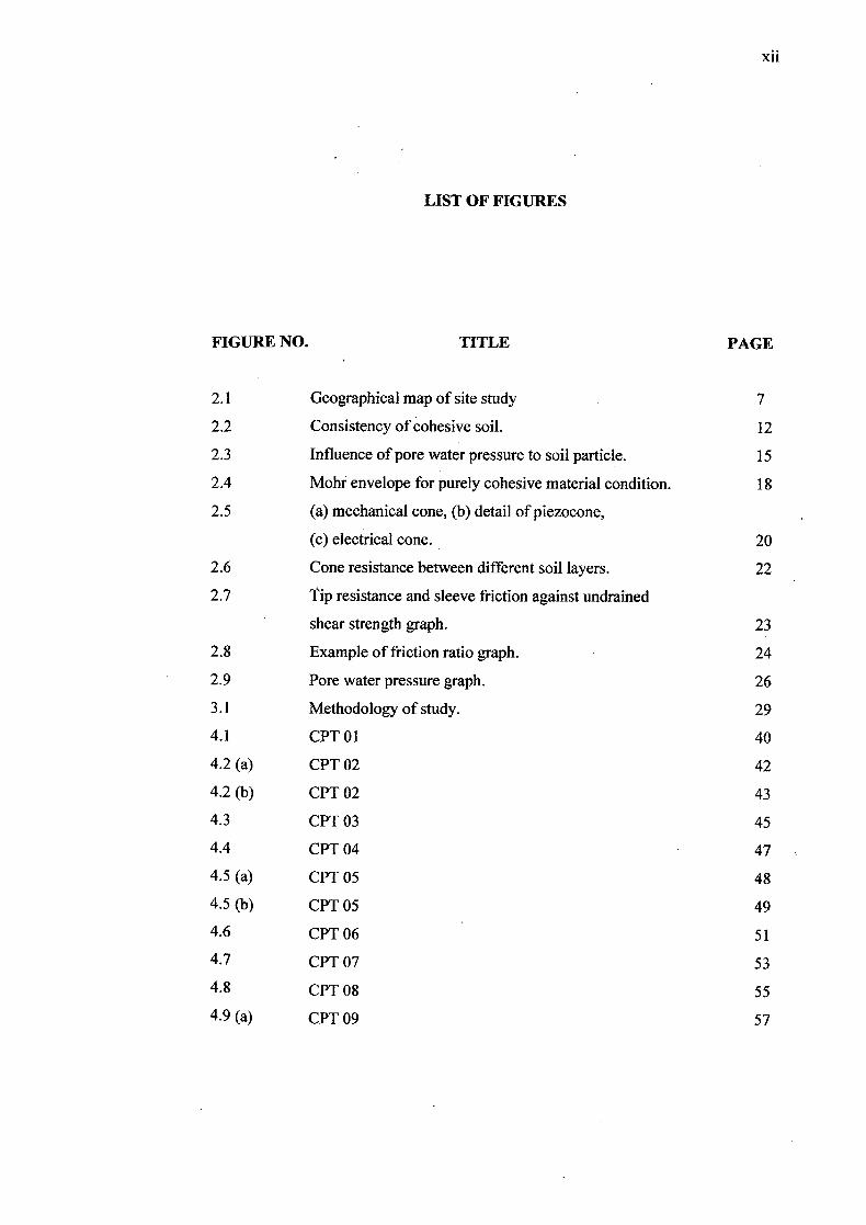
2.1 Geographical map of site study 7
2.2 Consistency of cohesive soil. 12
2.3 Influence of pore water pressure to soil particle. 15
2.4 Mohr envelope for purely cohesive material condition. 18
2.5 (a) mechanical cone, (b) detail of piezocone,
(c) electrical cone. 20
2.6 Cone resistance between different soil layers. 22
2.7 Tip resistance and sleeve friction against undrained
shear strength graph. 23
2.8 Example of friction ratio graph. 24
2.9 Pore water pressure graph. 26
3.1 Methodology of study. 29
4.1 CPT 01 40
4.2 (a) CPT 02 42
4.2 (b) CPT 02 43
4.3 CPT 03
4.4 CPT 04
4.5 (a) CPT 05 48
4.5(b) CPT 05
4.6 CPT 06 51
4.7 CPT 07 53
4.8 CPT 08 55
4.9(a) CPT 09 57
xl'
XIII
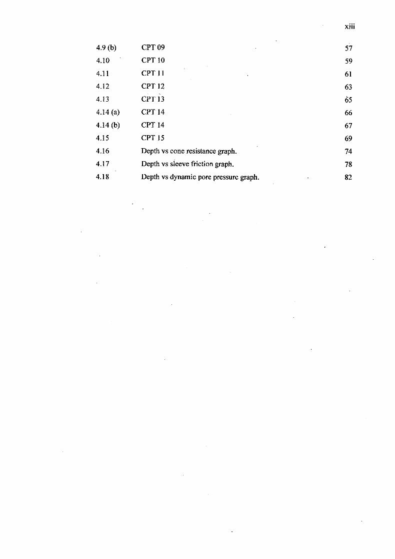
4.9(b) CPT 09 57
4.10 CPT 10 59
4.11 CPT 11 61
4.12 CPT 12 63
4.13 CPT 13 65
4.14(a) CPT 14 66
4.14(b) CPT 14 67
4.15 CPT 15 69
4.16 Depth vs cone resistance graph. 74
4.17 Depth vs sleeve friction graph. 78
4.18 Depth vs dynamic pore pressure graph. 82
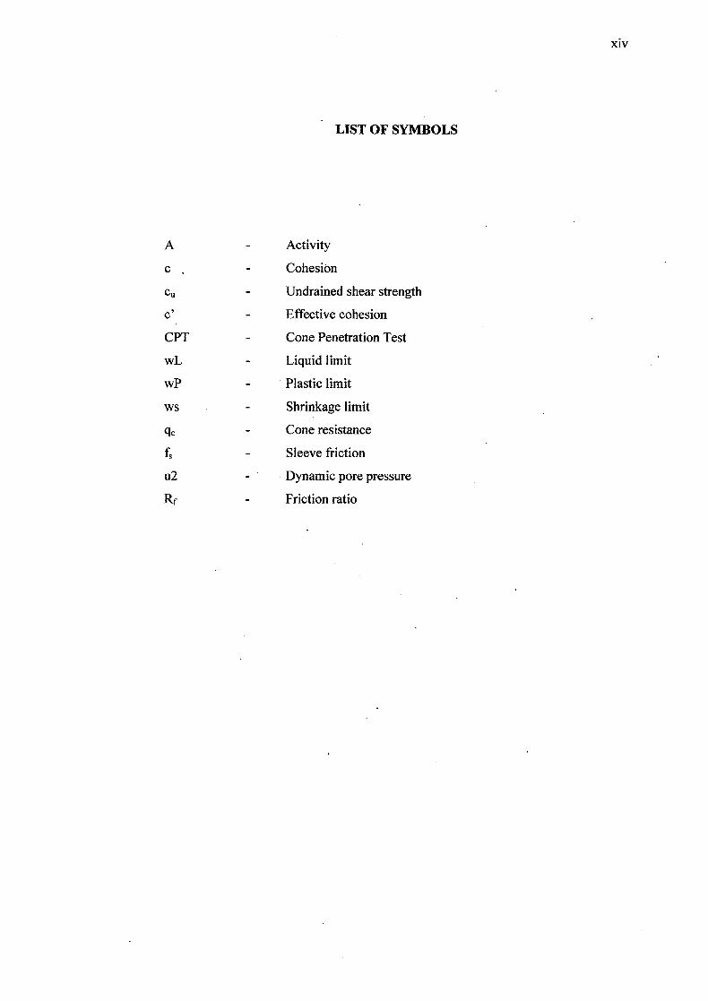
LIST OF SYMBOLS
A - Activity
c - Cohesion
C, - Undrained shear strength
c' - Effective cohesion
CPT - Cone Penetration Test
wL - Liquid limit
wP - Plastic limit
ws - Shrinkage limit
q - Cone resistance
fS - Sleeve friction
u2 - Dynamic pore pressure
Rf - Friction ratio
xiv
xv
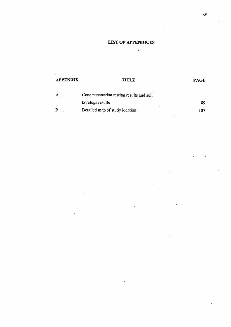
LIST OF APPENDICES
APPENDIX TITLE PAGE
A Cone penetration testing results and soil
borelogs results 89
B Detailed map of study location 107
CHAPTER 1
INTRODUCTION
1.1 Introduction
Soil is a natural property of earth which is formed by a small pieces of
mineral particle and it may contain three properties; water, air and organic material.
Soil is the oldest and the most complex of the construction materials used by
engineers. More generally, soil is a three phase system comprised of various
combinations of naturally-derived solids including fine to coarse-grained rock and
minerals organic matter, weathered rock and precipitates, liquid primarily water
solutions and gases (Rosnah, 2008). The behavior of soil itself is very important in
civil engineering field design. Properties of soil are an essential prior to any
geotechnical design. Due to the different situation at every field, properties of the soil
need to be determined and tested first before constructing any structure at the site.
The soil classification systems that are commonly used are AASTHO (American
Association of State Highway and Transportation Officials), Unified Soil
Classification System and British Soil Classification System. Besides, ASTM
(American Standard Testing Method) also play a major role in classify and determine
soil properties.
2
It has been discussed that soil is formed by the process of physical and
chemical weathering. The individual size of the constituent parts of even the
weathered rock might range from the smallest state to the largest possible. This
implies that all the weathered constituents of a parent rock cannot be termed as soil.
According to their grain sizes, soil particles are classified as cobbles, gravel, silt and
clay (Murthy V.N.S, 2002). In order to build a structure on top of the ground, some
experimental method should be done to determine the strength of the soil. Otherwise,
structure built will fail and even will collapse. There are two type of soil testing
method which is field testing (in-situ testing) and laboratory testing to gain data and
test soil sample. Soil which is not suitable enough in term of property, such as
strength of soil need to be treat well if structures are intended to be built at the site.
Shear strength is one of the most important geotechnical parameter which
used by engineers in designing foundation, slope stability, dam and structure. Shear
strength of soil is measured and determined depending on type of soil tested. The
undrained shear strength of clay soil in Pekan will be studied in this report.
Kuala Pekan is one of several places in peninsular Malaysia which has an
availability of soft soil existence. Soft soil in this area is reaching until the 40 meter
depth. Accordingly, the other places are Johor, Melaka, Pelabuhan Klang, Alor Star,
some part of Terengganu and some part of east coast peninsular Malaysia (Ting and
Ooi, 1976). The undrained shear strength of this area, Pekan will be determined by
in-situ testing method and the result will show that whether treatment of soil is need
to be done when a structure is intend to be built.
3
1.2 Problem statement
Since the soft soils have a low shear strength and high compressibility, the
constructions on this soft soil is a challenge to engineers (Mitchell, 1993). The
geotechnical properties of clay soil are proved to have high cohesive value and
friction ratio. The clay soil at Pekan will be tested by in-situ method which is
Piezocone's Cone Penetration Test (ASTM D5778).
Strength of soil need to be determined in order to analyze which foundation is
suitable to be applied on site area. A foundation needs to be build as its function is to
transmit the weight of the structure. Without foundation as a base, a structure can not
be built on site. By revising the strength of soil, we can notice whether it is
competent enough to support loads from structure. If the strength of soil shows that it
is unable to support loads, reinforcement on soil can be made or foundation can be
made deeper into the earth layer.
The existence of pore water pressure can influenced the soil stability. The
pore water pressure will produce the seepage in the soil layer which is has connection
with the depth below the groundwater table. The profile of clay soil is known to have
excessive pore water pressure and seepage in soil layer due to its particle size which
can be classified as finer.
The significance of knowing the clay's physical properties is engineers will
get to know the condition of the soil. Such as the condition of pore water pressure,
the consistency of soil, the seepage and the testing suitable to determine the strength
of soil.
4
1.3 Objective
The objectives of this study of soil analysis are as stated below:
i. to determine soil parameters using Piezocone Cone Penetration Test at
Pekan.
ii. to determine the soil profile based on the in situ testing (Piezocone's
Cone Penetration Test (ASTM D5778).
1.4 Scope of study
This study will focus on the specific scope which has been determine to
ensure that research done is precise with the study area chosen. The scope of study
has been narrowed down so the study will not exceed the limit stated. Below are the
narrowed scopes of study:
i. Location of study
Pekan is the location chosen which is located at the bank of Pahang
River and 50 km south from Kuantan town. Pekan is also located
approximately 6500km from South China Sea. Exact location will be chosen
is Kuala Pahang and Langgar (Pekan's subdistricts)
5
ii. Scope of work
The scope of work involved in this study is in-sitU soil testing. Testing
is involving the piezocone's cone penetration test apparatus (Piezocone's
Cone Penetration Test (ASTM D5778)). The testing method will be done on
the field as for this test, there is no laboratory testing.
Properties of material (soil)
The properties of the soil is said to be categorized as soft soil as Pekan
is situated at the river bank of Pahang River. Usually area which is stated is
near a river or sea.
1.5 Significant of study
This study will give information on the properties of clay soil at Pekan
especially the properties of soil parameter. This information is beneficial to student
who wanted to do further research about the properties of clay soil at Pekan. Site
investigation is carried out and determination of soil properties at in-situ condition,
which can give actual condition of natural condition of soil. The Piezocone's Cone
Penetration Test is less at cost and time value as it is done right at the site area. It is
also produce more result for the soil properties. It is very significance as engineers
will be able to determine other properties of soil at the site area. Moreover, Cone
Penetration Test is also a fastest way to get data at site area as the testing is not
taking a long time to come out with soil data.
CHARTER 2
LITERATURE REVIEW
2.1 Introduction
The shear strength of a clay soil can be influenced by the particle size of the
soil, the pore water pressure, total stress of soil and many more. This chapter will
discuss the important element that influenced the shear strength of soil. The clay soil
of the site area of Pekan, Pahang will be studied for its shear strength by the in-situ
testing.The important element in this chapter which have to be taken note is the
testing method; the Piezocone's Cone Penetration Test (ASTM D5778). This test will
also be discussed at the end of this chapter, reviewing for its previous data result,
previous graph presented and the significance of the testing.
7
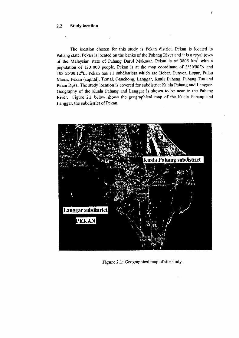
2.2 Study location
The location chosen for this study is Pekan district. Pekan is located in Pahang state. Pekan is located on the banks of the Pahang River and it is a royal town of the Malaysian state of Pahang Darul Makmur. Pekan is of 3805 km2 with a population of 120 000 people. Pekan is at the map coordinate of 3°30'00"N and 103 025'00.12"E. Pekan has 11 subdistricts which are Bebar, Penyor, Lepar, Pulau Manis, Pekan (capital), Temai, Ganchong, Langgar, Kuala Pahang, Pahang Tua and Pulau Rusa. The study location is covered for subdistrict Kuala Pahang and Langgar. Geography of the Kuala Pahang and Langgar is shown to be near to the Pahang River. Figure 2.1 below shows the geographical map of the Kuala Pahang and Langgar, the subdistrict of Pekan.
Figure 2.1: Geographical map of site study.
8
The borehole testing will be held around Langgar and Kuala Pahang subdistricts for all 15 numbers. For detail of boreholes location on map, refer the appendix.
2.3 Soil
In this world, there is an element called soil which is covered the earth
approximately at 30%. Soil can be divided into several groupings according to the
system of classification which has been revised all around the world by geologists
and soil scientists. Soil can be grouped through its physical properties. Soils consist
of grains (mineral grains, rock fragments, etc.) with water and air in the voids
between grains. The water and air contents are readily changed by changes in
conditions and location: soils can be perfectly dry (have no water content) or be fully
saturated (have no air content) or be partly saturated (with both air and water
present). Although the size and shape of the solid (granular) content rarely changes at
a given point, they can vary considerably from point to point. Generally, soil can be
classified into cohesion less soil and cohesive soil. Soils as we know are sand, clay
soil, peat soil, silt and gravel. Each one of the group soil has different physical
properties with other soil's groups. This shows the uniqueness of every soil group as
an important element in the civil engineering field. This study will focus on clay soil
as a main subject.
It is very important for one to have skill on differentiate among types of soil
referring to their plasticity analysis and gradation in fields. Even though this
information is available in the laboratory testing, engineers should be able to
differentiate among soils in the field. Such situation involving the excavating process
which needed one to excavate until the certain layer will need an engineer to give a
stop order whenever the excavation process has reached to the selected soil layer.
This is a reason why all major construction projects require on-site inspection.
Granular soil, fine-grained soil and coarse-grained soil are needed to be differentiated
9
among them. In this project study, the fine-grained soil properties will be discussed
as the clay is classified as fine-grained soil.
2.3.1 Definition of clay
Cohesive soil or clay soil is a group of soil, determined through the
classification system by soil scientists. Basically, clay particles are flaky and their
thickness is very small relative to their length and breadth. They therefore have high
to very high specific surface value. These surfaces condition somehow
electrochemically causes a lot of water whether held or absorbed within clay mass.
Clay or fine-grained soil will not crumble and is in a plastic condition when is
moisture. Cohesive or clay soil is hard to break up when it is in dry condition. Clay
can be grouped as clayey silt, sandy clay, silty clay, clay and organic clay. Clays are
produced mainly from the chemical weathering and decomposition of feldspars, such
as orthoclase and plagioclase, and some micas. They are small in size and very flaky
in shape. The structure of clay itself is the key to clay main properties, such as
plasticity, compressibility and shrinkage/swell potential. Clay is defined as having
very small particle sizes, sticky and plastic. This is due to its properties which has
high content of moisture in the soil structure.
Clay is consist of several minerals such as Silica Tetrahedron and Alumina
Octahedrons as the basic mineral units; composing the clay minerals. Particle size of
clay is very small which is less than 2m and electrochemically is very active.
Minerals of clay are produced mainly from the chemical weathering and
decomposition of feldspars such as Orthoclase and Plagioclase (Rosnah, 2008).
In Malaysia, clay soil or soft soil are available along the west coast of
Peninsular Malaysia such as Johor, Malacca, Port Klang and some part of east coast
10
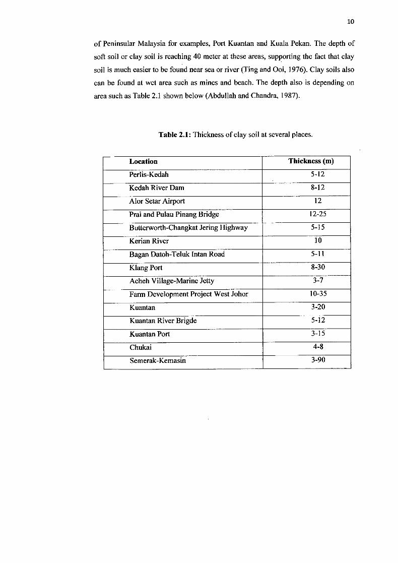
of Peninsular Malaysia for examples, Port Kuantan and Kuala Pekan. The depth of
soft soil or clay soil is reaching 40 meter at these areas, supporting the fact that clay
soil is much easier to be found near sea or river (Ting and Ooi, 1976). Clay soils also
can be found at wet area such as mines and beach. The depth also is depending on
area such as Table 2.1 shown below (Abdullah and Chandra, 1987).
Table 2.1: Thickness of clay soil at several places.
Location Thickness (m)
Perlis-Kedah 5-12
Kedah River Dam 8-12
Alor Setar Airport 12
Prai and Pulau Pinang Bridge 12-25
Butterworth-Changkat Jering Highway 5-15
Kerian River 10
Bagan Datoh-Teluk Intan Road 5-11
Kiang Port 8-30
Acheh Village-Marine Jetty 3-7
Farm Development Project West Johor 10-35
Kuantan 3-20
Kuantan River Brigde 5-12
Kuantan Port 3-15
Chukai 4-8
Semerak-Kemasin 3-90
11
2.3.2 Properties of clay soil
From the view of soil texture, soil scientists have proved that, clay soil have
the smallest sized particles and sticky when held as mention at the paragraph earlier.
Clay soil also show a character of hardly to be squeezed. The smallest sized particles
of clay soil influenced the porosity, permeability, water holding capacity and soil
particle surface. Clay soils show that for porosity properties, it dominantly has small
pores and slow in permeability. Clay also capable of holding water in a very large
capacity, same goes with the soil particle surface.
2.3.3 Consistency of cohesive soil
Soil classification is the arrangement of soils into various groups or
subgroups to provide a common language, expressing briefly the general usage
characteristics without any detailed descriptions. Currently, there are two major
classification system, which are Unified Soil Classification System (USCS) and
Association of State Highway and Transportation Officials (AASTHO).
Taken from the analysis of the USCS, clay soil/fine-grained soil is
characterized based on its plasticity index and the liquidity if the soil itself. From the
key word of plasticity index, we can notice that water content influences the
plasticity of a soil. In other word, since clay soils/fine-grained soils content water in
the structure, only fine-grained soil can be classified in plastic condition. The plastic
consistency is then termed as Plasticity Index. Table 2.2 shows the plasticity chart
ranges and the classification.
12
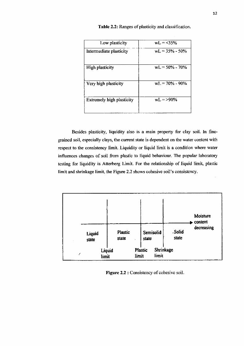
Table 2.2: Ranges of plasticity and classification.
Low plasticity wL = <35%
Intermediate plasticity wL = 35% - 50%
High plasticity wL = 50% - 70%
Very high plasticity wL = 70% - 90%
Extremely high plasticity wL = >90%
Besides plasticity, liquidity also is a main property for clay soil. In fine-
grained soil, especially clays, the current state is dependent on the water content with
respect to the consistency limit. Liquidity or liquid limit is a condition where water
influences changes of soil from plastic to liquid behaviour. The popular laboratory
testing for liquidity is Atterberg Limit. For the relationship of liquid limit, plastic
limit and shrinkage limit, the Figure 2.2 shows cohesive soil's consistency.
Moisture content decreasing
Liquid Plastic Semisolid .Solid
state state state state
Liquid Plastic Shrinkage
limit limit limit
Figure 2.2 : Consistency of cohesive soil.


![[ Pekan Review ] Bridging Universiti Malaysia Pahang to ... · Bridging Universiti Malaysia Pahang to the World Community ... Dato' Sri Abdul Aziz: ... [ Pekan Review ] Bridging Universiti](https://img.pdfslide.us/doc/110x75/5ac62be47f8b9a12608e0327/-pekan-review-bridging-universiti-malaysia-pahang-to-universiti-malaysia.jpg)