Embed Size (px)
Citation preview
110
The Grand Canal (China) No 1443 Official name as proposed by the State Party The Grand Canal Location Provinces, municipalities with province status, and cities: Beijing Municipality Tianjin Municipality Hebei Province: Cangzhou City, Hengshui City Jiangsu Province: Wuxi, Changzhou, Suzhou,
Huai’an, Yangzhou and Suqian Cities Zhejiang Province: Hangzhou, Ningbo, Jiaxing,
Huzhou and Shaoxing Cities Anhui Province: Huaibei City, Suzhou City Shandong Province: Zaozhuang, Jining, Tai’an,
Dezhou and Liaocheng Cities Henan Province: Zhengzhou, Luoyang, Shangqiu,
Anyang and Hebi Cities People’s Republic of China Brief description The Grand Canal forms a vast inland waterway system in the north-eastern and central eastern plains of China, passing through eight of the country’s present-day provinces. It runs from the capital Beijing in the north to Zhejiang Province in the south. Constructed in sections from the 5th century BC onwards, it was conceived as a unified means of communication for the Empire for the first time in the 7th century AD (Sui Dynasty). This led to a series of gigantic worksites, creating the world’s largest and most extensive civil engineering project ensemble prior to the Industrial Revolution. Completed and maintained by successive dynasties, it formed the backbone of the Empire’s inland communications system. Its management was made possible over a long period by means of the Caoyun system, the imperial monopoly for the transport of grain and strategic raw materials, and for the taxation and control of traffic. The system enabled the supply of rice to feed the population, the unified administration of the territory, and the transport of troops. The Grand Canal reached a new peak in the 13th century (Yuan Dynasty), providing a unified inland navigation network consisting of more than 2,000 km of artificial waterways, linking five of the most important river basins in China, including the Yellow River and the Yangtze. Still a major means of internal communication today, it has played an important role in ensuring the economic prosperity and stability of China over the ages. Category of property In terms of categories of cultural property set out in Article I of the World Heritage Convention of 1972, this is
a nomination for the serial inscription of 31 groups of buildings.
1 Basic data Included in the Tentative List 28 March 2008 International Assistance from the World Heritage Fund for preparing the Nomination None Date received by the World Heritage Centre 25 January 2013 Background This is a new nomination. Consultations ICOMOS has consulted TICCIH and several independent experts. Technical Evaluation Mission Two ICOMOS technical evaluation missions visited the property from 16 to 26 September 2013. Additional information requested and received from the State Party A letter was sent to the State Party on 2 October 2013 to request further information about: the status of the land owned by local communities and
their involvement in the management of the property; the information provided to property owners affected
by the measures to protect the property and the buffer zone;
the protection measures along the canal for ordinary sections (with no specific attributes but included in the property);
the boundaries of the buffer zone of the ordinary sections of the canal and the associated protection measures;
the monitoring system project.
The State Party replied on 29 October 2013, sending additional documentation which has been taken into account in this evaluation. A second letter was sent to the State Party on 16 December 2013, asking it to: confirm that all the components of the proposed sites
have been granted the highest degree of national protection;
supply a timetable for the introduction of the property monitoring system, confirm its staff resources, and provide information about how it functions;
consider extending and redefining the buffer zone to allow for different types of environment.
111
The State Party replied on 26 February 2014, sending additional documentation that has been taken into account in this evaluation. Date of ICOMOS approval of this report 6 March 2014
2 The property Description The Grand Canal is located in the vast plains of north-eastern and central eastern China. It runs from the present-day capital Beijing, in the north, to the province of Zhejiang, in the south, as far as the port of Ningbo, on the East China Sea. It connects five of the largest river basins in China: the Hai coastal river in the north which flows into the Bohai Gulf at Tianjin; the Yellow River which today runs to the north of Shandong, but which had southerly courses earlier in its history, until 1855; the Huai River whose lower course merged with the southern arm of the Yellow River; the Yangtze further south; and finally the Qiantang coastal river. The rivers generally flow from the mountainous west to the Yellow Sea and the East China Sea to the east. The Grand Canal system tends to connect them along a north-south axis, and it flows successively through five major natural regions: the great plain of north-eastern China and the downstream basin of the Yellow River; the low hilly zone of Shandong; the Yangtze delta with its numerous lakes; the coastal plain of Ningbo – Shaoxing; and the Qiantang estuary region. The Grand Canal connects the temperate regions of the north, with low or relatively low rainfall, and the subtropical regions further south, with a hot, wet climate that is particularly favourable for rice-growing. Furthermore, rainfall is seasonal, both in the north and south, with monsoons that represent major risks of flooding, giving rise to specific constraints for the construction of hydraulic facilities and the management of water resources. Built and maintained by the constant efforts of successive dynasties, the Grand Canal was a vital axis in the Empire’s lines of communication, particularly for the feeding of the population, the unified administration of the territory and cultural interchanges. In the 13th century, it provided a complete inland network of more than 2,000 km of navigable man-made waterways. The nominated property aims to present the most comprehensive sample possible of the range of vestiges of the historical facilities of the Grand Canal, over the whole of its course. The remains are either archaeological or constitute a hydraulic heritage which is in many cases still functioning. The Grand Canal has 10 main sections of ancient artificial waterways. The historic names have been preserved, and the canals are presented in chronological order according to which were completed first. The nominated serial property is made up of 31 individual properties, corresponding to a little over 1,000 km of navigable waterways, most of which are still filled with water, but some of which are today archaeological sites. Together
they represent a total of 85 major heritage items, consisting of 27 canal sections and 58 cultural heritage sites on the Grand Canal. The chosen properties illustrate archaeological sites showing its course, river navigation landscapes, technical facilities used for water management, urban landscapes associated with the canals, and monuments. The properties are as follows: Tongji Canal (7 properties, Provinces of Henan and Anhui): Part 1 (TJ-01), Hanjia is the archaeological site of an imperial granary, where the canal reaches the former capital Luoyang; it illustrates the principle of large-scale commercial interchanges for the benefit of the capital, and their control by the Caoyun imperial administration. Part 2 (TJ-02), Huiluo is the archaeological site of one of the largest granaries on the Grand Canal; it is a suburban site north-east of the present-day town of Luoyang; its vast scale illustrates the extensive range and power of the imperial Caoyun system. Part 3 (TJ-03), Zhengzhou is one of the few typical sections of the Tongji canal (20 km) still in use, close to the Yellow River; there is also an archaeological part (a reach providing a connection to the river and a water supply). Part 4 (TJ-04), Shangqiu Nanguan is an archaeological section of the Tongji Canal (1 km) which illustrates the techniques of construction of the canal and the use of rammed-earth revetments during the Tang and Song Dynasties; it also bears witness to the great size of this canal, designed in the 7th century. Part 5 (TJ-05), Shangqiu Xiayi forms another archaeological section of the canal (0.5 km) in the town of Jiyang; it also bears witness to the exceptional dimensions of the Tongji Canal, the shape of the dykes, and navigation practices. Part 6 (TJ-06), Liuzi consists of (1) a canal section (2 km) and (2) a bridge site; both are archaeological; they illustrate the canal facilities, which demonstrate great architectural quality in the use of stone, and the remains of boats, which confirm the scale of river traffic between the 7th and 11th centuries. Part 7 (TJ-07), Si comprises an annex section of the canal (6 km), which connected the town of Sicheng to the Xinsui River; this is a section that is still filled with water, and still has its rammed-earth revetments. It is an archaeological site. Wei Canal (or Yongji Canal) (2 properties, Henan): Part 8 (WH-01), Hua and Xun comprise a relatively long section of the Wei Canal (18 km); this is the best preserved section, and forms one of the most typical
112
landscapes illustrating ancient navigation in the inland regions. Part 9 (WH-02), Liyang is the archaeological site of a large granary dating from the Sui Dynasty; it is situated in the town of Xun, close to the Yellow River, and bears witness to the changes in form of silos and warehouses from the Sui to the Song Dynasty. Huaiyang Canal (or Li Canal) (3 properties, Jiangsu): Part 10 (HY-01), the Qingkou site near Huai’an consists of (1) a long section of the ancient canal (46 km) illustrating a canal landscape, (2) the archaeological remains of the Qingkou hydraulic complex designed to cross the former bed of the Yellow River and the junction with the Huai River, (3) the boat lock of Shuangjin, (4) the boat lock of Qingjiang, (5) the stone dyke of Lake Hongze. Benefiting from a water supply either from the Huai River or from the earlier course of the Yellow River, depending on the period, and the lake as a spillway, the Qingkou site is a vital nodal point of the Grand Canal and its history. It was completed in the 16th century and operated for around 200 years in its most elaborate form. It is one of the most emblematic sites in terms of the techniques and scientific knowledge embodied in the Grand Canal. Part 11 (HY-02), the archaeological site of the Caoyun Governor’s Mansion is close to the canal, in the former provincial capital Huai’an; it is the most important vestige of the Caoyun imperial administration. Part 12 (HY-03), the Yangzhou region comprises (1) a very long section of canal (134 km) and its branches in the town of Yangzhou; it illustrates a navigation landscape and an urban canal landscape; (2) the archaeological site of the drainage lock of Luibao; (3) the Yucheng post, (4) the remains of the ancient Shaobo dyke; (5) Shaobo docks; (6) Slender West lake, (7) Tianning palace and temple, (8) Ge garden, (9) Wang Lumen’s residence; (10) the Salt Ancestral Temple; and (11) Lu Shaoxu’s residence. This is one of the sections of the Grand Canal that has been in use for the longest period, demonstrating the hydrological changes that have occurred over the ages, and the gradual transition in navigation from lakes and natural rivers to an entirely artificial waterway; Yangzhou reflects the economic history of the canal, and was at the heart of the lucrative salt trade, and bears witness to the resulting urban and cultural wealth. The Jiangnan Canal (5 properties, Jiangsu and Zhejiang): Part 13 (JN-01), the Changzhou City section comprises a 23 km section of the canal which passes through the built-up area; it illustrates a typical landscape of the canal in the setting of a large city. Part 14 (JN-02), Wuxi City comprises (1) an urban section of the historic canal of Jiangnan (14 km), with two branches that encircled the former urban centre, (2) the historic Qingming bridge quarter. Wuxi embodies urban
landscapes associated with the canal, its everyday activities and its economy. Part 15 (JN-03), Suzhou comprises (1) a section of the canal in the marshes and then in the city, along with numerous urban branches (73 km); (2) Pan Gate on one of the branches of the canal; (3) Baodai Bridge; (4) the Shantang canal conservation zone; (5) the Pingjiang quarter, (6) the former Wujiang towpath. Just next to the Yangtze, Suzhou was from time immemorial a major regional economic and cultural capital; it bears witness to the most intense and most continuous use of the southern canal system, from the 6th century BC to the present day. Part 16 (JN-04), the Jiaxing-Hangzhou region comprises: (1) a long section of the canal with numerous branches (187 km), between Taihu Lake in the north and Qiantang River in the south, with navigation landscapes; (2) the archaeological site of Chang’an, bearing testimony to an 11th century three-gate lock, to which was added in the 14th century a boat passage with a winch-towing system; (3) the site of the Fengshan hydraulic gate, (4) the Fuyi granary at Hangzhou; (5) Changhong Bridge; (6); Gongchen Bridge; (7) Guangji Bridge, (8) the Qiaoxi conservation area at Hangzhou. This part of the canal bears witness to a diversified network of waterways associated with rivers and lakes. Part 17 (JN-05), Nanxun is a district of the canal which comprises: (1) an urban branch of the Jiangnan (or Ditang) Canal (2 km); (2) the urban area of Nanxum. This is a particularly well preserved urban section, and is typical of the canal, representing the prosperity it brought to the waterside populations. Zhedong Canal (4 properties, Zhejiang): Part 18 (ZD-01), Hangzhou Xiaoshan-Shaoxing is the start of the Zhedong Canal at the point where it links up to the Qiantang River, which it connects to the urban areas of Shushan, Shaoxing and Shangyu. It comprises: (1) the section of canal between these towns (90 km); (2) the docks of the distribution centre of Xixing; (3) Bazi Bridge; (4) the urban zone of the Bazi bridge; (5) a portion of the former towpath. This was an important traffic hub which was particularly active over a long historical period, in connection with the river and with maritime trade. Part 19 (ZD-02), Shangyu-Yuyao is a section of canal (25 km), which runs from the River Cao’e, in the town of Shangyu, for some twenty kilometres to the east and the River Yao; it bears witness to the economic role of the canal and the prosperity it generated. Part 20 (ZD-03), Ningbo is a section of canal (23 km) which runs to the town of Ningbo; this section is lateral to the Yao River, of which it forms a second artificial branch in order to avoid tidal currents. Part 21 (ZD-04), Ningbo Sanjiangkou is an urban river site at the confluence of the Yao and Fenghua Rivers, in the town of Ningbo which marks the end of the Grand
113
Canal in the south; its terminal port provides access to the East China Sea; this was the point of departure of the maritime silk route during the Song Dynasty. Tonghui Canal (2 properties, Beijing): Part 22 (TH-01), Old Beijing City comprises: (1) an urban section of the canal (0.5 km), which is an archaeological site; (2) the upper lock of Chengqing; (3) the lower lock of Chengqing; (4) Shixha Lake. Beijing marks the northern end of the Grand Canal, and also shows how canal planning affected the layout and drainage of the old city. Part 23 (TH-02), Tongzhou is a section of the canal (5 km) where it joins the Wenyu River and where the Bei Canal exits in the direction of Tianjin. This was a key node for the control of traffic at the entrance to the capital for the Caoyun system, during the Ming and Qing Dynasties. Bei Canal (1 property, Tianjin): Part 24 (BY-01), Sanchakou is a section of the canal comprising the eastern part of the Bei Canal, the arrival of the Nan Canal at Tianjin and their urban junction (71 km). The Bei Canal has a winding course. After connecting with several rivers, it forms an urban waterway which continues to the sea via the Haihe Estuary. An intermodal point between river and sea traffic, the site constitutes an urban landscape that is typical for the canal in the northern provinces of China. Nan Canal (1 property, Hebei and Shandong): Part 25 (NY-01), Cangzhou–Dezhou is a section of the Nan Canal which includes: (1) the canal section in the town of Decheng Qu and the surrounding region, mainly to the north (94 km); (2) the Xiejia Dam at Lianzhen; (3) the well-preserved rammed-earth levée of Huajiakou, built under the Qing Dynasty. The site is also an example of the technique of using curving branches with gates, which function as locks. Huitong Canal (4 properties, Shandong): Part 26 (HT-01), the town of Linqing marks the historic intersection between the waterways running to the west and the former capitals, to the north and Tianjin, and to Shandong and the south. The property includes: (1) the two branches of the Huitong Canal at its confluence with the Wei Canal, and their combined flow to the south (8 km); (2) the Linqing customs post. This was an important place for the control and organisation of river traffic. Part 27 (HT-02), the Yanggu complex includes: (1) a section of the canal (19 km) at the approach to its confluence with the Yellow River; (2) the lower lock of Echeng; (3) the upper lock of Echeng; (4) the lower lock of Jingmen; (5) the upper lock of Jingmen. This site is emblematic of the hydraulic techniques used in Chinese canals during the Qing Dynasty.
Part 28 (HT-03), the Nanwang Complex includes: (1) a section of the Huitong Canal comprising archaeological remains at the confluence with (2) which is the whole of the supply reach for the Xiaowen canal, from the Daqing River (102 km), which is also a navigable branch; (3) the Daicun Dam which is the river water intake for Xiaowen; (4) the remains of the Shili lock; (5) the archaeological site of Xujiankou lock; (6) the archaeological site of Xingtong; (7) the archaeological remains of a brick dyke; (8) the Liulin lock; (9) the archaeological site of the Royal Dragon Temple at the confluence, together with the remains of an overflow weir; (10) the site of the Siqiuanpu lock. This component bears testimony to many kinds of technical know-how, in a context that was crucial for the operation of the canal as a whole. Part 29 (HT-04), Weishan is a section of canal (9 km) which includes: (1) the archaeological site of the ancient canal as it crossed Dushan Lake; (2) the remains of the Lijian lock. This site has unique landscape importance, and also bears witness to the efforts made by man to overcome the caprices of nature and changes in rivers and lakes over the course of history. Zhong Canal (2 properties, Shandong and Jiangsu): Part 30 (ZH-01), Taierzhuang is a former section of canal (3 km) in an urban zone, today replaced by the Hanshuang canal a little further south. Part 31 (ZH-02), Suqian is a canal section (35 km) which includes (1) its course in the Sucheng district and on the edge of the Luoma Lake, (2) the location and the remains of the temporary palace and the Royal Dragon Temple. It is a canal landscape which bears witness to the ultimate efforts made to overcome and break free from the natural constraints affecting the river navigation of the Yellow River. This principle of independence reaches a higher degree here than at any point on the Grand Canal. Several of the nominated reaches are filled with water and are still used for active commercial traffic, while other mainly urban sections of the canal are today used only for tourist traffic. Other sections are used as overflow weirs in the event of flooding, or are used for irrigation purposes. History and development River traffic operated on the Middle Yellow River and its tributaries the Wei and Fen, in the 6th century BC, before any idea of building canals had been conceived, in order to provision Shaanxi Province and the capital of the Jin kingdom. At the end of the 5th century BC, the ambitions of regional states for conquest were such that canals were built for the more efficient transport of troops and supplies. The Wu kingdom dug the Hangou Canal to link the Yangtze to the Huai River; towards the south the Jiangnan Canal was opened as far as Suzhou. In the 4th century, the Wei kingdom connected the Yellow River to the Huai River via the Honggou Canal.
114
The founding Qin dynasty (221-206 BC) set up the imperial Caoyun system to control and tax the grain trade, with imperial granaries, which were both food reserves and tax collection centres. Emperor Qin Shi Huang used the Honggou Canal to provide supplies to his capital Xianyang in Shaanxi Province. The Western Han period (206 BC – 25 AD) was marked by the extension of the Hongghu Canal and the improvement of river navigation to the new capital of Chang’an, in central Shaanxi. The Eastern Han (25-221 AD) established their capital Luoyang in Henan Province, on the Luo River, a southern tributary of the Middle Yellow River. A canal connected the Luo to the Yellow River; however, the silting up of the Honggou Canal due to flooding greatly reduced the scope of the river network. This was followed by a long period of intermittent constructions, restorations and abandonment as a result of specific circumstances. The northern wars gave rise to the creation of a system of navigable waterways in the Tianjin region. The Sui Dynasty (589-618 AD), followed by the Tang Dynasty (618-907 AD), reunified the Empire. Luoyang remained the capital, but the economic centre of gravity shifted towards the Yangtze and the eastern plains, while the threat from the nomadic peoples in the north remained. To ensure the political, military and administrative coherence of zones that were distant from each other, and ensure the regular supply of food for the population, the Sui Dynasty launched a vast project of canals centrally managed by the Caoyun system. The waterway beginning at Luoyang was wholly re-excavated as far as the Huai River, and was named the Tongji Canal; the Hangou Canal connecting to the Yangtze was thoroughly renovated, as were the ancient Jiangnan and Zhedong Canals south of the river. To support his military actions in the north, Emperor Yang of Sui launched the digging of the Yongji Canal. For the first time in the history of China, a complete network of interconnected canals with centralised management was set up, and this process was completed by the Tang Dynasty. The Grand Canal thus became a waterway carrying busy traffic between the major poles of the empire, to supply their needs. The Caoyun system was extended to include iron and salt, and enabled effective control of supplies with substantial revenues for the central power base. The empire reached a peak, achieving an exceptionally high level of development, much of which stemmed from the interchanges made possible by the Grand Canal system as a whole, which had become the vital artery of China. On the whole, the Tang and then the Song Dynasties (960-1127 AD) maintained the Grand Canal satisfactorily. In the most favourable phases, they improved it, but during periods of weakness for the central power base maintenance was reduced or brought to a standstill, temporarily preventing the overall interconnection. The canal then returned to regional functions. The Yellow River overflowed on several occasions into the plains (10th
and early 11th centuries), and the terminal course of the river split into three branches. In the early 12th century, the Song Dynasty lost control of Northern China to the Jin, Mongol invaders who established their capital at Zhongdu (Beijing). The Song retreated to the south and to the central eastern part of the country. Once again the Grand Canal system was broken up into a set of regional waterways, which remained active primarily to the south of the Huai River. In the late 13th century, the Mongol Yuan Dynasty (1276-1368) reunified the empire. The dynasty quickly became sinisized and took many measures to re-establish links between the north, where it had established its capital (Beijing), and the central eastern part of the country, the rice-growing and economic dynamo of the empire. The axis of communications shifted to the east, and the new Grand Canal followed more of a direct north-south axis, via Shandong and crossing over various arms of the Yellow River delta. The construction of the connecting Huitong Canal was undertaken, requiring the resolution of a considerable number of new hydraulic problems. The canal was opened in 1289. The Tonghui Canal was completed shortly afterwards in the province of Dadu (Beijing). The new waterway to the south was 500 km shorter than the earlier one, and up to 3,000 barges were used to supply the new capital. However, following disastrous flooding, the Lower Yellow River merged to form a single water course: its widest course south of Shandong (1344). Navigation thus became more difficult and irregular on this central river section of the Grand Canal. One of the first political moves of the Ming Dynasty (1368-1644) was the confirmation of the office of the Caoyun for the transport of grain, and its reorganisation with the establishment of a governor general at Huai’an. As the flooding of the Yellow River regularly disrupted the operation of the Grand Canal, a supplementary canal (Zhong Canal) was planned by the Qing Dynasty (1644-1912), for the direct connection of the Huaiyang and Huitong, Canals, which required the crossing of the river by the Qingkou hydraulic complex. The new system was completed at the end of the 17th century. In 1855, exceptional flooding of the Yellow River changed its course once again, this time favouring a channel to the north in the direction of Bohai Gulf. The hydraulic system of the Grand Canal was severely disrupted, and the measures taken proved ineffective. The weakening of the Qing Dynasty led to a lack of maintenance, and then to an organisational breakdown of the Grand Canal. The original Caoyun system was abandoned in favour of monetary taxation. Its operation was confined to the most active economic zones, and many branches of the canal become silted up. Following the creation of the People’s Republic of China (1949), a vast project was launched to renovate and modernise the Grand Canal. This project was carried out over a period of some 50 years, particularly refurbishing
115
the section between Beijing and Tianjin, the canals to the north of the Yellow River, followed by the canals in Shandong. The great northern ancient waterways of Jiangsu, the Yangtze region and the Qiantang estuary region, in the south, were regularly improved, and they carried increasingly heavy levels of bulk traffic. Many sections were re-excavated and widened, historic cities were by-passed, and many hydraulic and port infrastructures were constructed. This period marked the arrival of the machine age in the history of the Grand Canal, replacing the manual labour that had been used for millennia. Since the early 2000s, traffic growth has been phenomenal, particularly in the provinces of Jiangsu and Zhejiang, reflecting the unprecedented economic boom taking place in China. ICOMOS considers that the historic aspects referred to are important, and that they contribute a great deal to knowledge of the Grand Canal. But the historic information is insufficient or entirely lacking in several areas, and the information needs to be supplemented to improve the overall quality of the understanding of the property and its values: hydraulic and technical operation, archaeological overview of the ensemble, economic and social history along the banks of the canal, history of river transport, etc.
3 Justification for inscription, integrity and authenticity
Comparative analysis The comparison is first made with canals already inscribed on the World Heritage List: Canal du Midi, France, (1996, criteria (i), (ii), (iv) and (vi)), Rideau Canal, Canada, (2007, criteria (i) and (iv)), Canal du Centre, Belgium (1998, criteria (iii) and (iv)), and Pontcysyllte Aqueduct and Canal, United Kingdom (2009, criteria (i), (ii) and (iv)), to which are added hydraulic systems with more complex functions, such as Shushtar, Iran (2009, criteria (i), (ii) and (v)) or used for irrigation and water supply, such as Aflaj Irrigation Systems of Oman (2006, criterion (v)) or drainage and town planning, such as the Canal Ring Area of Amsterdam inside the Singelgracht, Netherlands (2010, criteria (i), (ii) and (iv)). Other conventional transport canals are also mentioned, in Europe, North America and South America. In the State Party’s view, these comparisons clearly establish the uniqueness of the Grand Canal: The dimensions of the Grand Canal are beyond
comparison to other artificial waterways. The Caoyun governmental grain transport monopoly
system is unique, and, over the long history of its use, its role in the unity of China as a great agricultural empire is clearly demonstrated.
The Grand Canal constitutes a benchmark, illustrating the apogee of hydraulic engineering prior to the Industrial Revolution. The Grand Canal may be seen as a training ground for canalisation techniques applied at various stages of human civilisation.
The origins of the Grand Canal date back more than 2,000 years, which is not the case with European hydraulic works, which were all designed in the modern and contemporary era.
ICOMOS considers that the comparative analysis that has been put forward is relevant in many ways, and that it highlights the specific genius of the Grand Canal, but there are some shortcomings. During the history of the great agricultural empires of antiquity, many made use of large river transport networks, in most cases using major rivers and their tributaries: the canals between the Tigris and the Euphrates in the case of Mesopotamia, such as Shushtar (Iran, 2009) nearby, which gives some idea of their wealth. Another example is the system of transport on the Nile and the network of canals in the Nile delta, at the time of the pharaohs of Egypt. The Khmer empire also used a vast artificial hydraulic system for the transport, drainage and irrigation of a rice-growing empire, etc., as illustrated by Angkor, Cambodia (1992, criteria (i), (ii), (iii) and (iv)). Furthermore, the comparison with Western canals, to which should be added those of the Italian Renaissance and the canal network of the Netherlands, could be extended to include technical elements. With this in mind, the description of the hydraulic techniques of the Grand Canal should be made more thorough. The fact remains that because of its massive scale, its antiquity, its imperial management and the long duration of its operation up to the present-day, the Grand Canal is both unique and outstanding. The comparative analysis justifies the selection of the elements to form the nominated series.
ICOMOS considers that the comparative analysis justifies consideration of this serial property for the World Heritage List.
Justification of Outstanding Universal Value The nominated property is considered by the State Party to be of Outstanding Universal Value as a cultural property for the following reasons: It is the most extensive and oldest inland waterway
system put in place by a government to feed its people, stabilise its power base, and unify its territory. The length of the Grand Canal and its branches reaches 3,000 km.
The first steps towards the creation of the Grand Canal were taken in the 6th century BC, and the canal was completed for the first time in the 7th century AD. With some intermittent periods, the canal has been in regular operation up to the present-day, when it constitutes a major axis for bulk transport.
It bears unique testimony to the history of China from ancient times up to the present day, and almost all the dynasties, along with the Republican and Communist regimes of the 20th century, have left their mark on it. Today it presents elements that are
116
sufficiently well preserved for an understanding of its different dimensions.
For a vast agricultural empire, the Grand Canal has enabled the achievement of three major objectives over the course of history: 1) maintaining a link between the successive political capitals and the fertile plains of the central east and east, 2) providing military transport to protect the northern frontier, 3) promoting interchanges between the northern and southern provinces of China.
The construction of the Grand Canal involved innovative technical skills and an organisation of civil engineering works that was unquestionably the largest such enterprise of any time.
The Caoyun management system was formulated at the birth of the Chinese Empire, and was effective from the 7th century onwards for the Grand Canal. It consisted of a grain transport monopoly combined with tax collection, and the monopoly was extended to include other strategic raw materials during the course of its history.
The property has a scope and richness of archaeological, technological, urban and landscape components which are unrivalled by any other canal in the world.
The serial approach is justified by a choice of places and built remains which illustrate firstly the canal’s vast territorial extent in various provinces of China, and secondly the different periods of its conception, construction and operation. The series has been chosen in such a way as to present a balanced ensemble of archaeological remains, canal sections that are still in use, and the diversified landscapes of the canal, particularly in historic urban centres. Finally, the series illustrates the history of hydraulic techniques (dykes, lock gates, water supply, weirs, drainage and irrigation, etc.), and the associated facilities (quays, warehouses, granaries, canal administration, housing and town planning, canal-related economic activities, etc.). ICOMOS considers that this justification is appropriate. Integrity and authenticity Integrity
The canal sections, the remains of hydraulic facilities, and the associated complementary and urban facilities satisfactorily and comprehensibly embody the route of the Grand Canal, its hydraulic functioning in conjunction with the natural rivers and lakes, the operation of its management system and the context of its historic uses. The geographic distribution of these attributes is sufficient to indicate the dimensions, geographic distribution of the routes, and the major historic role played by the Grand Canal in the domestic history of China. Of the 85 individual elements forming the serial property, 71 are considered to be appropriately preserved and in a state of complete integrity, with 14 in a state of lesser integrity.
The justification of the choice of elements in the series was analysed in the previous section, and ICOMOS has concluded that it is overall satisfactory. However, there are two questions about integrity that need to be raised: 1) the inclusion of recently excavated archaeological elements means that it is not always possible to properly judge their contribution to the overall understanding of the Grand Canal, particularly in terms of technical operation; 2) a paradoxical situation arises for the property: on the one hand, the repetitive succession of long sections of canal does not seem to make a decisive contribution to the Outstanding Universal Value; on the other hand, the continuity of the course of the canal across China, and the continuity of its hydraulic systems, is not well highlighted by a discontinuous series.
ICOMOS considers that, although the integrity of such a vast and ancient property raises various fundamental questions which should be explored further (archaeology, the paradox of a discontinuous series for a property for which continuity is an essential value), the power, complementarity and scale of testimony provided mean that the conditions of integrity of the individual sites forming the series are considered to have been met.
Authenticity
In the State Party’s view, all the elements of the Grand Canal presented in the serial property are of satisfactory authenticity in terms of their forms and conceptions, construction materials and location. They appropriately support and express the values of the property. The functions of use in particular are present and easily recognisable in most of the elements. As an overall organisational structure, the Grand Canal sites also express great authenticity in terms of appearance and the feelings they generate in the visitor. ICOMOS considers that this approach to authenticity is too optimistic, mainly because of two important ambiguities in the presentation of the property. The first relates to the very history of certain sections of the Grand Canal and the successive dredging, deepening and widening operations they have undergone, along with the technological alterations made to associated facilities. Some of the sections presented have clearly been recently rebuilt, either in the same bed, or alongside the earlier course. This raises an element of doubt in the perception of the property, particularly as the presentation stresses the ancient origins of the canals and their historic role, while the heritage aspect of the Grand Canal in the 20th century has been neglected. The second difficulty concerns the landscapes of certain urban or suburban sections of the canal, once again from the viewpoint of a historic canal whose elements are supposed to represent the long history of China. The canal thus passes quite often through zones which are poorly preserved in terms of urban heritage, and which have undergone large-scale recent development in terms of housing and industrial infrastructures. This difficulty with
117
regard to the perception of landscape in several sections of the canal is reinforced by a property definition often limited to the waterway itself, and to minimal buffer zones along its banks, which is not consistent with a policy truly aimed at preserving the landscapes of the Grand Canal, at least not for its whole 1,000 km length.
ICOMOS considers that, despite a certain number of reservations, particularly for perceived historical authenticity and the landscape authenticity of certain sections of a heritage which is moreover living and still in use, the conditions of authenticity of the series as a whole and of the individual sites have been met.
ICOMOS considers that, despite a certain number of reservations, the conditions of integrity and authenticity of the whole series have been overall met.
Criteria under which inscription is proposed The property is nominated on the basis of cultural criteria (i), (iii), (iv) and (vi). Criterion (i): represent a masterpiece of human creative genius;
This criterion is justified by the State Party on the grounds that the Grand Canal represents the greatest masterpiece of hydraulic engineering in the history of mankind, because of its very ancient origins and its vast scale, along with its continuous development and its adaptation to circumstances down the ages. It provides tangible proof of human wisdom, determination and courage. It is an outstanding example of human creativity, demonstrating technical capabilities and a mastery of hydrology in a vast agricultural empire that stems directly from Ancient China. ICOMOS considers that the arguments advanced by the State Party are admissible.
ICOMOS considers that this criterion has been justified.
Criterion (iii): bear a unique or at least exceptional testimony to a cultural tradition or to a civilization which is living or which has disappeared;
This criterion is justified by the State Party on the grounds that the Grand Canal bears witness to the unique cultural tradition of canal management via the Caoyun system, its genesis, its flourishing, and its adaptations to the various dynasties and their successive capitals, and then its disappearance in the 20th century. It consisted of an imperial monopoly of grain transport and storage, and a taxation system. It contributed to the fundamental link between the peasant economy, the imperial court and the supply of food to the population and troops. It was a factor of stability for the Chinese Empire down the ages. ICOMOS considers that the arguments advanced by the State Party are fully worthy of consideration, and that it should be added that the Caoyun system was extended
to include other vital raw materials such as salt and iron. More broadly, the economic and urban development along the course of the Grand Canal bears witness to the functioning core of a great agricultural civilisation, and to the decisive role played in this respect by the development of waterway networks. To focus on this aspect, a history of transport and economic life along the Grand Canal would have been necessary.
ICOMOS considers that this criterion has been justified.
Criterion (iv): be an outstanding example of a type of building, architectural or technological ensemble or landscape which illustrates (a) significant stage(s) in human history;
This criterion is justified by the State Party on the grounds that the Grand Canal is the longest and oldest canal in the world. It bears witness to a remarkable and early development of hydraulic engineering. It is an essential technological achievement dating from before the Industrial Revolution. It is a benchmark in terms of dealing with difficult natural conditions, as is reflected in the many constructions that are fully adapted to the diversity and complexity of circumstances. It fully demonstrates the technical capabilities of Eastern civilisations. ICOMOS considers that several of the elements presented in the serial property constitute important, innovative and particularly early examples of hydraulic techniques. The property also bears witness to specific know-how in the construction of dykes, weirs and bridges, and to the original and sophisticated use of materials, such as stone and rammed-earth, and the use of mixed materials (such as clay and straw).
ICOMOS considers that this criterion has been justified.
Criterion (vi): be directly or tangibly associated with events or living traditions, with ideas, or with beliefs, with artistic and literary works of outstanding universal significance;
This criterion is justified by the State Party on the grounds that the Grand Canal is a demonstration of the ancient Chinese philosophical concept of the Great Unity, and that it was an essential element for the unity, complementarity and consolidation of the great agricultural empire of China. It is also the birthplace and setting for the development of a way of life specific to the populations on its banks, and is seen by them as a maternal influence. ICOMOS considers that the Grand Canal is indeed directly associated with important human values and remarkable living cultural traditions. The people who live along the canal have a specific way of life and culture, whose effects cover a large proportion of the territory of China and have long contributed to the country’s economic and political equilibrium. However, these values have already been recognised by criterion (i) for
118
the exceptional nature and scale of the project, and by criterion (iii) for the cultural traditions that underpin its operation and long-standing use.
ICOMOS considers that this criterion has not been justified.
ICOMOS considers that the serial approach is based on a substantial effort in terms of the thematic and geographic selection of elements, and that it is appropriate.
ICOMOS considers that the nominated property overall meets the conditions of integrity and authenticity, and criteria (i), (iii) and (iv).
Description of the attributes It is the largest and oldest inland waterway system,
set up by a government to provide food for its population, stabilise its power base and unify its territory.
The Grand Canal and its branches have attained a length of 3,000 km, and its course passes through eight of the present-day provinces of China.
The first steps towards the Grand Canal were taken in the 6th century BC, and the canal was completed for the first time in the 7th century. Apart from certain intermittent periods, the canal has operated on a regular basis up to the present-day.
It bears unique testimony to the history of China from ancient times up to the present day, and almost all the dynasties up to the regimes of the 20th century have left their mark on it. Today it still has sufficiently well-preserved elements to be fully understood.
For a vast agricultural empire, the Grand Canal enabled the achievement over the course of history of the objectives of maintaining a link between the successive political capitals and the fertile plains of the central east and east, providing military transport to protect the northern frontier, and promoting interchanges between the northern and southern provinces.
The construction of the Grand Canal involved innovative technical skills and what was unquestionably the greatest enterprise of all time in terms of the organisation of civil engineering worksites.
The Caoyun management system was effective from the 7th century onwards for the Grand Canal. It consisted of a grain transport monopoly combined with tax collection, and the monopoly was extended to other strategic raw materials in the course of history.
The property is unique in its scope and richness of its archaeological, technological, urban and landscape components.
4 Factors affecting the property The Grand Canal passes through provinces which have always been amongst the richest in China, throughout its history. The strong economic development since the 1990s has necessarily had an impact on the canal environment in many places: bridges, motorways, modern facilities for the canal itself (locks, port zones, dockyards, etc.), industrial zones often linked to the canal, urban expansion zones, etc. Pressure from tourism is felt in several specific zones of the Grand Canal: 1) hydraulic complexes developed as parks, such as Nanwang and Quingkou, 2) lake and canal zones which are sought after for leisure purposes and for urban development, 3) major historic urban centres which are already well-known tourist destinations. The State Party considers that such pressures are relatively moderate, and that current facilities are sufficient to cope with them. Bearing in mind the scale of urban development and population growth along the Grand Canal, the current environmental conditions are not considered to be excessively poor by the State Party. They are in line with the nationally recommended standards. The main environmental factor affecting the property is constant pressure on water quality, as the canal and its associated hydrological elements constitute a water reserve, and are often used as an outfall for waste water after treatment, of varying intensity depending on the location). The canal is affected, like all highly urbanised regions, (but less directly because of the water), by the quality of the air, which is impacted by industrial activity, the boom in individual means of transport, and rapid urban development. With regard to natural risks, the Grand Canal is directly threatened by flooding risks as a result of meteorological conditions (rainfall, storms and occasional hurricanes). Up to a certain limit, the canal plays an important role in the regulation of water levels and the prevention of flooding risks. Other natural disaster risks also exist, but at much lower levels of probability. The risk of fire in urban settings is the most significant risk, given that a great deal of wood is used in many buildings. The impact of climate change may increase the existing imbalances in rainfall between the provinces, and thus directly affect water resources, both as regards the canal and the life of local residents. The dry periods in the northern provinces may become longer and more intense; the monsoon episodes may become more violent and longer in the subtropical provinces.
ICOMOS considers that the main threats to the property are economic and urban development, together with the risk of flooding. Here and there, the risk of fire in a historic urban setting should be taken into account. Pressure from the development of tourism could become a bigger phenomenon than predicted over the coming years, at least in certain zones of the Grand Canal.
119
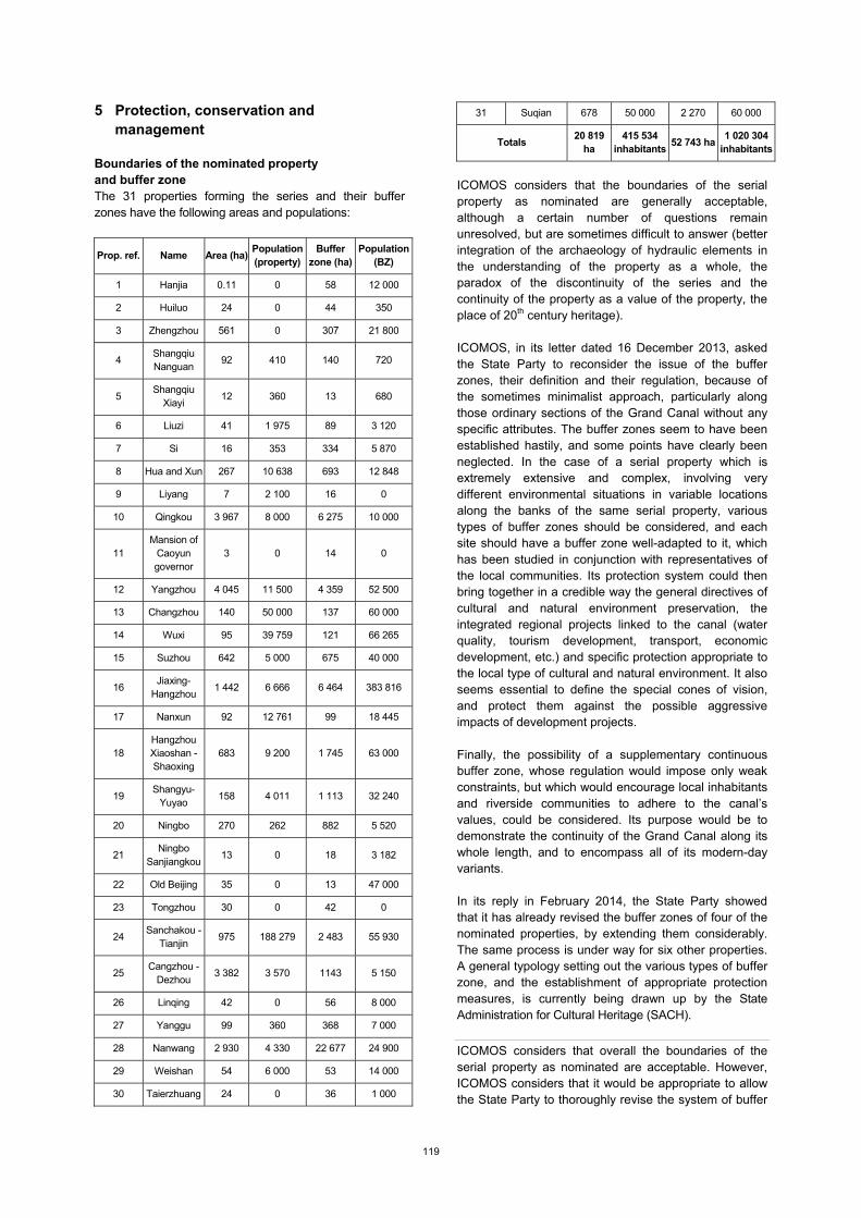
5 Protection, conservation and management Boundaries of the nominated property and buffer zone The 31 properties forming the series and their buffer zones have the following areas and populations:
Prop. ref. Name Area (ha) Population (property)
Buffer zone (ha)
Population (BZ)
1 Hanjia 0.11 0 58 12 000
2 Huiluo 24 0 44 350
3 Zhengzhou 561 0 307 21 800
4 Shangqiu Nanguan
92 410 140 720
5 Shangqiu
Xiayi 12 360 13 680
6 Liuzi 41 1 975 89 3 120
7 Si 16 353 334 5 870
8 Hua and Xun 267 10 638 693 12 848
9 Liyang 7 2 100 16 0
10 Qingkou 3 967 8 000 6 275 10 000
11 Mansion of
Caoyun governor
3 0 14 0
12 Yangzhou 4 045 11 500 4 359 52 500
13 Changzhou 140 50 000 137 60 000
14 Wuxi 95 39 759 121 66 265
15 Suzhou 642 5 000 675 40 000
16 Jiaxing-
Hangzhou 1 442 6 666 6 464 383 816
17 Nanxun 92 12 761 99 18 445
18 Hangzhou Xiaoshan - Shaoxing
683 9 200 1 745 63 000
19 Shangyu-
Yuyao 158 4 011 1 113 32 240
20 Ningbo 270 262 882 5 520
21 Ningbo
Sanjiangkou 13 0 18 3 182
22 Old Beijing 35 0 13 47 000
23 Tongzhou 30 0 42 0
24 Sanchakou -
Tianjin 975 188 279 2 483 55 930
25 Cangzhou -
Dezhou 3 382 3 570 1143 5 150
26 Linqing 42 0 56 8 000
27 Yanggu 99 360 368 7 000
28 Nanwang 2 930 4 330 22 677 24 900
29 Weishan 54 6 000 53 14 000
30 Taierzhuang 24 0 36 1 000
31 Suqian 678 50 000 2 270 60 000
Totals 20 819
ha 415 534
inhabitants 52 743 ha
1 020 304 inhabitants
ICOMOS considers that the boundaries of the serial property as nominated are generally acceptable, although a certain number of questions remain unresolved, but are sometimes difficult to answer (better integration of the archaeology of hydraulic elements in the understanding of the property as a whole, the paradox of the discontinuity of the series and the continuity of the property as a value of the property, the place of 20th century heritage). ICOMOS, in its letter dated 16 December 2013, asked the State Party to reconsider the issue of the buffer zones, their definition and their regulation, because of the sometimes minimalist approach, particularly along those ordinary sections of the Grand Canal without any specific attributes. The buffer zones seem to have been established hastily, and some points have clearly been neglected. In the case of a serial property which is extremely extensive and complex, involving very different environmental situations in variable locations along the banks of the same serial property, various types of buffer zones should be considered, and each site should have a buffer zone well-adapted to it, which has been studied in conjunction with representatives of the local communities. Its protection system could then bring together in a credible way the general directives of cultural and natural environment preservation, the integrated regional projects linked to the canal (water quality, tourism development, transport, economic development, etc.) and specific protection appropriate to the local type of cultural and natural environment. It also seems essential to define the special cones of vision, and protect them against the possible aggressive impacts of development projects. Finally, the possibility of a supplementary continuous buffer zone, whose regulation would impose only weak constraints, but which would encourage local inhabitants and riverside communities to adhere to the canal’s values, could be considered. Its purpose would be to demonstrate the continuity of the Grand Canal along its whole length, and to encompass all of its modern-day variants. In its reply in February 2014, the State Party showed that it has already revised the buffer zones of four of the nominated properties, by extending them considerably. The same process is under way for six other properties. A general typology setting out the various types of buffer zone, and the establishment of appropriate protection measures, is currently being drawn up by the State Administration for Cultural Heritage (SACH).
ICOMOS considers that overall the boundaries of the serial property as nominated are acceptable. However, ICOMOS considers that it would be appropriate to allow the State Party to thoroughly revise the system of buffer
120
zones, as regards their geographic definition, their regulation and their setting up on the basis of negotiations with the regional and local authorities; a level 2 buffer zone could possibly be considered, in order to highlight the continuity of the Grand Canal and to encompass all its modern-day components.
Ownership In accordance with the Constitution and the Land Administration Law of the People’s Republic of China, the nominated properties are either state-owned (88%) or collectively owned at local level (12%). The state-owned property consists of the canals, their banks and verges, and the territory of the towns. The rural and suburban property consists of rural communities in accordance with constitutional and legal texts. 162 local communities are concerned with the properties and 632 with the current buffer zones. Protection Specific priority protection and conservation measures apply to those properties already inscribed on the World Heritage List and those inscribed on the Tentative List of China, in accordance with the Law on the protection of cultural remains. This measure has been fully applicable since 2008. Meanwhile, the List of the six key examples of the cultural heritage of China has been promulgated, and includes 18 sections and 49 elements of the Grand Canal. This recognition by the Council of State gives these sites priority in protection terms. As indicated in the additional documentation of February 2014, all the properties nominated for inclusion on the World Heritage List were granted this maximum level of protection by the State Party in 2013. The serial property is managed in accordance with national regulation laws which are applicable for a variety of reasons. The law is applied through administrative regulation texts which apply to all the properties concerned, and by provincial or local protection plans for specific properties. The property as a whole has been the subject of the promulgation of 54 texts of this type, of which the main ones are referred to below. The hydraulic management of the canals depends on the Law on the administration of the regulation of rivers (including canals) (1988), amended by the Law on flood control, the Law on water and the Law on water pollution. The application documents are enacted by the competent provincial administrations, and all these documents are grouped together in the form of Regulation plans specific to each canal and catchment area, defining the management areas for the waterway and its technical facilities. The national law on the regulation of the protection of historic towns, villages and conservation areas (2008) ensures the highest degree of national protection. Six urban areas of the property are concerned, with specific regional and local regulation texts.
The Law on the regulation of scenic sites (2006) can lead to the institution of a national conservation park. One property in the series is concerned. The Law on the regulation of natural reserves. One property in the series is concerned: the natural reserve of Nansihu (2003) includes the Weishan site (property n° 29). The other national laws concerning the property, with the administrative and local regulation texts applicable to the sites concerned are: the Law on the protection of the environment, the Law on territorial administration, the Law on urban and rural planning, and the Law on water and soil conservancy. In 2008, the Ministry of Culture and the State Authority for the Cultural Heritage of China took charge, along with the eight provincial governments concerned, of the setting up of advanced heritage protection for the Grand Canal. A document setting out the basis for harmonisation between the towns along the canal – the Joint Agreement for the Protection of the Grand Canal – was signed and was implemented in 2012 for the main municipalities concerned. It guarantees the convergence of municipal regulations in town planning and building rules, and in the demarcation of protected areas, etc. In practice, all elements next to the canal (passageways, bridges, house facades, trees) in the historic urban quarters are recognised and strictly protected as urban districts associated with the canal. In the ordinary sections of the linear course of the canal, with no specific attributes, the banks are considered to form part of the canal because of their technical role, and they are protected in the same way as the canal. However, immediately adjacent elements which play a role in the heritage integrity of the canal and its landscapes (trees, footpaths, facades, etc.) are not always protected by the current buffer zones. The buffer zones are intended to prevent building and development pressure in the most sensitive zones of the canal. Generally speaking, they are covered by the same regulation as the nominated property itself. When this is not the case, building density and height are regulated by the provisions of the local Master Plan.
ICOMOS considers that the legal protection in place is generally adequate, but that various improvements and extensions are necessary. It is necessary to systematically widen the protection of the banks to include immediately adjacent elements, by extending the buffer zones along the canal.
Conservation The large amount of canal maintenance work and dredging carried out since the 1950s has demonstrated the revival in interest in waterways in China. Several of the sections included in the nominated property have been affected by this work. The associated documentation is available from the River Regulation Administration of the
121
People’s Republic of China, from provincial bodies and departments, and from municipalities and local authorities. The canals are currently carrying intense levels of traffic; in some cases the canals have been widened, and in many cases new sections have been dug and new port facilities built. While their state of hydraulic conservation is usually good, the state of heritage conservation may vary considerably, as in some cases technical characteristics have been substantially altered, and landscape authenticity has been affected by the many sections passing through suburban or industrial zones, often developed because of the presence of the canal. The non-navigable sections of the canals have often been kept as drainage reaches, to carry away rainwater and protect against flooding, and they are also used for irrigation purposes. They have thus been kept for water management purposes, but without any major structural alterations. These are the most authentic sections, and those most representative of the historic canal. Recently, projects have been drawn up with a view to refilling some of these sections with water to enable navigation. Conservation plans have been drawn up for each of the canals included in the nominated property; they provide for the construction of technical facilities whose materials and shapes are in keeping with traditional facilities, and the regulation of new building densities and heights mentioned above. Each plan acts as a guide of best practices for the restoration and maintenance of the canal itself, the associated hydrological zones (lakes, marshland, irrigation zones, etc.) and of its existing facilities. It also sets out a series of measures to improve environmental quality in general and water quality in particular, and is based on a plan for the distribution of water between the various zones along the Grand Canal. Since 2006, systematic monitoring of the heritage conservation of the property as a whole has been added to the hydraulic management. A policy of encouraging archaeological excavations, with the conservation and protection of the remains unearthed, has also been developed. The archaeological sites fall into 2 main categories: those whose existence has been known since 1970-1980, and those that were recently discovered following research undertaken for the purpose of the World Heritage List nomination. These sites have been excavated recently, or are still being excavated. Protection measures have been taken to prevent deterioration and intrusion, in some cases by back-filling the sites after excavation. In 2008, in response to the problems of economic and urban development in many zones around the canal, the provincial and municipal authorities agreed to coordinate a global conservation plan for the property, including control of urban development in the zones forming part of the nominated property and buffer zones (urban density, building height, industrial and logistical facilities). The associated documentation is available from the State Administration for Cultural Heritage (SACH) and from the local management units in charge of a section or site
included in the property. The conservation monitoring project will also have a centralising effect on the canal documentation, which will take the form of a geographic information system (GIS) and data base. The conservation of historic urban areas forming part of the Grand Canal heritage has led to the creation of national bodies for the protection and management of historic city conservation and urban conservation zones. Six have been set up since 1982: one each at Wuxi, Hangzhou, Shaoxing, and Naxum-Hugzhou, and 2 at Suzhou. Special attention is paid to the historic urban zones of the Grand Canal, particularly with regard to the rapidly growing use of the canal for tourism. The conservation programmes are wide-reaching, and include the appearance of the canal banks, and the conservation of streets and quarters traditionally associated with the life and economy of the Grand Canal. The main difficulties are social, as the improvement of the housing stock raises many compatibility problems (access to modern conveniences versus maintaining the existing ancient appearance of houses and quarters). A great deal of work on networks (water, sewerage, electricity, etc.) is also necessary. Some more specific programmes, usually in urban areas or in park zones close to urban centres, are aimed at carrying out overall landscape and environmental rehabilitation. Environmental measures are also being taken in some sectors, consisting of the controlled management of land and building, and water quality improvement. The conservation of the section of the Huaiyang Canal and its environment in the Yangzhou region (n° 12 or HY-03) has national park status (2006). ICOMOS wishes to emphasise the impressive nature of the work carried out by the State Party for the conservation of a property as vast and complex as the Grand Canal. This has already produced important and convincing results in terms of the preservation of the many cultural and environmental values. The Grand Canal clearly illustrates the challenges of heritage conservation today in a huge country in a phase of swift economic development. The successes achieved are unquestionable, as are the difficulties encountered in certain major issues, not only social and economic, but also related to the philosophy of development. In view of the scale of the efforts and their mobilisation, ICOMOS congratulates the State Party, but also wishes to make some observations: The sharp increase in the number of excavation sites
may be detrimental to an understanding of their significance. Excavations must be carried out carefully, over a long period, and greater efforts must be made to critically analyse their results and set them into context. The current rate of excavations seems to be excessive, and the results need to be looked at using the perspective of international scientific critical analysis.
122
The hydraulic rehabilitation of the Grand Canal over the last 60 years and the boom in the use of waterways in China must be seen in the context of the property as a whole, so that each section is understood in terms of what it really is today, thus avoiding confusion. It is important to distinguish those restorations that have been carried out that have changed the status of anything.
Greater attention must be paid to environmental issues and to the landscapes of the Grand Canal.
The question of the place of the 20th century in the heritage of the Grand Canal remains, and it must be identified in its own right, and not only in terms of past history to which it bears testimony.
ICOMOS considers that the state of conservation is generally good, and that a determined and diversified conservation policy has been carried out, to its benefit. However, greater attention should be given to: setting archaeological findings into a more critical perspective, clarifying which historical periods are actually represented by sections of the canal, and increasing the efforts made in environmental and landscape conservation.
Management Management structures and processes, including traditional management processes
The management system is based on several levels of responsibility. At national level, under the auspices of the State Council, the coordination of the property’s management is in the hands of the Inter-Provincial and Ministerial Consultation Group for the conservation of the Grand Canal. The group is made up of the governments of the six provinces and of the two cities with provincial status, the State Administration of Cultural Heritage (SACH), the Water Distribution Office, the Ministry of Water Resources and the other ministerial departments concerned. Its work is carried out at plenary sessions and in working subgroups. The Group is the supreme body for the management of the canal, because of its role of coordination, harmonisation and control of provincial and municipal planning. It has set up 8 provincial management committees under the responsibility of the provincial governments. The management committees have members from the provincial departments, the decentralised state departments and the catchment area organisations. Their role is to ensure cooperation and developing decisions made. 25 municipal councils have formed the Contractual Alliance of Towns for Protection of the Grand Canal. Its role is the inter-city coordination and harmonisation of protection and conservation practices. The provincial management committees and the Alliance have set up institutions in charge of the everyday protection and management of the various sites. There are 80 institutions of this type, most of them responsible for managing one or several element(s) of a property. As part of the Master Plan, there is currently an updated flood risk monitoring and control plan along the whole
length of the Grand Canal, continuing the measures taken since the 1950s. Its material resources are regularly improved in the light of technical advances in water management and control (dykes, dredging, reservoirs, etc.) and in the improvement of regulation facilities (dams, weirs, sluices, etc.). The plan has three levels of application: the river basin, the province and the municipality. Each historic urban zone affected by fire risk must have an intervention plan, fire-fighting facilities and fast emergency access roads. The funding for the protection and conservation of the Grand Canal comes mainly from central government, through the cultural authorities and the river management authorities, and from funds allocated by the various local authorities to the plans and to the management institutions. At present, a fairly modest additional sum is provided by direct tourism revenue. Over the five years up to 2012, central government invested USD 96 million and the local authorities a total of USD 1,600 million. These amounts cover the maintenance of the waterways, the consolidation of banks and dykes, the conservation of cultural sites, archaeological research, environmental improvement, scientific research and the operation of the institutions. Staff resources along the canal for protection, conservation and visitor interpretation varies considerably from one site to another. Generally speaking, there are four main departments in the management body of a site: cultural heritage, water conservancy, transport and urban administration. Specialist departments are added depending on the nature of the site: archaeology, history, promotion and education, etc. In 2012, 3,559 staff were employed in the management of the Grand Canal. Policy framework: management plans and arrangements, including visitor management and presentation
The current national plans are the General Master Plan for the property (2012-2030) and the Grand Canal Management Plan drawn up for the purpose of the World Heritage nomination, and which is based on the General Master Plan. These framework documents were based on an overview drawn up on the basis of the protection, conservation and management measures taken by the municipalities and then by the provinces. The municipal and provincial plans are based on the application of legal protection rules and the associated regulatory decisions. These rules also apply to buffer zones. A process of concertation between the provinces and municipalities takes place under the auspices of the Group, which harmonises and validates the plans, before grouping them together. The current Master Plan, which is federal, was drawn up using this principle from 2008 onwards. The Master Plan is divided into 35 sector conservation plans, all of which have been promulgated and are being
123
applied, up to 2030; 5 historic town conservation plans, up to 2020; 8 provincial land use plans, up to 2020; 24 urbanisation plans for towns along the canal; and the plan for the scenic Shugang-Slender West Lake site. The 2013-2015 Management Plan for the property was drawn up for the purpose of the World Heritage List nomination. It brings together, over a period of 3 years, the various items relating to governance, management and protection of the property, in line with the expectations of the Committee. This has led to the fine tuning of protection levels, the improvement and reinforcement of conservation, the enrichment and standardisation of management measures, the precise definition and harmonisation of buffer zone protection, and the development of short-term action plans to improve knowledge of the property. Tourist visits take place mainly in a series of clearly identified places, which are clearly identified and generally satisfactorily organised (historic urban sites of the canal, and associated gardens, hydraulic facilities, lakes and parks) or which are currently being identified (archaeological sites). The most frequently visited sites on the canal are: Slender West Lake at Yangzhou (3.2 million visitors in 2012), Suzhou (2.3m), Jiaxing-Hangzhou (1.3m), Nanxun (4.0m), the old city of Beijing (3.0m) and Taierzhuang (1.8m). Visitor facilities have been standardised with regard to signage, trained guides and security systems. Four national museums have been opened to act as Grand Canal interpretation centres: Jining, Huai’an, Hangzhou and Huaibei. Of the 31 sites, 10 do not yet have a visitor reception centre. 23 canal sections offer the possibility of visits by boat. Involvement of the local communities
This is achieved by strong institutional involvement of the towns along the canal in the management of conservation, and by means of risk intervention plans. It is also achieved by the local development of visitor facilities and the providing of commercial and cultural facilities for the sites most frequently visited.
ICOMOS considers that the management system as a whole for such a complex system has been rationally devised and organised over the last 7 to 8 years, and implemented over the last 4 to 5 years. The system seems to function satisfactorily and the State Party is encouraged to continue its efforts in this direction, while paying closer attention to water quality management, improving the quality of visitor reception plans in the new zones of the canal (interpretation centre, qualified guides) and training personnel about the values of the Grand Canal.
6 Monitoring A large amount of material already exists relating to the monitoring of the property, in terms of its hydraulic operation, the various urban preservation policies, and the
active policy recently introduced for the conservation and valorisation of the property. The material consists of reports and studies on conservation, some of which were drawn up for the preparation of the nomination file. Archiving of technical information about the management of the canals is currently being carried out at both local and national level. In 2012, there were 21 recent monitoring reports on individual sites, 8 water quality monitoring reports, 16 major conservation-restoration project reports for components of the property, and 21 reports on local monitoring or district monitoring of hydraulic management. In view of the diversity of issues and situations encountered, the following general categories are proposed: Physical fabrics: 1- Current condition of the individual
components (shape, structure, materials, etc.); 2- Uses; 3- Relationships between the elements themselves and with the environment.
Factors affecting conservation efforts: 1- Natural environment (weather, geology, environment, ecology, etc.): 2- Social environment (urban development, economic installations, pollution, etc.).
Conservation and management: 1- Tourism (number of tourists, financial and economic impacts); 2- Intervention practices (archaeological excavations, routine maintenance, environmental improvement, conservation projects, etc.): 3- Heritage enhancement (exhibitions, interpretation centres, tourist facilities, etc.) 4- Management and staff resources (implementation of management plan, management bodies, management staff, funding, etc.).
Security: 1- General security and fire security 2- Measures to deal with emergencies and unexpected incidents.
The State Party intends to ensure that the monitoring of the property is carried out using standardised practices under the Master Plan and the Property Management Plan. The practices will be coordinated between the various levels (national, provincial and local). To set up the necessary system for monitoring and sharing information between all the bodies involved, the State Party is currently setting up a Grand Canal Heritage Monitoring and Archive Centre, with its own staffing and with local centres at the property’s sites. A guide for Grand Canal monitoring and archives has been published to harmonise practices. Although the setting up of the Centre seemed to be a project when the nomination file was drawn up (at the end of 2012), the additional documentation supplied by the State Party (October 2013 and February 2014) refers to the setting up of 41 local and regional agencies. However, the definitive setting up of the Centre is not scheduled until 2015.
ICOMOS considers that the monitoring of a complex property such as the Grand Canal must be set up in a permanent and coherent form that covers all the
124
components. This work has begun, but it is now necessary to complete its implementation.
7 Conclusions ICOMOS recognises the Outstanding Universal Value of the Grand Canal of China. It is the largest civil engineering project in the history of mankind, whose first construction work dates back to pre-imperial Chinese antiquity, and which even today in its modernised form constitutes the largest internal waterway with the highest levels of traffic in the world. It bears witness to an exceptional technical, social, economic and political history. It represents in civil terms what the Great Wall of China represents in the military field, a fundamental testimony to Chinese civilisation. ICOMOS congratulates the State Party for taking up the challenge of the heritage conservation of a property of this kind, at the heart of an internal waterway network almost 2,500 km long, which is currently the most active in traffic terms in the world, in one of the world’s most densely populated regions.
8 Recommendations Recommendations with respect to inscription ICOMOS recommends that the nomination of the Grand Canal, People’s Republic of China, be referred back to the State Party in order to allow it to: Continue the work that has begun to revise the
system of buffer zones in terms of their territorial definition, by major canal environment zone type, and enact protection measures that are fully adapted to local situations and negotiated with the municipal and regional authorities. In this connection, systematically widen the protection of the canal banks beyond the historic urban zones to include the elements forming the immediate canal landscape: footpaths, trees, facades of bordering houses, etc.
Complete the setting up of the Grand Canal Heritage Monitoring and Archive Centre.
Additional recommendations ICOMOS further recommends that the State Party give consideration to the following: Better explaining the technological elements that
form part of the canal, particularly the hydraulic functioning of the archaeological parts of the Grand Canal. A more critical analysis of the archaeological findings should be carried out;
Clarifying the historic periods that are actually represented by the preserved sections of the canal;
Stepping up efforts in environmental and landscape conservation, for example by defining priority cones of vision for the properties, and then protecting them from the impact of new buildings;
Strengthening the quality of the tourism development and visitor reception plans in those zones of the canal that have recently been opened up for tourism (interpretation centre, qualified guides);
Examining the possibility of a supplementary continuous buffer zone with a low level of constraint, which could both indicate the value of the functional continuity of the Grand Canal and also involve all the local residents in adhering to its values;
Clarifying recent and projected funding, drawing a clearer distinction between operations and investment, and drawing a distinction between funding relating to the hydraulic conservation of the waterway, its conservation as cultural and natural heritage, and tourism development programmes;
Continuing and deepening efforts to improve water quality by incorporating them systematically in conservation and development programmes linked to the Grand Canal;
Strengthening the continuing education of the permanent or temporary staff at the various sites with regard to the overall values of the Grand Canal;
Encouraging international cooperation in order to
promote the sharing of knowledge relating to canal management/conservation.
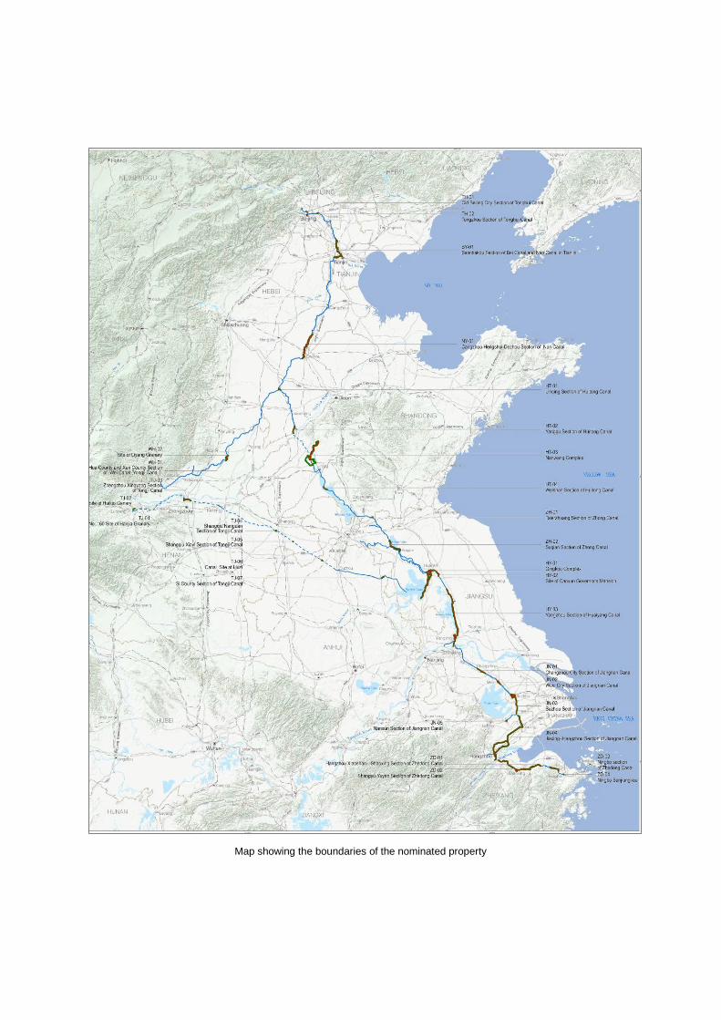
Map showing the boundaries of the nominated property
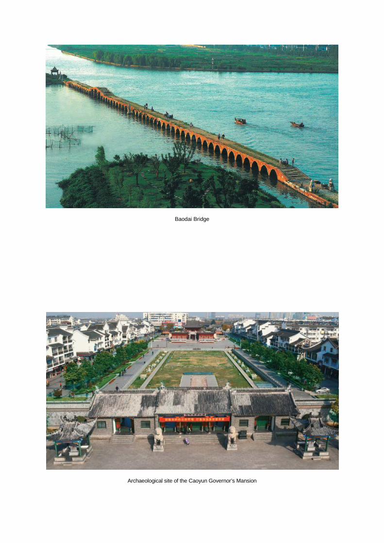
Baodai Bridge
Archaeological site of the Caoyun Governor’s Mansion
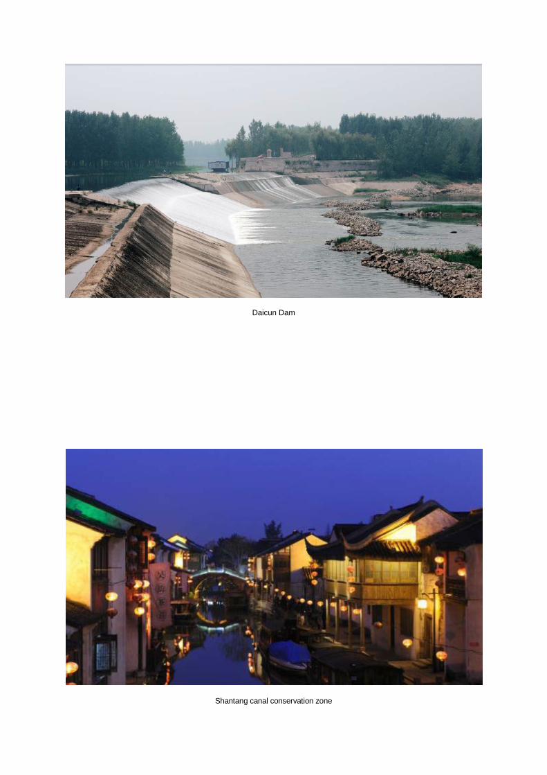
Daicun Dam
Shantang canal conservation zone
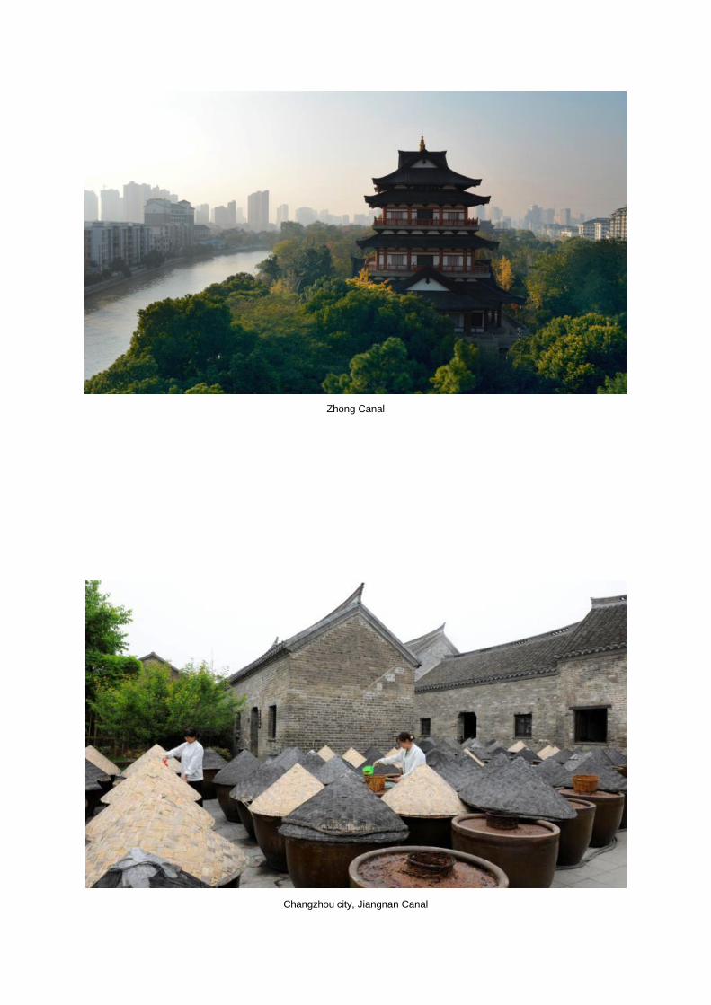
Zhong Canal
Changzhou city, Jiangnan Canal