Embed Size (px)
Citation preview
The Glaciation of Parts of the Wyoming and Lackawanna ValleysAuthor(s): John C. BrannerSource: Proceedings of the American Philosophical Society, Vol. 23, No. 123 (Jul., 1886), pp.337-357Published by: American Philosophical SocietyStable URL: http://www.jstor.org/stable/983217 .
Accessed: 19/05/2014 08:53
Your use of the JSTOR archive indicates your acceptance of the Terms & Conditions of Use, available at .http://www.jstor.org/page/info/about/policies/terms.jsp
.JSTOR is a not-for-profit service that helps scholars, researchers, and students discover, use, and build upon a wide range ofcontent in a trusted digital archive. We use information technology and tools to increase productivity and facilitate new formsof scholarship. For more information about JSTOR, please contact [email protected].
.
American Philosophical Society is collaborating with JSTOR to digitize, preserve and extend access toProceedings of the American Philosophical Society.
http://www.jstor.org
This content downloaded from 195.78.108.143 on Mon, 19 May 2014 08:53:15 AMAll use subject to JSTOR Terms and Conditions
Feb. 19, 1886.] 337 [Branner.
PROCEEDINGS
OF' THE
AMERICAN PHILOSOPHICAL SOCIETY,
HELD AT PRILADELPIIIA, FOR PRONIOTING USEFUL KNOOWLEDGE.
VOL. XXIII. JULY, 1886. No. 123.
The GZaciation of Parts of the Wyoming and Lackawanna Valleys. By John C. Branner, Ph. D.
(Read before the American Philosophical Society, February 19, 1886.)
PREFATORY.
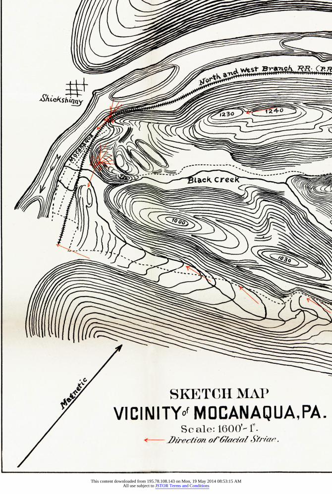
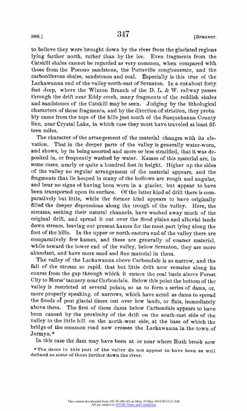
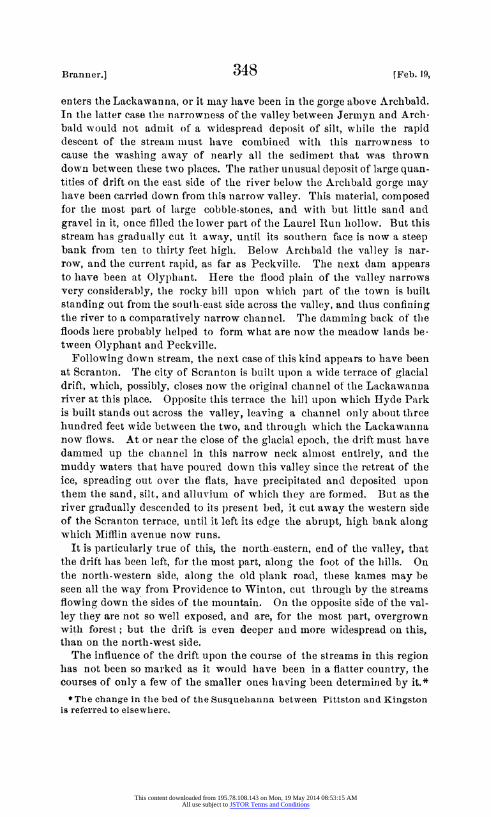
It has long seemed to me that the careful study of limited glaciated areas would add some valuable information to our present knowledge of the subject of continental glaciation. By a limited area I mean one suffi- ciently large to have a varied and well-defined topography, when taken in connection with the surrounding country, and small enouglh to admit of thorough examination, and of a representation upon the map of details which cannot be admitted into maps of large areas without obscuring the subject instead of throwing light upon it. The Wyoming and Lacka- wanna valleys, with their bordering mountains, form such an area, and the work necessary to make of this region a topographical map of unusual detail gave me an excellent opportunity for making the necessary observa. tions.
I have hesitated though about presenting observations that would be so much more valuable had they been extended, with the same care and detail, over a wider territory, and especially over the high lands that bound the valley to the north and north-west on one side, and to the east and south-east on the other; but as I shall, in all probability, have no opportunity for completing the work, and as all knowledge is cumulative, I offer these notes in the hope that others may be induced to add to tlhem, and thus render them more valuable.
The glacial geology of this region is exceedingly varied and interesting. The Shickshinny end of the basin, on account of its bold and well-defined topography, is particularly so, especially in the study of the ice currents in their relation to topography. In studying the area under consideration, however, I have never lost sight of the fact that I was dealing with a very small portion of the glaciated part of the continent, and with localized parts, localized movements, and localized facts in a continental glacier.
Although the work done and the explanations offered here are entirely PROC. AMER. PHILOS. SOC. XXIII. 123. 2Q. PRINTED MARCH 29, 1886.
This content downloaded from 195.78.108.143 on Mon, 19 May 2014 08:53:15 AMAll use subject to JSTOR Terms and Conditions
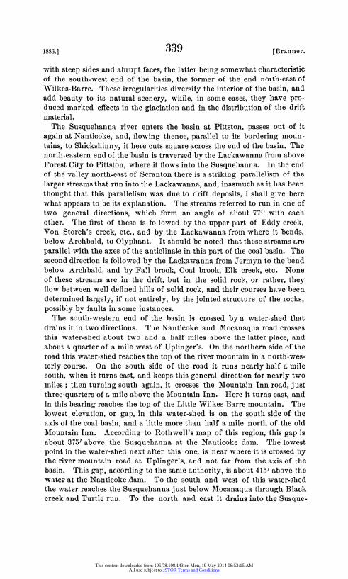
4 JLQSh_~
+vt~KEC MAPCH V.CINITYoz MCAU PA..._ __. H..
This content downloaded from 195.78.108.143 on Mon, 19 May 2014 08:53:15 AMAll use subject to JSTOR Terms and Conditions
ea3l
. . -. = - X// / XS
=c CreeN
xTCIIMA d1OCANAOUAs PA.
This content downloaded from 195.78.108.143 on Mon, 19 May 2014 08:53:15 AMAll use subject to JSTOR Terms and Conditions
Iaa
N
This content downloaded from 195.78.108.143 on Mon, 19 May 2014 08:53:15 AMAll use subject to JSTOR Terms and Conditions
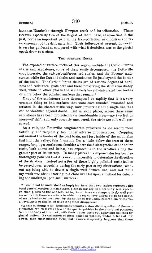
4vLQShh~
ViCINITYof MOCANAQ~UA,VPA.
This content downloaded from 195.78.108.143 on Mon, 19 May 2014 08:53:15 AMAll use subject to JSTOR Terms and Conditions
Ifor~~~~~~~~~~~~~~~~~~~~~~~~~~~~~~
- - S A
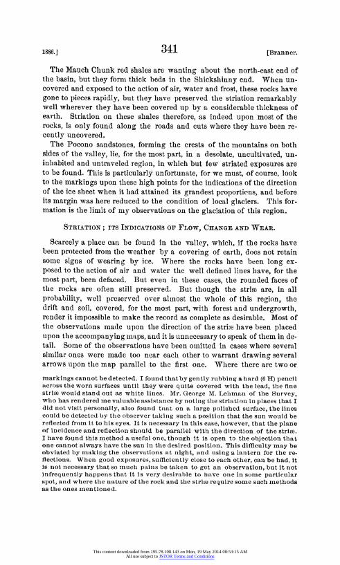
I N
xTCIIMA d1OCANAIQUA, PA. fli 1600: "'. n ofr' 6/acl 4trie.
This content downloaded from 195.78.108.143 on Mon, 19 May 2014 08:53:15 AMAll use subject to JSTOR Terms and Conditions
I~~~~~~~~~~~~~~~~~~~~~~~~~~~~~~~~~i
N~~~~~~~~~~~~~~~~~~~~~~~~~~~~~~~~~~~~~~~~~~~J
This content downloaded from 195.78.108.143 on Mon, 19 May 2014 08:53:15 AMAll use subject to JSTOR Terms and Conditions
Brannler.] 338 [Feb. 19,
original, I find that the influence of topography upon the movement of the ice was given, as an explanation of double striation, by Mr. C. E. Hall in the Proceedings of the American Philosophical Society, Novem- ber 5, 1875 (pp. 633-4). The expression in this place of his theory upon the subject, is the most explicit I have seen. Prof. N. H. Winchell published an article in the Popular Sczence Monthly in 1873 upon "TThe Drift Deposits of the Northwest," in which he refers to the influence of valleys upon the edge of the ice. Mr. T. C. Chamberlin, in his "Terminal Moraine of the Second Glacial Epoch," refers in many places to the influence of topography on the direction of glaciers, and no doubt there are many other references to, and observations upon this sub- ject which I have not been able to consult.
If, in recording the facts observedl, I have been led to what may possi- bly be regarded as theorizing, my only defence is that it was quite impos- sible to see all about me the evidences of so wonderful, so awe-inspiring phenomena without coming to some conclusions regarding them. Then, too, in his letter transmitting Report Z of the Second Geological Survey of Pennsylvania, Professor Lesley has thrown no little doubt over the physical questions connected with glaciation, and, whether his suggestions there be open questions or not, they are calculated to make young geolo- gists observe the evidences of glacial phenomena with a view to arriving at rational conclusions in regard to these questions.
The accompanying maps are necessarily upon a scale too small to con- vey a proper idea of the influence of the topography upon the movement of the ice. To show this a map would need to be very detailed and exact, and upon an unusually large scale, or better still, a large model would be required.
I take great pleasure in acknowledging here the kind encouragement of Professor Lesley and of Mr. Ashburner. To Mr. Geo. M. Lehman I am indebted for a number of valuable observations upon the direction of strike in various places, and to Sheldon Reynolds, Esq., of Wilkes-Barre, for some observations made in the vicinity of that city.
PHYSICAL FEATURES.
The Wyoming and Lackawanna valleys are, properly speaking, a single closed and curved synclinal valley, about fifty miles long by about five miles wide at its widest part, and bounded by mountains which coalesce at the extremities of the valley.
The concave side of its crescent form faces toward the north-west, the north-east end of the basin bearing about N. 200 E., and the south-west end bearing S. 70? W. Its mountain barriers thus presented themselves to the ice sheet at various angles, and now offer a valuable opportunity for observing the influence of such barriers upon the ice flow. Within this great basin are niany secondary or miiiniature basins with a general resemblance to the large one, and many low, gently undulating and regu- larly sloping hills, some of which are anticlinals, and some are ridges
This content downloaded from 195.78.108.143 on Mon, 19 May 2014 08:53:15 AMAll use subject to JSTOR Terms and Conditions
1886.1 339 [Branner.
with steep sides and abrupt faces, the latter being somewhat eharacteristic of the south-west endl of the basin, the former of the end noith-east of Wilkes-Barre. These irregularities diversify the interior of the basin, and add beauty to its natural scenery, wlhile, in some cases, they have pro- duced marked effects in the glaciation and in the distribution of the drift material.
The Susquehanna river enters the basin at Pittston, passes out of it again at Nanticoke, and, flowing thence, parallel to its bordering moun- tains, to Shickshinny, it here cuts square across the end of the basin. The north-eastern end of the basin is traversed by the Lackawanna from above Forest City to Pittston, where it flows into the Susquehanna. In the end of the valley north-east of Scrantoni there is a striking parallelism of the larger streams that run into the Lackawanna, and, inasmuch as it lhas been thought that this parallelism was due to drift deposits, I shall give here what appears to be its explanation. The streams referred to run in one of two general directions, which form an angle of about 770 with each other. The first of these is followed by the upper part of Eddy creek, Von Storch's creek, etc., and by the Lackawanna from where it bends, below Archbald, to Olyphant. It should be noted that these streams are parallel with the axes of the antielinals in this part of the coal basin. The second direction is followed by the Lackawanna from Jermyn to the bend below Archbald, and by Fa'l brook, Coal brook, Elk creek, etc. None of these streamis are in the drift, but in the solid rock, or rather, they flow between well defined hills of solid rock, and their courses have been determined largely, if not entirely, by the jointed structure of the iocks, possibly by faults in some instances.
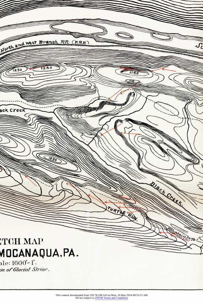
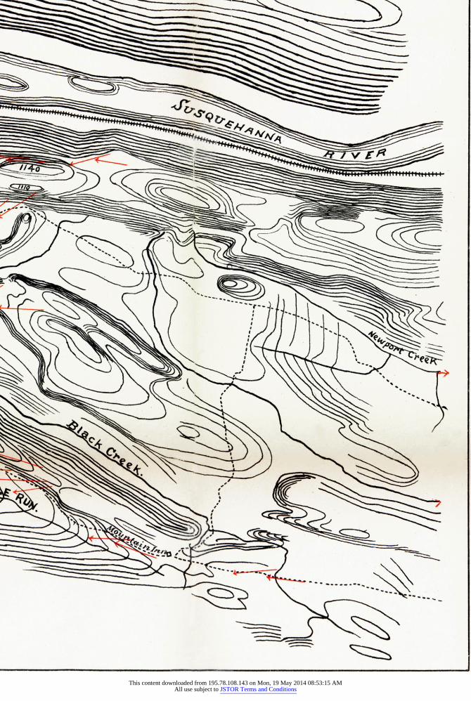
The south-western end of the basin is crossed by a water-shed that drains it in two directions. Thie Nanticoke and Mocanaqua road crosses this water-shed about two and a half miles above the latter place, and about a quarter of a mile west of Uplinger's. On the northern side of the road this water-shed reaches the top of the river mountain in a north-wes- terly course. On the south side of the road it runs nearly half a mile south, wlhen it turns east, and keeps this general direction for nearly two miles; then turning south again, it crosses the Mountain Inn road, just three-quarters of a mile above the Mountain Inn. Here it turns east, and in this bearing reaches the top of the Little Wilkes-Barre mountain. The lowest elevation, or gap, in this water-shed is on the soutlh side of the axis of the coal basin, and a little more than half a mile north of the old Mfountain Inn. According to Rothwell's map of this region, this gap is about 3751 above the Susquehanna at the Nanticoke dam. The lowest point in the water-shed next after this one, is near where it is crossed by the river mountain road at Uplinger's, and not far frorn the axis of the basin. This gap, according to the same authority, is about 415' above the water at the Nanticoke dam. To the soutlh and west of this water-shed the water reaches the Susquehanna just below Mocanaqua through Black creek and Turtle run. To the north and east it drains into the Susque-
This content downloaded from 195.78.108.143 on Mon, 19 May 2014 08:53:15 AMAll use subject to JSTOR Terms and Conditions
Branner.] 340 [Feb. 19,
hanna at Nanticoke through Newport creek and its tributaries. These streams, especially two of the largest of them, have, at some time in the past, borne an important part in the transportation, modification and re- arrangement of the drift material. Their influence at present, however, is very insignificant as compared with what it doubtless was as the glacial epoch drew to a close.
THE SURFACE RocKs.
the exposed or surface rocks of this region include the Carboniferous shales and sandstones, some of them easily decomposed, the Pottsville conglomerate, the sub-carboniferous red shales, and the Pocono sand- stones, while the Catskill shales and sandstones lie just beyond the border of the basin. The Carboniferous shales nre of various degrees of hard- ness and resistance, spots here and there preserving the strive remarkably well, while in other places the same beds have disintegrated two inches or more below the polished surfaces that remain.*
Many of the sandstones have decomposed so rapidly that it is a very common thing to find surfaces that were once rounded, smoothed and striated in the characteristic way, now preserving not a single line that can be identified beyond doubt. But in some places, where these same sandstones have been protected by a considerable layer-say two feet or more-of drift, and only recently uncovered, the strke are still well pre- served.
As a rule, the Pottsville conglomerate preserves its ice record most faithfully, and frequently, too, under adverse circumstances. Cropping out around the border of the coal basin, and just inside of the mountains that limit the valley, this formation lies a little below the crest of these ranges, forming a continuous shoulder where the disintegration of the softer rocks, both above and below, has exposed it to the weather along the greater part of its outcrop. In many places this exposed rim has been so thoroughly polished that it is next to impossible to determine the direction of the striation. Indeed not a few of these highly polished rocks had to be passed over, especially during the early part of my observations, with- out my being able to detect a single well defined line, and not until my work was about drawing to a close did I hit upon a method for detect- ing the markings upon such surfaces.t
* I would not be understood as implying here that two inches represent the total general erosion that has taken place in this region since the glacial epoch. In such places as the one referred to, the surfaces are comparatively well pre- served, while there are others in which the rocks lhave flaked ofl to the depth of many inches, or even feet, by the actioni of frost, and from which, of course, all evidences of glaciation have long since disappeared. tA thin covering of soil sometimes permits a slow disintegrationi of the con-
glomerate, which leaves a few of the quartz pebbles in their original position, fast in the body of the rock, with their upper parts cut away and polished by glacial action. Examination of these polished pebbles, under a lens of low power, may show minute strihe, but it more frequently happens that these
This content downloaded from 195.78.108.143 on Mon, 19 May 2014 08:53:15 AMAll use subject to JSTOR Terms and Conditions
1886.] 341 [Branner.
The Mauch Chunk red shales are wanting about the north-east end of the basin, but they fornm thick beds in the Shickshinny end. When un- covered and exposed to the action of air, water and frost, these rocks have gone to pieces rapidly, but they have preserved the striation remarkably well wherever they have been covered up by a considerable thickness of earth. Striation on these shales therefore, as indeed upon most of the rocks, is only found along the roads and cuts where they have been re- cently uncovered.
The Pocono sandstones, forming the crests of the miountains on both sides of the valley, lie, for the most part, in a desolate, uncultivated, un- inhabited and untraveled region, in which but few striated exposures are to be found. This is particularly unfortunate, for we must, of course, look to the markings upon these high points for the indications of the direction of the ice sheet when it had attained its grandest proportions, and before its margin was here reduced to the condition of local glaciers. This for- mation is the limit of my observations on the glaciation of this region.
STRIATION; ITS INDICATIONS OF FLOW, CHANGE AND WEAR.
Scarcely a place can be found in the valley, which, if the rocks have been protected from the weather by a covering of earth, does not retain some signs of wearing by ice. Where the rocks have been long ex- posed to the action of air and water the well defined lines have, for the most part, been defaced. But even in these cases, the rounded faces of the rocks are often still preserved. But though the strime are, in all probability, well preserved over almost the whole of this region, the drift and soil, covered, for the most part, with forest and undergrowth, render it impossible to make the record as complete as desirable. Most of the observations madle upon the direction of tlle strikl have been placed upon the accompanying maps, and it is unnecessary to speak of them in de- tail. Some of the observations have been omitted in cases where several similar ones were made too near eacll other to warrant drawing several arrows upon the map parallel to the first one. Where there are two or markings cannot be detected. I foun(d that by gently rubbing a hard (6 H) pencil across the worn surfaces until they were quite covered with the lead, the fine striae would stand out as white lines. Mr. George M. Lehman of the Survey, who has rendered me valuable assistance by nioting the striation in places that I did not visit personally, also fouind triat on a large polished surface, the lines could be detected by the observer takinig such a position that the sun wotuld be reflected from it to his eyes. It is necessary in this case, however, that the plane of incidence and reflection should be parallel with the directioni of the striee. I have found this method a useful one, though it is open to the objection that one cannot always have the sun in the desired position. This difficulty may be obviated by making the observations at night, and using a lantern for the re- flections. When good exposures, sufficienitly close to each other, can be had, it Is not necessary that so much painis be taken to get an observation, but it not infrequently happens that it is very desirable to have onie in some particular spot, and where the nature of the rock and the strive require some such inethods as the ones mnentioled.
This content downloaded from 195.78.108.143 on Mon, 19 May 2014 08:53:15 AMAll use subject to JSTOR Terms and Conditions
Branner.] 342 [Feb. 19,
more sets of striae in one place, they are represented by the arrows cross- ing each other at the proper angle. In a few instances the change in the direction of the striae, either in the same place, or in places not far removed from each other, has been so great that it might well be asked upon what grounds I conclude that the flow of the ice was in the direction repre- sented, and not exactly in the opposite direction. In such cases I have depended upon the topographical features and the nature of the scratches to settle the question-tthe lines frequently deepening in the direction of the movement of the ice-and, as far as I am able to see, the results have been satisfactory, thouglh somiietimes striking.
The strike themselves are of the usual character, modified by the rocks upon wlhich they occur. rThose on the harder sandstones and conglomer- ates are shallow, and frequently so fine as to produce a high polish, while those upon the slhales and softer sandstones are well defined and deep. They are approximately parallel to each other, though often crossed by other parallel sets of striae pointing in different directions. Individual marks frequently deepen toward the south, and end in a deep gouge. In- stances occur ot what were at first considered to be glacial grooves, but, upon further and mDre careful study, these grooves were always found to be channels in the rocks, polished and more or less modified by ice. In one instance the impression of the trunk of a large Lepidodendron, lying in the direction of striation, had been worn out so smoothly that it was for some time mistaken for a glacial groove. The best defined strie are found where the glacier moved along upward, horizontal, or gently downward gradients, and least prominent upon the steeper faces of hills that slope in the direction in whichl the ice moved. Evidences of "upward flow " are quite abundant, and where two or lmlore sets of strihe occur in such a place, those pointing upward are frequently, thouglh not always, the deepest. Furtliermore, where the striau indicate an upward movement the glacier appears to have moved forward witlh little or no regard to the smaller details of topographical features. I would emplhasize these smaller details in this connection, for they lhad their share of ilnfluence later, as I hope to show.
The explanation of this upward movement and of these variations in the direction of the ice stream must be sought in the topograplhy of the regioll and the varying thickness of the ice; indeed, unless these matters be taken into consideration, such phenomena are utterly meaningless. In the conglomerate ledge east of Carbondale are a great many depressions, or shallow holes, across whichl the ice has moved, to all appearances, without being impeded or deflected perceptibly froiml its general course. These, depressions are of various sizes and depths, nmany of them being from a few inclhes to two or tlhree feet wide and one or two inches deep. Such inequalities in the surface of the rock are not uncommon all through the region under consideration, and they are doubtless to be found in all gla- ciated countries. No one appears to be surprised that the ice should move down one side of these shallow depressions and up the other, and when
This content downloaded from 195.78.108.143 on Mon, 19 May 2014 08:53:15 AMAll use subject to JSTOR Terms and Conditions
1886.1 3 t3 [Branner.
the rim of the depression is a thousand feet, or more, above the bottom, why should not the same physical law hold good? It certainly does, to all appearances. But while ice only a few feet in thickness might flow across an inequality in its rock floor one or two inches deep, it would require a sheet proportionally thick to cross a valley like the Wyoming and Lackawanna witlhout being deflected. And whenever varying sets of strive in high altitudes were found, they go to show that, when the ice was at its greatest thickness, it moved across this valley witlhout being turned from its general course, influenced only by the continental topography, in comparison with which the bordering ridges of the valley were insig- nificant, and scoring the evidences of its course deeply in the rocks. In other words, the only topography ignored by a continental glacier is that of local details. As the ice-sheet grew thinner, these mountains-the topographical details-influenced its course more and more, until it was reduced to the condition of local glaciers along its retreating southern margin.
The author of Report Z of the Second Geological Survey of Pennsylva- nia refers to " upper strihe " and "lower strive " (Z, p. 106), and appears to think that the latter were made by under-currents in the ice, while he explains the different sets, when found together, by referring some of them to a sort of land-slides, which are said to produce '' creep strioe " (Z, p. 84).
I have found no evidences in the region under consideration of strise having been produced otherwise than by ice moving as a glacier. That some of tlhem, indeed all of tlhem, were produced by masses moved by " gravity " (Z, p. 85) is quite admissible, inasmiuch as gravity is the force which causes the ice of all glaciers to move, and is as accountable for its moving down a great general or continental incline with surface irregu- larities a thousand feet deep, as over a limited one having depressions only an inch deep.
Many instances might be mentioned of a variation in the direction of the ice current, caused by little irregularities in the surface of the bed rock, without the glacier becoming localized. Tllese are doubtless glacial under-currents. Evidences of this kind of a current are to be seen above Dunmore, at the quarry near the head of Plane No. 7. Here, a block of conglomerate having been removed from the wall of rock, the ice in the bottom of the glacier was caught beneatlh and below the projecting ledge, and forced forward and upward at an angle whichl I did not measure, but which, as nearly as I can remember, is about fifteen or twenty degrees. The horizontal bearing of these strike is S. 400 E., while immediately above, on top of the ledge, and ten feet away, the strie point S. 100 W.
Anotlher interesting example of this character is found on Kelly's island in Lake Erie, and is described by Charles Whittlesey in vol. xxvii of the Proceedings of the A. A. A. S., pp. 239-245. It is also well figured by Chamberlin in his "Preliminary Paper on the Terminal Moraine of the Second Glacial Epoch."* BuLt the existence of such diminutive under- * Third Annual Report of the U. S. Geol. Survey, p. 336.
This content downloaded from 195.78.108.143 on Mon, 19 May 2014 08:53:15 AMAll use subject to JSTOR Terms and Conditions
Branner.] 344 LFeb. 19,
currents can hardly be regarded as evidence that there was an under-cur- rent filling and flowing down the Wyoming valley, wliile another upper- current flowed over the tops of the mountains. The existence of different sets of strike in the same place, pointing one set across the mountain, and another down the valley, make such a theory unnecessary at least. Evi- dence that there were no great or extensive undercurrents in the ice may be seen in the gap through which the Lackawanna runs at Archbald. Just above the village, where the track of the D. & H. Gravity railway track crosses the old plank road, the strife show beyond question that the ice in passing through this gap was not deflected by the topography into undercurrents, but that it was pushed straight ahead, and when there was not room for it in the narrow gorge, it was forced obliquely up and over the steep side of the hill, while the main body of the ice moved square across the hill that here stands out across the valley. If it had been mov- ing in currents, it would have gone around the end of the hill, and the strike would converge in the narrowest part of the gorge.
Again, at Mocanaqua, a quarter of a mile from the bridge, up the railway track, the strie on the red shale point up the side of the steep hill at an angle of at least 300, showing that the ice at the side of this gap flowed straight forward and up the hillside, instead of turning as an undercurrent and going down the channel as water would have done.
Just east of Mocanaqua, on the top of the hill above the West End breaker, a few hundred feet from it, and near the side of the road, are ex- posures of striee with the following bearings:
S. 300 E. S. 250 E.
Due South. S. 450 W. S. 650 W. Due West.
Those pointing S. 300 E. and S. 250 E. appear to be the oldest of the ones now preserved, while those pointing due south predominate. It seems probable therefore that the oldest strife were made when the ice came over the Shickshinny mountains, and whenL it was thick enough to disregard such a topographical feature. As the ice became thinner it ran due soutlh, the later strike almost obliterating those previously made. Further thinning of the ice sheet subjected it more and more to local influences until nothing was left here but a thin and narrow body of ice that came down the valley of Black creek, and being turned by the con- glomerate ledge, left these last faint strike that point west over the edge of the precipice.
In the Lackawanna end of the valley are several cases of double sets* of *Strice sometimes cross each other at well-deflned angles without occuring in
sets. Such variations may possibly have been caused bv the cutting material having been turned In the grasp of the ice. No account was taken of strire of this cliaracter.
This content downloaded from 195.78.108.143 on Mon, 19 May 2014 08:53:15 AMAll use subject to JSTOR Terms and Conditions
1886.] 345 [Branner.
striae. One of these exposures is near the village of Jessup, on tle hillside between Dolph's drift and its air shaft. Here they point due south, S. 250 W., and S. 300 W. Where there are several sets of strive it is not always easy, and indeed it is sometimes quite inmpossible, to determine, by the strike alone, which of the sets is the oldest. In this case, those pointing south appear to be the oldest, from which it is to be inferred that they were made when the ice was least influenced by the hills to the south, and that those veering to the west were made when the thinner ice began to feel the influence of the topography. In both cases the movement of the ice was up the side of the mountain. Another case of double striation was found above the track of the Erie and Wyoming railway, and about 1500 feet above the Scranton reservoir on Roaring brook. At this place one set points due souith, wlhile the other points S. 150 W. It was im- possible to determine which of these sets was the older, though the strise pointing south were the more numerous.
At the Nanticoke gap is a striking instance of local topographical influ- ence upon the glacier. Near the mill-pond on the south side of the Sus- quehanna, and on the low ground, the strive point N. 700 W., and on the north side of the river, near the railway station, they point N. 800 W. and due west. On top of the conglomerate ledge that rises above Nanticoke, near the gap, and just south of the river, the strive point south, from five to twenty degrees east. Witlhin a mile of each other horizontally, and five hundred feet vertically, these two sets of strive differ in their bearing by 1300. Directly north of those on top of the conglomerate and at the foot of the steep ridge, Mr. Lehman informs me, the strive are parallel with the river. The explanation of these contrasts in the direction of the stria- tion is naturally suggested by the bold and well-defined topography of this region. The earlier ice probably moved nearly south across these ridges, while the localized glacier followed the depressions of the valley and, a part of it, at least, flowed tlhrough the Nanticoke gap and down the present channel of the Susquiehanna river.
The south pointing strive on the mountain west of Nanticoke contrast strongly with those on the top of the same ledge near Mocanaqua.
It will be noticed that where the water-shed from across the basin reaches the top of this mountain the strive are parallel with the ridge. When they occur below the crest of the ridgre, they are, doubtless, due to the ice moving down the (leep, narrow valley, now occulpied by the Sus- quehlanna river. The explanation of the direction of those near Nanti- coke must be sought in time topography to the nortlh of where they are found.
The topograplhy of the surface of the great glacier itself probably bad its influence in directing tle novements of tle ice. Ifweimaginea perfectly even surface with the ice flowing across it, and a deep gap or notch made in the margin of the ice, it is evident tliat the tendency would be for the ice to flow toward this gap from botlh sides, while an ice promonotory be- tween two such gaps would move along lines lhaving a palmate radiation.
PROC. AMER. PHILOS. SOC. XXIII. 123. 2R. PRINTED MARCH 29, 1886.
This content downloaded from 195.78.108.143 on Mon, 19 May 2014 08:53:15 AMAll use subject to JSTOR Terms and Conditions
Branner.] 346 [Feb. 19,
Mr. Chamberlin has lhappily represented the glaciers of the second epoch as moving in this manner. I would suggest that the scratches referred to on pp. xxi and xxii of Report Z may have been varied by such means, if the topography itself of the region cannot account for the change.
The glacial strite, wherever observed in this valley or along its borders, seem, in every instance, to prove:
1st. That the glacier, wlhen at its greatest thickness, was influenced only by the great average topograplhical features of the glaciated region, and, consequently, that what appears to have been the upward mnovement of the ice is upward only in a local sense.
2d. That as the ice-slheet began to grow thinner and to retreat, its southern margin came m-ore and more under the influence of local topo- graphy, and ended in local glaciers.
3d. That when more than one set of strive are found in the same place, they are due to the direction of the thinning ice having been changed by topograplhy.
WEARING POWER.
The variation in the direction of striation in the case above the West End breaker at Mocanaqua amounts to 1200, without the original (?) striwe being obliterated. Otlher instances of double striation have also been re- ferred to. I was at first inclined to thiink that such cases might be taken as conclusive evidence of the small wearing power of ice. But suclh a con- clusion would evidently be unwarranted, for, whatever the original wear- ing power of the ice miay have been, that power certainly diminished as the ice grew thinner and the glacier retreated. The later striie cannot fairly, therefore, be taken to represent the wearing power of the ice when it was thickest. Indeed it is quite evident, from almost any one of the cases found, that the furrows made by the ice when tlhickest, were very deep, while later ones were so shallow as to fail to entirely obliterate the former ones. Furthermnore, we have no means of knowing the compara- tive length of time the ice was moving in tlhe different directions recorded. It may have moved for a long period in the direction indicated by tIme oldest of the preserved strive, and, so moving, may have worn what the most extravagant claim for it (at least as far as any evidence to the con- trary, found in this region, is concerned); wllile motion in the otlher direc- tions may have been only of long enough duration to leave the markings we now see upon the rocks.
THE DRIFT, ITS CHARACTER, ORIGIN, DISTRIBUTION AND ARRANGE- MENT.
The material composing the drift found tlhrough this region appears to be almost entirely local. In no instance did I find a single boulder of granite, or of any other archelan rock, thouglh I watched carefully for such speci- mens. Only along the Susquehanna river did I find a few pebbles of archlian origin, but these were so small and water-worn that I am obliged
This content downloaded from 195.78.108.143 on Mon, 19 May 2014 08:53:15 AMAll use subject to JSTOR Terms and Conditions
1886.1 347 [Branner.
to believe they were brought down by the river from the glaciated regions lying farther north, rather than by the ice. Even fragments from the Catskill shales cannot be regarded as very common, when compared with those from the Pocono sandstone, the Pottsville conglomerate, and the carboniferous shales, sandstones and coal. Especially is this true of the Lackawanna end of tle valley north-east of Scranton. In a cut about forty. feet deep, where the Winton Branch of the D. L. & W. railway passes through the drift near Eddy creek, many fragments of the reddish shales and sandstones of the Catskill maybe seen. Judging by the lithological characters of these fragments, and by the direction of striation, they proba bly came from the tops of the hills just south of the Susquehanna County line, near Crystal Lake, in which case they must have traveled at least fif- teen miles.
The clharacter of the arrangement of the material changes with its ele- vation. That in the deeper parts of the valley is generally water-worn, and shows, by its being assorted and more or less stratified, that it was de- posited in, or frequently waslhed by water. Kames of this material are, in some cases, nearly or quite a lhundred feet in height. Higher up the sides of the valley no regular arrangement of the material appears, and the fragments that lie heaped in many of the hollows are rough and angular, and bear no signs of having been worn in a glacier, but appear to have beens transported upon its surface. Of the latter kind of drift there is com- paratively but little, while the former kind appears to have originally filled the deeper depressions along the troulgh of the valley. Here, the streams, seeking their natural channels, have washed away much of the original drift, and spread it out over the flood plains and alluvial lands down stream, leaving our present kames for the most part lying along the foot of the hills. In the upper or north-eastern encl of the valley there are comparatively few kames, and these are generally of coarser material, while toward the lower end of the valley, below Scranton, they are more abundant, and have more sand and fine material in them.
The valley of the Lackawanna above Carbondale is so narrow, and the fall of the stream so rapid, that but little drift now remains along its course from the gap tlhrough whiclh it enters the coal basin above Forest City to Morss' tannery near Carbondale. Below this point the bottom of the valley is restricted at several points, so as to form a series of dams, or, more properly speaking, of narrows, which have acted as dams to spread the floods of post glacial times out over low lands, or flats, immediately above them. The first of these dams below Carbondale appears to have been caused by the proximity of the drift on the south-east side of the valley to the little hill on the north-west side, at the base of which the bridge of the common road now crosses the Lackawanna in the town of Jermyn. *
In this case the dam may have been at or near where Rush brook now *The dams in this part of the valley do not appear to have been as well
defined as some of them further down the river.
This content downloaded from 195.78.108.143 on Mon, 19 May 2014 08:53:15 AMAll use subject to JSTOR Terms and Conditions
Brannier.] 348 [Feb. 19,
enters the Lackawanna, or it may lhave been in the gorge above Archbald. In the latter case the narrowness of the valley between Jermyn and Arch- bald would not admit of a widespread deposit of silt, wlhile the rapid descent of the streamii iiiust lhave combined witlh this narrowness to cause the washing away of nearly all the sediment that was thrown down between these two places. The ratlher unusual deposit of large quan- tities of drift on tlle east sidle of the river below thle Arclibald gorge may lhave been carried down from this narrow valley. This material, composed for the most part of large cobble-stones, and witlh but little sand and gravel in it, once filled the lower part of the Laurel Run llollow. But this stream has gradually cut it away, until its southern face is now a steep bank from ten to thirty feet higlh. Below Arclibald the valley is nar- row, and the current rapid, as far as Peckville. The next dam appears to lhave been at Olyphzant. Here the flood plain of the valley narrows very considerably, the rocky bill upon which part of the town is built standing out from the soutlh-east side across the valley, and tllus confining the river to a comparatively narrow clhannel. The damming back of the floods lhere probably helped to formn what are now the mneadow lands be tween Olyphant and Peckville.
Following down stream, the next case otf tlis kind appeatrs to have been at Scranton. The city of Scranton is built upon a wide terrace of glacial drift, which, possibly, closes now the originatl chlannel of tlle Lackawanna river at this place. Opposite this terrace the hill upon wlhich Hyde Park is built stands out across the valley, leaving a clhannel only about three lhundred feet wide between the two, and through wlhich tlle Lackawanina now flows. At or near the close of the glacial epoclh, the drift must lhave dammed up the channel in this narrow neck almlost entirely, and the muddy waters that have poured down this valley since the retreat of the iee, spreading out over the flats, have precipitated and deposited upon them the sand, silt, and alluvium of wlhiclh they are formned. But as the river gradually deseended to its l)resent bed, it cut away the western side of the Scranton terrace, until it left its edge the abrupt, higlh bank along wllich Mifflin avenue now runs.
It is particularly true of tlhis, the nortl-eastern, end of the valley, that the drift has been left, for the most part, alongr tlle foot of the lhills. On the nortlh-western side, along the old plank road, these kames may be seen all the way from Providence to Winton, eut tlhrouglh by the streams flowing down tlhe sides of thie mountain. On time opposite side of the val- ley they are not so well exposed, and are, for the most part, overgrown with forest; but the drift is even deeper and more widespread on this, than on the north-west side.
The influence of the drift upon the course of the streams in tllis region lias not been so marked as it would have been in a flatter country, the courses of only a few of the smaller ones having been determined by it.*
*The change in the bed of the Stisquehanina between Pittston and Kingston is referred to elsewhlere.
This content downloaded from 195.78.108.143 on Mon, 19 May 2014 08:53:15 AMAll use subject to JSTOR Terms and Conditions
1886.1 349 [Branner.
DRIFT IN THE SOUTH-WEST END OF TILE VALLEY.
Having had no opportunity for examining the drift between Scranton and Wilkes-Barre, I shall pass over this part of the valley, and speak of its south-western extremity.
The great body of the drift in this end of the valley, especially between Nanticoke and tlle water-shed that crosses it two and a half miles above Mocanaqua, lies below the elevation of the gap in the water-shed. Most of this drift is assorted. The largest and most interesting kames in the whole valley, as might have been expected, are found in the vicinity of Nanti- coke.* Two of these were cut into in imiaking the Newport colliery branch of the Susquellanna Coal Company's railway, one opposite the bridge of the Lehighl and Susquehanna railway over Newport creek, the other three- quarters of a mile furtlier up Newport creek. The horizontal stratifica- tion of the material forming the kames soutlh-west of Naticoke, and par- ticularly those about the Newport colliery, show an absence of any strong current in the waters by and in whicli it was deposited. Tlle sand of these kames shows, by the presence of much coal in it, that a large part of the material is near its original source. Here niay also be seen good examples of distorted bands or strata of sand lying between straight or horizonthl ones.
The distribution of assorted drift throu(ghout tllis end of the basin, from Nanticoke to the gaps in the water-shed, seems to show that the water was once backed into this space by a dam, or gorge, in the Susquehanna at, or below the Naticoke water gap. The topograplhy and the disposition of the drift also, indicate that the water was backed into this end of the basin, and that some of it, at least, flowedl over the water-slhed at the gaps already mentioned, and reached the river below Mocanaqua, by the way of Black creek and Turtle run. The valley through which Black creek runs is too narrow, and its fall too great to permit the accumulation of much drift along the stream, and as a matter of fact but little has been left along it above where it passes the conglomerate ledge. Below tlle ledge and between the West End breaker, and where the Mountain Inn road turns off to the east, are some very large kames.
KETTLE-HOLES.
But few kettle-holes have been observed, and it is probable that the nar- rowness of the valley through which the glacial floods were obliged to pass has caused most of them to be filled up or otlierwise obliterated. The half dozen observed are all small. One of them is in the town of Jermyn, just north of the school-house, and is now partly filled with water. Another smaller one is south of, and about a thousand feet from the resi- dence of Mr. Richmond, of Richmond Hill farm, near Providence. Three
* In making this statement it Is possible that I should make an exception of the kames in the viciniity of Pittston, which I have had ino opportunity of ex- amining.
This content downloaded from 195.78.108.143 on Mon, 19 May 2014 08:53:15 AMAll use subject to JSTOR Terms and Conditions
Branner.] 350 [ Feb. 19,
others are on the water-shed near Uplinger's, in the south-west end of the basin. They are in the fields near the road, and are visible from it. The largest of these is nearly round in outline, from ten to fifteen feet deep, and about seventy-five feet wide. The smallest one is oval, and about twenty-five feet wide, while tlle intermediate one lies nearest the road and is pear-shaped in outline.
BOULDERS.
Large boulders are common throughout tlle valley, but especially so along the sides and top of the mountain that bounds the south-eastern side of the basin. They are generally of Pottsville conglomerate, and have been brought, at farthest, only across from the outcrop of this forma- tion along the north-western rim, and left stranded where they now stand. Most of them are angular, and show few or no signs of glacial wearing. The largest seen by the writer are grouped together two and three-quarter miles due south-east of Peckville, but within the outcrop of the conglom- erate, on the side of the basin. They are about 8'1X IO/X 1O, some larger and some smaller. Juidging from their thickness and general appearance, their position and the course of the ice hereabout, they appear to have been carried up hill fromn tlhe outcrop of conglomerate along the edge of a small valley about a thousand feet to the north-east of where they now stand. Smaller boulders, both of conglomerate and Pocono sandstone, are also widely distributed in this region, while they are especially common in some of the little hollows that head high up the sides of the mountains on the east. Here they lie heaped together promiscuously. These frag- ments are also local, and generally angular, being but little worn, or not worn at all, as if they lhad been brought lhere upon the surface of the ice. When boulders are found heaped together in this way lower down in the valley, they are invariably worn by ice, or water, or both. A striking example of this kind is exposed in the shallow cut alolng a branch of the Delaware, Lackawanna and Western railway where it runs in toward Dolph's breaker, near Jessup. Here boulders from one to three feet in diameter, and well rounded, are heaped together in the greatest confiusion, and often without enough sand and gravel to fill the spaces be- tween them.
SOIL AS AFFECTED BY GLACIATION.
While the soils of drift-covered regions are frequently very fertile, those of the Wyoming and Lackawanna valleys are, for the most part, poor. The principal exceptions to this are the narrow, broken strips of alluvial lands along tlle Lackawanna river from just below Carbondale to its mouth, and the broad bottom lands of the Susquehanna. The finer ma- terial of the drift generally being spr6ad out over the south-west end of the valley, and the coarser in the north-east end, the country below Wilkes-Barre is, on the whole, better adapted to agriculture than that along the Lackawanna. The reason for the prevailing barrenness of the
This content downloaded from 195.78.108.143 on Mon, 19 May 2014 08:53:15 AMAll use subject to JSTOR Terms and Conditions
1886.1 351 I Brannier.
soil in this region will be understood wlhen it is remembered, that, as I have already stated, the drift here is almost entirely local, and that these carboniferous rocks have but little or no lime in them.*
I am decidedly of the opinion, however, that the soil of the Lackawanna valley is not so poor as it is generally believed to be. Very little effort has been made to reclaim and improve the land in tllis. end of the valley. This is doubtless due in some part to the fact that the mining companies, which own the land, object to paying damages to owners or renters of the surface when abandoned workings cave in. They therefore prefer to allow the surface to lie idle.
Moreover the great mining and manufacturing interests of tllis region have tended to draw the population away from less remunerative agricul- ture. The greater part of the uplands now under cultivation-that in the vicinity and to the south-west of Wilkes-Barre-was cleared and tilled before the importance of anthracite coal was known. There is no essen- tial difference between the upland soil above Scranton and that below Wilkes Barre, and yet, comparatively, there is very little under cultivation in the valley north-east of Scranton.
LOCAL CHANGES-BLACK CREEK. Closely connected with the subject of glaciation are certain local phe-
nomena and clhanges that have taken place, either during or immediately following tlle glacial epoch, that shouid be spoken of in this connection. The interesting changes in the bed of the Susquelhanna river between Pitts- ton and Kingston are described by Mr. Ashburner. Doubtless similarones have taken place elsewher-e, both in the Stusquehanna and in other streams in this reoion. I would put on record here tle evidences that have come under my observation of certain clhanges in the lower part of Black creek. From the head of the West End breaker the conglomerate ledge to the east and south-east forms a steep precipice, cut through at one point, about 1500' from the breaker by Black creek, and making here a fall some twenty-five feet in height. Below the falls the walls of conglomerate spread apart, forming a V-shaped gorge witlh the fall at its Apex. This gorge is filled with large, angular fragments of conglomerate, the fallen remains of the original conglomerate ledge. The water of Black creek, after falling over the ledge, ordinarily runs, partly underneath and partly over these fragments, for about one hundred and fifty feet, when it enters a pot- lhole in the red shale. This pot-hole is about fifteen feet in diameter. Further down, two hundred feet below the fall, is anotlher pot-hole from fifteen to twenty feet in diameter, likewise in the red shale. As these holes are both full of debris, it was not possible to ascertain their depth. Judging from the position and size of the pot-holes, and from the appearance of the material with which they are filled, they could not have been made by the
* To this same fact Scranton owes the excellence of the water supplied to the city. The streams from which this clear, soft water is brought, rise in and flow for their whole length over the Cats cill and Pocono formations, both of which and especially the latter, are poor in lime.
This content downloaded from 195.78.108.143 on Mon, 19 May 2014 08:53:15 AMAll use subject to JSTOR Terms and Conditions
Branner.1 352 [Feb. 19,
current of the stream that now runs through them. The force of the stream, even when it is swollen to unusual dimensions, is quite broken by the time it reaches these holes, by the large and small fragments through and over which it flows. It cannot stir the stones in these holes, and con- sequently it is incapable at present of wearing them. A little further to the west a reservoir, dam has been built across the stream, and, for some distance along the pipe line leading from it, the bed rock has been uncov- ered, in places more than one hundred feet above the stream, as it flows below the reservoir. This uncovered surface has the soft, half-decayed and smoothly rounded appearance characteristic of the rocks in the beds of streams, or where they have been worn by water set with stones. There is no confusing this peculiar smoothing of the surface with that done by ice-a subject referred to below.
The form of the ravine through which this stream now runs, the clharac- ter of the debris which fills it, the pot-holes so far below the present posi- tion of the fall, and the water-worn surface of the rocks even below these pools are evidences that the falls were once farther to the south-west than at present. But as the conglomerate here dips to the north and north- west, the ledge over which it falls must have been proportionately higher than at present.
Such an elevation of this conglomerate rim-say ten to fifteen feet- would back the water of Black creek until it would leave its present chan- nel near where the road crosses the narrow-gauge railway track, a quarter of a mile above the head of the West End breaker, and send it to the right down the gap through, or near, which the railway is built.*
Further evidence that the water once followed the course mentioned is found in the fact tlhat, in mining beneath this old channel, either a pot- hole or the bed of an ancient stream, filled with sand-and water-worn drift material, was cut into by the miners of the West End colliery. The material in this hole was struck some twenty (?) feet below the present surface, but as the workings were abandoned in its immediate vicinity, on account of the inconvenience caused by it, no further developments were made that throw light upon the origin or character of this hole or channel. The removal of some of the drift from the bottom of the mass caused a falling in of the surface. This surface depression made by the hole may be seen north of the track near, and just west of the crossing of the rail- way track and the dirt road.
But this gorge, if it did exist, was a very narrow one. and easily choked up, and when the floods of the ice age poured over the water-shed at Uplinger's and near the Mountain Inn, the stream down Black Creek val. ley was probably too large to flow readily through this narrow cliannel, and so it swept over the low conglomerate barrier which stood more directly in its pathway, and soon wore for itself a broader channel, smoothed the rocks below the falls, and ground out the pot-holes.
*The railway does not rtun exactly through the original gap. This has been quite filled up by drift and debris from the overhanging cliffs, and the railway passes through a cut a little to the south of the old channel.
This content downloaded from 195.78.108.143 on Mon, 19 May 2014 08:53:15 AMAll use subject to JSTOR Terms and Conditions
u'ri~~~~~~~~~~~~~~~~~~~~~~~~~~'
This content downloaded from 195.78.108.143 on Mon, 19 May 2014 08:53:15 AMAll use subject to JSTOR Terms and Conditions
)
'K
"V
?-'. - --
I .-
I Q
* c% (====7
* ii
* / ( ( - (1
I x M ) >1 V
jI*
This content downloaded from 195.78.108.143 on Mon, 19 May 2014 08:53:15 AMAll use subject to JSTOR Terms and Conditions
62
0
-4 I -C p&-.'-',. --.. --
-S..--. ,'--..---. - *1 - --
o : 0
-
1
7-
L
This content downloaded from 195.78.108.143 on Mon, 19 May 2014 08:53:15 AMAll use subject to JSTOR Terms and Conditions
'O '
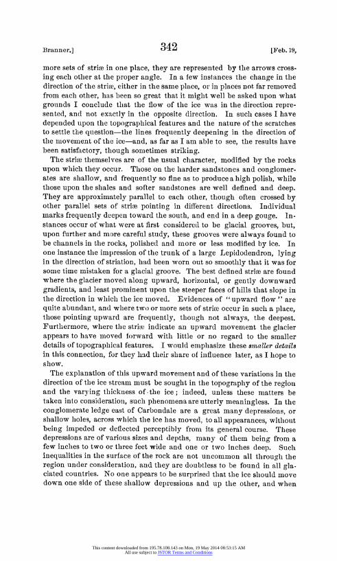
SKVETCHMA OF THE
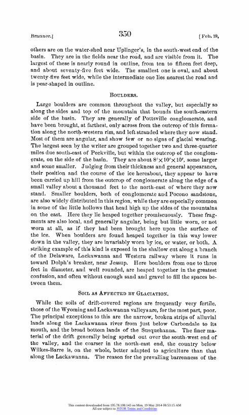
LACKAWAAVALElY FROM
Scranton to Forest Ci ty PENNSYLVANIA.
lInhile =:-in-cit. 1885.
<D > Rosdzzon~ of Pot V?obwFn. Th&e arrowes6howW the direofWort of' tfd-6 strias
c J.C.BTritnner.
This content downloaded from 195.78.108.143 on Mon, 19 May 2014 08:53:15 AMAll use subject to JSTOR Terms and Conditions
1886.1 3a3 (Branner.
POT-HOLES.
Among the interesting local phenomena related, in one way or another, to the glaciation of this valley, are the great pot-holes found near Archbald-
As the first one of these pot-holes is described in detail by Mr. Ashburner, I will only mention here, in speaking of the second one, what appear to be some of the important facts that relate to, or bear upon, their common origin.
The first of these holes was discovered in February, 1884, by the miners of Jones, Simpson & Co. cutting into it where it had penetrated the Arch- bald bed of coal in the Ridge mines. It was full of sand and water-worn material, and the surface of the ground, being covered with forest, slhowed no evidence of its presence. It is situated near the foot of the mountain, two miles due north-west of the town of Archbald, and nearly a mile south-east of the Callender gap. The little hollow in which both the holes are situated is half a mile long, and, in. this distance, rises about ninety-five feet in the direction of N. 320 E. At the lower end this hollow broadens out, the hill-tops on either side being about five hundred feet apart, and about seventy feet above the top of the first hole, which is at the lower end of the lhollow. A small, wet-weather stream runs down this hollow during the greater part of the year.
The second pot-hole is in the bottomi of the same hollow 1100' N. 330 E. from the first. At this point the hill on the north-west is only about ten feet above the level of the streamii, while the one to the east rises almost peipendicularly abouit sixty feet above it. The location of the seCond or upper hole was discovered in May, 1885, in the same manner, and by the, same parties that discovered the first one. Sand and water-worn drift, in every way similar to that found in the first hole, fell into the breast when the opening was made. To prevent further inconvenience in working this part of the mine, the material was propped up, and confined with pillars, to keep it out of the breasts. Not having been cleared of its con- tents it is impossible to describe this hole in detail, but with the aid of information kindly furnished me by M1r. Edward Jones of Jones, Simpson & Co., the operators of these mines, I am able to give its position and depth. The former, was determined by the minie map. The depth was obtained by using the mine levels, which give the elevation of the bottoim of the hole, and my own topographical survey of this vicinity, which gives the elevation of the surface at this point.
Elevation A. T. of the rail at the mouth of the drift..... 1077.95' Rise to the bottom of the second or upper pot-hole........ 49.50' Elevation A. T. of the bottom of second or upper pot hole.1127.45' Elevation A. T. of Topographical Survey station 3372,
which is almost exactly over the hole ............. 1192.07'
Total deptlh, including surface ........ ................. 64.62' Surface-say . ......... . 14.62'
Approximated deptlh of pot-hiole ........................ 50.00' PROC. AM1ER. P1IiLOS: SOC. xxIIr. 123. 2s. PRINTED APRIL 15, 1886.
This content downloaded from 195.78.108.143 on Mon, 19 May 2014 08:53:15 AMAll use subject to JSTOR Terms and Conditions
Branner.] 354 [Feb. 19,
From the first, or lower hole the debris was all removed by the mining company, and before it was employed as an air-slhaht, it could easily be examined both from above and below. The general profile of this hole along its greatest diameter is rudely that of an inverted riding-boot, the toe pointing about N. 800 E. It is thirty-four feet deep, and, at the top, about twenty feet wide in its smallest diameter, wllile its longest diameter -the length of the foot of tlle boot-is not known, the drift filling this prolongation never lhaving been removed. It is not cut straiglht down, but leans considerably in the direction of the greatest diamieter, that is, N. 800 E. In a foot-note on pagre 111 of Report Z, Professor Lesley refers to this first pot-hole (the second one not having been discovered at that time), and expresses tlle opinion that it is a glacial pot-hole, caused by the water falling over a crevasse in the glacier. After lhaving gone over the ground repeatedly, and after having made a thorough study of the topo- graphy of this region, and of what appear to be all the questions that throw any liglht upon tlle subject, tlle more firmly am I convinced that his is the true and only possible explanation of it.
The theory advanced by Mr. Ashburner, was to the effect that this first hole was made by water flowing down the lhollow in which it is situated, at a time when the stream was larger than it is at present, or by a stream coming from the direction of the Callender gap.
In regard to the latter suggestion, it may be replied, that, wlhatever tlle possibilities or probabilities may be of a stream lhaving, at any time, flowed into the valley tllrough the Callender gap, the position, inclination, and the direction of tlle greatest diameter of the top of tlle pot-hole pre- clude the possibility of its having been formed by a stream from such a quarter. The inclination and prolongation of the top of the hole point about N. 800 E., while the Callender gap lies N. 55? W. from this place.
Tllat a pot-hole of such dimensions could not possibly have been made by tlle stream that now runs down tlhrouglh the hollow in whiclh the hole occurs, is too plain to require demonstration ; and indeed no suclh claim, as far as I am aware, lhas been made. That this stream was once much larger than at present is doubtless true, but, with tlle present topography, the greatest possible area drained into tlle hole is less than a quarter of a square mile, or, to speak mlore exactly, twenty-tllree lhundredths (.23) of a square mile. The torrential rains of tlle tropics would not be sufficient to produce, upon tllis surface, a stream big enough to grind out suclh a pot-lhole. If we suppose that tlle two streams that cross tlle Callender gap road north of the hole, and the upper part of Tinklepaugh creek may have, at one time, drained into this hole (and, wlhile the first two mnay have done so, there is scarcely a possibility that this last ever did), the greatest possible area so draining would have been less than two square miies, or, more precisely, t.85 square miiles.*
*-These calculations are based upon the topographical map of t4is region made by the writer, and are known to be trustworthy.
This content downloaded from 195.78.108.143 on Mon, 19 May 2014 08:53:15 AMAll use subject to JSTOR Terms and Conditions
1886.] 35 LBraDner.
It is scarcely credible that suclh pot-holes could have been formed by a stream smaller than the Lackawanna at Arclibald, and this falling from a considerable height. I say "falling fromii a height " because, while I know that pot-holes may be, and are, formed in eddies by currents capa- ble of whirling the wearing material inside of them, I do not imagine that any one will claim that even the Lackawanna could whirl the stones in the bottom of even the smaller of these pot-holes, at a depth of thirty-four feet without striking the water in it from a considerable elevation. But even admitting that such a stream might have done this, we should still need to account for such a stream at this place and elevation.
At the Archbald iron bridge the Lackawanna contains the water drained from a hydrographic basin having an area of one hundred and four (104) square miles, and, when at an average height, this stream has, at this point, a volume of 83.441 cubic feet per second. To produce such a stream as this upon an area of less than two square miles, to say nothing of a quar- ter of a square mile, would require a precipitation surpassing anything of which we have any knowledge. Finally while the difference of elevation between the upper and lower pot-holes is about sixty-five feet in a distance of 1100 feet, the head of this hollow is much flatter, there being but thirty- five feet fall between the head of the hollow and the upper hole-a distance of about 1800'-which is clearly not enough to produce a current suffi- ciently powerful to move the stones in the bottoili of a pot-hole fifty feet deep.
In support of the explanation offered by Professor Lesley, I would call attention to an important, and somewhat remarkable topographical feat- ure in this part of the valley-a feature even more striking when looked at upon the ground, than when seen upon the map. This is a hill that projects, from tlle vicinity of the pot-hole, directly across the whole val- ley, in the direction of Archbald, and is only interrupted at this place by a narrow gorge, through which the Lackawanna flows.
Where the "back road," leading from Olyphant to Jermyn, crosses this hill, it is 310' above the level of the river at Archbald, while 1500' north-east of the lower pot-hole, it (tlle hill-top), is 3S0' above the river, and 125' above the mouth of the lower hole, which is just below thte crest of the hill.
The ice moving down the Lackawanna valley, and over the top of this bill, must have been broken by it into crevasses into which the streams that formed these pot-holes must have plunged. As the ice moved for- ward, tlhe crevasse would occur at, or about, the same point every time, aind so keep the water fall stationary, or nearly so. The shallow prolonga- tion of the upper part of the lower hole was probably caused by the occa- sional withdrawing of the stream, as it cut the ice more rapidly than it was pushed forward.
The surfaces of the rocks on the top of tlle hill above the upper pot-hole have been worn smooth by the ice, but being friable sandstones they have failed to preserve any striae, and although mnost careful search was made,
This content downloaded from 195.78.108.143 on Mon, 19 May 2014 08:53:15 AMAll use subject to JSTOR Terms and Conditions
Branner.] 356 [Feb. 19,
no striated exposedl surfaces were found anywllere in the immediate vicinity of these lholes.
Exactly why the stream flowing over the ice should come from N. 800 E., and not from sonmc other precise point of the compass to tlle north- east, we lhave no means of knowing. We do know, however, that very insignificant influences may determine the direction of a stream beginning to form upon the surface of mlielting ice.
Exactly wlhy tllere slhould lhave been, a crevasse above thle lower pot- hole is anotlher problem we lhave no means of solving. Thlie hill to the east of the lhole runs to a point just here, and is only sixty feet hiiglh. The crest of this ridge is m-ore than a tlhousand feet to the nortlh-east, and it is lhere under its very hbrow that one would naturally expect to find a pot-hole, if anywhere in the vicinity. And it is interesting to know tlhat, as a matter of fact, the second and deeper pot-hole is exactly at this point.
In considering this question of tlle origin of these pot-lholes I have taken into account the possibility of the water lhaving been tllrown over the ridge at tlle place in question by an ice-dam in tlle Areibbald gorge toward the close of tlle glacial epoclh. While I admit tlle possibility of suclh a dam, I do not find tllat it sinmplifies the explanation in any way; but, on tlle contrary, tllat it would necessitate a great mainy subordinate hlypotlheses.
It seems probable also that the circumstances nmust lhave been more favorable for the formiiation of tllesc lholes after the ice slheet hacl begLn to retreat, anld after it lhad coimie somewhat, but not wlholly, under the influenice of local topograplhy.
As far as I have been able to learn, these two are the only pot-lholes of this character that have been cliscovered in this valley. The one referred to by Prof. Lesley (Report Z, p. 111), as hiaving been mentioned in the Scranton Republican, is a small and simple one, macle by Laurel run in the soft shales of its bed. Suclh pot-holes are not uncommilon in this region. Besides those referred to on Black creek the writer has seen several along Laurel run near Arclibald and in Wlhite Oak run between the reservoir and where this streamii runs into the Lackawalina. Mr. George IM. Leh- man found several in Mlill creek lower down the valley. Two of these, he says, " are side by side, exactly alike, about the size of a stove-pipe, and just as round."
WATER-WEARING.
Further evidence that these pot-holes were made by water falling from a considerable lheight, may be seen in the water-worn condition of the preserved rock surfaces in the vicinity of the lower hole. All the pre- served surfaces of these rocks have the rounded ancl worn appearance that is -imparted by falling water. There can be no confusing these witlh glaciated surfaces. The latter, whetlher preserving tlleir strive or not, gen- erally have a regularly rounded appearance, the tendency of tlle ice beilng to reduce all irregularities. This smootlling, as has already been said, is most marked upon upward, level, or gently downward gradients. Water,
This content downloaded from 195.78.108.143 on Mon, 19 May 2014 08:53:15 AMAll use subject to JSTOR Terms and Conditions
1886.] 357 C cope.
on the other hand, does its principal wearing on down grades, and espe- cially in cataracts, or, where falling over precipices or obstructions, it can dash the stones, or other grinding material with wllich it may be charged against the rocky bed below. In suclh places the erosion caused by ice would be very insignificant or nil. Every one is acquainted with the fan- tastic forms and miniature pot-lholes made in tlle rocky bed of a stream where it pitches down a cataract. Suclh cases are common in the carbo- niferous shales along Wrliite Oak run and Laurel run near Archbald, and in the Chemung and Portage rocks of Central New York. In addition to tllese more specific differences, there is an indefinable one in the softer otutlines and appearances of a water-worn surface which generally aidsthe experienced eye.
Immediately to the north of the lower pot-hole a ledge, that is now breaking up, has this water-worn appearance. Somle of tlye best evidences of the action of water may be seen about 500' N. 400 W. from the mouth of this hole, and at the foot of the little hill that rises to its north. Here the evidences of wearing by a large stream are unquestionable, although there is now no considerable stream nearer than the Lackawanna at Jermyn, more than a mile and a lhalf away, and 210' below this level.
On Two Newo Species of 7hree-toed IIorses from tlhe Upper Miocene, with Notes on the Fauna of the Ticholeptus Beds. By E. D. Cope.
(Read before the American Philosophical Society, February 19, 1886.)
ANCHITHERIUM ULTIMUM, sp. nov. Unusual interest attaches to this horse since it is the latest representa-
tive in time of the genus to wlichl it belongs. It is from a horizon above the Johln Day Miocene, whiclh contains several Loup Fork genera and species, as Protolabis, Hippotherium ancl Dicotyles. As, however, the Blastomeryx borealis Cope occurs at the same locality and horizon, the bed is probably to be referredl to the Ticlioleptus epoch, which I have shown to be between the John Day and Loup Fork epochs in age, witlh greater affinities to the latter.* The principal locality is the valley of the Deep river, Montana, but the present species is derived, with those above men- tioned, from Cottonwood creek, Oregon.
The Anchitherium ultimum is represented in my collection by a nearly complete superior dentition, with palate and sides of skull to the middle of the orbits, and top of skull to above the infraorbital foramen. The size is less than that of the A. prastans Cope and A. equiceps Cope (? A. anceps Marsh) of the Johlni Day bed, and tlle dental series has the same length as that of the A. longicriste Cope. also of the John Day. The animal is adult, and anterior teetlh are considerably worn. The posterior molars
* See American Naturalist for April, 1886.
This content downloaded from 195.78.108.143 on Mon, 19 May 2014 08:53:15 AMAll use subject to JSTOR Terms and Conditions